pro-forma for notice paper word 7 - city of stonnington€¦ · web viewnotice paper. monday 30...
TRANSCRIPT

NOTICE PAPER
Monday 30 September 2013 at 7:00 p.m.
Council Chamber, Stonnington City Centre(enter off Glenferrie Road, Malvern)

RECONCILIATION STATEMENT
We acknowledge that we are meeting on the traditional land of the Boonwurrung and Wurundjeri people and offer our respects to the elders past and present. We recognise and respect the cultural heritage of this land.
PRAYER
Almighty God, we humbly beseech you, to grant your blessing on this Council, direct and prosper its deliberations to the advancement of your glory, and the true welfare of the people of the City of Stonnington. Amen.
NOTE
Council business is conducted in accordance with Part 4 Division 3 of the Meeting Procedure section of Council’s General Local Law 2008 (No 1). Some copies are available with the agenda or you can find a copy on Council’s website www.stonnington.vic.gov.au under local laws.
Page 2
Council MeetingNotice Paper
30 September 2013
Order of Business and Indexa) Reading of the Reconciliation Statement and Prayer;b) Apologies;c) Adoption and confirmation of minutes of previous meeting(s) in accordance with Section 63 of
the Act and Clause 423 of General Local Law 2008 (No 1);d) Disclosure by Councillors of any conflicts of interest in accordance with Section 79 of the Act1
e) Questions to Council from Members of the Public;f) Correspondence – (only if related to council business);g) Questions to Council Officers from Councillors;h) Tabling of Petitions and Joint Letters;i) Notices of Motion;- Notice of Motion 02/2013j) Reports of Special and Other Committees; - Assembly of Councillors & IMAP Minutes 31 May 2013k) Reports by Delegates;l) General Business;
1. PLANNING APPLICATIONS........................................................................................................................... 81.1. PLANNING APPLICATION 0734/12 - 52 - 54 THE BOULEVARD, MALVERN EAST – CONSTRUCTION OF
THREE DWELLINGS ON A LOT IN A RESIDENTIAL 1 ZONE........................................................................81.2. PLANNING APPLICATION 0259/12 - 34E ROSE STREET ARMADALE - FULL DEMOLITION OF THE
EXISTING BUILDING USE AND DEVELOPMENT OF THE LAND FOR A RETIREMENT VILLAGE AND ASSOCIATED CAR PARKING DISPENSATION IN A RESIDENTIAL 1 ZONE, HERITAGE OVERLAY AND SPECIAL BUILDING OVERLAY............................................................................................................27
1.3. PLANNING APPLICATION 0940/12 - 715 - 719 ORRONG ROAD, TOORAK - CONSTRUCTION OF A MULTI DWELLING DEVELOPMENT ON A LOT WITHIN A RESIDENTIAL 1 ZONE...................................................48
1.4. PLANNING PERMIT 0441/09 - 12 CUNNINGHAM STREET SOUTH YARRA – AMENDMENT TO THE EXISTING PLANNING PERMIT TO REMOVE CONDITIONS RELATING TO A PROPOSED GARAGE/STUDIO ADDITION AND RETROSPECTIVE APPROVAL FOR THE RELOCATION AND REDESIGN OF THE REAR BALCONY SCREENING AND ASSOCIATED SUPPORT STRUCTURE............................................................................................76
1.5. PLANNING PERMIT 441/09 – 12 CUNNINGHAM STREET SOUTH YARRA – REVIEW OF COMPLETED DEVELOPMENT.................................................................................................................................. 86
1.6. PLANNING APPLICATION 0056/76 - 489 - 505 TOORAK ROAD TOORAK - RETROSPECTIVE APPROVAL FOR A WASTE BIN STORAGE STRUCTURE.........................................................................................91
1.7. PLANNING APPLICATION 0102/13 - 31 DUKE STREET, WINDSOR – EXTENSION TO A DWELLING ON A LOT UNDER 500SQM......................................................................................................................... 99
1.8. PLANNING APPLICATION 0308/13 - 210 WATTLETREE ROAD MALVERN – PART DEMOLITION BUILDINGS AND WORKS AND SUBSEQUENT USE OF THE LAND FOR A MEDICAL CENTRE WITH ASSOCIATED ADVERTISING SIGNAGE AND CAR PARKING DISPENSATION IN A RESIDENTIAL 1 ZONE AND HERITAGE OVERLAY....................................................................................................................................... 108
1.9. PLANNING APPLICATION 0762/08 - 26 - 29 BEATTY AVENUE, ARMADALE – AMENDMENT TO THE APPROVED DEVELOPMENT TO ALLOW FOR THE INTRODUCTION OF THREE DWELLINGS, A REDUCTION IN THE OFFICE FLOOR AREA AND AMENDMENTS TO THE CAR PARKING ARRANGEMENT...........................120
1 Note that s.79(1)(a) of the Act requires Councillors to disclose the nature of a conflict of interest immediately before the relevant consideration or discussion.
Page 3

1.10. PLANNING APPLICATION 0118/13 - 17 - 23 HEYINGTON PLACE - SHERREN HOUSE , TOORAK – PARTIAL DEMOLITION AND BUILDINGS AND WORKS TO RENOVATE AND EXTEND EXISTING SCHOOL BUILDINGS.................................................................................................................................. 140
1.11. PLANNING PERMIT 313/12 – 5/529 CHAPEL STREET SOUTH YARRA – REVIEW OF COMPLETED ADVERTISING SIGN..................................................................................................................... 152
2. AMENDMENT C155 - YARRA RIVER SKYLINE CONTROLS – CONSIDERATION OF RECOMMENDATIONS OF THE PLANNING PANEL AND ADOPTION OF AMENDMENT....................................................................................158
3. AMENDMENT C173 – DANDENONG ROAD REVIEW – PLANNING CONTROLS – ADOPTION...............................1654. APPLICATION FOR VEHICLE CROSSING – 25 VALETTA STREET, MALVERN................................................1735. REPORT ON THE STREET TREES IN GLADSTONE AVENUE, ARMADALE FOLLOWING A SURVEY OF RESIDENTS TO
DETERMINE THEIR ATTITUDE TO THE REPLACEMENT OF THE LILLY PILLY STREET TREES.............................1776. ROAD RECONSTRUCTION WORKS IN ROSS STREET TOORAK RESIDENT SURVEY......................................1817. PUBLIC ART COMMISSION – PRAHRAN TOWN HALL PRECINCT.................................................................1848. adventure playground – plaque approval..............................................................................................188
m) Urgent Business; andn) Confidential Business.1. CONSIDERATION OF PROPERTY PURCHASE……………………………………….…………………………1902. REGIONAL KITCHEN MEALS SUPPLY AGREEMENT……………………………………………………………190
Page 4

ADOPTION AND CONFIRMATION OF MINUTESOF PREVIOUS MEETINGS
30 SEPTEMBER 2013
RECOMMENDATION
That the Council confirms the Minutes of the Ordinary Meeting of the Stonnington City Council held on 16 September 2013 and Minutes of the Confidential Meeting of the Stonnington City Council held on 16 September 2013 as an accurate record of the proceedings.
Page 5
GENERAL BUSINESS30 SEPTEMBER 2013
i) Notice of Motion
NOTICE OF MOTION NO 02/2013- (CRS SEHR & ULLIN)
I hereby give notice of my intention to move the following motion at the Ordinary Meeting of Council to be held at 7.00pm on Monday 30 September 2013, at the Stonnington City Centre, Council Chamber (off Glenferrie Road).
“That Stonnington Council formally request a meeting urgently with the Minister for Planning Matthew Guy, Michael O’Brien - Member for Malvern and Clem Newton-Brown - Member for Prahran to discuss planning issues within the municipality.”
Rationale
Stonnington has specific issues in relation to the massive amount of development occurring in the city which is disadvantaging the amenity of our residents and creating an undesirable outcome for the city’s future.
Page 6
GENERAL BUSINESS30 SEPTEMBER 2013
J) Reports of Committees: IMAP
The Cities of Melbourne, Port Phillip, Stonnington and Yarra have each set up the Inner Melbourne Action Plan Implementation Committee, pursuant to Section 86 of the Local Government Act 1989, to provide a coordinated decision making process to facilitate the implementation of the Inner Melbourne Action Plan (IMAP), as adopted by member Councils in December 2005.
RECOMMENDATION
That the Council confirms the minutes of the Inner Melbourne Action Plan Implementation Committee (IMAP) Meeting No 30 held on 31 May 2013 as an accurate record of the proceedings.
Page 7

GENERAL BUSINESS30 SEPTEMBER 2013
1. PLANNING APPLICATIONS
1.1. PLANNING APPLICATION 0734/12 - 52 - 54 THE BOULEVARD, MALVERN EAST – CONSTRUCTION OF THREE DWELLINGS ON A LOT IN A RESIDENTIAL 1 ZONE
(Statutory Planning Manager: Alexandra Kastaniotis)(General Manager: Stuart Draffin)
PURPOSE
For Council to consider a planning application for the construction of three dwellings on a lot in a Residential 1 Zone at 52-54 The Boulevard, Malvern East. Executive Summary
Applicant: Raffaele Pascuzzi Ward: EastZone: Residential 1Overlay: NoneDate lodged: 11/10/2012Statutory days: (as at council meeting date)
235
Trigger for referral to Council:
7 objections
Number of objections: 55 objections from 49 different propertiesConsultative Meeting: 27 June 2013Officer Recommendation: Notice of Decision to Grant a Planning Permit
BACKGROUND
The Proposal
The plans that form part of the basis of Council's consideration were prepared by ABP Consultants Pty Ltd and are known as File No.734/12, Drawing No.s:2012-073TP Sheet 1-13 and Council date stamped 26 November 2012.
Key features of the proposal are:
Demolition of the existing single storey dwelling. Construction of three, two storey dwellings comprising three bedrooms and study with a
double garage provided for each dwelling. Unit 1 is located on the north-eastern side of the site and will feature a separate living room
facing the street frontage and an open plan family room/kitchen, laundry and powder room at the rear. A double garage is setback to the side of the living room and located along the eastern boundary. The garage is accessed via a new crossover from The Boulevard. Three bedrooms and an ensuite for each bedroom is provided at first floor level. Private open space is located at the back of the dwelling and faces south-east. An additional area of open space is provided within the front setback.
Page 8

GENERAL BUSINESS30 SEPTEMBER 2013
Unit 2 is located within the south-western section of the site and features a living room/family room and kitchen/dining area with a separate study provided adjacent to the laundry. A double garage is provided with direct access from the existing crossover from The Boulevard. Three bedrooms each with ensuite is provided at first floor level. Open space is located to the south of the dwelling.
Unit 3 is located within the north-west section of the site and features a family/dining/kitchen and open study at ground level. A double garage is located behind the dwelling and is also accessed via the existing crossover and central driveway to this unit and unit 2. Three bedrooms each with ensuite are located at first floor level. North facing open space is provided within the front setback.
Pedestrian access will be provided via the two driveways. The proposal incorporates a pitched tiled roof and face brick work finish. The maximum height of the buildings above the natural ground level is proposed to be 7.8
metres at its highest point.
Site and Surrounds
The site is located on the south side of The Boulevard, between Argyll Street to the south-east and Ayr Avenue to the west. The site faces Malvern Valley Golf Course to the north, Holmesglen Institute and Holmesglen Station to the south and Warrigal Road to the east. The site has the following significant characteristics:
The site is irregular in shape. The existing dwelling is not of heritage significance. The site has a frontage of approximately 36 metres to The Boulevard and a maximum
depth of 41 metres on the western side of the site and 22 metres on the eastern side. The overall size of the lot is 956 sqm and the site has a fall of approximately 1 metre across the site from east to west and from south to north.
The site contains an existing single storey building constructed of brick with a tiled hipped roof. A garage and carport are located along the western side of the site. Open space is currently provided at the rear of the building and within the front setback surrounded by a low brick fence. The site accommodates a number of mature trees and smaller shrub planting.
The surrounding neighbourhood also known as the Malvern Meadows Estate accommodates approximately 200 lots which primarily accommodate single dwellings on larger lots dating from the 50s and 60s. There is not a strong presence of multi-unit development and where they do exist they are generally single storey in design. There is evidence of new single dwellings comprising two storeys within the immediate area.
The site interfaces with adjoining properties as follows:
Number 56 The Boulevard abuts the site to the east. This has been a vacant block since 2005, prior to this time the site accommodated a single storey brick dwelling facing The Boulevard. Currently the site is being developed for a single two storey dwelling. This site has dual frontages to The Boulevard to the north and to Argyll Street to the south. There are no current planning permits for the development of this site given the site is over 500sqm in area. However, the building plans detail approved plans for the construction of a double storey dwelling fronting Argyll Street with open space to the rear adjoining 52- 54 The Boulevard.
Further east is number 58 The Boulevard which accommodates a single storey brick dwelling with a side driveway and private open space at the rear which includes a swimming pool.
Directly west of the site is 50 The Boulevard which is a corner block intersecting with Ayr Avenue. The site accommodates a single storey brick dwelling which is sited to face Ayr Avenue. The dwelling is a modest brick dwelling with a small side access way of 1.7m in width facing the development site.
Page 9

GENERAL BUSINESS30 SEPTEMBER 2013
Two properties abut the site’s southern boundary which are addressed to No. 97 and No. 99 Argyll Street respectively. 97 Argyll Street accommodates a single storey brick dwelling and double garage to its western side. A large grassed back garden faces the rear of the development site where the rear boundary features mature vegetation. Adjoining this property is 99 Argyll Street which also accommodates a single brick dwelling and rear single brick garage. A large portion of the site accommodates rear facing open space which has direct views toward the development site. To the south west is a property addressed to No. 95 Argyll Street which also accommodates a single storey dwelling with a rear garage.
Previous Planning Applications
A search of Council records indicates the following relevant planning applications: Planning Application 624/08 for 52-54 and 56 The Boulevard Malvern East for 8 dwellings
was refused by Council. VCAT subsequently upheld Council’s decision not to issue a permit. Planning Application 71/10 for 52-54 and 56 The Boulevard Malvern East for 7 dwellings was
refused under delegation and subsequently VCAT upheld this decision not to issue a permit. Planning Application 974/11 for 6 dwellings was withdrawn by the applicant.
There are no current planning permits for this site.
The Title
The site is described as allotment 465 on LP10296. A restrictive covenant is registered on title. The covenant restricts the owners of the land from excavating or removing any earth, clay, stone, sand or gravel from the site except for the purposes of excavating for the foundations of any building. The land may not be used for the manufacture or winning of bricks or pottery ware. Council considers that the current development will not breach this covenant.
Planning Controls
The following controls/permit triggers are considerations for this application:
Zone
Clause 32.01 - Residential 1
Pursuant to Clause 32.01-4 a permit is required to construct two or more dwellings on a lot. A development must meet the requirements of Clause 55 (Rescode).
Overlays
There are no overlays that affect this site.
The site is included in an Area of Cultural Heritage Sensitivity, however this proposal does not warrant the need for the submission of a Cultural Heritage Management Plan. There is a list of criteria provided under the Aboriginal Heritage Act 2006 that determines whether or not a Cultural Heritage Management Plan is required and the proposal is exempt from this requirement.
Particular Provisions
Clause 52.06 Car Parking
Page 10

GENERAL BUSINESS30 SEPTEMBER 2013
Pursuant to Clause 52.06-2 prior to a new use commencing or a new building being occupied, the car spaces required under Clause 52.06-5 must be provided on the land or as approved under Clause 52.06-3 to the satisfaction of the Responsible Authority.
Pursuant to Clause 52.06-3 a permit may be granted to reduce (including reduce to zero) the requirement to provide the number of car spaces required under this clause.
The table at Clause 52.06-5 states two car spaces are required to each three or more bedroom dwelling (studies counted as a bedroom). The development proposes three bedrooms and one study to each dwelling, with two car spaces being provided in the form of a double garage. Therefore, car parking is in accordance with the requirements of the Stonnington Planning Scheme.
Clause 55 – Two or more dwellings on a lot and residential buildings
Given Clause 32.01-4 is triggered an assessment against Clause 55 (Rescode) is required.
General Provisions
Clause 65 – Decision Guidelines
The decision guidelines of Clause 65 of the Stonnington Planning Scheme are relevant to this application and require consideration to be given to a variety of matters including the Planning Scheme policies, the purpose of the zone, orderly planning and the impact on amenity.
Relevant Planning Policies
Clause 15.01-5 Urban DesignClause 15.01-5 Cultural Identity and Neighbourhood CharacterClause 15.02 Sustainable Development Clause 16.01 Residential Development
Clause 21.01 Vision for the City of StonningtonClause 21.02 Settlement and the Environment Clause 21.03 Housing
Clause 22.02 Urban Design PolicyClause 22.06 Residential Character, Amenity and Interface
Clause 32.01 Residential 1 Zone Clause 52.06 Car Parking Clause 55 RescodeClause 65 Decision Guidelines
Other Considerations:
Draft Clause 22.18 Stormwater Management (Water Sensitive Urban Design) Policy is a seriously entertained document and applies to all new buildings. The objectives of this policy are:
To promote the use of water sensitive urban design, including stormwater re-use. To mitigate the detrimental effect of development on downstream waterways, by the
application of best practice stormwater management through water sensitive urban design for new development.
Page 11

GENERAL BUSINESS30 SEPTEMBER 2013
To minimise peak stormwater flows and stormwater pollutants to improve the health of water bodies, including creeks, rivers and bays.
To reintegrate urban water into the landscape.
Advertising
The application has been advertised pursuant to Section 52 of the Planning and Environment Act 1987 by sending notices to the owners and occupiers of adjoining land (and by placing two signs on the site). The public notification of the application has been completed satisfactorily.
The site is located in East Ward and objections from 49 different properties have been received. The concerns can be summarized as follows: Out of character with the area Mass and bulk Overlooking and loss of privacy Design details and materials not in keeping with the street Overdevelopment Loss of views Setbacks are insufficient from boundaries Overshadowing of open space Insufficient car parking Increase in traffic in the area Has not addressed the previous VCAT Order
A Consultative Meeting was held on 27 June 2013. The meeting was attended by all East Ward Councillors, the applicant, objectors and a Council planning officer. The meeting did not result in any changes to the plans.
Referrals
Infrastructure
The application plans dated 26 November 2012 were referred to Council’s Infrastructure Unit who had no fundamental objection to the proposal. Comments regarding the requirement for a report relating to the legal point of discharge and a drainage and driveway design for the development could be satisfied as a condition of permit. The feedback also promotes the installation of water tanks for re-cycling and to minimise storm-water runoff.
Transport and Parking
Council’s Transport and Parking Department have reviewed the proposal and have noted that the parking facilities raise some concern with regard to the finer details of the driveway grades, sight distance at property boundary and garage widths and headroom. It is noted that,
“It is considered that the additional traffic generated by the proposed development will not significantly impact upon the existing traffic conditions of the area”.
“There is a concern that future occupants of the proposed Units 2 and 3 may attempt to park additional vehicles in the paved area adjacent to their respective garages. This may affect turning movements for vehicles exiting from the other dwelling and force motorists to exit the site in reverse. Whilst the Transport and Parking Unit does not object to the proposed arrangement it should be ensured that the paved area is established as a shared area, maintained clear for access movements”.
Page 12
GENERAL BUSINESS30 SEPTEMBER 2013
The car parking arrangement will be discussed below in the “Assessment” section of this report. Furthermore, details of the driveway widths and gradients of parking floors, and sight lines are to be required by way of conditions.
Parks
All trees being retained must be listed on the tree inventory. Mature specimens in the front setback such as the Kanooka and the Norfolk Island Pine are currently not listed on the inventory but would make a good contribution to the front landscape of the property. Confirmation is also required if the Sweet Gum is to be retained.
Should a permit issue conditions of permit must require a Tree Inventory of all trees to be retained including the Kanooka and the Norfolk Island Pine, a Tree Management Plan for the trees to be retained including the street tree and a landscape plan detailing species and installation sizes listed, this plan must include canopy trees.
KEY ISSUES
As detailed in the previous planning applications section of this report it is worth outlining the previous history of development applications for this site. It should be noted that the two previous applications reviewed by VCAT included the adjoining land at 56 The Boulevard. This current proposal does not include this land which has since been sold to a new owner.
Bearing in mind the reduced site area and reduction in the number of dwellings it is pertinent to review what the Tribunal discussed in its previous decision.
As mentioned earlier in this report, two previous applications for this site were refused by the Victorian Civil and Administrative Tribunal in October 2009 (VCAT Order P174/2009) and in January 2011 (VCAT Order P1099/2010). At the time the applications involved demolition of the existing dwelling and construction of eight and seven double storey dwellings respectively across the two sites. The most recent set of development plans for 71/10 detailed three double storey dwellings spaning the frontage of 52-54 The Boulevard, Malvern East, for the benefit of this assessment as we are reviewing a smaller portion of the original site it is relevant to assess whether changes address the Tribunal’s comments in the previous cases and also consider the merits of the proposal afresh.
The Tribunal found in both cases that:
“the review site is suitable for medium density development and that respect for neighbourhood character, based on the planning context that applies allows a change in housing density and style”.
“two storey development is acceptable in principle with new dwellings needing to respect the architectural style, scale and form of surrounding development.” (VCAT Order P1099/2010 paragraph 9) “the longer frontage to The Boulevard, equivalent to around three standard lots in area, enables several dwellings to front this street while maintaining the pattern or rhythm of development”(paragraph 17).
The areas where the Tribunal considered the application flawed included the site coverage being too high and a failure to scale down the development. The transition between the eastern most dwelling in terms of scale, height and setbacks from 58 The Boulevard was seen as ‘abrupt’.
Page 13

GENERAL BUSINESS30 SEPTEMBER 2013
The Tribunal also found that they did not consider that “the increase in traffic that would arise from this proposal cause the permit application to fail”. The constraints of the existing single road in and out of the estate were noted as were the problems associated with the intersection with Warrigal Road. The member noted that, “I do not, however, consider fewer dwellings on the site are warranted for these reasons”. (paragraph 31).
It should also be noted that the modern design of the buildings was not noted as a concern. However, the current proposal has reverted to a more traditional design approach in relation to roof pitch and finishes which reflect a more cohesive response to the surrounding dwellings.
Based on the findings of the previous VCAT Order P1099/10 it is considered that the proposal has sought to address the concerns by:
Removing the side by side configuration and providing a break between the buildings; Providing a varied building setback from The Boulevard frontage; Retention of a variety of trees within the front setback; Deletion of first floor balconies facing The Boulevard.
It is also worthy to consider the VCAT Order P375/2009 Ramage V Stonnington City Council regarding a site located at 66-68 The Boulevard Malvern East where approval was given for three, two storey dwellings. The site is located 150m east of the 52-54 The Boulevard.
The Tribunal noted that:
“the test for new development in areas with a defined neighbourhood character is that a proposal must be respectful and fit in to the prevailing character. It does not need to replicate, mimic or be the same as the prevailing neighbourhood character, but be able to demonstrate that it has paid attention to and is generally similar to the prevailing features of existing development”.
Furthermore:
“I take the approach that this site should be developed for a higher density to meet wider planning objectives. Hence the development should not be same as the dominant neighbourhood character as this is a lower density character. Any higher density development on the review site needs to be respectful of the prevailing character, but will have some variances to this character” (paragraph 21). Neighbourhood Character
The application has been assessed against the provisions of Clause 55 in conjunction with Council’s local policies Clause 22.02 (Urban Design Policy) and Clause 22.06 (Residential Character, Amenity and Interface Policy).
As previously discussed in the site and surrounds section of this report, the area surrounding the site has a distinct single storey character although there are a number of examples of infill development such as the current construction of a double storey dwelling at 56 The Boulevard and 64 and 66 The Boulevard which alter the paradigm of development. The pattern of development in the area also includes buildings generally being setback from side boundaries, garages and carports being the exception. The proposal provides setbacks from both side boundaries with the garage to Unit 1 located along the eastern boundary which generally replicates other building footprints within the immediate area.
Page 14

GENERAL BUSINESS30 SEPTEMBER 2013
Some objectors have raised concern with the use of materials proposed for this development not being in keeping with the area. The proposal details the dwellings being finished in face brickwork and tile roofing, colour selection being of a muted tone. These finishes are commonly seen in the Malvern Meadows Estate and as such are considered appropriate.
Landscaping is also an important feature of this development with a number of trees being listed as being retained within the front setback. Council’s Arborist’s have also recommended that the Norfolk Island Pine, the Kanooka and the Sweet Gum are also worthy of retention to ensure that an appropriate garden setting is achieved. As such a permit condition will require that a tree management plan and landscape plan be provided for approval.
Integration with the Street
The proposed development maintains the existing crossover which will provide access to car parking for Units 2 and 3. The plans also detail the inclusion of a proposed new crossover along the eastern side of the site providing access to a double garage for Unit 1.
The development provides satisfactory vehicle access and pedestrian access is provided via two separate pathways to Units 1 and 3. Unit 2 is accessible via the main driveway which is open and not impinged by any obstructions.
The development is oriented toward The Boulevard frontage and is not obstructed by high fencing therefore meeting the requirements of Standard B5.Street Setback
In terms of its presentation to the street, the proposed building form is considered to be a sympathetic design response and will be compatible with other existing and new dwellings within the surrounding area. Units 1 and 3 have direct frontages to The Boulevard. The adjoining lot to the west although having an address of the 50 The Boulevard is oriented to face Ayr Avenue which includes vehicle and pedestrian access. The adjoining lot to the east is 56 The Boulevard and is currently a vacant site with construction commencing for a double storey dwelling to face Argyll Street. The objective of Standard B6 (street setback) strives “to ensure that the setbacks of buildings from a street respect the existing or preferred neighbourhood character and make efficient use of the site”.
Given there is no existing building on either of the abutting allotments facing the same street, and the site is not on a corner the minimum required setback from the street is 4 metres. The proposed setback is 5.7m at its closest point resulting in compliance with the Standard.
Building Height
The maximum height of the proposed development is 7.8 metres to the pitch of the roof and wall heights are generally 3 metres for the ground floor and 2.55 metres at first floor level. The height of the buildings is below the maximum height recommended by Standard B7 of 9 metres and therefore complies with the objective being, “to ensure that the height of buildings respects the existing or preferred neighbourhood character”.
Site Coverage
The development on the site will result in 42.7% site coverage which is less than the maximum 60% coverage recommended by Standard B8. Permeable ground will also equate to 41.3% of the total site area, which also meets the requirements of Standard B9. Therefore the level of site coverage and permeability complies with the Rescode guidelines.
Page 15

GENERAL BUSINESS30 SEPTEMBER 2013
Energy Efficiency The objective of this Standard is to ensure the orientation and layout of the development reduces fossil fuel energy use and makes appropriate use of daylight and solar energy.
The orientation of the site in a north-west direction has required the buildings to be sited to provide partial open space within the front setback and where this has been achieved it has allowed for a substantial amount of northern exposure to Units 1 and 3 for those areas of internal and external space which face the front of the site. Units 1 and 3 have allocated windows to all habitable rooms and the open plan layout will promote cross ventilation. Generally the front dwellings have north and east facing windows overlooking open space and maximising solar access.
These sites however, are problematic given building frontages must face the street with private open space generally located to the rear of these buildings. In this case the rear of the site and an area of private open space to Units 1 and 2 face south and are largely in shade from noon onwards.
Although there is additional shading beyond the site to the west and south it is considered that the extent of shadowing to these adjoining open spaces is not unreasonable and meets the Standard.
Landscaping
A landscape concept plan has been submitted but additional detail will be required in relation to the trees being retained given there is no reference to the removal of the Norfolk Island Pine, the Kanooka and the Sweet Gum. As noted previously in this report a condition of permit will require the submission of a Tree Management Plan including the retention of the three trees discussed, a landscape plan with the inclusion of appropriate canopy trees and a management plan for the protection of abutting street trees.
Access
The proposal details maintenance of the existing crossover to allow access to the on-site double garage space to Units 2 and 3 and the introduction of a new single crossover to accommodate access to the double garage for Unit 1. The objective of this Standard notes that in assessing compliance the number and design of vehicle crossovers must respect the neighbourhood character. Although the area is not characterised by more than one crossover per property the development site has an unusually wide frontage, the crossovers not exceeding 33% of the site frontage and the location of the crossovers continues to allow effective use of on-street parking which has been raised as a concern by a number of local residents. Provision of parking on site meets the requirements in that two spaces within a double garage are provided for each dwelling.
Council’s Transport and Parking Unit have noted that the open area adjoining the garages to Units 2 and 3 should not be used for additional vehicles to be parked as this area is required as a turning area for cars to exit the site in a forward motion. It is considered that this issue will be managed by future owners and occupants of the dwellings.
Council’s Transport and Parking Unit have not raised any issues with the proposals impact on traffic in the area although many comments have been received relating to traffic and parking concerns which may relate to the use of Holmesglen Station and the Holmesglen Institute. Traffic counts for the area are ongoing and will be monitored for any further changes which require management measures to be adopted within this location.
Page 16
GENERAL BUSINESS30 SEPTEMBER 2013
Amenity Impacts
Side and Rear Setbacks
West Interface
Unit 2 proposes a west facing wall at ground level, accommodating a kitchen/laundry and study varying in height from 3.4 to 3.5 metres. Standard B17 (side and rear setbacks) requires a minimum setback of 1 metre. A setback of 1.2 metres is detailed hence the Standard has been met.
The double garage to Unit 3 has a wall height varying between 3.2 and 3.3 metres and is setback 1.8 metres from the boundary which meets the Standard.
The western ground level wall to Unit 3 which accommodates a study, laundry and kitchen has a wall height varying between 3.6 and 3.9 metres which requires a minimum setback of 1.09 metres. The plans detail a setback of 1.2 metres and as such the Standard has been met.
The first floor west wall to Unit 2 which accommodates a bedroom and two small bathrooms details a wall height of 5.7 metres and as such requires a setback of 1.63 metres. The plans detail a setback from the western boundary of 2.1 metres. The Standard has been achieved.
The west facing wall to Unit 3 accommodates a bedroom and an ensuite and details a wall height varying between 5.7 metres at the southern end to 6.1 metres at the northern point of the building. A minimum setback of 1.75 metres is required to meet the Standard. The plans detail a setback of 3.2 metres which will meet this requirement.
South Interface
Unit 2 has a south facing wall varying in height between 3.1 metres and 3.5 metres and is setback 3.0 metres from the rear boundary from the family room and 4.8 metres from the living room. A minimum setback of 1 metre is required and has been achieved.
Likewise, Unit 1 has a ground floor wall height varying between 3.1 metres and 3.5 metres and is also setback from the rear boundary a minimum of 3.0 metres. Based on the requirements of Standard B17 a setback of 1 metre is required and has been achieved.
The first floor wall to Unit 2 has a maximum wall height of 5.7 metres and as such requires a setback of 1.63 metres. The plans detail a minimum setback of 3.63 metres. The Standard has been achieved.
The first floor to Unit 1 has a maximum wall height of 5.7 metres and provides a setback of 5.68 metres. Based on the Standard a setback of 1.63 metres is required and as such has been met.
East Interface
The wall height to the laundry and pantry area of Unit 1 is detailed on the plans at 3.2 metres and requires a minimum setback of 1 metre. The plans detail a setback of 1.28 metres, achieving the Standard.
The first floor east facing wall of Unit 1 has a maximum wall height of 5.7 metres and therefore requires a setback of 1.63 metres, a setback of 2.04 metres has been provided. The Standard has been met.
Page 17
GENERAL BUSINESS30 SEPTEMBER 2013
Walls on Boundaries
The plans detail the east facing wall to the garage to Unit 1 setback 150mm from the side boundary. The wall has a length of 6.46 metres and has a maximum height of 2.9 metres. The Standard notes that the height of new wall constructed on or within 150mm of a side or rear boundary or a carport constructed on or within 1 metre of a side or rear boundary should not exceed an average of 3 metres with no part higher than 3.6 metres unless abutting a higher of simultaneously constructed wall. Given the wall is not higher than 3 metres and is no longer than 10 metres the Standard has been met.
Daylight to Existing Windows
The key assessment tool in determining impacts to neighbouring windows with regard to light obstruction is the Daylight to Existing Windows Objective, Standard B19.
South Interface
The dwellings to the south at 97 and 99 Argyll Street have a series of habitable room windows facing the site. These windows are located over 9 metres from the title boundary. Compliance with Standard B19 is achieved comfortably on this interface on all levels.
North-West Interface
The dwelling at 50 The Boulevard has a number of habitable room windows facing the site which are setback 1.79 metres from the shared boundary. Unit 3 abuts these windows and has a maximum wall height 6.1 metres which based on the Standard requires a setback of 3.05 metres from these windows. A setback of 3.2 metres is detailed and as such the Standard has been met.
North- East Interface
The adjoining land at 56 The Boulevard is currently under construction to develop one double storey dwelling on the site. The dwelling faces Argyll Street. The current set of building plans have been checked and there are no windows which will be directly affected by the location of Unit 1. All habitable room windows within Units 1 and 3 will receive sufficient light in accordance with the requirements of Standard B27. The family/dining room of Unit 2 located at ground level faces south-west and although the orientation is not ideal will receive sufficient light from the adjoining open space area.
North Facing Windows
Standard B20 under the North Facing Windows Objective is not triggered in this assessment as the closest neighbouring north facing windows are located more than 9m from the boundary.
Overshadowing Open Space
The Overshadowing Objective is to ensure that buildings do not unreasonably overshadow existing secluded private open space Standard B21 states that the existing sunlight to secluded private open space of an existing dwelling should not be further reduced if less than 40 square metre of private open space receives 5 hours of sunlight between 9:00am and 3:00pm on 22 September. Whilst additional shading will occur to the rear open space of 50 The Boulevard in the morning by 11am the shadows cast are limited to shared boundary fencing. Likewise the properties to the south and north-east will not be unreasonably impacted save for a slight increase in additional shadowing beyond the fence line. Compliance with Standard B21 is achieved comfortably on all interfaces.
Page 18

GENERAL BUSINESS30 SEPTEMBER 2013
Overlooking and Internal Views
The key assessment tool to determine unreasonable overlooking is the Overlooking Objective, included in Standard B22. The Standard provides a 9 metre 45 degree angle arch that determines unreasonable overlooking and windows or balconies that are located in such a position must be screened to a height of 1.7 metres above finished floor level accordingly. Assessment of overlooking impacts to each interface is provided as follows:
South
To the south of the site is a 1.8 metre high boundary fence. It is considered that this fence will restrict overlooking into the private open space of 97 Argyll Street from the ground floor kitchen window which is setback 3 metres from the boundary. Likewise the views from the kitchen window of Unit 1 will also be restricted by the adjoining 1.8 metre high fence protecting the privacy within the rear open space of 99 Argyll Street.
There are no first floor windows facing south.
West
To the west, a new boundary fence of 1.8 metres is proposed, the plans also including an additional 450mm of lattice to screen ground floor windows which are detailed to be fitted with clear glass and may provide views to adjoining open space and abutting windows. The treatment proposed opposite the study windows meets the Standard.
All west facing windows at first floor level have sill heights 1.7 metres above floor level and as such meet the Standard.
East
Although the adjoining site is currently detailed on the plans as vacant, plans detail open space for a new double storey dwelling at 56 The Boulevard. All east facing first floor windows are detailed to have sill heights 1.7 metres above floor level to maintain the privacy of this area.
An additional east facing window is located at first floor level to Unit 2 and will not provide unreasonable views either internally or toward open space outside the site.
Ground floor windows do not provide any unreasonable views toward this space and as such the Standard has been satisfied.
Internal Overlooking
The proposed design has sought to ensure that internal overlooking will be minimal. The proposal is considered to comply with Standard B23.
On Site Amenity
Dwelling Entry and Safety
An entrance is provided to Units 1 and 3 via a pathway from The Boulevard. Access to the entrance of Unit 2 is provided via the shared driveway which is not obscured by vegetation and will allow passive surveillance from ground and first floor windows facing the street frontage. It is considered that Objectives B12 and B26 have been met.
Page 19

GENERAL BUSINESS30 SEPTEMBER 2013
Private Open Space
Each unit will have private open space in excess of the requirements of Standard B28 Private Open Space which states the following:
‘a dwelling or residential building should have private open space consisting of:
An area of 40 square metres, with one part of the private open space to consist of secluded private open space at the side or rear of the dwelling or residential building with a minimum area of 25 square metres, a minimum dimension of 3 metres and convenient access from a living room, or
A balcony of 8 square metres with a minimum width of 1.6 metres and convenient access from a living room, or
A roof-top area of 10 square metres with a minimum width of 2 metres and convenient access from a living room’.
Unit 1 is proposed to have a 47 square metre courtyard at the rear of the site accessible from the living room and 75 square metres of open communal space within the front setback. Unit 2 has 65 square metres of open space at the rear of the dwelling with access provided directly from the living room. Unit 3 has 29 square metres of private open space along the north-western side of the dwelling and a further 106 square metres of open communal space facing the street frontage.
The proposed areas of private open space are in accordance with Standard B28 and are considered appropriate.
Solar Access to Open Space Objective
Standard B29 requires private open space to be located on the north side of the dwelling or residential building, if appropriate.
Units 1 and 2 have their primary area of open space facing south and as a result will be affected by overshadowing from the dwellings themselves.
Standard B29 states the following:
The southern boundary of the secluded private open space should be set back from any wall on the north of the space at least (2 + 0.9h) metres, where ‘h’ is the height of the wall.
Given the angled lot orientation, coupled with the fact that the proposed south facing walls to Units 1 and 2 on both levels have varied setbacks from the rear boundaries, assessment against this Standard produces varied results. It is therefore considered appropriate to refer to the Decision Guidelines which state the following:
The useability and amenity of the secluded private open space based on the sunlight it will receive.
It is considered that the proposed arrangement is acceptable for the following reasons:
The internal spaces of each dwelling will receive adequate access to solar light to allow satisfactory utility of all habitable rooms;
For Unit 1, a reasonable portion of the secluded open space will receive unobstructed northern light due to the angle of the lot and the lack of building on the eastern neighbouring site at this location.
Page 20
GENERAL BUSINESS30 SEPTEMBER 2013
For Unit 2, most of the main area of secluded open space (adjacent the living room) will be affected by the single storey garage, meaning a significant amount of northern light will also be provided to this space.
There is generous communal open space at the front of the site; The layout of the open space for Units 1 and 2 is well laid out and provides good access
from main living areas; The development is largely compliant in all other aspects of the Clause 55 assessment
For the above reasons it is considered that the Solar Access to Open Space Objective is met.
Landscaping
A landscape concept plan was submitted as part of the original documentation which detailed planting within the front setback and generally around the site within the private open space areas.
Council’s Arborist’s raised concerns in relation to the accuracy of the inventory for tree removal and recommended that three trees including the Norfolk Island Pine, the Kanooka and the Sweet Gum be retained. In addition a Tree Management Plan for all vegetation including the street trees must be included and can be accommodated as a condition of the permit. A detailed landscaping plan outlining species, quantity and installation size with the inclusion of canopy trees throughout the site is also required as a condition of the permit. Subject to these conditions the level of landscaping is considered to respond to the existing neighbourhood character of the area and will provide a safe and attractive and functional environment for residents in accordance with Standard B13.
No significant trees will be removed.
Car Parking and Traffic
Parking Provision and Location
The proposal includes six car parking spaces provided in the form of a double garage for each dwelling. This meets the requirements of Clause 52.06-5 which stipulates a requirement of two car parking spaces for each dwelling with no visitor spaces required given that the proposal is for less than five dwellings.
The garages are designed to measure 6.0 metres x 5.5 metres. These dimensions meet the requirements of Clause 52.06. Internal headroom also meets the requirements for access into a double garage.
As detailed in the referrals section of this report Transport and Parking highlighted that the occupants of Units 2 and 3 may attempt to park additional vehicles in the paved area adjacent to their respective garages affecting turning movements exiting from the other dwelling. It was recommended that the paved area be maintained as an open unobstructed space to ensure the vehicles from these units can exit the site in a forward motion. This can be included as a condition of permit.
In regard to driveway grades this can also be conditional of any permit which may issue.
Page 21

GENERAL BUSINESS30 SEPTEMBER 2013
Sight distances at the property boundary are satisfactory given there is no proposed front fence to obstruct views toward the pedestrian footpath for vehicles leaving the site. However, at the north-eastern corner of the block the driveway to Unit 1 is positioned 500mm from the edge of the boundary with 56 The Boulevard which it is assumed will construct a high paling fence around its primary area of private open space given it is altering its street frontage from The Boulevard to Argyll Street. It would be recommended that a condition be placed on the permit to revise the location of the driveway to allow for adequate site lines for any vehicles reversing from this driveway. This alteration will not impact on any street trees or services within the footpath and should provide safe egress for all vehicles and pedestrians.
Common Property and Site Services
The central access driveway to Units 2 and 3 will form part of the common property as will the area of open space not fenced within the front setback. These areas area considered to be functional and capable of efficient management consistent with Standard B33. The proposal provides an area within the front setback for mail boxes and bin storage, however the treatment of the bin storage area is not detailed on any elevation plans and as such a condition of permit will require the bin area and mail boxes to be shown in elevation and be screened to the satisfaction of the Responsible Authority. No front fence is proposed, this is a common characteristic of the area to either have a small 0.5m high fence or no fence.
Water Sensitive Urban Design
The application proposes to install three, 2,000 Litre rainwater tanks one for each dwelling and a 300mm rain garden for the driveway. A STORM Report was submitted that details a rating of 126% with these tanks and rain garden. These initiatives result in compliance with the best practice performance objective, set out in the Urban Stormwater Best practice Environmental Management Guidelines, Victoria Stormwater Committee 1999. Objections
In response to the grounds of objection not already discussed in the report, the following comments are made:
Loss of Views
Loss of views is not a relevant consideration under the provisions of the Stonnington Planning Scheme and as such cannot be considered as part of the assessment of this application.
Human Rights Consideration
This application has been assessed in accordance with the requirements of the Planning and Environment Act 1987 (including the Stonnington Planning Scheme), reviewed by the State Government and which complies with the Victorian Charter of Human Rights and Responsibilities Act 2006.
Page 22

GENERAL BUSINESS30 SEPTEMBER 2013
CONCLUSION
Having assessed the application against the relevant planning controls, it is recommended that the proposal be supported for the following reasons:
The works are of an appropriate scale and form to integrate with the existing streetscape and are compatible with existing neighbourhood character of the Malvern Meadows Estate.
The proposal will not result in unreasonable off-site amenity impacts and is deemed to generally comply with the objectives of Clause 55 (Rescode) of the Stonnington Planning Scheme.
The development is considered to have satisfactorily addressed the concerns on which two previous applications were refused by the Victorian Civil and Administrative Tribunal.
RECOMMENDATION
That a Notice of Decision to Grant a Planning Permit No: 734/12 for the land located at 52-54 The Boulevard, Malvern East be issued under the Stonnington Planning Scheme for the construction of three dwellings on a lot in a Residential 1 Zone subject to the following conditions:
1. Before the commencement of the development, two (2) copies of plans drawn to scale and fully dimensioned, must be submitted to and approved by the Responsible Authority. The plans must be in accordance with the plans submitted with the application and Council date stamped 26 November 2012 but modified to show:
a) Plans to detail the proposed floor gradients of the parking areas and driveways in accordance with AS 2890.1 or otherwise to the satisfaction of the Responsible Authority;
b) A notation on the plans showing the shared paved area adjoining the garages of Units 2 and 3 to be maintained as an open unobstructed space to allow for vehicles to leave the site in a forward motion;
c) Plans to show the location of bin and recycling enclosures and mailboxes to each dwelling in accordance with Standard B34 of Clause 55 of the Stonnington Planning Scheme;
d) A site line diagram detailing the site distance at the property boundary for the driveway for Unit 1 to comply with Clause 52.06-8 or otherwise to the satisfaction of the Responsible Authority. This may require the repositioning of the crossover to Unit 1 further west.
e) Notation that all water tanks will be connected to toilets for all dwellings. f) A Landscape Plan as required by Condition 4 which includes the retention of the
Norfolk Island Pine, the Kanooka and the Sweet Gum or otherwise to the satisfaction of the Responsible Authority.
g) A Tree Management Plan in accordance with Condition 6.
2. The development must be in accordance with the endorsed plans unless otherwise agreed in writing by the Responsible Authority.
3. Concurrent with the endorsement of plans, a schedule of construction materials, external finishes and colours to the satisfaction of the Responsible Authority must be submitted and approved. When approved, the schedule will be endorsed and will form part of the permit.
Page 23

GENERAL BUSINESS30 SEPTEMBER 2013
4. Concurrent with the endorsement of plan, a landscaping plan to be prepared by a landscape architect or suitably qualified or experienced landscape designer, must be submitted to and approved by the Responsible Authority. When approved, the landscape plan will be endorsed and will then form part of the permit. The landscape plan must be drawn to scale with dimensions and two copies must be provided. The landscape plan must show:
a) A survey (including botanical names) of all existing vegetation to be retained and/or removed.b) Buildings and trees (including botanical names) on neighbouring properties within three metres of the boundary.c) Details of surface finishes of pathways and driveways.d) A planting schedule of all proposed trees, shrubs and ground covers, including botanical names, common names, pot sizes, sizes at maturity and quantities of each plant.e) Landscaping and planting within all open areas of the site.f) The extent of any cut, fill, embankments or retaining walls associated with the landscape treatment of the site.
5. Before the occupation of the development, the landscaping works as shown on the endorsed plans must be carried out and completed to the satisfaction of the Responsible Authority. Landscaping must then be maintained to the satisfaction of the Responsible Authority, including that any dead, diseased or damaged plants are to be replaced.
6. Concurrent with the endorsement of development plans a tree management plan prepared by a suitably qualified arborist must be submitted to and approved by the Responsible Authority. When approved, the tree management plan will for part of this permit and all works must be done in accordance with the tree management plan. The tree management plan must details measure to protect and ensure the viability of the Norfolk Island Pine, the Kanooka and the Sweet Gum.
Without limiting the generality of the tree management plan it must have at least three sections as follows:
a) Pre-construction – details to include a tree protection zone, height barrier around the tree protection zone, amount and type of mulch to be placed above the tree protection zone and method of cutting any roots or branches which extend beyond the tree protection zone.
b) During - construction – details to include watering regime during construction and method of protection of exposed roots.
c) Post -construction – details to include watering regime and time of final inspection when barrier can be removed and protection works and regime can cease.
Pre – construction works and any root cutting must be inspected and approved by the Parks Unit. Removal of protection works and cessation of the tree management plan must be authorised by the Parks Unit.
7. All existing vegetation shown on the endorsed plans to be retained must be suitably and clearly identified before any development (including demolition and excavation) starts on the site and that vegetation must not be removed, destroyed or lopped without the written consent of the Responsible Authority.
Page 24

GENERAL BUSINESS30 SEPTEMBER 2013
8. The project must incorporate the Water Sensitive Urban Design initiatives detailed in the endorsed site plan and/or stormwater management report.
9. Any poles, service pits or other structures/features on the footpath required to be relocated to facilitate the development must be done so at the cost of the applicant and subject to the relevant authority’s consent.
10. All utility services to the subject land and buildings approved as part of this permit must be provided underground to the satisfaction of the Responsible Authority by completion of the development.
11. Prior to the occupation of the building, all screening devices designed to limit overlooking herby approved must be fixed to a height of 1.7m and have not more than 25% openings or an alternative to the satisfaction of the Responsible Authority. The screens must be designed and coloured to blend in with the development to the satisfaction of the Responsible Authority.
12. All plant and equipment (including air conditioning units) shall be located and screened so as not to be visible from any surrounding footpaths and adjoining properties and shall be baffled so as to minimise the emission of unreasonable noise to the environment in accordance with Section 48A of the Environment Protection Act 1970 to the satisfaction of the Responsible Authority.
13. Prior to the occupation of the building/commencement of use, the walls on the boundary of the adjoining properties must be cleaned and finished to the satisfaction of the Responsible Authority.
14. The legal point of discharge must be obtained from Council and a drainage design for the development must be prepared by a suitably qualified Engineer in accordance with that report prior to a building permit being issued. The drainage must be constructed in accordance with the Engineer’s design.
15. The level of the footpaths and/or laneways must not be lowered or altered in any way to facilitate access to the site.
16. The proposed vehicle crossing is to be designed and constructed in accordance with Council’s standard vehicle crossing details.
17. This permit will expire if one of the following circumstances applies:
a. The development is not started within two years of the date of this permit.b. The development is not completed within four years of the date of this permit.
The Responsible Authority may extend the periods referred to if a request is made in writing within the following time frames:
Before or within 6 months after the permit expiry date, where the development allowed by the permit has not yet started; and
Within 12 months after the permit expiry date, where the development allowed by the permit has lawfully started before the permit expires.
Page 25
GENERAL BUSINESS30 SEPTEMBER 2013
NOTES:
This permit does not constitute any authority to carry out any building works or occupy the building or part of the building unless all relevant building permits are obtained.
Nothing in the permit hereby issued may be construed to allow the removal of, damage to or pruning of any street tree without the further written consent of the Stonnington City Council. Contact the Council Arborist on 8290 1333 for further information.
Nothing in this permit hereby issues shall be construed to allow the removal of, damage to or pruning of a significant tree (including the roots) without the further written approval of Council.
“Significant tree” means a tree:
a) with a trunk circumference of 180 centimetres or greater measured at its base; or b) with a trunk circumference of 140 centimetres or greater measured at 1.5 metres above its base; or c) Listed on the Significant Tree Register.
Please contact the Council Arborists on 8290 1333 to ascertain if permission is required for tree removal or pruning or for further information and protection of trees during construction works.
The owners and occupiers of the dwelling/s hereby approved are not eligible to receive “Resident Parking Permits”.
Page 26

GENERAL BUSINESS30 SEPTEMBER 2013
1.2. PLANNING APPLICATION 0259/12 - 34E ROSE STREET ARMADALE - FULL DEMOLITION OF THE EXISTING BUILDING USE AND DEVELOPMENT OF THE LAND FOR A RETIREMENT VILLAGE AND ASSOCIATED CAR PARKING DISPENSATION IN A RESIDENTIAL 1 ZONE, HERITAGE OVERLAY AND SPECIAL BUILDING OVERLAY
(Statutory Planning Manager: Alexandra Kastaniotis)(General Manager: Stuart Draffin)
PURPOSE
For Council to consider a planning application for full demolition of the existing building, use and development of the land for a retirement village and associated car parking dispensation in a Residential 1 Zone, Heritage Overlay and Special Building Overlay at 34E Rose Street, Armadale.
This item was considered at the Council meeting of 16 September 2013. The application is now re-presented to Council for further consideration.
Executive Summary
Applicant: Glenloch Homes For the Elderly Inc Ward: SouthZone: Residential 1Overlay: Heritage Overlay, Special Building OverlayDate lodged: 7/05/2012Statutory days: (as at council meeting date)
134 days
Trigger for referral to Council:
More than 7 objections
Number of objections: 30 objections from 28 different properties Consultative Meeting: Yes - held on 18/09/2012 and 27/06/2013Officer Recommendation: Notice of Decision to Grant a Planning Permit
BACKGROUND
The Proposal
The plans that form part of the basis of Council's consideration were prepared by MA Architects and are known as Drawing No’s: 12033 DR01A, DR02A, DR03A, TP00A, TP01A, TP02A, TP03A, TP04A, TP05A, TP06A, TP07A, TP08A and SBA, all Council date stamped 26 March 2013. Additional information submitted for Council’s consideration includes: Traffic Impact Report prepared by Ratio Consultants, Council date stamped 26 March 2013.
The application proposes to demolish the existing ‘C’ graded building and construct a double-storey retirement village, comprising 20 single-bedroom dwellings. Key features of the proposal are:
Full demolition of the existing ‘C’ graded swimming pool building. Construction of a double-storey retirement village to provide accommodation for aged
persons who are capable of independent living. No medical facilities or nursing care will be provided on site.
Page 27

GENERAL BUSINESS30 SEPTEMBER 2013
The development contains 20 self-contained single-bedroom dwellings. Each dwelling is consisted of a bedroom, a bathroom and an open plan living/kitchen area.
The proposed development is split into two separate buildings:- Each of the northerly-located building (marked as ‘Building A’ on the plans) and the
southerly-located building (marked as ‘Building B’ on the plans) will accommodate 10 dwellings.
- Both buildings have a maximum height of 9m with varied roof forms.- Building A and B are separated by a communal garden which has a width of 5m. - Building A is setback between 6m and 7.2m from the northern boundary, 3m from the
western boundary, and between 4m and 7.2m from the eastern boundary.- Building B is setback between 4m and 5m from the western boundary, 3m from the
southern boundary, and between 3.5m and 4.5m from the eastern boundary. Each dwelling is provided with a balcony with a size ranging from 3.6sqm to 10.9sqm.
25.6% of the subject site is designated as communal gardens. A total of 4 car parking spaces are provided, comprising 3 visitor spaces (including one
disabled space) and 1 ‘resident representative space’ for a resident who will cater for the personal vehicle travel needs of other residents.
Access to the dwellings is provided via the shared walkway/ramp and staircases that are contained within the subject site.
The building presents a contemporary architectural style, with various features and materials, including a combination of timber, glass, steel, metal cladding, brick, and render. Climbing vines will be integrated onto the building facades.
The plans Council date stamped 26 March 2013 were formally submitted to Council as revised application plans. Compared to the originally advertised plans, the revised plans represent a significant reduction in the scale of the proposed development. More specifically, the revised plans show the following main changes:
The proposed development is divided into two separate buildings and no longer presents as one long and unbroken built form.
The number of dwellings is reduced from 24 to 20. The number of on-site parking spaces is reduced from 5 to 4. Changes to the layout and orientation of the dwellings. Changes to the setbacks from all boundaries. Substantial changes to the architectural articulation of the proposed development.
Site and Surrounds
The subject site is located within the heart of the residential pocket bound by Eileen Street to the west, Rose Street to the north, Northcote Road to the east and Elm Grove to the south. As the site is situated approximately 37m south of Rose Street, it has limited visibility from the street. The subject site has the following characteristics:
A rectangular shaped lot with a width of 20.36m, a depth of 65.9m and a total area of approximately 1341sqm.
The subject site abuts a 3.6m wide right of way to its east. Access to the subject site entirely relies on this right of way.
The land is relatively flat, with a 1m rise in land level from the north to the south. The subject site is improved by a single-storey building which is used as a swimming pool.
According to Council’s Heritage Studies, the existing building has a grading of C. The subject site currently provides 17 angled parking spaces and a disabled space at the
northern end. The site does not provide any landscaping as it is largely paved.
Page 28

GENERAL BUSINESS30 SEPTEMBER 2013
The subject site forms part of a residential hinterland. Due to the unique location of the subject site, it is surrounded by residential properties to its north, west, south and east. Despite its location within an established residential area, the subject site has excellent access to services and facilities. The small Neighbourhood Activity Centre along Beatty Avenue is located approximately 150m north-west of the subject site and the Major Activity Centre along High Street is some 450m south-east. The Activity Centres provides a variety of commercial facilities and community services. The site is also highly accessible to major forms of public transport, with Toorak and Armadale Railway Stations within easy walking distance as well as trams along High Street and Malvern Road.
The site interfaces with adjoining properties as follows:
To the immediate west, the subject site abuts the rear of the properties along the eastern side of Eileen Street. The western adjoining properties are single to double storey in height, with relatively small private open space. The boundary fences that separate these properties from the subject site have a height between 2.6m and 3m.
To the north of the subject site, are the single storey dwellings at 34A-34D Rose Street. The subject site directly abuts the private open space of these properties.
To the east, on the opposite side of the right of way, are the properties fronting Northcote Road. Most of the Northcote Road properties are single storey with a first floor rear extension. The private open space of these properties generally includes garages/outbuildings and is separated from the right of way by paling fences/roller doors. A number of properties rely on the right of way to enter/exist their garages.
To the south, the subject site is adjacent to the private open space of 5, 7 and 9 Elm Grove.
Previous Planning Applications
A search of Council records indicates the following relevant planning applications:
Council refused an amendment application to Permit No. 179/82 on 19 October 2006, which sought to allow operation of the swimming pool on Sundays between 9:15am and 12pm.
Planning Permit No. 422/05 was issued on 24 May 2005 for alterations to an existing swimming pool centre within a Heritage Overlay for external steel bracing.
The Title
The land is described as Lot 1 on Title Plan 365333V and is contained in Title Volume 06371 Folio 023. No covenants or easements affect the land and the applicant has signed a declaration to this effect.
Planning Controls
The following controls/permit triggers are considerations for this application:
ZoneClause 32.01 – Residential 1 ZonePursuant to Clause 32.01-1 of the Stonnington Planning Scheme, a permit is required to use the land as a retirement village.
Pursuant to Clause 32.01-6, a permit is required to construct a building or construct or carry out works for a use in Section 2 of Clause 32.01-1.
OverlayClause 43.01 – Heritage Overlay
Page 29

GENERAL BUSINESS30 SEPTEMBER 2013
Pursuant to Clause 43.01-1, a permit is required to demolish or remove a building, to construct a building or construct or carry out works.
Clause 44.05 – Special Building Overlay Pursuant to Clause 44.05-1, a permit is required to construct a building or construct or carry out works.
Particular ProvisionsClause 52.06 – Car ParkingPursuant to Clause 52.06-2, the car parking spaces required under Clause 52.06-5 must be provided on the land prior to the commencement of a new use. A permit may be granted to reduce or waive the number of car spaces required by the table included in Clause 52.06-5.
Pursuant to Clause 52.06-5:A retirement village requires the following rates:1 parking space for each one or two bedroom dwelling;2 parking spaces for each three or more bedroom dwelling;1 parking space for visitors to every 5 dwellings for developments of 5 or more dwellings.
The proposed development includes 20 single-bedroom dwellings. As a result, a total of 24 spaces are required. The proposal will provide 4 on-site parking spaces. Therefore, permission is required to reduce the parking requirement.
Relevant Planning Policies
Clause 11.01 Activity CentresClause 15.01 Urban EnvironmentClause 15.02 Sustainable DevelopmentClause 16.01 Residential DevelopmentClause 21.01 Vision for the CityClause 21.02 Settlement and the EnvironmentClause 21.03 HousingClause 22.02 Urban design policyClause 22.06 Residential Character, Amenity, and Interface PolicyClause 22.13 Parking PolicyClause 65 Decision Guidelines
Amendment C161 seeks to provide a revised Municipal Strategic Statement (MSS) and Local Planning Policy Framework (LPPF). Council adopted the Amendment on 4 March 2013 and has forwarded the Amendment to the Minister for Planning for approval.
The review, rather than providing wholesale changes to the policy, seeks to rearrange existing policy such that the majority of this is provided within the MSS. The policy wording has been enhanced and the consolidation of policies assists in avoiding repetition.
There has been further clarity in the ‘Housing’ section at Clause 21.05 whereby the ‘Location of Residential Development’ is discussed. The Amendment proposes a clear distinction between locations for higher density development and the lower residential hinterland. The new ‘Housing’ Policy has identified the need to provide appropriate accommodation for older aged groups as a key issue.
Page 30

GENERAL BUSINESS30 SEPTEMBER 2013
Advertising
The original application for 24 dwellings was advertised pursuant to Section 52 of the Planning and Environment Act 1987 by sending notices to the owners and occupiers of adjoining land and by placing one sign on the site. The public notification of the application was completed satisfactorily.
The site is located in South Ward and 28 objections from 26 different properties were received. In summary, the objections raised the following concerns:
Inconsistency with the existing neighbourhood character Overdevelopment Excessive building height, bulk and scale Amenity impacts (e.g. loss of light, overshadowing, overlooking and visual bulk) Traffic and parking impacts Noise emission Impact on drainage Demolition of a heritage building Inaccurate title boundary Insufficient access to the subject site Inadequate private open space Impacts during demolition and construction phase Inadequate public notification
A Consultative Meeting was held on 18 September 2012. The meeting was attended by Councillor Ullin and ex-Councillor Smith, representatives of the applicant, objectors and Council Planning Officers. As stated above, the applicant lodged revised plans in response to the concerns raised by Council Planning Officers and the objectors. The revised plans include the following changes:
The proposed development is divided into two separate buildings and no longer presents as one long and unbroken built form.
The number of dwellings is reduced from 24 to 20. The number of on-site parking spaces is reduced from 5 to 4. Changes to the layout and orientation of the dwellings. Changes to the setbacks from all boundaries. Substantial changes to the architectural articulation of the proposed development.
The revised plans were re-advertised and Council received 2 new objections and 4 further submissions from existing objectors (i.e. overall 30 objections from 28 different properties). A second Consultative Meeting was held on 27 June 2013. The meeting was attended by Councillors Sehr, Hibbins and Ullin, representatives of the applicant, objectors and Council Planning Officer.
Referrals
Melbourne Water
Melbourne Water confirmed in writing that they did not object to the proposal subject to the following conditions:
No polluted and / or sediment laden runoff is to be discharged directly or indirectly into Melbourne Water's drains or watercourses.
The dwellings must be constructed with finished floor levels a minimum of 300mm above the applicable flood level.
The walkway on the eastern side of the building must be unenclosed underneath, or constructed at natural surface levels.
The finished floor level of the shed must be 150 mm above the applicable floor level.
Page 31
GENERAL BUSINESS30 SEPTEMBER 2013
No filling is to occur outside of the building footprints. Open space areas must remain at natural surface levels.
Prior to the issue of a Certificate of Occupancy, a certified survey plan, showing finished floor levels (as constructed) reduced to the Australian Height Datum, must be submitted to Melbourne Water to demonstrate that the floor levels have been constructed in accordance with Melbourne Water's requirements.
The building/structure including footings, eaves etc must be set outside any easement or a minimum 1.5 metres laterally clear of the outside edge of the main drain, whichever is greater.
Prior to the commencement of works a separate application, direct to Melbourne Water’s Asset Services team, must be made for any new or modified stormwater connection to a Melbourne Water asset.
Heritage
Council’s Heritage Advisor confirmed that the existing building should be an ungraded building and does not have any significant heritage value. Therefore, demolition of the existing building does not raise substantial heritage issues. The replacement building will not present significant visual bulk to the local streets and provides a satisfactory outcome on this relatively concealed site.
Transport and Parking
Council’s Transport Engineers expect the proposal will generate significantly fewer vehicle trips than the existing swimming pool does and therefore will not have a negative impact on the surrounding road network. However, the Transport Department raised concerns with the car park dimensions, ramp grades and sight distances at the property boundary. The following comments were made:
Further clarification in relation to allocation of the parking spaces and how the resident representative space works.
Parking bay to be widened by 0.1m in accordance with the Australian Standards. Length of the disabled bay to be shown on the plan. The length should be of a minimum of
5.4m. A cross section from the far side of the right of way to the front of the parking bays that
shows all proposed grades, all lengths of grades and all levels. The placement of bins along the kerb of Rose Street may restrict parking availability and
impact on sight distance.
Infrastructure
Council’s Infrastructure Engineer commented that there are no apparent Infrastructure related concerns. Should a permit be issued, the following conditions have been requested to be included:
The development must be fully contained with the title boundary of the subject site and must not encroach onto the neighbouring titles including the Council drains located to the west and south of the subject site.
A report for the legal point of discharge must be obtained from Council and a drainage design for the development must be prepared by a suitably qualified Engineer in accordance with the report prior to a building permit being issued. The drainage must be constructed in accordance with the Engineer’s design.
All buildings and works must be clear of the main Council drain located near the north-east corner of the subject site.
The finished development levels must match the existing road levels and the road levels must not be altered in any way to facilitate the new development levels.
Waste
Page 32
GENERAL BUSINESS30 SEPTEMBER 2013
The application was referred to Council’s Waste Management Coordinator who provided the following comments:
The standard allocation of bins for the development will be 20 x 240 litre bins. The proposed bin area does not have the capacity to accommodate the standard allocation
of bins. As the land has no street frontage, it will be difficult to present bins from the development at
the kerbside in accordance with the Stonnington Local Law. A Waste Management Plan (WMP) must be submitted to Council. The WMP needs to
demonstrate how bins will be collected in a manner compliant with the Stonnington Local Law.
KEY ISSUES
The application seeks to redevelop the site at 34E Rose Street, Armadale for a retirement village. As a reflection of the unique attributes of the subject site (e.g. being surrounded by private open spaces, generous lot size and single access point to name a few), the application has attracted some community opposition. Having considered the relevant planning policies, the grounds of objection and the various referral comments, the key issues that Council have to determine are:
Is the proposed use appropriate at this locale? Are the heritage impacts associated with the full demolition and the replacement building
acceptable? Does the proposed development fit into this neighbourhood? Are the off-site amenity impacts within reasonable limits? Would the proposal offer future occupants an adequate level of internal amenity? Will the proposal result in unreasonable parking and traffic impacts? Does the proposal provide adequate opportunities for meaningful landscaping? Would the proposal significantly increase the flooding risk and water runoff? Is the waste management arrangement acceptable?
Is the proposed use appropriate at this locale?
There is little dispute over the growth of aged population in our society and the dearth of appropriate accommodation for older members of the community (refer to Crowncross Pty Ltd v Stonnington CC [2009] VCAT 2128). In this context, it is no surprise that the State and Local Planning Policies support the provision of a wider diversity of housing and the provision of accommodation specifically to meet the needs of an ageing population. Council’s revised Municipal Strategic Statement acknowledges that the population of Stonnington is ageing and Council’s Housing Policy at Clause 21.03 encourages alternative housing choices for older persons within the municipality.
The proposed use of the land for a retirement village is consistent with the policy direction and enjoys strong policy support for the following reasons:
The close proximity of the subject site to services, facilities and infrastructures makes it highly suitable for the proposed use.
The proposed use would generate social benefits as it allows older persons to remain within a familiar living environment, geographic area and community.
The proposed use is consistent with the purpose of the Residential 1 Zone as it helps to meet the housing needs of the ageing population.
The proposed use is residential in nature and is compatible with the surrounding residential uses.
Page 33

GENERAL BUSINESS30 SEPTEMBER 2013
In light of the above, it is considered that the proposed use is appropriate at this locale. In order to ensure the proposed development will be used as a retirement village, conditions will be included on any permit that issues that require any person residing on site must be a ‘retired person’ as defined in the Retirement Villages Act 1986 and the development must be operated by Glenloch Homes for the Elderly Inc.
Notwithstanding the strategic support for the proposed use, consideration must also be given to whether the proposal has responded appropriately to its particular context and environment as required by Council’s Municipal Strategic Statement, Urban Design Policy and Residential Character, Amenity and Interface Policy. This will be discussed in the following sections of the report.
Can demolition of existing building be supported and is the replacement building acceptable from a heritage perspective?
The subject site is located within HO130 – Armadale Precinct, which is highly valued for its subdivision pattern and high level of intactness. The Armadale Precinct is identified of aesthetic, historical and social significance because of its intact collection of late nineteenth and early twentieth century buildings, the illustration of the early development of the Municipality and the introduction of new subdivision typologies.
The existing building on the site is a ‘C’ graded post-war building. According to Council’s Heritage Guidelines, C graded buildings are either reasonably intact representative examples of particular periods of styles, or have been substantially altered but stand in a row or street which retains much of its original character. However, Council’s Heritage Advisor confirmed that the existing building should be ungraded, which means it makes no important contribution to the heritage value of the area.
Whilst Council’s Heritage Guidelines generally discourage demolition of graded buildings, the proposed full demolition of the existing building can be supported because:
The existing building has no significant heritage value and does not contribute to the understanding of the heritage value of the area. As a result, its removal will not detract from the heritage significance of the Armadale Precinct.
The existing building is largely concealed from views from the surrounding streets. Therefore, its removal will have a negligible impact on the heritage significance of the area.
Council’s Heritage Advisor supported the proposed full demolition.
In regard to infill developments, the Heritage Guidelines require new buildings to adopt the scale, massing, setbacks and general form of the existing heritage buildings in the area. Materials should reflect those found elsewhere in the precinct. New buildings may be of a contemporary style but should not be visually dominant in terms of size, height or bulk.
Although the proposed double-storey replacement building is higher than the existing building, its form and scale are not considered to be excessive. Due to the location of the subject site, the new building will be largely concealed from views from the streets. Furthermore, it adopts an understated modern expression and interprets some of the heritage elements (e.g. roof form) in a contemporary way. In addition, the selected materials reflect those found in the heritage precinct. Therefore, the proposed replacement building makes an architectural statement that is of high calibre and adequate sufficiency.
For all the reasons discussed above, the proposed demolition of the existing building can be supported and the replacement building is considered to be acceptable from a heritage perspective.
Page 34

GENERAL BUSINESS30 SEPTEMBER 2013
Does the proposed development fit into the neighbourhood?
This neighbourhood predominately features a mix of single and double storey modest dwellings. Whilst the lot size varies, it generally displays a fine grain pattern of development. Many objectors were concerned that the proposed development does not respect the existing character of development because of its scale and form.
Before starting to assess the suitability of the proposal in neighbourhood character terms, it is necessary to point out that the subject site is a large site (i.e. over 1,300sqm). It is obvious that any redevelopment of this site will bring about changes to this urban environment and consequently impact on the existing neighbourhood character. However, the Tribunal has in numerous decisions (refer to Austcorp Group v Monash CC (Red Dot) [2006] VCAT 692 and Crowncross Pty Ltd v Stonnington CC [2009] VCAT 2128) commented that change is not necessarily to be regarded as negative and respecting existing neighbourhood character does not mean replication of the exact scale and design of existing dwellings. Bearing this in mind, the assessment now turns to reviewing how the proposed development responds to the character of this neighbourhood.
Unlike the previous scheme which included an unbroken and unrelenting built form that almost extended the full length of the land, the current proposal contains two buildings that are separated by a 5m wide communal garden. Each building has a length of approximately 26m and a width between 10m and 12.8m. The separation effectively breaks up the building mass and the resulting building scale is more compatible with the existing neighbourhood character.
The building mass is further reduced by the various setbacks. The layout of Building A and B is slightly different, creating varied setbacks. For instance, Building A is setback 3m from the western boundary consistently. Building B, however, has a staggered setback between 4m and 5m from the western boundary. The variance avoids two repetitious buildings and creates visual interest. The generous setbacks also allow in-ground canopy trees to be planted around the perimeter of the subject site, which will provide good screening between the subject site and the neighbouring properties.
In relation to the concern of excessive building height raised by some objectors, the proposed building height is not considered to be unreasonable in this residential hinterland. The subject site is within a flood prone area and consequently the finished floor levels have to be raised above the flood level to minimise flooding risk. Despite the raised floor levels, both Buildings A and B have a maximum building height of 9m (i.e. to the top of the roof), which complies with Standard B7 of Clause 55 of the Stonnington Planning Scheme. In addition, the proposed development adopts a raked roof form, which allows the height of the west and east elevations to be kept as low as possible (i.e. under 7m). The height of the side elevations is similar to many of the first floor extensions found in this area and provides a gradual height transition to the adjoining residential dwellings.
The design details of the proposal are considered to be appropriate and help to make the proposed development a good ‘neighbour’. This is evidenced by:
The varied roof forms. Both Buildings A and B have a gable roof form with a lower pitched roof behind. This architectural feature responds to the surrounding properties which have high roofs at the front and lower extensions to the rear. The varied roof forms also reduce the visual mass of the development further.
Stepped line of the building facades. The elevations of the proposed development are articulated by stepped lines, which help to break up the elevations into smaller visual elements. The integration of climbing plants onto the building facades also adds visual interest.
Page 35

GENERAL BUSINESS30 SEPTEMBER 2013
Different materials and fenestration. The proposed development includes a range of materials. The different positions and dimensions of the openings avoid a regular presentation that is visually dull.
Various forms of privacy screening. The screening varies from pergola frames to perforated panels with integrated vines, and from timber battens to ribbed privacy glass. The variety of the screens provides articulation to the development.
For all the reasons outlined above, the proposed design response is found to be appropriate in this site context because:
The separation of the development into two buildings with appropriate scale and height; The high degree of articulation with varied setbacks; The varied use of materials and fenestration; The opportunity for landscaping; and The design details that assist in breaking the building mass and creating visual interest.
Would the proposal generate unreasonable amenity impacts on the neighbouring properties?
Side and rear setbacks
Standard B17 (side and rear setbacks) sets out numeric requirements for side and rear setbacks. The table below illustrates how the proposal meets these requirements.
West Elevation North elevation South Elevation East Elevation
Wall height
Setback required
Setback proposed
Wall height
Setback required
Setback proposed
Wall height
Setback required
Setback proposed
Wall height
Setback required
Setback proposed
Building A
6.77m 1.95m 3m 6.8m 1.96m 6m – 7.2m
N/A 6.81m 1.96m 4m – 7.2m
Building B
6.52m 1.88m 4m – 5m N/A 6.87m 1.98m 3m 6.87m 1.98m 3.5m – 4.5m
* all setbacks are taken from the title boundary of the subject site and the depth of the balconies and walkways are included The shed to the south of Building B has a height of 2.5m and is setback approximately 0.7m from the southern boundary. However, the shed is setback over 2m from the northern boundary of 5 and 7 Elm Grove and does not exceed the height of the boundary fences of 5 and 7 Elm Grove. As a result, the non-compliance will not impact on the amenity of the properties to the south. Apart from the shed, the proposal well exceeds the side and rear setback requirements. In addition, the separation of the proposed development from all boundaries provides a respectful response to the character of this area and allows meaningful landscaping to be provided. Therefore, the proposal meets the objective of Clause 55.04-1.
Wall on boundaries
The development is setback from all boundaries except a pergola that is located along the western boundary. The elevations do not show the details of the pergola. Therefore, a condition will be included, requiring the elevations be updated to include the pergola. In order to minimise the potential impact of the pergola, the height of the pergola will be required not to exceed the height of the adjacent boundary fence.
Daylight to existing windows
The surrounding properties have habitable room windows facing the subject site. However, the windows in question are well setback from the subject site. The distance between the proposed development and the neighbouring habitable room windows well exceed the requirements of
Page 36
GENERAL BUSINESS30 SEPTEMBER 2013
Standard B19. As a result, the proposal will not restrict daylight to the existing habitable room windows.
North facing windows
There are no north-facing habitable room windows located within 3m of the southern boundary of the subject site. Thus, Standard B20 does not apply.
Overshadowing
The shadow diagrams demonstrate that the private open space to the east of the subject site will not be overshadowed by the proposal throughout the day. Some of the western adjoining private open spaces will experience additional shadows in the morning between 9am and 10am. However, the additional shadows will be clear by 10am. Due to the size of the western adjoining private open spaces, Standard B21 is not met. But the overshadowing impact is not considered to be unreasonable in this inner city context given the limited duration of the additional shadows (i.e. one hour) and the relatively minor extent of the overshadowing.
Overlooking
The key assessment tool to determine unreasonable overlooking is the overlooking objective, including Standard B22. The standard provides a 9m 45 degree angle arc that determines unreasonable overlooking, and windows or balconies that are located in such a position must be screened to a height of 1.7m above finished floor level accordingly. Assessment of overlooking impacts from the ground and first floor to each interface is provided as follows:
- North ElevationAccording to the north elevation, the ground floor north facing balconies may cause overlooking to the northern adjoining private open spaces. As the finished floor level of the balconies is higher than 800mm above natural ground level, Standard B22 applies. Therefore, it is necessary to require the balconies be screened up to 1.7m in accordance with Standard B22.
The plans show screens to the first floor north-facing balconies, but do not indicate the height of the screens. As a result, a condition that requires a note be included confirming the height and transparency of the screens are in compliance with Standard B22 will be included.It is also noted that the floor plans show north facing windows to Units G.01, G.02, 1.01 and 1.02, which are not shown on the elevations. Thus, the floor plans should be amended to delete these windows or the elevation be updated to show the windows.
- West ElevationThe existing boundary fences of the Eileen Street properties will limit views from the ground floor west-facing habitable room windows to their private open spaces. The top of the existing fence are around 1.7m above the finished floor level of the development. Therefore, it is considered acceptable to leave the ground floor west-facing window unscreened.
Page 37

GENERAL BUSINESS30 SEPTEMBER 2013
The first floor west-facing windows are screened up to 1.7m, complying with Standard B22.
- East ElevationThe ground floor east facing windows and balconies are not screened. However, the rear fences of the properties along Northcote Road have a height over 2.5m. As shown on Section 1 (Drawing No. DR03A), the existing fences are sufficient to restrict overlooking from the east elevation of the ground floor to the private open space of the Northcote Road properties.
The plans indicate the first floor east elevation is screened with the exception of the east-facing windows to Units G.02 and 1.02. As the east elevation of Units G.02 and 1.02 is setback over 9m from the east adjacent private open spaces, it is acceptable to leave it unscreened. Because the elevation does not specify the height and transparency of the screening, a condition will be included to require a note confirming the east elevation of the first floor is screened in accordance with Standard B22.
- South ElevationThe ground and first floor south-facing habitable room windows of Building B have a sill height of 1.7m above finished floor. As a result, compliance with Standard B22 is achieved and no unreasonable overlooking will occur from these windows.
Will the proposal offer future occupants an adequate level of internal amenity?
Dwelling Entry and others
Entry to the dwellings is via shared a walkway, ramp and staircases. The entry point is easy to identify and accessible to people with limited mobility. In order to further improve safety and visibility of the entry points, especially at night, it is considered necessary to provide lighting along the walkway. This can be addressed via permit conditions.
Internal amenity
The proposed dwellings have a size ranging from 52sqm to 64sqm. The size is generous and all the dwellings are provided with the necessary components for comfortable living, including the provision of windows to all habitable rooms. It is noted that all the habitable areas have clear outlook and direct solar/daylight access. The detailing of the proposed development, such as the cut out on the first floor balconies and the varied form of screening, would improve the level of internal amenity afforded to the future residents.
Private open space
Each dwelling is provided with a balcony with a size between 4.6sqm and 10.9sqm. The proposed balconies are conveniently accessible from the living areas and have outlooks to various perspectives. However, most balconies fall short of the 8sqm requirement as set in Standard B28 and some objectors raised concerns in this regard. As Member O’Leary commended in Lancbil Builders Pty Ltd v Mornington Peninsula SC [2004] VCAT 139, it is unnecessary to have large amounts of individual private open space areas in a retirement village given the needs and lifestyle of the elderly occupants. In addition, the proposal includes substantial communal gardens, which will facilitate the recreational needs of the residents and promote social interaction among the occupants. As a result, it is considered that the objective of Clause 55.05-4 is satisfied.
Page 38

GENERAL BUSINESS30 SEPTEMBER 2013
Service facilities
The proposal provides areas for the necessary site services. The plans clearly indicate the locations of mailboxes and bin area, which are considered to be acceptable. Whilst the size of the external storage facility does not meet the requirement of Standard B30, it is commensurate with this style of accommodation.
For all the reasons discussed above, it is considered that the proposal will provide future occupants with a high standard of internal amenity.
Will the proposal generate unreasonable parking and traffic impacts?
Pursuant to Clause 52.06-5, the development is required to provide 24 on-site parking spaces (i.e. being 20 for residents and 4 for visitors). A total of 4 car spaces are proposed within the subject site, including one disabled parking space. Thus, the development has a shortfall of 20 car spaces.
The applicant submitted that based on a traffic study commissioned by the City of Port Phillip, a retirement village in an inner city location has an empirical parking rate of 0.25 spaces per dwelling. Council’s Traffic Engineers generally agree with this rate. Application of this rate results in a requirement of 5 spaces. Consequently, the parking provision falls short of this requirement by 1 space. It is considered that the proposed parking waiver can be supported and the proposal will not cause significant traffic and parking impacts for the following reasons:
The subject site benefits from its close proximity to services, facilities and major forms of public transport. The occupiers of the development have easy access to shops, restaurants and medical centres to name a few within the Activity Centres. In addition, Toorak and Armadale Railway Stations as well as trams along High Street and Malvern Road are within short walking distance.
Given the nature of the proposed use, it is reasonable to expect that the residents would have a low car ownership rate. The applicant stated that the occupiers will not be allowed to have vehicles and a resident representative will cater for their needs for personal vehicle travel.
All the dwellings are self-contained and there will be no staff working on site. The residents and visitors of this development are not eligible for “Resident Parking
Permits” pursuant to Council’s Local Laws. Since the surrounding streets are strictly regulated by parking restrictions (e.g. Eileen Street and part of Rose Street are subject to ‘permit zone’ control), waiver of the parking requirement will not significantly impact on the street-parking network.
Partial waiver of the parking requirement is consistent with Council’s Sustainable Transport Policy, which encourages use of more sustainable modes of transport (e.g. walking, cycling and public transport).
The proposed development will generate much less vehicle movements along the laneway than the existing swimming pool does. As a result, it will have less traffic impact on the road network.
In order to address the issues raised by Council’s Transport Engineers, the following conditions will be included:
Parking bay No. 4 be widened by at least 0.1m in accordance with the Australian Standards.
Length of the disabled bay be of a minimum of 5.4m. A cross section from the far side of the right of way to the front of the parking bays detailing
all proposed grades, all lengths of grades and all levels.
Page 39
GENERAL BUSINESS30 SEPTEMBER 2013
A car parking allocation plan that clarifies the allocation of parking spaces and how the resident representative system works.
The proposed conditions will adequately address the concerns of Council’s Traffic Engineers.
Does the proposal provide adequate opportunities for meaningful landscaping?
Amendment C161 includes stronger policy emphasis on the provision of high quality landscaping. Clause 21.06-2 (Landscape Character) of the revised MSS stresses the importance of:
Acknowledging the City’s landscape quality and character as one of its most distinctive characteristics.
Preventing further erosion of the existing landscape character and repairing the damage of the past.
Establishing high standards of landscape integration with all new developments.
The policy seeks to (among others):
Ensure new developments incorporate a designated landscape setting with substantial canopy tree vegetation, with the exception of land in a Business Zone where a street wall character is preferred.
In residential streetscapes, ensure consistent front setbacks, sufficient for the planting of canopy trees.
Avoid extensive site coverage in medium and higher density developments so as to provide canopy landscaping, having regard to the existing or preferred character of the area.
The proposed development is well setback from the site boundaries and provides sufficient opportunities for meaningful landscaping. The floor plans and elevations show some indicative landscaping, but a landscape plan was not submitted to Council as part of the application. Given landscaping is an important part of the application, it is necessary to require a detailed landscape plan which details the schedule of all proposed trees, shrubs, ground cover and vines. It is considered that a well-designed landscape scheme will contribute to the landscape character of this area.
Would the proposal significantly increase the flooding risk and water runoff?
The subject site is covered by a Special Building Overlay and is adjacent to Council drains. Some of the objectors were concerned that the proposed development will increase the flooding risk and water runoff.
This application was referred to Melbourne Water and Council’s Infrastructure Unit, both of which did not object to the proposal subject to conditions. The conditions proposed by Melbourne Water and Council’s Infrastructure Engineer will be included on any permit that issues. This would ensure that the proposal will have minimal impacts on the Special Building Overlay.
The subject site is almost paved to its entirety at present and does not allow stormwater infiltration. The proposed development will significantly increase the permeability of the subject site, which would in turn reduce stormwater runoff from the site. In addition, the applicant will be required to provide a Water Sensitive Urban Design Response, which will further reduce stormwater runoff from the subject site.
Page 40
GENERAL BUSINESS30 SEPTEMBER 2013
As a result, the proposal will not increase the flooding risk and water runoff from the subject site.
Is the waste management arrangement acceptable?
Both Council’s Waste and Transport Units raised concerns in relation to the waste management arrangement. As the subject site does not have a frontage to Rose Street, placing bins along the Rose Street nature strip will not only breach Council’s Local Laws but also impact on on-street parking and sight distance. Furthermore, Council waste services will not be provided to the subject property because it can only be accessed via a laneway and collecting waste from the laneway may impact on some of the neighbours to enter/ exit their garages as they rely on the laneway. Therefore, a condition that requires waste generated from the proposed development must be collected in accordance with Council’s Local Law and by a private waste collector will be included. A Waste Management Plan will also be required via permit conditions to ensure appropriate management of waste storage and collection.
Council’s Waste Management Coordinator was concerned that the bin storage capacity of the development will not be able to accommodate the standard allocation of bins. However, due to the nature of the proposed use, it is unlikely that the development will require 20 bins. In addition, the Waste Management Plan will include strategies to minimise the generation of waste and recyclables.
In light of the above, the waste management arrangement is considered to be acceptable subject to a satisfactory Waste Management Plan and private waste collection.
Water Sensitive Urban Design
The plans indicate a 3,000L water tank will be installed next to the shed. However, the applicant did not formally submit a Water Sensitive Urban Design Response. This will be required via a permit condition.
Objections
In response to the grounds of objection not already discussed in the report, the following comments are made:
Noise emission - the development will not generate noise over and above that expected with normal dwellings. In regard to the noise emission from air conditioners, there are EPA requirements in place. In addition, a condition will be placed requiring all plant and equipment be screened and baffled so as to minimise noise emission.
Inaccurate title boundary – the floor plans show land that is outside the title boundary of the subject site. Thus, a condition will be included to require deletion of reference to the land that is outside the title boundary. It is worth pointing out that first, the proposed development is entirely contained within the title boundary of the subject site; and secondly the setbacks used in this assessment were taken from the title boundary of the subject site.
Impacts during demolition and construction phase - this issue is not within the planning consideration. There are building and local law controls in place to regulate demolition and construction.
Public advertisement was inadequate – as the subject site does not have a Rose Street frontage, it was not practical to place a public notice sign along Rose Street. However, all the adjoining properties were notified by letters. Given this application has been advertised twice and the extensive period for lodging objection (i.e. over a year since the application was first advertised in July 2012); it is considered that public notification of the application was appropriate.
Page 41

GENERAL BUSINESS30 SEPTEMBER 2013
Human Rights Consideration
This application has been assessed in accordance with the requirements of the Planning and Environment Act 1987 (including the Stonnington Planning Scheme), reviewed by the State Government and which complies with the Victorian Charter of Human Rights and Responsibilities Act 2006.CONCLUSION
Having assessed the application against the relevant planning controls, it is recommended that the proposal be supported for the following reasons:
The proposed use and development is consistent with the strategic direction outlined by the Stonnington Planning Scheme.
Demolition of the existing building and the replacement building will not significantly impact on the heritage value of the Armadale Precinct.
The proposed development is respectful of the existing neighbourhood character. The proposed development will not result in unreasonable off site amenity impacts. The proposal offers the future residents a good level of internal amenity. The proposed use and development will not result in unreasonable parking and traffic
impacts.
RECOMMENDATION
That a Notice of Decision to Grant a Planning Permit No: 259/12 for the land located at 34E Rose Street, Armadale be issued under the Stonnington Planning Scheme for full demolition of the existing building, use and development of the land for a retirement village and associated car parking dispensation in a Residential 1 Zone, Heritage Overlay and Special Building Overlay subject to the following conditions:
1. Before the commencement of the development, three (3) copies of plans drawn to scale and fully dimensioned, must be submitted to and approved by the Responsible Authority. The plans must be generally in accordance with the plans advertised in April 2013 but modified to show:
a) Elevations be updated to include the arbor (pergola) along the western boundary. The height of the arbor must not exceed that of the boundary fence to its west.
b) North elevation of the balconies to Units G.01 and G.02 be screened in accordance with Standard B22.
c) North elevation of Building A be updated to show the north facing windows to Units G.01, G.02, 1.01 and 1.02 in accordance with the floor plans and the windows to Units G.01 and G.02 are screened in accordance with Standard B22. Alternatively, the floor plans can be amended to show deletion of the windows so as to match the north elevation of Building A.
d) Elevations be updated to include notes that confirm the first floor screening has a height of 1.7m above the finished floor level and a maximum transparency of 25% in accordance with Standard B22.
e) Provision of lighting along the walkway to improve safety and visibility of the entry points to the satisfaction of the Responsible Authority.
f) Deletion of reference to any land that is outside the title boundary of the subject site.
g) Parking bay No. 4 be widened by at least 0.1m in accordance with the Australian Standards.
h) Length of the disabled bay be of a minimum of 5.4m.
Page 42

GENERAL BUSINESS30 SEPTEMBER 2013
i) A cross section from the far side of the right of way to the front of the parking bays detailing all proposed grades, all lengths of grades and all levels in accordance with the Australian Standards or to the satisfaction of the Responsible Authority.
j) Any change required by the Water Sensitive Urban Design Response in accordance with condition 5.
k) Any change required by the landscape plan in accordance with condition 7.l) Any change required by the Waste Management Plan in accordance with
condition 12.All to the satisfaction of the Responsible Authority.
2. The layout of the site and the size, levels, design and location of buildings and works and the description of the use on the endorsed plans must not be modified for any reason without the prior written consent of the Responsible Authority.
3. The site must be operated by Glenloch Homes for the Elderly Inc unless with the further written consent of the Responsible Authority.
4. Except with the prior written consent of the Responsible Authority no dwelling on the land is to be occupied by any person other than a "retired person" as defined in the Retirement Villages Act 1986 and may include a child who has special needs of a retired person.
5. Concurrent with the endorsement of plans, the applicant must provide a Water Sensitive Urban Design Response addressing the Application Requirements of the draft Stormwater Management (Water Sensitive Urban Design) Policy to the satisfaction of the Responsible Authority.
6. The project must incorporate the Water Sensitive Urban Design initiatives detailed in the endorsed site plan and/or stormwater management report.
7. Concurrent with the endorsement of development plans, a landscape plan to be prepared by a landscape architect or suitably qualified or experienced landscape designer must be submitted to and approved by the Responsible Authority. When approved, the landscape plan will be endorsed and will then form part of the permit. The landscape plan must be drawn to scale with dimensions and three copies must be provided. The landscape plan must show:
a) A survey (including botanical names) of all existing vegetation to be retained and/or removed.
b) Buildings and trees (including botanical names) on neighbouring properties within three metres of the boundary.
c) Details of surface finishes of pathways and driveways.d) A schedule of all proposed trees, shrubs, ground covers and vines, which will
include the location, number, size at the time of planting, height and spread at maturity of all plants, the botanical names of such plants and the location of all areas to be covered by grass, lawn or other surface material as specified.
e) The extent of any cut, fill, embankments or retaining walls associated with the landscape treatment of the site.
f) Details of all proposed hard surface materials including pathways, patio or decked areas.
Page 43

GENERAL BUSINESS30 SEPTEMBER 2013
8. Before the occupation of the development, the landscaping works as shown on the endorsed plans must be carried out and completed to the satisfaction of the Responsible Authority. Landscaping must then be maintained to the satisfaction of the Responsible Authority, including that any dead, diseased or damaged plants are to be replaced.
9. Concurrent with the endorsement of plans, a Car Parking Allocation Plan must be submitted to and approved in writing. The Car Parking Allocation Plan must clarify how the ‘resident representative’ system works and confirm that no other residents are permitted to park a vehicle on-site to the satisfaction of the Responsible Authority.
10. Before the building is occupied, the areas set aside for car parking and access shown on the endorsed plans must be: a) Constructed; b) Formed to such levels and properly drained so that they can be used in
accordance with the endorsed plans; c) Surfaced with an all weather seal coat; d) Clearly line marked to indicate each car space; ande) Clearly marked to show the location of visitor parking spaces.to the satisfaction of the Responsible Authority.
11. The areas set aside for visitor car parking shown on the endorsed plans must be made available for use free of charge to visitors at all times and must not be used for any other purpose except with the prior written consent of the Responsible Authority.
12. Concurrent with the endorsement of plans, a Waste Management and Delivery Plan must be submitted and approved by the Responsible Authority. The plan must include the following details of a regular private waste collection service (including recyclables) for the subject land including: a) Dimensions of the waste areas.b) The number and type of bins to be provided.c) Method of waste and recyclables collection.d) Hours and frequency of waste collection.e) Type and size of trucks.f) The location of waste collection point/s. g) Delivery of bins to waste collection points and retrieval of bins once collected.h) Strategies for how the generation of waste and recyclables from the
development will be minimised.
When approved, the plan will be endorsed and will then form part of the permit. Waste collection from the development must be in accordance with the plan, to the satisfaction of the Responsible Authority.
13. Adequate provision must be made for the storage and collection of wastes and recyclables within the site prior to the occupation of the building. This area must be appropriately graded, drained and screened from public view to the satisfaction of the Responsible Authority.
Page 44
GENERAL BUSINESS30 SEPTEMBER 2013
14. Collection of waste must be conducted so as not to cause any unreasonable disturbance to nearby residential properties and must only take place during the hours in accordance with Council’s General Local Law.
15. A report for the legal point of discharge must be obtained from Council prior to a building permit being issued. A drainage design for the development must be prepared by a suitably qualified Engineer in compliance with the above report prior to the commencement of works and the drainage must be completed in accordance with the Engineer’s design.
16. All utility services to the subject land and buildings approved as part of this permit must be provided underground to the satisfaction of the Responsible Authority by completion of the development.
17. The level of the right of way must not be lowered or altered in any way to facilitate access to the site or the new development levels.
18. Prior to the occupation of the building, all screening devices designed to limit overlooking hereby approved must be fixed to a height of 1.7m and have no more than 25% openings or an alternative to the satisfaction of the Responsible Authority. The screens must be designed and coloured to blend in with the development to the satisfaction of the Responsible Authority.
19. Prior to the occupation of the building, privacy screens designed to limit overlooking as required in accordance with the endorsed plans must be installed to the satisfaction of the Responsible Authority and maintained to the satisfaction of the Responsible Authority thereafter for the life of the building.
20. All plant and equipment (including air-conditioning units) shall be located or screened so as not to be visible from the surrounding footpaths and adjoining properties (including from above) and shall be baffled so as to minimise the emission of unreasonable noise to the environment in accordance with Section 48A of the Environment Protection Act 1970 to the satisfaction of the Responsible Authority.
21. All outdoor lighting must be designed, baffled and located to prevent light from the site causing any detriment to the locality, to the satisfaction of the Responsible Authority.
22. Prior to occupation, access for persons with disabilities must be provided in compliance with the Disability Discrimination Act 1992 and such access must be maintained at all times the building is occupied or in use.
23. The development must be fully contained with the title boundary of the subject site and must not encroach onto the neighbouring titles including the Council drains located to the west and south of the subject site.
24. All buildings and works must be clear of the main Council drain located near the north-east corner of the subject site to the satisfaction of the Responsible Authority.
Melbourne Water Conditions
25. No polluted and / or sediment laden runoff is to be discharged directly or indirectly into Melbourne Water's drains or watercourses.
Page 45

GENERAL BUSINESS30 SEPTEMBER 2013
26. The dwellings must be constructed with finished floor levels a minimum of 300mm above the applicable flood level.
27. The walkway on the eastern side of the building must be unenclosed underneath, or constructed at natural surface levels.
28. The finished floor level of the shed must be 150 mm above the applicable floor level.
29. No filling is to occur outside of the building footprints. Open space areas must remain at natural surface levels.
30. Prior to the issue of a Certificate of Occupancy, a certified survey plan, showing finished floor levels (as constructed) reduced to the Australian Height Datum, must be submitted to Melbourne Water to demonstrate that the floor levels have been constructed in accordance with Melbourne Water's requirements.
31. The building/structure including footings, eaves etc must be set outside any easement or a minimum 1.5 metres laterally clear of the outside edge of the main drain, whichever is greater.
32. Prior to the commencement of works a separate application, direct to Melbourne Water’s Asset Services team, must be made for any new or modified stormwater connection to a Melbourne Water asset.
End of Melbourne Water Conditions
33. This permit will expire if one of the following circumstances applies: a) The development is not started within two years of the date of this permit. b) The development is not completed within four years of the date of this permit. c) The use is not started within five years from the date of this permit. d) The use is discontinued for a period of two years or more.
The Responsible Authority may extend the periods referred to if a request is made in writing within the following timeframes:
i. Before or within 6 months after the permit expiry date, where the development allowed by the permit has not yet started; and
ii. Within 12 months after the permit expiry date, where the development allowed by the permit has lawfully started before the permit expires.
iii. Before or within 6 months after the permit expiry date, where the use allowed by the permit has not yet started.
Page 46
GENERAL BUSINESS30 SEPTEMBER 2013
NOTES:
This permit does not constitute any authority to carry out any building works or occupy the building or part of the building unless all relevant building permits are obtained.
The owners and occupiers of the dwelling/s hereby approved are not eligible to receive “Resident Parking Permits”.
This property is located in a Heritage Overlay and planning permission may be required to demolish or otherwise externally alter any existing structures. External alterations include paint removal and any other form of decoration and works, but do not include re-painting an already painted surface.
The applicable flood level for the property is 37.7m to Australia Height Datum (AHD).
If further information is required in relation to Melbourne Water’s permit conditions shown above, please contact Melbourne Water on telephone 9679 7515, quoting Melbourne Water’s reference 221175.
Page 47

GENERAL BUSINESS30 SEPTEMBER 2013
1.3. PLANNING APPLICATION 0940/12 - 715 - 719 ORRONG ROAD, TOORAK - CONSTRUCTION OF A MULTI DWELLING DEVELOPMENT ON A LOT WITHIN A RESIDENTIAL 1 ZONE
(Statutory Planning Manager: Alexandra Kastaniotis)(General Manager: Stuart Draffin)
PURPOSE
For Council to consider a planning application for the Construction of a Multi dwelling development on a lot within a Residential 1 Zone and associated reduction in the car parking requirements at 715-719 Orrong Road.
This item was considered at the Council meeting of 16 September 2013. The application is now re-presented to Council for further consideration.
Executive Summary
Applicant: Orrong Road Investment Trust C/- G2 Urban PlanningWard: NorthZone: Residential 1Overlay: NoneDate lodged: 21/12/2012Statutory days: (as at council meeting date)
214
Trigger for referral to Council:
More than 7 objections
VCAT Hearing Date 30 September 2013Number of objections: 13Consultative Meeting: Yes, held on 1 May 2013Officer Recommendation: That Council advise VCAT and other interested parties that had a
failure to determine appeal not been lodged, a Notice of Decision to Grant a Planning Permit would have been issued based on the Mediation Plans.
BACKGROUND
Planning permit application 0940/12 was lodged on 21 December 2012. The application was advertised on 28 February 2013 and received a total of 13 objections. Following the advertising period, a consultative meeting was held on 1 May 2013 and did not result in any changes to the plans. O 20 June 2013, the applicant lodged a failure to determine appeal with VCAT. Mediation took place on 12 August 2013 in which a number of issues were raised by all parties. Following the mediation process, revised plans (mediation plans) were circulated to all parties on 16 August 2013 which now address the concerns raised by the parties to the appeal.
Page 48
GENERAL BUSINESS30 SEPTEMBER 2013
The key changes between the advertised plans and the mediation plans are outlined in the table below:
Advertised Plans 28/02/2013 Mediation Plans 16/08/2013Total Height 15.6m 14.5m
Basement Height 1.4m 1.3m
Setbacks to the west opposite 22 Lascelles Avenue
5m-7m at ground floor level
7m-9m at first floor level
7m-10m at second floor level
10m-13m at third floor level
7m-9m at ground floor level
7m-9m at first floor level
10m-12m at second floor level
12m-13m at third floor level
Setbacks to the west opposite 20 Lascelles Avenue
5m-7m at ground floor level7m at first floor level
7m-9m at second floor level
11.75m-16.37m at third floor level
7m at ground floor level7m at first floor level
9m-11.5m at second floor level
11.75m-17.615m at third floor level
Setbacks to the south opposite 711 Orrong Road
4m-5m at ground floor level
3m-5m at first floor level
4m-6m at second floor level
6m-8m at third floor level
4m-5m at ground floor level
4m-5m at first floor level
4.5m-8m at second floor level
7m-10m at third floor level
Setbacks to the north opposite 721 Orrong Road
3m at ground floor level
3m at first floor level
3m-4.5m at second floor level
3m-7.1m at third floor level
3m at ground floor level
3m at first floor level
3m-4.5m at second floor level
3m-7.1m at third floor level
As a result of the mediation process, parties to the appeal requested that the following matters be included as permit conditions on any permit issued for the development:
Additional screening measures to Unit 2.3 to both the lower and upper level west facing balconies for this dwelling;
Boundary fence requirements abutting 20 Lascelles to the west and 711 Orrong Road to the south;
A revised landscape plan showing alternative planting to the west and south boundaries; A construction management plan.
All parties agreed that the above requirements are reasonable requests to enable a mediated outcome on this proposal.
Page 49

GENERAL BUSINESS30 SEPTEMBER 2013
The Proposal
The VCAT mediation plans that form part of the basis of Council's consideration were prepared by Smith and Tracey Architects and are known as File No. 9118, Drawing No.s: DA1101 Rev A, DA1102 Rev A, DA1103 Rev A, DA1104 Rev A, DA1105 Rev A, DA1106 Rev A, DA2001 Rev A, DA2002 Rev A, DA3001 Rev A, DA3002 Rev A, DA3003 Rev A, DA3004 Rev A, DA3005 Rev A, DA7006 Rev A, DA7007 Rev A, DA7008 Rev A, DA7009 Rev A, DA7010 Rev A, DA7011 Rev A, DA7012 Rev A, DA7013 Rev A, DA7014 Rev A, DA7024 Rev 1, and Council date stamped 16 August 2013.
Key features of the proposal are:
Demolition of the existing dwellings at 715, 717 and 719 Orrong Road (planning permit not required).
Construction of a 4-storey multi-dwelling development containing 10 dwellings (1x3 and 9x2 bedroom plus study dwellings). Technically the development is 5-storeys as a small section of the basement located at the north west corner of the site projects higher than 1.2m above NGL, however the majority of the development is 4-storeys, therefore for the benefit of this assessment, the development is described as a 4-storey development.
Basement parking for 21 cars. Bicycle parking for 8 bicycles proposed at basement level. Vehicle access is via a new crossover and access ramp located at the north east corner of
the site with access off Orrong Road. The development will be a contemporary design utilising a mix of white and brown stone,
light grey and dark grey metal cladding for the facades, a light coloured rendered masonry wall, anodised aluminium window frames, coloured glass southern facade detailing and frosted glass privacy screens.
The width of the building as it presents to Orrong Road is 39m wide. The building presents to Orrong Road as a 3-storey building with recessed fourth storey. The front fence is 1.9m high and uses a combination of transparent and solid materials. Secluded Private Open Space (SPOS) for each dwelling will to be provided in the form of
balconies accessed off living areas. Solar panels and a/c units and associated plant equipment will be located at roof level in
the centre of the roof area. The proposed maximum height of the building is 14.5m to the parapet or 15.2m to the top
of the roof top plant equipment. Bins are located in a communal waste room located at basement level. A comprehensive landscape scheme is proposed to provide planting throughout the site.
Site and Surrounds
The site consists of three adjoining lots and is located on the west side of Orrong Road. The site has the following significant characteristics:
Total site area of 1,705m² Existing dwellings at 715, 717 and 719 Orrong Road are 2-storey dwellings with vehicle
access off Orrong Road, and landscaped front garden areas. The combined frontage of the subject site is 46.54m with a depth of 33.46m to 42.67m. The land slopes from east to west and from south to north 711 Orrong Road abuts the subject site to the south. The site is improved by a 2-storey
dwelling with driveway leading to a garage running along its northern boundary. To the rear is an outdoor entertaining area and swimming pool.
721 Orrong Road abuts the subject site to the north. The site is improved by a 2-storey building with hipped roof. The building contains two dwellings, one at ground floor level and
Page 50
GENERAL BUSINESS30 SEPTEMBER 2013
the other at first floor level. A single storey shed is located at the rear of the site with hard surfaced rear outdoor area.
20 and 22 Lascelles Avenue abut the subject site to the west. 22 Lascelles Avenue is a large 2-storey mansion known as Trawalla that has an individual
Heritage Overlay. The building has an A1 heritage grading and is on the Victorian Heritage Register. A large rendered masonary wall seperates the subject site with 22 Lascelles Ave. An indoor swimming pool and entertaining area is located at ground floor level and faces the subject site. This space was considered Secluded Private Open Space (SPOS) in the previous VCAT decision.
20 Lascelles Avenue is a contemporary 2-storey dwelling. To the rear is an outdoor entertaining area and swimming pool.
The surrounding area is residential in nature comprising a mixture of built forms with taller apartment buildings, large single dwellings and multi dwelling development from a variety of eras.
Building heights vary from large single storey dwellings to 8-storey multi dwelling apartment buildings.
Notable taller built forms in the immediate vicinity exist at 732 Orrong Road (8-storeys), 703 Orrong Road (6 to 8-storeys) and 740 Orrong Road (7-storeys).
Front setbacks along the western side of Orrong Road are generally consistent and heavily vegetated.
Dense mature street trees line both sides of Orrong Road. The Toorak Village Large Neighbourhood Activity Centre is approximately 397m walk from
the subject site containing a variety of local shops and services Number 8 Tram can be caught off Toorak Road 135m immediately to the south of the site.
Previous Planning Application(s)
A search of Council records indicates the following relevant planning applications:
Planning Permit 289/11 for a multi dwelling development at 715, 717 and 719 Orrong Road was appealed for failure to determine within the prescribed timeframe. Council advised VCAT that had they had the opportunity to determine the application they would have refused the application on the following grounds:
1. The proposal is inconsistent with the purpose of the Residential 1 Zone as it does not respect the neighbourhood character.
2. The proposal fails to satisfy Clause 15.01, Clause 22.02 and Clause 22.06 of the Stonnington Planning Scheme and the Guidelines for Higher Density Residential Development as it is an overdevelopment of the site that fails to respect the existing neighbourhood character of the area.
3. The building height is excessive in the context of the surrounding neighbourhood and introduces an unreasonable amount of bulk and massing to the streetscape and neighbouring properties. As such, the proposal fails to satisfy relevant State and local policies of the Stonnington Planning Scheme including Clause 15.01, Clause 22.02 and the Guidelines for Higher Density Residential Developments.
4. The proposal fails to satisfy Clause 15.01-2 as it will result in unreasonable amenity impacts to adjoining properties and therefore does not achieve compliance with the Guidelines for Higher Density Residential Developments.
5. The development fails to satisfy the landscape architecture principles of Clause 15.01 of the Stonnington Planning Scheme as the excessive site coverage (including basement) provides insufficient space for planting and therefore does not contribute to the character of the area.
Page 51
GENERAL BUSINESS30 SEPTEMBER 2013
6. The basement layout does not satisfy the relevant Australian Standards in parking floor gradients, parking module gradients, column locations, headroom clearance, sight distance at the property boundary and design of bicycle facilities.
7. The proposal plans do not detail compliance with the requirements of the Covenant for 715 Orrong Road with regards to the tiled roofing.
8. The front fence is out of character with the area and does not comply with Clause 15.01 and Clause 22.02.
Whilst VCAT determined that the application be refused, VCAT did not agree with most of the reasons given by Council to refuse the application. Instead VCAT determined that the application be refused for the following reasons outlined in the conclusion of the VCAT Order:
“The interfaces of the proposed building with the immediately surrounding properties is the key issue for the design of a new building on the subject land, and it is the reason why we have decided to refuse this proposal. We think its massing and bulk to the side and rear are inconsistent with the scale and bulk seen in the neighbourhood. We are not persuaded the combination of the building height, setbacks, articulation and landscaping as proposed are sufficient to minimise the visual bulk impact on the adjoining properties. The design needs to go back to the basics of understanding the interfaces that it has with the adjoining properties and designing to respond to those interfaces. For all of the above reasons, we have decided to affirm the Council’s decision and order that no permit be issued.”
The current application, subject of this assessment, is essentially a repeat of the previous planning application 289/11 yet is attempting to adopt design changes in response to the issues raised in the VCAT Order.
The Title
715 Orrong Road is described as Lot 1 on Title Plan 815154Q on parent title Volume 05790 Folio 833. Covenant 1499210 is registered on title and has a number of prohibitions as follows:
prohibits use of the land for any trade or business purposes; no building save one dwelling house or one building comprising residential flats with the
usual outbuildings shall be erected on the land; the cost of erecting such dwelling house and or residential flats to be not less than two
thousand exclusive of outbuildings; no such building or outbuildings shall be constructed of materials other than brick stone or
concrete with roof of tiles slates or shingles; no building shall be without written consent of the said Solia Mitchell Edward Love Cantor
and John Dixon their and each of their heirs executors administrators, and transferees first had and obtained be erected in a position other than facing the street frontage of the lot as set out on the plan of subdivision; and
no excavation, quarrying, digging or excavation or take up or carry away or remove from the said lot any stone clay, earth or gravel.
It is considered that this covenant would not be breached by the proposal and the applicant has signed a declaration to this effect. The reasons the covenant will not be breeched are as follows:
The land will not be used for any trade or business purpose; The proposed development is a building comprising residential flats; The cost of the development will exceed two thousand dollars; The proposed materials consist of stone facades and other materials consistent with the
materials outlined in the covenant; The building will be constructed so that it is facing the street;
Page 52

GENERAL BUSINESS30 SEPTEMBER 2013
The construction of the basement is not considered to be an activity such as quarrying or earth extraction which the covenant seeks to restrict.
717 Orrong Road is described as Lot 3 on Plan of Subdivision 021918 on parent title Volume 07519, Folio 133. No covenants apply to the land and the applicant has signed a declaration to this effect.
719 Orrong Road is described as Units 1 and 2 on Strata Plan 0200XS and an undivided share in the common property for the time being described on plan Volume 09710 Folio 871 and Volume 09710 Folio 872. No covenants apply to the land. An appurtenant easement for drainage is located to the rear (western boundary) of the land.
Planning Controls
The following controls/permit triggers are considerations for this application:
Clause 32.01 - Residential 1 ZonePursuant to Clause 32.01-4 a permit is required to construct 2 or more dwellings on a lot
Clause 52.06 - Car ParkingPursuant to Clause 52.06-2 prior to a new use commencing and new building being occupied the car parking spaces required under Clause 52.06-5 must be provided on the land or as approved under Clause 52.06-3 to the Satisfaction of the Responsible Authority. The required number of parking spaces for a dwelling is one space to each one or two bedroom dwelling or two spaces for each three or more bedroom dwellings (a room used as a study is counted as an additional bedroom). Further, a development for 5 or more dwellings requires 1 visitor space for every 5 dwellings. The development proposes 10 dwellings (9 x 2 bedroom plus study and 1 x 3 bedroom). Therefore the parking requirement for the development is 20 residents’ spaces and 2 visitor spaces.
Clause 52.34- Bicycle FacilitiesPursuant to Clause 52.34-1, a new use must not commence until the required bicycle facilities are provided on the land. A total of 8 resident and visitor bicycle spaces are proposed (detailed in the traffic report), thus exceeding the requirements of Clause 52.34 (1 resident space per 5 apartments and 1 visitor space per 10 apartments).
Clause 52.35- Urban Context Report and Design Response for Residential Development ofFour or More StoreysPursuant to Clause 52.35-1 an application for a residential development of four or more storeysmust be accompanied by:
An urban context report A design response
The associated report Council date stamped 21 December 2012 is considered satisfactory.
Relevant Planning Policies
State Planning Policy Framework:Clause 11 - SettlementClause 15.01 - Urban DesignClause 15.02 - Sustainable DevelopmentClause 16.01 - Residential DevelopmentClause 18.01 - Integrated TransportClause 18.02 - Movement Networks
Page 53

GENERAL BUSINESS30 SEPTEMBER 2013
Local Planning Policy Framework:Clause 21.02 - Settlement and EnvironmentClause 21.03 - HousingClause 22.02 - Urban Design Clause 22.06 - Residential Character, Amenity and Interface PolicyClause 22.12 - Traffic PolicyClause 22.13 - Parking PolicyClause 22.15 - Infrastructure Policy
Amendment C161
This is an update to the existing Local Planning Policy Framework, and includes a new Municipal Strategic Statement, and the deletion of a number of local policies. Of relevance to this application the Urban Design Policy, Residential Character, Amenity and Interface Policy, Traffic Policy and Parking Policy will be deleted.
The amendment has been exhibited, and the Panel report has recently been released. The Panel was generally supportive of the amendment subject to a number of changes. Those changes have recently been considered by Council who have adopted a modified version of the Panel recommendations.
Although the amendment is a major change to the Planning Scheme, it is considered that the principal assessment criteria relating to this application are still largely unchanged given that the site is not identified in either the existing or proposed Strategic Framework Plan as a site for medium density housing.
Advertising
The application has been advertised pursuant to Section 52 of the Planning and Environment Act 1987 by sending notices to the owners and occupiers of adjoining land and by placing three signs on the site. The public notification of the application has been completed satisfactorily.
The site is located in North Ward and objections from 13 different properties have been received. The objections can be summarised as follows:
The proposal does not address the previous reasons for refusal outlined in the VCAT decision.
Proposal represents an overdevelopment of the site. The building is too high. The building is too large and obscures views to the city. The development is at odds with the historic character of the area. The proposal will result in a loss of light to neighbouring properties. The development will set a poor precedent for future development in the surrounding area. Proposal has insufficient setbacks to neighbouring properties. Proposal presents as excessive visual bulk onto neighbouring properties. Proposal will result in overlooking of neighboring properties. The development will result in an increase in traffic onto Orrong Road which is already
congested particularly during peak hour. The proposal will exacerbate existing parking problems in the area. A tree management condition needs to be placed on any permit issued to ensure the
protection of the existing Queensland Box Brush tree located next to the south west corner of the application site.
The building is a 5-storey development as the basement projects more than 1.2m above NGL.
Page 54
GENERAL BUSINESS30 SEPTEMBER 2013
The proposal does not comply with ResCode requirements for side and rear setbacks.
It should be noted that the objections outlined above are in response to the advertised plans, Council date stamped 21 December 2012.
A Consultative Meeting was held on 1 May 2013. The meeting was attended by Councillor(s) Klisaris, Chandler and Koce, representatives of the applicant, objectors and a Council planning officer. The consultation meeting did not result in any changes to the plans.
Referrals
Infrastructure
Please place a condition on the permit stating that a report for the legal point of discharge must be obtained from Council and a drainage design for the development must be prepared by a suitably qualified Engineer in accordance with that report prior to a building permit being issued. The drainage must be constructed in accordance with the Engineer’s design.
There will be additional stormwater runoff generated by the development however the 12,000 litre tanks connected to the toilets will help reduce stormwater runoff as well as addressing WSUD and sustainability issues
Please place a condition that the existing footpath levels must not be lowered or altered in any way (to facilitate the basement ramp).
Arborist
The proposed landscape concept is suitable for approval.
Transport and Parking Unit
The parking bay dimensions generally accord with or exceed the Planning Scheme requirements and can be considered generally satisfactory.
The applicant is to revise the plans to clearly show a 0.5m space between the parking bays in the tandem arrangement.
It is recommended that the applicant demonstrate via turning template that access can be provided to bays 09 and 10. Multiple movements could be supported in this case, as the bays are to be allocated to residents. A preliminary template analysis indicates access should be able to be provided in a reasonable number of movements.
The plans indicate that columns are to be set back 0.25m from the front of the parking bay, which accords with the requirements of the Planning Scheme, and can be considered satisfactory.
It is strongly recommended that wheel stops be used where pedestrian access routes are provided behind parking bays, to ensure vehicles do not encroach into the pedestrian access route. This applies to bays 05, 06, 07, 08, and 09.
The plans do not include dimensions for the pedestrian routes. The access to Store 01, 02, 03, and 04 in particular appears narrow. The applicant is to clearly dimension this pedestrian width to allow for assessment.
The access to Store 10 is directly adjacent to the bicycle storage area, and the distance between the rack and the door has not been dimensioned. This is to be clearly shown on revised plan to allow for assessment.
The Lobby areas extend into the parking area to provide a clear access route. It is recommended that bollards or similar be used, particularly in the lobby area between bays 10 and 11, to prevent any parking occurring on the lobby extension. The applicant may also
Page 55

GENERAL BUSINESS30 SEPTEMBER 2013
need to install a physical barrier in the lobby area extension next to bays 04 and 20 to stop vehicles encroaching into the lobby extension area and disrupting pedestrian access.
The plans submitted do not detail the proposed floor gradients of the parking area. The plans indicate that eight (8) bicycle racks are to be provided, located in the lobby areas
in the basement car park, however no further information is provided. Bicycle facilities are to be designed in accordance with the Planning Scheme and Australian Standard 2890.3. The plans should be revised to show the bicycle parking provision, in terms of amount of facilities, the type of bicycle storage facility proposed, and all relevant dimensions to allow for assessment. Relevant dimensions include spacing, size, aisle width, and access width.
The width and grade of the ramp have been checked against the requirements of the Australian Standards and the Planning Scheme, and can be considered satisfactory.
The headroom at the lowest point on the ramp is shown as 2.4m, which is in excess of the 2.2m required to accord with the Australian Standards, and can be supported. The applicant is to confirm that the headroom throughout the parking floor is a minimum of 2.2m at the lowest point. This includes at the car park entry door, measured to the lowest point with the door in the open position.
The Traffic Report notes that sight distance to the north cannot be provided in accordance with the standard sight distance triangles due to an existing fence with a neighbouring property. In order to mitigate against potential conflict, a convex mirror is proposed at the access. This is to be shown on the plan.
The proposed vehicle crossover is to be designed in accordance with Council’s Vehicle Crossing Policy. The proposed crossover is to be clearly dimensioned on the revised plans and resubmitted to Council for assessment, noting any existing features which may be affected.
In summary, there remain some outstanding issues with the revised parking layout design, however for the most part these are minor. The applicant is to submit revised material which clearly addresses the concerns outlined above.
Waste Management Coordinator
A comprehensive Waste Management Plan prepared by Leigh Design Pty Ltd and dated 22 March 2013 accompanied this proposal. This document responded well to the waste management challenges presented in the plans.
I believe any Planning Permit issued for this development must include a clause specifically requiring the submission and approval of a Waste Management Plan.
ESD Officer
Whilst the 10 SDAPP criteria have been presented within the SDA, sustainability targets identified in each are either recommended (i.e. show no firm commitment) or are below the minimum standards required by Stonnington Council in our SDAPP. The Applicant should review these aspects to ensure project meets minimum requirements in all categories.
Urban Designer
The proposal was not referred to Councils Urban Designer for comment as the principal issue with the proposal relates to visual bulk and the impact of visual bulk on the amenity of the abutting dwellings. The previous VCAT Order made it clear that design was not an issue with the previous proposed development on this site.
Page 56

GENERAL BUSINESS30 SEPTEMBER 2013
KEY ISSUES
The principal issue with this proposal is whether or not the development is appropriate for the site and its surrounds and whether it now responds to and addresses the reasons the previous proposal was refused by VCAT. An assessment of the specific issues outline in the VCAT Order are discussed below as well as an assessment of the proposal against the relevant State and Local planning policy framework and Clause 15 of the Planning Scheme.
Previous VCAT Order P2987/2011
VCAT sanctioned mediation took place on 12 August 2013. Whilst officers had no delegated powers to mediate, officer views were provided to parties to the appeal with a view to helping facilite the mediation process. As a result of the mediation process, revised plans (mediation plans) have been circulated to all parties. These are Council date stamped 16 August 2013 and are now before Council for consideration. It is noteworthy that the mediation plans appear to address the key concerns of neighbours.
The following is a brief summary of the main changes adopted in the Mediation plans for the current application in comparison to the previous proposal considered by VCAT:
Reduction in maximum building height from 17.6m to 14.5m (parapet) and 15.2m (plant) above NGL.
Reduction in height of the basement from 2.1m to 1.3m above NGL. Reduced size of basement and deletion of habitable rooms from the basement level. Greater setbacks to the north, south and west boundaries at all levels. Deletion of balconies to the north west corner of the site at first and second floor levels. Greater area for landscaping throughout the site.
Detailed changes to the proposed building are outlined later in this report.
It is relevant to note that there are principles determined by VCAT relating to repeat applications. The Tribunal has determined that for the sake of equity and fairness in the case of a similar application, which has been prepared in accordance with the advice of the Tribunal, considerable weight needs to be given to the fact that the applicant has endeavoured to accommodate the recommendations as to what would be appropriate. Factors that might justify a departure from an earlier determination could include the following:
Significant changes in the application itself; Changes in the circumstances of the land and its surrounds; Changes in planning policy; and/or, Changes in the interpretation of the facts or law relevant to the Tribunal’s consideration.
None of the abovementioned factors have occurred (except for changes to the proposal in an attempt to address the issues/recommendations outlined in the order) that would warrant significant deviation from the findings/recommendations of the previous VCAT Order.
The previous VCAT decision is relevant in determining the merits of the current proposal, as the Order provided guidance as to potential design changes to satisfy the concerns identified.
It is noted that the Tribunal members made the following findings in the previous VCAT Order:
Page 57

GENERAL BUSINESS30 SEPTEMBER 2013
With regards to neighbourhood character, Pages 7 and 8 (Para. 21) of the Order, the Tribunal members conclude:
“There is a diverse and highly varied built form in the broader neighbourhood, and we accept the neighbourhood in general terms is not one that is sensitive to change. Within this context, we think a taller, wider building can fit within the Orrong Road streetscape.”
With regards to a four storey form on the site Page 8 (Para. 23) of the Order states:
“Mr Sheppard explained the third floor (or fourth level) has been setback in accordance with his recommendation so that it is barely visible from the street. It is his view that the building will read as a three storey form in the street and will fit within its immediate context. We are satisfied the design achieves Mr Sheppard’s desired outcome, and we accept that a three storey form with a fourth recessed level will fit in and be respectful of the neighbourhood character.”
With regards to building width Page 8 (Para. 24) of the Order States:
“We agree with Mr Sheppard that the proposed width of 39 metres is acceptable because it is within the range that exists in Orrong Road. We find the front façade is broken up into a series of forms through the setbacks, articulation and materials. Overall, we are satisfied this would be a contemporary and acceptable addition into this streetscape.”
With regards to heritage impact Page 7 (Para. 16) of the Order states
“We are satisfied that the proposed development would not adversely impact upon the heritage significance of Trawalla.”
With regards to landscaping to the front of the site and the proposed front fence height, pages 7 and 8 (Paras. 25 and 26) of the Order state:
“The Council was critical of the landscaping opportunities as the basement site coverage is 70% and there is also ground level paved and terraced areas. Ms Rigo shared this concern pointing out the neighbourhood includes a landscape character of gardens, street trees and topography that retains a sense of space around the buildings in this area. However, she accepted front gardens are often lost because of solid fencing, which meant she was quite comfortable with the streetscape landscaping proposed. We agree with Ms Rigo and find Mr McWha’s landscape concept for the front of the site is appropriate.”
“The Council expressed a preference for a 1.2-1.5 metre high front fence despite acknowledging the existence of solid fencing elsewhere in the street, including along much of the existing frontage of the subject land. We are not persuaded this is either necessary or appropriate given the existing neighbourhood character. In our view, the more appropriate design outcome is to balance the style and height of fencing with the landscaping opportunities and, again, we find Mr McWha’s landscape concept for the front of the site has achieved an appropriate balance.”
On the matters of overlooking and overshadowing, Pages 9 and 10 (Para. 29) of the Order states:
“We are generally satisfied that the proposal does not create any unreasonable impacts upon the amenity of the adjoining properties by way of overlooking and overshadowing.”
Page 58
GENERAL BUSINESS30 SEPTEMBER 2013
With regards to parking and traffic Page 4 (Para. 6) of the Order states:
“The parties concurred at the commencement of the hearing that traffic and car parking were not contested and we have no concerns with those aspects of this proposal.”
Therefore, having regard to the matters relating to neighbourhood character, design, height, scale and presentation of the development to the street VCAT has ruled that the development is acceptable. Further, matters relating to parking, overlooking and overshadowing are not unreasonable. As the current proposal proposes reductions in built form and no material change to the parking provided on site, it can be reasonably concluded that these matters are not issues with the current proposal.
VCAT found that the key issue with the previous proposal related to how the development addressed the neighbouring interface. Page 9 (Para. 27) States:
“This case is about the interfaces. In our opinion, the interfaces of the proposed building with the immediately surrounding properties is the key issue for the design of a new building on the subject land, and it is the reason why we have decided to refuse this proposal.”
The notable findings that the Tribunal members made that resulted in the previous application being refused are set out below:
Impact on the dwelling at 22 Lascelles Avenue, Page 11 (Para. 37) of the Order States:
“During the hearing there was some dispute about the weight to be given to the pool as open space ... Having had the benefit of inspecting this property, we are satisfied the indoor pool area is an area of secluded private space that provides for recreational and social gatherings and should be afforded consideration in regard to the visual bulk impact of the proposed building.”
Further, Page 11 (Para. 39) of the Order states:
We agree ... that the design does not sufficiently address the slope of the land as the basement is 2.1 metres above ground and the ground floor is 3.2 metres above the ground level of No. 22 Lascelles Avenue. In our opinion, a greater effort should have been made to step the building down to the rear.
Furthermore, Page 12 (Para. 42) of the Order states:
We are not persuaded the combination of the building height, setbacks, articulation and landscaping as proposed are sufficient to minimise the visual bulk impact to No. 22 Lascelles Avenue.
The impact on the dwelling at 20 Lascelles Avenue, Page 12 (Para. 43) of the Order states:
“20 Lascelles Avenue will have a limited visibility of the proposed building because of the existing landscaping, the proposed landscaping and the setbacks of the proposed building from the common property boundary. As we agree it is not necessary for the proposed building to be invisible, we think this particular interface has been appropriately designed to minimise the visual bulk impact to No. 20 Lascelles Avenue.”
Page 59
GENERAL BUSINESS30 SEPTEMBER 2013
The impact on the dwelling at 711 Orrong Road, Pages 13 and 14, (Para. 50) of the Order states:
“Landscaping on the subject land’s side of this boundary is both necessary and desirable. However, we are not persuaded the landscaping is sufficient to address the visual bulk impact. We find the overall length, height and architectural treatment of the south elevation creates a visually oppressive building form. It is not our expectation that the building be invisible but we think a more generous approach should be taken in regard to the interface with the rear terrace area and pool area of No. 711 Orrong Road.”
The impact of the dwellings at 721 Orrong Road, Page 14 (Para. 51) of the Order states:
“It is our view that the proposal creates a significant building form adjacent to this boundary that could have a visual bulk impact upon this property, including the enjoyment to be derived from the rear open space area that appears to be at a lower ground level than the proposed ground level of this building. If there is to be any new proposal for an apartment building on the subject land, we wish to make it clear that we would not want to see any further building bulk added to this side of the development.”
The conclusion reached by VCAT is outlined on Page 14 (Para. 52) of the Order which states:
“The interfaces of the proposed building with the immediately surrounding properties is the key issue for the design of a new building on the subject land, and it is the reason why we have decided to refuse this proposal. We think its massing and bulk to the side and rear are inconsistent with the scale and bulk seen in the neighbourhood. We are not persuaded the combination of the building height, setbacks, articulation and landscaping as proposed are sufficient to minimise the visual bulk impact on the adjoining properties.”
The following table lists the issues raised in the previous VCAT order and how the current proposal (as shown in the mediation plans, Council date stamped 16 August 2013) seeks to address the issues:
Issue How the current proposal addresses this issueImpact on 22 Lascelles Avenue
The basement boundary setback was previously 4.5m and is now 4.5m – 9m. It is noted that the 4.5m setback is opposite the car port at 22 Lascelles Avenue and the setback increases to 9m opposite the pool at 22 Lascelles Avenue.
The ground floor boundary setback was previously 4.3m from the terraces and 5m from the facade and is now setback 5.5m from the terraces opposite the pool and 7m - 9m from the facade.
The first floor boundary setback was previously 5.3m from the terraces and 7m from the facade and is now setback 6m from the terrace and 7.5m the facade opposite the car port and 9m from the facade opposite the pool.
The second floor boundary setback was previously 5m from the terraces and 7m from the facade and is now setback 7.3m from the terrace and 10m from the facade opposite the car port and 10.98m from the facade opposite the pool.
The third floor boundary setback was previously 6.6m from the terrace and 8.5m to 10m from the facade and is now setback 10m from the terrace and 12m from the facade opposite the car port and 13m from the facade opposite the pool.
The north west facing terrace servicing Unit 1.1 (first floor level) has been deleted.
Page 60
GENERAL BUSINESS30 SEPTEMBER 2013
The north west facing terrace servicing Unit 2.1 (second floor level) has been deleted.
The height of the basement at the north west corner has been reduced from 2.1m to 1.3m above NGL.
The maximum height of the building opposite 22 Lascelles has been reduced from 17.6m to 14.5m.
Impact on 20 Lascelles Avenue
The basement and ground floor boundary setbacks were previously 5m and are now 7m.
The first floor boundary setback was previously 5m from the terrace and 7m from the facade and is now setback 7m from the terrace and from the facade.
No changes to setback are proposed at second floor level. The third floor boundary setback was previously 11.5m from
the terraces and 15.8m from the facade and is now setback 11.75m from the terrace and 17.615m from the facade.
The maximum height of the building opposite 20 Lascelles Avenue has been reduced from 16.5m to 14.2m.
The width of the building opposite 20 Lascelles Ave has been reduced by 1m at ground floor level, 1.9m at first floor level, 3.8m at second floor level and 2.5m at third floor level.
Impact on 711 Orrong Road (opposite the pool area)
The basement and ground floor boundary setbacks were previously 3m and are now 4m.
The first floor boundary setbacks were 3.1m and are now 4m to 5m.
The second floor boundary setbacks were 4.5m and are now 6.42 to 6.6m.
The third floor boundary setbacks were 4.5m and are now 6.42m to 8m.
The maximum height of the building opposite 711 Orrong Road has been reduced from approximately 15m to 13.2m
Impact on 721 Orrong Road The basement boundary setbacks were previously 3m and are now 3.05m.
The ground, first and second floor boundary setbacks are the same as the previous proposal.
The third floor was previously setback 7m and are now 7.1m. The north west facing terrace servicing Unit 1.1 (first floor level)
has been deleted. The north west facing terrace servicing Unit 2.1 (second floor
level) has been deleted. The maximum height of the building opposite 721 Orrong Road
has been reduced from approximately 15.4m to 13.6m.
Overall there are greater setbacks and noticeable reductions in building height across the whole development. It is considered that the changes collectively represent a clear reduction in visual bulk opposite the neighbouring interfaces that address the reasons for refusal outlined in the previous VCAT Order.
Page 61
GENERAL BUSINESS30 SEPTEMBER 2013
Strategic Justification
A number of provisions from the State Section of the Planning Scheme are relevant to the policy setting for assessment of this application. These include commentary about Activity Centres (11.01), Structure Planning (11.02-3), Metropolitan Melbourne (11.04), Urban Design (15.01), Housing (16) and Transport (18).
At the State Policy level these policy objectivities provide a State policy impetus for the residential intensification of sites that are located around activity centres and which are well served by physical and social infrastructure. In particular, the State Policy Framework includes specific direction for the encouragement of a diversity of housing types at higher densities in and around activity centres (11.01) and encourage higher density housing in and around Neighbourhood Activity Centres that is designed to fit the context and enhance the character of the area while providing a variety of housing options for different types of households (11.04-2).
Specific State policy support for appropriate residential intensification is also highlighted in Clause 16 (Housing). This includes strategies to increase the supply of housing in existing urban areas by facilitating increased housing yield in appropriate locations, including under-utilised urban land (16.01-1) and to increase the proportion of housing in Metropolitan Melbourne to be developed within the established urban areas particularly at activity centres, employment corridors and at other strategic sites (16.01-2).
When considered against this policy direction there is strong State Policy support for the proposed redevelopment and residential intensification of an existing site that is located near a large neighborhood activity centre. The subject site is located 397m north east of Toorak Village which is identified as a large neighborhood activity centre. In addition, the State Policy objectives in relation to transport provide strong support for the development of higher residential density on a site that is located near a main arterial road which is well served by public transport including a principal tram route on Toorak Road.
Clause 21.03-1 (Housing) of the Local Policy Framework encourages residential development that caters for the diverse housing needs of the existing and future population. Locations for housing diversity are directed to arterial roads and the Strategic Framework Plan at Clause 21.01-2 identifies arterial roads where medium density housing is encouraged. The subject site is not located on a major arterial road identified on this plan. However, more generally the local Housing Policy also encourages medium density development that respect established residential character. The proposed development is considered to meet this local policy direction in that it proposes a medium density development in an area where multi dwelling development is already prevalent. The subject site does not sit within a neighbourhood of single dwellings but rather an area where there are a myriad of other multi dwelling developments. In this context the proposal is considered appropriate.
The local Urban Design Policy (22.02) includes objectives that design and scale of new developments make a positive contribution to the built form of an area and is respectful to the existing character and streetscape. The Urban Design Policy generally encourages built form in residential areas that respects the one to two storey built form character. However, this policy is balanced by the requirement for new buildings to be of a height and scale that is consistent with its particular setting and location. In this setting, it is considered that the four storey building proposed is an appropriate form that is consistent with the number of other large multi storey residential developments located immediately near the subject site. The four storey building proposed provides an appropriate built form in the context of the surrounding area which consists primarily of large 2-storey development and higher medium density development in the immediate vicinity.
Page 62

GENERAL BUSINESS30 SEPTEMBER 2013
In this regard the proposal measures favourably with the Urban Design Policy direction that new buildings should not be significantly higher or lower than surrounding buildings but match other building heights found nearby.
For these reasons, it is considered that the proposal is consistent with the strategic direction outlined by the Stonnington Planning Scheme
Clause 15 Preliminary Matters
On 22/08/2013 Amendment VC100 was introduced into the Planning Scheme. Amendment VC100 now stipulates that developments of up to 4-storeys in height must be assessed under the ResCode Provisions (Clause 55 of the Planning Scheme). Previously this only applied to developments up to 3-storeys in height. As previously highlighted, whilst part of the proposed development is technically a 5-storey building, the majority is 4-storeys and has been assessed as such.
Notwithstanding the above, transitional provisions stipulate that Clause 55 does not apply to an application to construct or extend a development of four or more storeys made before the approval date of the Planning Scheme amendment that introduces those amendments into the Planning Scheme. Given the current application was lodged on 21 December 2012, this application is to be considered against the provisions of Clause 15 of the Planning Scheme.
Built form
It is proposed to develop a 4 –storey (technically 5-storey given the basement projection) contemporary designed residential building. Clause 15.01-1 includes strategies for the assessment of development higher than 3-storeys against the design principals listed under this policy. The following is an assessment against the guidelines in Clause 15.01-1:
Context / Height
The section of Orrong Road, north of Toorak Road contains a mix of single dwellings and larger apartment buildings. While many single one or two storey dwellings can be found within the neighbourhood, medium density development is a strong, recognizable feature of this area. This is particularly evident in the area immediately surrounding the subject site (between Toorak Road and Robertson Street) where multi dwellings are prevalent and are of a scale where they are a dominant feature of the streetscape. In this context, the proposed four storey building would fit comfortably with the existing scale of built form found in Orrong Road. The proposal at four storeys is smaller than other multi dwelling buildings found nearby and is an appropriate response to the built form that characterises the street.
The proposed building would also create a positive impact in providing a 3-storey presentation to the street that is consistent in height to the tall 2-storey dwellings with hipped roof forms either side of the development. The Urban Design Policy at Clause 22.02 of the Stonnington Planning Scheme includes policy that new buildings should not be significantly higher or lower than surrounding buildings. The proposed development has been designed to respect the height and scale of the dwellings immediately to the north, south and west of the site. As outlined in the previous VCAT decision , the proposal as it presents to the street is respectful of the existing neighbourhood character and is considered consistent with the strategic direction of the Stonnington Planning Scheme as it relates to design.
Page 63

GENERAL BUSINESS30 SEPTEMBER 2013
The Public Realm
The building has been designed to address Orrong Road. The building has been designed with a contemporary style with vertical elements that break the building up into three modules. The use of white and brown stone cladding light grey and dark grey metal cladding for the facades combined with a significantly recessed fourth floor shaped element provide a highly articulated and visually interesting form that would have a positive impact on the public realm.
Safety
The proposed development will not detrimentally impact on the safety of the surrounding public environment. The proposed building has balconies and habitable room windows to the front which would provide passive surveillance over the street.
Landmarks, Views and Vistas
The proposed development does not detract from any landmarks, views or vistas. Notably, there are no specific planning controls such as a Design and Development Overlay which seek to protect views in this location.
Pedestrian Spaces
It is considered that the proposed design of the building will be respectful of the surrounding environment and enhance the visual and social experience of pedestrians walking along Orrong Road. The proposed design, building materials, finishes and the articulation of the building will provide visual interest to the area.
Heritage
The subject site is not affected by a Heritage Overlay and would not have an adverse impact on heritage character.
Consolidation of Site and Empty Sites
Should a planning permit be issued the site would need to be re-subdivided.
Light and Shade
The proposed development will not detrimentally impact the public realm.
Energy and Resource Efficiency
Given the orientation of the site, the development has maximised the northern aspect as much as possible. The proposal also implements ESD measures such as solar panels to improve the energy efficiency of the development.
Architectural Quality
The development is considered to be of a high quality design that incorporates a range of forms and materials that present as a well articulated and visually interesting building.
Page 64
GENERAL BUSINESS30 SEPTEMBER 2013
Landscape Architecture
Landscaping is an important feature of the surrounding neighbourhood. This landscaped character is significant due to the presence of mature street trees that line this section of Orrong Road as well as mature vegetation planted in the front and rear yards of properties in the area. It is noted that the issue of landscaping was addressed in the VCAT Order for the previous proposal and the Tribunal deemed the landscaping at the front of the site was appropriate having regard to the character of the area. The revised proposal incorporates even greater landscaping of the site with opportunities for in-ground canopy tree planting. Councils Arborist has reviewed the landscape concept plan submitted with the application and has advised that it is suitable for endorsement.
Amenity Impacts
As outlined in the preliminary matters, Clause 55 (ResCode) is not applicable to the assessment of the proposal. Nevertheless, Clause 55 provides a useful guide in considering the amenity impacts of the proposed building on adjoining residential properties. Under a Clause 55 assessment, amenity impacts would be assessed against the Side and Rear Setbacks (Clause 55.04-1), Daylight to Existing Windows (Clause 55.04-3) North Facing Windows (55.04-4), Overshadowing Open Space (Clause 55.04-5) and Overlooking (55.04-6) provision. An assessment against these provisions is provided below:
Side and Rear Setbacks
Western and Southern Boundaries.Plans and sections submitted with the proposal demonstrate compliance with the ResCode standard to both the south and west elevations.
Northern BoundaryThe plans show some minor non-compliance at second and third floor levels with the side and rear setbacks standard to the northern boundary. This is outlined below:
The ground floor and first floor walls are setback 3m from the boundary. The wall ranges in height from 7m to 7.9m above NGL. The standard requires setbacks of 2.09m to 2.99m. Therefore the proposed ground and first floor setbacks meet the standard.
The second floor wall and third floor balcony are setback between 3m to 4.5m from the boundary. The wall ranges in height from 11.105m to 11.2m above NGL. The standard requires setbacks of 6.195m to 6.29m. Therefore the proposed second floor setbacks do not meet the standard.
The third floor wall is setback 7.1m from the boundary. The wall ranges in height from 13.2m to 14.2m above NGL. The standard requires setbacks of 8.29m to 9.29m. Therefore the proposed third floor setbacks do not meet the standard.
Notwithstanding the above, the proposal is considered to represent an acceptable impact on the amenity of the neighbouring dwellings at 721 Orrong Road. Notably the proposal represents further setbacks, and a lower built form than what was previously considered by VCAT. Further the deletion of the north west balconies at first and second floor level further reduces the built form opposite the SPOS are of 721 Orrong Road. In addition it is noted that the NGL levels at 721 Orrong Road are approximately 700mm higher than the subject site (as indicated on the west elevation plan), therefore the level of non-compliance with the standard is less than what is indicated from the above assessment.
Page 65

GENERAL BUSINESS30 SEPTEMBER 2013
Further, it is noted that the area of non compliance is opposite the side facade at 721 Orrong Road and not opposite the SPOS area which was the primary concern raised in the previous VCAT decision. The current proposal no long proposes built form opposite the SPOS area at 721 Orrong Road, and is therefore now considered acceptable.
In addition to the above amenity considerations, it is noteworthy that the occupants of 721 Orrong Road have not objected to the proposed development.
In terms of neighbourhood character, the proposal adopts setbacks at all levels. Whilst the second and third floor setbacks do not meet the standard, they are considered appropriate in the context of the surrounding streetscape. Given the proposal represents significant reductions in built form, through increased setbacks and a reduction in height, the proposed setbacks are considered appropriate in the context of the surrounding streetscape.
Daylight to Existing Windows / North Facing Windows
There are no north facing windows within 3m of the boundary with the subject site therefore the north facing windows standard is not applicable.
As for daylight to existing windows, the proposed development has significant setbacks from the abutting boundaries to ensure comfortable compliance with the daylight to existing windows standard.
Overlooking and Overshadowing Open Space
On the matter of Overlooking and Overshadowing Pages 9 and 10 (Para. 29) of the Order states:
“We are generally satisfied that the proposal does not create any unreasonable impacts upon the amenity of the adjoining properties by way of overlooking and overshadowing.”
Further with regards to overshadowing it goes on to state:
“The shadow cast by the proposed building generally falls on the ground floor of 20 Lascelles Avenue and 711 Orrong Road between 9am and 3pm at the September Equinox. We agree with Mr Sheppard that it generally falls on the driveway of 711 Orrong Road rather than the rear secluded private open space. The shadow also generally falls within existing shadow cast onto 20 Lascelles Avenue at 9 and 10am. The outcome to be achieved is to maintain a reasonable level of sunlight to private open space and we find the shadow impact, including of the raised terrace at the front of 711 Orrong Road is acceptable.”
Shadow diagrams submitted with the advertised plans demonstrate that whilst there will be some overshadowing of neighbouring SPOS areas, this will not be for extended periods of time and will not be unreasonable. The revised proposal represents reductions in built form, increased setbacks and lower overall height. Therefore given the above and the conclusions reached in the previous VCAT Order it is considered that there will be no unreasonable impact on the amenity of neighbouring dwellings as a result of overshadowing.
With regards to overlooking the VCAT Order states:
“The potential for overlooking has been minimised by incorporating screening to 1.7 metres in height for balconies and windows where necessary. This is appropriate as the outcome to be achieved is to minimise the potential for overlooking rather than preventing overlooking entirely.”
Page 66
GENERAL BUSINESS30 SEPTEMBER 2013
The same design measures have been included into the design response, however it is noted that bedroom 2 of unit 1.3 is not screened and is within 9m of a habitable room at 711 Orrong Road. It is therefore considered appropriate to include a permit condition to ensure screening is provided in accordance with the requirements of Standard B17. Given the above, the proposal will limit opportunities for overlooking to neighbouring dwellings and is therefore considered acceptable.
Internal Amenity
The ten dwellings have a minimum size of 169sqm which would provide comfortable and practical living arrangements. All dwellings are provided with good access to natural light and ventilation. No habitable rooms for this development rely on borrowed light with all bedrooms designed with direct access to natural light. The dwellings are all provided with individual areas of private open space in excess of 21sqm which will provide for the reasonable recreation and service needs of residents. The development has also been designed to avoid any internal overlooking of any units within the development.
Traffic and Parking
Traffic Generation
No concerns were raised regarding traffic generation issues with the previous VCAT decision. As the proposal represents the same number of dwellings and the same number of car parking spaces as the previous proposal it is considered that this is not an issue for the current proposal.
Parking
The development proposes 10 dwellings (9 x 2 bedroom plus study and 1 x 3 bedroom). Therefore the parking requirement for the development is 20 residents’ spaces and 2 visitor spaces. 21 car parking spaces are proposed at basement level, however no visitor spaces are proposed. It is noted that the lack of visitor parking was not an issue with the previous proposal.
In this instance it is considered that a waiver of the visitor parking requirements can be supported.The site is located close to a large neighbourhood activity centre and has convenient access to public transport including tram services on Toorak Road (135m south of the site). This would allow visitors access to other transport alternatives that are easily and conveniently located to the site. The proposed waiver of the two visitor car spaces is also in line with the “Sustainable Transport Policy” adopted by Stonnington City Council in September 2008 which aims to create an integrated, sustainable, safe, convenient and accessible transport network that delivers priority to alternatives to single occupancy vehicles as a transportation option.
For these reasons, it is considered that the waiver of the two visitor car parking spaces measures favourably against the policy objective of Clause 22.13 (Parking Policy), the decision guidelines of 52.06, the policy principles of the Sustainable Transport Policy and would not adversely affect the surrounding area.
Access and Manoeuvring
Car parking is proposed to be at grade within the basement. The Transport and Parking Unit have confirmed that the proposed layout of the basement car park is generally acceptable. It is clear that the basement parking layout and access arrangements will function in a safe and efficient manner. Some additional information has been requested by permit condition. Subject to these conditions, the proposal is considered acceptable.
Page 67
GENERAL BUSINESS30 SEPTEMBER 2013
Waste
The submitted plans show that a waste storage area is to be provided in the basement near the front of the site. The waste area is located in a convenient location for residents / or private collectors to access and take out for collection. A Waste Management Plan was submitted with the application and Council’s Waste Management Coordinator was satisfied that this generally responds well to the waste management challenges presented in the plans. Subject to a permit condition requiring an updated Waste Management Plan to be submitted reflecting the revised plans, the waste management for the development is considered acceptable.
Environmental Sustainable Design
A Sustainable Design Assessment (SDA) was submitted with the application (Energy Lab 05/03/2013) which was referred to Council’s ESD officer. Comments have been received that conclude that because the development is for 10 dwellings, the development falls within the large development category and technically a Sustainable Management Plan (SMP) is required.
Notwithstanding this, the SDA was assessed and Council’s ESD Officer advised that the applicant is to submit an SMP addressing the following matters:
Energy Efficiency The STEPS assessment for energy and peak energy indicates a low-level of attainment
compared to similar apartments. This could be improved by specifying a higher rating for the gas hot water system, for example.
Specify if energy meters will be provided to individual apartments Any fixed indoor clothes drying facility must be marked on plans Condensing systems for AC units must be marked on plans Identify lighting type for car parking and common areas
Stormwater To comply with Stonnington’s WSUD policy, further information on the proposed rain
garden must be provided. Rainwater tanks must be annotated to show connection to the number of internal toilets
identified by STORM and a roof plans must be submitted confirming drainage area to be connected to the rainwater tank.
Selection of appropriate paving material (such as decking which is free to drain), gravel or permeable paver types will greatly increase permeability from terrace areas.
Building Materials Ensure specific standards and targets are identified for Volatile Organic Compounds
(VOCs) and use of recycled materials.
Transport The type and number of bicycle facilities to be provided is clearly identified on plans. This
includes identifying which spaces are allocated to residents and which for visitors.
Waste Management Ensure that strategies are identified for waste management at construction at operational
phases and that specific targets are identified in the SMP.
Urban Ecology This section should focus on measures to be taken to reduce impacts to existing site
ecology, such as retention of major trees, or measures that have been taken to enhance site ecology such as the planting of mature trees, native and drought-tolerant species.
Page 68
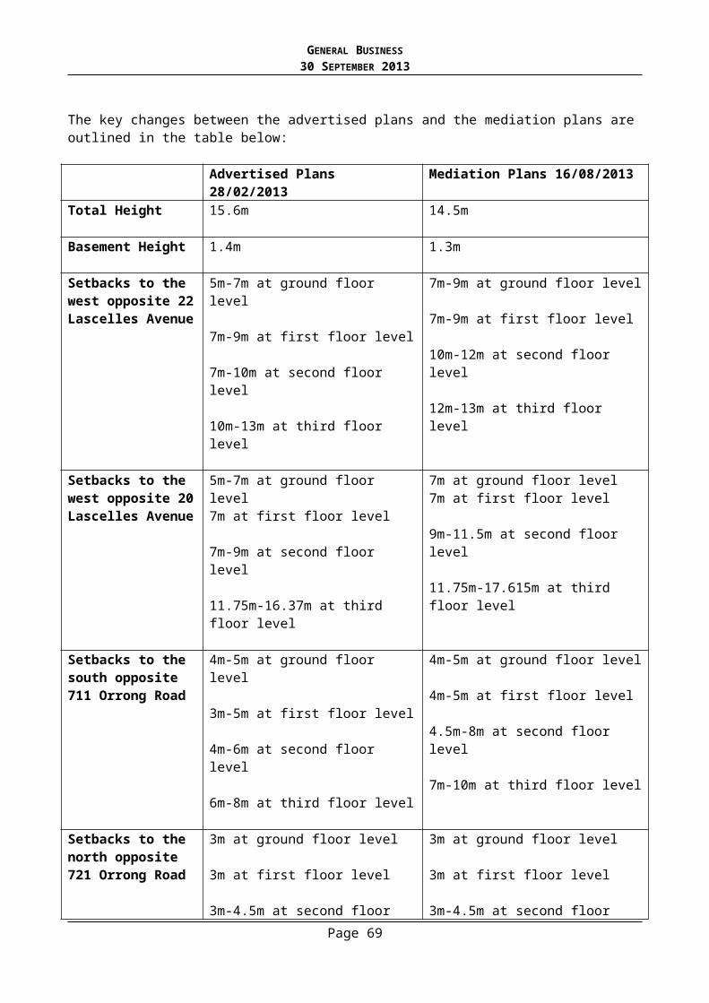
GENERAL BUSINESS30 SEPTEMBER 2013
Innovations Esure measures identified here provide an innovative approach, beyond standard practice.
Those currently identified represent standard practice in many cases.
Ongoing Building and Site Management Ensure this section reflects requirements in our SDAPP category.
As no fundamental issues have been identified by Council’s ESD officer it is recommended that a condition is included which requires SMP addressing the above matters.
Impact on Street Trees
In front of the site there are significant mature street trees. Council’s Arborist previously commented on these trees on the former application and advised that these trees will need to be protected during construction given the proximity of works to the trees. Whilst this was not formally commented on this time for this proposal, a discussion with Councils Arborists has confirmed that the street trees must be protected during construction. It is considered appropriate to apply Conditions requiring a Tree Management Plan and other measures to protect these trees.
Objections
In response to the grounds of objection not already discussed in the report, the following comments are made: TMP for the Queensland Brush Box located in the south west corner. It is considered
reasonable to ensure the protection of this tree by way of a permit condition. The development is 5-storeys not 4-storeys high – technically the development is 5-storeys
(any part of the basement over 1.2m is defined as an extra level). This is because a small section of the basement in the north west corner is 1.3m above NGL technically this part of the development is 5-storeys under the definitions outlined in the Planning Scheme. Notwithstanding this, most of the building is technically 4-storeys and the development would present as a 4-storey development. The point regarding 5-storeys is considered inconsequential in terms of the assessment of the proposal.
Human Rights Consideration
This application has been assessed in accordance with the requirements of the Planning and Environment Act 1987 (including the Stonnington Planning Scheme), reviewed by the State Government and which complies with the Victorian Charter of Human Rights and Responsibilities Act 2006.
CONCLUSION
Having assessed the proposal against the relevant planning controls, it is recommended that the proposal as outlined in mediation plans, Council date stamped 16 August 2013 be supported for the following reasons: The proposal address the key reasons for refusal of the previous proposal outlined in VCAT
Order P2987/2011 The proposed development has an appropriate relationship on the interfaces of the adjoining
properties and ensures the amenity of these properties is not unreasonably impacted upon. The proposal is consistent with the strategic direction outlined by the Stonnington Planning
Scheme. The sites location in close proximity to a large neighborhood activity centre (Toorak Village) and aligns with state and local polices for new housing to be located near activity centres.
Page 69
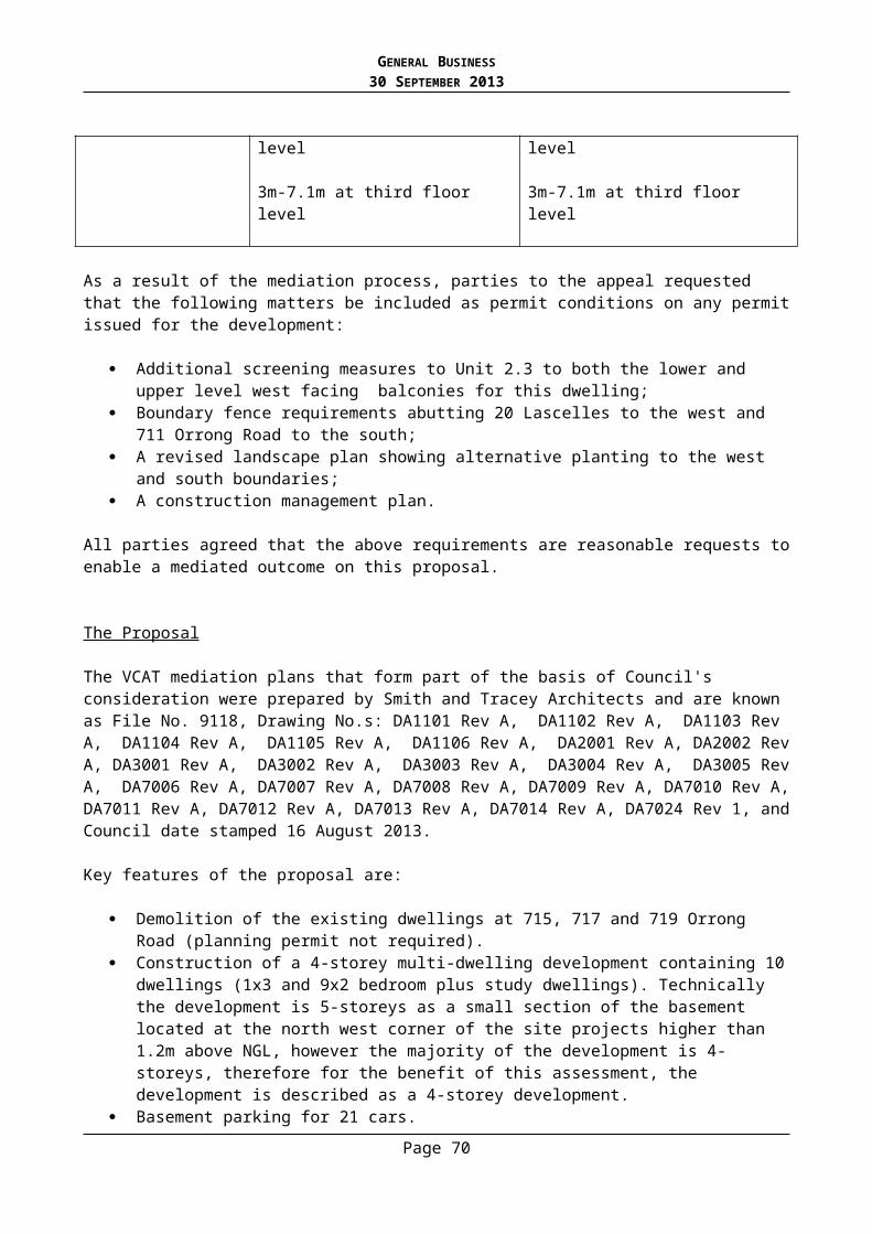
GENERAL BUSINESS30 SEPTEMBER 2013
The development is a high quality design that incorporates a range of forms and materials that present as a well articulated and visually interesting building both to the street and adjoining properties.
RECOMMENDATION
There are two recommendations. Recommendation ‘A’ is based on the Mediation Plans, Council date stamped 16 August 2013. Recommendation ‘B’ is based on the advertised plans Council date stamped 21 December 2012
Recommendation A - Mediation Plans
A. That Council advise VCAT and other interested parties that had a Failure to Determine appeal not been lodged, a Notice of Decision to Grant Planning Permit No: 940/12 would have been issued, based on the mediation plans Council date stamped 16 August 2013, for the land located at 715, 717 and 719 Orrong Road under the Stonnington Planning Scheme for the Construction of a Multi dwelling development on a lot within a Residential 1 Zone and associated reduction in the car parking requirements subject to the following conditions:
5. Before the development starts, three (3) copies of plans drawn to scale and fully dimensioned, must be submitted to and approved by the Responsible Authority. The plans must be generally in accordance with the VCAT mediation plans Council date stamped 16 August 2013 but modified to show:
a) Screening design measures to the following areas:i. West facing balcony of unit 2.3 at second floor level to limit downward
views to 20 Lascelles Avenue to the satisfaction of the Responsible Authority.
ii. A widened planter to the west facing portion of the balcony for unit 2.3 at third floor level to limit downward views to 20 Lascelles Avenue to the satisfaction of the Responsible Authority.
iii. Window of Bedroom 2 to Unit 1.3.b) Details of obscure glazing and / or privacy screening designed to limit
overlooking to neighbouring properties in accordance with the requirements of Standard B17 or an alternative design solution to the satisfaction of the Responsible Authority.
c) Details of the height and materials of the boundary fences as follows:i. New rendered fibre cement fence on the boundary with 20 Lascelles
Avenue to be constructed to the same height as the existing trellis fence on the boundary.
ii. New rendered fibre cement fence on the boundary with 711 Orrong Road to be a minimum 2.4m high above NGL to be constructed to the west of Unit G3 (starting from the car port of 711 Orrong Road moving west).
To the satisfaction of the Responsible Authority.d) A revised landscape plan showing modified planting to the western and southern
boundaries to the satisfaction of the Responsible Authority.e) A Sustainable Management Plan as required by Condition 8.f) A revised basement floor plan clearly showing a 0.5m space between the parking
bays in the tandem arrangement servicing units G.1 and G.2.g) Turning templates demonstrating that access can be provided to parking bays 09
and 10.
Page 70

GENERAL BUSINESS30 SEPTEMBER 2013
h) Wheel stops used where pedestrian access routes are provided behind parking bays, to ensure vehicles do not encroach into the pedestrian access route. This applies to bays 05, 06, 07, 08, and 09.
i) Dimensioned widths for the pedestrian routes at basement level. j) Bollards or a similar barrier be used in the lobby area between bays 10 and 11
and between bays 04 and 20 to prevent any parking occurring on the lobby extension.
k) The proposed minimum and maximum floor gradients of the parking area. l) Bicycle parking provision, in terms of amount of facilities, the type of bicycle
storage facility proposed, and all relevant dimensions to be shown on plan. m) Revised plans showing the headroom throughout the parking area with a
minimum headroom height of 2.2m at the lowest point. This includes at the car park entry door, measured to the lowest point with the door in the open position.
n) A convex mirror proposed at the access to be shown on plan. o) The proposed vehicle crossover is to be designed in accordance with Council’s
Vehicle Crossing Policy. The proposed crossover is to be clearly dimensioned on the revised plans, noting any existing features which may be affected.
6. The development allowed by this permit and shown on the drawings and/or schedules endorsed to accompany the permit shall not be amended for any reason without the consent of the Responsible Authority.
7. Prior to occupation, the landscaping works as shown on the endorsed plans must be carried out and completed to the satisfaction of the Responsible Authority. Landscaping must then be maintained to the satisfaction of the Responsible Authority, including that any dead, diseased or damaged plants are to be replaced.
8. Concurrent with the endorsement of development plans a Tree Management Plan prepared by a suitably qualified arborist must be submitted to and approved by the Responsible Authority. When approved, the Tree Management Plan will form part of this permit and all works must be done in accordance with the tree management plan.
The Tree Management Plan must detail measures to protect and ensure the viability of the Queensland Box Brush tree in the south west corner of the site and the mature street trees to the front of the site.
Without limiting the generality of the Tree Management Plan it must have at least three sections as follows:a) Pre-construction – details to include a tree protection zone, height barrier around
the tree protection zone, amount and type of mulch to be placed above the tree protection zone and method of cutting any roots or branches which extend beyond the tree protection zone.
b) Pre-construction works and any root cutting must be inspected and approved by the Parks Unit. Removal of protection works and cessation of the tree management plan must be authorised by Council’s Parks Unit.
c) During-construction – details to include watering regime during construction and method of protection of exposed roots.
d) Post-construction – details to include watering regime and time of final inspection when barrier can be removed and protection works and regime can cease.
e) The Tree Management Plan must include measures to protect the trees from the proposed connection to the substation and that this must be done by way of underground boring and not open trenching.
Page 71
GENERAL BUSINESS30 SEPTEMBER 2013
9. Before the development (including excavation and demolition) starts, a tree protection fence must be erected around the Queensland Box Brush tree and the street trees to the front of the site to define a ‘Tree Protection Zone’. The fence must be constructed of 1.8m high chain mesh to the satisfaction of the Responsible Authority. The tree protection fence must remain in place until all construction is completed. The ground surface of the Tree Protection Zone must be covered by a 100 mm deep layer of mulch before the development starts and be watered regularly to the satisfaction of the Responsible Authority.
10. No vehicular or pedestrian access, trenching or soil excavation is to occur within the Tree Protection Zone of the two street trees without the written consent of the Responsible Authority. No storage or dumping of tools, equipment or waste is to occur within the Tree Protection Zone.
11. Concurrent with the endorsement of plans, a Waste Management Plan must be submitted to and approved by the Responsible Authority. The Waste Management Plan must be generally in accordance with the Waste Management Plan submitted with the application by Leigh Design Pty Ltd dated 22 March 2013 but updated to reflect the changes to the plans dated 16 August 2013.
12. Concurrent with the endorsement of plans, a Sustainable Management Plan must be submitted to and approved by the Responsible Authority. The Sustainable Management Plan must be generally in accordance with the Energy Lab Sustainable Design Assessment submitted on 05/03/2013 but modified to show:a) A revised STEPS assessment for energy and peak energy to be improved by
specifying a higher rating for the gas hot water system or an alternative to the satisfaction of the Responsible Authority.
b) Specify whether energy meters will be provided to individual apartments.c) Any fixed indoor clothes drying facility must be marked on plans.d) Condensing systems for AC units must be marked on plans.e) Identify lighting type for car parking and common areas.f) Further information on the proposed rain garden must be provided
demonstrating compliance with Council’s draft Water Sensitive Urban Design policy.
g) Rainwater tanks must be annotated to show connection to the number of internal toilets identified by the STORM Rating Report and roof plans must show drainage area to be connected to the rainwater tank.
h) Details of permeable paving materials to be used in the developmenti) The type and number of bicycle facilities to be provided is clearly identified on
plans including identifying which spaces are allocated to be allocated to residents and which for visitors.
j) Ensure that strategies are identified for waste management at construction at operational phases and that specific targets are identified in the Sustainable Management Plan.
k) Measures to be taken to reduce impacts to existing site ecology, such as retention of major trees, or measures that have been taken to enhance site ecology such as the planting of mature trees, native and drought-tolerant species.
To the satisfaction of the Responsible Authority. Once approved, the development will be constructed and operated in accordance with the commitments outlined in the endorsed Sustainable Management Plan including any responsibilities for the ongoing management, maintenance and monitoring over the lifetime of the development.
Page 72
GENERAL BUSINESS30 SEPTEMBER 2013
13. Prior to the commencement of any buildings and works allowed by this permit the owner and/or developer must submit a Construction Management Plan to the satisfaction of the Responsible Authority. The Construction Management Plan must include details on how the construction will be undertaken so it has minimal impact on the environment. Details to be provided in the Construction Management Plan will include, but are not be limited to:a) Full work schedule/construction management plan for each individual stage to
ascertain impacts on surrounding properties;b) Public/worker access and safety issues;c) Hours of construction activity (including at what stage “out of hours works” are
proposed and what type of works are to be conducted outside the hours of operation;
d) The location of hoardings, hoists and workers amenities;e) The location of public precautions, loading zones, site sheds, materials, cranes
and crane/hoisting zones, gantries and any other construction related items or equipment to be located in any street;
f) Details as to how traffic and pedestrian safety and amenity will be controlled within the vicinity of the site and its surrounds;
g) The provision of a traffic management plan, including detailed plans that show all items to be placed on any street during all stages of construction in accordance with approval by the responsible Building Surveyor, entry and exit points for construction vehicles (including temporary and permanent vehicle crossings), traffic management during construction including road closures/road occupation/footpath closures, workzones/construction zones to accommodate vehicles and deliveries;
h) Service connections/road and footpath openings and anticipated impact on public land during the connection of different services;
i) Measures to be used to protect the Council infrastructure from damage;j) Existing services and environmental management;k) A list of all environmental hazards that the activities on-site pose ie;
contaminated soil, materials and waste, dust, stormwater contamination from run-off and wash-waters, sediment from the site on roads, construction noise, hours of operation, vibration, washing of concrete trucks and other vehicles and machinery, spillage from refuelling cranes and other vehicles and machinery etc;
l) Protection measures that will be undertaken to minimise the risk of the above hazards being realised;
m) Regular monitoring/inspections of the above protection measures; n) Identification as to who will be responsible for managing all of the above issues;
and o) Anticipated staging of the development.
The Construction Management Plan must be submitted to the Responsible Authority prior to commencing construction and all buildings and works must be carried out in accordance with the approved Construction Management Plan.
You may still be required to obtain separate permits under the Local Law from Council’s Building Control Services Unit for various construction activities.
14. All utility services to the subject land and buildings approved as part of this permit must be provided underground to the satisfaction of the Responsible Authority by completion of the development. Services must not run through the structural root zones of the street trees to the front of the site without the written consent of the Responsible Authority.
Page 73

GENERAL BUSINESS30 SEPTEMBER 2013
15. Prior to occupation of the building any existing vehicular crossing made redundant by the building and works hereby permitted must be broken out and re-instated as standard footpath and kerb and channel at the permit holders cost to the approval and satisfaction of the Responsible Authority.
16. The level of the footpaths must not be lowered or altered in any way to facilitate access to the site.
17. Any poles, service pits or other structures/features on the footpath required to be relocated to facilitate the development must be done so at the cost of the applicant and subject to the relevant authority’s consent.
18. Prior to the occupation of the building/ commencement of use, the walls on the boundary of the adjoining properties must be cleaned and finished to the satisfaction of the Responsible Authority.
19. Prior to the occupation of the building, privacy screens designed to limit overlooking as required in accordance with the endorsed plans must be installed to the satisfaction of the Responsible Authority and maintained to the satisfaction of the Responsible Authority thereafter for the life of the building.
20. A report for the legal point of discharge must be obtained from Council and a drainage design for the development must be prepared by a suitably qualified Engineer in accordance with that report prior to a building permit being issued. The drainage must be constructed in accordance with the Engineer’s design.
21. The project must incorporate the Water Sensitive Urban Design initiatives detailed in the endorsed site plan and/or stormwater management report.
22. This permit will expire if one of the following circumstances applies:
a) The development is not started within two years of the date of this permit. b) The development is not completed within four years of the date of this permit. The Responsible Authority may extend the periods referred to if a request is made in writing within the following timeframes:
c) Before or within 6 months after the permit expiry date, where the development allowed by the permit has not yet started; and
d) Within 12 months after the permit expiry date, where the development allowed by the permit has lawfully started before the permit expires.
NOTES
This permit does not constitute any authority to carry out any building works or occupy the building or part of the building unless all relevant building permits are obtained.
Nothing in the permit hereby issued may be construed to allow the removal of, damage to or pruning of any street tree without the further written consent of the Stonnington City Council. Contact the Council Arborists on 8290 1333 for further information.
The crossover must be constructed to Council’s Standard Vehicle Crossover Guidelines unless otherwise approved by the Responsible Authority.
Page 74
GENERAL BUSINESS30 SEPTEMBER 2013
The owners and occupiers of the dwellings hereby approved are not eligible to receive “Resident Parking Permits”.
RECOMMENDATION
Recommendation B - Advertised Plans
B. That Council advise VCAT and other interested parties that had a Failure to Determine appeal not been lodged, a Decision to Refuse Planning Permit No: 940/12 would have been issued based on the advertised plans Council date stamped 21 December 2012, for the land located at 715, 717 and 719 Orrong Road under the Stonnington Planning Scheme for the Construction of a Multi dwelling development on a lot within a Residential 1 Zone and associated reduction in the car parking requirements on the following grounds:
1. The proposed development, by reason of excessive building height and insufficient setbacks to the western, southern and northern boundaries, would result in a building that is excessively bulky, prominent and visually obtrusive when viewed from the abutting dwellings, to the detriment of the amenity of neighbouring properties and contrary to Clauses 15, 22.02, 22.06 of the Stonnington Planning Scheme.
2. The proposed development proposes excessive massing and bulk to the side and rear boundaries that are inconsistent with the scale and bulk seen in the neighbourhood, to the detriment of neighbourhood character and neighbouring amenity and contrary to Clauses 15, 22.02 and 22.06 of the Stonnington Planning Scheme.
3. The proposed development, by reason of unobstructed views from bedroom 2 of Unit 1.3 to the north facing habitable room window at 711 Orrong, would result in overlooking and a loss of privacy for neighbouring occupants of this dwelling, to the detriment of neighbouring amenity and contrary to Clauses 15 and 22.06 of the Stonnington Planning Scheme.
Page 75
GENERAL BUSINESS30 SEPTEMBER 2013
1.4. PLANNING PERMIT 0441/09 - 12 CUNNINGHAM STREET SOUTH YARRA – AMENDMENT TO THE EXISTING PLANNING PERMIT TO REMOVE CONDITIONS RELATING TO A PROPOSED GARAGE/STUDIO ADDITION AND RETROSPECTIVE APPROVAL FOR THE RELOCATION AND REDESIGN OF THE REAR BALCONY SCREENING AND ASSOCIATED SUPPORT STRUCTURE
(Statutory Planning Manager: Alexandra Kastaniotis)(General Manager: Stuart Draffin)
PURPOSE
For Council to consider a Section 72 amendment application to a Planning Permit and Plans to allow for removal of the proposed garage/studio addition, plus retrospective approval for the relocation and redesign of the rear balcony screening and associated support structure.
This item was considered at the Council meeting of 16 September 2013. The application is now re-presented to Council for further consideration.
Executive Summary
Applicant: Antony AleknaWard: NorthZone: Residential 1Overlay: Heritage Overlay No. 128Date lodged: 26/04/2013Trigger for referral to Council:
Councillor call up
Number of objections: 4Consultative Meeting: No Officer Recommendation: Notice of Decision to Amend Planning Permit and Plans
BACKGROUND
History of Planning Permit No.441/09
Planning application No.441/09 was lodged on 30th June, 2009 for the part demolition, alterations and additions to a dwelling on a lot less than 500m2 in a Heritage Overlay. The application was advertised in October, 2009 and two objections were received from the owner/occupiers at No.s 20 and 22 Oxford Street relating to:
Neighbourhood character Amenity Impacts Potential Future Development Impacts Potential Graffiti Impacts
A Notice of Decision to Grant a Permit was issued on 12th March 2010 under delegation. No appeals were lodged with the Tribunal and therefore Planning Permit No.441/09 was issued on 22nd April 2010. Plans were endorsed on 4th February 2011. The endorsed plans indicate the following screening measures:
Provision of a fixed screen to 1.7m above floor level attached to the first floor southern and eastern elevations of the first floor deck with no more than 25% transparency.
Page 76

GENERAL BUSINESS30 SEPTEMBER 2013
Provision of a fixed screen to 1.7m above floor level attached to the first floor north elevation with a maximum of 25% openings. This screen was to be constructed in “M1 – aluminium privacy screen louvres (charcoal)”. These northern screens project over the ground floor.
In August 2010, an amendment was lodged pursuant to Section 72 of the Act for the following:
Partially replace the existing garage with a double storey garage/studio addition. Construct the garage/studio addition to a maximum height of 6.15m above nominal
ground level. Modify the materials of the approved dwelling addition from timber and panel
cladding to off white render. Modify the material of the northern boundary fence to the secluded private open
space from panel cladding to off white render and aluminium frames Convert one north facing highlight window to two north facing highlight windows. Install a skylight and flue to the approved dwelling addition. Internal reconfiguration Install a new air conditioner on the existing dwelling
The amendment was advertised and two objections were received from the owner/occupiers at No’s 20 and 22 Oxford Street relating to:
Does not respect existing character Non compliance with ResCode Visual bulk Overlooking Inaccuracies on existing conditions plans Overdevelopment / Potential second dwelling Shed structure may be inadequate to support a second floor Location of air-conditioning plant Noise impacts Impact to existing street light on corner of Oxford Lane and subject site
A Notice of Decision to Grant an Amended Planning Permit was issued on 30th November 2011 under delegation subject to permit conditions 1j) and 1k). No appeals were lodged with the Tribunal.
Enforcement History
Concerns have been raised by objecting parties that the as built building does not comply with the plans in the following areas:
The building height of the approved development and whether or not it is generally in accordance with the endorsed plans;
The lack of permanent screening to the first floor north-facing habitable room windows; and The redesigned first floor balcony and support structure that has been constructed without
approval.
A site inspection revealed that a redesigned first floor balcony, pergola and screening in the first floor elevation has been constructed without planning approval. These works are the subject of this amendment application.
Page 77

GENERAL BUSINESS30 SEPTEMBER 2013
A second compliance issue relates to the lack of permanent screening for the first floor north elevation habitable room windows. Whilst temporary screening has been installed inside the windows, Council officers are currently in the process of requiring the owner to install the permanent screens in accordance with the endorsed plans.
A separate report is tabled at this meeting for Council to consider the compliance of the completed development approved under Planning Permit No.441/09. One of the compliance issues associated with the development is whether or not the building height is generally in accordance with the endorsed plans.The Proposal
This amendment request was lodged on 26th April, 2013 for the following:
Firstly, it is proposed to delete Condition 1(j) i-xii on the NOD for the Amended Planning Permit No.441/09 that states:
1j) The existing garage to be demolished and replaced with a garage/studio addition generally in accordance with Drawing No.s TP01, TP02-B, TP03-3, TP03-C to TP06-C, TP07, TP08, TP09, TP10-B to TP12-B Council date stamped 5th August 2011 showing:
i. The existing levels on the subject site to the satisfaction of the Responsible Authority.
ii. The demolition and replacement of the entirety of the existing garage to the satisfaction of the Responsible Authority.
iii. A new wall on the southern boundary to a maximum height of 3.08m to the satisfaction of the Responsible Authority.
iv. A new wall on the northern boundary to a maximum height of 5.95m to the satisfaction of the Responsible Authority.
v. A new wall on the eastern boundary to a maximum height of 5.95m to the satisfaction of the Responsible Authority.
vi. A reduction in the overall height of the proposed garage/studio to a maximum height of 5.95m above nominal ground level to the satisfaction of the Responsible Authority.
vii. The proposed first floor deck reduced in area to align with the first floor west facing walls of the studio to the satisfaction of the Responsible Authority.
viii. A solid screen on the northern elevation of the first floor deck fixed to a height of 1.7 metres above finished floor level to the satisfaction of the Responsible Authority.
ix. The proposed air-conditioning plant (if any) to be located on the southern elevation of the first floor studio.
x. All new walls to the proposed garage/studio to be sited within the Title Boundary.
xi. The proposed first floor deck to the studio to be fixed and screened in accordance with Standard A15 or a sight line diagram showing that there is no overlooking into No.10 Cunningham Street or No.20 Oxford Street from the first floor deck, to the satisfaction of the Responsible Authority
xii. Show the location of all proposed windows on the proposed floor plans to match the proposed elevation plans.
Page 78

GENERAL BUSINESS30 SEPTEMBER 2013
Secondly, the application seeks retrospective approval for the relocation and redesign of the rear balcony screening and associated support structure as described in Project No. A0088-1, Plan TP04-C& TP06-B Council date stamped 26th April, 2013 that proposes:
Construction of a pergola structure extending the length of the deck from the first floor east elevation to support the balustrade/screening of the deck. The structure includes four support vertical posts and four overhead angled support posts.
Provision of fixed 1700mm high screens on the north, east and south elevation of the first floor deck/balcony. The screens include horizontal battens with no more than 25% openings.
Site and Surrounds:
The subject site is located at 12 Cunningham Street, South Yarra, on the eastern side of the road reserve, approximately 41 metres south of the Oxford Street / Cunningham Street T-intersection. The site has the following significant characteristics:
The site is rectangular, measuring a frontage of 6.81 metres, a depth of 42.67 metres, and a site area of 290.61 square metres.
The site contains a single storey B graded dwelling with a two storey contemporary extension at the rear;
Oxford Lane abuts the site to the east, providing vehicle access and the north boundary abuts a right of way;
North of the laneway is the rear of properties at No.s 18, 20 & 22 Oxford Street.
The Title
The site is described on Certificate of Title Volume 5587 Folio 265 on Title Plan 24891N and no covenants or easements affect the land.
Planning Controls
Section 73(1) of the Planning and Environment Act 1987 states that Sections 47 to 62 apply to an application to amend a permit as if the application were an application for a permit and any reference to a permit were a reference to the amendment to the permit.
Therefore, the amendments to the permit and plans are to be assessed against the relevant planning controls affecting the proposal.
Note: Only the changes to the approved proposal are considered as part of this application for amendment.
The following controls/permit triggers are considerations for this application:
Residential 1 ZoneClause: 32.01
Pursuant to Clause 32.01-1, a planning permit is required for the construction of a dwelling on a lot less than 500 square metres. Furthermore, the Clause states that a development must meet the requirements of Clause 54.
Page 79

GENERAL BUSINESS30 SEPTEMBER 2013
Heritage Overlay HO128Clause:43.01
The site is affected by Heritage Overlay HO128 – Cunningham Street Urban Conservation Area. A permit is required to partially demolish a building and to construct a building or carry out works. Decision Guidelines area at Clause 43.01-5.
Particular ProvisionsClause 54 - One dwelling on a lot
A standard contains the requirements to meet the objective. A development must meet all of the objectives of this clause and should meet all of the standards of this clause.
Advertising
The application has been advertised pursuant to Section 52 of the Planning and Environment Act 1987 by sending notices to the owners and occupiers of adjoining land. The public notification of the application has been completed satisfactorily.
The site is located in North Ward and objections from 4 different properties have been received. The objections can be summarised as follows: Pergola
o Design compounds the visual bulk of the additiono The vertical posts and overhead beams create an additional obstruction of what is
left of views of the southern sky.o Structure looks poorly designed with cracking treated pine and no support braces
for the vertical postso Retrospective approval should not be approvedo Pergola is not a support structure for the balcony
Screening o Use of horizontal slat screening does not satisfy the requirement to avoid direct
views into private open space areas of No. 20 Oxford Street.o Use of horizontal slats do not fit in with the neighbourhood and was not agreed by
all partieso Screens fail standard A15 of Res Code as there is greater potential to view between
the slats into adjoining properties than previously approved louvreso Screens increase visual bulk as louvred screens have a softer appearanceo Screens do not comply with endorsed plans or Building Codeo Loss of privacy o Overlookingo Appearance
Balcony does not include stainless steel wire balustrade
Structural concerns with construction of pergola and the mounting plates overhanging the rear of the building 20 - 30mm
Conditions o Conditions should not be removed in relation to building heights, screening and air-
conditioning plant.
Concern development will limit future applications in area
Page 80

GENERAL BUSINESS30 SEPTEMBER 2013
Non complianceo Building height o Screens to north facing windowso Deck and pergola o Planning and Building Standards
KEY ISSUES
The assessment is limited to the decision guidelines at Clauses 32.01-3, 43.01- 4, 54, and 65 of the Scheme. This assessment is confined to the issues relating to the relocation and redesign of the rear balcony and screening, and removal of the conditions relating to an approved garage/studio addition at the rear of the property.
Heritage Overlay No.128 - Building and Works
The Heritage Guidelines highlight the importance of maintaining the character of the streetscape and ensuring the proposal will not adversely affect the heritage significance of the precinct through such factors as location, bulk, form and appearance of new works. The relocation and redesign of the rear balcony involves introducing a pergola like structure above the approved deck, locating the screening directly above the deck on the northern elevation (previously it projected beyond the balcony) and modifying the material of the screening from aluminium louvres to horizontal timber battens. These changes will not affect the significance of the heritage place given that the works are located to the rear of the dwelling and setback over 36 metres from Cunningham Street. It is also noted that the subject site is located on the edge of the Heritage Overlay Area and that part of the laneway running parallel to the rear half of the subject site is not included in the Heritage Overlay Area. As such, views from the Heritage Overlay Area are limited. Given this, it is considered that the proposal meets the purpose of the Heritage Overlay.
The second part of the assessment is based on how the proposal meets the relevant objectives and standards of Clause 54.
Clause 54.04-5 - Overlooking
The objective of Standard A15 is to limit not prohibit views into existing secluded private open space and habitable room windows.
The current endorsed plans indicate:
The southern and eastern sides of the first floor rear deck are to have fixed screens to 1.7 metres above floor level and no more than 25% transparent. The materiality of these screens has not been identified.
The northern elevation of the first floor rear deck is to have fixed screens to 1.7 metres above floor level and no more than 25% transparent, and they are to be constructed of “aluminium privacy screen louvers (charcoal)”.
This amendment application seeks to modify the above screening. The submitted plans indicate the provision of horizontal timber batten screening on the north, south and east elevations of the deck with a notation stating no more than 25% transparency.
Page 81
GENERAL BUSINESS30 SEPTEMBER 2013
The critical factor in assessing the suitability of the amended balcony design is whether the proposal will achieve the required level of screening in accordance with Standard A15 of Res Code.
Standard A15 requires that:
A deck “with a direct view into a habitable room window of existing dwelling within a horizontal distance of 9 metres (measured at ground level) of the window, balcony, terrace, deck or patio should be either:
Offset a minimum of 1.5 metres from the edge of one window to the edge of the other,or
Have sill heights of at least 1.7 metres above floor level, or Have obscure glazing in any part of the window below 1.7 metres above floor level, or Have permanently fixed external screens to at least 1.7 metres above floor level and
be no more than 25 per cent transparent.”
Screens used to obscure a view should be:
Perforated panels or trellis with a maximum of 25 per cent openings or solid translucent panels.
Permanent, fixed and durable. Designed and coloured to blend in with the development
The submitted plans propose the use of horizontal timber batten screens on the north, south and east elevation of the balcony. The screens are not angled to prevent downward views. However, the screens are shown to be fixed to 1.7 metres above floor level and no more than 25% transparent, which complies with the requirements listed above. The objectors consider the use of horizontal timber battens is unsatisfactory as it will allow a greater angle of view between the slats than the previously approved aluminium privacy screen louvers. It is considered that the horizontal timber battens affixed to the side of the balcony satisfies the requirements of Standard A15. It is not considered that the timber battens need to be angled to satisfy the overlooking requirement as the wording of the standard does not state that it has to be angled screening to achieve the 25% transparency requirement.
It is considered that the horizontal timber battens are in compliance with the above provisions of Standard A15 as they are permanent, fixed and durable, have a maximum of 25% openings, and are designed to blend in with the contemporary design of the addition.
Notwithstanding the above, it is relevant to note that Condition No. 1 (f) vii states:
The first floor bedroom/retreat and deck to be screened in accordance with Standard A15 so that there is no overlooking into the habitable room windows or private open space of the adjoining properties within 9 metres.
This condition is to be retained as part of Planning Permit No.441/09. There are two main parts to the above condition. As noted earlier the provision of horizontal timber batten screening on the north, south and east sides of the deck as described on the plans is considered to comply with Standard A15, which meets the first part of the condition. The second part of the condition requires screening to be in accordance with Standard A15 so that there is no overlooking of the adjoining properties within 9 metres. It is noted that the purpose of this condition was to limit unreasonable views into the secluded private open space of neighbouring properties within 9 metres.
Page 82
GENERAL BUSINESS30 SEPTEMBER 2013
The objectors consider that the horizontal timber batten screening as constructed will afford views between the spacing of the battens into their properties within a 9 metre radius.
Given the objections received from the residents to the north and the wording of the condition ‘as read’, it is considered that the north elevation of the deck should continue to be screened with ‘M1 – aluminium privacy screen louvers’ as per the originally endorsed plans. To be specific, the louvers are to be fixed to 1.7 metres above floor level, no more than 25% transparent and angled to prevent downward views. The appearance of the screening is to continue to be consistent with the screening approved to the north elevation windows. It is considered appropriate to allow the redesign of the screening so that it no longer projects beyond the deck.
The screening to the south and east sides of the deck as described on the plans is considered to meet the intent of the condition. It has not been confirmed on site if the screens as constructed are fixed to 1700mm high above finished floor level and no more than 25% transparent. Part B of this recommendation will ensure that the works as constructed comply with these requirements.
Removal of Condition No. 1(j)
The deletion of conditions relating to the approved garage/studio addition at the rear of the property can be supported. These works are no longer being pursued by the applicant.
The previous Officer report included analysis of the additions against the provisions of Clause 54 that resulted in the recommendation of a number of conditions to maintain privacy and amenity to abutting properties.
Condition No.1 (j) required amended plans to be submitted to ensure the works were in accordance with concept plans received on 5th August, 2011, were within the title boundary, and screening was provided to prevent overlooking.
Given these works are no longer being pursued, it considered reasonable to delete this condition from any amended permit.The objectors are concerned that condition No. 1(j) should be retained on the permit as it relates to the existing levels on the subject site. However, Condition No.1 (j) specifically relates to the construction of the replacement garage and the associated plans submitted on the 5th August 2011. This condition does not translate to the entire development.
Outstanding Issues
North Elevation Screening for the Dwelling
The endorsed plans indicate the north elevation includes “M1 – aluminium privacy screen louvres (charcoal)” to the first floor north elevation windows. It would appear that the word ‘louvres’ has been omitted from the advertised plans as submitted by the applicant for the current proposal.
This amendment is not part of the formal written request for amendments to the endorsed plans currently under consideration. This change is not being considered or supported. Therefore, the applicant will need to correct the plans to match the original endorsed plans requiring “M1 – aluminium privacy screen louvres (charcoal)” to the first floor north elevation windows.
Finishes
The previous amendment included the following modifications to the approved dwelling addition in accordance with condition 1(k) of the planning permit.
Page 83

GENERAL BUSINESS30 SEPTEMBER 2013
Modify the materials of the approved dwelling addition from timber and panel cladding to off white render.
Modify the material of the northern boundary fence to the secluded private open space from panel cladding to off white render and aluminium frames
Convert one north facing highlight window to two north facing highlight windows. Install a skylight and flue to the approved dwelling addition. Internal reconfiguration Install a new air conditioner on the existing dwelling
The endorsed plans have not been updated to comply with Condition No.1(k).
It has been identified during the advertising of this amendment application, that the dwelling has been completed with the modified materials listed above. However, the endorsed plans and the subsequently advertised plans continue to show the first floor to be constructed with timber panelling. Any plan to be endorsed as part of the approval of this current amendment application must be corrected so as to also comply with condition 1(k).
Objections
In response to the grounds of objection not already discussed in the report, the following comments are made:
Pergola – Visual Bulk – It is not considered that inclusion of pergola over the first floor balcony with screening will significantly increase the bulk and scale of the dwelling at the rear of the site given the originally endorsed plans also included privacy screens that would have had some impact in the building form at the rear of the dwelling. In addition, it was deemed appropriate to support a two storey garage/studio addition at the rear. Given that the garage/studio addition is no longer being pursued, the resultant change to visual bulk is acceptable.
Views - Whilst it is recognised that views may form part of residential amenity, there is no specific controls within the Stonnington Planning Scheme that protects residents’ rights to a view. It is not considered that the extent of views lost by the construction of the four posts of the pergola and screening would warrant refusal of this request for amendment.
Structural Integrity of Pergola – The construction of the decking/pergola must comply with the relevant Building regulations.
Building height – Refer to the associated item discussing the issue elsewhere in this agenda.
Human Rights Consideration
This application has been assessed in accordance with the requirements of the Planning and Environment Act 1987 (including the Stonnington Planning Scheme), reviewed by the State Government and which complies with the Victorian Charter of Human Rights and Responsibilities Act 2006.
CONCLUSION
Having assessed the application against the relevant planning controls, it is recommended that the proposal be supported for the following reasons:
The bulk, scale and siting of the deck and pergola structure is acceptable. The amendment to the balcony screening complies with the requirements of Standard A15 of
the Stonnington Planning Scheme. The deletion of Condition No.1 (j) is no longer required as the construction of the
garage/studio addition is not being pursued.
Page 84

GENERAL BUSINESS30 SEPTEMBER 2013
The north elevation of the deck to be provided with ‘M1 – aluminium privacy screen louvers’.
RECOMMENDATION
A. That a Notice of Decision to Amend Planning Permit No: 0441/09 for the land located at 12 Cunningham Street, South Yarra be issued under the Stonnington Planning Scheme to remove conditions for the Planning Permit and plans relating to the proposed garage/studio addition, plus retrospective approval for the relocation and redesign of the rear balcony screening and associated support structure subject to the following:
1. Delete Condition 1 (j) i to xii
2. Amend the plans generally in accordance with plans as described in Project No. A0088-1, Plan TP04-C& TP06-B Council date stamped 26th April 2013, showing:
Construction of a pergola structure extending from the first floor east elevation to support the balustrade/screening of the deck. The structure includes four support vertical posts and four overhead angled support posts.
Provision of fixed 1700mm high screens that include horizontal battens with no more than 25% openings on the east and south elevation of the deck/balcony.
Provision of ‘M1 - Aluminium Privacy Screens – Charcoal’ to the north elevation of the deck/balcony that are fixed to 1700mm high above finished floor level, no more than 25 transparent and angled to prevent downward views.
Correction of anomalies on the plans:
The screening to the north elevation habitable room windows to match the existing endorsed plans (M1 - Aluminium Privacy Screens – Charcoal).
The plans and elevations for the dwelling to comply with condition 1(k) as appropriate.
B. That the amended plans in reflection of Part A of the Resolution be submitted to Council within 28 days of this decision and that the works required to comply with the endorsed plans be undertaken within 90 days of the endorsed plans being issued.
Page 85

GENERAL BUSINESS30 SEPTEMBER 2013
1.5. PLANNING PERMIT 441/09 – 12 CUNNINGHAM STREET SOUTH YARRA – REVIEW OF COMPLETED DEVELOPMENT
(Statutory Planning Manager: Alexandra Kastaniotis)(General Manager: Stuart Draffin)
PURPOSE
For Council to consider the compliance of a completed development approved under Planning Permit 441/09 at 12 Cunningham Street, South Yarra.
This item was considered at the Council meeting of 16 September 2013. The application is now re-presented to Council for further consideration.
Executive Summary
Ward: NorthZone: Residential 1Overlay: Heritage Overlay 128Trigger for referral to Council:
Councillor call up
Officer Recommendation: That the report be noted
BACKGROUND
Application historyThis site and its recent development has been the subject of ongoing planning compliance questions. This report outlines the planning history associated with the development of the site, the planning compliance questions and the Officer assessment of these issues.
Planning application 441/09 was lodged on 30 June 2009 for part demolition, alterations and additions to a dwelling on a lot less than 500sqm in a Heritage Overlay. The works consisted of a two storey extension to the rear of the existing dwelling. The extension consisted of an open plan kitchen/dining/living area at ground floor and 3 bedrooms at first floor.
The application was advertised in October 2009 and Council received two objections. The objections were from 10 Cunningham Street and 20 Oxford Street. The objections raised concerns with neighbourhood character, amenity impacts, future development impacts and graffiti concerns.
Following assessment of the application, a Notice of Decision was issued on 12 March 2010 under delegation. No appeals were lodged with the Victorian Civil and Administrative Tribunal (VCAT) and consequently, Planning Permit 441/09 was issued on 22 April 2010.
The Planning Permit contained a number of conditions requiring further detail of parts of the existing dwelling to be demolished, changes to the floor plans to reflect revisions that were sent to Council during the assessment process and screening measures to ensure no unreasonable overlooking.
Plans were endorsed to form part of the Permit on 4 February 2011.
Page 86

GENERAL BUSINESS30 SEPTEMBER 2013
The applicant lodged an amendment application pursuant to Section 72 of the Act in conjunction with the plans submitted for endorsement. This amendment sought permission to construct a double storey garage/studio at the rear of the site, amend the finishes of the dwelling extension and undertake minor internal works.
The amendment application was advertised in December 2010 and Council received two objections similar to those raised to the original application.
A Notice of Decision to Amend a Permit was issued on 30 November 2011 under delegation. No appeals were lodged with VCAT.
A further amendment to the permit was lodged on 26 April 2013 for retrospective approval for a first floor balcony/pergola structure at the rear of the dwelling. This application is currently being assessed by Council officers and will be presented to Council at its meeting on 30 September 2013.
Site and Surrounds
The subject site is located on the eastern side of Cunningham Street, South Yarra, approximately 140m south of Toorak Road and 110m east of Chapel Street. The site has the following significant characteristics:
The site is rectangular with a frontage width of 6.81 m, a depth of 42.67m and a site area of 290sqm.
Oxford Lane abuts the site to the east and an unnamed lane abuts the site to the north. The site contains a single storey B-graded dwelling with a two storey contemporary
extension at the rear. North of the laneway at 22 Oxford Street is the property owned and occupied by the
residents who have concerns towards possible non-compliance of the approved development.
The Title
The site is described on Certificate of Title Volume 5587 Folio 265 as Lot 1 on Title Plan 24891N. No covenants or easements affect the land.
Planning Controls
The following controls/permit triggers were considerations for this application:
ZoneClause 32.01 – Residential1 ZonePursuant to Clause 32.01-1 a planning permit was required to construct or extend a dwelling on a lot less than 500sqm.
Over/ay(s)Clause 43.01 – Heritage OverlayPursuant to Clause 43.01-3 a planning permit was required to partially demolish a building and to construct a building or construct or carry out works.
Particular ProvisionsClause 54 – One dwelling on a lotA development must meet the Objectives of this Clause.
Page 87

GENERAL BUSINESS30 SEPTEMBER 2013
KEY ISSUES
There are three key compliance issues associated with this development:
The building height of the approved development and whether or not it is generally in accordance with the endorsed plans;
The lack of permanent screening to the first floor north-facing habitable room windows; and The redesigned first floor balcony and support structure that has been constructed without
approval.
Building Height
The extension was approved at a maximum building height of 7m as noted in the Delegate’s report of 11 March 2010.
In late 2011, the owner/occupier of 22 Oxford Street initially raised concerns with Council Enforcement Officers that the constructed development height was taller than what was shown on the endorsed plans. The complainant believed that the approved development height was 6.6m. However, the officer report and endorsed plans indicated the approved development height was to be 7m, not 6.6m as alleged by the complainant.
Council’s Enforcement Officer reviewed the height of the constructed development and confirmed it was built at 7m and therefore in accordance with the endorsed plans. Despite this, the complainant has maintained that the development was not compliant with the plans. Council officers reiterated previous advice that the development had been built in accordance with the endorsed plans.
In April 2012, the complainant reiterated his concerns in relation to the building height. Council Officers provided a further response in May 2012 to the same effect as previously.
In August 2012, Council Officers remeasured the development and advised the complainant that it appeared the development might not comply with the endorsed plans. The permit holder was then advised to either; undertake additional survey quality information to show compliance with the endorsed plans, modify the building to bring it into compliance with the endorsed plans or lodge an amendment for Council to consider the building as built.
No response was received from the permit holder and no amendments to the plans were requested by the permit holder. Following this, Council engaged Reeds Consulting in November 2012 to undertake surveys of the building to assess its compliance with the endorsed drawings, specifically in regard to the building height concerns.
The matter is further clouded by the poor quality of the plans. There are no NGL, AHD or RL points to use as reference points as the endorsed plans contain internal floor to ceiling levels. Given the poor quality of the plans, Reeds Consulting determined the building heights by measuring the internal floor to ceiling levels. In their correspondence to Council they advised that "NGL can be a hard level to determine, particularly after a development has taken place .... Therefore, without a known relationship to NGL prior to the development taking place, we believe any current comparison of the building to the current NGL is a flawed comparison."
The advice from Reeds Consulting indicated that there are minor discrepancies in the height of the as built development when compared to the endorsed plans. On the north elevation, the ground floor parapet is 2cm higher than the design and the first storey parapet has been built 7cm higher than the design shown on the endorsed plans.
Page 88
GENERAL BUSINESS30 SEPTEMBER 2013
The complainant questioned this advice and how the measurements were undertaken. In January 2013, Reeds provided further advice at the request of Council. This reiterated their initial advice and further noted that their measurements were undertaken by establishing a Temporary Bench Mark (TBM) and measuring the internal floor levels connected to these TBMs. They provided the following table comparing the heights of the as built extension (from the internal ground floor level to the ground and first floor parapets) in comparison to the endorsed plans:
Endorsed Plans SurveyGround Storey 3.40m 3.42mFirst Storey 6.60m 6.67m
As can be seen from the table, the height difference between the endorsed plans and the survey commissioned by Council is negligible.
These discrepancies were considered to be minor and deemed to be “generally in accordance” with the endorsed plans based on the surveyors advice. Council again notified the complainant that it considered that the building had been constructed in accordance with the endorsed plans and that no further action would be pursued by Council. Advice was also provided that the matter could be further pursued at the Victorian Civil and Administrative Tribunal via the review provisions of Section 149A of the Planning and Environment Act 1987 should the complainant disagree with Council’s assessment.
As noted in the Delegate’s report for the original application, the building height was approved at 7m. The 6.6m measurement is in actual fact, the measurement of the internal floor level of the ground to the parapet level, not an external measurement of the building height. The building surveyor for the project confirmed this in a letter to the Building Commission dated 7 March 2012.
In April 2013 the complainant disagreed with Council’s advice and advised he would undertake an independent survey of the building. The survey commissioned by the complainant produces significantly different levels to those provided to Council by Reeds Consulting.
The survey information provided by the complainant appears to incorrectly assume that the dark line on the endorsed elevation is natural ground level and compares the levels of the lane to internal floor levels for the development. Furthermore, there is no information other than a hand drawn sketch and spot levels, so it is impossible to determine whether the base of the complainant’s elevation is the laneway, the bluestone kerb sitting above the laneway or the altered ground levels inside the property at 12 Cunningham Street. It is for this reason that Reeds Consulting advised a more accurate comparison must be undertaken from the internal floor levels as that is the only information provided on the endorsed plans.
It is considered that the building height of the extension is generally in accordance with the endorsed plans for Planning Permit 441/09 and that no further action should be pursued on this matter.
Screening
Having regard to the screening non-compliance, the owner has placed temporary screens within the first floor elevation windows. These screens have been in place well after occupation of the development. Council Enforcement Officers are in the process of ensuring the owner of 12 Cunningham erects permanent screens as shown on the endorsed plan should the landowner fail to positively respond to the compliance request.
Page 89

GENERAL BUSINESS30 SEPTEMBER 2013
Additional works without permission
It is further noted that the owner has constructed a first floor balcony and associated structure that was not shown on the endorsed plans.
The landowner has applied for an amendment to the approved plans under Planning Permit 441/09 seeking retrospective approval to allow for the redesign of the rear first floor balcony/pergola screening and retention of the associated support structure. It also proposed to remove conditions related to a proposed garage/studio addition that is no longer being pursued. In essence, the proposal seeks to allow the retention of the screening and support structure on the balcony as constructed.
This amendment application is the subject of a separate report on this agenda and will be considered by Council at its meeting of Monday 30 September 2013.
Human Rights Consideration
This application has been assessed in accordance with the requirements of the Planning and Environment Act 1987 (including the Stonnington Planning Scheme), reviewed by the State Government and which complies with the Victorian Charter of Human Rights and Responsibilities Act 2006.
CONCLUSION
Having assessed the compliance issues, it is recommended that the following occur:
No further action be pursued in relation to the building height as it is considered that the extension has been built generally in accordance with the endorsed plans.
Council Officers pursue the non-compliance in relation to the screening. Council assesses the amendment application for the illegal structure at the rear first floor.
RECOMMENDATION
That Council note this report for Planning Permit 441/09 at 12 Cunningham Street, South Yarra and that:
1. No further action be pursued in relation to the building height as it is considered that the extension has been built generally in accordance with the endorsed plans.
2. Council Officers pursue the non-compliance in relation to the screening.3. Council assesses the amendment application for the illegal structure at the rear first
floor.
Page 90

GENERAL BUSINESS30 SEPTEMBER 2013
1.6. PLANNING APPLICATION 0056/76 - 489 - 505 TOORAK ROAD TOORAK - RETROSPECTIVE APPROVAL FOR A WASTE BIN STORAGE STRUCTURE
(Statutory Planning Manager: Alexandra Kastaniotis)(General Manager: Stuart Draffin)
PURPOSE
For Council to consider a planning application for a Section 72 amendment application to a Planning Permit and plans to allow for the provision of a waste bin storage structure at 489 – 505 Toorak Road, Toorak.
This item was considered at the Council meeting of 16 September 2013. The application is now re-presented to Council for further consideration.
Executive Summary
Applicant: Lester TrickeyWard: NorthZone: Business 1Overlay: Design and Development Overlay Schedule 9 Date lodged: 19/04/2013Statutory days: (as at council meeting date)
122
Trigger for referral to Council:
Councillor Call Up
Number of objections: 1Consultative Meeting: NoOfficer Recommendation: Refusal to Grant a Planning Permit
BACKGROUND
The Proposal
The plans that form part of the basis of Council's consideration were prepared by the applicant and are known as File No. 56/76, Drawing No’s: Sheet 1 of 1 Council date stamped 19th April 2013 and photos.
Key features of the proposal are:
Retrospective amendment to the plans to allow for the provision of a waste bin storage structure on a landscaped median strip within the car park at the rear of the property.
The structure is metal, with corrugated roofing and part corrugated screening on the northern facade. It has the capacity to house approximately 18 x 240L bins.
The application does not propose changes to the conditions.
Should the amendment application be approved, it is considered that the permit will need to be amended to modify condition 3 and 7 which currently state:
Page 91

GENERAL BUSINESS30 SEPTEMBER 2013
Condition 3: “The area set aside for the parking of vehicles and so delineated on the endorsed plan shall be made available for such use and shall not be used for any other purpose and at all times in conformity with such plan there shall be clearly indicated on the ground the boundaries of all such car spaces and access lanes and direction in which vehicles should proceed along the access lanes.”
Condition 7: “Garden Areas shown on the endorsed plan shall be landscaped and maintained at all times to the satisfaction of the Responsible Authority.”
Site and Surrounds
The site is located on the northern side of the road reserve, approximately 95 metres west of Grange Road. The site has the following significant characteristics:
The site is zoned Commercial 1 and is affected by a Design and Development Overlay (Schedule 9)
The site has two access points, from Toorak Road (front) and from Jackson Street (rear). The land is irregular in shape with a total area of approximately 2593sqm, including a
frontage of 38.57m to Toorak Road and a frontage of 27.64m to Jackson Street. The site is located in the Toorak Village Commercial Precinct. The land is currently used as a mixed use development in line with Planning Permit
No.56/76. The land is developed with a two storey building, comprising two parallel shopping arcades
known as ‘The Village Way’ and ‘The Village Walk’. A large car park is located to the north (rear) of the building, accessed from Jackson Street. With specific regard to this proposal, the new bin store area is proposed on a median strip
between two car parking aisles, near the eastern boundary of the car parking (northern) section of the site.
Surrounding land includes:
Adjoining to the southwest and southeast the land is zoned Commercial 1. These sites comprise shops and offices fronting Toorak Road.
Adjoining to the northwest at 22 Jackson Street, the land is zoned Public Use Zone 6 and the site is developed with a Council owned public car park.
To the north, on the other side of Jackson Street, the land is zoned Residential 1. Immediately to the north at 19 – 21 Jackson Street, the site is developed with an education centre.
To the northeast at 28-30 Jackson Street, the land is zoned Commercial 1 and the site is developed with a seven storey residential building (retirement living) and public car park. At ground level, the interface with the proposed bin store area is that of a pedestrian access ramp which is located adjacent a vehicle ramp. At first floor level, the interface with the proposed bin store area is that of two open terraces which abut the title boundary and serve as open space for Apartments 1.04 and 1.05 respectively.
Page 92

GENERAL BUSINESS30 SEPTEMBER 2013
Previous Planning Applications
A search of Council records indicates the following relevant planning applications:
Planning Permit No. 56/76, which is the permit that is the subject of this amendment application, was issued on 17th June 1976 for buildings and works for the purposes of shops, offices and associated car parking.
Planning Permit No.558/02 was issued by VCAT on 3rd March 2004 for the subdivision of the land. In total 46 principle lots and 41 associated car parking lots were created.
Planning Permit No.734/05 was issued VCAT on 26th June 2004 for the subdivision of the land. The application was refused by Council as it was deemed to contravene the permits listed above. VCAT set aside Council’s decision and approved the application.Planning Permit 734/05 allowing the subdivision of the site and requires the car parking spaces to be open to the general public during the following minimum hours:
i. Monday to Wednesday 7.00am to 8.00pmii. Thursday 7.00am to 10.00pmiii. Friday 7.00am to 2.00am the following day.iv. Saturday 8.00am to 2.00am the following day; andv. Sunday 8.00am to 8.00pm.
Planning Permit No.509/12 was issued under delegation for buildings and works to a mixed use development to allow for a lift at the rear of the building and the relocation of two car spaces.
The Title
The site is currently contained in Title Volume 11006 Folio 210 known as the land in plan of consolidation 105501. The application specifically affects the area titled common property No.2.
No covenants or easements affect the proposal.
Planning Controls
The following controls/permit triggers are considerations for this application:
Commercial 1 ZoneClause 34.01
Pursuant to Clause 34.01-4 a permit is required to construct a building or construct or carry out works. All buildings and works must be maintained in good order and appearance to the satisfaction of the responsible authority.
Overlay(s)
Design and Development Overlay (Schedule 9)Clause 43.02
Pursuant to Clause 43.02 and the schedule a permit is required to construct a building or construct or carry out works.
Relevant Planning Policies
Clause 34.01 Commercial 1 Zone
Page 93
GENERAL BUSINESS30 SEPTEMBER 2013
Clause 43.02 Design and Development Overlay Schedule 9
Advertising
The application has been advertised pursuant to Section 52 of the Planning and Environment Act 1987 by sending notices to the owners and occupiers of adjoining land. The public notification of the application has been completed satisfactorily.
The site is located in North Ward and one objection has been received. This can be summarised as follows:
Failure to follow comply with Council's Rules and Regulations (unauthorised, illegal addition)
Failure to notify residents prior to construction Structure does not meet Council's requirement Visual amenity impact - Unit overlooks the Car Park and Bins
Referrals
WasteCouncil’s Waste Coordinator has advised that the application can be supported for several reasons:
This application attempts to bring the development into conformance with the City of Stonnington Local Law 2008 (No.1) Clause 900 (2) which states:
“The owner of commercial and residential land on which there are more than one premises must:
a) Construct on the land an area for the storage of waste receptacles; andb) Ensure that the area constructed is screened from view and maintained in a clean and
sanitary condition.”
Seemingly no consideration had been made for the storage of waste receptacles when this development was originally devised, approved or built.
It is understood that once this oversight was realised (in the 1970’s), Council provided – and still provides today – waste receptacles in the adjoining Council owned public car park for tenants of the subject development to dispose of their wastes. In providing a storage area for waste bins on their own land Council can permanently remove the waste receptacles from the adjoining public car park. Participating traders will then have Council provided waste services at a level equitable with all other traders within the municipality.
Council’s Waste Coordinator has also advised that any approval should be conditional on the submission and approval of a successful Waste Management Plan (WMP), including specifically:
how the bin population will be managed within the store; directions on how traders will correctly disposed of their wastes; how bins will be collected – including the frequency of, and how they will be presented for,
collection; the protocol and frequency of housekeeping, including litter collection and the removal of
illicitly dumped wastes; and, how the amenity of the local vicinity will be maintained.
Page 94

GENERAL BUSINESS30 SEPTEMBER 2013
The Waste Management Plan will also include explicit instruction that ensures continual compliance with the Stonnington Local Law.
Transport and Parking
Council’s Senior Transport Engineer had the following concerns with the proposal:
If the car park was fully occupied, it would be difficult or impossible to move the bins. Typically where access is provided from within a parking bay, it is generally only
appropriate if the area accessed is allocated to the same user as the affected parking bay. It is understood this is not the case in the presented example, and as such would generally be deemed unsatisfactory.
Council’s Transport Engineer has also advised that there is potential for the bin store to be struck by overhanging vehicles. It was noted that there are wheel stops and the bin store is set back from the kerb, so this is likely only a concern for large vehicles, possibly with tow bars or bullbars.
If the proposed bin store area had been included in this location in a new development, Transport and Parking would raise a concern regarding the access to the storage area.
Council’s Senior Transport Engineer has advised that the bin store should be removed from this location if possible. It was further noted that the removal of car parking bays to provide access to the bin store area will not be supported under any circumstances.
Arborist
Council’s Arborist has advised that the location of the bin storage area will not have any detrimental effect on the health of the two mature Platanus x acerifolia (London Plane) trees located within the median strip.
Health
Council’s Environmental Health Officer has advised that approximately one year ago a health inspection determined that all food shops in this shopping complex must be provided with an individual cleaners’ sink or a bin wash area, or alternatively a communal bin wash area must be provided. Following discussions with the landlord, Council’s Environmental Health Officer advised that a communal bin wash area should be provided in a suitable area, usually at the rear of the site with convenient access away from the public. This area could be internal such as in a toilet block or near a stairwell provided it is closed off from public access.
Council’s Environmental Health Officer has advised that the current location was never recommended or endorsed by Council’s Health Department. The current location is not considered appropriate because of the potential negative impacts to the public, including from the smell or appearance of any rubbish. In addition, the public access to this location often results in the dumping of rubbish in this location and other behaviour such as people urinating in this area, which would adversely impact on the amenity of the neighbourhood.
Following a complaint from surrounding residents, Local Laws commenced enforcement proceedings on this matter.
Page 95

GENERAL BUSINESS30 SEPTEMBER 2013
KEY ISSUES
This application seeks retrospective approval for a waste bin storage structure that was recently erected on one of the landscaped median strips at the rear of the property. The structure was built predominantly to provide weather protection as well as in part screening to a number of bins that are now stored on the landscaped median strip. The landscaped median strip contains two mature trees and is bordered by car spaces either side. The bins are accessed through the car spaces, via ramps that have been located in three areas affecting five car spaces.
Following a complaint from surrounding residents relating to the sight and smell of waste, Council’s Local Laws Department commenced enforcement proceedings on this matter. It was determined that planning approval was required for the structure and that a Planning Permit Amendment was required to Planning Permit No.56/76.
Planning Permit No.56/76 was issued on 17th June 1976 for the land at 489-505 Toorak Road, Toorak, to allow for buildings and works for the purpose of Shops, Offices and Associated Car Parking. Notably, the endorsed plans do not show the location of waste storage areas and there are no conditions relating to waste management or collection. The applicant has advised that the waste storage area was previously located next to the stairs west of the site, however they have been relocated due to fire safety regulations and due to Council’s request for a bin wash down area.
As noted in the referrals section earlier, Council’s Environmental Health Officer undertook a health inspection at the premises last year and determined that all food shops in this shopping complex must be provided with either: an individual cleaners’ sink or a bin wash area, or alternatively a communal bin wash area. It was also advised that these types of food premises were always required to be provided with some form of a wash down facility, but for an unknown reason none were installed in the development. The current location of the waste bin storage structure was never recommended or endorsed by Council’s Health Department.
The current location of the waste bin storage structure is considered to contravene conditions 3 and 7 of Planning Permit No.56/76 which currently states:
Condition 7: “Garden Areas shown on the endorsed plan shall be landscaped and maintained at all times to the satisfaction of the Responsible Authority.”
Condition 3: “The area set aside for the parking of vehicles and so delineated on the endorsed plan shall be made available for such use and shall not be used for any other purpose and at all times in conformity with such plan there shall be clearly indicated on the ground the boundaries of all such car spaces and access lanes and direction in which vehicles should proceed along the access lanes.”
The applicant has advised that the bins are used for recycled waste only and no food waste. In addition, the applicant has advised that the bins are taken out to the Toorak Road frontage every Wednesday evening by the tenants of the shops after clearway times have commenced so that Council trucks can collect the rubbish from that frontage and the bins are then stored back in their location the next morning at times when the car spaces are usually vacant.
Notably, the built form of the structure is not of concern. Although, there are a number of balconies and habitable room windows overlooking the waste area from the residential building at 28 – 30 Jackson Street, the structure will appear alongside a high wall on the eastern boundary of the subject site, which is to the seven storey residential building.
Page 96

GENERAL BUSINESS30 SEPTEMBER 2013
It is the associated waste storage and collection that is concerning. It cannot be guaranteed that the associated use will not result in detrimental amenity impacts to the neighbourhood or to the operation of the car park. Although the rubbish bins themselves do have locks on them, the waste area remains open to the public and the bins must be manoeuvred between vehicles. In considering the request for retrospective approval for the location of the waste bin storage structure, the Stonnington Planning Scheme advises that Council must have regard to the decision guidelines at Clause 34.01-8 (Commercial 1 Zone) as appropriate:
- The movement of pedestrians and cyclists, and vehicles providing for supplies, waste removal, emergency services and public transport.
- The provision of car parking.- The streetscape, including the conservation of buildings, the design of verandahs, access
from the street front, protecting active frontages to pedestrian areas, the treatment of the fronts and backs of buildings and their appurtenances, illumination of buildings or their immediate spaces and the landscaping of land adjoining a road.
- The storage of rubbish and materials for recycling.- Defining the responsibility for the maintenance of buildings, landscaping and paved areas.
Council’s Waste Management Coordinator has no concerns with the proposal, subject to the submission and approval of a successful Waste Management Plan (WMP). This could enable Council to remove waste receptacles in the adjoining Council owned public car park.
Council’s Arborist has raised no concerns with the proposal. It is not expected that the structure will negatively impact on the two mature trees located in the landscaped median strip, however there will be a loss of greenery to this area.
Council’s Health Officer is not supportive of the proposal. Council’s Health Officer considers that the location is inappropriate because it is located at a considerable distance from the food premises in the development and the waste area is open to the public which is likely to attract the dumping of rubbish and other inappropriate behaviour.
Council’s Transport and Parking Officer is generally not supportive of the proposal. Council’s Transport and Parking Officer is concerned with the impact of the proposal on operation of the car park.Having regard to the decision guidelines listed earlier, it is considered that the proposed waste bin storage structure is unacceptable and will unreasonably impact on the amenity of the area for the following reasons:
The design and location of the bin storage structure may unreasonably impact on the amenity of the area due to the associated sight and smell of waste.
The location of the bin storage structure will result in the loss of landscaped areas. The location of the bin storage structure impacts on the area set aside for parking, due to
the potential for larger vehicles striking the structure. The location of the bin storage structure requires bins to be manoeuvred through car
spaces, which has the potential to scrape cars parked in the parking bays. The design of the bin storage structure allowing the waste area to be accessible to the
public has the potential to attract unsightly dumping of rubbish and other undesirable behaviour.
On balance, the waste storage area and management is inadequate and unresolved. Given the above, it is considered that the location of the waste bin storage structure cannot be supported in the current form.
Page 97

GENERAL BUSINESS30 SEPTEMBER 2013
It is recommended that the bins are relocated to a dedicated area for waste collection and storage closer to the existing building on site and in a structure that ensures the bins are not accessible to the public. The applicant has advised in writing that they are not willing to reconsider the location of the storage structure because it would necessitate the loss of car spaces.
The difficulties the applicant would face in proposing a reduction of car spaces at this site is acknowledged. It is noted that Council’s Senior Transport Engineer has advised that the Parking and Transport Department would not support the removal of any car spaces under any circumstances. However, the current location for the waste storage area should only be considered a temporary solution.
The current location of the waste storage area will result in detrimental impacts to the amenity of the neighbourhood and the operation of the car park in the long term. Furthermore, Councils Waste Management Coordinator intends to also remove the waste receptacles currently provided for this development from the adjoining Council car park. This is likely to substantially increase the amount of waste to be stored in this location, possibly including food waste. Since the applicant is not willing to reconsider the proposal at this stage or provide a waste management plan, it is recommended to refuse the application in the current form.
Human Rights Consideration
This application has been assessed in accordance with the requirements of the Planning and Environment Act 1987 (including the Stonnington Planning Scheme), reviewed by the State Government and which complies with the Victorian Charter of Human Rights and Responsibilities Act 2006.
CONCLUSION
Having assessed the application against the relevant planning controls, it is recommended that the proposal be refused.
RECOMMENDATION
That a Refusal to Grant an Section 72 Amendment to Planning Permit No:56/76 for the land located at 489 to 505 Toorak Road, Toorak be issued under the Stonnington Planning Scheme for retrospective approval for a waste bin storage structure on the following grounds:1. The location of the waste bin storage structure contravenes conditions 3 and 7 of
Planning Permit No. 56/76.2. The location of the waste bin storage structure will be detrimental to the amenity of
the area.3. The location of the waste bin storage structure impacts on the area set aside for
parking.
Page 98

GENERAL BUSINESS30 SEPTEMBER 2013
1.7. PLANNING APPLICATION 0102/13 - 31 DUKE STREET, WINDSOR – EXTENSION TO A DWELLING ON A LOT UNDER 500SQM
(Statutory Planning Manager: Alexandra Kastaniotis)(General Manager: Stuart Draffin)
PURPOSE
For Council to consider a planning application for an extension to a dwelling on a lot under 500sqm at 31 Duke Street, Windsor.
Executive Summary
Applicant: Catherine Parkinson – Clare Cousins ArchitectsWard: SouthZone: Residential 1Overlay: Incorporated Plan Overlay (Schedule 3)Date lodged: 25/02/2013Statutory days: (as at council meeting date)
97 days
Trigger for referral to Council: More than 7 objectionsNumber of objections: 10 objections from 10 different propertiesConsultative Meeting: Yes – held on 25 July 2013Officer Recommendation: Notice of Decision to Grant a Planning Permit
BACKGROUND
The Proposal
The plans that form part of the basis of Council's consideration were prepared by Clare Cousins Architecture and are known as Drawing No.s: TP001, TP002, TP003, TP004, TP005, TP006, TP007, TP008, TP009, TP010, TP011, TP012, TP013, TP014, TP015, TP016, TP017 and TP018, all Council date stamped 9 May 2013.
The application proposes to construct a ground and first floor rear extension. Key features of the proposal are:
Demolition of the rear section of the existing dwelling (no planning permit is required). Construction of a ground floor extension, comprising an open plan living/dining/kitchen
area. The ground floor extension will be constructed along the western and eastern boundaries.
Construction of a first floor extension, including a bedroom, a bathroom and a deck. The northern section of the first floor extension will be constructed along the side boundaries while the southern section (including the bathroom and staircase) is setback 0.7m and 2.4m from the western and eastern boundary respectively.
The proposed extension has a maximum height of 7.52m (taken from the south elevation). The proposal adopts a contemporary architectural style. Proposed finishes and materials
include brick, colourbond and metal.
Page 99
GENERAL BUSINESS30 SEPTEMBER 2013
Site and Surrounds
The subject site is located on the northern side of Duke Street, approximately 140m east of its intersection with Chapel Street. The subject site has the following characteristics:
A rectangular shaped lot with a frontage to Duke Street of 9.39m, a depth of 21.8m and a total area of approximately 194sqm.
The subject site abuts a 3m wide right of way to its north, which provides vehicle access to the subject site and the surrounding properties.
The subject site is currently improved by a single-storey Victorian weatherboard dwelling with a ground floor rear extension.
The land is relatively flat, with a slope of approximately 1:20 towards the rear lane.
The subject site forms part of a residential hinterland, which generally features single storey attached and semi-detached dwellings on small lots, mixed with a number of double-storey brick buildings. Whilst the lot size varies, this neighbourhood generally displays a fine grain pattern of development.
The site interfaces with adjoining properties as follows:
To the immediate west is 29 Duke Street, comprising a single-storey Victorian weatherboard cottage. The western adjoining property has a rear extension which sits along the common boundary with the subject site. The property at 29 Duke Street has one habitable room window facing the subject site.
The eastern adjoining property at 33 Duke Street is a single dwelling with an extension that is constructed along the rear section of the common boundary with the subject site.
The subject site abuts a 3m right of way to the north. Further north is the private open space of 30 and 32 Earl Street.
To the south, on the opposite side of Duke Street, are the single-storey Victorian cottages at 30 and 32 Duke Street.
Previous Planning Application(s)
A search of Council records indicates there are no relevant planning applications.
The Title
The land is described as Lot 1 on Title Plan 342031S and is contained in Title Volume 04679 Folio 727. No covenants or easements affect the land and the applicant has signed a declaration to this effect.
Planning Controls
The following controls/permit triggers are considerations for this application:
ZoneClause 32.01 – Residential 1 ZonePursuant to Clause 32.01-3 of the Stonnington Planning Scheme, a planning permit is required to construct or extend one dwelling on a lot of less than 500sqm. A development must meet the requirements of Clause 54.
Page 100

GENERAL BUSINESS30 SEPTEMBER 2013
OverlayClause 43.03 Incorporated Plan Overlay (Schedule 3) Pursuant to Clause 43.03-1, a permit must not be granted to use or subdivide land, construct a building or construct or carry out works until an incorporated plan has been incorporated into this scheme. This does not apply if a schedule to this overlay specifically states that a permit may be granted before an incorporated plan has been incorporated into this scheme.
Schedule 3 of this overlay is related to late night liquor licence trading in the Chapel Street Precinct. The application does not apply for a late night liquor licence and therefore does not trigger the permit requirements of this overlay.Particular ProvisionsClause 52.06 – Car ParkingPursuant to Clause 52.06-1, Clause 52.06 does not apply to the extension of one dwelling on a lot in a Residential 1 Zone. Therefore, the requirements of Clause 52.06 are not applicable in this case.
Relevant Planning Policies
Clause 16.01 Residential developmentClause 21.02-2 Urban Environment and CharacterClause 21.03-2 Residential Areas Clause 22.02 Urban Design PolicyClause 22.06 Residential Character, Amenity and Interface PolicyClause 32.01 Residential 1 ZoneClause 54 One dwelling on a lotClause 65 Decision Guidelines
Amendment C161 seeks to provide a revised Municipal Strategic Statement (MSS) and Local Planning Policy Framework (LPPF). Council adopted the Amendment on 4 March 2013 and has forwarded the Amendment to the Minister for Planning for approval.
The review, rather than providing wholesale changes to the policy, seeks to rearrange existing policy such that the majority of this is provided within the MSS. The policy wording has been enhanced and the consolidation of policies assists in avoiding repetition.
There has been further clarity in the ‘Housing’ section at Clause 21.05 whereby the ‘Location of Residential Development’ is discussed. The Amendment proposes a clear distinction between locations for higher density development and the lower residential hinterland. Insofar as this application is concerned, the key themes remain generally unchanged.
Advertising
The application has been advertised pursuant to Section 52 of the Planning and Environment Act 1987 by sending notices to the owners and occupiers of adjoining land and by placing two signs on the site. The public notification of the application has been completed satisfactorily.
The subject site is located in South Ward and 10 objections from 10 different properties were received. In summary, the objections raised the following concerns:
Two story extension is excessive in height Visual bulk Overlooking Loss of daylight Noise emission from the balcony
Page 101
GENERAL BUSINESS30 SEPTEMBER 2013
Loss of view Impact on drainage and water run-off Impact on the existing boundary fence Inaccuracy of the plans
A Consultative Meeting was held on 25 July 2013. The meeting was attended by Councillor Sehr, representatives of the applicant, objectors and Council Planning Officers. The consultative meeting did not result in any changes to the proposal.
Referrals
Given the nature and scale of the proposal, it was not considered necessary to refer the application to any internal or external referral bodies.
KEY ISSUES
The application seeks to construct a ground and first floor extension at the rear of the existing dwelling at 31 Duke Street, Windsor. Given the only permit trigger is Clause 32.01-3 of the Stonnington Planning Scheme, the application essentially is to be assessed against the provisions of ResCode at Clause 54. The key issues that Council has to determine are:
Is the proposal acceptable in neighbourhood character terms? Will the proposal unreasonably affect the amenity of the adjoining properties? Does the proposal provide an adequate level of internal amenity to the occupants?
Is the proposal acceptable in neighbourhood character terms?
The State Planning Policy Framework and the Local Planning Policies require the design of a development to respect the existing or preferred neighbourhood character and be appropriate for its setting. Some objectors are concerned that the proposal does not respect the existing character of this neighbourhood by virtue of its height, scale and form.
Having considered the policies, provisions and decision guidelines of the Stonnington Planning Scheme and the context of the subject site and its surrounds, the proposed extension is considered to be respectful and compatible with the existing neighbourhood character for the following reasons:
Firstly, the height and scale of the extension are appropriate in this neighbourhood. As described in the site and surrounds section of this report, the surrounding area generally features single storey attached and semi-detached dwellings, mixed with a number of double-storey buildings. Rear extensions, including first floor extensions, are not an uncommon feature of this area (e.g. 20, 23 and 28 Duke Street all have first floor additions). Given the variety in building heights and the lack of design-specific overlays (such as Heritage Overlay or Neighbourhood Character Overlay), it is considered that a double-storey extension with a maximum height of 7.52m will not significantly impact on the character of this neighbourhood. This finding is consistent with the position endorsed by the Victoria Civil and Administrative Tribunal (VCAT). Member Rundell remarked in RS Rogers Architects v Stonnington CC [2011] VCAT 868:
This Tribunal has consistently found that a height variance of one storey in a streetscape is modest and can be seen in nearly all residential streets in Melbourne, including streets with very high heritage quality. Such a small variance is unremarkable…
Page 102
GENERAL BUSINESS30 SEPTEMBER 2013
In relation to the scale of the proposed extension, the proposal represents an extension that is relatively modest and will not introduce a built form that is dominant or overwhelming to this neighbourhood.
Secondly, the proposed extension will have limited impacts on the streetscape of Duke Street. The proposed ground floor extension sits behind the existing dwelling and therefore will be generally concealed from views from Duke Street. The proposed first floor extension is setback approximately 5m from the façade of the existing dwelling and over 9m from the street boundary. The setback is sufficient to ensure that the first floor addition will present to Duke Street as a recessed element that does not overwhelm the existing dwelling or the streetscape of Duke Street.
Thirdly, the form of the proposal provides an acceptable response to this neighbourhood. The proposed extension will be constructed along both side boundaries. However, boundary construction is clearly a prevailing character of this area. It is noted that many buildings are constructed along the side boundaries. The proposed development is consistent with the prevalent character of this neighbourhood in this regard. The slope of the proposed pitched roof not only minimises the impacts on the amenity of the adjoining properties, but also makes a legitimate response to the hipped roof form that is commonly found in this area.
Furthermore, the design details of the proposed dwelling are considered to be appropriate. The material palette responds to materials that are common in this area and distinguishes the new addition from the original part of the existing dwelling. The proposed roof form, fenestration and finishes are considered to be appropriate in this site context.
For all the reasons outlined above, it is considered that the scale, massing and form of the proposed extension are appropriate in this locale. The proposal will be a good neighbour that assimilates well into the neighbourhood.
Will the proposal cause unreasonable amenity impacts on the adjoining properties?
This application has been assessed against the relevant requirements of Clause 54 and the section below outlines the key findings:
Side and rear setbacks
Standard A10 (side and rear setbacks) sets out numeric requirements for side and rear setbacks. The proposed extension is largely constructed along the side boundaries (refer to assessment of Standard A11 below). However, part of the first floor extension is setback from the side boundaries. The table below illustrates how the proposal meets these requirements:
North elevation West Elevation (staircase) East Elevation (bathroom)
Wall height
Setback required
Setback proposed
Wall height
Setback required
Setback proposed
Wall height
Setback required
Setback proposed
First floor
Max 7.5m 2.59m 3m –
5.1m 4.71m 1.33m 0.7m 6.46m 1.86m 2.4m
The west elevation of the first floor staircase falls short of the side setback requirement by 0.63m. Given the narrow spacing between properties in this neighbourhood, the non-compliance is considered to be acceptable from a character perspective. For the reasons that will be discussed in the assessment of Standard A12 (daylight to existing windows) below, the non-compliance will not impact on daylight access to the habitable room window of 29 Duke Street. In addition, the bulk impact associated with the non-compliance is not considered to be excessive given the habitable room window of 29 Duke Street is opposite a 3.3m high wall currently. As a result, the proposal meets the objective of Clause 54.04-1.
Page 103

GENERAL BUSINESS30 SEPTEMBER 2013
Wall on boundaries
The proposed extension will be constructed along both the eastern and western boundaries. Standard A11 states a new wall should not exceed an average of 3m with no part higher than 3.6m. The height of the proposed walls does not comply with the standard. However, it is considered that the objective of Clause 55.04-2 is satisfied for the following reasons:
As discussed in the neighbourhood character section of this report, boundary construction is common in this area. There are examples of two-storey sheer walls constructed alongside boundaries. The proposal is consistent with the character of this neighbourhood.
The proposed eastern boundary wall abuts an existing wall of 33 Duke Street. As a result, it will not adversely impact on the amenity of 33 Duke Street through visual bulk, loss of daylight or overshadowing.
The proposal seeks to rebuild the ground floor western boundary wall with the same height and length. As a result, the proposed ground floor wall along the western boundary will not result in any additional detriment to 29 Duke Street.
The first floor western boundary wall abuts the existing wall of 29 Duke Street and does not extend beyond the rear elevation of 29 Duke Street. Therefore, it will not impact on the amenity of the western adjoining property.
In light of the above, the proposed boundary walls are consistent with the character of developments in this neighbourhood and will not cause detriments to the amenity of the adjoining properties.
Daylight to existing windows
Both 29 and 33 Duke Street have a habitable room window facing the proposed first floor extension.
The wall that is opposite the habitable room window of 33 Duke Street has a height of 6.46m and is setback 3.23m from the eastern adjoining habitable room window. The setback complies with Standard A12 and therefore will allow adequate daylight into the window in question.
The wall that is opposite the western adjoining habitable room window has a height of 4.71m and is setback 1.48m from the window in question. This complies with Standard A12 because:
The window in question is provided with a light court that has an area exceeding 3sqm with a minimum dimension over 1m clear to the sky.
The proposed wall is opposite half of the window in question and there will be no new wall within a 55 degree arc from the centre of this window.
As a result, it is considered that the proposal will not unreasonably restrict daylight access to the existing neighbouring habitable room windows.
North-facing windows
There are no north-facing habitable room windows within 3m of the boundary of the subject site and Standard A13 is not applicable.
Page 104
GENERAL BUSINESS30 SEPTEMBER 2013
Overshadowing
The relevant assessment mechanism for overshadowing of neighbouring areas of private open space is the Overshadowing Open Space Objective, including Standard A14. The submitted shadow diagrams (Drawing No. TP14-16) demonstrate that there will be no additional shadows cast onto the private open space of 29 and 33 Duke Street. This is because the first floor extension aligns with the rear extension of 29 Duke Street and the existing extension at 33 Duke Street separates its private open space from the subject site. As a result, the proposal will not impact on solar access to the adjoining private open spaces and the standard is satisfied.
Overlooking
The key assessment tool to determine unreasonable overlooking is the Overlooking Objective, including Standard A15. The standard provides a 9m 45 degree angle arc that determines unreasonable overlooking, and windows or balconies that are located in such a position must be screened to a height of 1.7m above finished floor level accordingly. The standard does not apply to any overlooking issues from the ground level because all the existing boundary fences are at least 1.8 metres in height and the finished floor level is less than 0.8 metres above ground level at the boundary. Assessment of overlooking impacts from the first floor to each interface is provided as follows:-
North Elevation
The north elevation of the first floor deck is screened up to 1.7m above finished floor level. This complies with Standard A15 and will limit unreasonable overlooking to the adjoining private open spaces.
- West & East Elevations
There are no windows along the first floor west and east elevations. As a result, no overlooking will occur from the west and east elevations.
- South Elevation
There is a window along the first floor south elevation. However, this window is not a habitable room window (i.e. it is a window to a staircase) and it faces Duke Street instead of any habitable room windows or secluded private open space. As a result, the first floor south elevation will not give rise to any overlooking issue.
Does the proposal provide an adequate level of internal amenity to the occupants?
The proposed extension benefits from its northerly aspect and will provide the occupants with the necessary components for comfortable living, including the provision of windows to all habitable rooms, clear outlook and direct solar/daylight access. In addition, the provision of private open space complies with the requirements of Standard A17. Furthermore, the relevant Building Regulations are in place to ensure the proposed development meets the relevant energy efficiency standards. As a result, the proposal will provide the occupants with an adequate level of internal amenity.
Water Sensitive Urban Design
The applicant proposes to install a 3,000L water tank as a response to the Water Sensitive Urban Design Policy (WSUD), which will achieve a 101% STORM rating. This meets the best practice and is considered to be an acceptable response.
Page 105

GENERAL BUSINESS30 SEPTEMBER 2013
Objections
In response to the grounds of objection not already discussed in the report, the following comments are made:
Noise emission from the balcony - as Member Glynn found in Rodian Homes Pty Ltd v Frankston CC [2009] VCAT 403, the provisions of the planning scheme only require consideration of noise impacts from mechanical plant and non-residential noises. In addition, the development is unlikely to generate noise over and above what is expected with normal dwellings.
Loss of view – there is no inherent legal right to views unless the Planning Scheme provides for it, which is not the case here.
Impact on drainage and water run-off – this is not within the planning consideration. However, the proposed water tank will help to reduce stormwater run-off from the subject site.
Impact on the existing boundary fence – this is a civil issue that is outside the ambit of the planning regime.
Inaccuracy of the plans – the plans incorrectly label the street number of the Earl Street properties. However, this mistake is immaterial and does not affect the assessment of this application.
Human Rights Consideration
This application has been assessed in accordance with the requirements of the Planning and Environment Act 1987 (including the Stonnington Planning Scheme), reviewed by the State Government and which complies with the Victorian Charter of Human Rights and Responsibilities Act 2006.
CONCLUSION
Having assessed the application against the relevant planning controls, it is recommended that the proposal be supported for the following reasons:
The proposal provides an appropriate response to the character of this neighbourhood. The proposed extension will not unreasonably impact on the amenity of the adjoining
properties. The proposal will offer the occupants an adequate level of internal amenity.
RECOMMENDATION
That a Notice of Decision to Grant a Planning Permit No: 102/13 for the land located at 31 Duke Street, Windsor be issued under the Stonnington Planning Scheme for extension to a dwelling on a lot under 500sqm subject to the following conditions:
1. The development must be in accordance with the endorsed plans unless otherwise agreed in writing by the Responsible Authority.
2. The project must incorporate the Water Sensitive Urban Design initiatives detailed in the endorsed site plan and/or stormwater management report.
3. Prior to the occupation of the building, the walls on the boundary of the adjoining properties must be cleaned and finished to the satisfaction of the Responsible Authority.
Page 106

GENERAL BUSINESS30 SEPTEMBER 2013
4. Prior to the occupation of the building, all screening devices designed to limit overlooking hereby approved must be fixed to a height of 1.7m and have no more than 25% openings or an alternative to the satisfaction of the Responsible Authority. The screens must be designed and coloured to blend in with the development to the satisfaction of the Responsible Authority.
5. All plant and equipment (including air-conditioning units) shall be located or screened so as not to be visible from the surrounding footpaths and adjoining properties (including from above) and shall be baffled so as to minimise the emission of unreasonable noise to the environment in accordance with Section 48A of the Environment Protection Act 1970 to the satisfaction of the Responsible Authority.
6. This permit will expire if one of the following circumstances applies: a. The development is not started within two years of the date of this permit. b. The development is not completed within four years of the date of this permit.
The Responsible Authority may extend the periods referred to if a request is made in writing within the following timeframes:
Before or within 6 months after the permit expiry date, where the development allowed by the permit has not yet started; and
Within 12 months after the permit expiry date, where the development allowed by the permit has lawfully started before the permit expires.
NOTE:This permit does not constitute any authority to carry out any building works or occupy the building or part of the building unless all relevant building permits are obtained.
Page 107

GENERAL BUSINESS30 SEPTEMBER 2013
1.8. PLANNING APPLICATION 0308/13 - 210 WATTLETREE ROAD MALVERN – PART DEMOLITION BUILDINGS AND WORKS AND SUBSEQUENT USE OF THE LAND FOR A MEDICAL CENTRE WITH ASSOCIATED ADVERTISING SIGNAGE AND CAR PARKING DISPENSATION IN A RESIDENTIAL 1 ZONE AND HERITAGE OVERLAY
(Statutory Planning Manager: Alexandra Kastaniotis)(General Manager: Stuart Draffin)
PURPOSE
For Council to consider a planning application for part demolition, buildings and works and subsequent use of the land for a medical centre, with associated advertising signage and car parking dispensation in a Residential 1 Zone and Heritage Overlay at 210 Wattletree Road, Malvern.
Executive Summary
Applicant: Contour Consultants Pty LtdWard: EastZone: Residential 1Overlay: Hertiage OverlayDate lodged: 28/05/2013Statutory days: (as at council meeting date)
51
Trigger for referral to Council:
7 objections and Councillor Call up
Number of objections: 7Consultative Meeting: Yes, held on 13 August 2013Officer Recommendation: Issue a Notice of Decision to Grant a Planning Permit
BACKGROUND
This application was deferred from the Council meeting held on Monday 2 September 2013. The deferment allowed time for the applicant to explore the option of maintaining one crossover to the Staniland Avenue frontage whilst providing access to 5 car parking spaces. A plan proposing a revised layout utilising the existing crossover was submitted by the applicant on 13 September 2013. This is a ‘discussion plan’ given that the plans have not been formally amended. Following receiving a copy of the ‘discussion plan’ the objector at No. 9 Staniland Avenue advised of concerns with this proposal. The Planning Department will be making a recommendation on the application plans (Council date stamped 13 June 2013) and not the ‘discussion plans’.
The Proposal
The plans that form part of the basis of Council's consideration were prepared by F2 Architecture and are known as Drawing No.s: TP.01- TP.07 and Council date stamped 13 June 2013.
It is proposed to use the existing dwelling as a Medical Centre. The Medical Centre will operate Monday to Friday between the hours of 8.00am and 6.00pm. One practitioner will be present on site at any one time. All attendances by patients will be by appointment and no walk up consultations are proposed.
Page 108
GENERAL BUSINESS30 SEPTEMBER 2013
It is proposed to carry out supporting external works to the rear of the site which includes the construction of two new car parking bays (including one disabled bay) in the rear yard, all accessible via a new single crossover from Staniland Avenue. The proposed crossover requires the removal of one street tree. The existing crossover will remain in the south west corner providing access to the existing carport. The works also include the demolition of the existing pergola and alterations to a door to the rear of the site.
Additional works are proposed to the fence in Staniland Avenue to accommodate new pedestrian access and vehicle access gates. The two gates will be constructed with steel palings to match the existing fence, and will extend to a maximum height of 1.9 metres consistent with the height of the existing fence.
It is also proposed to display business identification signs to the Wattletree and Staniland Avenue frontage. The sign fronting Wattletree Road will measure 1.4m x 1m and will be located in the front garden on posts. The two signs fronting Staniland Avenue will measure 1m x 700mm and will be fixed to the fence.
Site and Surrounds
The subject site is located on the south east corner of Wattletree Road and Staniland Avenue in Malvern. The site is zoned Residential 1 and has the following significant characteristics:
The site is a rectangular shaped allotment with a frontage to Wattletree Road of approximately 12 metres and a frontage to Staniland Avenue of approximately 45 metres.
The total site area is approximately 548 square metres. There are no easements encumbering the land. The site is occupied by a single storey B graded (HO156) Federation villa fronting
Wattletree Road. A low rendered brick fence exists across the frontage of the site that extends around the
corner along the front 30% of the Staniland Avenue frontage. A higher paling fence approximately 1.8 metres in height is located along the balance of the Staniland Avenue boundary.
There is an existing crossover and roller door to the south west of the site which provides access to an existing double carport.
The site is located in a residential area of Malvern, although located on a main road in close proximity of the Cabrini Hospital.
No.212 Wattletree Road adjoins the site to the east and is occupied by a single storey brick dwelling of similar proportions to No.210. It has its open space and rear yard to the south of the dwelling with its vehicle access to the rear accessed via a laneway. This laneway runs along the rear of the properties fronting Staniland Avenue.
To the south, the site abuts No. 9 Staniland Avenue which is occupied by a large red brick dwelling. Vehicle access is provided adjacent to the access to No. 210 Wattletree Road.
Opposite the subject site on the south west corner of Wattletree Road and Staniland Avenue is No. 204-208 Wattletree Road. The land is occupied by a large single storey dwelling with a tennis court along its eastern boundary.
On the north side of Wattletree Road, immediately opposite the subject site is No. 191-193 which is occupied by a large two storey dwelling.
The site has reasonable access to a number of public transport facilities and services. Tram No.5 travels along Wattletree Road and tram No.16 travels along Glenferrie Road joining with Dandenong Road. Malvern Station is located less than 800 metres from the site to the south west. Bus services are within 500 metres of the site travelling along Tooronga Road and further west along Kooyong Road.
Page 109

GENERAL BUSINESS30 SEPTEMBER 2013
Previous Planning Application(s)
A search of Council records indicates that there are no relevant planning applications for this site
The Title
The site is described on Certificate of Title Volume 04204 Folio 668 on title plan 232954E Subdivision and no covenants or easements affect the land.
Planning Controls
The following controls/permit triggers are considerations for this application:
Zone
Clause 32.01 Residential 1 ZonePursuant to Clause 32.01-1 a permit is required to use the land for a Medical Centre.
Pursuant to Clause 62.02-2 a permit is not required for buildings or works associated with a fence, road works or a disabled access ramp. A permit is therefore not required under this zone for the proposed crossover, disabled ramp or alterations to the fence.
Pursuant to Clause 32.01-7 advertising signage requirements are to be considered under Clause 52.05 and the zone is in category 3.
Clause 43.01 Heritage OverlayPursuant to Clause 43.01-1 a permit is required to construct a building or construct or carry out works. A permit is also required for demolition, construction of a crossover and to display a sign.
Particular Provisions
Clause 52.05 – Advertising signsPursuant to Clause 52.05-9 a permit is required for a business identification sign. Three business identification signs are proposed on the Wattletree Road and Staniland Avenue frontage.
Clause 52.06 – Car ParkingPursuant to Clause 52.06 a permit is required for a car parking reduction associated with the use as a Medical Centre. A total of 5 car parking spaces are required for the first person providing health services and 3 spaces to every other person providing health services.
One practitioner is proposed to operate on the site at any one time. As such, pursuant to Clause 52.06-5 a total of 5 on-site car parking spaces are required. A total of 4 car parking spaces are proposed and as such, the applicant seeks a waiver of 1 car parking space.
Relevant Planning Policies:
Clause 22.03 Advertising PolicyClause 22.04 Heritage Policy Clause 22.07 Discretionary Uses in a Residential 1 ZoneClause 22.13 Traffic PolicyClause 22.13 Parking PolicyClause 65 Decision Guidelines
Page 110

GENERAL BUSINESS30 SEPTEMBER 2013
Amendment C161
This is an update to the existing Local Planning Policy Framework, and includes a new Municipal Strategic Statement (MSS), and the deletion of a number of local policies. Of relevance to this application, the Urban Design Policy, Residential Character, Amenity and Interface Policy, Traffic Policy and Parking Policy will be deleted. The policy positions of these deleted items will be included within the new MSS. The amendment has been exhibited, and the panel report has been recently released. The panel were generally supportive of the amendment subject to a number of changes. Those changes have been recently considered by Council who have adopted a modified version of the panel recommendations.
Although the amendment is a major change to the Planning Scheme, it is considered that the principal assessment criteria relating to this application are still largely unchanged.
New Residential ZonesThe existing Residential 1 Zone, Residential 2 Zone and Residential 3 Zone are to be replaced by three new residential zones:
The Residential Growth Zone The General Residential Zone The Neighbourhood Residential Zone
Council have until 1 July 2014 to introduce the new residential zones. It has not been determined what zone the subject site will be replaced with.
Pursuant to Clause 32.07-1 (Residential Growth Zone) a permit is not required for the use of a Medical Centre if the gross floor area of the building does not exceed 250sqm.Pursuant to Clause 32.08-1 (General Residential Zone) a permit is not required for a Medical Centre if the gross floor area of all buildings do not exceed 250sqm, a permit is not required under Clause 52.06-3 and the site is adjoined or has access to a road in a Road Zone.
Pursuant to Clause 32.09-1 (Neighbourhood Residential Zone) a permit is not required for a Medical Centre if the gross floor area of all buildings do not exceed 250sqm, the centre is located in an existing building, the site adjoins or has access to a road in a Road Zone and the use does not require a permit under Clause 52.06-3.
Advertising
The application has been advertised pursuant to Section 52 of the Planning and Environment Act 1987 by sending notices to the owners and occupiers of adjoining land (and by placing two signs on the site). The public notification of the application has been completed satisfactorily.
Council has received 7 objections. The objections can be summarised as follows:
Car parking Traffic Entrance to Medical Centre off Staniland Avenue Safety Visibility for exiting vehicles Inappropriate Use Dwelling vacant after 6pm. Contravenes Clause 21.03-2 (Residential Areas) Contravene Clause 21.05-4 (Institutional Uses)
Page 111

GENERAL BUSINESS30 SEPTEMBER 2013
Signage inappropriate More than 2 practitioners Existing carport inappropriate Precedent Tree Removal
A Consultative Meeting was held on 13 August 2013. The meeting was attended by Councillor Davie, Councillor McMorrow, Councillor Stubbs, representatives of the applicant, objectors and a Council planning officer. No formal changes were made to the plans following the meeting.
Referrals
Traffic
The application was referred to Councils Traffic and Transport Department. The comments received can be summarised as follows:
The submitted parking survey data appears to indicate that there is sufficient on-street parking availability to accommodate the removal of two on-street parking bays and overflow of one short term patient parking. As such, the increase in parking demand is negligible and can be supported at this stage.
It is considered that the additional traffic generated by the proposed development is not likely to significantly impact upon the existing traffic conditions.
The sight distance at the property boundary has not been specifically addressed on the submitted plans.
The parking bays in the new parking area are generally designed in accordance with the Planning Scheme requirements, being 4.9m by 2.6m with a 6.4m aisle.
The disabled parking bay has been designed in accordance with the Australian Standards, including the required shared area with a bollard.
Two staff parking spaces will be provided within the existing carport. While it is acknowledged that these spaces will remain unchanged from the existing conditions, the applicant is to demonstrate that they are adequate for the proposed change in use (from resident to staff).
The plans submitted do not show the gradients along the driveway in to the parking area.
The plans submitted do not detail the proposed floor gradients of the parking area.
The crossing splays do not appear to be in accordance with Council’s Vehicle Crossing Policy. The splays of 1.3m are required on each side of the crossing.
The location of the new vehicle crossing should take into consideration proximity to the existing vehicle crossing for the site. It appears that there will be kerb length of approximately 3.9m remaining between the crossovers. This is long enough that one vehicle may attempt to park in the space causing an access obstruction.
Page 112

GENERAL BUSINESS30 SEPTEMBER 2013
Arborist
Councils Arborist provided the following summarised comments:
The street tree at this location is a Tristaniopsis laurina (Kanooka), which has a combined DBH of approx. 20cm. Although in good health, the tree has poor structure at the base of the main stem, including a large area of decay on the northern structural stem. The habit of this tree has been suppressed by the larger Lophostemon confertus (Queensland Brushbox) located immediately to the south of the tree in question. Council has no objection to the removal of this tree.
The southern edge of the southern splay of the new crossover is to be located no closer than 2.2m from the centre of the Lophostemon confertus (Queensland Brushbox) street tree located to the south of the proposed construction. The southern edge of the crossover is to be hand dug, and any tree roots encountered to be pruned with the appropriate equipment.
The applicant is to cover the costs of the tree removal, which will be carried out by Council.
Heritage
The application was discussed verbally with Councils Heritage Advisor. Concerns were raised with the proposed additional crossover given that the proposal would result in an additional crossover to the site.
KEY ISSUES
Use
A Medical Centre is a section 2 use and as such, requires a permit under the Residential 1 Zone. The purpose of the Residential 1 Zone is to identify areas suitable for residential use and development and encourage the establishment of limited services relative to education, recreation, community and religious uses, ultimately compatible with the area and responsive to community needs.
The proposal is consistent with the State Planning Policy Framework. The subject site is located on a main arterial road, providing adequate accessibility to a medical centre facility.
The use is also consistent with Clause 22.07 relating to non residential uses locating in residential areas. The policy encourages non residential uses when:
In a group 4 commercial centre The use is on land with a frontage to a Road Zone (category 1) and concentrates its
traffic and car parking to that frontage. The use and development will not have an adverse impact on the amenity of the
surrounding and nearby residential areas through noise, hours of operation, traffic and car parking
The use will cater for a need in the local community The use will be conducted in a building constructed as a dwelling or a heritage
building The use and development will maintain the residential and streetscape character of
the area.
Page 113
GENERAL BUSINESS30 SEPTEMBER 2013
The proposed Medical Centre is in close proximity to the Major Activity Centre along Glenferrie Road and the Neighbourhood Activity Centre at Tooronga Road. It is also a suitable location having regard to its proximity to the other medical facilities and the Cabrini Hospital. The site also fronts a Road Zone. The proposed use does not concentrate its traffic and car parking to the frontage given that there is an existing access to the Staniland Avenue frontage. However, it is considered that the statements of the Policy (point 2 above) should be balanced against the other applicable planning scheme provisions including in this instance, the Heritage Overlay which would prevent and restrict parking being concentrated to the Road Zone frontage. Further, there may be issues raised by VicRoads if a new access point was proposed on Wattletree Road when there is already an existing access point on Staniland Avenue. It is considered that on balance that the proposed access along Staniland Avenue is acceptable with respect to all relevant scheme provision. The proposed hours of operation are Monday to Friday 8:00am to 6:00pm. These hours are considered reasonable and will allow the evening and weekend amenity of neighbouring residential properties to be protected. The proposed use will also cater for a need in the local community whilst maintaining the residential and streetscape character given that the existing dwelling will remain.
It is considered that the proposed use is appropriate and can be supported.
Works
The proposed works to the rear of the site comprise the creation of two car parking spaces, alterations to the rear door of the dwelling, demolition of the existing pergola, demolition and alterations to the side fence and the construction of a crossover.
The proposed car parking spaces and the alteration of the rear door do not impact on the existing heritage fabric of the existing dwelling. Similarly, the partial demolition of the existing fence and alterations to the fence fronting Staniland Avenue and demolition of the existing pergola raise no heritage concerns. The dwellings retention for another use is supported.
Councils Heritage Advisor however, did raise concerns with the addition of a second single crossover to the Staniland Avenue frontage. It is noted that the sites frontage to Staniland Avenue extends for a length of approximately 45 metres. It is not considered that the addition of a second crossover will have a detrimental impact on the heritage character of the building or place. The crossover is located to the dwellings side and close to the rear of the property. In terms of appearance, there will be little difference between what currently exists and what is proposed. The existing paling fence will be altered to allow for the crossover and access however, a sliding gate is proposed that will match the existing fence; that is steel palings. As such, there will be the presence of a fence and not a garage roller door or similar feature. Additional crossovers to a sites frontage are typically discouraged when it is to a sites main frontage and/or will detract from the heritage character of the area or place. For example, a crossover to the subject sites frontage to Wattletree Road would typically be discouraged given it would allow for additional parking to the front of a graded building and would detract from the building itself. In this context, the subject site has a large side aspect to Staniland Avenue and the additional crossover will not have a detrimental impact to the heritage graded building. In addition, Staniland Avenue has a high presence of vehicle crossovers and as such, the proposed crossover will not have a detrimental impact to the streetscape.
It is also noted that the existing conditions to the rear of the property will be maintained with the proposal for a second crossover. This will ensure that there will be minimal impacts to the adjoining property to the rear of the site.
Overall, it is considered that the proposed crossover will not detract from the heritage building or place and can be supported.
Page 114
GENERAL BUSINESS30 SEPTEMBER 2013
Carparking
Pursuant to Clause 52.06-5, a Medical Centre Use requires the provision of 5 car parking spaces for the first person providing health services and 3 spaces to every other person providing health services. The proposal is for a Medical Centre with one (1) practitioner on-site at any one time which would generate a parking requirement of 5 car parking spaces. The provision of 4 on site car park falls short of the statutory requirement by 1 space. The applicant is therefore seeking a waiver of one car parking space.
The shortfall of one space is considered to be a patient parking space, given that the applicant has advised that staff parking will be accommodated on site in the existing double carport. As such, 1 short term space will need to be accommodated off site.
The site is very well serviced by public transport, including trains, tram and buses. The available services are outlined as follows:
Malvern Railway Station is located approximately 800 metres south west of the site. Tram No.5 runs directly past the site along Wattletree Road. Tram No.16 runs along Glenferrie Road approximately 500 metres west of the site. Tram No.6 operates along High Street approximately 700 metres north of the site. Bus route 624 operates long Tooronga Road approximately 450 metres to the east of
the site.
The traffic engineering parking study that was submitted with the application, details that there is available parking to accommodate the one short term car parking space. The survey area included Wattletree Road, between McKinley Avenue and Gaynor Crescent and along Staniland Avenue to Wheatland Road. The survey period was conducted at 1pm on a weekday. The results determined that there were a total of 10 vacant car parking spaces at the survey time, with all of the spaces recorded along Staniland Avenue. It is therefore considered that the waiver of one short term car parking space can be accommodated within the available on street parking.
Given the availability of public transport options within close proximity to the subject site and the availability of car parking within walking distance of the subject site, it is considered that the shortfall of car parking spaces can be supported and can be managed accordingly within the area. It is considered that the Policy at Clause 22.13-3 has been met.
It is noted that as a result of the proposed crossover, two on-street car parking spaces will need to be removed. However, given the availability of car parking in the area as recorded in the surveys and the available of public transport in the area, the loss of two car parking spaces on street can be supported. Parking Layout and Traffic
The parking arrangement comprises a total of four car parking spaces. Two existing car parking spaces are located within a carport and will be maintained. These spaces are 2.6m wide x 4.9m long. These spaces are unchanged and are considered appropriate. As currently used, these spaces will be accessed in a forwards direction with vehicles reversing onto Staniland Avenue to exit the site. The applicant has advised that these spaces will be utilised by staff only. This is considered appropriate given that staff, like existing residents will be familiar with the manoeuvres required to exit the site. A condition will be placed on any permit issued requiring that these spaces must only be used by staff.
Page 115

GENERAL BUSINESS30 SEPTEMBER 2013
Two additional spaces will be provided. One space will be 2.6m wide and 4.9m long and accessed via a 6.4m wide aisle. A disabled space is also proposed being 2.6m wide, 5.4m long and accessed via a 6.4m aisle. The applicant provided swept paths which clearly detail that these spaces will be able to be accessed in a forwards direction. In addition, vehicles will be able to reverse accordingly on site to exit the site in a forwards direction. This arrangement is considered appropriate and is in accordance with Clause 52.06.
Concerns were raised by an objector that vehicles would reverse from the site. Given that it has been demonstrated that vehicles will be able to exit the site in a forwards direction from the new car parking spaces it is considered unlikely that vehicles will reverse from the site. However, regardless of whether vehicles reverse from the site or leave in a forwards direction it is considered that there should be appropriate sight distances provided. The fence either side of the proposed accessway extends to a maximum height of 1.9 metres. It is considered appropriate to place a condition on the permit requiring a convex mirror to be provided on top of the fence either side of the access to allow for vehicles to see pedestrians approaching from either side of the accessway and for pedestrians to see into the site. This can be placed as a condition on any permit issued.
The additional traffic generated by the proposal is not expected to adversely affect the traffic conditions in the surrounding road network.
Signage
The sign proposed to the Wattletree Road frontage is proposed to be 1.4m x 1m on posts. The sign will extend to a height of 2.1m and will be located in the sites front garden adjacent to the sites front fence. It is Policy at Clause 22.03 that signs in a residential area and fronting a Road Zone 1 be no more than 0.5sqm. A condition will be placed on any permit issued requiring the sign fronting Wattletree Road to be reduced to a maximum size of 0.5sqm.
The two signs to Staniland Avenue are proposed to be fixed to the fence and will measure 1m x 700mm. It is considered appropriate to place a condition on the permit requiring these signs to be reduced to a maximum size of 0.5sqm. This is considered to be an appropriate size given that they are in close proximity to a Road Zone (Wattletree Road) and given the large frontage afforded to the site. Subject to these conditions, it is considered that the proposed signage meets the Decision Guidelines set out at Clause 52.05-3. The signs will have minimal impact on any views or vistas; they are not considered large in context of the site area and are not considered to have an impact on the road safety. Furthermore, they are not deemed to have a detrimental impact on the safety of pedestrians or vehicles considering the location of the signage.
With regards to the impact to the heritage character of the building and place, the signage is considered appropriate. The signage is not large in context of the site and is not considered to have an adverse impact on the character of the building or place.
Overall, it is considered that the proposed advertising signage will not substantially affect the significance of the heritage place and meets the purpose of Clause 43.01 (Heritage Overlay) as well as the Decision Guidelines at Clause 52.05-3 (Advertising Signs). The proposal is deemed to be appropriate and is recommended for approval.Landscaping
Page 116

GENERAL BUSINESS30 SEPTEMBER 2013
A tree is proposed to be removed to accommodate the proposed crossover. Councils Arborist has confirmed that the tree is in poor health and there are no concerns with the removal of the tree. However, Councils Arborist required the following conditions to be placed on the permit.
The southern edge of the southern splay of the new crossover is to be located no closer than 2.2m from the centre of the Lophostemon confertus (Queensland Brushbox) street tree located to the south of the proposed construction. The southern edge of the crossover is to be hand dug, and any tree roots encountered to be pruned with the appropriate equipment.
The applicant is to cover the costs of the tree removal, which will be carried out by Council.
These conditions will be placed on any permit issued.
Crossover
The crossover has not been detailed on the plans in accordance with Councils Crossover Policy. A condition will be placed on any permit issued requiring the crossover to be detailed in accordance with these Standards. This will also alleviate Councils Traffic Engineers concerns of the possibility of vehicles parking between the existing and proposed crossover given it may cause access issues.
Objections
In response to the grounds of objection not already discussed in the report, the following comments are made:
The use not being in operation after 6:00pm is considered appropriate. Entrance to Staniland Avenue is not considered inappropriate given that the site has
a frontage to Staniland Avenue. The proposal is considered to be in accordance with Clause 21.03-2. The site fronts a
Road Zone and will retain an existing heritage graded building. The proposal is considered to be in accordance with Clause 21.05-4. The proposed
use is not an expansion of Cabrini Hospital. Concerns were raised that more than one practitioner would practice at the site at any
one time. This will be restricted by way of a permit condition. Precedent, any future applications for development will be assessed on their
individual merits.
Human Rights Consideration
This application has been assessed in accordance with the requirements of the Planning and Environment Act 1987 (including the Stonnington Planning Scheme), reviewed by the State Government and which complies with the Victorian Charter of Human Rights and Responsibilities Act 2006.
Page 117
GENERAL BUSINESS30 SEPTEMBER 2013
CONCLUSION
Having assessed the application against the relevant planning controls, it is recommended that the proposal be supported for the following reasons:
The proposed use is consistent with Clause 22.07 (Discretionary Uses in a Residential 1 Zone)
The proposed advertising signage meets the purpose of Clause 43.01 (Heritage Overlay) as well as the Decision Guidelines at Clause 52.05-3 (Advertising Signs).
The proposed works are consistent with Clause 43.01 (Heritage Overlay) and Clause 22.04 (Heritage Policy).
The car parking dispensation of 1 car parking space is considered appropriate given the existing provision of public transport and availability of on-street parking in the surrounding area.
RECOMMENDATION
That a Notice of Decision to Grant a Planning Permit No: 308/13 for the land located at 210 Wattletree Road, Malvern be issued under the Stonnington Planning Scheme for part demolition, buildings and works and subsequent use of the land for a medical centre, with associated advertising signage and car parking dispensation in a Residential 1 Zone and Heritage Overlay subject to the following conditions:
1. Before the commencement of the development/use, three (3) copies of plans drawn to scale and fully dimensioned, must be submitted to and approved by the Responsible Authority. The plans must be generally in accordance with the plans advertised in June 2013 (Council dated 13 June 2013) but modified to show:
a) The proposed crossover detailed in accordance with Councils Crossover Policy to the satisfaction of the Responsible Authority. In addition, the southern edge of the southern splay of the new crossover is to be located no closer than 2.2m from the centre of the Lophostemon confertus (Queensland Brushbox) street tree located to the south of the proposed crossover.
b) The southern edge of the crossover is to be hand dug, and any tree roots encountered to be pruned with the appropriate equipment to the satisfaction of the Responsible Authority.
c) A convex mirror to be placed on top of the fence either side of the vehicle accessway to allow for vehicles to see pedestrians approaching from either side of the accessway and for pedestrians to see into the car park to the satisfaction of the Responsible Authority.
d) The plans to detail the proposed floor gradients of the parking area in accordance with the Australian Standards or to the satisfaction of the Responsible Authority.
e) Each of the proposed signs to be no more than 0.5sqm in area to the satisfaction of the Responsible Authority.
2. The plans endorsed to accompany the permit must not be amended without the written consent of the Responsible Authority.
3. The use hereby permitted must operate with a maximum of one (1) medical practitioner at any one time.
4. The use hereby permitted must operate only between Monday - Friday: 8.00 am - 6.00 pm.
Page 118

GENERAL BUSINESS30 SEPTEMBER 2013
5. The location and details of the signs, including those of the supporting structure, must be in accordance with the endorsed plans, unless otherwise agreed in writing by the Responsible Authority.
6. The signs must be maintained to the satisfaction of the Responsible Authority.
7. The signs must not contain any flashing or moving light.
8. This permit, as it relates to signage, expires 15 years from the permit issue date.
9. Four (4) car spaces must be made available for the purpose of staff parking and patient vehicles at all times the use is in operation.
10. The two (2) car parking spaces within the existing carport must be used by staff only at all times the use is in operation.
11. All attendances by patients must be by appointment only. No walk up consultations are permitted.
12. The applicant must cover the costs of the tree removal, which will be carried out by Council prior to the use commencing.
13. The emission of noise or any other emission to the environment derived from activities on the site must conform to standards contained in the appropriate State Environment Protection Policy or Policies.
14. The permit will expire if one of the following circumstances applies:
a) The development is not started within two years of the date of this permitb) The development is not completed within four years of the commencement of
worksc) The use is not commenced within two years of the date of this permit. d) The sign is not erected within two years of the date of this permit
The Responsible Authority may extend the periods referred to if a request is made in writing within the following timeframes:
i. Before or within 6 months after the permit expiry date, where the development allowed by the permit has not yet started; and
ii. Within 12 months after the permit expiry date, where the development allowed by the permit has lawfully started before the permit expires.
NOTE
This permit is for the use of the land and/or buildings and does not constitute any authority to carry out any building works or occupy the building or part of the building unless all relevant building permits are obtained.
Page 119
GENERAL BUSINESS30 SEPTEMBER 2013
1.9. PLANNING APPLICATION 0762/08 - 26 - 29 BEATTY AVENUE, ARMADALE – AMENDMENT TO THE APPROVED DEVELOPMENT TO ALLOW FOR THE INTRODUCTION OF THREE DWELLINGS, A REDUCTION IN THE OFFICE FLOOR AREA AND AMENDMENTS TO THE CAR PARKING ARRANGEMENT.
(Statutory Planning Manager: Alexandra Kastaniotis)(General Manager: Stuart Draffin)
PURPOSE
For Council to consider a planning application for an amendment to Planning Permit 0762/08 for partial demolition and subsequent use of part of the land for the purpose of dwellings, development of the site and associated car parking and loading bay dispensations at 26 – 29 Beatty Avenue, Armadale.
Executive Summary
Applicant: Contour Consultants Aust P/LWard: SouthZone: Commercial 1 ZoneOverlay: Heritage Overlay – Schedule 130Date lodged: 21/02/2013Statutory days: (as at council meeting date)
40
Trigger for referral to Council:
Development over four storeys
Number of objections: Two (2) propertiesConsultative Meeting: No meeting heldOfficer Recommendation: Issue a Notice of Decision to Grant an Amended Planning Permit
BACKGROUND
Planning Permit 0762/08 was issued by Council on 23 April 2009 for 'partial demolition and subsequent use and development of the site for a shop (and offices) and associated car parking and loading bay dispensations'. The permit allows for partial demolition of the existing squash court building and the construction of a five storey building to comprise ground floor retail, ground and mezzanine floor car parking and offices on levels 1 to 4. Plans have not been endorsed to date.
An extension of time was granted to the permit on 21 April 2011 and again in 2013. The extension of time in 2013 was granted to allow for the submission and assessment of the current section 72 amendment, which forms the subject of this report. Works must now commence no later than 23 April 2015.
This is the first amendment to this planning permit.
Following advertising and discussions with Council Officers, the applicant lodged amended plans under Section 57A of the Planning and Environment Act 1987 to remove windows from the south-east boundary through the implementation of a light court. These changes were not deemed to require re-advertising as they would not result in increased detriment to the adjoining properties. The advertised plans have now been superseded by plans Council date stamped 21 August 2013, described below.
Page 120
GENERAL BUSINESS30 SEPTEMBER 2013
The Proposal
This proposal seeks to amend Planning Permit 0762/08 to allow for a variation to the permit preamble, permit conditions and the endorsed plans. The plans that form part of the basis of Council's consideration were prepared by Jackson Clements Burrows and are known as Drawing No’s: TP0-000, TP0-101, TP0-102, TP0-103, TP0-201, TP0-202, TP0-203, TP0-301, TP0-401, TP0-402, TP1-101, TP1-102, TP1-103, TP1-104, TP1-105, TP1-106, TP1-107, TP1-108, TP2-101, TP2-102, TP3-101, TP3-102, TP5-101, all Revision B and Council date stamped 21 August 2013.
This application seeks to vary the previously approved development by allowing for the introduction of three dwellings over the top three floors, a reduction in the office area to one floor level only and a variation to the car parking layout. The proposal will present in a similar form to the development approved in 2009 with the principal changes to the building being:
Relocated vehicle entry from Beatty Avenue that provides access to two levels of basement car parking.
Ground floor shop tenancy fronting Beatty Avenue of 61sqm of floor area. 598sqm of office floor area including a 12sqm north facing deck with planter boxes at the first
floor level. Two dwellings at the second floor level. Both will contain two bedrooms and have areas of
private open spaces equating to 11sqm and 15sqm, respectively. The previous proposal included a boardroom at the second floor level which has been removed as part of this application and is an internal change only.
A single dwelling containing three bedrooms and a study is to be spilt over the third and fourth levels and will include extensive outdoor terraces, decking and a plunge pool.
Reduction in the overall number of car spaces on the site from 24 to 22. The introduction of a light court on the south-east boundary to provide access to natural light
and ventilation to the new bedrooms at the upper floor levels.
The street wall height, overall building height, and the setbacks have been largely maintained as per the 2009 scheme.
There are also some administrative changes proposed as follows:
Permit preamble
The amendment seeks to alter the permit preamble to remove the reference to use of the land for shops and offices which no longer require a planning permit under the Commercial 1 Zone. The permit preamble is proposed to read:
Partial demolition and subsequent use of part of the land for the purpose of dwellings, development of the site and associated car parking and loading bay dispensations in accordance with the endorsed plans and subject to the following conditions.
Changes to the conditions of the permit
Conditions of the permit are proposed to be amended as follows:
Condition 1 to remove all requirements (a) to (r) due to the submission of new plans and a revised proposal.
Condition 4, sections (j) and (k) to be removed as these are no longer applicable to the development.
Condition 6 amended from 24 car spaces to 22 car spaces to be provided on the site.
Page 121

GENERAL BUSINESS30 SEPTEMBER 2013
Site and Surrounds
The site is located on the north eastern side of Beatty Avenue, approximately 90 metres to the south-east of Malvern Road. The subject site is an irregular shape and is currently occupied by a disused six-level Squash Court building. The site has the following significant characteristics:
A frontage of 20.85 metres to Beatty Avenue and an overall site area of 752 square metres. The existing brick building has a maximum height of 17.4 metres. A ground level car park exists with vehicle access from both Beatty Avenue and the rear
lane.
The site is located within a small Neighbourhood Activity Centre (NAC) that fronts Beatty Avenue and which consists of one to two storey Victorian style buildings. A range of uses exist in the centre including shops, cafes, offices and some residences. This area falls within the Armadale Precinct Heritage Overlay (H0130) and the subject site has no heritage value.
The surrounding area consists of a mix of uses and development types. More specifically, to the north-west of the site is 30 Beatty Avenue which comprises a three storey mixed use building. To the south-east is 25 Beatty Avenue that contains a single storey brick shop. To the rear north, the site adjoins a right of way (ROW) that connects with Watson Street and Clendon Road to the east. On the north side of the right of way are largely residential properties facing Malvern Road. To the south and west of the site are the Toorak train station and the railway line cutting.
Previous Planning Applications
The site has an extensive planning permit history that is relevant in the consideration of this application. Despite the site having several permits, the current building on this land is derelict. A search of Council records indicates the following relevant planning applications:
2003 Permit (Approved by VCAT)
Planning Permit 623/02 was issued 8 December 2003 at the direction of VCAT for ‘partial demolition of the building and subsequent development for 14 dwellings and dispensation from the standard car parking requirement'. It allowed for the construction of a 6 storey building comprising ground and basement car parking and 14 dwellings on the upper levels. This permit was not acted upon and has since lapsed.
2006 Permit (Approved by VCAT)
Planning Permit 892/05 was issued 14 August 2006 at the direction of VCAT for 'demolition, the use of the land for a dwelling and the construction of a five level building (including the reduction and/or waiver of car parking and loading requirements)'. It allowed for the construction of a 6 storey building comprising ground level cafe, ground and first floor car parking, second to fourth floor offices and fifth floor (top level) dwelling. This permit was not acted upon and has since lapsed.
2012 Application (Refused by VCAT)
Planning application 591/11 was lodged with Council on 3 August 2011 and proposed ‘demolition of the existing buildings on site and the construction of a multi storey building for use as dwellings and shop (and office - as of right use), a reduction in car parking requirements and waiver of the loading bay requirements’. The development sought the entire demolition of the existing building and construction a five storey building with an overall height of 19.1m. This application included the land at No. 25 Beatty Avenue.
Page 122

GENERAL BUSINESS30 SEPTEMBER 2013
The applicant lodged an appeal with the Tribunal under Section 79 of the Planning and Environment Act 1987 on 10 January 2012. Council resolved that had it been in a position to determine the application it would have issued a refusal on the following grounds:
The proposed building, by virtue of lack of upper level setbacks, breadth of street wall and architectural expression is inconsistent with the purpose of the Heritage Overlay as it does not respect the neighbourhood character.
The proposed building height, mass and scale is excessive and fails to meet the State and Local Planning Policies, including Clause 15.01 (Urban Environment), Clause 22.02 (Urban Design Policy) Clause 22.04 (Heritage Policy) and Clause 22.06 (Residential Character, Amenity and Interface Policy).
The Tribunal upheld Council’s decision following a hearing in May 2012 and directed that no permit be issued.
The Title
There is no restrictive covenant on the certificate of title and the applicant has signed a declaration to this effect.
Planning Controls
The amendments to the permit and plans are to be assessed against the relevant planning controls affecting the proposal.
Note: Only the changes to the approved proposal are considered as part of this application for amendment.
The following controls/permit triggers are considerations for this amendment:
Zone
Clause 34.01 – Commercial 1 Zone (previously Business 2 Zone)
Pursuant to Clause 34.01-01 a permit is not required to use the land for a shop and office. A dwelling does not require a planning permit where any frontage at ground floor level is no greater than 2 metres. In this instance, the entry exceeds 2 metres.
Therefore, pursuant to Clause 34.01 a planning permit is required for:
Use the land for dwellings; and Construction of buildings and works.
Overlays
Clause 43.01 - Heritage Overlay
Pursuant to Clause 43.01-1 a permit is required to construct a building or construct or carry out works, including partial demolition.
Page 123
GENERAL BUSINESS30 SEPTEMBER 2013
Particular Provisions
Clause 52.06 – Car Parking
Pursuant to Clause 52.06-2 prior to a new use commencing or a new building being occupied, the car spaces required under Clause 52.06-5 must be provided on the land or as approved under Clause 52.06-3 to the satisfaction of the Responsible Authority.
Pursuant to Clause 52.06-3 a permit may be granted to reduce (including reduce to zero) the requirement to provide the number of car parking spaces required under this clause.
The proposed use generates a demand for 26 spaces under the requirements of Clause 52.06-5 as follows:
Dwelling: 1 space for a one or two-bedroom dwelling, or 2 spaces for a three or more bedroom dwelling, plus 1 visitor space for 5 dwellings
Office: 3.5 spaces for 100sqm net floor area. Shop: 4 spaces for 100sqm leasable floor area
This generates the following car parking requirement for each use proposed by this amendment:
Dwelling: 4 spaces Office: 20 spaces Shop: 2 spaces
A total of 21 car spaces are proposed within the basement and 1 additional space is located to the rear of the building. Therefore, a reduction in the car parking requirement of four (4) spaces is sought.
Clause 52.07 – Loading and Unloading of Vehicles
The standard 27.4sqm loading area is required for this development. The variations to the permit include reducing the office floor area and introducing three dwellings on the land. These changes do not trigger additional consideration of Clause 52.07 beyond what was previously deemed acceptable under the original permit.
Clause 52.34 Bicycle Facilities
The development does not trigger any requirement for bicycle facilities under these provisions. Notwithstanding, the development has included 17 bicycle parking facilities over the two basement levels.
General Provisions
Clause 65 – Decision GuidelinesThe Decision Guidelines of Clause 65 of the Stonnington Planning Scheme are relevant to this application and require consideration to be given to a variety of matters including the Planning Scheme policies, the purpose of the zone, orderly planning and the impact on amenity.
Relevant Planning Policies
Clause 11.01 Activity centresClause 15.01 Urban Environment Clause 15.02 Sustainable Development
Page 124

GENERAL BUSINESS30 SEPTEMBER 2013
Clause 16.01 HousingClause 17.01 CommercialClause 18.02 Movement networks
Clause 21 Municipal Strategic StatementClause 22.02 Urban Design PolicyClause 22.04 Heritage PolicyClause 22.05 Residential Development in Commercial Areas PolicyClause 22.06 Residential Character, Amenity and Interface PolicyClause 22.09 Retail Centres PolicyClause 22.12 Traffic PolicyClause 22.13 Parking PolicyClause 52.06 Car parkingClause 52.07 Loading and unloading vehiclesClause 52.34 Bicycle facilities
Advertising
The application has been advertised pursuant to Section 52 of the Planning and Environment Act 1987 by sending notices to the owners and occupiers of adjoining land and by placing two signs on the site. The public notification of the application has been completed satisfactorily.
The site is located in South Ward and objections from two (2) different properties have been received. The concerns raised can be summarized as follows:
Inappropriate height of development in this street Out of character with the area Density Car parking Traffic congestion A 2011 planning permit application for this site was refused by Council and that decision was
upheld by VCAT in April 2012. This decision overtakes the 2008 decision. The entrance from Beatty Avenue to the two-storey underground car park is a poor
arrangement and does not take account of the current heavy traffic flows in the street.
A Consultative Meeting was not requested by the Ward Councillors.
Referrals
Transport and Parking
The Transport and Parking Department have reviewed the plans and have advised that there are some concerns with the parking arrangement, albeit there are no fatal flaws. Further information relating to dimensions noted on plans, car stacker details, bicycle dimensions, headroom clearance, ramp grades and widths, sight lines details and car parking allocations are to be addressed prior to the endorsement of the plans. Additionally, the proposed storage areas accessed from the vehicle aisles and the car park to the rear of the building are not supported by Council Traffic Engineers. These items are discussed in more detail later in this report.
Urban Design
Council’s Urban Designer has reviewed the proposal and is of the opinion that the height, form, scale and visual impact of the current proposal continues to be excessive and will dominate this intimately-scaled heritage place.
Page 125

GENERAL BUSINESS30 SEPTEMBER 2013
Heritage
The outcome sought as part of the current amendment would not differ substantially from that currently anticipated under Permit No. 0762/08. The application raises no new heritage issues.
Waste
Council’s Waste Unit has no objection to the proposal. The Waste Management Plan prepared by Leigh Design Pty Ltd and dated 21 January 2013 is considered to be satisfactory.
Infrastructure
Infrastructure has no concerns with the proposed amendments.ESD Officer
The amended plans have been reviewed by Council’s ESD Officer who has noted that the submitted ESD Management Plan does not meet the requirements of Stonnington Council’s SDAPP program. Council requires that Applicants for developments of this size submit a Sustainable Design Assessment (SDA) report, providing a response to the best practice requirements outlined in each of the 10 Key Sustainable Design Categories of the SDAPP. Stonnington Council also requires that all Applicants provide evidence for compliance with the BCA mandatory 6 Star energy rating at the planning stage.
On review of the ESD Management Plan there are several areas of this report that need to be addressed, including: stormwater treatment on site, internal environmental quality, ecology and energy. The advice from the ESD Officer includes several requirements for more details of rain gardens and rainwater tanks, deleting rooms that rely on borrowed light, investigating a green roof and confirming the size of solar hot water panels. These matters can be addressed via conditions as required.
KEY ISSUES Context
This application seeks to reduce the previously approved office floor area to allow for the introduction of three dwellings on the site, along with a variation to the car parking requirements. The building in terms of height, setbacks and bulk will present in a similar form as approved in 2009.
It is also noted that since the permit issued the zoning of the land has changed and there has been a VCAT decision to refuse a five storey building on this land. The building continues to remain disused and there has been no variation to the building’s presentation since the VCAT Order in 2012. It is acknowledged that there is a real need to allow for the re-development of this site to improve the existing conditions for the wider Neighbourhood Activity Centre.
Change in zone
At the time this permit issued in 2009 the land was covered by a Business 2 Zone, in which a Planning Permit was required for dwellings and a shop use. In 2013 the land converted to a Commercial 1 Zone, whereby a planning permit is no longer required for a shop or dwelling with any frontage at ground floor level of no greater than 2 metres. The purpose of this zone seeks to:
Page 126

GENERAL BUSINESS30 SEPTEMBER 2013
To implement the State Planning Policy Framework and the Local Planning Policy Framework, including the Municipal Strategic Statement and local planning policies.
To create vibrant mixed use commercial centres for retail, office, business, entertainment and community uses.
To provide for residential uses at densities complementary to the role and scale of the commercial centre.
The introduction of dwellings into this development, at a density that is commensurate with the scale of the commercial strip, is considered to be in accordance with the purpose of the zone and will provide a complementary use within the small activity centre. In accordance with State and local policies, new housing is to be located in urban environments that are well serviced by public transport, existing infrastructure and community amenities. Based on the site’s attributes being within an activity centre and on a train line, there is no concern with the introduction of dwellings to this development.
VCAT decision from 2012Objectors have raised opposition to this amendment on the basis that an application for a five storey development was refused by VCAT in 2012. The application proposed in 2012 varied substantially from this application with regard to architectural form, height and scale. More specifically, VCAT and Council raised concern with the imposing upper levels and the breadth of the street wall, with the VCAT Order noting that:
The building will draw the eye and dominate the setting in manner that will detract from the local heritage values. While of unquestionable architectural merit in its own right, the building will stand as an incongruous element within its context.
With regard to height, the 2012 application proposed a building 2.58 metres higher than the 2009 approval and 2.93 metres taller than the existing Squash Court building. The height coupled with limited street setbacks was a principal concern for Council.
The extent of demolition was also a factor in the refusal of the application in 2012. Due to the extent of demolition proposed it was considered that the new five storey building had not responded to the surrounding heritage context through its height, bulk and form as it would overwhelm and detract from the surrounding heritage buildings.
Indeed, in contrast to previously approved proposals for the site (none of which included 25 Beatty Avenue), the current proposal involves demolition, thereby resulting in a ‘blank canvas’ from which a design can respond more fully to the heritage character.
During the hearing, comparison was drawn between the 2009 and 2012 proposals and Council’s advocate noted that the retention and refurbishment of the squash court building allowed for a development of a larger scale than if the building were removed in its entirety.
In the Council’s submission by demolishing the existing anomalous building it also removes the existing “height and scale credits” associated with this site. That is, either the existing building is retained and recycled and is used to provide the justification for height and scale or it is demolished and the new design is tempered to “fit the context” as sought by State policy.
This was an argument accepted by the Tribunal in their decision to uphold Council’s refusal of the application.
Page 127

GENERAL BUSINESS30 SEPTEMBER 2013
For the reasons noted above, the building approved in 2009 continues to be an appropriate outcome for this site due to there being no change to the extent of demolition proposed and no change to the height and bulk of the building.
Built form
The specific changes proposed by this amendment (from the 2009 approval) are detailed below:
No change to building footprint at the ground and first floor level from the approved scheme in 2009. At ground level the crossover to Beatty Avenue is to be retained in its current location and reduced in size. Also the ground floor facade incorporates larger areas of glazing for the retail space.
The first floor facade and street wall remains unchanged with the exception of shading devices on the glazing fronting the street.
At the second floor level the decking area to the north-west has been reduced in size and a deck of 11sqm has been introduced in place of the previous green roof (non-trafficable area). Also the boardroom fronting Beatty Avenue has been removed from within the building (no impact to the exterior walls).
At the third floor level the building footprint has been reduced and there are new decks and planter boxes on the north-west side of the building, including a plunge pool on the south-west boundary.
At the fourth floor level the deck facing towards Beatty Avenue has been reduced and is now setback from the southern boundary by 3.45 metres.
The building approved in 2009 proposed a setback of approximately 9 metres from Beatty Avenue with a height of RL53.25. This remains unchanged as part of this amendment. Noteworthy changes to the interface with Beatty Avenue have been proposed to the ground and first floor level as discussed below.
Vehicle Entry / Garage Door
Changes are proposed to the vehicle entry at the ground floor level fronting Beatty Avenue as a result of the retention of the existing crossover. The plans now show a garage door that is setback 2.5 metres from the footpath, thereby reducing the prominence of the vehicle entry to the street edge. While there is no concern with the position of the revised entry, details of the garage door have not been shown on the plans. Condition 1(n) of the existing permit requires that the garage door material be shown as a visually permeable material that is aesthetically pleasing. The proposed garage door will now serve a 21 car basement and vehicles will be required to cross a footpath that experiences high volumes of foot traffic (within the NAC). Therefore, in an effort to reduce pedestrian and vehicle conflict, the use of a visually permeable garage door is to be maintained as a condition of any amended permit that issues.
Screening devices to first floor windows
The window protrusion that overhangs the footpath has been maintained at the first floor level facing Beatty Avenue, as per the existing conditions. The previous approval showed the first floor windows unobstructed with the exception of some wire mesh planter screens and planter boxes for shading. This amendment now proposes to cover the majority of the first floor glazing with openable retractable privacy screens (SC-02). No specific details have been provided of these screens and this is problematic as the windows should not be shut off to the street. Any screening that largely obscures windows to the street is not supported due to the lack of streetscape activation, passive surveillance and increased visual bulk. As such, detailed design of the screens will be required by way of a condition to ensure that any screens proposed have a minimum of 50 per cent transparency.
Page 128

GENERAL BUSINESS30 SEPTEMBER 2013
Other than the items above, the majority of changes proposed relate to reconfiguration of the internal spaces to allow for the new dwellings within the existing building footprint. Based on the minimal external changes proposed, limited discussion is needed on the built form itself. The proposal seeks to make minor alterations to the appearance of the building from what was approved in 2009. The bulk of the building, the majority of setbacks, street wall height and overall height do not vary from the previous approval. Where minor changes have been made to setbacks, it has resulted in reduced building footprints for improved internal amenity.
Heritage
The application was referred to Council’s Heritage Advisor who raised no new concerns with the proposed amendments. The variations to the exterior of the building from the 2009 plans are minor. The building will continue to present in a similar form as approved when viewed from Beatty Avenue. There are no new heritage concerns as a result of this amendment.
Amenity Impacts
As previously mentioned, the amendments do not make substantial variations to the building from what was previously approved. The changes will not alter the building height, street wall height or setbacks which would result in unreasonable overshadowing or visual bulk impacts on the adjoining properties or public realm. The amendments do introduce some new decks and windows associated with the office and dwellings and these are considered below.
Overlooking
The development incorporates new residences at the upper floor levels which includes decks and windows with an outlook towards the north and north-west. The land directly to the south, east and south-west is located within the Commercial 1 Zone and as such there are no sensitive interfaces on these aspects. While there are some residential properties located within the Commercial 1 Zone, the amenity afforded to these residences is not the same as those located within a residential zone. Therefore, windows with an outlook to the south, east or west are not considered to raise overlooking concerns. It is noted that the adjoining property at No. 30 Beatty Avenue does not contain dwellings.
Across the right of way, to the north and north-east are residential properties located within a Residential 1 Zone. The ROW separates the Commercial Zone from the private open spaces of these properties. The previous proposal included one window at the fourth level on the northern-most wall of the development. This wall was shown on the previous plans as being a high level window (denoted as “FG”) with notations of no overlooking issues.
Notably, the permit that issued in 2009 included several conditions requiring screening to be fixed at a minimum of 1.7 metres high and no more than 25 per cent transparent where there were views of residential private open space within 9 metres. While Rescode does not technically apply to this development, the same measures will be required for this amendment to limit unreasonable overlooking impacts.
Windows on northern wall
New north facing windows are proposed at all floor levels on the northern wall of the development. These windows are situated a minimum of 4 metres from the nearest residential property at No. 760 Malvern Road and have been noted as having “operable screens” to prevent overlooking. Details of these screens have not been provided.
Page 129

GENERAL BUSINESS30 SEPTEMBER 2013
The applicant is to provide these details, demonstrating that there will be no unreasonable overlooking as a condition of the amended permit.
First floor (office) deck
The north-west deck at first floor level (Plan TP1-104 Rev B) includes a fixed planter screening device to prevent overlooking. From the section (TP3-101 Rev B) the planter box will have a height of 1.1m and depth of 1m and it appears that this will not limit unreasonable overlooking across the ROW. As such, a condition of the amended permit will require screening be provided (at no less 1.7 metres above finished floor level with no more than 25 per cent transparency) to limit views to the private open space across the ROW.
N.B The original assessment that was carried out in 2009 noted that the north-west windows closest to the ROW did allow for views of residential private open space within 9 metres.
North-west facing bedroom windows of Apartment 1 (Second floor)
The north-west bedroom windows of Apartment 1 are shown to have fixed horizontal fins to prevent overlooking. These fins are noted on Section BB (TP3-101 Rev B) as being 1.7 metres above finished floor level, yet no details are provided of the type of fins or transparency. To ensure no unreasonable overlooking, more details are required of the fins (horizontal steel blades), ensuring that sensitive views within 9 metres are screened to 1.7 metres above finished floor level and with no more than 25 per cent transparency.
North-west decks for Apartment 1 and 2 (Second floor)
The two decks proposed on this level have an outlook to the north and north-west and both rely on fixed planter boxes to limit overlooking to the nearest residences. It is unclear from the sections and plans (no details of planter box widths have been noted on the plans) as to whether the planter boxes will provide an adequate buffer between the decks and the private open spaces located within 9 metres. It appears that there will be overlooking from Apartment 2 to No. 760 Malvern Road. More details are required to determine whether the impact will be unreasonable and this will be addressed through conditions.
Upper floor decks and windows (Apartment 3)
The upper floor levels forming part of Apartment 3 has a sizeable north facing deck with fixed planter box screening devices and windows with operable screens including notes that these are to prevent overlooking. Without dimensions of planter boxes and the details of the operable screens it cannot be determined if the impact will be unreasonable. The application material includes a section detail that suggests views within 9 metres of this floor level will not reach areas of private open space. However, it is unclear whether this is the case from all decks and windows. As such sight distances from all aspects of the upper level decks and windows will need to be confirmed via conditions of the permit.
Subject to conditions to limit unreasonable overlooking, the variations will not result in any new unreasonable amenity impacts on the adjoining properties.
On-site amenity
The amendment seeks to allow 3 apartments over the upper levels of the development. Residences 1 and 2 will be provided sizeable living areas and large terraces to the north. Apartment 3 is located over two floor levels and includes extensive living spaces offering a high level of on-site amenity for future residents.
Page 130

GENERAL BUSINESS30 SEPTEMBER 2013
All residences will be provided with private open space of no less than 11sqm and each dwelling has an outlook to the public realm. The residences will also receive ample access to daylight, particularly northern sunlight.
Windows on boundaries
The original Planning Permit Condition 1(e) required, “deletion of any new window openings in the southeast elevation boundary wall”.
The initial advertised plans (dated 16 April 2013) included new bedrooms that relied entirely on windows on the south-east boundary. Windows on boundaries are not accepted by Council, especially when they are the only source of light to a habitable room. Furthermore, these windows would prejudice future development on the adjoining lot and could not be afforded amenity protection.
Following discussions with Council Officers, the applicant lodged amended plans on 21 August 2013 that incorporated a light well of 6.73 metres in length and 1.5 metres in depth along the south-east boundary. The light well provides a setback for windows from the title boundary and allows all habitable rooms to receive access to natural light and ventilation.
The variations to the proposal shown on the amended plans have addressed the concerns with regard to borrowed light and internal amenity. The remainder of the on-boundary walls are as per the existing approval and do not raise any new concerns.
Car parking and traffic
Clause 52.06 Car parking
The variations to the use of the land results in a different requirement for car parking from what was originally proposed. The 2009 application triggered a statutory requirement for 52 car spaces due to there being 4 floor levels of offices. Therefore, a reduction of 28 car spaces was granted. This amendment substantially reduces the demand expected on the site with the statutory requirement being 26 car spaces (4 to the dwellings, 2 to the shop, and 20 to the office). The application proposes 22 on-site car spaces, which is two less than originally approved and four less than required by Clause 52.06-5.
The application has been reviewed by the Transport and Parking Department who have not raised concerns with the car parking numbers. It is considered that a statutory reduction of four (4) car spaces for this site can be accepted, particularly as a reduction of 28 spaces was previously granted.
In an effort to offset the shortfall in car parking, 17 bicycle spaces have been proposed at the basement levels. As the wall hung bicycle facilities are located within the secure basement it is likely these will be used by employees and residents of the development, rather than visitors. Nonetheless, the bicycle facilities are accessible from the ground floor level via stairs and as such it is possible for visitors to access these racks by carrying a bicycle down the stairwell. While not an ideal outcome, the facilities are not required by the Stonnington Planning Scheme and therefore it is positive that these have been incorporated to promote sustainable modes of personal transport.
In addition to the bicycle parking, the subject site has excellent access to public transport being located opposite the Toorak train station. Tram and bus services are also available on Malvern Road (approximately 90 metres to the north-west).
Page 131

GENERAL BUSINESS30 SEPTEMBER 2013
Due to the proximity of public transport, the bicycle facilities provided on-site, and the reduction in overall office car parking demand; the parking provision is considered to be acceptable to cater for the on-site demand and will not adversely impact on the surrounding road network.
The Transport and Parking Department have noted that the car spaces have not been allocated to particular uses on the plans. It is required that no less than 4 car spaces be allocated to the dwellings, no less than 2 car spaces be allocated to the shop, and no less than 10 car spaces be allocated to the office. This will be addressed via amendments to Condition 5(a) which relates to the Parking Management Plan. It is expected that the surplus car parking will be allocated to the office. It is also noted that the Transport Department are not supportive of the car parking space to the rear of the building and this is to be removed. This variation will reduce car parking on-site to 21 spaces which will continue to be a satisfactory number based on the empirical data and anticipated demand. It is also noted that the number of dwellings proposed does not trigger a requirement for visitor parking.
Traffic Generation
The report submitted in support of the application suggests that a total of 75 vehicle movements per day are anticipated, with up to 12 vehicle movements in the peak hour. This is not anticipated to significantly impact the surrounding road network as confirmed by Council’s Transport and Parking Department.
Basement and car parking layout
Council’s Traffic Engineers have reviewed the basement layout and several details are still required via conditions. These details include dimensions of setbacks for columns from the parking aisles; dimensions of the proposed vehicle crossing to accord with Council’s Vehicle Crossing Guidelines; minimum head height clearance of 2.2m to be shown throughout the basement; proposed floor gradients of the parking area; and longitudinal section of each ramp showing each of these features, including the gradient of the floor/ground at either end of each ramp.
In addition to the above, comments were provided on the following aspects of the proposal:
Car stackers
All dimensions of the car stacker units, including platforms are to comply with either the Planning Scheme or Australian Standards dimensions to the satisfaction of the Responsible Authority. Access sight lines
The layout of the parking area and the access ramp appears to restrict line-of-sight between vehicles on the ramp and the basement parking areas, depending on the height of walls along the ramp. The applicant must address this and consider how conflicts could be managed should sight lines be restricted. GTA on behalf of the applicant has suggested the use of a convex mirror could improve the line of sight. This has not been shown the plans and therefore has not been assessed and is to form a condition on the amended permit.
Bicycle parking facilities
The 17 bicycle spaces located within the basement levels are acceptable and exceed the statutory requirements, although not all dimensions have been included on the plans. The plans are to show all dimensions, including the 0.9m spacing required at the end of the rack via a condition of the permit.
Page 132
GENERAL BUSINESS30 SEPTEMBER 2013
Storage areas The storage areas located between the ramps are difficult to access safely and may place pedestrians in a hazardous location with very little sight distance to approaching vehicles. The Transport and Parking Department have stated that despite the low speed environment, they do not support access of storage lockers from vehicle movement aisles. Therefore, these storage areas are to be removed or redesigned to the satisfaction of the Responsible Authority.
Parking at the rear of building
There is one car space proposed to the rear of the building which is accessed from the ROW. The car space is not supported by Council’s Transport and Parking Department as pedestrians utilising this car space will be required to pass through car spaces and vehicle aisles in the basement, which is not ideal for safety reasons. Of greater concern is the potential for pedestrians to more frequently use the ROW for access to Beatty Avenue. The ROW is not maintained for pedestrian traffic and is predominantly a vehicle thoroughfare. Promoting pedestrian movement in the ROW increases opportunities for vehicle and pedestrian conflict and this scenario is not supported. Therefore, the rear car space is to be removed from the plans.
Clause 52.07 Loading and Unloading
Council’s Transport and Parking Department has reviewed proposal and has commented on the non-provision of loading, requesting that the intended use of the shop tenancy be clarified prior to making a decision. However, the planning permit issued in 2009 allowed for the dispensation of the loading bay requirements on the following basis:
“...the proposed retail tenancy is a small component of the development and it is not expected that major loading activities will be required to cater for the shop’s needs”.
As no planning permit is required for a shop use it is not considered necessary to comment further on loading as part of this amendment. However, it is noted that the permit does not currently stipulate that loading must be carried out in accordance with Council’s Local Laws. This condition will be added to the amended permit for clarity and consistency.
Environmentally Sustainable Design
Since the permit issued in 2009, Council has introduced the Sustainable Design in the Planning Process (SDAPP). The applicant has submitted an ESD Management Plan prepared by Waterman AHW (Vic) Pty Ltd, which was reviewed by Council’s ESD Officer. Additional details are required to satisfy Council’s ESD requisites such as details of the size and location of the rain gardens; drainage to the rain garden and type of drainage connection, as well as proposed maintenance and management regime; the size and location of rainwater tanks and connection to toilets; calculations for sizing of solar panels to the projected demand; and specific details of energy saving measures.
The additional details are to be updated in the ESD Management Plan (otherwise known as Sustainable Design Assessment) and on the architectural drawings. In accordance with Council’s current ESD practices, a new condition will be placed on any amended permit that issues requiring the submission of a Sustainable Design Assessment (SDA).
Overall, the development has responded well to sustainable design objectives by incorporating rain gardens, solar hot water panels to the roof and a retractable sun shade roof to the west. These measures are to be further detailed and refined in the SDA.
Page 133
GENERAL BUSINESS30 SEPTEMBER 2013
Objections
In response to the grounds of objection not already discussed in the report, the following comments are made:
Inappropriate height of development in this street
The height of the development has been previously approved and is similar to the existing building on the site.
Density
The proposed density is considered to be appropriate for a site of this size in a neighbourhood activity centre that has excellent access to public transport.
The entrance from Beatty Avenue to the two-storey underground car park is a poor arrangement and does not take account of the current heavy traffic flows in the street.
The basement car park will utilise the existing crossover, yet will be reduced in width to allow for improved activation of the street and larger areas of glazing. The basement arrangement has been assessed by Council’s Traffic Engineers who have not raised safety concerns with vehicle ingress and egress, subject to conditions. Additionally, the garage door is to be visually permeable to reduce conflict between vehicles and pedestrians.
Human Rights Consideration
This application has been assessed in accordance with the requirements of the Planning and Environment Act 1987 (including the Stonnington Planning Scheme), reviewed by the State Government and which complies with the Victorian Charter of Human Rights and Responsibilities Act 2006.
CONCLUSION
Having assessed the application against the relevant planning controls, it is recommended that the proposal be supported for the following reasons:
The introduction of dwellings on this site is an appropriate variation in accordance with the purpose of the zone and State and local policies.
The dwellings will be provided with an acceptable level of on-site amenity. The variations to the building will not result in unreasonable off-site amenity impacts on the
adjoining properties, subject to conditions. The variation to the car parking layout is acceptable and will not detrimentally impact on the
existing street network, subject to conditions.
Page 134

GENERAL BUSINESS30 SEPTEMBER 2013
RECOMMENDATION
That a Notice of Decision to Grant an Amended Planning Permit No: 0762/08 for the land located at 26-29 Beatty Avenue, Armadale be issued under the Stonnington Planning Scheme for partial demolition and subsequent use of part of the land for the purpose of dwellings, development of the site and associated car parking and loading bay dispensations subject to the following conditions:
1. Before the commencement of the use and development, three (3) copies of plans drawn to scale and fully dimensioned, must be submitted to and approved by the Responsible Authority. The plans must be generally in accordance with the substituted plans Council date stamped 21 August 2013 but modified to show:
a) Heights and depths of all planter boxes to be noted on the plans;b) Details of the operable screens to prevent overlooking to the north and north-
west to the satisfaction of the Responsible Authority;c) Detailed design of the fins (horizontal steel blades) used to limit overlooking
from the upper levels north and north-west facing windows, including the level of transparency to be no more than 25 per cent;
d) All windows and decks with an outlook to the north and north-west are to be screened to limit views of residential private open space within 9 metres. Screening must be fixed at a minimum of 1.7m high with no more than 25% transparency or otherwise to the satisfaction of the Responsible Authority. Where windows or decks are not proposed to be screened, sectional diagrams must be provided for each floor level to demonstrate that no unreasonable overlooking of private open space to the north and north-west will occur from the proposed window and / or deck;
e) Materials of the garage door to basement car parking to be noted on the plans so as to include some visually permeable material that is aesthetically pleasing to the satisfaction of the Responsible Authority;
f) Detailed design of the screening devices proposed to the first floor level windows facing Beatty Avenue, ensuring that screens have a minimum of 50% transparency to allow for adequate activation and surveillance of the street;
g) The car park layout including parking spaces, blind aisles, column locations and spacing, gradients within parking modules, parking aisles, ramp widths, sight distance at the property boundary, car stacker dimensions, and headroom clearance at the entry point and throughout the parking area, to comply with the Stonnington Planning Scheme or relevant Australia Standard or otherwise to the satisfaction of the Responsible Authority;
h) The layout of the parking area and the access ramp restrict line-of-sight between vehicles on the ramp and the basement parking areas, depending on the height of walls along the ramp. Plans to be amended to address this and consider how conflicts could be managed should sight lines be restricted to the satisfaction of the Responsible Authority;
i) All bicycle spaces to be dimensioned including a 0.9m space at the end of the rack;
j) A longitudinal section from the far side of the footpath (or centre line of the roadway) to the parking area that shows all proposed grades, all lengths of grades and levels for both access points to the parking area to be to the satisfaction of the Responsible Authority, so no scraping occurs.
k) Storage areas located between the ramps and accessed from the vehicle aisle are to be removed or otherwise redesigned to the satisfaction of the Responsible Authority;
Page 135

GENERAL BUSINESS30 SEPTEMBER 2013
l) Plans to remove all reference to the car parking space at the rear of the building that is accessed from the Right of Way;
m) The plans to include dimensions of the proposed vehicle crossing to accord with Council’s Vehicle Crossing Guidelines;
n) The size and location of the rain gardens are to be shown on the plans and via a cross-sectional diagram;
o) Clear illustrations to be provided of areas to be drained to the rain garden and type of drainage connection, as well as proposed maintenance and management regime;
p) The size and location of rainwater tank to be shown on the plans including annotations to confirm connection to the required number of internal toilets;
q) Any inconsequential changes to the plans as recommended by the Sustainable Design Assessment required by Condition 4;
r) A schedule of construction materials, external finishes and colours;
all to the satisfaction of the Responsible Authority.
2. The plans endorsed to accompany the permit must not be amended without the written consent of the Responsible Authority.
3. Prior to the commencement of the use, the applicant must submit a Green Travel Plan that is prepared by a qualified professional and includes initiatives to minimise car use, and encourage bicycle and public transport use for the employees on the site to the satisfaction of the Responsible Authority.
4. Concurrent with the endorsement of plans required by Condition 1, a Sustainable Design Assessment (SDA) must be submitted to and approved by the Responsible Authority. The SDA will be endorsed to form part of the planning permit and the development must incorporate the sustainable design initiatives outlined in the SDA to the satisfaction of the Responsible Authority. The recommendations outlined in the SDA are to be shown on the plans. The report must include, but not limited to, the following:
a. Demonstrate how Best Practice measures from each of the 10 key Sustainable Design Categories of Stonnington Council’s Sustainable Design Assessment in the Planning Process (SDAPP) have been addressed.
b. Identify relevant statutory obligations, strategic or other documented sustainability targets or performance standards.
c. Document the means by which the appropriate target or performance is to be achieved.
d. Identify responsibilities and a schedule for implementation, and ongoing management, maintenance and monitoring.
e. Demonstrate that the design elements, technologies and operational practices that comprise the SDA can be maintained over time.
f. Calculations for sizing of the solar panels to the projected demand.g. Specific energy saving measures to be identified.
All works must be undertaken in accordance with the endorsed Sustainable Design Assessment to the satisfaction of the Responsible Authority. No alterations to the Sustainable Design Assessment may occur without written consent of the Responsible Authority.
Page 136

GENERAL BUSINESS30 SEPTEMBER 2013
5. Prior to the use of the building, a Parking Management Plan must be prepared and submitted to the satisfaction of the Responsible Authority for approval. When approved, the parking management plan must be endorsed to form part of the permit. The parking management plan must not be amended without the further written consent of the Responsible Authority and must provide:
a) A plan showing the allocation of car spaces for all tenancies and dwellings ensuring that no less than 4 car spaces are allocated to the dwellings; no less than 2 car spaces allocated to the shop; and no less than 10 car spaces allocated to the office.
b) A plan showing the allocation of car spaces for visitors.b) Management measures for the car spaces.c) Details of signage and line marking.d) Detail of leasing arrangements for tenant car spaces.e) No parking spaces are to be leased by any party other than tenants of the
development.f) The overall operation of the car park and any safety mechanisms.g) Allocation of bicycle parking and storage.h) Proposed access controls such as boom gates securing access to the car
park.i) The allocation of visitor car park spaces to encourage the use of visitor car
parking instead of reliance on street parking.
6. Before the use or development starts, areas set-aside for parked vehicles and access lanes as shown on the endorsed plans must be:
a) Constructed to the satisfaction of the Responsible Authority.b) Properly formed to such levels that they can be used in accordance with the
plans.c) Surfaced with an all-weather sealcoat or surfaced with crushed rock or gravel
to the satisfaction of the Responsible Authority.d) Drained and maintained to the satisfaction of the Responsible Authority.e) Line-marked to indicate each car space and all access lanes to the
satisfaction of the Responsible Authority. Parking areas and access lanes must be kept available for these purposes at all times.
7. No less than 21 car parking spaces must be made available on-site at all times to the satisfaction of the Responsible Authority. No fees may be imposed for the use of the spaces to the satisfaction of the Responsible Authority.
8. All screening devices designed to limit overlooking hereby approved must be constructed prior to the commencement of the use and be of a minimum height of 1. 7m and not have more than 25% openings or they must be of solid translucent panels, permanent, fixed and durable, and designed and coloured to blend in with the development to the satisfaction of the Responsible Authority.
Page 137

GENERAL BUSINESS30 SEPTEMBER 2013
9. Prior to the endorsement of plans, a Waste Management Plan must be submitted to and approved by the Responsible Authority. The Waste Management Plan must include:
a) Dimensions of waste areasb) The number of bins to be providedc) Method of waste and recyclables collectiond) Hours of waste and recyclables collectione) Method of presentation of bins for waste collectionf) Sufficient headroom within the basement to allow the passage of waste
collection vehiclesg) Sufficient turning circles for the waste collection vehicles to drive out in
forward gear from within the basementh) Strategies for how the generation of waste and recyclables from the
development will be minimised
When approved, the plan will be endorsed and will then form part of the permit. Waste collection from the development must be in accordance with the plan, to the satisfaction of the Responsible Authority.
10. Any poles, service pits or other structures/features on the footpath required to be relocated to facilitate the development must be done so at the cost of the applicant and subject to the relevant authority's consent.
11. All services to the subject land and buildings approved as part of this permit must be provided underground to the satisfaction of the Responsible Authority.
12. Prior to occupation of the building or commencement of use, any existing vehicular crossing made redundant by the building and works hereby permitted must be broken out and re-instated as standard footpath and kerb and channel at the permit holders cost to the approval and satisfaction of the Responsible Authority.
13. Prior to occupation, access for persons with disabilities must be provided in compliance with the Disability Discrimination Act 1992 and such access must be maintained at all times the building is occupied or in use.
14. All loading and unloading of goods must be undertaken in accordance with Council’s Local Laws.
15. This permit will expire if one of the following circumstances applies:
a) The development is not started within two years of the date of this permit. b) The development is not completed within four years of the date of this permit. c) The use is not commenced within five years of the date of this permit.d) The use is discontinued for a period of two years or more.
The Responsible Authority may extend the periods referred to if a request is made in writing within the following timeframes:
i. Before or within 6 months after the permit expiry date, where the use allowed by the permit has not yet started; and
ii. Within 12 months after the permit expiry date, where the development allowed by the permit has lawfully started before the permit expires.
Page 138
GENERAL BUSINESS30 SEPTEMBER 2013
NOTES:
A. The owners and occupiers of the dwelling/s hereby approved are not eligible to receive “Resident Parking Permits”.
B. This permit does not constitute any authority to carry out any building works or occupy the building or part of the building unless all relevant building permits are obtained.
C. The crossover must be constructed to Council’s Standard Vehicle Crossover Guidelines unless otherwise approved by the Responsible Authority.
Page 139

GENERAL BUSINESS30 SEPTEMBER 2013
1.10. PLANNING APPLICATION 0118/13 - 17 - 23 HEYINGTON PLACE - SHERREN HOUSE , TOORAK – PARTIAL DEMOLITION AND BUILDINGS AND WORKS TO RENOVATE AND EXTEND EXISTING SCHOOL BUILDINGS
(Statutory Planning Manager: Alexandra Kastaniotis)(General Manager: Stuart Draffin)
PURPOSE
For Council to consider a planning permit application for partial demolition and subsequent building and works to a Section 2 Use (Education Centre) in a Residential 1 Zone and Heritage Overlay
Executive Summary
Applicant: St Catherine’s SchoolWard: NORTHZone: Residential 1Overlay: HO, IPO1Date lodged: 1/03/2013Statutory days: (as at council meeting date)
115
Trigger for referral to Council:
Of Council interest
Number of objections: NilConsultative Meeting: No Officer Recommendation: Notice of Decision to Grant a Planning Permit
BACKGROUND
The Proposal
The plans that form part of the basis of Council's consideration were prepared by Croxton Ramsay and are those which were advertised in May of this year (they are Council date stamped 23 April 2013).
Council has been asked to consider a proposal at St Catherine’s School to partially demolish some of the existing structures and subsequently carry out buildings and works. No increase in student numbers is sought or any other intensity of the existing use.
This proposal has three key components, which are described below:
Mary Davis Centre
The Mary Davis Centre is an existing building located immediately south of the tennis courts at the centre of the site. At present, the Mary Davis Centre is used as an office associated with the School. It is proposed to renovate the existing building and convert it for use as the school canteen.
Page 140

GENERAL BUSINESS30 SEPTEMBER 2013
Specific works to the building include the following:
Removal of the existing doors and windows and opening up the building by expanding glazing on the south and east and including bi-fold doors on the north. Existing windows on the west elevation will be bricked up.
Construction of a new, 50 sqm deck on the north side of the building. Construction of a plant and equipment area within a timber structure on the western
part of the roof. Removal of the existing triangular skylight and construction of a new glass louvered roof
vent. Internal works associated with converting the building’s use to a canteen. A new metallic roof will be constructed on the building. Construction of external stairs to the south west (leading to the Library).
Works to the Mary Davis Centre include the proposed removal of one tree; a Willow Bottlebrush (Tree 12).
Senior School Building
The Senior School Building abuts the property’s west boundary, towards the southern end of the site. It is proposed to extend and upgrade various, existing ground floor uses as well as the existing walkways serving the building and connecting it to Sherren House to its east.
Specifically the following is proposed:
Demolition of existing stair structures inside the Senior School Building and the subsequent extension of the building to the east. At ground floor level the new building will extend the library (and provide a new library deck), as well as provide additional office and locker space, and extend the Yr 10 facilities. A central stair is provided adjoining a new foyer.
At the first floor, the existing external walkway linking the Senior School with Sherren House will be removed. The existing first floor building envelope will be extended to the east to match the new ground level and provide additional space for study and locker space.
Plant and equipment which is located on the roof of the building will be removed as will services affixed to the external western wall. These services will be relocated to two new locations on the west side of the building at the ground level, enclosed with timber screens.
The works propose to preserve and enclose a fresco (“Mural on the Arts”) which is located at present on the eastern external wall of building.
The new works will not alter the building’s existing height of two storeys or maximum height of around 7.5 metres.
The building will be primarily finished in brick with the northern stair finished with ‘Champaign’ alucobond.
Works to the Senior School Building include the proposed removal of four trees; a Smooth-barked apple myrtle (Tree 6), a Saucer Magnolia (Tree 7) and two Bull Bay trees (Tree 8 & 9).
Two existing trees between the Senior School Building and the Mary Davis Centre (a Silver Birch (Tree 10) and a Native Frangipani (Tree 11)) are proposed to be retained.
The Science Courtyard
Page 141

GENERAL BUSINESS30 SEPTEMBER 2013
The Science Courtyard is located at the rear of Sherren House. As its name suggests, the area is mostly open however there is an external stair located at its west end linking the ground and first floor, along with an open air observatory at the second level. It is proposed to enclose the stair within a two and a half level pitched roof structure. New lockers will be included in the newly enclosed first floor landing. The new building will be a maximum of around 7.7 metres tall and finished in steel and glass.
The proposed works within the Science Courtyard include the removal of 5 Lemon Scented Gum trees (Tree 1-5). New landscape works are proposed in this area including new paving and seating, new lockers and pathways as well as replacement landscaping.
Site and Surrounds
The site is located on the west side of Heyington Place, Toorak. It comprises over 2.8 hectares of land which is used as St Catherine’s School. St Catherine’s has occupied the site since 1922 and accordingly benefits from existing use rights.
The land occupies six different land titles however, the proposed works are all confined to the southern half of the School site (i.e. south of the tennis courts). The key features of this area of the site are summarised below:
The southern half of St Catherine’s contains the Senior School building, which is a two storey building sited nearby the property’s south and west boundaries, Sherren House, a significant heritage building used as the Senior School reception, the free standing Mary Davis Centre (used for office as described above) and a substantial building facing Heyington Place containing a gym and the existing canteen (among other things).
This area of the site also contains an open air car park abutting the southeast boundary accessible immediately from Heyington Place.
Primary access to the site is via entry gates north of the car park, and a driveway which leads to Sherren House. Sherren House (as well as its fence and gates) are considered to be of State heritage significance (i.e. A1 grade). The House itself is a two storey, Italianate mansion thought to be originally constructed in the 1860s.
The site also contains a significant fresco on the eastern wall of the Senior School building which was completed in 1943 by Elaine Haxton. The fresco is classified by the National Trust and part of HO50.
A carriageway easement extends along the property’s western boundary. The easement’s only beneficiary is St Catherine’s and the existing Senior School building is partially built within it.
It should also be noted that a Section 173 Agreement is registered against the School’s titles (Ref: W6355574). The Agreement was required as a condition upon Planning Permit 399/98, which allowed the construction of an indoor swimming pool at the School. A concurrently issued Permit (No. 400/98) allowed the development and use of car parking. The Section 173 Agreement, in essence, required that the School meet certain car parking requirements both in the event that the works permitted by Planning Permit 399/98 were and were not carried out.
The School is located in a residential context and accordingly, it has numerous residential interfaces. Most relevant to this application are the following properties;
18, 20A and 22 St Georges Road are located immediately to the west of the subject site. In each case, a tennis court at the rear of each property forms the immediate interface.
Page 142
GENERAL BUSINESS30 SEPTEMBER 2013
The dwellings occupying these properties are recessed by at least 25 metres from their respective boundaries with the subject site.
5 & 6 Crestmont Crescent & 15A Heyington Crescent are located immediately south of the subject site. These properties are all between 800 sqm and 920 sqm in size and occupied by fairly substantial, modern dwellings. 5 Crestmont Crescent and 15A Heyington Crescent are designed orientated to the north, with open space (and swimming pools) abutting their respective common boundary with St Catherine’s. 6 Crestmont Crescent has open space in its north east (also containing a swimming pool).
Previous Planning Application(s)
A search of Council records indicates that many permits which have been issued for various buildings and works at St Catherine’s School. Most relevant is the following:
Planning Permit No. 852/12 was issued on 4 January 2013 and allows for demolition and works within the Science Courtyard area. Specifically the following was approved:
o Removal of an existing staircase to the south west corner of Sherren House and its replacement with a new staircase located in the same position and constructed of galvanised and stainless steel coloured natural grey.
o Construction of an external staircase on the southern side of Sherren House to allow direct access into the first floor of the adjoining building.
o To remove, replace and extend an existing canopy to a small section of the existing southern section of buildings currently accommodating Year 8 lockers. The canopy constructed of steel and polycarbonate roofing is approximately 3.6m by 6.1m and is proposed to provide further weather protection for this area.
These works have not yet been carried out.
The Title
St Catherine’s School is described on the following titles:
Lots 1 and 2 on Title Plan 629963R Lot 1 on Title Plan 680621G Lot 1 on Title Plan 369402G Lot 1 and 2 on Title Plan 536959Y
As already noted, these titles are all subject to Section 173 Agreement W6355574 (described above) and contains several easements, most relevantly a carriageway easement along the western boundary.
Planning Controls
The following controls/permit triggers are considerations for this application:
ZoneClause 32.01 - Residential 1 ZonePursuant to Clause 32.01-6 a permit is required for buildings and works associated with a Section 2 use (i.e. Education Centre).
OverlayClause 43.01 - Heritage Overlay
Page 143

GENERAL BUSINESS30 SEPTEMBER 2013
Pursuant to Clause 43.01-1 a permit is required for demolition and to construct a building or construct or carry out works.
Relevant Planning Policies
Clause 15 Built Environment and Heritage Clause 19.02-2 Education Facilities Clause 22.02 Urban Design Clause 22.04 Heritage Policy Clause 22.05 Residential Character, Amenity and Interface Policy Clause 22.07 Discretionary Uses in Residential Areas Policy Clause 22.16 Institutional Uses Policy Clause 65 Decision Guidelines
Advertising
The application has been advertised pursuant to Section 52 of the Planning and Environment Act 1987 by sending notices to the owners and occupiers of adjoining land. The public notification of the application has been completed satisfactorily.
No objections have been received.
Referrals
Heritage
In relation to the works south of Sherren House, which enclose the stair in the Science Courtyard and creates a new building fully abutting the rear of Sherren House, Council’s heritage adviser noted, that while this was not an ideal outcome, as it is preferred the House revives as a free standing structure, the impact of the works would be relatively modest and concealed from the street. Accordingly it was advised that the proposal could be supported.
In respect to the mural on the eastern wall of the Senior School building, Council’s heritage adviser liaised with the National Trust (who has classified the art work) and it was agreed that while the changes in the context of the mural were unfortunate (given it was one of Melbourne’s first substantial external mural) the benefit of protecting the artwork from further deterioration would offset this change in aspect.
Parks
As already described 10 trees are proposed to be removed from the site. Council’s Arborist has made extensive comments in respect to this tree removal which are described in a detailed Arboricultral Assessment submitted by the application, as well as responded to further submissions.
Page 144
GENERAL BUSINESS30 SEPTEMBER 2013
The key comments from Council’s Arborist are as follows:
Tree No. Species CommentTree 1 Corymbia citriodora
Lemon Scented Gum
Agree to removal of these trees, as their structure would be problematic in the future
Tree 2 Corymbia citriodora Lemon Scented Gum*
Tree 3 Corymbia citriodora Lemon Scented Gum
Tree 4 Corymbia citriodora Lemon Scented Gum
Tree 5 Corymbia citriodora Lemon Scented Gum
Tree 6 Angophora costata Smooth-barked apple myrtle*
Do not agree to removal of this tree. The tree is in good health and is an excellent example of its species. We disagree with the 6-10 year useful life expectancy (ULE) quoted for this tree in the applicant’s report but we do agree that the tree is in good health and has fair structure. The ULE for this tree is in its current health would be more likely 30+ years.
Tree 7 Magnolia soulangeana Saucer Magnolia
Agree to removal of this tree. The tree is an exotic species and in poor health.
Tree 8 Magnolia grandiflora Bull Bay
Tree could be retained. It is in good health and of fair structure. We disagree with the 6-10 year useful life expectancy (ULE) quoted for this tree in the applicant’s report. The ULE for this tree is in its current health would be more likely 30+ years. The tree is not native though.
Tree 9 Magnolia grandiflora Bull Bay*
Agree to removal of this tree. The tree is in very poor condition, most likely as a result of previous root damage during the construction of the pedestrian path in its vicinity.
Tree 12 Callistemon salignusWillow Bottlebrush
Tree could be retained It is is healthy and in good condition however, if it will ultimately affect DDA compliant access, it can be removed.
* This tree is considered “Significant” under Council’s Local Law
After making the above findings, St Catherine’s commissioned a report from Galbraith & Associates. This report has been submitted to Council for further consideration and referred to Council’s arborist. This report finds the tree is healthy, structural sound above ground and at low risk of substantial branch failure.
The main point the Galbraith report makes in support of the tree’s removal is that it disagrees with Council’s ULE of 30 years, finding it is likely to be only 10-15 years on the basis of an evident condition in the tree’s structure. The report concludes the tree is therefore of relatively low retention value. The report also finds the tree is not of high importance for habitat, it has no historic value, the species is widespread in NSW to where it is native and it is quite common in the Melbourne metropolitan area.
Upon reviewing the report Council’s arborists responded as follows:
Page 145

GENERAL BUSINESS30 SEPTEMBER 2013
All 3 Council arborists have inspected this report and note the following,
The tree is worthy of retention. We concur with the bulk of the submitted tree report. We note a contradiction for the retention value. The report notes a healthy, well
structured tree with no impact on the surrounding buildings and a low risk of substantial branch failure – but has been labelled ‘low retention’.
ULE can be difficult to determine in cases such as this.
Council’s Parks Department also suggested some changes to the submitted Landscape Plan, as follows:
Do not endorse Acer rubrum ‘October Glory’ (Red Maple) and Betula pendula (Silver Birch) as appropriate replacement species, due to their insufficient size and unsuitability to Melbourne’s climate. A more robust species would be better suited to the courtyard area (for example Pin Oaks).
If paving is proposed within close proximity of the tree planting then it should be designed to accommodate the future growth and expansion of a maturing tree root system (for example Stratacells, structural soils, suspended paving, Geocells).
KEY ISSUES
This application proposes some fairly routine upgrades to the St Catherine’s School. For the most part the works are internal to the School site and therefore are of little consequence to either neighbours or the streetscape. Furthermore, the cumulative increase in built form at the site is not of concern in principle. There are however some landscape related matters which should be resolved by way of conditions upon the approval.
The three sets of building works proposed are assessed in detail below.
Mary Davis Centre
The Mary Davis Centre is a centrally located, free standing building which is proposed to be converted from use as an office to a canteen. The building is of no heritage value and accordingly the removal of, essentially, all but its bare structure is of no consequence. The replacement works will create a light and bright canteen with new adjoining, north facing deck which is likely to be a popular space for students. The plant facilities on the roof are well integrated with the building and sit below the height of the central glazed roof vent, which replaces a similar triangular structure.
This building is setback around 28 metres from the property’s western boundary and therefore the new works will not have any impact upon the abutting neighbours. The building is also not visible from Heyington Place, given it is sited behind the Frank Gibson Centre and the Dorothy Pizzey Centre which front Heyington Place in this location of the site.
It is sought to remove a tree from south of the existing Mary Davis Centre building (Tree 12). Council’s arborist did not have a strong view as to this proposition given it is a small species of only fair structure and health. The permit applicant has advised that the tree may interfere with the ability to achieve DDA compliant walking paths which are proposed to link the new canteen with the existing pavement outside Sherren House. In the vicinity of Tree 12, Tree 10 and 11 are to be retained. After considering these facts, it is recommended that the removal of Tree 12 be supported.
The new steps located to the southwest of the Mary Davis Centre provide a connection to the Senior School Building and raise no issue.
Page 146

GENERAL BUSINESS30 SEPTEMBER 2013
Overall, the works to the Mary Davis Centre are considered to be acceptable.
Senior School Building
The majority of the works to the Senior School Building affect its east elevation and seek to extend the building towards the east. The works also involve the demolition of an elevated walkway which current links the Senior School Building with the rear of Sherren House. Specifically this connection leads to a non-original part of Sherren House. Nonetheless detaching the two buildings will improve an appreciation of the form and volume of Sherren House, and is a positive outcome. Details of how the relevant wall will be reinstated have not been provided and should be requested as a condition of permit.
The remaining demolition concerns structures associated with the existing Senior School Building (stairs, an airlock and a locker area) and raise no issues. The new works in short, will significantly improve the amenity and facilities of the Senior School and represent fairly typical upgrades which educational facilitates require from time to time. The Senior School Building will project closer to Sherren House however, an offset of around 6.7 metres will remain between the two buildings which is sufficient to protect the integrity of Sherren House (both during and after construction). The existing ground level walkway dividing the two buildings will be retained and new landscaping introduced.
The proposed alteration to the Senior School requires the removal of four trees (Tree 6, 7, 8 and 9). Council has no objection to the removal of Trees 7 and 9. Tree 8 is of some value however, Tree 6 is of considerable aesthetic and landscape value. Requiring the retention of both trees would quite seriously compromise the proposed design however a quite reasonable outcome would be to require the retention of Tree 6. Tree 6 is an attractive, healthy tree, considered to be “significant” pursuant to Council’s Local Law and an excellent example of its species. Council’s arborist has objected to its removal and even after considering several further submissions from the applicant, all three of Council’s arborists maintain that this tree is worthy of retention.
The main argument which the permit applicant’s has put forward for the tree’s removal (as per the Galbraith Report) is that its ULE is 10-15 years rather than Council’s estimate of 30 years. It is considered that both these figures represent a fairly notable timeframes for which to benefit from what is at present a very highly valued tree. The argument of Galbraith therefore is not considered particularly compelling, particularly given the report also finds very favourably in respect to the tree’s health and above ground structure. It is recommended that the views of Council’s three arborists prevail and the tree should be retained.
Retention of this tree would only require a relatively minor loss of office space / study space at the ground and first floor respectively, which would allow the corridor to be moved over to the west. On balance, given the quite significant loss of other trees which is being supported, the degree of change to the building required in order to protect this significant and highly valued specimen is not considered overly onerous.
A Tree Management Plan should also be requested for Tree 6 (and the other two trees to be retained) to ensure its proper protection during construction.
As already noted, the majority of the works to the Senior School Building are internal to the site, and as a consequence they will not impact on the abutting properties. The building extension will for the most part be a flat roof structure which at its maximum height will sit 200 mm beneath the existing roof’s apex.
Page 147
GENERAL BUSINESS30 SEPTEMBER 2013
There are some minor works along the western elevation of the building, including the replacement of a window with a wall (for a new toilet), the removal of what appears to be several fairly ad hoc building services, and the construction of two plant areas. At present plant and service equipment is scattered across the building’s west wall and on the roof. The consolidation of these services is considered to be a good outcome. The northern proposed plant area will be contained by a timber screen which is 2.1 metres high. It will not therefore be visible above the existing building fence dividing the School from its western neighbours. The southern plant area is south of the residential interface opposite one of St Catherine’s other buildings where it will also not impact upon neighbours.
Emissions from the plant and equipment are governed by EPA legislation and a condition should be imposed to ensure that the relevant State Environment Protection Policy (SEPP) is met.
More generally, the presentation of the west elevation of the building will be improved and a more consistent impression affected though new window frames and the position and regularising of openings on the northern half of the building. A number of existing windows will be removed (mostly on the first floor of the northern half) however the removal of a timber structure outside what will be new classrooms at the first floor will insert new windows opposite 20A St Georges Road. These windows may facilitate some views into the adjoining tennis court (although there is a row of fairly dense trees in this location) yet given such views are already readily available from the adjoining window it would be futile to require its screening.
It should also be noted that a number of existing windows are being removed mostly those on the northern half of the building.
The materials proposed for the building are typical of a school building and comprises mostly of brick. There will be a section of alucubond up the north end of the building (housing the stair) which will present an interesting point of difference.
The impact on the existing mural has been found to be acceptable by both Council’s heritage advisor and the National Trust. The mural is at present showing signs of deterioration as a consequence of its exposed location and its new shelter will extend the life of this art work.
It is not considered that the proposed building works will have any unreasonable impacts upon neighbours; works are also located so as to be invisible from the public realm, and on this basis it is considered that these works can be supported.
Science Courtyard
The works within the Science Courtyard seek to enclose an area at the east end containing a stair and to carry out various landscaping works. As noted in the comments from Council’s arborist, the tree removal in this location is not problematic (i.e. the removal of Trees 1-5) on the basis that these species (Lemon Scented Gums) are not appropriate for the relevant space. New trees will be planted in this courtyard however, Council’s arborist has objected to the species proposed and there has been some discussion regarding an appropriate ground finish (although this will obviously be a product of the eventual species selected). Obviously this area of the proposal requires some further resolution and accordingly, an amended Landscape Plan should be requested as a condition of permit which seeks to address the matters of replacement planting and surface finish.
The new building itself will be enclosed to the north, east and south by existing School buildings and it will not therefore have an impact upon neighbours or the streetscape.
Page 148

GENERAL BUSINESS30 SEPTEMBER 2013
The roof pitch of the new building will slightly exceed the height of the existing science block to the south (by 550 mm) however, it would still not be visible from abutting southern properties. The existing roof top observatory is not proposed to change.
The new building will abut the rear of Sherren House which, as found by Council’s heritage advisor, is not an ideal outcome, yet an acceptable one. Importantly, the new structure would not be visible when observing the House from its main front aspect. Moreover, it is preferable to the existing first floor stair structure linking to the Senior School Building and which is proposed for demolition.
The new building will be a light weight structure finished in mostly glass with fixed aluminium louvers.
Overall this building is considered to be acceptable.
Human Rights Consideration
This application has been assessed in accordance with the requirements of the Planning and Environment Act 1987 (including the Stonnington Planning Scheme), reviewed by the State Government and which complies with the Victorian Charter of Human Rights and Responsibilities Act 2006.
CONCLUSION
Having assessed the application against the relevant planning controls, it is recommended that the proposal be supported for the following reasons: Generally these works represent the typical type of upgrades which are required at schools
from time to time. The works are mostly modest and the extent of new built form relatively constrained.
The new buildings are mostly located internal to the site, in locations where they will not be visible from either abutting properties or the public realm. The works to the western elevation of the Senior School Building, which will be visible for neighbours, are considered to improve the existing presentation of this building.
The application appropriately manages matters of heritage and will not impact upon the significance of either Sherren House or the mural located on the Senior School wall.
Subject to the retention of Tree 6 the extent of tree removal required to facilitate the new works is acceptable.
Page 149
GENERAL BUSINESS30 SEPTEMBER 2013
RECOMMENDATION
That a Planning Permit No: 118/13 for the land located at 17-23 Heyington Place, Toorak be issued under the Stonnington Planning Scheme for partial demolition and subsequent building and works to a Section 2 Use (Education Centre) in a Residential 1 Zone and Heritage Overlay subject to the following conditions:
1. Before the commencement of the development, three (3) copies of plans drawn to scale and fully dimensioned, must be submitted to and approved by the Responsible Authority. The plans must be generally in accordance with the advertised plans (Council date stamped 23 April 2013) but modified to show:
a) The retention of Tree 6 and necessary alterations to the proposed Senior School Building to achieve an adequate Tree Protection Zone (in accordance with Condition 3).
b) The proposed west elevation of Sherren House (following demolition of the walkway).
c) Replacement of the proposed Red Maple and Silver Birch with a more robust species appropriate to the local climate and any related alteration of the ground treatment in the vicinity of the new trees.
2. The development must be in accordance with the endorsed plans unless otherwise agreed in writing by the Responsible Authority.
3. Concurrent with the endorsement of development plans a Tree Management Plan prepared by a suitably qualified arborist must be submitted to and approved by the Responsible Authority. When approved, the tree management plan will form part of this permit and all works must be done in accordance with the tree management plan.
The Tree Management Plan must detail measures to protect and ensure the viability of Tree 6 Apple Myrtle (Angophora costata), Tree 10 Silver Birch (Betula pendula) and Tree 11 Native Frangipani (Hymenosporum Flavum).
Without limiting the generality of the Tree Management Plan it must have at least three sections as follows:
a. Pre-construction – details to include a tree protection zone, height barrier around the tree protection zone, amount and type of mulch to be placed above the tree protection zone and method of cutting any roots or branches which extend beyond the tree protection zone.
b. During-construction – details to include watering regime during construction and method of protection of exposed roots.
c. Post-construction – details to include watering regime and time of final inspection when barrier can be removed and protection works and regime can cease.
Pre-construction works and any root cutting must be inspected and approved by the Parks Unit. Removal of protection works and cessation of the Tree Management Plan must be authorised by the Parks Unit.
4. Before the occupation of the development the landscaping works as shown on the endorsed plans must be carried out and completed to the satisfaction of the Responsible Authority. Landscaping must then be maintained to the satisfaction of the Responsible Authority, including that any dead, diseased or damaged plants are to be replaced.
Page 150

GENERAL BUSINESS30 SEPTEMBER 2013
5. All existing vegetation shown on the endorsed plans to be retained must be suitably and clearly identified before any development (including demolition and excavation) starts on the site and that vegetation must not be removed, destroyed or lopped without the written consent of the Responsible Authority.
6. Noise emanating from the subject land must not exceed the permissible noise levels when determined in accordance with State Environment Protection Policy (Control of Noise from Commerce, Industry and Trade) No. N-1, to the satisfaction of the Responsible Authority. Any works required to ensure and maintain the noise levels from the plant and equipment area are in compliance with this policy must be completed prior to the commencement of the use or occupation of the site and maintained thereafter, all to the satisfaction of the Responsible Authority.
7. This permit will expire if one of the following circumstances applies:
a) The development is not started within two years of the date of this permit. b) The development is not completed within four years of the date of this permit.
The Responsible Authority may extend the periods referred to if a request is made in writing within the following timeframes:
i. Before or within 6 months after the permit expiry date, where the development allowed by the permit has not yet started; and
ii. Within 12 months after the permit expiry date, where the development allowed by the permit has lawfully started before the permit expires.
NOTES:
This permit does not constitute any authority to carry out any building works or occupy the building or part of the building unless all relevant building permits are obtained.
This property is located in a Heritage Overlay and planning permission may be required to demolish or otherwise externally alter any existing structures. External alterations include paint removal and any other form of decoration and works, but does not include re-painting an already painted surface.
Page 151
GENERAL BUSINESS30 SEPTEMBER 2013
1.11. PLANNING PERMIT 313/12 – 5/529 CHAPEL STREET SOUTH YARRA – REVIEW OF COMPLETED ADVERTISING SIGN
(Statutory Planning Manager: Alexandra Kastaniotis)(General Manager: Stuart Draffin)
PURPOSE
For Council to note resident concerns in relation to an approved advertising sign at 5/529 Chapel Street, South Yarra.
This item was considered at the Council meeting of 16 September 2013. The application is now re-presented to Council for further consideration.
Executive Summary
Ward: NorthZone: Public Use ZoneOverlay: Design and Development Overlay Schedule 7Trigger for referral to Council:
Councillor call up
Officer Recommendation: That the report be noted
BACKGROUND
The application was deferred at the last Council Meeting held 16 September 2013 to allow for traffic advice to be sought.
The application was referred to Council’s Transport and Parking Department at the time the application was assessed and the Traffic Engineers raised concern with the sign due to its proximity to traffic signals and pedestrian crossings. It was considered that the sign may distract drivers and it was suggested that the sign could be supported if it was relocated to the southern boundary of the building away from the T-intersection.
While these comments were noted in the Report to Council in September 2012, the report also referenced various Victorian Civil and Administrative Tribunal (VCAT) decisions for electronic signs that discussed impacts on road safety. Based on the Tribunal findings, it was deemed that the location of the sign was satisfactory, as static images rotated no more than every two seconds are unlikely to distract drivers to an extent that it is considered hazardous. It was acknowledged that excessive written content on a sign may lead to drivers' taking their eyes off the road for prolonged periods (rather than a glance), increasing the risk of accidents. It was also considered that traffic approaching the intersection would be travelling at low speeds from a car park, which would further reduce the risk of pedestrian and vehicle conflict. Therefore in response to the above, conditions were required to limit the rotation of static images and the amount and size of written text, in accordance with other VCAT decisions.
It was deemed that conditions of the permit could satisfactorily address the traffic concerns and would mitigate the risk of drivers being unreasonably distracted, based on similar cases presented to VCAT.
Page 152

GENERAL BUSINESS30 SEPTEMBER 2013
This site and its recently constructed electronic major promotion sign has been the subject of recent concerns from residents in Palermo Street. This report outlines the planning history associated with the approval of the sign, the concerns from residents and the Officer assessment of these issues.
Application history
Planning application 313/12 was lodged on 22 May 2012 for the construction and display of an electronic high wall major promotion sign in a Public Use Zone and Design and Development Overlay Schedule 7. The sign consisted of an LED electronic sign measuring 5.12m2 with an area of 26.2sqm. The sign would display moving interchangeable images of general advertising material, promotional content for VicLand projects and community announcements and updates.
The application was advertised in July 2012 and Council received objections from 4 different properties, all located on Chapel Street. The objections raised concerns with the size of the sign, visual clutter, light spill and illumination and impacts on the amenity and character of the area.
Council considered the application at its’ 10 September 2012 meeting and resolved to issue a Notice of Decision. This was issued on 17 September 2012. No appeals were lodged with the Victorian Civil and Administrative Tribunal (VCAT) and consequently, Planning Permit 313/12 was issued on 17 October 2012.
On 8 November 2012, the permit holder lodged an appeal with VCAT against two conditions of the permit; one in relation to the expiry of the sign and the other prohibiting the rotation of images and displaying of animations/movies.
The appeal was ultimately withdrawn on the basis that the parties agreed to allow the opportunity to apply to extend the permit at the end of its 15 year expiry date. A subsequent Section 72 Amendment was lodged with Council and Officers amended the condition to allow for the possibility of an extension. The condition relating to images management remains. A copy of Planning Permit 313/12 and the associated endorsed plans is attached to this report.
A copy of planning permit 713/12 and the associated endorsed plans is attached to this report.
Site and Surrounds
The subject site is located on the western side of Chapel Street, on the north-west corner of its intersection with Arthur Street. The land has the following characteristics:
Frontage to Chapel Street of 28.63m, a maximum depth of approximately 24m and an overall site area of approximately 645sqm.
The land is developed with a three-storey mixed use development which is constructed at street level to Chapel Street, over a railway line. The ground floor consists of three shops while the upper two levels consist of an apartment, office floor space and large terrace.
The land falls within the South Yarra/Prahran Principal Activity Centre, which comprises a diverse range of commercial and entertainment uses. Features of adjoining land and nearby properties are as follows:
North of the subject site, across the Lovers Walk laneway is 531 Chapel Street, comprising a three storey building which contains one shop on the ground floor and two offices above.
Page 153

GENERAL BUSINESS30 SEPTEMBER 2013
To the east is 512-516 Chapel Street which comprises a large double storey commercial property. Beyond this building is a Residential 1 Zone and residences are located approximately 55m from the subject site on Palermo Street. The residential area of Palermo Street is separated from the Activity Centre by a planter box which acts as a physical and landscape barrier.
South of the subject site, on the opposite side of Arthur Street at 527 Chapel Street, is a double storey building, comprising a shop on the ground floor and an office on the first floor. The building at 527 Chapel Street is constructed along its Arthur Street frontage with no setback at the first floor. Land further west of 527 Chapel Street is the Residential 1 Zone which features multi-unit and single dwelling buildings.
To the immediate west of the subject site is the railway line. Residential properties along the north side of Arthur Street commence approximately 90m west of the subject site.
The Title
The land is known as Volume 10362 Folio 393 and is described as Lot 5 on Plan of Subdivision 407441B. There is no restrictive covenant on the title of land.
Planning Controls
The following controls/permit triggers were considerations for this application:
ZoneClause 36.01 – Public Use ZonePursuant to Clause 36.01-7 advertising sign requirements are at Clause 52.05. This zone, except for the PUZ4 (Transport), is in Category 4 unless a different requirement is specified in the schedule to this zone.
For land within the PUZ4 (Transport), the category of advertising control which applies is the category which applies to the adjoining zone nearest to the land. If land is equidistant from two or more adjoining zones, the least restrictive category applies. Where the Road Zone is the nearest adjoining zone, a permit is required to display a sign.At the time of assessment, the nearest zone was the Business 1 Zone. However this is now the Commercial 1 Zone following Planning Scheme Amendment VC100. Pursuant to the provisions of this zone, like the Business 1 Zone, signage restrictions fall within Category 1 at Clause 52.05 of the Stonnington Planning Scheme.
OverlayClause 43.02 – Design and Development Overlay Schedule 7Pursuant to Clause 43.02-4 advertising sign controls are at Clause 52.05 unless otherwise specified in a schedule to this overlay. Schedule 7 of this Overlay does not vary the requirements above.
Particular ProvisionsClause 52.05 – Advertising SignsAs per the requirements of Clause 36.01-7 the land falls within Category 1 which applies to all commercial areas and applies minimum limitations with regard to signage. An electronic high wall major promotion sign falls within Section 2 at the table to Clause 52.05-7 and therefore a permit is required.
Furthermore, the requirements of Clause 52.05-6 (Major Promotion Sign) sets out specific guidelines and conditions which are to be included as part of any approval. Decision guidelines for major promotion signs are also outlined at Clause 52.05-6.
Page 154
GENERAL BUSINESS30 SEPTEMBER 2013
Under the requisites for Clause 52.05-1, the application for an electronic sign is not required to be referred to VicRoads as the sign is not within 60m of a freeway or arterial road declared under the Road Management Act 2004.
Relevant Planning Policies
Clause 11.01 Activity CentresClause 15.01 Urban EnvironmentClause 17.01-1 BusinessClause 21.04 Economic DevelopmentClause 22.02 Urban Design PolicyClause 22.03 Advertising PolicyClause 22.09 Retail Centres PolicyClause 22.19 Prahran, South Yarra and Windsor Activity Centre PolicyClause 52.05 Advertising SignageClause 65 Decision Guidelines
Issues raised by the Complainants:
Council has received two complaints in relation to the sign. The first complainant is from 26 Palermo Street who has raised concerns in relation to the extent of light spill into Palermo Street at various locations including at the Jam Factory car park entrance, at the corner of Cunningham Street and adjacent to Clara Street.
The second complainant is from 32 Palermo Street, approximately 180m east of the sign. This owner/occupier has raised concerns in relation the extent of light spill into the third floor habitable rooms of his property.
KEY ISSUES
The primary area of concern relates to the level and intensity of illumination as viewed from residential properties in Palermo Street.
In regard to the level of illumination, the Officer’s assessment of the sign stated:
“Consideration of potential amenity impacts as determined by Clause 52.05-3 relates in this instance to the extent of illumination and its output on the surrounding residential properties. As the sign is located on the eastern facade of the building the only residences to be potentially affected by the sign are located along Palermo Street and are in excess 55 metres from the sign.
The acceptability of the sign must be considered in the context of its location within a Principal Activity Centre and on a main road. A lighting report provided as part of this application details that the luminance output of the sign will not be unreasonable on the properties to the east which are affected to a greater extent by street lights and lights within the adjacent car park. The sign will be installed with automatic ambient light condition sensors to control light intensity output/luminance throughout the day and night to further achieve an acceptable level of light spill on Chapel Street and the surrounding area. A control device will be required by way of a condition.
Page 155

GENERAL BUSINESS30 SEPTEMBER 2013
The extent of illumination within the public realm is considered to be acceptable based on the lux levels provided by the applicant. It is asserted that the lux levels would not exceed 5 lux, when compared to an average street light of between 10 and 20 lux. It is also noted that there are no residential windows with a direct outlook to the sign.The sign is considered to be located a sufficient distance from residential properties to not have an unreasonable impact with regard to light spill and glare. It is also noted that no objections were received from the surrounding residential addresses during the public notification period.”
To ensure adequate levels of residential amenity could be maintained, conditions were included on the permit to ensure the impacts would not be unreasonable. More specifically, conditions 7, 8 and 9 state:
7 The sign must not display images using an unreasonably high intensity of light in the signs, to the satisfaction of the Responsible Authority.
8 The sign must be fitted with automatic light conditions sensors to control light intensity output/luminance, to the satisfaction of the Responsible Authority.
9 The intensity of the light in the sign must be limited so as to not cause glare or distraction to motorists or other persons or loss of amenity in the surrounding area to the satisfaction of the Responsible Authority.
Following construction and display of the sign, Council has received two complaints. Site inspections and observations to ascertain the impact of the sign on the amenity of the area and Palermo Street have been undertaken by Officers.
The first complainant is from 26 Palermo Street. The complainant’s concern relates to the amenity of the street rather than to his private property.
The second complainant is located at 32 Palermo Street. The affected area is the 3rd level of the development.
It is noted that the separation distance between the sign location and the commencement of the Residential Area of Palermo Street is approximately 65m. The complainant’s properties are located 155m (26 Palermo) and 180m (32 Palermo) from the sign. The key issues of concern raised relate to the impact on the amenity of Palermo Street and the impact on the internal amenity of one of the complainants properties.
Officers have discussed the highlighted concerns with the operator of the sign. In response, the sign operator has undertaken to “turn down” the luminage level of the sign. They have also indicated a willingness to assist in contributions to any possible landscaping treatments or fixed shutters (or the like) on the complainants building.
Officers have undertaken a preliminary assessment of mitigation options with regard to the capacity to provide canopy vegetation to provide a visual buffer, the existing landscaping garden bed that provides separation between the residential and commercial areas of Palermo Street has been reviewed. It was noted that existing electrical wires provided an impediment to any additional, higher vegetation being incorporated.
The majority of dwellings in Palermo Street have a north-south orientation. This is advantageous in that they are not orientated to the sign.
Options of screening on the complainants building have only been discussed in a preliminary manner to date. Officers are continuing to liaise with both the operator of the sign and the complainants in an effort to arrive at a mutually acceptable outcome.
Page 156

GENERAL BUSINESS30 SEPTEMBER 2013
Human Rights Consideration
This application has been assessed in accordance with the requirements of the Planning and Environment Act 1987 (including the Stonnington Planning Scheme), reviewed by the State Government and which complies with the Victorian Charter of Human Rights and Responsibilities Act 2006.
CONCLUSION
It is recommended that Council Officers continue to work with affected parties to minimise and/or reduce the extent of light spill.
RECOMMENDATION
That Council note this report.
Page 157

GENERAL BUSINESS30 SEPTEMBER 2013
2. AMENDMENT C155 - YARRA RIVER SKYLINE CONTROLS – CONSIDERATION OF RECOMMENDATIONS OF THE PLANNING PANEL AND ADOPTION OF AMENDMENT
Manager: Susan PriceGeneral Manager: Karen Watson
PURPOSE
The purpose of the report is for Council to consider the recommendations of the Planning Panel on Amendment C155 – Alexandra Ave Boulevard and Yarra River Skyline and decide whether to adopt the amendment with or without changes.
This report was deferred from Council meeting 2 September 2013 for Officers to meet with the Department on mandatory height controls on the Yarra River. An update is outlined below.
BACKGROUND
The Yarra River skyline area (west of Grange Road) is already included in a Design and Development Overlay (DDO3) Yarra River Skyline. This present control was originally introduced into the Planning Scheme after the preparation of the Lower River Concept Plan 1986. It includes a permit requirement for buildings over 6 metres in height which must meet several built form and character objectives. In 2007, Council changed the reference document to the Planisphere (2005) study as it is the most up to date document and provides more specific objectives and guidelines.
Council at its meeting on 21 March 2011 resolved to "review the current controls for the residential area from Punt Road to Grange Road" (June 2005). A study to review the current planning controls was subsequently commissioned.
Yarra River Skyline – DDO3 ReviewThe aim of the review was to analyse and determine the appropriateness, location and content of the existing DDO (Design and Development Overlay). The overall objective of the project was:
To improve the role of Alexandra Avenue as a cohesive boulevard, where development enhances the built form and landscape/ topographical character of this area.
The sloping topographic nature of the study area and the importance of the Yarra River as a natural landscaped corridor is acknowledged. The built form character consists primarily of large private houses and multi-unit developments on moderate to large blocks. A number of heritage areas occur throughout the study area, most notably the Alexandra Avenue Precinct between Punt Road and Chapel Street (HO122). The study area has been broken up into five different typologies which have common landscape and built form characteristics.
Amendment C155 – Alexandra Ave Boulevard and Yarra River Skyline controls# Amendment C155 applies to the Alexandra Avenue Boulevard and Yarra River Skyline
area. It includes land zoned Public Park and Recreation Zone (PPRZ), Residential 1 Zone (R1Z), Public Use Zone (PUZ2 and PUZ4) and Mixed Use Zone (MUZ) along the Yarra River corridor, from Punt Road to Grange Road (refer Attachment 1 for the DDO3 precincts and proposed building heights).
Page 158

GENERAL BUSINESS30 SEPTEMBER 2013
The Amendment proposes to replace the existing Design and Development Overlay 3 (DDO3) with a new, more comprehensive Schedule, over the same and extended area. The Amendment also proposes to include the City of Stonnington DDO3 Review Report, February 2012 as a reference document in the Planning Scheme as well as the Review of Policies and Controls for the Yarra River Corridor: Punt Road to Burke Road (Consultant Report) June 2005.
The key elements of the new DDO3 include:
Design objectives – relating to landscaping, views, space for vegetation and the design of buildings.
Buildings and works – requirements for maximum building heights.
Design guidelines – relating to Building Siting and Massing, Permeability, Building Height & Form, Materials & Design Detail, landscaping (Private Realm), Fencing, Car parking and Landscaping (Public Realm).
Decision guidelines – Table 1 and Table 2 with guidelines for maximum building heights and built form outcomes. The building heights are 6 metres (discretionary 2 storeys), 9 metres (mandatory 3 storeys) and 12 metres (mandatory 4 storeys).
ExhibitionAmendment C155 was placed on public exhibition between 9 August and 10 September 2012. Council held a drop in information session on 28 August 2012 to answer questions and the meeting was attended by approximately eleven people.
As result of exhibition, five supporting submissions and eight objecting submissions were received. In summary the submissions are from affected individual owners, Melbourne High School, the Yarra River Alliance Inc. and the Yarra River Keeper Association Inc.
The majority of submitters are located along Alexandra Avenue or Rockley Road and the issues raised largely relate to the potential impact of properties on Alexandra Avenue from 89 to 141 Alexandra Avenue (including 61 Kensington Road which fronts Alexandra Ave). This area has been subject to a number of large redevelopment applications.
In response to the submissions, officers recommended a number of changes including:
Revise the DDO precinct boundary to move the riverside portion of 61 Kensington from DDO3-4 (9m) to DDO3-1 (12m).
Add an objective to the DDO for new development to consider the amenity impact with respect to views of the Yarra River corridor from private land.
At its meeting on 17 December 2012, Council adopted these changes as its position for Panel and in addition resolved to measure the building height from the centre of the front of the site for DDO3-1 area (mandatory maximum building height 12 metres).
Panel
The Panel hearing was held on 9, 10 and 11 July 2013 at Planning Panels Victoria and five submitters appeared before the Panel. The submitters included Melbourne High School, owner of 1A Copelen Street, owner of 61 Kensington Road, owner of 125-127 Alexandra Avenue and owners of 51 Rockley Road. An advocate on behalf of the owner of 61 Kensington Road called expert witnesses in urban design, Mark Sheppard (David Lock Associates) and Maugan Bastone (Urbis). An advocate on behalf of the owner of 125-127 Alexandra Avenue called an expert witness in planning, Amanda Ring (SJB Planning).
Page 159

GENERAL BUSINESS30 SEPTEMBER 2013
Along with Council's submission to the Panel, by our advocate Barrister Andrew Walker, Council called an expert witness in urban design and planning Mike Scott (Planisphere Pty Ltd).
# The Panel Report was received by Council on 20 August 2013 (refer Attachment 2). Under the provisions of section 26 of the Planning and Environment Act 1987, Council has 28 days from its receipt to release the report to the public. Council will release the Panel report and advise all submitters of the availability of the Panel report at the same time as advising them of the Council meeting date for adoption.
DISCUSSION
Council must now formally consider the Panel's recommendations before deciding how to proceed with the Amendment. The Panel report recommends that Amendment C155 be adopted as exhibited, subject to the following changes:
Apply a discretionary Maximum Building Height of 12 metres to the DDO3‐1 area that is generally between River Street and Kensington Road.
Apply a discretionary Maximum Building Height of 9 metres to the DDO3‐4 area that is generally between River Street and the western boundary of Como Park.
Include a requirement that all applications for buildings above a discretionary maximum building height must:
- Meet all Design Objectives in this schedule.- Identify the key public vantage points within the Yarra River corridor from which the
site can be seen.- Demonstrate through cross‐sections and/or perspective images that the proposed
building(s) will remain below the predominant tree canopy height in views from the vantage points identified above.
- Demonstrate through perspective images that the proposed building(s) will be compatible with the character of the Alexandra Avenue Boulevard, public open space areas and the Yarra River Corridor, as appropriate.
- Respond appropriately to the Design Guidelines contained within this schedule.
Additional sharing of views objective not supported.
Include the riverside portion of 61 Kensington Road in DDO3‐1 instead of DDO3‐4.
Include Darling Gardens and the VicTrack rail line in DDO3‐2 instead of DDO3‐1.
Replace the third Design Objective with:- To minimise the visual impacts of development, particularly when viewed from
Alexandra Avenue, the Yarra River and its banks and from other key publicly accessible locations.
Replace the fifth Design Guideline under Landscaping (Private Realm) with:- Soften buildings, structures and large areas of hard surfaces with appropriately
scaled informal landscaping, suitable to the landscape character of the area.
Add the word 'preferred' for scale and character in the Built Form Outcomes in Table 1 and Table 2.
That Council advise the owners and occupiers of 117 Caroline Street, South Yarra of the proposed inclusion of the site in the DDO3 and invite and consider comments on the proposal before adopting the amendment.
Page 160
GENERAL BUSINESS30 SEPTEMBER 2013
The key issues for Council consideration include mandatory maximum height controls, the way to measure building height, sharing of views objective and extension of DDO3 to include 117 Caroline Street, South Yarra.
# Refer to the attached table which outlines the Panels recommended changes and the recommendation for adoption of the amendment (refer Attachment 3).
# Attached is the proposed DDO3 for adoption (refer Attachment 4).
Mandatory Maximum Height Controls
A mandatory maximum building height of 12 metres along Alexandra Avenue will ensure that future development is compatible with the scale and character of the area and sits below the predominant tree canopy height. Any development that protrudes above the predominant tree canopy height will have a significant detrimental impact on the established landscape and built form character of the corridor. In the absence of mandatory controls, development will continue to seek to maximise access to northern views, and the vegetative canopy will become subservient to the built form.
The values of the Yarra River corridor, and the need to preserve those values, is enshrined in the State Planning Policy Framework (SPPF), and therefore has very strong strategic support. This very strong strategic support was further reinforced with the implementation of Amendment VC96 which introduced a new Design and Development Overlay (DDO31) to apply mandatory building heights to properties in Boroondara directly abutting the Yarra River.
Council’s adopted Municipal Strategic Statement (Amendment C161 with the Minister for approval) identifies strategies for accommodating growth and demonstrates how substantial capacity will be met. It is considered that mandatory controls confined to a small area will not impact on growth.
The Stonnington Planning Scheme and the SPPF provide a sound basis for the proposed mandatory maximum height controls. The Amendment is underpinned by thorough strategic research and the controls are designed to achieve a clear character outcome.
Measuring Building Height
Building height is calculated from natural ground to allow built form to step down the site and reflect the topographical character of the landscape; reducing the need for cut and fill. Development that follows the slope will avoid excessive disturbance to existing topography by impacting less on the stability of the land and reducing erosion. Development that cuts less into the slope will enable better stormwater flow through the site above and below ground.
A provision to measure a mandatory building height from the centre of the frontage of a lot is not preferable. This type of provision will encourage a greater cutting into the slope, impacting on the stability of the land and restricting stormwater and drainage flow. This provision would also not enable a stepped built form to reflect the topographical character of Alexandra Avenue. The proposed DDO3 includes a design guideline under Building Siting and Massing to design buildings to step down the site and reflect the topographical character of the landscape, reducing the need for cut and fill.
Page 161
GENERAL BUSINESS30 SEPTEMBER 2013
Ministerial Amendment VC96 introduced a new Design and Development Overlay (DDO31) to apply mandatory building heights to properties in Boroondara directly abutting the Yarra River. The maximum building height is measured above the natural ground level at any point similarly to Stonnington's proposed DDO3 controls.
The existing approach to measure height in the Planning Scheme for Residential 1 zoned land is from natural ground at any point of a site. This approach has also been translated into the new residential zones.
Meeting with the Department of Transport, Planning and Local Infrastructure (DTPLI)
Council officers met with the Department on 5 September 2013 and discussed the issue of mandatory height controls for buildings along the Yarra River. The Department confirmed its support for mandatory height controls in this context. The Department is also reviewing the application of interim height controls for Stonnington in the existing SLO (Significant Landscape Overlay) area in Yarradale and St Georges Road, to be made permanent in 2014.
# The Minister has subsequently reaffirmed his position for stronger planning controls for Melbourne’s iconic rivers in a Media Release dated 14 September 2013 (refer Attachment 5).
Legislative Requirements
In accordance with the requirements of the Planning and Environment Act 1987, Council can choose to adopt the amendment without changes, adopt the amendment with changes or abandon the amendment.
If Council adopts the amendment, with changes in accordance with the Panel's recommendations, it is likely to be approved by the Minister for Planning.
If Council adopts the amendment in a form contrary to the Panel recommendation, Council must give its reasons. Ultimately, it is the Minister for Planning who will approve the amendment. Council needs to provide strong strategic justification for any variations from the Panel’s recommendations.
In accordance with Ministerial Direction 15 Council has within 40 business days to make a decision on the amendment. Unless Council requests and receives an exemption from these timelines Council must make a decision on the amendment by 15 October 2013.
Adoption of amendment
It is recommended that Council adopt Amendment C155 with changes, in part as recommended by the Panel and as outlined in this report and attachments.
POLICY IMPLICATIONS
The policies in the Planning Scheme support the proposed Amendment. The new planning controls are required to implement the direction expressed in the adopted Yarra River Skyline Report – DDO3 Review. The proposed planning controls are consistent with the following Council Plan strategies (2013-2017):
Page 162

GENERAL BUSINESS30 SEPTEMBER 2013
'Preserve Stonnington's heritage architecture and balance its existing character with complementary and sustainable development'; and
'Balance the competing demands of maintaining residential amenity and population growth through appropriate planning.'
LEGAL ADVICE AND IMPLICATIONS
Amendment C155 is consistent with policy direction in the Stonnington Planning Scheme. All affected parties have been given the opportunity to make submissions on the amendment and be able to be heard by an Independent Panel.
FINANCIAL AND RESOURCES IMPLICATIONS
The cost of processing Amendment C155 included within the 2012/13 - 2013/14 Strategic Planning budget.
June 2012 Aug / Sept 2012 July 2013 Sept 2013 Dec 2013
Authorisation Exhibition Panel Adoption Approval
CONCLUSION
The Panel report on Amendment C155 recommends adoption of the Amendment as exhibited with the exception of a number of changes including the 'mandatory' maximum height controls (for part of the 12m and 9m height areas).
Some of the changes are supported; however it is considered that some of the exhibited provisions should be retained, contrary to the recommendations of the Panel. The Yarra River corridor between Punt Rd and Grange Rd is a unique environment and an asset of local, metropolitan and State significance. It is important that the built form and landscape character of this area is appropriately managed to ensure the preservation of one of Melbourne's valued attributes.
It is recommended that Council adopt the amendment as contained in this report and the attachments.
HUMAN RIGHTS CONSIDERATION
This recommendation complies with the Victorian Charter of Human Rights and Responsibilities Act 2006.
Page 163
GENERAL BUSINESS30 SEPTEMBER 2013
RECOMMENDATION
That Council:
1. Notes the release of the report of the Planning Panel to the public on Amendment C155 – Alexandra Ave Boulevard and Yarra River Skyline.
2. On considering the Independent Panel report, adopts Amendment C155 – Alexandra Ave Boulevard and Yarra River Skyline to the Stonnington Planning Scheme with changes (pursuant to Section 29(1) of the Planning and Environment Act 1987) as outlined in Attachment 3.
3. Submits the adopted Amendment C155 – Alexandra Ave Boulevard and Yarra River Skyline to the Minister for Planning for approval, in accordance with Section 31(1) of the Planning and Environment Act 1987.
4. Advises all submitters of Council’s decision in relation to proposed Amendment C155 – Alexandra Ave Boulevard and Yarra River Skyline.
Page 164
GENERAL BUSINESS30 SEPTEMBER 2013
3. AMENDMENT C173 – DANDENONG ROAD REVIEW – PLANNING CONTROLS – ADOPTION
Manager: Susan PriceExecutive Manager: Karen Watson
PURPOSE
The purpose of the report is for Council to consider the recommendations of the Planning Panel on Amendment C173 – Dandenong Road Review and decide whether to adopt the amendment with or without changes.
BACKGROUND
Amendment C75 – Waverley Road Urban Design Framework and DDO
Proposed planning controls (Design and Development Overlay 5) were exhibited by Council under Amendment C75 in August and September 2008. The proposed planning controls included 18.5 metres (5 storeys) for the area between Tooronga Road and Boardman Street and 15 metres (4 storeys) discretionary height limit for the area between Boardman Street and Bates Street. Following the exhibition period, and in response to submissions, Council resolved to reduce the height limit to 15 metres (4 storeys) and 11.5 metres (3 storeys). Council then proceeded to a Panel with this adopted position.
The Panel recommended that there should be no controls on the land west of Bates Street. The Panel formed the view that the western end of this centre provided a different function from that of the eastern end and had in fact a stronger relationship to the Caulfield Activity Centre (Major Activity Centre) south of Dandenong Road. The Panel concluded that the block depth of lots in this section would self regulate the height limits of buildings. The Panel recommended that the proposed DDO5 be abandoned in respect of the land west of Bates Street.
The Panel's recommendation was reflected in the final version of the amendment that was approved by the Minister for Planning and came into operation on 9 September 2010. The Amendment introduced permanent built form controls (a new Design and Development Overlay – DDO5) over the Waverley Road Neighbourhood Activity Centre applying only to the area east of Bates Street. The DDO includes future character statements and discretionary building heights and setbacks.
Dandenong Road Review (Tooronga Road to Bates Street) # Following three VCAT decisions and development pressure in the area, Council appointed
urban design consultants David Lock Associates in August 2012 to undertake a review of the area west of Bates Street (see Attachment 1 for location map). This review is specific to the area excluded from DDO5 to the west of the Neighbourhood Activity Centre that extends along Dandenong Road from Tooronga Road to Bates Street. The area is situated north of the Phoenix Precinct, the Major Activity Centre within the City of Glen Eira on the southern side of Dandenong Road.
Page 165

GENERAL BUSINESS30 SEPTEMBER 2013
The aim of the review was to provide clear guidance in relation to the appropriate form of development. The overall objective of the project was to: Complement and provide a transition to the low-scale residential character of John and
Boardman Streets. Avoid unreasonable impacts on the amenity of surrounding residential streets and
properties. Contribute to the safety and visual interest of the public realm. Balance the development of the area. Contribute towards improved traffic capacity of rear lanes.
Amendment C173 – Dandenong Road DDO9# Amendment C173 applies to land along Dandenong Road from Tooronga Road to Bates
Street. The land is zoned Commercial 1 (previously Business 2). Four properties are zoned Residential 1 Zone (R1Z) (See Attachment 2 for zoning map).
# The Amendment proposes to apply a Design and Development Overlay (DDO10) to direct built form and height. The proposed overlay incorporates guidelines with regard to height, form and siting, building appearance, setbacks and public/private interfaces. The Amendment also proposes to include the Dandenong Road Urban Design Guidelines December 2012 as a reference document in the Planning Scheme (See Attachment 3).
The key elements of proposed DDO9 include:
Design objectives – relating to appearance, amenity and safety, building scale and form and efficient use of land.
Buildings and works – requirements for maximum building heights (discretionary and mandatory).
Design standards – relating to building siting and massing, building height and form, materials and design detail, vehicle access and car parking, setbacks, landscaping and public/private interfaces, fences.
Decision guidelines –proposed building height, setbacks and built form outcomes. The building heights are 10 metres (mandatory 3 storeys along John and Boardman Streets), 18 metres (discretionary 6 storeys on the ‘corner sites’ at Tooronga Road/John Street and Dandenong Road/Boardman Street) and 25 metres (discretionary 8 storeys Boardman to Bates Street).
ExhibitionAmendment C173 was placed on public exhibition between 24 January 2013 and 25 February 2013. Two meetings were held on 7 December 2012 with the directly affected owners between Tooronga Road and Boardman Street. Council held two drop-in information sessions on the Amendment on Tuesday 29 January and Wednesday 13 February 2013. Each session was attended by approximately twenty people.
As a result of exhibition, forty three (43) submissions were received. Two were supporting submissions, 10 submissions were support in principle and sought changes to the Amendment and 31 submissions objected to the Amendment and sought changes. Twenty (20) of the objecting submissions were the same.
At its meeting on 22 April 2013, Council adopted a position in support of Amendment C173, generally in accordance with the officer’s response to submissions as contained in the report and attachments.
Page 166

GENERAL BUSINESS30 SEPTEMBER 2013
One change was made to the amendment to clarify the height of the corner sites. In order to achieve the preferred number of storeys (6 storeys) the height of the corner sites was changed from 18m to 20m.
Panel
A Panel Hearing was held on 13, 14 and 17 June 2013 at Planning Panels Victoria and seven submitters appeared before the Panel. The submitters included the Malvern East Group, submitters from 803 Dandenong Road, 809-823 Dandenong Road, 857 Dandenong Road, 1 Finch Street and 9 Finch Street. An advocate on behalf of the owner of 803 Dandenong Road called one expert witness in urban design and architecture Mark O’Dwyer (H2o Architects Pty Lyd), and two expert witnesses in planning, Stuart McGurn (Environmental Resources Management Australia and Andrew Biacsi (Contour Town Planners). Catherine Heggen (Message Consultants) was called as an expert witness in planning by the advocate for 809-823 Dandenong Road.
Along with Council's submission to the Panel by our advocate Tania Cincotta (Best Hooper Solicitors), Council called one expert witness in urban design, Mark Sheppard (David Lock Associates) and one expert witness in planning, Robert Milner (10 Consulting).
# The Panel Report was received by Council on 20 August 2013 (refer Attachment 4). The Appendix to this report shows the various versions of the DDO as drafted by two submitters following the hearing. Council also tabled a redrafted DDO as a result of the discussions at the hearing however this has not been attached to the Panel report.
Under the provisions of section 26 of the Planning and Environment Act 1987, Council has 28 days from its receipt to release the report to the public. Council released the Panel report and advised all submitters of the availability of the Panel report at the same time as advising them of the Council meeting date for adoption (letter dated 13 September 2013).
DISCUSSION
Council must now formally consider the Panel's recommendations before deciding how to proceed with the Amendment. The Panel report recommends that Amendment C173 be adopted as exhibited, subject to the following changes: Amend the ‘General Design Objectives’ – deletion and revision of objectives. Delete all provisions which repeat existing provisions. Specify all heights in terms of both metres and storeys and that height is to be calculated
from the footpath. Delete all references relating to the introduction of mandatory controls. Amend provision for height for Precinct A to read as discretionary. Insert a preferred character statement for 'Mid-scale buildings'. Delete the preferred height for 'Corner Sites'. Delete Figure 2 which shows the Corner Site dimensions. Delete ResCode Standard B17 setback requirements for development at the interface
with 6-12 John Street. Delete Figure 1 that shows the 30m extent of this control. Delete 'avoid vehicle access from John Street and Boardman Street.' Amend the reference to 8 storeys to 7 storeys. Amend Precinct B design standards to add 'Incorporate screen landscaping within the
northern setback at the ground and upper levels in order to soften the visual impact of the building, this could include the incorporation of vertical landscaping.'
Page 167

GENERAL BUSINESS30 SEPTEMBER 2013
Amend vehicular access provision for Precinct B. Delete the provision for development to provide for the connection of lanes between
Clarence and Boardman Street. Insert a ‘Foreword’ into the Dandenong Road Urban Design Framework (Tooronga Road
to Bates Street).
Other Recommendations
The Panel has recommended Council investigate a number of future changes. If pursued, these changes will not form part of Amendment C173. These issues for future investigation include: Review the status of this Activity Centre and consider identifying the Amendment area as
a ‘Large Redevelopment Site’ in the Strategic Framework Plan. Consider rezoning the land at 6-12 John Street to a zone consistent with that of land
within Precinct A. Investigate the feasibility and possible impacts associated with connecting the lanes
between Clarence Street and Boardman Street. Consider adopting a consistent approach for the setback from the northern residential
properties if it is determined widening of St John’s Lane is not feasible.
# Attachment 5 outlines in detail the Panel’s recommended changes and Officers recommendation for adoption of the amendment (refer Attachment 5).
# The Design and Development Overlay (DD10) for adoption is attached (refer Attachment 6). The number of the DDO has changed from 9 to 10 as DDO9 has recently been included in the Planning Scheme for the Toorak Village DDO (Amendment C77).
The key issues for Council consideration include mandatory height controls, heights for corner sites, height in metres and equivalent height in storeys and ResCode B17 setback standard.
Mandatory height controls
The Panel has not supported mandatory height controls of 10m (3 storeys), stepping back to 13m (4 storeys) on John and Boardman Street.
The Practice Note (Role of Mandatory Provisions in Planning Schemes, Sept 2010) identifies that there will be circumstances where mandatory provisions will provide certainty and ensure a preferable and efficient outcome in areas of high heritage value and strong consistent character. This Practice Note identifies that a balance must be struck between the benefits of a mandatory provision and the achievement of an objective against any result in loss of opportunity for flexibility in achieving the objective. It is considered that the benefits of a mandatory provision in this circumstance will avoid the risk of adverse outcomes in circumstances where there is likely to be constant pressure for development inconsistent with a more performance based approach.
# A mandatory maximum building height along a minimal area of John and Boardman Street will ensure that future development is compatible with the scale and character of the consistent, low scale character of John and Boardman Street. The character of these streets has been identified in the Neighbourhood Character Study Review 2012 as warranting preservation in a Neighbourhood Character Overlay (NCO) control (refer Attachment 7 for a map of area identified).
Page 168

GENERAL BUSINESS30 SEPTEMBER 2013
The NCO control is currently being drafted to form part of an Amendment. Given this identification the character in John and Boardman Street is not expected to change and development on the opposite side of the street needs to respond appropriately within this context.
There are a number of examples of mandatory height controls in other Planning Schemes. Amendments in Bayside City Council (C100, C101, C102 and C103) introduced mandatory maximum building heights for residentially zoned land similarly to mandatory height controls proposed for DDO10.
In response to the Practice Note it is considered that there will not be any 'result in loss of opportunity for flexibility' by applying the mandatory height controls. The only mandatory controls relate to John and Boardman Street and will only affect a small portion of the land with other areas in Precinct B having discretionary height controls (corner sites) or no height specified at all.
Without mandatory controls, Council would continue to face the pressure of development which has the potential to unreasonably impact on the character of John and Boardman Street.
Council’s adopted Municipal Strategic Statement (Amendment C161 with the Minister for approval) identifies strategies for accommodating growth and demonstrates how substantial capacity will be met. It is considered that mandatory controls confined to a small area will not impact on growth.
Corner sites
The Panel has recommended the deletion of preferred height controls on corner sites and removal of the diagram which shows the dimensions of these corner sites.
A height of 20m (6 storeys) has been designated for the corner sites in order to ensure built form will appropriately transition down to the residential precincts along John and Boardman Street. The preferred heights are discretionary and provide flexibility to allow for urban consolidation and growth while balancing objectives to ensure that development does not overwhelm the nearby residential precincts.
The specified height will provide clarity in the outcome sought by Council and what is meant by 'mid-rise' in the context of no height controls specified in the 'high-rise' areas of Precinct A.
It is considered that the dimensions of the mid-rise corner sites may be unreasonably specific and not necessary to define in order to achieve an appropriately scaled corner building. These could be removed. The map within the DDO will continue to identify where these sites are located and this is deemed sufficient policy to direct an appropriate built form outcome.
Height in metres and equivalent storeys
The Panel has recommended that all heights be specified in metres and storeys. It is considered that Council should adopt this approach to provide clarity. The equivalent height in storeys recommended by the Panel is not consistent with Council's position at the Panel.
Page 169

GENERAL BUSINESS30 SEPTEMBER 2013
The recommended equivalent height in storeys allows for much greater floor to floor heights. As an example the Panel has recommended that 10 metres is the equivalent height of two storeys. This approach allows for 1m for services and 4.5m per storey.
Council's rationale allows for a 3m floor to floor height plus an additional 1m height for a raised ground floor (for residential privacy) or additional height for a business use building. Three metres is also greater than the minimum floor to ceiling height required under the Building Regulations (2.4m) and this approach is consistent with other DDOs in the Stonnington Planning Scheme (DDO5 – Waverley Road and DDO7 – Prahran/South Yarra and Windsor Activity Centre).
Officers propose to maintain storey heights as proposed.
ResCode B17 Setback Standard
The Panel has recommended that the setback requirement for development abutting 6-12 John Street be removed.
This setback provision is in place in the circumstance that the properties of 6-12 John Street remain. The backyards of these dwellings are orientated south and are highly sensitive to visual bulk and overshadowing impacts. It is necessary to ensure adequate amenity protection for these properties and as such the ResCode B17 (setback) standard is an appropriate tool.
It is considered that the 30m extent of the proposed ResCode B17 (setback) extrapolation may be unreasonable and limiting on the development potential of Precinct A. The ResCode Standard B17 is still a relevant standard that could assist in the decision making process for this sensitive interface. It is recommended that the 30m extent of the B17 extrapolation may be unnecessary to achieve the desired transitional built form outcome but the setback tool itself is still a useful standard for this sensitive interface.
It is recommended that the diagram be removed with the retention of a statement to have regard to the ResCode B17 (setback) standard.
Planning application – 781-805 and 807 Dandenong Road
The current planning application (891/12) at 781-805 and 807 Dandenong Road for a mixed use development, including an 18 storey residential tower has been listed for a VCAT hearing on 2 December 2013. It is important that a decision on Amendment C173 is made in advance of this VCAT hearing date to allow a future report to be taken back to Council on the planning application if necessary in line with Council’s adopted position on Amendment C173.
Legislative Requirements
In accordance with the requirements of the Planning and Environment Act 1987, Council can choose to adopt the amendment without changes, adopt the amendment with changes or abandon the amendment.
If Council adopts the amendment, with changes in accordance with the Panel's recommendations, it is likely to be approved by the Minister for Planning.
If Council adopts the amendment in a form contrary to the Panel recommendation, Council must give its reasons.
Page 170
GENERAL BUSINESS30 SEPTEMBER 2013
Ultimately, it is the Minister for Planning who will approve the amendment. Council needs to provide strong strategic justification for any variations from the Panel’s recommendations.
In accordance with Ministerial Direction 15 Council has within 40 business days to make a decision on the amendment. Unless Council requests and receives an exemption from these timelines Council must make a decision on the amendment by 15 October 2013.
Adoption of amendment
It is recommended that Council adopt Amendment C173 with changes, in part as recommended by the Panel and as outlined in this report and attachments.
POLICY IMPLICATIONS
The policies in the Planning Scheme support the proposed Amendment. The proposed planning controls are consistent with the following Council Plan strategy:
'Celebrate the municipality's heritage and diverse buildings by balancing its existing character with complementary and sustainable developments'.
FINANCIAL AND RESOURCES IMPLICATIONS
The cost of processing Amendment C173 is within the 2012/13 and 2013/14 Strategic Planning budget.
Amendment C173 timeline:
Dec 2013 Jan/Feb 2013 June 2013 Sept 2013 Dec 2013
Authorisation Exhibition Panel Adoption Approval
CONCLUSION
The Panel report on Amendment C173 recommends adoption of the Amendment as exhibited with the exception of a number of changes including the removal of mandatory height controls, removal of a specified height for Corner Sites and removal of the ResCode B17 standard (setback).
Some of the changes are supported; however it is considered that some of the exhibited provisions should be retained, contrary to the recommendations of the Panel.
It is recommended that Council adopt the amendment as contained in this report and the attachments.
HUMAN RIGHTS CONSIDERATION
This recommendation complies with the Victorian Charter of Human Rights and Responsibilities Act 2006.
Page 171
GENERAL BUSINESS30 SEPTEMBER 2013
RECOMMENDATION
That Council:
1. Notes the release of the report of the Planning Panel to the public on Amendment C173 – Dandenong Road Review.
2. On considering the Independent Panel report, adopts Amendment C173 – Dandenong Road Review to the Stonnington Planning Scheme (pursuant to Section 29(1) of the Planning and Environment Act 1987) as outlined in Attachment 5 and 6.
3. Submits the adopted Amendment C173 – Dandenong Road Review to the Minister for Planning for approval, in accordance with Section 31(1) of the Planning and Environment Act 1987.
4. Advises all submitters of Council’s decision in relation to proposed Amendment C173 – Dandenong Road Review.
Page 172

GENERAL BUSINESS30 SEPTEMBER 2013
4. APPLICATION FOR VEHICLE CROSSING – 25 VALETTA STREET, MALVERN
Manager: Madeleine Grove/Ian McLauchlanGeneral Manager: Stuart Draffin
PURPOSE
This report informs Council of the issues related to an application for a vehicle crossing at 25 Valetta Street Malvern. The report was requested by Cr Sehr.
The report also advises Councillors of other options to address the access issue to 25 Valetta Street, as requested by Council at its meeting of 16 September 2013.
This item was considered at the Council meetings of 23 September 2013. The application is now re-presented to Council for further consideration.
BACKGROUND
# Valetta Street runs in an East-West direction, between Glenferrie Road and Irving Street. A traffic survey was conducted in 2011 outside property number 17 Valetta St and confirmed that the majority of motorists were travelling at, or below, 42 km/h. The traffic surveys also indicated that the volume of traffic was approximately 1000 vehicles per day. On-street parking on both kerbsides is evident. Traffic flow is in both directions, with a carriageway width of approximately 9m. Valetta Street has a 45 alignment change midway through it. The site that is the location for this application is located within the alignment change, (see Attachment One).
# The property at 25 Valetta Street does not currently have a vehicle crossing to the front of the residence. An application for vehicle crossing was submitted by James Gooley (Visioneer Builders) on 12 February 2013. The application was for one vehicle crossing. The application included two options for the crossover location. Option one was to locate the crossing to the west, while option two was to locate the crossing to the east of the property frontage, (see Attachment Two). Both options required assessment by Council’s Infrastructure Department and Council’s Arborist. It is worthwhile to note that an assessment of traffic movement in Valetta St is currently being undertaken as part of a traffic study related to Cabrini Hospital.
DISCUSSION
Policy Context
The assessment as to whether or not to grant a permit for a vehicle crossing relies on Council’s Vehicle Crossing Policy 2007 which identifies a number objectives including, to prevent inappropriate loss of significant street trees, vegetation and landscaping, to prevent unnecessary loss of on-street car parking and to protect the safety and amenity of pedestrians and motorists.
The objectives of the Vehicle Crossing Policy are:
To enable appropriately situated and constructed vehicular access between the road pavement and private property
To prevent inappropriate loss of significant trees, vegetation and landscaping To prevent unnecessary loss of on-street parking
Page 173
GENERAL BUSINESS30 SEPTEMBER 2013
To control the impact of crossings on utility infrastructure, street furniture and other assets
To control the impact of crossings on the visual amenity of streetscapes by avoiding excessive dominance
To protect the safety and amenity of pedestrians and motorists.
Arborist assessment
One of the vehicle crossing options (Option one), identified by the applicant for the proposed location of a vehicle crossing required assessment by Council’s Arborist. The Officer reported that a street tree (Trident Maple) was in the path of the crossing. It was determined by the Senior Arborist that the street tree could be removed and replaced for a fee of $750.00. This issue did not impact on the decision not to approve the Vehicle crossing application.
Infrastructure issues
# The location of 25 Valetta Street is on a bend (see Attachment Three). This required details of the crossing options to be referred to the Transport and Parking Unit for assessment. The assessment of both options identified that neither location for a crossing at 25 Valetta Street was suitable for the following reasons:
Valetta Street is a narrow Street with high traffic and parking demand. A crossing would result in the loss of kerbside parking and no associated parking gain. If a crossing was permitted, Officers considered it is likely that Council would soon receive requests to remove parking to improve sight distances. Officers estimate at least 2-3 parking spaces would be lost, including parking in front of adjacent property not part of the application. This was not considered a desirable outcome as it would further diminish available parking in the Street.
Both proposed vehicle crossing options are located on the road bend and
negotiating the curved exit while reversing from the property would be problematic due to sight distance limitations in both directions.
In light of these concerns, the options assessed by Officers for a crossing do not meet the standards and requirements, as a crossover would:
Reduce the number of available car parking spaces Compromise safety by reducing sight distances for pedestrians and motorists
It is worthwhile to note that the reason provided for the vehicle crossing is that one of the householders as 25 Valetta Street has an illness that requires them to park closer to the property. It is noted that the property at 25 Valetta Street is serviced by a rear right of way that could be explored by the owner as an alternative access point to the property.
Page 174
GENERAL BUSINESS30 SEPTEMBER 2013
Other OptionsGiven the stated reason for the vehicle crossing above and the problems associated with approving a vehicle crossing at the property frontage, it is suggested two other options can be considered :
1. Access from the rear The existing right-of-way at the rear of the property provides sufficient vehicular access should off-street parking at the rear be deemed suitable. This is in the form of off-street parking used by a number of other properties abutting the right-of-way, including a multi-unit development. It is a common method of providing off-street parking for narrow fronted properties with limited space available between the building and the front property boundary and no room for a side access driveway, where a rear lane is available. Inspection of the aerial photograph suggests there is significant open space at the rear of the property which could accommodate an off-street parking space. Coupled with the road safety issues in this instance this would be the preferred approach.
2. Modify parking restrictions at the property frontage
If the stated need is to provide better access to the property to assist with transporting an incapacitated or non-ambulatory person, then modifying parking restrictions to provide better availability to the adjacent kerb space may be an option for Council to consider. Parking restrictions in the residential section of Valetta Street are generally 2P, 9am-6pm, Mon-Sat (permits exempt and excluding street sweeping hours), but the section on the north side between Number 19 Valetta Street and Irving Street is unrestricted outside of the street sweeping hours of 11am-12noon on Thursdays. The parking in the street is being reviewed as part of the Cabrini Hospital Traffic and Parking Impact study and is likely to be further restricted. It would not compromise the study, if Council decided to temporarily alter the on-street restrictions on the north side of Valetta Street between property number 19 and Irving Street, to say, “Permit Zone, 9am-6pm, Mon-Wed, Fri, Sat, 12noon-6pm, Thu”. If installed this, would likely improve access to the kerb-side parking for all residents in the vicinity including the applicant. If Council wished to pursue this course all property occupiers in Valetta Street between the car park on the south side (at the rear of Glenferrie Road) and Irving Street, should be consulted before a decision is made.
DISCUSSION
Officers have assessed the vehicle crossing application in light of Council’s Adopted Policy. Although the issue of the tree on the nature strip could be addressed by removal of the existing Trident Maple and replacement in an alternative location, the application could not be supported due to safety concerns arising from the proposed crossing location and the impact on existing car parking in the street.
Vehicular access is available to the rear of the subject property via a right-of-way and is the preferred method of providing off-street parking at the site, as per a number of other properties abutting the right-of-way.
If Council wished to adopt an alternative approach, modification of the parking restrictions on the north side of Valetta Street could be considered as outlined above, however consultation with other residents in the street should occur prior to any decision on this option.
Page 175
GENERAL BUSINESS30 SEPTEMBER 2013
HUMAN RIGHTS CONSIDERATION
The recommendation has been assessed in line with the Victorian Charter of Human Rights and Responsibilities Act 2006 and identified that any impact on the Human Rights of the resident would be offset by the consideration of safety concerns and parking needs of the broader community.
RECOMMENDATION
That:
1. The application for a proposed vehicle crossing at the front of 25 Valetta Street, Malvern be refused.
2. The applicant be advised that Council would support an application to provide vehicle access to 25 Valetta Street, via the right-of-way at the rear of the property.
Page 176
GENERAL BUSINESS30 SEPTEMBER 2013
5. REPORT ON THE STREET TREES IN GLADSTONE AVENUE, ARMADALE FOLLOWING A SURVEY OF RESIDENTS TO DETERMINE THEIR ATTITUDE TO THE REPLACEMENT OF THE LILLY PILLY STREET TREES.
Author: Mark PhillipsGeneral Manager: Simon Thomas
PURPOSE
The purpose of this report is to advise Council of the results of the survey that was undertaken with residents of Gladstone Avenue, Armadale. The survey was in response to a resident petition (of 18 November 2012) requesting the removal of the existing street trees, Syzygium australe (Scrub Cherry) and Waterhousea floribunda (Weeping Lilly Pilly), both commonly referred to as Lilly Pilly.
BACKGROUND
The Street
Gladstone Avenue is a residential street running from Dandenong Road to Wattletree Road. The street is approximately 250 metres in length. The majority of the street is residential with predominantly single and double fronted period dwellings with very small gardens at the front.
Street Trees
The street is planted with 13 x Waterhousea floribunda (Weeping Lilly Pilly), 8 x Syzygium australe (Scrub Cherry), 1 x Callistemon ‘Kings Park Special’ (Kings Park Bottlebrush) and 2 x Prunus x blireana (Double Flowering Cherry Plum). (Attachment 1)
Street Reconstruction
Council’s Infrastructure Unit is planning to reconstruct Gladstone Avenue; Armadale Council is currently undertaking detailed design for the project and is planning to undertake these works during the 2013/2014 financial year.
The works likely to be undertaken are: Kerb and channel improvements; Vehicle crossing reconstruction; Road resurfacing and/or reconstruction; Footpath & naturestrip reconstruction; The installation of speed suppression devices.
Page 177

GENERAL BUSINESS30 SEPTEMBER 2013
The Petition
During preliminary discussions with the Infrastructure Unit a number of residents of Gladstone Avenue expressed concern about the existing street trees. Council then received a petition dated 18 November 2012 from residents and ratepayers (Attachment 2) expressing concerns about the Lilly Pilly trees. Resident’s main concerns are:
1. The fruit and flower drop;2. The fruit bats and possums feeding on the fruit and the associated excrement and
noise;3. The trees root systems causing damage to Council infrastructure and private
property.
The petition sought the following:1. Re-consideration of the current street-tree situation in the light of comments already
expressed in response to Mark Sturge’s (Council Engineer) letter to residents dated 18 September 2012, with a proper assessment of the damaging effect and general unsuitability of lillypilly trees in Gladstone Avenue where there is very limited off-street parking;
2. Some discussion between Council and resident aimed at selecting more appropriate replacement trees while the opportunity exists prior to the reconstruction.
This matter was reported to Council at its meeting of 8th April 2013 at which it was resolved that:
1. The residents of Gladstone Avenue, Armadale, are surveyed to determine their level of support the removal of the existing Lilly Pilly and replacement with an alternative species as part of the street reconstruction proposal.
2. The nominated contact for the petition be advised accordingly.
The residents of Gladstone Avenue, Armadale were surveyed in May of this year.
DISCUSSION
Gladstone Avenue, Armadale is abutted by 37 properties. They are: 34 detached or semi-detached dwellings 3 blocks of units (1 x 4 units, 1 x 12 units, 1 x 13 units)
Page 178
GENERAL BUSINESS30 SEPTEMBER 2013
Surveys were distributed to the 63 properties (every rateable property) of Gladstone Avenue. The following provides an analysis of the survey results from Gladstone Avenue.
Survey results (63 properties fronting Gladstone Avenue)
Total no. respondents - 31 28 from detached or semi-detached dwellings and 3 from the blocks of units.
Responses for tree replacement – 30(2 respondents indicated they would change their opinion if there was any cost involved)
28 from detached or semi-detached dwellings and 2 from a block of units.
Responses against tree replacement – 1 1 from a block of units.
These results indicate significant support for the removal of the existing Syzygium australe (Scrub Cherry) and Waterhousea floribunda (Weeping Lilly Pilly).
FINANCIAL AND RESOURCES IMPLICATIONS
The cost of removing the existing trees, replacing them and establishing the new trees would be in the order of $800 to $1000 per tree ($19,200 to $24,000 to replace all trees).
CONCLUSION
When making the decision on this issue the following factors need to be taken into consideration:
The level of support for the replacement of the Syzygium australe (Scrub Cherry) and Waterhousea floribunda (Weeping Lilly Pilly) in Gladstone Avenue;
That Council continues to maintain Syzygium australe (Scrub Cherry) in other streets and continues to plant Waterhousea floribunda (Weeping Lilly Pilly) as a street trees ;
That there is very little borrowed landscape from neighbouring properties and the removal of the existing trees will have a significant impact on the streetscape;
Having regard for these considerations, it is apparent that there is widespread resident support for the replacement of the Syzygium australe (Scrub Cherry) and Waterhousea floribunda (Weeping Lilly Pilly).
It is recommended that as part of the street reconstruction project all street trees [13 x Waterhousea floribunda (Weeping Lilly Pilly), 8 x Syzygium australe (Scrub Cherry), 1 x Callistemon ‘Kings Park Special’ (Kings Park Bottlebrush) and 2 x Prunus x blireana (Double Flowering Cherry Plum)] in Gladstone Avenue are removed and replaced. The replacement tree species and their planting location are to be chosen in consultation with the residents of Gladstone Avenue.
Page 179

GENERAL BUSINESS30 SEPTEMBER 2013
It is proposed that the following three (3) tree species will be offered to residents as potential street trees for planting in Gladstone Avenue.
Pyrus ‘Chanticleer’ (Callery Pear) – medium sized deciduous tree with white flowers in spring and vibrant autumn colour.
Acer buergerianum (Trident Maple) – a small to medium sized deciduous tree with excellent late autumn colour.
Tristaniopsis laurina (Water Gum) – a small to medium sized evergreen tree with yellow flowers in spring / summer and attractive mottled bark.
HUMAN RIGHTS CONSIDERATION
This recommendation complies with the Victorian Charter of Human Rights and Responsibilities Act 2006.
RECOMMENDATION
That;
1. The results from the survey of Gladstone Avenue residents are noted.
2. Based on the survey responses the existing street trees [primarily Syzygium australe (Scrub Cherry) and Waterhousea floribunda (Weeping Lilly Pilly)] be removed and replaced with an appropriate tree species as part of the Gladstone Avenue reconstruction project.
3. As part of the reconstruction project the residents of Gladstone Avenue be consulted about the replacement tree species.
4. The residents of Gladstone Avenue be advised accordingly.
Page 180

GENERAL BUSINESS30 SEPTEMBER 2013
6. ROAD RECONSTRUCTION WORKS IN ROSS STREET TOORAK RESIDENT SURVEY
Author: Mark SturgeManager: Rick KwasekGeneral Manager: Simon Thomas
PURPOSE
The purpose of this report is to advise Council of the outcomes from the survey that was undertaken with residents of Ross Street, Toorak in response to a resident request that the extent of proposed road works be reduced.
Giving consideration to the survey results, the status of the existing road and Officer’s opinion, it is recommended that Council approve of full width road works in Ross Street.
BACKGROUND
Ross Street is a narrow street running between Toorak Road (at Toorak Village) and Canterbury Road. The street is predominantly residential characterised by large houses; there are some multi-unit developments (six out of 53 properties) in the street, varying in scale from five apartments to 105 apartments, and at the Toorak Road end of the street there are also some (7) businesses. Some of these properties, while addressed to Ross Street, are rated to other parallel streets given their main frontage is more aligned to the other streets.
The reconstruction of Ross Street was placed on the Capital Program for 2013/14 for a number of reasons:
Excessive pavement cross fall – creating access difficulties and contributing to property flooding in several properties within the street.
Limited drainage collection points. Undulating footpaths
On 6 June 2011 and again on 10 July 2013, Ross Street residents were advised by letter of Councils proposal to reconstruct Ross Street. One resident rang Council to advise that residents did not want road works in Ross St so it was resolved to survey all residents of the street to clarify this point.
The survey was implemented on 17 July 2013 and the residents were advised of the following:
“Council officers have been requested to gauge resident preferences for the proposed road works within Ross Street. The survey is in response to concerns raised by some residents. Please find attached a questionnaire regarding the proposed road works to be completed and returned to Council by Wednesday, 31 July 2013.
As previously stated in our letter of 10 July 2013, the road works in Ross Street are proposed to incorporate major components such as a new asphalt surface, concrete footpaths and vehicle crossings. The road reconstruction will help manage an existing drainage concern by improving the capacity of the road and allow it to more effectively convey storm water to the underground drainage system during significant rain events.
Page 181
GENERAL BUSINESS30 SEPTEMBER 2013
At the same time as conducting the road works, council proposes to renew all assets within the street (such as the footpaths and kerb and gutters) to provide a consistent quality finish to the street. Undertaking these renewal works provides a cost benefit due to economy of scale when doing larger works. Following this upgrade council would not be required to do further major work in Ross St in the foreseeable future.
Depending on the outcome of the survey it is anticipated that the works would be programmed to commence in January 2014.”
From a questionnaire sheet attached to the above notice residents were asked to select one of the following options:
1. Undertake full road reconstruction as previously described including kerb and gutters and footpaths
2. Undertake works without reconstructing footpaths (some footpath may need replacement in order to match levels)
3. Do nothing
DISCUSSION
Surveys were distributed to the 180 residents and businesses directly affected by Ross Street works on Thursday 18 July 2013. The following provides an analysis of the survey results under two scenarios; analysis of all respondents (180 residences addressed to Ross Street within the survey area), and analysis by the 57 properties rated to Ross Street within the survey area. Results for both forms of analysis are provided in the following table:
Table 1 : Analysis Results.Survey results (180 residences addressed to Ross Street)
Survey results (57 properties rated to Ross Street)
Total maximum no. respondents - 180 Total maximum no. respondents - 57Total responses – 63 (65% of residents did not respond)
Total responses – 39 (32% of properties did not respond)
Responses in favour of full road works – 71% (45 residents)
Responses in favour of full road works - 46% (26 properties)
Responses in favour of part road works - 25% (16 residents)
Responses in favour of part road works - 21% (12 properties)
No works - 3% (2 residents) No works - 3% (2 Properties)
CONCLUSION
The decision not to fully reconstruct Ross Street at the request of some residents is not widely supported by residents within Ross Street. Giving due regard to all of these considerations, it is apparent that the majority of resident responses support full width road reconstruction works
Infrastructure officers recommend that on the basis that a significant majority of residents support the full reconstruction of Ross Street works should proceed as programmed. The reconstruction works are in line with asset management principles, resolve a significant flooding issue and provide economies of scale and cost benefits to council.
Page 182
GENERAL BUSINESS30 SEPTEMBER 2013
HUMAN RIGHTS CONSIDERATION
This recommendation complies with the Victorian Charter of Human Rights and Responsibilities Act 2006.
RECOMMENDATION
That;
1. Council notes results from the survey of Ross Street (Toorak) residents,
2. Council supports the full width reconstruction works in Ross Street Toorak, and
3. Residents be advised of:
the survey results, Council’s support of the proposal for street reconstruction, and the timing of the proposed works.
Page 183

GENERAL BUSINESS30 SEPTEMBER 2013
7. PUBLIC ART COMMISSION – PRAHRAN TOWN HALL PRECINCT
Manager: Jan JacklinExecutive Manager: Karen Watson
PURPOSE
The purpose of the report is to detail to Council the Public Art Proposal recommended by the Art Acquisitions Panel for the Prahran Town Hall precinct and gain Council support to proceed with this proposal.
BACKGROUND
This proposal was originally presented to Council earlier this year. Council requested the proposal come back for further consideration, after the Chapel Street Masterplan was approved. The proposed commission is in line with the recently adopted Chapel Street Masterplan.
In 2012, Council approved the Prahran Town Hall precinct as the site for a Public Art commission.
The Art Acquisition Panel (AAP) recommended four significant artists from their desiderata list for the Stonnington Contemporary Art Collection. Each was invited to respond to a prepared brief and submit a proposal for consideration. The artists were selected based on the relevance of their recent and sustained body of work, the regard in which they are held by the Panel and the Australian art industry, and their capacity to respond to the site. The artists approached were: John Campbell Constanze Zikos Elizabeth Gower Tom Nicholson.
Due to a prior international engagement Tom Nicholson declined to submit.
# The brief (refer attachment 1) asked the artists to respond with a site-specific proposal to the contemporary place and culture of Prahran, while reflecting on an aspect of the precinct’s history of their choice.
Key objectives were to: Deliver a tangible permanent contemporary artwork Enliven the forecourt of the Prahran Town Hall Engage the residents and broad publics who visit or use the area Contribute a positive, accessible, landmark element to the precinct
Consideration was also given to safety issues, conceptual relevance, potential for vandalism and likely cost.
Each artist visited the Prahran Town Hall forecourt on a number of occasions to conceptualise their proposal and determine the best location for their artwork. Without any conceptual direction on this approach, each artist proposed at treatment for the footpath, illustrating a sensitivity to the complexity and other items installed in the area including seating, lighting and trees.
Page 184

GENERAL BUSINESS30 SEPTEMBER 2013
DISCUSSION
Proposals
Constanze Zikos
# (selected images attached, refer attachment 2)
This proposal, titles ‘Stonnington Southern Stars’ references the Southern Cross, and considers this constellation’s stars as guides and emblems of the desire for national unity. From Zikos’ perspective, the possibility of this sense of togetherness in a new world is a common theme in the hearts of recent and existing migrants, residents, traders, musicians and artists, all inhabitants of the contemporary and historical Prahran locale.
The proposal is for 14 Stars and 6 details of the Key Pattern to be inlaid in the footpath in Chapel Street in slightly abstract forms. The installation design would wrap around into Greville Street and down the side of the Town Hall building. Three Stonnington logos of reconstituted stone would also be installed ‘in harmony’ with the 14 Stars. Each icon would be flush with the footpath and constructed of hard wearing reconstituted stone.
The proposal is a strong response to the brief and is consistent with the cultural heritage of Stonnington.
Jon Campbell
# (selected images attached, refer attachment 3)
The artist proposed two concepts, an Illuminated Dance Floor and a Banner Tower. The Banner Tower responded to the idea of a sculptural element for the site, and refers to the historical makeup of the area with Leggett’s Ballroom and Hard and Fast, the name of a rock night at Chaser’s Nightclub in the 80s and 90s. The Assessment Panel felt that it added disorder to an already cluttered area.
The minimalist Illuminated Dance Floor comparatively adds dynamism without taking up space or adding confusion. It alludes to the history of Chapel Street as the centre of Melbourne’s nightlife and the dance floor suggests a distinctly fun, nightclub feel. Bright during the day and electronically illumined at night, it would respond to the day/night activity of Chapel Street’s visitor profile. Flush with the bluestone and potentially cast in ground glass and sandblasted for wear and grip, the ‘Illuminated Dance Floor’ is a playful and highly accessible proposal.
Elizabeth Gower
# (selected images attached, refer attachment 4)
The artist presented three iterations of her proposal which aims to reduce the clutter of the Town Hall forecourt. She integrates her artwork as paving and functional seating, with an aim to provide and ‘open space within this busy cosmopolitan locality’. The circular artwork ‘seats’ are printed with imagery from the artist’s Artefacts of the 20th Century, Urban Artefacts and Genera Series which illustrate day-to-day items associated with ‘the character and history of Prahran as a centre for ‘merchandise, manufacture and lifestyle’. Within these intricate designs, no two images would be repeated or are alike.
Page 185

GENERAL BUSINESS30 SEPTEMBER 2013
At night the artworks could be lit form underneath and created with the fluorescent ink used in street signs. This proposal requires the removal of all threes and planter boxes from this site. This integrated design provides a point of reflection and contrast to the immediate environment, and would provide a strong visual stimulus to mark the site.
Art Acquisition Panel Recommendation
The AAP recommends Constanze Zikos’ proposal ‘Stonnington Southern Stars’ for the Prahran Town Hall forecourt. Conceptually nuanced yet exciting and humorous, it is consistent with the culture and history of the Prahran area where Zikos began art school. The proposed installation extends the artist’s practice into the public realm whilst referencing prior works including a 1999 artwork acquired by the National Gallery of Victoria. Zikos states the stars ‘appear as symbols, guides and emblems... forging nations towards [a] unity and understanding possible in a new world.’ The Panel noted the artist’s highly respected body of work and consistent practice over nearly three decades and accordingly found Zikos’ proposal to be an outstanding response to the brief, eminently suitable for a public commission.
The Illuminated Dance Floor proposal by Jon Campbell was also considered by the Panel to have strong merit. They describe it as clever, playful, and accessible conceptually and physically.
This proposal has the potential to become a landmark within Stonnington and is recommended for another location, to be determined.
POLICY IMPLICATIONS
This Public Art Commission addresses each of the Strategic Themes of the Arts and Cultural Strategy 2011-15, in particular Leadership and Advocacy, where Council aims ‘to celebrate, advocate and champion arts and culture in the community’ and Creative Spaces, as Council determines to ‘enliven public spaces with arts and cultural activities’.
The Commission proposed by artist Constanze Zikos can further be seen to fit within Stonnington’s Pubic Realm Strategy of October 2010, as it ‘is integrated with the values and design of [the] public space’ in which it is to be situated.
The Brief developed for this Public Art Commission is in line with the policy for Art in the Public Domain 2013-2015.
FINANCIAL AND RESOURCES IMPLICATIONS
The budget for the project is $60,000 which includes artist fees, materials and construction. An additional $10,000 has been set aside for installation. Costs are included within the 2013/14 capital budget.
CONCLUSION
The Brief to which the artists responded for this Public Art Commission elicited a high standard of proposals that gave due consideration to the Prahran environment, history and culture to which the selected artwork must contribute.
Page 186
GENERAL BUSINESS30 SEPTEMBER 2013
The Art Acquisition Panel recommends Constanze Zikos’ proposal ‘Stonnington Southern Stars’ for commission and installation in the forecourt of Prahran Town Hall.
HUMAN RIGHTS CONSIDERATION
This recommendation complies with the Victorian Charter of Human Rights and Responsibilities Act 2006.
RECOMMENDATION
That Council endorse the Art Acquisition Panel’s recommended proposal by Constanze Zikos for Stonnington’s Public Art Commission.
Page 187
GENERAL BUSINESS30 SEPTEMBER 2013
8. ADVENTURE PLAYGROUND – PLAQUE APPROVAL
(Author: Cath Harrod)(General Manager: Connie Gibbons)
PURPOSE
This report seeks approval from Council to install a plaque to commemorate the completion of the Adventure Playground Redevelopment.
BACKGROUND
Redevelopment of the Adventure Playground, which is located on the Horace Petty Estate in South Yarra, commenced in April 2013 and completed in September 2013 for a total cost of $300,000.
The project was jointly funded by the City of Stonnington $150,000 and the State Government of Victoria $150,000. The works include:
a new kitchen facility a new path and bike path that links play zones with the entry and the new kitchen a centralised basketball half court and a range of play zones to suit the varied age
groups, including a large hammock, climbing net, swing set and log toad stools.
DISCUSSION
An official opening for the Adventure Playground Redevelopment is planned for Thursday, 7 November, 2013 at 10am. The unveiling of the plaque will be followed by a morning tea.
The Minister for Housing and the Minister for Children and Early Childhood Development, the Hon Wendy Lovell MLC, will attend and speak at the official opening of the Adventure Playground redevelopment.
The plaque will read:
THE ADVENTURE PLAYGROUND REDEVELOPMENT
Opened by His Worship the Mayor, Cr Matthew Koce,on Thursday 7 November, 2013
Cr John Chandler Cr Erin Davie Cr Sam Hibbins Cr Jami Klisaris Cr John McMorrow Cr Melina Sehr Cr Adrian Stubbs Cr Claude Ullin
Chief Executive Officer, Warren Roberts
This project was funded by the City of Stonnington and Victorian Government Neighbourhood Renewal - Community Infrastructure Funding
Program.
Page 188

GENERAL BUSINESS30 SEPTEMBER 2013
The City of Stonnington and Victorian Government logos will appear on the plaque.
CONCLUSION
In recognition of the works undertaken and to commemorate the completion of the Adventure Playground Redevelopment, it is recommended that a plaque be displayed at the entrance of the refurbished Adventure Playground.
RECOMMENDATION
That Council approves the display of the following plaque at the Adventure Playground to mark the completion of the redevelopment.
THE ADVENTURE PLAYGROUND REDEVELOPMENT
Opened by His Worship the Mayor, Cr Matthew Koce,on 7 November, 2013
Cr John Chandler Cr Erin Davie Cr Sam Hibbins Cr Jami KlisarisCr John McMorrow Cr Melina Sehr Cr Adrian Stubbs Cr Claude Ullin
Chief Executive Officer, Warren Roberts
This project was funded by the City of Stonnington and Victorian Government Neighbourhood Renewal - Community Infrastructure Funding
Program.
The City of Stonnington and Victorian Government logos will appear on the plaque.
Page 189

GENERAL BUSINESS30 SEPTEMBER 2013
n) Confidential Business
1. CONSIDERATION OF PROPERTY PURCHASE
(Author / General Manager: Geoff Cockram)
Confidential report circulated separately.
2. REGIONAL KITCHEN SUPPLY AGREEMENT
(Author / General Manager: Connie Gibbons)
Confidential report circulated separately.
Page 190