primary subject resources social studies and the arts · primary subject resources social studies...
TRANSCRIPT
Primary Subject Resources
Social Studies and the Arts Module 1 Section 1 Mapping the local environment 1 Exploring the local area in groups 2 Using a game to introduce maps 3 Working together to create a map
ENGLISH

TESSA (Teacher Education in Sub-Saharan Africa) aims to improve the classroom practices of primary teachers and secondary science teachers in Africa through the provision of Open Educational Resources (OERs) to support teachers in developing student-centred, participatory approaches. The TESSA OERs provide teachers with a companion to the school
textbook. They offer activities for teachers to try out in their classrooms with their students, together with case studies showing how other teachers have taught the topic, and linked resources to support teachers in developing their lesson plans and subject knowledge.
TESSA OERs have been collaboratively written by African and international authors to address the curriculum and contexts. They are available for online and print use (http://www.tessafrica.net). The Primary OERs are available in several versions and languages (English, French, Arabic and Swahili). Initially, the OER were produced in English and made relevant across Africa. These OER have been versioned by TESSA partners for Ghana, Nigeria, Zambia, Rwanda, Uganda, Kenya, Tanzania and South Africa, and translated by partners in Sudan (Arabic), Togo (French) and Tanzania (Swahili) Secondary Science OER are available in English and have been versioned for Zambia, Kenya, Uganda and Tanzania. We welcome feedback from those who read and make use of these resources. The Creative Commons License enables users to adapt and localise the OERs further to meet local needs and contexts.
TESSA is led by The Open University, UK, and currently funded by charitable grants from The Allan and Nesta Ferguson Foundation, The William and Flora Hewlett Foundation and Open University Alumni. A complete list of funders is available on the TESSA website (http://www.tessafrica.net).
As well as the main body of pedagogic resources to support teaching in particular subject areas, there are a selection of additional resources including audio, key resources which describe specific practices, handbooks and toolkits.
TESSA Programme The Open University Walton Hall Milton Keynes, MK7 6AA United Kingdom
Except for third party materials and otherwise stated, this content is made available under a Creative Commons Attribution-Share Alike 4.0 licence: http://creativecommons.org/licenses/by-sa/4.0/. Every effort has been made to contact copyright holders. We will be pleased to include any necessary acknowledgement at the first opportunity.
TESSA_EnPA_SSA_M1, S1 May 2016
This work is licensed under a Creative Commons Attribution-Share Alike 4.0 License
Creative Commons Attribution-Share Alike - www.tessafrica.net TESSA ENGLISH, Social Studies and the Arts, Module 1, Section 1
Page 3 of 14
Contents • Section 1: Mapping the local environment
• 1. Exploring the local area in groups • 2. Using a game to introduce maps • 3. Working together to create a map • Resource 1: Map symbols • Resource 2: Sample map • Resource 3: Questions for maps • Acknowledgements
Creative Commons Attribution-Share Alike - www.tessafrica.net TESSA ENGLISH, Social Studies and the Arts, Module 1, Section 1
Page 4 of 14
Section 1: Mapping the local environment Key Focus Question: How can you use the local environment to develop pupils’ understanding of maps and place?
Keywords: local environment; maps; group work; symbols; investigation; game
Learning outcomes By the end of this section, you will have:
• used local resources to develop your skills in teaching about the physical features of home and school environments;
• used games to extend your pupils’ understanding of maps; • used group work as a teaching and learning strategy to manage large and small
classes.
Introduction
Most pupils have some understanding of the area in which they live. They know the quickest way to their friends’ houses or the local market. When developing their understanding of place and, in particular, their mapping skills, it is always important to start with what pupils know before you move on to what they don’t know. This gives pupils confidence, because you are using what they already understand.
Building on what your pupils know about the physical features of their home and school environments, ensure you move on to more formal mapping of their local surroundings. This provides a meaningful context to explore the symbols used in mapping. The activities in this section will help you encourage your pupils’ skills in observation and help transfer their knowledge into formal symbolic representations.
You will also develop your skills in using group work in your classroom.
Creative Commons Attribution-Share Alike - www.tessafrica.net TESSA ENGLISH, Social Studies and the Arts, Module 1, Section 1
Page 5 of 14
1. Exploring the local area in groups
Most pupils know a lot about their local environment and may be able to map their understanding of where things are in their own way. First, it is important to develop your pupils’ abilities to observe their local environment and to make these activities meaningful for them .Explain that noticing the features in their surroundings enables them to locate places in relation to each other and to describe places clearly. Having a sense of direction helps pupils to find their way around. Once they understand their own environment, and their way around it, your pupils can begin to explore the wider world.
One way to start observing the local environment is to encourage your pupils to keep a notebook with them and to draw or write down any interesting things they see as they move around the local area. Another way is to work with your pupils to produce a class mural or picture on the classroom wall. Each day, a small number of pupils could add pictures (and words from older pupils) of things in the local environment.
In Case Study 1, one teacher shows how she organised a large class. Read this before you try Activity 1.
Case Study 1: A map of school and its surroundings
Mrs Kazimoto, a teacher at Dabanga Primary School in Tanzania, wants to develop her Grade 3 pupils’ skills at observing and identifying important features in the local area. She will then progress to drawing maps.
Mrs Kazimoto has a large class and so she divides them into eight groups of ten pupils. She knows that using group work will help her manage the class and ensure that all pupils participate. It will also develop their cooperative learning skills. (See Key Resource: Using group work in your classroom.)
She asks each group to list all the features of the school grounds that they see as they come to school, such as trees, buildings etc. She asks one person in each group to write down all the important information. After a few minutes, she stops the class and asks each group to read out one feature from their list, which she writes on the board. She keeps going round the class until they have read out all the features.
Next, Mrs Kazimoto hands out large pieces of paper to each group and asks them to mark in the middle a square for the school. Each pupil is then asked to place a feature on the paper in the correct place.
When each group has finished, Mrs Kazimoto sends them outside to see what they had in the right place and what they need to move or add. Their plans are modified and then displayed in the classroom.
Mrs Kazimoto sees that two groups have managed very well. The other groups have had to modify quite a few features and she plans to take these pupils out in groups to do some more simple mapping of the school ground and its features.
Creative Commons Attribution-Share Alike - www.tessafrica.net TESSA ENGLISH, Social Studies and the Arts, Module 1, Section 1
Page 6 of 14
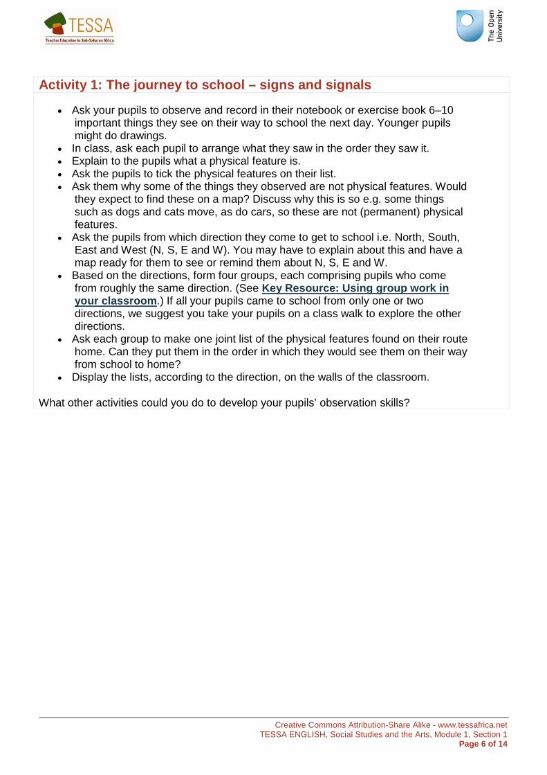
Activity 1: The journey to school – signs and signals
• Ask your pupils to observe and record in their notebook or exercise book 6–10 important things they see on their way to school the next day. Younger pupils might do drawings.
• In class, ask each pupil to arrange what they saw in the order they saw it. • Explain to the pupils what a physical feature is. • Ask the pupils to tick the physical features on their list. • Ask them why some of the things they observed are not physical features. Would
they expect to find these on a map? Discuss why this is so e.g. some things such as dogs and cats move, as do cars, so these are not (permanent) physical features.
• Ask the pupils from which direction they come to get to school i.e. North, South, East and West (N, S, E and W). You may have to explain about this and have a map ready for them to see or remind them about N, S, E and W.
• Based on the directions, form four groups, each comprising pupils who come from roughly the same direction. (See Key Resource: Using group work in your classroom.) If all your pupils came to school from only one or two directions, we suggest you take your pupils on a class walk to explore the other directions.
• Ask each group to make one joint list of the physical features found on their route home. Can they put them in the order in which they would see them on their way from school to home?
• Display the lists, according to the direction, on the walls of the classroom.
What other activities could you do to develop your pupils’ observation skills?
Creative Commons Attribution-Share Alike - www.tessafrica.net TESSA ENGLISH, Social Studies and the Arts, Module 1, Section 1
Page 7 of 14
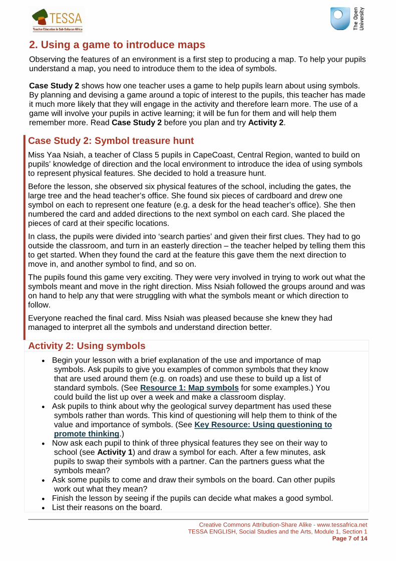
2. Using a game to introduce maps Observing the features of an environment is a first step to producing a map. To help your pupils understand a map, you need to introduce them to the idea of symbols.
Case Study 2 shows how one teacher uses a game to help pupils learn about using symbols. By planning and devising a game around a topic of interest to the pupils, this teacher has made it much more likely that they will engage in the activity and therefore learn more. The use of a game will involve your pupils in active learning; it will be fun for them and will help them remember more. Read Case Study 2 before you plan and try Activity 2.
Case Study 2: Symbol treasure hunt Miss Yaa Nsiah, a teacher of Class 5 pupils in CapeCoast, Central Region, wanted to build on pupils’ knowledge of direction and the local environment to introduce the idea of using symbols to represent physical features. She decided to hold a treasure hunt. Before the lesson, she observed six physical features of the school, including the gates, the large tree and the head teacher’s office. She found six pieces of cardboard and drew one symbol on each to represent one feature (e.g. a desk for the head teacher’s office). She then numbered the card and added directions to the next symbol on each card. She placed the pieces of card at their specific locations. In class, the pupils were divided into ‘search parties’ and given their first clues. They had to go outside the classroom, and turn in an easterly direction – the teacher helped by telling them this to get started. When they found the card at the feature this gave them the next direction to move in, and another symbol to find, and so on. The pupils found this game very exciting. They were very involved in trying to work out what the symbols meant and move in the right direction. Miss Nsiah followed the groups around and was on hand to help any that were struggling with what the symbols meant or which direction to follow. Everyone reached the final card. Miss Nsiah was pleased because she knew they had managed to interpret all the symbols and understand direction better.
Activity 2: Using symbols • Begin your lesson with a brief explanation of the use and importance of map
symbols. Ask pupils to give you examples of common symbols that they know that are used around them (e.g. on roads) and use these to build up a list of standard symbols. (See Resource 1: Map symbols for some examples.) You could build the list up over a week and make a classroom display.
• Ask pupils to think about why the geological survey department has used these symbols rather than words. This kind of questioning will help them to think of the value and importance of symbols. (See Key Resource: Using questioning to promote thinking.)
• Now ask each pupil to think of three physical features they see on their way to school (see Activity 1) and draw a symbol for each. After a few minutes, ask pupils to swap their symbols with a partner. Can the partners guess what the symbols mean?
• Ask some pupils to come and draw their symbols on the board. Can other pupils work out what they mean?
• Finish the lesson by seeing if the pupils can decide what makes a good symbol. • List their reasons on the board.
Creative Commons Attribution-Share Alike - www.tessafrica.net TESSA ENGLISH, Social Studies and the Arts, Module 1, Section 1
Page 8 of 14
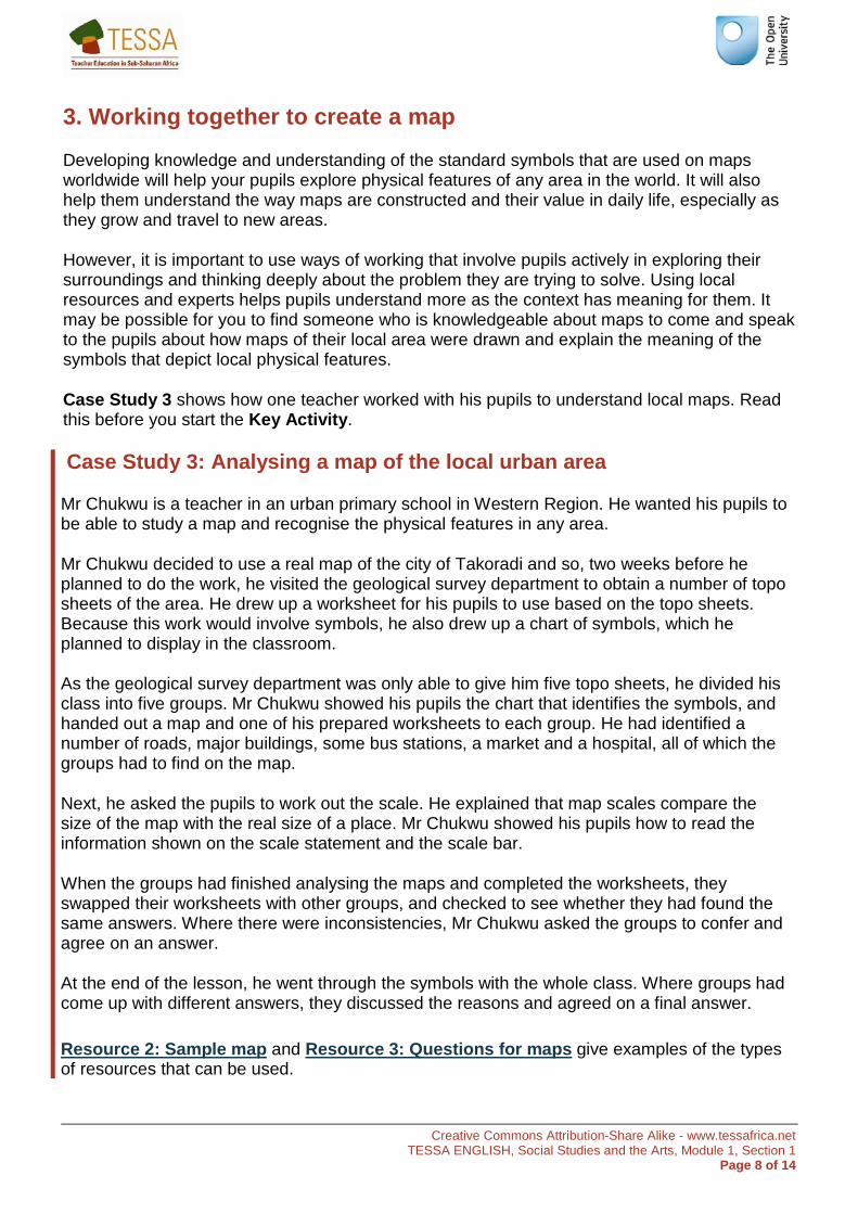
3. Working together to create a map
Developing knowledge and understanding of the standard symbols that are used on maps worldwide will help your pupils explore physical features of any area in the world. It will also help them understand the way maps are constructed and their value in daily life, especially as they grow and travel to new areas.
However, it is important to use ways of working that involve pupils actively in exploring their surroundings and thinking deeply about the problem they are trying to solve. Using local resources and experts helps pupils understand more as the context has meaning for them. It may be possible for you to find someone who is knowledgeable about maps to come and speak to the pupils about how maps of their local area were drawn and explain the meaning of the symbols that depict local physical features.
Case Study 3 shows how one teacher worked with his pupils to understand local maps. Read this before you start the Key Activity.
Case Study 3: Analysing a map of the local urban area
Mr Chukwu is a teacher in an urban primary school in Western Region. He wanted his pupils to be able to study a map and recognise the physical features in any area.
Mr Chukwu decided to use a real map of the city of Takoradi and so, two weeks before he planned to do the work, he visited the geological survey department to obtain a number of topo sheets of the area. He drew up a worksheet for his pupils to use based on the topo sheets. Because this work would involve symbols, he also drew up a chart of symbols, which he planned to display in the classroom.
As the geological survey department was only able to give him five topo sheets, he divided his class into five groups. Mr Chukwu showed his pupils the chart that identifies the symbols, and handed out a map and one of his prepared worksheets to each group. He had identified a number of roads, major buildings, some bus stations, a market and a hospital, all of which the groups had to find on the map.
Next, he asked the pupils to work out the scale. He explained that map scales compare the size of the map with the real size of a place. Mr Chukwu showed his pupils how to read the information shown on the scale statement and the scale bar.
When the groups had finished analysing the maps and completed the worksheets, they swapped their worksheets with other groups, and checked to see whether they had found the same answers. Where there were inconsistencies, Mr Chukwu asked the groups to confer and agree on an answer.
At the end of the lesson, he went through the symbols with the whole class. Where groups had come up with different answers, they discussed the reasons and agreed on a final answer.
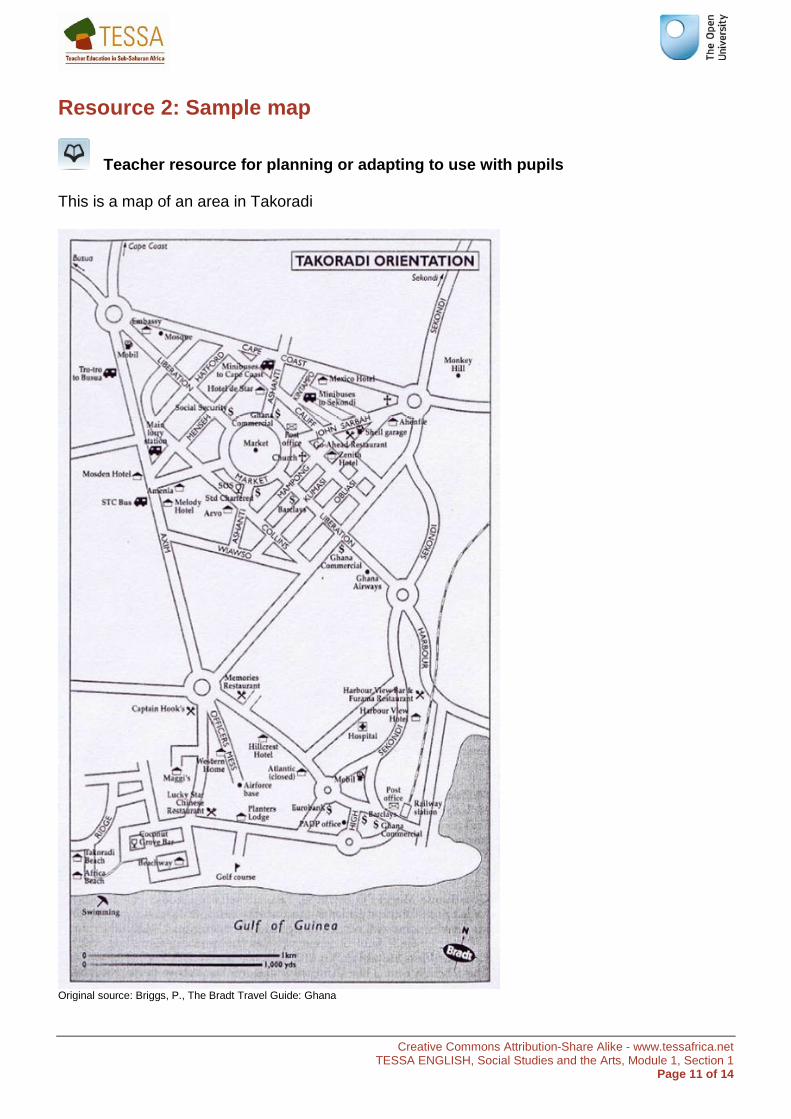
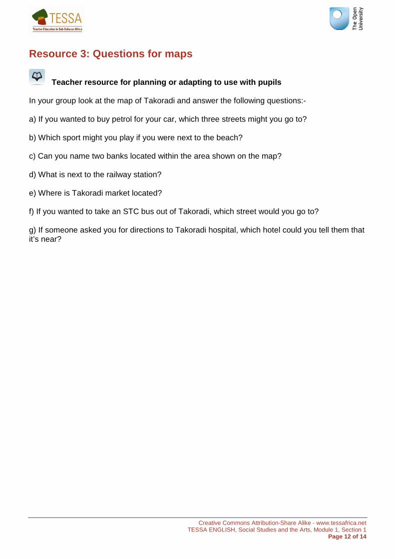
Resource 2: Sample map and Resource 3: Questions for maps give examples of the types of resources that can be used.
Creative Commons Attribution-Share Alike - www.tessafrica.net TESSA ENGLISH, Social Studies and the Arts, Module 1, Section 1
Page 9 of 14
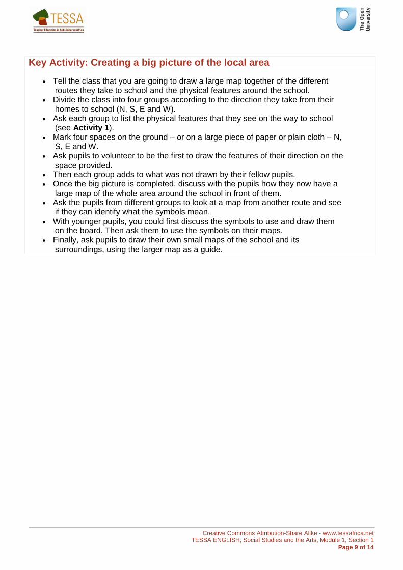
Key Activity: Creating a big picture of the local area
• Tell the class that you are going to draw a large map together of the different routes they take to school and the physical features around the school.
• Divide the class into four groups according to the direction they take from their homes to school (N, S, E and W).
• Ask each group to list the physical features that they see on the way to school (see Activity 1).
• Mark four spaces on the ground – or on a large piece of paper or plain cloth – N, S, E and W.
• Ask pupils to volunteer to be the first to draw the features of their direction on the space provided.
• Then each group adds to what was not drawn by their fellow pupils. • Once the big picture is completed, discuss with the pupils how they now have a
large map of the whole area around the school in front of them. • Ask the pupils from different groups to look at a map from another route and see
if they can identify what the symbols mean. • With younger pupils, you could first discuss the symbols to use and draw them
on the board. Then ask them to use the symbols on their maps. • Finally, ask pupils to draw their own small maps of the school and its
surroundings, using the larger map as a guide.
Creative Commons Attribution-Share Alike - www.tessafrica.net TESSA ENGLISH, Social Studies and the Arts, Module 1, Section 1
Page 10 of 14
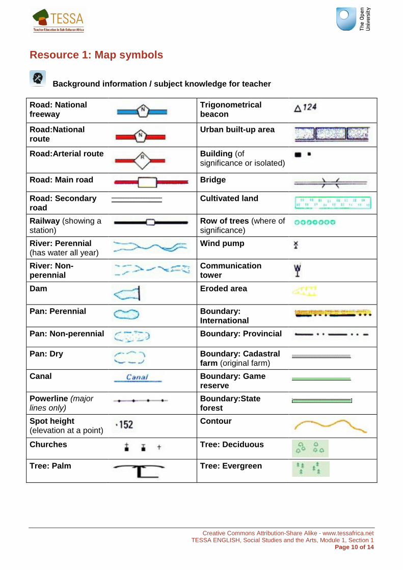
Resource 1: Map symbols
Background information / subject knowledge for teacher
Road: National freeway
Trigonometrical beacon
Road:National route
Urban built-up area
Road:Arterial route
Building (of significance or isolated)
Road: Main road
Bridge
Road: Secondary road
Cultivated land
Railway (showing a station) Row of trees (where of
significance)
River: Perennial (has water all year)
Wind pump
River: Non-perennial
Communication tower
Dam
Eroded area
Pan: Perennial
Boundary: International
Pan: Non-perennial
Boundary: Provincial
Pan: Dry
Boundary: Cadastral farm (original farm)
Canal
Boundary: Game reserve
Powerline (major lines only) Boundary:State
forest
Spot height (elevation at a point)
Contour
Churches
Tree: Deciduous
Tree: Palm
Tree: Evergreen
Creative Commons Attribution-Share Alike - www.tessafrica.net TESSA ENGLISH, Social Studies and the Arts, Module 1, Section 1
Page 11 of 14
Resource 2: Sample map
Teacher resource for planning or adapting to use with pupils
This is a map of an area in Takoradi
Original source: Briggs, P., The Bradt Travel Guide: Ghana
Creative Commons Attribution-Share Alike - www.tessafrica.net TESSA ENGLISH, Social Studies and the Arts, Module 1, Section 1
Page 12 of 14
Resource 3: Questions for maps
Teacher resource for planning or adapting to use with pupils
In your group look at the map of Takoradi and answer the following questions:-
a) If you wanted to buy petrol for your car, which three streets might you go to?
b) Which sport might you play if you were next to the beach?
c) Can you name two banks located within the area shown on the map?
d) What is next to the railway station?
e) Where is Takoradi market located?
f) If you wanted to take an STC bus out of Takoradi, which street would you go to?
g) If someone asked you for directions to Takoradi hospital, which hotel could you tell them that it’s near?
Creative Commons Attribution-Share Alike - www.tessafrica.net TESSA ENGLISH, Social Studies and the Arts, Module 1, Section 1
Page 13 of 14
Acknowledgements
Grateful acknowledgement is made to the following sources:
Photographs and images
Resource 2: Sample map: Briggs, P., The Bradt Travel Guide: Ghana
Every effort has been made to contact copyright holders. If any have been inadvertently overlooked the publishers will be pleased to make the necessary arrangements at the first opportunity.
Return to Social Studies and the Arts (primary) page

www.tessafrica.net