primary record - south bay riders
TRANSCRIPT

Primary Record – (Feb. 2004) * = Required Data
Primary Record
Primary # P-35-000445HRI #
TrinomialNRHP Status Code
Other ListingsReview Code Reviewer Date
Page 1 of 13 *Resource Name or # (Assigned by Recorder) Idria Site 033
P3. a. Description: (Describe resource and its major elements. Include design, materials, condition, alterations, size, setting, and boundaries)
P5a. Photo or Drawing (Photo required for buildings, structures, and objects.)
Idria is 64 miles southeast from Hollister. Take California State Highway 25 south of Hollister for 10.5 miles to Paicines. Turn south (left) on Panoche Road, continue 30.9 miles. Continue on New Idria Road for 21.4 miles to Idria. The site is located on county parcel number 029-31-0-003-0.
The Single-family residential dwelling is constructed of wood with tongue-in-grove siding and a gable roof. Some portions of the structure (southeast room) are single-wall construction. The living room, with stone fireplace, is double-wall construction. All windows, except for the east (back) porch are double-hung multiple pane windows. The building has three bathrooms, two enclosed porches and a large kitchen. The stone fireplace is constructed of handcrafted locally quarried sandstone. Related features include a fenced yard, a laundry room, vehicle garage and a shop or storage building. The building was constructed sometime before 1940. Continued, see “P3 - Description” on page 5.
P3. b. Resource Attributes: HP2. Single family property
P10. Survey Type: Reconnaissance survey to inventory historic resources at Idria.P11. Report Citation: See “Bibliography” on page 5.
Mine Superintendent's House
P2. Location: Not for Publication UnrestrictedXa. County: San Benito County and (P2C, P2e and P2d. Attach a location map as necessary)
b. USGS 7.5’ Quad: TDate R ¼ of ¼ of Sec B.M.Idria, Calif. 1969 17S NE SE MD12E 29 ;c. Address: City: Zip:22150 New Idria Rd. Paicines 95043
d. UTM: Zone: mE / mNNAD-27 10S 708785 4032460(Give more than one for large and/or linear resources) Zone: mE / mN
e. Other Location Data: (e.g., parcel #, directions to resource, elevation, etc., as appropriate.)
P1. Other Identifier:
P4. Resources Present: Building Structure Object Site District Element of District Other (Isolates, etc.)X
P5. b. Description of Photo: (View, date, accession #)
P6. Date Constructed/Age and Sources:
West side of building, Feb. 18, 2007
Historic Prehistoric BothXP7. Owner and Address:
F.F. Family, Inc.647 S 6th StreetSan Jose, Calif., 95112
P8. Recorded by:Three Rocks ResearchSee “P8 - Recorded by” on page 5.
P9. Date Recorded:March 14, 2007
Attachments: NONE, Location Map, Sketch Map, Continuation Sheet, Building, Structure and Object RecordArchaeological Record District Record Linear Feature Record Milling Station Record Rock Art RecordArtifact Record Photograph Record Other (List):
X X X X
Building, Structure, and Object Record – (Feb. 2004) * = Required Data
Primary # P-35-000445HRI #
TrinomialNRHP Status Code
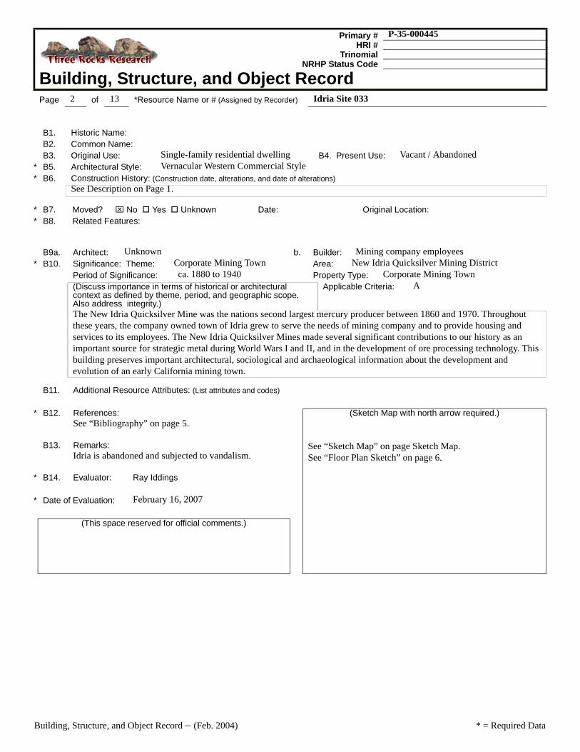
Building, Structure, and Object RecordPage 2 of 13 *Resource Name or # (Assigned by Recorder) Idria Site 033
B1. Historic Name:B2. Common Name:B3. Original Use: Single-family residential dwelling B4. Present Use: Vacant / Abandoned
* B5. Architectural Style: Vernacular Western Commercial Style* B6. Construction History: (Construction date, alterations, and date of alterations)
See Description on Page 1.
* B7. Moved? ⌧ No Yes Unknown Date: Original Location:* B8. Related Features:
B9a. Architect: Unknown b. Builder: Mining company employees* B10. Significance: Theme: Corporate Mining Town Area: New Idria Quicksilver Mining District
Period of Significance: ca. 1880 to 1940 Property Type: Corporate Mining Town(Discuss importance in terms of historical or architectural context as defined by theme, period, and geographic scope. Also address integrity.)
Applicable Criteria: A
The New Idria Quicksilver Mine was the nations second largest mercury producer between 1860 and 1970. Throughout these years, the company owned town of Idria grew to serve the needs of mining company and to provide housing and services to its employees. The New Idria Quicksilver Mines made several significant contributions to our history as an important source for strategic metal during World Wars I and II, and in the development of ore processing technology. This building preserves important architectural, sociological and archaeological information about the development and evolution of an early California mining town.
B11. Additional Resource Attributes: (List attributes and codes)
* B12. References: (Sketch Map with north arrow required.)See “Bibliography” on page 5.
See “Sketch Map” on page Sketch Map.See “Floor Plan Sketch” on page 6.
B13. Remarks:Idria is abandoned and subjected to vandalism.
* B14. Evaluator: Ray Iddings * Date of Evaluation: February 16, 2007
(This space reserved for official comments.)

Location Map – (Feb. 2004) * = Required Data
Primary # P-35-000445HRI #
Trinomial
Location MapPage 3 of 13 *Resource Name or # (Assigned by Recorder) Idria Site 033
*Map Name: Idria, Calif. Scale: 1:24,000 Date: 1969
GNMN
1º 18'23 Mils
16º284 Mils
UTM Grid and 1969 MagneticNorth Declination
Map is Cropped from U.S.G.S Topographical MapIdria, Calif.
Scale 1:24,000 Contour Interval 40 Feet
New Idria Community Site
1 1/2 0 1 Mile
1000 0 1000 2000 3000 4000 5000 6000 7000 Feet
1 5 0 1 Kilometer

Sketch Map – (Feb. 2004) * = Required Data
Primary # P-35-000445HRI #
Trinomial
Sketch MapPage 4 of 13 *Resource Name or # (Assigned by Recorder) Idria Site 033
*Drawn By: Ray Iddings *Date: March 14, 2007

Continuation Sheet – (Feb. 2004) * = Required Data
Primary # P-35-000445HRI #
Trinomial
Continuation SheetPage 5 of 13 *Resource Name or # (Assigned by Recorder) Idria Site 033
*Recorded by: See “P8. Recorded by” on Page 1 *Date: March 14, 2007 ⌧ Continuation Update
Resource Name
Site numbers 001 through 299 follow the number sequence assigned to a map drafted by Mark Ward of the New Idria Mining and Chemical Company in 1957. Mr. Ward's sequence followed a building numbering sequence already in use at that time. Site numbers 300 onward are assigned sequentially beginning with the Idria Resource Inventory Project of February 2007.
P3 - Description
The house was occupied by company president, C. Hyde Lewis, until 1968. It was next occupied by mine superintendent, Nick Estoban, until the mine was sold in 1974. This building is historically important because it is structurally sound, reasonably intact, and preserves a cultural statement about remote mining town sociology.
P8 - Recorded by
Continued from page 1. Three Rocks Research, Ray Iddings, Rodger Tiffin, and the following volunteers: Leon Decker, Marshall Eubanks, Jay Jacobson, Karen Jacobson, Zac Krohn, Michael Ludwig, Patsy Ludwig, David O'Hare, Ryan O'Hare, Teresa Reynaga, Marcus Rodriquez, Ron Wilcher, and Erik Zaborsky.
Bibliography
Bradley, Walter W. “Quicksilver Resources of California.” California State Mining Bureau, Bulletin No. 78.Sacramento: California State Printing Office. 1918.
Crippen, Richard A. “Condenser Installation at the New Idria Quicksilver Mining Company, IdriaCalifornia.” California Journal of Mines and Geology, Vol. 43, No. 1. San Francisco: State Division ofMines. 1947.
Frusetta, Peter C. Quicksilver Country: California's New Idria Mining District. Tres Pinos, California: PeterC. Frusetta. 1990.
Gilbert, Charlene Ann. Prospectors, Capitalists, and Bandits: The History of the New Idria QuicksilverMine, 1854-1972. A Thesis Presented to the Faculty of the Department of History San Jose StateUniversity. May, 1984.
Huttl, John B. “New Idria Increase Production.” Engineering and Mining Journal. Vol. 155, No. 10. Oct.1954.
Linn, R. K. and Dietrich, W. F. “Mining and Furnacing Mercury Ore at the New Idria Mine. San BenitoCounty. California,” Bureau of Mines Information Circular 8033. Washington D.C.: United StatesDepartment of the Interior, 1961.
Nuñez, Julius. “Recollections: New Idria and Hollister, 1902-1923.” Transcription of a tape recording byDavid B. Kier for the Oral History Project of the San Benito County Historical Society, 13 March 1979.
Interviews
Peter Frusetta, retired local rancher and historian.
Mark Ward, retired resident manager New Idria Mining and Chemical Company.
Continuation Sheet – (Feb. 2004) * = Required Data
Primary # P-35-000445HRI #
Trinomial
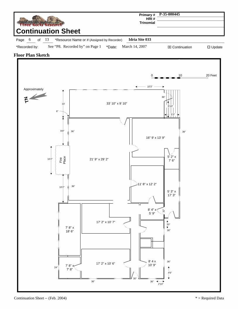
Continuation SheetPage 6 of 13 *Resource Name or # (Assigned by Recorder) Idria Site 033
*Recorded by: See “P8. Recorded by” on Page 1 *Date: March 14, 2007 ⌧ Continuation Update
Floor Plan Sketch
6"
TN
0 10 20 Feet
21' 9" x 29' 2"
5' 3" x17' 3"
8' 4" x5' 9"
17' 2" x 10' 6"
17' 2" x 10' 7"
11' 8" x 12' 2"
8' 4 x10' 9"
33' 10" x 9' 10"
16" 9' x 13' 9"
5' 2" x7' 6"
7' 8" x18' 6"
7' 8" x7' 8"
30"
32"
5'10"
5'3"
36"
10'3"
10'
2'10"
4'6"
33"
24"
10'2"
Fire
Pla
ce
9'9"
10'2"
Approximately
36" 36"
36"
30"
36"36"
36"

Continuation Sheet – (Feb. 2004) * = Required Data
Primary # P-35-000445HRI #
Trinomial
Continuation SheetPage 7 of 13 *Resource Name or # (Assigned by Recorder) Idria Site 033
*Recorded by: See “P8. Recorded by” on Page 1 *Date: March 14, 2007 ⌧ Continuation Update
Photographs
Photo 1: West Exterior WallPhotograph by R. Tiffin, Feb. 18, 2007
Photo 2: South Exterior WallPhotograph by R. Tiffin, Feb. 18, 2007
Photo 3: North Exterior Side, east of fireplacePhotograph by R. Tiffin, Feb. 18, 2007
Photo 4: North Exterior Side, west of fireplacePhotograph by R. Tiffin, Feb. 18, 2007
Continuation Sheet – (Feb. 2004) * = Required Data
Primary # P-35-000445HRI #
Trinomial
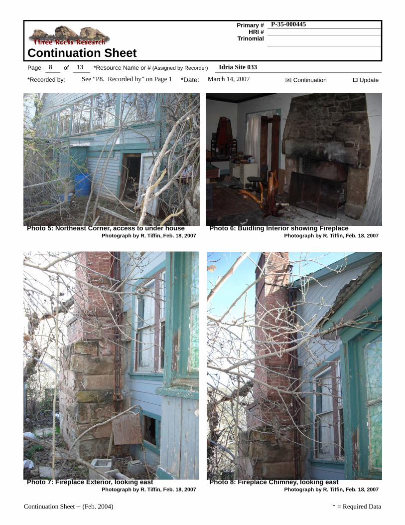
Continuation SheetPage 8 of 13 *Resource Name or # (Assigned by Recorder) Idria Site 033
*Recorded by: See “P8. Recorded by” on Page 1 *Date: March 14, 2007 ⌧ Continuation Update
Photo 5: Northeast Corner, access to under housePhotograph by R. Tiffin, Feb. 18, 2007
Photo 6: Buidling Interior showing FireplacePhotograph by R. Tiffin, Feb. 18, 2007
Photo 7: Fireplace Exterior, looking eastPhotograph by R. Tiffin, Feb. 18, 2007
Photo 8: Fireplace Chimney, looking eastPhotograph by R. Tiffin, Feb. 18, 2007
Continuation Sheet – (Feb. 2004) * = Required Data
Primary # P-35-000445HRI #
Trinomial
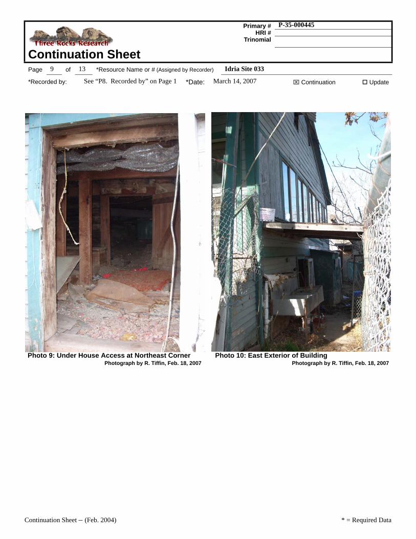
Continuation SheetPage 9 of 13 *Resource Name or # (Assigned by Recorder) Idria Site 033
*Recorded by: See “P8. Recorded by” on Page 1 *Date: March 14, 2007 ⌧ Continuation Update
Photo 9: Under House Access at Northeast CornerPhotograph by R. Tiffin, Feb. 18, 2007
Photo 10: East Exterior of BuildingPhotograph by R. Tiffin, Feb. 18, 2007

Continuation Sheet – (Feb. 2004) * = Required Data
Primary # P-35-000445HRI #
Trinomial
Continuation SheetPage 10 of 13 *Resource Name or # (Assigned by Recorder) Idria Site 033
*Recorded by: See “P8. Recorded by” on Page 1 *Date: March 14, 2007 ⌧ Continuation Update
B8 - Related FeaturesRelated features include a fenced yard, a laundry room, vehicle garage and a shop or storage building.

Continuation Sheet – (Feb. 2004) * = Required Data
Primary # P-35-000445HRI #
Trinomial
Continuation SheetPage 11 of 13 *Resource Name or # (Assigned by Recorder) Idria Site 033
*Recorded by: See “P8. Recorded by” on Page 1 *Date: March 14, 2007 ⌧ Continuation Update
Laundry Room
A 10-foot by 16-foot two-room wood frame building clad with tongue-in-groove. Possibly a “kit-home” built in the 1940s. The building has wood floor with a concrete step. The building served as a laundry room for the superintendent’s house, Idria site 33.
Photo 11: Southeast side of Laund\ry RoomPhotograph by R. Tiffin, Feb. 18, 2007
TN 0 10 20 Feet
9'5" x 7'4"
9'5" x 7'8"
30"
30"
16' 9"
10' 3"
Reference Map Item #307 on Sketch Map.
Continuation Sheet – (Feb. 2004) * = Required Data
Primary # P-35-000445HRI #
Trinomial
Continuation SheetPage 12 of 13 *Resource Name or # (Assigned by Recorder) Idria Site 033
*Recorded by: See “P8. Recorded by” on Page 1 *Date: March 14, 2007 ⌧ Continuation Update
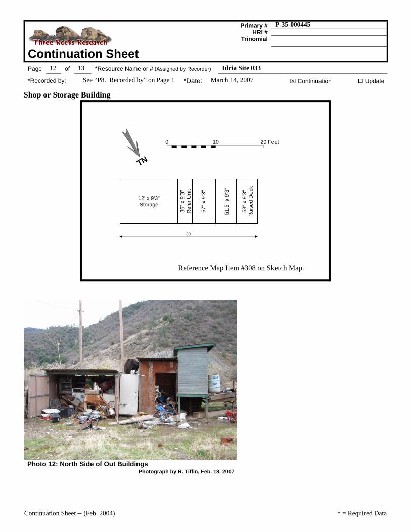
Shop or Storage Building
Photo 12: North Side of Out BuildingsPhotograph by R. Tiffin, Feb. 18, 2007
0 10 20 Feet
12' x 9'3"Storage
36" x
9'3
"R
efer
Uni
t
57" x
9'3
"
51.5
" x 9
'3"
53" x
9'3
"R
aise
d D
eck
30'
TN
Reference Map Item #308 on Sketch Map.

Continuation Sheet – (Feb. 2004) * = Required Data
Primary # P-35-000445HRI #
Trinomial
Continuation SheetPage 13 of 13 *Resource Name or # (Assigned by Recorder) Idria Site 033
*Recorded by: See “P8. Recorded by” on Page 1 *Date: March 14, 2007 ⌧ Continuation Update
Historic Garage and Non-historic Animal Pens
Photo 13: West Side of GaragePhotograph by R. Tiffin, Feb. 18, 2007
Photo 14: Non-Historic Animal PensPhotograph by R. Tiffin, Feb. 18, 2007
TN
0 10 20 Feet
19'5" x 10'5"Animal Pen
19'5" x 9'5"
13' x 7'Water Pool
26' x 17'7"Lean-to Garage Shop
26' x 12'2"Garage
?? x 6'8"StorageStructure
?? x 8'2"Animal Pen
Fence
16'2"
Reference Map Item #309 on Sketch Map.