aces prequalification.pdf · services in land and marine surveying field in uae and ... total...
TRANSCRIPT

Regional Center of Excellence
ACESFor Land and Marine Surveying

Arab Center for Engineering Studies "ACES", was established in Amman-Jordan in the year 1983, initially, as a geotechnical invistigation and materials testing engineering organization.
Today, ACES provides a complete range of specialized consulting services which include, additionally, quality control of projects, special studies, environmental studies and testing, and land and marine surveying.
ACES has carried out thousands of projects for its clients in the Middle East and elsewhere. All ACES’ projects, regardless of the size, are approached with the expertise, technology and equipment required to meet the client’s needs.
ACES has a network of fourteen sister companies in Amman, Aqaba, Riyadh, Jeddah, Al-Khobar, Abu Dhabi, Dubai, Al-Ain, Doha, Muscat, Khartoum, Sana’a, Ramallah and Gaza. ACES also undertakes projects in other countries. A few examples include Azerbaijan, Syria, Kuwait, Angola, Djibouti, and Morocco.
Everything done by ACES is built around its commitment to deliver the best value for its clients in terms of responsiveness, consistency, quality and practical solutions. ACES main goal is to partner with its clients, understand and exceed their expectations.
About ACES
About ACES


ACES has considerable knowledge and experience in topographical survey, bathymetric survey, underground utilities detection, survey consultancy, settlement monitoring, earthwork volume computation, route survey and setting out survey and has conducted hundreds of successful projects in the Middle East.
To gather all the capabilities of ACES that are related to survey works under one highly professional and equipped center and be the market leaders in survey services, ACES established its Regional Center of Excellence for Land and Marine Surveying, which is located in Abu Dhabi, UAE.
The focus of ACES Regional Center of Exellence For Land and Marine Surveying is to render high quality services in land and marine surveying field in UAE and Middle East region. With complete in-house facilities and state of the art equipment, specialized software and highly qualified survey engineers and surveyors, ACES is very well positioned to be a leader in the field of land and marine surveying services in the region.
ACES Regional Center of Exellence For Land and Marine Surveying

Offered Services
Offered Services
. Topographic survey. • Near shore bathymetric surveys.• Cadastral surveys. • Corridor alignments (horizontal & vertical) and profiles. • Setting out survey. • Under ground utilities surveys. • As-built survey. • Digital terrain modeling.• Establishment of control stations and bench marks. • Precise and differential leveling. • Settlement monitoring. • Earthworks volumes. • Survey consultancy and check engineering.• Hiring of survey crews.• Maps digitizing and conversion of raster to vector. • Hydrographic survey. • Bathymetric survey. • Tidal measurements. • Current measurements.• Sea water sample collection and in-situ testing.

tha
t enable them to make str
ategic decisions for their projects.ACES provides its clients with land and mar
ine surveying solutions

Available Technologies
Available Technologies
Land Surveying
Total Stations
Total Stations are survey instruments which have combined a theodolite with a distomat. The instrument can measure angles and distances simultaneously and it can determine coordinates and elevations with high accuracy. It is equipped with software that makes many survey computations. It is extremely useful in or near buildings where GPS can not operate. ACES use the latest total stations of the world number one brand Leica. All ACES total stations are calibrated by the authorized dealer periodically and are certificated.
Auto Levels
Auto levels are simple and easy to use instruments used for leveling. They are still considered the most accurate way for calculating elevations. Digital levels, which record the readings and do the computation, are in use now as well as the classical auto levels. ACES use high accuracy Leica digital levels for all kind of leveling works.

Global Positioning systems (GPS)
GPS is satellite based navigation system. The principle is getting the signals from the satellites by a receiver and converting them into coordinate and elevation data. GPS provides reliable location and time information in all weather conditions and at all times and anywhere on or near the Earth . It increases the accuracy in large scale projects and lessens the time consumed to do the survey works. The instrument can operate even kilometers far from the benchmark without compromising on the accuracy which makes it the most preferred survey technology. ACES use the Leica GPS instruments which are known for their reliability and accuracy. All GPS instruments are calibrated by the authorized dealer periodically and are certificated. ACES have the intrinsic certificates as well which are proof that the equipments are safe to use inside oilfields and plants. This document is required by the authorities in oilfield for all battery operated instruments.
Available Technologies
Avai lable Technologies
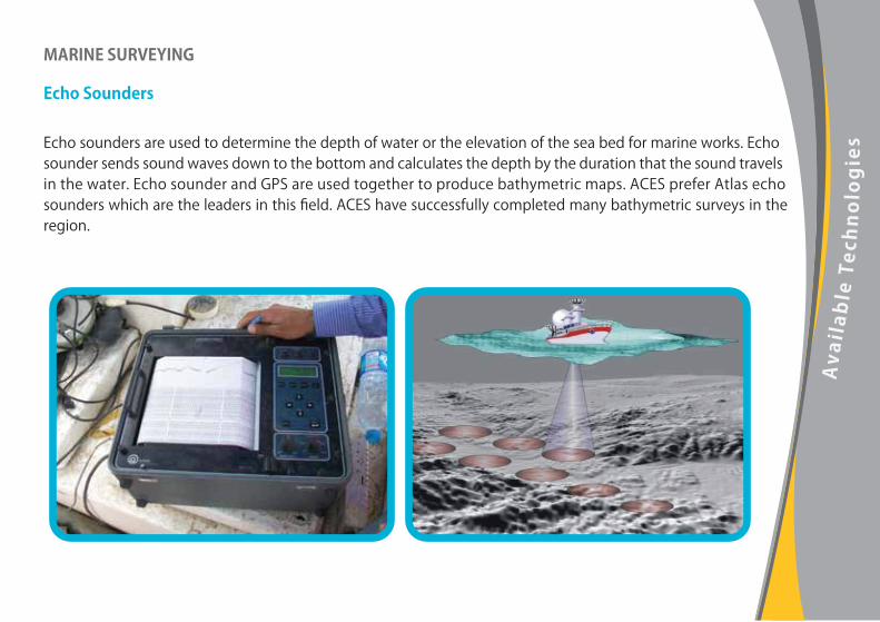
MARINE SURVEYING
Echo Sounders
Echo sounders are used to determine the depth of water or the elevation of the sea bed for marine works. Echo sounder sends sound waves down to the bottom and calculates the depth by the duration that the sound travels in the water. Echo sounder and GPS are used together to produce bathymetric maps. ACES prefer Atlas echo sounders which are the leaders in this field. ACES have successfully completed many bathymetric surveys in the region.

UNDERGROUND DETECTION
GPR
Ground penetrating radar is used to locate all types of utilities metallic or non metallic and obtain their depths down to a depth of 10 meters. It provides a section of the ground on its color screen identifying the utilities clearly. ACES utilize Radio Detection UK GPR’s.
Radio Detectors
Underground detectors are used for detecting buried metallic utilities. It provides depth of the utility also. This service provides the necessary information for the client to protect the existing utilities during their works. ACES utilize Radio Detection UK instruments.
Available Technologies

Avai lable Technologies
Sub-bottom Profiling
GeoPulse Profiler System -Industry standard sub-bottom profiling system for shallow geophysics. 2-12 Khz frequency range and selectable with front panel dial.
Magneto meter
Cesium Magnetometer Geometrics G-881 Determine the presence of metal objects on the sea floor.
Tide Gauge
Valport 740- Self Recording Automatic.
Boat
Double Engine126 X 2 HP, 26 feet long boat.

SPECIALISED SOFTWARE
Software is an extremely important part of a professional survey company. The computations that have to be very accurate and the drawings that have to reflect the survey results precisely are all done by software. ACES use a wide range of software which are essential and serve to different purposes. ACES staff has been trained in using the software and all are competent. ACES are able to deliver the end result of its studies in any format the client requires. Some of the software being used by ACES is listed below:
. AutoCAD. . MicroStation. . SoftDesk. . Surfer.
. Leica Geo Office. . Leica SkiPro. . SDR Map. . Navipac.
Available Software

KEY PERSONNEL
Meet ACES Land & Marine Specialists
Manager of ACES Regional Center of Excellence for Land & Marine Surveying

Selected Projects
Pipeline Route Survey VECO ENGINEERING 2006
Topographic & Bathymetric Survey MAUNSELL CONSULTANCY 2006
Topographic& Bathymetric Survey KEO INTERNATIONAL 2007
Topographic& Bathymetric Survey ALGECO 2007
Bathymetric Survey PB INTERNATIONAL 2007
Topographical Survey & Est. of Control Points IDROESSE 2008
Topographical Survey TAKREER 2008
Pipeline Route Survey DOLPHIN ENERGY 2008
ADCO Replacement of NGL Pipeline Network Project
Reem Island Plot-2 Development
Corniche Mixed Use Development
Jabel Al Dhanna Airfield Runway Extension Project
Coconut Island
Development of South Shamkha, Abu Dhabi
TAKREER Ruwais Refinery Expansion Project
DOLPHIN ENERGY Taweela to Fujairah Pipeline Project
Selected ProjectsProject Name Project Type Cl ient Year

Selected ProjectsPlant Survey & U/G Detection Bechtel 2008
Plant Survey & U/G Detection Petrofac 2009
Route Survey & Bathymetric Survey Technip 2009
Topographical Survey & U/G Detection ZADCO 2010
Topographical Survey & U/G Detection Hyundai 2010
Topographical & Bathymetric Survey Samsung 2010
Settlement Survey Takreer 2011
Pipeline Route Survey WGI 2008ADCO 1.8 MMBPD Oil Field Development Project
Takreer Ruwais Refinery Expansion Project
Asab Full Field Development Project
Inter Refineries Pipelines Project II
Satah Full Field Development (Zirku Island)
Habshan 5 Utilities & Offsites Project
Fertil 2 Expansion Project
Takreer ADRD & RRD Settlement Survey
Project Name Project Type Cl ient Year


ACES Regional Center of ExcellenceFor Land and Marine Surveying