preparing the ground: finding minor landscape names in
TRANSCRIPT
IntroductionLandscape reconstruction is often an important aspect of the work of local historiansin uncovering the history of a parish. For many English parishes in particular, titheand enclosure maps of the eighteenth and nineteenth centuries—alongsidecontemporary field-books, surveys and terriers—help researchers to take the firststeps in recreating the historic environment. Local history groups embarking uponthis work often generate useful material and deposit this with county record officesfor the benefit of all. However, continuing back beyond the modern period can beproblematic, especially for those without the specialist skills to read and deciphermedieval records. This paper recognises the important contribution that volunteerresearchers make to the discipline of local and regional history and, using materialdeveloped in conjunction with volunteer groups at the Staffordshire Record Office,provides a set of guidelines and resources designed to help non-specialist researchersto access medieval documents. Specifically, these resources aid local historians infinding and recording the abundant minor landscape- and field-names written inlater medieval charters.1 The paper is also designed to illustrate the value of thiswork for place-name scholars, especially those working on the English Place-NameSociety’s (EPNS) Survey of English Place-Names,2 and for historians of all kinds.
Volunteers and the English Place-Name SocietyThe work of volunteers has underpinned the EPNS Survey from its very beginnings.The first of the county volumes (Buckinghamshire, 1925) acknowledges in its prefacethe work of many more individuals than the two men named on the title page, A.Mawer and F.M. Stenton.3 This work was various, and included transcribingunpublished manuscripts, extracting name-forms from manuscripts and publishedsources, ‘carding up’, building gazetteers, and dealing with ‘questions of situationand pronunciation in which the man on the spot, who has lived in the district itself, isalways the best guide’.4 Volunteer input has remained of primary importancethroughout the almost hundred-year history of the Society. The preface to The Place-Names of Northamptonshire, published in 1933, reveals an increased and systematic useof volunteers: the editors recorded their thanks to the Northamptonshire EducationCommittee for its help in securing the services of around 200 of the county’s schoolsto collect modern field-names.5 The editors of The Place-Names of Cumberland (1952)benefited from similar help from ten schools: the appeal ‘was made at a difficulttime, when the staffs were faced with war-time problems, and though only a fewschools were able to help us, that help was of great value’.6 The EPNS survey ofShropshire owes its very existence to the efforts of a group of volunteers, students at a
276 © British Association for Local History 2019
Preparing the ground: finding minor landscape names
in medieval documents
JAYNE CARROLL AND SUSAN K ILBY
University of Birmingham Extra-Mural Department weekend school on Shropshireplace-names. Their teacher, Dr Margaret Gelling (1924–2009), ‘was pressurised by[their] local enthusiasm into the instigation of a research group for the collection ofmaterial for a full EPNS survey’.7 That group was active for 27 years, and its findingsare still being brought to fruition in recent and forthcoming Shropshire volumes.8
The breadth and detail of modern EPNS surveys make them long-term projects—their completion is the work of decades rather than months or years. The surveysinclude not only the names of major and minor settlements, but also those of streets,fields, streams, and patches of woodland, marsh, and waste. Documents from theAnglo-Saxon period (and sometimes earlier, from the Romano-British period) to thepresent day are combed for forms of place-names, both obsolete and surviving. Thescale of the undertaking presents challenges, particularly in the current academicclimate, and makes volunteer contributions essential. At present, the EPNS editors ofKent, Lancashire, and Staffordshire receive very significant help with the collection ofsource material from groups within each of those counties.9
Public engagement as an integral part of academic research projects is a fairly recentphenomenon, despite the long history of volunteering for the EPNS, but is becomingincreasingly widespread.10 Some recent projects have harnessed the resources ofhundreds of volunteers.11 Working in this way can generate mutually beneficialrelationships: academic researchers profit from the quantity of data a committedvolunteer group can produce, and volunteer researchers in turn benefit in myriadways. They receive training from academics who are specialists in their field, whichhelps to ensure that volunteers can make a real intellectual contribution to theprojects they are working on, rather than simply providing data input. Frequently,this provides them with new skills that can be usefully applied in the wider world andalso to their personal research projects. Following medieval palaeography trainingdelivered by the University of Nottingham, one Staffordshire Place-Name Projectvolunteer observed that the course would ‘widen the range of documents I can tacklefor my own research’.12 As is the case with many of the volunteer groups run fromStaffordshire Record Office (SRO), the place-name groups (one in the SRO and onein Lichfield) meet each week for one afternoon.13 This is naturally moreadvantageous for student volunteers or those who are retired, especially as manygroups meet mid-week. For older researchers in particular, volunteering can provide‘a sense of well-being, or making valuable contributions to society … and a sense ofbeing part of an ongoing agenda’.14 As many reports attest, the associated socio-emotional and health benefits should not be underestimated.15 Margaret King, avolunteer on the Staffordshire Place-Names Project, sums up her volunteeringexperience as ‘quite hard work, but also a great deal of fun’, and her article outliningher experience with the group clearly expresses her understanding that all of thevolunteers are an important part of this collaborative project, and essential to itssuccess.16
Why work on place-names?English place-names evolved as meaningful descriptions, sometimes arising in theeveryday speech of those who worked the land, sometimes bestowed by people inpositions of power. They described landscape, flora and fauna, agricultural,administrative, social and religious practices—the multifarious perceptions andevaluations of past populations. Some of them—the names of most towns andvillages—are at least a thousand years old. They were given in languages no longer
FINDING MINOR LANDSCAPE NAMES IN MEDIEVAL DOCUMENTS 277
278 THE LOCAL HISTORIAN/OCTOBER 2019
spoken in Britain, or in early stages of English (and other languages) no longerreadily comprehensible. Minor names, such as those of fields and minor landscapefeatures, tend to be (although are not always) much younger, and can be subject torelatively frequent replacement. Typically, they start appearing in documents fromthe thirteenth century and later, and are very well represented in material from thenineteenth century. The best way to decode names, of whatever age, is from spellingswhich originate from a time as close as possible to the point at which the names aroseas meaningful labels. These spellings are, therefore, the foundations of place-namestudy.
The EPNS editors of the first half of the twentieth century were mostly concernedwith settlement-names and with the names of significant rivers and administrativedistricts, although they did include other sorts of names found on the OrdnanceSurvey one-inch and six-inch maps. Most of these major names are entirely opaqueto modern English speakers, so the editors’ linguistic and historical expertise washarnessed to offer etymologies (identifying the languages and words which originallycomprised the names), thus exposing a rich seam of information to be mined byscholars of all sorts. A few examples from the earliest county survey,Buckinghamshire, reveal the value of these names, and the kinds of information theycontain. Historical fauna is referred to in (North and South) Crawley ‘crow openwoodland’ (Crauelai 1086; Old English (OE) crawe, leah); Foscott ‘fox’s cottage(s)’(Foxescote 1086; Old English fox, cot); and Culverton ‘wood-pigeon hill’ (Culu’don1199, OE culfre, dun). Calves were farmed at Calverton (Calvretone 1086; OE cealf,tun), sheep at Shipton (Schipton 1279; OE scep, tun), and goats on the wooded slope atGayhurst (Gateherst 1086; OE gat, hyrst). Flora is also recorded: nuts grew at Notley(Nutele 1204; OE hnutu), oaks at Oakley (Achelei 1086; OE ac) and aspens at Apsley(Aspeleia c.1210; OE æspe), while Willen meant ‘at the willows’ (Wily 1189; OE welig).Landscape character and features also appear: wet ground was noted in MarshGibbon (Merse 1086; OE mersc), North Marston (Merstone 1086; OE mersc), Maids’Moreton (Mortone 1086; OE mor ‘waste, swamp’), and Slough (Slo 1340; OE sloh‘mire’), and geology was a factor in the naming of (Steeple) Claydon ‘clayey hill’(Claindone 1086; OE clægig, dun), which stands on Oxford Clay. The precisesignificance of the hill-term dun, ‘a low hill with a fairly extensive summit whichprovided a good settlement-site in open country’, was brought to light many yearsafter the publication of the Buckinghamshire survey.17 It can be distinguished fromother hill- and ridge-terms, such as hoh, used of ‘ridges which rise to a point andhave a concave end’ and found in Ivinghoe ‘ridge of Ifa’s people’ (Evingehou 1086),and Tattenhoe, whose first element is uncertain; and beorg, used of rounded hills andfound in Grandborough ‘green hill’ (Grenebeorge c.1060).
Some names point to early travel and communications infrastructure. Ford-names arecommon, and include Fenny Stratford (Fenni Stratford 1252), Stony Stratford (StaniStratford 1202) and Water Stratford (Stradford 1086). Old English stræt ‘main road,Roman road’ refers in the first two names to Watling Street, and in the third to theRoman road heading north east towards Towcester. Ward’s Hurst (Wardhurst 1333)and Whorley Wood (Wardeleie 1195/14th-century MS)18 contain the OE word weard‘watch, look out’, and have excellent views over the Icknield Way—groups movingalong this ancient route would not have remained undetected for long. Fingest(Tingeherst mid-12th century) and Skirmett (la Skiremote c.1307) were sites ofadministrative importance: each contains an Old English word for an assembly, þingand gemot. The first means ‘wooded hill of the assembly’, the second ‘shire meeting’.Some of the county’s hundred-names, such as Cottesloe (Coteslau 1086), Rowley(rugan hlawe 949/1200 MS), and Secklow (Sigelai 1086), have hlaw as their second or

FINDING MINOR LANDSCAPE NAMES IN MEDIEVAL DOCUMENTS 279
generic element, indicating that the freemen of these hundreds met at the hlaw, amound or tumulus. That legends and superstitions grew up around such features issuggested by an early name for Warren Farm, scuccan hlaw (792/c.1250 MS; OEscucca, hlaw) ‘mound associated with a demon or sprite’.
Here, there are riches for historians of all persuasions—landscape, social andadministrative, religious and linguistic—and their interest is clear. The generallyyounger field-names, on the other hand, were deemed less interesting in the earlyyears of the Survey. Until 1952 they were covered in brief summary sections at theback of EPNS volumes: Buckinghamshire devotes just over four pages to theelements and personal names found in field-names. The justification was, as theeditors put it, that ‘many are without much interest, consisting largely of forms thatare common in all field-names’.19 However, only eight years after theBuckinghamshire volume appeared, one of these editors, Allen Mawer, published anessay demonstrating just how valuable field- and minor names could be. Thiscoincided with the more detailed treatment of field-names in the Northamptonshiresurvey, facilitated by the involvement of 200 of the county’s schools.20 Not until thepublication of the three-volume Place-Names of Cumberland (1950–1952), however,were field-names treated within the main body of the survey, after the major namesof each parish and township.21 Since then, the county surveys have tended towardsever fuller coverage of field- and minor names. An entry for a single parish in theLeicestershire survey (1998–2016) typically contains more field-name informationthan that found in the entire Buckinghamshire volume.22
The increased focus on field-names reflects the realisation that their evidence isevery bit as valuable as that provided by the major place-names, and not only foragricultural history. John Field’s A History of English Field-Names includes chapters oncommon fields and enclosure, landscape and geology, woodland, size and shape,transferred names (the name of one place being used for another, different place—the recurrent field-name London being one example), tenure and endowment,structures, transport, and industry, and religious and judicial-administrativematters.23 Many of Field’s examples are from his 1972 Dictionary, which draws onevidence from the medieval to the modern periods. This and its successor, PaulCavill’s A New Dictionary of English Field-Names, demonstrate clearly the interest andvalue of field-names of all periods.24 In the editorial preface to Field’s History, DavidHey commented that, with field-names,
the amateur comes into his own. Few documents record field-names so farback in time that only a trained linguist can be trusted to interpret theevidence. With field-names that were coined in much later periods thehistorian who knows a locality intimately is in a far better position than thelinguist to offer a convincing explanation25
Nowhere is this demonstrated more effectively than in H.D.G. Foxall’s ShropshireField-Names.26 Foxall was one of Margaret Gelling’s weekend-school students, whosecontribution to the Shropshire survey was so great that he is acknowledged on thetitle pages of the first six volumes. He recreated the Shropshire tithe apportionmentmaps of the mid-nineteenth century, redrawing them to scale by tracing OrdnanceSurvey maps, and copying onto them the field-names preserved in theaccompanying schedules.27 In doing this, Foxall (and Gelling) could study the namesin relation to the fields and features to which they referred. The fruits of thiscontextualisation, and of his local knowledge of the Shropshire landscape, are clearin his book, whose focus is these nineteenth-century names. They reflect shape(Hare’s Ears, The Haunch); soil type (Clay Puddings, Quaking Mire, Pastrycrust);
280 THE LOCAL HISTORIAN/OCTOBER 2019
crops (Hemp Butt, Saffron Hill, Barley Field); industry (Mill Meadow, WalkmillField, Limekiln Leasow, Tanhouse Close); rent (Penny Rent, Guinea Furlong);animals (Stag Park, Brockhill, Swinesdale, Foxholes); birds (Kites Piece, LapwingLeasow, Pye Pit); trees (Wollers [alders], Birchen Pits, Wild Peartree Piece);archaeological features (Bloody Romans, Great Stone Castle); defensivearrangements (Tuthills [OE tot ‘lookout’], Wart Hill [OE weard ‘watch, lookout’]);judicial history (Gallows, Gallitree Bank); superstition (Drake Hill [OE draca,‘dragon’], Powke Field [OE puca ‘sprite, goblin’], Devil’s Nest); and leisure (SkittleCroft, Race Field, Cockpit Meadow). Without specialist linguistic or onomastictraining, much can be learned from the tithe apportionment about the lie of theland and its nineteenth-century inhabitants.28
Earlier records are invaluable though, and may cast light on seemingly transparentnineteenth-century and later names. Thus, the Shropshire field-names Far and NearDiagonal appear to be shape- or position-names, but a seventeenth-century form,Drakenal (1698), reveals a rather more exciting possible origin: ‘dragon’s nook’ (OEdraca, halh).29 Most records dating from the seventeenth century and later arerelatively accessible to the non-specialist. The deeds, surveys, terriers, maps andplans which began to proliferate during this period often record the names of smalllandscape features, and are well worth investigating for this reason alone.Seventeenth-century name-forms collected by the Staffordshire Place-Name Projectvolunteers include references to structures (Bathhowse croft, Brikilne), flora (Byrchcroft, Bromycroft), livestock (Calfe Croft, Hogghay), soil improvement (Marl Pit Croft),land newly cultivated (Newe intacke) or cleared (Pye Riddinge [OE ryding ‘clearedland’], Stocking [OE stoccing ‘land cleared of stumps’), small fields (Plecke [ME plek‘small piece of ground’]), wet fields (Riddings Flash [ME flasshe ‘marshy piece ofland’]), and features of open fields (Clifts doale [OE dal ‘share of common land’],Hemp Butt), striking landscape features (Cloughhead [OE *cloh ‘ravine’]), and themorbid (Gallowtree feild).30
Documents dating to before 1600 contain equally rich material, but are likely topresent greater challenges to researchers lacking specialist linguistic andpalaeographical skills, who can easily be deterred from attempting to investigatethem for place-name evidence. These archival sources were written in early forms ofEnglish or in a contracted form of medieval Latin, which survives in manorial courtrolls long after the close of the Middle Ages. Some of the richest sources of medievalname-forms are the earliest documents in local history collections within our countyarchives. Access to this earlier material can be facilitated relatively easily eitherwithin a supportive volunteering environment which offers training, orindependently, as should be clear from what follows.
Volunteering on the Staffordshire Place-Names ProjectThe Staffordshire Place-Names Project was launched at an SRO study day in early2017. This event generated a high level of interest and the feedback wasoverwhelmingly positive. The SRO has established an excellent volunteer networkand a highly effective existing infrastructure within which projects are run, and theEPNS benefited from this considerable expertise in managing archival volunteergroups. The Stafford and Lichfield place-name groups focused initially on thecollection of place-name forms from published and manuscript post-medievalmaterial. Under the guidance of designated project officers, the volunteers wereencouraged to work independently on their findings.31 The project website provided

FINDING MINOR LANDSCAPE NAMES IN MEDIEVAL DOCUMENTS 281
a forum for the volunteers to write blog posts, and two members of the grouppublished short articles in local magazines and presented their work at a secondstudy day held in July 2017.32
In order that the volunteers might access earlier material, they were invited to attenda short palaeography course specifically focused on extracting place-names frommedieval documents, including surveys, charters and manorial records. The coursewas led by academic staff from the University of Nottingham, and was designed toensure that novice palaeographers could learn to identify where they might findplace-names, and to provide them with a range of tools to aid their ongoing research.In creating the course materials, special attention was paid to the fact that delegatesmight have little or no experience with either medieval Latin or English court hand.In a very short time, the fledgling palaeographers had made significant progress,and the majority could locate and transcribe the medieval minor landscape namesthat they found in the documents with increasing confidence. The feedback andenthusiasm from those undertaking the course provided the impetus for the creationof the palaeography resources both within this article and on the Institute for Name-Studies website, designed to help many other would-be palaeographers interested inusing medieval documents to research their own local place-names.33
Finding place-names in medieval documentsMedieval landscape names are often found in abundance within the typicaldocumentary sources which are among the earliest material in local historycollections within our county archives. These include later medieval charters andcartularies, and manorial documents (surveys, extents and terriers, and also manorialcourt and account rolls) can also be a good source. Some rentals also contain minorlandscape names.34 The principal repositories for medieval manuscript material inthese categories are The National Archives, the British Library, the National Libraryof Wales and the county record offices.35 In general, field-names are most likely to befound in surveys and in later medieval charters and deeds; for those new to readingmedieval documents it is generally easiest to begin with conveyance charters, as theyare usually formulaic. Those are the documents featured in what follows.
Field-names in medieval chartersLater medieval charters produced by freemen and burgesses survive from thethirteenth century onward, and are frequently a good source of minor landscapenames. The earliest are usually undated and a date can typically only be estimatedusing the style of handwriting.36 Legally, only freeholders could transfer land bycharter, although it should not automatically be assumed that every grant wastransacted between freeholders.37 For the earliest charters within their collections,most archives will have produced a calendar, summarising the key information—notably the type of land transfer, the names of the parties involved, the propertydetails, names of the witnesses, and the date if it was recorded. Frequently, but notreliably, field-names are also noted, and it is therefore worth checking these findingaids.
The greatest barriers to reading and understanding documents from this periodare the language—until the fifteenth century, usually medieval Latin38—and thehandwriting, described by historians as court hand. The resources presented herehave been designed to assist researchers with little or no palaeographical trainingin finding and transcribing medieval field-names. Nevertheless, some familiarity

282 THE LOCAL HISTORIAN/OCTOBER 2019
with medieval letter forms is essential in order to read documents with any degreeof confidence. Several volumes provide an overview of medieval court hand, themost useful for beginners being Johnson and Jenkinson’s English Court Hand 1066-1500 (Phillimore, 1915), since it includes a comprehensive history of individualletter forms and the abbreviations most frequently used by medieval scribes.39 Anumber of useful websites offer resources for thirteenth- and fourteenth-centurypalaeography which can be studied before attempting to read original manuscriptmaterial.40
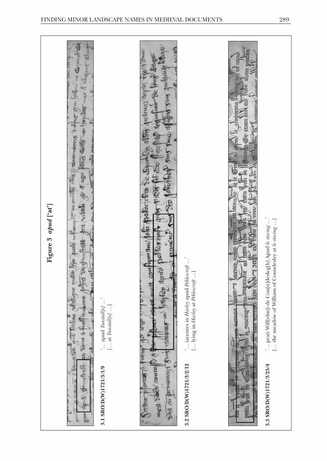
Even with a limited understanding of later medieval letter forms, it is possible tolocate and identify English field-names within Latin charters. This is becauseconveyance charters are generally formulaic, and understanding how they arearranged helps in narrowing down the important elements. Figure 1 outlines themain clauses within a standard later medieval conveyance charter that must beidentified in order to locate field-names.41 They are summarised in Table 1 andsample clauses are given in Table 2. Once these clauses can be identified, it is usuallyrelatively straightforward to find the section of the charter in which minor landscapenames are likely to be found (usually just after the clause detailing the action andgrantee). Once the correct section has been identified, it is possible to look forspecific ‘indicator terms’ which alert the reader that field-names are likely to follow(Table 3). The following examples of Latin words usually precede field-names, andare therefore useful to look for.
Table 1 Identifying the key clauses of a medieval deed
1. The grantor ‘q[uo]d Ego Margareta Messager de Tunstall’
[that I Margaret Messager of Tunstall]
2. The action and the grantee ‘dedi concessi et hac p[re]senti carta mea confirmaui42 Joh[ann]iPekoc de Broml’ Abb[at]is’
[have given, granted and by this my present charter confirmedto John Pekoc of Abbots Bromley]
3. The property ‘tres acras t[er]re cu[m] p[er]tinenc[iis] suis in feodo de Broml’Bagot iacentes apud le gorstes iuxta le Breche int[er] t[er]ramd[omi]ni ex p[ar]te vna in latitudine et t[er]ram quondam AdeWiyer et extendunt se sup[er] t[er]ra q[uo]nd[am] Rob[er]ti deTunstall’
[three acres of land with its appurtenances in the fee of BagotsBromley, lying at le gorstes next to le Breche, between the lord’sland on one side in width, and the land sometime belonging toAdam Wiyer, and extending onto the land sometime belongingto Robert of Tunstall]
4. The tenure ‘H[abe]nd[um] et tenend[um]…’
[To have and to hold ...]
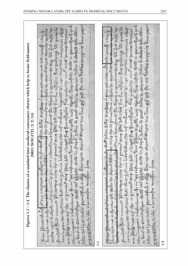
Figures 1.1 – 1.4 The clauses of a standard later medieval conveyance charter which help to locate field-nam
es[SRO/D
(W)1721/3/2/14]
FINDING MINOR LANDSCAPE NAMES IN MEDIEVAL DOCUMENTS 283
1.2c
aptio
n
1.1
caption

284 THE LOCAL HISTORIAN/OCTOBER 2019
1.3c
aptio
n
1.4
caption

FINDING MINOR LANDSCAPE NAMES IN MEDIEVAL DOCUMENTS 285
Table 2 Samples of the main clauses in later medieval conveyance charters
clause key Latin phrases English translation
1 first party Ego [Margareta Messager] I [Margaret Messager]
2 action and second party (i) Dedi, concessi et hac presenticarta confirmaui [Johanni Pekoc]
Have given, granted and by thismy present charter confirmed to[John Pekoc]
3 property (i) Tres acras t[er]re cu[m]p[er]tinenc[iis] suis in feodo deBroml’ Bagot iacentes apud legorstes iuxta le Breche
Three acres of land with itsappurtenances in the fee of BagotsBromley, lying at le gorstes next tole Breche
4 tenure Habendum et tenendum … To have and to hold …
property (iii) Unum messuagium cum curtilagiiset gardinis adiacentis ...
A messuage with the curtilages andgardens adjacent …
property (ii) Omnia terras et tenementa, prata,pascua et pasturas cum omnibuspertinenciis suis in villa et campisde ...
All lands and tenements,meadows, grazings and pasturewith all their appurtenances in thevill and fields of ...
action and second party (ii) Dedi, vendidi et hac presenti cartaconfirmauimus Ricardo atte Hulleet Cristine uxori sue et heredibussuis
Have given, granted and by thismy present charter confirmed toRichard atte Hulle and Christinahis wife, and their heirs
Finding field-names: indicator terms in chartersIn the following section, the most useful indicator terms are assessed in detail,alongside examples from later medieval charters. As a supplement to this article,additional examples of these terms (together with those featured here) can be foundusing a permanent link on our website at https://www.nottingham.ac.uk/go/medievalfieldnames/. This allows for a much greater range of documents to befeatured, and also enables users to increase the size of the images to read them moreeasily.
Table 3 Some useful indicator terms in later medieval charters
indicator term translation indicator term translation
abuttans ‘abutting’ quarum ‘of which’
apud ‘at’ situato ‘situated at’
iacens, iacet ‘lying’, it lies’ super ‘on’
iuxta ‘next to’ vocatur, vocatus ‘is called’
Note: primary indicator terms are in bold type

286 THE LOCAL HISTORIAN/OCTOBER 2019
2.1 SRO/D(W)1733/A/2/40
‘... vnam placeam pastur[am] que vocat[ur] tapmoreiacentem int[er] campu[m] vocatu[m] fenfylde…’
[... a plot of pasture which is called tapmore, lying between the field called fenfylde…]
2.2 SRO/D(W)1733/A/2/17
‘…a p[ra]to q[uo]d vocat[ur] Creswellemedewe…’
[… from the meadow that is called Creswellemedewe …]
2.3 SRO/D(W)1721/3/26/5
‘…que acra vocatur Le Berkerysaker…’
[… which acre is called Le Berkerysaker…]
Figure 2 V
ocat
ur, v
ocat
us[‘called’]

FINDING MINOR LANDSCAPE NAMES IN MEDIEVAL DOCUMENTS 287
2.4 SRO/D(W)1733/A/2/12
‘… vna cum p[ra]to q[uo]d vocatur Sweynesmedue…’
[… together with the meadow that is called Sweynesmedue…]
2.5 SRO/D(W)1733/A/2/118
‘… iacet int[er] vnu[m] Gardinu[m] voc[atur] Seyntmary yorde…’
[… lies between a garden called Seyntmary yorde(yard) …]
2.6 SRO/D(W)1721/3/30/12
‘… in ca[m]po vocato Pursfeld…’
[… in the field called Pursfeld…]

Of all the indicator terms, vocatur (or, occasionally, dicitur) ‘called’ is the most useful,since in every instance we can expect it to be followed by a name. Therefore, forthose searching for landscape names, it is worth becoming familiar with this termand the various ways in which scribes reproduced it. In examples 2.1 and 2.2 notethat it has been abbreviated to vocat, and that a superscript ‘ur’ symbol completes theword.43 This kind of abbreviation is common: a comprehensive list of the symbolsused for abbreviations can be found in Johnson and Jenkinson’s English Court Hand1066-1500. Here, the two scribes have written the ‘ur’ symbol quite differently. In 2.1it looks a little bit like a drawing of a tadpole or a hook, and in 2.2 it resembles thesymbol for a modern ‘2’. These are the two principal ways in which medieval scribeswrote this symbol. In example 2.3 vocatur has been written out in full, though splitbetween two lines of text: ‘voca’ at the end of line four, and ‘tur’ at the beginning ofline five. In 2.4, although vocatur is written in full, the field-name that follows is splitover two lines of text, which is not untypical. In 2.5 the scribe has simply written thefirst three letters of vocatur: voc’. There are two examples in which the past participlehas been used. In 2.1 the scribe has used vocatu[m] for the second use of this word.This is written in the accusative case, linked with the word ‘between’. In 2.6 theablative form is used: vocato, linked with the word ‘in’. This is a common way formedieval charter scribes to construct a sentence containing vocatus, and it should benoted that the word ending changes according to the case used. When used inconjunction with place-names, the past participles are usually found in the accusative,ablative or dative forms. Table 4 gives the declension of vocatus.44 Additionally,medieval scribes might sometimes shorten any of these forms to voc’.
Table 4 The declension of Latin vocatus (past participle)
singular plural
case/gender masculine feminine neuter masculine feminine neuter
nominative vocatus vocata vocatum vocati vocata vocata
accusative vocatum vocatam vocatum vocatos vocatas vocata
genitive vocati vocata vocati vocatorum vocatarum vocatorum
dative vocato vocata vocato vocatis vocatis vocatis
ablative vocato vocata vocato vocatis vocatis vocatis
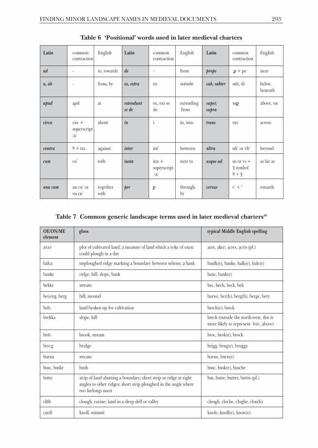
Apud 'at' is another useful indicator term (Figure 3). In figures 3.1 - 3.3 apud, ‘at’, iswritten out in full, but in 3.4 - 3.6, typical abbreviations are used: in the first abbreviatedform, the first two letters are written out, followed by a superscript /d/, while the secondabbreviation consists of a simple contraction, with the horizontal pen stroke through thefinal /d/ indicating a missing letter, in this case /u/. Example 3.6 features the first twoletters of apud, above which is a tilde – a mark used to let the reader know that there areletters missing. For finding place-names, vocatur, and its derivatives, and apud are themost useful terms, since they are almost always followed by a name.
Nevertheless, iacet ‘[it] lies’ and iacens ‘lying’ are also very helpful because they areoften used in later medieval charters to indicate where a particular plot of land liesand frequently these are in named places (Figure 4). In general, two forms of theverb ‘to lie’ are used to indicate where the transferred land is situated. Thestraightforward present tense form iacet is occasionally used, as indicated in example4.1. The more commonly used form, iacens, is the present participle form of the verb,translated as ‘lying’. It declines in accordance with the relevant case (Table 5). In
288 THE LOCAL HISTORIAN/OCTOBER 2019
FINDING MINOR LANDSCAPE NAMES IN MEDIEVAL DOCUMENTS 289
Figure 3 a
pud[‘at’]
3.1 SRO/D(W)1721/3/1/9
‘… apud Tunstall[e] …’
[… at Tunstall[e]…]
3.2 SRO/D(W)1721/3/2/12
‘… iacentes in Harleyapud Peklescroft …’
[… lying in Harleyat Peklescroft…]
3.3 SRO/D(W)1721/3/25/4
‘… prati Will[elm]i de Cou[n]desleg[h] Apud le stocing…’
[… the meadow of William of Coundesley atle stocing…]

290 THE LOCAL HISTORIAN/OCTOBER 2019
3.4 SRO/D(W)1721/3/21/2
‘… ap[u]d Haitel[e]in Campo vocato Cromburley…’
[… at Haitel[e]in the field called Cromburley…]
3.5 SRO/D(W)1721/3/21/13
‘… ap[u]d Haytelegh[e]in Campo vocato Moldefeld[e]…’
[… at Haytelegh[e]in the field called Moldefeld[e]…]
3.6 SRO/D(W)1721/3/24/4
‘… Iacent[em] ap[ud] Le Beregrene…’
[… Lying at Le Beregrene…]

FINDING MINOR LANDSCAPE NAMES IN MEDIEVAL DOCUMENTS 291
Figure 4 i
acetand
iace
ns[‘lies, lying’]
4.1 SRO/D(W)1721/3/30b/2
‘… que iacet in campo vocato Eliesfield…’
[… which lies in the field called Eliesfield…]
4.2 SRO/D(W)1721/3/31/12
‘… iacentem int[er] vastu[m] vocatu[m] le Mosseex vna p[ar]te, et
pasturam vocatam Dokeley…’
[… lying between the waste called le Mosseon one side, and the
pasture called Dokeley…]
4.3 SRO/D(W)1721/3/31/18
‘… et vna[m] acram t[er]re iacente[m] sup[er] ladyslathe…’
[… and one acre of land lying on ladyslathe…]
4.4 SRO/D(W)1721/3/26/3
‘… Iacentes scil[ice]t ex vt[raq]ue p[ar]te Lutlehaysiche…’
[… Lying, namely on both sides [of] Lutlehaysiche…]

292 THE LOCAL HISTORIAN/OCTOBER 2019
examples 4.2 and 4.3, because inter ‘between’ and super ‘on, above’ take the accusativecase, it becomes iacentem. The nominative plural form is used in 4.4 because in thisinstance two acres of land are being transferred. This is not as complex as it seems,but it is important to remember that however iacens declines, the stem form is alwaysiacen- which makes it easy to look for when scanning the document for field-names.
Table 5 The declension of Latin iacens (present participle)
singular plural
case/gender masculine feminine neuter masculine feminine neuter
nominative iacens iacens iacens iacentes iacentes iacentia
accusative iacentem iacentem iacens iacentes iacentes iacentia
genitive iacentis iacentis iacentis iacentium iacentium iacentium
dative iacenti iacenti iacenti iacentibus iacentibus iacentibus
ablative iacente iacente iacente iacentibus iacentibus iacentibus
The remaining indicator terms listed in Table 2 are secondary, and usually appear inconjunction with one of the primary terms listed above. They are useful to know andto be able to recognise, as they can signal place-names in charters.45 Examples ofthese words in medieval charters can be found by visiting our website.46 In addition tothese terms, another group of words can indicate the position of the fields beingnamed, and these are useful words to look out for (Table 6).
Finding field-names: some typical generic field-name elementsIn addition to the finding aids outlined in the preceding section, it is helpful whenlocating minor landscape names to have some idea of how they are formed, andwhich elements are the most useful in identifying them as names. Names are usuallymade up of anything from one to four or five distinct parts; the final element isknown as the ‘generic’, and the preceding elements are ‘qualifiers’ or ‘specifics’.47 Forexample, grenehull has one qualifier ‘green’; and its generic is ‘hill’. The genericterms are often, but not always, words that were commonly used to describe the rurallandscape in the later Middle Ages. These words are sometimes still in everyday use(like ‘hill’), but in many instances they no longer form part of our modernvocabulary. Table 7 lists many of the most common medieval generic landscape nameterms, and aims to make finding field-names in charters and other medieval localhistory documents a little easier. In each case, there is also a list of possible variantspellings, as spelling in this period varied according to local English dialect, whichwas generally the language used in writing down field-names.
The resources presented here have been designed to help researchers with little orno medieval palaeography skills to begin the process of unravelling a typicalmedieval conveyance; to find the relevant section within the charter in which field-names are most commonly found; and to locate the field- and minor landscapenames recorded therein. They provide a step-by-step approach to understandingwhere minor landscape names are recorded in most standard medieval conveyances.
FINDING MINOR LANDSCAPE NAMES IN MEDIEVAL DOCUMENTS 293
Table 6 ‘Positional’ words used in later medieval charters
Latin common English Latin common English Latin common Englishcontraction contraction contraction
ad - to, towards de - from prope ϼ + pe near
a, ab - from, by ex, extra ex outside sub, subter sub, sb below, beneath
apud apd at extendunt ex, ext se extending super, suϼ above, onse de de from supra
circa circ + about in i in, into trans tns acrosssuperscript /a/
contra 9 + tra against inter int’ between ultra ult’ or vlt’ beyond
cum cu’ with iuxta iux + next to usque ad us or vs + as far assuperscript ȝ symbol/a/ 9 + ȝ
una cum un cu’ or together per ϼ through, versus v’ + 9 towardsvn cu’ with by
Table 7 Common generic landscape terms used in later medieval charters48
OE/ON/ME gloss typical Middle English spellingelement
æcer plot of cultivated land; a measure of land which a yoke of oxen acre, aker; acres, acris (pl.)could plough in a day
balca unploughed ridge marking a boundary between selions; a bank baulk(e), bauke, balk(e), balc(e)
banke ridge, hill, slope, bank banc, bank(e)
bekkr stream bec, bech, beck, bek
be(o)rg, berg hill, mound barwe, ber(h), berg(h), berge, bery
brec land broken up for cultivation brech(e), breck
brekka slope, hill breck (outside the north-west, this is more likely to represent brēc, above)
broc brook, stream broc, brok(e), brock
brycg bridge brigg, brug(e), brugge
burna stream borne, burn(e)
busc, buskr bush busc, busk(e), busche
butte strip of land abutting a boundary; short strip or ridge at right but, butte; buttes, buttis (pl.)angles to other ridges; short strip ploughed in the angle where two furlongs meet
cloh clough, ravine; land in a deep dell or valley cleugh, cloche, cloghe, clou(h)
cnoll knoll, summit knole, knoll(e), know(e)

294 THE LOCAL HISTORIAN/OCTOBER 2019
cot cottage, hut, shelter or den cot(e)
croft small enclosed field croft(e)
cros cross cros(e), crosse
crouche cross crouch(e), cruch, cruce
dic ditch or embankment dich, dych(e), dyk
dæl hollow, valley dal(e), del(e)
dole a share, a portion; share in the common field dole
ende an end; the end of something, the end of an estate; a district or end(e), hend(e), yndquarter of a village or town
eng wet meadow or pasture land eng(e), hing, hyng(e), ing(e)
erg shieling arg(e), erg(e), erh(e)
fal(o)d fold fald(e), fold(e)
f(e)alh ploughed land; later, fallow land falgh, faluwe, faugh, vallow(e)
feld land for pasture or cultivation feld(e), fild(e), fyld(e), field
fell, fjall fell, mountain fel, fell(e)
flasshe pool, flooded grassland flask(e), flaisk(e), flash(e), floch(e), flosh(e), flosshe
flat a piece of flat ground flat(e)
ford ford ford(e), forth
furlang furlong forlong(e), furlong(e)
gara a gore, a triangular plot of ground gar(e), gore
garðr, garth an enclosure gard, garth(e)
gata a road49 gat(e)
geard yard yerd(e), yord(e)
gil ravine, narrow valley ghil(e), gil(e), gill(e), gyl(e), gyll(e)
gote watercourse goat, gote, gott
graf / græfe grove, copse, thicket greue, greve, groue, grove
grene grassy spot, a village green grene
haugr mound, natural or manmade how(e), hou(e)
hæg fence, enclosure hay(e), hey(e)
halh nook of land; small valley; dry ground in marsh; piece of land all(e), hale, halugh, halw(e), haugh(e)projecting from, or detached from, the main area of its administrative unit
heafod-land strip of land at the head of a furlong, for turning the plough hauelond, hauedlond, hauedelond
hethe heath heth(e)
OE/ON/ME gloss typical Middle English spellingelement
¯

FINDING MINOR LANDSCAPE NAMES IN MEDIEVAL DOCUMENTS 295
hlaða barn lad(e), ladhe, late, lathe
hlaw tumulus; a hill law(e), low(e)
holmr island, an inland promontory, raised ground in marsh, a river-meadow holm(e)
hop valley, remote enclosed space, enclosed land in the midst of fens hop(e), hopp, ope, up
hyll hill hil(e), hul, hull(e)
hyrst wooded hill hurst, hyrst
kjarr marsh overgrown with brushwood car, carr(e), ker(e), kerr(e)
læs pasture, meadow-land leys, lese, lees, lesewe, leswe, lesue
land land; an estate; possibly a new arable area; in minor and field land, lond, lont; londes (pl.)names, a strip in a field-system
lane lane lone
leah forest, wood, glade, clearing; (later) a pasture, meadow ley(e)
lundr grove, small wood lond, lound, lund
med meadow mede, medue, medewe, medo, medowe, medwe
mere pond, pool or lake mere50
mersc marsh merch, mersh51
mor marsh, barren upland; later, open grazing land mor(e)
mos bog, swamp mos(e), moss(e)
myln mill muln(e), miln(e), myln(e)
myrr swampy ground mir(e), myer, myre
place an open space in a town, an area surrounded by buildings; placea town-house; a residence, a mansion-house
pōl pool pol(e), polle, pul
pytt pit pett, put, putte, putth, pytt
rode, rodu clearing rod(e), roid(e), royd(e)
rydding clearing ri(d)ding(e), ryding(e), rydyng(e)
sceaga small wood, copse saghe, sahe, shagh, shaw(e)
sīc small stream, drainage channel sech, sich(e), sych(e)
skógr wood scoe, scouwe, scugh, skowe
slæd valley, meadow, marshy greensward sclade, slade scled(e)
stede place sted(e)
stīg path, a narrow road sty(e)
stīgel stile, a place devised for climbing over a fence; topographically stile, steyll, styleperhaps a steep ascent
OE/ON/ME gloss typical Middle English spellingelement
296 THE LOCAL HISTORIAN/OCTOBER 2019
stoccing place cleared of tree stumps stoccing(e), stokkyng(e), stoking(e), stocking(e)
stræt paved (Roman) road; later ‘street’ strete
þveit clearing; meadow; paddock thueit, thwait(e), twayte
vangr enclosure in an open field wong(e), wang(e)
weg road wey(e), weg
wella spring, stream wall(e), well(e), wel
wudu wood wod(e), wodd
OE/ON/ME gloss typical Middle English spellingelement
ConclusionThe increasing importance of field-names and minor landscape-names as historicalevidence in local history research should not be underestimated. Medieval materialof this nature can help to illuminate elements of the socio-economic outlook for aperiod in which there may be little detailed documentary evidence. Furthermore,landscape names, almost exceptionally, offer researchers access to the perceptions ofpeople lower in the social hierarchy, enabling a more complete reconstruction of thelocal landscape. The linguistic value of field-names is also worth stressing. Theypreserve the agricultural, environmental and cultural vocabulary of those whoworked the land, which is poorly represented in other medieval sources. Theguidelines set out within this article place this previously inaccessible material withinthe reach of non-specialist researchers.
The success of this approach is witnessed by the treasure trove of landscape namesalready unearthed from medieval manuscripts by the Staffordshire Record Officevolunteers. These relate to industry (Lymputtes 1297–8 ‘lime pits’, Wynmulnefield 1398‘windmill field’); pastoral farming (Oxemedewe 1297–8 ‘ox meadow’, scheperduscrofte1398 ‘shepherd’s croft’, Swynefen 1297–8 ‘pig marsh’); crops (le Ruyeland 1275–1300‘rye arable land’); flora (Bromhull 1297–8 ‘broom hill’, le Gorstiknol 1297 ‘gorsy hillock’,le Olleresshawe 1340 ‘alder’s small wood’) and woodland more generally (Gretwode1297–8 ‘great wood’, le quech 1317 ‘thicket’); fauna (Foxholes 1297, Owelcotesfeldes 1430‘owl cottage’s fields’, Wolfhurst 1297–8 ‘wolf wooded slope’); and features of thelandscape, in particular wetland (Dedemor 1297–8 ‘dead (i.e. unproductive) marsh’,Mershemedewe 1297–8 ‘marsh meadow’, le snape 1401–2 ‘swamp’, Wethales 1297–8 ‘wetnooks’) and watercourses (Holebrokende 1297–8 ‘hollow brook end’, Shirwelleheuede1297–8 ‘bright spring head’, Smalesich 1297–8 ‘small stream’).52
The landscape is peopled with individuals who bear nicknames (Pecokesfeld 1430‘Peacock’s field’), occupational names (messengereshey 1437 ‘Messenger’s enclosure’),names of Old English origin (Levericheruding 1297–8 ‘Leofric’s clearing’,Wilmondesruding 1297–8 ‘Wilmund’s clearing’) and (ultimately) of Biblical origin(Jamesbrich 1297–8 ‘James’s newly broken-in land’).53 In addition to the details ofpeople, land-use and landscape provided by these names, they also include linguisticfeatures characteristic of the west midlands, for example the u in Lymputtes,Wynmulne-, and Bromhull (and also le Hulfeld 1398), where we have standard modernEnglish i (in the forms of pit, mill, and hill) . The date of attestation of the name lequech ‘the thicket’ is 1317, 169 years earlier than the first citation in the OxfordEnglish Dictionary.

The process of learning to read medieval documents proficiently typically requiresstudents to embark upon many hours of study. So, while the resources presented inthis article cannot replace a formal palaeography course in which expert tuition isoffered, they provide an accessible introduction to medieval palaeography for thosewishing to develop their skills. More significantly, for many researchers andvolunteers who cannot make such a significant time investment, especially thosesimply wishing to extract information that relates to the medieval landscape of theirparticular village or town, they offer a guide to retrieving data that, for someresearchers, might hitherto have seemed impossible to access.
AcknowledgementsWith thanks to the Staffordshire Record Office (most especially to Dr Matthew Blake,its Participation and Engagement Officer) and our wonderful volunteers in Lichfieldand Stafford (too many to name individually) and their past and present supervisors,Dr Rebecca Gregory, Jennifer Lewis, Joshua Neal, and Jessica Treacher. Our work inStaffordshire has been generously funded by Professor Jim and Mrs Mary Ann Wilkes(Ann Arbor, Michigan), the University of Nottingham (the School of English, theDigital Research Team, and the Hermes Fellowship scheme), and by the BritishAcademy. We would also like to thank the BALH and the editor of The Local Historianfor their generosity in allowing this paper to be published as Open Access, andtherefore available to all via our website.
A select bibliography of useful published sources N. W. Alcock, Old Title Deeds: a Guide for Local and Family Historians (Phillimore, 1986)
A. Armstrong, A. Mawer, F.M. Stenton, and Bruce Dickins, The Place-Names of Cumberland, 3 vols(Cambridge UP, 1950–2) Part 3
J. Baker, with S. Beach, The Place-Names of Shropshire: Part Seven (EPNS, 2018)
P. Cavill, A New Dictionary of English Field-Names, with an introduction by R. Gregory (EPNS, 2018)
B. Cox, The Place-Names of Leicestershire, 7 vols (EPNS, 1998–2016)
G.R.C. Davies, Medieval Cartularies of Great Britain and Ireland, revised by Claire Breay, JulianHarrison and David M. Smith (British Library, 2010)
J. Field, A History of English Field-Names (Longman, 1993)
H.D.G. Foxall, Shropshire Field-Names (Shropshire Archaeological Society, 1980)
M. Gelling, Place-Names in the Landscape (Dent, 1984)
M. Gelling, with H.D.G. Foxall, The Place-Names of Shropshire, 6 vols so far (EPNS, 1990–2009) PartOne
M. Gelling and A. Cole, The Landscape of Place-Names (Shaun Tyas, 2000)
E. A. Gooder, Latin for Local History, An Introduction (Longman, 1978)
J.E.B. Gover, A. Mawer, and F.M. Stenton, The Place-Names of Northamptonshire (Cambridge UP,1933)
V. Greatorex and M. Headon (eds), Field-Names in Cheshire, Shropshire and North-East Wales(Marlston Books, 2014)
R. Gregory, ‘Some Nottinghamshire dead men’, Nomina 38 (2015) 85–92
J. Harte, ‘Down among the dead men’, Nomina 36 (2013) 35–52
P.D.A. Harvey, Manorial Records (Alan Sutton, 1984)
FINDING MINOR LANDSCAPE NAMES IN MEDIEVAL DOCUMENTS 297

298 THE LOCAL HISTORIAN/OCTOBER 2019
C. Johnson and H. Jenkinson, English Court Hand 1066-1500 (Clarendon Press, 1915)
A. Mawer, ‘The study of field-names in relation to place-names’, in J.G. Edwards, V.H. Galbraith,and E.F. Jacob (eds), Historical Essays in Honour of James Tait (1933) 189–200.
A. Mawer and F.M. Stenton, The Place-Names of Buckinghamshire (Cambridge UP, 1925)
M.M. Postan and C.N.L. Brooke (eds), Carte Nativorum, a Peterborough Abbey Cartulary of theFourteenth Century (Northamptonshire Record Society, 1960)
A.H. Smith, English Place-Name Elements, Part 1 and Part 2 (Cambridge UP, 1956)
D. Stuart, Manorial Records: an Introduction to their Transcription and Translation (Phillimore, 1992)
J. West, Village Records (Phillimore, 1982)
WebsitesBritish Academy: www.thebritishacademy.ac.uk/academy-research-projects
British History Online: www.british-history.ac.uk/search/series/ancient-deeds
Mapping the Medieval Countryside: www.inquisitionspostmortem.ac.uk
British Library Online Catalogue: www.explore.bl.uk/
Place-Names Committee of Kent Archaeological Society: www.kentarchaeology.org.uk/about-us/committees/place-names-committee
Lancashire Place-Names Survey: www.lancspns.weebly.com/
The National Archives Online Catalogue: www.discovery.nationalarchives.gov.uk/
The National Archives Latin Palaeography: www.nationalarchives.gov.uk/latinpalaeography/
The National Archives Manorial Documents Register:discovery.nationalarchives.gov.uk/manor-search
Staffordshire Place-Name Project: www.staffordshireplacenames.wordpress.com/ andhttps://staffordshireplacenames.esdm.co.uk/
University of Nottingham Introduction to Palaeography:www.nottingham.ac.uk/manuscriptsandspecialcollections/researchguidance/medievaldocuments/handwritingstyles.aspx
University of Nottingham Finding Medieval Landscape Names:www.nottingham.ac.uk/go/medievalfieldnames/
Johnson and Jenkinson on the Internet Archive:www.archive.org/details/englishcourthand01john/
NOTES AND REFERENCES1 Specifically, conveyances (otherwise known as
‘gifts’).2 The Survey is an Academy Research Project, one
of about 55 projects distinguished by the BritishAcademy’s ‘kitemark of academic excellence’,producing ‘fundamental works of scholarship’(www.thebritishacademy.ac.uk/academy-research-projects).
3 A. Mawer and F.M. Stenton, The Place-Names ofBuckinghamshire (Cambridge UP, 1925) v–viii
4 ibid, v; ‘carding up’ involved volunteerresearchers noting historical place-namespellings on slips of paper, ready for furtheranalysis.
5 J.E.B. Gover, A. Mawer, and F.M. Stenton, ThePlace-Names of Northamptonshire (CambridgeUP, 1933) vi
6 A. Armstrong, A. Mawer, F.M. Stenton, andBruce Dickins, The Place-Names of Cumberland(Cambridge UP, 1950–2) vol.3, vii
7 Margaret Gelling, with H.D.G. Foxall, ThePlace-Names of Shropshire, 6 vols (English Place-Name Society [EPNS], 1990–2009) pt.1, ix
8 The latest volume is John Baker, with SarahBeach, The Place-Names of Shropshire: Part Seven(EPNS, 2018).
9 Place-Names Committee of Kent ArchaeologicalSociety (www.kentarchaeology.org.uk/about-us/commit tees/place -names -commit tee) ;Lancashire Place-Names Survey (http://lancspns.weebly.com/); Staffordshire Place-NameProject (https://staffordshireplacenames.wordpress.com/ and https://staffordshireplacenames.esdm.co.uk/)
FINDING MINOR LANDSCAPE NAMES IN MEDIEVAL DOCUMENTS 299
10 Ann Grand et al, ‘Mapping public engagementwith research in a UK university’, PLoS ONE10:4 (2015) 2; S.R. Davies, ‘Research staff andpublic engagement: a UK study’, HigherEducation 66 (2013) 726; J. Tosh, ‘Publichistory, civic engagement and the historicalprofession in Britain’, The Journal of theHistorical Association (2014) 194; althoughthose engaged in local history research in allits forms have long connected with localcommunities: J. Beckett, ‘Local history in itscomparative international context’, The LocalHistorian vol.41 no.2 (May 2011) 102
11 The Charnwood Roots project at the Universityof Leicester, for example, attracted more than500 volunteers over its four-year lifetime:<https://www2.le.ac.uk/departments/history/research/grants/charnwood>; J. Attard and M. Morris, ’Digging up the past: communitytest-pit excavations with Charnwood Roots’,Transactions of the Leicestershire Archaeological andHistorical Society vol.92 (2018) 149.
12 Feedback received following medievalpalaeography training at Staffordshire RecordOffice, May 2018.
13 The SRO hosts and co-manages a number ofadditional projects for which volunteer inputis essential. These include joint initiatives withthe Staffordshire Victoria County History; andwith the Universities of Keele and Sussexexamining poor law records (‘Small bills andpetty finance: co-creating the history of theold Poor Law’).
14 J. Hendricks and S.J. Cutler, ‘Volunteerismand socioemotional selectivity in later life’,Journal of Gerontology: Social Sciences, vol.59b(2004) S252
15 R. Casiday et al, Volunteering and health: whatimpact does it really have? Report to VolunteeringEngland (2008) 3; F. Tang, E. Choi and N.Morrow-Howell, ‘Organizational support andvolunteering benefits for older adults’, TheGerontologist 50:5 (2010) 605
16 M. King,‘Wots-Its-Name?’, Smestow ValeGrapevine (April 2017)
17 M. Gelling and A. Cole, The Landscape of Place-Names (Shaun Tyas, 2000) 164; see alsoGelling’s earlier book, Place-Names in theLandscape (Dent, 1984) 140–158
18 The form ‘1195/14th-century MS’ indicatesthat the name occurs in a later copy of anearlier and now lost document.
19 Mawer and Stenton, Place-Names ofBuckinghamshire, 257
20 A. Mawer, ‘The study of field-names in relationto place-names’, in J.G. Edwards, V.H.Galbraith, and E.F. Jacob (eds), HistoricalEssays in Honour of James Tait (1933) 189–200
21 Armstrong, Mawer, Stenton, and Dickins, ThePlace-Names of Cumberland.
22 Barrie Cox, The Place-Names of Leicestershire, 7vols (EPNS, 1998–2016). An eighth volume,the introduction to this county survey, is inprogress.
23 John Field, A History of English Field-Names(Longman, 1993)
24 John Field, English Field Names: A Dictionary(David & Charles, 1972); Paul Cavill, A NewDictionary of English Field-Names, with anintroduction by Rebecca Gregory (EPNS,2018)
25 Field, A History of English Field-Names, xi26 H.D.G. Foxall, Shropshire Field-Names
(Shropshire Archaeological Society, 1980)27 Where tithe apportionment material did not
exist, Foxall drew on estate survey maps. 28 For some more recent work, see the
contributions by members of the ChesterSociety for Landscape History in VanessaGreatorex and Mike Headon (eds), Field-Namesin Cheshire, Shropshire and North-East Wales(Marlston Books, 2014).
29 Gelling with Foxall, The Place-Names ofShropshire, Pt.2, 97
30 The names are from the following SROdocuments: D593/H/14/3/2, D593/J/6/1/1, B/V/6/B15-16, D554/25/1-16, D593/H/14/3/1,D240/B/2/1. For the significance of the lasttwo names, see J. Harte, ‘Down among thedead men’, Nomina 36 (2013) 35–52, and R. Gregory, ‘Some Nottinghamshire deadmen’, Nomina 38 (2015) 85–92.
31 Our project officers are students writing PhDson place-names; they also benefit enormouslyfrom the experience of working withvolunteers and record office staff, and fromexposure to the broad range of documents onwhich the volunteers work.
32 https://staffordshireplacenames.wordpress.com/blog/
33 https://www.nottingham.ac.uk/go/medievalfieldnames/
34 For useful overviews of these sources see: J.West, Village Records (Phillimore, 1982); P.D.A.Harvey, Manorial Records (Alan Sutton, 1984);N.W. Alcock, Old Title Deeds: a Guide for Localand Family Historians (Phillimore, 1986).
35 Online catalogues are: TNA http://discovery.nationalarchives.gov.uk/ and BLhttp://explore.bl.uk/ (select ‘Archives andmanuscripts catalogue’ from the drop-downbox on the left-hand side of the menu).Medieval documents within county archivecollections and at other repositories are usuallyalso found on the TNA online catalogue,Discovery, and this is the best place to beginany search for manuscript material. Themajority of the TNA collection of ‘AncientDeeds’ is searchable at British History Onlinewww.british-histor y.ac.uk/search/series/ancient-deeds. For a list of medieval cartulariessee G.R.C. Davies, Medieval Cartularies of GreatBritain and Ireland, revised by Claire Breay,Julian Harrison and David M. Smith (BritishLibrary, 2010). Lists of manorial documentsare also searchable for most counties athttp://discovery.nationalarchives.gov.uk/manor-search. Some inquisitions post mortemcontain minor landscape names, and aresearchable at https://www.british-history.ac.uk/search/series/inquis-post-mortem andhttp://www.inquisitionspostmortem.ac.uk/.
300 THE LOCAL HISTORIAN/OCTOBER 2019
36 Alcock, Old Title Deeds; dating of medievalcharters usually begins in the last quarter ofthe thirteenth century.
37 M.M. Postan and C.N.L. Brooke (eds), CarteNativorum, a Peterborough Abbey Cartulary of theFourteenth Century (Northamptonshire RecordSociety, 1960) xli
38 Occasionally, charters were written in Anglo-Norman. Here, we concentrate on the Latincharters.
39 C. Johnson and H. Jenkinson, English CourtHand 1066-1500 (Clarendon Press, 1915). Anelectronic copy is available online:https://archive.org/details/englishcourthand01john/. Also worth consulting is D. Stuart,Manorial Records: an Introduction to theirTranscription and Translation (Phillimore,1992).
40 There are good introductory onlinepalaeography resources, including TNAhttp://www.nationalarchives.gov.uk/latinpalaeography/ and University of Nottinghamhttps://www.nottingham.ac.uk/manuscriptsandspecialcollections/researchguidance/medievaldocuments/introduction.aspx.
41 Medieval charters take several forms. Thosetypically used in peasant land transactions areall formulaic. Examples of the relevant clausescan be found online at https://www.nottingham.ac.uk/go/medievalfieldnames/.
42 confirmaui ‘I have confirmed’ is sometimesreplaced by the Latin vendidi ‘I have sold’.
43 Superscript (‘above written’) indicates thatone or more letters have been missed out. Thetype of superscript symbol used usuallyindicates which letters are missing.
44 E.A. Gooder, Latin for Local History, AnIntroduction (Longman, 1978) 26 provides auseful guide to the formation of Latinparticiples.
45 The secondary indicators are very much that,and while in many instances they precedefield-names, occasionally they may not. Forfurther information, see https://www.nottingham.ac.uk/go/medievalfieldnames/.
46 https://www.nottingham.ac.uk/go/medievalfieldnames/
47 Cavill, A New Dictionary of English Field-Names, vi48 This is not an exhaustive list. For more place-
name elements see A.H. Smith, English Place-Name Elements, Part 1 and Part 2 (CambridgeUP, 1956).
49 This element can be confused with OE gat‘goat’, and with ME gate, which can be used asa northern dialect term meaning ‘right orprivilege of pasture for cattle’: Armstrong,Mawer, Stenton and Dickins, Place-Names ofCumberland, Part 3, 474.
50 Beware, as this element is often abbreviated tomer’, which means that it is difficult todistinguish from other elements, such asmersc.
51 Sometimes abbreviated to mer’ or mar’.52 SRO D(W)1721/3/29/ 3 and 9; D(W)1721
/3/14/7; D(W)1721/3/19/11; D(W)1721/3/7/13; D(W)1721/3/12/16; D4038/E/1/1; D4038/E/2/1; D(W)1734/J/2268
53 SRO D4038/E/2/1; D4038/E/2/2; D(W)1734/J/2268
JAYNE CARROLL is associate professor and director of the Institute for Name-Studies at theUniversity of Nottingham, and honorary secretary of the English Place-Name Society. She haspublished on place-names and on Old English and Old Norse language and literature; wasprincipal investigator on the AHRC-funded project, The Place-Names of Shropshire; and has beenco-investigator on a number of Leverhulme Trust-funded interdisciplinary projects, including‘Travel and Communication in Anglo-Saxon England’, and ‘Flood and Flow: Place-Names andthe Changing Hydrology of English and Welsh Rivers’. She is the author of The Vikings inBritain and Ireland, with S. Harrison and G. Williams (2014) and Anglo-Saxon Mint-Names, with D. N. Parsons (2007), and editor of Power and Place in Europe in the EarlyMiddle Ages, with A. Reynolds and B. Yorke (2019) and Perceptions of Place, with D. N.Parsons (2013).
SUSAN KILBY is a research fellow in the Institute for Name-Studies at the University ofNottingham and honorary secretary of the Medieval Settlement Research Group. She is amedieval landscape historian, principally interested in peasants’ relationship with the ruralenvironment, and a monograph on this theme is due in 2020 with the University of HertfordshirePress. Much of her work focuses on field-names as a primary means of accessing peasantmentalities. Recent publications include ‘Divining medieval water: the field-names of Flintham inNottinghamshire’, JEPNS 49 (2017) and co-authored ‘Living with a trespasser: riparian namesand medieval settlement on the River Trent floodplain’, Journal of Post-ClassicalArchaeologies 7 (2017).