prepared for the town of youngtown by
TRANSCRIPT

Prepared for the Town of Youngtown by

YOUNGTOWN
GENERAL PLAN 2025
Prepared for the Town of Youngtown by:
www.blantoncooper.com

CONTENTS ACKNOWLEDGEMENTS……………………………………………………...….….. 7 RESOLUTION OF ADOPTION.......................................................................................8 PREFACE……………………………………………………………...………....…...…. 11 YOUNGTOWN MISSION and VISION STATEMENT 2025……...………….....…...13
1.0 INTRODUCTION……………………………………………………….................14
1.1 Purpose of the General Plan ………………………………...………….…...14 1.2 General Plans and How They Are Used ………………………………….....14 1.3 Public Participation ……………………………………………………….....16 1.4 How the Plan is Arranged ………………………………………………..….16 1.5 Amendments to the General Plan ………………………………………..….17
2.0 CONTEXT ………………………………...………………….................................19
2.1 Introduction …………………………...…………………………...…..……19 2.2 History ……………………………………………………………..…..……19 2.3 Geography …………………………………………………………………..19 2.4 Youngtown Planning Area ………………………………………….....……20 2.5 Demographic Overview ……………………………………………….....…21
3.0 LAND USE ELEMENT …………………………………………..………............24
3.1 Introduction …………………………………...……………………….…....24 3.2 Existing Land User ………………………………………………...…..……24 3.3 Planning Issues …………………………………………………………..….27 3.4 Goals, Objectives and Policies …………………………………………..….28 3.5 Proposed Land Uses and Map …………………………………………..…..32 3.6 Land Use Categories ………………………………………………….…….33 3.7 Protection of Aggregate Sites and Resources …………………………..…..36
4.0 CIRCULATION AND TRANSPORTATION ELEMENT ………………….... 37
4.1 Introduction ……………………………………………...………...……..…37 4.2 Existing Conditions ……………………………………………...…….........37 4.3 Street Class Definitions ……………………………...……………….….….39 4.4 Planning Issues ……………………….………………………………..……40 4.6 Goals, Objectives and Policies ……………………...…………………..…..40

5.0 WATER RESOURCES ELEMENT…………………………………………….47
5.1 Introduction ……………………………………..…………………………47 5.2 Current Conditions ……………………………..…………………….……47 5.3 Future Trends ……………………………………..…………………...…..48 5.4 Planning Issues …………………………………..…………………...……48 5.5 Goals, Objectives and Policies ………………..………………...…………49
6.0 OPEN SPACE AND RECREATION ELEMENT .............................................50
6.1 Introduction ……………………...……………..………………………….50 6.2 Current Conditions ……………...……………..…………………….…….50 6.4 Planning Issues ………………………...………..…………………………52 6.5 Goals, Objectives and Policies ………...………..…………………………52
7.0 ENVIRONMENTAL PLANNING ELEMENT ..………….……………….......55
7.1 Introduction …………………………………………………………..……55 7.2 Current Conditions ………………………………………………….......…55 7.3 Future Trends ………………………………………...……………..……..57 7.4 Planning Issues ………………………………………..…………...............57 7.5 Goals, Objectives and Policies ……………………..……………..……….57
8.0 ECONOMIC DEVELOPMENT ELEMENT ...………..…………….…….......59
8.1 Introduction ………………………………………………………..………59 8.2 Goals, Objectives and Policies …………………………………….....……59
9.0 GROWTH AREAS ELEMENT …………………………………...…………....64
9.1 Introduction ……………………………………………………..…………64 9.2 Current Conditions ………………………………………………..……….64 9.3 Growth Areas ………………………………………...………..……….… 64 9.4 Planning Issues ……………………………………...……………………..64 9.5 Goals, Objectives and Policies …………………………….....……………65
10.0 COST OF DEVELOPMENT ELEMENT..............................................................67
10.1 Introduction…………………………………………………………….……67 10.2 Current Conditions…………………………………………………….…….67 10.3 Planning Issues……………………………………………………….……...67 10.4 Goals, Objectives and Policies……………………………………….……...68
11.0 IMPLEMENTATION PROGRAM………………………………………………69
11.1 Introduction ………………………………………………………...……….69 11.2 Phased Actions …..……………………………………………….…...…….69

LIST OF FIGURES
Figure 1: Airport Vicinity Map for LAFB…………………………………………20 Figure 2: Population by Age……………………………………………….………21 Figure 3: Housing Unit Occupancy………………………………………………..22 Figure 4: Household Income……………………………………………………….22 Figure 5: Businesses by Sector…………………………………………………….23 Figure 6: Area Vicinity Map …………………………………………,,……….… 25 Figure 7: Land Use Map ……………………………………………,,…………... 26 Figure 8: Circulation and Transportation Map ………………………,,…………. 46 Figure 9: Growth Areas Map …………………………………………,,………… 66
LIST OF TABLES
Table 1: Related Documents…..…………………………………….………...….. 15 Table 2: Organization of Elements…………………………………………..…… 17 Table 3: Land Use Densities and Projected Build-Out ..…………………..…...… 33 Table 4: Roadway Level of Service and Service Volumes…………………..….. 40 Table 5: Youngtown Public Parks……………………………………………..… 51 Table 6: Measures Adopted to Reduce PM-10 Particulates…………………..…. 55 Table 7: Growth Areas………………………………………………..………….. 64 Table 8: Land Use Element: Implementation Strategies and Timing…………......72 Table 9: Circulation and Transportation Element: Implementation
Strategies and Timing…………………………………………….…..…...74 Table 10: Water Resources Element: Implementation Strategies and
Timing………………………………………………………………...….. 75 Table 11: Open Space and Recreation Element: Implementation Strategies
and Timing…………………………………………………………….......76 Table 12: Environmental Planning Element: Implementation Strategies and
Timing……………………………………………………………...…….. 77 Table 13: Economic Development Element: Implementation Strategies and
Timing…………………………………………………………………......78 Table 14: Growth Areas: Implementation Strategies and Timing…………….…..79 Table 15: Cost of Development: Implementation Strategies and Timing…....……80
Appendix A: Youngtown Public Involvement Process …………………………..………81
7 | P a g e
ACKNOWLEDGEMENTS
Youngtown General Plan 2025 was made possible through the collaboration of residents, business/landowners, Town of Youngtown Council, staff, and consultants. The Town would like to extend its appreciation to all for their participation, thoughtful input, and commitment to Youngtown’s future.
The following persons are particularly acknowledged for their participation. Youngtown General Plan 2025 was adopted by Resolution No: (insert #) on (insert date).
Youngtown Town Council
Michael LeVault, Mayor Jacob “Jack” Duran, Vice Mayor
Margaret Chittenden Dorena Mello
Shirley Gustafson Judy Johnson June Miller
Youngtown Staff
Jeanne Blackman, Town Manager Diane Cordova, Town Clerk
Marty Mosbrucker, Public Works Manager Gayle Cooper, Economic Development Manager
Consultants
Joe Blanton, AICP Gayle Cooper, CEcD
8 | P a g e

9 | P a g e

10 | P a g e

11 | P a g e
PREFACE Youngtown updates its General Plan to serve three, interrelated purposes: 1) to comply with Arizona's Growing Smarter (1998), Growing Smarter Plus (2000), and Regulatory Bill of Rights (2011) legislation; 2) to recognize changes of conditions in the community since the last comprehensive General Plan adoption; and 3) to develop strategies to ensure a prosperous and sustainable future for Youngtown.
Since the last comprehensive adoption of the Youngtown General Plan in 2003, changes have occurred that required the Plan to be updated. Most notable of these are the doubling of the population, a shift in demographics from older to younger, and the strain on Town resources caused by the current recessional period.
The Town Council has adopted a Public Participation Program, as required by State statutes, to ensure that the General Plan 2025 process is open to involvement by all interested members of the community. Three citizen-involvement workshops, stakeholder meetings, Plan briefings and public presentations have afforded interested residents and business people opportunities for input in validating existing, and establishing new policy directions for Youngtown.
In February 2012, Joe Blanton and Gayle Cooper of Blanton & Cooper, LLC were selected to update the General Plan. Blanton & Cooper provided a comprehensive update to the text of the Plan and added an Economic Development Element. The public was engaged throughout the process to ensure the Plan’s endorsement. Maricopa Association of Governments (MAG) provided their services to create and update applicable maps for the Plan.
Various meetings were held with private stakeholders, particularly landowners and business people, to hear their views about the future of Youngtown. A Visioning Workshop was then held in March 2012 to elicit further comments from additional stakeholders following which a revised Vision Statement was formulated. In May 2012, a Land Use Alternatives Workshop explored general land uses and introduced “live/work” and “Commerce/Business Park” (employment) classifications. A draft revised future land use map was prepared from input gathered at the workshop.
Blanton & Cooper provided monthly status reports to the Town Manager and press releases to the Youngtown Village Reporter. A Draft Plan was presented to the Town Council on October 18, 2012 and Town staff distributed draft plans in compliance with the 60-day statutory review requirements. Since 2012, and with a new Town Manager and
12 | P a g e
the majority of staff being new, the document was reviewed by all staff with input provided as well as resending the document to key community stakeholders for their input. Updated information has been incorporated into the plan regarding the Northwest Valley Transportation Plan, the Small Area Transportation Study, and Maricopa County Air Quality Standards (PM-10) as well as Youngtown’s Mission and Vision Statement, and strategic priorities that resulted from the Town’s Strategic Planning Session held in November, 2013. Residents were able to review the updates as well as provide additional input to the plan. Updates were made to the goals outlined in the original plan which included the adoption by Council of the Youngtown Community4Good Initiative which includes significant emphasis on additional outreach to residents and the business community.

13 | P a g e
Youngtown Mission Statement
Youngtown exists as a municipality to provide a sustainable, locally controlled environment in which its citizens and businesses can thrive, by:
Supporting and engaging the community through programs and services and by providing opportunities for resident and business feedback.
Promoting transparent, effective and efficient government.
Promoting a business-friendly environment that contributes to quality of life and the sustainability of Youngtown as an independent municipality.
Youngtown Vision Statement
We envision Youngtown to be an aesthetically beautiful community that embodies small town values such as safety, community pride and a highly engaged citizenry while at the same time providing proximity to big city amenities, a business-friendly environment as well as a dynamic and sustainable local economy.
Strategic Priorities:
1. Engage Citizenry/Foster Community Pride (create “I’m from Youngtown and proud of it” residents rather than “My address just happens to be in Youngtown… I think”). The lack of such citizen engagement on the part of Youngtown may be a continued alienation from new Youngtown residents and various sub-communities that are less inclined to make decisions to preserve a locally controlled Youngtown. Such a resident mind-set increases the probability that Youngtown moves closer toward no longer existing as an individual municipality.
2. Cultivate, protect and strengthen existing and new sources of town revenue. 3. Cultivate a strong business community/business community identity. 4. Create a system/process that ensures strong, principled leadership of Youngtown in
the future. 5. Foster a mindset of bold innovation that further encourages/enables Youngtown to
“think outside the box” to address the challenges and opportunities facing municipal government in the 21st century.
14 | P a g e
1.0 INTRODUCTION
1.1 Purpose of the General Plan
The General Plan (Plan) provides guidance for Town staff, citizens, and others doing business with our Town to help them achieve Youngtown’s vision for future land use and development. The Plan contains eight elements: Land Use, Circulation and Transportation, Water Resources, Open Space and Recreation, Environmental Planning, Economic Development, Growth Areas and Cost of Development. Together, these elements provide guidance regarding future development of the community.
A General Plan Is: A General Plan Is Not: A means to protect quality of life
A rigid, static document
A statement of policy
A zoning ordinance
An expression of community intentions A detailed policy of specific areas of the Town
A guide to decision making
A Capital Improvement Plan
A presentation of long-term perspectives
A tool to promote special interests
A legal mandate
Just a land use map
1.2 General Plans and How They Are Used
General Plans reflect the long-term development goals of the community and guide future growth. General Plans are comprehensive because they seek to coordinate all the systems of a municipality. They consist of maps, goals, objectives and policies. These are used by officials to guide decisions about types of land uses, permitted density and/or coverage area, open space, infrastructure, and circulation systems, along with the financing tools necessary to accomplish them.
Citizens use the Plan to better understand their Town and its future. Those wishing to develop projects within the Town use the Plan to understand what types of developments are desired by the Town and where they should be located.
The General Plan does not change existing zoning. If a property’s existing zoning is not in conformance with the adopted Plan, the property may still be developed

15 | P a g e
according to the existing zoning. However, any proposed changes to existing zoning must be consistent with, and conform to, the current adopted Land Use Plan. This does not mean the Plan is static. There are provisions under Arizona Revised Statutes (A.R.S.) §9-461.06 for General Plan Major and Minor Amendments and a procedure for considering them. This process is further described at the end of this section. The General Plan affects every resident and business/landowner in Youngtown. It provides guidance to the Town and to the private sector about the types and locations of public facilities, private development, and infrastructure needs. The Plan’s eight elements are interrelated. All the General Plan elements should be considered collectively in any decision-making process. That is, no single element or excerpted statement should be used to reach a particular conclusion. Other plans formulated by outside sectors of government may influence the planning of Youngtown. These are listed in Table 1, Related Documents.
Table 1: Related Documents Document Name Related General Plan Element(s) Flood Control District of Maricopa County Watercourse Agua Fria Master Plan
Land Use, Open Space
Maricopa Association of Governments West Valley Non-Motorized transportation Plan
Open Space
Maricopa Association of Governments Desert Spaces Plan
Open Space
Maricopa County Countywide Trails Plan
Open Space
Grand Avenue Northwest Corridor Study
Circulation, Environmental
Northwest Valley Transportation Plan
Circulation, Transportation
Maricopa Association of Governments Small Area Transportation Study
Circulation, Transportation

16 | P a g e
1.3 Public Participation Public participation is critical to a successful; general planning process. The formation of the Youngtown General Plan 2025 involved residents, business/landowners, staff and officials of Youngtown through three public meetings.
Arizona Law requires that each entity preparing a General Plan to adopt written procedures to provide effective, early, and continuous public participation in the development and major amendment of General Plans from all geographic, ethnic and economic sectors of the community. The procedures provide for: 1) the broad dissemination of proposals and alternatives; 2) the opportunity for written comments; 3) public hearings after effective notice; 4) open discussions, communications, programs, and information services; and, 5) consideration of public comments. The Town of Youngtown adopted a public involvement policy on July 18, 2002 at the regular meeting of the Town Council. The complete text of the Youngtown Public Involvement Process can be found in Appendix A: Youngtown Public Involvement Process. 1.4 How the Plan is Arranged The General Plan is organized into eight elements. Each of these contains specific goals, objectives and policies that provide guidance to citizens and decision makers about future land use and development. Broadly defined, goals are the desired result, objectives are benchmarks toward achieving the goals, and policies are the action items that the Town can take to reach the objectives and desired goals. An Implementation Plan is provided, which suggests short-, mid-, and long-range strategies to accomplish the goals and objectives of the General Plan 2025. In compliance with A.R.S. §9-461.05, the General Plan Elements will address the elements illustrated.
First Public Meeting March 12, 2012
17 | P a g e
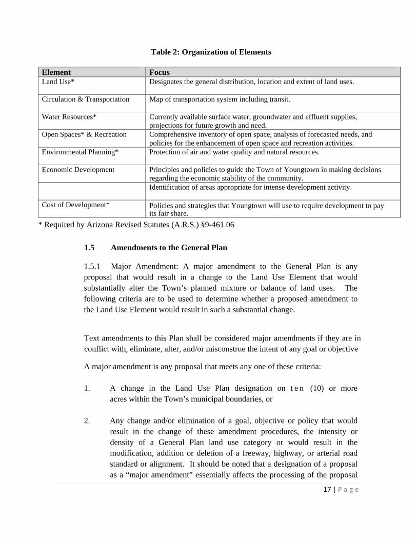
Table 2: Organization of Elements
Element Focus Land Use* Designates the general distribution, location and extent of land uses.
Circulation & Transportation Map of transportation system including transit.
Water Resources* Currently available surface water, groundwater and effluent supplies,
projections for future growth and need. Open Spaces* & Recreation Comprehensive inventory of open space, analysis of forecasted needs, and
policies for the enhancement of open space and recreation activities. Environmental Planning* Protection of air and water quality and natural resources.
Economic Development Principles and policies to guide the Town of Youngtown in making decisions
regarding the economic stability of the community.
Identification of areas appropriate for intense development activity.
Cost of Development* Policies and strategies that Youngtown will use to require development to pay its fair share.
* Required by Arizona Revised Statutes (A.R.S.) §9-461.06
1.5 Amendments to the General Plan
1.5.1 Major Amendment: A major amendment to the General Plan is any proposal that would result in a change to the Land Use Element that would substantially alter the Town’s planned mixture or balance of land uses. The following criteria are to be used to determine whether a proposed amendment to the Land Use Element would result in such a substantial change.
Text amendments to this Plan shall be considered major amendments if they are in conflict with, eliminate, alter, and/or misconstrue the intent of any goal or objective
A major amendment is any proposal that meets any one of these criteria:
1. A change in the Land Use Plan designation on t e n (10) or more acres within the Town’s municipal boundaries, or
2. Any change and/or elimination of a goal, objective or policy that would result in the change of these amendment procedures, the intensity or density of a General Plan land use category or would result in the modification, addition or deletion of a freeway, highway, or arterial road standard or alignment. It should be noted that a designation of a proposal as a “major amendment” essentially affects the processing of the proposal

18 | P a g e
and does not directly relate to the merits of the proposal. By State Statute, the key procedural elements that apply to a major amendment proposal are: 1) all major General Plan amendments shall be presented at a single Town Council hearing during the calendar year; and 2) a 2/3 majority vote of the Town Council is needed to approve them.
1.5.2 Minor Amendment: Any change that does not meet the above criteria defining “major” amendments shall be considered a minor amendment that can be considered by the Town staff, Planning and Zoning Commission, and Town Council in accordance with the regularly scheduled process as prescribed by the Arizona Revised Statutes. Amendments to this Plan may be initiated by the Town and/or may be requested by private individuals and/or agencies in accordance with the procedures set forth in Arizona State Law.
Text changes that change a policy or policies may be considered minor amendments if the goals and objectives are not directly affected.
The Town Council shall not approve any rezoning requiring a General Plan amendment, major or minor, until a Town Council action has been taken on the General Plan amendment.

19 | P a g e
2.0 CONTEXT
2.1 Introduction
This section covers Youngtown’s history, setting, and growth. Occurring within these contexts are the historical, economic, demographic, and environmental influences that could affect the future growth and development of Youngtown.
2.2 History
Like many of the other communities in the Northwest Valley, the area around Youngtown began as agricultural, specifically a dairy farm. In 1954, Ben Schliefer, Real Estate broker and Clarence Suggs, banker, purchased 320 acres of farmland. Working with developer Elmer Johns, Schliefer and Suggs designed the country’s first master- planned retirement community. In November of 2004, Youngtown celebrated its 50th Anniversary. In 1960, the Town was incorporated and was the first municipality to establish age restrictions. These were removed in 1998 and the Town now consists largely of younger families.
2.3 Geography
Youngtown is located in the Northwest Valley: north of Peoria, west of Sun City, and east of El Mirage. It is located between Grand and Olive Avenues, and between 111th and 115th Avenues. The Town is fortunate to be close to the 101 (Agua Fria Freeway) and bordered by State Route 60 (Grand Avenue).
Youngtown Historical Society Museum

20 | P a g e
Town of Youngtown
2.4 Youngtown Planning Area
Youngtown is situated in the center of the Northwest Valley at an elevation of approximately 1150 feet. The Town encompasses 1.5 square miles, bordered by the Agua Fria River and El Mirage on the west, unincorporated Sun City to the north and east, and Peoria to the south.
The Town’s Municipal Planning Area includes the incorporated area and potential future annexation, totaling 2.2 square miles. It is basically flat,
with the exception of the Agua Fria riverbed which forms a deep cut on the north end of Town that gradually lessens to the south. Because of the slight elevation on the river’s east bank, there are distant views of the White Tanks Mountains from the river’s edge. The Agua Fria River corridor is planned to become a major regional recreation corridor.
Youngtown has approximately 1/2 mile of frontage on U.S. 60 (Grand Avenue). U.S.60 connects Youngtown to SR101, 2.5 miles east, and SR 303, five miles to the west.
Luke Air Force Base (Luke AFB) is located three miles to the southwest. Although Youngtown lies outside the 65 DNL noise contours of the airport, it does have territory in the vicinity of Luke AFB, defined as ten miles to the north, south and west and four miles to the east.
Luke AFB is extremely important to the WestValley and is instrumental in bringing jobs, tourism and new residents to the region. It is touted as adding $5 billion to the State’s economy.
Figure 1: Airport Vicinity Map for LAFB

21 | P a g e
2.5 Demographic Overview
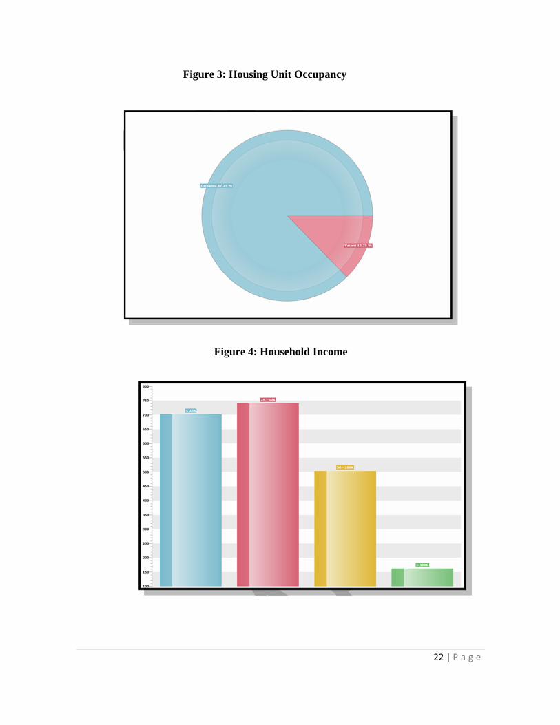
Youngtown has undergone significant changes in its demographic since removal of the Town’s age restrictions in 1998. Youngtown now more closely resembles the age distribution of Maricopa County as a whole. Of the 2010 total population, 4,386 people (71%) were under the age of 55, and 1,770 people (29%) were over the age of 55 (see Figure 2: Population by Age). This represents a 100% increase in the number of residents under age 55 since the 2000 Census. This is largely due to the development of the master planned community of Agua Fria Ranch, which attracts young families.
Figure 2: Population by Age
Youngtown resembles the age distribution of Maricopa County as a whole.
22 | P a g e
Figure 3: Housing Unit Occupancy
Figure 4: Household Income
23 | P a g e
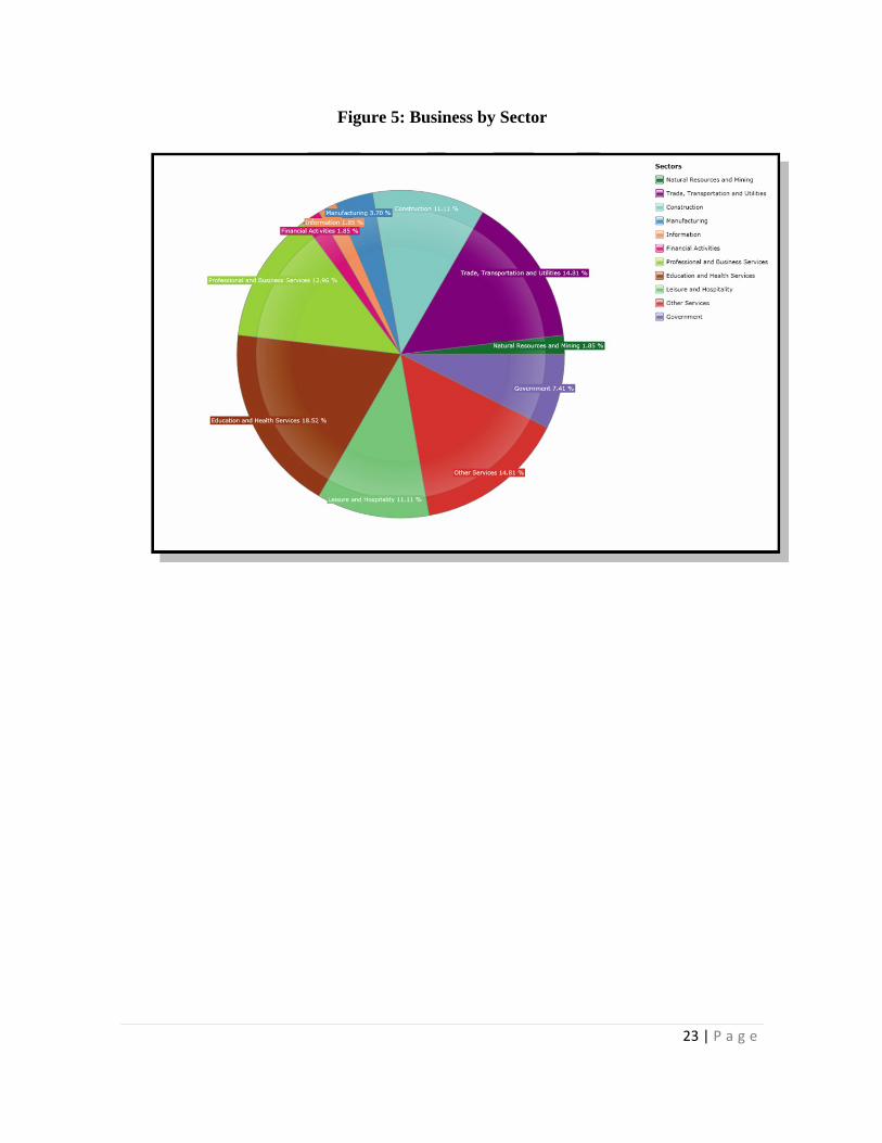
Figure 5: Business by Sector

24 | P a g e
3.0 LAND USE ELEMENT
3.1 Introduction
The Land Use Element describes, through policies and a land use map, the locations and types of land uses and land use intensities desired by Youngtown. By law, all rezoning must be consistent with and conform to the General Plan. The Land Use Map guides rezoning decisions and does not change existing zoning. This Land Use Element is prepared in accordance with A.R.S. §9-461.05. 3.2 Existing Land Use The current incorporated area of the Town of Youngtown is approximately 1.5 square miles and extends from Grand Avenue (US 60) on the north to Olive Avenue on the south (see Figure 6: Youngtown Area Vicinity Map, next page). The Town’s western boundary is generally the west edge of the Agua Fria River floodway; the eastern boundary is 111th Avenue from Grand Avenue to Peoria Avenue and 114th Avenue from Peoria Avenue to Olive Avenue. The Municipal Planning Area addressed by this Plan includes the incorporated area and potential future annexation areas. The potential annexation areas are mostly vacant, unincorporated areas bounded by Olive Avenue on the north, Northern Avenue on the south, the east side of the Agua Fria River floodway on the west and approximately 117th Avenue from Peoria to Olive Avenues and 115th Avenue from Olive to Northern Avenues. The Municipal Planning Area (which includes the incorporated area and the potential annexation areas) is approximately 2.2 square miles. Approximately 41% of the Municipal Planning Area is vacant and only about 10% is currently usable. Currently, all of the land within the unincorporated portion of the Municipal Planning Area is either mined or consists of vacant land, which includes land within the 100-year floodplain of the Agua Fria River.
Residential land uses categories of all densities account for 555 acres or 39% of the Municipal Planning Area. Commercial land use categories, including Institutional and Public, Business Park, and Town Center Business District uses account for 38%, or 529 acres of the Municipal Planning Area. The balance of the Municipal Planning Area is designated as open space, which includes the Agua Fria River floodway, and accounts for approximately 322 acres or 23% of the Municipal Planning Area. The distribution of land use is shown on Figure 7, Land Use Map.

25 | P a g e
Figure 6: Youngtown Area Vicinity Map
Luke Air Force Base
City of Peoria
Sun City

26 | P a g e
Figure 7: Land Use Map
Live/Work Area
Commerce Park
Aggregate Land
Use
Aggregate Land
Use
Life Stream

27 | P a g e
3.3 Planning Issues
The majority of Youngtown’s opportunity for new growth is located in areas east and south of Agua Fria Ranch between Peoria Avenue and Northern Avenue.
New development includes amenities and services provided in traditional
mixed generation communities. The median household income of Youngtown residents is below that of
Maricopa County as a whole. The Town’s median income has improved somewhat with the construction and sale of new houses in the annexed area south of Peoria Avenue and as new residents move into existing homes, Youngtown residents’ median income may move closer to that of Maricopa County residents.
This General Plan designates a low density area from light
commercial/industrial. Limited commercial land use designations exist within the Town. While undeveloped commercial land exists on the north side of Olive Avenue at Agua Fria Ranch Parkway, industrial uses may be planned for land previously designated as Low Density Residential east of Agua Fria Ranch.
The commercially zoned land south of Peoria Avenue, on the east side of
115th Avenue includes approximately ten acres that could be consolidated and intensified.
An opportunity exists along 113th Avenue, from Grand Avenue to
Alabama, and along Alabama from 113th Avenue to 111th Avenue, to create an identifying gateway to the Town.
The residentially designated/zoned parcels along the west side of 115th
Avenue between Wisconsin Avenue and Nevada Avenue is an area that could be considered for live/work. The rise of the Internet, telecommuting, and teleconferencing has created unprecedented opportunities for home office and small, at-home business, which many jurisdictions call home occupation. On the other hand, there is a demand for a more work-driven type of space in which employees and walk-in trade are permitted and more intense kinds of work are performed. This is referred to as live/work.

28 | P a g e
Aggregates (particulate materials such as sand, gravel, and crushed stone, used to make concrete) are typically mined from riverbeds and riverbanks, including the Agua Fria River. Aggregate mining, which is regulated by county flood control districts, sometimes leads to conflicts with nearby residents affected by noise, dust, traffic, or other impacts associated with mining activities. To address these problems, A.R.S. Section 9‐461.05 requires local governments to include in their general or long-term planning a land use element that identifies known sources of aggregates and establishes policies to preserve these resources and avoid incompatible land uses (e.g., distance and buffering policies). Thus, future conflicts between mining companies and local communities should be reduced.
3.4 Goals, Objectives and Policies
GOAL 1: MAINTAIN YOUNGTOWN’S “SMALL TOWN” FEEL FOR CURRENT AND FUTURE RESIDENTS TO ENJOY.
Objective 1.1: Promote development that enhances the existing community by providing the appropriate “small town” scale and character.
Policy 1.1.1: Develop design standards or guidelines that define the elements of Youngtown’s “small town” character such as roadway width, architectural character, building size, common areas, and elevations.
Policy 1.1.2: Discourage the construction of gated communities, walled subdivisions, and other development that is physically separated from the community by a barrier of any type.
Objective 1.2: Enhance the attractiveness of infill parcels as an option for new development throughout the community.
Policy 1.2.1: Consider adaptive reuse of existing vacant buildings.
Policy 1.2.2: Incorporate community gardens and urban agriculture.

29 | P a g e
GOAL 2: MINIMIZE CONFLICTS BETWEEN LAND USES.
Objective 2.1: Ensure that residential areas are appropriately sited and protected from incompatible land uses.
Policy 2.1.1: Provide transition land uses between Medium and High Density Residential areas and non-residential land uses on the Land Use Map.
Policy 2.1.2: Provide appropriate transition zones, buffers and/or screening
between dissimilar land uses and development intensities.
Policy 2.1.3: Incorporate and upgrade the buffer standards in the Town’s zoning and subdivision ordinances.
Policy 2.1.4: Mitigate the potential impact of mining sites during their operation
and plan for productive re-use following their eventual closure. GOAL 3: PROTECT AND PRESERVE THE SAFETY OF
NEIGHBORHOODS Objective 3.1: Encourage participation by residents in keeping their
neighborhoods safe.
Policy 3.1.1: Support the formation of block watch organizations. Policy 3.1.2: Consider appointing a member of staff to be the point-of-contact
for neighborhood groups.
GOAL 4: PROVIDE A RANGE OF HOUSING INTENSITIES AND DENSITIES THAT CONTRIBUTE TO YOUNGTOWN’S RESIDENTIAL DIVERSITY AND STABILITY.
Objective 4.1: Provide an adequate mix of housing types at various densities and for persons of all income levels and ages.
Policy 4.1.1: Encourage the development of energy-efficient, affordable housing.
Policy 4.1.2: Review the requirements of the Town’s zoning and subdivision
ordinances to permit all types of attainable housing in a manner

30 | P a g e
consistent with community desires, land use capacity, and legal requirements.
Objective 4.2: Understand the changing population dynamics of Youngtown to better provide housing and services.
Policy 4.2.1: Address Youngtown’s housing affordability gaps for family home ownership as well as rental opportunities.
Policy 4.2.2: Provide the right types of common spaces and amenities for each generation.
Objective 4.3: Locate suitable live/work areas, while providing for flexibility and use evolution.
Policy 4.3.1: Develop planning regulations and required application materials for live/work uses
Policy 4.3.2: Ensure that live/work is predominantly residential in character. Policy 4.3.3: Consider a “live/work incubator” in which business assistance
and facilities would be provided in a residential live-work setting. GOAL 5: PROMOTE REGIONAL LAND USE PLANNING AND
COORDINATION WITH NEIGHBORING COMMUNITIES TO DEVELOP AND MAINTAIN SUSTAINABLE LAND USE PATTERNS.
Objective 5.1: Coordinate with external entities, surrounding jurisdictions,
and state and federal agencies to address issues of regional importance.
Policy 5.1.1: Work with El Mirage, Peoria and Maricopa County to successfully annex unincorporated land south of Youngtown and east of the Agua Fria River floodway that benefit the quality of life for Youngtown residents and are in the best interest of the Town.
Policy 5.1.2: Provide up-to-date information regarding land use changes and
development plans to MAG to assist in regional planning studies.

31 | P a g e
Policy 5.1.3: Coordinate with El Mirage, Peoria, and Maricopa County regarding land use along communal borders on issues such as buffering, screening, compatible land uses, and connectivity opportunities.
Policy 5.1.4: Plan for opportunities when aggregate mining is no longer needed
or if mine activities along the Agua Fria River cease.
GOAL 6: IMPROVE THE APPEARANCE OF EXISTING NEIGHBORHOODS
Objective 6.1: Promote a high level of property maintenance.
Policy 6.1.1: Develop and enforce a property maintenance ordinance.
Policy 6.1.2: Implement programs that provide incentives to property owners to maintain, rehabilitate, revitalize and protect the existing housing stock.
Objective 6.2: Focus on established Redevelopment Areas to promote growth and
vitality in Youngtown with educational outreach, code enforcement and revitalization.
Policy 6.2.1.: Design or retrofit neighborhoods to emphasize outdoor
enjoyment, traffic reduction, and water conservation. Policy 6.2.2.: Add to the Town’s housing stock through
neighborhood revitalization, infill and mixed-use developments. Objective 6.3: Explore all possible sources of funds for housing renovation
and neighborhood improvement. Objective 6.4: Establish a Gateway into Youngtown along 113th Avenue and
Alabama Avenue.
Policy 6.4.1: Develop guidelines that promote quality development along these corridors including generous setbacks and parking lot screening.
32 | P a g e
Policy 6.4.2: Develop landscape standards that will create a consistent streetscape along these corridors including site amenities that reflect the Town’s desired ‘small town’ character.
GOAL 7: CONTINUE TO MONITOR TOWN PLANNING DOCUMENTS TO ENSURE THEY ARE FUNCTIONING OPTIMALLY TO THE TYPE OF GROWTH AND AESTHETICS DESIRED BY THE COMMUNITY.
Objective 7.1: Bring the zoning ordinance and other development related documents into conformance with the updated General Plan.
Policy 7.1.1: Revise and update zoning and design requirements as necessary. Policy 7.1.2: Revise and update the sign ordinance. Include the requirement that
all town-owned signs and all signs located within the public right- of-way have a standardized design and format.
Objective 7.2: Continue to promote aesthetically designed developments which foster an economically sustainable and socially dynamic community.
Policy 7.2.1: Develop design standards or guidelines for all types of new
and renovated developments (residential, commercial, employment).
Policy 7.2.2: Ensure Youngtown is at the forefront by continuously updating
codes and policies to include standards for new industries.
3.5 Proposed Land Uses and Map
Table 3, Land Use and Projected Build-out Population, lists the acres for each land use included in the Land Use Element, the target densities and projected population at build-out.
The Land Use Map, Figure 7, graphically represents the locations of the land uses listed in Table 3. The Land Use Map fulfills the requirements of A.R.S. §9-
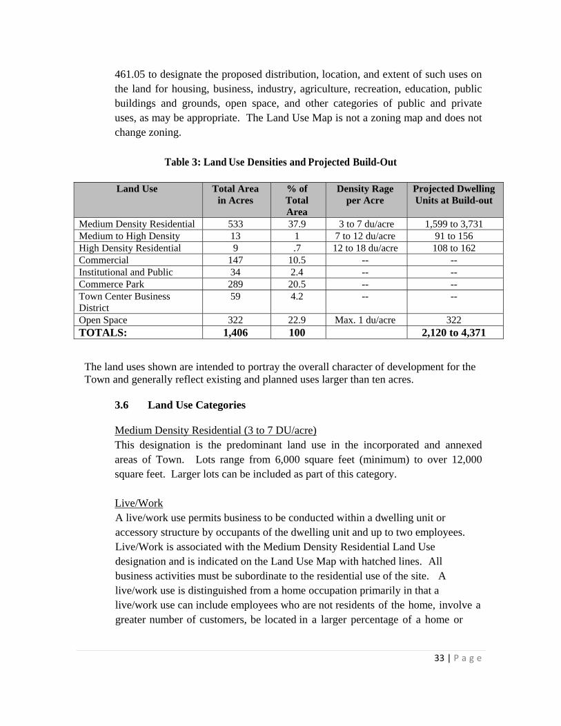
33 | P a g e
461.05 to designate the proposed distribution, location, and extent of such uses on the land for housing, business, industry, agriculture, recreation, education, public buildings and grounds, open space, and other categories of public and private uses, as may be appropriate. The Land Use Map is not a zoning map and does not change zoning.
Table 3: Land Use Densities and Projected Build-Out
Land Use Total Area
in Acres % of Total Area
Density Rage per Acre
Projected Dwelling Units at Build-out
Medium Density Residential 533 37.9 3 to 7 du/acre 1,599 to 3,731 Medium to High Density 13 1 7 to 12 du/acre 91 to 156 High Density Residential 9 .7 12 to 18 du/acre 108 to 162 Commercial 147 10.5 -- -- Institutional and Public 34 2.4 -- -- Commerce Park 289 20.5 -- -- Town Center Business District
59 4.2 -- --
Open Space 322 22.9 Max. 1 du/acre 322 TOTALS: 1,406 100 2,120 to 4,371
The land uses shown are intended to portray the overall character of development for the Town and generally reflect existing and planned uses larger than ten acres.
3.6 Land Use Categories Medium Density Residential (3 to 7 DU/acre) This designation is the predominant land use in the incorporated and annexed areas of Town. Lots range from 6,000 square feet (minimum) to over 12,000 square feet. Larger lots can be included as part of this category. Live/Work A live/work use permits business to be conducted within a dwelling unit or accessory structure by occupants of the dwelling unit and up to two employees. Live/Work is associated with the Medium Density Residential Land Use designation and is indicated on the Land Use Map with hatched lines. All business activities must be subordinate to the residential use of the site. A live/work use is distinguished from a home occupation primarily in that a live/work use can include employees who are not residents of the home, involve a greater number of customers, be located in a larger percentage of a home or

34 | P a g e
accessory building, and operate beyond the days and hours prescribed for home occupations.
Medium to High Density Residential (7 to 12 DU/acre)
This designation is created to allow for alternative designs in various non- traditional detached and attached homes. Lot size and/or density shall be determined by quality, function, and diversity. This land use designation can be considered for in-fill parcels, areas located between land uses of different intensities where a transitional use or density gradation is advisable. Projects with densities up to 12 units per acre may be located along arterial or collector roads, adjacent to employment and commercial areas, regional parks or major recreation facilities, or as part of an approved neighborhood or area plan where compatibility, transition, or other justifications warrant approval. This category may include town homes, condominiums, and other products built at similar intensities.
High Density Residential (12 to 18 DU/acre) This designation is the highest density category. Apartments or condominiums up to 18 dwelling units per acre may be located adjacent to freeways, arterial or collector roads, or employment and commercial areas. Densities exceeding 18 dwellings per acre can be considered in the Town Center Business District or for projects that provide elderly care with assisted living components. Quality and infrastructure capability will be the primary determinants of density.
Institutional and Public This designation allows commercial offices, commercial services, health care, public facilities, and institutional uses.
Commercial This designation allows neighborhood or community shopping facilities. This land use is most appropriate at the intersections of major arterials and other access to these centers and internal vehicular access from within adjacent neighborhoods to minimize the need for local vehicular traffic to enter arterial streets to enter the shopping center. This land use designation commonly abuts residential areas. Buffers, transitional uses, attention to building size to height, and truck delivery movement should be considered in site design in order to provide compatibility and convenient access.

35 | P a g e
Town Center Business District
This designation allows neighborhood or community shopping facilities, commercial services, health care, public facilities, institutional uses, and medium- high to high density residential. These are places designed to be pedestrian friendly activity areas that support a mix of retail and commercial services uses and attract visitors. It could include restaurants, retail shops, entertainment and recreational uses, offices, and plazas. It could also include higher density residential projects as part of an approved, mixed-use area plan and projects that provide elderly care with assisted living components.
Commerce Park This designation is intended to allow for campus-type development that provides employment opportunities. It generally offers amenities such as: attractive streetscapes, attractive landscaping, appropriate screening from adjacent residential areas, pedestrian connections, efficient circulation, and areas for active and passive activities to keep a healthy lifestyle for all employees. The category accommodates enclosed light manufacturing, corporate commerce, multi-story offices, research and development industries, solar and renewable energy manufacturers, and limited warehouse and services that support these primary employment uses.
Open Space (Max. 1 DU/acre) This designation provides for open space within Youngtown. The priority location for open space is along the Agua Fria River. This designation also allows for low density residential at a maximum of one dwelling unit per acre.
Aggregate Land Use This designation encompasses all existing sand and gravel/mining operations within the Town’s Municipal Planning Area. This category also identifies broad areas that may contain commercial quantities of aggregates subject to permitting requirements. These locations are identified on the Land Use Map to provide proper disclosure to the public.

36 | P a g e
3.7 Protection of Aggregate Sites and Resources
The State of Arizona SB1598 requires General Plans to identify current and potential sources of aggregate material from maps that are available from state agencies and to provide policies to preserve currently identified aggregates sufficient for future development and policies to avoid incompatible land uses. The Town of Youngtown has provided the locations of existing and potential future aggregate sites on its Land Use Map as required by State law as well as generally described these properties in this Land Use Element text. Every reasonable effort has been made to assure the accuracy of the maps and related information contained herein. However, these maps and information reflect limited data available through the Arizona State Mine Inspector, Flood Control District of Maricopa County, and Arizona Geological Survey at the time of this General Plan Update. Youngtown assumes no liability either for any errors, omissions, or inaccuracies in the information provided regardless of the cause of such. Aggregate mining operations exceeding five acres in area are required by Arizona statute to file “Reclamation Plans” with the Arizona State Mine Inspector. These plans detail the total acreage of the mining site, the disturbed (i.e. mined) acreage, and the manner in which the owner/operator will restore the site once mining activity has ceased. Reclamation Plans have been filed with the Arizona State Mine Inspector for sites located within the Town of Youngtown’s planning boundary.
The Town recognizes these sites as existing or future operations, but has identified policies to plan for the eventual re-use of these aggregate sites, if annexed into the corporate limits of the Town. Once mining operations have ceased the potential for each of these sites to develop, or, if located within an un- developable floodway, contribute to the Town’s open space network, will be limitless. The Town will work with the Arizona Mine Inspector, the property owner, and the operator of these facilities to complete their reclamation plans that ensure the future use of any existing or future mining sites will benefit all parties and the residents of Youngtown.

37 | P a g e
4.0: CIRCULATION and TRANSPORTATION ELEMENT 4.1 Introduction The Circulation and Transportation Element includes goals, objectives, and policies for vehicular and non-vehicular mobility throughout Youngtown and between Youngtown and adjacent communities. The purpose of this element is to provide decision-making guidance to enhance access to jobs, schools and recreation areas for all Town residents, businesses and visitors, as well as facilitate regional travel. This element is prepared in conformance with A.R.S. §9-461.05.
4.2 Existing Conditions
4.2.1 Roads State Route (SR) 60 (Grand Avenue), an Arizona Department of Transportation owned and maintained facility, forms the northern border of Youngtown. It travels northwest/southeast, providing quick access to the center of Phoenix. Grand Avenue is a fundamental factor in the viability of the Town’s commercial corridor, as it provides access and visibility from a major thoroughfare. 111th Avenue, a Maricopa County facility, forms the eastern border of Youngtown. It is the major north-south arterial of the Town, and the primary commercial corridor. Two of Youngtown’s three commercial centers are located on 111th Avenue. Peoria Avenue provides access to Agua Fria Ranch, located between Peoria and Olive Avenues, west of the 115th Avenue alignment. Olive Avenue forms the southern border of the Town’s incorporated area. It is a regionally significant roadway that is bridged across the Agua Fria River. This road is fundamental to the commercial and residential development at the Town’s southern end. Within the incorporated area of the Town, 113th Avenue/114th Avenue functions as a major collector street providing through-access between Grand and Peoria Avenues.
Typical Youngtown Residential Street

38 | P a g e
The development of Agua Fria Ranch introduced a second collector street, the Agua Fria Parkway, into the Town. This street provides access to and within the Agua Fria Ranch subdivision. SR 101 is located approximately two and one half miles east of Youngtown and SR 303 is located approximately five miles west of Youngtown. These major freeways afford Youngtown residents regional access and contribute to additional opportunities for economic development of the community. 4.2.2 Multimodal Transportation Pedestrian Facilities Sidewalks are provided within the Agua Fria Ranch subdivision and along several major roadways, including but not limited to Grand Avenue, 111th Avenue, and Peoria Avenue. The majority of residential and collector roadways within the Town do not have sidewalks. Bicycle Facilities The Agua Fria Ranch subdivision provides the only bike lane. Agua Fria Ranch Parkway provides dedicated, 6-foot bicycle lanes with applicable signs and pavement markings along both sides of the median-separated roadway. The bicycle lanes extend from Cheryl Drive to Green Drive. Existing Golf Cart Facilities There is substantial golf cart traffic through portions of the Town and adjacent Sun City. The intersection of 111th and 103rd Avenues with Grand Avenue are key golf cart crossing points to access Sun City golf courses and recreation centers located to the north of the Town. In Maricopa County, golf carts are allowed to share the roadway where posted speed limits are 35 mph or less. Existing Public Transit Valley Metro Route 106 (Peoria/Cactus) and Route 571 (Surprise Express) are the only fixed routes within Youngtown. Route 106 travels east/west from Cactus Road to 111th Avenue along Peoria Avenue before redirecting to travel north/south along 111th. The route terminates on the east side of the Banner Boswell Medical Center after crossing Grand Avenue. Route 571 generally travels along Grand Avenue providing service from Surprise to Phoenix. Only Route 106 provides fixed, stop locations in the Town.

39 | P a g e
There are no park-and-ride facilities within the Town. The nearest facility is located at the intersection of 129th Avenue and Thunderbird Road in the City of El Mirage. The Northwest Valley Dial-a-Ride paratransit service is provided through Valley Metro to residents of the Town, the City of Surprise, the City of El Mirage, Sun City and Sun City West. The Town is provided service for ADA certified residents, seniors over age 65 and residents with disabilities. The service is provided Monday through Friday from 7 a.m. to 5 p.m. 4.3 Street Classification Definitions The following definitions apply to roadways within Youngtown: Arterial Roads Arterial roads provide high traffic volume capacity and serve major traffic circulation movements at higher speeds. They put more emphasis on traffic movement than land access. They are generally four or six lane roadways, with two to three lanes striped in each direction and medians and turn lanes where applicable. Collector Roads Collector roads provide connections between arterial and local roads and generally operate at lower speeds than arterial roads. Collector roads link residential, commercial, and industrial areas while providing more frequent access to properties than arterial roads. Local Roads Local roads primarily provide access to properties and generally operate at low speeds. Local roads are typically two lanes with frequent driveway access. Roadway design criteria shall follow the latest edition of the Maricopa Association of Governments Uniform Standard Specifications and Details for Public Works Construction, with modifications to accommodate older drivers.
40 | P a g e
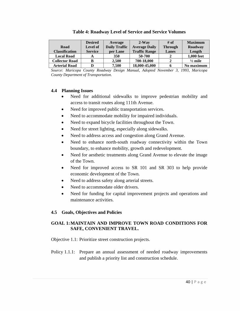
Table 4: Roadway Level of Service and Service Volumes
Road Classification
Desired Level of Service
Average Daily Traffic
per Lane
2-Way Average Daily Traffic Range
# of Through
Lanes
Maximum Roadway Length
Local Road A 350 50-700 2 1,000 feet Collector Road B 2,500 700-18,000 2 ½ mile Arterial Road D 7,500 18,000-45,000 6 No maximum
Source: Maricopa County Roadway Design Manual, Adopted November 3, 1993, Maricopa County Department of Transportation. 4.4 Planning Issues
Need for additional sidewalks to improve pedestrian mobility and access to transit routes along 111th Avenue.
Need for improved public transportation services.
Need to accommodate mobility for impaired individuals.
Need to expand bicycle facilities throughout the Town.
Need for street lighting, especially along sidewalks.
Need to address access and congestion along Grand Avenue.
Need to enhance north-south roadway connectivity within the Town boundary, to enhance mobility, growth and redevelopment.
Need for aesthetic treatments along Grand Avenue to elevate the image of the Town.
Need for improved access to SR 101 and SR 303 to help provide economic development of the Town.
Need to address safety along arterial streets.
Need to accommodate older drivers.
Need for funding for capital improvement projects and operations and maintenance activities.
4.5 Goals, Objectives and Policies GOAL 1: MAINTAIN AND IMPROVE TOWN ROAD CONDITIONS FOR
SAFE, CONVENIENT TRAVEL. Objective 1.1: Prioritize street construction projects. Policy 1.1.1: Prepare an annual assessment of needed roadway improvements
and publish a priority list and construction schedule.
41 | P a g e
Policy 1.1.2: Conduct periodic traffic safety audits on major streets to determine if traffic control measures need to be modified.
Policy 1.1.3: Work with the Maricopa County Department of Transportation to
conduct a corridor improvement study along 111th Avenue that includes an element focused on safety.
Policy 1.1.4: Work with the Arizona Department of Transportation to improve
the eastbound Grand Avenue right-turn lane near 113th Avenue and consider a new eastbound Grand Avenue right-turn lane at 111th Avenue.
Policy 1.1.5: Conduct regular reviews of non-motorized transportation facilities
for safety issues.
Policy 1.1.6: Identify roadways that need to be brought into compliance with Maricopa County level of service criteria and add them to the annual priority list.
Objective 1.2: Enhance transportation network connectivity. Policy 1.2.1: Continue to work with commercial landowners and the City of
Peoria to extend 114th Avenue north into Youngtown. Policy 1.2.2: Consider additional east-west access from 115th Avenue to the
Agua Fria Parkway south of Olive Avenue and to 114th Avenue north of Olive Avenue.
Policy 1.2.3: Provide an additional north-south link within the Town by
extending Agua Fria Ranch Road to Peoria Avenue.
Policy 1.2.4: Provide entry features along Grand Avenue at 111th Avenue and 113th Avenue.
Policy 1.2.5: Create a Town gateway along 113th Avenue from Grand Avenue to
Alabama Avenue, and along Alabama Avenue from 113th Avenue to 111th Avenue. Signing the gateway can indicate it as an alternative route if the intersection of Grand Avenue and 111th Avenue is closed.
42 | P a g e
Objective 1.3: Ensure adequate funding to address long-term transportation needs. Policy 1.3.1: Require new development to pay for the costs of future
transportation improvements that will occur within the development boundaries.
Policy 1.3.2: Coordinate with other jurisdictions to maximize federal, state and county roadway funding.
Policy 1.3.3: Pursue state and federal grants for transportation enhancement
projects. Objective 1.4: Improve safety for older drivers. Policy 1.4.1: Adopt design standards to improve safety for older drivers. Policy 1.4.2: Increase size and letter height of new and replacement roadway
signs, including the existing "No Parking" signs on Alabama Avenue west of 113th Avenue as a priority.
GOAL 2: PROMOTE NON-VEHICULAR CIRCULATION WITHIN
YOUNGTOWN AND BETWEEN THE TOWN AND NEIGHBORING COMMUNITIES.
Objective 2.1: Improve non-motorized connections to all areas of Youngtown and
implement complete streets. Policy 2.1.1: Develop an implementation plan for new sidewalks and street
lighting recommended in the Youngtown Small Area Transportation Study.
Policy 2.1.2: Require installation of sidewalks and lighting for new development and roadway improvement projects.
Policy 2.1.3: Prepare a bicycle program that includes physical improvements,
signs, and education.
Policy 2.1.4: Develop an implementation plan for sharrows recommended in the Youngtown Small Area Transportation Study to increase driver awareness of bicyclists.
Policy 2.1.5: Support Maricopa County Trail Plan along Agua Fria River.
Policy 2.1.6: Prepare a Trails Master Plan.

43 | P a g e
Policy 2.1.7: Look for opportunities to make connections to existing non-motorized routes in existing and new developments.
Objective 2.2: Integrate Youngtown’s circulation system with neighboring
communities. Policy 2.2.1: Meet with adjacent communities to compare circulation plans and
look for opportunities to make connections. Objective 2.3: Encourage the use of alternative transportation modes. Policy 2.3.1: Work with Valley Metro to expand bus service, dial-a-ride, and
other services, including the increased services planned along 111th Avenue.
Policy 2.3.2: Provide a community education program on transportation options available and how to use them.
Policy 2.3.3: Prepare design guidelines that create pleasant walking and biking
environments to encourage these activities. Improvements might include plants, shade, bike racks, rest stops and comfortable, attractive transit stops.
Policy 2.3.4: Continue to work with Valley Metro to ensure bus access along
111th Avenue is maintained.
GOAL 3: PROMOTE REGIONAL COOPERATION TRANSPORTATION ISSUES.
Objective 3.1: Join regional and other committees that review vehicular and non-
vehicular circulation issues. Policy 3.1.1: Participate in Maricopa Association of Government’s
transportation committees.
Policy 3.1.2: Support the MAG US-60/Grand Avenue Corridor Optimization, Access Management, and System Study (COMPASS).
Policy 3.1.3: Partner with appropriate jurisdictions to improve regionally
significant roadways and circulation routes such as El Mirage Road as a north/south route.
Objective 3.2: Support and Enhance Regional Mobility Policy 3.2.1: Support Commuter Rail on Grand Avenue.

44 | P a g e
Policy 3.2.2: Adopt recommendations of the US-60/Grand Avenue COMPASS.
Policy 3.2.3: Work with the City of El Mirage and Maricopa County to improve mobility across the Agua Fria River to facilitate emergency responders and provide fast access to other metropolitan centers. Consider widening the existing Olive Avenue bridge crossing or establishing a new river crossing at Peoria Avenue, with an interim, two-lane low-flow river crossing.
45 | P a g e
GOAL 4: ENSURE THAT YOUNGTOWN’S STREET STANDARDS MEET
CURRENT/FUTURE CIRCULATION DEMANDS. Objective 4.1: Assess impacts of proposed developments on existing and planned
streets. Policy 4.1.1: Require that public and private roads be developed in accordance
with the latest edition of the Maricopa Association of Governments Uniform Standard Specifications and Details for Public Works Construction, with additional provisions to improve safety for older drivers.
Policy 4.1.2: Require that sharrows meet the standards provided in the latest edition of the Federal Highway Administration Manual on Uniform Traffic Control Devices.
46 | P a g e
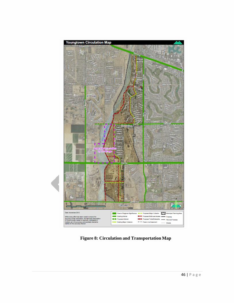
Figure 8: Circulation and Transportation Map

47 | P a g e
5.0: WATER RESOURCES ELEMENT
5.1 Introduction
A sufficient water supply is crucial to all communities. Economic growth and the wellbeing of residents and businesses depend on adequate water resources. The Water Resources Element reviews the future water needs of Youngtown and contains goals, objectives, and policies to guide the Town in meeting current and future needs. The Water Resources Element addresses potable and reclaimed water sources. This element was prepared in accordance with A.R.S. §9-461.05.
5.2 Current Conditions
Historically, Youngtown has had an adequate water supply. State-wide, however, there has been substantial groundwater depletion. The overdraft of groundwater in some areas has resulted in significant lowering of groundwater levels, surface subsidence and cracking, water quality problems and/or loss of aquifer storage space. The Arizona Department of Water Resources (ADWR) was created to oversee the use of surface water and groundwater and works to develop the policies to ensure long-term water supplies for the people of Arizona.
Throughout the State, ADWR formed Active Management Areas (AMAs) to address water supply issues. Youngtown is located within the Phoenix AMA. The management goal of the Phoenix AMA is to attain “safe-yield” by the year 2025. Safe-yield means to “achieve and thereafter maintain a long-term balance between the annual amount of groundwater withdrawn in an active management area and the annual amount of natural and artificial groundwater recharge in the active management areas” (A.R.S. §45-561.12).
Potable water and wastewater services in Youngtown are provided by EPCOR Water Arizona, Inc. (EPCOR) EPCOR’s service area boundary for Sun City/Youngtown stops at Olive Avenue. The Youngtown water system is fully integrated with the Sun City Water delivery system. Sun City and Youngtown customers pay the same water rates and are recognized by the Arizona Corporation Commission (ACC) as one entity for rate making and other regulatory purposes.
The water supply for the system is provided by 24 wells owned and operated by EPCOR. Of the 24 wells, five to seven are typically inactive in a given year. The wells pump a combination of groundwater, Central Arizona Pr0oject (CAP) water

48 | P a g e
store credit generated through recharge activities at the company’s Northwest V a l l e y W a t e r R e c l a m a t i o n F a c i l i t y . EPCOR h a s a CAP w a t e r allocation of 4,189 acre-feet per year. Currently, the CAP water allocation is recharged in the Maricopa Water District Groundwater Savings Facility and recovered on an annual basis. The Sun City/Youngtown system’s current demand is approximately 16,500 acre-feet per year. In 2011, 4,105 acre-feet of effluent credits were pumped.
The current system has a peak-day capacity of approximately 34.5 million gallons per day. The per capita demand for the Sun City/Youngtown system is currently approximately 300 gallons-per capita-per-day (gpcd). This amount includes non- residential uses as well as residential. New residential development in Youngtown would be expected to use considerably less water. ADWR Third Management Plan residential use expectations are in the range of 160-175 gpcd. These figures reflect anticipated water demands for new residential development in Youngtown.
Future demand of new development in Youngtown will be met by EWAZ through current and new well capacity. A number of existing wells can be equipped and retrofitted to provide the additional capacity needed to meet increased demand. New residential subdivisions which receive groundwater are required to obtain an agreement to serve in the Central Arizona Groundwater Replenishment District (CAGRD) as a means of meeting the State’s 100-year Assured Water Supply Certificate Requirements. Homes enrolled in the CAGRD pay a “replenishment tax” to the CAGRD that is used to purchase renewable water and replenish the groundwater that is pumped and delivered to the homes each year.
Wastewater generated in Sun City and Youngtown is conveyed to the Tolleson Wastewater Treatment Plant under a contract between Tolleson and EWAZ. The water is treated and delivered to Palo Verde Nuclear Generating Station for use as cooling water.
5.3 Future Trends
Youngtown has no plans to become a water service provider. As n e w development occurs in the Town, individual landowners or developers will continue to work with entities to ensure adequate water supplies.
5.4 Development Issues
As Youngtown continues to expand, working with existing providers to ensure adequate water supplies to serve new development.

49 | P a g e
5.5 Goals, Objectives and Policies
GOAL 1: CONTINUE TO UTILIZE PRIVATE WATER COMPANIES AND OTHER ENTITIES T O PROVIDE WATER TO YOUNGTOWN RESIDENTS.
Objective 1.1: Provide a continuous water supply. Policy 1.1.1: Ensure that all new development has an adequate water supply to
meet its needs now and in the future.
GOAL 2: PROMOTE CONSERVATION, REUSE, AND RENEWABLE WATER RESOURCES.
Objective 2.1: Enact effective conservation measures.
Policy 2.1.1: Work with EPCOR Water Arizona Inc. to provide incentives to existing users to switch to low-flow water devices.
Policy 2.1.2: Promote the use of low-water use plants in public and private
landscape areas.
Policy 2.1.3: Install low flow and water saving devices in all public facilities. Objective 2.2: Plan for future conditions. Policy 2.2.1: Encourage local water companies to develop and provide to the
Town plans for providing water in the event of regional water shortages.
50 | P a g e
6.0: OPEN SPACE and RECREATION ELEMENT
6.1 Introduction
The Open Space and Recreation element is intended to document current open space and recreation facilities provided by Youngtown for its residents, and identify open space and recreation desires that the Town may choose to address in the future. This element also addresses how Youngtown’s open spaces contribute to a regional system of open space. This element was prepared in accordance with A.R.S. §9-461.05.
6.2 Current Conditions
Recreational facilities near Youngtown include the Glendale Westgate Center within 4-½ miles. Jobing.com arena, home of the Phoenix Coyotes National Hockey League team, and the University of Phoenix stadium, home of the Arizona Cardinals National Football League team, along with many restaurants and entertainment venues, are located here in the Westgate Center. In addition, the West Valley Arts Center and the Peoria and Surprise Town Centers and Spring Training Facilities are located nearby.
The Town currently maintains seven parks ranging in size from just under three acres to one-third acre. Youngtown parks were formerly maintained as open areas without facilities; however, the Town has now provided tot lots in some parks to address the needs of families. Table 5, Y o u n g t o w n P u b l i c P a r k s includes a list of planned and existing parks within Youngtown.
In addition to parks, Youngtown also maintains a community building and a crafts center. The community building is open to the public by reservation and provides space for a variety of community sponsored art and recreation groups. In the near future, the Town plans to initiate programmed recreation activities in the community building and expand Schliefer Park to provide connections to the Agua Fria River.
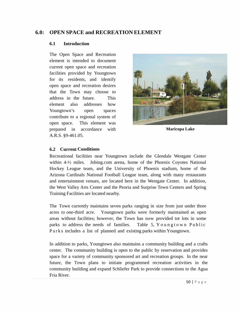
Maricopa Lake

51 | P a g e
Table 5: Youngtown Public Parks
Name Location Landscape Type Area Greer Park, North Greer Park, South
112th Lane and Youngtown Avenue
Grass 1.03 acres
Caliche Cactus Garden 112th and Alabama Avenues Granite Rock 0.34 acre Caliche Park 113th Avenue west of
Connecticut Avenue Grass 0.32 acres
Memorial Park 111th and Peoria Avenues Rock Landscape 0.37 acre Schliefer Park 113th and Alabama Avenues 1.52 acre grass
.957 acre river rock 2.48 acres
Maricopa Lake Park 114th and Connecticut Avenues
1.64 acre grass .905 acre river rock 1 acre granite rock 2.8 acres lake
6.34 acres
David C. Uribe Park 117th Avenue and Agua Fria Parkway
Tot lot Sports Field Rest rooms
5.0 acres
TOTAL: 15.88 acres
A variety of standards has been developed by professional and trade associations which are used throughout the country. The standard derived from early studies of park acreages located within metropolitan areas was the expression of acres of park land per unit of population. Over time, the figure of 10 acres per 1,000 population came to be the commonly accepted standard used by a majority of communities.
As illustrated in Table 5 above, Youngtown has 15.88 acres of parks. The Town’s population of 6156 indicates a ratio of 3.87 acres per 1000 residents. This falls short of the minimum suggested ratio of 6.25 per thousand by approximately 40%, and short of the recommended amount by a great deal; i.e., less than four as compared with ten – or two and a half times what Youngtown currently has.
The stated recommended ratio is 6.25 to 10.5 acres per 1000 residents in the 1983 Guidelines – since then it has risen steadily.
In 2002, the Flood Control District of Maricopa County adopted the Agua Fria Watercourse Master Plan. While the primary purpose of this plan is to address flood control options for the Agua Fria River, it also provides recreation options to maximize the use of undeveloped areas within the 100-year floodplain. These options include the development of a park on the west side of the river at Olive Avenue and a trail/maintenance road on both sides of the floodway. The plan includes additional recommendations that encourage the conservation of areas within the 100-year floodplain as open space.
52 | P a g e
Youngtown’s location on the east bank of the Agua Fria River provides it with an opportunity to implement the recommendations of the Agua Fria Watercourse Master Plan and provide an open space resource to its residents. At Maricopa Lake Park, where the Town owns land directly adjacent to the River, a steep bank accesses the riverbed. Study of the condition of the existing bank and opportunities to provide direct river access would be necessary to create a direct open space link here. South of Maricopa Lake Park, private land directly abuts the river’s edge. South of Peoria Avenue, the elevation of the Town and the riverbed begin to merge and additional open space opportunities on undeveloped floodplain exist for the Town.
6.3 Planning Issues
While the Agua Fria River offers opportunity to provide public open space to Town residents, river access from public lands is difficult and private property owner permission is necessary for access to the river from private land.
Demand has increased for publicly-owned/maintained active recreation facilities and recreation programming.
Consideration should be given to options that provide additional recreation facilities and parks to accommodate post 2010 population growth.
6.4 Goals, Objectives and Policies
GOAL 1: ALL RESIDENTS HAVE REASONABLE ACCESS TO THE RECREATIONAL OPPORTUNITIES PROVIDED BY THE AGUA FRIA RIVER.
Objective 1.1: Public trail access to the Agua Fria River is available. Policy 1.1.1: Continue to work with the Flood Control District of Maricopa
County to implement the Agua Fria Watercourse Master Plan. Policy 1.1.2: Require all new developments adjacent to the Agua Fria floodplain
to provide recreational access to it. Policy 1.1.3: Provide access from the Agua Fria River to Maricopa Lake Park
and Schliefer Park.

53 | P a g e
Policy 1.1.4: Work with the Flood Control District of Maricopa County and U.S. Army Corps of Engineers to identify the potential for acquiring and developing floodplain for recreation purposes.
GOAL 2: PROVIDE ADEQUATE RECREATION OPPORTUNITIES
FOR ALL RESIDENTS. Objective 2.1: Maintain at least four to five acres of park per 1,000 residents. Policy 2.1.1: Look at potential expansion possibilities of all parks. Policy 2.1.2: Require, as part of all new developments, over five acres of
contiguous public parks and open space per 1,000 residents. Policy 2.1.3: Apply for grants to develop recreation facilities for Youngtown
residents. Objective 2.2:Provide recreation programs for Youngtown residents at the
community building, craft center, and Town parks. Objective 2.2.1:Explore the possibility of a new multi-generational community
center for all residents. Policy 2.2.2: Consider a non-resident fee for recreation programs to subsidize
additional programs and materials. Objective 2.3: Provide a range of recreation facilities for all Youngtown residents.
Policy 2.3.1: Provide tot lots in all new public and private parks over one-half an acre.
Policy 2.3.2: Provide at least one sport court or ball field in all new parks over
one acre. Policy 2.3.3: Provide restrooms, some parking and water fountains in all new
parks larger than five acres. Objective 2.4: Provide for the future recreational needs of Youngtown residents. Policy 2.4.1: Prepare an Open Space and Recreation Plan.

54 | P a g e
GOAL 3: THE AGUA FRIA RIVER IS AN OPEN SPACE USED BY THE COMMUNITY.
Objective 3.1: Transform the Agua Fria River into an open space and recreation asset that benefits the community.
Policy 3.1.1: Continue to work with the City of El Mirage, the Flood Control District of Maricopa County and U.S. Army Corps of Engineers to implement the Agua Fria River Watercourse Master Plan.
Policy 3.1.2: Consider working with the City of El Mirage to jointly provide
recreation options along and within the Agua Fria River floodplain.

55 | P a g e
7.0: ENVIRONMENTAL PLANNING ELEMENT 7.1 Introduction
The purpose of the Environmental Planning Element is to address the impacts of development and lifestyle on air and water quality and the conservation of natural resources. This element was prepared in accordance with A.R.S. §9-461.05.
7.2 Current Conditions
Maricopa County was, at one time, designated as a nonattainment area for carbon monoxide, ozone and particulate matter (PM10). In the past several years, corrective measures have been taken and great strides have been made in lowering the levels of these pollutants. Table 6: Measures adopted by Town to reduce PM-10 Particulates
98-FP-1 Adopt a fireplace ordinance (Ordinance No. 98-15) 98-DC-7 Completed the implementation plan to stabilize unpaved roads and
alleys 98-DC-8 Implement a plan to stabilize shoulders of paved targeted arterials 98-DC-9 Adopt an Ordinance to reduce particulate emissions from unpaved
parking lots (Ordinance No. 08-04) 98-DC-10 Adopt an Ordinance to reduce particulate emissions from vacant
disturbed parking lots (Ordinance No. 08-04) 98-DC-12 The Town has purchased a PM-10 efficient street sweeper
Source: Revised MAG 1999 Serious Area Particulate and Carbon Monoxide Plans for the Maricopa County Non-attainment Area, Commitments for Implementation, Vols. 3 & 4
Carbon Monoxide
The region has met the federal air quality standard for Carbon Monoxide. EPA re-designated the Maricopa County nonattainment area to attainment for the carbon monoxide standard, effective April 8, 2005. There have been no violations of the eight-hour standard since 1996.
PM-10
The primary sources of particulate matter (PM-10) are: Non-road Sources (construction/earthmoving dust, construction track out, non-road engine exhaust, and construction windblown dust), On-road Sources (paved road dust, unpaved road dust, and
on-road vehicle exhaust), and Area Sources (disturbed vacant land and agricultural windblown dust, agricultural dust, and residential wood burning).

56 | P a g e
The EPA published a notice on February 6, 2014 proposing to approve the MAG 2012 Five Percent Plan for PM-10. The plan includes a wide variety of existing control measures and projects that have been implemented to reduce PM-10 and includes a new measure designed to reduce PM-10 during high risk conditions, including high winds. EPA is also proposing to make a determination that the region has met the standard based upon three years of clean data for 2010-2012 as measured by the air quality monitors. There were six days in 2013 that exceeded the PM-10 levels; however, these were due to exceptional events such as regional dust storms, thunderstorms or high winds. To date, there have been no occurrences in 2014. Ozone
For ozone, the region was re-designated to attainment for the one-hour standard, effective June 14, 2005. There have been no violations of this standard since 1996. In 2004, EPA designated the region as a Basic nonattainment area for the eight-hour ozone standard of 0.08 parts per million. On March 14, 2014, EPA proposed approval of the MAG 2009 Eight-Hour Ozone Re-Designation Request and Maintenance Plan. The plan demonstrates maintenance of the standard through 2025. According to the proposal, the region would be re-designated to attainment status for this standard. There have been no violations of the 0.08 ppm standard since 2004. In March 2008, EPA revised the eight-hour ozone standard to 0.075 parts per million. On May 21, 2012, EPA published a final rule to designate the Maricopa nonattainment area as a Marginal Area with a December 31, 2015 attainment date. Flooding Youngtown works with the Flood Control District of Maricopa County (MCFCD) to protect the community from flooding. Because it is impacted by the Agua Fria River 100-year floodplain, the Town cooperates with MCFCD to determine appropriate actions to prevent flooding and developments compatible with the floodplain. Landfills The closed El Mirage landfill, which is located on the west bank of the Agua Fria River, is visible from Youngtown.
Aggregate Mining The Town of Youngtown has provided the locations of existing and potential future aggregate sites on its Land Use Map as required by State law and generally described these properties in this Land Use Element text. Although the Town recognizes these sites as existing or future operations, it has identified policies to plan for the eventual re-use of these aggregate sites should they be annexed into the corporate limits of the Town. Once mining operations have ceased, two possibilities will exist for each of the sites. The first is appropriate development
57 | P a g e
of the site. The second is incorporation into the Town’s open space network in the event the site is within an undevelopable flood plain.
7.3 Future Trends
Practices have been established to improve air and water quality for Youngtown. As the region and Town increase in population, h o w e v e r i n c r e m e n t a l l y , efforts to maintain and enhance these programs must be maintained.
7.4 Planning Issues
Efforts must continue to ensure that the 100-year, 2-hour storm event is fully contained and does not affect new development.
If new areas are annexed, existing County and private roads will need to comply with PM-10 and Carbon Monoxide commitments.
7.5 Goals, Objectives and Policies
GOAL 1: LOCATE POLLUTING LAND USES SO AS TO MINIMIZE IMPACTS TO YOUNGTOWN RESIDENTS AND THE ENVIRONMENT
Objective 1.1: Potentially hazardous land uses which may include, but are not limited to landfills, power generating stations and gas stations are best located a safe distance from residential development.
Policy 1.1.1: Prohibit uses that could negatively impact the safety and health of the
residents next to existing residential development. Policy 1.1.2: Require that all development which has, or may have, air, water or other
environmental impacts affecting the health and safety of Town residents, mitigate these impacts at their own expense.
Policy 1.1.3: Work with El Mirage to redevelop or remove the El Mirage landfill. Objective 1.2 Identify the locations of existing and potential future aggregate sites on the
Land Use Map. Policy 1.2.1 Work with the Arizona Mine Inspector, the property owner, and the
operator of these facilities in completing their reclamation plans to ensure the future use of any existing or future mining sites will benefit all parties and the residents of Youngtown.
Policy 1.2.2 Plan for the eventual re-use of these aggregate sites
58 | P a g e
GOAL 2: CONTINUE TO MEET FEDERAL, STATE AND COUNTY AIR AND
WATER QUALITY STANDARDS. Objective 2.1: Continue participation in MAG and Maricopa County efforts to meet
federal and state air and water quality standards. Objective 2.2: Continually work to reduce PM-10 and Carbon Monoxide levels. Policy 2.2.1: Encourage ridesharing through maintenance of the employee rideshare
database and providing preferential parking for carpools. Policy 2.2.2: Require all parking areas and driveways to have a paved surface. GOAL 3: PROTECT RESIDENTS OF YOUNGTOWN FROM EXCESSIVE
NOISE IMPACTS Objective 3.1:Discourage rezoning requests for residential development in high noise areas.
Policy 3.1.1: Require mitigation measures on new residential development areas to achieve compliance with local, state and federal noise standards.
Policy 3.1.2: Require buffers between high noise areas and other development.
59 | P a g e
8.0: ECONOMIC DEVELOPMENT ELEMENT
8.1 Introduction
An economic development element has been incorporated into General Plan 2025 in order to expand and enhance the economic viability of Youngtown. Goals have been formulated with input from residents and landowners who attended one or both of the Public Workshops. The first, held on March 12, 2012, created an opportunity for envisioning “best-case Youngtown” in 2025. The second, held on May 14, 2012 gathered suggestions for alternative land use scenarios. Thoughts have also been incorporated from meetings with Town Council, staff, the economic development consultant and business owners in the Town.
Note: On May 14, 2012, House Bill 2826 was adopted, consolidating all elections of jurisdictions in the State of Arizona. This changed the date of the public adoption of the General Plan to coincide with a later election cycle. On July 19th, 2012, the Town Council approved the incorporation of Phase One of the Economic Development Element, consisting of Goals 1 and 2, to move the economic development plan forward.
8.2 Goals, Objectives and Policies
GOAL 1: COMMUNITY REVITALIZATION
INVEST IN COMMUNITY INFRASTRUCTURE AND COMMERCIAL UPGRADES TO ENCOURAGE OUTSIDE INVESTMENT
Youngtown was in a downward economic spiral, largely due to: 1) recent recessionary conditions 2) decreased state- shared revenues, and 3) the absence of additional revenue streams.
The Town has languished with regards to both public and private buildings and properties. Due to the prevalence of dated structures and the lack of landscaping in the community, surrounding cities, particularly Peoria and El Mirage, have more to offer outside businesses and developers. In the past year the following portions of Phase One, Goal One have been embarked upon.
Objective 1.1: Update and improve the Town’s appearance.

60 | P a g e
Policy 1.1.1: Identify vacant and underutilized parcels for mixed-use development.
Policy 1.1.2: Enhance the public environment with landscaping, lighting and signage.
Policy 1.1.3: Encourage a b s e n t e e l a n d o w n e r s ’ p a r t i c i p a t i o n i n r e v i t a l i z a t i o n plans and activities.
Policy 1.1.4: Exercise eminent domain to purchase obsolete buildings, when necessary. Objective 1.2: Partner with landowners and businesses in upgrading and
landscaping their property.
Policy 1.2.1: Establish a funding mechanism such as a 50/50 or Revolving Loan Fund to assist businesses with exterior improvements, such as painting and landscaping.
Policy 1.2.2: Catalogue deteriorating buildings and encourage the owners to take advantage of
incentives for upgrades. Policy 1.2.3: Expand use of creative financing tools such as Federal and State grants and
Community Development Action Committee (CDAC) grants. Policy 1.2.4: Explore all potential funding sources, including Revolving Loan
Funds (RLFs) and Business Improvement Districts (BIDs).
GOAL 2: PUBLIC RELATIONS AND MARKETING CAMPAIGN ELEVATE YOUNGTOWN’S IMAGE THROUGH A PUBLIC RELATIONS/MARKETING CAMPAIGN EMPHASIZING THE TOWN’S ASSETS.
Objective 2.1: Produce a Marketing Campaign for the Town
Policy 2.1.1: Enlist assistance from the Arizona Republic in repositioning the Town’s image.
Policy 2.1.1: Utilize paid advertising and unpaid publicity to sell the Town. Policy 2.2.3: Partner with business owners in co-op ads.
Objective 2.2: Generate enthusiasm around the new Youngtown brand by marketing it internally and externally.
Policy 2.2.1: Hold a public event to roll out the new brand.

61 | P a g e
Policy 2.2.2: Invest in creative, high-quality collateral materials. Policy 2.2.3: Give complimentary signs to businesses that proudly indicate
“Town of Youngtown”.
Policy 2.2.4: Encourage use of the new brand in the preparation of collateral materials for commercial areas and individual businesses.
GOAL 3: BUSINESS ENHANCEMENT
Develop a strong business community by helping owners/managers increase client activity. Youngtown is home to more than 150 businesses, ranging in profitability from “thriving” to “doing okay.” Most of these businesses’ customers come from outside the Town, mainly the surrounding Sun Cities. In meetings with individual business owners, the consultant found that those businesses that are doing well take advantage of technology, while the weaker businesses rely on word-of-mouth to market their product or service. The reluctance to embrace technology prevents many of the Town’s businesses from achieving their potential. This reluctance is a product of fear and/or lack of initiative to learn about computer hardware and software systems.
Objective 3.1: Increase use of technology within the Youngtown business district. Policy 3.1.1: Establish a s e r i e s o f c l a s s e s t o e n g a ge b u s i ne s s o w n e r s a nd
incorporate the advantages of technology – perhaps in partnership with the Surprise Regional Chamber of Commerce (the Chamber).
Policy 3.1.2: Facilitate a round-table event among retailers to share technology hints. Policy 3.1.3: Explore utilizing Amazon for online ordering. Policy 3.1.4: Explore employing a group of high school students earn credit by performing
computer tasks for older business owners; e.g., email, or Amazon orders. Objective 3.2: Establish a program of regular contact with downtown businesses and
property owners. Policy 3.2.1 Create a quarterly event such as a Mayor’s Round Table inviting business
leaders to discuss issues affecting the community, patterned after the November 8, 2012 luncheon of property owners.
Policy 3.2.2 Initiate a “Breakfast with the Mayor” program.

62 | P a g e

63 | P a g e
GOAL 4: BUSINESS ATTRACTION
MARKET THE COMMUNITY TO DEVELOPERS, SITE SELECTORS AND TENANTS TO EXPAND RETAIL AND COMMERCIAL ACTIVITY Many of Youngtown’s residents see the Town’s retail and service providers as inappropriate for their needs. The large surrounding cities of Glendale and Peoria have much to offer and to attract the Town’s more affluent residents. The Town must provide a greater variety of shopping and dining in order to shrink leakage and increase sales tax for the Town. Objective 4.1:Create an atmosphere conducive to investment through the community
revitalization campaign. Objective 4.2: Market the Town’s commercial areas at International Council of Shopping
Centers (ICSC) events in the Valley and throughout the southwest region. Policy 4.2.1: Design and publish a single sheet marketing piece specific to retail. Policy 4.2.2: Target and recruit businesses appropriate to the Town’s demographic profile. Objective 4.3: Provide tours to commercial brokers in order to expand retail activity. Objective 4.4: Explore allocating a portion of the sales tax for economic development in the
Town.
GOAL 5: BUSINESS DIVERSIFICATION
INCORPORATE COMMERCIAL/INDUSTRIAL DEVELOPMENT.
Youngtown did not have an area dedicated to industry and industrial issues but does now with the additional of the land designated for the Commerce Park. The General Plan provides for individual classifications.
Objective 5.1: Plan, fund and implement zoning changes and capital improvements that will
support economic development.
Objective 5.2: Coordinate with landowners to develop a commerce park in the area between Agua Fria and 115th Avenue.
Policy 5.2.1: Create a Public/Private Partnership for the commerce park and other ventures.
Objective 5.3: Utilize the commerce park as an economic catalyst.
64 | P a g e
GOAL 6: SIGNATURE EVENT: CREATE AND DEVELOP A MAJOR EVENT
THAT IS UNIQUE TO YOUNGTOWN The purpose of this goal is to initiate a unique event that will foster pride in the Town a nd w i l l d r a w p a r t i c i p an t s f ro m t h roughou t N o r t h w e s t P h o e n i x . Objective 6.1: Establish an annual community event within the Town of
Youngtown that is unique to the Northwest Valley. Policy 6.1.1: Formulate an event that is uniformly attractive to young couples, families
and seniors. Policy 6.1.2: Create excitement around the event by presenting complementary events at
the Town Square and in the parks. Policy 6.1.3: Encourage private sector event partners. Policy 6.1.4: Encourage coordination and implementation of themed sales days to
accompany the event.

65 | P a g e
9.0: GROWTH AREAS ELEMENT
9.1 Introduction The purpose of the Growth Areas Element is to guide new development to areas where the maximum use of existing infrastructure and services can be obtained. Youngtown has chosen to focus on developing policies that maximize services at the southern end of the Town and redevelopment of existing commercial areas. 9.2 Current Conditions
Youngtown has been a master planned community since its transformation from a dairy farm to a retirement community and, most recently, to a standard, mixed generational community. Most of the Town is built out at residential densities from four to six dwelling units to the acre. Two major commercial areas exist within Youngtown - at Grand Avenue north of Wisconsin Avenue and between Nevada and Arizona Avenues west of 112th Avenue. These areas consist of small, strip centers with on-site parking.
9.3 Growth Areas
Generally, only commercial/industrial growth is anticipated for Youngtown. Growth areas of Youngtown are shown in the following Table 7, Growth Areas, and in Figure 9, Growth Areas Map.
Table 7: Growth Areas Growth Areas Desired Development Patterns Commerce Park (North of Olive Avenue) Light industrial/employment land uses
9.4 Planning Issues
The Town has limited opportunity for retail development, with the exception of new market opportunities on Olive Avenue. The Agua Fria River separates the Town from markets to the west and undeveloped land annexed by Glendale limits the potential market from the south.
The Town’s major commercial areas consist largely of small, outdated structures that lack the ability to attract new business. The best potential for retail is in redevelopment of these centers.
66 | P a g e
9.5 Goals, Objectives and Policies
GOAL 1: YOUNGTOWN MAXIMIZES THE COMMERCIAL POTENTIAL OF
DEVELOPED, COMMERCIALLY ZONED LAND AT GRAND AVENUE AND AT THE TOWN CENTER BUSINESS DISTRICT
Objective 1.1: Maximize the commercial potential for commercially zoned land. Policy 1.1.1 Work with landowners of commercial frontage along Grand Avenue to attract
high-volume retail use.
Policy 1.1.2: Work with landowners at Arizona and 111th Avenues to update their properties and intensify their uses.
GOAL 2: THE DEVELOPMENT POTENTIAL OF VACANT COMMERCIALLY ZONED LAND IS MAXIMIZED
Objective 2.1: High intensity, high volume enterprises located along the frontage of Olive Avenue.
Policy 2.1.1: Encourage the development of businesses in areas located along the north side
of Olive Avenue. Policy 2.1.2: Encourage the development of community retail uses along the south side of
Peoria Avenue. Objective 2.2: Encourage new residential uses to support retail development. Objective 2.3:Continue to support the health care businesses on 113th Avenue. Policy 2.3.1: Encourage continued development of new eldercare facilities.

67 | P a g e
Figure 9: Growth Areas Map
Lifestream Growth Area
68 | P a g e
10.0: COST OF DEVELOPMENT ELEMENT
10.1 Introduction
The Cost of Development Element identifies strategies that can be used to require new development to pay its share of the cost of the infrastructure needed for that new development. Exceptions are considered when all or part of the development is in the greater public interest. By implementing the strategies of the Cost of Development Element, Youngtown will secure a source of revenues to provide for new facilities required as a result of new development from developers and the Town will ensure that newly developing areas are provided with needed infrastructure. The purpose of this element is to ensure that the level of infrastructure and services is constant between new and existing development. This element is prepared in accordance with A.R.S. §9-461.05. 10.2 Current Conditions
The Town of Youngtown contracts its public safety services to Maricopa County Sheriff’s Office (MCSO), and fire services to Sun City Fire Department (SCFD). EPCOR provides water and sewer services. The Town entered into a development agreement with the developer of the Agua Fria Ranch Subdivision for the payment of development fees of $1,200 per dwelling unit for infrastructure requirements. The Town has created a Community Facilities District and a Street Lighting Improvement District (SLID) associated with the Agua Fria Ranch Subdivision, along with a SLID for the northern residential portion of the Town.
The Town is in great need of an alternate form of revenue such as a property tax. To date, attempts to initiate a property tax have been unsuccessful. As a result, Youngtown relies on alternate sources of financing to fund public services and improvements. These include sales tax, state shared revenues and grants.
10.3 Planning Issues
Development and redevelopment of commercial sites has become important as new housing starts and the sales tax and development fee revenues from them decline.
Olive Avenue crosses the Agua Fria River, providing access to a potential retail market west of the River. Development of additional commercial sites on Olive Avenue could provide additional revenues to the Town.

69 | P a g e
Intensification of commercial sites on established regional corridors, such as Grand Avenue, presents an opportunity to enhance the Town’s revenues from sales tax.
El Mirage Road, on the opposite side of the Agua Fria River, is a major north-south route that benefits Youngtown.
A new Peoria Avenue crossing will enhance the potential of a retail market in new areas of Youngtown.
10.4 Goals, Objectives and Policies
GOAL 1: LOCATE NEW LAND USES WHERE APPROPRIATE AND WHERE THE TAX-BASE BENEFITS MOST.
Objective 1.1: Promote commercial developments that attract buyers from surrounding communities.
Policy 1.1.1: Work to obtain commercial uses that have potential for regional attraction.
Objective 1.2: Maximize the use of infrastructure.
Policy 1.2.1: Support m u l t i -family h o u s i n g o n l y w h e r e t h e r e i s a d e q u a t e infrastructure i.e. near transportation and away from or buffered from low-density residential.
GOAL 3: NEW D E V E L O P M E N T S H A L L B E A T T R A C T I V E A N D REVENUE-PRODUCING.
Objective 3.1: Enhanced developments that benefi t the Town both aesthetically and financially.
GOAL 4: ENCOURAGE INFILL DEVELOPMENT.
Objective 4.1: Encourage the infill of vacant parcels with high-quality developments.
Policy 4.1.1: Implement an Infill Incentive Program.
Policy 4.1.2: Develop a list of properties that are obsolete in use or vacant and work with
the landowner on an alternate, appropriate use. Policy 4.1.3: Where necessary, utilize eminent domain to purchase deteriorated properties
for redevelopment.
70 | P a g e
11.0 IMPLEMENTATION PROGRAM
11.1 Introduction The Town of Youngtown General Plan 2025 is intended, in all respects, to guide progressive change in a sustainable manner. Citizens' vision for their community translates into goal and objectives, followed by policies (recommendation actions) for each of the Plan Elements. These statements of principle now need to be carried out in practice. In this section of the General Plan 2025, strategic approaches indicate methodical application of local resources and capabilities -- working toward civic aspirations.
11.2 Phased Actions The Youngtown General Plan 2025 Vision Statement contemplates a secure and prosperous future for residents and stakeholders over a period of ten years or more. The Phased Actions portion of the implementation strategy focuses on the next decade, specifying recommended actions that may be completed between 2014 and 2024 in order to be well on the way toward fulfilling this General Plan 2025, before the next comprehensive revision sets the community's sights even higher.
Stages are coordinated for start-up through Short-Term actions anticipated for the years 2014-2016; achieving major objectives under each Element during Mid- Term, 2016-2020; and expanded, Long-Term activities from 2020 through 2024 to meet or exceed many, if not all, of the Plan's Goals. The program is meant to be flexible. Actions may be added, redefined or deleted as circumstances require.
Each Phase is described in narrative and tabular format. A straightforward table that lists all of the policies (recommendation actions) of each Element, followed by an anticipated timeframe of when the action would be accomplished, is provided.
11.2.1 Short-Term Action Steps
General Plan 2025 implementation effectiveness will rely heavily upon first step preparations of a strong, directed foundation for accomplishing defined planning objectives and recommendations that, ultimately, achieve the Goals Youngtown citizens have set. Most activities are intended to set the stage for development quality in future projects; however, they also can provide useful guidance to plans either in progress or imminent. Landowners/developers with projects already underway will benefit from their voluntary
compliance with evolving improvement criteria so that their properties can compete, in terms of appearance and functional efficiency, with future development.

71 | P a g e
Commitments for many of these initial actions are already being formulated. The years 2015-207 should provide clear evidence of General Plan 2025 progress of these Recommendation Actions. All steps should be fully in practice by 2017. General Plan 2025 monitoring, including the yearly amendment process, will allow for adjustments in schedules, ordinance provisions and administrative procedures that enable the Town to take on larger, more aggressive projects during the Mid- and Long-Term implementation phases.
11.2.2 Mid-Term Action Steps Implementation priorities in the mid-term (three to five years) focus on creative approaches for installing planned improvements. All existing parks would be improved and/or expanded -- as direct outgrowths of short-term performance. Citizen participation in environmental check-ups begins. Other programs, such as Capital Improvement Program (CIP) updating, continue on their established cycles.
The scale of these projects will depend on available financial resources. Revenues generated by successful economic development projects may enable the Town to expedite capital investment, begin to subsidize incentive programs, and undertake more aggressive open space/recreation improvements.
Evaluations of General Plan 2025 implementation effectiveness will enable public determination, possibly in a Town Hall forum (held as the Mid-Term commences in early 2017), of whether adjustments are needed in the Phased Actions priority. Essential p r o g r a m s , s u c h a s i n f i l l incentives and comprehensive bicycle program are "givens". But other enhancements dealing with environment, open space preservation and outdoor enjoyment must move forward, also, even if funding resources are limited.
11.2.3 Long-Term Action Steps
From six to ten years after General Plan 2025 adoption, and beyond, major projects begun during the short-term or mid-term Phased Actions phases will take on new directions. Emphasis would be on completion so that the next General Plan Update, required by State statutes at least every ten years, can begin on a solid foundation of infrastructure and preserved open space: streets and sidewalk improvements in place; Agua Fria River recreational enhancements, infill in older areas; and quality of life enhancements.
Although a full General Plan 2025 revision may not be needed, the annual Plan Amendment process during 2020 or 2021 would focus on considering "mid-course" evaluations of each Plan Element. Findings may be added to the document as appendices or, as may be preferred, one or more Elements could be adopted formally, with additions each year so that the General Plan will be effectively revised in stages by 2024.

72 | P a g e
Additional Action Steps, derived from changes of conditions (including growth rate), should be considered for expanding 2020-2024 municipal planning priorities. Possible activities could include: reconsidering annexation policies, further code revisions to encourage desired land uses; or joint Town-County projects such as Agua Fria River recreational improvements.

73 | P a g e
Table 8: LAND USE ELEMENT
Implementation Strategies and Timing
Recommendation Actions Timing
Short-term
Mid- term
Long-term
On-going
Develop design standards or guidelines that define the elements of Youngtown’s “small town” character such as roadway width, architectural character, building size, common areas, and elevations.
X
Discourage the construction of gated communities, walled subdivisions and other development that is physically separated from the community by a barrier of any type.
X
Consider adaptive reuse of existing vacant buildings. X Encourage community gardens and urban agriculture. X Provide transition land uses between Medium and High Density Residential areas and non-residential land uses on the Land Use Maps.
X
Provide appropriate transition zones, buffers and/or screening between dissimilar land uses and development intensities. X
Revise the buffer standards in the Town’s zoning and subdivision ordinances. X
Mitigate the potential of mining sites during their operation and plan for productive re-use following their eventual closure.
X
Support the formation of block watch programs. X Consider appointing a member of staff to be the point-of-contact for neighborhood groups. X
Encourage the development of energy-efficient, affordable housing. X
Review the requirements of the Town’s zoning and subdivision ordinances to permit all types of attainable housing in a manner consistent with community desires, land use capacity and legal requirements.
X
Address Youngtown’s housing affordability gaps for family home ownership and rental opportunities. X
Provide the right types of common spaces and amenities for each generation. X
Develop planning regulations and require application materials for live/work uses. X
Ensure that live/work is predominately residential in character. X
Consider a “live/work incubator” in which business assistance and facilities would be provided in a residential live-work setting.
X
Work with Maricopa County and the cities of El Mirage and Peoria to successfully annex unincorporated land south of Youngtown and east of the Agua Fria River floodway that benefit the quality of life for Youngtown residents and are in the best interests of the Town.
X
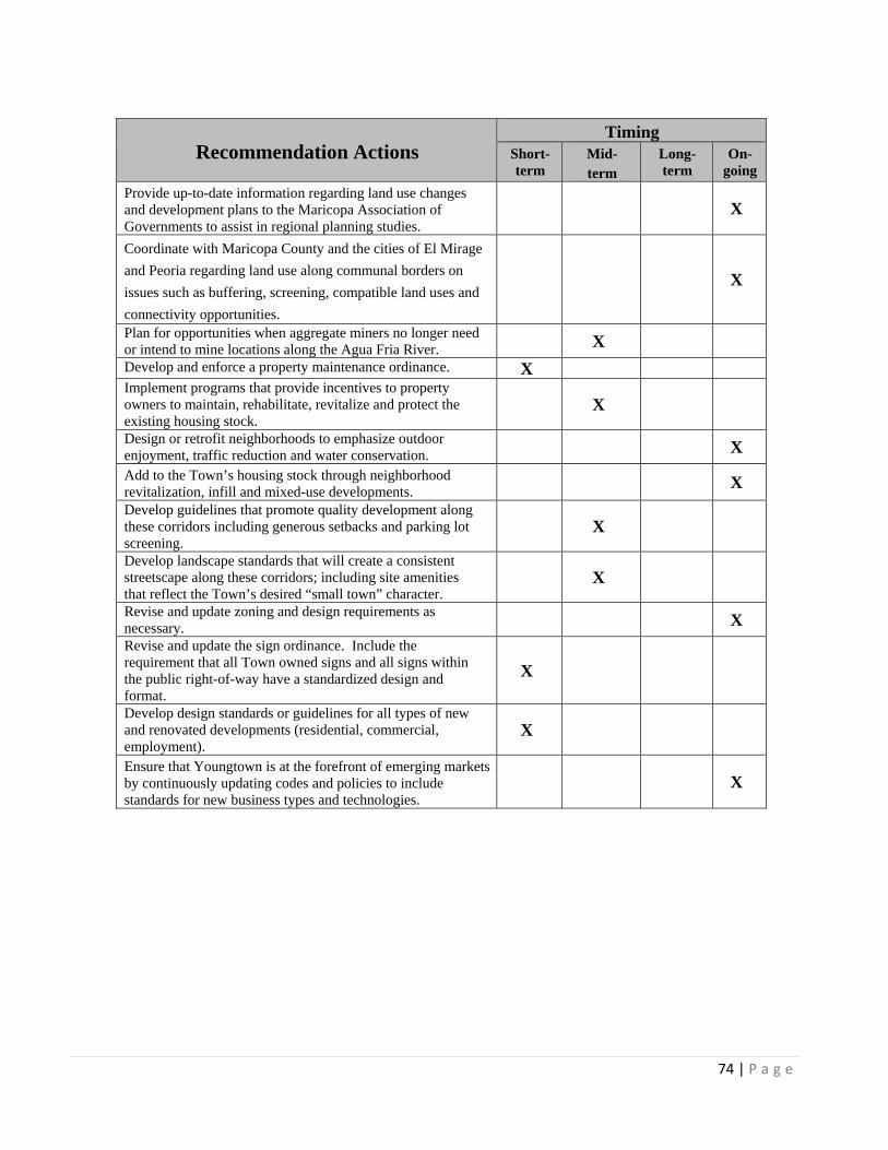
74 | P a g e
Recommendation Actions Timing
Short-term
Mid- term
Long-term
On-going
Provide up-to-date information regarding land use changes and development plans to the Maricopa Association of Governments to assist in regional planning studies.
X
Coordinate with Maricopa County and the cities of El Mirage
and Peoria regarding land use along communal borders on
issues such as buffering, screening, compatible land uses and
connectivity opportunities.
X
Plan for opportunities when aggregate miners no longer need or intend to mine locations along the Agua Fria River. X
Develop and enforce a property maintenance ordinance. X Implement programs that provide incentives to property owners to maintain, rehabilitate, revitalize and protect the existing housing stock.
X
Design or retrofit neighborhoods to emphasize outdoor enjoyment, traffic reduction and water conservation. X
Add to the Town’s housing stock through neighborhood revitalization, infill and mixed-use developments.
X
Develop guidelines that promote quality development along these corridors including generous setbacks and parking lot screening.
X
Develop landscape standards that will create a consistent streetscape along these corridors; including site amenities that reflect the Town’s desired “small town” character.
X
Revise and update zoning and design requirements as necessary. X
Revise and update the sign ordinance. Include the requirement that all Town owned signs and all signs within the public right-of-way have a standardized design and format.
X
Develop design standards or guidelines for all types of new and renovated developments (residential, commercial, employment).
X
Ensure that Youngtown is at the forefront of emerging markets by continuously updating codes and policies to include standards for new business types and technologies.
X

75 | P a g e
Table 9: CIRCULATION and TRANSPORTATION ELEMENT Implementation Strategies and Timing
Recommendation Actions Timing
Short-term
Mid- term
Long-term
On-going
Prepare an annual assessment of needed roadway improvements and publish a priority list and construction schedule.
X
Conduct periodic traffic safety audits on major streets to determine if traffic control measures need to be modified.
X
Conduct regular reviews in non-motorized transportation facilities for safety issues.
X
Identify roadways that need to be brought into compliance with level of service and add them to the annual priority list.
X
Review traffic signal timing and phasing to enhance traffic movement from Grand Avenue.
X
Continue to participate in the Grand Avenue Northwest Corridor Study.
X
Continue to work with commercial landowners and the City of Peoria to extend 114th Avenue north into Youngtown.
X
Consider additional east-west access from 115th Avenue to the Agua Fria Parkway south of Olive to 114th Avenue north of Olive Avenue.
X
Require new development to pay th3e costs of future transportation improvements that will occur within the development boundaries.
X
Coordinate with other jurisdictions to get the most out of Federal, State and County roadway funding.
X
Pursue State and Federal grants for transportation enhancement projects.
X X
Prepare a Trails Master Plan. Look for opportunities to make connections to existing non-motorized routes in existing and new developments.
X
Prepare a bicycle program that includes physical improvements, signs and education.
X
Develop a plan and priority list to provide more sidewalks. X Meet with adjacent communities to compare plans and look for opportunities to make connections.
X
Continue to work with commercial landowners and the City of Peoria on extending 114th Avenue north.
X
Work with the City of El Mirage to establish a river crossing at Peoria Avenue.
X
Continue to participate in the Maricopa Association of Government’s transportation committees.
X
Partner with appropriate jurisdictions to improve regionally significant roadways and circulation routes such as El Mirage Road as a north/south route.
X

76 | P a g e
Recommendation Actions Timing
Short-term
Mid- term
Long-term
On-going
Require that all roads meet the Maricopa County Road Standards.
X
Work with Valley Metro to expand bus service, Dial-a-Ride, etc.
X
Ensure that Youngtown is linked to the proposed light rail system.
X
Provide a community education program on transportation options.
X
Prepare design guidelines that create pleasant walking and biking environments to encourage these activities. Improvements might include plants, shade, bike racks, rest stops and comfortable attractive transit stops.
X
Continue to work with Valley Metro to ensure bus access along 111th Avenue is maintained.
X
Table 10: WATER RESOURCES ELEMENT Implementation Strategies and Timing
Recommendation Actions Timing
Short-term
Mid- term
Long-term
On-going
Require as a part of all requests for new development proof of water service.
X
Work with EPCOR Water Arizona, Inc, to provide incentives to existing users to switch to low-flow water devices.
X
Promote the use of low-water use plants in public and private landscape areas.
X
Install low-flow devices in all public facilities. X Encourage local water companies to develop and provide to the Town plans for providing water in the event of regional water shortages.
X

77 | P a g e
Table 11: OPEN SPACE and RECREATION ELEMENT Implementation Strategies and Timing
Recommendation Actions Timing
Short-term
Mid- term
Long-term
On-going
Continue to work with the Flood Control District of Maricopa County to implement the Agua Fria Watercourse Master Plan.
X
Require any new developments adjacent to the Agua Fria Floodplain to provide access to it.
X
Provide access from Agua Fria River to Maricopa Lake and Schliefer Park.
X
Work with the Flood Control District of Maricopa County and the U.S. Army Corps of Engineers to identify the potential for acquiring and developing the Agua Fria River Floodplain for recreational purposes.
X
Expand Schliefer Park. X Require, as part of all anew developments, over five (5) acres of contiguous public park and open space per 1,000 dwelling units.
X
Apply for grants to develop recreation facilities for Youngtown residents.
X
Consider a non-resident fee for recreation programs to subsidize additional programs and materials.
X
Provide tot lots in all new public and private parks over one-half an acre.
X
Provide at least one sport court or ball field in all new parks over one (1) acre.
X
Provide restrooms, some parking and water fountains in all new parks larger than five (5) acres.
X
Prepare an Open Space and Recreation Plan. X Continue to work with the City of El Mirage, Flood Control District of Maricopa County and the U.S. Army Corps of Engineers to implement the Agua Fria River Watercourse Master Plan.
X
Consider working with the City of El Mirage to jointly provide recreation options along and within the Agua Fria River Floodplain.
X
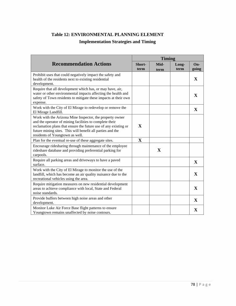
78 | P a g e
Table 12: ENVIRONMENTAL PLANNING ELEMENT
Implementation Strategies and Timing
Recommendation Actions Timing
Short-term
Mid- term
Long-term
On-going
Prohibit uses that could negatively impact the safety and health of the residents next to existing residential development.
X
Require that all development which has, or may have, air, water or other environmental impacts affecting the health and safety of Town residents to mitigate these impacts at their own expense.
X
Work with the City of El Mirage to redevelop or remove the El Mirage Landfill.
X
Work with the Arizona Mine Inspector, the property owner and the operator of mining facilities to complete their reclamation plans that ensure the future use of any existing or future mining sites. This will benefit all parties and the residents of Youngtown as well.
X
Plan for the eventual re-use of these aggregate sites. X Encourage ridesharing through maintenance of the employee rideshare database and providing preferential parking for carpools.
X
Require all parking areas and driveways to have a paved surface.
X
Work with the City of El Mirage to monitor the use of the landfill, which has become an air quality nuisance due to the recreational vehicles using the area.
X
Require mitigation measures on new residential development areas to achieve compliance with local, State and Federal noise standards.
X
Provide buffers between high noise areas and other development.
X
Monitor Luke Air Force Base flight patterns to ensure Youngtown remains unaffected by noise contours.
X

79 | P a g e
Table 13: ECONOMIC DEVELOPMENT ELEMENT Implementation Strategies and Timing
Recommendation Actions Timing
Short-term
Mid- term
Long-term
On-going
Identify vacant and underutilized parcels for mixed-use development.
X
Enhance the public environment with landscaping, lighting and signage.
X
Encourage absentee landowners’ participation in revitalization plans and activities.
X
Exercise eminent domain to purchase obsolete buildings, when necessary.
X
Establish a funding mechanism such as a 50/50 or Revolving Loan Fund to assist businesses with exterior improvements, such as painting and landscaping.
X
Catalogue deteriorating buildings and encourage the owners to take advantage of incentives for upgrades.
X
Expand use of creative financing tools such as Federal and State grants and Community Development Action Committee (CDAC) grants.
X
Explore all potential funding sources, including Revolving Loan Funds (RLFs) and Business Improvement Districts (BIDs).
X
Enlist the assistance from the Phoenix metro area media in repositioning the Town’s image.
X
Utilize paid advertising and unpaid publicity to sell the Town.
X
Partner with business owners in co-op advertising. X Hold a public event to roll out the new Town brand. X Invest in creative, high-quality collateral materials. X Give complimentary signs to businesses that proudly indicate “Town of Youngtown”.
X
Encourage use of the new Town brand in the preparation of collateral materials for commercial areas and individual businesses.
X
Establish a series of classes to engage business owners and incorporate the advantages of technology – perhaps in partnership with the Surprise regional Chamber of Commerce.
X
Explore utilizing Amazon for online ordering. X Facilitate a round-table event among retailers to share technology hints.
X
Explore employing a group of high school students to earn high school credits toward graduation by performing computer tasks for older business owners; e.g., email or Amazon orders.
X
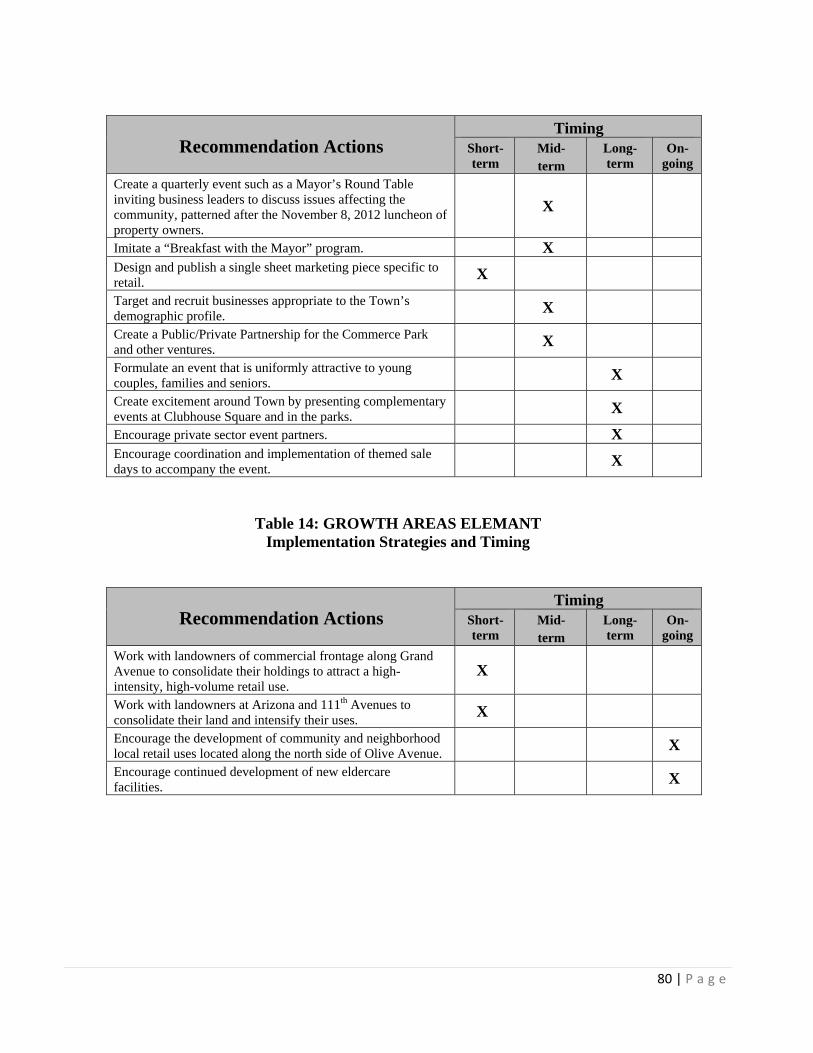
80 | P a g e
Recommendation Actions Timing
Short-term
Mid- term
Long-term
On-going
Create a quarterly event such as a Mayor’s Round Table inviting business leaders to discuss issues affecting the community, patterned after the November 8, 2012 luncheon of property owners.
X
Imitate a “Breakfast with the Mayor” program. X Design and publish a single sheet marketing piece specific to retail.
X
Target and recruit businesses appropriate to the Town’s demographic profile.
X
Create a Public/Private Partnership for the Commerce Park and other ventures.
X
Formulate an event that is uniformly attractive to young couples, families and seniors.
X
Create excitement around Town by presenting complementary events at Clubhouse Square and in the parks.
X
Encourage private sector event partners. X Encourage coordination and implementation of themed sale days to accompany the event.
X
Table 14: GROWTH AREAS ELEMANT Implementation Strategies and Timing
Recommendation Actions Timing
Short-term
Mid- term
Long-term
On-going
Work with landowners of commercial frontage along Grand Avenue to consolidate their holdings to attract a high-intensity, high-volume retail use.
X
Work with landowners at Arizona and 111th Avenues to consolidate their land and intensify their uses.
X
Encourage the development of community and neighborhood local retail uses located along the north side of Olive Avenue.
X
Encourage continued development of new eldercare facilities.
X
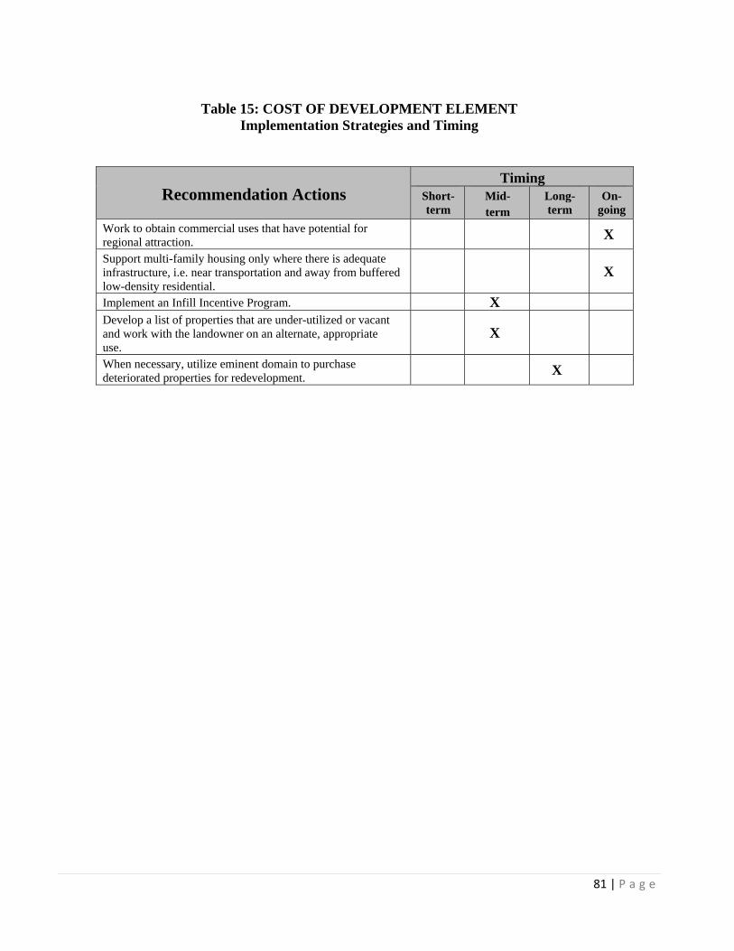
81 | P a g e
Table 15: COST OF DEVELOPMENT ELEMENT Implementation Strategies and Timing
Recommendation Actions Timing
Short-term
Mid- term
Long-term
On-going
Work to obtain commercial uses that have potential for regional attraction.
X
Support multi-family housing only where there is adequate infrastructure, i.e. near transportation and away from buffered low-density residential.
X
Implement an Infill Incentive Program. X Develop a list of properties that are under-utilized or vacant and work with the landowner on an alternate, appropriate use.
X
When necessary, utilize eminent domain to purchase deteriorated properties for redevelopment.
X

82 | P a g e
APPENDIX A
YOUNGTOWN PUBLIC INVOLVEMENT PROCESS Arizona law requires written procedures be adopted to provide effective, early and continuous public participation in the development of the Town of Youngtown General Plan and amendments to it from all geographic ethnic and economic areas of the Town of Youngtown. The Town of Youngtown Public Involvement Goals are to:
a. Obtain broad-based citizen participation in the planning process. b. Provide information to Town of Youngtown citizens and general public throughout
the process. c. Understand the residents’ attitudes and opinions regarding the direction of
Youngtown’s growth and development, key issues facing Youngtown and their hopes for Youngtown’s future.
d. Keep the Plan update and amendment process accessible and understandable to citizens of Youngtown.
e. Promote intergovernmental and interagency cooperation and collaboration. f. Meet the requirements of A.R.S. §9-461 (Growing Smarter) as amended
through the Arizona Revised Statutes. g. Keep the plan and amendments to it in the public eye throughout the process
and establish programs to increase their understanding of the plan recommendations.
To accomplish these goals, the following strategies and specific actions shall be implemented:
STRATEGY I: ENCOURAGE CITIZEN INVOLVEMENT AND ENCOURAGE BROAD-BASED PARTICIPATION IN THE DEVELOPMENT, UPDATE OR AMENDMENT OF THE GENERAL PLAN.
Action la: At least two public meetings to inform the public of the update of the
General Plan and solicit ideas and comments that could be considered in the General Plan update process may be held separately or in conjunction with public meetings of the Town Council and Planning and Zoning Commission to encourage public participation in the development of the Plan.

83 | P a g e
Action 1b: At least one public meeting to discuss and solicit ideas and comments on
amendments proposed to the General Plan may be held separately or in conjunction with public meetings of the Town Council and Planning and Zoning Commission to encourage public participation in the development of the Plan.
Action lc: Regular briefings on update or amendments proposed to the General Plan
shall be given to elected and appointed officials by Town Staff in order to keep them informed.
STRATEGY II: INVOLVE CITIZENS, LANDOWNERS, BUSINESS REPRESENTATIVES,
MINORITY GROUPS AND NEIGHBORING JURISDICTIONS, DISTRICTS AND OTHER ENTITIES IN THE DEVELOPMENT, UPDATE AND AMENDMENT OF THE PLAN
Action lla: Neighborhood organizations, major employers, civic groups, major landowners and developers may be contacted regarding the update of a proposed amendments to the General Plan and meetings with them as a group or individually may be conducted to obtain their views on the proposed plan goals, objectives, policies and proposed amendments.
Action llb: Town staff shall consult with, give advice and provide for official
comment by the school districts, community college, flood control district, public utility companies, and civic, educational, professional and other organizations to secure maximum input and coordination. The Town shall provide review copies of the Plan, in accordance with State law to:
School Districts in Youngtown
Maricopa Association of Governments
Arizona Land Department
Maricopa County Planning Department
Youngtown Utility Companies
Sun City
Sun City West
City of El Mirage Planning Department
City of Peoria Planning Department
City of Surprise Planning Department
ACA Community Planning Department
Any other entities or individuals that notify the Town, in writing, of their desires to be notified of the development of the
84 | P a g e
General Plan or major amendments to the General Plan. STRATEGY III: KEEP THE PLAN AND AMENDMENTS TO IT IN THE PUBLIC EYE
THROUGHOUT THE PLANNING PROCESS AND ESTABLISH PROGRAMS TO INCREASE THEIR UNDERSTANDING OF THE PLAN RECOMMENDATIONS.
Action llla: Town staff may provide information to the local media regarding the Plan and the Plan development process.
Action lllb: Town staff shall educate the public about the General Plan update and
amendment process through public meetings, speaking at civic and community functions or other venues.
Town staff shall educate the public about the General Plan update and · amendment process through public meetings, speaking at civic and community functions or other venues.
Action lllc: The Town staff may establish additional means to increase public understanding
and knowledge of the plan update or amendments proposed to it.
Action llld: A draft of the proposed updated Plan and a copy of any amendment proposed to the Plan shall be maintained at the Town Hall and made available to interested members of the general public.
Action llle: Notice of the time, place and date of public hearings on updates or
proposed amendments to the General Plan shall be provided in accordance with State Law.