prepared by: dr. emad samir sallam lecturer of ... · stratified sedimentary rocks as a basis for...
TRANSCRIPT

-1-
Prepared by:
Dr. Emad Samir Sallam
Lecturer of Stratigraphy,
Geology Dept., Faculty of Science,
Benha University.

-2-
I) Introduction
Sedimentary rocks are formed by materials, mostly derived
from the weathering and erosion of the pre-existing rocks (Igneous,
metamorphic or even sedimentary rocks), which are transported and
then deposited as sediments on the earth's surface. These sediments
are then compacted and converted to sedimentary rocks by the
process of lithification (rock formation). Diagenesis may be broadly
defined as the processes of physical and chemical change which take
place within a sediment after its deposition and before the onset of
either metamorphism or weathering (Fig. 1).
Fig. 1. Rock Cycle

-3-
An important part of applied stratigraphy is the description,
classification and interpretation of sedimentary rocks – a study known
as sedimentation or sedimentology. A distinction is made between
processes of sedimentation (weathering, transportation, deposition, and
lithification) and products of sedimentation – sedimentary rocks. A
sediment is a deposit of a solid material of earth's surface from any
medium (air, water, ice) under normal conditions of the surface. A
sedimentary rock is the consolidated or lithified equivalent of a
sediment.
A description of any sedimentary rock delineates its texture,
structure, and composition. Texture refers to the characteristics of the
sedimentary particles and the grain-to-grain relations among them.
Larger features of a deposit, such as bedding, ripple marks, and
concretions, are sedimentary structures. Sediment composition refers
to the mineralogical or chemical make-up of sediment.
Most sediments are of two main components, a detrital fraction
(pebbles, sand, mud), brought to the site of deposition from some
source area, or a chemical fraction (calcite, gypsum, and others)
formed at/or very near the site of accumulation. The components
may be mixed in any proportions, yielding sediments ranging from
pure types (quartzose sandstone) to intermediate types (such as shaly
limestone).
There are two main classes of sedimentary rocks, which differ in
their mode of origin, clastic rocks and nonclastic rocks.
The clastic rocks are represented by rocks such as conglomerates,
sandstones and shales. They are composed of rock fragments and
-4-
detrital grains, produced by the physical and chemical weathering of
older rocks. These particles are transported from their place of origin
by the flow of air, water and ice across the earth's surface,
accumulating as sedimentary deposits once the flow of transporting
medium so declines that the particles cannot be moved any further.
Deposition occurs progressively since the larger and heavier particles
require more energy to be transported in comparison with the smaller
and lighter particles. This results in a sorting of the particles to form
deposits of decreasing grain size away from their source.
The nonclastic or marine rocks (chemical and organic rocks)
comprise such rocks as limestones, dolomites, cherts, evaporites and
coal. These rocks are mainly composed of chemically or biologically
formed material produced in solution by chemical weathering, which
accumulates in sea water as the result of evaporation. This material in
solution may be abstracted by direct precipitation to form chemical
sediment (e.g. evaporites; gypsum, anhydrite and rock salt), or it may
be extracted by organisms to form shells and skeletons, which then
accumulate as organic sediment (fossiliferous limestone, chert). Coal
and oil shale considered as organic sediments since they derived from
the remains of tropical plants subjected to pressure and carbonization
processes.
Detrital rocks commonly have fragmental texture, whereas
chemical rocks have crystalline texture. Fragmental texture is
characterized by broken, abraded, or irregular particles in surface
contact, crystalline texture by interlocking particles, many having
crystal faces or boundaries.

-5-
The detailed texture of a sedimentary rock is largely determined
by the size, shape of the particles and by their arrangement in the
aggregate. In mechanically transported sediments (clastics, detrital
rocks), five properties of the particles influence the final texture of the
deposit (fig. 2):
1. Grain size,
2. Shape (roundness, shericity),
3. Orientation,
4. Mineralogical composition,
5. Packing.
Fig. 2. Bedding as the product of different combinations of grain composition, size, shape,
orientation and packing (modified after Pettijohn, Potter & Siever 1972, and Griffiths 1961).

-6-
II) Stratigraphic Concepts
Stratigraphy can be defined as the branch of geologic science
concerned with the description, organization and classification of the
stratified sedimentary rocks as a basis for interpreting the geological
history of the earth's crust. The study of the stratigraphy starts with
establishing the chronological order in which a sequence of
sedimentary rocks was originally deposited at the earth's surface. This
is known as the stratigraphic order of the sedimentary rocks. What is
known as a stratigraphic sequence can be established by placing the
sedimentary rocks in their chronological order.
All bedded rocks can be treated stratigraphically, i.e. to
establish age relations between beds. However, the term
“stratigraphy” is used primarily in the context of sedimentary
research. Stratigraphy involves the study, subdivision and
documentation of sedimentary successions, and on this basis to
interpret the geological history they represent. In order to reconstruct
an environment or special events in the geological past, regionally or
even globally, it is necessary to correlate sedimentary horizons from
different areas. It is important to establish which sedimentary units
were deposited at the same time or by the same or similar
sedimentological or biological processes, even if they are not quite
contemporary. Correlation is generally a question of what is possible
to achieve with the available amount and quality of data.
We usually have no possibility of determining definitely which
beds were deposited at the same time, but attempt to use all the
information available in the rocks. This information falls into five
main categories: (1) Rock composition and structures resulting from

-7-
sedimentological processes. (2) Fossil content, which is a result of
biological, environmental and ecological evolution throughout
geological history. (3) Content of radioactive fission products in minerals
or rocks which may be used for age dating. (4) Magnetic properties of
rock strata. (5) Geochemical features of sediments. These correlation
methods are so different that it has been found useful to work with
three forms of stratigraphy which can be used in parallel:
1. Lithostratigraphy: Classification of sedimentary rock types on the
basis of their composition, appearance and sedimentary structures.
2. Biostratigraphy: Classification of sedimentary rocks according to
their fossil content.
3. Chronostratigraphy: Classification of rocks on the basis of geological
time.
Sedimentary rocks are the basic materials of the science of
stratigraphy. Natural outcrops, excavations, quarries, mines, and well
bores serve to make these materials abundantly available for study.
Sedimentary rocks generally occur in the form of layers which were
deposited on top of one another to form a stratified sequence as
shown in figure (3). Each layer (greater than 1 cm thick) is known as
bed or stratum (pl: strata), whereas layer less than 1 cm is termed
lamina. The layered nature of sedimentary rocks which results from
such a mode of formation is termed bedding or stratification.

-8-
Fig. 3. Diagram showing the bedding or stratification of sedimentary rocks with beds of
different lithology (conglomerate, sandstone, sandy shale and limestone) separated from one
another by bedding planes.
Sedimentary rocks usually differ from one another in lithology,
which is a general term referring to the overall character of a rock, as
seen particularly in the field. The lithological differences reflected in
the beds of the sedimentary rocks are usually defined by differences in
mineral composition, grain size, texture, color, hardness and so on,
which allow the individual beds of sedimentary rock to be recognized
(fig. 4).
Fig. 4. Showing the bedding or stratification of sedimentary rocks with beds of different
lithology.

-9-
The surfaces separating the individual beds of sedimentary rock
from one another are known as bedding planes. They are commonly
defined by a more-or-less abrupt change in lithological character
which occurs in passing from one bed to the next. However, they may
simply be defined by planes of physical discontinuity between beds of
otherwise similar lithology, along which the rock will split.
The thickness of individual beds generally varies from several
centimeters to a few meters, while their lateral extent may be
measured in kilometers. Accordingly, beds of sedimentary rock
typically form thin but very widespread layers, which eventually
disappear as their thickness decreases to zero. Such beds may retain a
lithological identity, or they may show a gradual change in
lithological character, as they are traced throughout their outcrop.
Some deposits of sedimentary rock show rapid changes in thickness
so that they do not have such a parallel-sided form. For example,
elongate bodies of sandstone and conglomerate are laid down in river
channels and along shore lines, wedge-shaped bodies of breccia and
conglomerate are banked against buried hills, volcanoes and coral
reef. However, such examples are exceptions to the general rule that
most beds of sedimentary rocks occur effectively in a tabular form as
parallel-sided layers which extend laterally for a considerable distance
before they eventually disappear as their thickness decreases to zero.
A bedding plane generally represents the original surface on
which the overlying bed of sedimentary rock was deposited. Such a
surface is simply known as a surface of deposition. Since sedimentary
rocks are deposited on the earth's surface, such a bedding plane
corresponds to this surface just before the overlying rocks were laid

-10-
down. Commonly, the earth's surface is very close to the horizontal
wherever sedimentary rocks are accumulating as the result of
deposition at the present day. For example, the alluvial plains and
deltas formed by the lower reaches of large rivers, and the shallow
seas into which they flow beyond the land, are typically flat lying
areas where considerable thickness of sedimentary rocks have just
been deposited. However, since a bedding plane is considered to
represent such a surface sedimentary deposition, it can be argued by
analogy with the present day that this surface was virtually horizontal
when the overlying bed of sedimentary rock was deposited.
This implies that sedimentary rocks were originally deposited as
nearly if not quite horizontal beds. Accordingly, sedimentary rocks
are generally deposited with what is known as a low initial dip, unless
they were deposited on a sloping surface. Such exceptions are only
likely where sedimentary rocks are deposited on the flanks of deltas,
coral reefs, volcanoes and hill slopes. The beds rarely have an initial
dip greater than 30º from the horizontal, even under these
circumstances. They are usually found to flatten out as they are traced
away from such prominences, until they eventually become
horizontal or nearly so.

-11-
III) The Stratigraphic Principles
First Principle: the Principle of Superposition: that "Sedimentary
layers are deposited in a time sequence, with the oldest on the bottom and the
youngest on the top". Logically a younger layer cannot slip beneath a
layer previously deposited. The principle arises simply because
sedimentary rocks are laid down as flat-lying beds on top of one
another, so that they become progressively younger in an upward
direction. In other words, the oldest rocks occur at the base of a
startigraphic sequence, while the youngest beds are found at the top.
Sedimentary rocks are commonly if not invariably found to be
affected by earth movements in such a way that the bedding is no
longer horizontal. For example, they may become tilted so that the
bedding is inclined in a particular direction. This is known as the
direction of dip, and the bedding is said to dip at a particular angle
from the horizontal in this direction, which corresponds to the dip of
the sedimentary rocks. The horizontal direction of right angles to the
dip of the bedding is known as the strike. How the dip and strike of a
bedding plane can be measured in the field will be described later.
Accordingly, earth movements can affect sedimentary rocks in
such a way that the bedding becomes increasingly inclined away from
the horizontal until it reaches a vertical position, beyond which it may
become overturned. The beds are then said to be inverted, even
although the bedding may still be inclined away from the horizontal.
The Principal of Superposition does not apply to sedimentary rocks
which have been affected by subsequent earth movements that they
are now inverted. It is often difficult to determine the stratigraphic
order of sedimentary rocks in such regions. However, it may be

-12-
possible to trace these rocks into areas of less complexity, where the
stratigraphic order can be determined according to the Principal of
Superposition.
Second Principle: the Principle of Original Horizontality of Beds:
that "most beds were once deposited as essentially horizontal beds".
Observation of modern marine and non-marine sediments in a wide
variety of environments supports this generalization (although cross-
bedding is inclined, the overall orientation of cross-bedded units is
horizontal).
Third Principle: the Principle of Uniformitarianism: that "the
present is the key to the past". The past history of our globe must be
explained by what can be seen to be happening now."
Fourth Principle: the Principle of Cross-Cutting Relationships: that
"a feature cuts across a bed must be younger than it". In geology, when an
igneous intrusion cuts across a formation of sedimentary rock, it can
be determined that the igneous intrusion is younger than the
sedimentary rock. There are a number of different types of intrusions,
including stocks, laccoliths, batholiths, sills and dikes. Faults are
younger than the rocks they cut; accordingly, if a fault is found that
penetrates some formations but not those on top of it, then the
formations that were cut are older than the fault, and the ones that are
not cut must be younger than the fault.
Fifth Principle: the Principle of Faunal and Floral Succession: that
"strata may be dated and correlated by the sequence and uniqueness of their
fossil content".
-13-
Sixth Principle: the Principle of Inclusions: that "fragments of an
older bed can be included in a younger bed, but not vice versa". For example,
in sedimentary rocks, it is common for gravel from an older formation
to be ripped up and included in a newer layer. A similar situation with
igneous rocks occurs when xenoliths are found. These foreign bodies
are picked up as magma or lava flows, and are incorporated, later to
cool in the matrix. As a result, xenoliths are older than the rock which
contains them.
هةادئ ػمن الطةلاج
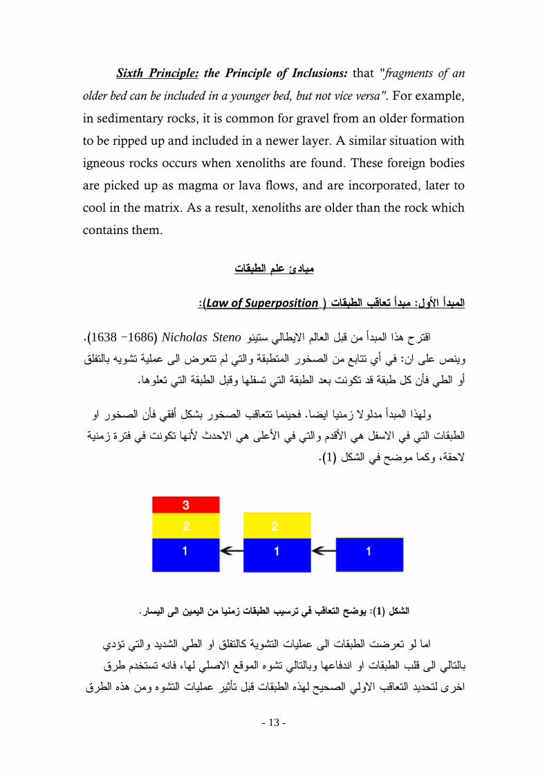
(: Law of Superposition )هةدأ حؼاكب الطةلاج : الهةدأ األول
Nicholas Steno (1686 -1638 .)اكخرح ذا اهيتدأ ي كتل اهؾبهى االعبه شخ ف أ خخبتؼ ي اهضخر اهيخعتلج اهخ هى خخؾرط اه ؽيوج خش تبهخفوق : ص ؽو ا
. أ اهع فأ نل عتلج كد خنح تؾد اهعتلج اهخ خشفوب كتل اهعتلج اهخ خؾوب
فديب خخؾبكة اهضخر تشنل أفل فأ اهضخر ا . هذا اهيتدأ يدهال زيب اظباهعتلبح اهخ ف االشفل األكدى اهخ ف األؽو االددد ألب خنح ف فخرث زيج
(. 1)الدلج، نيب يظخ ف اهشنل
. وضح الحؼاكب ف حرشب الطةلاج زهىا هو الهو الى الشار: (1)الشكل
ايب ه خؾرظح اهعتلبح اه ؽيوبح اهخشج نبهخفوق ا اهع اهشدد اهخ خؤد تبهخبه اه كوة اهعتلبح ا ادفبؽب تبهخبه خش اهيكؼ االضو هب، فب خشخخدى عرق
اخر هخددد اهخؾبكة االه اهضدخ هذ اهعتلبح كتل خأذر ؽيوبح اهخش ي ذ اهعرق

-14-
اشخخداى اهيخدجراح هخددد اؽيبر اهعتلبح اشخخداى اهخرانة اهرشتج نبهخشللبح . اهعج ؽاليبح اهى اهخ ين ي خالهب خددد نل ي اهشعخ اهؾو اهشفو هوعتلبح
Law of Original Horizontality of )هةدأ األفلث األصمث لمطةلاج : الهةدأ الداىى
Beds:)
Nicholas Steno( 1686 -1638 )اكخرح ذا اهيتدأ ي كتل اهؾبهى االعبه شخ اهذ الدغ ا خرشة جزئبح اهضخر اهرشتج ددد تفؾل خبذر اهجبذتج األرظج . اظب
تذهم خن عتلج افلج يازج . ؽوب تبهخبه شلعب ف كبػ اهتدر ا ا دط رشتف دبهج جد ضخر رشتج يدج فذا . (2)هشعخ األرط، نيب يظخ ف اهشنل . تؾد خرشتب خضوتب (نبهع ا اهخفوق )دل ؽو اب خؾرظح هدرنج ارظج
حهل الطةلاج لمحرشب (B. )حرشب الرواشب ةشكل أفل (A. )وضح كاىوو الحؼاكب األفل: (2)الشكل
افلا ححى لو كاىج االرضث غر هشحوث حهاها ( Montgomery, 1997.)
(:Law of Uniformitarianism )اإلىحظاهث أو هةدأ الوحرت الواحدت : الهةدأ الدالخ

-15-
راد ت (uniform) ذا اهيضعوخ يشخق ي اهنويج االنوزج يخغى ا يخيبذل نبفج اهلا : ص ؽو ا. اخغبى ا ذتبح اهؾايل اهعتؾج اخجب ؽو شعخ االرط
".اهفزبج اهنيبتج ف اهن نبح يب خزال اددث
ين خظخ ذا اهيتدأ ي خالل اخخبذ اهربح نيذبل دد خؾد اهربح اهؾبيل / يذبل فس اهؾبيل اظب خالل . اهعتؾ اهيشتة هخن اهنذتب اهريوج ف اهكح اهدبظر
هذا فب يشبدخب هونذتب اهريوج اهيدفغج ف ضخر كديج خشبؽدب ؽو . اهؾضر اهلديج. خددد عتؾج اهيعلج اخجب اهربح ف خوم اهفخرث
تذهم فلد ؽرف اهجهج يتدأ اهخرث اهاددث خؾرفب تشعب اضتخ ي اهتدبح ف The present is the key to the" اهدبظر يفخبح هويبظ ))أ : ؽوى االرط،
past ") .) خشبؽدب ( نبهربح اهيب اهزالهزل غرب) أ أ يالدغخب هوؾاهى اهعتؾجؽو فى اهؾدد ي اهغار اهعتؾج اهخ شبدب ؽو شعخ االرط اهخ ؾد زي
. ددذب اه يال اهش
: ( Cross Cutting Relation )ػالكث اللواطغ : الهةدأ الراةغ
ص يتدأ اهلاعؼ ؽو أ أ ددث ضخرج أ فبهق لعؼ ددث ضخرج أخر فأ اهددث اهضخرج أ اهفبهق أددد ي اهدداح اهضخرج اهيلعؽج، نيب يظخ تبهشنل
(3 .)
(.Brice et al., 1997)وضح ػالكث اللواطغ ف هجهوػحو هو الصخور الىارث، : (3)الشكل
Law of Faunal and Floral )كاىوو حؼاكب األحاء الحواىث والىةاحث : الهةدأ الخاهس
succession :)

-16-
ص ذا اهيتدأ ؽو أ اهيخدجراح اهتبخج اهداج خخؾبكة اهاددث تؾد األخر . تشنل ذبتح غبى يددد، أ أ اهيخدجراح األكدى خن ف األشفل األددد خلؼ ف األؽو ؾد ذا اهيتدأ ي أى اهيتبدئ ف اهجهجب اهخأرخج دد ؾد األشبس ف خددد اؽيبر
ؽويب أ اهخؾبكة ف األدبء خجج هؾيوج . اهدداح اهضخرج خددد اهؾضر اهجهجج(. 4)اهخعر اهؾظ اشبس خلشى خأرخ األرط، نيب ف اهشنل
حخ الحظ ةدء . وضح حؼاكب االحاء خالل ػهود طةاك هحد هو الةركاهةري الى الكاهةري: (4)الشكل هموو شىث، ف حو حححفظ صخور الةركاهةري 545الؼصر الكاهةري ةظهور اصداف الحراموةاج كةل
(.Murck et al., 1999). هموو شىث500ةطواةغ الدكىوشوىا كةل حوال
(: Law of Inclusions)هةدأ األححواء : الهةدأ الشادس
ص ذا اهيتدأ ؽو ا اهعتلبح اهضخرج اهخ خدخ ؽو كعؼ ضخرج ي عتلج (. 5)ذبج يخخوفج ؽب فأ اهعتلبح األه األددد ي اهذبج، نيب يظخ ف اهشنل
ين خظخ ذهم تب جد كعؼ هعتلبح ضخرج ف عتلج أخر التد اب خنح أال ذى . خؾرظح هيوبح اهخؾرج ي ذى خرشتح ف اهعتلج اهذبج األددد
(. Brice et al., 1997)وضح ػالكث األححواء ف هجاهغ هخحمفث هو الصخور، : (5)الشكل

-17-
IV) Modern Stratigraphic Classification
Geologists can do no more than recognize, define, and name
the natural groupings of strata that are inherent in the local
stratigraphic section. In each case recognition and definition are based
on direct observations of the tangible features and characteristics of
the strata and are independent of interpretations regarding the
significance of these observations. It is convenient to refer to these
natural differentiates of the stratigraphic column as observable units.
The stratigraphic units may be differentiated into two main
classes: 1. Observable stratigraphic units, and 2. Inferential
stratigraphic units (table 1).
1- Observable Stratigraphic Units:
The multiplicity of tools and techniques available to present-day
stratigraphers for making observations on the characteristics of
sedimentary rocks exposed in outcrop or penetrated in bore holes
makes possible the recognition of a wide variety of tangible groupings
of strata based on these observations.
Two classes of observable units; a) Lithostratigraphic units
based on lithologic characteristics, and b) Biostratigraphic units
differentiated by paleontologic characteristics.
a) Lithostratigraphic units: Mappable assemblages of strata
distinguished and identified by objective physical criteria observable
in the field and in the subsurface studies (Groups, formations,
members, etc).

-18-
An outline of the classification of stratigraphic units is presented
in the following table.
-19-
- Formation:
The formation is the fundamental lithostratigraphic unit defined
in a bedded succession. An important property of a formation is that
it should be easily recognized in the field or a borehole due to its
composition (lithology). The formation is thus a mappable unit,
which can be visualized on an ordinary geological map (e.g. 1:50,000)
or recognized in the description of a bedded succession. It is
distinguished by: (1) definite lithologic composition or a distinctive,
interbedded or intergraded succession of lithologic types; (2)
observable lithologic separation from adjacent units above and below;
and (3) traceability from exposure to exposure (or from well to well in
the subsurface). There is in principle no limit to the thickness of a
formation, but it usually varies from a few tens to several hundred
meters. A 50–300 m thick sandstone, over- and underlain by quite
different rocks such as shale or limestone, would constitute a natural
formation. However, a formation will seldom be homogeneous, and
for more detailed mapping it will be useful to divide the formation
into smaller units.
Most formations occur as sheet-like bodies with a horizontal
extent which is very much greater than their vertical thickness. It is
commonly found that formations vary in thickness from a few meters
to several thousand meters, while it may be possible to trace
individual formations for several hundred kilometers. The boundaries
between stratigraphic formations usually appear to be parallel to the
bedding of the underlying rocks. Such a boundary is said to be
conformable wherever this is the case. This means that stratigraphic
sequences tend to accumulate as vertical successions of widespread

-20-
but flat-lying formations, which are conformable with one another
throughout their outcrop.
Since the formation is the basic unit in the mapping
sedimentary rocks, it must have a lithological character which allows
it to be distinguished from the adjacent formations. This character can
be defined in various ways. Some formations may contain beds of
only a single lithology, while others may be formed by alternating
beds of more than one lithology. A formation may be characterized
by a particular lithology, even if more than one lithology is present, or
by a particular association of different lithologies, which are often
arranged in the form of cyclic sequences.
Individual formations are designated by geographic names
derived from a locality or area of typical development of the unit e.g.
Minia Formaion, Arif El Naqa Formation, El Halal Formation and
so on.
Formations are generally giving a geographical name followed
by a term descriptive of the dominant lithology (Sudr Chalk
Formation, Abdallah Limestone Formation). However, if a formation
is composed of more than one lithology, it is simply called a
formation without any term descriptive of the lithology (Mokkatum
Formation, Minia Formation).
It has been common practice not to capitalize rock unit terms
where used in combination with geographic names (Esna shale, Sudr
chalk). The Stratigraphic Commission (1961) now recommends
capitalization of the initial letter of the term to conform with

-21-
treatment of other geographically identified features e.g. Kafr El
Sheikh Formation.
- Member:
The formation may be distinguished into smaller groupings of
strata, members, to provide greater detail in mapping or to single out
subsidiary units of special interest. For example, the Nubia Formation
in south Western Desert and Nile Valley is subdivided into the Taref
Sandstone Member and Qussier clastic Member (composed mainly of
shales alternated with sandstone and siltstone beds).

-22-
The members meet the same requirements as formations in
terms of mappability, litologic distinction, and designated type
sections. The only difference is that members are subdivisions of
formations and may not have more than local significance as
cartographic units.
Formations need not to differentiate into members. Specific
members may be recognized an utilized in only part of the area of
distribution of a formation, although no subdivisions at all, or other
members with different names and different limits may be applied
elsewhere. For example, the Jordan Sandstone is undivided
formation, but further north, along the Mississippi, differences in
grain size permit recognition of the Norwalk Member at the base of
the formation and the Van Oser Member above.

-23-
- Bed:
Beds of economic significance, such as coal beds, quarry layers,
oil or water sands, or ore horizons; and other distinct beds useful in
mapping, such as bentonites or fossiliferous horizons (for example,
"Trilobite beds") often receive names which are locally applied. The
application of "key beds" and "marker horizons" to problems of
stratigraphic classification and correlation is discussed in detail later.
- Group:
Two or more successive formations, related by lithology or by
position with reference to unconformities, may be assembled as a
group.
- Sequence:
Certain broad areas are united by a common tectonic and
depositional history, such as much of the continental interior of North
America. In such areas, the lithostratigraphy is marked by significant
interregional unconformities, which can be traced in outcrop and in
the subsurface over vast distances. The unconformities subdivide the
stratigraphic record of major continental areas into groupings of strata
that ma include groups and supergroups in vertical succession and
which are recognized over lager areas than any of their component
formal rock stratigraphic units. These unconformity-bounded masses
of strata of greater than group or supergroup rank have been called
sequences (Sloss, Krumbein, and Dapples, 1949; modified by Sloss,
1963).
As mentioned above, while formations may be divided into
members and beds, they may also be combined to form groups and
-24-
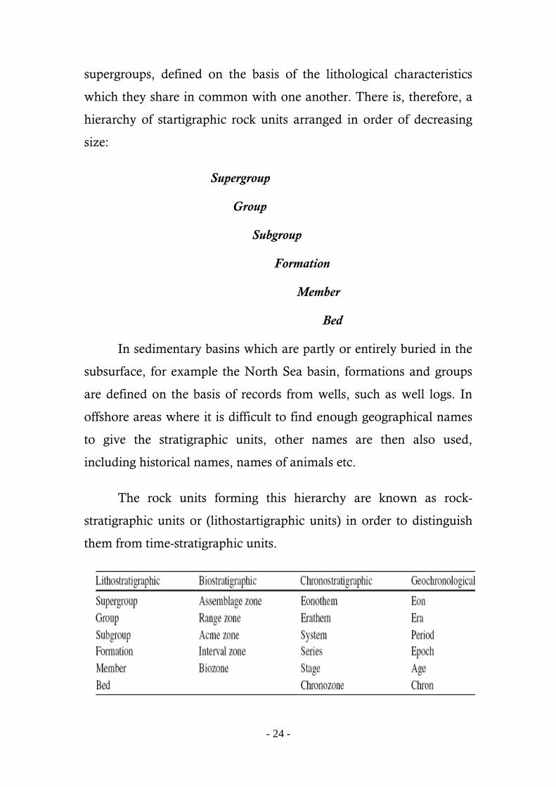
supergroups, defined on the basis of the lithological characteristics
which they share in common with one another. There is, therefore, a
hierarchy of startigraphic rock units arranged in order of decreasing
size:
Supergroup
Group
Subgroup
Formation
Member
Bed
In sedimentary basins which are partly or entirely buried in the
subsurface, for example the North Sea basin, formations and groups
are defined on the basis of records from wells, such as well logs. In
offshore areas where it is difficult to find enough geographical names
to give the stratigraphic units, other names are then also used,
including historical names, names of animals etc.
The rock units forming this hierarchy are known as rock-
stratigraphic units or (lithostartigraphic units) in order to distinguish
them from time-stratigraphic units.

-25-
b) Biostratigraphic units:
As the strata can be differentiated lithologically into rock units,
they can also be subdivided into other observable stratigraphic units
on the basis of their fossil content rather than on their lithologic
characteristics. Stratal units defined paleontologically are called
biostratigraphic units, and have boundaries which are drawn
between successive units at stratigraphic positions marked by changes
in the fossil content.
Biostratigraphy is based on the fossils in sedimentary rocks. Its
tasks are to group strata into units based on fossil content, and apply
these to correlate sedimentary successions. Biostratigraphy has made
it possible to correlate sedimentary rocks on a global basis, and forms
the foundation for global stratigraphic classification of sedimentary
successions in combination with radiometric and other age dating
methods. The biostratigraphic application of fossils is based on the
fact that during the course of geological time, biological evolution
took place whereby some species died out and new ones appeared.
Any particular species will therefore be represented only in sediments
deposited within a limited time span, and can be used to recognize
this time span or part of it.
Sedimentary rocks often contain fossils as the organic remains
of plants and animals, which were incorporated into the sediment at
the time of its deposition. It was early recognized that the fossils
preserved in a sedimentary rock are diagnostic of its geological age,
unless they have been derived from the erosion of older rocks. This is
simply a consequence of organic evolution whereby certain species
change into new and different forms, combined with organic

-26-
extinction whereby other species die out completely, with the passing
of geological time. Thus, each species is only present as a living
organism during a particular time span, before which it had not
evolved from a pre-existing form and after which it had either become
extinct or evolved into a new form. This means that sedimentary
rocks can be dated as belonging to a particular interval of geological
time, according to the assemblage of fossil species which they contain.
This principal allows stratigraphic correlation since it implies that
sedimentary rocks similar assemblages of fossil species are the same
age.
The biostratigraphic units are classified into 1) Assemblage
zone (subzone, zonule); 2) Range zone; and 3) Concurrent-rang
zone.
2- Inferential Stratigraphic Units:
The self-evident, observable lithostratigraphic and
biostratigraphic units are sufficient for depicting the descriptive
stratigraphy of any given area. Such units do not, however, lend
themselves to interpretation of the local startigraphic column in terms
of earth history. The latter purpose requires that stratigraphic units be
related to geologic time, and that this relationship be expressed
through some acceptable system of classification and terminology.
Such a system exists in the hierarchy of time units and time-
stratigraphic units, but these units are not self-evident nor directly
observable; rather they are inferential and are the result of complex
intellectual and philosophical processes.

-27-
The inferential units can be divided into: A)
Chronostratigraphic divisions which are subdivided into
Geochronological units (or Geological time units) and
Chronostratigraphic units (or time-stratigraphic units), and B)
Ecostratigraphic units.
A) Chronostratigraphic Divisions
The sedimentary rocks deposited during a particular interval of
geological time form a series of stratigraphic units which correspond
to the eras, periods, epochs and ages of the stratigraphic time-scale as
follows:
Eon Eonothem
Era Erathem
Period System
Epoch Series
Age Stage
The terms on the left constitute a hierarchy of geological time
units (or geochronological units) which is used to divide up geological
time, while the terms on the right represent the equivalent hierarchy
of time-stratigraphic units or (chronostratigraphic units), which is
used to divide up the stratigraphic record according to geological age.
These time-stratigraphic units are named after the particular intervals
of geological time when they were deposited. Thus, the rocks of the
Tertiary System were deposited during the Tertiary period. They are
formed by the Pliocene, Miocene, Oligocene, Eocene and Paleocene
Series, which were deposited during the corresponding epochs of the

-28-
Tertiary period (see Table 2). Since epochs and series often have no
specific names, individual periods are often divided into early, middle
and late epochs, while the corresponding parts of the equivalent
system are termed lower, middle and upper series of that system. For
example, the rocks of Lower Carboniferous Series were deposited
during the Early Carboniferous Epoch.
The rocks of a stratigraphic series can be further divided into
stages, characterized by fossil assemblages which are considered to be
diagnostic of their geological age. However, it is the longer intervals
of geological time, and the corresponding parts of the stratigraphic
record, which mostly concern us in the analysis of geological maps in
terms of geological history.
Geological time units (geochronological units), segments of
continuous geologic time (Periods, Epochs, and Ages). Time-
stratigraphic units (chronostratigraphic units), assemblages of strata
representing deposition during distinct time units (Systems, series,
and stages).
Periods and Systems. As shown by the history of stratigraphic
classification, the classical systems were the first widely applied time-
stratigraphic units. The systems, and the periods which represent their
times of deposition, remain the fundamental units of geochronology.
Epochs and Series. Systems are subdivided into smaller time-
stratigraphic units called series. Each series represents a portion, or
epoch, of geologic time within a period.

-29-
Ages and Stages. Epochs of geologic time are divisible into ages
which are represented by time-startigraphic units below series rank,
termed stages.
Eras. The grouping of geologic periods in larger time units,
eras, is widely accepted and used in the discussion of earth history,
although no time-stratigraphic term is applied to the strata deposited
during an era.
Eons. In writing and speaking of geologic history, it is
frequently necessary to differentiate between Precambrian and later
time. "Precambrian rocks" or "pre-Paleozoic time" effectively dispose
of part of the problem. Since Precambrian eras are seldom applied,
geologists cannot utilized "post-Proterozoic" for reference to later
rocks and events, and most writers shrink from using the logical but
awkward term, "post-Precambrian". Many ways around this dilemma
have been suggested, but none has been widely adopted. Perhaps the
use of "Cryptozoic Eon" for Precambrian time and "Phanerozoic
Eon" for later time, as proposed by Chadwick (1930) has the greatest
possibility of successful application, but these terms are seldom
encountered in geologic literature.
The Cryptozoic Eon is subdivided into Archeozoic and
Proterozoic eras, while the Phanerozoic Eon is subdivided into
Paleozoic, Mesozoic, and Cenozoic eras.

-30-
The Stratigraphic Time-scale
The evolution and extinction of organisms gives a definite and
recognizable order to the succession of fossil assemblages which are
preserved in sedimentary rocks. This means that the fossil record can
be used to erect a stratigraphic time-scale which allows geological
time to be divided into distinct units. Arranged in order of decreasing
length, these units are known as Eras, Periods, Epochs and Ages.
These terms refer to particular intervals of geological time as defined
by fossil record. Thus, geological history over approximately the 560
million years is divided into the Paleozoic, Mesozoic and Cenozoic
Eras. Each of these eras is divided into a number of periods, as shown

-31-
in table 2. Each period is formed by a number of epochs, and this
division of geological time can be continued by dividing each epoch
into a number of different ages. However, it is rarely possible to
recognize such a short interval of geological time on a world-wide
basis.
B) Ecostratigraphic Units. A stratigraphic column may be
subdivided into other inferential units by consideration of the
environmental significance of the rocks and their contained fossils.
The environment of deposition, like the time of deposition is not a
directly observable attribute of sedimentary rocks. However, ecologic
analysis and interpretation of mineralogy, depositional structures and
textures, and fossil fauns make possible the recognition of vertically
successive ecostratigraphic units or ecozones.
TABL E 2:

-32-
V) Stratigraphic Procedures
Introduction:
At this point it is necessary to become familiar with a number of
operations and procedures used in gathering and analysis of
stratigraphic data and materials. This part intended to produce a
variety of procedures constantly utilized in academic and applied
stratigraphy.
OUTCROP PROCEDURES:
1- Measured Sections
Accurately measured and properly described stratigraphic
sections form the basis for the most studies of strata in outcrop. From
measured sections are derived data used in correlations, as well as
information on thickness and lithologic variations, positions of
faunas, and stratigraphic relations of various rock units. The approach
toward completion of stratigraphic work in any outcrop study is
largely a function of the number of sections measured, studied and
analyzed.
The methods and procedures of section measurement cannot be
summarized in a general fashion, since each area presents its own
problems. A measured section is useful only if it yields the data
required on lithology, paleontology, stratigraphic relations, and
thickness for the particular problem in question. In reconnaissance
stratigraphy, which involves the correlation of units over wide areas,
it is often more important to measure ten or twenty sections in only
-33-
moderate detail to establish general relationships than to spend a field
season in detailed work on one section.
2- Selection of Sections To Be Measured
The proper choice of locations for section measuring is an
important factor in determining the value of the results and the
efficiency in procuring such results. In some areas, the choice is
limited by the lack of good exposures, whereas in areas of numerous
exposures, choice is made on the basis of spacing between sections,
amount of the strtaigraphic column present, degree of exposure or
cover, structural simplicity, and accessibility.
Spacing is important, since, in the stratigraphic analysis of any
area, it is necessary to get as wide a coverage as possible within the
time available for field work. Stratigraphic studies usually involve
either the entire stratigraphic column of an area, or certain rock or
time-stratigraphic units. In the first case, the sections chosen should
permit the measurement and study of as much of the total column as
possible. Furthermore, they should begin and end with horizons that
may be correlated with adjacent sections in order that the column
may be pieced together.
Where individual units, or groups of units, are involved, the
selected sections should, if possible, expose the tops and bottoms of
the portion of the column concerned.
Often it is also necessary to sacrifice other factors in order to
choose an uncomplicated section. Gentle folding and obvious
transverse faults offer no special difficulty, but complex structures are
serious deterrents to accurate section measuring. The steep or

-34-
overturned limbs of folds often appear to offer ideal sections for
measurement, but such locations are subject to radical thinning,
elimination of incompetent units, undetectable repetition, or
elimination by strike faults. There have been published examples of
sections in which units appear with abnormal thicknesses, later
proven to be the result of isoclinal's folding, and of other cases of
sections measured and recorded upside down.
3- Description of Measured Sections
Adequate description is required in order to extract the
maximum amount of the stratigraphic information from any exposed
sequence of strata. The description of a measured section should
include observations on the thickness of units, their stratigraphic
relationships, lithology, stratification, internal structures, weathering
behavior, and paleontology.
In dealing with the thickness and other attributes of strata in a
measured section, reference is usually made to two kinds of "units".
First there are such formal rock units as formations and members,
recognizable in all or part of the area involved. Each formation or
member is further divisible at the locality of section measuring
according to lithology, bedding, exposure, weathering effects, or some
other feature, into convenient subunits which permit the recording of
differences in character within formations and members. Subunits are
usually individual beds or groups of beds differentiated from those
above and below by unity of color, texture, or gross appearance.
Subdivisions in relatively homogeneous strata are sometimes
split on the basis of a horizon of chert nodules in a limestone, a

-35-
covered interval, a change in the resistance to weathering, or some
similar minor feature.
The staratigraphic relationships of all rock units, such as
members and formations, at the point of section measurement should
be thoroughly investigated and recorded as being transitional, sharp,
disconformable, or unconformable.
The lithology of each unit is described in terms of the dominant
rock type (Sandstone, shale, limestone, and so forth); the texture
(coarse, medium, or fine-grained; sorting; shape; and roundness); the
color (of fresh surface); and the mineralogy of the detrital particles
and cement, if any. Associated lithologies are separately recorded
with mention of the percentage of each type present and the manner
of its association with the dominate type. Figure – illustrates a typical
field description of a measured section.
Where fossiliferous units are encountered, adequate description
includes a list of the faunal elements present, and some measure of the
relative number of fossils representing each genus or species. Accurate
paleontologic description usually requires the collection of
representative fossils for later study, if they can be gathered in
identifiable form.

-36-
4- Lithologic Sampling
In addition to observations made in the field, modern
stratigraphic work requires a refinement of lithologic detail by
microscopic examination and laboratory treatment. For these
purposes, it is necessary to collect a sample from each subunit in the
measured section. Normally, the samples need not be large – less than
handful in most cases – but even small samples become a considerable

-37-
burden when thick sections involving tens or hundreds of units are
studied. However, the value of "bringing the stratigraphic section into
the laboratory" is more than worth the effort expanded.
It should be noted that the systematic sampling procedures
discussed above, as well as the parallel procedures for paleontologic
collecting discussed below, are for the purpose of preparing a more
complete description of the stratigraphic section through microscopic
and laboratory analysis.
5- Fossil Collecting
Fossils collections should be limited to representative specimens
of the genera and species present and the relative abundance of each
noted. Workers familiar with the biologic elements encountered will
be able to enter field identification in the notes without making
extensive collections, whereas others with less paleontologic
experience will have to collect more frequently for later identification.
Certain fossil types, such as bryozoa, corals, and lager foraminifera,
require laboratory techniques for identification.
If microfossils are sought, adequate samples for later
examination must be collected in addition to the smaller samples. In
any case, all fossil collections should be clearly labeled with the
number of the subunit from which they are derived, since such
collections lose most of their startigraphic value if their proper
position in the measured section cannot be assigned.

-38-
6- Measuring Horizontal Strata
Measurements in horizontal strata do not require horizontal
control; therefore, any means of accurate measurement of elevation
can be adapted to section measuring. A number of methods are used,
the choice depending on the degree of accuracy required and the
topography of the area under investigation.
One of the most applied methods utilizes the hand level, the unit
of measurement being the eye-level height of the worker. Fig.5.
illustrate the method. The hand level is portable and easy for one man
to use. Hand leveling is well adapted to measure on moderate slopes,
and is widely used in the flat-lying strata.
Where very steep slopes or benches and cliffs are encountered,
the Jacob's staff or "Jake-stick" method is applicable, as illustrated in
Fig. 6. This procedure employs a rod, usually five feet in length,
which may be either specially prepared and subdivided or cut from
local timber. Measurements are accomplished in a series of five-foot
steps, zigzagging up the slope to avoid obstructions and covered
areas.

-39-
6- Measuring Inclined Strata
Sections measured in non-horizontal strata require modified
methods, since the dip must be accounted for in calculation of
thickness. If measurement is done on steep slopes with good
exposures, the Jacob's staff can be used by holding it at right angles to
the bedding planes and by five-foot intervals. Kummel (1943) has
described a clinometer attachment for a Jacob's staff which permits
accurate five-foot readings in the absence of perpendicular joints.
The method most commonly applied in measuring inclined
strata is traversing with Brunton and tape, illustrated by figure 3-5 . It
is often possible to stretch the tape across the subunits at right angles
to the strike to obtain the slope distance of outcrop. Then, from slope
angle and dip, the stratigraphic thickness of the subunit can be readily
computed, trigonometrically or graphically.

-40-
7- Laboratory Study of Outcrop Samples
Many details of lithology cannot be sufficiently studied in the
field, some because of insufficient time during section measuring,
others because they are not readily observable with a hand lens. Field
descriptions of carbonate rocks and fine-grained clastics seldom do
justice to the wealth of valuable detail these sediments can yield to
microscopic study.
When sandstone grains are split into heavy and light fractions
by gravity separation in heavy liquids, many mineralogical details not
detectable in the gross sample are exposed. Such data are useful in
correlation and in studies of source and depositional environments of
sediment.
Many textural details of clastic rocks cannot be adequately seen
in a routine microscopic examination. The particle-size distribution of
sandstone, silts, and shales must be determined by mechanical
analysis usually by sieving and settling velocity techniques.
Differential thermal and X-ray analyses of shales can be interpreted in

-41-
terms of clay minerals present and thus implement detailed lithologic
description and analysis.
8- Presentation of Outcrop Data
a) Written Descriptions. A written description of every measured
section is presented which include all the data gathered in the field
and in the laboratory for each rock unit, as well as the results of
paleontologic investigation.
b) Geologic Cross Sections. Geologic cross sections conveniently
illustrate both stratigraphy and the relationship of the stratigraphy and
topography. Geologic cross sections may be used to illustrate the
position and occurrences of various stratigraphic units within a
mountain or sedimentary basin (fig. 3-6). They cannot, however,
show much stratigraphic or lithologic detail without great vertical
exaggeration of scale and consequent distortion of relief and structure.
c) Columnar Sections. Columnar sections are the most useful and
familiar graphic means of expressing the stratigraphic data of the
measured sections. Columnar sections show the sequence,
interrelations, and thickness of stratigraphic units and illustrate their
lithology by conventional symbols.
The selection of vertical scale makes possible the expression of
whatever degree of detail is available or desired. Each unit is shown
with the proper scale thickness in its proper position in the column.
Symbols expressing the chief lithologic attributes of each
subunit and certain accessory features are entered within the main
body of the column. The position and distribution of chert and other

-42-
significant details, the spacing of bedding planes, cross-lamination,
and unconformities can be indicated.
Color and texture are best shown by separate strips of symbols
along one or both sides of the column.
The range of paleontologic zones may be represented by
brackets or arrows adjacent to the column, each zone being identified
by its characteristic species or by a symbol referring to an annotated
faunal list.
A properly organized columnar section is capable of expressing
practically all the significant physical and biological data obtained
from measurement and analysis of a stratigraphic section.

-43-

-44-
d) Stratigraphic Cross Sections. Stratigraphic cross sections differ
from geological cross sections in that they do not attempt to illustrate
the topographic profile, and structure is either restored or
diagrammatically expressed. Moreover, vertical scale is greatly
exaggerated in order to show stratigraphic detail. Cross stratigraphic
sections are drawn by arranging series of columnar sections side by
side in proper geographic sequence. In indicating actual distance from
one location to another, a uniform spacing between columns may be
used, or irregular spacing may be used to show the actual separation.
Lithologic and faunal correlations are indicated by lines connecting
the proper horizons form column to column.

-45-
VI) Stratigraphic Relationships
The present chapter attempts to examine the fundamentals
governing the relationships among sedimentary bodies and seeks for a
usable language by which the relationships may be expressed.
Lithosome: The term lithosome is proposed for these masses of
essentially uniform lithologic character which has vertical and lateral
relationships with adjacent masses of different lithology.
1. Vertical Relationships among Lithosomes
The vertical relationships between successive sedimentary
bodies are the most easily visualized, since they can be studied at a
single point of observation, either in outcrop or in the subsurface,
without involvement with the problems of lateral changes in
character.
1.A. Conformable Relationships
Surfaces of contact between vertically successive lithosomes are
considered conformable if there is no significant evidence of
interruption of deposition between adjacent units. Conformable
contacts may be abrupt, gradational, or intercalated. In each case, the
change in lithologic character reflects a shift in the conditions of
deposition or in the materials brought to the site of deposition.
Abrupt Contacts. Abrupt, yet strictly conformable, contacts
between vertically successive lithosomes are relatively rare. Where
such contacts can be observed, they do not persist over large areas but
commonly pass laterally into unconformable relationships. Abrupt

-46-
conformable contacts resulting from primary causes are most
frequently encountered in areas of very slow deposition, in which
changes taking place over span of thousands of years are represented
by accumulations measured in fractions of inches.
Secondary post-depositional effects can result in sharply defined
lithosomes. Dolomitization, for example, may selectively effect
certain elements of a previously uniform limestone lithosome,
producing abrupt distinctions in color, grain size, and resistance to
weathering.
Gradational Contacts. Normally, the changes in material and
conditions that differentiate successive sedimentary bodies are gradual
throughout a variable thickness of stratigraphic section. The resulting
gradational contacts are of two types, mixed and continuous
contacts. Mixed gradation occurs where two distinct sediment types
grade from one to the other. Sandstone, for example, may grade
upward into shale by gradual admixture of clay. Starting with a clay
matrix in the voids between sand grains, the composition may change
to sand grains enclosed in clay laminae, then to "floating" sand grains
in a mass of clay, and finally to pure, sand-free, clayey shale.
Continuous gradation involves the progressive changes in a single
sedimentary parameter, without mixing of end members. Examples
are found in sand-to-shale gradations in which there is a progressive
reduction in grain size from sand to silt to clay.
Intercalated Contacts. The majority of intercalated lithosome
contacts are problems of formation and member definition rather than
questions of lithosome differentiation. When as, for example, in a
sand body that becomes interbedded with shale before giving way to
-47-
an overlying shale body. The interbeds are seen to be tongues
extending from the main bodies of shale and sandstone, each of which
exhibits abrupt or gradational contacts with lithosomal tongues above
and below.
1.B. Unconformable Relationships
Relationships between lithosomes separated by a surface of
non-deposition or erosion are unconformable, and the separating
surface is an Unconformity.
What is an Unconformity?
An unconformity is a buried erosion surface. It is a surface of
rock that was exposed on the Earth's surface and was then covered by
younger layers. Unconformities are important because they represent
missing intervals of the geologic record, like pages missing from a history
book.
An unconformity is a buried erosional or non-depositional
surface separating two rock masses or strata of different ages,
indicating that sediment deposition was not continuous. In general,
the older layer was exposed to erosion for an interval of time before
deposition of the younger, but the term is used to describe any break
in the sedimentary geologic record.
Unconformities are gaps in the geologic record that may
indicate episodes of crustal deformation, erosion, and sea level
variations. They are a feature of stratified rocks, and are therefore
usually found in sediments. They are surfaces between two rock
bodies that constitute a substantial break (hiatus) in the geologic

-48-
record (sometimes people say inaccurately that "time" is missing).
Unconformities represent times when deposition stopped, an interval
of erosion removed some of the previously deposited rock, and finally
deposition was resumed.
Commonly four types of unconformities are distinguished by
geologists:
Fig. Unconformities within the stratigraphic succession comprising
the wall rocks of the Grand Canyon, Arizona.
1- Angular Unconformity: An angular unconformity is an unconformity
where horizontally parallel strata of sedimentary rock are deposited on
tilted and eroded layers, producing an angular discordance with the
overlying horizontal layers. The whole sequence may later be
deformed and tilted by further orogenic activity.

-49-
Angular Unconformities are those where an older package of
sediments has been tilted, truncated by erosion, and than a younger
package of sediments was deposited on this erosion surface. The
sequence of events is summarized in the pictures at left. First:
subsidence and sediment deposition occurs; Second: rocks are uplifted
and tilted (deformation); Third: erosion removes the uplifted mountain
range; Fourth: subsidence occurs, the sea covers the land surface, and
new sediments deposition occurs on top the previous land surface.
Then the cycle may repeat. (fig. ).
Fig. Development of an angular unconformity. Angular unconformity. An
angular unconformity can form when rocks that were initially horizontal are
tilted, eroded and subsequently buried beneath younger layers of sediment.
For geologists, one of the most famous angular unconformity is
the Grand Unconformity in the Grand Canyon of Arizona. Here tilted
sedimentary rocks of Precambrian age (lower half of photo 1) are
overlain by younger sedimentary rocks of Phanerozoic age (Cambrian
and younger, upper half of photo). The two packages of strata are
clearly separated by an angular unconformity that is best seen just left
of the center of the photo.

-50-
2- Disconformity: a surface separating essentially parallel strata,
indicating the absence of beds represent certain ages due to a period of
erosion or no deposition.
Disconformities are also an erosion surface between two
packages of sediment, but the lower package of sediments was not
tilted prior to deposition of the upper sediment package.
Disconformities are marked by features of subaerial erosion. This type
of erosion can leave channels and paleosols in the rock record. The
sequence of events is as follows: First: subsidence and sediment
deposition; Second: uplift and erosion; Third: renewed subsidence and
deposition. Because the beds below and above the disconformity are
parallel, disconformities are more difficult to recognize in the
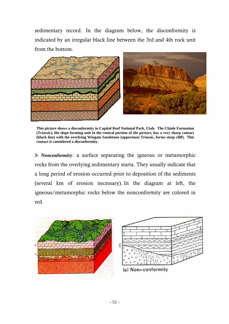
-51-
sedimentary record. In the diagram below, the disconformity is
indicated by an irregular black line between the 3rd and 4th rock unit
from the bottom.
This picture shows a disconformity in Capitol Reef National Park, Utah. The Chinle Formation
(Triassic), the slope forming unit in the central portion of the picture, has a very sharp contact
(black line) with the overlying Wingate Sandstone (uppermost Triassic, forms steep cliff). This
contact is considered a disconformity.
3- Nonconformity: a surface separating the igneous or metamorphic
rocks from the overlying sedimentary starta. They usually indicate that
a long period of erosion occurred prior to deposition of the sediments
(several km of erosion necessary). In the diagram at left, the
igneous/metamorphic rocks below the nonconformity are colored in
red.

-52-
A nonconformity in the Obigarm River gorge in Tajikistan. The red line
points out the irregular contact between Precambrian granitic rocks (black
color at the base) and the Quaternary sediments (grey color at the top).
4- Paraconformity: A paraconformity is a type of unconformity in
which strata are parallel; there is little apparent erosion and the
unconformity surface resembles a simple bedding plane. It is also
known as nondepositional unconformity or pseudoconformity
Barrell (1917) introduced the term diastem to refer to the slight
discontinuities in marine sediments that indicate minor interruptions
in deposition. It should be distinguish between major breaks in the
sedimentary record (unconformities) and minor interruptions of brief
duration (diastems). In order to make this distinction, diastems were
Granite
Quaternary
sediments

-53-
defined as breaks in the record involving a "bed or series of beds" but
not an entire formation. The implication that a formation has a
definite time value is no longer acceptable, but the differentiation
between major and minor discontinuities remains valid and useful.
ؽتبرث ؽ شعخ يخؾرر شتب اهذ يذل يجيؽخ ي اهعتلبح ، اهشفو يب يعج :ػدن الحوافق .أ يجؾدث اهؾوب أفلج
: أىواع ػدن الحوافق
ؽدى اهخافق اهزاAngular Unconformity : يذل شعخ فضل ت عتلبح يبئوج أخر .يبئوج هنيب يخخوفخ ف اهيل
الزاوىعدم التوافق
ؽدى اهخافق االلعبؽDisconformity : ن ؽو شنل شعخ يخؾرر ت عتلبح يخازج أ .يبئوج أ أفلج
عدم التوافق االنقطاعي

-54-
ال حوافقNonconformity : خن ذا اهػ ي ؽدى اهخافق ؽديب خى خرشة يجيؽج ي .اهعتلبح اهرشتج فق ضخر برج أ يخدهج
الال توافق
خن ذا اهػ ي ؽدى اهخافق ؽديب خى خرشة يجيؽخ ي Paraconformityشةه حوافق . اهعتلبح اهرشتج هيب فس اهيل ، فضويب شعخ خؾرج غر اظخ
شبه توافق
Recognition of Unconformities
There are many criteria available for the recognition of the
unconformable surfaces, both in outcrop and in the subsurface. These
criteria falls into three classes: sedimentary, paleontologic, and
structural. The following treatment lists several of each.

-55-
Sedimentary Criteria. More than twenty sedimentary criteria
have been proposed. The more important ones include the presence of
a basal conglomerate, residual (weathered) chert, buried soil profiles,
and zones of glauconite, phosphatized pebbles, or magniferous zones.
The first three criteria are generally accepted as evidences of
subaerial disconformities. The latter three, represent submarine
disconformities or diastems, indicative of solution or nondeposition.
Paleontologic Criteria. More than a half dozen paleontologic
criteria are known, among which three are the most significant.
Abrupt changes in faunal assemblages, gaps in evolutionary
development, and the occurrence of bone and tooth conglomerates
represent generally accepted criteria.
Perhaps the most decisive criterion of an unconformity is an
abrupt phylogenetic change from one fossil assemblages to another in
vertical succession of the rocks. If the beds below a stratigraphic
surface contain Lower Silurian fossils and the beds above contain
Pennsylvanian forms, a subaerial unconformity of major proportions
is established.
Less marked faunal changes indicate unconformities of lesser
magnitude. A gap in the orderly evolution of a single organism
through a vertical series of beds is indicative of a hiatus.
Structural Criteria. Four structural criteria are recognized.
Discordance of dip above and below a contact is a distinctive criterion
of an angular unconformity. An undulatory surface of contact which
cuts across bedding planes of the underlying formation marks a
disconformity caused by emergence and erosion.
Truncation of dikes at a surface of contact, with no evidence of
thermal alteration of the overlying beds, marks subaerial
unconformities caused by erosion. Similarly, relative complexity of
-56-
faults above and below a surface of contact may indicate an erosional
disconformity. If the lower formation is more complexly faulted, with
abrupt cessation of fault planes at the contact, an unconformity is
established.
2- Lateral Relationships Among Lithosomes
All sedimentary bodies, large and small, widespread and local,
have laterally bounding peripheries. In many instances, the lateral
boundary is the result of erosion and the edge of the lithosome no
longer represents its original depositional limits. Or, a particular
lithosome may be bounded by lateral passage into beds of a different
lithology. Such lateral termination of a lithosome may involve pinch-
out, intertonguing, or lateral gradation.
Pinch-out
The term pinch-out is applied to the termination of a lithosome,
a sandstone for example, that thins progressively to extinction. Pinch-
out may be accompanied by an increase in the thickness of an
adjacent body (a shale, for instance) which may lie above, below, or
both above and below; or, pinch-out may involve thinning or
convergence of the stratigraphic section. In a typical pinch-out, the
lithologic character of the lithosome is maintained right to the feather-
edge of the body. Commonly, the angle formed by the converging
upper and lower surfaces of the lithosome is very small – one degree
or less. However, in some bodies such as reefs and channels,
significant thicknesses may be reduced to nothing in a few hundred
feet.

-57-
Pinch-outs are among the most eagerly sought after
sedimentary relationships, since many stratigraphic-trap oil and gas
fields have been discovered along the pinch-out zones of porous and
permeable lithosomes.
Sandstone pinch out in shales in the Jurassic Morrison Fm. near
Green River.
Intertonguing
Some bodies of sediment disappear and are lost in laterally
adjacent masses owing to splitting into many thin units, each of which
reaches an independent pinch-out termination. The resulting
intertonuing zone has many vertically successive intercalations of thin
representatives of two lithosomes. The numbers of tongues increases
with the distance from the main mass of either sedimentary body,
reaching a maximum as tongues split again and falling as individual
tongues pinch out.

-58-
This view looking down Golden Canyon shows red and yellow interbedded strata of the
Furnace Creek Formation on an unnamed hill (between Golden Canyon and Gower Gulch).
The inter-tonguing beds perhaps reflect changing shoreline depositional environments
(between terrestrial and lake deposits) within an ancestral intermountain basin in the mid-to-
late Pliocene (about 3 million years ago) before the formation of modern Death Valley (Hunt
and Mabey, 1966).
White Sands National Monument, New Mexico. Latex peel of vertical cross section of dune,
showing intertonguing cross-wind deposits and fade-outs from avalanching. 1959.
Lateral Gradation
In lateral gradation, there is no necessary thinning of rock units.
Instead, lithosomes are commonly terminated by gradual replacement
of their lithologic characteristics by those of another type. Lateral
gradation may be mixed or continuous, similar in nature to the
vertical gradational relationships described earlier, except that the
lateral rate of change is normally very low, and distances of hundreds
of feet, or even miles, must be traversed in order to observe the same

-59-
magnitude of change exhibited within a few beds in vertical
succession.
Mixed lateral gradation of sandstone to shale is typical of the
“shale-out” of petroleum geologists and is responsible for oil and gas
trapping where the zone of gradation is relatively narrow. Similar
relationships are common between carbonate rocks and shale and
between carbonates and sandstone. Continuous gradation is
exemplified by many sand-to-shale patterns and is also common
among carbonates, as in the gradual change of a coarse biogenic
limestone to a micritic lithesome.
-60-
VII) Principles of Correlation
Stratigraphic correlation is the demonstration of equivalency of
stratigraphic rock units. Recognition of the distinctions that separate
rock-stratigraphic, biostratigraphic, and time-stratigraphic units makes
it apparent that “equivalency” may be expressed in lithologic,
paleontologic, or chronologic terms. Therefore, most stratigraphers
apply the noun “correlation” the verb “correlate” and the adjective
“correlative” to lithostratigraphic equivalency as well as to time-
stratigraphic equivalency. In each situation, it is necessary to identify
the nature of the equivalency, the kind of correlation involved (such
as lithologic correlation, biostratigraphic correlation, and so on).
Correlation is an essential element of most stratigraphic investigations
and typically occupies a major portion of a stratigrapher’s time.
Without correlation, the facies relationships, and others discussed in
the preceding chapter, would be meaningless and the rational
treatment of the analytical aspects of stratigraphy would be
impossible.
A) Correlation of Lithostratigraphic Units