preliminary rpt wallace mine locations - ontario · along the shore of lake huron on the wallace...
TRANSCRIPT

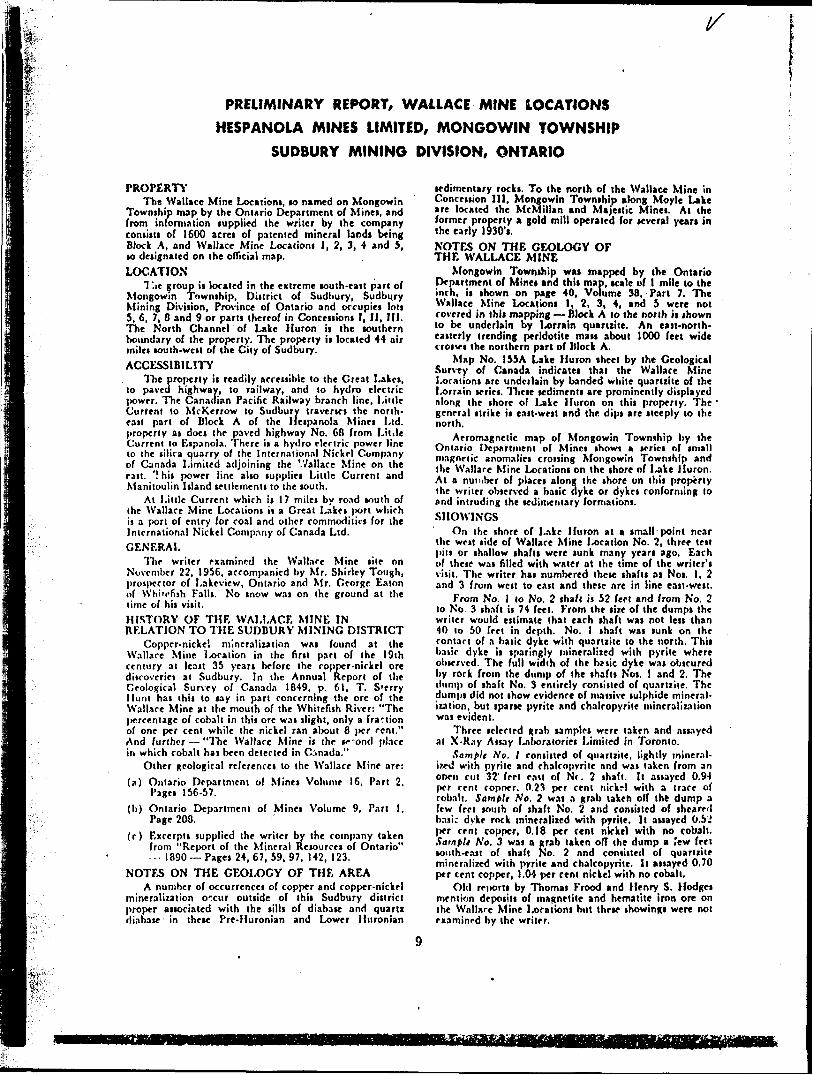
PRELIMINARY REPORT. WALLACE MINE LOCATIONS
HESPANOLA MINES LIMITED. MONGOWIN TOWNSHIP
SUDBURY MINING DIVISION. ONTARIO"
Property
The V/allace Mine Locations, so named on Mongowin Township map by the Ontario Department of Mines, and from information supplied the writer by the company consists of S.600 acres of patented mineral lands being Block A, and V/allace Mine Locations i, 2, 3, k and 5, so designated on the official map*
Location
The group is located in the extreme south-east part of Mongowin Township. District of Sudbury, Sudbury Mining Division, Province of Ontario and occupies lots 5* 6, 7, # and 9 or parts thereof in Concessions I, II, III. The North Channel of Lake Huron is the southern boundary of the property. The property is located 44 air miles south-west of the City of Sudbury*
Accessibility
The property is readily accessible to the Great Lakes, to paved highway, to railway, and to hydro electric power. The Canadian Pacific Railway branch line, Little Current to McKerrow to Sudbury traverses the north-east part of Block A of the Hespanola Mines Ltd* property as doas the paved highway No, 63 from Little Current to Espanola. There is a hydro blectric power line to the silica quarry of the International Nickel Company of Canada Limited adjoining the Wallace Mine on the east. This power line alto supplies Little Current and Manitoulin Island settlements to the south,
At Little Current which is 17 miles by road south of the Wallace Mine Locations is a Great Lakes port which is a port of entry for coal and other commodities for the International Nickel Company of Canada Ltd,
O Q
The writer examined the Wallace Mine site on November 22, 1956, accompanied by Mr. Shirley Tough, prospector of Lakeview, Ontario and Mr. George Eatoii of Whitefish Failr. No snow was on the ground at the time of his visit.
History of the Wallace... Mine in Relation to ̂ the Sudbury Mining District
Copper-nickel mineralization was found at the Wallace Mine Location in the first part of the 19th century at least 35 years before -he copper-nickel oro discoveries at Sudbury, In the Annual Report of the Geological Survey of Canada 1849* P, 61. T. Sterry Hunt has this to say in part concerning the ore of the Wallace Mine at the mouth of the Whitefish River: "The percentage of cobalt in this ore was slight, only a fraction of one per cent while the nickel ran about B per cent." And further - "The Wallace Mine is the second place in which cobalt has been detected in Canada. n

Other geological references to the Wallace Mine are:Ontario Department of Mines Volume 16, Part 2, Pages 156-57. Ontario Department of Mines Volume 9, Part l, Page 203. Excerpts supplied the writer by the company.taken from "Report of the Mineral Resources of Ontario" - 1890 - Pages 24. 6?, 59, 97, 142,123.
Notes on the Geology of the AreaA number of occurrences of copper and copper-nickel mineralization
occur outside of this Sudbury district proper associated with the sills of diabase and quartz diabase in these Pre-Huronian and Lower Huronian sedimentary rocks. To the north of the Wallace Mine in Concession III. Mongowin Township along Moyle Lake are located the McMillan and Majestic Mines. At the former property a gold mill operated for several years in the early 1930's.
Notes on the Geology of the Wallace MineMongowin Township was mapped by the Ontario Department of Mines
and this map, scale of l mile to the inch, is shown on page 40, Volume 38, Part 7. The Wallace Mine Locations l, 2, 3. 4, and 5 were not covered in this mapping - Block A to the north is shown to be under lain by Lorrain Quartzite. An east-north-easterly trending peridotite mass about 1000 feet wide crosses the northern part of Block A.
Map No. 155A Lake Huron sheet by the Geological Survey of Canada indicates that the Wallace Mine Locations are underlain by banded white quartzite of the Lorrain series. These sediments are prominently dis played along the shore of Lake Huron on this property. The general strike is east-west and the dips are steeply to the north.
Aeromagnetic map of Mongowin Township by the Ontario Department of Mines shows a series of small magnetic anomalies crossing Mongowin Township and the Wallace Mine Locations on the shore of Lake Huron. At a number of places along the shore on this property the writer observed a basic dyke or dykes conforming to and intruding the sedimentary formations.
ShowingsOn the shore of Lake Huron at a small point near the west side
of Wallace Mine Location No. 2, three test pits or shallow shafts were sunk many years ago. Each of these was filled with water at the time of the writer's visit. The writer has numbered these shafts as Nos. l, 2 and 3 from west to east and these are in lino east-west.
From No. l to No. 2 shaft is 52 feet and from No, 2 to No. 3 shaft is 74 feet. From the size of the dumps the writer would estimate that each shaft was not less than 40 to 50 feet in depth. No. l shaft was sunk on the contact of a basic dyke with quartzite to the north. This basic dyke is sparingly mineralized with pyrite where observed, The full width of the basic dyke was obscured by rock from the dump of the shafts Nos. l and 2. The dump of shaft
.' * ""f''
-No. 3 entirely consisted of quartzite. The dumps did not show evidence of massive sulphide mineralization, but sparse pyrite and chalcopyrite mineralization was evident.
- . ,
Three selected grab samples were taken nnd-assayed at X-Ray Assay Laboratories Limited in Toronto.
Sample No. l consisted of quartzite, lightly mineralized with pyrite and chalcopyrite and was taken from an open cut 32 feet east of No. 2 shaft. It assayed 0.94 per cent copper, 0.23 per cent nickel with a trace of cobalt. Sample No. 2 was a grab taken off the dump a few feet south of shaft No. 2 and consisted of sheared basic dyke rock mineralized with pyrite. It assayed 0.52 per cent copper, 0.18 per cent nickel with no cobalt. Sample No. 3 was a grab taken off the dump a few feet couth-eaBt of shaft No. 2 and consisted of quartzite mineralized with pyrite and chalcopyrite. It assayed 0.70 per cent copper, 1.04 per cent nickel with no cobalt.
Old reports by Thomas Frood and Henry S. Hodges mention deposits of magnetite and hematite iron ore on the Wallace Mine Locations but these showings were not examined by the writer.
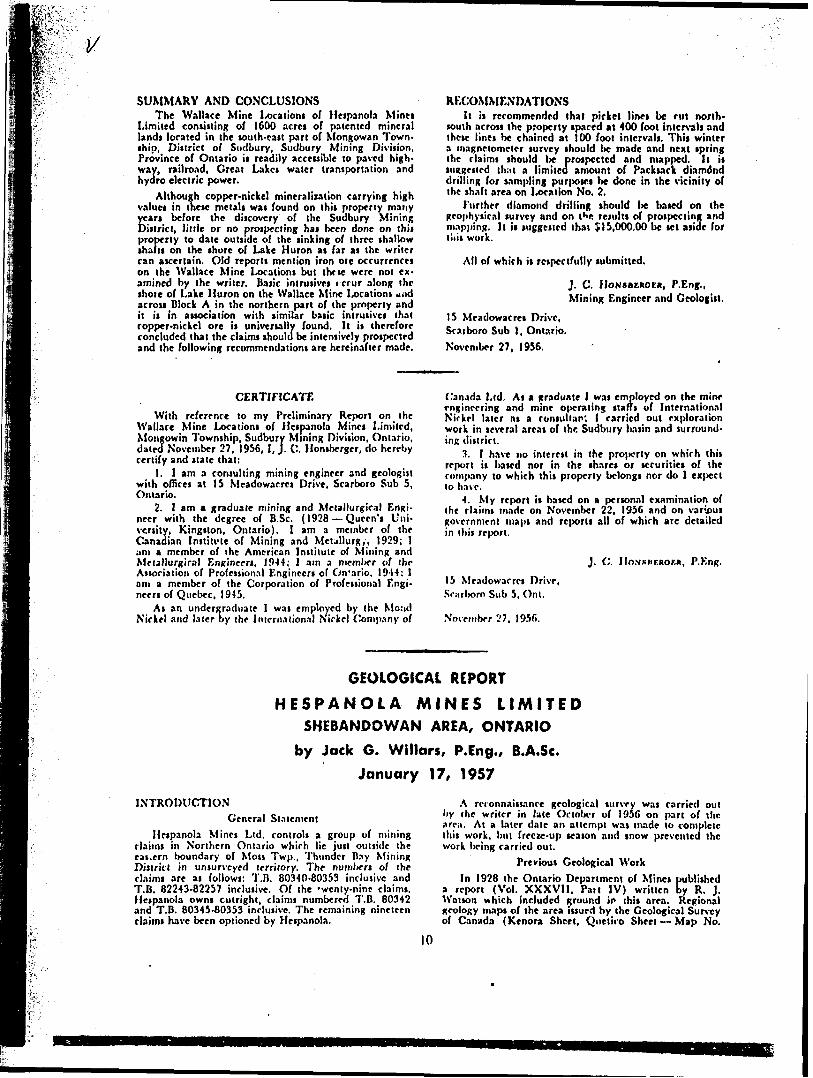
Summary and Conclusions
The Wallace Mine Locations of Hespanola Mines Limited consisting of 1600 acres of paterted mineral lands located in the south-east part of Mongowan Township, District of Sudbury, Sudbury Mining Division, Province of Ontario is readily accessible to paved highway, railroad, Great Lakes water transportation and hydro electric power.
Although copper-nickel mineralization carrying high values in these metals was found on the property many years before the discovery of the Sudbury Mining District, little or no prospecting has been done on this property to date outside of the sinking of three shallow shafts on the shore of Lake Huron as far as the writer can ascertain. Old reports mention iron ore occurrences on the Wallace Mine Locations but these were not examined by the writer. Basic intrusives occur along the shore of Lake Huron on the Wallace Mine Locations and across Block A in the northern part of the property and it is in association with similar basic intrusives that copper-nickel ore is universally found. It is therefore concluded that the claims should be intensively prospected and the following recommendations are hereinafter made.
Recommendations
It is recommended that picket lines be cut north-south across the property spaced at 400 foot intervals and these lines be chained at 100 foot intervals. This winter a magnetometer survey should be made and next spring the claims should be prospected and mapped. It is suggested that a limited amount of Packsack diamond drilling for sampling purposes be done in the vicinity of the shaft area on Location No. 2.
ji^,' .".t;i\
l*B "-ay.
Further diamond drilling should be based on the surrey and on the results of prospecting and mapping* suggested that ^15,000.00 be set aside for this work.
All of which is respectfully submitted,
geophysical[t is
J. C. Honsberger, P. Eng., Mining Engineer and Geologist
15 Meadowacros Drive, bcarboro Sub l, Ontario. November 27, 1956.
Certificate
With reference to my Preliminary Report on the Wallace Mine Locations of Hespanola Mines Limited, Mongowin Township, Sudbury Mining Division, Ontario, dated November 27, 1956, I, J. C. Honsberger, do hereby certify and state that:
1. I am a consulting mining engineer and geologist with offices at 15 Meadowacres Drive, Scarboro Sub 5, Ontario.
2. I am a graduate mining and Metallurgical Engineer with the degree of B.Se. (1923 - Queen's University, Kingston, Ontario.). I am a member of the Canadian Institute of Mining and Metallurgy, 1929; I am a member of the American Institute of Mining and Metallurgy, 1944; I am a member of the Association of Professional Engineers of Ontario, 1944; I am a member of the Corporation of Professional Engineers* of Quebec, 1945.
As an undergraduate I was employed by the Mond Nickel and later by the International Nickel Company of Canada Ltd. As a graduate I was employed on the mine engineering and mine operating staffs of International Nickel later as a consultant I carried out exploration work in several areas of the Sudbury basin and surrounding district,
3. I have no interest in the property on which this report is based nor in the shares or securities of the company to which this property belongs nor do I expect to have.
4. My report is based on a personal examination of the claims made on November 22, 1956 and on various government maps and reports all of which are detailed in this report.
l
J. C. Honsberger, P.Eng.
15 Meadowacres Drive, Scarboro Sub 5* Ont.
November 27, 1956.

^ RE: WALLACE MINE LOCATIONS •^••^^.
Volume 16 - Part 2 - Page 156
OTHER CANADIAN KICKEL-COBALT ORES
The following extract from the Report of the Geological Survey in Canada for 1890-91 summarizes a number of the known occurrences of nickel and cobalt in Canada at that time.
One of these discoveries is a steel-gray pyritous ore from the Wallace Mine on Lake Huron which was found by Dr. T. S, Hunt to contain 13.93# of nickel.
In the Report of the Geological Survey for 1849, page 61, T. Sterr* Hunt has this to say concerning the ore of the Wallace Mne at the mouth of the White Fish River, a partial examination only having been made of it:
"The specimen was a mixture of a steel gray arseniuret, the species of which I have not yet determined, with wide iron pyrites and probably some arsenical sulphuret of iron". The per- centage of cobalt in this ore was slight, only a fraction of 1# while the nickel ran about 8#.". He further says: "The Wallace Mine is the second place in which cobalt has been detected in Canada".
Speaking at this early date. Hunt made the remark, which after a lapse of a lifetime reads like a prophecy: "The detection of a small portion of cobalt in association with these metals upon the shore of Lake Huron, should lead us to look for deposits of this rare and valuable material",
REPORT OF THE. MINERAL RESOURCES OF ONTARIO 1890
Page 67;
The Wallace Mine is the saroo as the Sudbury Mines, It is a nickeliferous pyrites.
Page 142;
Thomas Frood; "Back from Lake Huron on the Wallace' Kine locationis a deposit of iron. . It is on the side of the
mountain. A shaft has been sunk there to the depth of about 20 feet. That shaft was cleaned out this Spring by a Cornish miner whom I employed for the purpose. The iron is on the rear of the property North-east from the old Wallace Mines. The property, as originally patented, consisted of 2200 acres and the Hughes Bros, of Toronto and myself now control 1600 acres of it. It is on this 1600 acres that all the work has been done. I cannot exactly say how the iron should be classified. It is of steel color, slightly magnetic; part of which is red and very soft. The vein is visible for about 200 yards; at the West end on the surface it is about 6 inches wide; at the Bast end where the pit has been sunk, the width of the vein is about B feet. The depth of the pit is about 20 feet and the vein seems to increase in width and the ore to improve in quality as we go down. There have been no assays made since w* have had possession of the property".
-
Henry S. Hedges: "One of 3 deposits of hematite iron which I dis-covered near the Wallace Mine location, I believe
will last for three generations if worked. It is an enormous mass of oret The hematite and magnetic beds discovered by me are quite close together on the same property. It crops out all over some 10 or 15 acres. It is on high land near the water and is handy for shipping. I had to sell part of this property so as to be able to retain part.
Page 59:
Thomas Frood: "The sand in the front of the Wallace Mine propertycarries small but distinct appreciable quantities of
gold. In 5 or 6 places where Williams, the Cornish miner, dug into tha hill, small particles of free gold were found. As yet, no large quantity has been discovered. We h*ve not come upon any veins carrying free gold, but we have met with galena mixed with iron in several places.
In some cases these bands are parallel to the mountain; sometimes they are angling across; and this diorite always shows some metal, generally pyrites. I have been told that in places where the diorite is cut by quartz, free silver and copper have been found. Lumbermen have brought specimens from the North slope of the Lacloche Mountains of good galena. In the bands we generally find iron pyrites, copper pyrites, arsenical pyrites, small quantities of specular iron and galena but no precious metals".
Page 24:
The discovery of nickel^ferous copper pyrites around Sudbury recall the fact that similar ore had been found nearly 40 years before at the Wallace Mine on the shore of Lake Huron near the mouth of the White Fish River. Deposits at the two localities appear to lie in the same geological horizon and in following the general strike of the rocks North-eastward from the Wallace Mine, ores of copper have been found near the West end of Lake Panache,
Page 1231
In the North-west corner of the Wallace Minelocation on the north shore of Lake Huron a vein or bed of iron ore occurs in quartzite. It consists of about 8 feet of banded ore and quartzite. The ore varies from crystalline to compact specular. The bed may be traced some 200 or 300 yards Westward and is but 2 feet across where last visible. Towards the East a mass of debris and a steep declivity prevent its being followed without exploration work. Where the ore is solid it is of an excellent quality. In going out of this location from the lake shore diorites, quartzites, chloritic and talcose schists and a light grade quartzose felsite are crossed.
r -
ll
WALLACE MIME LOCATIONS
SKETCH PLANWALLACE MINE LOCATION Z ,

QwG
HESPANOLA MINES LIMITED
PROSPECTUSFOR FILING AND AS FILED WITH THE ONTARIO SECURITIES COMMISSION
PURSUANT TO THE SECURITIES ACT (ONTARIO)
1.
2.
HESPANOLA MINES LIMITED (hereinafter called "the Company") was incorporated under the provision* of The Corporations Act 1953 (Ontario), by Letters Patent dated October 18th, 1956. The Head Office of the Company is located at Room 206, 88 Richmond Street West, Toronto, Ontario.
(a) OFFICERS AND DIRECTORS:
NAMES IN FULL AND OCCUPATION:
Prttident and a Director . ..,................ FRANCIS FORD HENRY,Office Manager.
Vict-Prttidenl and a Dirtclor ............ ROBERT GLEASON SMITH,Retired Executive.
Secretary-TTrasurrr and a Dirtelor..,. ALFRED ROGERS SELBY,Secretary-Treasurer.
Dirfctor . ............................................... RUSSELL Ross SPLAN,Insurance Agent
Dirtclor . ............................................... RUSSELL KENNEDY Mr.Avov,Solicitor.
ADDRESSES IN FULL:
154 Roselawn Avenue, Toronto, Ontario.3000 Yonge Street, Apt. 711, Toronto, Ontario.50 Dromorc Crcsc., Willowdale, Ontario.577 Bedford Park Avc., Toronto, Ontario.Ow r lund, Ontario.
(b) PROMOTER:TOLANA TRADING LIMITED (hereinafter called "Tolana"). a private Company, with Head
Office at 90 Richmond Street West, Toronto, Ontario, caused the incorporation of the Company, and was the vendor of the mining claims described in Paragraph 10 hereof, and therefore might bc considered the promoter of the Company.
3. FISHER, GORDON AND COMPANY, Chartered Accountants, 100 Adelaide Street West, Toronto, Ontario, are the Auditors for the Company.
4. GUARANTY TRUST COMPANY OF CANADA, 70 Richmond Street West. Toronto, Ontario, is the Transfer Agent and Registrar of the Company.
5. The authorized capital of the Company is $6,000,000.00, divided into 6,000,000 shares of the par value of 51.00 each, all of one class, namely common. As of the datr of this Prospectus, 900,005 shares, all as fully paid and non-assessable, have been allotted and issued.
6. There are no bonds or debentures authorizi-d or outstanding nor is it presently proposed to issue any such securities.
7. Of a total of 900,000 shares issued for properties as outlined in Paragraph 10 hereof (hereinafter called "vendor shares"), certificates representing 8)0,000 shares of the capital stock of the Company, being part of the vendor shares, are presently held in escrow with Guaranty Trust Company of Canada, 70 Richmond Street West, Tordnto, Ontario, subject to pro rata release amongst the persons entitled thereto only upon the prior written consent of the Directors of the Company and the Ontario Securities Commission. Any dealings with the said vendor shares within the escrow including assignment, hypothecation or alienation require the written consent of The Ontario Securities Commission. The 90,000 vendor shares not so placed in escrow and such of the presently escrowed 810,000 vendor shares as may be released from time to time from escrow, may be offered and sold at the current offering price for shnres of the Company, but the proceeds of such sales will not go into the Treasury of the Company.

8. As of the date of this Prospectus, the only shares of the capital stock of the Company sold for cash are the five shares issued to the original incorporators and now held by the Directors, for which shares the Company received a total of $5.00 on the basis of a subscription of 51.00 per share. No commissions were paid in respect of the sale of any of these shares.
9. No securities, other than the shares mentioned above, have been created or issued by the Company.
10. (a) By a contract in writinp dated November 5th, 1956, and made between the Company and Tolana, the Company acquired from Tolana full right, title and interest in and to 10 unpatcntrd mining claims located in the Thunder Bay Mining Division of the Province of Ontario, and being more particularly described as Claims No. T.H. 80342 and T.B. 80345 to T.D. 80353 inclusive. The claims have been recorded in the name of the Company under its Ontario Miner's Licence. These claims arc in good standing until June 4th, 1957, before which date there must be performed and recorded one year's assessment work under the provisions of the Mining Act (Ontario), otherwise the claims will fall open.
The consideration paid by the Company was the allotment and issuance lo Tolana of 708,000 fully paid shares of the capital stock of the Company, being part of the vendor shares referred to in Paragraph 7 hereof. Of the said shares, 10^, or 70,800 shares were issued to Tolana or according to its directions, free from escrow, and 90^?, or 637,200 shares were issued to Tolana or according to its directions, in escrow on the terms and conditions set out in Paragraph 7,
(b) By an Agreement in writing dated November 5th, 1956, and made between the Company and Tolana, the Company acquired the exclusive right to purchase from Walter Sharpe, 67 Kingsdale Avenue, Willowdalc, Ontario, 19 unpatcnted mining claims in the Thunder Bay Mining Division of the Province of Ontario, being Claims No*. T.B. 80340, T.B. 80341, T.B. 80343, T.B. 80344, and T.B. 82243 to T.B. 82257 inclusive, The consideration to Tolana for thr said Option was the assumption by the Company of Tolana's obligations under the original Option Agreement lx*twcen Walter Sharpe and Tolana and the Company's undertaking to save Tolana harmless from any loss, cause or damages arising out of the said Option.
The original Option Agreement between Walter Sharjx,- and Tolana was made the 16th day of October, 1956. By the said Agreement, Tolana purchased from Walter Sharpe, the 10 claims referred to in Paragraph 10 (a) hereof and obligated itself to incor|xiratc a new mining company within thirty days, to cause the new mining company to acquire the said 10 claims from Tolana for such consideration as Tolana should deem advisable, and out of such consideration to cause 100,000 shares of the capital stock of t lie new mining company lo lx- issued to Walter Sharjx? or acrordini; to his direction.
]n consideration of the cash payment and the obligations set out above, \Valter Sharpe granted Tolana the exclusive option to purchase the remaining 19 claims, set out above, for i11,400.00. The Option could bc exercised by paying \Valter Sharp- the sum of -53.000.00 on or be-fore the expiration of 90 days from October 16th, 1956. Upon the payment Ix-ing made the Option became a firm commitment to purchase the remaining claims for the sum of 58,400.00. Tolana was entitled to call for transfers of any five claims, en bloc, upon payment of the 53,000.00, and thereafter to call for transfers of as many Ciaiins as are paid for at the rate of 5600.00 per claim, until the 14 remaining claims have all been paid for, and the, total purchase- price of $8)400.00 thereby paid. All the claims must be paid for within 18 months of the dair the Option was exercised. Tolana also agreed lo keep all the claims in good standing during the time- the Option is in good standing.
In fact, the Company has paid the said $3,000.00 to Walter Sharpe. Tolana loaned the 53,000.00 necessary to exercise the Option, ...id the Company is indebted to Tolana for that amount. By virtue of the payment, the Company must now pay an additional 58,400.00 under the Agreement, and will receive transfers of all the said claims. The: Company is the Mining Company referred to in the v -.'-\ Agreement of October 16th; and 100,000 shares of its stock have been allotted and issued,, irsuant to the said Agreement.
(c) By a contract in writing dated November 5th, 1956, and made tatwrcn the Company and Tolana, the Company acquired from Tolana the mineral rights in, to and under five parcels of land in the Sudbury Mining Division of the Province of Ontario, which arc known as Block A and Wallace Mine Locations l, 2, 3, 4 and 5 according to the Mongowin Township map and are more particularly described as follows:

.m.FIRSTLY:
ALL AND SINGULAR that certain parcel or tract of land and premises situate, lying and being in the Township of Mongowin in the District of Sudbury, and Province of Ontario and being composed of Lot Number One (1), Section C, together with Islands lettered "A", and "B" lying in front thereof, all according to Alexander Vidal's plan of survey of Mining Locations on the North Shore of Lake Huron near the Whitefish River on record in the Registry Office for the District of Sudbury at the City of Sudbury, SAVING AND EXCEPTING thereout and therefrom that parcel of land heretofore conveyed by Instrument dated 26th of May, 1941, and which cxceptcd parcel is more particularly described as follows:
PREMISING that all bearings herein mentioned arc derived from astronomical north of the west boundary of the surrendered portion of the Whitefish Indian Reserve as shown by plan of T. J. Patten, OLS. dated 14th March, 1921, and registered in the Registry Office for the District of Sudbury on the 11th day of February, 1926;
COMMENCING at a point in the common boundary of the Township of Mongowin and surrendered portion of the Whitefish River Indian Reserve in Township Eleven, said point being the northwest corner of Lot Three (3) formerly T.P. 23 in the said surrendered portion of the said Whitefish River Indian Reserve as shown on said plan by T. J. Patten, O.L.S.
THENCE southerly along the said common boundary of the Township of Mongowin and the surrendered portion of the Whitefish River Indian Reserve a distance of 1450 feet;
THENCE WEST astronomically a distance of 1320 fret; THENCE NORTH astronomically a distance of 2350 feet;THENCE EAST astronomically a distance of 1320 feet more or less to a point on the said
common boundary between the Township of Mongowin and the surrendered portion of Whitefish River Indian Reserve in Township Eleven (11);
THENCE SOUTHERLY along the said last mentioned boundary a distance of 900 feet to the point of commencement, containing by admeasurement 71.2 acres, more or less;SECONDLY:
THAT parrel or tract of land and premises situate, lying and being in the District of Algoma in the Province of Ontario, containing 1600 acres more or less, being composed of Ix)ts Numbers 2, 3, 4, and Block A all in Section C according to Alexander Vidal's plan of survey of mining location* on the north shore of Lake Huron near the Whitefish River, together with Islands Ix-ttercd "C", "D", "E", "F", "G" and that portion of Island "H", lying along the front of the said lots;
TOGETHER WITH all the csta'o. right, title and interest of the grantor in and to all minerals, mineral oils and gas found in tn. Mid lands.THIRDLY:
THAT parrel or tract of land and premises situate, lying and 'x mg in the District of Algoma in the Province of Ontario, containing 400 acre*, more or less, and being composed of Lot Number Five (5), in Section "C", together with Island lettered "H" and all other islands lying along the front thereof, according to Plan of survey of Alexander Vidal of the mining locations on the north shore of Lake Huron near the Whitefish River, together with all the estate, right, title and interest of the grantor in and to all minerals mineral oils and gases found in the said lands.
SAVING AND EXCEPTING thereout and therefrom a certain parcel of land heretofore conveyed by instrument dated 27th November, 191fi, and which parrel is more particularly described as follows:
COMMENCING at a point on the waters edge of the southwesterly angle of said lot;THENCE NORTHERLY along the westerly limit of said lot a distance of 50 chains to a
point;THENCE EASTERLY in a straight line at right angles to the said Westerly limit a distance
of 10/3 chains to a point;THENCE SOUTHERLY in a straig.it line parallel to the said westerly limit of said lot a
distance of 50 chains more or less to the waters edge;THENCE WESTERLY along the waters edge to the place of beginning.
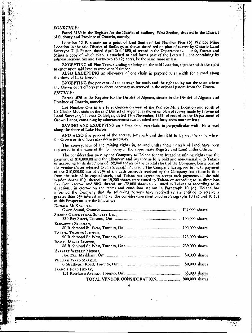
FOURTHLY:Parcel 5169 in the Register for the District of Sudbury, West Section, situated in the District
of Sudbury and Province of Ontario, namely;Location 12 P. situate on a point of land South of Lot Number Five (5) Wallace Mine
Location in the said District of Sudbury, as shown tinted red on plan of survey by Ontario Land Surveyor T. J. Patton, dated April 3rd, 1890, of record in the Department ^. tnds, Forests and Mines a copy of which plan is attached to and forms part of the Letters l *ient containing by admeasurement Six and Forty-two (6.42) acres, bc the same more or less.
EXCEPTING all Pine Trees standing or being on the said Location, together with the right to enter upon said land to remove said timber.
ALSO EXCEPTING an allowance of one chain in perpendicular width for a road along the short of Lake Huron.
EXCEPTING five per cent of the acreage for roads and the right to lay out the same where the Crown or its officers may deem necessary as reserved in the original patent from the Crown.FIFTHLY:
Parcel 1676 in the Register for the District of Algoma, situate in the District of Algoma and Province of Ontario, namely:
Lot Number One-in the First Concession west of the Wallace Mine Location and south of La Cloche Mountain in the said District of Algoma, as shown on plan of survey made by Provincial Land Surveyor, Thomas O. Bolger, dated 17th November, 1884, of record in the Department of Crown Lands, containing by admeasurement two hundred and forty acres more or less;
SAVING AND EXCEPTING an allowance of one chain in perpendicular width for a road along the shore of Lake Huron;
AND ALSO five percent of the acreage for roads and the right to lay out the same where the Crown or its officers may deem necessary.
The conveyances of the mining rights in, to and under these p.irccls of land have bcrn registered in the name of trf Company in the appropriate Registry and Land Titles Offices.
The consideration pu f tiy the Company to Tolana for the foregoing mining rights was the payment of S10,000.00 and the allotment and issuance as fully paid and non-assessable, to Tolana or according to its directions of 192,000 shares of the capital stock of the Company, being part of the vendor shares referred to in Paragraph 7 hereof. The Company has agreed to make payment of the 310,000.00 out of 25^t of the cash proceeds received by the Company from time to time from the sale of its capital stork, and Tolana has agreed to accept such payments of the said vendor shares lO^f thereof, or 19,200 shares were issued to Tolana or according lo its directions free from escrow, and 90^fc thereof, or 172,800 shares were issued to Tolana or according to its directions, in escrow on the terms and conditions set out in Paragraph 10 (d). Tolana has informed the Company that the following persons have received or arc entitled to receive a greater than 5^4) interest in the vendor consideration mentioned in Paragraphs 10 (a) and 10 (c) of this Prospectus, are the following: DONALD McKrRROLL,
Owen Sound, Ontario ................................................................................ 192,000 sharesSHARPE GEOPHYSICAL SURVEYS LTD.,
330 Bay Street, Toronto, Ont. ...........................................................,...... 100,000 sharesELIZABETH FREEMAN,
80 Richmond St. West, Toronto, Ont....................................................... 100,000 sharesTOLANA TRADING LIMITED,
SO Richmond St. West, Toronto, Ont...................................................... 123,000 sharesROMAJI MINUS LIMITED,
88 Richmond St. West, Toronto, Ont....................................................... 250.000 sharesHERBERT WKSLEY MORRIS,
Itox 395, Markham, Ont. ...................................................................,...... 50,000 sharesWILLIAM WARP MARKLK,
6 Strathearn Road, Toronto, Ont. ............................................................ 50,000 sharesFRANCIS FORD HENRY,
154 Roselawn Avenue, Toronto, Ont. .......................,.............................. 35,000 shares
I *-. if- TOTAL VENDOR CONSIDERATION....................... 900,000 shares
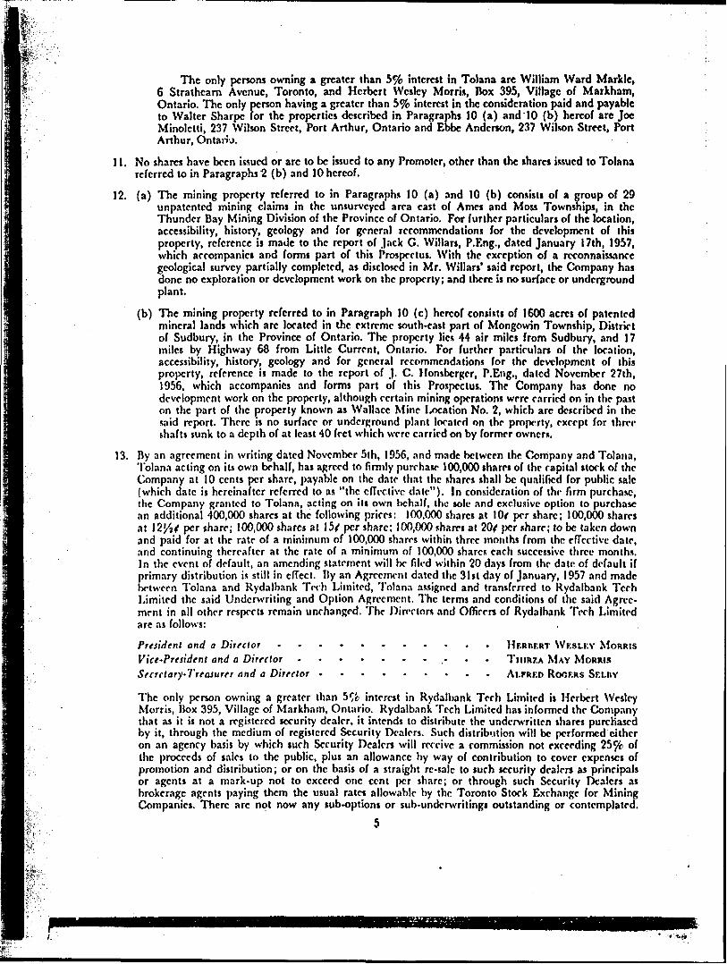
ft- The only persons owning a greater than y/o interest in Tolana arc William Ward Markle, 6 Strathearn Avenue, Toronto, and Herbert Wesley Morris, Box 395, Village of Markham, Ontario, The only person having a greater than 5 ^/c interest in the consideration paid and payable to Walter Sharpe for the properties described in Paragraphs 10 (a) and '10 (b) hereof are Joe Minolctti, 237 Wilson Street, Port Arthur, Ontario and Ebbc Anderson, 237 Wilson Street, Port Arthur, Ontario.
11. No shares have been issued or arc to bc issued to any Promoter, other than the shares issued to Tolana referred to in Paragraphs 2 (b) and 10 hereof.
12. (a) The mining property referred to in Paragraphs 10 (a) and 10 (b) consists of a group of 29 unpatcntcd mining claims in the unsurveyed area east of Ames and Moss Townships, in the Thunder Bay Mining Division of the Province of Ontario. For further particulars of the location, accessibility, history, geology and for genera) recommendation* for the development of this property, reference is made to the report of Jack C. Willars, P.Eng., dated January 17th, 1957, which accompanies and forms part of this Prospectus. With the exception of a reconnaissance geological survey partially completed, as disclosed in Mr. Willars' said report, the Company has done no exploration or development work on the property; and there is no surface or underground plant.
(b) The mining property referred to in Paragraph 10 (c) hereof consists of 1600 acres of patented mineral lands which arc located in the extreme south-east part of Mongowin Township, District of Sudbury, in the Province of Ontario. The property lies 44 air miles from Sudbury, and 17 miles by Highway 68 from Little Current, Ontario. For further particulars of the location, accessibility, history, geology and for general recommendations for the development of this property, reference ii made to the report of J. C. Honsbcrgcr, P.Eng., dated November 27th, 1956, which accompanies and forms part of this Prospectus. The Company has done no development work on the property, although certain mining operations were carried on in the past on the part of the property known as Wallace Mine 1/xation No. 2, which arc described in the said report. There is no surface or underground plant located on the property, except for three shafts sunk to a depth of at least 40 feet which were carried on by former owner*.
13. By an agreement in writing dated November 5th, 1956, and made between the Company and Tolana, Tolana acting on its own behalf, has agreed to firmly purchase 100,000 shares of the capital stock of the Company at 10 cents per share, payable on the date that the shares shall bc qualified for public sale (which date is hereinafter referred to as "the effective, date"). In consideration of the firm purchase, the. Company granted to Tolana, acting on its own behalf, the sole and exclusive option to purchase an additional 400,000 shares at the following prices: 100,000 shares at lOf per share; 100,000 shares at 12/j/ per share; 100,000 shares at I5f per share; 100,000 shares at 20f per share; to bc taken down and paid for at the rate of a minimum of 100,000 shares within three months from the effective date, and continuing thereafter at the rate of a minimum of 100,000 shares each successive three months. In the event of default, an amending statement will be filed within 20 days from the date of default if primary distribution is still in effect. By an Agreement dated the 31st day of January, 1957 and made between Tolana and Rydalbank Tech Limited, Tolana assigned and transferred to Rydalbank Tech Limited the said Underwriting and Option Agreement. The terms and conditions of the said Agree ment in all other respects remain unchanged. The Directors and Officers of Rydalbank Tech Limited arc as follows:
President and a Director . .......... Ifr.RnF.RT WF.SLKV MORRISVict'Pretident and a Director ~ T IIIRZA MAY MORRISSecretary-Treasurer and a Director - ALFRED ROOF.RS Sr.Lnv
The only person owning a greater than 5^fc interest in Rydalbank Tech Limited is Herbert Wesley Morris, IJox 395, Village of Markham, Ontario. Kydalbnnk Tech Limited has informed the Company that as it is not a registered security dealer, it intends to distribute the underwritten shares purchased by it, through the medium of registered Security Dealers. Such distribution will bc performed cjthcr on an agency basis by which such Security Dealers will receive a commission not exceeding 25^ of the proceeds of sales to the public, plus an allowance by way of contribution to cover expenses of promotion and distribution; or on the basis of a straight rc-salc to such security dealers as principals or agents at a mark-up not to exceed one cent per share; or through such Security Dealers as brokerage agents paying them the usual rates allowable by the Toronto Stock Exchange for Mining Companies. There arc not now any sub-options or sub-underwritings outstanding or contemplated.
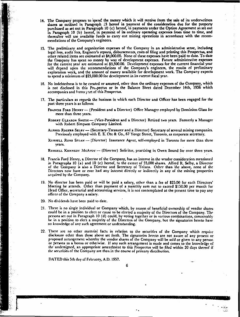
14. The Company proposes 'to 'spend the money which it will receive from the tale of its underwritten shares as outlined in Paragraph 13 hereof in payment of the consideration due for the property purchased as set out in Paragraph 10 (c) hereof, in payments under the Option Agreement as set out in Paragraph 10 (b) hereof, in payment of its ordinary operating expense* from time to time, and thereafter will use available funds to carry out mining operations in accordance with the recom mendations of the Company's engineers.
15. The preliminary and organization expenses of the Company in an administrative sense, including legal fees, audit fees, Engineer's reports, disbursements, costs of filing and printing this Prospectus, and other related items arc estimated at 94,000.00. None of these expenses have been paid to date. To date the Company has spent no money by way of development expenses. Future administrative expenses for the current year arc estimated at ?3,500.00. Development expenses for the current financial year will depend upon the recommendations of the Company's engineers, the results of preliminary exploration work, and the amount of money available for development work. The Company expects to spend a minimum of 525,000.00 for development in its current fiscal year.
16. No indebtedness is to bc created or assumed, other than the ordinary expenses of the Company, which ii not disclosed in this Prospectus or in the Balance Sheet dated December 14th, 1956 which accompanies and forms j.'i rt of this Prospectus.
17. The particulars as regards the business in which each Director and Officer has been engaged for the past three years is as follows:
FRANCIS FORD HENRY {President and a Director) Office Manager employed by Dominion Glass for more than three years.
ROBERT GLEASON Sunn (Vice-President and a Director) Retired two years. Formerly a Manager with Robert Simpson Company Limited.
ALFRED ROGERS SELBY (Secretary-Treasurer and a Director) Secretary of several mining companies. Previously employed with E. E. Ott A Co., 67 Yonge Street, Toronto, as corporate secretary.
RUSSELL Ross SPI.AN (Director) Insurance Agrnt, sclf-rmployed in Toronto for more than three years.
RUSSELL KENNEDY McAvov (Director) Solicitor, practising in Owen Sound for over three years.
18. Francis Ford Henry, a Director of the Company, has an interest in the vendor consideration mentioned in Paragraphs 10 (a) and 10 (c) hereof, to the extent of 35,000 shares. Alfred K. Selby, a Director of the Company is alio a Director and Secretary of Tolana. Other than the above, none of the Directors now have or ever had any interest directly or indirectly in any of the mining properties acquired by the Company.
19. No director has been paid or will be paid a salary, other than a fee of 125.00 for each Directors' Meeting he attends. Other than payment of a monthly sum not to exceed S150.00 per month for Head Office, secretarial and accounting services, it is not contemplated at the present time to pay any officer of the Company a salary.
20. No dividends have beer paid to date.
21. There is no single individual or Company which, by reason of beneficial ownership of vendor shares could be in a position to elect or cause to bc elected a majority of the Directors of the Company. The persons set out in Paragraph 10 (d) could, by %'oting together or in various combinations, conceivably be in a position to elect a majority of the Directors of the Company, but the signatories hereto have no knowledge of any such agreement or understanding.
22. There arc no other material facts in relation to the securities of the Company which requite disclosure other than those above set forth. The signatories hereto arc not aware of any present or proposed arrangement whereby the vendor shares of the Company will be sold or given to any person or persons as a bonus or otherwise. If any such arrangement is made and comes to the knowledge of the undersigned, an appropriate amendment to this Prospectus will bc filed within 20 days thereof if the securities of the Company are then in the course of primary distribution.
DATED this 5th day of February, A.D. 1957.
s*.-.-.
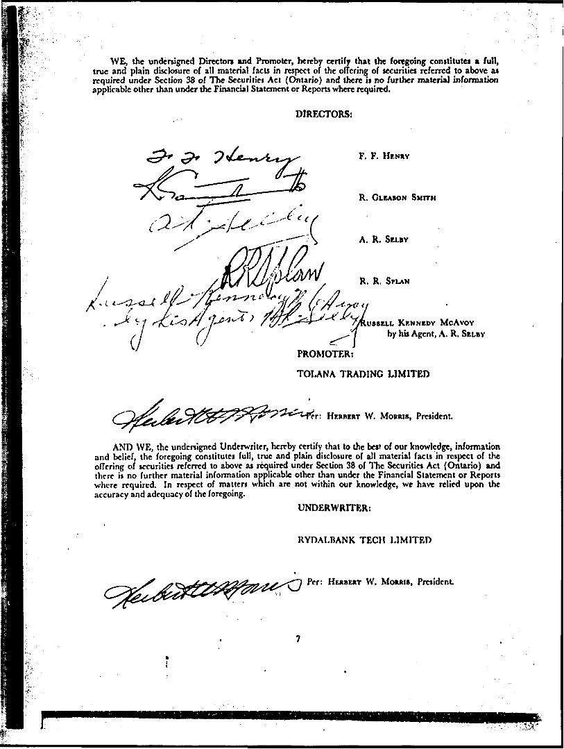
WE, the undersigned Directors mnd Promoter, hereby certify that the foregoing constitutes a full, true and plain disclosure of all material facts in respect of the offering of securities referred to above as required under Section 38 of The Securities Act (Ontario) and there is no further material information applicable other than under the Financial Statement or Reports where required.
DIRECTORS:
F. F. HENRY
R. GLEASON SMITH
A. R. SELBY
R. R. SPLAN
KENNEDY McAvov by his Agent, A. R. SELBY
PROMOTER;
TOI.ANA TRADING LIMITED
HERBERT W. MORRIS, President.
AND WE, the undcnigncd Underwriter, hereby certify that to the bctf of our knowledge, information and belief, the foregoing constitutes full, true and plain disclosure of all material facts in respect of the offering of securities referred to above as required under Section 38 of The Securities Act (Ontario) and there is no further material information applicable other than under the Financial Statement or Reports where required. In respect of matters which are not within our knowledge, we have relied upon the accuracy and adequacy of the foregoing.
UNDERWRITER:
UYDALBANK TECH LIMITED
Per: HERBERT W. MORRIS, President
HESPANOLA MINES LIMITED
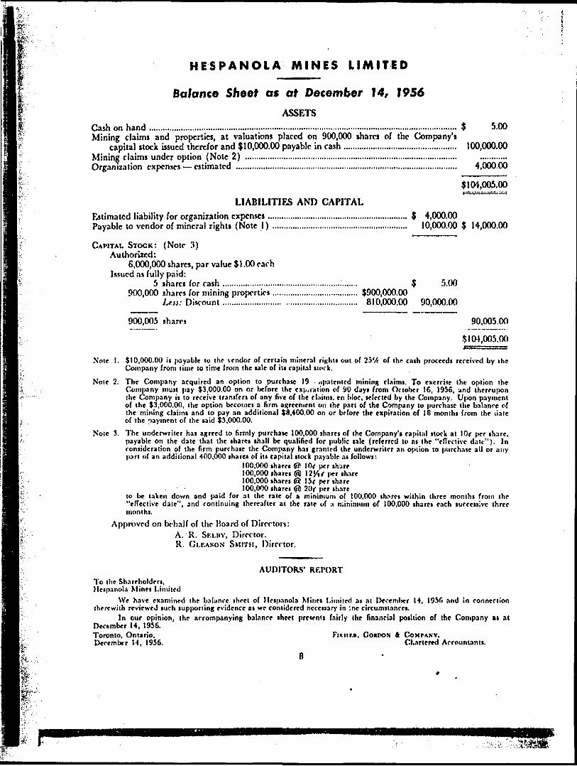
Balance Sheet as at December 1 4, 1956ASSETS
Cash on hand .........,..........,...................................................................................................................Mining claims and properties, at valuations placed on 900,000 shares of the Company's
capital itock issued therefor and 510,000.00 payable in cash ...........................................,......Mining claims under option (Note 2) ..............................................................................................Organization expenses estimated ..................................................................................................
5 5.00
100,000.00
4^000.66
5104,005.00
LIABILITIES AND CAPITALEstimated liability for organization expenses................,............................................. 5 4,000.00Payable to vendor of mineral rights (Note 1) ............................................................ 10,000.00 5 14,000.00
CAPITAL STOCK: (Note 3) Authorized:
6,000,000 shares, par value 51.00 each Issued as fully paid:
5 share* for cash ............................................................ 5 -r'.(X)900,000 shares for mining properties...................................... 5900,000.00
Less: D iscount .......................... ............................... 810,000.00 90,000.00
900,005 shares 90,005.00
5104,005.00i " sss
Note I. (10,000.00 it payable to the vendor of certain mineral righti out bf IV/r of the cnih proceeds received by the Company from lime lo time from the tale of itt capital itork.
Note 2. The Company acquired an option to purchate 19 ^patented mining claimi. To exercise the option the Company muit pay (3,000.00 on or before the exp,ration of 90 dayi from October 16, 1956, and thereupon ihe Company i) to receive tranifert of any five of the claimt. en bloc, telecled by Ihe Company. U|X3n payment of the (3,000.00, the option become) a firm agreement on the part of the Company lo purchase the balance of the mining claimi and to pay an additional (8,400.00 on or before the expiration of IB monlhi from the ilalc of the payment of the taid (3,000.00.
Note 3. 1'he underwriter ha) agreed to firmly purchate 100,000 tharei of the Company1 ! capital ttock at l Or per ihare, payable on the date that the iharet ihall bc qualified for public tale (referred lo ni the "effective date"). In contideration of the firm purchate the Company hat granted the underwriter an option to purchase all or any part of an additional 400,000 share* of ill capital Hock payable At followi:
100,000 iharei (ffi !0f per ihare100,000 tharei @ 12'/tf per thare100.000 iharet Gi 1 5f per thare100,000 iharei (fi) 20( per ihare
lo be taken down and paid for at the rate of a minimum of 100,000 th.irei within three monthi from ihe "effective date", and continuing thereafter at the rate of a minimum of 100,000 tharet each tuccetsive three month).
Approved on behalf of the Hoard of Directors: A. R. SELBY, Director. R. GLF.ASON SMITH, Director.
AUDITORS' REPORTTo the Shareholderi, Hetpanola Minet Limited
We have examined the balance theel of Hetpanola Minci Limited at at December 14, 1950 and in connection therewith reviewed tuch lupponing evidence at we contidered ncceisary in '.ne circumstance!.
In our opinion, the accompanying balance iheet prcwnii fairly the financial position of the Company at at December 14, 1956.Toronto, Ontario. Fisur.a, COUPON A COMPANY. December 14, 1956. CK.irlcred Accounianli.
tuff.
IL
l/
PRELIMINARY REPORT, WALLACE MINE LOCATIONS
HESPANOLA MINES LIMITED, MONGOWIN TOWNSHIP
SUDBURY MINING DIVISION, ONTARIO
PROPERTYThe Wallace Mine Location!, to named on Mongowin
Township map by the Ontario Department of Minei, and from information lupplitd the writer by the company consiiti of 1600 acrci of patented mineral lands being Block A, and Wallace Mine Locations l, 2, 3, 4 and 5, o designated on the official map.LOCATION
7 lie f roup is located in the extreme touth-east part of Mongowin Township, District of Sudbury, Sudbury Mining Division, Province of Ontario and occupies lots S, 6, 7, 8 and 9 or parti thereof in Concessions l, II, III. The North Channel of Lake Huron is the southern boundary of the property. The property is located 44 air miles south-west of the City of Sudbury.ACCESSIBILITY
The property is readily accessible to the Great I.akcs, to paved highway, to railway, and to hydro elrctric power. The Canadian Pacific Railway branch line, Lillie Current to McKerrow to Sudbury traverses the north east part of Block A of the 11 espanola Mines Lid. property as does the paved highway No. G8 from Lillie Current lo Eipanola. There is a hydro electric power line lo the silica quarry of the International Nickel Company of Canada Limited adjoining the '.Vallace Mine on the rait. 7 hii power line also supplies Little Current and Manitoulin Island settlements to the south.
At Little Current which is 17 miles by ro.id south of the Wallace Mine Locations is a Great Lakes port which is a port of entry for coal and other commodities for the International Nickel Company of Canada Ltd.GENERAL
The writer examined the Wallace Mine sile on November 22, 1956, accompanied by Mr. Shirley Tough, prospector of I,akeview, Ontario and Mr. George Eaton of Whin-fish Falls. No snow was on the ground at the time of his visit.HISTORY OF THE WALLACE MINE IN RELATION TO THE SUDBURY MINING DISTRICT
Copper-nickel mineralization was found at the Wallace Mine i-oral ion in the first part of the 19th century ai least 35 years before the copper-nickel ore discoveries at Sudbury. In the Annual Report of the Geological Survey of Canada 1849, p. 61, T. S'erry Hunt has this to say in part concerning the ore of the Wallace Mine ut the mouth of the Whitefish River: "The percentage of cobalt in this ore was slight, only a fraction of one per cenl while the nickel ran about 8 per cent." And further "The Wallace Mine is the sr-ond place in which cobalt has been detected in Canada."
Other geological references to the Wallace Mine are:(a) Ontario Department of Mines Volume 16, Part 2,
Pages 156-57.(b) Ontario Department of Mines Volume 9, Part I,
Page 208.(c) Excerpts supplied the writer by the company taken
from "Report of the Mineral Resources of Ontario" ... 1890 Pages 24, 67, 59. 97, 142, 123.
NOTES ON THE GEOLOGY OF THE AREAA number of occurrences of copper and copper-nickel
mineralization o-cur outside of this Sudbury district proper associated with the sills of diabase and quartz diabase in these Pre-Huronian and Lower Huronian
sedimentary rocks. To the north of the Wallace Mine in Concession III, Mongowin Township along Moyle Lake are located the McMillan and Majestic Mines. At the former property a gold mill operated for several yeari in the early 1930's.NOTES ON THE GEOLOGY OF THE WALLACE MINE
Mongowin Township was mapped by the Ontario Department of Mines and this map, scale of l mile to the inch, is shown on page 40, Volume 38, Part 7. The Wallace Mine Locations l, 2, 3, 4, and 5 were not covered in this mapping Block A to the north is shown to be underlain by Lorrain quartzite. An east-north easterly (rending peridotite mass about 1000 feet wide crosvs the northern part of Block A.
Map No. 155A Lake Huron sheet by the Geological Survey of Canada indicates that the Wallace Mine locations are underlain by banded white quartzite of the Lorrain series. These sediments are prominently displayed along the shore of Lake Huron on this property. The ' general strike is east-west and the dips are steeply to the north.
Aeromagnetic map of Mongowin Township by the Ontario Department of Mines shows a series of small magnetic anomalies crossing Mongowin Township and the Wallace Mine Locations on the shore of 1-aVe Huron. At a number of places along the shore on this property the writer observed a basic dyke or dykes conforming lo and intruding the sedimentary formations.SHOWINGS
On the shore of Lake Huron at a small point near the west side of Wallace Mine l .oca t ion No. 2, three test pits or shallow shafts were sunk many years ago. Each of these was filled with water at the time of the writer's visit. The writer has numbered these shafts as Nos. l, 2 and 3 from west to east and these are in line east-west.
From No. l lo No. 2 shaft is 52 feet and from No. 2 lo No. 3 shaft is 74 feet. From the size of the dumps the writer would estimate thai each shaft was not less than 40 lo 50 fret in depth. No. l shaft was sunk on the contact of a basic dyke with quartzite lo the north. This basic dyke is sparingly mineralized with pyrite where observed. The full width of the bs tic dyke was obscured by rock from the dump of the shafts Nos. l and 2. The clump of shaft No, 3 entirely consisted of quartzite. The dumps did not show evidence of massive sulphide mineral ization, but sparse pyrite and chalcopyrite mineralization was evident.
Three selected grab samples were taken and assayed at X-Rny Assay LnWatoriei Limited in Toronto.
Sam pit No. l consisted of quartzite, lightly mineral ized with pyrite and chalcopyrite and was taken from an orteri cut 32'fert east of Nr. 2 shaft. It assayed 0.94 per rent copoer. 0.23 per cenl nickrl with a trace of r oba It. S am fir No. 3 was a grab taken off the dump a few feel south of shaft No. 2 and consisted of thearnl b.isi; dyke rock mineralized with pyrite. It auayed O.V- per cenl copper, 0.18 per cent nickel with no cobalt. Katnfli No. 3 was a grab taken off the dump a ,'ew feet south-east of shaft No. 2 nnd consisted of quartzite mineralized with pyrite and chalcopyrite. It assayed 0.70 per cent copper, 1.04 per cent nickel with no cobalt.
Old reports by Thomas F rood and Henry S. Hodges mention deposits of magnetite and hematite iron ore on the Wallace Mine Locations hut these showings were not examined by the writer.
SUMMARY AND CONCLUSIONSThe Wallace Mine Locations of Hespanola Mines
Limited consisting of 1600 acres of patented mineral lands located in the south-cast part of Mongowan Town ship, District of Sudbury, Sudbury Mining Division, Province of Ontario is readily accessible to paved high way, railroad, Great Lakes water transportation and hydro electric power.
Although copper-nickel mineralization carrying high value* in these metals was found on this property many years before the discovery of the Sudbury Mining District, little or no prospecting has been done on this property to date outside of the sinking of three shallow shafts on the shore of Lake Huron as far as the writer ran ascertain. Old reports mention iron ore occurrences on the Wallace Mine Locations but thrte were not ex amined by the writer. Basic intrusive* i ccur along the shore of Lake Huron on the Wallace Mine Locations and across Block A in the northern part of the property and it is in association with similar basic intrusive! that copper-nickel ore is universally found. It is therefore concluded that the claims should be intensively prospected and the following recommendations are hereinafter made.
RECOMMENDATIONSIt is recommended that picket lines bc rut north-
south across the property spaced at 400 foot intervals and these lines he chained at 100 foot intervals. This winter a magnetometer survey should bc made and next spring the claims should be prospected and mapped. It is suggested that a limited amount of Packiack diamond drilling for sampling purposes he done in the vicinity of the shaft area on IxKation No. 2.
Further diamond drilling should lie based on the geophysical survey and on l^r reiults of prospecting and mapping. It is suggested thai J15,000.00 be set aside for liiis work.
All of which is respectfully submitted.
J. C. HoNSBr.Ror.it, P.Eng., Mining Engineer and Geologist.
15 Meadowacres Drive, Scarboro Sub l, Ontario.November 27, 1956.
CERTIFICATE
With reference to my Preliminary Report on the Wallace Mine Locations of Hespanola Mines Limited, Mongowin Township, Sudbury Mining Division, Ontario, dated November 27, 1956, I, j. C. Honshcrger, do hereby certify and state that:
1. I am a consulting mining engineer and geologist with offices at 15 Meadowacres Drive, Scarboro Sub 5, Ontario.
2. I am a graduate mining and Metallurgical Engi neer with the degree of B.Sc, (1928 Queen's Uni versity, Kingston, Ontario). I am a member of the Canadian Institute of Mining and Metullurg,, 1929; I am a member of the American Institute of Mining and Metallurgical Engineers, 1944; I am a memlttr of Ihr Association of Profcnion.il Engineers of On'ario, 1944: l am a member of the Corporation of Professional Engi neers of Quebec, 1945.
As an undergraduate l was employed by the Mond Nickel and later by the International Nickel Company of
Canada Ltd. As a graduate I was employed on the mine engineering and mine operating staffs of International Nickel later ns a consullan: f carried out exploration work in several areas of the Sudbury basin and surround ing itistrirt.
3. I have no interest in the property on which this report is based nor in the shares or securities of the company to which this property belongs nor do l expect lo have.
4. My report is based on a personal examination of the claims made on November 22, 1956 and on various government maps and reports all of which are detailed in this report.
J. C. HoNKHF.nor.ft, P.Kng.
15 Meadowacrrs Drive, Sfiirliorn Sub 5, Out.
November 27, 1956.
GEOLOGICAL REPORT
HESPANOLA MINES LIMITEDSHEBANDOWAN AREA, ONTARIO
by Jack G. Willars, P.Eng., B.A.Sc.
January 17, 1957
INTRODUCTIONGeneral Statement
Hespanola Mines Ltd. controls a group of mining claims in Northern Ontario which lie just outside the eai.ern boundary of Mots Twp., Thunder Bay Mining District in unsurveyed territory. The numbers of the claims are as follows: T.B. 80340-80353 inclusive and T.B. 82243-82257 inclusive. Of the 'wenly-ninc claims. Hespanola owns cutright, claims numbered T.B. 60342 and T.B. 80345-80353 inclusive. The remaining nineteen claims have been optioned by Hrspanola.
A rcronnain.inre geological survey was carried out liy the writer in lute October of 1956 on part of the area. At a later date an attempt was made to complete this work, but freeze-up season and snow prevented the work being carried out.
Previous Geological WorkIn 1928 the Ontario Department of Mines published
a report (Vol. XXXVII, Pan IV) written by R. J. Watson which included ground ir (his area. Regional geology maps of the area issued by the Geological Survey of Canada (Kenora Sheet, Qtietico Sheet Map No.
10

432 A and Shebandowan Area Map No, 338 A) all t how essentially the tame geology. These ma p t shi'W Keewatin volcanici and tedimcnti, and granite ai t. e roc k i in the area of Heipanolk t properly.
Great Lakei Copper who own the adjoining property to the wet! have conducted a detailed geological survey on their properly. Thil lurvcy did not include any of Hetpanola's ground. To the can of Fountain Lake in tow ground n a band of sheared volcanic* which have been intruded by quarlx stringers. In plarei along ihit band heavy pyrite mineralization with a miall Amount of chalcopyrite was leen. Thil band itrikes towards the north part of Hespanola's property and it parallel to the banded lava flow* which commute the country rock. Great Lakes Copper have drilled tome discoveries in thii area, but the detail of the reiultt is unknown by the writer.
Great Lakes Copper have conducted a self-potential geophysical- survey on their ground. One anomaloui conductor wai indicated near the weitern boundary of Heipanola'i R round.
Stratmat holds a group of claims lo the northeast of Heipanola'i properly. They have completed a detailed geological survey on their properly. The ilrike of the banded lava flowi it the same as that on the Great Lakes Copper and Heipanola'i properties. It is not known by the writer what economic mineralization they found on their property.
TimberTimber on the properly coniists chiefly of large spruce
growing on the hills and cedar growing in the swamp. Throughout both areal there is much deadfall, and alio inu.-h small bruih growing up. Thil makei M great deal of the area very rough for buih travel.
TopographyThe topography variei with the rock typet. The turanite
nreai are in low ami iwampy ground chiefly, while Op hiolite i'hill and volcanics are mainly in high ground. The sheared volranic area it in low ground.
The hilli rise approximately 3001 above the low nrc.ii and are elongated in the direction of the ilrikr of ihr rork. From the air the northern pan of the projx-rty it wen lo be mostly covered by overburden.
AcceuHetpanola'i property ii arccisilile by water or air.
li ii approximately five milri louth of Colditream Copper Minei properly. A very good gravel and paved highway onne-ls the Lakehead with the Coldsircam properly and Heipanola'i property can bc reached by boat from ther-. However the ben method of travel it by air from either Shebandowan or Port Arthur to Fountain Lake which the properly ii near.
AcknowledgemenliInformation received from M. Ogden of Halrt,
lirojdhurii and Ogden. Consulting Engineer! for Strat- mat nnd Great Lakei Copper, wai greatly appreciated.
CF.NERAL GEOLOGYThe rocki in thii area are a lerici of banded arid and
basic vol-aniri of Keewatin period which have been intruded by a granite.
The acid and intermediate volcanici are ichiilote and rhlorilized and containing epidote and mu-.h quartz and pegmatitic intruiion. Inlerbandcd with theie rorki urr
basic volcanici which consist of fine (trained diorite and very siliceous andesite^ and dacite. The basic volcanici are of granular texture and not ichiitose like the acid volcanics.
The Cjuarlx stri.iger tone ii a sheared part of the volranic Krics. The shearing is along the strike of the volcanics. Quartz stringer* have intruded the shear zone and this intrusion was accompanied by pyrite mineral ization and a small amount of chalcopyrite.
At the contact of 'he volcanici and granite ii a band of biotite schist remitting chiefly of biotite and chlorite and including tome pink feldspar and quarts and the odd patch of acid or basic volcanic. The rock ii very irregularly banded and contorted locally. It ii a product of contact metamorphism originated from the granite intruding the volcanic teriei.
The general trend of the volcanic series is N 70* E and the dip is vertical and very Meeply to the north.
The granite is a normal, pink, coarse grained rock roniisling of hornblende, quartz and pink feldspar. Near the contact with the biotite schist it is gneisiic.
Overburden covers about 75% of the bedrock in the area traversed. The overburden is light on lop of the hills and deep in the swampy areas.
ECONOMIC GEOLOGYThe shearing in the volcanic series which hat been
intruded by quartz, pyrite mineralization and a small amount of chalcopyrite strikes into the north pan of Hcipnnota's properly.
CONCLUSIONSThe nor hern pan of Heipanola's properly near
Fountain 1,-ike in the Shebandowan minii a; area is good protocoling ground. A pair of good pri ipcciors should lie put to work on the ground as soon ai spring comes to see what they can discover in economic mineralization.
Signed: J. C. WII.LAM*. P.Eng. January 17. 1957.
CERTIFICATIONThii is to certify t hat:1. I am a member in good standing in The Associ
ation of Professional Engineers of Ontario and I rend* and hold office at 127 Lakcihorc Road, New Liikeard, Ontario.
2. I am a graduate in Mining Geology from the l.'n i ve r ii l y of Toronto and have the degree of Bachelor of Applied Science.
J. I have no iniereit either directly or indirectly and l do not expert lo receive any interest either directly or indirectly in the property cov. d in (hit report, nor in any of the securities of the company lo which the property referred to herein belongs.
l. My report is based on a personal examination of the properly and neighbouring area during the period Ortober 21-22, 1956.
Signed: J. G. WILLANS, P.Eng.
Ja.iu.iry 17. 1957.
11

\
WHITEFISH RIVER*
*
, INDIAN RESERVE
( SURRENDERED PORTION )
FOR STATUS REFER TO'
Curtin Twp. - M. 745
THE TOWNSHIP 'OF
MONGOWINDISTRICT O F
SUDBURY
SU'D BUR YMINING DIVISION