preliminary excavation directors report central station
TRANSCRIPT

Unclassified
Unclassified
Preliminary Excavation Directors
Report
Central Station Main Works
March 2020

Unclassified
© Sydney Metro 2018 Unclassified Page 2 of 43
Preliminary Report – Central Station Main Works
Table of Contents
1. Introduction ........................................................................................................... 4
1.1. Background ............................................................................................... 4
1.2. Site location ............................................................................................... 5
1.3. Heritage significance ................................................................................. 5
1.4. Report structure ......................................................................................... 5
1.5. Authorship ................................................................................................. 5
2. Aboriginal archaeological investigations ............................................................ 7
2.1. Background ............................................................................................... 7
2.2. Monitoring .................................................................................................. 9
2.3. Excavation ................................................................................................. 9
2.3.1. Test/Salvage Excavation Area 1 ................................................. 9
2.3.2. Test Excavation Area 2 ............................................................. 10
2.3.3. Salvage Excavation Area 2 (Redeposited Sands) ..................... 11
2.3.4. Perimeter pile testing ................................................................ 12
2.3.5. Plunge column testing ............................................................... 12
2.4. Summary ................................................................................................. 13
3. Non-Aboriginal archaeological investigations .................................................. 13
3.1. Background. ............................................................................................ 13
3.2. Monitoring ................................................................................................ 14
3.2.1. Modern services and potential archaeological features ............. 17
3.2.2. Burial vault 1 ............................................................................. 17
3.2.3. Gas holder ................................................................................ 17
3.2.4. Locomotive shop ....................................................................... 18
3.2.5. Tram Yard ................................................................................. 19
3.2.6. Devonshire Street and tram tracks ............................................ 20
3.3. Excavations ............................................................................................. 22
3.3.1. Plunge column testing ............................................................... 25
3.3.2. Locomotive Shop ...................................................................... 25
3.3.3. Turntable .................................................................................. 26
3.3.4. Test/Salvage Excavation Area 1 ............................................... 27
3.3.5. Test Excavation Area 2 ............................................................. 28
3.3.6. Salvage Excavation Area 2 (Redeposited Sands) ..................... 29
3.3.7. Salvage Excavation Area 2 (Cemetery) .................................... 29
4. Preliminary artefact analysis results/ post-excavation analysis requirements .............................................................................................................................. 37
4.1. Introduction .............................................................................................. 37
4.2. Summary ................................................................................................. 37
5. Future/ongoing archaeological management .................................................... 39
5.1. Summary ................................................................................................. 39
5.2. Revised archaeological potential ............................................................. 39
Unclassified
© Sydney Metro 2018 Unclassified Page 3 of 43
Preliminary Report – Central Station Main Works
5.3. Considerations for future management .................................................... 40
6. References ........................................................................................................... 43

Unclassified
© Sydney Metro 2018 Unclassified Page 4 of 43
Preliminary Report – Central Station Main Works
Introduction
1.1. Background
The Sydney Metro City & Southwest - Chatswood to Sydenham project involves the construction of a new metro rail line between Chatswood and Sydenham. New metro stations will be provided along the line. As part of the project, new underground platforms will be constructed at Central Station along with other modifications to upgrade sections of the station to metro standard and associated works within the Sydney Yard. This part of the project is known as Central Station Main Works (CSMW). The project is approved as Critical State Significant Infrastructure (CSSI) under application SSI 15_7400. As part of the CSSI application, an Environmental Impact Statement (EIS) was prepared which included a Non-Aboriginal Heritage Impact Assessment and an Aboriginal Cultural Heritage Assessment Report (CHAR). The EIS documents found that the CSMW project area had the potential to contain non-Aboriginal archaeological remains associated with the former Devonshire Street Cemetery and the first and second Central Railway Stations. It was also found that there was a potential for subsurface Aboriginal objects to be present associated with intact remnants of the former land surface associated with the Botany Sands. The Non-Aboriginal Heritage Impact Assessment recommended the preparation of an Archaeological Assessment and Research Design (AARD) for the Sydney Metro City & Southwest project including the CSMW project site. The AARD was prepared for the Sydney Metro City & Southwest project as part of the Preferred Infrastructure Report (PIR). The AARD recommended that an Archaeological Method Statement (AMS) be prepared once construction impacts were known. A non-Aboriginal AMS was prepared for the CSMW project in consultation with the Heritage Division (now Heritage NSW Department of Premier and Cabinet) as a delegate of the NSW Heritage Council in accordance with the AARD and as required under Condition E17. The non-Aboriginal AMS outlined site specific archaeological management requirements in response to the CSMW construction methodology. An Exhumation Management Plan was prepared as part of the Sydney Metro City & Southwest Chatswood to Sydenham project and has since been updated for Sydney Metro wide use. The Exhumation Management Plan outlines the notification and permit requirements for the finds at Central Station.[1] An Aboriginal archaeological AMS was prepared as recommended by the CHAR, which outlined the management requirements for identified areas of Aboriginal archaeological potential at the CSMW site.[2] This preliminary report outlines the main archaeological findings for the CSMW project (station box and Sydney Yard) and discusses considerations for future archaeological management including providing a resource for input into the Heritage Interpretation Plan. A separate preliminary report will be provided to discuss the results of the archaeological program for Central Walk and the combined services route. A full excavation report will be prepared within two years of the completion of the program of archaeological works for CSMW, as required under Condition E18.
[1] Sydney Metro Exhumation management Plan SM ES-PW-315/2.2 [2] Artefact Heritage 2018b

Unclassified
© Sydney Metro 2018 Unclassified Page 5 of 43
Preliminary Report – Central Station Main Works
1.2. Site location
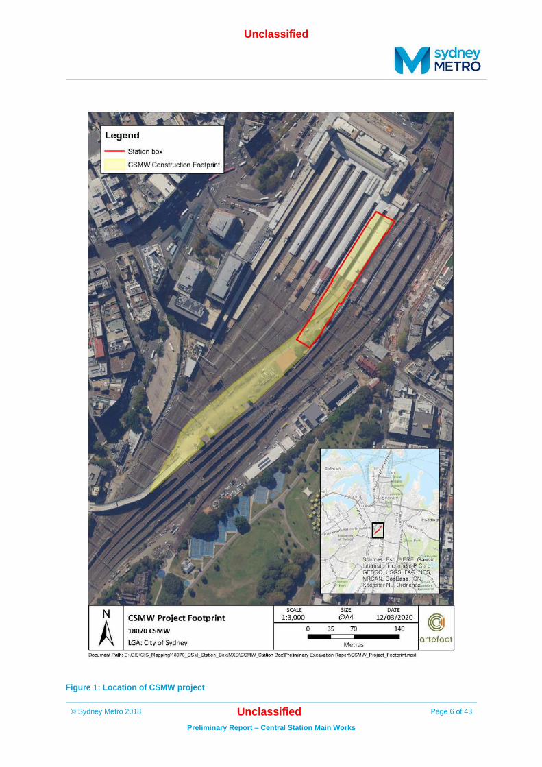
The CSMW site is within Central Station, Sydney Yard which is located within the City of Sydney Local Government Area (LGA) and in the Parish of Petersham. The CSMW site is located within Lot 118 DP1078271. The site is situated between platform/track 12 to its west, platform/track 16 to its east, Central Station Northern Concourse to its north, and active rail corridor to its south. The CSMW site is divided into the station box area and the remainder of Sydney Yard (Figure 1).
1.3. Heritage significance
The CSMW site is located within Central Railway Station, which is listed on the State Heritage Register (SHR) (SHR Item No. 01255), Railcorp Section 170 Heritage and Conservation Register (SHI No. 4801296), and Sydney Local Environmental Plan (LEP) 2012 (LEP Item No. I824) as an item of State Significance.
1.4. Report structure
This preliminary Excavation Directors report discusses the findings of the archaeological program at CSMW. It has been separated into sections discussing the Aboriginal and non-Aboriginal archaeological findings from the monitoring and excavation programs.
1.5. Authorship
This report has been prepared by Jessica Horton (Heritage Consultant), Julia McLachlan (Site Director), Dr Iain Stuart (Excavation Director – Historical Archaeology), and Dr Sandra Wallace (Excavation Director – Aboriginal Heritage).
Unclassified
© Sydney Metro 2018 Unclassified Page 6 of 43
Preliminary Report – Central Station Main Works
Figure 1: Location of CSMW project

Unclassified
© Sydney Metro 2018 Unclassified Page 7 of 43
Preliminary Report – Central Station Main Works
Aboriginal archaeological investigations
2.1. Background
An Aboriginal CHAR was completed as part of the Sydney Metro City & Southwest - Chatswood to Sydenham project Environmental Impact Statement (EIS).1 The CHAR assessed Aboriginal archaeological potential, set out a project wide test excavation methodology to manage areas of identified potential, and defined triggers for Aboriginal archaeological salvage excavation if required. The CHAR identified that prior to European development, the CSMW site was within a sand dune network associated with the Botany Sands and contained a water course.2 The CHAR assessed the CSMW site as having a moderate to high potential to contain intact former ground surface, with potential to contain Aboriginal objects. If Aboriginal objects were located, they would be considered to be of moderate to high archaeological significance as they would be rare in the local context.3 The cultural significance of any artefacts recovered, and the site as a whole was also recognised in the CHAR. An Aboriginal AMS was prepared for the CSMW site prior to construction commencing in accordance with Condition E24. Registered Aboriginal Parties (RAPs) were consulted during preparation of the AMS. The AMS outlined an archaeological methodology to manage site specific construction impacts to areas of Aboriginal archaeological potential, and Aboriginal objects if found, at the CSMW site. A staged excavation program was implemented within the station box in accordance with the AMS to manage potential impacts to Aboriginal objects. Archaeological monitoring required for non-Aboriginal archaeology included identification of Aboriginal objects where relevant in accordance with the AMS. Figure 2 shows the location of Aboriginal archaeological investigations.
1 Artefact Heritage 2016b 2 Artefact Heritage 2016b: 35 3 ibid
Unclassified
© Sydney Metro 2018 Unclassified Page 8 of 43
Preliminary Report – Central Station Main Works
Figure 2: Location of Aboriginal archaeology excavation program

Unclassified
© Sydney Metro 2018 Unclassified Page 9 of 43
Preliminary Report – Central Station Main Works
2.2. Monitoring
Archaeological monitoring for the CSMW project commenced in June 2018 and was completed by December 2019. Monitoring for Aboriginal objects was undertaken in conjunction with non-Aboriginal archaeological monitoring and in accordance Condition E17.4 Archaeological monitoring was undertaken where required in areas where ground penetrating works occurred during construction across the project footprint. Ground penetrating works generally included machine excavation, non-destructive digging (NDD) and piling. No Aboriginal objects were identified during the archaeological monitoring program.
2.3. Excavation
The staged archaeological excavation program was focussed in the location of the station box at Test/Salvage Excavation Area 1 and Test Excavation Area 2 where geotechnical testing had indicated the presence of sand deposits which indicated an elevated archaeological potential. The staged program undertaken in accordance with the AMS included an initial testing phase followed by salvage if triggered. The excavation was undertaken in conjunction with historical archaeological testing as the deposits to be excavated had potential for both Aboriginal and non-Aboriginal archaeological remains. Excavation occurred in the following locations:
• Two areas adjacent to the Devonshire Street tunnel where geotechnical testing has
identified the potential for sand deposits
• The perimeter pile locations to the south of Devonshire Street tunnel (where possible)
• The plunge column pile locations through the centre of the station box (where possible or
adjacent areas)
Figure 2 shows the location of these excavation locations.
RAPs participated in the CSMW Aboriginal archaeological investigations including Test/Salvage Excavation Area 1, Test Excavation Area 2, plunge column testing and redeposited sand sieving.
2.3.1. Test/Salvage Excavation Area 1
Aboriginal archaeological works, undertaken in conjunction with historical investigations at Test/Salvage Excavation Area 1, commenced on 20 November 2018 and were completed on 20 December 2018. A total of 52 square metres were archaeologically excavated in Test/Salvage Excavation Area 1. Depth of excavation varied between 200 millimetres (mm) and 1.7 metres (m).
A total of three Aboriginal artefacts were retrieved from Test/Salvage Excavation Area 1. The first identified Aboriginal artefact, a mudstone flake, was located in a disturbed context within the top layer (spit 1) of a test pit (excavation unit x149, y137). Under the Aboriginal AMS, this triggered salvage excavations. A further two Aboriginal artefacts where identified during salvage excavation in Test/Salvage Excavation Area 1. Both artefacts were silcrete, and both were identified within the upper preserved stratigraphic sequence of an intact dune system (spits 3 and 4). The two Aboriginal
4 Artefact Heritage 2018a

Unclassified
© Sydney Metro 2018 Unclassified Page 10 of 43
Preliminary Report – Central Station Main Works
artefacts located in situ were within 1m of each other, and 2m from the artefact retrieved during test excavation.
Geomorphologist Dr. Sam Player conducted auguring below the base of the excavated pits in Test/Salvage Excavation Area 1 to characterise the stratigraphy underlying the dune deposit. Auguring identified intact Blacktown soil landscape buried under the Aeolian dune at around 5m below ground surface. The geomorphological inspection concluded the basal dune was found to be pre-contact with the buried landscape anywhere from 1,000 to 10,000 years old. No A horizon soils were identified in association with the buried soil landscape. The A horizon had been truncated with the underlying B horizon clays directly overlain by the basal dune. No Aboriginal objects were recovered from the auger deposits and the truncation of the A horizon meant that Aboriginal archaeological potential was reduced in the buried soil landscape so no further management was undertaken. Optically stimulated luminescence (OSL) date samples were retrieved by the geomorphologist from the interface between the basal dune and buried landscape to determine a terminus post quem associated with the intact Botany Sand and associated artefacts uncovered in Test/Salvage Excavation Area 1. The analysis of the OSL samples are currently in progress.
Figure 3: Stage 1 open area investigation
Figure 4: Profile of upper intact dune deposit with presence of Aboriginal objects
Figure 5: Silcrete Aboriginal artefact found within intact dune
Figure 6: Silcrete Aboriginal artefact found within intact dune
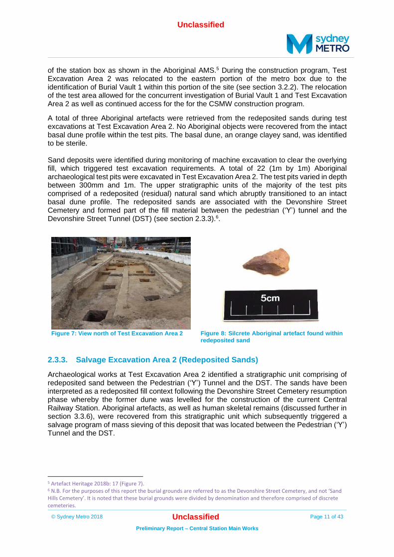
2.3.2. Test Excavation Area 2
Aboriginal archaeological excavation, undertaken in conjunction with historical archaeological investigations at Test Excavation Area 2, commenced on 7 January 2019 and was completed on 25 January 2019. Test Excavation Area 2 was indicatively located on the eastern portion
Unclassified
© Sydney Metro 2018 Unclassified Page 11 of 43
Preliminary Report – Central Station Main Works
of the station box as shown in the Aboriginal AMS.5 During the construction program, Test Excavation Area 2 was relocated to the eastern portion of the metro box due to the identification of Burial Vault 1 within this portion of the site (see section 3.2.2). The relocation of the test area allowed for the concurrent investigation of Burial Vault 1 and Test Excavation Area 2 as well as continued access for the for the CSMW construction program.
A total of three Aboriginal artefacts were retrieved from the redeposited sands during test excavations at Test Excavation Area 2. No Aboriginal objects were recovered from the intact basal dune profile within the test pits. The basal dune, an orange clayey sand, was identified to be sterile. Sand deposits were identified during monitoring of machine excavation to clear the overlying fill, which triggered test excavation requirements. A total of 22 (1m by 1m) Aboriginal archaeological test pits were excavated in Test Excavation Area 2. The test pits varied in depth between 300mm and 1m. The upper stratigraphic units of the majority of the test pits comprised of a redeposited (residual) natural sand which abruptly transitioned to an intact basal dune profile. The redeposited sands are associated with the Devonshire Street Cemetery and formed part of the fill material between the pedestrian (‘Y’) tunnel and the Devonshire Street Tunnel (DST) (see section 2.3.3).6.
Figure 7: View north of Test Excavation Area 2
Figure 8: Silcrete Aboriginal artefact found within
redeposited sand
2.3.3. Salvage Excavation Area 2 (Redeposited Sands)
Archaeological works at Test Excavation Area 2 identified a stratigraphic unit comprising of redeposited sand between the Pedestrian (‘Y’) Tunnel and the DST. The sands have been interpreted as a redeposited fill context following the Devonshire Street Cemetery resumption phase whereby the former dune was levelled for the construction of the current Central Railway Station. Aboriginal artefacts, as well as human skeletal remains (discussed further in section 3.3.6), were recovered from this stratigraphic unit which subsequently triggered a salvage program of mass sieving of this deposit that was located between the Pedestrian (‘Y’) Tunnel and the DST.
5 Artefact Heritage 2018b: 17 (Figure 7). 6 N.B. For the purposes of this report the burial grounds are referred to as the Devonshire Street Cemetery, and not ‘Sand Hills Cemetery’. It is noted that these burial grounds were divided by denomination and therefore comprised of discrete cemeteries.

Unclassified
© Sydney Metro 2018 Unclassified Page 12 of 43
Preliminary Report – Central Station Main Works
2.3.4. Perimeter pile testing
Aboriginal archaeological testing of permitter pile locations south of the DST was coordinated with historical archaeological investigations from 28 February 2019 to 1 March 2019. Test excavation was initially conducted on the western perimeter pile locations. Test excavation in this area showed evidence of historical fill contexts. No intact sand profiles or Aboriginal objects were identified. As a result, the remainder of the perimeter pile test locations were not test excavated although archaeological monitoring was undertaken. Monitoring identified modern fill and services associated with the railway above sterile basal clays
No Aboriginal artefacts or intact dune deposits were identified in any of the perimeter pile locations.
2.3.5. Plunge column testing
The plunge column testing occurred over several days at various periods during enabling and construction works. A machine excavator was used to remove the overburden under archaeological supervision with the provision to proceed to hand excavation if archaeologically sensitive features or intact sand deposits were identified. Sixteen mechanical test pits were completed as part of the plunge column testing program. Mechanical test pits were approximately 2m by 1.2m. The remainder of the plunge column testing was incorporated into Test/Salvage Excavation Area 1, Test Excavation Area 2, and the Gasworks excavation.
Twelve of the sixteen test pits were located between the northern most boundary of the site and the southern branch of the ‘Y’ tunnel. It was found that this area contained an upper stratigraphic unit comprised of modern fill overlaying the natural basal clays and shale. No significant archaeological features or intact artefact bearing deposits were identified in these locations and therefore no salvage was triggered.
The four remaining test pit locations were situated south of the DST. Following initial machine clearance conducted under archaeological supervision, intact sand dune was identified at all four locations. In each location, a 1m by 1m test pit was hand excavated in 100mm stratigraphic units (spits). The southernmost test pit comprised of the lower portion of intact dune (basal dune) and contained no Aboriginal artefacts (Figure 10). This supported the findings in Test Excavation Area 2 that the basal dune is a sterile stratigraphic unit. The remaining three test pits contained the upper stratigraphic unit of the dune as evidenced by fine grey sand similar to that found in Test/Salvage Excavation Area 1 (Figure 11). One Aboriginal artefact was located within the intact sand profile of a test pit containing the intact upper stratigraphic sequence of the sand dune.
Figure 9:Test pit location north of ‘Y’ tunnel showing the shale profile
Figure 10: Test pit location south of DST showing the basal dune

Unclassified
© Sydney Metro 2018 Unclassified Page 13 of 43
Preliminary Report – Central Station Main Works
Figure 11: Test pit location south of DST showing grey sand
Figure 12: Silcrete Aboriginal artefact found within intact dune
2.4. Summary
A total of seven Aboriginal stone artefacts were retrieved during the CSMW testing/salvage program, three of which were retrieved from the upper stratigraphic unit of the truncated sand dune. The remainder of the artefacts were retrieved from an historic fill layer comprised of redeposited sand. Archaeological investigations identified that a truncated Botany Sands profile containing low density Aboriginal objects is present in a discrete location to the north and south of the DST.
Non-Aboriginal archaeological investigations
3.1. Background.
A SoHI and Archaeological Assessment and Research Design (AARD) was completed as part of the Sydney Metro City & Southwest - Chatswood to Sydenham project Environmental Impact Statement (EIS).7 The AARD assessed non-Aboriginal archaeological potential, set out a project wide test excavation methodology to manage areas of identified potential, and defined triggers for archaeological salvage excavation if required. The AARD identified that prior to the construction of the current Central Railway Station, previous European development on the site included the Devonshire Street Cemetery to the north of Devonshire Street (along the current alignment of the DST). The Cleveland Paddocks were located to the south of Devonshire Street, followed by the first and second Central Railway Station. A non-Aboriginal AMS (Artefact Heritage 2018a) was completed for the CSMW site. This report set out the monitoring and excavation methodology to manage the potential construction impacts to non-Aboriginal archaeology specific to the CSMW site. Based on the archaeological potential of the site, a program of monitoring and excavation was implemented across the site as outlined in the AMS and in accordance Condition E17.8 The monitoring and excavation programs, and their findings, are discussed below.
7 Artefact Heritage 2016b 8 Artefact Heritage 2018a: 99-105

Unclassified
© Sydney Metro 2018 Unclassified Page 14 of 43
Preliminary Report – Central Station Main Works
3.2. Monitoring
Archaeological monitoring for the CSMW project commenced in June 2018 and was completed by December 2019. Archaeological monitoring was undertaken where required in areas where ground penetrating works occurred during construction across the project footprint. Ground penetrating works generally included machine excavation, non-destructive digging (NDD) and piling.
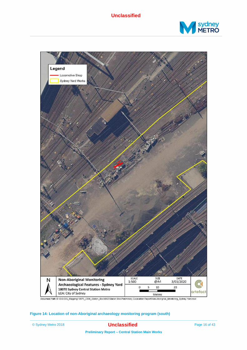
This section provides the results of the archaeological monitoring program for non-Aboriginal Archaeology. Figure 13 and Figure 14 shows the findings from the monitoring archaeological program.

Unclassified
© Sydney Metro 2018 Unclassified Page 15 of 43
Preliminary Report – Central Station Main Works
Figure 13: Location of non-Aboriginal archaeology monitoring program (north)
Unclassified
© Sydney Metro 2018 Unclassified Page 16 of 43
Preliminary Report – Central Station Main Works
Figure 14: Location of non-Aboriginal archaeology monitoring program (south)
Unclassified
© Sydney Metro 2018 Unclassified Page 17 of 43
Preliminary Report – Central Station Main Works
3.2.1. Modern services and potential archaeological features
A number of services were uncovered during archaeological monitoring. These services were associated with later development within Central Railway Station and were not identified as archaeologically significant features. Services varied in material, size, alignment and use.
In addition to this, a number of potential archaeological features were uncovered during early investigation (NDD) works however these were determined at the time not to be significant. These archaeological features included sandstone block or brick surfaces, walls or footings; and terracotta services and post-c1930s services. All subsequent bulk excavation was archaeologically monitored and where features were reidentified, additional recording was conducted. Where it was determined by the Excavation Director that these archaeological features were not of heritage significance further investigation was not undertaken.
All the features located were recorded in accordance with their significance and the requirements of the non-Aboriginal AMS.9
3.2.2. Burial Vault 1
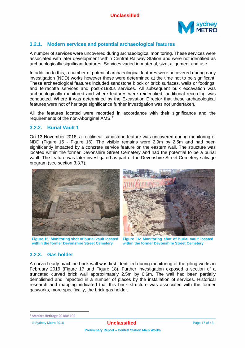
On 13 November 2018, a rectilinear sandstone feature was uncovered during monitoring of NDD (Figure 15 - Figure 16). The visible remains were 2.9m by 2.5m and had been significantly impacted by a concrete service feature on the eastern wall. The structure was located within the former Devonshire Street Cemetery and had the potential to be a burial vault. The feature was later investigated as part of the Devonshire Street Cemetery salvage program (see section 3.3.7).
Figure 15: Monitoring shot of burial vault located within the former Devonshire Street Cemetery
Figure 16: Monitoring shot of burial vault located within the former Devonshire Street Cemetery
3.2.3. Gas holder
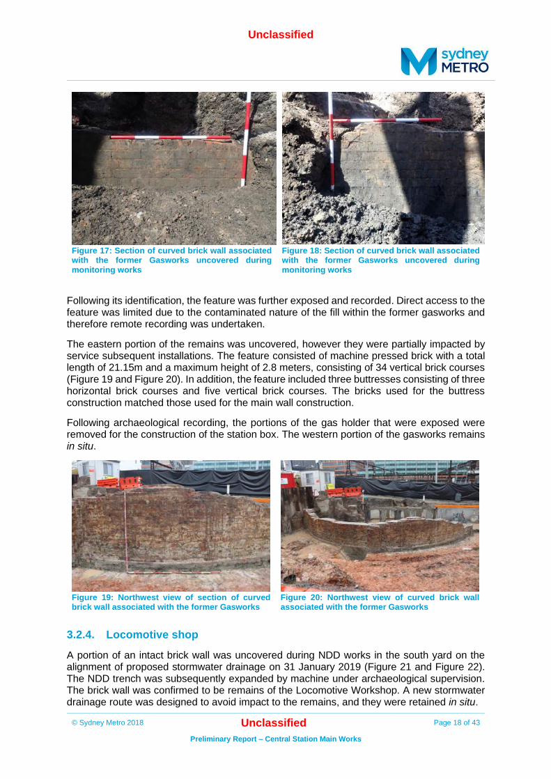
A curved early machine brick wall was first identified during monitoring of the piling works in February 2019 (Figure 17 and Figure 18). Further investigation exposed a section of a truncated curved brick wall approximately 2.5m by 0.6m. The wall had been partially demolished and impacted in a number of places by the installation of services. Historical research and mapping indicated that this brick structure was associated with the former gasworks, more specifically, the brick gas holder.
9 Artefact Heritage 2018a: 105
Unclassified
© Sydney Metro 2018 Unclassified Page 18 of 43
Preliminary Report – Central Station Main Works
Figure 17: Section of curved brick wall associated with the former Gasworks uncovered during monitoring works
Figure 18: Section of curved brick wall associated with the former Gasworks uncovered during monitoring works
Following its identification, the feature was further exposed and recorded. Direct access to the feature was limited due to the contaminated nature of the fill within the former gasworks and therefore remote recording was undertaken.
The eastern portion of the remains was uncovered, however they were partially impacted by service subsequent installations. The feature consisted of machine pressed brick with a total length of 21.15m and a maximum height of 2.8 meters, consisting of 34 vertical brick courses (Figure 19 and Figure 20). In addition, the feature included three buttresses consisting of three horizontal brick courses and five vertical brick courses. The bricks used for the buttress construction matched those used for the main wall construction.
Following archaeological recording, the portions of the gas holder that were exposed were removed for the construction of the station box. The western portion of the gasworks remains in situ.
Figure 19: Northwest view of section of curved brick wall associated with the former Gasworks
Figure 20: Northwest view of curved brick wall associated with the former Gasworks
3.2.4. Locomotive shop
A portion of an intact brick wall was uncovered during NDD works in the south yard on the alignment of proposed stormwater drainage on 31 January 2019 (Figure 21 and Figure 22). The NDD trench was subsequently expanded by machine under archaeological supervision. The brick wall was confirmed to be remains of the Locomotive Workshop. A new stormwater drainage route was designed to avoid impact to the remains, and they were retained in situ.
Unclassified
© Sydney Metro 2018 Unclassified Page 19 of 43
Preliminary Report – Central Station Main Works
Figure 21: Portion of Locomotive Shop uncovered during monitoring
Figure 22: Detail of Locomotive Shop brick wall uncovered during monitoring
3.2.5. Tram Yard
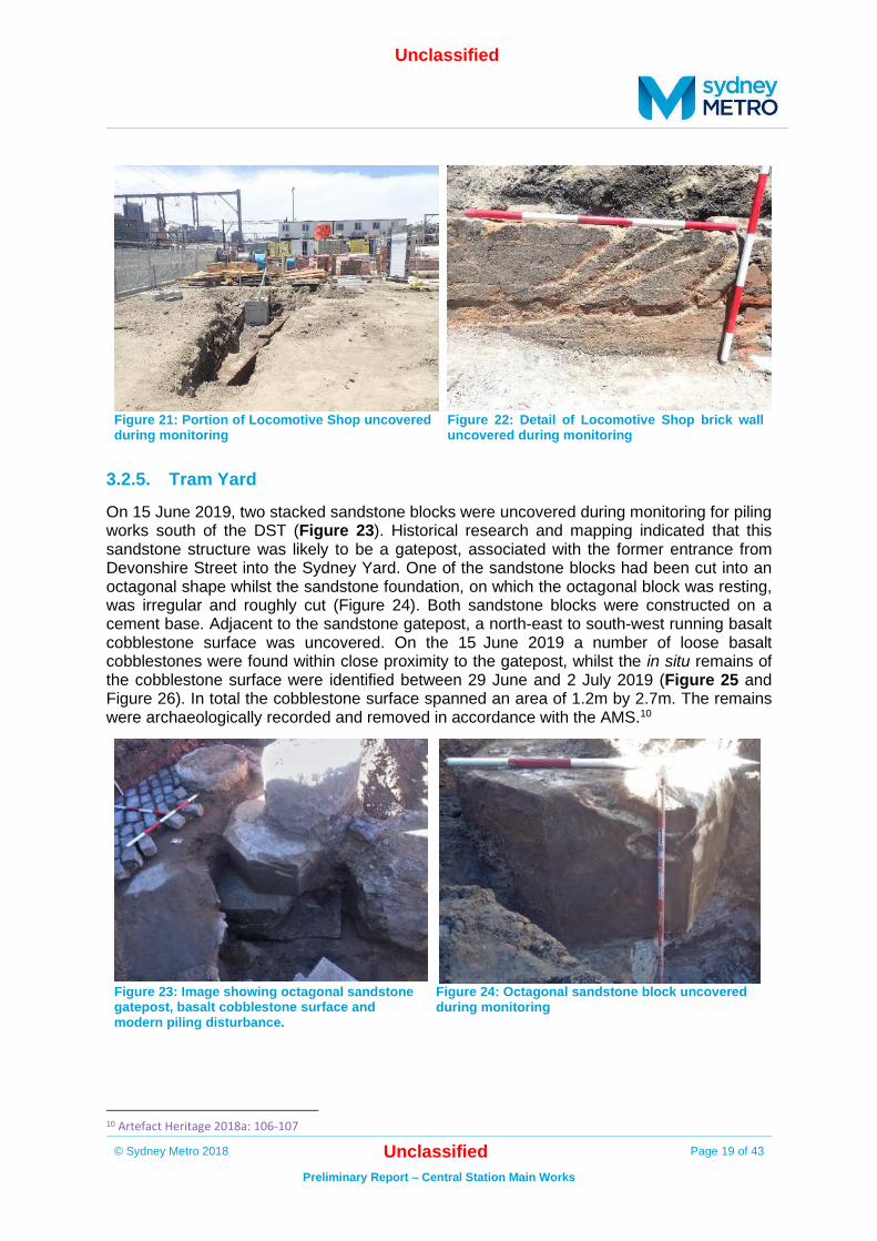
On 15 June 2019, two stacked sandstone blocks were uncovered during monitoring for piling works south of the DST (Figure 23). Historical research and mapping indicated that this sandstone structure was likely to be a gatepost, associated with the former entrance from Devonshire Street into the Sydney Yard. One of the sandstone blocks had been cut into an octagonal shape whilst the sandstone foundation, on which the octagonal block was resting, was irregular and roughly cut (Figure 24). Both sandstone blocks were constructed on a cement base. Adjacent to the sandstone gatepost, a north-east to south-west running basalt cobblestone surface was uncovered. On the 15 June 2019 a number of loose basalt cobblestones were found within close proximity to the gatepost, whilst the in situ remains of the cobblestone surface were identified between 29 June and 2 July 2019 (Figure 25 and Figure 26). In total the cobblestone surface spanned an area of 1.2m by 2.7m. The remains were archaeologically recorded and removed in accordance with the AMS.10
Figure 23: Image showing octagonal sandstone gatepost, basalt cobblestone surface and modern piling disturbance.
Figure 24: Octagonal sandstone block uncovered during monitoring
10 Artefact Heritage 2018a: 106-107

Unclassified
© Sydney Metro 2018 Unclassified Page 20 of 43
Preliminary Report – Central Station Main Works
Figure 25: Basalt cobblestone surface uncovered during monitoring
Figure 26: Additional section of basalt cobblestone surface
3.2.6. Devonshire Street and tram tracks
An additional section of cobblestones was uncovered on 17 August 2019. The cobblestones, which were irregular, had been significantly disturbed (Figure 27). Historical research and mapping indicated that this surface was associated with the original alignment of Devonshire Street. The basalt cobblestone surface was identified again on 22 August 2019, which triggered a program of archaeological salvage. The basalt cobblestone surface covered an area of 3.5m by 1m and was heavily disturbed; replaced by a basalt rubble fill in some areas.
Figure 27: Monitoring shot showing basalt cobblestone surface
Directly adjacent to the basalt cobblestone surface, a number of east-west running indentations were identified. The indentations were consistent in size and distance apart and remains of wooden sleepers and a section of metal rail were also present. Historical research and mapping indicated that these indentations were associated with the former Devonshire Street tram tracks.

Unclassified
© Sydney Metro 2018 Unclassified Page 21 of 43
Preliminary Report – Central Station Main Works
Figure 28: View of basalt cobblestone surface and tram track indentations within cement
Figure 29: View of basalt cobblestone surface and tram track indentations within cement
Figure 30: Detail shot of wooden sleeper and metal tram track
Figure 31: Detail shot of basalt cobblestone surface

Unclassified
© Sydney Metro 2018 Unclassified Page 22 of 43
Preliminary Report – Central Station Main Works
3.3. Excavations
Non-Aboriginal archaeological test excavation programs were focussed on the location of the station box where the majority of ground excavation for the project would occur. Additional test excavation was conducted in the remainder of Sydney Yard in the location of the storm water route. The excavation program included an initial testing phase followed by salvage if triggered, as required by the AMS and in accordance with Condition E17. The excavation was undertaken in conjunction with Aboriginal archaeological testing. The following locations were targeted for excavation:
• The perimeter pile locations to the south of Devonshire Street tunnel (where possible)
• The plunge column pile locations through the centre of the station box (where possible or
adjacent areas)
• Locomotive shop test excavation
• Turntable test excavation
• Two areas adjacent to the Devonshire Street tunnel
Figure 32 and Figure 33 shows the findings of the test/salvage archaeological program.

Unclassified
© Sydney Metro 2018 Unclassified Page 23 of 43
Preliminary Report – Central Station Main Works
Figure 32: Location of non-Aboriginal archaeology excavation program (north)

Unclassified
© Sydney Metro 2018 Unclassified Page 24 of 43
Preliminary Report – Central Station Main Works
Figure 33: Location of non-Aboriginal archaeology excavation program (south)

Unclassified
© Sydney Metro 2018 Unclassified Page 25 of 43
Preliminary Report – Central Station Main Works
3.3.1. Plunge column testing
The plunge column testing occurred over several days at various periods during enabling and construction works. A machine excavator under archaeological supervision was used to remove the overburden with the provision to proceed to hand excavation once archaeologically sensitive features were identified. Sixteen mechanical test pits were completed as part of the plunge column testing program. The remainder of the plunge column testing was incorporated into Test/Salvage Excavation Area 1, Test/Salvage Excavation Area 2, and the gasworks excavation.
Twelve of the sixteen test pits were located between the northern most boundary of the site and the southern branch of the ‘Y’ tunnel. Mechanical test pits were approximately 2m by 1.2m. It was found that this area contained an upper stratigraphic unit comprised of modern fill overlaying the natural basal clays and shale. No significant archaeological features were identified in these locations and therefore no salvage was triggered.
The four remaining test pit locations were situated south of the DST. No significant historical archaeological features or historical artefact bearing deposits were identified in these test pits. Intact sand dune was identified in all four test pits and excavated as outlined in the Aboriginal AMS and in accordance with Condition E24 (see Section 2.3.5).
3.3.2. Locomotive Shop
Following the identification of a portion of a brick wall associated with the Locomotive Shop during monitoring, an archaeological testing program was undertaken to identify the extent of the remains. Two test trenches were excavated along the alignment of the proposed stormwater route. Archaeological testing identified the preserved remains of at least one train service bay, including service access pits, drainage sumps, and various intersecting service conduits and standard gauge rails. Excavations demonstrated that those elements of the Locomotive Shop that were originally constructed below-ground level (such as mechanical service bays) were robustly constructed and are likely to remain in relatively intact condition beneath the overlying later surfaces of the Sydney Yard in areas not impacted by CSMW construction. The Locomotive Shop brick walls were found to run north-east to south-west and conform to the orientation of the Locomotive Workshop as shown in historical mapping. Several sandstone blocks set into the natural basal clay at the southern extent of the feature, running south-east to north-west, and perpendicular to the brick walls. These sandstone blocks may represent footings from an earlier structure, or an ad-hoc support for later development. The preserved structural features of the Locomotive Shop including the inspection pits and the structural footings appear to be those portions of the building that would have been below the original ground level. Stormwater works were abandoned in this location therefore no further investigation was required. The structural remains of the excavated extent of the Locomotive Shop were not impacted and were left in situ and are not anticipated to be further disturbed by future works.

Unclassified
© Sydney Metro 2018 Unclassified Page 26 of 43
Preliminary Report – Central Station Main Works
Figure 34: View of Locomotive Shop Figure 35: View of brick walling within Locomotive
Shop
Figure 36: View of brick walling within Locomotive Shop
Figure 37: View of brick walling within Locomotive Shop
3.3.3. Turntable
An archaeological test excavation program was undertaken in the predicted location of the early turntable structure in the south yard. A machine excavator was used to remove overburden under archaeological supervision. Machine excavation was halted following the identification of a curved sandstone feature. The sandstone feature was only partially exposed in two sections however the predicted circumference was estimated to be approximately 12 m in diameter. Archaeological test excavations identified the remains of the first turntable constructed in the Sydney Yard. Stormwater works were abandoned in this location therefore no further investigation was required. The structural remains of the excavated extent of the turntable were not impacted and were left in situ and are not anticipated to be further disturbed by future works.

Unclassified
© Sydney Metro 2018 Unclassified Page 27 of 43
Preliminary Report – Central Station Main Works
Figure 38: Detail shot of sandstone blocks within turntable
Figure 39: Extent of exposed portion of turntable
3.3.4. Test/Salvage Excavation Area 1
Non-Aboriginal archaeological excavations at Test/Salvage Excavation Area 1 commenced on 20 November 2018 and were completed on 20 December 2018 in conjunction with Aboriginal archaeological investigations. Earlier geotechnical analysis showed evidence of buried sands which informed the location Aboriginal archaeological testing.11
The test area was situated south of the DST on the western portion of the site. An area of approximately 20m by 10m was excavated by machine to remove overburden until historic features and deposits were identified. Initial machine clearance uncovered a portion of a basalt cobble paved surface. The cobble surface covered an area of approximately 3m by 4m which was set in a concrete base. The concrete base was approximately 10m by 15m across which indicated the extent of the original paved surface, however the cobbles were not present across the full extent of the area. Historical research showed that the remains were associated with the entrance to Sydney Yard. This feature was truncated by subsequent services and was only preserved in discrete sections across the test area and in some cases, was highly disturbed.
Adjacent to the cobbled entrance were a number of indentations set into a concrete base similar in composition to the base found under the cobbles. These indentations were consistent in distance apart; running roughly north- south with a gradual curve to the west. Some of the indentations contained preserved wooden sleepers. Historical research and mapping indicate that the indentations were associated with tram tracks leading into/from Sydney Yard. The sleepers had a width of approximately 200mm and height of 90-100mm; however, the average length of each track was undetermined due to disturbance.
Other historical features included brick service pits, service and utility trenches and pipes including terracotta and metal services, stanchion footings, and fills associated with the railway. These archaeological features were constructed above the natural Botany dune. No further historical features were identified, and Aboriginal archaeological excavations commenced (see section 2.3.1).
11 Artefact Heritage 2018a: 101

Unclassified
© Sydney Metro 2018 Unclassified Page 28 of 43
Preliminary Report – Central Station Main Works
Figure 40: View (left to right) of curved tram track, concrete road base, and basalt cobblestone surface
Figure 41: Detail of basalt cobblestone surface (left) showing concrete road base (right)
3.3.5. Test Excavation Area 2
Non-Aboriginal archaeological excavation in Test Excavation Area 2 commenced on 7 January 2019 and was completed on 25 January 2019 in conjunction with Aboriginal investigations. Test Excavation Area 2 was indicatively located on the eastern portion of the station box as shown in the AMS.12 During the construction program, Test Excavation Area 2 was relocated to the eastern portion of the station box due to the identification of Burial Vault 1 within this portion of the site (see section 3.2.2). The relocation of the test area allowed for the concurrent investigation of Burial Vault 1 and Test Excavation Area 2 as well as continued access for the for the CSMW construction program.
Earlier geotechnical analysis showed evidence of redeposited sands which informed the location of the testing location.13 The test area was situated north of the DST in the western portion of the CSMW site. An area of approximately 30m by 10m was excavated by machine to remove overburden. Burial Vault 1 was situated within the test area however it was excavated as part of the Devonshire Street Cemetery Salvage (see section 3.3.7.1).
A sandstock brick feature was uncovered following machine excavation. Its orientation and proximity to Burial Vault 1 indicated the remains might be associated with the Devonshire Street Cemetery. Fragmented human remains were retrieved from the redeposited sands excavated at this location. These findings triggered the Salvage Excavation Area 2 program comprising of the removal of the redeposited sands and excavation of the Devonshire Street Cemetery (see section 3.3.6 and 3.3.7).
12 Artefact Heritage 2018a: 103 (Figure 76). 13 Artefact Heritage 2018a: 101

Unclassified
© Sydney Metro 2018 Unclassified Page 29 of 43
Preliminary Report – Central Station Main Works
Figure 42: View south of Test Excavation Area 2 showing Burial Vault 2 (right), remnant wall of platform 13 (centre), burial vault 1 (left)
3.3.6. Salvage Excavation Area 2 (Redeposited Sands)
Archaeological works at Test Excavation Area 2 identified a stratigraphic unit comprising of light-grey residual natural sand between the Pedestrian (‘Y’) Tunnel and the DST. The sands appeared to be a redeposited and highly disturbed remanent from the original Botany Sand dune system. The redeposited sands were identified by lenses of brown sand with humic components, white-grey upper sand dune and, orange clayey sand indicative of the lower portion of the sand dune. The redeposited sands included historic refuse typical of a historic fill layer including fragments of metal, glass, and ceramic. The presence of human remains indicated that the historic fill was associated with the former cemetery.
The redeposited sands were interpreted as being the original landform into which the burials were placed and then were subsequently disturbed by the process of disinterment and then the construction of the railway platforms. The sands contained artefacts from the Aboriginal occupation of the site and from the Devonshire Street Cemetery.
The redeposited sands were encountered at reduced level (RL) 20.000 at its uppermost point. This level represents the uppermost preserved stratigraphic unit within the platform structures. The redeposited sands ranged in depth from a few millimetres to 1.4m, gradually increasing in depth from north to south. This sloping profile reflects the angle of the original dune landform associated with the southern slope of the Devonshire Street Cemetery. The natural sand dune profile was encountered directly below the redeposited sands; in the form of white-grey sand profile or an orange clay basal dune sand.
The redeposited sand was wet sieved using a 3mm sieve. Fragmented human skeletal remains, Aboriginal artefacts and non-Aboriginal artefacts (see section 2.3.3) were retrieved from this deposit. Analysis of the skeletal remains is ongoing.
3.3.7. Salvage Excavation Area 2 (Cemetery)
A program of salvage excavation was undertaken to manage impacts to the archaeological remains of the former Devonshire Street Cemetery that were identified during archaeological monitoring and test excavations. Historical mapping shows the location of the burial remains within the Congregational section. The cemetery salvage excavation program was conducted over two stages which commenced on the 10 March 2019 and was completed on the 16

Unclassified
© Sydney Metro 2018 Unclassified Page 30 of 43
Preliminary Report – Central Station Main Works
December 2019.14 This included the excavation, recording and removal of the archaeological features. The preliminary results of this excavation are discussed below.
3.3.7.1. Burial Vaults
Four burial vaults and one sandstone lined grave were uncovered as part of the salvage program. The burial vaults were partially preserved with only the lower portions of the structure intact.
The deposits were consistent across all burial vaults which reflected four phases of infilling; natural silting, post exhumation decay, exhumation and demolition.15
Burial Vault 1
A sandstone structure was uncovered during archaeological monitoring on 13 November 2018. Historical research and mapping showed that this feature was a burial vault associated with the former Congregational Cemetery.
The sandstone burial vault was 2.77m in length and 2.42m wide, with the internal space measuring 2.16m long and 1.96m wide. The burial vault was formed using 12 sandstone flagstones of varying dimensions placed directly above a levelled sand ground surface. Upon this, three uniform courses of rough ashlar sandstone were placed, to a maximum depth of 1.13m, held together with a sandy gravel mortar. The blocks were roughly hand dressed and a cement render had been applied on the internal facing.
The burial vault had been significantly impacted by the introduction of a concrete surface, resulting in the removal of roughly half of the upper course of sandstone blocks on the eastern wall.
The deposits within the burial vault reflected four phases of infilling: natural silting, post exhumation phase decay, exhumation and demolition. Within the decay deposit, the remains of three north-south facing adult hexagonal coffins were uncovered. The coffins were well preserved and found in situ on the base of the vault with a variety of intact coffin furnishings found including nails, decorative brass studs, iron handles and cloth lining. In addition, an abundance of poorly preserved human bone was present which included teeth, and hand and foots bones. The quantity and nature of the bone indicated that prior to exhumation, there would have been several additional coffins within the burial vault, as infant and juvenile bones were present.
14 N.B. Excavations did not run continuously due to project constraints. 15 N.B analysis in preliminary stages.

Unclassified
© Sydney Metro 2018 Unclassified Page 31 of 43
Preliminary Report – Central Station Main Works
Figure 43: Context shot of burial vault within the former Congregational Cemetery
Figure 44: Shot showing coffin remains within the burial vault
Figure 45: Shot showing coffin remains within the burial vault
Figure 46: View within burial vault following coffin remains removal
Burial Vault 2
A sandstock brick burial vault was uncovered during salvage excavations within the former Congregational Cemetery. The structure, which was semi-subterranean, with the entrance to south, had been built upon a levelled sand surface. The vault consisted of 22 brick courses to a depth of 1.6m; with an external measurement of 2.99m long and 2.4m wide, and internal chamber 2.31m long and 1.72m wide. The orange sandstock bricks were bonded with a sandy mortar with shell inclusions; and the walls were formed in a stretcher-header (English) bond absent of rendering or decorative elements.
Eight iron brackets were found built into the vault walls, designed to hold coffins. Two parallel rows of bricks, two courses high, were bonded to the floor against the northern wall of the vault, interpreted as an additional coffin shelf.
The deposits within the burial vault reflected four phases of infilling: post exhumation phase decay, exhumation, re-silting and demolition. The decay deposit was represented as a spread of coffin and fragmented human remains across the base of the vault. There was an abundance of coffin furnishings present including coffin nails, bronze tacks, handles, and fragments of a name plate. Human bones were small and degraded with a partial skull and feet bones identified. Lastly, a gold ring with abstract floral design was uncovered.

Unclassified
© Sydney Metro 2018 Unclassified Page 32 of 43
Preliminary Report – Central Station Main Works
Figure 47: Context shot of burial vault within the former Congregational Cemetery
Figure 48: Shot showing burial vault during excavation
Figure 49: Shot showing coffin remains within the burial vault
Figure 50: View within burial vault following coffin remains removal
Burial Vault 4
A subterranean ashlar sandstone burial vault was uncovered during salvage excavation within the former Congregational Cemetery. The structure measured 2.78m long and 2.47m wide, with an internal space measuring 2.10m long and 1.86m wide.
The vault had been constructed by placing 11 sandstone flagstones on a levelled sand surface, upon which three uniform courses of roughly faced sandstone blocks were placed at a maximum depth of 0.98m. The blocks were held together with a dark sandy clay mortar.
The vault had been impacted during the construction of Platform 14, during which time a single sandstone block had been removed.
The deposits within the burial vault reflected three phases of infilling: decay, exhumation and demolition. The decay deposit was represented as a spread of coffin and disarticulated human remains across the base of the vault. Within this deposit an abundance of coffin timber fragments, iron coffin nails and handles were found along with a small number of bone and teeth.

Unclassified
© Sydney Metro 2018 Unclassified Page 33 of 43
Preliminary Report – Central Station Main Works
Figure 51: Context shot of burial vault within the former Congregational Cemetery
Figure 52: Shot showing burial vault during excavation
Figure 53: Shot showing coffin remains within the burial vault
Burial Vault 5 (stone-lined grave)
A sandstone-lined subterranean grave was uncovered during salvage excavations within the former Congregational Cemetery. The structure measured 2.24m long and 0.73m wide, with an internal space of 2.047m long and 0.45m wide. The grave was constructed by excavating into the natural clay, lining three of the four vertical sides with three courses of roughly rectangular sandstone blocks to a depth of 0.9m. The blocks were bound together using a sandy clay mortar with shell inclusions. There was no indication that the fourth side or base had been formerly lined with sandstone.
The structure was well preserved despite being impacted by the construction of Platform 14, which had disturbed or removed only a small number of sandstone blocks.
The sandstone-lined grave contained the north-south aligned poorly preserved remains of an undisturbed burial. Remains included a coffin base with iron coffin nails, and human bone including right and left femurs, right humerus, skull and teeth.

Unclassified
© Sydney Metro 2018 Unclassified Page 34 of 43
Preliminary Report – Central Station Main Works
Figure 54: Context shot of burial vault within the former Congregational Cemetery
Figure 55: Shot showing burial vault during excavation
Figure 56: Shot showing coffin remains within the burial vault
Figure 57: View within burial vault following coffin remains removal
Burial Vault 6
A shallow rectangular subterranean sandstone burial vault was uncovered during salvage excavations within the former Congregational Cemetery. The structure measured 2.79m long and 2.47m wide, with an internal space of 2.16m long and 1.81m wide. The burial vault was constructed by placing eight large sandstone flagstones on a levelled sand, upon which a roughly tooled rectangular ashlar sandstone blocks were placed.
Only one course of sandstone blocks remained and at a total depth of 0.37m, the structure visible during excavation was not deep enough to contain intact coffin remains. The structure was partially disturbed by a concrete service which ran directly through its centre.
The deposits within the burial vault reflected three phases of infilling: decay, exhumation and demolition. The decay deposit was represented by a spread of coffin and human remains across the vault floors. Remains included coffin timber, small bone fragments, buttons and frequent coffin furniture including nails, handles and decorative brass studs.

Unclassified
© Sydney Metro 2018 Unclassified Page 35 of 43
Preliminary Report – Central Station Main Works
Figure 58: Context shot of burial vault within the former Congregational Cemetery
Figure 59: Shot showing burial vault during excavation
Figure 60: Shot showing coffin remains within the burial vault
Figure 61: View within burial vault following coffin remains removal
3.3.7.2. Graves
The cemetery salvage uncovered 62 graves with a further 12 considered to be indeterminate archaeological features.16 Graves were determined based upon the following criteria: • Skeletal remains
• In situ coffins remains
• Rectilinear shape, flat base and vertical sides
• Orientation
• Characteristic of fill and average size consistent with definite burials
The graves ranged in size and depth and had a range of archaeological material found within them, including skeletal remains, coffin remains, ceramic, glass and metal. Grave cuts were evident below the layer of redeposited sand and cut into the natural dune profile. Graves have been subdivided into three categories: unexhumed, exhumed, and indeterminate. The status of the grave was determined by a list of identifiable features – in some instances there was too much disturbance to determine its true nature. Of the intact graves, including both exhumed and unexhumed, the average dimensions of graves was approximately 1.8m by 500mm. The average depth of all grave features including truncated graves was approximately 280mm. The depth suggests that only the
16 N.B. Analysis is in preliminary stages.
Unclassified
© Sydney Metro 2018 Unclassified Page 36 of 43
Preliminary Report – Central Station Main Works
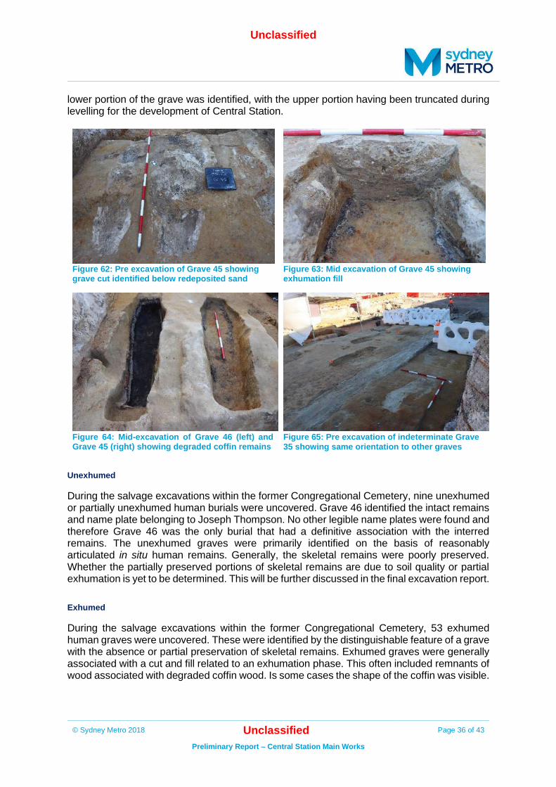
lower portion of the grave was identified, with the upper portion having been truncated during levelling for the development of Central Station.
Figure 62: Pre excavation of Grave 45 showing grave cut identified below redeposited sand
Figure 63: Mid excavation of Grave 45 showing exhumation fill
Figure 64: Mid-excavation of Grave 46 (left) and Grave 45 (right) showing degraded coffin remains
Figure 65: Pre excavation of indeterminate Grave 35 showing same orientation to other graves
Unexhumed
During the salvage excavations within the former Congregational Cemetery, nine unexhumed or partially unexhumed human burials were uncovered. Grave 46 identified the intact remains and name plate belonging to Joseph Thompson. No other legible name plates were found and therefore Grave 46 was the only burial that had a definitive association with the interred remains. The unexhumed graves were primarily identified on the basis of reasonably articulated in situ human remains. Generally, the skeletal remains were poorly preserved. Whether the partially preserved portions of skeletal remains are due to soil quality or partial exhumation is yet to be determined. This will be further discussed in the final excavation report.
Exhumed
During the salvage excavations within the former Congregational Cemetery, 53 exhumed human graves were uncovered. These were identified by the distinguishable feature of a grave with the absence or partial preservation of skeletal remains. Exhumed graves were generally associated with a cut and fill related to an exhumation phase. This often included remnants of wood associated with degraded coffin wood. Is some cases the shape of the coffin was visible.

Unclassified
© Sydney Metro 2018 Unclassified Page 37 of 43
Preliminary Report – Central Station Main Works
Indeterminate archaeological feature
Approximately 12 indeterminate archaeological features were identified during the salvage excavation. These features generally had a rectilinear excavation cut and consistent orientation alluding to the possibility of a grave cut feature. However, the indeterminate archaeological features were truncated and did not definitively possess the other criteria that would identify them as graves.
Preliminary artefact analysis results/ post-excavation analysis requirements
4.1. Introduction
Artefact processing and catalogue is ongoing for the assemblage retrieved from archaeological excavations for the CSMW project. This section provides an analysis of the 4,200 artefacts that have so far been catalogued. It is estimated that these artefacts represent at least 10% of the total artefacts recovered. These artefacts include items from grave cuts, burial vaults and redeposited sands. As such, they comprise a robust statistical sample of artefacts recovered throughout archaeological excavations. Analysis of skeletal remains are not addressed in these results. Given the demonstrated high potential for human bones to be present all bones retrieved from site, even those likely of animal origin, have been sent directly to a forensic anthropologist for formal identification. This is a preliminary and sample analysis. Inevitably as analysis of the remaining majority of the assemblage proceeds, new information will arise and new categories or means of analysis will need to be implemented. At that stage the findings of this analysis will need to be reconsidered and possibly revised to match new findings.
4.2. Methodology
The methods and protocols that have been followed in processing and cataloguing artefacts are documented in the Artefact Heritage Guide to processing and cataloguing artefacts. This standard procedural guide has been revised and updated to reflect the nature of archaeological excavations at this site. In particular, no bone elements have been retained for analysis in this catalogue. Given the demonstrated high potential for human bones to be present all bones retrieved from site, even those likely of animal origin, have been sent directly to a forensic anthropologist for formal identification. A catalogue category of Funerary Hardware has been utilised to differentiate between items that can be identified as directly connected with burial, as distinct from nails and similar items that may have derived from a wider range of structures. The guide is informed by Stabilising Stuff: A Guide for Conserving Archaeological Finds in the Field, published jointly by OEH, Heritage Council NSW and International Conservation Services (2012).17
4.3. Summary
The majority of artefacts were retrieved from sieved material (3mm mesh) associated with the redeposited sands and Devonshire Street Cemetery. Table 1 shows the rare or significant artefacts retrieved from these excavations. The excavation of the Locomotive shop, turntable
17
https://www.environment.nsw.gov.au/resources/heritagebranch/heritage/StabilisingStuff.pdf

Unclassified
© Sydney Metro 2018 Unclassified Page 38 of 43
Preliminary Report – Central Station Main Works
and Devonshire street did not yield large quantities of artefacts within their associated deposits. The assemblage associated with the cemetery salvage is strongly predominated by metal artefacts. This is due to the survivability of metal over organic material associated with funerary hardware. Coffin handles, tacks and nails survived to a greater extent than the coffin wood and fabric however in many cases the metal has been heavily corroded. Three coins were located within the cemetery salvage area, two of which were located at the base of Grave 27 and dated to the first half of the 19th century (Table 1). The redeposited sands yielded large quantities of fragmented glass, metal, and ceramic. Given the highly fragmented and degraded nature of artefacts analysed so far it is not surprising that few tightly datable items are present. It can be observed that there are no items that can be clearly defined as manufactured in the first half of the 19th century or earlier. There are also no items that can be demonstrated as clearly manufactured in the 20th century. The artefacts shown in Table 1 are undergoing further analysis and therefore limited information is available at present. These artefacts are considered to be intact and may have the potential to be used for interpretative purposes if appropriate. The condition is rated poor to good, however, items of poor quality may be subject to conservation that would yield more information. Table 1: List of rare or significant artefacts from CSMW excavations
Artefact Type Location Condition
Coin [1864?] Cemetery salvage Poor
Coin [1829] Cemetery salvage – Grave 27 Poor
Coin [1841] Cemetery salvage – Grave 27 Good
Name plate Cemetery salvage – Grave 46 Good
Ring (gold) Cemetery salvage – Burial Vault 2 Good
Name plate Cemetery salvage – Burial Vault 2 Very poor
Ring (silver?) Cemetery salvage – Burial Vault 6 Good
Name plate Cemetery salvage – Grave 61 Very poor
Ring (silver?) Cemetery salvage – Grave 71 Good
Coin/token [1857] Redeposited sands Good
Coin [1847] Redeposited sands Poor
Coin [1889] Redeposited sands Poor
Coin [1817] Redeposited sands Good
Coin [1853] Redeposited sands Poor
Ring (gold) Redeposited sands Good

Unclassified
© Sydney Metro 2018 Unclassified Page 39 of 43
Preliminary Report – Central Station Main Works
Future/ongoing archaeological management
5.1. Summary
Several historical archaeological features were uncovered during the CSMW test/salvage excavation program. Archaeological remains include:
• Burials from the former Devonshire Street Cemetery
• A portion of the gas holder associated with the gas works
• A portion of the 1855 turntable
• A portion of the Locomotive shop
• A portion of the former Devonshire Street, tram tracks, and entrance to the former
Sydney yard
• Intact Botany sand dune containing low density Aboriginal artefacts
Archaeological investigations have identified the buried remains associated with the former Devonshire Street Cemetery and the First and Second Station Expansion within the location of Sydney Yard.
Excavations throughout the CSMW project has uncovered a significant number of intact
subsurface archaeological features. It is evident from these excavations that they construction
of the Central Railway has heavily truncated many of these former features however they were
found to be intact in discrete portions across the CSMW project area. This is evident in the
localised portions of intact Botany dune deposit with Aboriginal artefacts present, portions of
the intact cemetery, intact portions of Devonshire Street and tram tracks, and intact portions
of First and Second Station infrastructure.
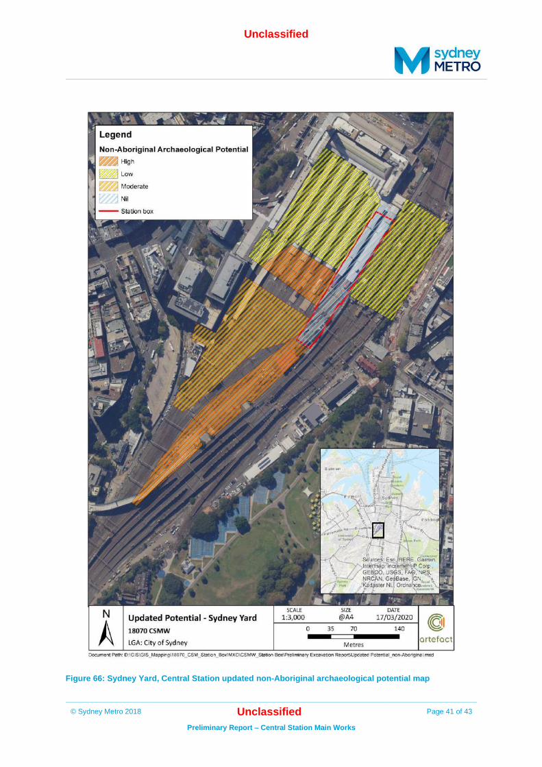
5.2. Revised archaeological potential
It is now considered there is a moderate to high potential to find intact archaeological remains
in Sydney Yard. No further archaeological resources would be found within the location of the
station box area as these have been archaeologically salvaged as part of the CSMW (Figure
66 and Figure 67). The revised archaeological potential as a result of the CSMW
archaeological program is summarised below.
Non-Aboriginal archaeological potential (Figure 66):
• High potential – discrete intact portion of the cemetery located between with the
Pedestrian ‘Y’ tunnel and the DST
• Moderate potential –first and second station expansion in the remainder of the Sydney
Yard, south of the DST
• Low potential – north of the DST where the landform has been heavily truncated
• Nil potential– location of Metro station box where all archaeological features were
salvaged

Unclassified
© Sydney Metro 2018 Unclassified Page 40 of 43
Preliminary Report – Central Station Main Works
Aboriginal archaeological potential (Figure 67):
• High potential - associated with the redeposited sands located between the Pedestrian
‘Y’ tunnel and the DST
• High potential - intact portion of sand dune predominantly located south of the DST and
partially north of the DST.
• Low potential - remainder of Sydney Yard due to absence of sand and/or truncated
landform
• Nil potential – location of Metro station box where all archaeological features were
salvaged
5.3. Considerations for future management
Future management of the archaeological resource at Central Railway Station would include
the following considerations.
• A detailed Excavation Directors Report and Aboriginal archaeological report would be
prepared for the full CSMW archaeological program.
• The results of the CSMW archaeological program should be accounted for in an updated
Conservation Management Plan (CMP) or archaeological zoning plan for Central
Railway Station. Archaeological management of Central Railway Station for future
projects would take into account the revised archaeological potential as outlined above.
• The SHR listing for Central Station should be updated to include the results of the
CSMW archaeological program and identify the implications for the Sydney Metro owned
portion of the asset.
• As an Aboriginal site (AHIMS ID 45-6-3654) is now registered in the Sydney Yard (in the
area of high archaeological potential shown in Figure 67) approval would be required for
impacts to the site area. This may include an Aboriginal Heritage Impact Permit or
approval under an SSI project. Aboriginal consultation should be undertaken as required.
• The finalised preliminary report should be distributed to all RAPs.
• Ongoing RAP consultation should seek an outcome on? long-term care and
management of the identified Aboriginal objects
• Where possible, opportunities should be taken to include information on, or
representation of, the archaeological resource at Central Railway Station in interpretive
media.
Unclassified
© Sydney Metro 2018 Unclassified Page 41 of 43
Preliminary Report – Central Station Main Works
Figure 66: Sydney Yard, Central Station updated non-Aboriginal archaeological potential map

Unclassified
© Sydney Metro 2018 Unclassified Page 42 of 43
Preliminary Report – Central Station Main Works
Figure 67: Sydney Yard, Central Station updated Aboriginal archaeological potential map

Unclassified
© Sydney Metro 2018 Unclassified Page 43 of 43
Preliminary Report – Central Station Main Works
References
Artefact Heritage 2016a. Sydney Metro City & Southwest Chatswood to Sydenham Historical Archaeological Assessment & Research Design. Report to Jacobs/Arcadis/RPS. Artefact Heritage 2016b. Sydney Metro City & Southwest Chatswood to Sydenham Aboriginal Cultural Heritage Assessment. Report to Jacobs/Arcadis/RPS. Artefact Heritage 2017. Sydney Metro City & Southwest: Exhumation Management Plan. Report to TfNSW. Artefact Heritage 2018a. Central Station Main Works – Station Box: Archaeological Method Statement. Report to Laing O’Rourke. Artefact Heritage 2018b. Central Station Main Works – Station Box: Aboriginal Archaeological Method Statement. Report to Laing O’Rourke.