preliminary environmental overview brownie creek...
TRANSCRIPT

PRELIMINARY ENVIRONMENTAL OVERVIEW
BROWNIE CREEK COAL LICENCES,
FORDING COAL LTD.
Project Report Project No. 1-06-994
July, 1979
Prepared f o r :
Fording Coal Ltd. Box 100
Elkford, B.C. VOB 1HO
Prepared by:
B.C. Research 3650 Wesbrook M a l l Vancouver, B.C.
V6S 2L2

i
TABLE OF CONTENTS
1
7
7 8 8 9 9
11
1.0
2.0
2.1 2.2 2.3 2.4 2.5
3.0
3 .1 3.2
3.2.1 3.2.2 3.2.3
3.3
3.3.1 3.3.2 3.3.3
3.4
4.0
4.1
4.1.1 4.1.2
4.2
4.2.1 4.2.2
4.3
4.4
SUMMARY ...................................................... INTROUCTION .................................................. BACKGROUND ................................................... OBJECTIVES ................................................... STUDY AREA ................................................... PERSONNEL .................................................... ACKNOWLEDGEMENTS ............................................. METHODS ...................................................... CLIMATE ...................................................... AQUATIC STUDIES .............................................. Hydrology .................................................... Water Q u a l i t y ................................................ F i s h e r i e s .................................................... TERRESTRIAL STUDIES .......................................... S u r f i c i a l M a t e r i a l s and S o i l s ................................. Vegetat ion ................................................... W i l d l i f e ..................................................... RESOURCE USE ................................................. ENVIRONMENTAL DATA ........................................... PHYSICAL OVERVIEW ............................................ Physiography ................................................. Geology ...................................................... CLIMATE ...................................................... Temperature .................................................. P r e c i p i t a t i o n ................................................ A I R QUALITY .................................................. AQUATIC RESOURCES ............................................
11 11 13
13
13 14 15
16
17
17
17 17
i a i a 18
19
20

i i
TABLE OF CONTENTS
4.4.1 4.4.2 4.4.3
4.4.3.1 4.4.3.2
4.4.4
4.4.5
4.5
4.5.1
4.5.1.1 4.5.1.2
4.5.2
4.5.2.1 4.5.2.2
4.5.3
4.5.3.1 4.5.3.2
4.6
4.6.1 4.6.2
4.6.2.1 4.6.2.2 4.6.2.3 4.6.2.4
4.6.3
5.0
5.1 5.2
Ident i f ica t ion and Description o f Drainages ................. Hydrology ................................................... Water Qual i ty ............................................... Review of exis t ing data ..................................... 1978/79 Water qual i ty s tudies ............................... Aquatic Invertebrates ....................................... Fisheries ................................................... TERRESTRIAL RESOURCES ....................................... Surf ic ia l Materials and Soi l s ............................... Surfi c ia1 materials ......................................... Soi l s ....................................................... Vegetation .................................................. Review of exis t ing data ..................................... 1978/79 Vegetation s tudies .................................. Wildlife .................................................... Review o f exis t ing data ..................................... 1978/79 Wildlife s tudies .................................... RESOURCE USE ................................................ Land Tenure ................................................. Present and Potential Resource Use .......................... Present land use ............................................ Agriculture ................................................. Forestry ..................................................... Recreation .................................................. Heritage Resources .......................................... ENVIRONMENTAL SENSITIVITY ANALYSIS .......................... AIR QUALITY ................................................. AQUATIC RESOURCES ...........................................
20 23 23
23 26
26
27
30
30
30 31
33
33 36
49
50 51
68
68 69
69 69 70 71
73
74
74 74

5.2.1 5.2.2 5.2.3
5.3
5.3.1 5.3.2 5.3.3
5.4
5.4.1 5.4.2
5.4.2.1 5.4.2.2 5.4.2.3
5.4.3
5.5
6.0
TABLE OF CONTENTS
Hydrology ................................................. Water Qua1 i ty ............................................. F ishe r ies ................................................. TERRESTRIAL RESOURCES ..................................... S u r f i c i a l M a t e r i a l s and S o i l s ............................. Vegeta t ion ................................................ W i l d l i f e .................................................. RESOURCE USE .............................................. Land Tenure ............................................... Present and P o t e n t i a l Resource Use ........................ A g r i c u l t u r e ............................................... Fores t r y .................................................. Recreat ion ................................................ Her i tage Resources ........................................ RECLAMATION CONSIDERATIONS ................................ RECOMMENDATIONS ...........................................
REFERENCES ............................................................. TABLES
FIGURES
APPENDICES
MAPS
iii
74 75 75
76
76 77 78
79
79 79
79 79 79
80
80
81
83

iv
LIST OF TABLES
TABLE
1
2
3
4
5
6
7
8
9
10
11
12
13
14
15
16
17
Climate Data from Fording Coal Limited, 1970-1977.
Sumnary of Climate Data from Fernie, 1941-1970.
Size Class i f ica t ion of Gravel in Kilmarnock Creek, October 1969.
Discharge Measurements i n the Kilmarnock and Henretta Creek Drainages, September 13-15, 1978.
Water Qua l i ty Characteristics of Kilmarnock Creek Collected
Water Qua l i ty Character is t ics of the F o r d i n g River and Kilmarnock and Henretta Creek Drainages, September 16, 1978.
Water Qua l i ty Character is t ics o f t h e Fording River and Kilmarnock and Henretta Creek Drainages, May 11 and 12, 1978.
Invertebrates Collected i n Kilmarnock Creek, October 1969.
Fish Sample S i t e s and F i s h i n g Effor t i n the Fording River and Kilmarnock and Henretta Creeks - September, 1978.
F i s h Captured i n the Fording River and Kilmarnock and Henretta Creeks - September, 1978.
Age and Stomach Contents of Fish C a u g h t in the Fording River, Kilmarnock and Henretta Creeks, September, 1978.
Comparison of Length and Age of Fish from the Study Area and Those from Montana and Utah Streams.
Fish Captured in Kilmarnock Creek May 11, 12 and 14 and June 18 and 19, 1979.
Vegetation Data for Mature Engelmann Spruce - Alpine F i r Map U n i t , Brownie Creek Coal Licences Area, 1978.
Vegetation Data fo r Logged Map Unit, Brownie Creek Coal Licences Area, 1978.
Vegetation Data f o r Sera1 Pine-Engelmann Spruce-Alpine F i r Map Unit Brownie Creek Coal Licences 4rea, 1978.
Vegetation Data f o r Young Engelniann Spruce-Alpine F i r Map Unit, Brownie Creek Coal Licences Area, 1978.
1969-1978.

r
V
TABLE
18 Vegetation Data for Alpine Larch - Alpine Fir Map Unit, Brownie Creek Coal Licences Area, 1978.
Vegetation Data for Meadow Map Unit, Brownie Creek Coal Licences Area, 1978.
Results of Preliminary Pellet Transect Survey of the Brownie Creek Coal Licence Area, September 12-15, 1978.
Coal Area, March 19, 1979.
19
20
21 Sightings of Ungulates During Aerial Survey of the Fording

v i
LIST OF FIGURES
FIGURE
1
2
3
4
5
6.
7
8
9
10
11
12
13
14
View o f Ridg 1 t h Between Mount T u r n b u l l r i g h Eagle Mountain (on t h e l e f t ) , L y i n g Above and t o o f Brownie Creek.
Henre t ta Creek a t Water Sample S i t e WS5.
) and i e West
Elect ro-Shocking Along Lower Ki lmarnock Creek, May 11, 1979.
F i s h Trap S i t e T2 Along Midd le Ki lmarnock Creek.
Brownie Creek Cross ing t h e Logging Road i n t h e Ki lmarnock Creek V a l l e y a t Water Sample S i t e ws3.
Yel lowstone Cu t th roa t T r o u t (Salmo c l a r k i l e w i s i ) Caputred by Ang l ing Dur ing t h e September 13-15, 1978 Sampling Per iod.
Spruce-Fir-Moss Vegetat ion Type a t P l o t 14 i n t h e Mature Engelmann Spruce-Alpine F i r Map U n i t .
E lderberry-Currant -F i reweed Vegeta t ion Type a t P l o t 11 i n t h e Logged Map U n i t .
Pine-Spruce-Fir Vegetat ion Type a t P l o t 3 i n t h e Sera1 Pine- Engelmann Spruce-Alpine F i r Map U n i t .
Spruce-Fir-Grouseberry Vegetat ion Type a t P l o t 1 i n t h e Young Engelmann Spruce-Alpine F i r Map U n i t .
Larch-Fir-Grouseberry Vegetat ion Type a t P l o t 6 i n t h e A l p i n e Larch-Alp ine F i r Map U n i t .
Fescue-Wheatgrass Vegetat ion Type a t P l o t 2 i n t h e Meadow Map U n i t .
E a r t h L i c k i n a Ravine, Located Near P l o t 7 i n L o t 6706 on t h e West Ridge o f Mount Farquhar.
Band o f 15 E l k Observed on Exposed Grassland Ridge Nor th o f Henre t ta Creek on March 19, 1979.

v i i
LIST OF APPENDICES
Appendix
4
5
6
7
8
9
10
11
12
13
14
Data and In fo rmat ion Sources Used i n t h e Ford ing Coal Study.
Resources Ana lys is Branch - Aquat ic B iophys ica l Data Cards f o r Ki lmarnock and Henre t ta Creeks, September, 1978.
S t a t i s t i c a l Ana lys is o f Range Foraqe Losses from F a l l t o Spr ing, as Determined by Foiage C l i p p i n g i n October 1970 and and May 1971 . Resu l ts of T o t a l N i t rogen Assay Conducted on Forage from Mount Tu rnbu l l and Eagle Mountain, October 1970 Compared t o May 1971 . L i s t of P l a n t Species Found i n t h e Brownie Creek Coal Licences Area, 1978.
Tree Mensurat ion Data f o r Brownie Creek Coal Licences Area, 1978.
Legend - Numerical Coding o f General P l o t Data.
L i s t o f Mammals Poss ib l y Occur r ing i n t h e Ford ing R ive r Area . Check L i s t o f B i r d s Whose Breeding Ranges Coinc ide w i t h t h e Ford ing R i v e r Area . B.C. Research Winter Survey Report, March 19, 1979.
W i l d l i f e Observat ions i n October, 1969 and A p r i l , 1970 i n the Ford ing Coal Area . Mule Deer Food Hab i t s as Determined from Ana lys i s o f a F a l l Rumen Sample . Moose Food Hab i ts as Determined from Ana lys is o f F a l l Rumen Samples . B i g Game Observat ions i n t h e Upper Ford ing R i v e r Va l ley , Eagle Mountain and Mount Tu rnbu l l Region, May and Ju ly , 1971 .

I
viii
LIST OF MAPS
MAP
1
2
Location Map
Location of Aquatic Sampling Sites - Brownie Creek Coal Licences
Aquatic Biophysical - Brownie Creek Coal Licences
Surficial Materials - Brownie Creek Coal Licences
Vegetation/Habitat - Brownie Creek Coal Licences
Results of March 19, 1979 Aerial Wildlife Survey - Brownie Creek Coal Licences

1 .o SUMMARY
This report describes existing environmental conditions of
five coal licences held by Fording Coal Limited in the Brownie Creek area, to the east of the existing Fording Coal operation, on the west slope of the Continental Divide. These licences (No.'s 3899-3903) cover Lots 6691, 6694, 6703, 6706 and the east half of Lot 6713 and are being considered as a possible site for dumping of overburden material. This report summarizes previously existing information on the area and presents the results of field studies conducted during September, 1978, to June, 1979.
Short-term climatological data for the area were obtained from the Fording Coal station and compared to long-term data from the Fernie climatological station. There are no site-specific data on air quality for the Brownie Creek area. As the area is in a relatively natural and undisturbed state, the air quality is assumed to be good.
The main streams of the study area are Kilmarnock Creek and Henretta Creek and their major tributaries, respectively, Brownie Creek and McQuarrie Creek. These streams were surveyed and described from the eastern boundary of the study area to their respective confluences with the Fording River. made at six sites in the Kilmarnock Creek and Henretta Creek drainages in September, 1978.
Surface water hydrology measurements were
Water quality data gathered during earlier B.C. Research
studies and from two reports of the "Kootenay Air and Water Quality Study" were summarized. Earlier studies found that Kilmarnock Creek was an alkaline, low outrient
stream of high water quality and a source of intermittent
high suspended solids.
prior study.
Henretta Creek had received no

I
2
Water quality samples were collected by B.C. Research on
September 16, 1978, and May 11-12, 1979. These and previously collected water quality data indicate that Kilmamock, Henretta, Brownie and McQuarrie Creeks were
of high water quality, characteristic of undisturbed or relatively undisturbed watersheds. Analyses of samples from the Fording River downstream of Kilmarnock Creek indicated differences from other study streams, showing higher levels of turbidity, solids, phosphorus (in May, 1979), nitrate and manganese.
A previous B.C. Research study found that benthic invertebrate fauna in Kilmarnock Creek were indicative of small, clean, cold-water streams.
Fish populations were sampled in Henretta and Kilmamock Creeks in September, 1978. Additional sampling took place in Kilmarnock Creek using an electroshocker and
trap nets in May and June, 1979. Yellowston; cutthroat trout was the only species captured. Stream survey and fish sampling results indicate that the lower reaches of Kilmarnock and Henretta Creeks are important as summer rearing areas for cutthroat trout. Kilmarnock Creek contained fish in spring which were in spawning condition and it is expected that some areas of the stream are spawned in late June and early July. Overwintering probably occurs in other streams. Both Brownie and McQuarrie Creeks appeared to be too small to provide fish habitat.
Surficial materials and soils of the Brownie Creek coal
licence area were described from Resource Analysis Branch
mapping. The dominant parent materials include blankets,
veneers, or aprons of colluvium and/or till overlying
bedrock. Soils in the area have mainly been derived from

colluvium and morainal materials of variable depth. Soil development is represented by fou r soil orders: Podzolic,
Luvisolic, Brunisolic and Regosolic. These soils and their distribution in the Brownie Creek coal licence area were described.
*
Vegetation studies conducted in the Fording Coal area by B.C. Research in 1969, 1970 and 1971 were summarized. Vegetation of the Brownie Creek coal licence area was sampled in September, 1978. The study area falls within the Dry Interior Region, represented by two forest zones: Subalpine Engelmann Spruce-Alpine Fir and Alpine Tundra. The study area was mapped into nine map units, each composed of one or more vegetation types. species of vascular plants, bryophytes and lichens was made from the study area and floristic data for the 20
vegetation plots sampled were presented. Each of the nine map units and its vegetation types were described.
A listing of 145
Wildlife sighting data obtained during B.C. Research wildlife studies conducted in 1969, 1970 and 1971 were summarized. A pellet transect survey of the Brownie Creek coal licence area was conducted in September, 1978, to provide an estimate of habitat use. An aerial winter survey of the Fording Coal area, including the Brownie Creek study area, was flown in March, 1979.
Elk were the most
coal licence area. All habitats appeared to be used as summer range. No elk or elic tracks were observed in these coal licences during the March, 1979 survey. The lack of elk in the area in winter, and ungulates in
general, can be attributed primarily to excess snow cover
during most of the winter, Elk were observed wintering
on the steep, south-facing meadow slopes of Eagle Mountain,
Nount Turnbull and several ridges north of Henretta Creek.
abundant ungulate in the Brownie Creek

~
b
4
Mule deer and white-tailed deer occur in small numbers in
the Fording Coal area. Deer use most of the habitat
types available during summer but do not appear to winter
in the Brownie Creek area.
limited use of the Brownie Creek coal licence area during the summer to fall period. to the Fording River and Henretta Creek valley bottoms during winter. Creek during the March, 1979, aerial survey.
Moose appear to make only
Moose appear to be confined
Nine moose were observed along Henretta
Within the licence area, sign of bighorn sheep was abundant
in meadow habitats to the east of Brownie Creek. Other
habitats were used to a lesser extent. appear to winter in the Brownie Creek coal licence area. Mountain goats occur in moderate numbers in the higher
regions east of the Fording valley. Goats appear to make little use of the study area during summer. During the March, 1979, survey, goats were observed in the rugged terrain at the headwaters of Henretta Creek and to the
east of the Brownie Creek coal licence area. The steep
meadow habitats at the eastern edge of the licence area appear to be used by goats during spring.
Sheep do not
The occurrence and distribution of black bears, grizzly bears, smaller furbearers and birds in the Brownie Creek
coal licence area were briefly described.
The present and potential resource use of the Brownie Creek coal licence area was described from Canada Land
Inventory and Resource Analysis Branch information. area generally has a low capability for agriculture and forestry. Logging has removed much of the mature coniferous forest cover of the Kilmarnock Creek valley bottom. The
coal licence area has the general recreation features for
The

5
vegetation and viewing, mostly of a low to moderate
significance. opportunities for angling. Elk appeared to be the most
sought after game animal in the area, followed by deer, moose and bighorn sheep. sites in the Brownie Creek coal licence area is considered low.
Kilmarnock and Henretta Creeks provide
The potential for archaeaological
A brief environmental sensitivity analysis was prepared, based on the limited amount of data collected for the Brownie Creek coal licence area. The general sensitivities of the major aquatic and terrestrial parameters were evaluated with regard to disturbance, specifically the possible use of the Brownie Creek drainage as a site for a waste dump. Dumping of overburden would result in an increased level of dustfall in the immediate area and in minor changes in the hydrologic regime of Brownie Creek. Streams in the area are highly sensitive to disturbance which may cause increased sedimentation, thereby having a direct effect on aquatic habitat. Aquatic resources in
Kilmarnock Creek could undergo substantial alteration if
siltation occurs.
The major problems which may be encountered by dumping of overburden above upper Brownie Creek would be the effects
on slope stability of the surrounding areas. Steep slopes with fine textured soil developed on morainal material are
highly sensitive to disturbance. could result in disturbance of surrounding vegetation communities and consequent loss of wildlife habitat.
Erosion and slope failure
No major impacts on wildlife are expected to occur from possible dumping of overburden into the west side of the Brownie Creek drainage. Winter survey information

b
6
indicated that this particular area is not a winter range.
The location of a waste dump in the Brownie Creek coal
licence area may result in interference with traditional
ungulate migration routes.
The agricultural and forestry capability of the Brownie
Creek coal licences would not be significantly affected
by dumping of overburden material. Some effects on the
recreation capability and use of the area are likely to
occur. Reclamation of an overburden dump area will be
conducted by Fording Coal Ltd. following established land-use objectives.
Several recommendations have been made to ensure that the
aquatic resources of streams in the area will not be significantly affected.
populations should be continued in the areas under the
influence of Fording Coal Ltd.
The monitoring of big game

2.0
2.1
INTRODUCTION
BACKGROUND
Fording Coal Limited has been involved i n explorat ion and development
of coa l reserves i n the upper Fording River Valley s ince 1967 and has
operated a coa l mine i n the area s ince 1971.
is being conducted on the e a s t s i d e of t he Fording River Valley
along t h e northwest s lopes of Eagle Mountain and on the w e s t s i d e
of t he Fording River along the l o w e r s lopes of the Greenhills Range.
A c o a l preparation p lan t , loading f a c i l i t i e s and associated o f f i c e and
maintenance f a c i l i t i e s a r e located i n the val ley f loor . Access i s
v i a paved highway from Elkford, B.C., 31 km t o the south (Nap 1). A
r a i l spur runs north from Sparwood, B.C. and provides coal t ranspor t
t o the Robert 's Bank bulk loading f a c i l i t y near Vancouver, B.C.
Open-pit coal mining
Fording Coal L t d . has maintained annual payments on 5 coal l icences
ly ing i n the Brownie Creek area t o the e a s t of t he ex i s t ing operations
and i s considering the p o s s i b i l i t y of t h e i r u se f o r mine waste
disposal. Overburden mater ia l could be dumped over t h e r i d g e ly ing
between Mount Turnbull and E a g l e Mountain (Figure 1) i n to the upper
Brownie Creek drainage. These l icences (Nos.3899-3903) cover Lots
6691, 6694, 6703, 6706, respectively,and the eas t half of Lot 6713
RlaP 2) .
As these l icences are attached t o an ex i s t ing mining operation, the
Ministry of Mines and Petroleum Resources, Reclamation Division, ruled
a t a meeting i n Victor ia on August 23, 1978, t ha t review of a required
environmental assessment would l i e within t h e r e spons ib i l i t y of the
Ministry, and would not be subjec t t o the "Coal Development Guide-
l ines" of the Environment and Land Use S e c r e t a r i a t (E.L.U.C.).
Accordingly, the study was planned and conducted with emphasis on data
co l l ec t ion and presentat ion based on those resource aspects most

l i k e l y t o come i n t o c o n f l i c t w i t h any i n d u s t r i a l l and use of t h e
5 c o a l l i c e n c e s . The s tudy i s g e n e r a l l y equ iva len t t o a Stage I
environmental assessment as o u t l i n e d i n the E.L.U.C. "Coal
Development Guidel ines" wi th t h e omission of socio-economic a s p e c t s .
The s tudy i s based upon on-s i te d a t a c o l l e c t e d dur ing f i e l d pe r iods ,
a s y n t h e s i s of a v a i l a b l e government in format ion , and r e l e v a n t d a t a
ga thered dur ing earlier B.C. Research i n v e s t i g a t i o n s i n t h e
Fording area.
B.C. Research had p rev ious ly been r e t a i n e d by Cominco Ltd. t o s tudy
b a s e l i n e environmental cond i t ions of the Fording Coal area p r i o r t o
development of t h e c o a l d e p o s i t s . These s t u d i e s were conducted
from October, 1969 to October, 1971, and r e s u l t s were presented i n
a series of s i x progress r e p o r t s (B.C. Research, 1970; -, 1970a; - , 1970b; -, 1971; -, 1972; -, 1973).
2.2
2 . 3
OBJECTIVES
The o b j e c t i v e s of t h i s s tudy were:
- t o assemble a l l a v a i l a b l e d a t a and informat ion r e l e v a n t t o t h e
l ands on and around Lots 6691, 6694, 6703, 6706 and 6713.
- t o conduct f i e l d s t u d i e s t o o b t a i n on - s i t e d a t a o f important
environmental parameters .
t o d e s c r i b e and r e p o r t e x i s t i n g environmental cond i t ions of t h e
lands covered by the 5 c o a l l i c e n c e s and immediate v i c i n i t y .
- t o e v a l u a t e t h e s e n s i t i v i t y of t h e s e l ands t o p o t e n t i a l indus t ry-
r e l a t e d d i s tu rbance , w i th emphasis on important a q u a t i c and
terrestrial a spec t s .
-
STUDY AREA
The i n t e n s i v e s tudy area f o r t h e purposes of t h i s s tudy cons i s t ed of
t h e lands w i t h i n and immediately sur rounding Lots 6691, 6694, 6703,

I
9
6706 and the east half of Lot 6713. area included Kilmarnock Creek and its major tributary, Brownie Creek;
as well as Henretta Creek from its confluence with the Fording River up to and including its major tributary, McQuarrie Creek. To provide a regional perspective for discussion of wildlife resources and resource use aspects, the upper Fording River watershed formed a larger study area.
For aquatic aspects the study
For many of the environmental parameters described in this report, the general area of the present Fording Coal operations has also been covered.
2.4
2.5
P E R S O N N E L
This study was conducted within the Division of Applied Biology at B.C. Research, headed by Dr. C.C. Walden. The study was directed by Mr. I.V.F. Allen, Group Leader, Ecological Studies. Aquatic resources were studied by Dr. J. Malick with field assistance by Mr. J. Coustalin and MY. C. Schmidt. Analytical services were provided
by the Water Quality Group under the supervision of Dr. J. Leach and
Mr. H. Lanz. Terrestrial studies were conducted by Mr. S. Parmar (terrain, soils, vegetation) and Mr. C. Schmidt (wildlife) with field assistance by Mr. M. Gordon. Resource use aspects were described by Mr. C. Schmidt. Drafting services were provided by Mr. F. Phillips and Mrs. E. Revoczi of the Supporting Services
Division. Mr. G. Longworth and Mr. C. Schmidt.
Final report editing and production were done by
ACKNOWLEDGEMENTS
Mr. R. Berdusco, Administrator of Environmental Services, and Mr. Dermot Lane, Reclamation Officer, at Fording Coal Ltd. provided
logistic support and cooperated throughout the study. Staff of the Resources Analysis Branch (R.A.B.), Ministry of the Environment,

10
Victoria, provided RAB data and mapping for the area, pa r t i cu la r ly
M r . Rod Chilton (cl imate) , M r . D. Demarchi (wi ld l i fe ) , M s . B. Collins
( recrea t ion) , and M r . P . Shera (aquat ics) . M r . T. L e e and M r .
L. Lacelle of the RAB, Kelowna, provided information on s o i l s ,
s u r f i c i a l mater ia ls and vegetation. M r . Ray Kenny, archaeologist ,
of the Heritage Conservation Branch, Victoria, provided information
on her i tage resources of t he area.
M r . B i l l Warkinten, B.C. F i s h and Wildlife Branch, Cranbrook,
who provided winter survey data fo r the upper Elk Valley survey
un i t and provided valuable background information on ungulate ranges
and winter d i s t r ibu t ion i n the area. M r . J. Drozduck, p i l o t for
Crowsnest Helicopters, Fernie, provided hel icopter support throughout
the f i e l d s tudies .
Special thanks a re extended to

3.0
3.1
3.2
3.2.1
3.2.2
METHODS
CLIMATE
Climate data for the Fording Coal area were obtained from Fording Coal Ltd. for the weather station operated by the company at the plant site. was obtained from the Atmospheric Environment Service's 25-year normals. Data for several Resources Analysis Branch (Ministry of
the Environment, Victoria) stations to the south of Fording Coal were obtained, but data have not been included in this report.
A summary of long-term climate data for Fernie, B.C.
AQUATIC STUDIES
Hydrology
Hydrological measurements includ d measurement of stream disch ge, drainage basin and stream length. September, 1978, using a Marsh McBirney Model 201 portable water meter attached to a wading rod. Current measurements were taken in a transect across each site at 25 cm intervals. The meter was located above the stream bottom at four-tenths of the water depth.
Sites were located as shown on Map 2. Drainage basin area, stream length and gradient were derived from topographic maps of the area.
Stream dischaqge was obtained in
Water Qua1 i ty
Seven water quality sites were selected in the study area and are shown on Map 2 . Samples were collected on September 16, 1978, and May 11 and 12, 1979, in Henretta Creek, McQuarrie Creek, Kilmarnock
Creek, Brownie Creek and the Fording River. were measured at each site and water samples -*ere collected for analysis of dissolved oxygen, total alkalinity, EDTA hardness,
Water temperature and pH

12
s p e c i f i c conductance, t u r b i d i t y , suspended s o l i d s , v o l a t i l e s o l i d s ,
t o t a l s o l i d s , t o t a l phosphorus, n i t r i t e , n i t r a t e , s u l p h a t e , phenol ,
t o t a l o rgan ic carbon, o i l and g rease , and d i s so lved copper, i r o n
and manganese.
Water w a s c o l l e c t e d in pre r insed (deionized water) p l a s t i c b o t t l e s
from sub-surface a t mid-stream. Samples f o r o i l and grease were
c o l l e c t e d i n p re r insed 1-litre g l a s s b o t t l e s . Samples f o r phenols
were c o l l e c t e d i n 1-l i tre g l a s s b o t t l e s con ta in ing a p r e s e r v a t i v e
s o l u t i o n of 1 ml 10% H~POI, and 10 m l s a t u r a t e d CUSOI, s o l u t i o n .
Samples f o r heavy metal ana lyses w e r e f i l t e r e d i n t h e f i e l d through
acid-washed 0.45 pm M i l l i p o r e f i l t e r s , i n t o 250 m l acid-washed
p l a s t i c b o t t l e s and preserved by t h e a d d i t i o n of 2 m l of 50% AR
n i t r i c ac id . Samples f o r d i s so lved oxygen were c o l l e c t e d i n 300 m l
g l a s s b o t t l e s and preserved us ing t h e Winkler method f o r subsequent
a n a l y s i s .
Water temperature and pH were measured on - s i t e , the la t te r us ing
an I L Model 175 p o r t a b l e pH meter.
analyzed us ing t h e Winkler method.
c o o l e r s f o r subsequent r e t u r n t o the l a b o r a t o r y where they were
s t o r e d a t 2OC u n t i l ana lyses were completed.
were based on methods o u t l i n e d by t h e American Pub l i c Heal th
Assoc ia t ion (1975) and B.C. Water Resources Se rv ice (1976).
Dissolved oxygen samples w e r e
Other samples were kep t in
A n a l y t i c a l procedures
In t h e l a b o r a t o r y , pH was measured w i t h a Radiometer Model 26
meter; t u r b i d i t y and s u l p h a t e w e r e determined us ing a Hach Model
2100 A t u rb id ime te r . Flameless AAS us ing a Perkin-Elmer HGA-2100
g r a p h i t e furnace and Perkin-Elmer 306 AAS un i t were used t o ana lyze
samples f o r copper and i r o n .
Reference water samples from t h e U.S. Environmental P r o t e c t i o n
Agency and "round-robin" i n t e r l a b o r a t o r y comparison samples from
t h e Canada Center f o r In land Waters have been analyzed r o u t i n e l y
as a check on procedures .
Flane AAS w a s used f o r manganese.

13
3.2.3
3 .3
3.3.1
Fisheries
Fish sampling was carried out by angling in Kilmarnock Creek,
Henretta Creek and the Fording River during September 13-15, 1978. Fish were again collected during May 11-14 and June 18-19, 1979, but only in Kilmarnock Creek. used for these collections. length and weight measurements.
Electrofishing and fyke trap nets were All fish were released after taking
Collection sites are shown on Map 2 .
Field observations and measurements included sex, sexual maturity, fork length and weight. Scales were taken for age determination. The relative condition of fish was calculated using the condition factor ("K") formula of Carlander (1969). The condition factor "K" is given by:
w lo5 L3 K =
where: W = weight in grams
L = length in mm lo5 = factor to bring the value near unity
TERRESTRIAL STUDIES
Surficial Materials and S o i l s
Surficial materials of the study area was described and mapped
(1:25,000) from the surficial materials map (1:50,000) prepared by the Resources Analysis Branch, Kelowna (Map Sheet 82/52 , 1977).
Soils of the study area were described from the soils map prepared by the Soils Section of the R.A.B., Kelowna, and from Valentine, _- et al. (1978), and Canada Department of Agriculture (1978),Field observations were made during September 12-15, 1978.

14
3 . 3 . 2 Vegetation
Field studies of vegetation were conducted in conjunction with the
wildlife study during September 12-15, 1978. Vegetation data from previous B.C. Research studies were reviewed. Preliminary vegetation map units were identified on air photos (1:20,000). Prior to sampling, these map units (habitat types) were checked by helicopter and/or ground reconnaissance. vegetation plots were selected and analyzed to describe vegetation
types.
Within these units, representative
Twenty vegetation plots were assessed.
Vegetation plot data were collected to conform to the "Vegetation Data Sheets" of the Resources Analysis Branch, Kelowna, B.C. boundaries were not measured but their dimensions correspond approximately to 100 s q . metre plots (10 m x 10 m) in forested areas and 16 sq. metre plots (4 m x 4 m) in non-forested areas. A visual estimate of canopy cover (Daubenmire, 1959) was made for each of the following five vegetation layers: tree (>lo m in height), tall shrub 51 (2-10 m in height), low shrub B2 (<2 m in height), herb, and the moss and lichen layer.
percentage for each plant species occurring in each layer, and as a total for each vegetation layer.
Plot
Cover was estimated as a
Plant species which could not be identified in the field were returned to the laboratory. Complete identification was not possible for some species as identifying features were often absent; in these cases plants were identified where possible to
genus level. Many ephemeral spring and summer species were probably indistinguishable in the plots. Identification manuals
of Hitchcock and Chase (1950) and Hitchcock and Cronquist (1973) were used for identifying vascular plants.
and MacBryde (1977) was consulted as a general reference for
vascular plants. Mosses and lichens were identified using Lawton (1971) and a checklist by Schofield (1968).
In addition, Taylor

15
3 . 3 . 3
The diameter at breast height (dbh) and height were recorded for
a selected representat ive of the dominant t r e e species on treed
p lo ts . The age of the selected t r e e was determined by core-sampling.
W i 1 dl i f e
Field s tud ies were conducted i n the Brownie Creek study area
during September 12-15, 1978 in conjunction with the vegetation
survey. A t each vegetation p lo t (except p lo t 20), a p e l l e t
t ransec t was run t o determine r e l a t i v e habi ta t use by ungulates
and t h e i r d i s t r ibu t ion i n t h e study area. A s e r i e s of ten c i r cu la r
p e l l e t p lo t s , each 20 m2 with plot centers 1 0 m apar t , were located
along a compass l i n e running p a r a l l e l t o the contour. S i t e s were
selected s o tha t the t ransect would s tay generally i n the same
habi ta t type. P e l l e t s were c l a s s i f i ed a s t o species, r e l a t i v e age
(<year o r >year) .and type (winter type o r so f t summer type). A
minimum of 1 2 p e l l e t s const i tuted a p e l l e t group and of these a t
l e a s t one half had t o be within the 20 m2 p lo t t o be included.
Along each t ransec ts , the major species of forage were noted and
checked f o r evidence of forage use. A l l observations of animals,
t racks, droppings, beds, e t c . were recorded. Additional w i ld l i f e
observations were made during May 11-14, 1979 aquatic f i e l d work.
4 hel icopter winter survey was flown on the morning of March 1 9 ,
1979 t o document the d i s t r ibu t ion and abundance of ungulates on
t h e i r winter ranges during the late-winter period. The survey
covered the 5 coal l icences as well as most of the region between
Kilmarnock and Henretta Creeks as w e l l a s the immediate areas t o
the north and south.
on May 1 2 , 1979 over smaller portions of the s t u d y a rea ,
primarily t o check on snow cover conditions and ungulate
d i s t r ibu t ion i n the alpine region.
A second reconnaisance survey was flown

1 6
Data for B.C. Fish and Wildl i fe Branch winter surveys of the upper
Elk Valley survey un i t flown during 1979 and previous years were
obtained from the Branch's sub-regional o f f i ce i n Cranbrook.
Information and mapping of ungulate ranges i n the area were derived
from B.C. Fish and Wildlife Branch repor t s (Demarchi, 1968) and
from Canada Land Inventory and Resources Analysis Branch ungulate
capabi l i ty maps.
the Fording Area by B.C. Research were used a s background
inf oIlnat ion.
Results of previous invest igat ions of w i ld l i f e i n
3.4 RESOURCE USE
Information on land tenure was derived from NTS maps and from
Fording Coal Ltd. Information on land capabi l i ty was derived from
the Canada Land Inventory maps fo r map sheets 82512 E & W and
82517W for : present land use, agr icu l ture capabi l i ty , fo re s t ry
capabi l i ty and recreat ion capabi l i ty (Appendix 1 ) . Forest cover
mapping fo r map sheet 82512 E & W was obtained from the Resources
Analysis Branch (RAB), Ministry of Environment, Victor ia .
Biophysical recreat ion capabi l i ty mapping was obtained from the
RAB. Information on hunting, guiding,angling and trapping was
obtained from the B.C. Fish and Wildlife Branch (Cranbrook of f ices)
and from published regulat ions (B.C. Fish and Wildl i fe Branch,
1978). Information on heri tage resources i n t h e area w a s obtained
from the Provincial Archaeologist 's o f f i ce , Heritage Conservation
Branch, Victoria.

4.0 ENVIRONMENTAL DATA
4.1 PHYSICAL OVERVIEW
4.1.1 Physiography
The study area is s i tua t ed in the Rocky Mountains t o the east of
t h e upper Fording River Valley a t approximately 114' 47' West by
50' 12' North. This region lies on t he w e s t s lope of t he High Rock
Range which forms the most e a s t e r l y range of the Front Ranges of
the upper Elk Valley. The study area occupies the highlands between
Henretta Creek on t he nor th and Kilmarnock Creek on t h e south. Both
these creeks arise on the western s lopes of the Continental Divide
and flow t o the w e s t through narrow va l l eys t o t h e i r confluence with
the Fording River.
Elevat ions in the area range from 1615 m (5300 f t ) i n t he Fording
Valley t o 2895 m (9500 f t ) on Mount Farquhar along the Continental
Divide. The study area covered by the 5 coa l l i cences ranges
from 1800 m (5900 f t ) t o a maximum of 2470 m (8100 f t ) .
e leva t ions w i t h i n t he l a rge r study area, apar t from those along the
Continental Divide, are 2500 m (8200 f t ) on Mount Turnbull and
2438 m (8000 f t ) on Eagle Mountain.
The highest
4.1.2 Geology
The Fording Coal property i s underlain by rock of t h e Mesozoic Era.
The Triassic Spray Formation of shaley q u a r t z i t e and sandy sha les
is disconformably overlain by the J u r a s s i c Fernie Formation, which
i n t h i s area is comprised of blue-black modular sha les with t h i n
calcareous sandstone bands. The Fernie Formation i s conformably
over la in by coal-bearing Upper Ju ras s i c - Lower Cretaceous Kootenay
Formation; approximately 1,220 m of sandstone and s i l t s t o n e with
interbedded mudstone and coa l seams i n the lower 550 m. Brownie Creek coa l l i cences are located on t he east limb of the north
plunging Eagle Mountain Syncline.
northwest and d ips 25" t o 45" westerly.
The
The bedding s t r i k e s north by
No coa l depos i t s are located on t he Brownie Creek coa l l i cences ,
which are underlain by Fernie and Spray River Formations.

18
4 . 2
4 .2 .1
4 . 2 . 2
CLIMATE
Short term cl imatological da ta f o r t he Brownie Creek study area was
obtained from the Fording Coal s t a t i o n (Table 1). More extensive da ta
w a s obtained from the Fernie c l imatological s t a t i o n (Table 2 ) , located
approximately 70 km (45 m i ) south of the study area,
Temperature
0 0 The mean da i ly temperature a t Fernie w a s 4.5 C (40.1 F) with maximum
and minimum d a i l y temperatures of 36.1 OC (97'F) and - 4 1 . 7 O C (-43'F),
respect ively (Table 2 ) .
The Fording Coal climatological. s t a t i o n has recorded a mean d a i l y
temperature of l .O°C (33.8'F) over a seven year period. The extreme
maximum and minimum d a i l y temperature recorded was 32.2OC (90'F) and
-40. 0°C(-400F) , respect ively (Table 1). The Fernie c l imatological
s t a t i o n i s located a t an elevat ion of 1000 m (3300 f t ) , while the
Fording Coal s t a t i o n i s a t an elevat ion of 1700 m (5600 f t ) , which
accounts f o r t he lower mean d a i l y temperature of the l a t t e r .
Precipitation
The t o t a l annual p rec ip i t a t ion a t Fernie w a s 108.15 cm (42.58 in )
(Table 2) while the Fording Coal s t a t i o n recorded 75.46 cm (29.70 i n )
(Table 1) for a seven year period.
P rec ip i t a t ion at both s t a t i o n s i s f a i r l y evenly d i s t r ibu ted throughout
t he year , w i t h m a x i m u m s occurring in December and January. Minimum
prec ip i t a t ion occurs i n July a t Fernie (3.68 cm, 1 . 4 5 i n ) , but a t
Fording Coa1,October exhib i t s the l o w e s t mean montlily l eve l (3.80 cm,
1.50 in).
Average annual snowfall a t Fernie was 368.8 cm (145.2 in ) (Table 2 ) , while a t the Fording Coal s t a t i o n i t w a s somewhat higher (436.6 cm,
171.8 in ) due t o the increased elevat ion.

4 . 3 AIR OUALITY
There are no background air quality data for the immediate study
area covering the Brownie Creek coal licences. A s the area is in a relatively natural and undisturbed state, the air quality is assumed to be good. The only exceptions would be fugitive dust from logging roads in the Kilmarnock Creek Valley and, possibly, wind blown air emissions from the Fording Coal plant to the west. A description of these emissions, their sources and monitoring data are discussed in two reports of the “Kootenay Air and Water Quality Study” (B.C. Water Resources Service, 1976; B.C. Water Investigations Branch, 1978).
The ambient air quality station at Elkford, 19 Ian air distance to the south, indicated a low average dustfall value of 2 . 0 g per m2 per month (Water Investigations Branch, 1978). available for the Brownie Creek area. The lack of site specific data on temperature inversions in the Fording Coal area precludes an assessment of possible effects on air quality. periods of inversions and low wind conditions, high levels of suspended particulates are possible in the Fording River Valley around the Fording Coal Ltd. plant and into the Henretta and Kilmarnock Creek Valleys.
No data are
During

20
4.4 AOUATIC RESOURCES
4.4.1 Identification and Description o f Drainages
The main streams i n the Brownie Creek coal l icence area a r e
Kilmarnock and Henretta Creeks which or ig ina te on the west slope of
the High Rock Range and flow westward in to the Fording River. These
creeks a r e respect ively 43.5 lan and 53 km upstream from the
confluence of the Fording River with the Elk River. Resources
Analysis Branch point and reach descr ipt ion cards were f i l l e d out
f o r these streams and a r e presented i n Appendix 2 .
The Henretta Creek drainage is r e l a t i v e l y undisturbed with a s ingle
d i r t road up the val ley f loor . The stream i s on the north s ide of
Mount Turnbull and flows i n t o the Fording River upstream of Fording
Coal operations. The creek is 10 .2 km i n length and drains an area
of 45.8 Ian2.
of 640 m and an average gradient of 9.5%. This sect ion of the
stream i s more precipitous than lower Henretta Creek but was outside
the present survey area and w i l l not be described fur ther .
The upper 6.7 lan of Henretta Creek has a v e r t i c a l drop
Lower Henretta Creek i s 5.8 km i n length, has a v e r t i c a l drop of
98 m and an average gradient of 1 .7%. This sect ion of the stream
flows through a flat-bottomed va l l ey where the stream is only
occasionally confined by the va l ley wall. The stream bed is mostly
a s ing le channel t ha t is r e l a t i v e l y s t r a i g h t , i n some pa r t s w i t h a
few pools.
development. Stream-side (r ipar ian) vegetation i s cha rac t e r i s t i ca l lv
low growing willows (g sp.) which overhang the stream and
provide good cover f o r f i s h (Figure 2 ) .
Other sect ions a r e more sinuous with good pool-r i f f le
The stream botton is composed primarily of cobble and gravel except
i n t h e lower reaches where outcroppings of bedrock a r e apparent.
There were no d e b r i s blockages, f a l l s or chutes i n lower Henretta
Creek.

2 1
McQuarrie Creek flows in to Henretta Creek 3.3 km upstream of the
Fording River.
Mount Farquhar and enters Henretta Creek from the south. McQuarrie
Creek i s a small stream 5.5 km i n length and drains an area of
11.6 la2.
average gradient of 7 .5%. The stream i s confined except where i t
has formed an a l l u v i a l fan from flowing over the va l ley wall i n to
Henretta Creek. Old channel scars a r e evident on the a l l u v i a l
fan.
coniferous t r e e s which form a closed canopy over pa r t s of t h e stream.
The stream is cha rac t e r i s t i c of small second order streams where
numerous pools a r e separated by debris or rock dams.
composition i n the pools w a s f i n e organic and inorganic mater ia ls
whereas some s m a l l gravel and cobble were evident a t the t a i l of
t he pools. McQuarrie Creek is too small t o provide acceptable f i s h
habi ta t .
This stream or ig ina tes from the north slope of
The creek undergoes a v e r t i c a l drop of 4 1 1 m and has an
The lower reach of McQuarrie Creek is bordered by willows and
Substrate
Kilmarnock Creek flows in to the Fording River downstream of Fording
Coal L t d . Par t of the drainage area includes the south and eas t
slopes of Eagle Mountain. Kilmarnock Creek has experienced
subs tan t ia l disruption. The lower sect ion of the r i v e r i s crossed
by the main access road to Fording Coal Ltd. and the Canadian
Pac i f ic Railway. In addi t ion, a l l but 1 la of t h e lower 5.6 km of
Kilmarnock Creek has been logged without leaving any stream-side
vegetation (Figure 3 ) .
willow shrubs now border the stream.
Logging occurred a f t e r 1970 and a few s m a l l
Kilmarnock Creek i s 10.2 km i n length and drains an area of
45.8 km2 on the w e s t s lope of the High Rock Range.
of Kilmarnock Creek i s a high gradient mountain stream w i t h a
v e r t i c a l drop of 396 meters and an average gradient of 9.4%. This
sect ion of the stream i s confined i n i t s val ley and the north and
south forks have f a l l s o r chutes tha t a r e ba r r i e r s t o f i sh .
The upper 4 .2 la

22
Lower Kilmarnock Creek is 6 lan in length, undergoes a vertical drop of 161 m and has an average gradient of 2 . 7 % . This section of the
creek flows through a flat bottomed valley where the stream is generally unconfined by the valley wall. The streambed is mostly
a single sinuous channel. part of the stream is good, whereas the logged areas have fewer and smaller pools (Figure 3 ) . Stream-side vegetation is sparse in
the logged part of the stream, comprised of a few willow shrubs. In the forested section, riparian vegetation of coniferous trees and willow shrubs provided good stream cover (Figure 4 ) . In addition, this section has significant amounts of in-stream fish cover in the form of tree stems and root balls.
Pool development in the 1 lan unlogged
The stream bottom throughout: is composed primarily of cobble and
gravel(Figures 3 and 4 ) .
were gathered by B.C. Research (1970a) in 1969 and these data are presented in Table 3 . The sites were located near the mouth of Kilraarnock Creek (2K) and downstream of Brownie Creek (1K) (Map 2 ) .
The data are from single grab samples which do not adequately represent the larger size categories. Inherent variability in
substrate sampling negates detailed analysis and comparison of single samples, however, moderate sediment levels are apparent. These samples were collected prior to logging and may not be indicative of present conditions.
Limited data on substrate composition
A single fish barrier exists in lower Kilmarnock Creek where the
lip of the culvert for the railroad crossing was 0 . 5 m above the downstream pool level. Fording Coal Ltd. has in the past raised the level of the pool each fall. Spring freshet eroded the pool lip away so that the blockage persisted each year from June to July until September or October when the pool level was again raised.
The pool level was raised permanently in the fall of 1978 to facilitate movement of fish.

23
Brownie Creek flows into Kilmarnock Creek 4.8 lun upstream from the Fording River. Brownie Creek is 5 Ion in length and drains an area of 14.5 Ian2 which includes the east slope of Eagle Mountain. This small stream has a vertical drop of 731 m with an average gradient of 1 4 . 6 % .
but widens along its lower reach near Kilmarnock Creek. The lower 1 lan length of Brownie Creek has been logged and has limited riparian vegetation, comprised of a few willows (Figure 5). In this part of the stream the substrate is composed mostly of cobble and gravel with few pools being evident. Brownie Creek is too small to provide suitable fish habitat.
It is confined in its upper reaches by a narrow valley
4.4.2 Hydrology
Surface water hydrology measurements were made at s ix sites in the Kilmarnock Creek and Henretta Creek drainages (Map 2). Two sites were established in Kilmarnock Creek; near the mouth and upstream of Brownie Creek. One site was located in Brownie Creek near its confluence with Kilmarnock Creek. Similarly, two sites were located along lower and upper Henretta Creek with another site established in McQuarrie Creek.
Discharge measurements made at these sites during September 13-15, 1978 are shown in Table 4 . 1979 but appeared to increase until early June. Both streams have considerably reduced discharge during the summer and winter period.
Discharges were similar during May 11-14,
4.4.3 Water Quality
4.4.3.1 Review o f existing data
Sampling of Kilmarnock Creek was begun by B.C. Research (1970a) with a single collection at two sites (1K and 2K) in 1969 (Map 2). Since

24
that time, two Provincial agencies have also established collection sites on the stream (Map 2). Henretta Creek has apparently received no prior study. The B.C. Water Investigations Branch established a site near the mouth of Kilmarnock Creek' (1190042) and collected samples in 1975 and 1976. The B.C. Pollution Control Branch established site 0200252 where the road to Elkford crosses Kilmarnock Creek. This site has been sampled since 1977 (B.C. Pollution Control Branch, 1978; Crozier, 1978; pers. corn.). Kilmarnock Creek or other provincial sampling sites may be requested from the EQUIS data storage and retrieval system through the Pollution Control Branch or Water Investigations Branch, Victoria.
Full data sets of water quality or biological information for
The earlier studies found that Kilmarnock Creek was an alkaline, low nutrient stream of high water quality (Table 5) and a source of intermittent high suspended solids. Further monitoring was suggested to provide background information for the assessment of future development in this drainage, as well as to determine its prsent suspended solids contribution to the Fording River (B.C. Water Investigations Branch, 1978). The B.C. Pollution Control Branch monitored Kilmarnock Creek in 1977 and 1978 and found that the suspended solids load was low at all times of the year, showing the usual slight increase during freshet (Crozier, 1978; pers. corn.).
Considerable data on the water quality and biology of the Fording River have been accumulated. This information will not be summarized here but the sources and types of information and provincial sampling site numbers are indicated. The earliest work in this area was performed by B.C. Besearch (1970a). This report contains data concernjag water quality, stream bedload, aquatic invertebrates and the potential acid production of materials from various sources on the Fording Coal Ltd. property. B.C. Besearch
lThis site was described as N-42 by B.C. Water Resources Service (1976b) and as 1190042 by B.C. Water Investigations Branch (1978a). Data are from the B.C. Water Investigations Branch (1978a) reporr.

I
25
(1973) carried out further work on invertebrates with a comparison of B.C. Fish and Wildlife Branch invertebrate sampling.
An excellent summary of work performed on the Fording River has been presented by the B.C. Water Investigations Branch (formerly Water Resources Service) in their “Rootenay Air and Water Quality Study” Phase I and Phase I1 (1976b, 1978a). The Phase I report assembles
and assesses all available water quality and biological data available to the end of 1974. This report also presents information
regarding mining operations in the Fording drainage and recommendations
for monitoring. on mining operations in the Fording drainage and results of water quality, sediment, invertebrate and periphyton studies,performed subsequent to the Phase I report. The Phase I1 report also lists water rights f o r the Fording River and Pollution Control Permit summaries.
The Phase I1 report presents additional information
The Pollution Control Branch has since carried out suspended solids monitoring; 1977 data are reported by Crozier (1978) and further sediment studies are continuing. site numbers for the Fording River are listed in Table 10 and shown in Figure 4 of the B.C. 5Jater Investigations Branch (1978a) Phase I1
report. Additional sites for the Fording drainage basin include:
Provincial and Federal sampling
Site No.
0200251
0200252
0200271
Location and type of information documented
Fording River lmile upstream of Clode Creek haul road; water quality.
Kilmarnock Creek at culverts on road to Elkford; suspended solids only.
Fording River upstream of Kilmarnock
Creek and 100 yds downstream of bridge to Greenhills area; water quality.

26
4.4.3.2 1978/79 water quality studies
Water samples were collected at six sites in the Kilmarnock and
Henretta Creek drainages with an additional site on the Fording River downstream of Kilmarnock Creek (Map 2). Sampling dates were September 16, 1978 and May 11 and 12, 1979. Results of analyses are shown in Tables 6 and 7. These data show that Kilmarnock Creek corresponds closely, with few exceptions, to earlier data collected by Water Investigations Branch, Pollution Control Branch and B.C. Research as shown in Table 5. Water Investigations Branch reports much higher iron values (up to 200 pg/l) than found in the
present study (up to 7 pg/l) and B.C. Research reported considerably lower pH and alkalinity values but higher total solids than found in the present study.
Present and former water quality data indicate that Kilmarnock, Henretta, Brownie and McQuarrie Creeks were of high water quality, characteristic of undisturbed or relatively undisturbed watersheds. These streams exhibited high dissolved oxygen, pH usually above 8 and alkalinity of 99 to 147 mg CaC03/1 (Tables 6 and 7). and solids were low as were nutrient levels, phenol, oil and grease, and metals. The Fording River analyses indicated differences from other study streams, showing higher levels of turbidity, solids, phosphorus (in May), nitrate and manganese. Other water quality characteristics of the Fording River were similar to those found in Kilmarnock and Henretta Creeks.
Turbidity
4.4.4 Aquatic Invertebrates
Sampling for benthic invertebrates was not conducted during this study, however, limited collections were made in Kilmarnock Creek in October, 1969 by B.C. Research (1970a) and included three "kick"
samples" collected at two sites. The sites were located near the

mouth of Kilmarnock Creek (2K) and downstream of Brownie Creek (1K)
(Map 2) and results are shown in Table 8.
The limited number of samples and the nature of the sampling make it difficult to comment on the productivity of the stream or to compare the sites. However, the presence of the two Heptageniidae indicate a clean,rocky substrate was present at the time of sampling. The fauna collected in the samples is indicative of small, clean, cold- water streams. since the collection of these samples as a result of logging in the Kilmarnock valley. Logging may have altered the hydrological regime, sediment load and algal community of the creek. should be performed to document the present condition of these streams.
The invertebrate fauna may have undergone some change
Further sampling
4.4.5 Fisheries
Fish populations were sampled by angling in Henretta and Kilmarnock Creeks in September,l978. Additional sampling took place in Kilmarnock Creek using an electroshocker and fyke trap nets in May and June, 1979. Throughout these sampling periods the only fish
species captured was the Yellowstone cutthroat trout (e clarki lewisi) (Figure 6). Dolly Varden and rainbow trout, which occur in the Elk River and the lower Fording River, may not be present in the upper Fording above the falls near Elkford.
Scott and Crossman (1973) indicate that spawning of Yellowstone cutthroat trout is expected 3 to 5 weeks after ice break up in small gravelly streams when water temperatures reach about 10 C. Their redds are about 30 cm in diameter and 1.02 to 127 mm in depth. The eggs normally hatch in 6 or 7 weeks after which the alevins remain in the gravel for 1 or 2 weeks prior to emergence in August, assuming spawning occurs in mid to late June. Fry may move into a large
0

28
stream or continue to reside in the natal stream for rearing.
of these fish is mainly insects of aquatic and terrestrial origin although the larger fish may be piscivorous.
Food
Sampling indicated that adult and juvenile fish use Kilmarnock and Henretta Creeks as summer rearing areas (Tables 9 and 10). Smaller fish than indicated in Table 10 were observed but not captured in the September, 1978 sampling.
Fish captured in the fall had fed entirely on aquatic and terrestrial
insects with the aquatic insects of the order Trichoptera being the major source (Table 11). These fish ranged from 200 to 306 mm in
length, 80 to 400 g in weight and 2+ to 4+ years of age.
factors varied from 1.0 to 1.4 (Table 10). the gonads and ovaries of these fish were maturing in preparation for spring spawning. the study area is compared to Yellowstone cutthroat from Montana and Utah streams in Table 12. This comparison indicates that the 2+ age class may have been longer than fish from the other areas but
that the 3+ and 4+ ages were similar to fish from Montana and Utah streams.
Condition
It was also evident that
The length and age relationship of fish from
Juvenile and a few adult fish were collected in Kilmarnock Creek in
mid-may (Table 13), one to two weeks after ice break up when maximum
water temperatures were about 4 C and discharge was similar to the previous September. reach of Kilmarnock Creek, below the railroad crossing. They were probably moving into Kilmarnock Creek from the Fording River as it is doubtful that fish could overwinter in the stream; with the possible exception of the large pools at the downstream ends of the culverts at the railroad and highway crossings. Two of the fish captured in May were adult males in spawning condition. Other fish included one adult fish of undetermined sex and several juveniles
0
These fish were captured primarily in the lower
I
29
(Table 13).
and were s imilar t o those of f i s h captured i n the previous f a l l . The
juveni le f i s h were l i k e l y seeking a summer rear ing area and the
adul t s preparing t o spawn i n the creek.
Condition f a c t o r s of these f i s h ranged from 0.9 t o 1 . 7
Kilmarnock Creek was again sampled on June 18 and 1 9 , 1979.
f i s h were captured a t t h i s time than during the mid-May sampling but
no c lea r evidence of spawning could yet be seen. Again, more
juveni les and adu l t s were captured downstream of the highway than
upstream (Table 14),but water temperatures were s t i l l i n t h e
3 t o 5 C range and probably retarded upstream movement. The adul t
f i s h were a l l males with the possible exception of two adul t sized
f i s h t h a t yielded no sex products when the abdomen were pressed.
Condition fac tors of these f i s h ranged from 0.9 to 1 .7 and were
s imilar t o the May, 1979 and September, 1978 sampling. Freshet had
occurred between the May and June, 1979 sampling and stream discharge
i n June was s l i g h t l y grea te r than during the May sampling, but water
w a s again c lear .
More
0
Based on observations of f i s h and habi ta t i t i s expected tha t f i s h
occur i n Henretta Creek from i ts mouth t o a point near the upper
end of Reach 2 (on May 3) but would not enter McQuarrie Creek.
Likewise cut throat t rou t i n Kilmarnock Creek would be expected t o
u t i l i z e the stream t o near the upper end of Reach 3 , but would not
enter Brownie Creek.
Careful inspection of Kilmarnock Creek disclosed tha t the grea tes t
a reas of su i t ab le spawning subs t ra te per area of stream occurred i n
the lower sect ions of each of the three reaches. The upper sect ions
of Reaches 1 and 2 contained i so la ted areas of su i t ab le spawning
habi ta t .
for spawning hab i t a t , however, t h i s sect ion of the stream is steep
and has a rocky subs t ra te and does not appear t o represent su i tab le
spawning hab i t a t .
The upper sect ion of Reach 3 w a s not spec i f i ca l ly assessed

30
Subsequent discussion with Mr. B. Lister, engaged in fisheries
investigations of the Fording River, revealed that cutthroat were observed spawning in the Fording River in mid-June, 1979 when water temperatures had reached 5 to 6.5 C. He indicated that he had also surveyed the lower 3 km of Henretta Creek and found no spawning cutthroat, commenting that this section of Henretta Creek did not appear to contain particularly suitable spawning habitat. Based on
this information, it is expected that spawning would occur in Kilmarnock Creek by late June o r early July when water temperatures reach 5 to 6.5OC.
seemed to prefer spawning areas with standing trees along the bank; such areas are lacking along most of Kilmarnock Creek.
0
However, he also mentioned that cutthroat sampled
In summary, stream survey and fish sampling results indicate that the lower reaches of Kilmarnock and Henretta Creeks are important as summer rearing areas f o r cutthroat trout. fish in the spring which were in spawning condition and it is expected that some areas of the stream are spawned in late June and early July. and rearing but probably move out and overwinter in other streams. Some overwintering may occur in the pools located along
Kilmarnock Creek below the railway and highway culverts.
Kilmarnock Creek contained
Fish seem to move into the stream in spring for spawning
4.5 TERRESTRIAL RESOURCES
4.5.1 Surficial Materials and Soils
4.5.1.1 Surficial Materials
The distribution of surficial materials in the Brownie Creek coal
licence area is shown on Map 4 .
blankets, veneers, or aprons of colluviumand/or till overlying bedrock. Gravelly silt and silty clay morainal blanket materials modified by gullying are found in the eastern part of Lot 6694 , and in Lots 6706
The dominant parent materials include

31
and 6713, respectively. Gravelly fluvial fans along with colluvial aprons are found along Brownie and Kilmarnock Creeks near their junction. Steep rock outcrops and escarpments (cirques) are found
at higher elevations. Modifying processes such as avalanching and gullying are quite common on steep slopes.
The dominant textural class is rubly colluvium, while morainal materials generally consist of compact, non-sorted and non- stratified material chat contains a wide range of particle sizes and matrix of silt and clay.
4.5.1.2 Soils
Soils in the Brownie Creek licence area have mainly been derived from colluvium and morainal materials of variable depth, except at lower elevations near the junction of Brownie and Kilmarnock Creeks, where they have been derived from deep gravelly fluvial deposits. Soil development in the study area is represented by four soil orders: Podzolic, Luvisolic, Brunisolic and Regosolic. A brief description of each order along with its occurence in the study area is given below.
4.5.1.2.1 Podzolic soils
Podzolic soils occupy the major portion of the study area and occur extensively in the mature Engelmann spruce-alpine fir, logged, sera1 pine-Engelmann spruce-alpine fir, young Engelmann spruce- alpine fir and, to a limited extent, in the alpine larch-alpine fir, pioneer shrub, meadow and alpine fir krummholz map units. Soils
belong to the Humo-Ferric Podzol Great Group and three Subgroups are found in the area: Orthic Humo-Ferric Podzol, Luvisolic Humo-Ferric
Podzol and Sombric Humo-Ferric Podzol.

32
These soils have developed under less humid or cool conditions with accumulation of iron plus aluminum and little organic matter to give
a Bf horizon. The iron and aluminum accumulation in the Bf horizofl has come from the volcanic ash weathering which makes up a significant
portion of the top soil.
Soils are of variable depth and range in texture from silty clay loam to gravelly sand. These occur on steep to very steep slopes. Orthic Humo-Ferric Podzols occur extensively at lower elevations, while Luvisolic Humo-Ferric Podzols are found on strongly rolling to hilly slopes in Lot 6713 and the western part of Lot 6706. Soils are quite deep at lower elevations but lithic phases are found at higher elevations (generally Sombric Humo-Ferric Podzol).
4.5.1.2.2 Luvisolic soils
Luvisolic soils occur in the northern portion of the study area in Lots 6713 and 6706 and also on the lower, southern slopes of Eagle Mountain and Mount Turnbull along the west side of Brownie Creek. These occur on strongly rolling to hilly areas in the mature Engelmann spruce-alpine fir and sera1 pine-Engelmann spruce-alpine fir map units. These soils have developed on morainal materials in well to imperfectly drained sites, in sandy loam to clay base - saturated materials under the forest vegetation, and in the forest grassland transition zone under humid to sub-humid soil moisture regimes. The dominant process in Luvisolic soils is the translocation of clay sized mineral particles in suspension from the A to the B horizon forming a Bt horizon. The clay accumulation is sometimes so great that root and water penetration are restricted and soils can become very wet in the spring.
Soils of this order in the study area belong to the Gray Luvisol
Great Group and represent two Subgroups: Podzolic Gray Luvisol and
Brunisolic Gray Luvisol. occur only as a lithic phase at higher elevations.
Soils are deep at lower elevations but

I
33
4.5.1.2.3 Brunisolic s o i l s
Brunisolic s o i l s are found on h i l l y to very h i l l y areas i n the sera1
pine-Engelmann spruce-alpine f i r map un i t with southern exposures,
i n a lpine meadows, pioneer shrub and i n the a lp ine fir-krummholz
map un i t s .
shallow colluvium and morainal mater ia ls which have a low water
holding capacicy.
l i t h i c phases a t higher elevations.
These s o i l s have developed generally on coarse textured,
These s o i l s a r e generally shallow and occur a s
4.5.1.2.4 Regosolic soils
Regosolic s o i l s a r e found a t high elevations under dry, cold
conditions or a t lower elevations with extremely s teep slopes or
constantly eroding slopes. These s o i l s occur above alpine meadows
o r grasslands i n the non-vegetated and alpine fir-krummholz map un i t s .
L i t t l e vegetation grows here and f r o s t act ion continually d is rupts
the surface mater ia ls .
These s o i l s a r e generally rapidly t o imperfectly drained. Both
Regosol and Humic Regosol Great Groups a r e found i n the area and a r e
represented by the Orthic Regosol and Cumulic Humic Regosol Sub-
groups.
4.5.2 Vegetation
4.5.2.1 Review of existing data
Vegetation su td ies were conducted by B.C. Research i n the Fording
Coal area i n 1969, 1970 and 1971. Results of these s tud ies were
presented i n three reports (B.C. Research, 1970;-, 1971: -, 1972). These s tudies concentrated on the high elevat ion ungulate
ranges on Mount Turnbull and Eagle Mountain and the eas t slope of

I
34
the Fording River val ley.
Brownie Creek coal l icences a t tha t time.
Studies were not conducted within the
The f i r s t vegetation survey was conducted during October 15-31, 1969
(B.C. Research, 1970). S i x vegetation p lo t s were assessed, and from
these data , in conjunction with a i r photo in te rpre ta t ion , a t o t a l of
seven major vegetation types were defined and two addi t ional types
were mapped:
1.
2.
3.
4 .
5.
6.
7 .
Communities of north faces ( typ i f ied by presence of larch)
Open f o r e s t and grassland.
Open a lp ine grasslands.
Valley bottom meadows.
Burned areas carrying various ages of lodgepole pine.
Englemann spruce/subalpine f i r fo re s t .
Valley bottom grassland and willow communities.
A preliminary vegetation map of the upper Fording River val ley and
adjacent highlands w a s prepared.
Subsequently, a second vegetation survey w a s conducted between
September 29 and October 4 , 1970 covering the grassland ranges on
Mount Turnbull and Eagle Mountain (B.C. Research, 1971). Six
vegetation p lo t s and several s i t e s were assessed. Four major
communities w e r e defined:
1. Alpine tundra.
2. Alpine grasslands: rough fescue community
Idaho fescue community
3. Subalpine communities: subalpine grassland
subalpine open f o r e s t .
4. Creek ravine community
Descriptions of the plant communities were given, including
cha rac t e r i s t i c species.

I
35
In addition, six forage assessment plots were established on the
grassland ranges (four on Mount Turnbull and two on Eagle Mountain). Fall forage carry-over was estimated by hand clipping from sample
quadrats within the plots. an alpine tundra grassland to 228.8 g/m2 in a fescue community on a low elevation, south-facing slope on Eagle Mountain.
Values ranged from a low of 7 6 . 2 g/m2 in
Forage quality was evaluated by total nitrogen assay on composite samples of clipped herbage and browse. as follows: percent nitrogen ranged from 0.72% to 1.26%, crude protein ranged from 4.9 to 7.9 and nitrogen yield ranged from 0.69 g/m2N to 1.75 g/m2N.
observed between forage carry-over, curing properties, total nitrogen content and the elevation of the plant community. Moreover, at a given elevation, the forage carry-over and its total nitrogen content was higher on Eagle Mountain than on Mount Turnbull due to inherent differences in the environs of each mountain. The crude protein content of the fall clipped forage was above the minimum requirement for winter feed. The communities comprising the grassland in the area were in good condition. observed floristic composition, carry-over yields and plant vigor."
(B.C. Research, 1971).
The results were summarized
"On Mount Turnbull an inverse relationship was
This conclusion was based upon the
In the following spring and summer (May 26-31 and July 26-29, 19711, the s i x grassland plots on Mount Turnbull and Eagle Mountain were re-assessed and the descriptions of grassland communities revised (B.C. Research, 1972). Vegetation data tables for plant communities were up-dated from the previous fall's survey. forage assessment plots were sampled for over-winter forage losses and total nitrogen. The results of both the October, 1970 and May, 1971 sampling are presented as Appendices 3 and 4 of this report, and are summarized as follows: "Differences observed between total forage yields in the fall and spring were analyzed for statistical
Five of the s i x

36
significance.
forage losses between the first week in October, 1970, and the last week in May, 1971. Spring carry-over forage yields ranged from 36.7 g/m2 to 127.1 g/m2 as compared to 76.2 g/m2 to 228.8 g/m2 in the fall. In all communities studied, the observed reduction in
forage carry-over was significant at either 1% or 5% level. forage losses ranged from 44.4% to 52.6% at five sites observed in the spring. The largest losses were observed at the higher elevation plots where the effect of weather is greatest and where the majority of elk range-use occurred during the winter of 1970-71. of spring carry-over forage quality was masked by the presence of new growth in the clipped samples." (B.C. Research, 1972).
The statistical analysis results presented are for total
Mean
Determination
4.5.2.2 1978/79 vegetation studies
The Brownie Creek coal licences fall within the Dry Interior Region, represented by two forest zones: Subalpine Engelmann Spruce - Alpine Fir and Alpine Tundra (R.A.B., unpublished data). These two forest zones conform to the Engelmann Spruce-Subalpine Fir and Alpine Tundra biogeoclimatic zones described by Krajina (1969). The
Subalpine Engelmann Spruce - Alpine Fir zone occurs at lower elevations to a maximum elevation of 2286 m (7,500 ft). This includes the valley bottoms of Brownie, Kilmarnock, McQuarrie and Henretta Creeks and extends to the upper slopes of Eagle Mountain and Mount Turnbull, covering the largest portion of the licence area. Above 2286 m
(7,500 ft) lies the Alpine Tundra which occupies the mountain tops and covers only a small portion of the licence area. limits are only an approximation of the zonal boundaries which are modified by topography, aspect and micro-climatic factors.
These elevation
The study area contains a diversity of plant communities. Elevational
gradients largely account for the zonal transitions. Substrate ranges from fluvial materials in the valley bottoms to in situ

b
37
weathered material a t higher e leva t ions along with blankets ,
veneers and aprons of colluvium and g l a c i a l till. The e f f e c t of
aspect is extremely important, with s teep south-facing s lopes
covered by meadows, as opposed t o equivalent nor ther ly aspects
character ised by l a r c h comuni t i e s . Also, p a s t f i r e a c t i v i t y has
influenced the pat tern of p l an t c o m u n i t i e s , espec ia l ly through the
formation of seral lodgepole pine (Pinus contor ta) communities and
subalpine meadows.
The climax f o r e s t in the Subalpine Engelmann Spruce - Subalpine F i r
zone i s composed of a lp ine f i r (Abies las iocarpa) and Engelmann
spruce (Picea engelmanii).' The zone i s subdivided i n t o the fores ted
subzone general ly below 2225 m (7,300 f t ) and the Krummholz subzone
a t higher e levat ions. The fo re s t s i n the Krummholz subzone, due
t o severe climatic condi t ions, a t t a i n only a shrub form ( l e s s than
10 m i n height) . Lodgepole pine i s the major seral spec ies i n the
fores ted subzone but r a r e l y occurs i n the Krummholz subzone.
A t e leva t ions greater than 2400 m (7 ,875 f t ) climatic conditions are
so severe t h a t tree growth i s impossible, however, s m a l l shrub
growth ( l e s s than 2 m i n height) does occur on some si tes. This area
i s described as the Alp ine Tundra zone. Alpine p lan t communities
occur i n the study area at lower e leva t ions because of s p e c i f i c s i t e
condi t ions such as wind, exposure and aspect (edaphic tundra) .
The Brownie Creek licence area w a s mapped i n t o nine map u n i t s .
(corresponding t o hab i t a t types) based on a i r photographs, f o r e s t
cover maps, R.A.B. vegetat ion map and descr ip t ions (unpublished),'
and f i e l d descr ip t ions of vegetat ion types (Map 5 ) . Complexes of
map u n i t s were mapped where separat ion i n t o d i s t i n c t u n i t s w a s not
f eas ib l e .
These vegetat ion types were derived from an assessment of individual
p l o t d a t a whereby p lo t s whose species composition were similar, were
subjec t ive ly grouped i n t o a vegetat ion type. These types were named
by dominant species based upon t h e i r pos i t ion i n the canopy, t o t a l
cover and constancy of cover.
Map u n i t s were composed of one o r more vegetat ion types.

b
38
A l i s t i n g of 145 vascular p lan ts , bryophytes and l ichens w a s made
from the study area (Appendix 5) . Tree mensuration data a re
presented i n Appendix 6 .
presented i n Tables 14-19.
da ta a r e explained i n Appendix 7.
F l o r i s t i c data for map un i t s sampled a r e
The numerical coding of general plot
Descriptions of each map un i t and i ts vegetation types a re given
below.
4.5.2.2.1 Mature Engelmann spruce-alpine fir map unit
This map uni t represents areas of climax and l a t e successional
coniferous fo re s t s and covers l a rge portions of the low t o mid-
e levat ion slopes of the l icence area (Map 5). The upper limits of
t h i s map u n i t are a t approximately 2200 m (7218 f t) elevat ion,
depending upon slope and aspect.
The s o i l s i n t h i s map u n i t a r e generally w e l l drained but may be
moderately well drained on gent le slopes. This un i t is found on
shallow t o deep co l luv ia l , deep morainal and deep f l u v i a l s o i l
mater ia ls on moderately t o s teeply sloping areas . This map un i t i s
not r e s t r i c t e d t o any par t icu lar aspect.
Three p lo t s were described in t h i s map and a l l represent the spruce-
fir-moss vegetation type (Table 14).
4.5.2.2.1.1 Spruce-fir-moss
The vegetation cover i n t h i s type w a s qu i t e uniform and extensive
(80-90%) (Figure 7) . The semi-open t r e e canopy (27-40%) was mainly
composed of Engelmann spruce (20-35% cover) with some alpine f i r
(5%) and occasional western la rch (Larix occidental is) . A l l three

I
39
species in the tree layer consisted of large (dbh 40 cm), over-
mature (>225 yr in age) and tall trees (height 20-24 m).
The shrub layer contained moderate to dense cover ( 4 5 7 0 % ) composed of numerous species. Alpine fir and Engelmann spruce composed the B1 layer (2-10 m in height) with cover values ranging from 2 to 15 percent. B2 layer (<2 m in height) included: fool's huckleberry (Menziesia
ferruginea) (1-30%), Rocky Mountain rhododendron (Rhododendron albiflorum) (2-35%), grouseberry (Vaccinium scoparium) (2-30%), dwarf bilberry (Vaccinium myrtillus)(8-15%), alpine fir (2-5%) and Engelmann spruce (2-5%). The occurrence of Engelmann spruce and alpine fir, the two climax species in the shrub layer, indicates that
these areas will remain under climax forests in the future unless some disturbance occurs.
The most dominant or frequently occurring shrubs in the
The herb layer had a low total cover (6-10%) composed of numerous
species but none represented higher than 3 percent cover. Typical species which occurred regularly with low cover values included:
heart-leaved arnica (Arnica cordifolia), sedge (Carex sp.), bunchberry (Cornus canadensis), strawberry (Fragaria virginiana), one-sided
wintergreen (Pyrola secunda) and veiny meadowrue (Thalictrum venulosum) . The moss and lichen layer was well represented (24-42% cover) under the dense canopy of trees and shrubs, with the major species being Lophozia sp. (5-20%), Pleurozium sp. (15-30%) and Aulacomnium sp.
(15%). included: Cladonia sp. (<1 to 2 % ) , Atrichyum sp. (2%) and Peltigera sp. (2%)
Other species which occurred frequently with low cover values
4.5.2.2.2 Logged map u n i t
This map unit occurs along Kilmarnock Creek and near the confluence of Brownie Creek and Kilmarnock Creek. It represents areas of early

40
successional vegetation regenerating after logging which was started in the early 1970's in the study area. Before logging, this area was covered by climax forests of Engelmann spruce and alpine fir.
Three plots were described in this map and all represent the
elderberry-currant-fireweed vegetation type (Table 15).
4.5.2.2.2.1 Elderberry-currant-fireweed
The total vegetation cover i n this type was moderate (50-70%) and was mainly composed of herbs (Figure 8). Total shrub cover, all of which occurred as the B2 layer, was low (10-15%), mainly composed of early pioneer species such as elderberry (Sambucus racemosa) (2 -6%) ,
bristly black currant (e lacustre) (1-2%) and willow (g sp.) (1-2%). areas is a good indication that this map unit will revert to climax forest.
The presence of alpine fir and Engelmann spruce in some
The moderate cover (40-60%) in the herb layer was quite variable in
its species composition, depending upon available moisture, logging history and other site conditions. Fireweed (Epilobium angustifolium), an early colonizer on disturbed sites, was generally quite common and abundant in most areas (5-30%). Other herbs which were typical of this type or contributed significantly to their ground cover values included: smooth aster (Aster laevis) (<1 to 15%), strawberry (3-5%), fowl bluegrass (Poa - palustris)(<l-15%), field horsetail (Equisetum
arvense) (10%) and ryegrass (Elymus innovatus) (25%).
4.5.2.2.3 Sera1 pine-Engelmann spruce-alpine fir map unit
This map unit covers large portions of the licence area at lower
elevations with moderate to steep,well-drained slopes. consists of open coniferous sera1 forests with lodgepole pine as the
The vegetation

I
4 1
major seral species, except a t higher e levat ions where it is
replaced by white bark pine (Pinus a lb i cau l i s ) . Lodgepole pine
occurs i n the tree or shrub layer along with a lp ine f i r and Engelmann
spruce which are the climax species and eventually replace lodgepole
pine.
appears t h a t a series of f i r e s had extended through the area giving
r ise t o uneven aged stands. Both young seral and maturing seral
communities occur i n the l icence area though the p l o t s sampled w e r e
a l l i n the young seral communities.
Lodgepole pine stands develop primarily a f t e r f i r e and it
This un i t is described by six vegetation p l o t s a l l of which represent
t h e pine-spruce-fir vegetation type (Table 1 6 ) .
4.5.2.2.3.1 Pine-spruce-fir
This vegetation type occurs on w e l l drained moderate t o s teep slopes
generally with sandy loam textured ( ra re ly s i l t y c lay loam) co l luv ia l
o r morainal s o i l materials. T h i s type represents young seral f o r e s t s
i n var ious successional stages and includes both treed and shrubby
areas (Figure 9).
On treed p lo t s , the open tree canopy (4-25% cover) w a s formed by
lodgepole pine (2-7%), a lp ine f i r (2 -5%) and Engelmann spruce (15%).
The tree layer consisted of uneven aged trees (31-50 yr i n age) with
canopy height ranging from 12.5 m t o 17.9 m (Appendix 6).
The shrub cover w a s qu i te va r i ab le (30-70%) depending upon ava i lab le
moisture and other s i t e conditions.
be high where t h i s type i s found on southerly exposures, thereby
af fec t ing the shrub cover. The t a l l shrub layer (2-10 m i n height)
w a s e n t i r e l y composed of lodgepole pine (3-5%), a lp ine f i r (1-10%)
and Engelmann spruce (3-lo%), except one high elevat ion s i t e (p lo t 3)
where white bark pine a l s o formed 4 percent cover. The low shrub
Evapotranspiration may generally

42
layer (<2 m in height) was composed of numerous species and the most typical included: soapberry (Shepherdia canadensis) (2-35%),
grouseberry (1-30%), alpine fir (2-5%), Engelmann spruce (2-5%),
lodgepole pine (2%), willow (g sp.) (2x1, common mountain juniper (Juniperus cmunis) (1-2%), bristly black currant (1-2%) and elderberry (1-2%). formed 15 percent cover. The occurrence of climax species (Engelmann spruce and alpine fir) in the tree and/or shrub layer indicates that these areas, if not disturbed, will succeed to spruce-fir-moss type in the near future.
In one of the plots, fool's huckleberry
The herb cover was quite variable (10-70%) due to the shading effect of trees o r shrubs and other site conditions. The herb layer was composed of numerous species but none of them formed higher than 5 percent cover except ryegrass (Elymus innovatus). The most typical herbs which occurred consistently included: millefolium) (<l-l%), pearly everlasting (Anaphalis margaritacea) (<1-2%), fireweed (1-2%) and strawberry (2-4%). Ryegrass with 50 percent cover, added significantly to the herb layer at one
site (plot 17) on a steep slope with southerly aspect. The moss and lichen cover was low (<1 to 7 % ) , represented by few species with none higher than 3 percent cover.
common yarrow (Achillea
4.5.2.2.4 Young Engelmann spruce-alpine fir map u n i t
This map unit consists of immature open stands (generally less than
60 yrs old) o r of non-productive brushland of Engelmann spruce and alpine fir. and 2200 m (7218 ft) elevation and covers a large portion of the
higher elevations in the study area (Map 5). It occurs on shallow
to deep colluvial and morainal soil materials on moderately to
steeply sloping areas and is not restricted to any particular aspect.
This map unit generally occurs between 2000 m (6560 ft)

43
This map un i t
two vegetation types. (Table 1 7 ) .
i s described by three vegetation p l o t s representing
4.5.2.2.4.1 Spruce-fir-grouseberry
This vegetation type cons is t s of an open coniferous fo re s t dominated
by alpine f i r and Engelmann spruce. Whitebark pine and alpine l a rch
were sometimes found (Figure 10 ) . This vegetation type occurs on
l e v e l t o s teep slopes and covers most of the map un i t .
the s o i l s are w e l l drained but may be moderately w e l l drained on
gent le slopes.
Generally,
The shrub cover w a s moderate t o dense (40-70%) and w a s composed of
numerous species. The t a l l shrub layer (2-10 m i n height) w a s
e n t i r e l y formed by a lp ine f i r (2%) and Engelmann spruce (64%) while
the low shrub layer (<2 m i n height) w a s dominated by grouseberry
(15-50%).
values included: a lp ine f i r ( 1 - 4 % ) , Engelmann spruce (2 -4%) , a lp ine
l a r ch (Larix l y a l l i i ) (2%) and white bark pine ( 3 % ) .
Other shrubs which occurred frequent ly with low cover
The very l o w cover (5-6%) of t h e herb layer w a s represented by few
species with none having higher than 3 percent cover. Pussy-toes
(Antennaria anaphaloides) and spike tristeum (Trisetum spicatum)
occurred frequently with low cover values. Moss and l ichen cover
(3-12%) w a s poorly represented by Cladonia s p . (<1-3%), Stereocaulon
sp. (1%) and Bryum sp. (10%).
This open coniferous f o r e s t , i f remaining undisturbed, w i l l eventually
form mature climax stands. tree canopy and development of an understory with a well represented moss layer cha rac t e r i s t i c of humid conditions.
Changes w i l l include t h e closing of the

I ,
44
4.5.2.2.4.2 F i r -cur ran t -grouseber ry
This vegetat ion type is an ear ly successional s tage t o the spruce-
fir-grouseberry type and eventually w i l l succeed t o the same i f
undisturbed. This type was described by one vegetation p lo t (19)
located i n a creek bed (Map 5) and therefore, may not be
representat ive of the whole area.
The shrub layer was s imilar i n composition t o the type described
above except t ha t the t a l l shrub layer (2-10 m i n height) had lower
cover values (6%) and the low shrub layer (<2 m i n height) was
dominated by northern gooseberry (Ribes oxycanthoides) (30%).
Grouseberry, although reduced i n i t s cover value, s t i l l contributed
s ign i f i can t ly t o the shrub layer with 15 percent cover.
shrubs with cover values higher than 1 percent included: willow
( S a l k sp.) (2%) and elderberry ( 4 % ) .
Other low
The herb layer had much higher cover (25%) and species d ive r s i ty i n
t h i s type than the spruce-fir-grouseberry vegetation type. Typical
herbs with higher than 2 percent cover included:
(Penstemon confertus) ( 5 % ) , pearly ever last ing ( 3 % ) , wheatgrass
(Agropyron sp.) (3%), fireweed (3%) and strawberry ( 3 % ) . (The moss
and l ichen layer could not be assessed due t o a snow f a l l at the
time t h i s p lo t w a s assessed.)
yellow penstemon
4.5.2.2.5 Alpine l a rch -a lp ine f i r map u n i t
This map un i t occurs a t higher elevations (generally above 2200 m)
o f the study area on steep slopes w i t h north t o north-west aspects.
These areas a r e characterized by lower temperatures, longer snow
periods and shorter growing seasons. This map un i t generally occurs
on well drained g l a c i a l t i l l and co l luv ia l mater ia ls of var iab le
depth. Alpine la rch and alpine f i r compose the t r e e or shrub layer
b
45
with Engelmann spruce occurring occasionally.
the climax vegetation of high elevation north slopes. These species may be
Two vegetation plots were described in this map unit and both represent the larch-fir-grouseberry vegetation type (Table 18).
4.5.2.2.5.1 Larch-fi r -grouseberry
This vegetation type represents mature (Figure 11) forests as well as immature shrubby areas. canopy (8% cover) with rounded crowns showing maturity (91 yrs old). The shrub and understory composition was generally similar in both shrubby and treed areas.
Alpine larch on treed areas has an open
The shrub layer had dense cover (70%) composed of numerous species; The tall shrub layer (2-10 m in height) was formed by alpine larch (5-25%) with some alpine fir ( 2 % ) . Grouseberry (30%) and crowberry (Empertrum nigrum) (4-30%) dominate the low shrub layer (<2 m in height). Other shrubs with lower cover values included: alpine larch (4-5%), alpine fir (1-2%), Rocky Mountain rhododendron (4%), Engelmann spruce (2%) and dwarf bilberry (2%).
The herb layer contained 25 percent cover composed of numerous species, the most typical included: aster (Aster alpigenus), curly sedge (Carex rupestris), hawkweed (Hieracium gracile), alpine
bluegrass (Poa - alpina) and spike trisetum, all with 1 percent or less cover. Woodrush (Luzula parviflora) (1-4%) and alpine timothy
(Phleum alpinum) (1-5%) were common. Herbs which occurred occasionally but formed higher than 2 percent cover included: western pasqueflower (Anemone occidentalis) ( 7 % ) , pussy-toes (Antennaria anaphaloides) (4%), aster (Aster sp.) (3%) and valerian (Valeriana
sitchensis) (4%).
The moss and lichen layer had low cover (4-18%) with Aulacomnium sp.
(18%) and Aulacomnium palustre the major mosses.

L
-" 46
4.5.2.2.6 Meadow map unit
This i s a broad map un i t which includes: treeless meadows i n the
Alpine Tundra zone (above 2300 m); subalpine meadows with dry
southern aspect i n the Subalpine Engelmann Spruce-Alpine F i r zone
a t lower elevat ions; sedge meadows i n w e t pockets; and s l i d e areas
where continued snow movement prevents establishment of trees. The
harsh a lp ine environment prohib i t s trees i n the a lp ine areas, although
occasionally s t raggl ing p ros t r a t e shrubs are found i n shel tered areas.
In subalpine meadows on south t o south-easterly aspects with s teep
slopes, intense so l a r rad ia t ion creates intense moisture deficiency
preventing establishment of trees. These meadows represent edaphic
climax areas and probably w i l l remain unchanged fo r long periods i f
undisturbed.
The s o i l s have developed from t i l l or colluvium materials of va r i ab le
depth. Demarchi (1968) states tha t " so i l s tud ies car r ied out by
Canada Land Inventory personnel reveal t h a t grassland s o i l s have
developed over f o r e s t s o i l s through repeated fo re s t f i r e s , which
destroyed the f o r e s t cover more than 500 years ago --- and can be
considered unique t o t h e area".
meadows i s suppressed by lush herb growth and grass-formed sods.
S l igh t differences i n slope, aspect or s o i l t ex ture appear t o modify
the species composition.
The invasion of trees i n t o the
Two vegetation types were described from t h i s map unit (Table 19 ) .
4.5.2.2.6.1 Fescue-wheatgrass
This vegetation type w a s described by two p lo t s , one i n t h e Alpine
Tundra zone and another i n subalpine Engelmann Spruce-Subalpine F i r
zone (Figure 12) . Species composition i n both p lo t s w e r e similar.

b
47
This vegetation type occurs on s teep slopes with a south o r south-
eas t aspect. The shrub layer was absent except i n one p l o t where
common mountain juniper occurred a s a low shrub (<2 m i n height)
with 1 percent cover.
The herb layer contained a high cover (85-90%) composed of numerous
species. Rough fescue (Festuca scabrel la) (25-50%), bluebunch
wheatgrass (Agropyron spicatum) (6%) and an unnamed hybrid of
wheatgrass and squ i r r e l t a i l (&ropyron caninum x Sitanion hystr ix)
(30%) dominated the herb layer . Other herbs which occurred commonly
o r formed higher than 2 percent cover included: strawberry (3-lo%),
yellow hedysarum (Hedysarum sulphurescens), yellow penstemon ( 3 - 4 % ) ,
smooth a s t e r (1-5%), var i leaf phaclia (Phacelia heteropylla) and
fowl bluegrass ( 4 % ) . The moss and l ichen layer (2-4%) was poorly
represented by Torula princeps and Pe l t igera s p . due t o dry
conditions.
4.5.2.2.6.2 Aster-timothy-wheatgrass
This vegetation type occurs on steep slopes with an eastern aspect
under favourable moisture regimes.
The very low shrub cover (3%) of the B2 layer (<2 m i n height) was
composed of b r i s t l y black currant (2%) and grouseberry (1%)
The dense herb layer (80%) w a s dominated by showy a s t e r (Aster
conspicuus) (20%), alpine timothy (15%) and bluebunch wheatgrass
(10%). Other herbs with higher than 2 percent cover included: rough
fescue (8%), strawberry (8%), l eafy bromegrass (Bromus pumpellianus)
(5%) , s c a r l e t paintbrush (Cas t i l l a j a miniata) (5%) and yellow
penstemon (3%). The moss cover w a s poorly represented by Polytrichum
s p . (2%).

h
48
4.5.2.2.7 Pioneer shrub map u n i t
This map un i t i s dominated by pioneer shrubs such a s willows (e sp . ) , a lders (Alnus sp.) and others pr ior t o establishment of sera1 t r e e
species.
to f o r e s t communities o r i t may represent shrub communities on
recent s u r f i c i a l deposi ts including those subject t o periodic
disturbance such a s avalanches and floodplains. This map un i t occurs
on a var ie ty of s i t e s mixed with other u n i t s .
This pioneer un i t may represent an ear ly stage i n succession
4.5.2.2.8 A lp ine f i r - k rumnho lz map u n i t
This map un i t forms the upper portion of the Subalpine Engelmann
Spruce - Alpine F i r zone. This u n i t has moderate t o low cover of
a lp ine f i r and Engelmann spruce which, due t o harsh cl imat ic
conditions a t high elevations and exposure t o wind, a t t a i n only a
shrub growth form ( 4 0 i n height). Aspect and slope posi t ion
determine moisture conditions which influence species composition.
4.5.2.2.9 Non-vegetated map u n i t
This map un i t occurs a t higher elevations of the l icence area as the
upper edge of the Alpine Tundra on s teep t a l u s slopes or disturbed
areas a t lower elevations. These slopes a r e composed of la rge
boulders and afford l i t t l e s o i l .
except t o l ichens and mosses, although there a r e pockets where enough
moisture e x i s t s t o support a lpine f i r , Engelmann spruce and other
shrubs.
Growth is severely r e s t r i c t ed

49
4.5.3 Wild1 i f e
The Fording River va l l ey and adjacent highlands support a v a r i e t y of
w i l d l i f e species including ungulates, l a r g e carnivores , small
furbearers and b i rds .
t h e Fording River drainage a rea is presented as Appendix 8.
l i s t w a s compiled from range maps shown i n Banfield (1974) and
Cowan and Guiguet (1973). Many of the f i f t y - th ree species l i s t e d
may ac tua l ly a o t be present i n the Brownie Creek coa l l icences o r
t he l a rge r , general study area (Kilmarnock and Henretta Creek
va l l eys and area between).
A list of mammal species which may occur i n
This
A wide v a r i e t y of b i rd species favouring upland h a b i t a t types may
occur i n the upper Fording River watershed area.
species whose breeding ranges coincide with the a rea i s presented
a s Appendix 9.
i n t he a rea due t o l ack of s u i t a b l e hab i t a t .
add i t iona l species may occur a s migrants only.
time spent i n the study area many b i rd species which may breed i n
the area may have been missed.
therefore , biased toward the l a rge r and more observable species.
A l i s t of 150
This list includes species which may not be present
Conversely, several
Due t o the shor t
The observations recorded were,
Ungulates are the major w i l d l i f e resource i n the upper Fording
River and consequently received grea te r a t t e n t i o n than other w i ld l i f e .
Ungulates inhabi t ing the Fording River drainge area a r e mule deer
(Odocoileus hemionus hemionus), white-tailed deer (Odocoileus
virginianus ochrourus), moose (Alces -- a l c e s andersoni), e l k (Cervus
elaphus ne lsoni ) , mountain goats (Oreamnos americanus) and bighorn
sheep (E canadensis canadensis). All of these a r e important big
game animals and, with the exception of mountain goats , a r e open t o
hunting i n the Fording River drainage area.

I
50
'!,,
4.5.3.1 Review o f previous B.C. Research wildlife studies
Wildl i fe aspects s tudied during the previous B.C. Research
inves t iga t ions of the Fording Coal area were concerned only with
ungulates and r e s u l t s were de ta i l ed i n three repor t s (B.C. Research,
1970b; -9 1971; -, 1972).
Wi ld l i fe observations were f i r s t done i n conjunction with the
vegetat ion survey i n October, 1969. Observations were summarized i n
a subsequent repor t (B.C. Research, 1970b) and, together with r e s u l t s
of an aerial big game survey conducted on Apri l 26, 1970, are presented
a s Appendix 11.
and Mount Turnbull and Eagle Mountain area.
moose were counted during the survey.
ranges were del ineated on a map, as based on previous B.C. Fish and
Wildl i fe Branch surveys. I n addi t ion t o observation da ta , the repor t
presented information from autopsy of a hunter-kil led moose (October
27, 1969).
The aer ia l survey covered the Fording River va l l ey
Seventeen e l k and one
A s w e l l , e l k and moose winter
Observations of b i g game and s ign were co l lec ted during vegetation
s tud ie s conducted from September 29 - October 4 , 1970 and were
summarized i n B.C. Research (1971). Food habi t da t a f o r a buck mule
deer co l lec ted on Eagle Mountain on October 3 , 1970 were given (see
Appendix 1 2 ) .
hunter-kil led moose from the Green Hills area of the Fording River
va l l ey (see Appendix 13) .
I n addi t ion, food hab i t s da ta were given f o r two
Observations of b ig game and s ign were again co l lec ted during May
26-31 and Ju ly 26-29, 1 9 7 1 vegetat ion s tud ie s ( B . C . Research, 1972).
Results were tabulated and are presented as Appendix 14 .
from a B.C. Fish and Wild l i fe Branch survey conducted on February
20, 1971 and observations by Fording Coal Ltd. f i e l d personnel were
a l s o discussed,
Inforsa t ion

. 51
4.5.3.2 1978/79 wildlife studies
The pe l l e t t ransect survey conducted i n September, 1978 served t o
provide an estimate of l eve l of use of habi ta t types avai lable; data
a r e presented i n Table 20 and the locat ion of p lo t s ( t ransects) a r e
indicated on Map 5 . The a e r i a l survey served to del ineate winter and
spring ranges i n the l a rge r study area; survey r e s u l t s a r e presented
i n Table 2 1 and sightings indicated on Map 6. Detai ls of the f l i g h t
a r e summarized i n Appendix 9.
The importance of the Brownie Creek coal l icence area and the habi ta t s
avai lable have been b r i e f ly evaluated f o r each of t he major w i ld l i f e
species o r groups of species. The preliminary nature of f i e l d surveys
precluded a de ta i led assessment of habi ta t re la t ionships .
4.5.3.2.1 E l k
Elk a r e the most abundant and widespread ungulate i n the upper Fording
River drainage area. Much of t h i s region represents e l k summer range,
rated a s Class 3 (moderate capab i l i t y ) , Class 4 (moderate low) o r
Class 5 (low capabi l i ty) by the R.A.B. The exceptions a r e the rocky
r idges, b luf fs and t a l u s s l i d e s on the higher peaks of the Continental
Divide. The Brownie Creek coal l icences l i e mostly i n Class 4 and
Class 5 lands.
Elk s ign was generally abundant i n the area surveyed during September,
1978.
in Lot 6694, east of Brownie Creek near p lo t s 1 and 2 . A f resh bed
and a s ing le e l k were a l so observed a t the top edge of the burn along
Mcguarrie Creek, near p lo t 10 i n the seral pine-spruce-fir hab i t a t .
Fresh tracks and beds were a lso observed i n t h e creek bottom near the
confluence of Henretta and McQuarrie creeks and i n the se ra l pine-spruce-
f i r habi ta t along Brownie Creek near p l o t 20 (Map 5) . During s tudies
conducted i n 1969-70 and 1 9 7 1 e l k and sign were observed on Mount
Turnbull and Eagle Mountain (Appendices 10 and 13).
Fresh droppings and several beds were found on the open r idge
Further evidence of the abundance and widespread occurrence of elk

52
in t h e area w a s provided by the abundance of w e l l es tabl ished game
t r a i l s i n the area and a game l i c k on the w e s t s lope of Xount Farquhar
near p lo t 7 . These would be used mostly by e l k but a l s o by o ther
ungulates i n the area.
The p e l l e t transect survey provided an ins igh t i n t o t h e relative
h a b i t a t preferences of e l k i n the study area on a seasonal bas i s as
pel le ts were described as summer o r winter - type.
o v e r a l l use appeared t o be i n the logged hab i t a t sampled a t p l o t s
11, 13 and 1 6 with 1.0 t o 1 .6 p e l l e t groups per p l o t (Table 20) . Summer-type droppings ranged from 50-80 percent of t he t o t a l e l k
p e l l e t s i n the areas sampled. N e x t h ighest were the seral pine-
spruce-f i r h a b i t a t (0.2 t o 0.4 p e l l e t groups per p l o t ) which had
50-100 percent summer-type p e l l e t s and the meadow hab i t a t (0 t o 0.4
p e l l e t groups per p lo t ) with 75-100 percent summer-type pel le ts
(Table 20).
The highest
All h a b i t a t types i n the area appear t o be used as summer range.
The logged, meadow and seral pine-spruce-fir h a b i t a t types have a
high capab i l i t y as e l k summer range.
spruce-alpine f i r and a lp ine larch-alpine f i r h a b i t a t s have a moderate
capab i l i t y . Su i t ab le e l k forage i s available i n these h a b i t a t types,
including both grasses and forbs i n the herb layer and browse in the
B2 shrub l aye r .
The mature and young Engehann
Resul ts of t he survey ind ica t e t h a t the logged h a b i t a t i n the
Kilmarnock Creek va l l ey received heavy use by e lk , e spec ia l ly along
the interface w i t h t h e remaining s tands of mature EngdmaM spruce-
a l p i n e f i r .
well-used e l k trails heading down from the mature f o r e s t i n t o the
logging s lash.
area, however, d e t r a c t s from the s u i t a b i l i t y of t h i s h a b i t a t as
e l k tend t o avoid areas of excessive accumulation of s lash . The
mature EngelmaM spruce-alpine f i r h a b i t a t on t he south s i d e of t h e
upper Kilmarnock Valley provides important cover f o r e l k in the
summer and f a l l .
This w a s supported by the observation of numerous,
The presence of piled-up s l a s h i n much of the logged
Elk winter ranges i n the upper Fording area were mapped by Demarchi
(1968) and included the southern exposure s lopes on Eagle Mountain,

Mount Turnbull and the slopes on the north s ide above Henretta
Creek. The preliminary R.A.B. biophysical mapping i d e n t i f i e s these
same areas a s e l k winter range, a s w e l l a s the va l ley bottoms of
Henretta and Kilmarnock creeks and the Fording River, mostly a s
Class 3 (moderate capabi l i ty) winter range. The steep, south-
facing grassland slopes of Mount Turnbull a r e ra ted a s Class 1
(high capabi l i ty) winter range while the grassland slopes north of
Henretta Creek a r e ra ted a s Class 2 (moderate-high capabi l i ty)
winter range.
The r e s u l t s of the March 19, 1979 a e r i a l survey by B.C. Research
confirmed tha t the southern-exposure, grassland slopes i n the
previously described areas a r e the main winter ranges f o r e l k i n the
upper Fording drainage area. F i f t y e l k ( i n f i v e bands) were counted
on the steep, south-facing grassland slopes of Eagle Mountain
(Map 6; Table 21). A l a r g e band of e l k were observed on t h e w e s t
r idge of Mount Turnbull, again i n a grassland type habi ta t j u s t
above t r e e l i n e (Map 6 ) . An abundance of t racks on the south facing
a lp ine slopes of Mount Turnbull suggests t ha t t h i s band had been
ac t ive over a f a i r l y la rge area. A band of three e l k were observed
on an open h i l l top and a band of f i f t e e n on an open, grassy r idge
top north of Henretta Creek (Figure 1 4 ; Map 6 ) .
During annual surveys conducted by the Fish and Wildlife Branch,
e l k have regular ly been counted on the south-facing slopes of Eagle
Mountain above lower Kilmarnock Creek.
conducted by B.C. Research on A p r i l 22, 1970, a band of s ixteen
e l k were seen on a south-west slope on Eagle Mountain (Appendix 11).
During a spring survey
N o e l k or e l k t racks were observed i n the Brownie Creek coal l icence
a rea during the Elarch 1 9 , 1979 B . C . Research survey.
t h i s area can be a t t r i bu ted primarily t o excess snow cover during most
of the winter. Only a few, small patches of meadow habi ta t were
The lack of e lk use i n

54
snow-free in the area during the survey. This factor and the relative remoteness of this area from the winter
ranges on Eagle Mountain and Mount Turnbull impose major limitations on the capability of the area as elk winter range.
Creek valley bottom, though rated as a Class 3 winter range, presently has no capability as winter range due to the removal of the mature forest cover. The logged areas, however, appear to be used heavily during the spring "green-up" period.
The Kilmarnock
Of the habitat types described in this study, the meadow habitat has a high capability and the seral pine-spruce-fir habitat has a moderate capability as elk winter range. these are only potential capabilities with respect to the Brownie Creek coal licences. The capabilities of these habitats is due to their generally open nature which allows rapid snow-melt, their location in generally steep, southern exposure terrain and the presence of forage species which are consumed by elk during the winter to spring period.
It must be emphasized that
The meadow habitats sampled in 1978 had several species of grasses, including rough fescue (Festuca scabrella), bluebunch wheatgrass CAgropyron spicatum) and bluegrass (Poa - sp.), as well as aster (Aster sp.), all of which are consumed by elk. The range survey conducted by B.C. Research in 1971 found that several species of sedges (Carex sp.), aster (Aster sp.) and lupine (Lupinus sp.) were also present in the meadow habitat, and along with the grasses previously mentioned, are generally considered to be valuable elk forage Wuf eld, 1973) .
Browse is also a necessary source of forage during winter.
species of browse considered to be valuable elk winter forage (Kufeld,
1973) occur in the seral pine-spruce-fir habitat including: soapberry (Shepherdia canadensis) , aspen (Populus tremuloides) , willows (2 sp.), rose (Rosa - sp.), serviceberry (Amelanchier alnifolia) and bearberry honeysuckle (Lonicera involucrata).
Several
Aspen, willows, rose

and serviceberry were found to be the major browse species consumed by elk on the Grave Lake winter range to the south of the Fording valley during an earlier study by B.C. Research (1977).
Areas where the meadow habitat, with its abundance of herbage, and the seral pine-spruce-fir habitat, with an abundance of palatable shrubs, occur together are particularly valuable winter range. Such areas are predominant along the mid-to-lower elevation, south- facing slopes on Mount Turnbull and Eagle Mountain. of forage in the meadow and seral pine-spruce-fir habitats and the availability of shelter and cover i n the latter habitat, further enhances the capability of the south-facing slopes of Mount Turnbull and Eagle Mountain as elk winter range, and also as valuable summer range. These habitats also occur in the Brownie Creek coal licence area, however, the capability is greatly reduced by extended snow cover.
The availability
4.5.3.2.2 Deer
Mule deer and white-tailed deer occur in small numbers in the Fording River drainage area.
adjacent highlands represent summer range for mule deer, rated as Class 4 (moderate to low capability). The valley bottoms of Henretta and Kilmarnock Creeks and the Fording River have the same rating as well as being rated as Class 5 (low capability) summer range for white-tailed deer.
Most of the Brownie Creek study area and
Deer sign was observed infrequently during ground work in September, 1978. No deer were observed although the remains of a hunter killed mule deer were found on the slope near Plot 17 west of Brownie Creek. During previous field work by B.C. Research (in fall 1970 and summer 1971), several mule deer were observed on Eagle Mountain. The results of the pellet transect survey indicate that deer occur in

most of the habi ta t types ava i lab le i n the study area, but at low
dens i t ies .
Some information on food habi t s of deer i n the area i s avai lable
from an e a r l i e r study (B.C. Research, 1971). Analysis of rumen
samples from the yearling buck col lected on Eagle Mountain i n October,
1970 revealed t h a t browse and herbage were almost equally consumed
(50.3% and 49 .7%, respectively) (Appendix 12). Important browse
species were box wood (Pachistima myrsini tes) , rose (Rosa - sp.) and
black cottonwood (Populus tr ichocarpa). Herbage w a s comprised mostly
of avens (Gem tr i f lorum).
sample is expected during the summer and f a l l when forage is abundant
i n the grassland and s e r a l pine-spruce-fir habi ta t s .
The high proportion of herbage i n the
Preferred deer hab i t a t s include open coniferous fo re s t s , sub-climax
brush, aspen parklands, t he edges of deciduous fo re s t s , a lpine and
subalpine meadows and r ipa r i an habi ta t s . Most of the habi ta t types
i n the area have some capabi l i ty a s summer range for deer, with the
logged, s e r a l pine-spruce-fir and young Engelmann spruce-alpine f i r
hab i t a t s favoured a s sumer range.
No spec i f ic deer winter ranges a r e ident i f ied by the biophysical
mapping of the R.A.B. Deer or deer s ign were not observed during
the March 1 9 , 1 9 7 9 a e r i a l survey of the study area nor during B.C.
Fish and Wildlife Branch winter surveys conducted from 1976 to 1 9 7 9 .
Deep winter snow (during most years) and cold temperatures make the
upper Fording area unsuitable a s deer winter range.
winter and ear ly spring period when south facing h i l l s i d e s become
snow-free, such slopes have some capabi l i ty , though limited, a s deer
winter range. Once the snow has l e f t the la rge logged areas , these
would l i ke ly receive considerable use by deer during the spring and
ea r ly swmer.
During the l a t e

57
4.5.3.2.3 Moose
Moose are moderately abundant i n the upper Fording River drainage
area, occurring pr imari ly i n va l l ey and creek bottoms. Most of the
upland region of t he Brownie Creek c o a l licences and adjacent area,
with the exception of t h e exposed r idge tops and rock b l u f f s , are
c l a s s i f i e d as Class 4 and Class 5 (moderate - low and low capab i l i t y ,
respec t ive ly) moose summer range.
Fording Uver and Kilmarnock and Henretta Creeks have a t least a
moderate capab i l i t y .
A s w e l l , t he va l l ey bottom of the
During September, 1978 f i e l d work very l i t t l e moose sign w a s observed
i n t h e Brownie Creek l i cence area and l i t t l e evidence of moose s ign
w a s noted during t h e p e l l e t t ransec t survey (Table 21). Some s ign w a s
observed at the lower e leva t ions along creek drainages.
b u l l moose w e r e observed i n a bog approximately 2 km northwest of P l o t
1 0 within the l a r g e burn area (sera1 pine-spruce f i r hab i t a t ) along
McQuarrie Creek.
Two a d u l t
As moose are pr imari ly browsers, t h e species favours v a l l e y bottoms
and sub-climax f o r e s t s a t low e leva t ions where browse i s p l e n t i f u l .
Examination of a hunter k i l l e d moose (October 27, 1969) revealed
t h a t the m e n sample was comprised mostly of willow ( S a l k - sp.) and
red-osier dogwood (Cornus s to loni f era) twigs; these shrub species
a l s o showed evidence of browsing along water courses in the area
(B.C. Research, 1970h).
Analysis of m e n samples from two hunter k i l l e d moose from the
Greenhi l ls area determined t h a t mainly browse w a s used by one
animal (96.7%) whereas the o ther used almost exclusively herbage
(grasses and forbs , 98.7%) (Appendix 13) (B.C. Research, 1971).
In the la t ter sample, pinegrass (Calamagrostis sp.) w a s the most
important food while in the sample dominated by browse, willow
(- sp . ) and soapberry (Shepherdia canadensis) were the most

I
58
abundant food source, followed by a lder (Alnus - sp.) and black
cottonwood (Populus tr ichocarpa).
In the Brownie Creek coal l icence area, willows, a lder , soopolal l ie
and serviceberry are a l l avai lable , pa r t i cu la r ly along the creek
bottoms and the l a t t e r two species i n the s e r a l pine-spruce-fir
habi ta t . Moose generally inhabi t sub-climax f o r e s t s where abundant
deciduous vegetation is avai lable , such a s burn areas , r i v e r bottoms
and lake shores. The s e r a l pine-spruce-fir, logged and mature and
young Engelmann spruce-alpine f i r hab i t a t s a l l have a moderate
capabi l i ty as summer moose range.
use of the Brownie Creek l icence area during the summer t o f a l l
period.
Moose appear to make only l imited
In the upper Fording River area, moose appear t o be confined t o the
Fording River and Henretta Creek va l l ey bottom during the winter
period, moving down t o t h e i r ranges from the upper val leys and
adjacent uplands with the onset of heavy snowfalls.
ranges generally occur i n va l l ey bottoms and i n the ear ly successional
s tages of burns a t lower elevations. Moose a r e heavily dependent
on browse a s a food source during the c r i t i c a l winter period.
Moose winter
The R.A.B. biophysical mapping i d e n t i f i e s Class 3 moose winter ranges
i n the upper Fording River drainage area as being along the val ley
bottoms of the Fording River and the lower portions of Kilmarnock and
Henretta Creeks. Only the upper portion of the Kilmarnock Creek
winter range extends in to the Brownie Creek coal l icence area.
During the March 1 9 , 1979 a e r i a l survey, nine moose were observed
along Henretta Creek (Map 6; Table 2 2 ) . A l l were close t o the creek
i n open habi ta t where willows and other shrubs were abundant.
Sightings varied from 1735 m (5700 f t ) t o 1830 m (6000 f t ) along the
creek, generally a high elevation for wintering moose. However, snow

I
59
conditions i n the area a t t he time of the survey w e r e conducive t o
moose as m a x i m u m depth along the creek did not exceed 30-60 cm
(1-2 f t ) and browse was r ead i ly ava i lab le through the snow.
Moose were not observed along Kilmarnock Creek although severa l sets
of old t racks were noted. moose t racks
were r e l a t i v e l y abundant south of Kilmarnock Creek.
In the Fording River Valley
Few moose have been observed i n the upper Fording River area during
recent Fish and Wild l i fe Branch surveys. These surveys, however, were
not conducted s p e c i f i c a l l y f o r moose and a l a rge portion of the
wintering population may have been missed. Demarchi (1968) reported
t h a t "scat tered moose winter s ing ly , in pa i r s and small groups i n
the r i p a r i a n hab i t a t and open burns along the Elk and Fording Rivers".
Of t h e hab i t a t types ava i lab le in the study area, t he mature Engelmann
spruce-alpine f i r and logged hab i t a t s have a low capab i l i t y a s moose
winter range. The pioneer shrub hab i t a t , comprised primarily of
willow growing along a creek, has a moderate capab i l i t y a s moose
winter range and i s predominant along Henretta Creek. The Kilmarnock
Creek bottom w i l l not provide su i t ab le moose winter range u n t i l the
logged areas have regenerated a t a l l shrub cover (from f i v e t o ten
years) .
4 . 5 . 3 . 2 . 4 Bighorn sheep
Rocky Mountain bighorn sheep are r e l a t i v e l y abundant i n t h e upper
Fording River drainage a rea and a r e a common summer res ident i n the
higher regions of t h e Brownie Creek coal l i cence area and v i c i n i t y .
To the eas t of t he Fording River, a l l of t he upland regions a r e
c l a s s i f i e d a s summer range f o r sheep, e i t h e r Class 4 (aoderate-low
capabi l i ty ) o r Class 5 (low c a p a b i l i t y ) .

60
During September, 1978 f i e l d work, sheep s ign w a s f a i r l y abundant
i n the open, south-facing subalpine zone on the r idges eas t of Brownie
Creek (Lots 6694 and 6706).
abundant i n the meadow hab i t a t s along the open, s teep r idges a t P lo t s
2 and 5 (Map 5; Table 21) and i n the a lp ine larch-alpine f i r hab i t a t
a t P lo t 6, ly ing j u s t below the meadow hab i t a t on the r idge in
Lot 6706. The p e l l e t survey indicated l e s s e r use of the other
hab i t a t types (Table 2 1 ) .
Sheep droppings were p a r t i c u l a r l y
On t he bas i s of the f i e l d da t a i t appears t h a t the meadow hab i t a t has
a high capab i l i t y as sheep summer range. This can be a t t r i b u t e d t o
the nature of t he t e r r a i n where t h i s hab i t a t occurs (s teep, southern
exposure s lopes) , t he e a r l y snow m e l t i n the spring and an abundance
of high qua l i t y sheep forage, including bluebunch wheatgrass
(Agropyron spicatum) and bluegrass (& s p . ) .
The capab i l i t y of the meadow h a b i t a t s on these r idges i s fu r the r
enhanced by the proximity of escape t e r r a i n along the adjoining
rock b l u f f s a t Mount Farquhar and Mount Pierce.
may a l so be used during the lambing period ( l a t e May-early June).
This rugged t e r r a i n
The higher port ions of t he se ra1 pine-spruce-fir, young Engelmann
spruce-alpine f i r and a lp ine larch-alpine f i r hab i t a t s where these
occur i n the proximity of s teep , open t e r r a i n , a l so represent summer
sheep range. Several species of herbs, i n addi t ion t o the
aforementioned grasses , a r e ava i lab le i n these open hab i t a t s . The
a lp ine basin t o t he eas t of t h e Brownie Creek l icence area represents
a large expanse of su i t ab le summer range. Sheep summer range a l s o
occurs on t h e s teep, south-facing grasslands (meadow hab i t a t ) cn
Mount Turnbull and Eagle Mountain. .

L
61
The preliminary R.A.B. biophysical mapping does not ident i fy any
spec i f ic sheep winter ranges i n the study area. No evidence of
sheep a c t i v i t y was observed i n the Brownie Creek coal l icence area
and v i c i n i t y during the March 1 9 , 1979 a e r i a l survey by B.C. Research.
Prime sheep winter ranges a r e on windblown ridges with a southern
exposure where the reduced snow cover allows sheep t o forage f o r
exposed vegetation. A s sheep a r e primarily grazers , the a v a i l a b i l i t y
of exposed forage is extremely important t o the species. The major
l imi ta t ion of the open ranges within the Brownie Creek coal l icence
area appears t o be predominant snow cover during most of the winter
period. Large expanses of s teep, open meadow with a southern
exposure a r e c r i t i c a l f o r sheep during winter and these a re not
avai lable . Such ranges are, however, present on the south slopes of
Mount Turnbull and Eagle Mountain and, on t h e basis of habi ta t
a v a i l a b i l i t y , these areas have a capabi l i ty a s sheep winter range.
Bighorn sheep i n the study area may u t i l i z e winter ranges on the
e a s t slopes of t he Continental Divide (Mr. W. Warkinten, pe r s .
corn.) o r may move t o winter ranges lower i n the Fording drainage.
Important sheep winter ranges a r e located i n the Todhunter and Ewin
Creek areas t o the south (Demarchi, 1968).
4 . 5 . 3 . 2 . 5 Mountain goat
Mountain goats occur i n moderate numbers i n the higher regions of the
upper Fording River drainage area, primarily the steep, rugged t e r r a in
along the Continental Divide. The higher elevations i n the Brownie
Creek coal l icence area, the high elevat ion, south-facing slopes of
Mount Turnbull and Eagle Mountain and the s teep, rocky b lu f f s and
ridges along the Continental Divide t o the east a r e c l a s s i f i ed a s
Class 4 (moderate-low capabi l i ty) or Class 5 (low capabi l i ty) goat
summer ranges by t h e R.A.B . t iophysical mapping. The species prefers
such rugged t e r r a i n and inhabi ts c l i f f s , rocky b luf fs and t a l u s
slopes a t the base of c l i f f s . Mountain goat summer and winter ranges

,
62
are o f t e n cont iguous , w i th g o a t s moving t o wind blown r i d g e tops and
b l u f f s dur ing t h e win te r pe r iod .
Nei ther mountain g o a t s nor t h e i r s i g n were observed dur ing September,
1978 f i e l d work i n t h e Brownie Creek c o a l l i c e n c e area.
areas w i t h i n t h e immediate s tudy area which have a c a p a b i l i t y as
goat summer range, are the s t e e p g ras s l and r i d g e s t r end ing westward
from Mount Farquhar and Mount P ie rce .
t undra , c h a r a c t e r i z e d by s t e e p , rocky b l u f f s w i th only s p a r s e
v e g e t a t i o n cover .
The only
These are dominated by a l p i n e
Of t h e h a b i t a t t ypes descr ibed in t h i s s tudy , t h e meadow, non-
vege ta ted ( a l p i n e tundra) and t h e h igher e l e v a t i o n of t h e young
Egelmann spruce-alpine f i r map u n i t s have a moderate c a p a b i l i t y as
goat summer range.
Demarchi (1968) descr ibed t h e s t e e p g ras s l and on t h e south-facing
s l o p e s n o r t h of Henre t ta Creek as "moderately important" goat w in te r
range and t h a t two or more bands of g o a t s w in te r on t h e s e ranges.
P a r t of t h i s range has been d e l i n e a t e d as a Class 3 (moderate
c a p a b i l i t y ) winter range under t h e pre l iminary R.A.B. b iophys ica l
mapping. Th i s i s t h e only winter range s p e c i f i c a l l y d e l i n e a t e d as
goat winter range i n t h e upper Fording River d ra inage a r e a by t h e
R.A.B.
Several small groups of mountain g o a t s were observed dur ing t h e
March 19 , 1978 aer ia l survey by B.C. Research. This included f o u r
g o a t s i n an area of s t e e p , rocky b l u f f s on t h e south-facing r i d g e of
Mount Farquhar (Map 6 ) . Groups of three and f o u r g o a t s were observed
i n similar h a b i t a t on t h e rugged, south-facing s l o p e s of Cource le t t e
Peak a t t h e headwaters of Henretta Creek (Map 6; Table 2 2 ) . All
of t h e s e l o c a t i o n s were i n extremely rugged, s t e e p t e r r a i n where snow cover was cons iderably less than i n t h e lower a l p i n e bas ins .
The snow shedding characteristics of t h i s rugged t e r a i n are c r i t i ca l
t o t h e survival of g o a t s du r ing t h e win te r .

h
63
During a reconnaissance flown on May 1 2 , 1979, a band of f i v e goats were observed on t he steep, south-facing grassland slope (meadow habi ta t )
lying on the r idge west of Mount Farquhar ( i n Lot 6706). During the
March, 1979 survey of the area by che B.C. Fish and Wildlife Branch
several goats were observed i n s imilar t e r r a i n a t the headwaters of
McQuarrie Creek (Mr. W. Warkinten, pers. comm.). These sighrings
suggest tha t ac tua l extent of goa t winter ranges i n the area may be
l a rge r than tha t delineated by t he R.A.B. and could well include
par t of t he Brownie Creek coal l icence area.
On the b a s i s of habi ta t type, the meadow and non-vegetated (alpine
tundra) habi ta t s have a moderate t o high capabi l i ty a s goat winter
range. A s w e l l , the upper edges of t he young Engelmann spruce-
a lp ine f i r and a lp ine fir-krummholz hab i t a t s have a moderate
capabi l i ty and may be important f o r providing cover and forage
during severe winter storms. These hab i t a t s provide grasses and
forbs which become avai lable under windswept conditions a s well as
several shrubs, including alpine f i r (= lasiocarpa) and willow
(e sp . ) .

I
64
4.5.3.2.6 61 ack bear
Black bear (n americanus cinnamomm) sign was observed along a
game t r a i l near P lo t 1 2 i n the mature Engelmann spruce-alpine f i r
map uni t .
su i t ab le habi ta t f o r black bears, as do the more open fo res t s along
the slopes above the va l ley and the r ipa r i an hab i t a t s along la rger
t r i bu ta ry streams.
exposed r idge tops a r e not su i t ab le f o r black bears.
logged areas i n the Kilmarnock Creek va l ley a r e a l so not favoured
black bear hab i t a t s a s the species generally avoids la rge , open
habi ta t s . Black bears are probably subject t o heavy hunting pressure
i n the area a t present. The population appears t o be low over most
of the study area although food i s abundant i n most habi ta t s .
The mature f o r e s t s i n the Kilmarnock Creek va l ley provide
Open hab i t a t s of the higher elevations and
The recent ly
4.5.3.2.7 Grizzly bear
The open forested hab i t a t s along the higher slopes ( se ra l pine-spruce-
f i r and young Engelmann spruce-alpine f i r map uni t s ) and meadows
along r i d g e tops throughout the study area provide su i t ab le hab i t a t
f o r gr izz ly bears (% arc tos) .
during f i e l d work although a family of g r izz ly has been reported as
res idents i n the upper regions of the Brownie Creek drainage f o r
several years (Mr. Ken Clark? pers. comm.). The area covered by
the Kilmarnock and Henretta Creek val leys and highlands between i s
la rge enough t o support several bears. Food supply f o r g r i z z l i e s i s
generally abundant i n t h e region, with grasses and forbs on high
elevation meadows and snow s l i d e a reas (meadow and s e r a l pine-spruce
f i r map un i t s ) and berry producing shrubs and forbs a t lower
elevations.
No sign of gr izz ly w a s observed

65
4.5.3.z.a Other .large carnivores
Other large canivores which may occur in the study area include coyote
(Canis latrans lestis), wolf (Canis lupus columbianus), mountain lion (Felis concolor missoulensis) and lynx (Lynx lynx canadensis). Of these, only coyote were observed during field work: a lone animal
along Henretta Creek during the March 19, 1979 aerial survey. Coyote tracks were observed along lower Kilmarnock Creek in May, 1979.
Coyotes and wolves are expected to occur in low numbers throughout the upper Fording drainage area. forest zone and may inhabit the creek valleys and the coniferous forests such as in the Engelmann spruce-alpine fir map unit.
Lynx occur throughout the coniferous
4.5.3.2.9 Mustelids
The study area provides habitat for marten (Martes americana
abietinoides) in the remaining portions of the mature Engelmann spruce- alpine fir map unit in the Kilmarnock Creek valley and along the lower slopes above Henretta Creek. Mink (Mustela vison energumeros) and river otter (Lutra canadensis evexa) are aquatic furbearers and suitable habitat is restricted to the larger streams in the region such as the Fording River. and Henretta Creeks and along the larger tributary streams such as Brownie and McQuarrie Creeks. Wolverines (Gulo -- gulo luscus) inhabit the alpine regions of the Fording drainage area and can occur
throughout the study area. this species at some time. Two smaller mustelids, ermine (Mustela erminea invicta) and long-tailed weasel (Mustela frenata oribasus), inhabit mixed forests and riparian habitats and may occur along Kilmarnock and Henretta Creeks and the Fording River.
Mink likely occur along most of Kilmarnock
All of the map units may be utilized by

~
I
66
4.5.3.2.10 Waterfowl
The study area i s generally unsuitable for waterfowl, being rated a s
Class 7 lands (no capabi l i ty f o r waterfowl production). The Fording
River has a po ten t i a l for use by r i v e r ducks such as Harlequin
Ducks and Common Mergansers. One pa i r of Harlequin Ducks were
observed on lower Kilmarnock Creek and a lone male on the
Fording River a t NS7 i n Nay, 1979. The species probably breeds
along these streams a t r e l a t i v e l y low dens i t ies .
4.5.3.2.11 Upland game birds
The study area provides su i t ab le habi ta t f o r Blue Grouse, Spruce
Grouse, Ruffed Grouse and White-tailed Ptarmigan.
Blue Grouse prefer open hab i t a t s during the summer period and
frequent burns, logging s lash and open coniferous h i l l s i d e s . These
a r e r e l a t i v e l y abundant i n the study area. A hen with a brood of
three young were observed i n September, 1978 i n the s e r a l pine-
spruce-fir map un i t a t P lo t 17 and a male Blue Grouse along the
s teep slope within the same map u n i t between Plo ts 1 7 and 18.
Several b i rds were shot by hunters during the September, 1978 f i e l d
period i n the Brownie Creek area.
excel lent habi ta t f o r Blue Grouse, pa r t i cu la r ly throughout the s e r a l
pine-spruce-fir map un i t . The open coniferous f o r e s t along the
h i l l s i d e s and the denser coniferous fo re s t i n the va l ley bottom
provide su i t ab le habi ta t during the non-breeding period.
The study area provides
Spruce Grouse also appeared to be abundant i n the area, though
confined t o the lower elevations within the spruce fo re s t . This
species is usually associated with coniferous f o r e s t s and the s e r a l
pine-spruce-fir and Engelmann spruce-alpine f i r map u n i t s provide
idea l habi ta t . In September, 1978 Spruce Grouse were observed i n

67
the s e r a l pine-spruce-fir map un i t a t P lo t 4 (1 male) and i n an open
stand of immature mixed spruce and pine i n the same map u n i t below Plot
17 (a hen and two young). The remaining stands of Engelmann spruce-
a lp ine f i r i n the Kilmarnock Creek va l ley and the open stands i n the s e r a l pine-spruce-fir map u n i t along the Brownie Creek drainage
afford su i t ab le habi ta t f o r Spruce Grouse.
Ruffed Grouse were not observed and a r e expected t o be less abundant.
Ruffed Grouse inhabi t sub-climax deciduous and mixed f o r e s t s a t
lower elevat ions, preferr ing r ipa r i an hab i t a t s along streams and
other moist s i tua t ions . Such habi ta t is ava i lab le along the lower
reaches of Henretta Creek, and formerly along much of lower Kilmarnock
Creek. Regeneration of the logging s lash i n the Kilmarnock Valley
w i l l provide good habi ta t f o r Ruffed Grouse i n the fu ture .
White-tailed Ptarmigan inhabi t the a lp ine tundra region, preferr ing
rocky a lp ine meadows and rock s l ides .
the higher e levat ions i n the Brownie Creek cca l l icence a rea , but
i s abundant i n the alpine region t o the eas t along the Continental
Divide, mostly i n the non-vegetated map un i t . White-tailed
Ptarmigan move down t o the va l ley bottom during winter and l i ke ly
u t i l i z e the Kilmarnock and Henretta Creek va l leys during t h i s period.
Such habi ta t occurs only a t
4.5.3.2.12 Raptorial b i r d s
A var i e ty of r a p t o r i a l b i rds (hawks, falcons, owls) may occur i n
the upper Fording area, though only those preferr ing open, mountainous
t e r r a i n would frequent the study area i n and around the Brownie Creek
coal l icence area. Species observed during September, 1978 included
Merlin, American Kestrel , Golden Eagle, Red-tailed Hawk and a medium
s i z e raptor ten ta t ive ly ident i f ied a s a P r a i r i e Falcon. These a re
a l l species which inhabit open te r ra in . American Kestrels were
abundant i n the lower Kilmarnock Valley i n May, 1979 and displayed
reproductive behaviour.

I
68
4.5.3.2.13 Other b i r d s
Several other groups of b i rds occur i n t h e Fording River drainage
area and may occur within the present study area. Songbirds (Order
Passeriformes) were the most common and varied group of birds .
During September, 1978 the following species were observed:
Nuthatches, Dark-eyed Junco, Yellow-rumped Warbler, American Robin,
Gray Jay, Mountain Bluebird, Comnon Raven, Clark's Nutcracker and
American Goldfinch.
appeared t o be migrating through the a rea .
species were observed i n the lower Kilmarnock Creek area: American
Robin, Mountain Bluebird, Dark-eyed Junco, Gray Jay, Clark's
Nutcracker, S t e l l a r ' s Jay and Common Raven.
Several f locks of passerines were observed and
In May, 1979 the following
4.6
4.6.1
All of the above-mentioned species may breed i n the a rea , a s well as
several species of chickadees, sparrows, thrushes, v i reos and
warblers. Those species preferr ing open hab i t a t s would u t i l i z e the
logged, se ra1 pine-spruce-fir and meadow map un i t s while those
preferr ing older f o r e s t s would u t i l i z e the Engelmann spruce-alpine
f i r map u n i t s and the alpine larch-alpine f i r map un i t .
Information on other groups of b i rds (water b i rds , shorebirds,
s w i f t s , hummingbirds, woodpeckers, e tc . ) is lacking. The short f i e l d
periods during the l a t e summer and ea r ly spring period resul ted i n a
few sight ings of b i r d s of these groups. Two k i l l dee r were observed
along lower Kilmarnock Creek and a spotted sandpiper i n t h e Fording
Valley i n May, 1979.
RESOURCE USE
Land Tenure
Lands i n t h e Fording River drainage area north of Kilmarnock Creek
a r e Crown land, much of which i s held under coal leases OT l icences.

69
The Brownie Creek study area centres around Lots 6691, 6694, 6203,
6706 and the east half of Lot 6713 which are held as coal licences
by Fording Coal Ltd. The immediate area of the Fording Coal preparation plant in the Fording valley is included within the municipal boundaries of Elkford. No private dwellings, homesteads, water rights licences o r other mineral claims o r licences occur in the area covered by the Brownie Creek coal licences.
4.6.2 Present and Potential Resource Use
4.6.2.1 Present land use
The Canada Land Inventory (CLI) present land use mapping for the study area covering the Brownie Creek coal licences is as follows. The lower elevations in the Kilmarnock Creek Valley are designated
as T1 (mature productive woodland) (at least one tree per acre greater than 11.1 in d.b.h.). Creek Valley as well as several areas of the Brownie Creek and upper McQuarrie Creek drainage areas are designated as T2 (immature productive woodland). designated as U2 (non-productive woodland on a non-productive site). The highest slopes, devoid of any continuous tree or shrub cover,
are designated as L (rock and other unvegetated surfaces).
The lower, south-facing slopes of the Kilmarnock
Most of the area above the creek valleys is
The same general distribution of these land use designations applies to the larger study area. adjacent, lower slopes are generally designated as TI o r T2, while most of the highlands in the region are designated as U2, with L on the highest, exposed alpine slopes.
The Fording River Valley bottom and
4.6.2.2 Agriculture
Generally, the Brownie Creek coal licences and the larger study area have a very low capability (Class 6 or 7) for agriculture.

b
70
Limitations a r e imposed by near surface bedrock, unsuitable
topography, s toniness and adverse climate ( in various combinations).
The val ley bottom of the Fording River has a s l i g h t l y be t t e r
capabi l i ty with combinations of Class 5 (permanent pasture or forage),
Class 6 (natural grazing) and Class 7 lands. Agriculture i s
presently not practiced i n the upper Fording River val ley.
4.6.2.3 Forestry
.- .
The fo res t ry capabi l i ty of the Brownie Creek coal l icences and most
of t h e higher elevations of t h e la rger study i s very low, ra ted a s
Class 6 (11-30 f t 3 per acre per year) or Class 7 (0-11 f t 3 per acre
per year) .
r e s t r i c t e d rooting depth.
and Renretta Creeks a r e ra ted a s Class 4 (51-70 f t 3 per acre p e r
year) with the major t r e e species being Engelmann spruce.
a r e imposed by s o i l moisture deficiency and short growing season.
The Fording River Valley bottom and adjacent, lower slopes a r e
s imi la r ly c l a s s i f i ed a s Class 4 lands f o r Engelmann spruce with some
areas of Class 3 (71-90 f t 3 per acre per year) and Class 5 (31-50 f t 3
per acre per year) f o r Engelmann spruce.
s o i l moisture deficiency a r e a l so the l imit ing f ac to r s i n the Fording
River Valley.
Limitations a r e imposed by adverse climate and
The va l ley bottoms along lower Kilmarnock
Limitations
Short growing season and
Portions of the Kilmarnock Creek Valley bottom have been logged i n
recent years by Crows N e s t Industr ies . This logging extends t o the
western edge of Lot 6694. Most of the mercantile timber i n the
Kilmarnock Creek va l ley has been removed, though stands are s t i l l
present within Lot 6694.
appear imminent i n the immediate future . Clearing of fo re s t cover
has been undertaken by Fording Coal Ltd. along the lower, south-
facing slopes a t the entrance of the Kilmarnock Creek va l ley , but
has not involved subs tan t ia l amounts of mercantile t imber .
Additional logging i n the va l ley does not

71
4.6.2.4
4.6.2.4.1
Recreation
The Brownie Creek coal l icences and the l a rge r study area i n general ,
provide opportunities f o r extensive outdoor a c t i v i t i e s such as
angling, hunting, camping, hiking, photography and nature
in te rpre ta t ion .
exploration roads has opened up both the Kilmarnock and Henretta
Creek valleys.
Recently constructed access along logging and
The recreat ion capabi l i ty of the upper Fording River area has been
revised by the R.A.B.; t h i s mapping replaces the previous C . L . I .
mapping and i s described below.
The area covered by the Brownie Creek coal l icences has the general
recreat ion fea tures f o r vegetation (krummholz-subalpine, coniferous
or non-forested) and viewing. I n addi t ion, other fea tures ident i f ied
include landform (avalanche t racks and t a l u s ) , rock formations, l o c a l
topographic fea tures , small surface waters and water fa l l s . The
s ignif icance of most of these features is rated a s moderate o r l o w .
The surrounding area has generally the same fea tures .
Mountain and Mount Turnbull a reas a l so have the fea ture of w i ld l i f e
( la rge mammals). The r idges and peaks along the Continental Divide
have the highly s igni f icant fea ture of rock formations.
The Eagle
Angl i ng
Angling is a common recreat ional use of the upper Fording River
val ley. A f ishing closure i s i n e f f e c t along the Fording River and
i ts t r i b u t a r i e s from December 1 through t o June 15 of the following
year (B.C. Fish and Wildlife Branch, 1978a). Both Kilmarnock and
Henretta Creeks provide cut throat t rou t throughout the summer and
f a l l .
f a i r l y successful. However, both these creeks, especial ly Henretta
Creek, a r e l i k e l y subject t o l e s s f i sh ing e f f o r t than the Fording
River.
Angling conducted as p a r t of t he f i s n e r i e s study proved to be
Si te-specif ic data on angler use of the area is lacking.
72
4.6.2.4.2 Hunting
The upper Fording River watershed lies in Fish and Wildlife Branch
Management Unit 4-23. during the 1978/79 hunting season included: deer (bucks only), moose (bulls only), elk (bulls only plus limited entry season on antlerless), bighorn sheep (full curl rams only), black bear, mountain lion, raccoon, coyote, skunk, bobcat, lynx,
wolverine, grouse (blue, spruce and ruffed), ptarmigan, mourning doves and waterfowl (B.C. Fish and Wildlife Branch, 1978). There is no open sea5:on on mountain goats in the Fording River watershed.
Game animals open to hunting in this area mule and white-tailed
The Fording Coal area is protected by a "no shooting area" comprising those lands covered by Lots 6710, 6709, 6639, 6699, 6700, 6981, 6638, 6698, 6697, 6982, 6637, 6688, 6635, 6687 and an unspecified lot lying between Lots 6635 and 6687 (B.C. Fish and Wildlife Branch, 1978).
Recently improved access into the Kilmarnock and Henretta Creek valleys has facilitated use of the area by hunters. conducted in September, 1978, coincided with the beginning of the hunting season.
Creek valley, including several camper-type vehicles and two small trailers which had established camps in the valley. interviewed had taken a s ix point elk bull on the west side of Brownie Creek and reported another six point elk bull having been taken on the south side of Kilmarnock Creek. One deer kill was found on the hillside west of Brownie Creek (near Plot 17).
The field work
Several hunting parties were active in the Kilmarnock
One hunter
Elk appeared to be the most sought after game animal in the area.
Deer, moose and bighorn sheep are of secondary importance with the
latter species most actively hunted in the higher elevations on the
west slope of the Continental Divide. Grouse species are also secondary game species and are fairly abundant in the area. party of hunters, however, spent a day hunting within the Brownie Creek coal licence area specifically for blue grouse and had taken
several birds.
One

73
Most hunters appeared t o be loca l res idents , going i n t o the area for
a day or several days a t a time. One hunter was spending a week i n
the area and reported tha t he had been hunting i n the upper Fording
River watershed f o r "many years".
S i t e spec i f i c data on hunter days, k i l l locat ions and success r a t e s
a r e not generally ava i lab le f o r the area.
1970, 1971, 1973 and 1974 resul ted i n e l k k i l l locat ions i n the
following areas during these four years (number of e l k k i l l s i n
brackets): Clode Creek (l), Henretta Creek (1) and the Fording River
va l l ey (23). The hunter sample cards were not spec i f ic t o a locat ion,
other than indicat ing drainage, so i t was not possible t o determine
the portion of the 23 e lk taken i n the Fording River val ley which
were taken near or within the present study area.
The hunter samples f o r
4.6.3 Heritage Resources
Detailed s tudies of her i tage resources have to-date not been conducted
i n the upper Fording River drainage.
archaeological survey of the middle Elk River drainage was conducted
by Choquette (1973), but only p a r t i a l l y sampled the present study
area. Archaeological s i t e EbPrl, a t r ans i to ry campsite, was found
near t he mouth of Kilmarnock Creek.
A reconnaissance l eve l
The po ten t i a l f o r f inding other s i t e s i n the upper Fording River
val ley and Henretta and Kilmarnock Creeks has not been evaluated.
Within the Brownie Creek coal l icence area the po ten t i a l f o r
archaeological s i t e s is low due t o the topography of the area.
The poten t ia l for f inding h i s t o r i c s i t e s i s low a s the area w a s not
used during the settlement period.
most h i s t o r i c s i t e s date t o the post-1900 period.
In the middle Elk River drainage

5.0
74
ENVIRONMENTAL SENSITIVITY ANALYSIS
A brief environmental s e n s i t i v i t y analysis has been prepared, based
on the l imited amount of data collected for the Brownie Creek coal
l icence area. The general s e n s i t i v i t i e s of the major aquatic and
t e r r e s t r i a l parameters a r e evaluated with regard t o disturbance,
spec i f i ca l ly the dumping of overburden mater ia l i n t o the upper
Brownie Creek drainage, which appears t o be the most l og ica l
s i t e for a waste dump. The projected impacts of t h e
dumping of overburden i n t o t h i s area on the major environmental
parameters w i l l be ident i f ied but must be considered preliminary
only as the nature of the overburden mater ia l and the extent of the
dump area a r e not known a t t h i s time.
5.1 AIR QUALITY
5.2
5.2.1
The Brownie Creek coal l icence area i s presently i n a na tura l ,
r e l a t i v e l y undisturbed state.
val leys may presently be affected by pa r t i cu la t e emissions from the
Ford ing Coal L t d . preparation p lan t , however, s i t e spec i f i c data a r e
lacking. Location of an overburden dumping s i t e i n t o the upper
Brownie Creek drainage area would r e s u l t i n an increased l eve l of
d u s t f a l l which would a f f e c t t h e a i r qua l i ty of the immediate area.
This, however, should not s ign i f i can t ly a f f ec t t he overa l l a i r
qua l i ty of the Kilmarnock Creek val ley or the r e s t of the Brownie
Creek coal l icence area.
The Kilmarnock and Henretta Creek
AQUATIC RESOURCES
Hydrology
Dumping of overburden above Brownie Creek would r e su l t i n minor
changes i n the hydrologic regime of the watershed. Brownie Creek
would be the only stream d i r e c t l y affected.

. 75
5.2.1
5.2 .3
Water Qua1 i ty
Water qua l i ty data ind ica te tha t Henretta and Kilmarnock Creeks a r e
of high water qua l i ty , with generally low so l ids .
these streams a r e highly sens i t i ve to disturbance which may cause
increased sedimentation, thereby having a d i r ec t a f f ec t on aquatic
habi ta t . Depending on the amount of mater ia l , the stream may need
t o be diverted or a number of s e t t l i n g ponds established t o reduce
s i l t a t i o n during periods of heavy run-off.
Consequently,
Kilmarnock Creek would be sens i t i ve to leaching of possible con-
taminants from the overburden mater ia l , especial ly during the snow-
melt period i n the spring. A s t u d y of po ten t ia l acid drainage of
coal and overburden mater ia l was conducted during the e a r l i e r B.C.
Research invest igat ions of the Fording Project (B.C. Research, 1970a).
Overall, t h i s study found tha t there w a s l i t t l e po ten t ia l for an
acid mine drainage problem. However, considering the importance of
Kilmarnock Creek as f i s h hab i t a t , i t may be necessary t o test the
overburden mater ia l which i s proposed f o r dumping i n the upper
Brownie Creek drainage for possible contaminants. Also, t he water
qual i ty of Brownie and Kilmarnock Creeks should be monitored during
t h e f i r s t year of the dumping operation.
Fisheries
Aquatic resources i n Kilmarnock Creek could undergo subs tan t ia l
a l t e r a t i o n i f s i l t a t i o n occurs. S i l t a t i o n resu l t ing from
inadequately designed development above Brownie Creek would not be
flushed readi ly , except during f r e she t , and could seriously a f f ec t
the capacity of the stream t o provide adequate food resources f o r
rear ing f i s h and su i t ab le spawning areas f o r adul t cut throat t r o u t .
S i l t a t i o n and other changes i n water qual i ty cha rac t e r i s t i c s could
a l t e r t he present s t a tus of aquatic f l o r a and invertebrate fauna of

76
Kilmarnock Creek. In s t a l l a t ion of s e t t l i n g ponds along Brownie Creek
would help t o reduce the poten t ia l for a s i l t a t i o n problem.
The lower two reaches of Henretta Creek and the lower three reaches
of Kilmarnock Creek must be regarded as being highly sens i t ive to
disturbance. Reaches 1 and 3 of Kilmarnock Creek have already been
d ras t i ca l ly affected by the removal of fo re s t and shrub cover,
thereby af fec t ing the qua l i ty of the aquat ic habi ta t s available. This
may already have had an e f f ec t on the cut throat t rou t population using
Kilmarnock Creek f o r spawning and summer rearing habi ta t .
5 .3 TERRESTRIAL RESOURCES
5.3.1 S u r f i c i a l Ma te r i a l s and S o i l s
In general, the major problems which may be encountered by dumping of
overburden above upper Brownie Creek would be the e f f e c t s on slope
s t a b i l i t y of the surrounding areas. Areas of co l luv ia l and morainal
mater ia l on s teep slopes could be covered by the proposed dump.
s teep slopes with f i n e textured Luvisolic and Luvisolic
Podzols developed on morainal mater ia ls , where drainage is hindered
by clay accumulation i n the B horizon (Bt horizon), a r e highly
sens i t i ve t o disturbance. These areas remain soaked with water i n
spring and a r e l i ke ly t o have slope f a i l u r e s i f disturbed.
Such
Humo-Ferric
In general it can be expected tha t f a i l u r e s i n co l luv ia l materials
and morainal ( t i l l ) veneers w i l l take the form of shallow surface
s l i d e s and flows; the th ick till un i t s can be expected t o undergo
both deep seated and shallow surface f a i lu re s .
a r e generally more sens i t ive t o disturbance than colluvium o r fluvo-
g l a c i a l mater ia ls , but a r e be t t e r sui ted for r ec l ama t ion purposes.
Morainal mater ia ls

77
5.3.2
The general seusitivity mentioned above attempts to reflect not so
much the natural stability of the materials but rather their
stability when disturbed and applies to surficial materials and not
the bedrock.
Vegetation
Sensitive vegetation units reflect areas which represent uniqueness
of any plant ecosystems, high forestry values, valuable wildlife habitats and/or are difficult to reclaim after surface disturbance.
Forestry values in the study area are generally low and no unique or rare plant communities were found in the area.
Vegetation occurring on fine textured, gravelly silt r o silty clay
Luvisols or Luvisolic Humo-Ferric Podzols on the lower south to
southeastern slopes of Eagle Mountain and Mount Turnbull (along Brownie Creek) are sensitive to disturbance during the snow melt
period in the spring. in the area surrounding the dump site could result in disturbance
of surrounding vegetation communities and consequent loss of
wildlife habitat,
During this period erosion and slope failure
Moist vegetation communities are more sensitive to disturbance than dry or mesic communities as they are easily damaged due to poor
drainage and instability of underlying materials. effects of disturbance in moist communities will generally be higher
with respect to greater erosion and more stream sedimentation. These
problems are severe on sites with steep slopes. of disturbance in moist communities probably will be lower than in
dry communities, provided slope instability and erosion are controlled.
The short-term
The long-term effects

5 . 3 . 3 Wild1 i f e
Sens i t i v i t i e s t o w i ld l i f e from proposed indus t r i a l disturbance a r e
primarily re la ted t o l o s s of hab i t a t and disturbance of animals
on t h e i r home ranges. Of grea tes t significance a r e ungulate winter
ranges which a re often c r i t i c a l t o the survival of populations. As w e l l , t r a d i t i o n a l migration routes, ear th l i c k s and calving/lambing
areas a re of considerable importance.
The l imited baseline data col lected during the study indicate tha t
no major impacts a re expected t o occur on wi ld l i f e from possible
dumping of overburden material i n to the w e s t s ide of the upper
Brownie Creek drainage area. Habitat loss may a f f ec t the meadow and
sera1 pine-Engelmann spruce-alpine f i r habi ta t types, both of which
have a high capabi l i ty a s summer range for e lk . However, winter
survey informarion indicated t h a t t h i s pa r t i cu la r area i s not a
winter range.
appears t o render most of the Brownie Creek coal l icence area
unsuitable a s ungulate winter range.
Excessive prolonged snow cover throughout the winter
Dumping of overburden in to the upper Brownie Creek drainage area
may have some e f f e c t on migrations between the ranges i n t h e Mount
Turnbull-Eagle Mountain area and the area t o t h e ea s t of Brownie
Creek up to the Continental Divide. Elk and bighorn sheep a re
expected t o move between these regions.
number of game t r a i l s observed i n the area some interference with
t r ad i t i ona l migration routes is possible.
On the bas i s of the
The e f f e c t s of habi ta t loss and possible disturbance caused by
dumping of overburden a re not expected Co have any s ign i f i can t impacts
on carnivorous and furbearing mammals. Some habi ta t for gr izz ly
bears and upland furbearers w i l l be removed. The e f f e c t s on birds are
expected t o be minor.

79
5.4
5.4.1
5.4.2
5.4.2.1
5.4.2.2
5.4.2.3
RESOURCE USE
Land Tenure
Dumping of overburden material in to the upper Brownie Creek drainage
area would not a f f ec t any pr iva te ly owned lands, buildings or
other pr ivate holdings.
Present and Po ten t i a l Land Use
Agr i cu l tu re
Agricul tural capabi l i ty would not be s ign i f i can t ly affected by dumping
of overburden i n t o the upper Brownie Creek drainage.
Fores t ry
The fores t ry capabi l i ty of the area selected f o r a waste dump
would be reduced but t h i s would not a f f ec t the overa l l , l o w fores t ry
capabi l i ty of the Brownie Creek val ley.
Recreation
Recreation capabi l i ty and use would l i k e l y be affected by the
increased indus t r i a l a c t i v i t y i n the area. This would reduce the
aes the t ic qua l i ty of the immediate area and remove much of t h e
Brownie Creek drainage area from outdoor recreat ion such a s hunting,
hiking and nature in te rpre ta t ion . An expanded no-shooting zone w i l l
be required and t h i s w i l l a f f e c t the opportunities for hunting i n
the area.

b
80
5.4.3
5.5
Heritage Resources
A s no s i te -spec i f ic s tud ies f o r her i tage resources have been
conducted i n the immediate a rea , t he e f f e c t s of an overburden dump
cannot b e properly evaluated. However, t he area is not expected t o
have a high po ten t i a l for archaeological sites.
RECLAMATION CONSIDERATIONS
Reclamation of an overburden dump area w i l l b e conducted by Fording
Coal Ltd. following c lear ly established land-use objectives.
These land-use objectives a r e based on land capabi l i ty analysis
(Canada Land Inventory and Resources Analysis Branch biophysical
analysis) . The primary long-range land-use objective i n the
Fording mining area is t o re-establish pre-existing land-use
capab i l i t i e s .
The aim of Fording Coal Ltd. is t o eventually es tab l i sh nat ive
spe'cies on reclaimed lands. The ac tua l species used and pract ices
f o r es tabl ishing these species a r e being developed through Fording
Coal Ltd. 's reclamation research program. Current pract ices a t
Fording Coal t o reclaim mined areas include:
- resloping to 26'
- pre-logging and salvage of organic top s o i l s from a l l areas
which w i l l be mined or used f o r waste dumps
- drainage control t o prevent clean water from entering mine
areas and t o prevenc contaminated water from being discharged
in to na tu ra l water courses.

6.0
81
RECOMMENDATIONS
The following recommendations are made to avoid or minimize negative
impacts of the proposed dumping of overburden material into the upper Brownie Creek area:
- The waste dump configuration should be designed to incorporate a series of settling ponds along Brownie Creek (below the dump site) to reduce the effects of increased siltation on the Kilmarnock Creek drainage. to trap run-off from the area in order to control erosion and avoid stream sedimentation.
Settling ponds should be sized to ensure an adequate residence time and a discharge that meet Pollution Control Board standards.
Monitoring of water quality of Brownie Creek and Kilmarnock Creek should be conducted regularly during the first year of
operation of the waste dump and as required thereafter to detect possible changes in water quality.
Evaluation of fish habitat along Kilmarnock Creek suggests
that the complete removal of forest cover along the lower and middle portions of the Creek (Reaches 1 and 3) has decreased the suitability of the stream as fish habitat. No further removal of live timber should be permitted along Kilmarnock Creek. It is recognized that this is not the specific responsibility of Fording Coal Ltd., however, it is suggested that the company communicate with the Provincial resource management agencies to ensure that Kilmarnock Creek is protected from further poor logging practices.
Consideration should be given to the feasibility of removing and storing the upper soil horizons (A and B layers) of the proposed waste dump area for use as future reclamation material.
Drainage ditches should be designed
-
-
-
-

- The n a t u r e of t h e overburden and o t h e r p o t e n t i a l waste
material should be assessed f o r p o s s i b l e leaching of
contaminants i n t o t h e d ra inage system and a s a growth
medium f o r rec lamat ion .use .
- Where p o s s i b l e , vege ta t ion screens should be l e f t i n t h e
area of t h e proposed dump t o minimize t h e impact on t h e
a e s t h e t i c ameni t ies of t h e a r e a and t o minimize s u r f a c e
e r o s i o n and s i l t a t i o n of dra inages .
Cons t ruc t ion of access roads i n t o t h e Brownie Creek dra inage
should be kep t t o a minimum, or i f p o s s i b l e , avoided. Roads
which are cons t ruc ted should be r e s t r i c t e d t o company use
only.
Reclamation of t h e waste dump should be i n i t i a t e d soon a f t e r
i t is completed i n o r d e r t o minimize e ros ion and p o s s i b l e
s i l t a t i o n of dra inages .
rec lamat ion o b j e c t i v e of Fording Coal Ltd. t o enhance t h e
c a p a b i l i t y of reclaimed l ands f o r w i l d l i f e use should be
cont inued,
area t o provide s u i t a b l e summer range f o r deer and e l k ,
p r imar i ly through t h e p l a n t i n g of g r a s s e s and f o r b s recognized
as be ing p r e f e r r e d sunrmer range.
-
-
The c u r r e n t philosophy of t h e
Emphasis should be placed on rec la iming t h e dump
- The monitor ing of r e s i d e n t b i g game popula t ions shodld be
cont inued i n t h e areas under t h e in f luence of Fording Coal
Ltd. This can be accomplished by an annual w i n t e r h e l i c o p t e r
survey and r e g u l a r ground surveys dur ing t h e winter pe r iod
(December-May). This w i l l serve t o provide an e s t i m a t e of w in te r ing popu la t ions , t o d e l i n e a t e t h e a c t u a l e x t e n t of
w i n t e r ranges and t o i d e n t i f y migra t ion r o u t e s i n t h e Fording
Coal a r ea .
- The p r e s e n t no-shooting zone w i l l have t o be extended t o
inc lude the proposed waste dump a r e a and surroundings.
should be done i n c o n s u l t a t i o n w i t h t h e B.C. F i sh and W i l d l i f e
Branch.
This

b
a3
REFERENCES
American Public Health Association. 1975. Standard Methods for the Examination of Water and Wastewater, 14th edition. APHA, AWWA, WPCF, New York. 1193 p.
Banfield, A.W.F. 1974. The Manunals of Canada. University of Toronto Press. Toronto. 438 p.
B.C. Fish and Wildlife Branch. 1978. British Columbia Hunting Regulations Synopsis - 1978179. Ministry of Recreation and Conservation, Victoria. 53 p.
B.C. Fish and Wildlife Branch. 1978a. British Columbia Sport Fishing Regulations Synopsis - 1978179. Ministry of Recreation and Conservation, Victoria. 16 p.
B.C. Research. 1970. Preliminary Report of Vegetation Studies in the Upper Fording River Valley Between October 15 to 31, 1969. Phase 1, Progress Report No. 1. Report to Cominco Ltd.
B.C. Research. 1970a. Ecological Study - Fording River. Phase 1, Progress Report No. 2. Report to Cominco Ltd., Trail, B.C.
B.C. Research. 1970b. Ecologfcal Study - Fording River. Progress Report No. 3, Completing Phase 1. Report to Cominco Ltd.
B.C. Research. 1971. Report of Grassland Vegetation Studies in the Upper Fording River Valley Between September 29 and October 4, 1970. Progress Report No. 1, Phase 2. Report to Cominco Ltd.
B.C. Research. 1972. Range Survey and Wildlife Observations in the Upper Fording River Valley, 1971. Report No. 2, Phase 2. Report to Cominco Ltd.
B.C. Research. 1973. Ecological Survey - Fording River Invertebrate Observations. Report No. 3, Phase 2. Report to Cominco Ltd.
B.C. Pollution Control Branch. 1978. Computer printout of EQUIS data storage for site 0200252. Ministry of the Environment, Victoria.
B.C. Water Resources Service. 1976. A Laboratory Manual for the Chemical Analysis of Water, Wastewaters and Biological Tissues. edition. Ministry of the Environment, Victoria.
2nd
B.C. Water Resources Service. 1976a. Kootenay Air and Water Quality Study Phase I, Air Quality in Region A. Fernie Area. Ministry of the Environment, Victoria. 81 p.
Tine Fording - Sparwood -

84
B.C. Water Resources Service. 1976b. Kootenay Air and Water Quality Study Phase I, Water Quality in Region 2, The Elk River Basin. Ministry of the Environment, Victoria. 139 p.
B.C. Water Investigations Branch. 1978. Kootenay Air and Water Ouality Study Phase 11, Air Quality in the Elkford - Sparwood - Fernie Region. Ministry of the Environment, Victoria. 93 p.
B.C. Water Investigations Brnach. 1978a. Kootenay Air and Water Quality Study Phase 11, Water Quality in the Elk and Flathead River Basins. Ministry of the Environment, Victoria. 289 p.
Canada Department of Agriculture, 1978. The Canadian System of Soil Classification. Canada Soil Survey Committee, Publication 1646. 164 p.
Corlander, K.D. 1969. Handbook of Freshwater Fishery Biology, V.I. Iowa State University Press.
Crosier, R.J. 1978. Report on Sediment Production in the Vicinity of East Kootenay Coal Mining Operations, August, 1978. P.C.B., Ministry of the Environment, Nelson.
Daubenmire, R.F. 1959. A canopy-coverage method of vegetation analysis. Northwest Sc. 33: 43-64.
Demarchi, R.A. 1968. A survey of the big game resources in the coal licence area in the Upper Elk and Fording River Watersheds. Un- published report. B.C. Fish and Wildlife Branch, Dept. of Recreation and Conservation. Victoria. 4 p. plus map.
Hitchcock, A.S. and A. Chase. 1950. Manual of the grasses of United States. U.S. Department of Agriculture, Misc. Pub. No. 200. 1051 p.
Hitchcock, C.L. and A. Cronquist. 1973. Flora of Pacific Northwest. University of Washington Press, Seattle and London. 730 p.
Krajina, V.J. 1969. Ecology of Forest Trees in British Columbia. Ecology of Western North America. 2(1): 1-147.
Lawton, E. 1971. Moss Flora of the Pacific Northwest. Nichinan, Miyazaki, Japan, Hattori Botanical Laboratory. 362 p.
Schofield, W.B. 1968. A checklist of Hepaticae and Anthocerotae of British Columbia. Syesis. 1:157-162.
Scott, W.B. and E.S. Crossman. 1973. Freshwater Fishes of Canada. Fisheries Research Board of Canada. Bull 184. Ottawa, 966 p.
Taylor, R.L. and B. MacBryde. 1977. Vascular Plants of British Columbia. The University of British Columbia Press, Vancouver. 754 p.
Valentine, K.W.G., P.N. Sprout, T.E. Baker and L.M. Lavkulich. 1978. The Soil Landscapes of British Columbia. Published by The Resources Analysis Branch, Ministry of the Environment, Victoria, B.C. 197 p .


' 1 9 7 1 - I Temperature ( 0 0
~ Mean Daily
M a x u
M i n h !
- J,. - -7.2
6.7
-31.7
92.7
.10.6
7.2
-12.8
120.9
.15.0
0.6
-40.0
221.4
-7.2
5.6
-14 .1
55.4
-
- Feb. _.
-3.3 11.1
-20.0
26.1
-8.3
8.9
-25.6
bl.1
-8.3
6.7
-32.2
111.0
-7.8
8.9
-28.9
28.4
-
' T A B L E 1
CLIMATE OATA FROM FORDING COAL LIMITED*, 1970-1977
- m r . - -3.9
11.1
-27.2
32.3
-8.3
8.9
-27.2
37.6
-2.8
10.6
-28.9
122.7
- 3 . 3
8.3
-15.6
50.0
-
-1.1
13.3 -17.2
47.2
0.0
13.3
-19.4
93.7
-1.7
15.6
-19.4
66.3
0.0
12.3
-16.7
21.6
__.
- m y -
5.0
23.3
.15.6
17.6
7.2
22.2
-6.1
73.9
6.1
26.7
-8.3
15.7
6.1
25.6
-9.4
4 5 . 7
-
- rune -
12.8
29.4
-1.1
.07. 4
10.0
26.7
-1.1
43.9
8.9
24.4
0.0
71.6
9.4
28.3
-2.2
77.7
-
- luly - 13.9
28.9
0.0
45.7
13.3
30.0
-1.1
39.9
10.6
23.9
-1.7
74.4
u . 3
23.9
-2.2
29 .0
-
- h u g . - 16.7
30.0
-1.1
10.4
16.7
32.2
1.1
19.0
12.8
28.3
-2.8
72.9
12.8
29 .4
-1.7
85.3
-
0.6
21.1
-11.7
53.1
6.7
22.2
-5.6
59.9
1 .9
21.1
-12.2
56.9
3.1
26.1
-6.1
18.0
-
- OCt. -
-5.6
20.6
16.7
14.7
0.0
18.9
25.6
76.7
0.0
15.6
19.4
49.3
2.2
14.4
-9.4
16.3
-
- YOV . - 10.6
13.3 30.0
52.8
-4.4
6.7
24.4
15.4
-4.4
5.0 10.0
13.2
- 7 . 5
5.6
25.0
95.8
-
- DeC. -
.10.0
5.0
.27.2
24.0
.10.6
0.6
.31.7
.96.1
.12.8
1 . 4
.36.1
93.7
-7.8
3.3
-27.8
32.8
-
'ear -
0.5
30.0
-11.7
144.1
X I A
1.1
32.2
32.8
137.4
121.6
0 . 0
28.9
.40.3
111.7
132.1
1.7 ' 2 9 . i
.34.4
926.1
187.1
_.

- Jan. -
-11.7
4.4
-36.7
142.7
.10.6
10.6
-33.9
48.0
-7.9
8.3
-23.9
108.2
-11.6 1.1
-25 .0
50.8
- Ilspor
Feb .
-6.7
2 .2
-19.4
5 9 . 4
-11.7
2 . 2
-30.0
94.7
- 7 . 5
4.4
-22 .8
69.1
-4.1
5 . 0
-18.9
11.9
- aolda,
- *I. -
- 5 . 0
7 . 2 24.4
67.8
- 7 . 2
3.9
12.2
56.1
-6 .7
7.2
31.5
2 0 . 6
-5.3
6.1 17.8
85.9
- :tear
*pr.
1.7
16.7
-10.6
77.7
-1.1 12 .2
-26.1
53.6
2.3
16.7
-10.0
16.5
3.7
26.4
-11.1
4.6
- gica1
TABLE 1 (concluded)
_.
tlav - 3 . 3
16.1
-5.6
.42.0
5 . 0
20.0
-5.6
38.9
7 . 3
21.1 -5.0
3 2 . 0
5.1
18.3
-3.3
-23.7
- L ~ C h ,
- 1""e -
11.7
27.8
-2 .2
39.6
8.9
22.8
-1.7
69.8
X/A
N/A X / A
X I A
11.2 27 .2 -2.8
50.1
- i r h l y
- l U l Y -
12.8
28.9
-0.6
1 5 . 2
15.6 31.1
2.8
90.2
15.8
26.0
7.0
80.8
13.3
2 6 . 6
0.0
55.1
- Fmaco.
- *ug. -
11.1 28.3
-2 .2
57.6
10.0 24.4
0.6
81.5
14.0
2 3 . 0
3.5
103.8
11.2
2s.o 0.0
8 2 . 1
__ ica1
- YO", -
-4 .4
9 . 4
,18. 9
80.8
-5.6
12.8
21.7
23.6
-3.9
7.8
.21.1
21.3
-6 .7
3 .3
4 2 . 8
60.5
- :wine
- D e e . -
-7.2
2 .2
.24.4
78.5
-8.3
3 . 3
.21.:
67.1
- 5 . 2
7.8
.13.3
2 4 . 1
.12.9
1.1
.30.0
46.3
- Year
1.7 28.9
-36.7
847.6
504.6
0.5
31.1
-33.9
701.0
359.2
X"A
26.0
-31.6
*/a 266.4
1.0
2 7 . 2
-30.0 '
+ D a c s incomplece.

Pernie, Normals 1941-70 0 Temperature ( C)
Mean Daily Maximum
Minimum
Precipitation (mm)
Mean Total Annual Snowfall (cm)
TABLE 2
SUMMARY OF C L I N A T E DATA FROM F E R N I E , 1941-1970
Jan. -
-8.3
10.6 -39.4
143.8
Feb. -
-4.6 12.2
-40.0
107.9
9.6 32.8
-7.8
66.3
-
- June
13.2
36.1
-2.2
36.6
-
- July
16.5
35.6
0.0
36.8
- Aug .
15.5
35.c
-1.1
48.0
Sept -
10.8
31.7
.18.3
66.0
Oct. -
5.6
25.6
-24.4
106.7
Nov. -
-1.0
15.6 -32.2
117.6
-
- Dee. __
-5.4
12.2
-41.7
152.1
__
Year
4.5 36.1
-41.7
1081.5 368.8
*January values are based on a four year period.

S I Z E C L A S S I F I C A T I O N
TABLE 3
OF GRAVEL I N KILMARNOCK CREEK, OCTOBER 1969*
Percent of T o t a l Weight Locat ion
+38.1 mm +25.4 +19.0 +12.7 +9.5 +4.7 +2.8 +1.6 +0.2 -0.2
Kilmarnock Creek
lower (2K) 2 .3 1 6 . 9 1 2 . 8 15 .2 1 1 . 9 16.8 7.7 5 . 4 1 0 . 5 0 . 5
upper OK) 11 .4 18.6 12 .3 1 2 . 2 4.6 9.4 8 . 9 9.2 13.3 0.1
* Source: B.C. Research. 1970a. Ecologica l Study - Fording River . Phase 1, Progress Report No. 2 . Report t o Cominco L td . , T r a i l , B . C .

TABLE 4
Site -
DISCHARGE MEASUREMENTS IN THE KILMARNOCK AND HENRETTA CREEK DRAINAGES, SEPTEMBER 13-1 5, 1978
Lower Kilmarnock Creek (WS1) Upper Kilmarnock Creek (WS2) Brownie Creek (WS3) Lower Henretta Creek (WS4) Upper Henretta Creek (WS5) McQuarrie Creek (US61
Discharge (m3 /s and c f s )
0.54 (19.1) 0.50 (iilSj 0.03 (1.1) 0.68 (24.6) 0.63 (22 .2 j * 0.04 (1 .4 )
* Estimated

_-
TABLE 5
VATER QUALITY CHARACTERISTICS OF KiLXARNOCX CREEK COLLECTED 1969-1978
Pollution Control Branch' B.C. Research3 water Invescigacions Branch' site 0200252
Sice 119042 (1975-1976) (April, 1977-June. 1978) Sire lK Site 2K
NO. of No. of (October, 1969) mean "dues mAx min mean "al"e11 max min
11.5 Alkalinity, Io~al mg/L
Carbon. Iocal m g l l
Total organic mg/L
raca1 1narganic m g i i
Hardness. Total mg/L
9irrogen. Anamnia .gll
xic*ate ma/i
organic mgll
Total mg/L
PH
Oqgen, Dissolved mgll
Dissolved Inrraeravel m g l l
Phosphorus, Total me11
Total Dissolved m g l t
Solids, Dissolved mgll
Suspended n g l l
I0 ca1 mgl 1
Specific Conductance umhos/cm
remperacure OC
Turbidity *PEA Units
Turbidity J.T.U.
Arsenic. Total V%/L
Copper, Total ug/L
Iran, Total 2g/z
Lead. Oiseolved s g l l
Yanganese, 3issolved us11
Bickel, Dissolved u g / l
zinc, 1 a c a l a g l i
125 102
2 <1
0.01 0.22 0.09 0.12
8.6
0.011
0.008
142 104
0,006 0.02 0.03 0.09
3 .3
158
4
162
2.5
< S
(1
200
'1
' 2 0
(10
20
0.008
0.003
16
2
113
0.5
' 5
(1
el00
'1
(20
< l o
< S
113
1.3
124
0.009 0.10 0.06
0.17
3 . 4
0.01
0.006
140 4
137
i.1
( 5
< I
100
'1
<20
'10
9
4
3
4
1 3
1 3
4
&
& #
4
4
4
4
4
4
4
4
1
4
4
23.0 1.0
22.0
150
7.2
11.1
6.9
35
20 1 4 13 103
163
4
3.5
0.5
11.5
150
7.2
13.2
9.2
140
259
170
1
7.0

1
0 Temperature ( C)
PH Dissolved Oxygen (mg/l)
A l k a l i n i t y (mg CaC03/1)
Hardness (mg CaC03/1)
S p e c i f i c Conductance (umhos/cm)
Turbid i ty (NTU)
Suspended So l ids (mg/l)
Vo la t i l e So l ids (mg/l)
To ta l So l ids (mg/l)
Tota l Phosphorus ( u g / l )
Ni t r i te (ug N/1) N i t r a t e (ug N/1)
Sulphate (mg/l)
Phenol ( p g / l )
O i l and Grease (mg/l)
Dissolved Copper (pg/l)
Dissolved Xanganese (ug / l )
TOC
Dissolved I r o n ( u g / l )
ND: Not Detectable
Kilmarnock Brownie Henret ta McQuarrie Fordir Creek Creek Creek Creek River
WS1 ws2 ws 3 ws4 ws5 WS 6 WS 7
5 3.5 6 4.5 4 4 8 8.0 8.2 8.4 8.0 7.6 8.2 8.4
10.3 11.3 10.3 1 0 . 3 10.6 10.4 9.8 121 106 147 110 99 144 133 139 12 6 165 136 124 161 169 250 222 290 242 225 282 310 0.8 0.4 0.4 0.5 0.7 0.6 13 2 <1 1 1 <1 1 10 2 <1 <1 1 <1 1 6
168 15 7 180 154 142 173 192
<10 <10 - - <10 <10 - < 2 - < 2 < 2 - - I 5
I 79 - 5 44 - - j1455
21 19 19 25 26 1 7 30 5 5 5 - 4
ND :m ND ND m ?TD ND
- < 5 <5 - < 5 <5 -
- -
0.6 0 . 4 0 . 4 0 . 5 0.4 0.4 0.4
3.9 3.8 4.1 6 . 0 6 . 0 3.0 7.0 0.6 0.2 0.21 0.2 I .3
_ _

TABLE 7
WATER QUALITY CHARACTERISTICS OF THE FORDING RIVER AND KILMARNOCK AND HENRETTA CREEK DRAINAGES, MAY 11 AND 12, 1979
0 Temperature ( C)
PH Dissolved oxygen (mg/l) Alkalinity (mg CaC03/1)
Hardness (mg CaCO /l) Specific conductance (11 mhos/cm)
Turbidity (NTU) Suspended solids (mg/l)
Volatile solids (mg/l)
Total solids (mg/l) Total Phosphorus (pg/l)
Nitrite (pg N/1)
Nitrate (ug N/l)
Sulphate (mg/l)
Phenol (vg/l)
TOC (mg/l) Oil and Grease (mg/l)
Dissolved copper (pg/l)
Dissolved I ron (pg/l)
Dissolved Manganese (pg/l)
3
Kilmarnock Creek
ws1 3
8 . 3
1 5 . 8
1 4 0
160
260
0.7
<1 <1
2 0 1
< 5
<2
101 21 1
ND
<5 0.4
1 . 2
0 . 4
ws 2
3
8 . 3
1 4 . 8
1 2 8
1 6 9
245
0 . 2
<1 <1
191 - - -
3 1 -
ND -
0.4
1.0
0.4
Brownie Creek
ws3 1
8.4
15 .8
138
147
245
0 .3
<1
<1
1 7 2
<5
<2
9
16 <1 ND
<5
0.6
1.0
0.4
Henretta Creek
ws4 3
8 . 1
15 .3
120
1 6 3
265
0.2
Cl
<1
206
<5
<2
5 1
4 2
<1
ND <5
0 . 4
1.0
0 . 3
- ws5
3
8 . 3
1 4 . 5
1 1 2
1 6 4
2 8 0
0.2
<1 <1
2 2 1 - - -
5 3 -
ND -
0.5
1.1 0 . 3
:cQuarrie Creek
WS6 5
8.2
14 .3
111 1 1 4
195
0 . 4
<1
<1
145 - - -
20
- 6 -
0 . 5
5 .0
2.4
?ordin; River - ws7
7
8 . 3
13 .6
1 3 3
1 7 5
280
9.6
1 2
3 . 2 274
30
2
1 0 8 0
4 5
<1 ND
<5
0.5
3 .5
6.9
= Not Detectable

TABLE 8
INVERTEBRATES COLLECTED I N KILMARNOCK CREEK, OCTOBER 1969
S i t e
Lower Kilmarnock Upper Kilmarnock ( 2K) (10 *
Plecoptera (Stoneflies)
Chloroperlidae
Alloperla spp
Perlodidae
Isoperla spp
Ephemeroptera (Mayflies)
Heptageniidae
Rhithrogena spp
Ironodes spp
Trichoptera (Caddisflies)
Diptera (True Flies)
Empididae (Dance Flies)
Hemerodromie sp
10 -
46
5
26
-
20 2 3
2 -
35 1 2
Chironomidae (Midges) 1 2 4 - 750
* Two samples

.
S i t e
TABLE 9
F l S l l SAMPLE S I T E S AND F I S H I N G EFFORT
I N THE FORDING RIVER AND KILMARNOCK AND HENRETTA CREEKS - SEPTEHBER, 1978
P l
F2
F 1
F4
F5
Ph
F7
1 3 and 15 S e p t Kilmarnack Creek
11 and 1 5 S e p t K l l m r n o c k Creek
13 Sepl
14 S e p t
14 SepL
14 sept
15 SspL
Kllmarnock Creek
l l e i iret ta Creek
l l e n r e t t a Creek
l l e n r e t t a Creek
Ford ing R ive r
_-_ 1.oca t i o n Type of Effort Length of Time COmnentS
. _ _ _ ~
Houth of Kilmarnock Creek Angl ing 7 man-hours CT5 c a p t u r e d ; r e t u r n e d 2 undcrs lze and to 2 km upstream o b s e r v e d s e v e r a l o ~ h c r f i s h .
1 .25 km o f s tream Angl ing 4 man-hours CT1.2.6.7.8, and 9 captured; no o t h e r 2.75 km from mouth
1 . 5 km of st ream Angling 4 man-hours No fish caugtit or o b s e r v e d . upstream from Brownie Creek
1.0 km of stream Angllng 6 man-hours CT3 and 4 ; o t h e r f l s h o b s e r v c d . 1.25 km f run! mOuLh
1.0 km of st ream Angling 2 man-hours No f i s h caught o r observed 3.5 km from mouth
1.0 km of Stream Angl ing 2 man-hours No f i s h caught or observed 4 . 5 krn from mouth
1.0 km of s t r e a m upstream Angling 1 man-hour CT10. 11 and 1 2 from K l l m r n o c k Creek
fish caugltt.

TABLE 10
F I S H CAPTURED I N THE FORDING RIVER AND KILMARNOCK AND HENRETTA CREEKS - SEPTEMBER, 1978
K Factor
Fork Date Time Species Site Type of Effort Length Weight Sex Maturity
( cm) (e)
13 Sept 1500
13 Sept 1500
14 Sept 1200
1 4 Sept 1200
15 Sept 1630
15 Sept 1200
15 Sept 1200
1 5 Sept 1200
15 Sept 1200
15 SepL 1400
15 Sept 1400
15 Sept 1400
cutthroat
cutthroat
cutthroat
cutthroat
cutthroat
cutthroat
cut throat
cut throat
cutthroat
cut throat
cutthroat
cutthroat
F2
F2
F4
F4
F1
F2
F2
F2
F2
F7
F7
F7
Angling
Angling
Angling
Angling
Angling
Angling
Angling
Angling
Angling
Angling
Angling
Angling
30.6 400 20.5 1 2 0
22.0 110
20.0 80
21.0 95
20.1 90
23.5 140 23.2 135
22.7 145
26.0 215
23.5 150
31.0 330
M M F
M M
M F F F
M
M
M
IV
IV
IV IV
IV
IV
IV IV IV IV IV IV
1.4 1.4 1.0 1.0 1.0
1.1
1.1
1.1
1 . 2
1.2
1.1
1.1
F1 - Lower Kilmarnock Creek F2 - Middle Kilmarnock Creek F4 - Middle Henretta Creek F7 - Fording River upstream of Kilmarnock Creek

TABLE 11
AGE AND STOMACH CONTENTS OF FISll CAUGHT I N THE
FORDING R I V E R , KILMARNOCK AND IIENRETTA CREEKS, SEPTEMBER, 1978
Date
-
1 3 Sep t .
1 3 Sep t .
1 4 S e p t .
1 4 Sep t .
15 Sept .
15 Sep t .
15 Sep t .
15 S e p t .
1 5 Sep t .
15 Sep t .
15 Sep t .
1 5 Sep t .
Fork S p e c i e s S i t e Length Weight Age
(cm)
cuLtliroaL (CT1)
c u t t h r o a t ( c r 2 )
c u t t h r o a t (CT3)
c u t t h r o a t ( m 4 )
c u t t h r o a t (CT5)
c u t t h r o a t (CT6)
c u t t h r o a t (CT7)
cut t h r o a t (CT8)
cut t l i roaL (CT9)
c u t t h r o a t (CT10)
r u t t l i r o a t (CT11)
c u t t h r o a t (cC12)
F2
lt2
F4
F4
F1
F2
F2
F2
F2
F7
F7
F7
30.6
20.5
22.0
20.0
21.0
20.1
23.5
23.2
22.7
26.0
23.5
31.0
400
120
110
80
95
90
140
135
145
215
150
3 30
4+
3-1-
2+
2+
3+
2+
3+
3+
3-t
3.t
3+
4+
S tomacli
Stomacli f u l l 50% a d u l t P l e c o p t e r a , 35% a d u l t T r i c l iop te ra
Stomach f u l l 70% a d u l t T r l c h o p t e r a , 25% immature Tr i c l iop te ra
Stomach h a l f f u l l 50% immature T r i c h o p t e r a , 202 a d u l t T r i c h o p t e r a
Stomach f u l l 90% l a r v a l and pupal aq i i a t i c i n s e c t s
Stomach empty
Stomach h a l f f u l l 50% immature T r i c h o p t e r a , 45% a d u l t T r l c l iop te ra
Stomach q u a r t e r f u l l 50% immature T r i c h o p t e r a
Stomach f u l l 50% immature T r i c l iop te ra , 20% a d u l t T r l c l iop te ra
Stoniacti f u l l 80% innnature Tr i c l iop te ra , 10% immature a q u a t i c i n s e c t s
Stomach f u l l 50% an t s , 50% u n i d e n t i f i a b l e
Stomacli q u a r t e r f u l l 50% immature a q u a t i c i n s e c t s , 50% i i n i d e r i t i f 1 a l ~ l e
Stomach f u l l 80% un lden t i f l a b l e

T A B L E 12
COMPARISON OF LENGTH AND AGE OF F I S H FROM T H E STUDY A R E A AND T H O S E FROM MONTANA AND UTAH S T R E A M S
A g e 1+ 2+ 3+ 4+ 5+ 6+ 7+
Kilmarnock Creek
Henretta Creek
Yellowstone Lake, Wyo. (Scott and Crossman, 1 9 7 3 )
Fl in t Creek, M t . (Corlander, 1 9 6 9 )
Logan River, U t . (Corlander, 1 9 6 9 )
Montana Streams (Corlander, 1 9 6 9 )
Thompson River, Mt. (Corlander, 1 9 6 9 )
W. Gal la t in River, Xt. 6000’ elev. 5000’ elev. 4000’ elev.
(Corlander, 1 9 6 9 )
Fork Length
(mu)
Fork Length
(mm)
Total Length (Id
Total Length
(mm)
Total Length (4
Total Length (a)
Total Length
(mm)
Total Length
(mm)
46
6 6
99
74
1 3 0
1 0 4 1 1 9 104
201
210
1 2 9
1 1 9
1 7 0
132
1 9 8
175 185 185
222 306
225 312 393 444 485
175
231
198 279 330 302
262 318
257 274 274 310

TABLE 13
FISH CAPTURED IN K!LiWRNOCK CREEK MAY 11. 12 and 14 AND JUNE 18 and 13, 1373
SIL. Type and Duracian Pork Lagch Yeighr Sex ~aLuriCy K Of Effort (cml ( 8 ) FaCCOT
Date Time S p e c i e s
11 xay
11 my
11 ?ray
11 m y
11 my 11 nay
11 .yay
11 n a y
11 ?ray
11 ?ray
12 nag
14 m y
14 .yay
1 4 ?ray
18 June 18 June
18 svne
18 3me
1 8 June 18 June
18 June
18 June
18 June 18 June 18 June
18 June
18 June
18 June
18 June
1 8 June
18 June
19 June
19 June
19 June 19 June
19 June 19 June 19 J m e 19 June 19 June 19 June
19 June 19 June
19 June 19 June
19 June
19 June
1030 1030 1010 1030 1030 1030 1010 1030 1130 1410 0910 1260
1240
1240
0815
0815
0815
0815
0815
0815
0815
0815
0815
1115
1115
1115
1115
1330 1330 1330 1410 0800
0815 0815 0815
0815
0815
0815
0815
0815 0815
0815 0815 0815
0815
0815 0815
Cutthroat (CT131
cutthroat (CT141 cucchroac (CT151
cucrhroat (C1151 cutthroat (CT161 cvcthroar (CT17) cucrhroat (CIl81 cutthroat (CT191 cutthroat (CTZOI cutthroat (CT2l)
curchraar (c1221
curchmar (c121) evtrhroar (CT241
curchroac (CTZS)
F l
F l
F1 F1
F1 81
F 1
P1
F2
FZ Tl T1 T1 TI
T1 TI TI T1 I1 T I
1:.
T1 T1 F1 F1
FI Fl F1 81 F1
F2
T2
T1 T 1 T 1 Tl T1 T1 T1 T1 T1 T1
TI Tl TI 11 -1 ._
Electrashocker - 2 h
Electroshoeker - 2 h
ElecLronhocker - 2 h Eleetroahackar - 2 h Eleecroshacker - 2 h Elecrronhocker - 2 h Eleccroshocker - 2 h Electroshacker - 2 h Elecrmohocker - I h Elecrroshocker - 1.5 h Trap Net - 24 h Trap xec - 48 h Trap Net - 48 h Trap 3.c - 48 h
13.7 25 - 0.9 14.8 15 - - 1.0 10.4 20 - - 1.7
1 2 . 7 30 - - 1.4
14.2 45 - - 1 . 5
12 .7 25 - - 1.2
11.8 20 - - 1 .2 9.0 - - - - 9.4 - - - -
15.4 50 x V 1.1 22.9 155 - - 1 . 2
14.0 35 - - 1.2
14.6 15 - - 1.1 19.5 85 n V 1.1
35 - - 1 . 2
35 - - 1.2 - 1.1
Trap Bet - 17 h 1 4 . 3 Trap Y e t - 1 7 h 1 4 . 3
Trap Net - 17 h 13.8 10 - Trap Net - 11 h 1 5 . 7 40 Y V 1.0 Trap Net - 17 h 16.9 5 5 x V 1.1 Trap Net - 1 7 h 15.1 40 x V 1.0
Trap yet - 17 h 1 7 . 5 60 X V 1.1 Trap Net - 17 h 18.6 70 - - 1.0
Trap xec - 17 h 20.1 95 n V 1.1 Elecrroshocker - 2 . 5 h 9.0 10 - - 1.1 Electroshocker - 2 . 5 h 10.6 12 - - 1.0
- 1.4 Elecrroshocker - 2 . 5 h 10.2 15 - Electrorhocker - 2 . 5 h 1 5 . 6 A S ?i V 1.1 Electroshocker - 1 h 8 . 5 - - - Elecrroshocker - 1 h 9 . 2 - - - - Eleccroshocker - 1 h 18.2 80 n V 1.1 Elecrroshocker - 1 h 14.4 40 x V 1.3 Trap Net - 45 h 14.0 35 - - 1.2
1 r a p HcL - 24 h 9 . 5 - - - Trap Net - 24 h 10.5 20 -
Trap Xef - 24 h 11.4 22 - - 1 . 4
Trap xer - 26 h 12.3 25 - - 1.1 Trap Y e t - 24 h 12.5 28 - - 1.4
Trap XeL - 24 h 12.8 2 8 -
Trap Y e t - 24 h 14.6 30 - Trap xec - 24 h 15.7 4 2 - 1.3 Trap B.C - 2 4 h 1 4 . 2 34 - 1.1 Trap 3.t - 24 h 14.5 35 Y v 1 . 2
Trap !it= - 24 h 15.: i 5 Y V L... n a p xer - 24 i 1 6 . 2 5 s -
- 1.7
22 - - 1.3 Trap Bat - 24 h 11.7
Trap NeL - 24 h 11.7 2 5 - 1.5 - 1.3 - 1 . 2
- 0.9 Trap Net - 24 h 14.0 15 -
, "
- 1.1

TABLE 14
VEGETATION DATA FOR ,WTURE ENGELMANN SPRUCE - ALPINE F I R MAP UNIT. BROWNIE
Vegetation Type
P l o t Number
E leva t i on (metres)
Slope (degrees)
Aspect (degrees)
Date : Day Month Year
P l o t Size (metres)
Mois ture Regime'
Slope Por Macro
Surface Shape
Slope Po5 Moist
Exposure Type
To ta l Vegetat ion Cover (percent)
Bare Ground
Oead Wood
Humus
Rock
CREEK COAL LICENCES AREA, 1978
Spruce - F i r - Moss
9
2105
13
310
13 9
78
10 x 10
4
4
4
3
6
90
27
20 5 2
70
2 2
12
lago
13
31 0
14 9
78
0 x 10
4
5
4
3
6
90
40
35 5
d5
2 2
14
1810
6
210
14 9
78
I x 10
5
5
4
2
6
80
10 5
5
0
35
35
50
Frequency 1.
100
100 66 33
100
I00 100
(continues.. . )

Vegetation Type
P l o t Nurrder
B2 Layer
WSS AN0 LICHEN COVER
TABLE 14 (continued)
9
2 1 2
35
30 1 1
1
6
1
1 1 1 2
+
42
2
20
15 5
Soruce - Fir - Moss
12
5 15
5 1 5 2
2
10
3 1 1 2 1 2 + i
34
2
2 30
- 14
5 30
2 1 2 8
1
8
2
2 1
+
+ 1 + +
24
2 5 2
15
Frequency
100 100 100 66 66 66 66 33 33 33 33
100
100 100 100 100 100 66 33 33 33 33 33 33
100
See legend i n Appendix 7 + Less than 1%

TABLE I5
VEGETATION DATA FOR LOGGED VAP 'INIT, BROWNIE CREEK COAL LICENCES AREA. 1978
Vegetation Type
P l o t Number
Elevat ion (metres)
Slope (degrees)
Aspect (degrees)
Date : Day Month Year
P l o t S i re (metres)
Moisture Regime'
Slope Pas Macro
Surface Shape
Slope Pas m i s t
Exposure Type
Total Vegetation Cover (percent)
Bare Ground
Dead jlood
Humus
Rock
Elderberry - Currant - Fireweed
11
1775
1 2
250
14 9
78
10 Y 10
6
6
2
1
6
50
15
25
10
;1
10
I 6 1
1
1
13
1750
14 9
78
10 x 10
5
6
a 2
6
70
5
15
10
0
_ _ _ _ _ _ _ _ ~
15
2 6 1 1 2
2
1
__
16
1755
2
190
16 9
78
10 x 10
6
6
4
2
70
5
15
10
0
10
2 2
2
2
1
Frequency
1 on
(continued . . . I

ThELE 1 5 (concluded)
Vegetation Type
P l o t number
HERB COVER (%)
Elderberry - Currant - Fireweed
11
40
+ 30
3 f I +
+ +
+
1
1
1 1 1
1
+
13
55
1 5 5
15 + c 4 2
c 2 1
2
1
1
+ 2
i n +
1
-
16
60
15 10 5 1 1
+ 1 +
+
1
25
1
1
+
Frequency 3
1 no
100 100 100
100 66 66 66 66
i no
.. 66 66 66 33 33 33 33 33 33 33 33 33 33 33 33 33 33 33 33 33 33 33 33
66
33 33 33 33
* See legend i n Appendix 7 + Less than 1'.

TABLE 16
' i E G E i A T I O N OATA FOR SERAL PINE-ENGELMANN SPRUCE-ALPINE F I R VAP U N I T
BROWNIE CREEK COAL LICENCES AREA, 1973
( con t inued . _ . )


001
X3uanbadj
+
+
2
+ +
+
05
1
L I
-
E
l 2 I
L
2
2
+
+
2 2
+
~
01
2
I '
z 2
L
+
L
- 0
+
1 +
2
L +
+ t
+
I
- E

TABLE 17
VEGETATION DATA FOR YOUNG ENGEL'1ANN SPRUCE-ALP!NE FIR MAP UNIT. BROWN!€
CREEK COAL LICENCES AREA, 1978
Vegetat ion Type
P l o t Number
E leva t i on (metres)
Slope (degrees)
Aspect (degrees)
Oate: Oay Month Year
P l o t S i ze (metres)
Mois ture Regime-
Slope Pos Macro
Surface Shape
Slooe Pas Mois t
Exposure Type
T o t a l Vegetat ion Cover (pe rcen t )
Bare Ground
Oead Yood
H " W S
Rock
Spruce - F i r - Grouseberr:
1
2220
14
260
12 9
78
10 x 10 6
3
2
1
1
70
18
8
2
2
70
2 8
4 .I 50
2 I I 3
7
2205
13 9
78
0 x 10
6
4
8
2
1
50
20
15
0
15
40
2 6
F i r - Currant -Grouseberry
19
2040
2
90
15 9
78
10 x 10
5
5
4
3
6
80
8
5
2
5
55
4 2
Frequency I
I00
100 100
100 100
66 66 33 33 33 33
1 on
t:onr.. . . )

TABLE 17 (concluded)
Vegetation Type
P l o t Number
SPNCe ~ F i r - Gmuseberry
1
5
+ 1
1 1
+
1
+
3
3 1
1
7
6
+ +
1
+ +
+
3 1
12
+ 1
10 +
1
F i r - Currant -Grouseberry
19
25
2 3
3 3
c
1 1
2
3
2 5
Frequency % I
100
100 66 66 66 33 33 33 33 33 33 33 33 33 33 33 33 33 33 33 33 33 33 33 33
66
66 66 33 33 33 33
See legend i n Appendix 7 + Less than 1:

TABLE 18
'VEGETATION DATA FOR ALPINE LARCH - ALPINE FIR NAP UNIT, BROWNIE CREEK
COAL LICENCES AREA, 1978
~
Vegetation Type
I j P lo t Number
Elevation (metres)
Slope (degrees)
Aspect (degrees)
1 Date : Day Month Year
P lo t Slre (metres)
Moisture Regime'
1 Slope Por Macro
Surface Shape
Slope Pos Moist
Exposure Type
Total Vegetation Cover (percent)
TREE COYER ( % ) i kr.2 Z.iClZii
I 1 SHRUB COVER ( 5 )
B1 Layer
(continue0 _ _ . )

TABLE 18 (concluded)
Vegetation Type
P l o t Number
See legend i n Awendix 7 + Less than 15
Fescue --- Wheatgrass
5
-
1 1 1 1
1 2 1 2
1 1
1 1
+
+
1
+ +
1
1 1
+
I
+
2
2 +
2
2 4
2 +
30
1
4
4
~ ~~
Aster - T i m t h y - Wheatgrass
2
2
+
c
1 20
5
5 2
1
15 2
+ 1
2
2
2
Frequency %
66 66 66 66 66 66 66 66 66 66 66 66 66 66 33
33 33 33 33 33 33 33 33 33 33 33 33 33 33 33 33 33 33 33 33 33 33 33 33 33
100
66 33 33

99 05 03 L OG 1 00 I 00 I 00 L
00 1
EE EE EE
99
O L
E 2 8 8
08
5
1
6
S8
I
L
E
E
9
b Y P
EL 6 E l
06
b2
5212
81
1
? 9 01 52 1
06
1
L
5
0
0
5
06
I
1
2
E
9
b X b
8L 6 Z L
5b 1
LZ
0912
Z
r s e ~ 6 a e a q ~ --- a n x a j
8 ~ 6 1 'ow 833N3311 1 V O l W33H3 3INMONE 'IINn dW1 MOOV3U 803 V1VO N O I L V 1 3 3 A
61 31EVl

Vegetation Type
21 o t Number
Larch - F i r - Grouseberry
6
1 30
4 30
25
1 1 1 4 5 1 *
1
8
2 4 5 30
2 4 2
25
+ +
1 1
1
7
+ +
+ 1
+ 2 1 I
1 + c 2 4
18
18
+
Frequency %
100 100
1.00 50 50 so
100
1 no
50 50
100
50 sn so 50 50

TAHLE 20
2 0.2 0-1
0 -
0 - - 1 0.1 0-1
3 0.3 0-1
RESULTS OF PRELIMINARY PELLET TRANSECT SURVEY OF THE
BROUNlE CREEK COAL LICENCE AREA, SEPTEHHER 12-15. 1978
T M R T H R T
1 0.1 0-1 2
- 0 - - 0
2 0.2 0-1 10
0 - - 3
3 0.3 0-1 15
Vegetat ion P l o t No.
Groups Spec i er
Deer
Moose
E l k
Bighorn Sheep
0
0
0
0 1 T o t a l 7
9
Groups Per P l o t
I
I I 12 11
Logged
13 16

TABLE 20 (continued)
(Map U n i t )
Vegetation P l o t No.
Species
Bighorn Sheep
Total
Sera1 Plne-Spruce-Fir
I 3 10
0.2 0-1 I 0.2 0-1
I ” 15

TABLE 20 (concluded)
____
, I
Habi tilt Type (Hap urnit) Yoiing Engelnann Spruce-Alpine F i r Alpine Larch-Alpine F i r Meadow _-
I Vegetation Plot No.
Spe'ies
WOOSe
Uigliorn Sheep
-_ Total
I Ig' I 7 I 1

Species
Moose
Elk
Nountain goat
9 I C - u,
TABLE 21
SIGHTING5 OF UNGULATES DllRING AERIAL SURVEY OF THE
FORDING COAL AREA, MARCH 19. 1979
Number, Age and sex
3 ( 2 bu l l s and 1 u/c*l
4
2 (cow and cal f1
3 ( 2 adu l t b u l l s and 1 U I C )
15
30
10
3
14
12
Location
~~~
Henretta Creek b o t t m 1735 m (5700 f t ) , near Moore Creek (Lot 6644)
Henretta Creek bottom j u s t upstream o f Ncquarrie Creek a t 1800 m (5900 f t ) (Lot 6718)
Upper Henretta Creek b o t t m a t about 1830 m (6000 f t )
Ridge nor th o f lower Henretta Creek (opposite Mount Turnbull) a t 2255 m (7400 f t ) (Lot 6721)
Ridge north of middle Henretta Creek, 'north by northeast Of Mount Turnbull a t 2255 rn 17400 ft) (Lot 6722)
West r idge O f Mount Turnbull a t 2375 m (7800 f t ) (Lots 6709/6711)
South slope O f Eagle Mtn. a t about 2135 m (7000 f t ) , west of f i r s t t r i bu ta ry nor th Of Kilmarnock C r . (Lot 6696)
Southwest slope'of Eaale Mtn. a t about 2040 m (6700 f t ) west o f f i r s t t r i bu ta rv north o f Kil&%k C r : ( co t 6697)
South slope O f Eagle Mtn. a t about 1980 m (6500 f t ) , j u s t west of f i r s t t r i bu ta rv north o f Kilmamock C r . . (Lot 66961
Southwest Slope o f Eagle Mtn. a t about 1735 m (5700 f t ) , a t edge o f cleared a r e a above lower Kilmarnock C r . (Lot 6697)
South slope of Eagle Mtn. a t about 1980 m (6500 f t ) between f i r s t and second t r i bu ta r ies north o f Kilmarnock Creek
Upper Henretta Creek basin to south o f Courcelette peak a t about 2235 m (7500 f t ) (Lot 6722)
Upper Henrrt ta Creek basin t o southeast O f Courcelette peak a t about 2590 m (8500 f t)
Steep slopes west o f Yount Farouhar a t about 2440 m (8000 f t ) (Lot 6705)
C m e n t s
Along creek; willows abundant and many tracks i n area; pioneer shrub hab i ta t
Near creek; many tracks evident i n creek bottom; wil lows abundant along creek; edge betreen pioneer shrub and seral pine-spruce-fir habi tats
Along creek near top o f drainage basin; edge o f subalpine zone i n pioneer shrub hab i ta t
On top Of r idge, p a r t l y snow-free; smaller e l k may have been a Spike bu l l ; meadow hab i ta t surrounded by seral pine-spruce-fir hab i ta t
On open, southwest trending ridge. mostly snow-free; meadow hab i ta t
On wind swept, west facing slope. mostly snow-free; edge o f meadow hab i ta t above seral pine-spruce-fir hab i ta t ; many tracks i n area
On Steep, open slope i n meadow hab i ta t p a r t l y snow-free; many feeding c ra te rs throuqh snow
On Steep. rocky slope i n meadow hab i ta t ; mostly snow-free, also feeding craters through snow
On meadow i n se ra l pine-spruce-fir hab i ta t
I n Open stand of trembling aspen i n mixed aspen-alpine fir habi tat , p a r t l y cleared area
In opening i n seral pine-spruce-fir hab i ta t
On steep, rocky bluffs north o f upper Henretta Creek; non-vegetated man u n i t
On 5teep. - x k y bluffs a t top end of Henretta Creek basin; "on-vegetated map u n i t
On steeo, rocxy bluf fs w a r d i r ide ; non-vegetated m p u n i t

. ‘T F m

FIGURE 1 I
View of ridge between Mount Turnbull (on the right) and Eagle Mountain (on the l e f t ) , lying above and t o the west of Brownie Creek. overburden material. (foreground) shows the meadow and the alpine larch-alpine f i r map
T h i s east-facing slope i s a possible s i t e for dumping of The west-facing slope above Brownie Creek
I . ..
c
FIGURE 2 Henretta Creek a t water sample s i t e WS5. Note the dense cover of willows (Salix sp.) along the banks which provides cover for fish. Many of theseshrubs were heavily browsed by moose (Alces alces andersoni 1. (23649-22A)

10 n FIGURE 3
Electro-shocking along lower Kilmarnock Creek, May 11, 1979. Th i s stretch of the creek lies between the Fording River ( i n the trees i n t h e background) and the Fording Highway. Note the c la r i ty of the water during t h e early freshet period
(23791 -6)
FIGURE 4 Fish t r a p s i t e T2 along middle Kilmarnock Creek. T h i s i s the only section of the creek, downstream of Brownie Creek, w i t h forest cover along i ts banks (23791-18).

FIGURE 5 Brownie Creek crossing the logging road in the Kilmarnock Creek valley at water sample site WS3. This stream has very little discharge and has no value as fish habitat due to its small size (23649-7A).
l!
FIGURE 6 Yellowstone cutthroat trout (Salmo clarki 1ewisi)captured by angling during the September m,-s-g period
(23648-1 6 ) .

FIGURE 7 Spruce-fir moss vegetation type at plot 14 in the mature Englemann spruce-alpine fir map unit. The abundance of climax species in the shrub layer indicates that the climax forest will perpetuate. Numerous well-used game trails were found in this habitat type on the north-facing slope of the Kilmarnock Creek Val ley (23646-30).
FIGURE 8 Elderberry-currant-fireweed vegetation type at plot 11 in the logged map unit. The logged areas sampled indicated a high level of use by elk. An abundance of forage is available from the pioneer species of this habitat type which now occupies much of the Kilmarnock Creek valley bottom (23646-23).

I
FIGURE 9 Pine-spruce-fir vegetation type a t p lo t 3 i n the sera1 pine- Englemann spruce-alpine f i r map u n i t . T h i s habitat type occupies the low t o mid-elevations of the study area. Forage is rela- tively abundant and the areas sampled indicated a moderate level of use by elk (23645-12A).
. - A R E 10 Spruce-fir-grouseberry vegetation type a t p l o t 1 i n the young Englemann spruce-alpine f i r map u n i t . T h i s habitat type covers the higher elevations of the study area (23645-8A).

. . i' . : '..a
- FIGURE 11
Larch-f ir-grouseberry vegetation type a t p l o t 6 i n the a lp ine larch-a lp ine fir map u n i t . This hab i ta t type occupies the higher, northern aspect elevat ions o f the study area. L i t t l e evidence o f ungulate use was found i n the areas sampled
(23645-18A).
FIGURE 12 Fescue-wheatgrass vegetation type a t p l o t 2 i n the meadow map un i t . The meadow hab i ta t type occurs on steep slopes w i th a southern aspect. The areas sampled general ly ind icated a high leve l of use by e l k (Cervus elaphus nelson+) and bighorn sheep (Ovis canadensis canadensis). Note the abundance of grasses a n d o r b s (23645-11A).
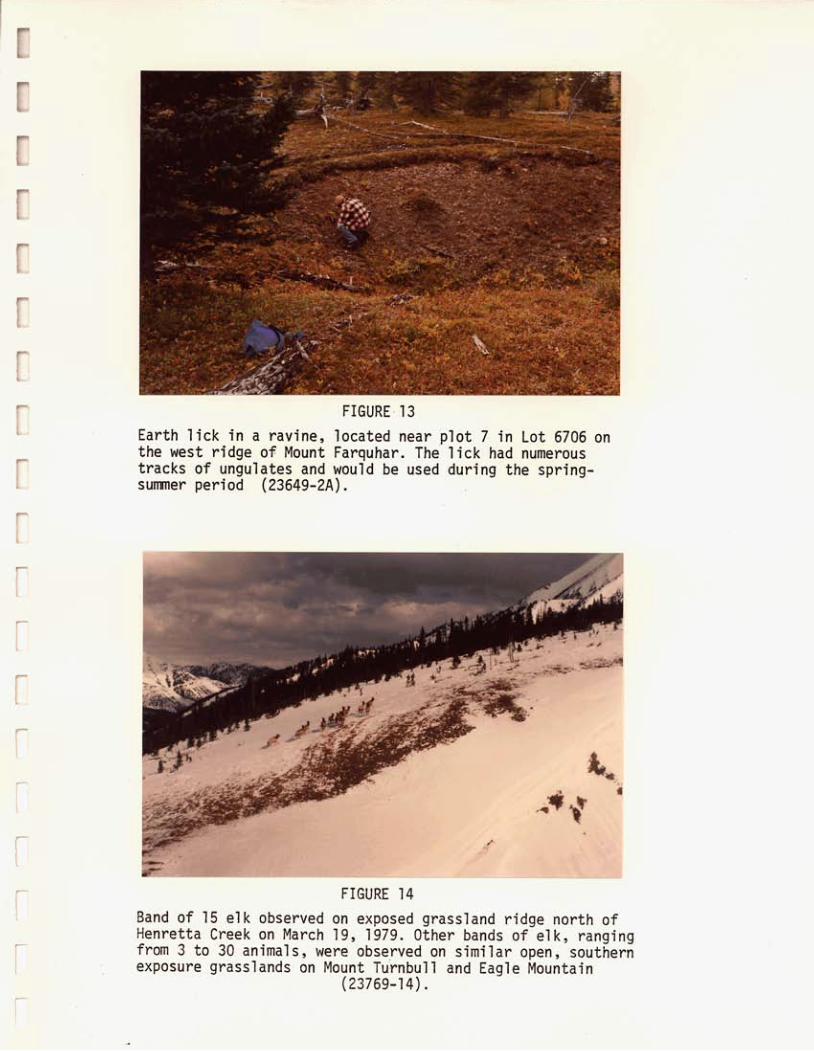
FIGURE 13 Earth lick in a ravine, located near plot 7 in Lot 6706 on the west ridge o f Mount Farquhar. The lick had numerous tracks o f ungulates and would be used during the spring- sumner period (23649-2A).
Band o f 15 elk observed on exposed grassland ridge north of Henretta Creek on March 19, 1979. Other bands o f elk, ranging from 3 to 30 animals, were observed on similar open, southern exposure grasslands on Mount Turnbull and Eagle Mountain
(23769-1 4).

.

APPENDIX 1
DATA AND INFORMATION SOURCES USED IN THE FORDING COAL STUDY
MAPS
National Topographic Series Maps
1:50,000 Scale 82512 E & W 825/7W
1:125,000 Scale 82J/SW {and part o f 82J/SE) 82G/NW (and part o f 82G/NE)
AIR PHOTOS
a) Federal - Energy, Mines and Resources Canada NAPL Production Center, Ottawa
RSA 30590-67 RSA 30590-68 (high level colour)
b) Provincial - Ministry o f the Environment Surveys and Mapping Branch Map Production Division, Victoria
BC7428~135-139 BC7428:190-203 BC7428 :233-244 (1:20,000 black and white)
c) McEl hanney Surveying and Engineering Ltd., Vancouver
06519-0 L1-2 to 8 06519-0 L2-14 to 18 (1 :30,000 colour)
AIR PHOTO MOSAICS
McElhanney Surveying and Engineering Ltd., Vancouver
Black and white air photo mosaics prepared for Fording Coal Ltd. and B.C. Research at scales o f 1:10,000 and 1:30,000 (based on 1978 aerial photography).

APPENDIX 1 (Concluded)
LAND CAPABILITY MAPS
Resources Analysis Branch, Ministry of the Environment, Victoria
a) Canada Land Inventory maps for NTS map sheets 82J/2 E & W and 82J/7W for:
- present land use - recreation - agriculture - forestry - waterfowl - ungulate (NTS map sheet 82J/SW)
b) c)
Forest cover map for 82J/2 E & W at 1:50,000 RAB Biophysical maps for 82J/2 at 1:50,000 for:
- surficial materials - soils - vegetation - recreation - ungulates
WATER QUALITY AND ASSOCIATED AQUATIC BIOLOGY DATA
B.C. Water Resources Service. 1976b. Kootenay Air and Water Quality Study Phase I, Water Quality in Region 2, The Elk River Basin. Ministry of the Environment, Victoria.
B.C. Water Investigations Branch. Phase 11, Water Quality in The Elk and Flathead River Basins. the Environment, Victoria.
Kootenay coal mining operations, August, 1978. P.C.B., Ministry o f the Environment, Nelson.
1978a. Kootenay Air and Water Quality Study Ministry of
Crozier, R.J. 1978. Report on sediment production in the vicinity of East
AIR QUALITY
B.C. Water Resources Service. 1976a. Kootenay Air and Water Quality Study Phase I, Air Quality in Region A, The Fording - Sparwood - Fernie Area Ministry of the Environment, Victoria.
B.C. Water Investigations Branch. 1978. Phase 11, Air Quality in the Elkford - Sparwood - Fernie Region. of the Environment, Victoria.
Kootenay Air and Water Quality Study Ministry

APPENDIX 2 RESOURCES ANALYSIS BRANCH -
AQUATIC BIOPHYSICAL DATA CARDS, SEPTEMBER, 1978

3 l d W V S lNlOd e:'S'M

Comnents : C1 - Vegetation Deciduous - sp.
Comnents :
C1 - Vegetation Coniferous - Picea sp., Pinus sp. C2 - Vegetation Deciduous - S z s p . C3 - Undercut Bank S t a b i l i z e ~ W W i l l c w Roots

w.5 .5 POINT SAMPLE
Cmments:
C l - Vegetation Coniferous - Pinus s p . , Picea s p . C2 - Vegetation Deciduous - Salix sp . , 1 Tree popvlus
C3 - Undercut Banks S t a b i l i z e d by Roots Tremuloides
W.S. 6 POINT SAMPLE
Connnents :
C l - Vegetation Coniferous - Picea sp C2 - Vegetation Deciduous - sp.

REACH


I..


APPENDIX 3
Locat ion and P lan t Conununity
A lp ine tundra
P l o t 4, Turnbu l l
A lp ine grasslands a. Rough fescue
P l o t 1, Turnbu l l b. P l o t 3, Eagle c. Idaho fescue
P l o t 5, Eagle
Subalpine grasslands P l o t 2, Turnbu l l P l o t 6, Turnbu l l
STATISTICAL ANALYSIS OF RANGE FORAGE LOSSES FROM FALL TO SPRING, AS DETERMINED BY FORAGE CLIPPING I N OCTOBER 1970 AND MAY 1971t
E leva t i on
(4
2,395
2,310 2,310
2,040
2,085 2,145
Aspect
ssw
S S
S
S ssw
j lope
("1 -
27
27 35
30
30 30
AVER. YIELD gm/m2
F a l l
76.2
88.9 140.9
228.8
186.3 142.1
Spr ing
36.7
42.1 -- 127.1
91.8 69.3
Percent Loss
51.8%
52.6% -- 44.4%
50.7% 51.2%
STAT1 S T I CAL SIGN I F I CANCE
Calcu lated F. value
114.654
22.071 -_ 27.860
13.856 24.692
S ign i f i cance l e v e l
**
** -- **
* **
t Source: B.C. Research, 1971. Report o f Grassland Vegetat ion Studies i n t h e Upper Ford ing R iver Va l l ey Between September29
* D i f f e rence i n average y i e l d s s t a t i s t i c a l l y s i g n i f i c a n t a t the 5% l e v e l .
** D i f f e rence i n average y i e l d s s t a t i s t i c a l l y s i g n i f i c a n t a t t h e 1% l e v e l .
and October 4, 1970. Progress Report No. 1, Phase 2. Report t o Cominco Ltd.

APPENDIX 4
0.69 1.73
1.65
1.75 1.18
P l o t No. and Locat ion
1.217 7.6 -- --
1.215 7.6
1.192 7.5 1.144 7.2
A lp ine tundra P l o t 4, Turnbu l l
A lp ine grasslands a. Rough fescue
P l o t 1 , Turnbu l l P l o t 3, Eagle
b. Idaho fescue P l o t 5, Eagle
Subalpine grasslands P l o t 2, Turnbu l l P l o t 6, Tu rnbu l l
RESULTS OF TOTAL NITROGEN ASSAY CONDUCTED ON FORAGE
OCTOBER 1970 COMPARED TO MAY 1971* FROM MOUNT TURNBULL AND EAGLE MOUNTAIN,
E leva t i on
(m1
2,395
2,310 2,310
2,040
2,085 2,145
Aspect
ssw
S S
S
S ssw
Slope
("1
27
27 35
30
30 30
TOTAL NITROGEN
% N
1.267
0.777 1.239
0.721
0.945 0.833
MAY, 1971 OCTOBER, 1970 I Crude P r o t e i n
7.9
4.9 7.7
4.5
5.9 5.2
Crude P r o t e i n N ( gm/M2 1
1.551
N (gm/M2 1
0.57
0.51 _-
0.84
1.09 0.79
* Source: B.C. Research. 1971. Report o f Grassland Vegetat ion Stud ies i n t h e Upper Ford ing R i v e r V a l l e y Between September 29 and October 4, 1970. Progress Report No. 1, Phase 2. Report t o Cominco L td .

APPENDIX 5
L I S T OF PLANT SPECIES FOUND I N THE BROWNIE CREEK COAL LICENCES AREA, 1978
S c i e n t i f i c Name Comnon Name
TREES
Abies Zasiocarpa (Hook.) Nutt. Larix ZyaZZii P a r l . Picea Engelmami Parry Pinus contorta Dougl.
SHRUBS
Abies Zasiocarpa (Hook.) Nutt. AZnus sinuata (Regel) Rydb. Amelanchier aZnifoZia Nutt. ArctostaphyZos uva-ursi (L.) Spreng. Empetm n i g m L. Juniperus corruriunis L. Larix ZyaZZii P a r l . Larix occidentazis Nutt. Linnaea borealis L. Lonicera invoZucrata (Rich.) Banks Lonicera utahensis Wats. Menziesia ferruginea Smith Picea engezmmnii Parry Pinus aZbicauZis Engelm. Pinus contorta Dougl. PopuZus t remloides Michx. Rhododendron a l b i f l o m Hook. Ribes Zacustre (Pers .) Poir. Ribes oxyeanthoides L. Rosa acicuZaris Lindl. Rosa woods i i Lindl. Rubus idaeus L. Rubus parviflorus Nutt. SaZix sp. Swnbucus racemosa L. aepherdia canadensis (L.) Nutt. Spiraea betuZifoZia P a l l . Vaccinium myrti l lus L. Vaccinh?n scop&wn Leiberg
Alpine F i r Alpine l a r ch Engelmann's spruce Lodgepole pine
Alpine F i r S i t k a a lder Serviceberry Kinnikinnick Crowberry Common mountain juniper Alpine l a r ch Mountain l a r ch Twinflower Bearberry honeysuckle Utah honeysuckle Fool's huckleberry Engelmann's spruce White bark pine Lodgepole pine Trembling aspen Rocky mountain rhododendron B r i s t l y black currant Northern gooseberry Prickly rose Wood's rose Red raspberry Thimbleberry Willow Elderberry Soapberry Shiny-leaf spiraea Drwarf b i lbe r ry Grouseberry

APPENDIX 5 (Cont'd)
Scientific Name Common Name
HERBS
AchiZZea miZZefoZiwn L. Agropyra caninwn (L.) Beauv. X Sitanion hystr ix (Nutt.) Sm. Agropyron repens (L.) Beauv. Agropyra spicatwn (Pursh) Scribn & Smith Agropyra SF. Agoseris aurmtiaca (Hook.) Greene Agoseris e lata (Nutt .) Greene Agoseris sp. Agrostis exarata Trin. Agrostis scabra Willd. Aira caryophyZZea L. A Z Z i w n cernum Roth AnaphaZis margaritacea (L.) Benth. & Hook. Anemone mltifida Poir Anenome occidentaZis Vats Antennerin anaphaZoides Rydb. Antennaria microphy 2 Za Rydb. A n t e n h a paruifolia Nutt. Antennaria racemosa Hook. Antennaria s p . Arnica cordifolia Hook. Arnica diversi fol ia Greene Arnica moZZis Hook. Arabis s p . L. Aster azpigenus (T. & G.) Gray Aster aZpinus L. Aster conspicutcs Lindl. Aster foliaceus Lindl. Aster Zaevis L. Aster sp. AstragaZus americanus (Hook.) Jones Astragalus miser Dougl. Broms pwnpeZZianus Scribn. CaZamagrostis canadensis CampanuZa rotmdifoZia L. Carex atrata L. Carex ni@cans Retz. Carex rupestris All. Carex sp. CastiZZeja miniata Dougl. Cerastium amense L.
Common Yarrow Unnamed hybrid Quackgrass Bluebunch wheatgrass Wheat gras s False-dandelion Tall Agoseris False-dandelion Spike bent Bentgrass Silver hairgrass Nodding onion Pearly everlasting Cut-leaved anemone Western pasqueflower Pussy-toes Rosy pussy-toes Nuttel's pussy-toes Raceme pussy-toes Pussy-toes Heart-leaved Arnica Sticky arnica Hairy arnica Rockcress Aster Aster Showy aster Leafy aster Smooth aster Aster American milk-vetch Weedy milk-vetch Bromegrass Bluejoint reedgrass Harebell Blackened sedge Black alpine sedge Curly sedge Sedge Scarlet paintbrush Field chickweed

APPENDIX 5 (Cont'd)
Scientific Name
HERES (Cont'd)
Cinna ZutifoZia (Trev.) Griseb. Cirsium vuzgare (Savi) Tenore Cornus canadensis L. Danthonia intermedia Vasey Deschcmrpsia elongata (Hook.) Munro Draba sp. EZymus glaueus Buckl. Elynius innovatus Beal
EpiZobium sp. L. Equisetwn urvense L. Equisetum scirpoides Michx. Eriogonwlr umbel Zatum Ton. Festuca scabreZZa Torr. F r a g d a virginiana Duchesne F d t i Z Z d a pudica (Pursh) Spreng Gentiana mareZZa L. Geranium viscosissimwn F. & M. Gem macrophyllwn Willd. Habenaria s p . Hedysanun suzphurescens Rydb. HeracZewn hnatwn Michx. Heuchera cyZhz?rica Dougl. Hieraciwn aZbifZorum Hook. Hieraciwn gracile Hook. LuzuZa parviflora (Ehrh.) Desv. MiteZla nu& L. Osmorhiza chiZensis Hook & Arn. PedieuZaris bracteosa Benth. Penstemon confertus Dougl. Penstemon sp. Petasites p a h t u s (Ait.) Gray Petasites sagittatus (Banks) Gray PhaceZia heterophyZta Pursh PhZewn aZpinwn L. Poa alpina L. Poa conrpressa L. Poa gracilzima Vasey Poa jun&foZia Scribn. Poa palustr is L. Poa sp. L. Polemonium p u l c h e r r i m Hook.
EpiZobium angustifoZiwn L.
Common Name
Wood seedgrass Bull thistle Bunchberry Timber danthonia Slender hairgrass Whitlow-grass Wild ryegrass Ryegrass Fireweed Fir eweed Field Horsetail Sedgelike horsetail Sulfur eriogonum Rough fescue Strawberry Yellow bell Northern gentian Sticky purple geranium Large-leaved avens Bog-orchid Yellow hedysarum Cow parsnip Roundleaf alumroot White-flowered hawkweed Hawkweed Wood rush Bare-stemmed mitrewort Mountain sweet cicely Bracted lousewort Yellow penstemon Penstemon Sweet coltsfoot Sweet coltsfoot Varileaf phacelia Alpine timothy Alpine bluegrass Canada bluegrass Pacific bluegrass Alkali bluegrass Fowl bluegrass Bluegrass Skunk-leaved Jacob's-ladder

APPENDIX 5 (Concluded)
Scientific Name
HERBS (Cont'd)
PotentiZZa nivea L. PyroZa sectmda L. PyroZa sp. PyroZa unifzora L. ScuteZZaria gaZericuZata L. Sedwn stenopetazwn Pursh Senecio pseudaureus Rydb. Senecio sp. Senecio trianguzaris Hook. Sitanion hystr ix (Nutt.) J.G.S. Thalictrwn sp. L. Thalictrwn venuZosm Trel. Tragopogon dubius scop. Trisetwn sgxtcatwn (L. ) Richt . Urtica dioica L. VaZeriana sitchensis Bong. Veronica wormskjoZdii Roem. & Schultz Vi&a americana Muhl.
BRYOPHYTES AND LICHENS
AuZacomim palustre AuZacomiwn sp. Atrichyzim sp. Brachythecim sp. Brywn s p . CZadonia sp. Dicrmm sp. KyZocOmiwn sp. Lophozia sp. Pettigera sp. PZeuroziwn sp. Pogonatzim a Zpinzim PoZytrichum sp. Stereocau Z o n sp . ToruZa princeps
Comon Name
Snow cinquefoil One-sided wintergreen Wintergreen Single delight Marsh skullcap Wormleaf stonecrop Streambank butterweed Groundsel Groundsel Squirreltail Meadow rue Veiny meadowrue Yellow salsify Spike trisetum Stinging nettle Valerian American alpine speedwell American vetch

APPENDIX 6
TREE MENSURATION DATA FOR BROWNIE CREEK COAL
LICENCES AREA. 1978
L lp ine Larch - A l p i n e F i r
Map U n i t
Larch - F i r - Grouseberry
l a t u r e Engelmann
Spruce - A l p i n e F i r
j e r a l Pine- Sp ruce -F i r
P l a n t Community
Spruce - F i r - Moss
P ine - Spruce - F i r
I
P l o t Number
9
12
14
4
15
20
6
P l a n t Species
Picea e w e tmannii
Picea engetmannii
Abies Zasiocarpa Pinus contorta
Abies lasiocarpa Picea engelamnnii Pinus contorta
Abies lusiocarpa Picea engeZmannii
Larix ZyaZlii
DBH (cm)
30 25 40
31
34
19 20
15 20 25
17 35
17
Age* ( Y r )
225 240 260
326
309
38 42
31 37 37
40 50
91
General Canopy He igh t
( m )
24.0 20.2 21.3
23.0
22.1
15.3 15.0
14.2 13.5 12.5
11.8 17.9
11.3
1 Bor ing h e i g h t a t 5 f e e t

APPENDIX 7
LEGEND
NUMERICAL CODING OF GENERAL PLOT DATA
MOISTURE REGIME:
hydric sybhydric , hygric s u b hy gr i c mes i c submes i c subxeric xer ic very xe r i c
SLOPE P O S I T I O N MACRO:
apex face upper slope middle slope lower slope valley f l o o r plain
SURFACE SHAPE:
smooth convex 1 i r r egu la r convex 2 smooth s t r a i g h t 3 i r r egu la r s t r a i g h t 4 smooth concave 5 i r r egu la r concave 6 smooth f l a t 7 i r r egu la r f l a t a
SLOPE P O S I T I O N MOISTURE:
shedding normal receiving co l lec t ing seepage
1 2 3 a 5
EXPOSURE TYPE:
wind 1 insotat ion 2 f ron t pocket 3 cold a i r drainage 4 (o ther ) 5 not appl icabl e 6

APPENDIX 8
LIST OF MAMMALS POSSIBLY OCCURRING I N THE FORDING RIVER AREA*
Conanon Name
ORDER INSECTIVORA ( I n s e c t i v o r e s )
Masked shrew Vagrant shrew American water shrew Pigmy shrew
ORDER CHIROPTERA (Bats)
Little brown bat Long-eared bat Long-legged bat Silver-haired bat Big brown bat Hoary bat
L a t i n Name
Sorex cinereus cinereus Sorex vagrans obscurus Sorex palustris navigator Microsorex hoyi washingtoni
ORDER LAGOMORPHA (Pikas, Hares and Rabbi ts)
Myotis lucifugus alascensis Myotis evotis evotis Myotis volans longicrus Lasionycteris noctivagans Eptesicus fuscus pallidus Lasiurus cinereus
American pika Snowshoe hare
ORDER RODENTIA (Rodents)
Least chipmunk Yellow pine chipmunk Hoary marmot Columbian ground squirrel Golden-mantled ground squirrel American red squirrel Northern flying squirrel American beaver Deer mouse Bushy-tailed wood rat Gapper's red-backed vole Northern bog lemming Heather vole Muskrat Richardson's water vole Meadow vole Long-tailed vole Western jumping mouse American porcupine
Ochotona princeps princeps Lepus americanus columbiensis
Eutamias minimus oreocetes Eutamias amoenus luteiventris Marmota caligata okanagana Spermophilus colmbianus columbianus Spermophilus lateralis tescorum Tamiasciurus hudsonicus richardsoni Glauconys sabrinus latipes Castor canadensis leucodontus Peromyscus maniculatus artemisiae Neotoma cinerea cinerea Clethrionomys gapperi galei Synaptomys borealis chapmani Phenacomys intermedius levis Ondatra zibethicus osoyoosensis Arvicola richardsoni richardsoni Microtus pennsylvanicus drummondii Microtus longicaudus vellerosus Zapus princeps idahoensis Erethizon dorsatum nigrescens
Continued...

Common Name
APPENDIX 8 (Concluded)
L a t i n Name
ORDER CARNIVORA (Carn ivores)
Coyote Wolf Red fox American black bear Grizzly bear American marten Ermine Long-tailed weasel American mink Wolverine American badger Striped skunk River otter Mountain lion LYnX Bobcat
Canis latrans lestis Canis lupus columbianus Vulpes vulpes macroura Ursus americanus cinnamomum Ursus arctos Martes americana abietinoides Mustela erminea invicta Mustela frenata oribasus Mustela vison energumenos Gulo gulo luscus Taxidea tams jeffersonii Mephitis mephitis hudsonica Lutra canadensis evexa Felis concolor missoulensis Lynx lynx canadensis Lynx rufus pallescens
ORDER ARTIODACTYLA (Cloven-hoofed Mammals)
Mule deer White-tailed deer Moose American elk Mountain goat Bighorn sheep
Total: 5 3 species
Odocoileus hemionus hemionus Odocoileus virginianus ochrourus Alces alces andersoni Cervus elaphus nelsoni Oreamnos americanus his canadensis canadensis
* Source: Banfield, A.W.F. 1 9 7 4 . The Mammals of Canada. University of Toronto Press, Toronto. 43% p.

APPENDIX 9
CHECK LIST OF BIRDS WHOSE BREEDING RANGES
C O I N C I D E WITH THE FORDING R I V E R AREAt*
ORDER GAVIIFORMES (Loons)
Common loon
ORDER P O D I C I PED I FORMES (Grebes )
Horned grebe Eared grebe
ORDER CICONIIFORMES (Herons)
American b i t t e r n
ORDER ANSERIFORMES (Geese, Ducks)
Canada goose Mal lard P i n t a i l Green-winged tea l B l ue-wi nged t e a l American widgeon Northern shoveler Lesser scaup Barrow's goldeneye Buff1 ehead Harlequin duck Hooded merganser Common merganser
ORDER FALCONIFORMES (Vultures, Hawks, Falcons)
Turkey vu l tu re Goshawk Sharp-shinned hawk Cooper's hawk Red- t a i 1 ed hawk Golden eagle Bald eagle Marsh hawk
Continued ...

APPENDIX 9 (~Cont'd)
ORDER FALCONIFORMES (Vultures, Hawks, Falcons) cont'd
Osprey Prairie falcon Peregrine falcon Merlin American kestrel
ORDER GALLIFORMES (Grouse)
Blue grouse Spruce grouse Ruffed grouse White-tailed ptarmigan Sharp-tailed grouse
ORDER GRUIFORMES (Rails)
Sora American coot
ORDER CHARADRI IFORMES (Shorebirds )
Ki 1 ldeer Comnon snipe Spotted sandpiper Wilson's phalarope
ORDER COLUMBIFORMES (Doves)
Mourning dove
ORDER STRIGIFORMES (Owls)
Great horned owl pygmy owl Great gray owl Long-eared owl Short-eared owl Saw-whet owl
Continued.. .

APPENDIX 9 (Cont'd)
ORDER CAPRIMULGIFORMES (Goatsuckers)
Common nighthawk
ORDER APODIFORMES (Swifts, Humningbirds)
Black s w i f t Vaux's s w i f t Rufous hummingbird Cal l iope humningbird
ORDER CORACIIFORMES (Kingf ishers)
Be1 ted k ing f isher
ORDER PICIFORMES (Woodpeckers)
Common f l i c k e r P i leated woodpecker Lewis ' s woodpecker Yel low-bel l ied sapsucker Will iamson's sapsucker Ha i ry woodpecker Downy woodpecker Black-backed three- toed woodpecker Northern three-toed woodpecker
ORDER PASSERIFORMES (Perching Bi rds)
Eastern k i ngbird Western k ingbi rd Say's phoebe Willow f l yca tcher Least f l yca tcher Hamnond's f l yca tcher Ducky f l yca tcher Western f l yca tcher Western wood pewee Olive-sided f l yca tcher Horned l a r k
Continued ...

APPENDIX 9 (concluded)
ORDER PASSERIFORMES (Perching Birds)
Violet-green swallow Tree swallow Bank swallow Rough-winged swallow Barn swallow Cliff swallow Gray jay Steller's jay Black- bil led magpie Comnon raven Common crow Clark's nutcracker Black-capped chickadee Mountain chickadee Boreal chickadee White-breasted nuthatch Red-breasted nuthatch Brown creeper American dipper House wren Winter wren Rock wren Gray catbird American robin Varied thrush Hermit thrush Swainson's thrush Veery Western bluebird Mountain bluebird Townsend's solitaire Golden-crowned kinglet Ruby-crowned king1 et Water pipit Bohemian waxwing Cedar waxwing Comnon starling Solitary vireo Red-eyed vireo
Warbling vireo Orange-crowned warbler Yellow warbler Yellow-rumped Warbler Townsend ' s warbler Northern waterthrush MacGillivray's warbler Common yellowthroat Wilson's warbler American redstart House sparrow Western meadowlark Ye1 low- headed blackbird Red-winged blackbird Brewer I s blackbird Brown-headed.cowbird Western tanager Luzul i bunting Evening grosbeak Purple finch Cassin's finch Pine grosbeak Gray-crowned rosy finch Pine siskin American goldfinch Red crossbill White-winged crossbill Rufous-sided towhee Savannah sparrow Vesper sparrow Dark-eyed junco Chipping sparrow Brewer's sparrow Whi te-crowned sparrow Fox sparrow Lincoln's sparrow Song sparrow
~ ~~~
t Source: Godfrey, W.E. 1966. The Birds of Canada. National Museum of Canada. Bull. No. 203, Biol. Series No. 73. Queen's Printer. Ottawa, 428 p.
* This list does not include migrant species which may pass through the area but do not breed there.
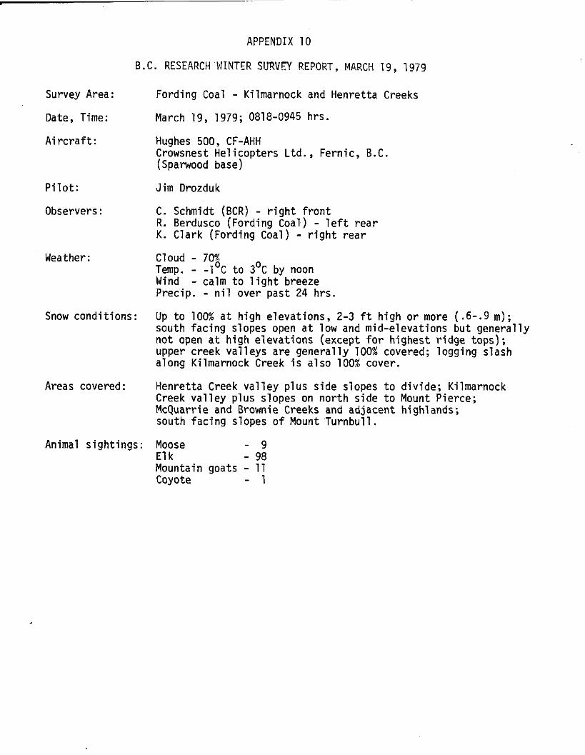
Survey Area:
Date, Time:
A i r c r a f t :
P i l o t :
Observers:
Weather:
Snow condi t ions:
Areas covered:
APPENDIX 10
B.C. RESEARCH NINTER SURVEY REPORT, MARCH 19, 1979
Animal s ight ings:
Fording Coal - Kilmarnock and Henretta Creeks
March 19, 1979; 081 8-0945 hrs . Hughes 500, CF-AHH Crowsnest Hel icopters Ltd., Fernic, B.C. (Sparwood base)
Jim Drozduk
C. Schmidt (BCR) - r i g h t f r o n t R. Berdusco (Fording Coal) - l e f t rear K. Clark (Fording Coal) - r i g h t rear
Temp. - -1 C t o 3 O C by noon Wind Precip. - n i l over past 24 hrs.
Up t o 100% a t high elevations, 2-3 f t high or more (.6-.9 m); south fac ing slopes open a t low and mid-elevations but general ly not open a t h igh elevat ions (except f o r h ighest r idge tops); upper creek va l leys are general ly 100% covered; logging slash along Kilmarnock Creek i s also 100% cover.
Henretta Creek va l l ey plus side slopes t o d iv ide; Kilmarnock Creek va l l ey plus slopes on nor th s ide t o Mount Pierce; McQuarrie and Brownie Creeks and adjacent highlands; south fac ing slopes o f Mount Turnbul l .
Cloud - 70%
- calm t o l i g h t breeze
Moose Elk
- 9 - 98
Mountain goats - 11 Coyote - 1

Sighting No. (Szz Fiztdye
1
Species
Moose
Elk
Elk
Elk
Elk
2,3
Date
Dct. 27/69
Oct. 15-31/69
Oct. 15-31/69
April 27/70
April 27/70
4
5
6
APPENDIX 1 1
WILDLIFE OBSERVATIONS I N OCTOBER, 1969 AND APRIL, 1970 IN THE FORDING
COAL AREA*
Beaver Oct. 15-31/69
Comnents
Hunter-killed moose along
Sign (tracks and droppings) on
Sign on Mount Turnbull
Single cow elk on north slope of Eagle Mountain (on small snow-free patch)
16 elk (15 cows and calves and 1 adult bull) on SW slope o f Mount Tur8bull at 195Om; slope 22 .
Single moose on west slope o f Castle Mountain at 1735 m.
Beaver dams on Fording River; on set tracks observed
Fording River
Eagle Mountain
* Source: B.C. Research. 1970b. Ecological Study - Fording River. Progress Report No. 3, Completing Phase 1. Report to Cominco Ltd.

APPENDIX 12
MULE DEER FOOD HABITS AS DETERMINED FROM ANALYSIS OF A FALL RUMEN SAMPLE*
Species
Forbs
Achillia millefolium Geranium viscosissimum (= triflorum) Heuchera % Polemonium Valeriana Forb 1 (unidentified) Forb 2 (unidentified) Forbs (unidentified)
Sub total Browse
Pachistima myrsinites Populus trichocarpa - Rosa gymnocarpa Spiraea 2 Browse (unidentified)
Subtotal
Grass
Grass sp (unidentified) Sub total
TOTAL
-
Cormnon Name
Yarrow Cranesbill Avens Alum root Polemonium Valer ian -- --
--
Oregon box wood Black cottonwood Rose Spiraea --
Percent by Volume
Tr Tr
22.2 Tr
4.4 3 . 3 7.3 5.6 4.4
47.2
2 2 . 6 3 . 4
16.6 Tr
7.7
50.3
2.5 2 .5
100
* Source: B.C. Research. 1971. Report of Grassland Vegetation Studies in the Upper Fording River Valley between September 29 and October 4 , 1970. Progress Report No. 1, Phase 2. Report to Cominco Ltd.

APPENDIX 14
B I G GAME OBSERVATIONS I N THE UPPER FORDING RIVER VALLEY, EAGLE MOUNTAIN AND MOUNT TURNBULL REGION, MAY AND JULY, 1971*
Date Location and Community Type Species
May 27-29, 1971
EAGLE MOUNTAIN
Plot 5 area, Idaho fescue
SE side of Eagle Mt. on open grassland
MOUNT TURNBULL
Between plots 1 and 2 , open subalpine forest
East of plot 1, rough Fescue alpine grassland
West of plot 2 , open forest community
July 27-28, 1971
EAGLE MOUNTAIN
Southwest side, spruce fir forest
MOUNT TURNBULL
East end of Clode Creek valley bottom, spruce- fir forest
I
May 27-2'
May 27
May 27
May 28
May 28
May 29
July 27-:
July 27
July 28
1971 -
Elk
Elk
Elk
Elk
Elk
1971
Mule deer
Elk
Observation
1 cow, 1 short yearling, 1 unclassified elk grazing the open grassland, 6,700 ft.
1 unclassified elk, 6,500 ft. Subtotal 4 .
1 cow, 1 short yearling calf, 7,000 ft.
2 cows, 2 short yearling calves, 7,500 ft.
3 unclassified. 6.500 ft. Subtotal 9 Total 13
Adult buck, 6,000 ft.
8 unclassified, 6,600 ft. Total 8 elk
1 mule deer -
* Source: B.C. Research. 1972. Range Survey and Wildlife Observations in the Upper Fording River Valley, 1971. Report No. 2 , Phase 2. Report t o Cominco Ltd.


i_.
!,? - . -. _,
i 1
i 1
r -.-._. i \
M a p 1 L O C A T I O N M A P

Polution Control Branch A02002521 Water Quality Site
Location of Fish Traps May 11-14 and June 18-19,1979 (B.C. Research)
0 TI
.
I I I
CONTOURS IN METERS
LOCATION OF AQUATIC SAMPLING SITES
BROWNIE CREEK COAL LICENCES
Preparea by B C Reseorch April, 1979 3 2 . ":","",",F E A R C H 8. c. '>

LEGEND AQUATIC BIOPHYSICAL
(Adopted from R.A.B. System)
YC t r 2 c l 23RI
substrate chonnel // chonnel channel t
profile slope cross section
FISH SPECIES YCt = yellowstone cutthroat @ = absence of f ish
0 = expectotion but unconconfirmed
CHANNEL
profile: r = regular slope
s = stepped (e.g. pool and r i f f l e sequence)
slope: %o grodient(e1evation difference/ reach length) cross section; c = confined
b = bounded (some loteral movement possible) u = unconfined (e.g. a groding fon, much laterol movement possible)
First digit x 10 = % of fines 0 - 2 m m . size closs
Second digit x 10 = % moteriol i n 2 -64mm. size closs Rn = R without postscript n indicotes occosional (<lo%) outcrops in substrate postscript n x 10 = bedrock substrate
Note: Larges (64-256mm.) are found by difference
ADDITIONAL SYMBOLS
SYMBOL MEANING
c
I I

I I I

L E G E N D
MAP UNIT Mature Engelmann spruce - Alpine fir Logged Sera1 Pine - Englemann spruce- Alpine fir
Young Engelmann - Mature spruce -Alpine f i r
Alpine larch - Alpine fir Meadow Pioneer Shrub Alpine f i r Krummholz Non- Vegetated
- Young
ON SITE SYMBOLS
Vegetation plot site Map unit .boundary Air photo centre(BC 191 7428 to 1991 Series,
Example of a composite map unit:
SYMBOL (MIEsAF LO
(Y ISPESAF (MISPESAF (YIEsAF ALAF ME PS AFK NV
x 3
ME7PS3 (70VoMeadow and 3OYO Pioneer Shrub map units)
-1---------7 KILOMETERS
0 I 2
SCALE I ~ 25,000
CONTOURS it4 M E T E R S
I

L E G E N D
Locbtion of sighting - Species and number of animals sighted indicated.
x 10 Elk - Approximate boundary of ’ Survey Area
I

(Adapted fmn R.A.B. Sur f i c ia l Hap)
.. , ~ - . ~ . , - ~ -- . . .
iplanation of L s t t e r Nowtion
A combination of l e t t e r s i s used to g s i g n a t e each map uni t . The re la t i ve pos l t ion of l e t t e r s w i th in tlyr symbol indicates the c h a r ~ ? $ r i s t i c tha t they represent,
modifying process
gF 1 4 I texture --'I t s u r t a c e expression genu ic w t e r i a l
Uni ts consist inq of fwo or nare typqf of t e r r a i n are designated by n*c o r m r e PUPS of l e t t e r s rrparated by dots and slashes:-
f.9. gFtldCf (See Eolposi te Uni ts below)
k t e r i a l underlying the surface w i t i s s h o n by a S W o l that i s w i t t e n beneath €he surface u n i t symbol and s e w r t o d fw it by a bwi(onta1 l ine : -
e.g. sEv S F
t t e r p a r t i c l e mbol flame size (mn.) other character ist ics
4 q r a s l i y >E-256 rqnded & subrounded per- t i c l w (includes i n te r - s t i t i a l sand)
i s i l t y 0.0039-0.0625
C clgyey <0.0039
d d i m i c t o n hrtcrogenwus mixture o f pa r t i c l es of any size. m u d ness o r angular i ty in s i l t and c lay matr ix
r rubbly 2-256 pngular and subangular par- t i c l e s w i th f iner i n y r - s t i t i a l mater ia l
p a n i $ l e s a blacky ,256 angular and subangular
tes:- (1) The absence of a tex tu ra l t e rn fry a uni$ symbcl indicates tha t texture of th material W@I not pb; sewed i n the f i e l d an4 cowo t be r e l i a b l y in - terpreted fm a i r p h a w . T b reader i( R f e r r e d to thc general tex tu ra l &$csiptisns uner th heqding Genetic Mater ia ls (belnr).
( 2 ) Where tm tex tu ra l terms are gseq togrther, they are wr i t t en i n order o f IncreiSimJ impor$ancg. ep. 15 i s s i l t y sand, $q i s gandy grgvel.
(31 A diamiqton t e i t u r e i s a l w y r inplied i n tw case qf m r a i n a l (EO m t e r l a l s . Any tex tu rq l term y r i t t e n i n the symbol " s l y w d i f i e s Chis W s i r texture. eg. i t4 indicates till consir;ing o f $ i l t y d im ic ton . not s i l t alone.
~
1 i . ~ . . , . , .. .
- .. c_I
vrface Expression
Ctter wl nam description _.
a
b
f
In
I
s
1
I
apron
blanket
fan
r v l i i n g
ri.$ged
steep
a r e l a t l v e l y gent ly slwing swrfacf t ha t i s a t the foot o f a s toeper s l o w and underlain by mater ia l deriv@d fry tha t s t a e w r slow. a mantle of unconsolidated neterlcl which bas no constructional form o f i t s om. but derives l t s g w r p l Surface exvression frsn the tow- graphy o f the un i t which i t over- i l e s ; i t masks minor topagradpic i r r e g u l a r i t i e s i n the underlying u n i t and i s mr@ than 1 m thick. - if th. underlying u n i t wnglstS of unconsolidated materials. i t i s skew i n the unit s p l w l ; if no underlying u n i t i s shorn. i t may be i s s u n d to be bedrock.
a surface tha t i s the sector pf a cone.
elongate o r l inear . pa ra l l e l p r subparallel h l l l s o r ridge5 with s l o w $ generally less t h w 15' pnd 1ocs1 r e l i e f of mre than 1 m.
elongate or l inear , pa ra l l e l o r subparallel h i l l s o r r i d g w with slopes predminant ly betweqn 15 an4 35' on unconsolidgted w t e r r a l ' and between I $ and 90 on b.dwt.
steeply in:lined erosionel $laws (scarps) with gradients ~ a m n l y g ~ e a t e r than 35' on UncMi01 ip tSd no te r ia l s and greater than $6 on badrock
undulating low h i l l s and depwssions w i th $lope$ generally less than 15' and rounded o r i r regu la r i n plan; ioca l r e l i e f gwa te r than 1 m,
P mantle of uncqnsolidated natQria1 which has no construetional form of i t s o m , but derives i t s surface PXPreSsion frm the topography Of the underlying un i t ; i t re f l ec ts minor i r r e a u l a r i t i e s o f the w d w .
veneer
l y i ng surfice, i s generally b e t w n 10 Outcrops of the underlying u n i t a r e C r n " .
and 1 m i n thicknasi, and
- if the underlying metsr i4 l i s unconsoli4ated, i t i s included i n the u n i t symbol; if no undqrlying u n i t i s indicated, i t i s pssumed t o Lm bedmck.

netic Materials
tter name mbol (process status')
difying Processes I
C colluvial ( A ) products of mass wastage; includes rubbly bedrock-derived material and material derived f r m uncon- solidated Quaternary sediments: includes earthflow, mudflow and landslide deposits and talus material. - generally consists of massive to nnderately Well-stratified sedimnts with a great range of particle sizes.
by streams and rivers: alluvial mterial I . - generally consists of moderatel, to well-bedded and moderately to well-sorted gravels andlor silt.
glaciers; till. - generally consists of cmpact. non-sorted and non-stratified ma- terial that contains a wide range of particle sizes and a matrix of silt or clay.
than 10 ms. of unconsolidated material.
F fluvial (I) material transported and deposited
Y morainal (I) material deposited directly by
? bedrock ( I ) outcrops and rock covered by less
tter name mbol (process status') description I
bn-site Symbols
blacier meltwater channel (minor)
blockfield
puntain escarpment
terrain unit boundary c__
(direction of flow known, unknown)
v ~
a avalanched ( A )
'A process status descriptor is designated for each genetic material and for each modifying process on the basis of their nnst comrmn state of activitv at the oresent time. (See
0 frost shattered ( A )
S soliflucted ( A )
~, ~~~ ~ ~
Processes aoove.. ' n .nit SFDOIS on the mdo only *new fnc Cwrenr stare If acrivity i s contrary t o t i c desiqnateo state.
Pvcers status iescrIptors a ~ e s n o m
V gullied ( A )
Cmposite Units
Composite units are mployed nhere tM or three types Of terrain are intermixed or occupy such w11 areas that they cannot be designated as separate units at the scale of mdpping. Symbols (defined belo*) are used to indicate the relative amunts of each terrain type. and the components are always written in de- creasing order of importance.
I the cmponent in front of the symbol is more extensive than the on& that follows.
the componenri in front of the symbol is con- siderably more extensive than the one that f0llOuJ.
11
eg. MbIR Mb is considerably more extensive than R
slopes modified by frequent snow avalanches and by the deposition of rock debris transported by snow avalanches.
rock surfaces covered with angular frag!nentS derived in situ by frost shattering.
surface modified by the s l n dwn-slope movment of saturated overburden across a frozen or other- wise impcmable substrate.
Surface crossed by deep, j step-sided ravines that are parallel or subparallel and result f m fluvial erosion.
. the components on are approximately
either equal.
side Of this Symbol
Mb/R.Cv Mb is considerably more extensive than R: R and Cv are of rouohlv
~~
equal extent
MblRIICv R i s less extensive than Mb; Cv is considerablv less than R