preface paper to the semi-arid land-surface-atmosphere ... · ities of the french agencies ird and...
TRANSCRIPT

Agricultural and Forest Meteorology 105 (2000) 3–20
Preface paper to the Semi-Arid Land-Surface-Atmosphere(SALSA) Program special issue
D.C. Goodricha,∗, A. Chehbounib, B. Goffa, B. MacNishc, T. Maddockc, S. Morana,W.J. Shuttleworthc, D.G. Williamsc, C. Wattsl , L.H. Hippse, D.I. Cooperf ,J. Schieldgen, Y.H. Kerrg, H. Ariasl, M. Kirklandf , R. Carlosf , P. Cayrolg,
W. Kepnerq, B. Jonesq, R. Avissars, A. Begueh, J.-M. Bonnefondo, G. Bouletb,B. Brananr, J.P. Brunelb, L.C. Cheni, T. Clarked, M.R. Davism, H. DeBruinj,G. Dedieug, E. Elguerob, W.E. Eichingeri, J. Everittm, J. Garatuza-Payanc,
V.L. Gempkoc, H. Guptac, C. Harlowc, O. Hartogensisj, M. Helfertd, C. Holifieldd,D. Hymerb, A. Kahlen, T. Keefera, S. Krishnamoorthyi, J.-P. Lhommeb,
J.-P. Lagouardeo, D. Lo Seenh, D. Luqueth, R. Marsetta, B. Montenyb, W. Ni d,Y. Nouvellonh, R. Pinkert, C. Petersc, D. Poolp, J. Qid, S. Rambalk, J. Rodriguezl,
F. Santiagol, E. Sanoc, S.M. Schaefferc, M. Schultec, R. Scottc, X. Shaof ,K.A. Snyderc, S. Sorooshianc, C.L. Unkricha, M. Whitakerc, I. Yucelc
a USDA-ARS, Southwest Watershed Research Center, Tucson, AZ 85719, USAb IRD/IMADES, Hermosillo, Sonora, Mexico
c University of Arizona, Tucson, AZ, USAd USDA-ARS Water Conservation Laboratory, Phoenix, AZ, USA
e Utah State University, Logan, UT, USAf Los Alamos National Laboratory, Los Alamos, NM, USA
g CESBIO, Toulouse, Franceh CIRAD, Montpellier, France
i University of Iowa, Iowa City, IA, USAj AUW, Wageningen, Netherlands
k CEFE, CNRS, Montpellier, Francel IMADES, Hermosillo, Sonora, Mexico
m USDA-ARS, Weslaco, TX, USAn Jet Propulsion Laboratory, Pasadena, CA, USA
o INRA, Bordeaux, Francep USGS-WRD, Tucson, AZ, USAq US-EPA, Las Vegas, NV, USA
r Audubon Research Ranch, Elgin, AZ, USAs Rutgers University, New Brunswick, NJ, USA
t University of Maryland, College Park, MD, USA
∗Corresponding author.
0168-1923/00/$ – see front matter Published by Elsevier Science B.V.PII: S0168-1923(00)00178-7

4 D.C. Goodrich et al. / Agricultural and Forest Meteorology 105 (2000) 3–20
Abstract
The Semi-Arid Land-Surface-Atmosphere Program (SALSA) is a multi-agency, multi-national research effort that seeksto evaluate the consequences of natural and human-induced environmental change in semi-arid regions. The ultimate goal ofSALSA is to advance scientific understanding of the semi-arid portion of the hydrosphere–biosphere interface in order to pro-vide reliable information for environmental decision making. SALSA approaches this goal through a program of long-term,integrated observations, process research, modeling, assessment, and information management that is sustained by cooperationamong scientists and information users. In this preface to the SALSA special issue, general program background informationand the critical nature of semi-arid regions is presented. A brief description of the Upper San Pedro River Basin, the initial loca-tion for focused SALSA research follows. Several overarching research objectives under which much of the interdisciplinaryresearch contained in the special issue was undertaken are discussed. Principal methods, primary research sites and data col-lection used by numerous investigators during 1997–1999 are then presented. Scientists from about 20 US, five European (fourFrench and one Dutch), and three Mexican agencies and institutions have collaborated closely to make the research leadingto this special issue a reality. The SALSA Program has served as a model of interagency cooperation by breaking new groundin the approach to large scale interdisciplinary science with relatively limited resources. Published by Elsevier Science B.V.
Keywords:Interdisciplinary; Semi-Arid; Land-Surface-Atmosphere; SALSA; Water balance; Energy balance; Ecological diversity
1. Introduction
The Semi-Arid Land-Surface-Atmosphere (SALSA)research Program seeks to evaluate the consequencesof natural and human-induced environmental changein semi-arid regions. The ultimate goal of thismulti-agency, multi-national research effort is to ad-vance scientific understanding of the semi-arid por-tion of the hydrosphere–biosphere interface in orderto provide reliable information for environmental de-cision making. SALSA is accomplishing this goalthrough a long-term, integrated program of obser-vation, process research, modeling, assessment, andinformation management, using both existing and in-novative technologies, and sustained by cooperationamong scientists and information users. A necessaryaspect of providing reliable information to decisionmakers is the publication of peer-reviewed researchresults. This special issue of Agricultural and ForestMeteorology brings together a number of SALSA re-search results in a unified format. This presentation isa preface to the SALSA special issue. A synthesis ofthese results is provided by Chehbouni et al. (2000c)at the end of this issue.
2. SALSA Program background
SALSA grew out of a convergence of several ongo-ing and proposed efforts to observe, quantify, and
model hydrometeorological and ecological processesin semi-arid regions. The experimental componentof the program follows the format of earlier land-surface-atmosphere studies, specifically “Monsoon’90”(Kustas and Goodrich, 1994) and “Walnut Gulch’92”(Moran et al., 1993) conducted in southeastern Ari-zona, USA, in 1990 and 1992; the European FieldExperiment in a Desertification-Threatened Area(EFEDA) in Spain (Bolle, 1995); and “Hapex-Sahel,”conducted in Niger, western Africa between 1991 and1993 (Goutorbe et al., 1994).
Building on the experience of previous field ex-periments, Goodrich (1994) proposed a multi-yearprogram to evaluate global change processes over awide range of spatial and temporal scales. The chal-lenge posed by this proposal was to evaluate the waterand energy balance for a heterogeneous semi-aridlandscape. In July 1995, 65 scientists from nine fed-eral agencies, eight universities, six foreign agencies,and several NASA/EOS science teams representing abroad spectrum of scientific disciplines met in Tucson,AZ to discuss plans for the SALSA effort (Wallace,1995). A principal outcome of the 1995 workshopwas the formulation of the Primary Science Objectiveto be addressed by SALSA researchers:
To understand, model, and predict the consequencesof natural and human-induced change on the basin-wide water balance and ecological complexity ofsemi-arid basins at event, seasonal, interannual, anddecadal time scales.

D.C. Goodrich et al. / Agricultural and Forest Meteorology 105 (2000) 3–20 5
It purposefully focuses on two separate but highlyinterrelated ecosystem components: water balance andecological complexity. The terrestrial water balancedetermines water availability, the primary factor lim-iting human and natural populations in semi-arid re-gions. Ecological complexity — representing species,habitat, and landscape diversity — is a key indicatorof environmental quality and stability in these regions.Water balance and ecological complexity interact atthe land-surface-atmosphere interface, making this theprimary target for SALSA observations.
River basins comprise well-bounded hydrologicalsystems, and encompass many biological and culturalsystems of interest, hence, research focuses on thebasin scale. By examining land-surface-atmosphereprocesses at a basin scale, SALSA results will havedirect applicability to environmental management ac-tivities based on basin or watershed planning units.Similarly, the range of time scales to be examined bySALSA — from event to decadal — falls within theeffective design and planning horizon for most man-agement decisions.
SALSA operates on the principle of voluntarycollaboration whereby researchers interact with oneanother across disciplinary, institutional, and politicalboundaries to address particular components of thePrimary Science Objective. Collaborators are free topursue their own lines of scientific inquiry in accor-dance with their institutional needs and resources,and may join or leave the program as they wish.The purpose of the organized SALSA “Program”is to facilitate these interactions and to serve as aplatform for research coordination, data assimilationand synthesis, and information exchange. The roleof the SALSA researcher is to collaborate with fel-low SALSA researchers to gain maximum benefitfrom the resources used to address the Primary Ob-jective. The ultimate product of the SALSA effortwill be a comprehensive “knowledge-base” of data,information, and tools that will aid environmentaldecision-making in semi-arid regions.
The USDA-Agricultural Research Service (ARS)in Tucson, AZ is the institutional home of SALSA.The ARS provides overall program administrationand coordination, and shares leadership and plan-ning responsibilities with Institut de Recherche pourle Développement (IRD, formerly ORSTOM), theFrench overseas research agency. IRD and its sister
agencies CESBIO, INRA and CIRAD bring a globalperspective to SALSA that in the future will helpextend SALSA research and product applications tosemi-arid regions in other parts of the world. Cur-rently, IRD scientists based in Hermosillo, Mexico— in close cooperation with their Mexican counter-parts in the Sonoran environmental agency IMADES— have directed and implemented SALSA activitiesin Mexico. SALSA is linked to several other globalchange research programs, primarily through its col-laborating scientists. Thus SALSA is closely tied tothe ARS’s National Global Change Program (Agricul-tural Research Service, 1998), which is guided by theUS Global Change Research Program. Similarly, it isclosely aligned with the global change research activ-ities of the French agencies IRD and CNRS. SALSAis also associated with various remote sensing tech-nology development efforts including NASA-EOS,ASTER, ERS-2, SPOT4-VEGETATION, ADEOS,and MODIS programs. SALSA will also be a keycontributor to the new NSF Science and Technol-ogy Center on “sustainability of water resources insemi-arid regions” established at the University ofArizona along with a wide range of partners.
2.1. Semi-arid regions
Over 20 countries worldwide, most of them in aridand semi-arid regions, are considered to be eitherwater-scarce or water-stressed because their growingpopulations require more water than the hydrologicalsystem can provide on a sustainable basis (Watsonet al., 1998). Even as the demand for water growsin these countries, the supply is being diminished byhuman activities that degrade watersheds and threatennatural ecosystems. The “desertification” of drylandsnegatively affects nearly one billion humans on 35–40million km2 of land, or about 30% of the world’s landsurface (FAO, 1993). While water shortages and de-sertification affect all dryland areas, developing coun-tries are particularly vulnerable to the economic andsocial costs associated with the decline of agriculturaland natural ecosystem productivity.
The prospect of natural or human-induced globalchange greatly increases the risks and challenges al-ready faced by these countries. Under current assump-tions of global warming, climate models predict majorshifts in world precipitation and evaporation patterns

6 D.C. Goodrich et al. / Agricultural and Forest Meteorology 105 (2000) 3–20
over the next century (UNEP, 1997). Semi-arid re-gions, many of which are already drought-prone, maysuffer longer and more severe dry periods, as wellas more destructive flooding and erosion caused byhigher-intensity rainfall events. The combined effectof these stresses could permanently alter the waterbalance in some semi-arid regions, further reducingwater availability to human and natural ecosystems.
Ecological complexity in semi-arid regions isclosely tied to water availability and is threatenedby the same unsustainable practices that disrupt thewater balance (UNEP, 1997). Many organisms andecosystems in these regions are already experiencingwide-spread habitat destruction, isolation, and frag-mentation (Watson et al., 1998). The loss of nativespecies (drylands are the ancestral home of major cropspecies such as wheat, barley, and sorghum) increasesthe vulnerability to agricultural systems worldwide. Itis predicted that global change will exacerbate theseproblems, as the physical barriers and environmentalstresses caused by human activity prevent organismsand ecosystems from adapting or migrating (Janetos,1997).
The adverse effects of natural and human-inducedenvironmental change are already manifest in semi-arid regions worldwide. The failure of communitiesin these regions to protect their natural resource baseis due, in part, to an incomplete understanding of thephysical and biological processes operating in semi-arid ecosystems, and the inability to monitor theseprocesses over a broad range of time and space scales.Even in developed countries, policy-makers andresource managers often lack the information and toolsneeded to detect, predict, and mitigate widespread,incremental, long-term change on water and biotic re-sources. These inadequacies will be greatly magnifiedin the event of major shifts in global climate patterns.Consequently, there is a need to better understand thekey ecological processes operating in semi-arid envi-ronments, and to develop observation, monitoring, andmodeling technologies that can be applied to globalchange problems in these environments worldwide.
SALSA intends to address this societal need througha long-term, integrated program of observation, pro-cess research, modeling, assessment, and informationmanagement. The program will employ a variety ofground-based and remote sensing techniques to ac-quire new knowledge on key hydrologic and ecologi-
cal processes operating within semi-arid river basins.SALSA will use a representative test basin, the UpperSan Pedro, as its primary experimental and observa-tional area. However, information from related stud-ies will be incorporated into its “knowledge-base.”SALSA will use airborne and satellite-based remotesensing technologies to help quantify the spatial dis-tribution of land–surface processes and, in turn, willuse ground-based measurements to calibrate and val-idate remote sensing systems. The relationships andtechnologies developed in the test basin will then beapplied to other semi-arid environments.
2.2. Upper San Pedro River Basin
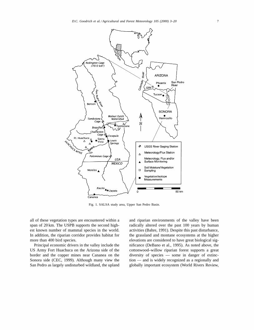
The Upper San Pedro Basin (USPB), located inthe semi-arid borderland of southeastern Arizona andnortheastern Sonora (Fig. 1), is a broad, high-desertvalley bordered by mountain ranges and bisected by anarrow riparian corridor sustained by an intermittentstream. The basin has a variety of characteristics whichmake it an exceptional outdoor laboratory to addressa large number of scientific challenges in arid andsemi-arid hydrology, meteorology, ecology, and thesocial and policy sciences. The area represents a tran-sition between the Sonoran and Chihuahuan desertswith significant topographic and vegetation variation,and has a highly variable climate. It is an interna-tional basin with significantly different cross-borderlegal and land use practices. The upper and middleportions of the basin have a drainage area of 7610 km2
at the US Geological Survey gaging station at Red-ington, AZ with approximately 1800 km2 in Mexico.Elevations within the basin range from roughly 1100to 2900 m.
The annual rainfall in the USPB ranges from around300 to 750 mm. Approximately 65% of this typicallyoccurs during the July through September monsoonseason from high intensity air – mass convective thun-derstorms. Roughly 30% comes from less intensewinter frontal systems. Potential evapotranspirationis estimated at more than 10 times annual rainfallat lower elevations (Renard et al., 1993). Interan-nual climate variability is also high with a demon-strated linkage to the El Niño-Southern Oscillation(Woolhiser et al., 1993). Major vegetation types in-clude desert shrub-steppe, riparian, grasslands, oaksavannah, and ponderosa pine. In portions of the basin
D.C. Goodrich et al. / Agricultural and Forest Meteorology 105 (2000) 3–20 7
Fig. 1. SALSA study area, Upper San Pedro Basin.
all of these vegetation types are encountered within aspan of 20 km. The USPB supports the second high-est known number of mammal species in the world.In addition, the riparian corridor provides habitat formore than 400 bird species.
Principal economic drivers in the valley include theUS Army Fort Huachuca on the Arizona side of theborder and the copper mines near Cananea on theSonora side (CEC, 1999). Although many view theSan Pedro as largely undisturbed wildland, the upland
and riparian environments of the valley have beenradically altered over the past 100 years by humanactivities (Bahre, 1991). Despite this past disturbance,the grassland and montane ecosystems at the higherelevations are considered to have great biological sig-nificance (DeBano et al., 1995). As noted above, thecottonwood–willow riparian forest supports a greatdiversity of species — some in danger of extinc-tion — and is widely recognized as a regionally andglobally important ecosystem (World Rivers Review,

8 D.C. Goodrich et al. / Agricultural and Forest Meteorology 105 (2000) 3–20
1997). In 1988, the United States Congress estab-lished the San Pedro Riparian National ConservationArea (SPRNCA), the first of its kind in the nation, toprotect riparian resources along 60 km of river northof the US–Mexico border (Bureau of Land Manage-ment, 1989). The US Bureau of Land Management(BLM) administers the conservation area in a mannerthat conserves, protects, and enhances its riparianvalues. A number of factors outside the control ofthe BLM make protection of the SPRNCA problem-atic: mine-related pollution, surface diversions, andgroundwater pumping in Mexico; potential water-rights claims by downstream users; and increasedwater use by communities near the conservation area(Jackson et al., 1987; Pool and Coes, 1999). Greatconcern exists regarding the long-term viability of theSan Pedro riparian system and ranching in the face ofcontinued population growth. Groundwater sustainsthe riparian system in the United States and also muchof the ranching industry in the Mexican portion ofthe San Pedro. The threat of excessive groundwaterpumping to this riparian system prompted the firstapplication of international environmental law withinUS via the North American Free Trade Agreement(CEC, 1999).
Many of the resource management problems in theUpper San Pedro Basin are due to a lack of infor-mation about the water and ecological systems beingmanaged. Despite the considerable amount of infor-mation already available, more is needed. High prior-ity needs include better quantification of those compo-nents of the water balance known with little certaintysuch as aquifer recharge, groundwater–surface-waterinteraction, and evapotranspiration from uplands andriparian areas. Research also needs to be conducted onthe effect of changing land use and water availabilityon the ecological complexity of the basin.
For SALSA, the USPB represents an ideal outdoorlaboratory, containing diverse topographic, climatic,vegetative, and land use features within a well-defineddrainage basin. These characteristics are useful in de-veloping and testing land-surface-atmosphere processmodels, and calibrating and validating satellite-basedEarth observation systems (Wallace, 1995). For over40 years, a great deal of hydroclimatological researchof semi-arid lands has been conducted in a sub-basinof the San Pedro at the USDA-ARS Walnut GulchExperimental Watershed (Goodrich and Simanton,
1995). This densely instrumented facility provides afoundation and extensive knowledge base for SALSAto expand to the larger USPB. The basin containsriparian and upland ecosystems that show evidenceof historic human impact on the vegetation of theregion, changes that continue today. Kepner et al.(2000) documented significant land cover and landuse change in the San Pedro over a nearly 25-yearperiod using classified Landsat satellite images (seediscussion related to objective four for more details).
3. 1997–1999 SALSA scientific objectives
The 1997–1999 SALSA activities were part of alonger term (3–10 year effort) to address the PrimaryObjective. These secondary objectives were formu-lated to address the Primary Objective and servedto integrate the research of several disciplines. Theyfocus on priorities established at the initial SALSAworkshop that were within logistical and monetaryconstraints. They were:1. Initiate the development and validation of a cou-
pled soil–vegetation–atmosphere transfer (SVAT)and vegetation growth model for semi-arid regionsthat will assimilate remotely sensed data with sev-eral years of observed data;
2. develop and validate aggregation schemes with dataover very highly heterogeneous surfaces;
3. conduct in situ and remote measurements to: (a)quantify and develop models for groundwater, sur-face water, and evapotranspiration interactions on aseasonal basis; (b) identify plant water sources; and(c) identify plant function and atmospheric con-trols on a semi-arid riparian system consisting ofmesquite, sacaton, and cottonwood/willow vegeta-tion communities; and
4. develop a multi-scale system of landscape patternindicators using remotely sensed data to estimatecurrent status, trend and changes in ecological con-dition; and investigate the impact of these changeson water cycle and surface–atmosphere interaction.The research conducted under these objectives
forms the foundation for addressing the SALSA Pri-mary Objective in the following manner. The researchassociated with the secondary objectives one andtwo is required to improve our understanding andour ability to model climatic and land use/land cover
D.C. Goodrich et al. / Agricultural and Forest Meteorology 105 (2000) 3–20 9
change impacts on the water and energy balance oflarge semi-arid regions. This cannot be achieved with-out an accurate representation of the coupled hydro-ecological processes, and an improvement of therepresentation of sub-grid scale heterogeneity inatmospheric models. The research associated withthe third objective is required because water use bysemi-arid riparian systems is a major factor in thesemi-arid water balance. Riparian systems support amuch higher proportion of the biodiversity than thearea they represent in semi-arid regions. Yet there is agreat deal of uncertainty in quantifying riparian wateruse as well as effects that changes in riparian wateravailability will have on riparian vegetation and theassociated species that are supported in this habitat.
The research associated with objective four is re-quired to quantify the changes in land use and landcover over three decades for the entire basin. This pro-vides a foundation for assessing the impacts of thesechanges on the primary components of the water andenergy balance. The spatial size and connectivity ofland cover are also a significant indicator of habi-tat characteristics required to support various species.Changes in these characteristics are often importantfactors in the survivability or increasing population ofvarious species.
4. Methods
The methods used in the first phase of the SALSAProgram spanning roughly the 1996–1999 period arediscussed in this section. Existing data collection net-works that were either used or expanded upon arebriefly mentioned. New experiments and additionaldata collection to address the objectives noted aboveare then briefly introduced.
Surface observations were obtained from a varietyof existing data collection networks. These includedintensive monitoring at the 148 km2 USDA-ARSWalnut Gulch Watershed (85 raingages, 30 runoffmeasurement sites, two sites with energy and CO2flux, meteorology, vegetation and soil moisture mea-surements; Renard et al., 1993), meteorological datacollection by the US Army at Fort Huachuca, and fiveUSGS stream gaging stations along the Upper SanPedro. In Mexico, four contrasting sites representingdifferent situations with respect to surface degrada-
tion have been instrumented (see Fig. 1). These sitesranged from a native and well-managed grassland,representing the pre-degradation conditions in thebasin, to a mesquite site representing the ultimatestage of degradation. These sites were equipped withmicro-meteorological devices to measure meteoro-logical forcing parameters (precipitation, wind speedand direction, air temperature and humidity, shortand long-wave radiation) and fluxes of water, en-ergy and CO2 (Chehbouni et al., 2000a; Nouvellonet al., 2000b; Cayrol et al., 2000). Soil moisture andtemperature were sampled at different depths in thesoil. Vegetation characteristics, stomatal conductance,surface reflectance and surface temperature at twodifferent view angles were taken at different sites. Intwo of the sites (grass and mesquite), runoff measure-ments were also made. Finally, a set of three largeaperture scintillometers (LAS) were used to addressthe issue of estimating area-average convective fluxover heterogeneous surfaces.
4.1. Objective one
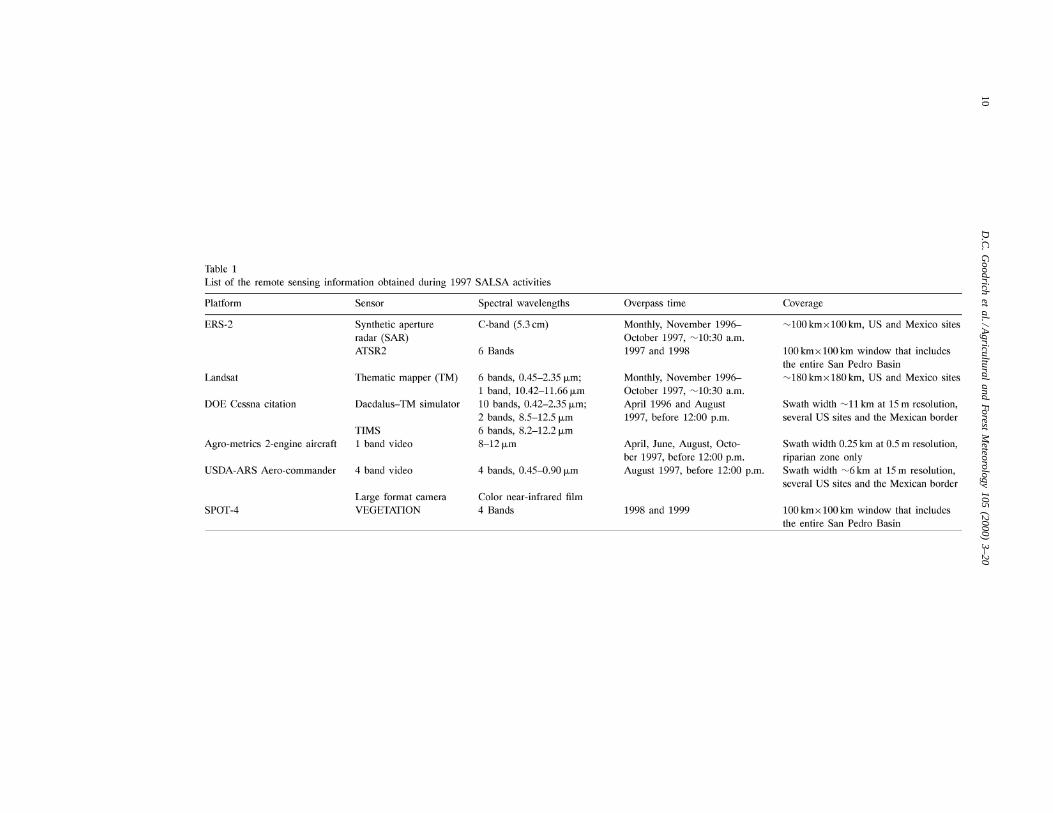
A wide variety of in situ and remotely sensed datawere collected at these sites to address this objective(Moran et al., 2000; Pinker et al., 2000; Nouvellonet al., 2000b; Qi et al., 2000). A summary of tim-ing, coverage, and sensor specifications of SALSA-related images is presented in Table 1. NOAA-AVHRRdata was also acquired and processed during sig-nificant portions of the study period. Several soil–vegetation–atmosphere-transfer (SVAT) models, withdifferent degrees of complexity were developed oradapted and successfully validated using multi-yeardata collected at different sites (Boulet et al., 2000;Nouvellon et al., 2000a; Cayrol et al., 2000; Nouvel-lon et al., 2000b). Some of these SVATs were coupledto different grass-functioning models (Cayrol et al.,2000; Nouvellon et al., 2000a). These models werealso coupled to radiative transfer models so that satel-lite observations could be assimilated into the processmodel. This procedure appeared to be very effectivein keeping the model on the right track by read-justing some of the unknown and spatially variablemodel parameters (Nouvellon et al., 2000b; Cayrolet al., 2000). Extensive large scale measurements, on ascale commensurate with the resolution of mesoscaleatmospheric models and satellites such as AVHRR,
10D
.C.
Go
od
riche
ta
l./Ag
ricultu
ral
an
dFo
rest
Me
teo
rolog
y1
05
(20
00
)3
–2
0

D.C. Goodrich et al. / Agricultural and Forest Meteorology 105 (2000) 3–20 11
ATSR2 and MODIS, of sensible heat flux were alsotaken at a relatively uniform site with a scintillometer(Lagouarde et al., 2000). In a study by Watts et al.(2000), sensible heat flux derived from the scintil-lometer measurements over a 1 km transect comparedfavorably to an estimate using AVHRR-based surfacetemperature.
4.2. Objective two
From August 8 to 19 of the 1997 growing seasonriparian experimental field campaign (discussed ingreater detail in Section 4.3) a greater concentrationof instrumentation, including two more aircraft, weredeployed at the Lewis Springs riparian site. Additionalinstrumentation deployed at this time included an ar-ray of eddy correlation flux instruments (Hipps et al.,1998), a scintillometer (Chehbouni et al., 1999), andthe Las Alamos National Laboratory Raman LIDAR(LIght Detection And Ranging) system (Cooper et al.,2000; Eichinger et al., 2000). During the first portionof the August campaign an intercomparison of flux in-
Table 2Schedule of SALSA activities, 1997
struments was conducted over a homogeneous regionof the sacaton grass while the LIDAR was deployedon the east bank of the San Pedro River. Kao et al.(2000) used this and a variety of measurements in theriparian corridor to do a very high-resolution atmo-spheric simulation of a portion of the corridor. Afterseveral days the LIDAR was moved to the west bankand the flux instruments were redeployed across thehighly heterogeneous vegetation types under the pathof the scintillometer. Objective two was addressedin part with these data due to the wide variationin vegetation type, height and stress resulting fromdifferential access to groundwater in the compact ri-parian area. Additional scintillometer data collectionwas also carried out in Mexico in 1998 and 1999 overa large grass site, mesquite and mixed grass–mesquitetransects to address this objective. These data havebeen used to develop and validate a wide range ofaggregation schemes (Chehbouni et al., 2000a,b).
Finally, ground-based remotely sensed observationsof atmospheric moisture derived from interferometricmethods (Shao et al., 1998) were also taken roughly

12 D.C. Goodrich et al. / Agricultural and Forest Meteorology 105 (2000) 3–20
400 m south of the Lewis Springs site. Like the scintil-lometer measurements, these were taken on a scale ofseveral kilometers. The temporal distribution of thesemeasurements and many of those described for 1997are summarized in the activity/data collection chart(Table 2).
4.3. Objective three
In addition to the broader-scale measurements notedabove, an intensive set of groundwater, surface water,isotope, energy flux and plant transpiration measure-ments were concentrated in the Lewis Springs sec-tion of the San Pedro Riparian corridor to addressthis objective. This stream section is a “gaining reach”where groundwater contributes water to the stream.The vegetation type and structure in the Lewis Springsarea was judged to be representative of vegetationthroughout the 60 km long SPRNCA. This ripariansystem typically consists of a narrow (20–100 m) cot-tonwood/willow forest gallery surrounded on eitherside by riparian grasses and mesquite thickets. Thesegrow on a flood plain that varies in width from severalhundred to between 1 and 2 km. A primary goal of the
Fig. 2. Lewis Springs section of the San Pedro riparian corridor with a summary of the simultaneous measurements carried out.
research and measurements within this corridor wasto quantify the surface water, groundwater, and evapo-transpiration fluxes into and out of the control volumeas depicted in Fig. 2 (Maddock et al., 1998; MacNishet al., 2000; Goodrich et al., 2000). This figure showsa schematic of the Lewis Springs section of ripariancorridor geometry and a conceptualization of the typesof simultaneous measurements to address this objec-tive. The network of instrumentation installed at LewisSprings is illustrated in Fig. 3.
Continuous measurements of water levels in thedeep wells, meteorology and fluxes (Bowen Ratio)over the riparian grass and mesquite thicket (Scottet al., 2000), and stream stage at section three weremade continuously throughout 1997. Measurementsof soil gravimetric moisture, temperature, and tensionwere taken in the near-stream bank trenches to inves-tigate bank storage-stream conductance relationships(Whitaker et al., 1998) for the last half of 1997.
In addition to the continuous measurements, inten-sive synoptic in situ and remote measurement cam-paigns of 48–120 h were conducted in March, April,June, August, and October of 1997. These synopticmeasurement periods coincided with tree phenologic

D.C. Goodrich et al. / Agricultural and Forest Meteorology 105 (2000) 3–20 13
Fig. 3. A schematic of the network of instrumentation installed at Lewis Springs.
stages and environmental conditions (pre-greenup,initial leaf-out, summer drought, monsoon, andpost-monsoon) of the entire growing season. Thisenabled characterization of the seasonal variations inevapotranspiration, and surface-water–groundwaterinteractions. Measurements taken during the synopticruns included hourly stream stage and water levelsfrom five river sections and the piezometer networkas well as stream discharge measurements determinedby current metering, dye-dilution, and an in-streamflume for the June campaign (Maddock et al., 1998;MacNish et al., 2000). Neutron probe measurements
of soil moisture were made during synoptic runs andother periods of dynamic change. Tree sap flow, waterpotential, stomatal conductance, and water sourcesusing stable oxygen and hydrogen isotope ratios weredetermined for mesquite, cottonwood, and willow.These measurements were made during each of thesynoptic campaigns to capture variations in transpira-tion demand as a function of atmospheric demand andsurface moisture availability (Schaeffer et al., 2000;Snyder and Williams, 2000). A subset of the vege-tation and water source measurements were made inan intermittent, losing and ephemeral riparian stream

14 D.C. Goodrich et al. / Agricultural and Forest Meteorology 105 (2000) 3–20
Fig. 4. Top row: San Pedro Basin land cover in 1973, 1986, 1992 and 1997. Middle row: change in grassland cover; 1973–1986, 1986–1992,1992–1997. Bottom row: change in mesquite woodland cover; 1973–1986, 1986–1992, 1992–1997. Note, for the middle and bottom rowred denotes a loss in cover type, yellow — no change, and green denotes a gain over the respective time period.

D.C. Goodrich et al. / Agricultural and Forest Meteorology 105 (2000) 3–20 15
reach (at Boquillas and Escapule locations, respec-tively, see Fig. 1). This design enabled the proportionand magnitude of surface water use by the gallerytrees as a function of groundwater availability to beevaluated.
Concurrent with these in situ measurements,ground-, aircraft-, and satellite-based remotely sensedmeasurements were taken. Reference tarps were alsodeployed to allow for atmospheric and systematic cor-rections of image data (Perry and Moran, 1994; Moranet al., 1994; Qi et al., 1998). These included monthlyacquisition of image sets from the Landsat TM andERS-2 SAR satellite sensors (Table 1). Furthermore,at each site measurements of surface reflectance andtemperature were made with hand-held radiometersfor small-scale studies and for validation of the satel-lite images. The five synoptic measurement periodswere also selected to coincide with overpasses of theLandsat and ERS-2 satellites. In addition, arrange-ments were made for aircraft overpasses to providefine-resolution (1, 5 and 15 m) images of the ripariansite, the Mexican border area, and several upland sitesof interest (see Table 1).
4.4. Objective four
The research related to this objective was motivatedby the critical need for defining status, trends andchanges in land use and land cover for contemporaryland management. Kepner et al. (2000) addressedthis objective through classifications of basin imageryfrom the 1970s, 1980s and 1990s. They noted thatnumerous studies (e.g. Houghton et al., 1983; Turner,1990; McDonnell and Pickett, 1993) suggest thathuman land use management practices are the mostimportant factor influencing ecosystem structure andfunctioning at local, regional, and global scales. Thedistribution of land use, including its type and extent,is a major factor affecting ecological and hydrologicalcondition related to alteration of species composi-tion, food-web structure, ecosystem carbon storage,and interactions between biota (Forman and Gordon,1986). Kepner et al. (2000) employed a landscapeframework, as it provides the context: (1) to investi-gate changes in composition, pattern distribution, andprocess function; (2) to compare conditions acrossmixed landscapes; and (3) to assess cumulative sourcesof environmental change (Jensen and Everett, 1994).
Kepner et al. (2000) acquired Landsat MSS andTM imagery over the USPB from 1973, 1986, 1992,and 1997. The images were resampled to 60 m×60 mpixel resolution, coregistered, and georeferenced us-ing the UTM coordinate grid. Vegetation and landuse within each image was processed into a 10-classsystem (see top portion of Fig. 4). Using this data, thechange in land cover classes was computed betweensuccessive land cover maps. These maps allowedcomputation of a variety of discrete landscape met-rics to assess dominance, fragmentation, and rates ofconversion.
In order to document the impact of land degra-dation (grass–mesquite transition) on the partitioningof available energy into sensible and latent heat flux,and on the partitioning of precipitation into runoffand infiltration, a specific investigation was carriedout in Mexico. This involved infiltration tests, isotopicsampling and analysis, and soil moisture monitoring.The results indicated that infiltration decreased, andtherefore runoff and erosion increased with increas-ing mesquite invasion. They also indicated that themesquite develops, along with its deeper roots, an ex-tensive surface root system. This dual root system al-lows the mesquite to extract water from the shallowsoil when this is available (during the monsoon sea-son) and to switch to deeper sources during the dryseason (also see Snyder and Williams, 2000).
5. Conclusions
Major progress has been made in addressing thePrimary Objective through a series of intensive exper-imental campaigns, long-term monitoring, applicationof innovative remote sensing techniques, and subse-quent analyses. The synthesis paper by Chehbouni etal. (2000c) at the end of this special issue summarizesthe primary findings and conclusions related to ob-jectives one through three. Several of the conclusionsresulting from research related to objective four arepresented here as they present an excellent overviewof the character of the Upper San Pedro Basin. Inaddition, they demonstrate the dynamic nature of thebasin as well as the great degree of change takingplace in the USPB.
The middle and lower portions of Fig. 4 illustrate asubstantial loss of grassland and a dramatic increase

16 D.C. Goodrich et al. / Agricultural and Forest Meteorology 105 (2000) 3–20
in mesquite woodland during the period between 1973and 1986. Table 3 contains a list of the relative landcover changes over several time periods for each of thecover classes. It is readily apparent that the mesquitewoodland has encroached upon the entire watershedwith over a 400% increase in the 1973–1986 period.Its total extent increased fivefold between 1973 and1986, from 20,812 to 107,334 ha. Where grassland wasthe dominant cover type, its total extent has steadilydeclined over each of the three sample periods. Over50,000 ha of vegetative communities dominated byperennial and annual grasses were lost between 1973and 1992, with the major decrease occurring between1973 and 1986 (46,025 ha lost).
Additional spatial analyses indicated that extensive,highly connected grassland and desert scrub areasare the most vulnerable ecosystems to fragmentationand actual loss due to encroachment of xerophyticmesquite woodland. During the study period, grass-lands and desert scrub became more fragmented aswell as decreasing in extent. As stated by Kepner et al.(2000), greater fragmentation implies the number ofgrassland and desert scrub patches increased and theiraverage patch sizes decreased. “In stark contrast, themesquite woodland patches increased in size, number,and connectivity. These changes have important im-pact for the hydrology of the region, since the energyand water balance characteristics for these cover typesare significantly different.” Mesquite woodlands canexploit water sources at greater depths and can there-fore out-compete shallow rooted grasses. To reverse
Table 3Percent relative land cover change for the Upper San PedroWatershed (1973–1986, 1986–1992, and 1973–1992) from Kepneret al. (2000)
Time period 1973–1986 1986–1992 1973–1992
Forest 0.12 −4.93 −4.82Oak woodland 0.54 −4.23 −3.71Mesquite 415.72 −1.02 410.47Grassland −14.70 −2.04 −16.44Desert scrub −17.69 −2.68 −19.90Riparian −28.01 3.41 −25.55Agriculture 55.95 33.05 107.49Urban 207.83 22.51 277.14Water −67.63 342.37 43.21Barren 55.23 4.62 62.40
this process and replace mesquite with grasses is en-ergy intensive and very difficult to accomplish on alarge scale. These dramatic changes at the basin scaleare an indication of the urgency needed to providepolicy and decision makers of the basin with soundresearch and data to enhance their ability to managebasin resources for a sustainable future.
From a programmatic perspective SALSA has ser-ved as a model of interagency cooperation. Scientistsfrom about 20 US, five European, and three Mexicanagencies and institutions currently cooperate in condu-cting SALSA research. These scientists readily shareresources and data with other SALSA researchers withwhom they are co-investigators. In addition, SALSAcooperates with several federal, state, and local gov-ernment agencies, and non-governmental organiza-tions, that it considers to be SALSA information-users,or clients.
The SALSA Program has broken new groundin the approach to large scale interdisciplinary sci-ence where limited resources are available. Carefulplanning resulted in the identification of critical andexciting scientific challenges that not only required,but fostered, interdisciplinary collaboration. Carefulattention to enhancing interdisciplinary communica-tion built the foundation for trustful collaborations.This enabled unselfish sharing of numerous smallgrants and in-kind resources to accomplish a goalwhich is much greater than the sum of the individualparts. An additional driving force behind the SALSAProgram’s success is the knowledge that the resultsof this research will directly aid land managers anddecision-makers in the near term.
The order of papers within the special issue isroughly aligned with the first three objectives dis-cussed above, with results from the forth discussedherein. Remote sensing results are presented firstfollowed by SVAT-related research and the param-eterization of water and energy fluxes in arid andsemi-arid regions. Next a series of papers discuss therepresentation of heterogeneity in surface-controllingparameters. Several papers then follow addressing thefunction and dynamics of basin vegetation with spe-cial emphasis on the competition for water betweengrass and mesquite. Finally, a set of papers focusedon the San Pedro riparian corridor and the interactionbetween riparian vegetation, ground water and surfacewater are presented.

D.C. Goodrich et al. / Agricultural and Forest Meteorology 105 (2000) 3–20 17
Acknowledgements
Financial support from the USDA-ARS GlobalChange Research Program, NASA grant W-18,997,NASA Landsat Science Team, grant No. S-41396-F,USDA National Research Initiative Grant Program,Electrical Power Research Institute, Arizona De-partment of Water Resources, US EnvironmentalProtection Agency, Office of Research and Develop-ment; IRD-France, the French Remote Sensing Pro-gram (PNTS); EU through VEGETATION Projectsand the ERS2/ATSR2 Projects; CONACYT (Project4298P-T), and US Bureau of Land Management isgratefully acknowledged. Assistance was also pro-vided in part by the NASA/EOS grant NAGW2425,EPA STAR Graduate Student Fellowship Program,National Science Foundation, US Geological Survey,US Department of Energy contract W-7405-ENG-36,California Institute of Technology-Jet PropulsionLaboratory (NASA, EOS/ASTER), WAU (Wagenin-gen Agricultural University, Netherlands), CochiseCounty Highway and Flood Control Department,and Fort Huachuca; this support is also gratefullyacknowledged. Support from the NSF-STC SAHRA(Sustainability of semi-Arid Hydrology and RiparianAreas) under Agreement No. EAR-9876800 is alsogratefully acknowledged. Special thanks are extendedto the ARS staff located in Tombstone, AZ for theirdiligent efforts and to USDA-ARS Weslaco for pi-lot and aircraft support. We also wish to extend oursincere thanks to the many ARS and University ofArizona staff and students, and local volunteers whogenerously donated their time and expertise to makethis project a success.
Appendix A. List of acronyms
ADEOS Advanced Earth Observing SatelliteASTER Advanced Spaceborne Thermal
Emission and Reflection RadiometerATSR2 Along Track Scanning RadiometerAUW Wageningen Agricultural University
(Netherlands)BLM Bureau of Land ManagementCEC Center for Environmental
Cooperation
CEFE Centre d’Ecologie Fonctionnelleet Evolutive
CESBIO Centre d’Etudes Spatiales dela Biosphere
CIRAD Centre de Cooperation Internationaleen Recherche Agronomique pour leDeveloppment
CNRS Centre National de la RechercheScientifique
EFEDA European Field Experiment in aDesertification-Threatened Area
ERS-2 European Remote Sensing SatelliteFAO Food and Agriculture Organization
of the United NationsHAPEX Hydrology–Atmosphere Pilot
ExperimentIMADES Instituto del Medio Ambiente y el
Desarrollo Sustentable del Estadode Sonora
INRA Institut National de la RechercheAgronomique
IRD Institut de Recherche pour leDeveloppment
Landsat-MSS Land Satellite MultispectralScanner
Landsat-TM Land Satellite Thematic MapperMODIS Moderate Resolution Imaging
SpectroradiometerNASA-EOS National Aeronautics and Space
Administration Earth ObservingSystem
NOAA-AVHRR National Oceanic and Atmospheric
Administration Advanced Very HighResolution Radiometers
SPOT4 Satellite Probatoire d’Observationde la Terre
SPRNCA San Pedro Riparian NationalConservation Area
SVAT Soil–Vegetation–AtmosphereTransfer Model
UNEP United Nations EnvironmentProgram
USDA-ARS United States Department ofAgriculture-AgriculturalResearch Service
US-EPA United States-EnvironmentalProtection Agency

18 D.C. Goodrich et al. / Agricultural and Forest Meteorology 105 (2000) 3–20
USGS-WRD United States GeologicalSurvey-Water Resources Division
USPB Upper San Pedro Basin
References
Agricultural Research Service, 1998. Global Change. NationalResources and Sustainable Agricultural Systems. Draft NationalProgram Statement 204, February 1998. US Departmentof Agriculture, Agricultural Research Service, Washington,DC. Internet Document, URL: http://www.ars.usda.gov/nps/programs/204b.htm.
Bahre, C.J., 1991. A Legacy of Change: Historic Human Impacton Vegetation in the Arizona Borderlands. The University ofArizona Press, Tucson, AZ.
Bolle, H.-J., 1995. Identification and obsenation of desertificationprocesses with the aid of measurements from space. Resultsfrom the European Field Experiment in Deserification-threatened Areas (AFEDA). In: Mouat, D.A., Hutchinson, F.(Eds.), Desertification in developed countries. Kluwer AcademicPublishers, Dordrecht, 1995, pp. 93–101.
Boulet, G., Chehbouni, A., Braud, I., Vauclin, M., Haverkamp, R.,Zammit, C., 2000. A simple water and energy balance modeldesigned for regionalization and remote-sensing data utilization.Agric. For. Meteorol. 105, 117–132.
Bureau of Land Management, 1989. San Pedro River riparianmanagement plan and environmental impact statement. Final.US Department of the Interior, Bureau of Land Management,Safford, AZ.
Cayrol, P., Chehbouni, A., Kergoat, L., Dedieu, G., Mordelet,P., Nouvellon, Y., 2000. Grassland modeling and monitoringwith SPOT-4 VEGETATION instrument during the 1997–1999SALSA experiment. Agric. For. Meteorol. 105, 91–115.
CEC (Commission for Environmental Cooperation), 1999. Ribbonof life, an agenda for preserving transboundary migratory birdhabitat on the Upper San Pedro River. CEC, Montreal, Canada,31 pp. http://www.cec.org.
Chehbouni, A., Kerr, Y.H., Hartogensis, O., Goodrich, D., Scott,R., Schieldge, J., Lee, K., Shuttleworth, W.J., Dedieu, G., DeBruin, H.A.R., 1999. Estimation of area-average sensible heatflux using a large aperture scintillometer. Water Resour. Res.35, 2505–2512.
Chehbouni, A., Watts, C., Lagouarde, J.-P., Kerr, Y.H., Rodriguez,J.-C., Bonnefond, J.-M., Santiago, F., Dedieu, G., Goodrich,D.C., Unkrich, C., 2000a. Estimation of heat and momentumfluxes over complex terrain using a large aperture scintillometer.Agric. For. Meteorol. 105, 215–226.
Chehbouni, A., Watts, C., Kerr, Y.H., Dedieu, G., Rodriguez,J.-C., Santiago, F., Cayrol, P., Boulet, G., Goodrich, D., 2000b.Methods to aggregate turbulent fluxes over heterogeneoussurfaces: application to SALSA data set in Mexico. Agric. For.Meteorol. 105, 133–144.
Chehbouni, A., Goodrich, D.C., Moran, M.S., Watts, C.J., Kerr,Y.H., Dedieu, G., Kepner, W.G., Shuttleworth, W.J., Sorooshian,S., 2000c. A preliminary synthesis of major scientific results
during the SALSA Program. J. Agric. For. Meteorol. 105,311–323.
Cooper, D.I., Eichinger, W.E., Kao, J., Hipps, L., Reisner, J.,Smith, S., Schaeffer, S.M., Williams, D.G., 2000. Spatial andtemporal properties of water vapor and latent energy flux overa riparian canopy. Agric. For. Meteorol. 105, 161–183.
DeBano, L.F., Ffolliott, P.F., Ortega-Rubio, A., Gottfried, G.J.,Hamre, R.H., Edminster, C.B. (technical coordinators), 1995.Biodiversity and management of the madrean archipelago: thesky islands of southwestern United States and northwesternMexico, September 19–23, 1994, Tucson, AZ. GeneralTechnical Report RM-GTR-264. US Department of Agriculture,Forest Service, Rocky Mountain Forest and Range ExperimentStation, Fort Collins, CO, 669 pp.
Eichinger, W., Cooper, D., Kao, J., Chen, L.C., Hipps, L., 2000.Estimating of spatially distributed latent energy flux overcomplex terrain from a raman lidar. Agric. For. Meteorol. 105,145–159.
FAO, 1993. Sustainable development of drylands and combatingdesertification. FAO Position Paper. Food and AgricultureOrganization of the United Nations, Rome, 1993.
Forman, R.T.T., Gordon, M., 1986. Landscape Ecology. Wiley,New York.
Goodrich, D.C., 1994. SALSA-MEX: a large scale Semi-AridLand-Surface-Atmospheric mountain experiment. In: Procee-dings of the 1994 International Geoscience and Remote SensingSymposium (IGARSS’94), Vol. 1, Pasadena, CA, August 8–12,pp. 190–193.
Goodrich, D.C., Simanton, J.R., 1995. Water research andmanagement in semi-arid environments. J. Soil Water Conserv.50 (5), 416–419.
Goodrich, D.C., Scott, R., Qi, J., Goff, B., Unkrich, C.L., Moran,M.S., Williams, D., Schaeffer, S., Snyder, K., MacNish, R.,Maddock, T., Pool, D., Chehbouni, A., Cooper, D.I., Eichinger,W.E., Shuttleworth, W.J., Kerr, Y., Marsett, R., Ni, W., 2000.Seasonal estimates of riparian evapotranspiration using remoteand in situ measurements. Agric. For. Meteorol. 105, 281–309.
Goutorbe, J.-P., Lebel, T., Tinga, A., Bessemoulin, P., Bouwer,J., Dolman, A.J., Engman, E.T., Gash, J.H.C., Hoepffner, M.,Kabat, P., Kerr, Y.H., Monteny, B., Prince, S.D., Saıd, F.,Sellers, P.J., Wallace, J.S., 1994. Hapex-Sahel: a large scalestudy of land–surface interactions in the semi-arid tropics. Ann.Geophys. 12, 53–64.
Hipps, L.E., Cooper, D., Eichinger, W., Williams, D., Schaeffer,S., Snyder, K., Scott, R., Chehbouni, A., Watts, C., Hartogensis,O., Lhomme, J.-P., Monteny, B., Brunel, J.-P., Boulet, G.,Schieldge, J., De Bruin, H., Shuttleworth, J., Kerr, Y., 1998. Asummary of processes which are connected to evaporation ofriparian and heterogeneous upland vegetation in arid regions.In: Proceedings of the Special Symposium of American Societyof Meteorologists on Hydrology, Phoenix, AZ, January 11–16,pp. 13–17.
Houghton, R.A., Hobbie, J.E., Melillo, J.M., Moore, B., Peterson,G.J., Shaver, G.R., Woodwell, G.M., 1983. Changes in thecarbon content of terrestrial biota and soil between 1860 and1980: a net release of CO2 to the atmosphere. Ecol. Monogr.53, 235–262.

D.C. Goodrich et al. / Agricultural and Forest Meteorology 105 (2000) 3–20 19
Jackson, W., Martinez, T., Cuplin, P., Minkley, W.L., Shelby,B., Summers, P., McGlothlin, D., Van Haveren, B., 1987.Assessment of water conditions and management opportunitiesin support of riparian values: BLM San Pedro Riverproperties, Arizona, Project Completion Report. Report No.BLM/YA/PT-88/004+7200. US Department of the Interior,Bureau of Land Management Service Center, Denver, CO.
Janetos, A.C., 1997. Do we still need nature? The importanceof biological diversity. Consequences. The Nature andImplications of Environmental Change, Vol. 3, No. 1, 1997.Saginaw Valley State University, Michigan. Internet document:http://www.gcrio.org/consequences/vol3no1/biodiversity.html.
Jensen, M.E., Everett, R., 1994. An overview of ecosystemmanagement principles. In: Jensen, M.E., Bourgeron, P.S.(Eds.), Eastside Forest Ecosystem Health Assessment, Vol.II: Ecosystem Management: Principles and Applications.PNW-GTR-318, USDA Forest Service, Missoula, MT, pp. 7–16.
Kao, C.-Y.J., Hang, Y.-H., Cooper, D.I., Eichinger, W.E., Smith,W.S., Reisner, J.M., 2000. High-resolution modeling of LIDARdata: mechanisms governing surface water vapor variabilityduring SALSA. Agric. For. Meteorol. 105, 185–194.
Kepner, W.G., Watts, C.J., Edmonds, C.M., Maingi, J.K., Marsh,S.E., Luna, G., 2000. A landscape approach for detectingand evaluating change in a semi-arid environment. J. Environ.Monitoring Assessment, 64 (1), 179–195.
Kustas, W.P., Goodrich, D.C., 1994. Preface to special section onMONSOON’90. Water Resour. Res. 30, 1211–1225.
Lagouarde, J.-P., Chehbouni, A., Bonnefond, J.-M., Rodriguez,J.-C., Kerr, Y.H., Watts, C., Irvine, M., 2000. Analysis ofthe limits of the CT
2-profile method for sensible heat fluxmeasurements in unstable conditions. Agric. For. Meteorol. 105,195–214.
MacNish, R.D., Unkrich, C.L., Smythe, E., Goodrich, D.C.,Maddock III, T., 2000. Comparison of riparian evapo-transpiration estimates based on a water balance approach andsap flow measurements. Agric. For. Meteorol. 105, 271–279.
Maddock III, T., MacNish, R., Goodrich, D.C., Williams, D.,Shuttleworth, W.J., Goff, B., Scott, S., Moran, M.S., Cooper, D.,Hipps, L., Chehbouni, A., 1998. An overview of atmosphericand surface water coupling to regional groundwater models insemi-arid basins. In: Proceedings of the Special Symposiumof American Society of Meteorologists on Hydrology, January11–16, Phoenix, AZ, pp. 38–42.
McDonnell, M.J., Pickett, S.T.A. (Eds.), 1993. Humans asComponents of Ecosystems. Springer, New York.
Moran, M.S., Weltz, M.A., Vidal, A., Goodrich, D.C., 1993. Chara-cterization of hydrologic properties of a semi-arid rangelandecosystem for combined optical–microwave remote sensing.In: IEEE Symposium on Combined Optical–Microwave Earthand Atmosphere Sensing, Albuquerque, NM, March 22–25, pp.82–85.
Moran, M.S., Clarke, T.R., Kustas, W.P., Weltz, M.A., Amer, S.A.,Huete, A.R., 1994. Evaluation of hydrologic parameters insemi-arid rangeland using remotely sensed spectral data. WaterResour. Res. 30, 1287–1297.
Moran, M.S., Hymer, D.C., Qi, J., Sano, E.E., 2000. Soil moistureevaluation using multi-temporal synthetic aperture radar (SAR)in semi-arid rangeland. Agric. For. Meteorol. 105, 69–80.
Nouvellon, Y., Rambal, S., Lo Seen, D., Moran, M.S., Lhomme,J.-P., Bégué, A., Chehbouni, A., Kerr, Y.H., 2000a. Modellingof daily fluxes of water and carbon from shortgrass ecosystems.Agric. For. Meteorol. 100, 137–153.
Nouvellon, Y., Bégué, A., Moran, M.S., Lo Seen, D., Rambal, S.,Luquet, D., Chehbouni, A., Inoue, Y., 2000b. PAR extinctionin shortgrass-ecosystems: effects of clumping, sky conditionsand soil albedo. Agric. For. Meteorol. 105, 21–41.
Perry, E.M., Moran, M.S., 1994. An evaluation of atmosphericcorrections of radiometric surface temperatures for a semi-aridrangeland watershed. Water Resour. Res. 30, 1261–1269.
Pinker, R.T., Laszlo, I., Goodrich, D., Pandithurai, G., 2000.Satellite estimates of surface radiative fluxes for the extendedSan Pedro Basin: sensitivity to aerosols. Agric. For. Meteorol.105, 43–54.
Pool, D.R., Coes, A.L., 1999. Hydrogeologic investigations of theSierra Vista subbasin of the Upper San Pedro River basin,Cochise County, Southeast Arizona. US Geological SurveyWater-resources Investigations Report 99-4197, 41 pp. and 3sheets.
Qi, J., Moran, S., Williams, D., Goodrich, D., Scott, R., Chehbouni,A., Cooper, D., Hipps, L., Eichinger, W., Marsett, R., Ni,W., 1998. Estimation of evapotranspiration over the San Pedroriparian area with remote and in situ measurements. In:Proceedings of the Special Symposium of American Societyof Meteorologists on Hydrology, January 11–16, Phoenix, AZ,pp. 55–60.
Qi, J., Marsett, R.C., Moran, M.S., Goodrich, D.C., Heilman,P., Kerr, Y.H., Dedieu, G., Chehbouni, A., 2000. Spatial andtemporal dynamics of vegetation in the San Pedro river basinarea. Agric. For. Meteorol. 105, 55–68.
Renard, K.G., Lane, L.J., Simanton, J.R., Emmerich, W.E., Stone,J.J., Weltz, M.A., Goodrich, D.C., Yakowitz, D.S., 1993. Agri-cultural impacts in an arid environment: Walnut Gulch casestudy. Hydrol. Sci. Technol. 9 (1–4), 145–190.
Schaeffer, S.M., Williams, D.G., Goodrich, D.C., 2000. Transpi-ration of cottonwood/willow forest estimated from sap flux.Agric. For. Meteorol. 105, 257–270.
Scott, R.L., Shuttleworth, J.S., Goodrich, D.C., Maddock III,T., 2000. Water use of two dominant riparian vegetationcommunities in southeastern Arizona. Agric. For. Meteorol.105, 241–256.
Shao, X.M., Carlos, R.C., Kirkland, M.W., 1998. Observationsof precipitable water vapor in the planetary boundarylayer via microwave interferometry. In: Proceedings of theSpecial Symposium of American Society of Meteorologists onHydrology, January 11–16, Phoenix, AZ, pp. 33–37.
Snyder, K.A., Williams, D.G., 2000. Water sources used by ripariantrees varies among stream types on the San Pedro River,Arizona. Agric. For. Meteorol. 105, 227–240.
Turner, B.L. (Ed.), 1990. The Earth as Transformed by HumanAction. Cambridge University Press with Clark University,Cambridge, MA.
UNEP, 1997. Climate change information kit. United NationsEnvironment programme, Information Unit for Conventions,Châtelaine, Switzerland, January 1997.
Wallace, J., 1995. Multidisciplinary program studies land–atmosphere interactions in semi-arid regions. A Meeting Report

20 D.C. Goodrich et al. / Agricultural and Forest Meteorology 105 (2000) 3–20
on the SALSA Workshop Held in Tucson, AZ, August 1995.EOS, Trans. Am. Geophys. Union 76 (46) 465, 469.
Watson, R.T., Zinyowera, M.C., Moss, R.H., Dokken, D.J. (Eds.),1998. The Regional Impacts of Climate Change. An assessmentof Vulnerability. A Special Report of IPCC Working Group II.Published for the Intergovernmental Panel on Climate Change.Cambridge University Press, Cambridge, 517 pp.
Watts, C.J, Chehbouni, A., Rodriguez, J.-C., Kerr, Y.H.,Hartogensis, O., De Bruin, H.A.R., 2000. Comparison ofsensible heat flux estimates using AVHRR with scintillometermeasurements over semi-arid grassland in northwest Mexico.Agric. For. Meteorol. 105, 81–89.
Whitaker, M.P.L., Maddock, T., MacNish, B., Goodrich, D., Goff,B., 1998. Monitoring bank storage in the San Pedro ripariannational conservation area, Arizona. In: Proceedings of theSpecial Symposium of American Society of Meteorologists onHydrology, January 11–16, Phoenix, AZ, pp. 195–198.
Woolhiser, D.A., Keefer, T.O., Redmond, K.T., 1993. Southernoscillation effects on daily precipitation in the southwesternUnited States. Water Resour. Res. 29 (4), 1287–1295.
World Rivers Review, 1997. Biodiversity, North America. WorldRivers Review, News Briefs, Vol. 12, No. 1, February1997. International Rivers Network. Internet document:http://www.irn.org/pubs/wrr/9701/briefs.html.