predicted fire behavior and societal benefits in three
TRANSCRIPT
Fire Ecology Special IssueVol. 5, No. 1, 2009
Dicus et al.: Predicted Fire Behavior and Societal BenefitsPage 67
Predicted fire behavior and societal benefits in three eastern sierra nevada vegetation tyPes
Christopher A. Dicus1,*, Kenneth Delfino2, and David R. Weise3
1Natural Resources Management Department, California Polytechnic State University, San Luis Obispo, California 93407, USA
2Urban Forest Ecosystems Institute, California Polytechnic State University, San Luis Obispo, California 93407, USA
3PSW Research Station, USDA Forest Service, Riverside, California 92507, USA
*Corresponding author: Tel.: (805) 756-5104; e-mail: [email protected]
abstract
We investigated potential fire behavior and various societal benefits (air pollution remov-al, carbon sequestration, and carbon storage) provided by woodlands of pinyon pine (Pinus monophylla) and juniper (Juniperus californica), shrublands of Great Basin sage-brush (Artemisia tridentata) and rabbitbrush (Ericameria nauseosa), and recently burned annual grasslands near a wildland-urban interface (WUI) community in the high desert of the eastern Sierra Nevada Mountains. Fire behavior simulations showed that shrublands had the greatest flame lengths under low wind conditions, and that pinyon-juniper wood-lands had the greatest flame lengths when winds exceeded 25 km hr-1 and fire transitioned to the crowns. Air pollution removal capacity (PM10, O3, NO2, etc.) was significantly greater in pinyon-juniper stands, followed by shrublands and grasslands. Carbon storage (trees and burned tree snags only) did not significantly differ between pinyon-juniper and burned stands (~14 000 kg ha-1), but will change as burned snags decompose. Annual C sequestration rates in pinyon-juniper stands averaged 630 kg ha-1 yr-1. A landscape-level assessment showed that total compliance with residential defensible space regulations would result in minimal impact to air pollution removal capacity and carbon sequestration due to a currently low population density. Our methodology provides a practical mecha-nism to assess how potential management options might simultaneously impact both fire behavior and various environmental services provided by WUI vegetation.
Keywords: air pollution removal, Artemesia tridentata, carbon sequestration, fire behavior, Flam-Map, NEXUS, Pinus monophylla, UFORE, wildland-urban interface
Citation: Dicus, C.A., K. Delfino, D.R. Weise. 2009. Predicted fire behavior and societal bene-fits in three eastern Sierra Nevada vegetation types. Fire Ecology 5(1): 67-78.
Fire Ecology Special IssueVol. 5, No. 1, 2009
Dicus et al.: Predicted Fire Behavior and Societal BenefitsPage 68
introduction
Burgeoning population growth are affect-ing fire prone areas in southwestern ecosys-tems. This trend further exacerbates difficul-ties in fire management in the region, which has been complicated by a changing climate that has increased the length and severity of fire season (Westerling et al. 2006), and by in-vasive species that can significantly alter fire regimes (Brooks et al. 2004). Because of mounting suppression costs and private prop-erty losses associated with fires in the wild-land-urban interface (WUI), there is an esca-lating call there and throughout the western United States to significantly reduce vegeta-tion both around structures and across the landscape to mitigate the risk of homes burn-ing (Dombeck et al. 2004).
Native vegetation, however, is more than fuel for fire, providing various levels of tangi-ble and intangible benefits to society. For ex-ample, vegetation not only enhances commu-nity attractiveness and subsequent value, but also removes air pollution (Taha et al. 1997), which regularly follows urbanization (Fenger 1999). Further, vegetation sequesters and stores atmospheric carbon, which many be-lieve to be a leading cause in global climate change (Solomon et al. 2007).
Thus, land managers are beset with the paradox that vegetation is both a liability and an asset to residents living in the WUI. Unfor-tunately, fuels management is sometimes ac-complished with little regard to the impact to the multiple societal and environmental bene-fits that vegetation provides. However, sus-tainable land management necessitates recog-nizing various tradeoffs when modifying veg-etation (Dicus and Zimmerman 2007), under-standing that post-treatment vegetative compo-sition and structure will influence both poten-tial fire behavior and benefits such as absorb-ing stormwater runoff, removing air pollutants, and sequestering and storing C (Dicus 2008).
Minimizing both destructive wildfires and loss of vegetative benefits are competing, yet integral, objectives in the WUI. We sought to provide a simultaneous evaluation of potential fire behavior and various benefits provided by the predominate woodland, shrubland, and grassland vegetation types near Kennedy Meadows, California, USA, a WUI communi-ty in the high desert of the eastern Sierra Ne-vada Mountains in California. Further, we ex-plored how implementation of various defen-sible space standards could potentially affect risk of home ignitions and loss of vegetative benefits to the community.
Methods
Study Area
Kennedy Meadows is an isolated, rural community located at an elevation of ~1980 m in the eastern Sierra Nevada along the south fork of the Kern River in the southeast corner of Tulare County, California (36º01’26” N, 118º06’55 W). There are approximately 50 permanent residents and 176 structures in the community, which range from high-value homes to abandoned trailers. Vegetation with-in and immediately surrounding the communi-ty consists of three primary types: woodlands consisting largely of single-leaf pinyon pine (Pinus monophylla) with a small component of California juniper (Juniperus californica); shrublands dominated by Great Basin sage-brush (Artemisia tridentata) and rabbitbrush (Ericameria nauseosa); and annual grasslands with prolific pinyon pine and juniper snags that resulted from the Manter Fire, which occurred in 2000.
The only documented record of fires burn-ing in the area include the Manter Fire, which burned ~30 000 ha (including 712 ha in the Kennedy Meadows community), and the 2003 Michael Fire, which burned ~120 ha east of the community. However, a mosaic of young-
Fire Ecology Special IssueVol. 5, No. 1, 2009
Dicus et al.: Predicted Fire Behavior and Societal BenefitsPage 69
er pinyon-juniper stands, usually less than 20 ha, are readily visible in the surrounding mountains, indicative of extensive past fire ac-tivity in the area. The Manter Fire is especial-ly singed into the conscience of Kennedy Meadows’ residents because it was a large, high-intensity, high-severity crown fire that destroyed eight homes in the southern portion of the community. Further, the post-fire land-scape has shown minimal vegetative regrowth to date, which, while not abnormal in pinyon pine (Wangler and Minnich 1996), serves as a constant reminder of the potential threat of wildfire to the community.
Field and Modeling Methods
We installed three randomly located 0.0405 ha plots in each of the primary vegetation types (pinyon-juniper, shrubland, and burned areas that are now grasslands with standing snags) to collect data pertinent to both fire behavior simulations and vegetative benefit calculations. We avoided minor features such as localized rock outcrops and bogs. Tree data collected included species, diameter at breast height, to-tal height, and height to base of the live crown. Shrub data included species, canopy height, canopy width, and percent dead. Snag data in-cluded species, diameter at breast height, and height. All trees and snags found in plots were greater than 1.4 m and were thus sampled for diameter at breast height. We also made ocu-lar estimates of overstory canopy coverage (percent of plot occupied by trees and by shrubs) and ground cover (percent of plot cov-ered by bare soil, by litter or duff, and by grass).
We modeled potential fire behavior at both the stand level for each of the three vegetation types and at the landscape level across the Kennedy Meadows community. We assigned fuel models to each of the three vegetation types based on how fuelbed measurements and observations in the vegetation plots compared
with standard fuel model loadings, descrip-tions, and photo guides (Ottmar et al. 2000, Scott and Burgan 2005). We designated pin-yon-juniper woodlands as TU1 (low load, dry climate timber-grass-shrub), shrublands as GS2 (moderate load, dry climate grass-shrub), and burned areas as GR1 (short, sparse dry cli-mate grass).
All geographic information system (GIS) data necessary for landscape-level simulations and for calibration of weather inputs were sup-plied by the Southern Sierra Geographic Infor-mation Cooperative (A. Birkholz, Sequoia and Kings Canyon National Parks, unpublished data; hereafter SSGIC). Elevation was ob-tained from a Digital Elevation Model (DEM). Slope and aspect files were then derived from the DEM with ESRI® ArcMapTM (version 9.1). We converted fuel models, canopy cover, and canopy base heights in the original data layer as necessary to reflect field measurements and observations. All gridded raster data layers were 30 m × 30 m.
Weather, wind, and fuel moisture parame-ters utilized in fire behavior simulations were intended to reflect a scenario similar to that ex-perienced in the 2000 Manter Fire. Existing documentation of the Manter Fire included general ranges of temperature, relative humid-ity, and winds; a specific National Fire Danger Rating System Burning Index (BI); and a fire progression map (S. Williams, Sequoia Na-tional Forest, personal communication). We therefore used a multi-step process to generate and then calibrate specific weather, wind, and fuel moisture inputs based on the available data. First, we estimated fine fuel moisture values using the reported weather conditions and standard fuel moisture tables (Rothermel 1983). We then adjusted specific weather and fuel moisture inputs, while remaining within the general documented range, within the NFDRS Calculator of FireFamily Plus 3.05 (Rocky Mountain Research Station Fire Sci-ences Lab and Systems for Environmental

Fire Ecology Special IssueVol. 5, No. 1, 2009
Dicus et al.: Predicted Fire Behavior and Societal BenefitsPage 70
Management 2002) until the specific BI re-ported for the Manter Fire resulted.
To further calibrate the specific inputs, we used FARSITE 4.1.03 fire simulation software (Finney 1998) to compare simulated fire be-havior with documented fire behavior. Based on weather, wind, and fuel moistures derived from FireFamily Plus (Table 1), and GIS data obtained from SSGIC, fire spread and behavior in the FARSITE simulations were relatively consistent with the Manter Fire spread map and documented fire behavior. Subsequent mi-nor adjustments in weather and fuel moistures caused negligible changes in simulated fire spread and behavior, thus we considered the original generated values appropriate for stand- and landscape-level fire simulations in the present study.
We considered this multistep approach to generate specific fire simulation inputs appro-priate because it incorporated all available data and because of commonalities in the derivation of BI and the fire behavior outputs calculated in the present study. BI is linearly related to flame length and is a modified version of By-ram’s (1959) flame length equation (Bradshaw et al. 1983). Both Byram’s (1959) flame length equation and Rothermel’s (1972) spread equa-tion, which is the foundation of simulated out-puts in the present study, require similar sets of inputs, including fuels, weather, and topogra-phy.
We used NEXUS 2.0 (Scott and Reinhardt 2001) for the stand-level simulations because of its ability to predict both surface and crown fire behavior. We calculated rate of spread and flame length for each vegetation type across a range of open wind speeds while holding all fuel parameters and slope constant (see Table 1 for input values).
We used FlamMap 3.0 (Finney 2006) to assess potential fire behavior at the landscape-level. Although FlamMap uses the same spa-tial and weather data as FARSITE, FlamMap is considered more useful to examine potential
fire behavior at any given point across a land-scape, which is preferable when assessing po-tential fire hazard in an area (Stratton 2004). Initial fuel moistures (Table 1) were condi-tioned across the landscape for two days to ad-just for differences in elevation, aspect, and overstory canopy shading across the study area that would affect fuel moisture at any given point (Nelson 2000). We simulated potential fire behavior at the most extreme part of the day and winds were forced to blow uphill across the landscape to simulate worst-case conditions at any given point. We ran two simulations, including no wind and 40 km hr-1 winds (at 6 m above canopy); the latter was in-tended to represent conditions experienced during the Manter Fire.
ValueWeather inputs
Wind speed (km hr-1) 40Wind reduction factor 0.3Low temperature (oC) 13High temperature (oC) 35High relative humidity (%) 30Low relative humidity (%) 10
Fuel moisture (%)1 hr 410 hr 5100 hr 6Live herbaceous 60Live woody 75Foliar moisture 100
Canopy characteristicsHeight (m) 4.6Canopy base height (m) 0.6Canopy bulk density (kg m-3) 0.1Available canopy fuel load (t ha-1) 5.4
Table 1. Inputs used in fire behavior simulations. Stand-level simulations utilized worst case scenario conditions. Landscape-level simulations subjected initial fuel moistures to a 2-day conditioning pe-riod.
Fire Ecology Special IssueVol. 5, No. 1, 2009
Dicus et al.: Predicted Fire Behavior and Societal BenefitsPage 71
Societal benefits, including pollution re-moval, C storage, and C sequestration, were calculated by the Forest Service Northeastern Research Station (R. Hoehn, Forest Service, personal communication) using the Urban For-est Effects Model (Nowak and Crane 2000; hereafter UFORE), utilizing data collected in the 0.0405 ha vegetation plots. UFORE calcu-lates whole-tree current C storage for individ-ual trees based on allometric equations in the literature (Nowak and Crane 2002), utilizing field observations of species, diameter at breast height, tree height, height to live crown, aver-age crown width, and percent dieback. UFORE then calculates annual C sequestration using current biomass estimates in conjunction with tree growth equations in the literature, which are adjusted dependent on tree condi-tion. UFORE does not currently estimate C storage or sequestration for shrubs (R. Hoehn, Forest Service, personal communication). UFORE also calculates hourly removal of ozone (O3), sulfur dioxide (SO2), nitrogen ox-ide (NO2), carbon monoxide (CO), and partic-ulate matter less than 10 µm (PM10) based on a canopy deposition model (Baldocchi et al. 1987) that depends on plant leaf area derived from equations in the literature and on local weather and air pollution data (Nowak 1994, Nowak and Crane 2000). Each of the calcu-lated benefits was converted to a per-hectare basis. We used one-way ANOVA (α = 0.05) followed by Tukey pairwise comparisons (MiniTab version 15.1.20.0) to compare means across vegetation types for each of the calcu-lated benefits.
We then calculated each of the societal benefits across the entirety of the Kennedy Meadows landscape by multiplying per-hect-are benefits for each vegetation type by the to-tal area of each vegetation type (as calculated by ArcMap). To illustrate the potential effects of legally mandated defensible space regula-tions on societal benefits (California Public Resources Code 4291), we ran two defensible
space scenarios: one with 9.15 m buffers (rep-resenting 1991 standards) around each of the 176 structures in the landscape, and one with 30.48 m buffers (representing 2006 standards). In each scenario, we reduced the landscape-level area of each vegetation type by their re-spective amounts in each buffer.
results
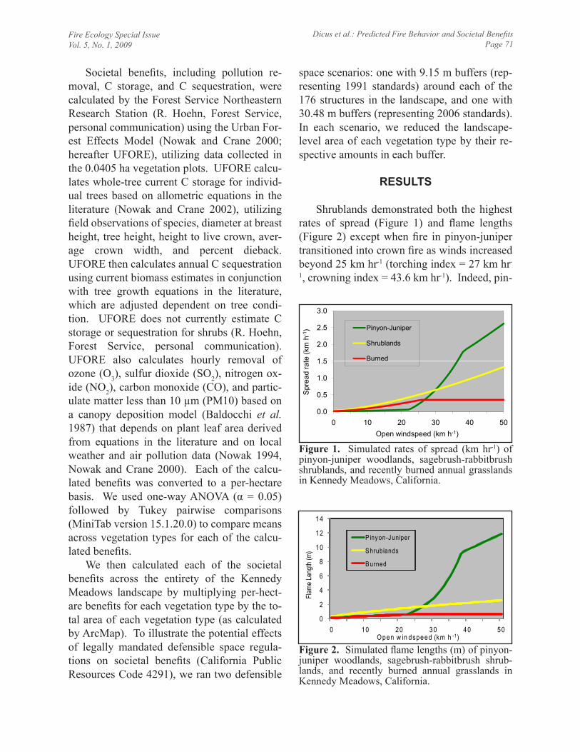
Shrublands demonstrated both the highest rates of spread (Figure 1) and flame lengths (Figure 2) except when fire in pinyon-juniper transitioned into crown fire as winds increased beyond 25 km hr-1 (torching index = 27 km hr-
1, crowning index = 43.6 km hr-1). Indeed, pin-
1 5
2.0
2.5
3.0te
(km
h-1
) Pinyon-Juniper
Shrublands
Burned
0.0
0.5
1.0
1.5
0 10 20 30 40 50
Spr
ead
rat
Open windspeed (km h-1)
Figure 1. Simulated rates of spread (km hr-1) of pinyon-juniper woodlands, sagebrush-rabbitbrush shrublands, and recently burned annual grasslands in Kennedy Meadows, California.
0
2
4
6
8
10
12
14
0 10 20 30 40 50
Flame
Leng
th (m
)
Open w in dspeed (km h -1)
P iny on-J uniper
S hrublands
B urned
Figure 2. Simulated flame lengths (m) of pinyon-juniper woodlands, sagebrush-rabbitbrush shrub-lands, and recently burned annual grasslands in Kennedy Meadows, California.
Fire Ecology Special IssueVol. 5, No. 1, 2009
Dicus et al.: Predicted Fire Behavior and Societal BenefitsPage 72
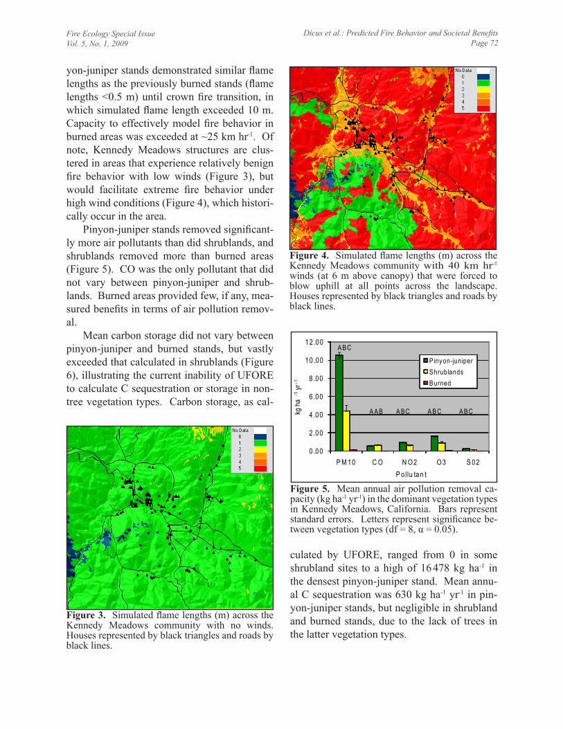
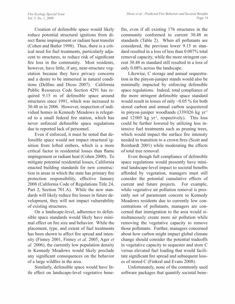
yon-juniper stands demonstrated similar flame lengths as the previously burned stands (flame lengths <0.5 m) until crown fire transition, in which simulated flame length exceeded 10 m. Capacity to effectively model fire behavior in burned areas was exceeded at ~25 km hr-1. Of note, Kennedy Meadows structures are clus-tered in areas that experience relatively benign fire behavior with low winds (Figure 3), but would facilitate extreme fire behavior under high wind conditions (Figure 4), which histori-cally occur in the area.
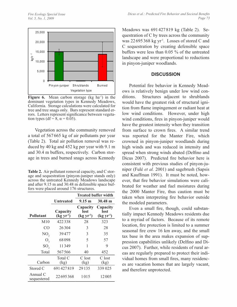
Pinyon-juniper stands removed significant-ly more air pollutants than did shrublands, and shrublands removed more than burned areas (Figure 5). CO was the only pollutant that did not vary between pinyon-juniper and shrub-lands. Burned areas provided few, if any, mea-sured benefits in terms of air pollution remov-al.
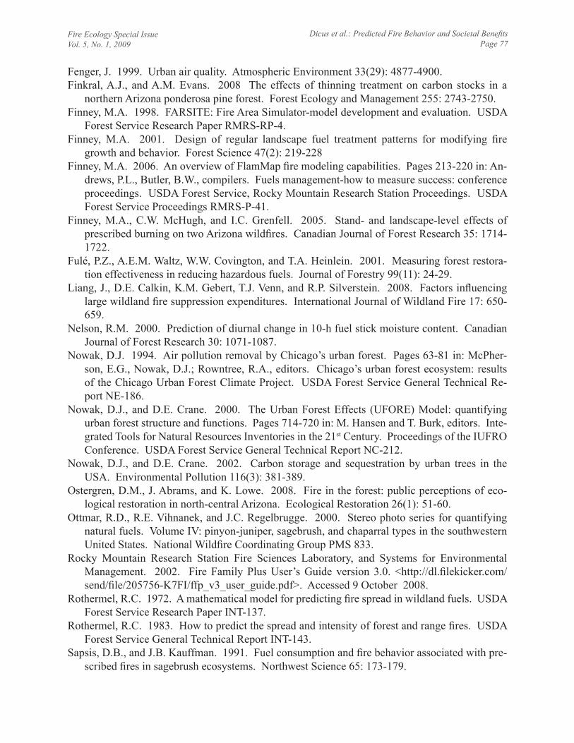
Mean carbon storage did not vary between pinyon-juniper and burned stands, but vastly exceeded that calculated in shrublands (Figure 6), illustrating the current inability of UFORE to calculate C sequestration or storage in non-tree vegetation types. Carbon storage, as cal-
culated by UFORE, ranged from 0 in some shrubland sites to a high of 16 478 kg ha-1 in the densest pinyon-juniper stand. Mean annu-al C sequestration was 630 kg ha-1 yr-1 in pin-yon-juniper stands, but negligible in shrubland and burned stands, due to the lack of trees in the latter vegetation types.
Figure 3. Simulated flame lengths (m) across the Kennedy Meadows community with no winds. Houses represented by black triangles and roads by black lines.
Figure 4. Simulated flame lengths (m) across the Kennedy Meadows community with 40 km hr-1 winds (at 6 m above canopy) that were forced to blow uphill at all points across the landscape. Houses represented by black triangles and roads by black lines.
0 .00
2 .00
4 .00
6 .00
8 .00
10 .00
12 .00
P M 10 C O N O2 O3 S 02
kg ha
-1yr
-1
P o llu tan t
P iny on-juniperS hrublandsB urned
A A B A B C A B C A B C
A B C
Figure 5. Mean annual air pollution removal ca-pacity (kg ha-1 yr-1) in the dominant vegetation types in Kennedy Meadows, California. Bars represent standard errors. Letters represent significance be-tween vegetation types (df = 8, α = 0.05).
Fire Ecology Special IssueVol. 5, No. 1, 2009
Dicus et al.: Predicted Fire Behavior and Societal BenefitsPage 73
Vegetation across the community removed a total of 567 665 kg of air pollutants per year (Table 2). Total air pollution removal was re-duced by 40 kg and 452 kg per year with 9.1 m and 30.4 m buffers, respectively. Carbon stor-age in trees and burned snags across Kennedy
Meadows was 691 427 819 kg (Table 2). Se-questration of C by trees across the community was 22 695 368 kg yr-1. Losses of stored C and C sequestration by creating defensible space buffers were less than 0.05 % of the untreated landscape and were proportional to reductions in pinyon-juniper woodlands.
discussion
Potential fire behavior in Kennedy Mead-ows is relatively benign under low wind con-ditions. Structures adjacent to shrublands would have the greatest risk of structural igni-tion from flame impingement or radiant heat at low wind conditions. However, under high wind conditions, fires in pinyon-juniper would have the greatest intensity when they transition from surface to crown fires. A similar trend was reported for the Manter Fire, which crowned in pinyon-juniper woodlands during high winds and was reduced in intensity and spread when strong winds abated (Delfino and Dicus 2007). Predicted fire behavior here is consistent with previous studies of pinyon-ju-niper (Fulé et al. 2001) and sagebrush (Sapsis and Kauffman 1991). It must be noted, how-ever, that fire behavior simulations were cali-brated for weather and fuel moistures during the 2000 Manter Fire, thus caution must be taken when interpreting fire behavior outside the modeled parameters.
Even a small fire, though, could substan-tially impact Kennedy Meadows residents due to a myriad of factors. Because of its remote location, fire protection is limited to a summer seasonal fire crew 16 km away, and the small tax base in the area makes expansion of sup-pression capabilities unlikely (Delfino and Di-cus 2007). Further, while residents of rural ar-eas are regularly prepared to protect their indi-vidual homes from small fires, many residenc-es are vacation homes that are largely vacant, and therefore unprotected.
0
5 ,000
10 ,000
15 ,000
20 ,000
25 ,000
P in yon -jun ipe r S h ru b lands B u rn ed
kg h
-1
Vege ta tion type
Figure 6. Mean carbon storage (kg ha-1) in the dominant vegetation types in Kennedy Meadows, California. Storage calculations were calculated for tree and tree snags only. Bars represent standard er-rors. Letters represent significance between vegeta-tion types (df = 8, α = 0.05).
Pollutant
UntreatedTreated buffer width
9.15 m 30.48 m
Capacity(kg yr-1)
Capacity lost
(kg yr-1)
Capacity lost
(kg yr-1)M10 422 338 28 323CO 26 304 3 28
NO2 39 477 3 35O3 68 098 5 57
SO2 11 349 1 9Total 567 566 40 452
CarbonTotal C
(kg)C lost (kg)
C lost (kg)
Stored C 691 427 819 29 135 339 025Annual C sequestered 22 695 368 1 015 12 005
Table 2. Air pollutant removal capacity, and C stor-age and sequestration (pinyon-juniper stands only) across the untreated Kennedy Meadows landscape and after 9.15 m and 30.48 m defensible space buf-fers were placed around 176 structures.
Fire Ecology Special IssueVol. 5, No. 1, 2009
Dicus et al.: Predicted Fire Behavior and Societal BenefitsPage 74
Creation of defensible space would likely reduce potential structural ignitions from di-rect flame impingement or radiant heat transfer (Cohen and Butler 1998). Thus, there is a crit-ical need for fuel treatments, particularly adja-cent to structures, to reduce risk of significant fire loss in the community. Most residents, however, have little, if any, near-structure veg-etation because they have privacy concerns and a desire to be immersed in natural condi-tions (Delfino and Dicus 2007). California Public Resources Code Section 4291 has re-quired 9.15 m of defensible space around structures since 1991, which was increased to 30.48 m in 2006. However, inspection of indi-vidual homes in Kennedy Meadows is relegat-ed to a small federal fire station, which has never enforced defensible space regulations due to reported lack of personnel.
Even if enforced, it must be noted that de-fensible space would not impact structural ig-nition from lofted embers, which is a more critical factor in residential losses than flame impingement or radiant heat (Cohen 2000). To mitigate potential residential losses, California enacted building standards for new construc-tion in areas in which the state has primary fire protection responsibility, effective January 2008 (California Code of Regulations Title 24, Part 2, Section 701.A). While the new stan-dards will likely reduce fire losses in future de-velopment, they will not impact vulnerability of existing structures.
On a landscape-level, adherence to defen-sible space standards would likely have mini-mal effect on fire size and behavior. While the placement, type, and extent of fuel treatments has been shown to affect fire spread and inten-sity (Finney 2001, Finney et al. 2005, Ager et al. 2006), the currently low population density in Kennedy Meadows would likely preclude any significant consequences on the behavior of a large wildfire in the area.
Similarly, defensible space would have lit-tle effect on landscape-level vegetative bene-
fits, even if all existing 176 structures in the community conformed to current 30.48 m standards (Table 2). When all pollutants are considered, the previous lower 9.15 m stan-dard resulted in a loss of less than 0.007% total removal capacity, while the more stringent cur-rent 30.48 m standard still resulted in a loss of only 0.08% across the landscape.
Likewise, C storage and annual sequestra-tion in the pinyon-juniper stands would also be minimally impacted by enforcing defensible space regulations. Indeed, total compliance of the more stringent defensible space standard would result in losses of only ~0.05 % for both stored carbon and annual carbon sequestered in pinyon-juniper woodlands (339 026 kg yr-1 and 12 005 kg yr-1, respectively). This loss could be further lowered by utilizing less in-tensive fuel treatments such as pruning trees, which would impact the surface fire intensity needed to transition to a crown fires (Scott and Reinhardt 2001) while moderating the effects of total tree removal.
Even though full compliance of defensible space regulations would presently have mini-mal landscape-level impact to societal benefits afforded by vegetation, managers must still consider the potential cumulative effects of current and future projects. For example, while vegetative air pollution removal is pres-ently not of paramount concern to Kennedy Meadows residents due to currently low con-centrations of pollutants, managers are con-cerned that immigration to the area would si-multaneously create more air pollution while removing the vegetative capacity to remove those pollutants. Further, managers concerned about how carbon might impact global climate change should consider the potential tradeoffs in vegetative capacity to sequester and store C versus elevated fuel loading that would facili-tate significant fire spread and subsequent loss-es of stored C (Finkral and Evans 2008).
Unfortunately, none of the commonly used software packages that quantify societal bene-

Fire Ecology Special IssueVol. 5, No. 1, 2009
Dicus et al.: Predicted Fire Behavior and Societal BenefitsPage 75
fits (e.g., UFORE, STRATUM, and CITYgreen) currently estimate C storage and sequestration for non-tree vegetation. Thus, the true impact of defensible space on carbon in the present study cannot be assessed. Fur-ther, while UFORE calculates air pollution re-moval for both trees and shrubs, no benefits of any kind are calculated for grasslands, limiting full interpretation of results. The inability to adequately calculate benefits in shrublands and grasslands is problematic, especially in areas where trees are not the dominant vegetation type (Dicus and Zimmerman 2007). Further, it should be noted that all vegetative benefits cal-culated by UFORE are based upon equations in the literature. While UFORE attempts to in-corporate the most appropriate equations in their calculations (Nowak and Crane 2000), there will undoubtedly be some degree of error in the results. However, while prudence should be taken in acceptance of absolute values, this methodology provides a sound mechanism to evaluate relative differences in benefits for various vegetative communities and for assort-ed fuel treatment alternatives, especially in landscapes in which trees are the dominant vegetation type.
Kennedy Meadows is emblematic of the challenges that will increasingly vex land man-agers throughout the fire-prone southwestern United States. Current population projections estimate an enormous influx of residents to the region by 2030. Indeed, compared to 2000 census numbers, Nevada and Arizona are ex-pected to double their populations by 2030, while Utah and Colorado are estimated to in-crease by 56 % and 35 %, respectively (US Census Bureau 2004).
Continued immigration to previously unin-habited areas will likely result in increased probability of ignitions through accident or ar-son (Syphard et al. 2008), which will serve to increase an ever-escalating cost of federal fire suppression expenditures that has been largely
attributed to protection of private property in-terfaced with public lands (USDA Office of Inspector General 2006, Liang et al. 2008). Further, the potential size and severity of wild-fires in the region will be exacerbated by warmer and drier conditions (Westerling et al. 2006) and fuel accumulation fostered by a cen-tury of fire suppression and land use changes (Savage and Swetnam 1990).
Greater risk of loss of life and property in the region will therefore necessitate a greater reliance on fuel treatments to mitigate that risk. Implementation of such treatments would like-ly be aided by widespread public support in the southwestern United States for prescribed fire and mechanical thinning to ameliorate po-tential fire hazards (Abrams and Lowe 2005, Ostergren et al. 2008). However, as lands are subdivided into increasingly smaller parcels, the potential for effective placement of fuel treatments on a landscape level will become constrained. Additionally, plant communities and the subsequent environmental benefits that they provide will be reduced and fragmented due to land clearing for homes and subsequent supporting services and infrastructure. Land managers must therefore be mindful of these potential losses when implementing fuel treat-ments in WUI areas.
Our results illustrate how land managers can better evaluate how fuel treatments in WUI areas could potentially affect a community. Our methodology provides a practical mecha-nism for managers and policy makers to better assess management options for WUI vegeta-tion so as to simultaneously reduce both the risk of fire losses and potential environmental impacts. That said, it is critical to understand that sustainable fire management in the WUI necessitates a holistic approach, including not only elements of vegetation management and suppression capabilities, but also home con-struction, sound land use planning, and public education (Dicus 2008).

Fire Ecology Special IssueVol. 5, No. 1, 2009
Dicus et al.: Predicted Fire Behavior and Societal BenefitsPage 76
acknowledgeMents
The project was funded in part by the Joint Fire Science Program Project 07-1-6-11 admin-istered through the Pacific Southwest Research Station and by the California State University Agricultural Research Initiative (ARI). The authors are grateful to Anne Birkholz of Sequoia and Kings Canyon National Parks for providing GIS layers and support, to Robert Hoehn and staff at the US Forest Service Northeastern Research Station for providing UFORE analysis of the data, and to Samantha Gill of California Polytechnic State University, San Luis Obispo, for providing GIS support.
literature cited
Abrams, J., and K. Lowe. 2005. Public perceptions of forest restoration in the southwest: a syn-thesis of selected surveys and literature. Ecological Restoration Institute, Northern Arizona University, Flagstaff, USA.
Ager, A.A., A.J. McMahan, J.J. Barett, and C.W. McHugh. 2007. A simulation study of thinning and fuel treatments on a wildland-urban interface in eastern Oregon, USA. Landscape and Urban Planning 80: 292-300.
Baldocchi, D.D., B.B. Hicks, and P. Camara. 1987. A canopy stomatal resistance model for gas-eous deposition to vegetated surfaces. Atmospheric Environment 21: 91-101.
Bradshaw, L.S., J.E. Deeming, R.E. Burgan, and J.D. Cohen. 1983. The 1978 National Fire-Danger Rating System: technical documentation. USDA Forest Service General Technical Report INT-169.
Brooks, M.L., C.M. D’Antonio, D.M. Richardson, J.B. Grace, J.E. Keeley, J.M. DiTomaso, R.J. Hobbs, M. Pellant, and D. Pyke. 2004. Effects of invasive alien plants on fire regimes. Bio-science 54(7): 677-688.
Byram, G.M. 1959. Combustion of forest fuels. Pages 61-89 in: K.P. Brown, editor. Forest fire: control and use. McGraw-Hill, New York, USA.
Cohen, J.D. 2000. Preventing disaster: home ignitability in the wildland-urban interface. Jour-nal of Forestry 98(3): 15-21.
Cohen, J.D., and B.W. Butler. 1998. Modeling potential ignitions from flame radiation exposure with implications for wildland/urban interface fire management. Pages 81-86 in: Proceedings of the 13th conference on fire and forest meteorology. International Association of Wildland Fire, Fairfield, Washington, USA.
Delfino, K., and C.A. Dicus. 2007. Kennedy Meadows community wildfire protection plan. <http://www.krvfiresafecouncil.org/KennedyMeadowsCWPP.pdf>. Accessed 9 October 2008.
Dicus, C.A. 2008. Changes to simulated fire behavior and societal benefits after two levels of thinning in a mixed-conifer wildland-urban interface community. Proceedings of the Royal Society of Queensland 115: 37-44.
Dicus, C.A., and M.P. Zimmerman. 2007. Quantifying fire behavior vs. community benefits of southern California shrublands and grasslands. Pages 214-221 in: R.E. Masters and K.E.M. Galley, editors. Proceedings of the 23rd Tall Timbers Fire Ecology Conference: Fire in grass-land and shrubland ecosystems. Tall Timbers Research Station, Tallahassee, Florida, USA.
Dombeck, M.P., J.E. Williams, and C.A. Wood. 2004. Wildfire policy on public lands: integrat-ing scientific understanding with social concerns. Conservation Biology 18(4): 893-889.
Fire Ecology Special IssueVol. 5, No. 1, 2009
Dicus et al.: Predicted Fire Behavior and Societal BenefitsPage 77
Fenger, J. 1999. Urban air quality. Atmospheric Environment 33(29): 4877-4900.Finkral, A.J., and A.M. Evans. 2008 The effects of thinning treatment on carbon stocks in a
northern Arizona ponderosa pine forest. Forest Ecology and Management 255: 2743-2750.Finney, M.A. 1998. FARSITE: Fire Area Simulator-model development and evaluation. USDA
Forest Service Research Paper RMRS-RP-4. Finney, M.A. 2001. Design of regular landscape fuel treatment patterns for modifying fire
growth and behavior. Forest Science 47(2): 219-228 Finney, M.A. 2006. An overview of FlamMap fire modeling capabilities. Pages 213-220 in: An-
drews, P.L., Butler, B.W., compilers. Fuels management-how to measure success: conference proceedings. USDA Forest Service, Rocky Mountain Research Station Proceedings. USDA Forest Service Proceedings RMRS-P-41.
Finney, M.A., C.W. McHugh, and I.C. Grenfell. 2005. Stand- and landscape-level effects of prescribed burning on two Arizona wildfires. Canadian Journal of Forest Research 35: 1714-1722.
Fulé, P.Z., A.E.M. Waltz, W.W. Covington, and T.A. Heinlein. 2001. Measuring forest restora-tion effectiveness in reducing hazardous fuels. Journal of Forestry 99(11): 24-29.
Liang, J., D.E. Calkin, K.M. Gebert, T.J. Venn, and R.P. Silverstein. 2008. Factors influencing large wildland fire suppression expenditures. International Journal of Wildland Fire 17: 650-659.
Nelson, R.M. 2000. Prediction of diurnal change in 10-h fuel stick moisture content. Canadian Journal of Forest Research 30: 1071-1087.
Nowak, D.J. 1994. Air pollution removal by Chicago’s urban forest. Pages 63-81 in: McPher-son, E.G., Nowak, D.J.; Rowntree, R.A., editors. Chicago’s urban forest ecosystem: results of the Chicago Urban Forest Climate Project. USDA Forest Service General Technical Re-port NE-186.
Nowak, D.J., and D.E. Crane. 2000. The Urban Forest Effects (UFORE) Model: quantifying urban forest structure and functions. Pages 714-720 in: M. Hansen and T. Burk, editors. Inte-grated Tools for Natural Resources Inventories in the 21st Century. Proceedings of the IUFRO Conference. USDA Forest Service General Technical Report NC-212.
Nowak, D.J., and D.E. Crane. 2002. Carbon storage and sequestration by urban trees in the USA. Environmental Pollution 116(3): 381-389.
Ostergren, D.M., J. Abrams, and K. Lowe. 2008. Fire in the forest: public perceptions of eco-logical restoration in north-central Arizona. Ecological Restoration 26(1): 51-60.
Ottmar, R.D., R.E. Vihnanek, and J.C. Regelbrugge. 2000. Stereo photo series for quantifying natural fuels. Volume IV: pinyon-juniper, sagebrush, and chaparral types in the southwestern United States. National Wildfire Coordinating Group PMS 833.
Rocky Mountain Research Station Fire Sciences Laboratory, and Systems for Environmental Management. 2002. Fire Family Plus User’s Guide version 3.0. <http://dl.filekicker.com/send/file/205756-K7FI/ffp_v3_user_guide.pdf>. Accessed 9 October 2008.
Rothermel, R.C. 1972. A mathematical model for predicting fire spread in wildland fuels. USDA Forest Service Research Paper INT-137.
Rothermel, R.C. 1983. How to predict the spread and intensity of forest and range fires. USDA Forest Service General Technical Report INT-143.
Sapsis, D.B., and J.B. Kauffman. 1991. Fuel consumption and fire behavior associated with pre-scribed fires in sagebrush ecosystems. Northwest Science 65: 173-179.
Fire Ecology Special IssueVol. 5, No. 1, 2009
Dicus et al.: Predicted Fire Behavior and Societal BenefitsPage 78
Savage, M., and T.W. Swetnam. 1990. Early 19th-century fire decline following sheep pasturing in a Navajo ponderosa pine forest. Ecology 71: 2374-2378.
Scott, J.H., and E.D. Reinhardt. 2001. Assessing crown fire potential by linking models of sur-face and crown fire behavior. USDA Forest Service Research Paper RMRS-RP-29.
Scott, J.H., and R.E. Burgan. 2005. Standard fire behavior fuel models: a comprehensive set for use with Rothermel’s surface fire spread model. USDA Forest Service General Technical Re-port RMRS-GTR-153.
Solomon, S., D. Qin, M. Manning, Z. Chen, M. Marquis, K.B. Averyt, M. Tignor and H.L. Miller, editors. 2007. Climate Change 2007: The Physical Science Basis. Contribution of Working Group I to the Fourth Assessment Report of the Intergovernmental Panel on Climate Change. Cambridge University Press, United Kingdom, and New York, New York, USA.
Stratton, R.D. 2004. Assessing the effectiveness of landscape fuel treatments on fire growth and behavior. Journal of Forestry 102(7): 32-40.
Syphard. A.D., V.C. Radeloff, N.S. Keuler, R.S. Taylor, T.J. Hawbaker, S.I. Stewart, and M.K. Clayton. 2008. Predicting spatial patterns of fire on a southern California landscape. Inter-national Journal of Wildland Fire 17: 602-613.
Taha, H., S. Douglas, and J. Haney. 1997. Mesoscale meteorological and air quality impacts of increased urban albedo and vegetation. Energy and Buildings 25: 169-177.
US Census Bureau. 2004. Table 1: Ranking of census 2000 and projected 2030 state population and change. <http://www.census.gov/population/www/projections/projectionsagesex.html./>. Accessed 9 October 2008.
US Department of Agriculture Office of Inspector General. 2006. Forest Service large fire sup-pression costs. Audit Report No. 08601-44-SF. <http://www.usda.gov/oig/webdocs/08601-44-SF.pdf>. Accessed 9 October 2008.
Wangler, M., and R.A. Minnich. 1996. Fire and succession in pinyon-juniper woodlands of the San Bernardino Mountains, California. Madroño 43: 493-514.
Westerling, A.L., H.G. Hidalgo, D.R. Cayan, and T.W. Swetnam. 2006. Warming and earlier spring increases western US forest wildfire activity. Science 313: 940-943.