pre-submission lavant neighbourhood development plan … pre-submission document.pdf ·...
TRANSCRIPT

PRE-SUBMISSION
LAVANT NEIGHBOURHOOD
DEVELOPMENT PLAN
2016 - 2031
Lavant Parish Council
March 2016
Looking across to the Trundle from the Earl of
March – the view that inspired Blake’s Jerusalem

2 | INTRODUCTION
"In the spring of 2013 Lavant Parish Council resolved to produce a
Neighbourhood Plan. They subsequently commissioned a Steering Group of
Village volunteers to research and implement this project. The manner in
which these volunteers and others carried out this task has earned the
respect and thanks of both the Council and the wider community. On 9
February 2016 the draft Plan was submitted to the Parish Council who
unanimously supported, and recommended that it go forward at the earliest
opportunity for public consultation and consideration."
Ian Hutton
Chair of Lavant Parish Council
“This Lavant Neighbourhood Development Plan sets out the vision,
objectives and policies for the sustainable development of the Parish from
2016 to 2031. Underpinned by community consultation and with a focus on
what is achievable and deliverable, this document will guide and inform
planning decisions within the parish for the next 15 years.
It has been prepared by the Lavant Neighbourhood Development Plan
Steering Group which consists of local residents and Parish Councillors all of
whom have volunteered their time to make this plan a reality.
The Steering Group would like to thank everyone who contributed valuable
ideas, suggestions and time throughout the consultation process.”
Alan Taylor
Chair of Lavant Neighbourhood Plan
Steering Group
NOTICE - A27 Trunk Road Proposals
Since completing the consultations required to secure a proper evidence
base for the Lavant Neighbourhood Development Plan (LNDP), it has
come to the notice of the Lavant Parish Council (LPC) and the LNDP
Steering Group that there are impending proposals from Highways
England to undertake major work to the traffic flows around Chichester.
Of significant concern are those new road options which involve routes
impacting the strategic gap between Lavant and Chichester.
Despite the responses received in July 2015 from both Highways England
(HE) and West Sussex County Council (WSCC) during the LNDP formal
consultation period, it is now apparent that two options generated by HE
include a 4 lane expressway, to be routed through the strategic gap with a
grade separated junction on the A286. Whilst not previously volunteered
by WSCC, this work was known to both HE and WSCC at the time of the
formal LNDP consultations.
If undertaken, this major development will clearly have fundamental and
far reaching impacts on the environment of Lavant and traffic routing
through the village into SDNP. In response to a change of this magnitude
the LNDP would require an urgent and significant review.
However, given the current levels of uncertainty around HE proposals, the
LPC have determined that it is in the best interest of the village to
progress the current LDP to Referendum without delay. Additionally, LPC
has advised that along with other affected Parish Councils it will, when
formally consulted, strongly oppose proposals for new roads within the
strategic gap between Lavant and Chichester.

INTRODUCTION | 3
TABLE OF CONTENTS
1.0 INTRODUCTION ...................................................................................... 4
The Purpose of a Neighbourhood Plan ............................................... 4
The Neighbourhood Plan Area ............................................................ 4
The Legal & Planning Policy Context ................................................... 6
How this document should be used .................................................... 6
Consultation ........................................................................................ 7
2.0 OUR VISION, QUALITIES AND OBJECTIVES ........................................... 11
Vision ................................................................................................. 11
Objectives .......................................................................................... 11
3.0 ABOUT LAVANT .................................................................................... 13
Heritage ............................................................................................. 13
Landscape .......................................................................................... 14
The River Lavant & Biodiversity ......................................................... 14
Housing .............................................................................................. 15
Infrastructure..................................................................................... 16
4.0 SPATIAL STRATEGY ............................................................................... 17
LNDP1 - Spatial Strategy and Settlement Boundaries ....................... 17
LNDP2 - South Downs National Park ................................................. 19
LNDP3 – Local Gaps ........................................................................... 20
LNDP4 – Delivering New Homes ........................................................ 21
5.0 GENERAL DEVELOPMENT PRINCIPLES ................................................. 23
LNDP5 – High Quality Design ............................................................. 23
LNDP6 – Development Principles ...................................................... 24
LNDP7 – New Dwelling Size & Tenure ............................................... 25
LNDP8 - Dark Night Skies ................................................................... 26
LNDP9 - Local Economy, Business and Employment ......................... 27
6.0 COMMUNITY SPACES & FACILITIES ...................................................... 28
LNDP10 - Local Green Space .............................................................. 28
LNDP11 - Local Community Space ..................................................... 30
LNDP12 - Retention of assets of community value ........................... 30
7.0 THE ENVIRONMENT & SUSTAINABILITY ............................................... 32
LNDP13 - Local Biodiversity Opportunity Areas ................................ 32
LNDP14 - Landscape Character and Key Views ................................. 34
LNDP15 – Core Floodplain and Flood Risk ......................................... 34
LNDP16 – Microgeneration and Renewable Energy ......................... 35
LNDP17 - Conserving and enhancing local Heritage Assets .............. 36
8.0 TRANSPORT AND INFRASTRUCTURE .................................................... 38
LNDP18 – New Public Rights of Way ................................................. 38
LNDP19 - Off-Road Parking in Residential Developments ................ 38
LNDP20 – Effective Traffic Management .......................................... 41
9.0 SITE SPECIFIC POLICIES ......................................................................... 43
LNDP21 – Land adjacent Pook Lane .................................................. 44
LNDP22 – Church Farm Barns ............................................................ 46
LNDP23 – Eastmead Industrial Estate ............................................... 47
LNDP24 – Summersdale Garage & Maddoxwood House .................. 48
LNDP25 – St Nicholas Church ............................................................ 50
LNDP26 – The Rectory ....................................................................... 51
SUPPORTING DOCUMENTS ............................................................................ 52
GLOSSARY ....................................................................................................... 53

4 | INTRODUCTION
1.0 INTRODUCTION
1.01 The Lavant Neighbourhood Development Plan (LNDP) has been
prepared by the LNDP Steering Group, a group consisting of local
volunteers and set up by Lavant Parish Council.
1.02 The LNDP provides a clear framework to guide residents, local
authorities and developers as to how the community wish to shape
future development within the parish over the next 15 years from
2016-2031.
The Purpose of a Neighbourhood Plan
1.03 Once it has been agreed at referendum and ‘made’, a neighbourhood
plan has the same legal status as the Local Plan prepared by the
relevant Local Planning Authorities (South Downs National Park
Authority & Chichester District Council). At this point it becomes part
of the statutory ‘development plan’ and used in the determination of
planning applications.
1.04 Applications for planning permission must be determined in
accordance with the development plan, unless material
considerations indicate otherwise (see section 38(6) of the Planning
and Compulsory Purchase Act 2004).
The Neighbourhood Plan Area
1.05 The Neighbourhood Plan area covers the parish of Lavant. The Parish
has an irregular shape and covers around six square miles. It is within
the Chichester District, part of which falls within the South Downs
National Park.
1.06 The parish therefore falls within two Local Planning Authorities,
namely Chichester District Council (CDC) and the South Downs
National Park Authority (SDNPA). The boundary between these two
Local Planning Authorities runs east/west across the Parish. 22% of
the parish is to the south of the boundary (in Chichester District) and
78% is to the north (in the National Park). The SDNPA is the primary
planning authority.
1.07 An application was made under the Localism Act 2011 to both
Chichester District Council (CDC) and the South Downs National Park
Authority (SDNPA) for the parish of Lavant to be designated as a
neighbourhood area. This was adopted by CDC on 18th March 2013
and the SDNPA on 14th March 2013.
1.08 A map showing the Plan Area can be found on the opposite page.

INTRODUCTION | 5

6 | INTRODUCTION
The Legal & Planning Policy Context
The legal basis for the preparation of neighbourhood plans is
provided by the Localism Act 2011, Neighbourhood Planning
Regulations 2012, Planning and Compulsory Purchase Act 2004 and
the Town and Country Planning Act 1990. These pieces of legislation
have enabled local communities to prepare neighbourhood plans but
also provide a number of conditions and tests to which the plan must
adhere to, to enable it to come into force. The basic conditions that
must be met are:
The policies relate to the development and use of land.
The plan must have been prepared by a qualifying body, and
relate to an area that has been properly designated for such
plan preparation.
The plan specifies the period to which it has effect, does not
include provision about excluded development and only
relates to one plan area.
The plan has regard to national policies and advice contained
in guidance issued by the Secretary of State
It contributes to the achievement of sustainable
development.
It is in general conformity with the strategic policies
contained in the existing development plan for the area
It does not breach, and is otherwise compatible with, EU
obligations.
1.09 Whilst the LNDP can shape and influence where development will go
locally and what it will look like there are some rules.
1.10 The plan should have regard to national policies and take account of
relevant national policy, this includes:
The National Planning Policy Framework (NPPF) 2012
The National Park Purposes & Duty
English National Park and The Broads – Vision and Circular
2010
1.11 As the Parish is located across the boundaries of two Local Planning
Authorities, the LNDP needs to be in general conformity with both
the policies of CDC and SDNPA, the key documents are:
The Chichester District Local Plan 1999 (relevant to the area
of Lavant within the National Park).
The Chichester Local Plan 2014-2029 (relevant to the area of
Lavant not in the National Park Chichester District).
The emerging South Downs National Park Local Plan:
Preferred Options 2015 (relevant to the area of Lavant within
the National Park).
How this document should be used
1.12 This plan, and its associated map should be used by residents, local
authorities and developers and other stakeholders to understand
how the local community wish future development to occur.
Whether or not the development required planning permission,
everyone should pay attention to the aspirations and objections set
out within this document.

INTRODUCTION | 7
1.13 For applications that require planning permission, whether you are
proposing a scheme or assessing the acceptability of a scheme the
policies1 contained within this document are key. For a planning
application to be considered favourably, all relevant policies
contained within this plan should be considered and complied with.
Consultation
1.14 In September 2013, when the Steering Group (SG) was established,
one of the initial workgroups was for Community Engagement. This
was seen to be critical to the overall development of a successful
LNDP. A Community Engagement Strategy was established. This
strategy has underpinned the approach of the SG throughout the
preparation of this plan.
1.15 Key stakeholders were identified as:
Village partners: all villagers and everyone on the electoral
roll of LPC, resident associations/groups, schools, businesses,
churches/PCC, and external users of village facilities (sports
clubs etc.).
External expert partners: CDC, SDNPA, West Sussex County
Council, Environment Agency and Infrastructure providers.
1.16 A plan of key activities was identified as part of the overall
development of the LNDP, and the Community Engagement
workgroup established a series of approaches for informing and
1 Planning and Compulsory Purchase Act 2004, s38B(3) states ‘If to any extent a policy set out in a neighbourhood development plan conflicts with any other statement or information in the plan, the conflict must be resolved in favour of the policy.’
involving residents. A full diary of community engagement activities
can be found in the Consultation Statement. Activities included:
Consultation Meetings with stakeholders.
A dedicated webpage hosted on the Lavant Parish Council
website. All key documents and meeting notes are on this
website ensuring full transparency.
A dedicated email address. Over time a database of contact
names has been established which forms the basis of any
electronic communications.
A dedicated mobile phone number to ensure that any parties
who are unable to use electronic methods for
communication have a way of contacting the Steering Group.
Regular progress updates in the local church magazine which
is circulated to most parishioners.
Regular progress updates in the LPC newsletter which is
delivered to all parishioners and posted on the LPC website.
Press articles in the Chichester Observer to highlight
forthcoming events and to report on recent events.
Pop-up stalls at village events (e.g. Village Fete, Allotments
Open Day, Flower Show, Lavant Community Day)
Development of a brand Logo to ensure recognition of LNDP
activities/communications.
Use of surveys and questionnaires to gather data.
Public events at key times to inform stakeholders and gather
views.

8 | INTRODUCTION
Regular leaflet distribution to all properties in the parish,
notifying of forthcoming events and providing outcomes of
public meetings and other key progress updates.
1.17 A full diary of community engagement activities can be found in the
Consultation Document but the key events that have provided the
community feedback that has informed the development of the
LNDP have been:
Date Event Name /
Audience /
Participation
Purpose/Outcomes
October 2013
Open Space Discussion - chairs of local associations and groups Attended by: 30 stakeholders
This meeting provided an introduction to the LNDP process and purpose and invited views on: Who should be involved in the consultation about a NP? What needs and issues are important for the future of Lavant? How do we capture everyone’s views?
February 2014
Initial Survey - all households in parish Responses: 143 (=20% of village)
Invited local residents to - prioritise the main focus areas for the LNDP - indicate preferred types of communication (household leafleting). - to submit further comments about Village matters.
May 2014
Housing Needs Survey
Identified the need for housing in the parish – how many, type, size,
2 See Consultation Statement for further information.
Date Event Name /
Audience /
Participation
Purpose/Outcomes
- all households in parish Valid returns: 331 (source: CDC) 45% of village population
affordability, type of ownership and timescales.
Septem-ber 2014
Beating of the Bounds - all stakeholders Attended by: 161 stakeholders Responses: 1000 sheets completed
Gave an opportunity to view, consider and provide feedback on 9 potential sites for building development around the parish as well as identify other potential sites.
February 2015
Landowners’ Meeting -all local landowners Chair of LPC Chair of LPS Governors
Presented the outcomes/options/ preferences of the parishioners on possible sites. Individual landowners gave their views regarding their sites.
February 2015
Lavant Community Day - all households and associations in parish
Gave residents the opportunity to review and give their preferences on the 4 Options2. (Repeated on Tuesday and Thursday )

INTRODUCTION | 9
Date Event Name /
Audience /
Participation
Purpose/Outcomes
Attended by: over 150 residents
May 2015
Plans and Policies - all households in parish Attended by: 58
Presented results of Options Preferences and first draft of key Policies, for comment and feedback. Notification of 2 additional sites volunteered by landowners after the Call for Sites. Road issues were highlighted as a concern.
July 2015 Roads and Traffic Day Ben Hamilton-Ballie -all households in parish WSCC Highways, CDC, SDNPA, Police reps invited Attended by 95 residents
Invited representatives from the key areas of the Parish reviewed road and traffic issues in the village. An Open Meeting feedback the findings and initial thoughts of leading expert and Village representatives.
1.18 A Strengths, Weaknesses, Opportunities and Threats (SWOT) analysis
of the parish has been prepared from the above activities to help
steer the LNDP and this is on the next page. To find out more about
our consultation activities and how these informed the plan, please
look at the Consultation Statement that accompanies this plan.
Beating the Bounds – a walkabout opportunity to
review and comment on potential development sites.

10 | INTRODUCTION
Strengths
A strong sense of community and active Parish Council.
High quality environment set within a National Park and containing a conservation area and historic buildings.
Adequate links to Chichester and A27 road network.
Proximity to the South Downs National Park and Chichester Harbour provides outdoor resource of national standards for local residents.
Proximity to Goodwood race course and motor circuit
Stunning views into the National Park from various locations in the village
Good footpath links to open countryside.
Considered to be a low crime village.
Good standard of local schools.
Frequent bus service 7am to 8pm with 4 bus stops each side on A286.
Healthy population.
Weaknesses
Business units are out of date, under occupied and not suitable for modern businesses.
Limited range of existing and new housing available in terms of size and price
Road seen as rat run through village from north/south and East Lavant from the east and from West Stoke.
No local shop / Doctors Surgery
Local primary school at capacity.
No public transport after 8 pm.
Significant number of older people /aging population.
The main community facility (Memorial Hall) is based well away from the bulk of housing.
Over-reliance on the car for transport.
Lack of adequate car parking spaces in parts of the village.
Average house prices more than 17 times higher than average wages.
Opportunities
Proximity to Goodwood and National Park offers tourism/economic prosperity opportunities.
Sites available for new housing for local needs.
Improve provision and value of open space.
Consider options for improving biodiversity within the village.
Provide safe opportunities to walk and cycle.
To widen the demographic base and encourage young people/families to live in the village.
Opportunities to provide improvements to the River Lavant.
Improve Centurion Way.
Community Hall could benefit from further investment.
To allow Lavant to be developed sensitively to maintain gaps between settlements.
Threats
Loss of employment site to other uses.
Out commuting continues to grow.
Flood risk along the course of the Lavant through the village.
Sewerage overflow in certain housing areas.
Possibly seen as an ideal location for a second home.
Limited funds to upkeep/improve/build new community facilities.
Young people moving away because of limited availability of affordable housing.
Limited funds to improve local infrastructure.
Growth of traffic on the A286 because of the proposed new houses to the west and east of Chichester.
Northern route option around Chichester for the A27.
Pilots taking a ‘short’ cut over the village after taking off from Goodwood aerodrome.
Poor / variable delivery of High Speed Broadband.

OUR VISION, QUALITIES AND OBJECTIVES | 11
2.0 OUR VISION, QUALITIES AND OBJECTIVES
Vision
2.01 We asked residents how they wanted Lavant to look and feel in 15
years’ time and a group of volunteers turned their responses into a
Vision Statement for the Parish that succinctly reflects these views.
2.02 Lavant will:
Celebrate its heritage, distinctive rural character and
downland location.
Ensure that all development results in a built and natural
environment which is attractive, sustainable,
environmentally sensitive and proportionate to the needs
and wishes of its community.
Enjoy inclusive community facilities and take advantage of
safe and integrated connections throughout the village.
Benefit from recreational spaces and opportunities which
support and enhance the lives of all its residents and
visitors.
2.03 Lavant is a community which values the special qualities that
contribute to its environment and social lifestyle. The special
qualities are:
The role and position of Lavant as a ‘gateway’ village to the
South Downs National Park (SDNP) whilst remaining separate
and distinct from Chichester.
Features of the village which create/ contribute to its distinct
rural nature and range of recreational and community
activities.
A celebration of sites of historical interest within the village.
A natural environment including the village green, river,
footpaths/ bridleways and historic views of the surrounding
hills to the north.
Local businesses and organisations that contribute to the
wellbeing of the community.
Objectives
2.04 The Vision and the feedback from the community have been put into
a set of Objectives for the Neighbourhood Plan. These state what the
Neighbourhood Plan is aiming to achieve through its overall strategy
and policies.
2.05 The objectives for this plan are as follows:
LOB1 Define new Settlement Boundaries and identify sites where
appropriate development will be accommodated.
LOB2 Prioritise use of Brownfield, Redundant and Derelict Land
as sites for Development.
LOB3 Promote and accommodate sustainable and affordable
housing development on specified sites and in accordance
with Local Strategic Policies.
LOB4 Ensure that open market development reflects local
housing needs and provides multi-use housing appropriate
for all age groups and that affordable housing is prioritised
for people with a defined local connection to Lavant.

12 | OUR VISION, QUALITIES AND OBJECTIVES
LOB5 Ensure that all new housing and/or extensions complement
the established vernacular of the Parish in terms of density,
building styles and materials, respecting the historic
environment and encouraging the conservation and
enhancement of Listed Buildings, their settings and other
historic buildings and other significant features.
LOB6 Encourage sustainable design that promotes energy
conservation and efficiency in mitigation of climate change.
LOB7 Promote appropriate developments, activities and facilities
that actively contribute to the special qualities of Lavant
and the well-being of the community.
LOB8 Protect specified local open and green spaces valued
and/or used by the local community.
LOB9 Encourage the provision of new open and green spaces for
sporting and general social/recreational use by the
community.
LOB10 Protect, enhance and conserve the special qualities of the
South Downs National Park, in particular historic and
valuable views, biodiversity, wildlife and cultural heritage
and the natural environment, both habitats and
landscapes.
LOB11 Encourage and support infrastructure improvements in
particular road enhancements that reduce traffic speeds.
Create new footpaths and safety improvements for
pedestrians and cyclists.
LOB12 Facilitate the development needs of those businesses,
employing organizations, and or charities operating within
Lavant, in ways compatible with the needs of local
residents and the rural character of the village.

ABOUT LAVANT | 13
3.0 ABOUT LAVANT
3.01 This section sets a background to the issues facing the parish and a
baseline for the Neighbourhood Development Plan. In summary:
The Parish of Lavant lies on the dip slope of the South Downs
National Park approximately 2 miles north of Chichester in
the western corner of West Sussex.
The village has three distinct areas East Lavant, Mid Lavant
and West Lavant. These distinct areas were amalgamated, for
civil purposes, into one parish in 1872.
The village covers an area of approximately 16,470 hectares
with 777 dwellings and total population of 1,656.
Approximately 78% of the northern part of the parish lies
within the South Downs National Park.
Lavant has features of a typical rural English village with a
picturesque village green, pond, two church buildings, the
Village Hall, primary school and well used footpaths and
historic views.
Lavant lies in a rural river valley and the character of the
landscape is typical of the South Downs.
A286 trunk road from Midhurst to Chichester runs through
the heart of the village. Historical maps indicate that the
settlement pattern has remained relatively unchanged
through the centuries and that the Village Green has always
featured as an important space in the village.
The pressures on Lavant's historic nature are typical of
villages in the South of England, lack of Affordable housing,
community investment and environmental enhancement.
Heritage
3.02 Back in 1954, Sussex Rural Community Council ran a competition to
find ‘the most sensibly active village’ in West Sussex. To have a
chance of winning, a village had to have the following characteristics:
a church with a resident vicar, a school, an inn, a sports ground, a
community centre, a branch of the Women’s Institute, and finally a
range of clubs and societies. The village of Lavant would have been a
worthy winner. Then, as now, it met all the required criteria: two
church buildings, a successful school, two inns, a sports ground for
football and cricket, the Memorial Hall, a flourishing W.I. and a whole
host of clubs and societies that led to the village becoming widely
known as ‘lively Lavant’. The Memorial Hall is busy every day of the
week with some event or meeting or leisure activity. Remarkably,
cricket has been played on the Village Green since at least 1628.
There are well-tended allotments, and a children’s playground at
Churchmead. Annual events such as the Duck Race and the Summer
Fete are enjoyed by all. As for scenery, lanes run along the river valley
floor, before heading up to the Trundle and the Downs.
3.03 The history of Lavant is long and typical of many villages. The main
change to Lavant’s identity as a rural village has been a result of the
opportunities and pressures created by the combustion engine. In the
21st Century there is a feeling that the village centre and life has
become subservient to the needs of the motor car.
3.04 Lavant takes its name from the term for a stream which only flows
when sufficient rain allows the landsprings to break out on the
Downs. The area north of the Village Green is still known as Lavant
Marsh, accessed up the aptly named Marsh Lane. In the Domesday
Survey (1086) Lavant was known as ‘Loventone’ indicating that it was
a ‘ton’ (an enclosure or farmstead or manor) on the River Lavant.

14 | ABOUT LAVANT
3.05 Until the late 19th century there were three Lavants: East Lavant and
Mid Lavant and West Lavant. The first two were a manor, with a
parish church. West Lavant had no church and was a tithing of East
Lavant, even though it is physically separated from it by Mid Lavant.
In 1872 the parishes were joined for civil purposes and for
ecclesiastical purposes in 1880. As a result of this history there are
three distinct elements to the village:
3.06 East Lavant has the feel of a typical downland village with a church,
village green and some fine examples of thatched cottages and use of
brick and tile as building materials.
3.07 Mid Lavant is essentially a linear settlement with terraced dwellings
and more substantial houses along the main road. It is separated
from East Lavant by various open fields across which there used to be
long views up to the Trundle, now largely obscured by mature trees
both along Pook Lane and along the main road.
3.08 West Lavant is centred around two significant Georgian dwellings,
West Lavant Farm (built in 1711) and West Lavant House, now a girls’
boarding school. These are surrounded by a straggle of cottages and
barns, gentrified into modern dwellings. From West Lavant there are
long views over fields to Kingley Vale and back to St. Nicholas Church.
Landscape
3.09 The Chichester District AONB Landscape Capacity Study 2009 states
the village of Lavant ‘lies at the southern edge of the South Downs, to
the north of Chichester. The village is surrounded by downland slopes
to the north, east and west. The River Lavant valley cuts through the
downs along the east of the settlement and onto the coastal plain, to
the south of the village. Lavant is largely limited to slightly higher
ground within the valley floor. To the east of the valley downland
slopes and boundary vegetation provide containment to Lavant and
an area of pastoral land to the east of the village which the edge of
Lavant overlooks. Generally land use along the valley floor consists of
pastoral land whist the valley slopes are larger arable fields.’
3.10 The South Downs Integrated Landscape Character Assessment (ILCA)
(2011) is an updated version of the CDC 2005 document. The South
Downs LCA defines 18 general landscape types within the National
Park as well as 49 more place-specific ‘character areas’. The Lavant
Valley falls within the character area of Chalk Valley Systems in the
South Downs. The area is characterised by wetland habitat, meadow
and woodland on the valley sides.
3.11 There are several Tree Preservation Orders on individual trees as well
as areas of woodland within the parish. All trees located within
Conservation Areas over 75mm diameter at 1.5m above the ground
are protected.
The River Lavant & Biodiversity
3.12 The River Lavant is a winterbourne that rises from spring heads at
East Dean, flows west to Singleton then south past West Dean and
through Lavant to Chichester- some nine miles. Its natural course was
south to the sea at Pagham. Since Medieval times it has been
diverted to flow around the southern walls of Chichester. Its flow is
intermittent and in most summer months it is dry. The River Lavant
plays an important part in the ecology of the area, creating an

ABOUT LAVANT | 15
important biodiversity corridor linking Chichester and SDNP and
assists in channeling flood waters away from Chichester.
3.13 Lavant watershed has been recognised as a Biodiversity Opportunity
Area (BOA) as it represents a priority area for the delivery of
Biodiversity Action Plan (BAP) targets e. g. in supporting known
populations of Water Vole and Great Crested Newts which have
colonised the village pond and other ponds east of the River Lavant:
the River Lavant is an important chalk stream in Sussex. There is one
other BOA’s located within the Parish called Walderton to Welldown
including Kingley Vale.
3.14 Much of the area around the River Lavant falls within flood zone 33
and 24. The river has flooded many times, 1960/61, 1994, 2001,
2011/12 and 2013/2014. The Village Green is the highest risk area
followed by the upper part of Mid Lavant flood plain. The Upper
Lavant Valley Flood Risk Management Study (January 2015) states
that flooding in this catchment is caused by groundwater emerging
through basements and inundating and infiltrating sewers,
overtopping the River Lavant. Flooding also occurs as a result of
heavy rainfall on saturated catchments which causes river levels to
rise rapidly and flow over the river bank. This occurs when already
high river levels (partly caused by high groundwater levels) are
exacerbated by intense rainfall; Singleton and Mid/East Lavant are
particularly affected. A contributory factor has been the lack of
effective maintenance by the relevant Environmental Agencies.
3 This zone comprises land assessed as having between a 1 in 100 and 1 in 1,000 annual probability of river flooding (1% – 0.1%), or between a 1 in 200 and 1 in 1,000 annual probability of sea flooding (0.5% – 0.1%) in any year
Housing
3.15 Lavant consists of three distinctive areas of housing, West Lavant,
Mid Lavant and East Lavant. The parish registered 777 houses in the
2011 census. 734 occupied, the others either 2nd homes or vacant on
the day of the census.
3.16 Prior to WWII the census recorded approximately 160 properties at
each 10 year period between 1881 and 1921. Since WWII the village
has seen a housing explosion and has grown nearly fourfold. The
population has doubled although the density of occupancy has fallen.
3.17 The tenure of the occupied houses5 is:
61% owned either outright or with a loan, (a similar level to
England, but well below the estimated average of 75% for the
whole of the SDNP).
12 properties are reported as being in shared ownership.
The rented sector consists of 25% socially rented. Of these,
5% are council owned and 20% housing association owned.
(A high number compared with England average of 17%).
9% are privately rented, (compared with the 17% average for
England).
3.18 Lavant’s housing shape in terms of bedrooms is similar to England’s.
However, in Lavant there are only 66 one bedroom properties. This
represents 9% of the total stock, below the 12% England average.
4 This zone comprises land assessed as having a 1 in 100 or greater annual probability of river flooding (>1%), or a 1 in 200 or greater annual probability of flooding from the sea (>0.5%) in any year.
5 Source: Office for National Statistics, Office for National Statistics, Census 2011, Neighbourhood Statistics - Lavant Parish, Neighbourhood Statistics - Lavant Parish - Tenure (KS402EW)

16 | ABOUT LAVANT
Infrastructure
3.19 The issue that the community is most concerned about for the future
is the effects on Lavant of traffic and parking. The proximity to
Chichester, where a great deal of housing development is proposed,
combined with Lavant’s location to the north of Chichester and
within SDNPA has resulted in many pressures and threats; some of
these can be mitigated through LNDP policies, some are beyond the
scope of the plan.
3.20 Lavant lies approximately 2 miles north of Chichester. The main road
through the village is the A286 which is a major north-south route
which runs north through Midhurst and Haslemere and joins the A3
near Milford. The southern route of the road is towards Chichester
where it forms part of the ring road and then joins the A27 by-pass
south of the town. The route of the road means that the A286 is a
major north-south route for traffic heading towards the south coast,
particularly the Witterings and the Selsey peninsula.
3.21 Traffic enters the north of the village from the Midhurst direction and
also from Petersfield on the B2141 which joins the A286 just north of
the village. From the west, traffic enters from Hunter’s Race or West
Stoke Road. Many of these commuters then travel east either along
Pook Lane or via Sheepwash Lane onto Fordwater Road and New
Road, and vice versa to gain access to the A27 and avoid the
congested sections of the A27 south of Chichester. During peak rush
hour times the minor roads are used as ‘rat-runs’ by through traffic.
3.22 A valued local transport resource is Centurion Way. This runs north
and south from Lavant and terminates to the west of Chichester. The
route is used by walkers and cyclists so avoiding local roads
particularly on the busy route south into Chichester. However, it is
not considered ‘safe’ at night and is not continuous through Lavant;
both walkers and cyclists have to use residential roads through Mid
Lavant.
3.23 Lavant is relatively well served by a bus route. There is a regular
service and seven bus stops in the village. Many residents are within
walking distance of a stop. The service in the northerly direction
service goes to Midhurst with connections to other services. South
the service stops at Chichester bus station which is close to the
railway station. However, the bus services stop at 7.30 p.m., there are
no rail services and taxis are expensive. There is, therefore, a heavy
reliance upon personal modes of transport particularly in the
evening.
3.24 The nearest hospital is St Richard’s in Chichester which is not directly
accessible by public transport. There are no doctor or dentist
surgeries in Lavant; many residents use the GP practice on the A286
which is accessible by bus. Dentists are only located in Chichester.
The main secondary schools are in Chichester (Bishop Luffa, 3.8 miles;
Chichester High School, 4.3 miles) or Midhurst Rother College, (9.5
miles) and children attending these schools use the local bus services.

SPATIAL STRATEGY | 17
4.0 SPATIAL STRATEGY
LNDP1 - Spatial Strategy and Settlement Boundaries
4.01 The parish is a rural area, predominantly consisting of beef, sheep
and arable enterprises and range of equestrian facilities from livery to
race horse training.
4.02 The rural character of the parish is key and a fundamental aspect of
sustainable development locally.
LNDP1 - Spatial Strategy and Settlement Boundaries
Development proposals will constitute sustainable development
where they:
(a) Are located within a Settlement Boundary; and
(b) Do not diminish the gaps between East Lavant, West
Lavant, Mid Lavant and Chichester; and
(c) Respond to the individual identities of East Lavant, West
Lavant, and Mid Lavant; and
(d) Protect and where possible enhance local habitats, flora
and fauna.
(e) Do not have a detrimental impact on the predominantly
open and undeveloped landscape setting of the village
(which provides a gateway to the SDNP) or the National
Park ; and
(f) Are in accordance with the Development Plan.
Land outside of the settlement boundary is ‘Countryside’.
Development proposals in the ‘Countryside’ and not addressed by
its own Site Specific Policy (LNDP23-28) shall be assessed on a site
by site basis in accordance with national and local policy and must
demonstrate that there is a significant need for the development
proposed and is in general conformity with this plan.
Justification
4.03 Sustainable development is at the heart of national planning policy
and this plan. There are three dimensions to sustainable
development; an economic role, a social role and an environmental
role. Locally, all three dimensions are important, however
consultation with the local community has identified a significant
desire to preserve our unique natural, built and historic environment
that consists of three individual settlements, surrounded by rural
land. This spatial strategy provides locally specific emphasis in
support of sustainable development.
4.04 A settlement boundary review has been carried out in accordance
with the SDNPA methodology. This has resulted in the boundary
being slightly expanded in Mid Lavant to include one additional
property and new boundaries being created around most of East
Lavant, and an area near Chichester. This review was vital and
ensures our spatial strategy reflects the current built area. Inside the
boundary development can occur in a sensitive way, maintaining our
unique identity. This will partly minimise the visual and
environmental impact on the village of new development, ensuring
that they will be seen as the natural organic growth of a rural
community.

18 | SPATIAL STRATEGY

SPATIAL STRATEGY | 19
4.05 Land outside the Settlement Boundary is classed as ‘Countryside’.
CDCLP (2015) Policy 45 & 46 address development in the Countryside
outside the National Park. Within the National Park the SDNP
Preferred Options 2015 contains a range of policies that would apply
(once adopted) including policies SD35 Rural Exception Sites, SD27
Sustaining the Rural Economy, SD47 Farm Diversification, SD49
Conversion of Redundant Agricultural Buildings.
4.06 The three settlements within the parish have unique identities and
development should respond to the settlement in which they are
located as described in Section 3. A key objective of this plan is to
protect, enhance and conserve the special qualities of the South
Downs National Park, in particular historic and valuable views,
biodiversity, wildlife and cultural heritage and the natural
environment, both habitats and landscapes. The parish benefits from
acting as the gateway to the National Park from the south in this area
and it is imperative that development does not threaten the key
qualities of the park that make it special.
4.07 Whilst this policy provides the spatial strategy for the plan, it is
important to remember that all relevant policies contained within
this plan should be considered when proposing or determining a
development proposal.
LNDP2 - South Downs National Park
4.08 It is important that development on the land near the SDNP does not
detract from the enjoyment of the National Park’s special qualities by
residents and members of the public. These special qualities include:
1) Diverse, inspirational landscapes and breathtaking views.
2) A rich variety of wildlife and habitats including rare and internationally important species.
3) Tranquil and unspoilt places. 4) An environment shaped by centuries of farming and
embracing new enterprise. 5) Great opportunities for recreational activities and learning
experiences. 6) Well-conserved historical features and a rich cultural
heritage.
LNDP2 – South Downs National Park
All development (both inside and outside the South Downs
National Park) must conserve and where possible enhance the
special qualities and essential characteristics of the National Park.
In particular development should not adversely affect the views
towards and out of the National Park by virtue of its location, scale
or design.
Assessment of such development proposals should have regard to
the South Downs Partnership Management Plan 2014-2019 (or
subsequent equivalent document).
Justification
4.09 Much of the parish lies within the setting of the SDNP, with 78%
contained in the park itself. The area of the Parish adjacent to the
boundary of the SDNP makes a valuable contribution to the setting
and special qualities of the Park.
4.10 As such, any development outside the National Park could have a
detrimental impact on the qualities identified above. Even an
unsympathetic house extension has the potential to unacceptably

20 | SPATIAL STRATEGY
impact the National Park. Ensuring all development proposals have
regard to these special qualities and the South Downs Partnership
Management Plan 2014-2019 will ensure any impacts are acceptable.
4.11 It is important that the historical (relatively) arbitrary boundary does
not result in the parks special qualities being diminished and that all
proposals within the parish are subject to the same level of scrutiny
with regard to impacts on the Park.
LNDP3 – Local Gaps
4.12 Lavant is characterised by its three unique settlements of East Lavant,
Mid Lavant and West Lavant. Whilst today these settlements fall
within a single parish it is important to maintain the separate historic
identities of each settlement and to prevent their coalescence with
Chichester.
LNDP3 – Local Gaps
Development proposed within a Local Gap, as designated on the
NP Map, must comply with the following criteria to be acceptable:
1. Diminution of the gap must not visually, perceptually or
physically lead to coalescence of settlements (A Landscape
and Visual Impact Assessment must demonstrate no
diminution in openness of and views from the local gaps.)
2. Important trees and hedgerows and key landscape features
must be retained as part of any development proposal.
Proposals for the use of a Local Gap for outdoor sport and
recreation will be supported unless the use will have a significant
detrimental impact on the openness of the Local Gap and wider
landscape. Any structures associated with the outdoor sport and
recreation use must satisfy the criteria above.
Justification
4.13 Lavant is characterised by green spaces and a feeling of spaciousness
both in the central core and within local gaps which separate the
settlement boundary from the potential for peripheral sporadic
ribbon development along the main village approach road from
Chichester, also within the local gaps separating areas of
development within the village.
4.14 These local gaps are an important and distinctive feature of the
village character and provide a physical and visual break between the
Lavant settlement area and outlying development. The gaps that
have been identified are:
West – Mid Lavant
There is a physical and visual gap created by a maintained
agricultural field between West Lavant and the back of the
Primary School situated in Mid Lavant. This area is used
informally by dog walkers and contains a footpath which
gives access to the Centurion Way
Mid – East Lavant
Created by the River Lavant which runs along the Eastern
boundary of Mid Lavant and several fields which are used for
grazing cattle. This physical and visual gap valued by the
community for its wildlife, biodiversity and the informal

SPATIAL STRATEGY | 21
leisure opportunities it offers alongside the River and the
footpath along Marsh Lane. Visually the gap provides views
to the Trundle and down into /over East Lavant.
Chichester – Mid Lavant
Appeal decision (APP/L3815/A/13/2200123) acknowledged
that the ‘Strategic Gap’ prevented the coalescence of
Chichester and Lavant. Furthermore this is not just separating
wedge of undeveloped land but the transition from suburb to
secluded Village.
LNDP4 – Delivering New Homes
4.15 There is a comparatively high degree of market pressure in
Chichester6 due to a combination of under-delivery of housing against
targets and proximity to London. In 2014 Chichester District was the
third worst area in England for affordability of housing; average
house prices are 17.9 times average earnings7.
4.16 Chichester District is also in the worst band for the proportion of
second homes as a percentage of all homes. New-build two bedroom
properties in Lavant are being marketed for £305,000 (August 2015),
making them unaffordable as an entry property for young people
joining the housing market.
6 http://www.chichester.gov.uk/studies#housing The Assessment of Housing Development Needs Study: Sussex Coast April 2014 although this refers to Chichester District. It is assumed that it covers the entire District even those areas where the South Downs National Park Authority is the planning authority.
7 National Housing Federation, “Rural Housing: Countryside in Crisis”(2014)
4.17 It is therefore essential that this plan provides a good supply of new
houses over the plan period.
LNDP4 – Delivering New Homes
The Lavant Neighbourhood Plan makes provision for at least 75
new dwellings on allocated sites over the plan period. These
allocations are:
LNDP21 – Land adjacent Pook Lane
circa 12 dwellings
LNDP22 - Church Farm Barns, East Lavant
circa 5 dwellings
LNDP23 - Eastmead Industrial Estate, Mid Lavant
circa 30 dwellings
LNDP24 - Summersdale Garage and Maddoxwood, Lavant
circa 20 dwellings
LNDP26 - The Rectory, East Lavant
circa 8 dwellings
The above sites are identified in the LNDP Map and are consistent
with the spatial strategy for the parish over the next 15 years.
Justification
4.18 A community-wide housing needs survey8 was carried out in May
2014 by the LNDP in collaboration with the Parish Council and
8 See Consultation Statement for further information.

22 | SPATIAL STRATEGY
Chichester District Council (CDC) housing officers. The response rate
was 45% of all Lavant dwellings. It identified a housing need of 55-89
dwellings within the next 10 years.9 After consideration the SG
determined that 75 over the 15 years of the LNDP was an appropriate
number.
4.19 Information from CDC housing register combined with the survey
produced an evidenced number of those in housing need through the
life time of the plan.
4.20 This approach highlighted the number of residents who have or will
have a need for housing and who fall into the CDC low priority
category. As such they are very unlikely to get access to affordable
housing and cannot afford to buy.
4.21 In order to calculate the required build numbers the ‘need’ was
compared with anticipated supply from new build – “Roman Fields’’
and Housing Association modelled stockturn (based on recent
historical actual stock turn).
4.22 A number of sites have been assessed for their development
potential and the full assessments can be found in the evidence
base10. This assessment looked at availability, designation constraints,
landscape impacts, suitability, community views, sustainability and
deliverability.
4.23 The allocations identified in this policy will provide at least 75 new
dwellings over the plan period and are available, suitable and
deliverable.
9 CDC Analysis of Housing Needs Survey www.lavantparishcouncil.co.uk/neighbourhood-plan
10 Assessment of Potential Development Sites (Lavant Parish Council 2015) – see www.lavantparishcouncil.co.uk

GENERAL DEVELOPMENT PRINCIPLES | 23
5.0 GENERAL DEVELOPMENT PRINCIPLES
LNDP5 – High Quality Design
5.01 Lavant as a parish is well established terms of density, scale, building
styles and materials. The Community wish to see new development
enhance this further and respects the existing buildings, particularly
those that have historical significance.
5.02 It is important to ensure this natural evolution can continue in a
sympathetic way.
LNDP5 – High Quality Design
All developments must be of high quality design and respond to
and integrate with the local landscape and built environment. In
Lavant this means proposals should:
• Reflect the scale, character and historic context of
existing buildings in the immediate vicinity.
• Enhance/improving the local character and quality of an
area.
• Not deviate from established building lines and
arrangements of front gardens, walls, railings or hedges.
Where a new boundary treatment is proposed it should
reflect other boundary treatments in the immediate
vicinity.
• Use quality materials that complement the existing
palette of materials used within Lavant.
• Incorporate the best practice of sustainable design in
respect of drainage, low carbon and energy-efficient
design.
• Incorporate sufficient external amenity space, refuse
and recycling storage and car/cycle parking to ensure a
high quality streetscape
Justification
5.03 High quality design is central to the NPPF and England’s desire for
sustainable development. However, perceptions of what high quality
design is varies from place to place and even two villages close
together can have distinctively different aspirations in terms of
design. It is therefore important for Lavant to set out what
constitutes high quality design locally.
5.04 This policy seeks to ensure that new development will reflect and
where possible enhance the traditional design of buildings typical of
this part of Sussex. The introduction of contemporary and innovative
materials and design will be supported where positive improvement
to housing can be robustly demonstrated without detracting from the
visual character of the village and the immediate environment.
5.05 The range of buildings in Lavant demonstrates its historical timeline
over many centuries using local materials and traditional design. In
many instances properties have demonstrated their flexibility to
accommodate various family sizes over time.
5.06 Most dwellings have two storeys with walls of red brick. Older
properties utilise a mix of brick, flint and stone. There is some painted
render with contrasting brick detail and some stained boarding. Roofs
are mainly gabled and hipped in red/ brown clay or manmade tiles.

24 | GENERAL DEVELOPMENT PRINCIPLES
There is some use of grey slate. There is a range of pitches with some
barn construction, mainly in converted farm buildings.
5.07 Windows vary according to the style of the property and the
character of the area and most common are sash and casement but
with some larger glazed doors. There is limited use of dormers and
some roof lights where attics have been converted into living
accommodation.
LNDP6 – Development Principles
5.08 This plan recognises that new development will occur within the
LNDP period. In addition, buildings are continually evolving, being
adapted to modern standards and expanding to provide additional
space.
5.09 This plan seeks to ensure that this can occur in a sympathetic way
over the plan period.
LNDP6 – Development Principles
All development proposals should:
a. Reflect the density of the immediate surrounding area.
b. Be of a scale, form, character and appearance that is
complementary to (but need not replicate) the
surrounding built environment. This can include the use of
contemporary and innovative materials and design where
appropriate. Particular attention to details such as size/
shape of windows, roof shapes and pitch, tiling materials,
brickwork colour and texture.
c. Ensure the amenity of neighbouring properties is
maintained.
d. Protect or enhance nearby designated and undesignated
historic assets and their settings.
Justification
5.10 This policy sets the general principles that all new development
should adhere to within the parish wherever it is located. The need to
reflect the surrounding area and protect the amenity of neighbours
has been expressed through consultation exercises; as is the need to
protect our unique heritage.
Contemporary design that complements older
buildings within Lavant will be supported.

GENERAL DEVELOPMENT PRINCIPLES | 25
5.11 The housing needs survey11 has identified that a range of dwellings is
required locally in the coming years. It is acknowledged that
developers will often seek to provide large homes as these can
attract higher values, this policy therefore seeks to ensure that all
developments with 2 or more dwellings will provide a mix of housing
to meet the local need.
5.12 It is also accepted that larger unallocated residential developments
within the Settlement Boundary may come forward. These may be
considered appropriate where they are not on Local Green Space or
Local Community Space and are well integrated to the development.
LNDP7 – New Dwelling Size & Tenure
5.13 This plan provides for the delivery of around 75 new dwellings on
allocated sites in accordance with the Housing Need Survey
undertaken, this is set out at policy LNDP4.
5.14 Whilst providing the quantum of new homes needed is important, it
is equally important that these homes meet the needs of the parish.
LNDP7 – New Dwelling Size & Affordable Housing
Proposals for 3 or more new dwellings will only be considered
acceptable where they provide a range of dwelling sizes and
11 Housing Needs Survey 2015 – see www.lavantparishcouncil.co.uk
affordable housing to meet local need. Unless stated in a Site
Specific Policy this shall be as follows:
Dwelling Size
Dwelling sizes shall be split in accordance with the table below.
Size of dwelling
Total No. of proposed dwellings
3 4 5 6 7 8 9 10
1 bedroom 1 1 2 2 2 3 3 3
2 bedroom 2 2 2 3 4 4 5 5
3 bedroom 0 1 1 1 1 1 1 2
Proposals for more than 10 dwellings shall provide 33% 1
bedroom dwellings; 54% 2 bedroom dwellings; and 13% 3
bedroom dwellings.
Affordable housing
Developments shall provide 50% of the proposed dwellings as
affordable housing.
Where developers are unable to meet this requirement for the
delivery of affordable housing, it must be demonstrated through
an ‘open book’ process that the provision of 50% affordable
housing is not viable. This is to be carried out in accordance with
Chichester Local Plan Policy 34. In exceptional circumstances
where it is demonstrated to be unviable, the affordable housing
requirement may be reduced or unit sizes altered.
Commuted sums in lieu of affordable housing provision are not
acceptable within the Parish.

26 | GENERAL DEVELOPMENT PRINCIPLES
Justification
5.15 The housing needs survey carried out in May 2014 has identified a
housing need of 55-89 units within the next 10 years of which:
23 – 39 are market housing (sale & rent).
32 – 50 are affordable housing.
5.16 This survey also identified a need for smaller properties partly as a
result of an ageing population but also due to young family
household needs. Affordable housing should be 1 bedroom flats and
2 bedroom houses and there is a need for first time buyer
accommodation in the form of 2 bedroom houses and some 3
bedroom houses.
5.17 This policy seeks to ensure that the identified need across the Parish
is delivered.
LNDP8 - Dark Night Skies
5.18 A key characteristic of the rural character of Lavant are its dark
nights. The area currently enjoys limited light pollution and local
communities are keen to prevent the introduction of unnecessary
light pollution in a dark rural area.
LNDP8 - Dark Night Skies
All development proposals must take account of the importance
of dark skies across the parish and those that include external light
fittings will be expected to demonstrate that the chosen light
fittings minimize light pollution.
Unless it is a requirement of a statutory body all new roads built as
part of a development must not feature street lighting.
Justification
5.19 The current street lighting in the Parish was provided when no
thought was given to light pollution or energy efficiency. The NPPF
paragraphs 95 and 97 support a low carbon future by reducing
unnecessary energy use. As such, all developments within the Parish
should not feature street lighting unless it is required to mitigate a
potential road safety hazard, and in this situation support will only be
given to minimal lighting and lighting design suitable for a rural
village.
5.20 The creation of artificial light is a factor that threatens the survival of
protected and threatened local wildlife and tranquillity. Outside
lighting needs to be regulated (where planning permission is
required) to be neighbourly in its use. This can be achieved by
ensuring lighting is deflected downwards rather than outwards or
upwards, that it is switched off at midnight at the latest and that
movement-sensitive triggers are regulated to reduce illumination
periods to a minimum. This is particularly important at nonresidential
locations such as equine establishments.

GENERAL DEVELOPMENT PRINCIPLES | 27
LNDP9 - Local Economy, Business and Employment
5.21 The parish is predominantly residential and has minimal amounts of
employment land. It is important to promote local commerce
wherever possible to retain local employment opportunities and
minimise the amount of commuting required by the local community.
LNDP9 - Local Economy, Business and Employment
Development, unless on allocated sites, that would result in the
loss of commercial activity or employment land/space will only be
considered acceptable in exceptional circumstances where the
applicant can demonstrate that the current use is no longer viable
and that there is no need for the employment land/space.
Development proposals that would result in the creation of small
scale employment opportunities (eg: micro businesses and home
working) will be supported where they have no unacceptable
impacts on the amenity of neighbours and the wider community,
noise, fumes, vibration and odours, transport system, traffic flows,
parking or infrastructure.
Justification
5.22 Census data shows that the number of people commuting to work is
rising and that the number of people travelling by car to work is also
rising. We recognise that the parish is not an ideal location for
businesses to locate and that urban centres nearby are better placed.
This is aptly demonstrated at the Eastmead Industrial Estate which is
largely vacant.
5.23 This policy seeks to retain employment space and offer support to
new enterprises within the village, particularly those that can work
from small offices (including those at home). New enterprises,
business start-ups, business seeking to re-locate and/or existing
businesses wanting to expand or develop will be supported in their
efforts to do so and this must be done in a way that respects the
largely residential nature of the parish.

28 | COMMUNITY SPACES & FACILITIES
6.0 COMMUNITY SPACES & FACILITIES
LNDP10 - Local Green Space
6.01 Consultation with the local community has identified a number of
open spaces that are considered important. The Local Green Space
designation is a way to provide special protection against
development for green areas of particular importance to local
communities.
LNDP10 - Local Green Space
No new development shall take place on the areas designated as
Local Green Space on the Neighbourhood Development Plan Map
other than in very special circumstances. These circumstances are:
(i) Where there is an existing building/structure within the
Local Green Space and the works are needed to maintain
its viability/use into the future (eg: Church, Pub, etc); OR
(ii) Where the proposed development will be for the benefit
of the community and will not detrimentally impact the
particular local significance of the space.
Justification
6.02 Having identified sufficient land to meet the identified local
development needs, the Local Green Space designation can be used
12 A review of open spaces in and around Lavant 2015 – see www.lavantparishcouncil.co.uk
to protect areas that are demonstrably special to the local
community and capable of enduring beyond the end of the plan
period. These spaces must be:
reasonably close proximity to the community it serves;
where the green area is demonstrably special to a local
community and holds a particular local significance, for
example because of its beauty, historic significance,
recreational value (including as a playing field), tranquillity or
richness of its wildlife and local in character and is not an
extensive tract of land; and
where the green area concerned is local in character and is
not an extensive tract of land.
6.03 The Steering Group have carried out a review of the open spaces12
across the parish. The spaces assessed were identified by the
community and the steering group and those that are considered to
adhere to the above criteria are designated by this policy.
6.04 The spaces that are designated as Local Green Space are:
The Children’s Play area at Churchmead Close.
The Village Green.
The Cemeteries of St Mary’s and St. Nicholas.
The allotments at the centre of the Village on the A286 and
opposite St Nicholas Church.
The ‘Amphitheatre’ next to Centurion Way.
Land south of St Mary’s Church
The WWII memorial at the junction of Pook Lane.

COMMUNITY SPACES & FACILITIES | 29

30 | COMMUNITY SPACES & FACILITIES
LNDP11 - Local Community Space
6.05 Consultation has identified a number of open spaces that are
considered important by the local community. Whilst some of these
areas are considered appropriate to be designated as Local Green
Space, others do not comply with the criteria for the designation.
LNDP11 - Local Community Space
Proposals affecting Local Community Spaces, as designated on the
LNDP Map, will only be supported if the proposed development
improves the existing use and community value of the space.
Justification
6.06 Despite these spaces not fulfilling the criteria for being designated as
Local Green Space they are still valued by the local community, both
for the environmental and social benefits they provide. Development
on these spaces will be supported where they can demonstrate that
the development will enhance the existing use and community value
of the space.
6.07 The spaces that are designated as Local Community Space are:
The triangle of grass between St Nicholas Road and the A286
which breaks up the ribbon development adjacent to the
A286 and enhances the views and setting of St Nic’s.
The green space created by the circular configuration of
Lavant Down Road.
The land north of Lavant Down Road, which marks the
northern settlement boundary and facilitates valued views
across to the SDNP.
LNDP12 - Retention of assets of community value
6.08 In England an asset of community value is land or property of
importance to a local community. Voluntary and community
organisations can nominate an asset to be included on their local
authority's register of asset of community value.
6.09 Community consultation has identified a number of buildings and
facilities that are of community value. The registering of Community
Assets is a separate legal process initiated by the Parish Council but
undertaken by CDC. The inclusion of these sites on the Local Planning
Authority's register of Assets of Community Value will provide the
Parish Council, or other community organisations within the Parish,
with an opportunity to bid to acquire the asset on behalf of the local
community once placed for sale on the open market.
6.10 When something is registered as an asset of community value that
fact is a material planning consideration. This policy provides
guidance to decision makers on development proposals that would
impact a registered asset.

COMMUNITY SPACES & FACILITIES | 31
LNDP12 - Retention of assets of community value
Development proposals affecting assets of community will be
supported where it can be demonstrated the development will be
of benefit to the local community.
Development proposals that would result in the loss of an asset of
community value or in significant harm to the community value of
that asset, will only be supported where it can be clearly
demonstrated that the operation of the asset is no longer viable.
Justification
6.11 Through consultation the community has identified a number of
community assets which are important for community life. The Parish
Council therefore intends to use the mechanism of registering the
assets and encourages the community to support registration in
acceptance that such assets will require community support in the
future if it is the community’s wish that they are retained.
6.12 Buildings and spaces being considered for registration as an Asset of
Community Value are set out in the Community Matters document
within the evidence base.
The landscaped ‘amphitheatre’ close to Centurion way

32 | THE ENVIRONMENT & SUSTAINABILITY
7.0 THE ENVIRONMENT & SUSTAINABILITY
LNDP13 - Local Biodiversity Opportunity Areas
7.01 Whilst statutory designations are addressed at the National and Local
Planning Authority level, non-statutory designations play an
important role in the restoration and creation of new habitats that
have the potential to support many new and native species that are
being forced out of areas as a result of man’s activities.
7.02 Sussex Biodiversity Partnership was set up in 1996. It contains
representatives from a range of organisations including conservation
bodies, local government and statutory agencies working together to
conserve and enhance the habitats and species of Sussex. This group
is developing a vision for delivering the Sussex Biodiversity Action
Plan (BAP) through a focus on Biodiversity Opportunity Areas (BOAs).
7.03 Two of these BOA’s are located in Lavant, namely Walderton to
Welldown including Kingley Vale and Lavant Watershed.
LNDP13 – Biodiversity Opportunity Areas
All development within a Biodiversity Opportunity Area, as shown
on the Lavant Neighbourhood Development Plan Map, should:
(a) Demonstrate how the proposal will protect or enhance
the habitats identified within the relevant Biodiversity
Opportunity Area Statement.
(b) Preserve or create corridors between the above habitats
identified within the relevant Biodiversity Opportunity
Area Statement.
(c) Demonstrate that the development will have no negative
impact on the ‘Sussex Biodiversity Action Plan Habitat
Targets’.
Justification
7.04 As a watershed area it is likely to be an important route for the
migration of species between the western Rother and
Lavant/Chichester Coastal Plain. The Watershed covers the West
Dean Estate, Hayes Down and the Trundle and to the north of the
chalk river it heads east to Singleton and Levin Down.
7.05 Lavant watershed has been recognised as a Biodiversity Opportunity
Area (BOA) and covers approximately 1686 hectares (including an
area outside of the parish). The Lavant is an important chalk stream
in Sussex. Despite heavy modifications due to its proximity to urban
areas there is a great deal of potential for its enhancement. The
Lavant supports at least 55 species including known populations of
Water Vole and Great Crested Newts, both species of which are
protected by UK and European legislation.
7.06 Development within the Parish should ensure that they are
sustainable by not having unacceptable impacts on the environment,
in this case on the local habitats that support so much local
biodiversity.

THE ENVIRONMENT & SUSTAINABILITY | 33

34 | THE ENVIRONMENT & SUSTAINABILITY
LNDP14 - Landscape Character and Key Views
7.07 A special quality of the Parish is its landscape character. This is made
up of open spaces, hedgerows, woodland, trees, verges, ditches, hills,
and varied habitats and a winterbourne river across the area.
Development should seek to retain this wherever possible.
LNDP14 - Landscape Character and Key Views
Development will be supported where it maintains the local
landscape character and does not cause unacceptable loss or
diminution of Key Views, as identified on the Lavant
Neighbourhood Development Plan Map.
Development proposals that will have a harmful impact on the
local landscape character and/or Key Views must be accompanied
by a Landscape and Visual Impact Assessment demonstrating that
the impact of the proposed development will be acceptable.
Justification
7.08 Avoid any loss or diminution of significant views that currently
provide open field aspects or views from the village or its open
spaces and particular
7.09 The local community identified a number of important views during
the consultation process. Whilst some look into and around the
parish, the majority look north towards/through the SDNP and
towards the Trundle and Kingley Vale, both landmarks of the SDNP
that hold significant landscape and historic value to the Lavant
community and visitors to the area. These views are identified on the
LNDP Map and consist of:
KEY VIEW 1 From the Earl of March down towards and across the Village Green
towards East Lavant and up towards the Trundle.
KEY VIEW 2 From Lavant Down Road. The significance and value of views along
this road northeast towards the Downs.
KEY VIEW 3 Towards the Trundle from Churchmead.
KEY VIEW 4 Towards Kingley Vale from the field between West Lavant and the
Primary school.
KEY VIEW 5 Looking north from West Lavant.
KEY VIEW 6 Towards St Mary’s Church East Lavant from Pook Lane.
KEY VIEW 7 Towards Lavant from the Trundle
LNDP15 – Core Floodplain and Flood Risk
7.10 One of the main natural features within the parish is the River Lavant
which has a seasonal flow from the National Park south towards the
coast.
7.11 The low-lying areas adjacent to the river are liable to flooding during
periods of high rain partly as a consequence of greater flood relief
operations higher up the valley. This results in higher volumes of
water discharging down the river valley in a shorter time.

THE ENVIRONMENT & SUSTAINABILITY | 35
LNDP15 – Core Floodplain and Flood Risk
The Core Floodplain should be regarded as ‘functional floodplain’
in accordance with the NPPF. Development in the core floodplain
will not be supported.
All development proposals on undeveloped land (i.e. greenfield)
must demonstrate that there will be no net increase in surface
water run-off from the application site as a result of the
development.
All development proposals on previously developed land (i.e.
brownfield) must demonstrate that surface water run-off from the
application site as a result of the development will be equivalent
to that if it were greenfield.
Justification
7.12 The River Lavant has flooded many times. Recently the worst of
which were in 1960/61, 1994, 2000/1, 2011/12 and 2013/2014.
Historical evidence of these floods are documented within the
supporting evidence (see Historical Flooding Evidence).
7.13 The Environment Agency produce flood maps that indicate the
probability of river flooding, ignoring the presence of any defences
that may exist. This identifies much of the area adjacent to the river
as being in Flood Zones 2 or 3. In these areas the NPPF states that the
Sequential Test should be used to steer new development to areas
‘with the lowest probability of flooding’, and failing that test an
Exception Test may be applied. It is clear that ‘Development should
not be allocated or permitted if there are reasonably available sites
appropriate for the proposed development in areas with a lower
probability of flooding’.
7.14 This plan identifies land for housing and employment uses and
provides a sustainable framework within which development can
come forward on sites not within the area identified. By defining the
Core Floodplain as ‘functional floodplain’ some water-compatible
uses and essential infrastructure (see Table 2 in the Technical
Guidance to the National Planning Policy Framework) may be allowed
within this area.
7.15 New developments tend to lead to increase in surface water run-off
from roofs and impermeable surfaces (eg: tarmac paths/roads). This
results in rainwater travelling to the river quicker, resulting in shorter
lag times and greater peak river discharge. Ensuring new
developments do not increase surface water run-off rates will ensure
that they do not contribute to greater floods in future years.
LNDP16 – Microgeneration and Renewable Energy
7.16 Climate change poses a global challenge for which we are all
responsible. At a local level the impacts of climate change could have
lasting impacts upon the environment and landscape.

36 | THE ENVIRONMENT & SUSTAINABILITY
LNDP16 –Microgeneration & Renewable Energy
Proposals that include the installation of renewable energy
generation equipment will be supported where:
(a) It is to provide energy for local dwelling(s), businesses or
proposed by a local community group; and
(b) It is proportion to the scale of the building(s) or
development it is intended to serve; and
(c) The siting, scale and design of the energy generating
infrastructure will not compromise the amenity of the
nearby community; and
(d) It will not significantly detract from the rural, visual and
historic character of the surrounding area.
Justification
7.17 Central to the NPPF is the concept of sustainable development and
central to this is the need to mitigate and adapt to climate change.
7.18 Microgeneration technologies are increasingly used to produce clean
electricity and heat from renewable sources. The installation of these
across the parish are supported.
7.19 Ensuring that proposals for, or that includes, this type of
development comply with the criteria as set out in this policy will
ensure that they do not have a negative impact on the parish’s
special qualities as set out earlier in this document.
LNDP17 - Conserving and enhancing local heritage assets
7.20 It has become clear through consultation exercises that Lavant’s
heritage is important to people that live and work in the community.
Local buildings and their relationship with the landscape contributes
to the unique nature of the three settlements. There is a desire to
give additional protection to buildings and features which
significantly contribute to this sense of heritage.
LNDP17 - Conserving and enhancing local heritage assets
Development proposals will be supported where they protect and
enhance the local distinctiveness and character of the parish, its
landscape and heritage features.
All proposals that directly impact, or impact of the setting of the
following must provide a heritage statement demonstrating that
the impacts do not detract from the designation criteria:
1. Locally listed buildings and monuments (designated by the
appropriate authority).
2. Parish Heritage Assets, including;
a. Lavant Railway Station. Mid Lavant
b. The West single track crossing over the river Lavant,
Sheepwash Lane
c. WWII War Memorial
d. Centurion Way (including the bridges)
e. Village Pond, Sheepwash Lane
f. Animal Village Pound, Sheepwash Lane
g. 1922 Memorial Hall Pook Lane. East Lavant
h. Church Farm Barns Fordwater Lane. East Lavant
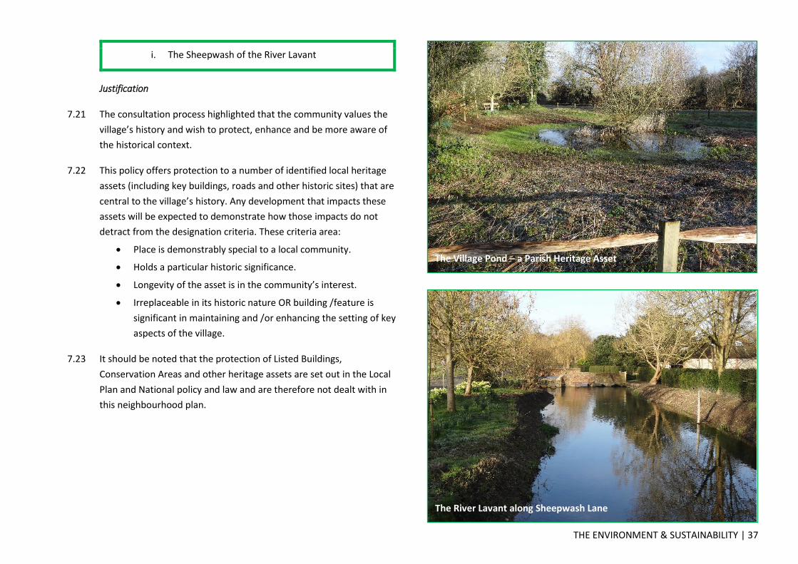
THE ENVIRONMENT & SUSTAINABILITY | 37
i. The Sheepwash of the River Lavant
Justification
7.21 The consultation process highlighted that the community values the
village’s history and wish to protect, enhance and be more aware of
the historical context.
7.22 This policy offers protection to a number of identified local heritage
assets (including key buildings, roads and other historic sites) that are
central to the village’s history. Any development that impacts these
assets will be expected to demonstrate how those impacts do not
detract from the designation criteria. These criteria area:
Place is demonstrably special to a local community.
Holds a particular historic significance.
Longevity of the asset is in the community’s interest.
Irreplaceable in its historic nature OR building /feature is
significant in maintaining and /or enhancing the setting of key
aspects of the village.
7.23 It should be noted that the protection of Listed Buildings,
Conservation Areas and other heritage assets are set out in the Local
Plan and National policy and law and are therefore not dealt with in
this neighbourhood plan.
The Village Pond – a Parish Heritage Asset
The River Lavant along Sheepwash Lane

38 | TRANSPORT AND INFRASTRUCTURE
8.0 TRANSPORT AND INFRASTRUCTURE
LNDP18 – New Public Rights of Way
8.01 Existing public rights of way within Lavant provide essential routes for
non-vehicular traffic to get around the parish. This includes Centurion
Way which acts as the main spine between Chichester and the SDNP.
8.02 It is key that these routes are protected and where possible new
routes are brought forward to improve the accessibility of the parish.
LNDP18 – New Public Rights of Way
Development proposals will be supported where they propose
new public rights of way, improving accessibility.
In particular, developments are encouraged to provide new public
footpaths along the routes identified on the LNDP Map.
Justification
8.03 Consultations have repeatedly identified the potential for serious risk
to pedestrians alongside some lengths of the A286 with the ever-
increasing volume of traffic.
8.04 The Roads and Traffic Day hosted by Hamilton-Baillie Traffic
Consultants resulted in substantial community support for measures
to mitigate the impact of vehicles including large agricultural vehicles,
articulated lorries and increasing numbers of visitors to Goodwood
events.
8.05 Any new development must facilitate connectivity of pedestrian only
routes and this is consistent with the ambitions of the SDNPA for safe
access to the countryside. These routes include:
Between the mini roundabout on the A286 and the Village
Green
Between the village Green and mid Lavant (Churchmead)
alongside the River Lavant
From Church Farm Barns parallel to Fordwater Road to
existing.
8.06 Additionally, as the use by traffic on green roads has changed with
the advance of technology, historical rights of way on un-made roads
that pre-date the combustion engine are not considered compatible
with today’s social and environmental responsibility to conserve the
countryside. Access by 4x4 off road activities along the river bed or
into adjacent land beyond rough unmade tracks is no longer tenable.
LNDP19 - Off-Road Parking in Residential Developments
8.07 The rural character, lifestyle of residents and minimal availability of
public transport have resulted in the parish having a higher than
average number of cars and vans per household (when compared to
the District, County or England as a whole.) This, when placed
alongside the relatively narrow roads within the parish, places
unnecessary stress creating pinch points where hazards are caused.

TRANSPORT AND INFRASTRUCTURE | 39

40 | TRANSPORT AND INFRASTRUCTURE
8.08 It is therefore prudent to ensure that any future development
provides adequate off road parking to meet the needs of that
development.
LNDP19 - Off-Road Parking in Residential Developments
All residential development must include provision for adequate
off-road parking spaces as set out below. Every dwelling should:
(a) Provide within its curtilage (or within the development if it
is a flat) 2 parking spaces or 1 parking space per bedroom,
whichever is greater; AND
(b) Include provision for adequate visitor parking (1 space of
0.5 spaces per dwelling rounded up to the nearest whole
number).
(c) Not include any form of tandem parking.
Justification
8.09 The 2011 Census data in the table below shows that only 10.1% of
households had no car or van (compared to 15.6% across Chichester
District), 46.5% of households have one car or van and 43.5% of
households have 2 or more vehicles. At the 2011 Census there was an
average of 1.54 vehicles per household in the parish, an increase
from 1.41 vehicles per household at the 2001 census. This trend is
expected to continue into the future.
Ho
use
ho
lds
wit
h n
o
cars
or
van
s
Ho
use
ho
lds
wit
h 1
ca
r o
r va
n
Ho
use
ho
lds
wit
h 2
ca
rs o
r va
ns
Ho
use
ho
lds
wit
h 3
ca
rs o
r va
ns
Ho
use
ho
lds
wit
h 4
or
mo
re c
ars
or
van
s
Ave
rage
nu
mb
er o
f ca
rs p
er h
ou
seh
old
ENGLAND 25.8% 42.2% 24.7% 5.5% 1.9% 1.16
West Sussex
17.8% 43.4% 29.2% 6.9% 2.7% 1.34
Chichester District
15.6% 42.0% 30.8% 8.0% 3.6% 1.44
Lavant Parish
10.1% 46.5% 31.7% 8.2% 3.5% 1.54
8.10 The Chichester District Local Plan 1999 (relevant to the area of Lavant
within the National Park) contains no saved policies relating to
parking provision for residential properties. The Chichester Local Plan
2014-2029 (relevant to the area of Lavant within Chichester District)
and the emerging South Downs National Park Local Plan which is at
the Preferred Options stage. The position on each of these is set out
below:
The Chichester Local Plan: Key Policies 2014-2029 Policy 39
(Transport, Accessibility and Parking) states that ‘The level of
car parking provision should be in accordance with current
West Sussex County Council guidance. This, together with
residential parking and the level of cycle parking, will be
assessed on a flexible site by site basis depending on the
provision of public transport and access to local facilities.’ The
current guidance issued by West Sussex County council is

TRANSPORT AND INFRASTRUCTURE | 41
contained with its Guidance for Car Parking in New
Residential Developments September 2010.
The South Downs National Park Preferred Options 2015
Policy SD44 states that development proposals should
‘provide an appropriate level of private cycle and vehicle
parking to serve the needs of that development in accordance
with the appropriate adopted parking standards for the
locality. Further guidance will be provided in a parking
standards SPD.’ According to this documents current
timetable it is not due for adoption until 2017 and the SPD
will be prepared after adoption.
8.11 The Guidance for Car Parking in New Residential Developments
September 2010 provides a set of principles upon which the quantum
of parking required can be identified. It also provides a calculator
upon which the ‘parking demand’ can be established. This calculator
uses the 2001 Census data as a baseline, and therefore does not take
into account the latest data as set out above and the increase in cars
per household. It is therefore right to ensure new development in the
parish responds to the increase in vehicles per household.
8.12 The last new development in Lavant, Meadow Close, was considered
by developers and CDC Planners to have adequate parking but has
since proved inadequate for the current residents and their needs.
This lack of vision regarding this aspect contributes significantly to the
pavement parking concerns on the A286. In addition it has detracted
from the well-being and neighbourliness of the cul-de-sac.
8.13 Whilst this policy seeks to vary the requirements of the Local Plan,
the provision of parking should not be considered a strategic matter
and therefore the Neighbourhood Plan has the ability to take
precedence over existing non-strategic policies in the Local Plan for
that neighbourhood where they are in conflict (see NPPF para 185).
In addition, Schedule 9 Part 2(6) of the Localism Act 2011 makes clear
that if a policy in the development plan for an area conflicts with
another policy in the development plan, the conflict must be resolved
in favour of the policy which is contained in the last document to
become part of the development plan.
8.14 Tandem parking layouts are often used by developers to provide off-
road parking in developments. This is when one car is to park in front
of the other, often along a drive or where a garage/carport is at the
end of a drive. Whilst these layouts provide the theoretical quantum
of spaces required they are often underused as one car is blocked in
when two cars are parked. This leads to an increase in vehicle
movements on/off the drive, often into the highway, or one space is
not used with the occupants preferring to park one car on the road.
This increases hazards and risk to both pedestrians and vehicles using
the highway. Ensuring tandem parking arrangements are not used
will remove this risk.
LNDP20 – Effective Traffic Management
8.15 The impact of traffic on the quality of public space is a concern to
many members of the community. On 30th July 2015 the Parish
Council hosted a visit and analysis of the issues by Ben Hamilton-
Baillie, director of Hamilton-Baillie Associates. Ben was the author of
“Traffic in Villages – A toolkit for communities” and has also drafted
the guidance for roads in the South Downs for the National Park
Authority.
8.16 The concept of shared space thereby not allowing traffic to dominate
the pedestrian environment emerged from this and subsequent

42 | TRANSPORT AND INFRASTRUCTURE
consultations with the Community and have been used to inform this
policy.
LNDP20 – Effective Traffic Management
Development proposals that require the creation/alterations of
roads shall:
Preserve historic roadside features (such as distinctive
fingerposts, milestones, unusual materials, post and
telephone boxes, nameplates, war memorials, etc.)
Only provide appropriately located and essential signage
that responds to the surrounding environment.
Contain measures to reduce the actual or apparent width
of the road. These measures could include an absence of
road markings, actual narrowing of the carriageway road,
careful use of materials, etc.
Identify and strengthen the main entry points to the
villages to achieve a clear transition between higher speed
roads and the village itself.
Incorporate measures to highlight the activities and
presence of the community, creating spaces for all non-
vehicular road users (inc. pedestrians, cyclists, and horse
riders) to enjoy.
Justification
8.17 The issue of perceived and actual speed of the traffic through Lavant
has been a prominent concern raised throughout the Consultation
process.
8.18 There is a need to incorporate traffic calming measures at
access/egress points such that there is a consistent approach
throughout the village.
8.19 Various measures will be required in addition to the minimal
engineering requirements of WSCC Highways.

SITE SPECIFIC POLICIES | 43
9.0 SITE SPECIFIC POLICIES
9.01 The policies within this section relate to particular sites within the
parish that have been identified as being suitable for development.
They have been identified following extensive consultation with the
local community, landowners and assessment by the SG. This process
is set out within the Assessment of potential development sites report
contained within the evidence base supporting this plan.
9.02 Six sites are allocated for development over the plan period:
Policy Ref.
Sites Assessment Ref.
Name Location
LNDP21 Site 3 Land adjacent Pook Lane
Mid Lavant
LNDP22 Site 4 Church Farm Barns East Lavant
LNDP23 Site 7 Eastmead Industrial Estate
Mid Lavant
LNDP24 Site 11 Summersdale Garage & Maddoxwood House
Lavant
LNDP25 Site 13 St Nicholas Church Mid Lavant
LNDP26 Site 14 The Rectory East Lavant
9.03 It should be noted that whilst the policies within this section relate to
specific sites development proposals that come forward on these
sites should not only adhere to the relevant policy but also all other
planning policies. That includes policies within this plan as well as
those set out by the relevant Local Planning Authority and Central
Government.

44 | SITE SPECIFIC POLICIES
LNDP21 – Land adjacent Pook Lane
9.04 This site encompasses the football field to the south of Mid Lavant,
land south of Pook Lane opposite the Village Hall and a small parcel
of land north of Pook Lane south of the Village Hall.
9.05 The playing field has been assessed as a space that could be worthy
of designation in its own right given the importance of the space to
the community. However, it has also been assessed as a suitable
location to deliver housing.
9.06 This allocation will see the football field in its current location being
lost but a new larger area being provided in perpetuity near the
Village Hall where improved vehicular access (and parking) can be
provided. It is considered that the allocation is the most sustainable
way to make use of the site which delivers a number of positive
results.
BENEFITS
Provision of new football pitch secured for the community in
perpetuity. Better vehicular access can also be provided
adjacent to the Village Hall (see 3 and 4 on map and in
policy).
The Scheduled Monument (The Chichester Intrenchment )
that runs along the northern border of the current football
field that is currently ‘At Risk’ can be protected & awareness
raised of its existence.
Provision of needed housing in a suitable location (see 1 on
map and in policy).
Improved accessibility from Mid to East Lavant meaning
pedestrians no longer have to walk down Pook Lane which
has no pavement (see 5 on map [blue dotted line] and in
policy).
Will open up a historic vista of SDNP which has been lost.
ISSUES:
Will increase traffic onto Lavant Road and may require
removal of trees to facilitate this access.
Loss of an area of amenity space for the village.
Users of new playing field will have to cross Pook Lane from
car park.
Screening of houses as viewed from Village Green will be
needed.

SITE SPECIFIC POLICIES | 45
LNDP21 – Land adjacent Pook Lane
The site is allocated for the provision of a new football field with
associated parking, new public footpath, and up to 12 dwellings.
Development of this site should accord with all of the following
criteria:
1) Circa 12 new dwellings to be provided on the existing
playing field site. Access shall be provided from Lavant
Road.
2) A 20m buffer shall will be provided between Devils Ditch
(a Scheduled Monument) located along the northern
boundary of the site and any development. This buffer
shall be retained as public open space. The field to the
east of the existing playing field shall form public open
space. These areas shall be made available in perpetuity
for use by the public.
3) A car parking area to allow vehicles to park safely off the
road when visiting the new football field identified at (3)
shall be provided south west of the village hall adjacent to
Pook Lane. This areas shall be made available in perpetuity
for use by the public.
4) A replacement football pitch shall be provided on the land
south of Pook Lane opposite the village hall for
community use. This area shall be made available in
perpetuity for use by the public.
5) A new public footpath shall be provided across the north
of the site within the 20m buffer identified above (2)
connecting Lavant Road to the Village Hall. A further
pedestrian access shall be created linking the southeast of
the new housing area (1) to the bus stop and existing
footpath on Lavant Road.
Those aspects of the development that are to be made available in
perpetuity for use by the public should be secured by legal
agreement prior to any development commencing on the
dwellings and associated access.
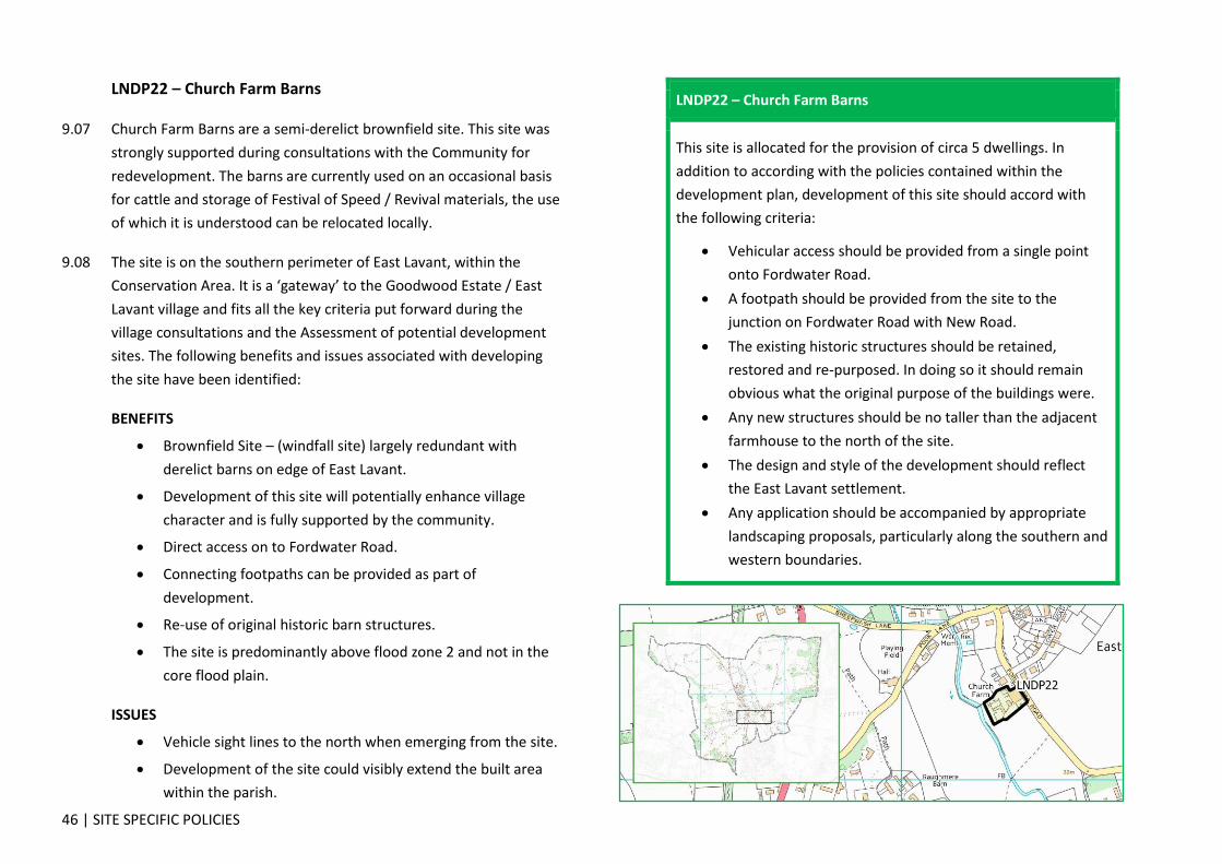
46 | SITE SPECIFIC POLICIES
LNDP22 – Church Farm Barns
9.07 Church Farm Barns are a semi-derelict brownfield site. This site was
strongly supported during consultations with the Community for
redevelopment. The barns are currently used on an occasional basis
for cattle and storage of Festival of Speed / Revival materials, the use
of which it is understood can be relocated locally.
9.08 The site is on the southern perimeter of East Lavant, within the
Conservation Area. It is a ‘gateway’ to the Goodwood Estate / East
Lavant village and fits all the key criteria put forward during the
village consultations and the Assessment of potential development
sites. The following benefits and issues associated with developing
the site have been identified:
BENEFITS
Brownfield Site – (windfall site) largely redundant with
derelict barns on edge of East Lavant.
Development of this site will potentially enhance village
character and is fully supported by the community.
Direct access on to Fordwater Road.
Connecting footpaths can be provided as part of
development.
Re-use of original historic barn structures.
The site is predominantly above flood zone 2 and not in the
core flood plain.
ISSUES
Vehicle sight lines to the north when emerging from the site.
Development of the site could visibly extend the built area
within the parish.
LNDP22 – Church Farm Barns
This site is allocated for the provision of circa 5 dwellings. In
addition to according with the policies contained within the
development plan, development of this site should accord with
the following criteria:
Vehicular access should be provided from a single point
onto Fordwater Road.
A footpath should be provided from the site to the
junction on Fordwater Road with New Road.
The existing historic structures should be retained,
restored and re-purposed. In doing so it should remain
obvious what the original purpose of the buildings were.
Any new structures should be no taller than the adjacent
farmhouse to the north of the site.
The design and style of the development should reflect
the East Lavant settlement.
Any application should be accompanied by appropriate
landscaping proposals, particularly along the southern and
western boundaries.

SITE SPECIFIC POLICIES | 47
LNDP23 – Eastmead Industrial Estate
9.09 As a brownfield site this site was strongly supported during
consultations with the Community for redevelopment for mixed use.
The industrial estate is rundown and only partially occupied. The
buildings, some of which date back to 1938, are no longer fit for
purpose. The roads around the site are not suitable for modern
articulated lorries and their construction and waste water runoff
causes flooding to the east of the site.
9.10 The site has direct access onto the A286 at the northern end of Mid-
Lavant, surrounded by housing on all four sides, and fits all the key
criteria put forward during the village consultations, the Assessment
of potential development sites report. The following benefits and
issues associated with developing the site have been identified:
BENEFITS:
Brownfield Site – Low occupancy and set to fall further as
buildings no longer fit for purpose.
Redevelopment of this site would add to the visual appeal of
a Downland village.
Direct access on to A286 and public transport.
Potential easy access to public footpath network.
Regenerated mixed use site can provide more local
employment than currently, as well as affordable dwellings.
Opportunity to provide additional road access/egress to
Gaston Way.
ISSUES:
Access onto the A286, due to the blind spot looking north
caused by cars parked on the pavement along Yarbrook.
Possible migration of on street parking to new developed
area.
Loss of designated employment space.
Flooding particularly in north-east corner.
Buildings contain asbestos.
Potential ground contamination.
LNDP23 – Eastmead Industrial Estate
This site is allocated for the provision of a circa 30 dwellings and
light industrial & office use. 40% of the site should be retained as
employment land. In addition to according with the policies
contained within the development plan, development of this site
should accord with the following criteria:
As a large site this requires an imaginative and
inspirational concept design that strikes the correct
balance between open space and built development. The
residential element should be no denser than that of the
immediate surroundings.
Public open and recreational space should be at the centre
of the development and not as space that is left over after
planning.
A pedestrian access between from/to the north-east of
the site should be provided.

48 | SITE SPECIFIC POLICIES
LNDP24 – Summersdale Garage & Maddoxwood House
9.11 This site comprising a redundant dwelling at the west end of the site
and currently contains warehousing and a petrol filling station on the
eastern side. It provides a sustainable development opportunity for
around 20 dwellings. There is no impact on the landscape of the
SDNP and no impact on the settlement of Lavant. Maddox Wood to
the north could potentially be gifted to Lavant Parish Council as a
buffer to safeguard any future development northwards.
9.12 The following benefits and issues associated with developing the site
have been identified:
BENEFITS:
Partial Brownfield Site comprising warehousing, Petrol Filling
Station and small convenience store.
The PFS and convenience store to be upgraded and retained.
Direct pedestrian/cycle access on to Centurion Way should be
provided as part of re-development.
Direct vehicle access to the A286.
Maddox Wood provides a barrier to further development
northwards.
The site is not visible from the SDNP.
This development has strong community support.
ISSUES:
Potential issues regarding sewerage capacity.

SITE SPECIFIC POLICIES | 49
LNDP24 – Summersdale Garage & Maddoxwood House
This site is allocated for up to 20 dwellings. In addition to being in
accordance with the policies contained within the development
plan, development of this site should accord with the following
criteria:
The petrol filling station and convenience store should be
retained.
Any application should be accompanied by a Sewerage
Infrastructure Assessment confirming that the local
sewerage infrastructure can accommodate the proposed
development.
A pedestrian and cycle access route should be provided to
Centurion Way.
An application to be made to WSCC Highways to extend
the 30 mile and hour speed limit to the North of
Maddoxwood House site.

50 | SITE SPECIFIC POLICIES
LNDP25 – St Nicholas Church
9.13 The village has expressed a desire for a village hub during previous
consultations and using St Nicholas Church for this purpose has been
strongly supported by the community in previous consultations.
9.14 When this was previously discussed the building was unavailable.
However, the Diocese of Chichester now support the use of this
facility for the wider benefit of Lavant residents.
BENEFITS
Optimisation of the building and its surroundings would
benefit the wider community.
Possible to incorporate a community shop in the hub
Existing good and safe pedestrian access available.
Central and prominent location in the parish, re-establishing
a true central focus.
Potential benefits from off-road parking.
ISSUES:
Church is a Grade II listed structure within the Conservation
Area.
Formal approval of any change of use would require approval
from the Church Authorities; there is an agreement in
principle at this time.
Development may impact the historical and religious
significance of the building, its setting and burial ground.
Increased usage of the building may impact parking for local
residents
LNDP25 – St Nicholas Church
St. Nicholas Church is allocated for use as a Community Hub. In
addition to according with the policies within the development
plan, any development required to fulfil its use as a Community
Hub should accord with the following criteria:
Any development should not obscure or detrimentally
impact the historical and religious significance of the
building, its setting or burial ground.
Existing access arrangements should be retained and the
north entrance improved with appropriate parking
adjacent.
Existing trees on the site should be retained.
Boundary planting along the southern boundary should be
used to secure the tranquility of the area from the
adjacent A286.

SITE SPECIFIC POLICIES | 51
LNDP26 – The Rectory
9.15 A brownfield site owned by the Diocese of Chichester. The site
currently comprises a 1950’s Rectory, outbuildings and gardens which
include a ‘curio’. The historical significance (if any) of the curio is
currently not known.
9.16 The site is within East Lavant and the Conservation Area. Subject to
confirmation of the historical significance of the curio, the site fits the
key criteria put forward during the village consultations, the
Assessment of potential development sites report.The following
benefits and issues associated with developing the site have been
identified:
BENEFITS:
Previously developed site.
Development will potentially enhance village character.
Direct access on to Pook Lane.
Would enhance the range of dwellings available in East
Lavant.
ISSUES:
Vehicular and pedestrian access onto Pook Lane currently has
a restricted line of sight.
The site is within the Environmental Agencies flood zone 2
but not part of the core flood plain. However there is no
historical evidence to demonstrate that the site floods. Aerial
photos from 1994 support this.
The site encompasses a ‘curio’ which may be of historical
significance.
The site is outside the Settlement Boundary albeit visually
part of the East Lavant settlement.
The redevelopment of this site is subject to the provision of
another site for a Rectory within the parish.
LNDP26 – The Rectory
The site known as The Rectory is allocated for up to 8 affordable
dwellings. In addition to being in compliance with the policies
contained within the development plan development of this site
should accord with the following criteria:
The development should include suitable flood defence
measures through landscaping and/or on the dwellings
themselves.
The historical significance (if any) of the ‘curio’ needs to be
established and appropriately responded to.

52 | SUPPORTING DOCUMENTS
SUPPORTING DOCUMENTS
The LNDP is based on the views of residents, businesses, statutory consultees
and other interested parties gathered through previous consultation and a
range of studies the SG and other parties have carried out.
Documents prepared by, or specifically for, the Steering Group include:
Consultation Statement & Appendices (March 2016), Steering Group
Community Matters (March 2016), Steering Group
Assessment of potential development sites (February 2016), Steering Group
Historical Flooding in Lavant (March 2016), Steering Group
Settlement Boundary Review (February 2016), Steering Group
A review of open spaces in and around Lavant (February 2016), Steering Group
A review of heritage assets in Lavant (February 2016), Steering Group
Rural Housing Needs Survey Report (June 2014), Chichester District Council
Sustainability Appraisal / Strategic Environmental Assessment (March 2016), Enplan
The above documents are available to download from the Parish Council’s
website - http://www.lavantparishcouncil.co.uk/
Documents prepared by other parties include but are not limited to:
European Directive 2001/42/EC
Localism Act 2011
Planning and Compulsory Purchase Act 2004
Town and Country Planning Act 1990
The Town and Country Planning (Local Planning) (England) Regulations 2012
The National Planning Policy Framework (NPPF) 2012
The National Park Purposes & Duty
English National Parks and The Broads – Vision and Circular 2010
The Chichester District Local Plan 1999, Chichester District Council
The Chichester Local Plan 2014-2029, Chichester District Council
South Downs National Park Local Plan: Preferred Options 2015, South Downs National Park Authority
Lavant watershed Biodiversity Opportunity Area, Sussex Biodiversity Partnership
Walderton to Welldown including Kingley Vale Biodiversity Opportunity Area
Office for National Statistics, Census 2011, Neighbourhood Statistics
CDC Housing register ‘Homemove.' Source. CDC website
Historic England data available at https://historicengland.org.uk/listing/
Lavant watershed Biodiversity Opportunity Area, Sussex Biodiversity
Partnership Sussex Biodiversity Partnership c/o Sussex Wildlife Trust
Sussex Biodiversity Target Area Identification Consultation conducted by
Sussex Biodiversity Record Centre August – November 2008
Desktop Biodiversity Report Record Centre Report regarding land at Lavant
Watershed BOA 02/06/2015 Lavant Parish Council ESD/15/392
Upper Lavant Valley Flood Risk Management Study, West Sussex County
Council - January 2015
Hydraulic modelling of Rivers Lavant and Ems, Cole Howard and Moore
Centre for Ecology and Hydrology, 2009
The Chichester Flood 1994 report, S M Taylor of the National Rivers Authority
Posford Duvivier River Lavant Flood Investigation commissioned by the
National Rivers Authority Southern Region

GLOSSARY & ABBREVIATIONS | 53
GLOSSARY & ABBREVIATIONS
Asset of Community Value
An asset of community value is land or property of importance to a local community which is subject to additional protection from development under the Localism Act 2011. Voluntary and community organisations can nominate an asset to be included on their local authority's register of asset of community value.
BAP Biodiversity Action Plan
BOA Biodiversity Opportunity Area
Brownfield site Abandoned, closed or under-used industrial or commercial facilities
CDC Chichester District Council
CDCLP Chichester District Council Local Plan
Conservation Area
An area of notable environmental or historical interest or importance which is protected by law against undesirable changes.
Core Floodplain Area of land alongside a river that is prone to frequent flooding
Grade Separated Junction
A method of aligning a junction of two or more roads at different heights (grades) so that they will not disrupt the traffic flow on other transit routes when they cross each other
HE Highways England
Historic England Formally English Heritage
Listed Building A building that has been placed on the Statutory List of Buildings of Special Architectural or Historic Interest
LNDP Lavant Neighbourhood Development Plan
Local Community Space
Space valued by the local community, both for the environmental and social benefits it brings
Local Green Space
Designating areas as Local Green Space is a way to provide special protection against development for green areas of particular importance to local communities.
Low priority category
Applicants for ‘Council’ housing are categorised dependent on need, the higher the priority the greater chance of being offered a house
LPC Lavant Parish Council
LPS Lavant Primary School
NP Neighbourhood Plan
NPPF National Planning Policy Framework
PFS Petrol Filing Station
Privately Rented
A property offered or rented form a commercial landlord
SDNP South Downs National Park
SDNPA South Downs National Park Authority
Settlement Boundary
Settlement boundaries are an essential tool for the management of development, principally to prevent the encroachment of development into the countryside
Sewerage Infrastructure Assessment
A review of the capacity of the network to take the expected flows (post proposed development)
SG Steering Group
Socially Rented A property offered or rented form a not for profit landlord
Stakeholder A person, group or organisation that has interest or concern in or for the Parish of Lavant

54 | GLOSSARY & ABBREVIATIONS
Strategic Gap The space between settlements which protects individual settlements’ unique identity
Tithing To pay or give a tenth part of ‘earnings’ for the support of the church
Tree Preservation Order
A TPO is made by a Local Planning Authority to protect specific trees or a particular area, group or woodland from deliberate damage and destruction. TPOs can prevent the felling, lopping, topping, uprooting or otherwise willful damaging of trees without the permission of the Local Planning Authority.
Vernacular Is a category of architecture based on local needs, construction materials and reflecting local traditions.
WSCC West Sussex County Council
WWII World War Two

GLOSSARY & ABBREVIATIONS | 55