pre-meeting agenda mountain brook … doc number: prior 1 st mlg ratekype: ! prior deed type: deed...
TRANSCRIPT

PRE-MEETING AGENDA MOUNTAIN BROOK CITY COUNCIL
PRE-COUNCIL ROOM (A106) CITY HALL
56 CHURCH STREET MOUNTAIN BROOK, AL 35213
JUNE 8, 2015, 6:00 P. M.
____________
1. Request by Urban Cookhouse to hold a Farmers’ Market in Crestline Village Friday afternoons/evenings during June-August – Clint Deshazo of Urban Cookhouse. (See attached information. This item may be added to the formal agenda.)
2. Add two (2) additional 15-minute parking spaces in Mountain Brook Village – Dana Hazen. (See attached maps. This item may be added to the formal agenda.)
3. Annexation petitions (Irving Meisler of 106 Lockerbie Lane (0.30 acres) and Lockerbie Association, Inc. of 3871 Lockerbie Drive (0.01 acres for connectivity to corporate boundary). (See attached. These items may be added to the formal agenda.)
4. Executive Session.

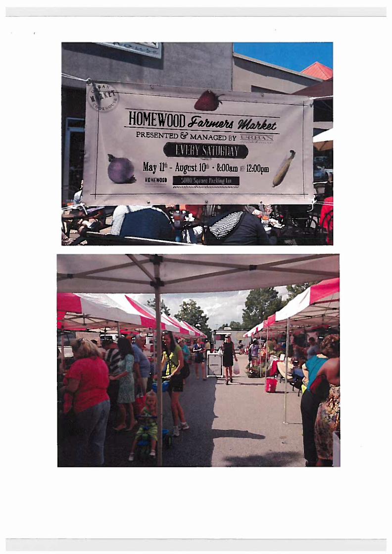
Urban Cookhouse Farmers Marke ts were established in 2010 in response to a growing need to support small family farms. In response to our motto, "Buy Local. Eat Urban," UC desires to provide a connection between these farmers and the local community. We currently manage two farmers markets, one in downtown Homewood (Soho Lot) and another at The Summit Shopping Center. All of our vendors are local. from a rough geographic range of about 85 miles. It's an absolute joy to serve these farmers and vendors, and UC's goal is to pull in the community to join us in this support.
Where: Church Street- In Front of City Hall (See Map Attached)
When: The markets will run for 6 weeks on Friday evenings from 4-8pm. July 3rd -Aug 7
Who manaa:es: Urban Cookhouse will fully manage the markets. Tim Hughes with Game Day Done Right provides all of our tents so the layout is very professional looking. http://www.gamedaydonerjght.com
Who comes: A variety of local growers and vendors. We will not bring anyone into the market that has a competing good with a Crestline merchant. We will also have kid's activities such as corn hole, face painting, etc. There will also be a booth hosted by Mountain Brook Commerce where retailers in the community can come out and represent their business. Cooking Demos will also take place for Crestline restaurants.
Oversia:ht Committee: Julie will head this, as she is top representative of Crestline merchants. Their job is to approve Farmers Market vendors so there are no competing vendors with Crestline merchants.
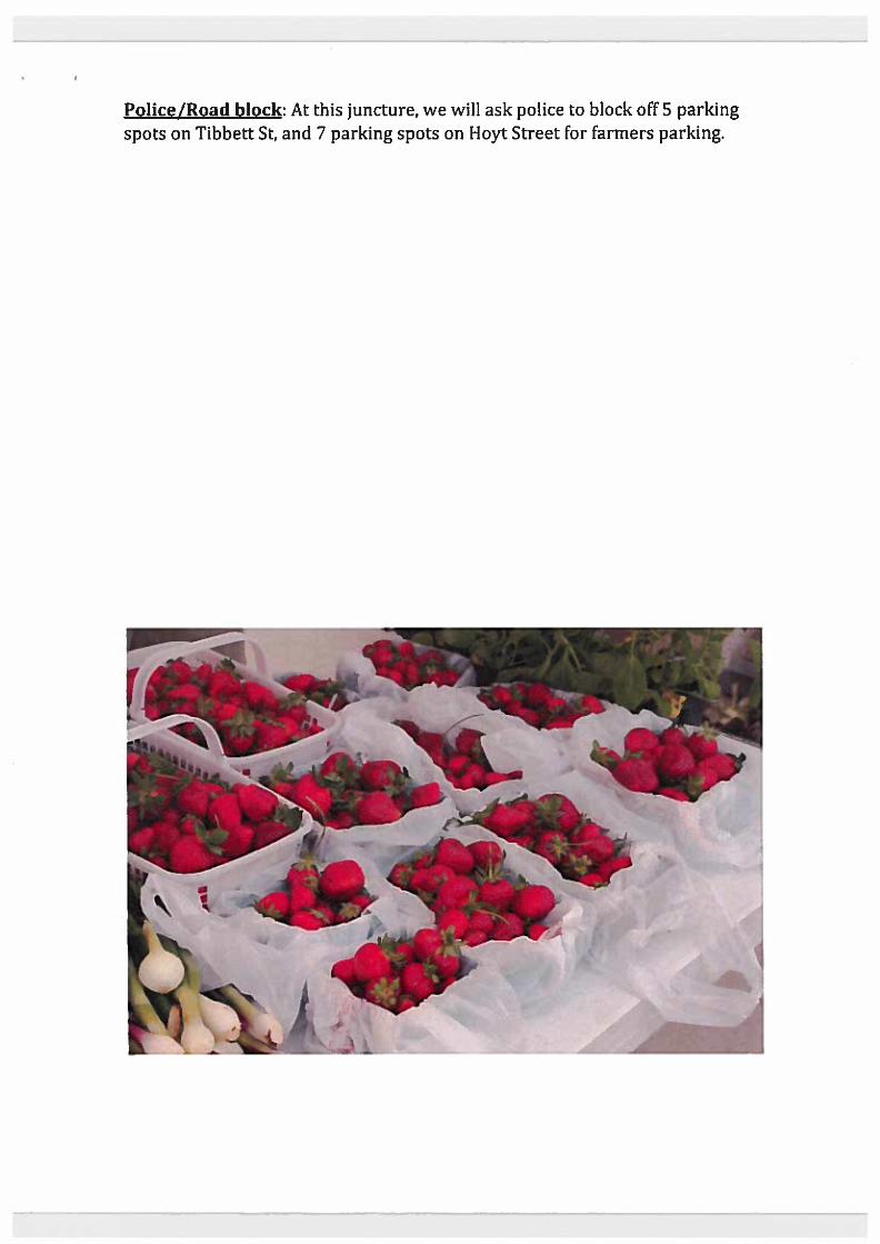
Police/Road block: At this juncture, we will ask police to block off 5 parking spots on Tibbett St, and 7 parking spots on Hoyt Street for farmers parking.
HOMEWOOD $'~ ~ PRESENTED & MANAGED BY "1m" "'i
." .....
I HI/\ .\ U "Ii II \\ -. May IP - August 10' . 8:00am ~ 12:OOpm

l

· . "
City of Mountain Brook EVENT PERMIT APPLICATION
FOR EVENT, PARADE, PROCESSION, OR OTHER AssEMBLY (Applications submitted Ius then 30 dqllS prior to ti,e (!IIent may not be approllC!d.)
Date: 5/z..o/7.D''s: Individual or organization:: 1JIl-e.1ct4 {CIO~~"}-e
Contact Information: (a) Name; Choir t>elt1'Jo (b) Title:' ___ >~P::s.c.e;liLtt~,~eo:.:v:=""'=u..I:b,--__
(c) Address: 't2.f:l'l '?l"le Cpyet '->'.......... ttl!-
(d) Tel No. (e) Cell No. Ls>'C - S;4 - b ~T' (g) Email address: e.\, tJ~@ V I !>..Nt OOWvlC. (f) Fax No. _________ _
Describe the type, nature, character and purpose of the event (list all activities):
t=',,\LJ!\i:(U /l:\A!l..gk. 5, ..... ,t e.tW't·
Give the inclusive date(s)/time(s) of the event: f'p...d~, IIIl1k~
Give the number and composition oithe event: Compoocnt People (riding/walking) Motor Vehicles Floats Animals
Q
Q
a Other Q
Identify the place, area, locality, andlor route of the assembly:
'"'"rl ~C5!"''t oJ. Cit=( fu.1! • ~c1"'f T,,,,i) ±! (,,-I-, 'P
Will it be nec~ to block any street or sidewalk during the course of tile assembly/event? Ifso. explain" o. Sn::Ic H&1l:; _ Lu" 1" d)'ScI +=sz S1" II in aN
Will alcoholic beverages be sold andlor served? If so, explain circumstanccs. _____ _
Will money be solicited? If so, explain circumstances? ____________ _
1\.0 Will sip. placards, banners. flaas or cards be displayed?_..,V""', ... t _______ _ List all vendors who will be supplying food, drink(s), games, booths,
etc.: k-Is§ A M ""AfI-&Sg.. i
Applicant Signature: (lit; (;I V Telephone Number: ( ) S-W; - f"l "it)
-

. . . '. .
• ••••••••••••••••••••••••••••••••••••••••••••••••••••••••••••••••••••••••••••• Approved this __ day of _______ , 20_
or Lawrence T. Oden, Mayor Sam S. Gaston, City Manager ............. Parade Safety & Restrictions·
• Candy or other objects shall not be tbrown or otberwise transferred to anyone alonl the parade route from vebicles or Ooats tbat are active witbin the parade.
• No stoPpinl alonl the parade route. • All Ooat drivers must be properly licensed and insured. All drivers should be
adults. • All Ooats must have adequate lines of vision for tbe the drivers to see. • No float or parade participant may tum out of the designated parade route
without police approval and direction. • No float participating in the parade event shall exceed 13 feet iD height as
measured from the ground to the highest point of the Ooat.
·St ..... dlle ..... IO lb ... restrlello .. 1IU1111e mll.t.lled. Fall_ .. lo adbe .. loth ...... lrI.IIo., ma, ..... Immedlat ••• plllllo. Crom tb. pa .... allb •• 1T .. dIa. pa.ty. may ..... 1b.III .. edltl. ,lopPlC' .Ub. pa .. d •• nd wiD J •• pardlze ftllure pll'All ... Orplllllo. parlles .. IUI.DIU ... 11 drlv.n In lb. p ... d .... ftlmbb.d a eapy oC III ....... rI.tlo ...
I hive read, understand and agree to comply with these guidelines. _____ -:::--:-____ _ Slp_ture
Police Department Remarks Applicant said no streets or sidewalks would be blocked. I cautioned him that this may create a traffic problem in the area and that we did did not have on duty personnel to direct traffic. I also told him that
Tibbett St could not become blocked. I told him if the event caused tr~ffic problems, they may be required to hire officers, but not at this po~nt. /l a. Signed: C. ~ Otpl/\ 4-\ Date: OS/26/2015
Applicant said PO did not need to do anything in preparation for event •
••••••••••••• Revenue Department Remarks;
Signed:. _________ _ Date: ___________ _
The approved application serves as the permit.
If you have any questions, please contact Doris Kenny at 802-3800 or [email protected] • EIrccIIve Novembor 2014

c=) Approved
_ Existing MB Village (north end) o.~
•

q Approved MB Village (south end)

To: Sam Gaston, City Manager
From: Steven Boone
Date: June 5,2015
Subject: Lockerbie annexation petitions
C: Mayor and members of the City Council
On Friday afternoon, I received the attached annexation petitions. Mr. Meisler wishes to annex his residential property into the City. In order to be contiguous, a 0.01 acre strip of land owned by Locker Association, Inc. must also be annexed hence the two annexation petitions.
Based on the questionnaire, there are no school-age children residing the residential property valued by the Tax Assessor at $1,062,900. Using the city-wide average students per household ratio of 0.56, the property is generating $8,484 per [imputed] child. This amount exceeds the ad valorem generated per student of $5,669.
The most recent annexation criteria are attached.
Based on the information provided in the annexation petition and available from Jefferson County with respect to valuation and ad valorem taxes generated, I am satisfied that this property meets the City's annexation criteria.
I will have ordinances ready for action should the City Council wish to proceed on June 8,2015.
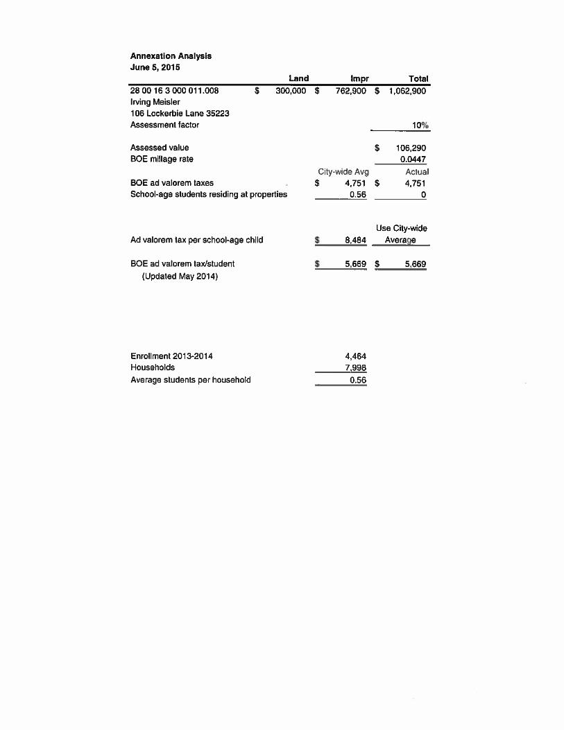
Annexation Analysis June 5,201 5
Land lmpr Total 28 00 16 3000 011.008 $ 300,000 $ 762,900 $ 1,062,900 Irving Meisler 106 Lockerbie Lane 35223 Assessment factor
Assessed value BOE millage rate
BOE ad valorem taxes School-age students residing at properties
Ad valorem tax per school-age child
BOE ad valorem laxistudent (Updated May 2014)
Enrollment 201 3-2014 Households Average students per household
$ 106,290 0.0447
City-wide Avg Actual $ 4,751 $ 4,751
0.56 0
Use City-wide $ 8,484 Average

Property Detail Report For Property Located At : 106 LOCKERBIE LN, MOUNTAIN BRK, AL 35223-2902
@ Corebgic. ReaIQuesta Professional
Owner Information 8 Owner Name: MEISLER IRVING D
Mailing Address: 100 VILLAGE ST, BIRMINGHAM AL 35242-6452 R087 Vestlng Codes: I I Location lnformation
I Legal Descrlplion: LOT1 CLUSTER 1 LOCKERBIE PHASE N 141167 AMENDED MAP 948120 County: JEFFERSON, AL APN: 28604 6-3-000-01 j.008 Census Tract1 Blocic; 108.04 1 1 Alternate APN: 367054 Township-Range-Sect: 18-2W-I 6 Subdivislon: LOCKERBlE P N AM Legal BooklPage: 148-20 Map Reference: 28-16-3 128-1 6-3 Legal Lot: 1 Tract #: Legal Block: 1 School District Market Area: School Dlstrict Name: Neighbor Code: Munl &Township: OUTSIDE MUNlC Owner Transkr lnforrnatlon RecordinglSale Dale: I Deed Type: Sale Price: 1 st Mtg Document #: Document #: Last Market a l e lnformation
RecordinglSale Dale: 12l19l2013 112104I2013 1 sf Mtg ArnounUType; Sale Price: $789,200 1 st Mtg Int. Ralemype: Sale Type: 1 st Mtg Document #: Document #; 65-1 5399 2nd Mtg AmounUType: Deed Type: WARRANTY DEED 2nd Mtg Int. Ratenype: Transfer Document #: Price Per SqFt: New Construction: MulUlSplil Sale: Title Company: Lender: NATIONAL BKICOMMERCE 1 Seller Name: WlDEMAN FRANCES D Prlor Sale Information
I Prior ReclSate Date: 1 0913011 985 Prior Lender: Prior Sale Price: $69,000 Prlor 1 st Mtg AmUType:
I Prlor Doc Number: Prior 1 st Mlg RateKype: Prior Deed Type: DEED (REG) ! Property Characteristics
I Gross Area: 8,335 Parking Type: Construction: Living Area: 7,392 Garage Area: Heal Type: FORCED AIR Tot Ad] Area: Garage Capadly Exterlor wall: WOODlBRlCK
Above Grade: 6,070 Parking Spaces: Porch Type: CONCRETEMASONRY PORCH i Total Rooms: 10 Basement Area: 2,265 Patio Type:
I Bedrooms: 4 Flnish Bsmnt Area: 1322 Pool: j Bath(FM): 411 Basement Type: BASEMENT Air Cond: CENTRAL i Year Built I ER 19961 Roof Type: GABLE Style:
Rreplace: Y l l Foundation: WOOD Quality: 1 #ofStories: 2.00 Roof Material: ASPHALT SHINGLE Condition: Other Improvemtnts: Site Information
1 Zoning: R-7 Acres: 0.30 County Use: SINGLE FAMILY (11 1) / Lot Area: 13,113 Lot WldthlOepth: x State Use: a Land Use: SFR ReslComm Units: I Water Type; PUBUC i Slte Influence; Sewer Type: SEPTIC TANK j Tax Information / Total Value: $1,062,900 Assessed Year: 2014 Property Tax: j Land Value: . $300,000 Improved %: 72% Tax Area: 0020000 1 Improvement Value: $762.900 Tax Year: Tax Exemption: i Total Taxable Value: ,- - ...-- -
$631,200 1 CONV I ADJ 65-1 5406 I I $106.76

OWNeR--MAP
JEFFERSON IYm91m.IsIp
-13
SI'ATE OF ALABAMA DEPARTMENT OF REV?WUE
PROPERIYYTY~,DIVISION W.UIXIcDLmrmUILOlOmCL -- *&?i?i=&,?z?L


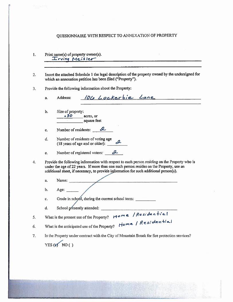
QUESIONNAIRE WITH RESPECT TO ANNEXATION OF PROPERTY
1. Print name@) of property owner(s). x r v i n q Mc i s l q
2. Insert the attached Schedule 1 the legal description of the property owned by the undersigned for which an annexation petition has been filed ("Property").
3. Provide the following information about the Property:
a. Address: /bcr ~ o t ~ ~ c r b ; a ;
b. Size of property: r 3U acres, or
square feet
c. Number of residents:
d. Nvmber of residents of voting age (18 years of age and or older): &
e. Number of registered voters:, dt
4. Provide the following information with respect to each pemn =siding on the Property who is under the age of 22 years. If more than one such person resides on the Property, use an additional sheet, if necessary, to for such additional person(s).
b. Age: / c. Grade in sch 1, during the current school term: p" d. School 6 s t n t l Y attended:
/ ~ c s ; & e n - k i a l 5. What is Ule present use ofthe Property? I? * " - -
t-w'"''' / flcriden+;=I
6. What i s the anticipated use of the Property?
7. Is the Property under contract with the City of Mountain Brook for fire protection services?

e (signature of owner)
(signature of owner)

TO THE CITY CLERK AND THE CITY COUNCIL OF THE CITY OF MOUNTAIN BROOK, A MUNICIPAL CORPORATION IN THE STATE OF ALABAMA:
The undersigned is the owne (are the owners) of the property described in Exhibit A attached hereto ("Propertya'), which Q r ous to the corporate limits of the City of Mountain Brook, a municipal corporation in the State of Alabama ("City"). No part of the Property is within the corporate limits or police jurisdiction of any other municipality. (I) (We) hereby file this petition with the City Clerk of the City and request that the Property be annexed to the City, pursuant to the Code of Alabama 1975, §11-42-21, et seq. A map of the Property, which shows its relationship to the corporate limits of the City, is attached hereto as Exhibit B.
In witness whereof, the undersigned (has) (have) signed thir petition on the _IS* day of , 2 0 g
1 .
Witness
Witness
z r u r q M e h j ~ @rint or type n'ame on this line)
(signature)
(print or type name on this line)

Description of Property
s , i ? ( f l ~ L H f i t . $?Czit'
Schedule 1


Property Detail Report For Property Located A! : 106 LOCKERBL LN, MOUNTAIN BRK, AL 35223-2902
tg core,,, RealQuest' Professional
I ----.-
Owner lnfomtlon Owner Nam: MBSGR IRVING 0 MaRing AUdmss: 100 WE ST, BlRMlNEHAM AL J6282-6162 ROW Vesting Codm I I
: LocaUon Inforinallon . Legal OesalpM: LOT1 CLUStU3 1 LOCKERBJEPHASEIY 14167 AMENDED MAP148120 ' C~uflly JemRSON,Al. APN: 2840-1 W O O 0 4 11.001 a Censiu7hdlBnck 1oa.M I1 AkmslsAPN: 367064 ! fm-ge-sect 18-2W46 SuWMdon: LOCKEIWE P WAM Legal BookPspe: 148-2D Map Rolorence: 28-163 128.164 hgal LOE I Tmet l:
I
Legal Block I Schod Dktlet: MerkclAme: School Mslrlct Nam: Nelghbor Code: hlunlEZTownsMp! OUTSIDE MUMC Owner Tmnskr Informatfon RecordlnglSde Dab: I Deed Type: Sale Prks: 1st Mlg Dawrnentt: Doabmenlt: Last Market SaIo InformaUon RecMdlnglSak Dab: 12H~R013112l01120t3 1st Mlp AmaunVTyps: $631,200 ICONV &fa Pdm: ~ 8 9 9 0 1aMtg lnt RaWype: IADJ 8erSType: IslMtg Do~mant& 65-is108 OocumenlR . 8116389 2nd Mlg Amom- I OcedType: WARRANTY'DEED 2nd Mlg In!. RahTTLpe; I Transfer Ooanneni X: fWa Per SqFt 5108.76 H e w Constnrdlon: MtdWSplil Sale:
I Tlle Company: NAIONAL BKICWERCE 1 Y %a",, WIDEMAN FRANCES O
1 Ptiot Sale Infarmallon ! Ptlar ReorSah Dale' IOSnW1988 Prior Lmdef: i HksNE%& S63,OOO
~ d o r 1st Mlg m e : I j Prior 1 s1 Mlg RaWyps: I o w (REG]
i Property Chaneterlstlcs ' Gmu ~ r e a : 8,336 PaMng Type: Conaudon: il Uvlnp Amr 7,392 Garage h a : eat we: FORC w AIR . Tol AdJ kea I
Garage Capadly: hferlarwalb WOOP/BRICK ' AbwaGradr 6,070 Parklng Spa- P~reh Type: CONCREEMASONRY
PORCH j Totel Room: 10 Basement m a : We6 Pello Type: i Bedroom: 4 nnlsh8wnntAma: 1322 Pool:
I i eaia(Fm]: 4 i1 EasemsnlTLpc: 6ASEnENT Ak Cond: CENTRAL Year W k I Elt 19981 Roof TLpe: GABLE Siyk
; Rrepla~: Y I I F O U ~ ~ ~ M I : woo0 Qually: I : # 01SMea: 200 Roo1 Materfsl: ABPHALTSHlNQLE Condlkn;
I i O M lmpmvemanb: i Site lnformatlon
I I am: K-7 Aaas 030 County Use: SWOLE FAMILY ( I l l ) I L o l A r e ~ 13,113 LotWdWDepm: x Sbla Use:
Ei2Ee: SFR ResTommUnltr: I Weer me: PUBUC Semr Ty pc: SEPnC TANK
I Tax lnformatlon Total V a l u ~ $1,062,900 Assessed Veer. 2014 ~ropartq TU: Land Value: . $MO,oW Improved 'Ib: 72% Tax h e : 002WOa ! mwmentWu: n r m fax Ye= Tax Emmpilon:
i i T obi Taxeble Value: ' * - - -- , - - - - - - - . - - - . ..--------. - - - - - - - - -,---.-

Description of Property
Schedule 1


7% iilslnfmetllt pppared i ( SEND TAX NOTICC TO: DmrEOrwn . IGirig 0:Meislor 2807 Cahaba Road Bk : LR201365 P : 15399 100 Village Street Elmingham, AL 35223 Jeff e r s a county ,.I a b u u Birdnphsm AL 35242
a1 c a r l l l lhlc inslrummt f l l a d 12/191~!3 09:19:15 CW D Judge of Probate- Alan L. Kinn
4 lS7 grn GENERAL UVAP,!@tPdrY' DEED
I . . - . . - I ' I . '
S ~ ~ Z T ~ QF'ALABAMA f
JEFFERSON COUNTY .. ; , '
I - ,
KNOW ALL MEW BY THESE PRESEMTS. tl:st i'r -:onSiderati@nbof Saven Hundred €tgh&Nitta'Thorrsand And Ndt CO Dol:ars j$7BSImD.OO) to iize uirdersignsd grsnts'b hand.paid by the grant& hmin', bfrerkeipl'rrhereol: ia ecknowledgacf, Ihrre, Frances D. Vdlciemar!, en un~nwried woman. Anne Bartoh, a mnied hmman, Katherine Watters, a married wornan, Margaret P.rnes. a mnied m a n , John Wideman. a married ;nan, and tile Estate of Elkabet11 W i i m r n Bldberg, decpssed. JsEwon County Probte Case No. 2012-217192 (heroinaner grantor, whether one cir mors), do grant, bargah, ssl! X i d ronvsy i:nto Inring 0. il4eisler (heroizlafier grant&?, whether one or mare), all d myloul. right, titls and inrrsiest iii the Rliowinj described real estate, situated in Jefferson County, Alabama:
Lot 1, in Cluster#i, amrding to the Amendd !asp cf L ~ ~ k ~ t b i e , Phase ISt 3s mwded in Map Book 148, Page 20, in tho OHioa of the Judgr of Prahate ot Jeff~imn Csunty, Alabarrta.
Note: This Is not the homestead property of the married grantors as defined In the Code of Alabama Section 6-10-3.
Subject to current taxss, all matters of pubb record, including, but not lirnikd to eacernents, rsstrtctions of . _, - . =cord. and other matters which may be viewad by obszrvetiarr.
Six Hundred Thi@pOna Thousand Tiva kiunijmd And NdlQO Dcllsrs [S631,200.103 a: tho cx?nsiderilion rmited hernin is k r n i!lo p ~ ~ ~ d s oFs purchase I-ironey rn;rQaga of wen c'ax harewih,
TO HAVE AND TO HOLD unto the said gr:.1ntz2, and g i ~ n t - ~ ' ~ h t b aid &!signs. irrr~vsr. kfid ylzin-nr doas fcr the grantor and for :he ~rant~rls heirs, ex¶artow, a d adliinistrators coveflant with the said grant~c, and gnnke's hsirs and asigns, lhat the srsntor is lahfdiy s2izM In %e simple af said plarnises; Ulat it is f r t x fmm all encumbrances, unless otlremt~se noted above; {hat gnntor has good r&ht to seii and convey the same as aforesaid: thst gntltcr ~vlvlIl and g~zntot's heirs, executors and administrators shall warrant and deknd the same to the said grantzs, and grantee's heirs and assigns forevtr, against the lawful claims of dl persons,
IN WJTNESS WHEREOF, Ule undersigned have hereunto set our hands and seals an
FILE NO.: TS-1302624

A- &. h i d Frances D. Wideman
SPTE OF J 6~f=l=KJ
- f i '7h 1 COUNM 1
I, the undersigned, a Notary Public in and for said County, in said State, hereby certify that Frances D. Wideman whose name is signed la the foregoing canveyance,,and who is known to me, acknowledged before me on this day, that, being Informed of the contents of the conveyance, she executed the same voluntarily on the day the same bears date.
qudaY of DtscEH,#tk ,2011. nder my hand and official seal on
. ~ornmisslon Expires:
DAVID F. OVSON
S U o f A b b v m
F I E NO.; 15-1 302624

Anne Barton
STATE OF A@d ~ r z ? f f ) COUNTY 1
1, the undersigned, a Notary Public in and for said County, in said State, hereby certify that Anne Barton whose name is signed to tbe foregoing conveyance, and who is known to me, acknbwledged before me on this day, that, being infomed of the cunbnts of the conveyance, she exkcuted fha same voluntarliy on the day he same bears date.
7/&y De c- 6, f l ,2013. Given under my hand and official seal on
Notary Public ~ o m ~ i s s i a n Expires:
%& NO.: 'TS-13026ZJ

a f COUNTY 1
I. the underrlgnsd. a N a r y Public in and for said County, In said Stale, hemby csr6fy thet M s r g a a A m e s w ~ n a m s i s d g n e d t o ~ e ~ l n g m v e y a n e e . a n d w h o & ~ t a m s , ~ d b ~ m ~ on Ulk day, that, behrg informed of the contents of the comreyance, she execubd the same whbdly on the day *e same bears date.
Notary Pubtic co-lon-. ' I -iL(

day the seme bears detq.

I, the umlwcigned, a NoEery public in and far sakl Cwnty, in said Stab, hersby cerWy that John Widonw whose name Is signed to the fMegaing conveyme, and who ta lawn to me, s c m d g e d Wre me on thls day, Wt, being in- of ttta contents of the mnveysnce, he exated lhe same voluntarily on the dey the same bears date,

Estate of Elizabeth Wideman Bleiberg, deceaed
Lawrence Russet1 Bleiberk Personal kraentatlve
STA~E OF AL/~BW Tr: FFEPCWN COUNTY
1 1
I, the undersigned, a Notary Public in and for said County, in said State, hareby certify that Lawrence Russell Bleiberg as personal' Representative d the Estab of Elizabeth Wdernan Elleiberg is signed to the foregoing conveyance, and who is known b"m, ackncnvledged belre me on his day, that, being informed of
- tha contents of the conveyace, Iw, in hls capacity as Personal RepsenktIve nnd wi!h full authority execuhd the =me vaIuntarify on the day fie same bears dsfe.
,2013.
Notary Public Carnmiss'm Expires:
Smtc of )I1khm
total UI f.4~ and Terrs-St96 00 C IBESS

QUESIONNAIRE WITH RESPECT TO ANNEXATION OF PROPERTY
Insert the attached Schedule I the legal description of the property owned by the undersigned for which an annexation petition has been filed ("Property").
Provide the following information about the Property:
a. Address:
-IQ/ 35 &
223
Size of property: acres, or square feet
Number of residents: & Number of residents of voting age (1 8 years of age and or older):
Number of registered voters: & Provide the following information with respect to each person residing on the Property who is under the age of 22 years. If more than one such person resides on the Property, use an additional sheet, if necessary, to provide i rrnation for such additional person(s). 9
Name: N Age: / Grade in school, d ing the current school term: r'
d. School p r e s e n ~ attended:
What is the present use of the Property? A ! d
What is the anticipated use of the Property? &jr~04dp A m Is the Property under contract with the City of Mountain Brook for fire protection services?

Attach a copy of the deed by which the Property was conveyed to the present ownerts).
In witness whereof, the undersigned (has) (have) executed this questionnaire on the - day of ,20-.
Witness
Witness
(signature of owner)
(signature of owner)
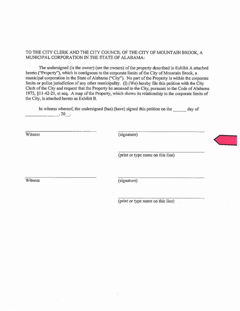
TO THE CITY CLERK AND THE CITY COUNCIL OF THE CITY OF MOUNTAIN BROOK, A MUNICIPAL CORPORATION IN THE STATE OF ALABAMA:
The undersigned (is the owner) (are the owners) of the property described in Exhibit A attached hereto ("Property"), which is contiguous to the corporate limits of the City of Mountain Brook, a municipal corporation in the State of Alabama ("City"). No part of the Property is within the corporate limits or police jurisdiction of any other municipality. (I) (We) hereby file this petition with the City Clerk of the City and request that the Property be annexed to the City, pursuant to the Code of Alabama 1975, $1 1-42-21, et seq. A map of the Property, which shows its relationship to the corporate limits of the City, is attached hereto as Exhibit B.
In witness whereof, the undersigned (has) (have) signed this petition on the day of
Witness
Witness
(signature)
(print or type name on this line)
(signature)
(print or type name on this line)

HOMEOWNER'S ANNEXATION NE 1/4 SW 1/4 OF SECTION 16, TOWNSHIP 18 SOUTH, RANGE 2 WEST
JEFFERSON COUNTY, ALABAMA
t4E I l4 SW 11.4
MAP BOOK 148, PAGE 20 AMENDED MAP OF
LOCKERBIE PHASE lV
W R.O.W.
STREET ADORCSSI I06 LOCMRDIE LAM
EXI.IIBIT MAP NOT TO SCALE

Homeowner's Association Annexation Legal Description Jefferson County Alabama
A parcel of land situated in the Northeast Quarter of the Southwest Quarter of Section 16, Township 18 South, Range 2 West, Jefferson County, Alabama, said parcel being a poi ion of landscape area as shown on the Amended Map of Lockerbie Phase IV as recorded in Map Book 148, Page 20, in the Office of Judge of Probate of Jefferson County, Alabama, and being more particularly described as follows:
Begin at the Northeast corner of Lot 1 Cluster 1 according to the Amended Map of Lockerbie Phase IV, as recorded in Plat Book 148, page 20; thence run in a northerly direction along the north line of said Lot 1 Cluster 1 a distance of 88.28 feet to a found 5/8 inch rebar; thence leaving said Lot 1 Cluster 1, turn an angle of 77 degrees 06 minutes 57 seconds and run a
distance of 6.15 feet to a found 1 inch crimped pipe; thence turn an angle of 102 degrees 53 minutes 03 seconds and run a distance of 91.54 feet to a set 5/8 inch capped rebar stamped GSA; thence turn an angle of 52 degrees 20 minutes 40 seconds and run a distance of 7.58 feet to the POINT OF BEGINNING. Said parcel contains 540 square feet or 0.01 acres more or less.


Report on Parcel 28 00 16 3 000 01 1 .OO 1 Yage I ot 2
Courthouse Retrieval System - Jefferson County, AL Report on Parcel :28 00 16 3 000 011.001 Generated :5/11/2015
General Information
Land C Map:
Acct No: Page:
Lot: District:
SSD2:
28 00 16 3
@
LOCKERBIE ASSOCIATION INC C/O BOOTHBY REALTY 4 OFFICE PARK CIR STE 106 MOUNTAIN BRK, AL 35223
3 67048 @
0 1
Parcel: SSD1:$04
1
Parcel ID:28 Alt-Parcel
ID: Subdivision
k
Property
ward:Pl
E IV 141 I67 AMENDED 148/20 TH WLY 10 FT TH 100.9 FT TH SELY 38.4 SE 105.8 FT TH ELY 91.5
TH NELY 77.5 FT TH SWLY
FTTJ3NLY 21.2 FTTH
00 16 3 000 01 1.001 Special
LOCKERBIE P IV AM 28- 1 6-3 3871 LOCKERBlE DR
Int: Map
Sort:: Plat
Book: Subdv Block:
A ~ ~ ~ ~ S S : ~ I R M I N G H A M , AL 35223 Telephone: 0-

Report on Parcel 28 00 16 3 000 0 1 1.001 Page 2 of 2
Building Information - No Building Data Available for Parcel: 28 00 16 3 000 011.001
Extra Features - No Extra Feature Data Available for Parcel: 28 00 16 3 000 011.001
Sales & Deed History
Sales Data Deed Data [NO Deed Data Available for Parcel ... I
Trust Deed Information - No Trust Deed Data Available for Parcel: 28 00 16 3 000 011.001
Information Deemed Reliable, but Not Guaranteed Copyright 0201 5, Courthouse Retrieval System, All Rights Reserved

This instrument was prepared by:
W i l l i a m C. Wood 1500 Liberty National Building 2001 Third Avenue South Birmingham, AL 35233-2101
WARRANTY DEED n
STATE OF ALABAMA 1 ) KNOW ALL MEN BY
COUNTY OF JEFFERSON ) .c
1' i ',\/ That i n consideration of One ($1.00) Dol4ar to ,,?;he &dersisned !, CICC . O L ' grantor, Secor Realty & Investment ~orporation,'~,\a corporation (herein referred to as GRANTOR) , id:?Fiand p&d by the GRANTEE herein, the rece ipt of which is h,qreby acknowlGdged, the said GRANTOR does by these presents, grant, bargain; sell and convey unto Lockerhie ~ s s o c i a t i o n ,..I I ~ c \ ~ , an;, Alabama nonprofit corporation (herein ref erres-$0 y--,G-RANTEE) the following described real es ta te , s i tuated ' i \ n . . ~ e f ~ e r s o n County, Alabama t o wit: 4;' 7, \, \\ \\ k,
4; '\ ,#.:A ./
All of the roadways,,,,{@tera3 are$./, managed, and landscaped areas, and parks as shown in.,the following subdivisions:
, ' < J ' r '.L, \ Lockerbie - has?,.^; ds rgcorded in Map Book 1 3 8 , page 37. ,----, \ +'\,
,.;.'-'.,-\ \L,? A resurvey of Cyts 1: 2, 3 , 4 , 5 , 6 and 7 , Lockerbie, Phasq,I (as recorded uin Map Book 1 3 9 , page 50.
' A \ )/ A resuqyey ofdots 1 and 2 of a Resurvey of Lots 1, 2 , '-.-- /-- 3 4 5$~6, and 7, Lockerbie, Phase I a s recorded i n
&~ap*-24,1, page 64. :T \\. >
of Lot 1 of a Resurvey o f Lots 1 and 2 of e . .fi
/! of Lots 1, 2 , 3 , 4 , 5 , 6 , and 7 , Lockerbie, .J% '\ ~l$ase+'k as recorded in Map Book 1 4 5 , page 31.
'\, '.. / I ' ' ~ \ ' ~ L ~ c k e r b i e , Phase I1 a s recorded in Map Book 138, page '\ b 5 7 .
Resurvey of Lockerbie, Phase I1 a s recorded i n Map Book 1 4 1 , page 65.
A resurvey of Lots 5 , 6, 7 , and 8 , CL III and a part of the Natural Area Resurvey of Lock~rbie , Phase I1 as recorded i n Map Book 146, page 74.
A resurvey of Lots 1A, 2, 3, and 4, Resurvey of Lockerbie, Phase If, Cluster #2, as recorded in Map

Book 146, page 7 5 .
A resurvey of Lot 11 and Natural Area Clus te r 3, Lockerbie, Phase I1 and Lot 12A, Clus ter 3 Resurvey Lockerbie, Phase I1 as recorded i n Map Book 156, page 37.
A resurvey of Lots 1, 2, 4 , 5, 6, 7 and 8 , C lus te r f and Managed and Landscaped Areas, resur6,ey of Lockerbie, Phase I1 and Lots 1, 2, 3 , 4, 5, 16;.,7,? and 8, Clus ter 11 and acreage, amended Map of Lockerbie
5, -----\
D Phase I V as recorded i n Map Book 155. page 78. \>?/ . Lockerbie, Phase I11 as recorded i n 6 6 .
Resurvey of Lot 1, Lockerbie, Map Book 1 5 2 , page 5. 1, Lockerbie, Phase page 45.
/ ' \ \ \ Lockarbia, Phase IV as ~ecdrded. I~-.M&';; Book 141 , page 67. /'/ /A \,:\ \-'
//' y, '\,\,&, Resurvey of Lots 3<(5 a,n& B,j,Cluster #I Lockerbie. Phase I V as recordd6d 'in-/,Map Book 1 4 4 , page 17.
/ / /;' \\ \.
Resurvey of L* t s $,\ ~ e s t r V e ~ of Lots 3 , 5, and 6 , /--+ Cluster #1, ~ g c k e ~ b x e , phase I V and L o t 4 , Cluster #I,
~ockerbie, ,~hase\IV, as recorded i n Map Book 1 4 8 , page
Amended ( ~ a ~ of + d c ~ e r b i e , Phase I V as recorded i n Map ~ook/:148~ 'page 2 ~ 1 . ' k/' .\/ Sgb-Ject\qo. / ---a *,
,? h,y-----..- h, , Terns and condit ions of covenants and restrictions
h$,app&,ring i n Volume 3365, page 358 at seq. i n the ? \\probate? ~ e c o r d s of Je f fe r son County, Alabama.
,/' '\ <, &' '?.\,,'. Encroachments and any o the r matters n o t shown on .. ', . , . , ,.- p,ublic records which would be disclosed by an accura te
'.-survey of the property conveyed.
Current taxes
It is the purpose of t h i s deed t o convey t o Lockerbie Homeowners Association a l l of the common property within the above designated subdivisions.
TO HAVE AND TO HOLD Unto t h e Said GRANTEE, its successors and ass igns , forever. And said GRANTOR does for i t s e l f , its successors and ass igns , covenant with s a i d GRANTEE and ass igns
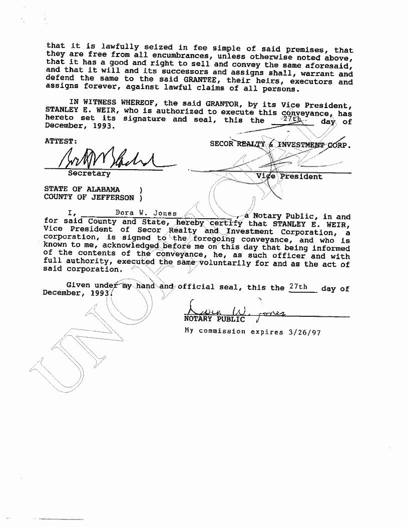
tha t it is lawfully seized i n fee simple of said premises, that they are free from a l l encumbrances, unless otherwise noted above, that it has a good and r i g h t t o sell and convey t h e same afaresaid, and that it will and its successors and assigns shall, warrant and defend the same to the said GRANTEE, their heirs, executors and assigns forever, against lawful claims of all persons.
IN WITNESS WHEREOF, the said STANLEY E. WEIR, who is authorized to hereto set its signature and seal, December, 1993.
ATTEST :
Secretary
STATE OF ALABAMA 1 COUNTY OF JEFFERSON )
It Dora w - J o n e s diy\ \\,;/Notary Public, in and for said County and State, .hekeby\"c,erti-fy that STANLEY E . WEIR, Vice President of Secor h a l t y andlInvestrnent Corporation, a corporation, is signed to/"\the+faregoihg conveyance, and who is known to me, ackno~ ledged~e fore me on t h i s day that being informed of the contents of thefconveyance, he, as such officer and with full authority, executed the same;;voluntarily for and as the act of
d* said corporation. \, \;'/ I' . . ,----\ .\ '%\ Given undeCmy~ha~d'\and,? official seal , this the 27th day o f
December, 199 3'! \ \ v' ..+ '\
I A'W . ,*++-
NOTARY PUBLIC J M y commission e x p i r e s 3/26/97
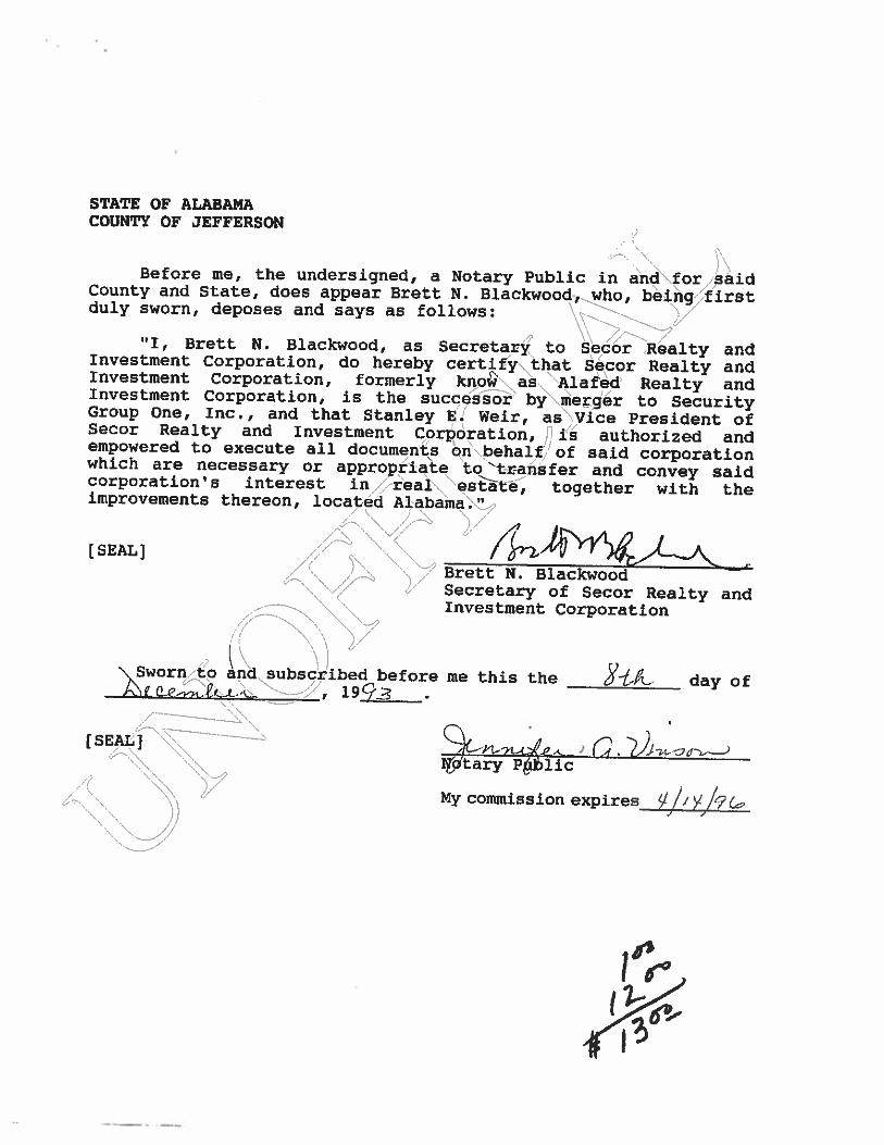
STATE OF ALABAMA COUNTY OF JEFFERSON
I \ Before m e 8 the undersigned, a ~ o t a r y public in &nd\for,,,said County and State, does appear Brett N. Blackwood,,who, be$ir9;5first duly sworn, deposes and says as follows: !??\\/
l11, Brett N. Blackwood, as ~ecreta,& to 6edor %alty and Investment Corporation, do hereby certify\t.hat Secor Realty and Investment Corporation, formerly knob as.. ,Alafed' Realty and Investment Corporation, is the success^' by\merger to Security Group One, Inc., and that Stanley E. Weir, as , V i c e President of Secor Realty and Investment Corporation, ,:i"s authorized and empowered to execute all documents bnb..behalfJ of said corporation which are necessary or appropr3ake tokrahsfer and convey said corporationp s interest i n n real~,'\eshte, together with the improvements thereon, located Alabama .k9t,,.
[SEAL] ",- '7' Brett N. Blackwood 1" Secretary of Secot Realty and -
Investment Corporation : I , , \ ' I \ /
\ \ \ I A~worn,/~o and subscribed before me this the 8 - t ~ . day of e w/K't..l? ,'-\ u.. 1 9 q 3 \ .
i -
My commission expires y,j, ykb

RESOLUTION
RESOLVED, that the Board of Directors of Secor Realty and Investment Corporation, a wholly owned subsidiary of Secor Bank, Federal Savings Bank, hereby ratifies and approves the conveyance by the Corporation of its interest in the common areas of the Lockerbie Development, more particularly described in Exhibit A attached hereto and incorporated herein by refe~ence, to the Lockerbie Association, and the relinquishment of <alk,interest in and to the Lockerbie Association, except for sucb,~interest as arises from the C o r ~ r a t i o n l s ownership of that reql\property identified as Lots 2-A and 1-B, according to a Resurvey af Lots l A , 2, 3, and 4, Resurvey of Lockerbie, Phase 11, ~luoter.~2,~recorded i n Map Book 146, Page 75, in the Probate od.Qcer-ofy~efferson County, Alabama; and
\ { >A. '\ ', '\ \La FURTHER RESOLVED, that the Board hare&~ythorizes ,and empowers the Presf dent, any Vice President, thei/ becreta*,,\and any Assistant Secretary of the Corporation to exec I te suchdeeds, agreements and other documents, and to take such further 0 9 d i i f e r e n t action, as management deems necessary
Or \ appropriate to effectuate the
purposes of this resolution. ,:-\,,., \;, /,;- \ '\
,>+. ", (,
CERTIFICATE OF SECRETARY
I, Brett N. ~la~kwo.od>,''~~r~orate Secretary of Secor Realty and Investment ~o&o%abi$n,,\do;hereby certify that the attached is a true and correct copy,of ,a'resolution adopted at a meeting of the Board of Directors of Secor Realty and Investment Corporation, duly called on,/~ecember lbyi1993 at 201 Office Park Drive, Birmingham, Alabama and ~such.~resol.ution has not been revised or rescinded as of this date. - . -
, ,
-------l\, ---- \. TN YITNESS WHEREOF, I have hereto set my hand and affixed the seal o i k h e Bank this ]&*day of December, 1993.
4 '\.\ :;+
Corporate Secretary