pppaa arrrttt aa i iinnn tt trrr oo...
TRANSCRIPT

Thiruvananthapuram Municipal Corporation City Development Plan
PPPAAARRRTTT AAA
IIINNNTTTRRROOODDDUUUCCCTTTIIIOOONNN,,, SSSTTTAAATTTUUUSSS SSSTTTUUUDDDIIIEEESSS,,, DDDEEEVVVEEELLLOOOPPPMMMEEENNNTTT
VVVIIISSSIIIOOONNN

Thiruvananthapuram Municipal Corporation City Development Plan
1
1.0 INTRODUCTION
1.1 Background India’s growth is synonymous with the growth of Indian cities and towns. The cities
and towns are acting as major growth centers and act as the hub of many social and
economic activities. According to the 2001 Census, the urban content of the
Country’s population was about 28 percent of the total population of the country. This
is estimated to increase to about 40 percent by the year 2021. The current
contribution of the cities towards the country’s Gross Domestic Product (GDP) is
about 50-55 percent, which is likely to grow with the increasing urban population and
concentration of productive economic sectors in the cities.
Due to increasing pressures of growing urban population, most of the cities and
towns are lacking in basic services and the quality of life in the cities degenerate.
The Urban Local Bodies and other institutions, who are the service providers, face
acute shortage of capacity and resources, notwithstanding the 74th Constitutional
Amendment. Unplanned growth, over stressed and non-reliable civic infrastructure,
inadequate financial resources and dissatisfying urban governance would have a
significant impact if not addressed timely and in a planned manner.
Considering that this state of cities is incompatible with the country’s socio-economic
development objectives and considering the country’s growing role in the world
economy, Government of India has launched a major urban infrastructure
development programme viz., Jawaharlal Nehru National Urban Renewal Mission
(JNNURM), for promoting reforms and investments in the selected 63 cities.
Thiruvananthapuram is one of the eligible cities under the programme.
Thiruvananthapuram –Historical Background
Thiruvananthapuram, which was previously called Trivandrum, is an ancient
city with tradition dating back to 1000 BC. Thiruvananthapuram became the capital of
Travancore in 1750. The city gets its name from the word, Thiru-anantha-puram,
meaning the city of Anantha or "the town of Lord ANANTHA", the abode of the
sacred Serpent Anantha on which Lord Vishnu, the preserver of the Hindu trinity,
reclines. The town has a history of supporting fine arts and culture and as a seat of
learning.
During the beginning of this century, Travancore Kings made women education
compulsory and free. 15 percent of the state budget was allocated to education,

Thiruvananthapuram Municipal Corporation City Development Plan
2
laying the foundation for 100% literacy, which Kerala achieved a few years ago. We
can see vivid proof of the religious tolerance of this state with the location of mosque,
temple, and church within yards of each other at Palayam Junction in
Thiruvananthapuram City.
Thiruvananthapuram, the capital of the state of Kerala is a beautiful seaside city built
on seven hills. The city is characterized by its undulating terrain of low coastal hills
with narrow winding lanes and busy commercial alleys. Thiruvananthapuram and its
famous beaches are one of the top tourist destinations in India.
Major Transport linkages to Thiruvananthapuram
By Air: Thiruvananthapuram Airport (International) is linked by flights to Cochin,
Chennai, Delhi, Goa, Bangalore and Mumbai. International flights also operate to
Colombo, Mali, Dubai, Abudhabi and Kuwait.
By Rail: Thiruvananthapuram is well connected to every part of the country by train.
There are trains from Mangalore, Ernakulam, Bangalore, Chennai, Delhi, Goa,
Mumbai, Kanyakumari and many other places. Thiruvananthapuram and Kochi
cities, the two most important cities in Kerala are well connected by commuter trains.
By Road: Long distance buses depart from the Central Bus Station (KSRTC Bus
Terminal) at Thampanoor, opposite the Central Railway Station. Buses operate from
Chennai, Madurai, Bangalore and Kanyakumari via Nagercoil to
Thiruvananthapuram. Similarly, Thiruvananthapuram is well connected to the
northern parts of the State by buses.
Geography
Thiruvananthapuram is located at 8.5oN 76.9o E on the west coast, near the
southern tip of mainland India. The city is sandwiched between the Western Ghats
and the Arabian Sea. The city is built on hills by the sea shore. The region can be
divided into three geographical regions, the lowlands, the midlands and the high
lands. The lowland is a narrow stretch comprising of shorelines, rivers and deltas,
dotted with coconut palms. The midland region comprises of low hills and valleys
adjoining the Ghats. The highlands form the eastern suburbs of the city. Ponmudi
and Mukkunimala are hill-resorts near the city.

Thiruvananthapuram Municipal Corporation City Development Plan
3
Climate
The city has a tropical climate and therefore does not experience distinct
seasons. The mean maximum temperature 34 °C and the mean minimum
temperature is 21 °C. The humidity is high and rises to about 90% during the
monsoon season.
Importance of the City and Future prospects
The first Indian space rocket was developed and launched from the Vikram
Sarabhai Space Centre (VSSC) located in the outskirts of the city in 1966. Several
establishments of the Indian Space Research Organization (ISRO) were later
established in Thiruvananthapuram.
The first Master Plan for Trivandrum City was prepared by the Department of Town
Planning and approved by the Government of Kerala in 1971. In order to co-ordinate
implementation of the various projects envisaged in the Master Plan, the
Government had constituted the Town Planning Trust in 1974, which was later on
transformed into the Trivandrum (Thiruvananthapuram) Development Authority
(TRIDA) in 1980. TRIDA published the Development Plan for Trivandrum in 1991.
A major milestone in the city's recent history was the establishment in 1995 of
Techno Park, India's first IT Park. Technopark has developed into the largest and
greenest IT Park in India. This placed Thiruvananthapuram on the IT map of India
and it is today one of the most promising in the country in terms of competitiveness
and capability.
The construction of the mega Deep Water Container Trans-shipment Port at
Vizhinjam is expected to begin in 2007. It is to be built in three phases, and expected
to be a key competitor in the ports business (especially for container transshipment),
with the international shipping lanes between Europe and the Far East very close to
the port, and also with major ports like Colombo, Kochi and Tuticorin in close
proximity.
The exponential growth of the services and IT based sectors coupled with its
prominence as the state capital and tourist centre has caused considerable strain on
the transport infrastructure of the city. To tackle this crisis, several multi-million dollar
construction projects are now underway including the construction of several new
underpasses and flyovers, scheduled to be completed by early 2007.
Thiruvananthapuram, apart from being the capital of India’s most literate and socially
developed State, is a strategically important city in Southern India. Being the biggest

Thiruvananthapuram Municipal Corporation City Development Plan
4
city with a credible infrastructure in India’s deep south, it is an important city for both
military logistics and civil aviation in the southern part of the country. It is the
headquarters of the Southern Air Command of the Indian Air Force and a base for
the Military.
The future prospects of Thiruvananthapuram are manifold. Potential future growth
areas include Tourism (medical and eco-tourism), civil aviation and air-cargo,
commercial activity through upcoming port (at Vizhinjam), software development
parks, media and the arts, etc. Beach resorts and also ayurveda resorts are coming
up at a rapid pace, especially along the International Beach of Kovalam and Varkala
coast.
1.2 Objective and Scope of City Development Plan
JNNURM is an opportunity for the city of Thiruvananthapuram to take much-
needed measures in order to improve the quality of life in the city. The objectives of
preparing City Development Plan for Thiruvananthapuram are:
Focused attention for the integrated development of infrastructure in the city ;
Undertake reforms based on the JNNURM guidelines for long-term project sustainability;
Ensuring adequate funds to meet the deficiencies in urban infrastructural services;
Planned development of Thiruvananthapuram Urban Agglomeration; Scale-up level of service in delivery of civic amenities and provision of
utilities with emphasis on universal access to the urban poor; Special focus on urban renewal programme for the old city areas to reduce
congestion; and to improve the quality of infrastructure; and Provision of basic services to the urban poor including security of tenure at
affordable prices, improved housing, water supply and sanitation, and ensuring delivery of other existing universal services of the government for education, health and social security.
The CDP for Thiruvananthapuram helps to identify and plan the future economic
growth of the city and to reduce urban poverty. This can be achieved by developing
proper framework, enhancing the creditworthiness of the municipal corporation and
integrating the urban poor with the service delivery systems.
Through this opportunity the municipal corporation plans to look at the various
financing options for city development including private sector participation, thereby
inviting participation of business, industries, civic groups, NGOs, and communities in
local decision making.
Thiruvananthapuram Municipal Corporation City Development Plan
5
The CDP is both a perspective and a vision for the future development of
Thiruvananthapuram city. It presents the following:
An in-depth analysis of the existing situation, covering the demographic, economic, financial, infrastructure, physical, environmental and institutional aspects;
Identifies the strengths and weaknesses of the city’s development, in consultation with the stakeholders and civil society;
Outlines the issues faced by the poor in the city and its peripheries; Develops a vision of the city for a long-term perspective; Formulates sector specific goals and strategies to achieve the vision; Formulates a city investment plan and a financing strategy, considering
alternative sources of financing the projects to be derived based on the vision and accompanying strategy and programmes; and
Focus of the reforms to be carried out at the state level and local level to ensure improvement in urban governance and service delivery.
1.3 Process of Preparation of CDP
The Ministry of Urban Development and the Ministry of Urban Employment &
Poverty Alleviation, Government of India has identified Thiruvananthapuram Urban
Agglomeration for coverage under the Jawaharlal Nehru National Urban Renewal
Mission (JNNURM). Accordingly Government of Kerala directed
Thiruvananthapuram Municipal Corporation to arrange for preparation of the City
Development Plan for Thiruvananthapuram, as required under JNNURM.
The guidelines issued by GOI under the sub missions on Urban Infrastructure and
Governance and Basic Services to the Urban Poor were explained to the
Corporation Council by Sri S.M. Vijayanand I.A.S., Principal Secretary to Govt., Local
Self Govt. Department, Government of Kerala. It was decided to constitute a Core
Committee for preparation of CDP and to utilise the services of officials in service,
experts from scientific organisations, experienced senior experts and NGOs for the
same. In the light of this, the Corporation Council resolved to form a Core Committee
comprising of expert officials drawn from various line departments, viz. PWD,
Irrigation, Kerala Water Authority, Tourism, Dept. of Town and Country Planning,
experts from NATPAC (National Transport Planning and Research Centre), senior
experts (retired from service) and representatives of a few NGOs under the
chairmanship of the worshipful Mayor Sri C. Jayan Babu; and to go ahead with the
preparation of CDP utilising the services of the Core Committee members.
The list of members of the Core Committee is given in Annexure 1.

Thiruvananthapuram Municipal Corporation City Development Plan
6
The Core Committee in its first meeting decided to prepare the CDP assigning
specific tasks among the members themselves and also to constitute Working
Groups co-opting members who are experts in the respective fields.
The basic planning concepts were discussed in the core committee meeting. The
issues to be addressed in general pertaining to the various sectors of development in
tune with the growth direction, the development activities that are already on the
anvil, development potential etc. were taken in to consideration. Approach papers
for individual sectors were prepared by the working groups concerned to throw light
on the issues in the stakeholder discussions.
Simultaneously, all the earlier studies and project reports pertaining to the
development sectors in Thiruvananthapuram were collected and reviewed.
A small team was formed as a Rapid Action Group (RAG) comprising of the Mayor/
Representative of Mayor, Deputy Mayor, a senior experienced spatial planning
expert, Project Engineer of the Corporation as representative of the Corporation
Secretary, two Planners to assist and Convenor of the Core Committee, who is also
a Spatial Planner.
The RAG met daily and decided on the modus operandi to be followed in the
formulation of CDP, which was approved in the subsequent Core Committee
meetings. Accordingly a series of stakeholder consultations were planned. The first
discussion was held with the Councillors of the Corporation, where the approach
papers were presented for each sector separately, raising the major issues to be
discussed. The Councillors interacted well and came up with many suggestions.
Even though some of the suggestions were ward specific, the issues confronting the
City as a whole were also discussed suggesting suitable alternative propositions.
Table showing all consultation meetings held with various groups is appended in
Annexure 2.
Consultations were held as detailed, with the Heads of Institutions and Government
Departments, Chamber of Commerce, Professional Organisations of Architects,
Engineers, Town Planners and Builders, Bar Association, Federation of Residents’
Associations Thiruvananthapuram (FRAT), Senior Citizens, NGOs, representatives
of the centres of physically & mentally challenged, representatives of INTACH, IMA,
ADS, CDS, CBOs, Women’s Organisations, Bank Officials, Political Leaders, Media
Personnel etc.
Individual consultations were also held with the former Chief Secretaries of the State,
District Collector and top level officials / citizens having stake in the development of

Thiruvananthapuram Municipal Corporation City Development Plan
7
the City. Apart from these the MPs and MLAs were also contacted and their valuable
opinions were recorded.
The Presidents of those Panchayats, which form part of the Urban Agglomeration,
were consulted separately and their requirements as part of urban agglomeration,
interrelationships with the city area and integrated planning issues to be addressed
were discussed and considered for action.
All consultations were recorded and tabulated according to the focus areas that
emerged out of the discussions. The Core Committee members attended all
consultation meetings and explained the draft approach paper for each sector. The
discussions were very fruitful and the draft approach papers could be improved
finally leading to derivation of strategies and identification of priority projects under
each sector. The RAG debated at length on the strengths and weaknesses of the city
region, development potential of the city region, Development Vision of the city and
the possible strategies to be adopted for attaining the Vision of Development. A draft
paper on this was also prepared and discussed in the Core Committee.
The suggestions put forth during consultations were incorporated suitably in the CDP
while formulating proposals. The RAG interacted with the members of the Core
Committee and working groups frequently who supplemented the additional
information in filling the identified gaps.
Table showing the various discussions held and the major suggestions is appended.
(Annexure 3).
In the meanwhile the existing national level and state level policies in the identified
thrust areas were listed and reviewed in the context of development of
Thiruvananthapuram. The identified project components for inclusion under
JNNURM could thus be substantiated with specific reference to the relevant aspects
of these policies.
The Vision 2010 of H.E. the President of India envisages an integrated high quality
improvement in infrastructure sector, in tune with provisions of basic services to the
urban poor.
The draft Vision Documents prepared earlier for Thiruvananthapuram Capital Region
and the planning attempts made so far were reviewed apart from making an
evaluation of the decentralisation process in the Corporation of Thiruvananthapuram.
All sectoral studies made by different agencies were also looked into in this
connection. The recommendations contained in these studies and the outcome of

Thiruvananthapuram Municipal Corporation City Development Plan
8
the planning efforts are given due weightage while formulating proposals for the
CDP.
Ward Committees are statutory bodies constituted under the Kerala Municipality Act
1994 with the ward councillor as the Chairman. The ward committee meets once in
three months. The proposals to be included in the annual and five year plans of the
TMC are recommended by the Ward Committees for consideration in the plan
coordination group. Ward Sabha, comprising of all the people residing in the
particular ward, meets only once in an year. Similarly Grama Sabhas in Panchayat
areas comprise of all the people living in the Panchayat which meet at regular
intervals. During the preparation of the CDP development proposals originated in
Ward Committees within the City and Grama Sabhas of the Panchayat areas
included in the TUA were referred. In the specific context of the projects which can
be considered under the CDP the Core Committee had detailed consultations with
the Chairmen of the Ward Committees and the Chairmen of the Grama Sabhas.
They were given adequate time to get back to their respective members and come
out with suggestions .A second round of discussions with them resulted in a number
of the Chairmen giving their suggestions in writing. Before these discussions the
Core Committee had identified the priority project components and their scope.
These were presented in the discussions so that the Councillors and the Panchayat
Presidents could derive help from the note and the discussions to crystallise their
ideas. The draft CDP including the priority components identified for inclusion in the
Project was subjected for scrutiny by the stakeholders.
Thus the process of formulating proposals were cross checked with the aspirations
of the ward sabhas/ward committees held during late 2005 and the beginning of
2006. The recommendations of the standing committees and the Development
Seminar are also used as inputs to refine the outcome.
Ultimately a general vision was developed for the planning area with focus on the
potential development areas followed by sector specific goals and strategies. The
Vision Statement has been coined keeping in view the SWOT analysis of the urban
agglomeration. In spite of these, sectoral studies highlighting the situation analysis,
problems, potentials, and strategies leading to project identification with broad cost
estimates have also been included in the report.
A generally satisfying task in the CDP preparation has been a long debate on the
poor and their problems and issues. Based on such detailed discussions with the
various groups and based on collection of all available data and studies on the Urban

Thiruvananthapuram Municipal Corporation City Development Plan
9
Poor, priority action programmes were identified and listed. The task included
identifying all categories of the poor population in the city region.
The integrated development package detailing each project and phasing out the
implementation process over the further plan period of 6 years is prepared along with
the City Investment Plan. Phasing has been proposed such that Projects for which
Detailed Project Reports are already available and hence can be implemented easily
are covered in the initial stage of implementation.
An attempt is also made to engender the CDP suggesting in brief how best gender
mainstreaming can be brought in urban governance with focus on the urban poor
under each sector separately.
Another important component which attracted a lot of debate was the area of
improvements in Urban Reforms and Governance, improvement in Municipal
Finances and bringing about better Financial Discipline in the TMC. The draft CDP
was presented in the council meeting for discussions and approval with or without
modifications. The council which met on 20.9.06 had approved CDP without
modifications.
1.4 City Planning Efforts - An Overview
1.4.1 Master Plan/ Development Plan for Thiruvananthapuram
The first Master Plan for Thiruvananthapuram city was prepared in 1966 with
a plan period of 20 years, in accordance with the then prevailing Town Planning Act;
Government of Kerala approved the Master Plan in 1971. This Master Plan (1971)
estimated a growth in population to 6,00,000 persons by 1986. The Main objectives
of the Master Plan (1971) were:
To achieve optimum utilization of the developable land in the city; To evolve a judicious pattern of land use; and To develop a good network of roads to allow smooth traffic flow.
However, rapid urbanization trends in the city’s periphery called for a larger planning
area to be considered under a Development Plan for 2001. The Development Plan
(2001) or second Master Plan covers an area of 148 sq. km with a projected
population of 9,30,000 in 2001. The above area was considered as the functional
urban area of Thiruvananthapuram, against the city area of 74.93 sq. km.

Thiruvananthapuram Municipal Corporation City Development Plan
10
The Development Plan (2001) indicates a pattern for development by “allocating”
areas on the map for future residential, commercial industrial, recreational,
transportation, utility, public and semi-public, agriculture and water bodies. The DP
(2001) also identifies areas for relocation of incompatible uses and development of
vacant land, redevelopment, regeneration, conservation and preservation.
Subsequently the City area was expanded, UDPFI guidelines were issued by
Government of India and the new Census findings published. In view of these, the
published draft Plan did not reach approval stage nor was it enforced.
The State Town and Country Planning Department (TCPD), Thiruvananthapuram
Municipal Corporation (TMC) and Thiruvananthapuram Development Authority
(TRIDA), have undertaken the preparation of a new Development Plan for 2025. In
this Development Plan (2025), various analyses like land use and land survey are
being carried out on the basis of revenue maps.
The major problem in preparation of Development Plans is up-dating town base
maps and existing land use maps, which are used as a basis for formulating
development proposals. The existing land use (1986) map available is outdated and
of insufficient accuracy for proper physical planning. Recent developments and
extension of the cities are often not included. Aerial photographs and high resolution
satellite images are potential data sources for spatial information for future planning
activities.
1.4.2 Studies on Transportation by NATPAC
The NATPAC carried out necessary surveys related to the studies in 1977.
The study reports were published in 1979. The studies were published in eight
reports / volumes as noted below:
Intercity Traffic/ Cordons; Travel Characteristics; Intra city Traffic; Goods Traffic; Travel Time and Delay; Intersections; Parking; and Traffic Analysis and Road Development Plan.
These studies carried out by NATPAC in 1977 are outdated since the traffic
characteristics in the city have substantially changed. However considering these as
the base work and depending on the present trend of developments, NATPAC is

Thiruvananthapuram Municipal Corporation City Development Plan
11
capacitated to conduct further studies and come out with suitable solutions in this
sector.
The parking studies conducted by NATPAC in 2003 in identified road stretches and
the studies on Inland Water Transport can be considered under JNNURM.
1.4.3 Report on Urban Slums in Kerala
The Department of Town & Country Planning, Government of Kerala had
prepared and published a report on urban slums in Kerala in 1985 and later in 1995 it
was updated. Aiming at a comprehensive picture of the urban slums in Kerala, the
Dept of Town &Country Planning had conducted a survey for collecting information
on the socio-economic aspects and environmental characteristics of slums. The
survey concentrated on the following aspects viz,
Identification particulars of the slums in all the Municipalities, Corporations and Townships in the State;
General amenities available in the slums; Details of Households, population etc., in the slum; Housing conditions in the slums; and Occupation and income of the slum dwellers.
Settlements on the roadside, railway side and other puramboke (revenue) lands and
the fishermen settlements at the coastal belts within the towns were also included in
the survey. For the identification of the slums the quality of environmental conditions
of an area was assessed based on the availability of basic amenities, density of
population, number of SC/ ST population and the structural conditions of the dwelling
units in the area. These indicators of backwards were assigned weightages and
slums were identified accordingly. The figures were updated in a study in 1995-96. A
total of 37 slums were identified in the Corporation area in 1995, covering a
population of 29681 in 6506 households.
Revision of the report is underway in the Department in the light of the developments
that have taken place recently especially with respect to the decentralisation efforts
in the State.
1.4.4 Kerala Urban Development Project (KUDP)
The Kerala Urban Development Project (KUDP) was a multi-city, multi-
component and multi-agency project started in 1990. It was conceived as a World
Bank assisted Urban Development project for the three cities of
Thiruvananthapuram, Kochi and Kozhikode.

Thiruvananthapuram Municipal Corporation City Development Plan
12
The following four major components were included in the Project:
Road Development and Traffic Management; Water Supply Improvements / Augmentation; Sewerage and Sanitation; and Surface Water Drainage.
The departments/agencies/organisations of the State Government involved were
Public Works Department, Kerala Water Authority, Irrigation, Town Planning
Department, Police and the City Corporations of Thiruvananthapuram, Kochi and
Kozhikode.
The KUDP was limited to the former city area of Thiruvananthapuram (75 sq. km)
and it envisaged projects for implementation within 5 years, i.e., short-range
proposals only. Under the Road Development and Traffic Management component,
KUDP proposed only Road Development study for identification of candidate roads,
which could be taken up for improvement immediately. Study of Comprehensive
Transport Systems was not undertaken under KUDP.
KUDP was project oriented, i.e., identification of certain road projects for immediate
implementation.
Road Development study under KUDP did not include large scale land acquisition.
Therefore, even for the selected important roads for ‘major road construction
programmes, only limited widening proposal was suggested. (M.G. Road was
proposed for widening to 18m and Chalai by-pass to 15m, whereas Master Plan and
Detailed Town Planning Schemes proposed 24m and 21m respectively for these two
roads.)
1.4.5 Theerapatham Urban Development Project
The Theerapatham Urban Development Project, 2000 envisages cleaning up
of 16.5 km stretch of T.S Canal connecting two important tourist centres, Veli-
Akkulam and Kovalam.
Project objectives were:
Ecological restoration of Veli-Akkulam lake and Parvathy Puthanar (T.S) canal;
Environmental regeneration of the project area; and Developing tourism and urban facilities, thereby creating a development
corridor on either side of the canal.

Thiruvananthapuram Municipal Corporation City Development Plan
13
The scheme envisaged cleaning up of canal, introducing pleasure boating along the
canal and improving the sides of the canal by providing a walk way of 16.50 km
length through the proposed 50m wide garden strip. The entire stretch on the two
sides of the canal will be developed into a natural garden suitable to the nearby
surroundings. Government of Kerala decided to prepare a Master Plan for
Theerapatham Urban Development Project area, declaring the project area as a
controlled area in accordance with the provisions of the Travancore Town Planning
Act 1120 .The project was estimated to cost Rs.950 crores. Detailed Project Report
has already been prepared for this.
1.4.6 Comprehensive Traffic & Transportation Study (CTTS) Report-CES
Comprehensive Traffic and Transportation Study (CTTS) was carried out by
the Consultants M/S Consulting Engineering Services (India) Private Limited, New
Delhi in year 2002. Road Development and Traffic Management projects were
prepared during 1992-95 for the three cities of Thiruvananthapuram, Kochi and
Kozhikode. CTTS for Thiruvananthapuram was for the TRIDA area of 296 sq. km.
The CTTS considers the entire traffic and transportation systems of
Thiruvananthapuram and proposals include short-term, medium-term and long-term
measures both in road improvements, junction improvements, pedestrian facilities
and transport improvements. CTTS also proposes Mass Transport System options,
which can be developed gradually for the long-term, as the traffic volume increases
and the financial resources become sound to fund such mass transportation
systems.
Major corridors for development have been identified in this study including the
options for MRTS which can be considered under JNNURM.
1.4.7 Report on Solid Waste Management – Vilappilsala
The Municipal Corporation has one solid waste disposal site located at
Vilappilsala, in Vilappil Panchayat, 16 km east of the city. This composting plant has
capacity for waste disposal till 2035. The Municipal Corporation acquired 12.35 Ha of
land of which 4.25 Ha has been provided to M/s POABS Envirotech, the Build-
Operate-Transfer (BOT) waste treatment operator appointed for composting waste.
Presently only 20% of the land transferred to the BOT Operator (about 1.6 Ha) is
being used effectively because of the undulating terrain. The approach road is

Thiruvananthapuram Municipal Corporation City Development Plan
14
bituminous topped and is in good condition. The existing compost plant is designed
to handle 300 tons per day and can be augmented to 500 tons per day.
The plant has sufficient capacity to handle the biodegradable portion of the total solid
waste generated in the city. However, due to non-segregation of waste at source, the
BOT Operator has to segregate the waste twice or thrice before it can be biologically
processed.
At present proper sanitary land filling is not practiced at the disposal site. The rejects
of the plant are dumped along the valley slopes.
1.4.8 Preliminary Report on Thiruvananthapuram Development Vision CES
The study was conducted in the year 2003 to prepare a Vision Document for
Thiruvananthapuram region spanning thirty years from 2003 to 2033.
The objective of the study was to concretize the development vision together with an
implementation strategy, a holistic development perspective including the physical,
environmental, social, economic and cultural traits of the region. Given the current
importance of Thiruvananthapuram as a business and cultural centre, planned
development of the region is essential to promote growth and facilitate substantial
change in various spheres like demographic, social, economic, physical and
environmental. The on-going process of globalization makes it imperative that the
city becomes competitive and viable and transforms itself into a vibrant world city.
Preparation of a Vision Document for Thiruvananthapuram Capital Region (TCR) has
been undertaken in this back drop.
The Study Area included Thiruvananthapuram Development Authority (TRIDA) area,
four municipal towns located on the radial arteries of Thiruvananthapuram i.e.,
Attingal, Nedumangadu, Neyyattinkara and Varkala, the tourist spot of Ponmudi and
the beach stretch from Vizhinjam to Varkala. TRIDA covers an area of 296.17 sq. km
including the area under the City Corporation (141.74 sq. km) and the adjoining 10
Panchayats.
The study was approached by reviewing the existing situation to understand the
growth trends of the region. A SWOT analysis was conducted to base the vision on
the region’s inherent strengths, weaknesses, available opportunities as well as likely
threats to it. Consultation workshops were held with various stakeholders to analyze

Thiruvananthapuram Municipal Corporation City Development Plan
15
growth trends and to formulate objectives, action plans, economic base, urban and
regional environment, transportation and infrastructure services.
1.4.9 Draft Final Report on Thiruvananthapuram Development Vision – Ernst & Young
Subsequent to the CES attempt, the task was entrusted to Ernst & Young
Consultants.
This study on Thiruvananthapuram Capital Region (TCR) Vision 2033 was
conducted in the year 2004 for a thirty year plan period. The Government of Kerala
(GoK) identified Urban Development as a priority component of a long-term
development plan. Importance of the city as a historical, economic and cultural
capital in the region, required a visioning exercise in order to facilitate planned
development of Thiruvananthapuram and its adjuncts as the Thiruvananthapuram
Capital Region (TCR). The objective of the study was to identify the core areas for
economic growth opportunities. The comprehensive development exercise also
aimed at preserving the city’s ecological and cultural heritage and respond
proactively to the short-term and long-term needs of growth.
While there had been parallel and disjoint planning efforts for development of the
region in the past, the driver for this initiative was the felt need for a focused and
integrated approach to planning.
The planning area consists of region covering the Thiruvananthapuram Development
Authority (TRIDA) area and the municipal towns of Attingal, Nedumangadu,
Neyyattinkara and Varkala, the tourist spot of Ponmudi and the beach stretch from
Vizhinjam to Varkala.
The Vision 2033 has been developed by identifying the emerging opportunities in the
global economy and evaluating the strengths and characteristics of the region to
capture value for these opportunities. The approach taken was:
Identifying the emerging paradigms in the Global Economy; Evaluating India’s position to benefit from these emerging global trends, and; Assessing Kerala and TCR’s position to capture value from these emerging
opportunities.
Emerging Opportunities in Kerala and TCR
The study has detailed the growing opportunities emerging in the world and the
country, resulting from increasing integration of trade and commerce. A review of
current state of the TCR was conducted to analyse its geographic and demographic

Thiruvananthapuram Municipal Corporation City Development Plan
16
profile, economic indicators and industrialization status. Strengths and weaknesses
were then identified based on the detailed assessment of growing opportunities at
international, national and state level. Meetings were also conducted with various
stakeholders to seek their inputs and discuss the findings of the analysis.
Based on the strengths and constraints of the region, it was prima facie concluded
that the region was well positioned to capture emerging opportunities from the
following sectors:
Health care; Tourism; Off-shoring of services; and Organic farming.
Thrust Areas
The short-listed sectors were further filtered on certain criteria to evolve one central /
core theme that would derive development, with other themes revolving around this
Core Theme. The criteria included potential economic impact, multiplier effect on
other sectors, uniqueness of positioning and existing brand equity. Healthcare
emerged as the most appropriate theme for developing the vision for TCR.
Proposed Vision 2033 for TCR
“By 2033, TCR would develop as a preferred destination for healthcare and
rejuvenation, offering variety of world class preventive and restorative solutions for
the body and mind”. The thrust areas of this core theme would be Medicare,
Research and Education.
Government did not conclude this study and take it beyond the DFR stage.
1.4.10 JBIC Report on Water Supply up Gradation Project
The existing water supply scheme for Thiruvananthapuram City Corporation
and adjoining panchayats provides a supply of 190mld of water as against the
present demand of 246mld. In order to augment the water supply, a project has been
formulated to provide a supply of 74mld of water and the JBIC assistance has been
obtained to implement the Water Supply Improvements to Thiruvananthapuram City
Region, 2005 to cater to the demand of the projected population of year 2021/2036)
The total project area comprises 183.76 sq. km covering Thiruvananthapuram
Corporation (141.74 sq. km), Sreekaryam panchayat (23.73 sq. km),
Kudappanakunnu panchayat (7.69 sq km) and Vattiyoorkavu panchayat (10.61 sq.

Thiruvananthapuram Municipal Corporation City Development Plan
17
km). As per the 2001 Census, the population of Thiruvananthapuram, Sreekaryam,
Kudappanakunnu and Vattiyoorkavu is 7.45 lakhs, 0.49 lakh, 0.38 lakh and 0.42 lakh
respectively. The present service level provided is 150 litres per capita per day (lpcd)
for urban areas and 100 lpcd for rural areas. The projected water demand for 2036,
at the rate of 195 lpcd for urban, 150 lpcd for rural areas along with a provision for
non domestic and industrial requirement, works out to be 410 mld.
The proposals envisaged in the JBIC Report have been considered while formulating
the vision in the CDP under the Water Supply Scheme.
1.4.11 REVIEW OF EXISTING NATIONAL AND STATE LEVEL POLICIES
a) National Environment Policy 2006, Ministry of Environment & Forest, Government of India
The policy lays down that Natural heritage sites are to be protected as they are
nature's laboratories for evolution of wild species in response to change in
environmental conditions.
The policy calls for adoption of a comprehensive approach to Integrated Coastal
Management by addressing linkages between coastal areas, wetlands, and river
systems, in relevant policies, regulation, & programs and preparation &
implementation of action plans for major cities for addressing water pollution,
comprising regulatory systems relying on a appropriate combination of fiats and
incentive based instruments, projects implemented through public agencies as well
as public-private partnerships for treatment, reuse, and recycle where applicable, of
sewage and wastewater from municipal and industrial sources, before final discharge
to water bodies.
The policy states that Integrated regional development plans should be drawn up,
with participation of the local community, to shift polluting activities or render them
much less polluting, to treat waste streams, to review transportation options, and
adopt building norms which maintain the overall heritage ambience of the area.
With this view, the Government of Kerala has already taken action to formulate a
Regulation for ensuring and promoting conservation of heritage buildings, precincts
and natural heritage. Also an attempt has been made to list the heritage sites in the
state including the planning area from which projects have been identified for
coverage under JNNURM.

Thiruvananthapuram Municipal Corporation City Development Plan
18
b) National Urban Transport Policy, 2006, Ministry of Urban Development, Government of India
The policy was laid down with a vision to recognize that people occupy centre stage
in our cities and all plans would be for their common benefit and well being; to make
our cities the most livable in the world and enable them to become the “engines of
economic growth” that power India’s development in the 21st century; to allow our
cities to evolve into an urban form that is best suited for the unique geography of
their locations and is best placed to support the main social and economic activities
that take place in the city. The objective of the policy is to ensure safe, affordable,
quick, comfortable, reliable and sustainable access for the growing number of city
residents to jobs, education, recreation and such other needs within our cities.
This is sought to be achieved by incorporating urban transportation as an important
parameter at the urban planning stage rather than being a consequential
requirement; encouraging integrated land use and transport planning in all cities so
that travel distances are minimized and access to livelihoods, education, and other
social needs, especially for the marginal segments of the urban population is
improved; improving access of business to markets and the various factors of
production; bringing about a more equitable allocation of road space with people,
rather than vehicles, as its main focus; encourage greater use of public transport and
non motorized modes by offering Central financial assistance for this purpose;
enabling the establishment of quality focused multi-modal public transport systems
that are well integrated, providing seamless travel across modes; establishing
effective regulatory and enforcement mechanisms that allow a level playing field for
all operators of transport services and enhanced safety for the transport system
users; establishing institutional mechanisms for enhanced coordination in the
planning and management of transport systems; introducing Intelligent Transport
Systems for traffic management; addressing concerns of road safety and trauma
response; reducing pollution levels through changes in traveling practices, better
enforcement, strict norms, technological improvements etc.; building capacity
(institutional and man power) to plan for sustainable urban transport and establishing
knowledge management systems that would service the needs of all urban transport
professionals; promoting the use of cleaner technologies; raising finances, through
innovative mechanisms that tap land as resource for investments in urban transport
infrastructure, associating the private sector in activities where their strengths can be
beneficially tapped; taking up pilot projects that demonstrate the potential as possible
best practices in sustainable urban transport.

Thiruvananthapuram Municipal Corporation City Development Plan
19
The vision formulated under the traffic &transportation sector as part of CDP is well
within the broad framework of this Policy.
c) National Policy for Inland Water Transport, 2001, Ministry of Shipping, Government of India
The policy identifies Inland Water Transport (IWT) as an economic, fuel efficient and
environment friendly mode of transport. The policy aims to support development of
an extensive network of rivers, lakes and canal in the country for shipping and
navigation to provide efficient network of inland transportation. While the thrust so far
has been in developing road and rail sectors, through this policy, Government
recognizes the need to actively promote the IWT sector for it to take a reasonable
share in the inter-modal mix of inland transport.
Keeping this policy in view, projects have been identified under the traffic and
transportation sector to develop the existing waterways in the project area for the
purpose of shipping and navigation and also to integrate the waterways to the
roadways, railways and airport.
d) National Policy for Urban Street Vendors 2004, Ministry of Urban Development & Poverty Alleviation, Government of India.
Street vendors provide valuable services to the urban population while trying to earn
a livelihood and it is the duty of the State to protect the right of this segment of
population to earn their livelihood. This policy aims to ensure that this important
section of the urban population finds recognition for its contribution to society, and is
conceived of as a major initiative for urban poverty alleviation.
The overarching objective to be achieved through this policy is to:
Provide and promote a supportive environment for earning livelihoods to the Street vendors, as well as ensure absence of congestion and maintenance of hygiene in public spaces and streets.
Street vendors are vulnerable to loss of goods due to natural as well as manmade disturbances that adversely hampers their economic situation. There should be special insurance schemes to cover their products.
Street vendors should be provided with training to upgrade their technical and business skills so as to increase their income as well as to look for alternatives
All State Governments should ensure that institutional arrangements, legislative
frameworks and other necessary actions achieve conformity with the National Policy
for Street Vendors.

Thiruvananthapuram Municipal Corporation City Development Plan
20
The policy states that a comprehensive survey of street vendors to build an adequate
database on street vendors particularly in large and medium cities should be
undertaken by the State Governments.
e) Tourism Vision 2025
The main aim of Tourism Vision 2025 is to serve as a guiding force which will provide
a clear vision and direction for optimising the tourism potential of the State in a
sustainable manner.
The Government has declared tourism as an industry far back in 1986 and offers
incentives and concessions to the industry to promote tourism products in the State
and to attract private investment.
The objectives of the Vision include the following.
Make tourism Kerala’s core competency sector; Generate employment and enhance productivity; Promote and market Kerala Tourism products at national and international
level thereby making Kerala a premier global tourism destination; Define and endorse the role of the Government as a catalyst and facilitator
for the growth of tourism industry; National tourism related legislations and policies of the Government so that
it is tourism friendly and promotes tourism growth; Create awareness and tourism consciousness among the people in general
and among the taxi drivers, policemen, bus conductors, porters, customs and emigration officers, and others with whom tourists interact in particular thereby removing prejudices and misconceptions and to make Kerala society a tourism friendly society;
Develop and improve roads, drinking water supply, electricity and power supply, sewage and sanitation systems, signages, transport systems like roads, rail, sea, inland water and air for selected tourist centres;
Promote sustainable and eco-friendly tourism in the State based on the carrying capacity of the destinations;
Conserve and preserve the art, culture and heritage of the State; Develop and promote new innovative tourism products, lesser-known
destinations, art forms, cuisines, monuments and handicrafts; Identify, conserve and preserve special tourism zones; Develop and promote KITTS, KIHMS and IHMCT into institutions par
excellence in India and regulate the syllabi and training facilities of other institutions to maintain quality standards; and
Involve PRIs and NGOs in the development of tourism infrastructure and tourism awareness.

Thiruvananthapuram Municipal Corporation City Development Plan
21
f) Tourism Policy for Kerala
State Tourism Policy document ‘Tourism Vision 2025’ states the vision statement as "To make Kerala, the God’s Own Country, an up-market high quality tourist destination through rational utilization of resources with focus on integrated development of infrastructure sector conserving and preserving the heritage and environment and enhancing productivity, income, creating employment opportunities, alleviating poverty thereby making tourism the most important sector for the socio-economic development and environment protection of the State." The focus here is to attract quality tourists by developing quality tourism infrastructure with private sector participation with sustainable development as the key concept.
The contents of the Tourism Policy have been well taken care of while formulating
sectoral strategies especially with respect to traffic and transportation, water supply,
sewerage, surface water drainage, environment and heritage and tourism.
g) IT Policy for Kerala
The IT Policy has been conceived keeping in view the fact that Information
Technology constitutes the primary instrument for facilitating Kerala’s emergence as
a leading knowledge society in the region. The blueprint for IT development has
been formulated in the context of emerging developmental trends that are relevant to
the growth strategy of the State:
IT has opened out new channels for service delivery in areas such as e-Governance,
education, e-health and information dissemination. IT can serve as the platform for
widening the reach of the advances made by the State in domains like health,
education, and participatory local governance. Kerala offers fertile ground for the
effective utilization of these new technologies; on account of its densely networked
communities which possess high awareness and literacy levels, its superior telecom
connectivity, and its propensity for quick technology absorption.
The objective of the Government is to put in place a package of policy measures and
incentives, which will make Kerala one of the most attractive investment destinations
in IT.
The Policy initiatives delineated in this document comprise a three pronged strategy
aimed at:
Creating an appropriate pro-business, pro-enterprise, legal, regulatory and commercial framework to facilitate the rapid growth of the IT industry in the state;

Thiruvananthapuram Municipal Corporation City Development Plan
22
Establishing Kerala as a global centre for excellence in Human Resources, through the creation of a large pool of diverse, multi-skilled technically competent manpower in the State; and
Establishing an internationally competitive business infrastructure and environment for the IT industry in the State, on par with the best facilities and practices worldwide.
Objectives
In line with this broad strategy, the Government has set the following immediate
objectives for the promotion of the IT industry in the State.
To establish Kerala as a leading IT destination in the country within the next five years;
To provide a nurturing and enabling environment conducive to the vigorous growth of the local IT industry in the State;
To significantly enhance direct and indirect employment creation in the IT sector;
To attain a minimum growth level of 100% every year in IT; To significantly accelerate the levels of investment inflows including foreign
capital into the hardware, software and ITES sectors; To aggressively promote the State as the destination of choice for emerging
IT business opportunities including IT Enabled Services, new media products and E-services. To establish ITES as the definitive core competence of the State;
To develop Kochi as an international media and ICT hub; and To consolidate and expand the Technopark, Thiruvananthapuram as a
leading software and HR Centre in the region.
IT Infrastructure
The policy envisages developing IT infrastructure on the following lines.
Government Parks Initiative:
The city of Kochi will be promoted as an IT hub where facilities offered will match the best available worldwide. A Hi-tech park will be developed here, comprising an area of 200 acres. An IT Corridor connecting the new international airport at Nedumbassery with the city will also be established as part of the larger proposed Special Economic Zone continuum. These facilities shall be developed through Joint Venture partnerships with the private sector and shall endeavour to provide an international business infrastructure and environment at Kochi. Kochi has all the necessary enablers in place including virtually unlimited bandwidth on tap from the VSNL gateway, concentration of quality, technical and non-technical human resources, a cosmopolitan social infrastructure and environment, and

Thiruvananthapuram Municipal Corporation City Development Plan
23
excellent air connections. These advantages shall be leveraged to make the city amongst the most preferred IT investment destinations of India.
The total space availability for IT industry shall be augmented by a minimum of 750000 sq.ft annually for the next two years. Thereafter, for the next three years a minimum of 1.5 million sq.ft space capacity shall be created annually. These additional capacities will be created through 100% private sector investments as well as Joint Venture projects between the Govt. and the private sector.
The Technopark, Trivandrum with about 1 million sq. ft of built up area, has established itself as one of the leading IT parks in the country. The campus is now home to several SEI-CMM companies and centres of HR excellence. The IIITM-K, which commenced functioning in the last year and which offers high-end training in emerging technologies is expected to move over to an independent campus shortly. In the second phase of expansion of the park, it is proposed to develop 26 acres with the participation of the private sector.
The IT Department shall shortly initiate with the help of leading consultants the exercise of preparation of Master Plans for each of the designated IT parks/ zones. These Master Plans shall delineate the blueprint for park development and framework for facilitating private sector participation.
Govt. shall endeavour to maintain uniform, international quality standards for park infrastructure and services across all State promoted and managed IT parks. A professional Parks’ Management team will be set up under the Kerala IT Department for ensuring this.
Built-up space for IT industry shall be classified under a new category “IT Industry” under the Kerala Building Rules with applicable FAR of 5. This classification shall apply only for newly built-up space that shall be used predominantly (at least 80% of carpet area) for IT software industry for a minimum period of 5 years from the date of first occupation/commissioning.
Govt. shall proactively encourage and facilitate the development of ancillary social infrastructure in a planned manner including hotels, restaurants, entertainment multiplexes, hospitals, schools, colleges etc within and appurtenant to the IT parks.
Private Parks Scheme:
To accelerate the process of private sector led IT infrastructure development, Govt. shall, in association with reputed global IT parks’ developers/consultants, announce a minimum set of standards to qualify as ‘Parks’ Standard’ certified IT park. Compliance shall be assessed, on formal request, at the pre-construction/design stage and thereafter on project completion. The State IT Parks’ Management team shall serve as the nodal agency for compliance assessment and administration of the ‘Private IT Parks Scheme’.

Thiruvananthapuram Municipal Corporation City Development Plan
24
All Parks’ standard compliant IT parks shall be entitled to the FAR classification as applicable to IT industry under Kerala Building Rules. For other compliant IT parks that are either entirely for IT hardware industry or for both IT hardware and IT software industry companies, classified under ‘Industrial’ category of the Kerala Building Rules, additional FAR of 50% shall be permitted (over currently applicable FAR of 1.5).
The Kerala State Electricity Board, the Kerala Water Authority, and the Office of the Chief Town Planning Authority shall each designate a Nodal Officer who shall facilitate the process of inspection, application processing, and application closure, for their respective responsibility areas. Response standards shall be announced by these agencies for the fast track clearance process.
A certified private IT park shall be governed by the same set of industry enabling regulations that are applicable for the State promoted IT parks.
A private park that qualifies for certification under this scheme shall be promoted by the State Govt. as an integral part of the State’s IT Infrastructure provided the promoter of the park so desires.
The scope of the ‘Private IT Parks’ scheme shall be restricted to projects that seek to provide a minimum of 50,000 sq. ft per project either through creation of fresh built up space or through conversion of existing space for use by IT industry. Projects less than the 50,000 sq.ft qualifying stipulation shall still have the benefit of FAR provided under point 1 provided they are otherwise compliant with the Parks’ standard.
The Government is aware that rapid change and transformation is the essence of
this sector, and acknowledge the need for a dynamically evolving policy that caters
to the changing I.T environment. Hence this policy document is envisaged as an
evolving blueprint that sets out an indicative roadmap. Government will endeavour to
improve upon the components of this policy on the basis of suggestions from
stakeholders and the changing requirements of the sector.
The proposals formulated in the CDP are well within the IT Policy for Kerala.
h) Industrial Policy for Kerala
The policy provides for exploring the scope of developing small scale industries,
Traditional Industries, Textiles, Sick Units, Food processing, Biotechnology,
Infrastructure. & Service Sector Industries.
Holistic and eco-friendly projects will be encouraged in tourism as the sector has
already been accepted as an instrument for generation of foreign exchange,
employment, poverty alleviation and sustainable social and economic development.
The Government shall endeavour to facilitate notified Special Economic Zones and

Thiruvananthapuram Municipal Corporation City Development Plan
25
bring in a special legal dispensation enabling a more liberalized environment within
specified industrial parks, estates and notified areas.
The waterways in the State shall be developed with the participation of the private
sector and made navigable particularly for barge transport.
i) Kerala Port Policy
The policy on Ports and Shipping Development announced by the Government of
Kerala envisages private participation in building up a wide variety of infrastructure
for ports and shipping. The Government will encourage development of special ports
and berths for handling petrol and oil, transhipment ports, multipurpose jetties and
passenger terminal by private agencies.
The policy also promises promotion of facilities for passenger ships, roll on and roll
off vessels, inland terminals and amusement parks besides port based industries
including ship yards and dry docks. The tax breaks promised in the industrial policy
will be extended for such ventures. Private agencies will be allowed to undertake
development of state highways and bridges to minor ports and collect toll to recover
their investment. Leasing of existing ports and provision of various services such as
loading and pilotage and navigation will also be permitted.
The government will take steps to encourage goods transport through waterways to
reduce congestion in highways and costs. A Maritime University is proposed to set
up for ensuring supply of trained man power.
Objectives of the Government of Kerala Port Policy:
Kerala shall target a place among the top three marine States of the country in terms of cargo handled in the next ten years;
Facilitate achievement of optimal multi-model transport and logistic chain outcomes by establishing an efficient and commercially viable transport system. This will be achieved by carrying out co-ordinated development of multi-purpose ports, transhipment bunks, inland water ways, coastal shipping inland terminal cargo handling and storage facilities, railways and road linkages;
Promote port based and Maritime Industries; Ensure protection of environment and coastal zones; and Promote establishment of passenger terminals and marinas.
j) People Centred Service Delivery Policy for Kerala
The Service Delivery Policy approved by the Government is intended to establish the
mode and manner in which services are delivered to citizens. In a broad sense it

Thiruvananthapuram Municipal Corporation City Development Plan
26
covers the whole range of interface between Government and the people and the
whole gamut of the interaction between people and their Government.
The objective of the Policy is to provide a systematic approach to ensure that
adequate level of public services of prescribed quality are provided by the various
departments and implementing agencies in the State and Local Self Governments of
Kerala.
The public services include civic services like water supply and sanitation, welfare
services like social security, human development services like health, nutrition and
education and basic minimum services like housing. In addition, Government and
Local Governments provide several regulatory and administrative services.
It is hoped that a Service Delivery Policy will help develop and put service standards
in place which would enable citizens, policy makers and service providers to track
service performance and take corrective measures.
1.4.12 Vision 2010 – On the Lines of Mission Initiated by the President of India
His Excellency the President of India Dr. A.P.J. Abdul Kalam has outlined 10
Missions for Kerala’s Prosperity in his address to the Kerala Legislative Assembly on
28.07.2005 considering the core competence of the State. Subsequently six more
visions were added by the State Government and Legislative Assembly to address
priorities for Kerala’s Development and Poverty alleviation covering agriculture,
poverty alleviation, traditional industries, revitalization of public sector, strengthening
decentralization and environmental conservation. A number of strategies proposed
under Vision 2010 fall within the programmes of the Mission.
The Vision statement included the following:
Economic prosperity for all, with equality of status, facilities and opportunities; minimal inequalities of income; and ownership and control of material resources of the communities so distributed as best to sub serve the common goal;
Social justice, social equality, gender justice and individual freedom reflecting the Constitutional values; communal harmony and peace; protection of our diverse culture, heritage; and conservation of our natural environment;
Strong and vibrant institutions of democratic self-government based on Panchayati Raj;

Thiruvananthapuram Municipal Corporation City Development Plan
27
High quality infrastructure and public services including health, water, sanitation, power, housing and education, accessible to all; and
Efficient, corruption free, transparent, responsive and accountable public administration.
The five goals of the vision to be achieved in five years are -
Double our per capita income and State GDP, with emphasis on agriculture, traditional industries and manufacturing as well as the knowledge economy;
Reduce unemployment by half; Provide quality higher education accessible to all. Triple higher education
opportunity for our youth, with a view to universalize higher education; Bring absolute poverty down to zero, strengthen social protection and
assure freedom from hunger; and Improve quality of public services (health, education, power and water
supply, sanitation and housing), strengthen Panchayati Raj Institutions as effective units of self government, and enhance efficient, responsive, transparent, accountable and corruption- free public administration.
The CDP for Thiruvananthapuram is envisaged to be in such a manner as to attain
the goals of the vision, especially by way of providing high quality infrastructure,
providing basic services to the urban poor and extending targeted assistance to
eradicate poverty.
1.5 Structure of the Report
The report is divided into four parts.
PART A. Deals with the introductory parts, brief note on the earlier planning
and development efforts, study of Thiruvananthapuram City Region and the logic of
Development Vision and Development Strategies.
PART B. Deals with the various priority sectors included under the Project
Package in Urban Infrastructure under JNNURM.
PART C. Deals with a study of the urban poor in Thiruvananthapuram City
Region and the various priority project components included under the Project
Package in Basic Services to the Urban Poor under JNNURM
PART D. Deals with Urban Reforms already implemented and reforms
proposed for implementation, the financial status of Thiruvananthapuram Municipal
Corporation (TMC) and the immediate Grama Panchayats adjoining TMC and a

Thiruvananthapuram Municipal Corporation City Development Plan
28
comprehensive picture of the City Investment Plan under JNNURM. This part also
discusses the Project Management and Implementation Mechanism, suggested for
JNNURM under TMC & State Government.
The four parts of the CDP are divided into 16 chapters with continuous numbering of
chapters to enable easy reference. The first chapter gives an introduction about the
JNNURM. It describes the Objective and Scope of CDP for Thiruvananthapuram and
the process adopted by the Municipal Corporation to prepare it.
The second chapter gives the Profile of Thiruvananthapuram in terms of
demography, economic base and land use with respect to the State, district and
region with specific reference to the planning area which is the Urban Agglomeration
of Thiruvananthapuram.
Chapter three details the Vision and Development Strategies for the city based on
SWOT analysis of Thiruvananthapuram City Region
Chapter 4 to 12 of Part B analyses the development of urban infrastructure in
Thiruvananthapuram like water supply, sewerage, storm water drainage,
environment, solid waste management, traffic and transportation, urban
regeneration, heritage & tourism and social infrastructure. Each chapter deals with
one component of urban infrastructure. Description of existing situation, key issues,
& challenges in the sector and the priority project components are listed in each
sector along with broad costing & phasing.
Under Part C on basic services to urban poor, Chapter 13 gives a profile of urban
poor in the project area, interventions by state / local governments and identifies the
key issues and challenges. A poverty reduction strategy plan is also outlined in this
chapter. Chapter 14 deals with decentralization and urban local governance and
reforms. Project costing and phasing of implementation are also attempted.
The major segment of the urban poor like urban slums, coastal population, informal
sectors and other vulnerable sections are studied and projects required to address
their problems are highlighted.

Thiruvananthapuram Municipal Corporation City Development Plan
29
Chapter 14 gives the status of urban governance and existing / proposed reforms at
State & City level.
Chapter 15 describes the structure and finances of the local governments with
Thiruvananthapuram urban agglomeration and a parastatal body viz. Kerala Water
Authority. Chapter sixteen also gives the City Investment Plan giving sector-wise
project identification and costing.
The CDP concludes with an attempt to identify institutional structure and mechanism
for Project Management and Monitoring. Chapter sixteen deals wholly with the
Management & Implementation Mechanism, this being important for the success of
JNNURM.
Thiruvananthapuram Municipal Corporation City Development Plan
30
2.0 PROFILE OF THIRUVANANTHAPURAM
2.1 Planning Area and Demography
2.1.1 URBAN SCENARIO
State Level
In Kerala, unlike in the other parts of the country, the population is distributed more or less
evenly over the entire area of the State in scattered homesteads with rural-urban continuum.
The migration to urban areas is not substantial. However, daily commutation is more from
the surrounding regions to the urban centres.
As per 2001 Census, urban population of Kerala is 25.97 percent of the total population and
the State ranks twelfth in urbanisation rate in the country. State’s population in comparison
to India’s population is shown in the table below.
Table 2.1: Urban population in India Country / State Total population Urban population % of Urban Population
India 102,52,51,059 28,49,95,688 27.8%
Kerala 3,18,41,374 82,66,925 25.97%
Source: Census of India, 2001.
Census of India, 2001, shows that the total urban settlements in Kerala have decreased from
197 in 1991 to 159 in 2001. This is because the jurisdiction of a few of the urban settlements
in the state has expanded accommodating the surrounding census towns. The urban
agglomeration however increased from 9 in 1981 to 16 in 1991 and to 17 in 2001. Out of the
159 towns, there are 5 municipal corporations, 53 municipalities, 1 cantonment, 1 township
and 99 non-municipal census towns.
The percentage of urban population of India increased from 10.84 in 1991 to 27.80 in 2001,
whereas, Kerala’s urban population did not show any substantial variation in the last decade.
The total urban population in Kerala varied from 26.4% in 1991 to 25.97 % in 2001.
According to Census 2001, Kerala is administratively divided into 14 districts, 63 taluks,
1364 villages and 159 towns including 58 statutory towns and 101 census towns. It is
observed that the main cause of urbanization in Kerala is the development of tertiary
sectors, unlike in the States like Tamil Nadu, Andhra Pradesh, Maharashtra and Karnataka,
where urbanization is the result of accelerated industrialization.
Thiruvananthapuram Municipal Corporation City Development Plan
31
District Level
As per Census 2001, Thiruvananthapuram district covers an area of 5.60 percent of the total
area of the State and has about 10.31 percent of the total population. The urban population
of Thiruvananthapuram district is 33.80 percent of the total population and ranks fifth out of
the total 14 districts in the State. The population of Thiruvananthapuram district with respect
to State is as shown in the table below.
Table 2.2: Urban Population in Kerala State / District Area(s
q. km) Urban Total % Urban Density
(Popu/sq. km) Kerala State 38863 82,66,925 3,18,41,374 25.97 819Thiruvananthapuram 2192 10,91,661 32,34,356 33.8 1475
Source: Census of India, 2001.
Thiruvananthapuram district has five urban areas namely, the Municipal Corporation of
Thiruvananthapuram, and the Municipal towns of Neyyattinkara, Nedumangad, Attingal and
Varkala. The availability of major transportation corridors and importance with respect to
tourism, marketing facilities, religious institutions etc. have accelerated the development of
these urban centres. The statutory towns are located along the major transportation
corridors, with the towns of Neyyattinkara and Attingal along the NH-47 at about 20 km and
28 km to the south and north respectively from Thiruvananthapuram city. Nedumangad town
is about 20 km to the north east side of the city along Shencottah road and Varkala town is
at 40 km to the north – west along broad gauge railway line.
2.1.2 THIRUVANANTHAPURAM CITY REGION (TRIDA AREA)
The jurisdiction of Thiruvananthapuram Development Authority having an area of 296
.35 sq. km encompasses 141.74 sq. km of Thiruvananthapuram Corporation area and
154.61sq. km of ten neighbouring Grama Panchayats with urban characteristics. The
population of TRIDA area is given in table 2.3. The figures indicate that the population is
increasing at a decreasing rate.
Table 2.3: Demographic Details of TRIDA Area
Year Population Percentage growth (%) 1971 7,46,139 -1981 9,07,040 17.741991 10,35,481 12.42001 11,32,394 8.6
Source: Census of India.
Thiruvananthapuram Municipal Corporation City Development Plan
32
Table 2.4: Demographic details of TRIDA Area, 2001 Population Sl.
No Town / UA Area
(sq. km) Male Female Total Density
(Persons/sq. km)
No. of H/Hs
1 Thiruvananthapuram (M.C)
141.74 366235 378748 744983 5256 174670
2 Kazhakkoottam 19.47 16826 17305 34131 1753 7755 3 Sreekaryam 23.73 24088 25057 49145 2071 11794 4 Kudappanakkunnu 7.69 18643 19532 38175 4964 9263 5 Vattiyoorkkavu 10.61 20433 21457 41890 3948 9996 6 Kalliyoor 17.23 18176 18660 36836 2137 9007 7 Vilavoorkkal 12.02 13528 13967 27495 2287 6441 8 Vilappil 19.42 16740 17339 34079 1755 8174 9 Pallichal 21.7 22252 22866 45118 2079 10807 10 Venganoor 10.12 16452 16920 33372 3298 8205 11 Vizhinjam 12.62 23922 23248 47170 3738 9273 Total 296.35 557295 575099 1132394 (Avg.)
3026 265385
Source: Computed from Census of India, 2001.
The area and population details of Thiruvananthapuram Corporation and 10 Panchayats
falling under TRIDA area are given in table 2.4. The Municipal Corporation alone had a
population of 7.45 lakh in the year 2001 and is the most populous local body in the district,
with an area of 141.74 sq. km. The average population density in TRIDA area is 3026
persons per sq. km. The population density and number of households is the highest in
Thiruvananthapuram Corporation.
2.1.3 THIRUVANANTHAPURAM URBAN AGGLOMERATION
Thiruvananthapuram Urban Agglomeration (TUA) as per Census 1981 had a population of
5.20 lakhs and included Thiruvananthapuram Corporation, one out growth (Thumba) and
one census town (Kadakampally). (Table 2.5)
Table 2.5: Demographic Details of Thiruvananthapuram Urban Agglomeration, 1981
Sl. no
Constituent Units of TUA Area sq.km
Population 1981
1 Thiruvananthapuram Municipal Corporation
74.93 483086
2 Thumba (OG ) 10.67 16445 3 Kadakampally ( CT ) 8.14 20594
TOTAL 93.74 520125 Source : Census of India, 1981
As per 1991 census, the population of Thiruvananthapuram Urban Agglomeration was 8.26
lakhs which included Thiruvananthapuram Municipal Corporation with an area of 74.93 sq.

Thiruvananthapuram Municipal Corporation City Development Plan
33
km, seven outgrowths of Kazhakoottam, Thumba, Sreekaryam, Cheruvikkal, Vattiyoorkavu,
Thiruvallam & Kovalam and four census towns of Ulloor, Kudappanakkummu, Anayara &
Nemom. (Table 2.6)
Table 2.6 : Demographic Details of Thiruvananthapuram Urban Agglomeration, 1991
Source : Census of India, 1991
In 2001, Thiruvananthapuram Urban Agglomeration accounts for 81.40% of the total urban
population of the district, indicating the strong influence exerted by the city on the district.
The total area of Thiruvananthapuram Urban Agglomeration as per census 2001 is 177.77
sq. km. Prior to 2001 census, the panchayats of Attipra, Ulloor, Nemom, Thiruvallam and
Kadakampally were annexed to the Corporation area of 1991 census and the extent of
Corporation area became 141.74 sq. km. In 2001, Thiruvananthapuram UA consists of
Thiruvananthapuram Corporation and five outgrowths of Kazhakkottam, Sreekaryam,
Kudappanakkunnu, Vattiyoorkkavu and Kovalam.
The National Commission on Urbanization (1988) had identified Thiruvananthapuram as one
of the National Priority Cities in the country. The demographic details of Thiruvananthapuram
UA, 2001are given in Table 2.7.
Table 2.7: Demographic details of Thiruvananthapuram Urban Agglomeration, 2001 Population S.
No Town / UA Area
(sq. km)
Male Female Total Density
(Persons / sq. km)
No. of Househol
ds 1 Thiruvananthapuram
(M.C) 141.74 366235 378748 744983 5256 174670
2 Kazhakkoottam (OG) 5.03 6922 7488 14410 2865 3310 3 Sreekaryam (OG) 8.87 10437 10994 21431 2416 5251
sl.no Constituent Units of TUA
Area sq.km
Population 1991
1 Thiruvananthapuram Municipal Corporation
74.93
524006
2 Kazhakkoottam (OG) 5.02 12515 3 Thumpa (OG) 16.03 33880 4 Sreekariyam (OG) 8.87 17245 5 Cheruvikkal 8.7 21286 6 vattiyoorkavu (OG) 10.61 33653 7 Thiruvallom (OG) 12.69 31868 8 Kovalam (OG ) 4.68 25419 9 Ulloor ( CT ) 7.97 25719 10 Kudappanakkunnu (CT 7.69 33534 11 Anayara (CT ) 8.14 24541 12 Nemom (CT ) 12.87 42559
TOTAL 178.20 826225

Thiruvananthapuram Municipal Corporation City Development Plan
34
4 Kudappanakkunnu (OG) 7.69 18643 19532 38175 4964 9263 5 Vattiyoorkkavu (OG) 11.11 20433 21457 41890 37739 9996 6 Kovalam (OG) 3.33 14737 14009 28746 8632 4970 Total 177.77 437407 452228 889635 (Avg.)
5004 207460
Source: Census of India, 2001
Accordingly, the average population density of the UA is 5004 persons per sq. km and that
of the Thiruvananthapuram Corporation is 5256 persons per sq. km.
The project area considered in the CDP is Thiruvananthapuram UA (TUA) as per Census of
India,2001.Since the TUA is changing during the last few decades it has not been possible
to discuss the same area as TUA over a period of three decades.Tables 2.5,2.6 and 2.7
show the constituent units of TUA in 1981,1991 and 2001 respectively and Table 2.8 gives a
better understanding of the variation in the constituent units of TUA over the three decades.
However to help comparative study, the present TUA area figures are computed for 1991
and 1981.(Table 2.9 ) It may also be noted that Kovalam OG falls in Vizhinjam Panchayat .
Table 2.8 : Variation in the Demographic details of Thiruvananthapuram Urban Agglomeration and the Constituent local bodies, 2001.
Source :Census of India, 2001
Table 2.9 Average annual growth rate
2005 2011
1 Thiruvananthapuram M.C 483086 524006 744983 753550 835228 3.582 Kazhakkuttam (OG) - 12515 14410 14743 15084 1.153 Sreekaryam (OG) - 17245 21431 21927 22434 1.244 Kudappanakkunnu (OG) - 33534 38175 39058 39962 1.135 Vattiyoorkavu (OG) - 33653 41890 42859 43850 1.246 Kovalam (OG) - 25419 28746 29411 30091 1.13
2001
EstimatedAverage Annual Growth
Rate
Sl. No
CONSTITUENT UNITS OF TUA 1981 1991
Sl.No.
Constituent Units
of TUA
Area sq.km
Population
2001
Name of Local Body
Area 2001
sq.km
Population 2001
1
Thiruvananthapuram (MC )
141.74
744983 Thiruvananthapuram Municipal Corporation
141.74
744983
2 Kazhakkoottam (OG) 5.03 14410 Kazhakkoottam panchayath
19.47 34131
3 Sreekariyam (OG) 8.87 21431 Sreekariyam panchayath 23.73 49145 4 Kudappanakkunnu (OG) 7.69 38175 Kudappanakkunnu
panchayath 7.69 38175
5 Vattiyoorkavu (OG) 11.11 41890 Vattiyoorkavu panchayath 11.11 41890 6 Kovalam (OG) 3.33 28746 Vizhinjam panchayath
12.62 47170
TOTAL 177.77 889635 TOTAL 216.36 955494

Thiruvananthapuram Municipal Corporation City Development Plan
35
Sex Ratio
Sex ratio in Thiruvananthapuram Urban Agglomeration is 1034 female to 1000 male in 2001
and remains below the state average of 1058.
Literacy Rate
The literacy rate in Thiruvananthapuram Corporation is 92.66 percent which is less than the
State average of 90.86 percent. The literacy rates for the constituent units in the TUA are
given in Table2.10 . These figures are derived based on comparative studies
Table 2.10 : Literacy Rate
1981 1991 2001 M F Total M F Total M F Total
State 75.26 65.73 70.42 93.62 86.17 89.81 94.24 87.72 90.86
District 75.29 65.85 70.50 92.84 85.76 89.22 92.64 86.14 89.28 Thiruvananthapuram 80.01 72.62 76.31 94.82 89.73 92.24 95.12 90.30 92.66 Outgrowths Kazhakkuttam 81.21 70.69 76.05 95.56 89.40 92.87 96.06 89.48 92.64 Sreekaryam 82.17 73.8 80.84 96.84 91.74 94.24 97.34 93.39 95.30 Kudappanakkunnu 79.28 72.1 76.13 96.23 91.52 94.43 97.01 92.52 94.71 Vattiyoorkavu 78.89 71.32 75.30 94.28 88.89 92.25 94.90 89.66 92.21 Kovalam data not available 70.06 66.24 68.60 76.95 72.18 74.63 source : computed from Census data
Slum Population
The total slum population in Thiruvananthapuram Corporation as per census, 2001 is 11667
which accounts to 1.57 percent of the total population. This contributes to 25 per cent of the
slum population in the state.
It may be noted that the state government or the TMC has not ‘notified ‘ any urban slum, though
the Kerala Slum (Improvement and Clearance) Act,1980 has provisions for notification of
slums. The Department of Town & Country Planning had carried out studies on urban slums
and published report on urban slums in Kerala in 1985 and modified in 1995. Since these
figures cannot be adopted in 2006 and also since the City area has almost doubled in 2001, the
CDP had to adopt the survey on urban poor conducted by the GOK under the BPL survey,
2001.This survey has identified 1,20,367 persons within the city area of 141.74 sq.km to be
falling under the category of urban poor based on the identification criteria laid down for the
BPL. Since this is an official GOK figure, this is adopted in the CDP. This obviously means that
majority of the urban poor live outside the urban slums.

Thiruvananthapuram Municipal Corporation City Development Plan
36
Migration
The population growth in the TUA cannot be split into natural increase and migration since such
figures are not collected by the Census. Moreover comparing with the population increase at
the district level for separating the natural growth and attempting to identify migration after
subtracting from such natural increase may not give a correct picture since natural increase in
the district and the city area may not be comparable. Kerala’s urbanisation is such that rural to
urban migration is marginal, and population growth within the TUA but outside the city is
substantial. The increasing rate of urbanisation in the peripheral panchayat areas around the
earlier city area of 74.93 sq km during the last two decades is clearly reflected in the rate of
growth of population in Thiruvananthapuram Urban Agglomeration.
2.1.4 Population Growth Trends
Thiruvananthapuram city population growth indicates a decadal population growth
rate of 5.70%. A conservative pessimistic assumption is that the 1991-2001 decadal growth
rate of 5.7% may reduce to 5% during 2001-2011, further decreasing to 4.5% during 2011-
21. This growth rate may further reduce to 4% during 2021 to 2031. By such an estimate, the
2031 population of the city is presumed to be only 8.5 lakhs. The total population of the TMC
area and the five Panchayats around together is estimated to be only 11.45 lakhs in 2031.
However, this estimate considering only the decreasing past trend of growth rate and
considering a conservative estimate does not take into account the growth potential of the
city region, the activity nodes which are proposed and the jobs that these nodes and the city
in general that may be generated in the future.
Table 2.11: Population Projection for Thiruvananthapuram UA (MC and the five panchayats in full)
Year Sl. No.
Name 1981 1991 2001 2011 2021 2031
1 Thiruvananthapuram MC 633481 704375 744983 770448 795913 8501302 Kazhakkuttam 24895 29469 34131 38837 43543 487703 Kudappanakunnu 27118 33534 38175 41929 45682 493404 Sreekariyam 34551 42050 49145 56038 62931 704805 Vattiyoorkavu 24249 33653 41890 49544 57197 657806 Vizhinjam 37298 42402 47170 51770 56370 60880 Total 781592 885483 955494 1008566 1061636 1145380

Thiruvananthapuram Municipal Corporation City Development Plan
37
Population Projection for Thiruvananthapuram UA
203120212011200119911981
11453801061636
1008566955494885483781592
0
500000
1000000
1500000
Years
Popu
latio
n
Population Projection for Thiruvananthapuram Corporation
203120212011200119911981
850130795913770448744983704375
633481
0200000400000600000800000
1000000
Year
Popu
latio
n
As per this estimate the population of both Thiruvananthapuram UA and the city show
declining growth rate.
Population projection taking into consideration the growth prospects of the major activity nodes/zones.
As far as Thiruvananthapuram city region is concerned, population projection based on the
past growth trends and with the concept that in future the natural increase will show a
declining growth trend, in view of the fairly highly improved health sector and high rate of
awareness among the people, may not correctly reflect the future scenario. This statement is
due to the fact that the city is sharing a remarkable potential in attracting major activities,
which may open out tremendous job opportunities in skilled, semi skilled and also unskilled
categories.
In view of this, population projections have to be made with a different and unconventional
approach compared to many traditional approaches that demographers normally adopt. The
approach suggested is as follows.
a) Consider the various new aspiring major activities and the zones where these are likely to be located;
b) For each activity zone, estimate the probable investment and scale of development;
c) Based on the nature, type and the scale of development, estimate the number of jobs in the skilled, semi skilled and unskilled categories that may be created;
d) Assumptions to be made on the percentage of jobs that may be availed by the local population and the percentage of jobs that may require skills from outside the city region;
e) Out of the jobs which are taken by workers migrating in to the city region, what percentage would be lone migrants and what percentage would be family migrants;
f) Estimate the total population that would migrate in to the city region and to which part of the city region;

Thiruvananthapuram Municipal Corporation City Development Plan
38
g) Estimate the number of service sector jobs that may be additionally created for the activity zone and for the additional population;
h) Estimate the quantum of in-migration for service sector jobs;
i) Estimate the impacts in terms of population increase that may be created in the city on account of all the above; and
j) Compile the total population of the city region based on the additional in migration and additional impact with in the city, taking together all the possible potential development of all the proposed activities and their effect on the growth of existing activities.
Based on the natural increase of population and assumptions of growth prospects in major
activity nodes / zones like IT and other hi-tech related developments near Kazhakuttom,
Vizhinjam ICTT Zone, Veli-Kovalam tourism zone and Kudappanakkunnu, the population of
Thiruvananthapuram UA is estimated to be 14 lakhs.
2.2 Economic Base
2.2.1 Occupational Structure Occupational structure is one of the most important analyses in demographic
characteristics which indicate the sustaining capacity of different economic sectors like
primary, secondary and tertiary activities. The work participation rate for the State and
Thiruvananthapuram district are almost equal with 32.30% and 32.40% respectively. The
percentage of main workers to total workers for Kerala State is 80.10 and that for
Thiruvananthapuram District is 78.10, which is slightly less than that of the State. The
percentage of other workers to total workers for Kerala State is 73.60% and that of
Thiruvananthapuram District is 80%.The work participation rate is more or less similar to that
of the State but the percentage of other workers to total workers is above the State average.
The category of workers in the urban areas of Thiruvananthapuram district given in the Table
2.12 shows that maximum numbers of workers fall in the category of other workers. This
indicates that the activities in agriculture and household sector are comparatively less in the
district.
Table 2.12: Category of workers in the urban areas of Thiruvananthapuram district Cultivators Agricultural
labourers Workers in household
Sector
Other Workers Person/ Male/
Female
Total Workers (Main+
Marginal) Number (%) Number (%) Number (%) Number (%) P M F
356329272502
83827
19229 (5.4)14472 (5.3)
4757 (5.7)
39249 (11.0)30420 (11.2)8829 (10.5)
18889 (5.3) 8360 (3.1)
10529 (12.6)
278962 (78.3)219250 (80.4)
59752 (71.2)Source: Census of India, 2001

Thiruvananthapuram Municipal Corporation City Development Plan
39
The category of workers for Thiruvananthapuram Urban Agglomeration indicates that almost
83% of the total workers in the district are from Thiruvananthapuram Urban Agglomeration.
Looking at the distribution of workers in the urban agglomeration, Thiruvananthapuram City
has the highest number of agricultural labourers and the lowest number of other workers,
compared to the panchayats in the UA. The number of other workers is above ninety percent
in the outgrowths of Kudappanakkunnu, Kovalam, Vattiyoorkkavu and Sreekaryam. This
might be due to the nearness to the city and the dominance of tertiary sectors like tourism,
institutions, IT, etc.
Table 2.13: Category of workers in Thiruvananthapuram Urban Agglomeration Cultivators Agricultural
labourers Househol
d Industries
Other Workers
Name
Total Workers (Main+
Marginal)
Number (%)
Number (%) Number (%)
Number (%)
Thiruvananthapuram (MC) P
M F
248054187385
60669
16789 (6.8)
12416 (6.6)
4373 (7.2)
30952 (12.5)23438 (12.5)
7514 (12.4)
15664 (6.3)
6318 (3.4) 9346
(15.4)
184649 (74.4)145213 (77.5)
39436 (65)
Kazhakkuttam (OG)
P M F
45063515
991
313 (7.0)229 (6.5)
84 (8.5)
248 (5.5)207 (5.9)
41(4.1)
38 (0.8) 18 (0.5) 20 (2.0)
39.7 (86.7)3061 (87.1)
846 (85.4)Sreekaryam (OG)
P M F
700152501751
176 (2.5)163 (3.1)
13 (0.8)
308 (4.4)287 (5.5)
21 (1.2)
130 (1.9) 69 (1.8) 34 (1.9)
6387 (91.2)4704 (89.6)1683 (96.1)
Kudappanakkunnu (OG)
P M F
1225891603098
128 (1.0)114 (1.2)
14 (0.4)
336 (2.7)299 (3.3)
37 (1.2)
143 (1.2) 91 (1.0) 52 (1.7)
11651 (95.1)8656 (94.5)2995 (96.7)
Vattiyoorkkavu (OG)
P M F
1406810940
3198
95 (0.7)81 (0.7)14 (0.4)
402 (2.9)352 (3.2)
50 (1.6)
299 (2.1) 215 (2.0)
84 (2.7)
13272 (94.3)10292 (94.1)
2980 (95.3)Kovalam (OG)
P M F
83867533
853
53 (0.6)33 (0.5)20 (2.4)
66 (0.8)54 (0.7)12 (1.2)
326 (3.9) 296 (3.9)
30 (3.5)
7941 (94.7)7150 (94.9)
791 (92.7)Total P
M F
294273223783
70490
1755413036
4518
3231224637
7675
16600 7007 9566
223939179076
48731Source: Census of India, 2001 * P-Persons; M-Male; F-Female.
Proper comparison of data on the distribution of workers (category wise) could not be done
due to the difference in the categorisation of the main workers in 1971, 1981, 1991 & 2001
Census. However, out of the total main workers 25.61% are engaged in activities other than
agricultural labourers, cultivators and household industries as shown in the table. The

Thiruvananthapuram Municipal Corporation City Development Plan
40
percentage of main workers in the urban agglomeration is increasing almost at a constant
rate.
Table 2.14: Distribution of main workers in TUA Sl. No
Type of works Main workers
1981
% to total main
workers 1981
Main workers
1991
% of total main
workers 1991
Total main
workers 2001
% to total main
workers 2001
1 Cultivators 957 0.70 6991 2.86 17554 5.972 Agricultural labours 8974 6.52 25222 10.31 32312 10.983 Livestock, fishing,
forestry NA NA 17189 7.03 NA NA
4 Mining & Quarrying NA NA 907 0.37 NA NA5 Household industries 3056 2.22 31189 12.75 16600 5.646 Other than H.I NA NA NA NA NA NA7 Construction NA NA 13096 5.35 NA NA8 Trade and
Commerce NA NA 44487 18.19 NA NA
9 Transport and communication
NA NA 23757 9.91 NA NA
10 Others 124668 90.57 81760 33.43 227807 77.4 Total 137655 244598 294273
Source: Census of India, 2001
30.10 percent of the total workers in the slum areas fall in the category of main workers.
Maximum workers are engaged in activities other than the cultivators, agricultural labourers
and household industries. Table 2.15 shows that almost 78% of the working slum population
is male.
Table 2.15: Work Participation Rate in Urban Slums in Kerala Person Male Female
Total Population 11667 5863 5804Total workers 3993 3106 887Work Participation Rate of workers (%) 34.2 53 15.3Work Participation Rate of main workers (%) 30.1 46.8 13.2Work Participation Rate of marginal workers (%) 4.1 6.2 2.1Cultivators Nil Nil NilAgricultural labourers (%) 0.00 Nil 0.1Household industry workers (%) 0.1 1.3 1.4Other workers (%) 98.7 98.7 98.5
Source: Census of India, 2001
2.2.2 MAJOR SECTORS OF ECONOMIC GROWTH
Due to non-availability of city-level data, district-level data is considered for analysis.
Thiruvananthapuram district houses 10% of the State’s population and contributes to 11% of
the State’s income. Sectoral contribution and its changes in Thiruvananthapuram district
during the period 2002-05 were similar to the trend exhibited by the State. The trend of net

Thiruvananthapuram Municipal Corporation City Development Plan
41
domestic product for the State as well as the district shows that the growth in primary sector
is less but stabilized over the last two years. The declining trend in the secondary sector is
substantial. Both the state and the district show growth in the tertiary sector.
Table 2.16: Trends in State Net Domestic Product Components 2002-03 2003-04 2004-05
NDP (Rs. Million at constant prices) Primary 694,278 713,796 731,511Secondary 734,608 812,953 823,226Tertiary 2,326,063 2,506,007 2,850,735Total 3,754,949 4,032,756 4,405,472Growth NSDP (% over preceding year) Primary 2.8 2.5Secondary 10.7 1.3Tertiary 7.3 13.6Total 7.4 9.2Composition (% of NDP at current prices) Primary 19.70% 18.80% 16.80%Secondary 22.20% 21.20% 22.20%Tertiary 58.10% 60.00% 61.00%Total 100.00% 100.00% 100.00%
Source: Economic Review, 2005, State Planning Board
Performance of total net domestic product and the per capita income are higher for
Thiruvananthapuram district compared to the corresponding figures of the State. The overall
net domestic product for the district and the state are showing positive growth and in line
with the structural pattern of a developing economy.
Table 2.17: Trends in District Net Domestic Product
Components 2002-03 2003-04 2004-05 NDP (Rs. Million at constant prices) Primary 45,468 46,620 47,606Secondary 79,500 88,772 91,971Tertiary 283,887 303,465 346,779Total 408,855 438,857 486,356Growth NDP (% over preceding year) Primary -8.0 2.5 2.1Secondary 13.9 11.7 3.6Tertiary 8.9 6.9 14.3Total 7.4 7.3 10.8Composition (% of NDP at current prices) Primary 12.20% 11.60% 10.30%Secondary 22.40% 21.70% 23.00%Tertiary 65.40% 66.60% 66.70%Total 100.00% 100.00% 100.00%
Source: Economic Review, 2005, State Planning Board.

Thiruvananthapuram Municipal Corporation City Development Plan
42
Trends of Per Capita Income
1160512328 13321
124391447113203
0
5000
10000
15000
20000
2002-03 2003-04 2004-05
Per
cap
ita In
com
e (R
s.)
State District
The per capita income of Thiruvananthapuram district is higher than that of the State. The
trend shows that the per capita income of both the district and the state is increasing at
almost similar rates.
Table 2.18: Trends in Per Capita Income (at constant price)
Year State District
Amount (Rs.)
Growth Rate %
Amount (Rs.)
Growth Rate %
2002-03 11605 124392003-04 12328 6.2 13203 6.12004-05 13321 8.1 14471 9.6
Source: Economic Review, 2005, State Planning Board.
Industrial Development
In the recent past, the State has made serious efforts to identify new opportunities and equip
it to meet the emerging challenges. While traditional industries like handloom, coir and
cashew are in a difficult phase of development with their inherent problems, the present
Industrial Policy and other related policies of the State are aimed at enhancing investment
opportunities in the State, especially in the industrial sector. Emphasis is on Information
Technology, which has started showing positive signs through promotion of IT enabled
services.
Table .2.19: The major noticeable economic activity centres and job centres within the TUA are given below.
Sl.no Centre Major activity approximate
numbers of jobs 1 ISRO / VSSC space research 7000 2 Technopark & other Info parks
and industrial parks software and hardware development, HRD for IT, ITES, etc.
25000
3 KINFRA Film & Video Park, Apparel park etc. 5000 4 Kerala University central administration offices of KU /
academic & research institutions 3000
5 Secretariat & Govt. offices HQ offices of all govt. departments, government secretariat offices & and offices & assembly halls of the state legislature and Cent. Govt. Offices
15000
6 Defence : Southern Air Command HQ of SAC & their offices 600 7 Defence: Artillery Army Units Pangode army camp under Brigadier 7000 8 Science & Technology Institutions RRL of CSIR, CTCRI, RGCB, CESS,
NATPAC, 4000
9 Kovalam tourist centre tourism related activities 5000 10 International Airport 1500

Thiruvananthapuram Municipal Corporation City Development Plan
43
Industries in Thiruvananthapuram Districts :
(i) Industrial Parks and Estates
The industrial infrastructure & facilities offered by the State include industrial parks and
industrial estates. About 50 ha of land was developed under this category in the TRIDA area,
of which 25 ha have been allotted, creating employment for 3,500 persons. Apart from
industrial estates, there are mini industrial estates, which come under the Kerala Small
Industries Development Corporation Ltd. (SIDCO) for provision of infrastructure facilities to
the small-scale sector – there are four mini industrial estates in Thiruvananthapuram District.
There was a marginal growth in working factories within the Thiruvananthapuram District
during the year 2004-2005. The Economic Review, 2005 indicates that:
Average annual growth of registered factories and employment in
Thiruvananthapuram District (2.60%) is less than that of the State (4.90%); and
The composition of registered industries and employment in Thiruvananthapuram
District to that of State is declining. During the period 1995-2002, the district share of
registered factories and employment in the State was about 5% and 7%,
respectively.
Small-scale industrial units registered in Thiruvananthapuram District along with their
associated investment and employment provided has declined in the past few years; a
similar trend is witnessed for the State. Thiruvananthapuram District has 10.69% of the total
small-scale industries in the State.
The Economic Review 2005 report reveals that the average growth of registered small-scale
units in Thiruvananthapuram District is declining compared to that of the State. Employment
provided in Thiruvananthapuram District is also declining but at a lesser rate than that of the
State.
Traditional handloom products of Kerala are extremely popular for their distinct blend of
elegance, simplicity and excellence in design. This sector employs about 175,000 persons
and is the second largest employer after the coir industry, among the traditional based
industries of the State. Thiruvananthapuram District has 360 handloom cooperative
societies, which is 48% of the State’s total. Various agencies such as KSIDC, KINFRA, and
KFC are involved in industrial promotion by providing financial and infrastructure assistance
to industrial units.

Thiruvananthapuram Municipal Corporation City Development Plan
44
(ii) (a) Medium and Large scale industries
Based on a study of district wise break up of medium and large scale industries in Kerala
(source Economic Review 2005, State Planning Board) it is seen that out of the 720 medium
and large scale industries located in Kerala, Thiruvananthapuram district has 89 industries
(the maximum is in Eranakulam district – 254)
Out of the 89 industries in Thiruvananthapuram district two numbers are in central sector,
fourteen in state sector, two in coop sector, four in Joint sector and, sixty seven in Private
sector
By the number of medium and large scale industries, Thiruvananthapuram district ranks
second among the 14 districts of Kerala
(b) Small scale units
Out of the 1,87,676 units registered in Kerala, Thiruvananthapuram district has 20,918 units
(of which 510 are reported sick) By the number of small scale industrial units,
Thiruvananthapuram district ranks third (next to Eranakulam – 23,786 and Thrissur –
21,465)
In spite of this higher ranking in the number of industries, Thiruvananthapuram district is not
recognised as an industrial district.
The occupational structure in TUA reflects that about 75 % of the workers are engaged in
other services, which mainly include jobs in government and non governmental sectors and
in trade and commerce.
However in the last decade this picture has started changing because I.T and Tourism
sectors have emerged as major economic activities in TUA. Also there is a recent trend
focussing on Health Tourism in this district.
(ii) Tourism As A Core Competent Sector of Development.
Kerala tourism has made significant growth during the last two decades. From the sluggish
tourist arrivals of the 1980s, tourism scenario in Kerala has shown substantial growth.
Foreign tourist arrivals have increased from 2 lakhs in the year 2000 to 3.50 lakhs in 2004.
Domestic tourist arrivals have increased from 50 lakhs to 60 lakhs from 2000 to 2004.
Foreign exchange earnings have increased from Rs. 525 crores in the year 2000 to
Rs. 1267 crores in 2004, thereby contributing substantially to Kerala economy. It is
estimated that the total foreign tourist flow to Kerala in 2004 constituted 10.26 percent of the
total foreign tourists visited India. It is broadly estimated that in the year 2004 the total direct
and indirect revenue generation through tourism has been of the order of Rs. 6800 crores.

Thiruvananthapuram Municipal Corporation City Development Plan
45
This leap in tourism growth was made possible because the Department of Tourism had
initiated the following approaches in promoting tourism in Kerala.
• Tourism Product Development - Developments in the natural scenic areas,
development of backwaters, conservation of heritage etc.;
• Development of tourism infrastructure - including increase in tourist accommodation
by Government and private sector; and
• Aggressive tourism marketing – both in international and domestic travel marts and
through various media
Kerala tourism has bagged a large number of international awards including PATA
(Pacific Asia Travel Association) awards, a large number of Government of India awards
from 1999 to 2005, FICCI award 2004 and the recent NDTV award for business
promotion in July 2006.
Government of Kerala (GoK) has recognized tourism as one of the core competent
sectors of economy of the state.
With Kovalam beach as a world tourism destination, Thiruvananthapuram is the gateway
for tourism in Kerala. Thiruvananthapuram district prides itself in many of the tourism
attractions noted below:
• Beach tourism
• Hill area tourism – with Ponmudi hill resort within 70 km & within the district
• Backwater tourism
• Heritage tourism – with a large number of attractions including fort area & environs,
which received national award for heritage & conservation
• Health tourism – gaining on the strength of ayurveda & allopathic treatment facilities
providing quality services
In view of the above, the city region is able to provide a variety of attractions for the tourists,
making Thiruvananthapuram a must visit location in the tour itinerary of domestic and foreign
tourists.
Foreign tourists in Thiruvananthapuram district comprise 28% and 32% of the State’s foreign
tourist population in 2002 and 2003, respectively. The corresponding figures for domestic
tourist are 14% and 18%. The number of foreign and domestic tourists in
Thiruvananthapuram district has grown significantly in the year 2004-2005.
2.2.3 INFORMAL SECTOR
Street vendors are the major component of the informal sector of Thiruvananthapuram City.
People in the informal sector are increasing in the Thiruvananthapuram City. The trade

Thiruvananthapuram Municipal Corporation City Development Plan
46
carried out by the informal sector in the city is mainly in ready made garments, fruits,
vegetables & flowers, cooked food (through Thattukada), cigarettes, beedi, pan etc.,
stainless steel and plastic household utensils, toys & fancy goods, electronic goods,
cassettes, foot ware, lottery tickets, office stationery, books & periodicals, old & used books,
watch repairing, repairing of optical, umbrella, bags etc., through street vending.
2.2.4 KEY ISSUES & CHALLENGES
The economic growth pattern in Thiruvananthapuram district shows a positive overall trend.
The tertiary sector is increasing at a substantial rate in both the state as well as in the
district. The growth of industrial sector is less than growth of primary sector in the district.
This indicates that serious measures are required to improve the growth trend in the
secondary sector. The growth in the primary sector, though less, has stabilized in the last
two years. Maximum number of workers are engaged in activities other than cultivation,
agriculture and households.
Issues in informal sector:
Absence of Town Vending Committee Lack of facilities provided by civic authorities at vendor market Lack of registration system in informal sector Laws existing against street vending Non-access to credit and social security schemes Lack of training and skill up-gradation
2.3 Land Use 2.3.1 PHYSICAL CHARACTERISTICS
The district can be divided into three geographical regions viz. highlands, midlands and
lowlands. Natural growth and urban development takes place in the midland and low land
regions, while the high lands mostly have plantation cash crops, scattered settlements and
reserved forests.
Thiruvananthapuram is a city of hills and valleys, the ground level varying from 0 to 76 m
above mean sea level. The city region consists of a number of rivers and canals, both
natural and man made. Karamana and Killi are the major rivers passing through the city.
Both the rivers run from north-east to south-west skirting the city and before meeting the sea
form some islands, mainly Edayar Island and water lagoons. In addition to these rivers, the
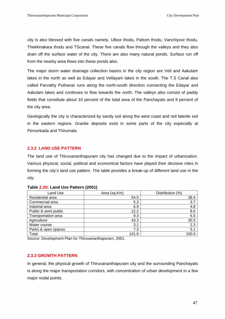
Thiruvananthapuram Municipal Corporation City Development Plan
47
city is also blessed with five canals namely, Ulloor thodu, Pattom thodu, Vanchiyoor thodu,
Thekkinakara thodu and TScanal. These five canals flow through the valleys and they also
drain off the surface water of the city. There are also many natural ponds. Surface run off
from the nearby area flows into these ponds also.
The major storm water drainage collection basins in the city region are Veli and Aakulam
lakes in the north as well as Edayar and Vellayani lakes in the south. The T.S Canal also
called Parvathy Puthanar runs along the north-south direction connecting the Edayar and
Aakulam lakes and continues to flow towards the north. The valleys also consist of paddy
fields that constitute about 10 percent of the total area of the Panchayats and 9 percent of
the city area.
Geologically the city is characterized by sandy soil along the west coast and red laterite soil
in the eastern regions. Granite deposits exist in some parts of the city especially at
Peroorkada and Thirumala.
2.3.2 LAND USE PATTERN
The land use of Thiruvananthapuram city has changed due to the impact of urbanization.
Various physical, social, political and economical factors have played their decisive roles in
forming the city’s land use pattern. The table provides a break-up of different land use in the
city.
Table 2.20: Land Use Pattern (2001) Land Use Area (sq.Km) Distribution (%)
Residential area 54.5 38.4Commercial area 5.3 3.7Indutrial area 6.9 4.8Public & semi public 12.2 8.6Transportation area 9.3 6.5Agriculture 43.3 30.5Water course 3.1 2.3Parks & open spaces 7.3 5.1Total 141.9 100.0
Source: Development Plan for Thiruvananthapuram, 2001.
2.3.3 GROWTH PATTERN
In general, the physical growth of Thiruvananthapuram city and the surrounding Panchayats
is along the major transportation corridors, with concentration of urban development in a few
major nodal points.

Thiruvananthapuram Municipal Corporation City Development Plan
48
Being the administrative capital of the State, most of the major institutions and the
Secretariat are present in the central area of the city. Recreational centres such as zoo,
museum, parks, open spaces and other socio-cultural centres are also located in the central
city zone. The major commercial centres are at Chalai, Palayam and along the Palayam –
Kesavadasapuram road corridor.
Thiruvananthapuram being located in the southern most part of the State, the major
transport corridors radiate towards the north and north-east of the city. Major institutions are
located along these major transport corridors. The north and north-west zone of the city has
attracted a large number of institutions of higher learning and research. Kerala University
main campus is at Karyavattom and next to that is Technopark. South-east of Karyavattom
is the College of Engineering and Loyola College of Social Sciences. On the west of these
institutions is the Centre for Development Studies (CDS), Centre for Earth Science Studies
(CESS) and Southern Air Command (SAC) at Akkulam. At Kazhakuttam, near Technopark,
are the international Apparel Park and the Film & Video Park, both promoted by KINFRA
(Kerala Industrial Infrastructure Development Corporation). Technopark, one of the first IT
Parks of the country, is in the process of expansion. A few I.T majors are setting up their
own software parks, adjacent to Technopark.
Comparatively less development has taken place towards the south and south-east of the
project area, except for Kovalam which is a major tourist destination. However, with the
proposed development of Vizhinjam port as an International Container Transhipment
Terminal, this area could witness growth in future.
Arabian Sea to the west is a physical barrier for growth of the city. And the presences of the
International Airport near the sea and the Coastal Zone Regulations have imposed
restrictions on the developments on the western zone of the city. The hilly terrain to the east
of the city is also a physical barrier to growth.
There is a shortage of land for housing the urban poor at an affordable price, which has
resulted in the growth of slums and squatter settlements. The Thiruvananthapuram
Municipal Corporation and the Department of Town and Country Planning had identified 31
slums and squatter settlements in 1995. Subsequent to the increase in the city area in 2000,
it is identified unofficially that there are about 350 slum like residential areas in the city. This
growth of slum like settlements in the city is a major concern in urban development.
The city area has an average density of about 5000 persons per sq km. A peculiar
phenomena observed in the Census 1991 & 2001 was that when the old city area of 74.93
sq km experienced a decadal population growth rate of 5 to 10 percent, a few peripheral

Thiruvananthapuram Municipal Corporation City Development Plan
49
panchayat areas contiguous to the city experienced growth of the order of 20 to 25 percent.
A few of these panchayats namely, Kadakampally, Attipra, Ulloor, and Nemom have been
attached to the city area in 2000, thus expanding the city area to the present 141.74 sq km.
Some are of the panchayat areas which now exist outside the city area, namely
Kudappanakunnu, Vattiyoorkavu etc. are also fringe area panchayats which have shown
high population increase. Such fringe area growth is not necessarily due to the overspill of
the city population due to high density developments within the city.
Another feature of the development pattern in the city is that intensity of development is
comparatively high for one plot depth of land abutting the major city roads, leaving the
central areas with poor access with less than optimum development. Redevelopment to
achieve optimum intensity of development within the allowable FAR has been made difficult
due to the smaller sizes of land holdings and larger number of land owners with skewed land
ownership pattern. (This is one of the objectives of the ‘Urban Regeneration’ programme
included under theCDP.
The low lying land parcels in the valleys within the city region (TUA) have been acting as
drainage basins, receiving surface run off during flash floods and slowly releasing the waters
into the streams and canals. The dual advantage of this system of drainage was that on the
one hand percolation of water into the soil is allowed recharging underground water and on
the other hand avoiding flooding of developed areas in the city. But due to population
pressure, many of these low lying valleys have been subjected to conversion for building
purposes, mostly as deviations to the land use regulations of the City Master Plan.
The city area offers opportunities for redevelopment and intensification of activities provided
the city managers are able to provide higher capacity infrastructure to support such
redevelopment. Such an attempt would be much cheaper than allowing urban sprawl and
trying to expand the coverage area of infrastructure. Such unplanned urban sprawl has also
the disadvantage of steady depletion of agricultural and horticultural land in the rural areas
adjoining the city.
2.3.4 Characteristics of urban land market The urban land market in Kerala is totally controlled by private sector. The land value escalated
drastically during early 1980’s based on a general trend of the national economy. However for
Thiruvananthapuram City major change in land values occurred in 1990’s when the
construction sector gained importance and the people started speculating investments in Real
Estates. Moreover the two decades from 1981-2001 witnessed high densifications of at least
four panchayat areas which lie contiguous to the city boundary. This made a strong impact in
Thiruvananthapuram Municipal Corporation City Development Plan
50
construction sector in the TUA resulting in escalation of land values. The negative impact of
these has been marginalisation of the lower MIG and LIG families, who could not compete in
the private land market for land. Therefore during these two decades, these groups who did not
have access to developed urban land, either acquired low lying marshy land within the City or
moved to the fringe areas for construction of residences since they could obtain land at much
lower price than the developed land in the city. This upset the City land use strategy causing
environmental problems and flooding of low lying areas during monsoons.
The developed commercial land in the central city now goes at Rs.25,000+ per sq m whereas
land in the intermediate area demands Rs.15,000+ per sq m and the peripheral areas
Rs.7500+ per sq m. Residential land in the above locations is going at 50 to 75 % of the above
rates.
Government have responsibility for social equity in urban land distribution. However the tools
available with Government for intervention to stabilise land values and to create a climate for
accessibility for the poor to urban land are limited. Master Plan zoning regulation is one such
tool. Similarly regulation on the allowable intensity of development on a parcel of urban land
limits the rent the land can earn and this may stabilise the land value. Other tools like DCR
relating it to TDR, reservation of land for urban infrastructure development, compulsory
reservation of land for LIG in government and privately developed housing schemes etc. are
measures to ensure that the poor have access to land. GoK is considering the process of
developing such tools as part of the City Region Master Plan. Similarly the FAR provisions for
the various parts of the city relating it to the carrying capacity are also under consideration.
2.3.5 Implementation and Impact of Master Plan The first Master Plan for Thiruvananthapuram City was prepared in 1966 by the then Chief
Town Planner & Consulting Architect to Government. This Master Plan was approved by
Government in 1971. The planning area consisted of the city of 74.93 sq km and part of the
adjacent panchayat areas of Ulloor and Thiruvallam. The Master Plan had a horizon period of
20 years .The plan proposed the land use structure of 1986 and had estimated the major
infrastructure requirements.
The road network envisaged in the Master Plan was broadly taken as a framework
when the Department of Town Planning (formed in 1969.This Department was later renamed
as Department of Town &Country Planning – DTCP - in 1998) prepared Detailed Town
Planning Schemes (D.T.P. Schemes as area development plans for priority development areas
within the City. When the National Highway Authority proposed a City By pass the Master Plan
was consulted for suggesting probable alignment .The Comprehensive Traffic &Transportation

Thiruvananthapuram Municipal Corporation City Development Plan
51
Study (CTTS) for the City carried out by consultants during 2000-2002 for GOK considered the
Master Plan as the relevant document to propose a road network plan for the City. The
Thiruvananthapuram City Road Development Project prepared in 2002 and being implemented
now has generally followed the road widening and improvement proposals indicated in the
Master Plan and the DTP Schemes.
Thiruvananthapuram City can generally be proud of a compatible land use development for the
last three decades, except very few sore spots where variance is noticed. This was greatly
possible because of the enforcement of the land use plans of the 1971 Master Plan. The State
Electricity Board (KSEB) and the Kerala Water Authority (KWA ) attempted preparation of
Thiruvananthapuram Master Plan for their subject areas. For this purpose both of them referred
the infrastructure requirements and the population density proposals for the various zones
envisaged in the Master Plan. In view of the above it can be broadly stated that the Master Plan
1971 was helpful as a planning tool in guiding the development of the City.
A Draft Development Plan was prepared by the Department of Town Planning for 2001
which was published by the then Trivandrum Development Authority (TRIDA). The
suggestions from the public and the TRIDA necessitated major changes. The main
proposals and Status of the Development Plan (2001) are detailed in the Table below.
Table 2.21: Development Plan (2001) Status Component Proposals Status
Growth Pattern Redevelopment of central market area near Chalai and Palayam and its surroundings.
Most of the area has been developed near Palayam.
Population Distribution DP for TVM-2001 has suggested areas in the vicinity of N. H. by-pass and Veli Tourist Complex kept for low density development.
Detail Town Planning Schemes were prepared and have been published.
About 100 Ha proposed for industrial development.
Very few industries have been located in Northwest region (Panchayat Area covering 33 Ha) This is due to lack of infrastructure.
Industries
Shifting of old industries from the central area of the city (which pose nuisance to the surroundings)
This is in process
Terminal facilities for inter city traffic
Land acquisition of intercity terminal is in process
Transportation
Improvement of existing KSRTC bus terminals at Peroorkada, Pappanamcode and shifting existing bus terminal from East fort to Ambalathara
Shifting of existing bus terminal from East Fort to Ambalathara is ongoing

Thiruvananthapuram Municipal Corporation City Development Plan
52
Component Proposals Status A lorry terminal to be located on southern side of Chalai Bazar at Kuriathy
It is in the process of development at Sreevaraham.
Water ways: T S Canal should be deepened to facilitate navigation. It is proposed to provide loading and unloading facilities for country boats at Chakkai and Vallakkadavu. T.S. Canal, Veli-Akkulam lake and Edayar Island are to be developed as places of tourism importance.
Will be implemented under Theerapatham Urban Development Project
Widening of the existing road from Kesavadasapuram to Attakulangara (Via Pattom, Palayam, East Fort etc.) (Width 21 m to 24m) Widening of the existing road from Ulloor to Sreekanteswaram and Sreekanteswaram to Killippalam connecting Ulloor, Medical College, Nalumukku, Uppilammodu Bridge, Sreekanteswaram Junction, Thakaraparambu, Power House Junction, Choorakattupalayam and Killippalam (Width 21 m to 24 m.). Widening of the existing road from Peroorkkada, Chalai via Kowdiar, Vellyambalam, Vazhuthacaud, Mettukkada and Aryasala, Widening of Palayam Sankhumugham road via Pattoor, Nalumukku and Chakai.
A total road length of nearly 42 km selected by PWD & TRIDA for upgrading is under implementation of which about 12 km has been completed
Widening of Killippalam Karamana road (21 to 24 m)
Completed
Widening of road from Palayam to Poojappura via Bakery Junction, Vazhuthacaud and Jagathy width 15 to 18 m from Bakery junction to Poojappura and 21 to 24 m from Palayam to Bakery Junction.
Commenced in 2004
Traffic Improvement Porojects (12 roads have been selected)
Formation of N.H 47 bypass to be completed to a width of 45m
From Kazhakuttom to Vizhinjam it is completed.
Source: Development Plan for Thiruvananthapuram 2001.
Subsequently the City area was expanded, UDPFI guidelines were issued by Government of India and the new Census findings published. In view of these, the published draft Plan did not reach approval stage nor was it enforced. A new Development Plan for the City Region is on the anvil and is expected to be published in 2007.

Thiruvananthapuram Municipal Corporation City Development Plan
53
2.3.6 KEY ISSUES & CHALLENGES
Key development issues include:
a) Unplanned development in the Fringe Areas: Areas like Sreekaryam, Kazhakuttom and
Kudappanakunnu are under pressure for further urban growth but do not have a sufficient
level of infrastructure and development control. This has resulted in the conversion of
agricultural land and filling / reclamation of water bodies for urban use. Tracts of Government
land available in these areas are easily susceptible to encroachment. Normally due to
extraneous reason, land is sub-divided according to Land Sub division Regulations and sold
by private developers to private individuals, which remain un-serviced or unused for many
years and without adequate infrastructure. Though enforcement powers exist under the KM
Act, 1994, action is rarely taken to remove unauthorized developments. Extensive areas of
unauthorized developments freeze land resources and thereby exert a negative impact on
the economic functioning of the city.
b) Shelter: There is shortage of affordable housing in the planning area. The urban poor find
it difficult to get developed sites for house construction at an affordable price because of high
land cost. This has resulted in the growth of slums and Economically Weaker Section (EWS)
colonies. The draft Development Plan (2001) has identified present deficiencies in the
housing stock and has estimated future requirements but it has not indicated how shelter
and land requirements for the urban poor should be met. It is essential to estimate based on
affordability the actual housing needs of the people, particularly for those Below Poverty Line
(BPL).
c) Dearth of Infrastructure: In Thiruvananthapuram, significant areas of land are subdivided,
sold and developed for urban uses. As a result, service demand exceeds infrastructure
capacity and the condition of infrastructure provided in the area has deteriorated. One of the
major areas of concern is that individual plots are being developed into multi-storied
apartment / commercial buildings, thereby exerting lot of strain on the existing infrastructure.
The number of vehicles far exceeds the road capacity, inadequacy in water supply and
sewerage, lack of mass transport system to cope with the growing demands etc are
problems experienced now. The growth trends demand additional infrastructure and a higher
level of service.
d) Poor Management of Water Bodies/Tanks: Karamana River and Killi River used to be the
life lines of the city. Thiruvananthapuram Water Supply Scheme exists on the water source
in Karamana River. Both these rivers are now polluted. The river boundaries are
encroached. Solid wastes are dumped in the rivers. Raw sewage from the individual plots

Thiruvananthapuram Municipal Corporation City Development Plan
54
and occasionally from the City Sewerage System is let off into these rivers. There is urgent
need to clean these rivers, clear the encroachments, prevent waste dumping into the rivers,
propose only planned developments on either side of these rivers and implement 100
percent coverage with sanitation projects for the river front developments.
All the five canals which receive surface water run off and carry the water to the sea have to
be cleaned and conserved, preventing sewage and solid waste being dumped into these
canals.
There are atleast a hundred ponds existing at various places in the city. Most of these ponds
are in an abandoned stage. Like many other ponds which have been encroached upon and
filled up, these existing ponds are also threatened. It is necessary to conserve and develop
these ponds in the city.
Ground water is the primary source for domestic consumption in the newly developed areas
but over extraction has resulted in brackish water, especially along the coastal belt. Ground
water exploitation should be effectively monitored and controlled.
e) Lack of Co-ordination in Planning: Industrial, residential and infrastructure investment
decisions are uncoordinated particularly in the fringe areas where pressures for urban
expansion are increasing and becoming increasingly difficult to monitor and control
development. There is a lack of clarity over departmental responsibilities for land use
planning, development, maintenance and enforcement. This has resulted in ineffective and
uncoordinated decision making processes and actions.
f) Inadequate open space: Most of the public and semi-public spaces are concentrated in
and around the central area of the city. There is lack of adequate organised open spaces at
zonal levels. It is necessary to adopt planned utilisation of the available public open spaces
in every ward of the city as play grounds, parks and gardens allowing space for active and
passive recreation for people. There is also need to bring more land under planned parks
and open spaces.
2.4 Gender in Urban Infrastructure Development, Governance & Poverty Alleviation
Women form more than half of the urban citizens, especially of the urban poor.
Understanding and addressing their specific needs is crucial to the success of development.
It is clear that women in urban areas are more vulnerable than men and they remain unequal
to men in terms of employment opportunities, access to resources and representation. All
the essential services for the urban poor such as security of tenure, improved housing,

Thiruvananthapuram Municipal Corporation City Development Plan
55
water supply, sanitation, education, health care and social security have a gender dimension
to it which needs to be kept in mind while planning programmes and projects.
The roles and activities of men and women in an urban milieu are different. Since women
are often under represented in decision making process, their issues hardly get any
attention.
A. Women in the Economy
Most of the women from urban households are working women, either in the formal or in the
informal sectors. There are many women who work in the services sectors-in government
offices, schools, hospitals, in the newly emerging IT sectors etc. Thiruvananthapuram being
the capital city has the presence and visibility of women working in the formal sectors. Their
specific problems need to find a place in urban planning exercise.
Many women work in the informal sector. There are vendors (fish, vegetables, fruits, flowers
etc). Basic services which the city needs like garbage collection, cleaning etc are performed
by women. A large number of poor women work as domestic maids, sales girls, and in
similar service sectors. All these women bear the double work burden of performing their
own household duties, and also work as earners and providers of the family. So these
differential needs and priorities need to be considered in planning urban infrastructure as
well as basic services for the poor.
Since women are responsible for provision of basic needs in households, there is need to
assist women in reducing their domestic work burden by providing access to safe water, fuel,
facilities for waste disposal, and access to essential requirements to run a home.
As workers and wage earners outside their homefront, they need transportation at the right
time, security while travelling and safe working environment. Most women in the informal
sector may be the sole earners in their families and providing facilities for them clearly
reduces poverty in the households. In Thiruvananthapuram Corporation, there are many
women headed households and also single women households.
B. Poverty Eradication and Women
Kerala has gone a long way in addressing issues of poverty, especially through women. Like
in many places micro credit initiatives have successfully brought many women into public
spaces and have helped them to initiate savings and credit programmes. Some groups have
moved to the next level of starting micro enterprises. But a review of such programmes by
several scholars in Kerala reveal the need for adequate forward and backward linkages like

Thiruvananthapuram Municipal Corporation City Development Plan
56
management skills, marketing support, networking etc. Moreover, product diversification,
quality assurance etc also have to be provided. These are critical in sustaining the process.
These aspects have to be kept in mind while planning the urban infrastructure as well as
basic services for the poor. A centre for women to sell their products, storage spaces,
working spaces etc can be provided for women’s micro –enterprises. Women vendors need
to be consulted in planning markets and shopping complexes.
Another crucial aspect is that, poverty eradication in general does not necessarily address
gender inequalities. Hence conscious efforts are needed to bring in the gender dimension.
Women are not to be viewed as passive beneficiaries but active agents in poverty
eradication. Their capacity to articulate needs and priorities should be enhanced and such
needs should get reflected in budgeting and resource allocation. Women should also be
involved in monitoring and auditing of projects and programmes from a gender angle.
C. Women in Governance
Kerala has legislated that one third of all elected members of the 3 tier Panchayati local
bodies and the municipalities should be women. The 33% elected women members or a
large number of women in Ayalkoottams or ADS/CDS structures do not necessarily mean
that their specific needs and interests are identified and addressed. For women who have
been socialised in the patriarchal society and has internalised its values, it is not ‘automatic
or natural’ to identify their strategic gender interests or those that help to change their status
in society. Identification and articulation of such needs requires broader gender sensitization
and capacity building to undertake institutional gender analysis.
Hence capacity building of elected women and leadership development among grassroot
women’s organizations (ayalkootams, ADS/CDS and other organizations) should form an
integral part of the governance agenda of urban planning. Networking and back up support,
necessary structures for this in the planning of urban infrastructure also is called for. A
resource centre cum meeting place for women under the control of the city corporation may
help partially to achieve this goal.
Such a resource centre for women can act as a strong base to help women achieve their
social and economic rights and also legal awareness to move towards accountability
(awareness raising, legal aid, resources for land titling etc).
D. Women in Transport
In the city of Thiruvananthapuram with large number of working women, transport is a major
issue which has a gender dimension. Transport planning often disregards women's priorities

Thiruvananthapuram Municipal Corporation City Development Plan
57
because the focus is on mobility for all people and the preoccupation is with the journey and
itinerary of formal sector workers and students. Accessibility is often not considered.
Women's travel needs frequently require transport outside of peak hours and to alternative
destinations from those of men. And yet cost cutting inevitably involves a reduction in off-
peak services, a consequence of the economy evaluation made by planners using
conventional cost/benefit measures which ignore the value of the trips women make in their
reproductive role (Levy 1991). It should be noted here that it is not only the priorities of
women that are overlooked by conventional transport planning, but also those of men
outside of centrally located, formal sector employment.
Women engaged in informal sector activities are often burdened with heavy loads like fish or
vegetables. There are many women who carry this by head load because the existing
transportation system does not provide for them. Moreover, working women usually combine
paid work with their domestic responsibilities. Women depend more than men on public
transport and walking than on private cars or two wheelers. Affordable transport systems
circumvent critical destinations; they are overcrowded and sometimes dangerous and are
often unreliable and irregular. This hinders women in their domestic and caring
responsibilities.
Safety while travelling is of paramount importance to women. Measures to ensure safety in
public transport, in bus shelters and on streets should receive special attention. Adequate
street lighting, aid posts in bus stands etc should be planned. Drivers and conductors of
transport vehicles should be sensitized to the specific needs of girls and women and help
lines can be established, information about which can be displayed at major bus
stations/railway stations. This helpline can also provide information regarding safe
accommodation facilities for women who are travelling alone for various needs to the capital
city and who are at risk.
Pedestrians are the most neglected in the planning process which include men, women,
children and the elderly. Foot paths are often reduced to widen roads, which has direct
relation to the safety of women. In a crowded street, if pedestrian space is very narrow and
enclosed with barricades, women are often harassed while walking. Elderly find it very
difficult to walk through a footpath which is uneven.
E. Women in Housing
Most women from among the poor use the house also as their workplace. Women spend
more time at home than men and if the kitchen has no adequate ventilation and lighting, and
if firewood is used for cooking, this can lead to health problems. Consultation with women is

Thiruvananthapuram Municipal Corporation City Development Plan
58
also important for the design, delivery and maintenance of urban services and communal
facilities. Women's responsibility for household and community management gives them a
particular vested interest in safe water supply, efficient sanitation, solid waste removal and
the provision of affordable and reliable sources of energy.
While Kudumbashree units are enlisted for waste management, care should be taken to
increase their skills and capacities by teaching them to drive vehicles, providing necessary
safety precautions etc. Health insurance should be arranged as the job involves many
occupational health hazards like slipping and falling, dog bites, contamination from the
waste being handled, back pain due to the weight carrying etc.
F. Social Infrastructure
Education, health, recreation etc are areas where specific gender concerns exist.
Addressing the social needs of poor families is a question of life and death. Special efforts
need to be made to identify vulnerable families whose education, health and social security
are to be addressed and provided for. Various programmes can be initiated through public
private partnership (PPP).
The quality of services in the institutions under the municipal city corporation has to be
ensured, with special focus on schools where children from marginalized communities study
especially in coastal areas, slums etc. Supervised study after school hours with the help of
parent teacher associations (PTA) will help the education of girls, who otherwise will be
burdened with household tasks preventing them from focusing on studies.
There is overcrowding in hospitals, lack of privacy in examination rooms and a host of other
problems which require urgent attention.
Recreation is a basic need of human beings and often such a need of women is not
recognized. Public spaces have to be free from harassment and basic facilities like toilets
need to be provided, so that women also can enjoy free time. Night life activities and Sunday
markets need to be promoted.
The role of women in each of the aspects specified under A to F above shall be considered
in detail under each sector in the subsequent chapters. When preparing Detailed Project
Reports these aspects need to be given due consideration so as to ensure gender
mainstreaming in Urban Infrastructure Development, Governance & Poverty Alleviation.

Thiruvananthapuram Municipal Corporation City Development Plan
59
DDEEVVEELLOOPPMMEENNTT VVIISSIIOONN AANNDD DDEEVVEELLOOPPMMEENNTT SSTTRRAATTEEGGIIEESS

Thiruvananthapuram Municipal Corporation City Development Plan
60
3.0 DEVELOPMENT VISION AND DEVELOPMENT STRATEGIES FOR THIRUVANANTHAPURAM
3.1 SWOT ANALYSIS OF THIRUVANANTHAPURAM URBAN AGGLOMERATION
Thiruvananthapuram city has a long history of being on an elevated pedestal as the capital city;
earlier of the erstwhile Travancore and later of the State of Kerala. The princely state of
Travancore had initiated a large number of reforms which included English Education,
Institutions of higher learning, cultural institutions etc. All these happened to be located at
Thiruvananthapuram. However over the last few decades, the city region has made a quantum
leap in attracting many institutions of learning and research and also quite a few modern
industrial establishments.
The natural endowments of TUA are getting recognition only now. These are taken into account
in the SWOT analysis.
3.1.1 STRENGTHS
• The City being the administrative capital of Kerala attracts a very large number of
people from Kerala and also from other states on government business.
• The City has a long history of recognition as the centre of learning and therefore
students from all over the state converge to the City: this continues in spite of the
fact that educational institutions have got located also in the other regions of the
state .
• Kovalam Beach in Thiruvananthapuram was one of the locations selected by
Government of India in the early seventies to be developed as a tourism destination
in India. During the last three decades Kovalam has been recognised as one of the
world tourism destinations.
• Thiruvananthapuram was the location of the first IT Park in India. Recently many IT
giants like Infosys and U.S. Software have set up their establishments in and around
the Technopark. GoK is in the process of acquiring 500 more acres about 6 km from
Technopark for establishing a ‘Technocity’. IT professionals consider
Thiruvananthapuram as providing the right environment for their living and working.
• Though Vizhinjam in Thiruvananthapuram was talked about as a potential harbour
location ,in the light of development of world shipping ,designation of international
shipping route and studies on World Shipping Vision, the state and the central
governments have now realised the importance of development of ICTT

Thiruvananthapuram Municipal Corporation City Development Plan
61
( International Container Transhipment Terminal ) at Vizhinjam. Estimate of revenue
generation and savings in cargo import have reemphasised the importance of Vizhinjam
ICTT. With the realisation of this Port, Thiruvananthapuram City Region in particular and
the state in general stand to make substantial economic gains in addition to gaining
from the job market generated by the ICTT.
• The natural endowments of Thiruvananthapuram make it the most livable city in
South India. The city is least affected by natural calamities. Because of its
physiography and terrain the city is not plagued by environmental problems like
water pollution, inundation during storms etc. Compared to any city in Kerala and
Tamil Nadu, Thiruvananthapuram has a much better water supply and sewerage
system. Thiruvananthapuram also has a very amiable climate throughout the year
without extreme summer and winter, without the need for winter clothing.
• The city is well connected with the important cities within the country and abroad. In
addition to rail, road and air connectivity, water transport development is also in the
offing.
• The city region accommodates a large number of reputed hospitals and medical
research institutions which offer a fairly high level of service, even attracting
foreigners to the medical facilities in the city region. The holistic health facilities
based on ayurveda offering not only curative but also health rejuvenation
programmes are considered to be the added strength of Thiruvananthapuram city
region.
3.1.2 WEAKNESS
• A large number of foreign and domestic tourists and people for governmental and
non governmental business converge to the city of Thiruvananthapuram with high
aspirations. But the carrying capacity of the city is such that it cannot provide high
quality infrastructure to the satisfaction of its users.
• Though a major percentage of the area of the old city of Thiruvananthapuram
spreading over an area of 74.93 sq km is covered under the sewerage scheme, with
the extension of the city to cover an area of 141.74 sq km, the coverage is limited to
about 30% of the city area. With the reducing land man ratio, the extension of the
sewerage system to the entire city and the urban agglomeration area, which is the
urbanising area, remains as a priority component which needs to be addressed.
• The existing water supply system, with the main centralised system and a few stand
alone systems, which cater to specific areas, is incapable of providing a satisfactory
level of service. This is in spite of its designed capacity. In many of the areas, the
service level remains at 80/90 lpcd at 2 to 4 hours of supply per day. Weak

Thiruvananthapuram Municipal Corporation City Development Plan
62
distribution systems, transmission losses, leakages, loss of pressure etc. are
attributed to this unsatisfactory service level.
• With the exploitation of the available potentials for development such as IT,
Vizhinjam port etc and also taking in to account of the present developments, the
number of vehicles catering to the needs of the city users is increasing at an
alarming rate. Lack of quality system for mass transport is experienced which
compels the road users to use their own individual personal vehicles adding to traffic
volume. Substantial improvements in public transport systems are required.
• The local self government does not have complete control over the city’s
infrastructure. A few state departments and para statal agencies are responsible for
some important components of development infrastructure. The TMC may however
have to respond to public grievances, when any dysfunction of any city infrastructure
or dissatisfaction in the service of any city infrastructure occurs.
• Being a state capital, Thiruvananthapuram happens to beat the receiving end, when
disruption of traffic, disruption of city infrastructure, destruction of public properties
etc. occur due to political upheavals, agitations, hartals etc.
3.1.3 OPPORTUNITIES
• The prospects for beach tourism, health tourism and adventure tourism clubbed with
the development potential for IT, Vizhinjam port etc would attract direct and indirect
jobs in various sectors.
• The above development potential combined with high quality of infrastructure can
attract both foreign and domestic investments. NRIs from Kerala may find such a
situation very conducive for investments in their home state.
• Availability of land in the peripheral areas of the city calls for inducing developments
therein through providing supporting infrastructure.
3.1.4 THREATS
• Thiruvananthapuram being a coastal city is frequently affected by coastal erosion,
which often necessitates rehabilitation of fisher folk.
• Thiruvananthapuram being the capital city of Kerala becomes venue for public
properties etc. which occur due to political upheavals, agitations, and hartals etc.
which cause disruption of traffic, disruption of city infrastructure and destruction of
public properties.
• The LSGD may have to elevate its status as an urban manager and administrator to
effectively implement the infrastructure development programmes and to continue to
maintain and manage the assets created out of the JNNURM programme.

Thiruvananthapuram Municipal Corporation City Development Plan
63
3.2 APPROACH TO DEVELOPMENT VISION
Thiruvananthapuram has been the capital of the princely state of Travancore and continues
to be the capital of Kerala. The city of Thiruvananthapuram has its authority and dignified
status as the Capital City of the State and will continue to be so.
From time immemorial, Thiruvananthapuram has been a centre of learning. It is said that
‘Kanthalloor Sala’ which could be equated to the Nalanda and Takshasila existed in the city.
Large number of institutions of higher learning and advanced research institutions are
located in the city and surroundings. These institutions now attract scholars and researchers
from all over the country. This is one of the key strengths of the Capital City Region.
The Techno-Park in Thiruvananthapuram is one of the first IT Parks developed in the
country. Currently around fifty IT companies are operating from here. A few of them are in
the process of establishing their own premises in the vicinity of the existing IT Park. KINFRA
has established a Film and Video Park and an Apparel Park in this zone. Government of
Kerala has envisioned establishment of a Techno-city in the zone. These developments and
the availability of technical skills in the Capital City Region enlarge the potential for
information technology, bio-technology and similar other non-polluting advanced industrial
sectors, which would contribute to a high quality economic development of the region.
Kovalam has been a world-class tourist destination, contributing to a large number of foreign
tourist arrivals. The strength of Thiruvananthapuram district in Tourism development lies in
The City of Thiruvananthapuram would be an effective and efficient Capital City adding value to its rich heritage and inheritance, providing quality infrastructure and services to the citizens and to the people within and outside the State who visit the city for various functions and services
1
Thiruvananthapuram City Region aspires to be a knowledge hub providing opportunities for learning and research in advanced fields of new and emerging horizons of science and also providing opportunities to work and develop in such fields.
2
Promoting Thiruvananthapuram City Region as an attractive destination for non-polluting advanced industrial sectors like information technology, bio technology, nano-technology and similar others by banking upon the greenery and amiable climate through out the year and utilizing technical skills of the state, supported by un-interrupted supply of essential services like water, power and fast moving corridors.
3

Thiruvananthapuram Municipal Corporation City Development Plan
64
its beaches, backwaters, rich cultural heritage and hill resorts. With the Thiruvananthapuram
International Airport providing the gateway to tourism in Kerala, a substantial increase in
foreign and domestic tourist arrivals in Thiruvananthapuram is envisioned. This would
necessitate substantial upgrading of the tourism infrastructure in the City.
Vizhinjam seacoast 15 km to the south of the city is naturally endowed. The calm waters
with a natural draft of more than 20 meters and within a distance of 7 nautical miles from the
International Shipping route offers a unique location unlike any existing harbours on the
eastern or western coast of India to be developed as an International Container
Transshipment Terminal (ICTT) which would compete with the ICTTs of Colombo, Dubai and
Singapore where transshipment now happens for the Cargo destined to India. With the
commissioning of the ICTT at Vizhinjam the International Cargo arriving in India may cost
much less than what it costs now, contributing to substantial gain in foreign exchange.
Innumerable number of direct and indirect jobs would be created by the harbour. Bunkering
facilities would provide many additional service jobs.
The music – composer – King Maharaja Swatithirunal of the erstwhile kingdom of
Travancore heralded modern medical institutions in the city, by constructing hospitals
offering Allopathic (English) medical facilities. Thiruvananthapuram Medical College, the first
medical institution in the State, the Sree Chithira Thirunal Institute for Medical Science and
Technology, the Rajiv Gandhi Institute of Bio-Technology and a host of hospitals and related
medical institutions situated in the city offer world class facilities for treatment. The inherited
strength of Thiruvananthapuram for ages has been in the field of ayurvedic health facilities,
which not only provide curative facilities but also for holistic health care. A large number of
yoga centres are also located in the city region. These have attracted people from all over
the country and abroad to visit Thiruvananthapuram for health care. The long waiting period
Thiruvananthapuram aspires to be the gateway of International and Domestic Tourism in Kerala, providing opportunities with varied tourism products from Beach Tourism to Hill Area Tourism supported by World Class Tourism Infrastructure in accommodation, food, transportation and services.
4
Thiruvananthapuram is naturally endowed to be developed as an International Container Transhipment Terminal, serving the whole of the country. Vizhinjam in the influence region of Thiruvananthapuram aspires to be developed as the shipping hub of the country offering substantial economic gains in International Trade. Vizhinjam would, in the next two decades become the most aspiring activity node of Thiruvananthapuram City Region, which the entire country would be proud of.
5

Thiruvananthapuram Municipal Corporation City Development Plan
65
and the heavy expenditure on health care in Europe and America have made
Thiruvananthapuram a destination for health care where the westerners combine this with
tourism. This strength of Thiruvananthapuram can be further expanded in the next decade to
elevate Thiruvananthapuram city as a destination for World Health Tourism.
Being a State capital with varied employment opportunities, the City Region has attracted a
large number of people in the service sectors. Quite a few of them are absorbed in the
informal sector without access to quality housing and basic amenities.
3.3 Development Vision
VISION STATEMENT
THIRUVANANTHAPURAM CAPITAL CITY REGION
AS A SUSTAINABLE AND ECONOMICALLY VIBRANT URBAN HABITAT
WITH WORLD CLASS INFRASTRUCTURE
3.4 Development Strategies for Thiruvananthapuram City Region The CDP envisages a Development Horizon of 25 years commencing from the year 2006.
This Development Vision for the Thiruvananthapuram City Region envisaged in the CDP is
proposed to be accomplished through a multi dimensional Development Strategy, which will
encompass many development sectors and lead to an improved urban management system.
Thiruvananthapuram City Region would develop as a preferred destination for curative and preventive health care and rejuvenation offering a variety of world-class Health Care facilities, which as a holistic health care serves both the Body and the Mind.
6
The Thiruvananthapuram city development envisions improvement in quality of life of the economically weaker sections of the urban population through adequate interventions of the state and local governments, thereby empowering them to improve their income and also contribute to the economic activities of the city.
7

Thiruvananthapuram Municipal Corporation City Development Plan
66
The Development Strategy acknowledges the fact that the Project Proposals in the
Jawaharlal Nehru National Urban Renewal Mission (JNNURM) are multi- component, multi -
sectoral and multi - agency in nature.
The proposed Development Strategy takes into consideration the following parameters:
The Development Vision for the City region; The Infrastructure required to support and service the major activity nodes
envisioned in the Development Vision are considered to be prioritized for development;
The status of the existing infrastructure with regard to Transport, Water Supply, Sewerage, Surface Water Drainage, Sanitation including Solid Waste Management, Urban renewal, Conservation etc., their deficiencies and the aspirations of the stakeholders in improving the level of services are considered in the strategy for improvement of urban infrastructure;
Infrastructure study based on the network, coverage and level of service in relation to the development of the city and environs as studied in the Development Plans and the Sectoral Plans prepared earlier were studied to draft sectoral level development strategies;
The development potential of the city level resources and the urban governance machinery are considered in drafting a long term development strategy for the city; and
The expertise and capability of the various implementing agencies and their potential to assume additional capacities are considered in adopting a City Development Strategy and also Sectoral Development Strategies.
The following are the development strategies proposed for Thiruvananthapuram City Region
3.4.1 STRATEGIES FOR COMPREHENSIVE LONG RANGE DEVELOPMENT OF THE CITY REGION
Preparation of a Comprehensive Long Range Urban Development Plan for Thiruvananthapuram City Region (UDP);
Preparation of Zonal Development Plans (ZDP) for all the identified Development Nodes within the broad framework of the City Region level Development Plan; and
Preparation of a Priority Action Plan (PAP) for phased implementation of the identified priority development programmes.
3.4.2 PROGRAMMES FOR THE DEVELOPMENT NODES
Kudappanakunnu Civil Station Area
Government of Kerala has decided to shift the District Collectorate to Kudappanakunnu
Panchayat lying adjacent to the city on the north side. This establishment will be followed by

Thiruvananthapuram Municipal Corporation City Development Plan
67
about 60 district level offices of various Government departments which in turn would
generate large scale housing demand in the zone. These would attract a large increase in
commercial activities and service jobs.
All these developments would require substantial up gradation in quality and quantity of
infrastructure, improvements in road access, transport facilities, land development for
housing, augmentation in water supply, establishment of sewerage system, improvement in
solid waste management, etc. The ZDP shall take into account all these. Compatibility of
land uses and making available developed land for various competing uses being a primary
need, the ZDP shall have an acceptable Land Use Plan, notified as a statutory document
and followed religiously.
Kazhakuttam Techno Zone
The Techno Park in Kazhakuttam is the first IT Park of its kind set up in India. The Techno
Park now has about 35000 employees and it attracts 4000 visitors daily. In the near future
the number of IT companies operating from Techno Park may substantially increase. In
addition, a few IT majors like Infosys are developing their own campuses near the Techno
Park. On completion of these, the additional employment that may be generated is about
33000. After the phase 3 developments also are realized the total number of jobs may be
around one lakh.
The State Government has recently decided to establish a Techno City about 5 km north of
Techno Park on the Kazhakuttam – Attingal NH Corridor. It is estimated that this premises
may provide nearly hundred thousand jobs.
The Kerala Industrial Infrastructure Development Corporation (KINFRA) has developed a
Film and Video Park near Kazhakuttam, which is considered a successful venture. KINFRA
has also developed an Apparel Park on the west of Kazhakuttam. This industrial park is also
fully occupied. These activities have attracted a large number of commercial activities and
service sectors to this zone. The demand for housing has substantially increased.
In spite of these developments happening in this zone, a statutory Development Plan for this
Zone is absent. This is a prime necessity. The CDP shall address all the development issues
and shall prioritise the requirements and lead to Project Preparation for phased
implementation.
Vizhinjam ICTT
Vizhinjam, 15 km south of the city and 5 km south of Kovalam, is the location for Vizhinjam
Harbour proposed to be constructed as an International Container Transshipment Terminal
(ICTT). This Project is in the final stages of clearance and is getting ready for construction on
Public - Private Partnership (PPP) basis. Expected to cost Rs.4000 crores, this Project may
create 10,000 direct jobs and nearly 50,000 indirect jobs. The land based developments may
Thiruvananthapuram Municipal Corporation City Development Plan
68
require container and passenger transport facilities, rail link, commercial activities, service
sector activities, housing etc. Such a development may require infrastructure development
as required for a small town of 100,000 people.
Zonal Development Plan for Vizhinjam Node shall address all these issues.
New Airport Terminal, Second Railway Terminal and Water Transport Terminal
The new Airport Terminal is under construction on the NH Bypass side at Chackai. The
present terminal on the western side of the runway is being shifted to the eastern side of the
runway to facilitate easy access from the city. The Airport Authority of India who has
undertaken the construction of the new terminal has stated that the related facilities required
for the terminal shall be developed by the State Government by acquiring land required for
these.
The related facilities are:
Access road from the NH bypass across the T.S. canal; Commercial developments required for the airport terminal; Transit hotels; VIP lounges for relaxing and for press conferences; Facilities for security personnel; and Staff Housing etc.
About 40 ha of additional land need to be acquired for these facilities and developed based
on a detailed Master Plan.
The second Railway Terminal at Kochuveli is under construction. The Railways have
proposed to terminate the long distance trains at this second terminal, considering the space
constraints at the Thiruvananthapuram Central Railway Station situated in the heart of the
city. In addition to the passenger terminal, the Kochuveli terminal may also accommodate
Cargo Terminal attracting heavy volume of road traffic.
The terminal premises thus need road transport terminal, truck terminals, road development,
parking facilities for private vehicles, good transport linkage with the central city etc.
These activities may also attract quite a few commercial and service activities which call for
planned land development with appropriate land use controls. All these point to the fact that
Kochuveli railway terminal area may require a sub-Master Plan for ordering the development
activities anticipated in the area.
Veli Water Transport Terminal: About two kilometres from the Kochuveli railway terminal is
the Veli lake, which is linked to Edayar lake on the south west of the city with a manmade
canal called T.S. Canal (Parvathy Puthanar). Government of India has declared Kollam –

Thiruvananthapuram Municipal Corporation City Development Plan
69
Kottapuram canal as National Waterway III. The State has proposed to extend this NW III
towards south up to Thiruvananthapuram. This water way would need Thiruvananthapuram
water transport terminal at Veli. Veli – Akkulam backwater have already demonstrated great
potential for development of tourism. Many tourism related activities have been established
at Veli – Akkulam lakes. The water transport terminal may not only provide alternative
transport facility, but would also provide a boost to tourism. This Water transport terminal at
Veli is adjacent to NH bypass and is near the International Airport. This water transport
Terminal together with the other activities in the proximity may need a Zonal Development
Plan for identifying, prioritizing and implementing all the development activities in this Zone.
The Infrastructure needs of the above zones are considered in the project packages evolved
under the Jawaharlal Nehru National Urban Renewal Mission (JNNURM).
3.4.3 INFRASTRUCTURE DEVELOPMENT IN THE CITY
Inadequacy of infrastructure coverage, poor level of service, non-availability in certain areas
of the city, lack of access to city level infrastructure for the urban poor and other similar
aspects related to Thiruvananthapuram were often projected in many a forum and in media.
This scenario of infrastructure was the focus of discussions in many Development Seminars
conducted in the city, since it was felt that such a situation is quite demeaning to the capital
city of the State of Kerala.
Subsequent to this, GOK adopted the development agenda for Thiruvananthapuram Capital
Region (TCR). Though problem solving measures, improvement and augmentation of many
a sector was considered under the TCR Development Agenda, the first initiative was taken
with Priority Road Improvement, under which 14 road corridors are considered for widening
and improvement.
The major infrastructure sectors considered for improvement under the JNNURM, based on
the study and analysis of the existing status and the future estimated needs are:
Transport – road development, improvement in road transport terminals, development of parking facilities, pedestrian facilities, water transport, mass transport system improvement etc.
Railways have become the main life line of movement of people and goods from and to the capital city. The inadequacies of the existing rail facilities were highlighted in the many consultation meetings. The future development needs in terms of infrastructure needs for the railway systems are included in the project.
Water Supply – improvement of existing distribution system, improvement to
transmission mains, improvement to treatment facilities, development of new
sources, increase in coverage, improvements in quality and level of service,
integration with the ongoing projects, addressing the needs of the urban poor.

Thiruvananthapuram Municipal Corporation City Development Plan
70
Sewerage and sanitation – provision of sewerage system in the uncovered areas of
the city, extending to the adjoining Panchayats and new development areas
addressing the needs of the urban poor.
Storm water drainage – addressing the drainage problem of the City with a
wholesome approach.
3.4.4 URBAN POOR
A major thrust area of development under the CDP is ‘URBAN POOR”. The sector on urban
poor considers all categories of groups which come to be referred to as poor, demanding
special attention.
The programmes under the CDP addresses the issues pertaining to the urban poor with
focus on urban slums, coastal population, vendors, destitutes, pavement dwellers, physically
& mentally challenged , women in distress , geriatric care etc.

Thiruvananthapuram Municipal Corporation City Development Plan
71
PPPAAARRRTTT BBB
DDDEEEVVVEEELLLOOOPPPMMMEEENNNTTT OOOFFF UUURRRBBBAAANNN IIINNNFFFRRRAAASSSTTTRRRUUUCCCTTTUUURRREEE
WATER SUPPLY
SEWERAGE
STORM WATER DRAINAGE
ENVIRONMENT
SOLID WASTE MANAGEMENT
TRAFFIC AND TRANSPORTATION
URBAN REGENERATION
HERITAGE AND TOURISM
SOCIAL INFRASTRUCTURE

Thiruvananthapuram Municipal Corporation
72
4.0 WATER SUPPLY
4.1 Existing Water Supply Scheme
a. Background: Source of Water Supply and Sustainability
Thiruvananthapuram Water supply scheme is one of the oldest Water Supply Schemes
in India. This was initially commissioned in 1933 and is widely known as Wellington
Water Works. Karamana River is the source of water for the Thiruvananthapuram water
supply scheme. This is a perennial river with a very large catchment area. A reservoir
constructed at Aruvikkara panchayat, about 13 km east of Thiruvananthapuram city
formed the source of the system. The capacity of Aruvikkara reservoir is 2 million cubic
metres. The capacity of Aruvikkara reservoir was augmented with the construction of
Peppara dam at the upstream of Karamana River.
The Peppara dam site is located in the reserve forest and has a storage capacity of 70
million cubic metres. The entire head works of the Thiruvananthapuram Water Supply
Scheme is located near Aruvikkara dam.
The dam at Peppara ensures a steady discharge of water as and when required in to the
Aruvikkara reservoir through the river Karamana. The details of the Water Treatment
Plants, Pumping Mains, and Reservoirs of Thiruvananthapuram Water Supply Scheme
are shown in the table 4.1
Peppara Dam Peppara Dam Catchment

Thiruvananthapuram Municipal Corporation
73
Table 4.1: Thiruvananthapuram Water Supply Scheme Sl.No. Items Details
Location Year of Commissioning Capacity (mld)
1933 a. Vellayambalam 1962 20 Augmented to 36
1972 Augmented to 481983 Augmented to 72b. Aruvikkara 1999 Augmented to 1541992
c. P.T.P Nagar 2004 14 Augmented to 30
Water Treatment Plants
d. Paramala 2006 5
1
Total 225Item Length
1200 mm CI 8900 m1200 mm PSC 2422 m1100 mm PSC 5611 m1000 mm PSC 4905 m
2 Pumping Mains (high sizes only)
900 mm PSC 1728 mLocation Capacity (ml)
a. Vellayambalam (under ground) 19.4b. Observatory (over head) 5.00 Ml + 7.00 c. Peroorkada (over head) 13d. P.T.P Nagar (over head) 8
3 Reservoirs
e. Manvila (over head) 6.9
It is estimated that the consumers of Thiruvananthapuram enjoy water consumption @
174 lpcd. Water is being supplied through 1, 50,000 odd house service connections,
22,000 non-domestic connections, 34 industrial connections and 4260 public stand
posts. All the connections, except the stand posts, are metered connections and are
being billed according to actual water consumption measured by water meters. The
scheme is fully owned and maintained by the Kerala Water Authority, a Government of
Kerala undertaking.
b. Present Scheme area
The present scheme area comprises 183.76 sq. km. with complete coverage of
Thiruvananthapuram City (141.74 Sq.km). The scheme also partially covers the
adjoining Panchayats viz. Sreekaryam, Kudappanakunnu and Vattiyoorkavu.
c. Water Treatment Process
The intake works are located in the Aruvikkara reservoir and the treatment plant in the
nearby area. The head works is designed according to the standards laid down in the
Water Supply Manual of CPHEEO, MOEF, Government of India and the code of practice
for water supply in India.

Thiruvananthapuram Municipal Corporation
74
The details of the process include Pre chlorination, PH adjustment with lime,
Coagulation with Aluminium Sulphate, Flocculation, Clarification, Rapid gravity filters and
Post chlorination.
d. Transmission of Water in the City
There are three existing pipelines in the transmission main system.
1. Cast Iron 838 / 762mm diameter raw water main supplying to Vellayambalam treatment works located in Thiruvananthapuram;
2. 1200mm cast iron main supplying treated water to service reservoirs; and
3. 1200 / 1000 / 900mm pre-stressed concrete main supplying treated water to the
service reservoirs
e. Storage of water
There are 5 zonal service reservoirs constructed at various locations depending upon
the geographic pattern of the city. The service area is broadly divided into the following
viz. Peroorkada Zone, PTP Nagar Zone, Low Level Zone, Observatory Zone and
Manvila Zone. The hydraulics is designed such that the reservoirs act as balancing
reservoirs.
f. Distribution System
The distribution system consists of a complicated network with a total length of 2,280
km. The length of the large size (300mm to 700mm) transmission main is 72 km. The
network is designed for 24hrs water supply. Online boosters are not common in the
distribution network and are not recommended. Booster pumps direct from the network
to the consumer tank is also not permitted.
g. Physical losses
The recent study on Leak Detection under the Japan Bank for International Cooperation
(JBIC) assisted Kerala Water Supply Project reveals that there is a distribution loss of
35.50%, amounting to 80 mld of treated water. Most of the leaks detected are from the
old corroded system of service connections.

Thiruvananthapuram Municipal Corporation
75
h. Salient features
Table 4.2: Salient features of existing water supply scheme 1 Year of commissioning 19312 Capacity - original (1931) 20 mld3 Capacity Augmented (2006) 225 mld
Two dams in Karamana river4 Source 70mm3 & 2 mm3 capacity5 Present Scheme Area 183.76 sq.km6 Population served (Corporation area) 8.61 lakhs7 Coastal Population served 0.50 lakhs8 Status of coverage 75% (Corporation area)9 Status of supply 24 hrs / 7 days10 Total number of water connections 17200011 Distribution network 2280km12 Transmission main 72km13 Average per capita supply 174 lpcd14 Average physical losses 35.50%
(i) Coverage of Water Supply distribution network across different areas including
slums and percentage of access to the households:
The number of service connections as on 2001 was 1, 59,590. By 30/09/2006 the approximate number of households and number of service connections are computed as 2, 30,646 and 1, 72,984 respectively. As far as area coverage is concerned the old Trivandrum City (of 74.93 sq km) is fully covered and the extended area is more than 90% covered. Most of the households in slum areas and a few households below poverty line depend on public stand posts. Accounting for stand post service together with individual connections, the coverage is 90%. A small area is left out in the extended area (i.e., in the area added to TMC in 2000). This area is proposed to be covered in the project, resulting in 100 percent coverage in the entire city area of 141.74 sq km. (ii) Number of house service connections (as against number of households)
and Public stand posts in the City. Present status of connections as on 30/09/2006 under the TWSS is as follows: Domestic connections 1, 48,447 Non-domestic connections 24,505 (inclusive of public stand posts) Industrial connections 32
------------------- TOTAL 1,72,984

Thiruvananthapuram Municipal Corporation
76
(iii) Metering system and their working status – percentage of meters working and
not working:
As per the amendment to clause 12(a) of Kerala Water Authority (WS) Regulations – 1991
vide G.O.(P)No.65/98/Ird., Tvpm. dtd.20/6/1998, defective water meters are to be replaced
by the consumer at his cost; otherwise surcharge at the rate of 25% on the water charges
for the first month, 50% for the next 2 months, and 100% beyond that period would be
collected. With the enforcement of this surcharge clause, there has been tremendous
improvement in the replacement of non-working meters. The present status of meters in
domestic & non-domestic categories is attached. On an average 1000 non-working meters
are being replaced every month.
Effective monitoring and management of the system is done based on relevant provisions
in the K.W.S. Regulations, 1991. The number of defective meters as on 30/09/2006 is
38420. The meters, on turning defective, are changed with new working meters by the
consumers themselves under the supervision of KWA. This is based on consumer
participation and relevant rules in the K.W.S. Regulations.
On an average 100 meters become defective every month and 1000 defective meters are
replaced. With the present attitude and participation of the consumers, defective meters at
any point of time can be brought to a minimum, once all defective meters are replaced.
This can be achieved by replacing all the defective meters as part of the project. In
addition, it is assessed that 70 % of the present running meters are showing either slow or
fast reading (+ - 5%) and these are also to be replaced as part of the project. Thus the total
number of meters to be replaced as part of the project works out to 85,000.
With the implementation of the ‘surcharge’ clause for non-working meters, consumers
are coming forward in large numbers for replacement of meters and this process is going
on at a very fast pace.
With the present attitude and participation of consumers, defective meters at any point of time
can be brought to a minimum once all the defective meters are replaced. This can be achieved
by replacing all defective meters as part of the project. Out of the replacement of the 38,420
non-working meters can be completed in the first 2 years.
4.2 Water Tariff
The monthly water tariff for the domestic, non-domestic and industrial uses with effect
from 1-4-1999 is given in Table 4.3.
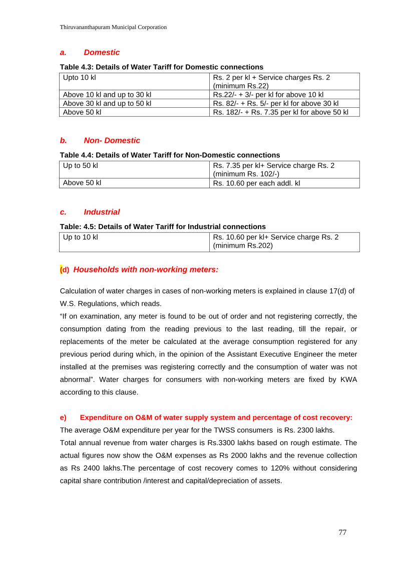
Thiruvananthapuram Municipal Corporation
77
a. Domestic
Table 4.3: Details of Water Tariff for Domestic connections Upto 10 kl Rs. 2 per kl + Service charges Rs. 2
(minimum Rs.22) Above 10 kl and up to 30 kl Rs.22/- + 3/- per kl for above 10 kl Above 30 kl and up to 50 kl Rs. 82/- + Rs. 5/- per kl for above 30 kl Above 50 kl Rs. 182/- + Rs. 7.35 per kl for above 50 kl
b. Non- Domestic
Table 4.4: Details of Water Tariff for Non-Domestic connections Up to 50 kl Rs. 7.35 per kl+ Service charge Rs. 2
(minimum Rs. 102/-) Above 50 kl Rs. 10.60 per each addl. kl
c. Industrial
Table: 4.5: Details of Water Tariff for Industrial connections Up to 10 kl Rs. 10.60 per kl+ Service charge Rs. 2
(minimum Rs.202)
(d) Households with non-working meters:
Calculation of water charges in cases of non-working meters is explained in clause 17(d) of
W.S. Regulations, which reads.
“If on examination, any meter is found to be out of order and not registering correctly, the
consumption dating from the reading previous to the last reading, till the repair, or
replacements of the meter be calculated at the average consumption registered for any
previous period during which, in the opinion of the Assistant Executive Engineer the meter
installed at the premises was registering correctly and the consumption of water was not
abnormal”. Water charges for consumers with non-working meters are fixed by KWA
according to this clause.
e) Expenditure on O&M of water supply system and percentage of cost recovery: The average O&M expenditure per year for the TWSS consumers is Rs. 2300 lakhs.
Total annual revenue from water charges is Rs.3300 lakhs based on rough estimate. The
actual figures now show the O&M expenses as Rs 2000 lakhs and the revenue collection
as Rs 2400 lakhs.The percentage of cost recovery comes to 120% without considering
capital share contribution /interest and capital/depreciation of assets.

Thiruvananthapuram Municipal Corporation
78
f) Co-ordination and convergence : O & M of the scheme, extensions of service facilities etc. are undertaken by KWA in
consultation with the TMC. A Management Committee for the scheme, with TMC
representatives and KWA representative shall be constituted to manage the scheme within
the framework of applicable rules and regulations.
g) Methods of co-ordination and convergence in in respect of the panchayats within Thiruvananthapuram Urban Agglomeration:
Local Self Government plays a major role in rendering service to the consumers. W.S.
connections will be provided only on the recommendation by the LSG. Further the
management of the system may be carried out by the Management Committee.
4.3 Integration With Ongoing JBIC Project A new project for the augmentation of the scheme has been taken up by the KWA at a
cost of Rs 275.7 crores (revised cost Rs. 311.91 crores) with loan assistance from JBIC.
The execution of works is expected to start within 3 months. This project envisages
additional production of 74 mld of water at Aruvikkara and transmission to the Service
Reservoirs in the city.
The components include, 74 mld treatment plant and pumping installations, new
pumping main from Aruvikkara to reservoirs which can transmit up to 144 mld, partial
extension of the distribution network, construction of service reservoirs, MIS with
network connectivity, cadastral survey of the existing network, leak detection studies,
etc.
Project in brief:
In the Project, provision has been made to install additional raw water pump sets,
pumping main to the water treatment plant, construction of a 74 mld treatment plant,
additional storage sump near the treatment plant, connecting it to the existing storage
sump and installation of additional clear water pumps. Besides, providing a new
transmission main aligning through a route different from the existing congested route at
Kummi area (where already three transmission mains of 33”, 48” dia cast iron and 48”
dia psc pipes are provided) to the reservoir sites, construction of new reservoirs,
supplying and laying of distribution lines to improve the existing areas as well as
covering new areas within the project area, rehabilitation of the existing old water
treatment plant components at Vellayambalam and Aruvikkara (constructed during 1933
and 1972) so as to improve to achieve the desired performance has been envisaged in
the project. Another unique feature of the project is the provision of telemetry stations,
SCADA system along with the transmission main work. (The telemetry station will pick

Thiruvananthapuram Municipal Corporation
79
up data signals from the SCADA system and will send to regional control centre for
monitoring the operation of various units).
For the convenient and effective implementation of the project, the above items of work
have been grouped into 5 packages viz. Intake Works and Treatment Plant,
Transmission Main, Distribution System, Service Reservoirs and Rehabilitation Works.
It is proposed to pool the projects under JBIC also under the JNNURM (as it is an
externally assisted project) so as to achieve the desired objective of 100% coverage with
24/7 water supply.
4.4 Growth Trends, Future Demand & Scope for Augmentation of Source The projected water demand for 2036, at the rate of 200 lpcd for urban domestic use
along with a provision of non-domestic and industrial requirements has been considered
for the development plan. This is taken as 135 lpcd for the adjoining Panchayats in the
urban agglomeration.
The population projection has been worked out in detail as part of the ongoing JBIC
project and also incorporating modifications based on the city development in the area.
Drastic developments in IT Sector in and around Techno Park, Kinfra Park, expansion of
Railways, Tourism potentials, ensuing Vizhinjam port and other development corridors
are also envisaged. The ultimate water demand by 2036 is 410 mld. This reflects a wide
supply-demand gap of 185 mld by 2036. The ongoing JBIC project when commissioned
by 2009, can supplement 74 mld still leaving a gap of 111 mld. This gap is proposed to
be compensated by a three-way approach.
(i) Augment the system by 76 mld to bring more water to the city.
(ii) Bring down the Unaccounted for Water (UFW) losses to the range of 15% by adequate rehabilitation measures. At present the UFW, which is the sum total of leakage losses, theft, losses in scouring of lines, unmetered connections etc, is estimated to be as high as 35.5 %.
(iii) Cut off some boundary areas from the city WSS by providing small WSS exclusively for these areas.
Out of the supply-demand gap of 185 mld, 74 mld will be taken care of by 2009 on
comissioning of the JBIC project; 76 mld will be taken care of by (i) above and the
balance 35 mld by (ii) and (iii) . The ultimate aim on completion of the JNNURM Project
is 100% coverage of the service area with 24/7 water supply till 2036.
Thiruvananthapuram Municipal Corporation
80
4.5 Key Issues, Challenges and Goals.
Key Issues & Challenges
a. There is a gap of 185 mld of water between production and demand. The city water supply scheme is one of the oldest schemes in India. Rehabilitation of transmission lines and strengthening of under sized mains were not taken up till now due to insufficient budget allocation. Hence shortage of water is commonly felt in the coastal belt, elevated areas and some of the outer peripherral areas.
b. Panchayat areas merged to Corporation boundary in 2001 are not well connected with proper distribution network. Hence such areas face shortage of water.
c. Distribution network along the coastal belt is insufficient due to growth in population.
d. The adjoining panchayats of Kazhakuttom, Sreekaryam, Kudappanakkunnu and Vattiyoorkavu are subjected to drastic urbanization. The ensuing development of Technocity at Kazhakkuttom and the shifting of the Collectorate to Kudappanakkunnu would attract substantial increase in population growth in these two zones, which need to be addressed. A part of the city water supply is diverted to that area by extending the existing network without strengthening transmission mains. A well-designed distribution network is also to be established urgently to cope with the increasing demand in these zones.
e. The development of the International Container Transshipment Terminal (ICTT) at Vizhinjam would also bring in substantial growth in population by way of the port activities as well as the related developments therein. The attraction of the tourists to Kovalam and the requirement of the population expected around Vizhinjam also have to be taken into consideration in the total Water Supply System for the City.
f. The total physical loss calculated is 35.5%. 75% of the physical loss of water is due to the leakages in old house service connections. A major cause of leak in the service connections is the deterioration of old service pipes. Leaks of pipe joints of transmission and distribution net work also account for the leakage loss.
g. Lack of efficient cost recovery approaches
h. Lack of effective communication and modern complaint redressal system
i. Being a very old water supply system, net work mapping of distribution system is not updated.
GOAL
To provide continuous and safe water supply in equitable, efficient, sufficient and
sustainable manner to the utmost satisfaction of the customers by introducing the latest
technologies and management techniques.
Thiruvananthapuram Municipal Corporation
81
4.6 Priority Project Components Considering the current challenges and identified key priorities, strategy for water supply
sector has been evolved in such a way as to make Thiruvannathapuram an enviably
self-sufficient city, where the most precious amenity of good and safe drinking water is
available round the clock at adequate pressures. A brief outline of the proposals is given
below which depicts the frame work of activities.
A. Planning reforms and institutional strengthening
This portion comprises of the following activities intended for overall development of
water supply sector.
(i) Preparation of a Water Supply Master Plan taking into account the future population densities in the various zones and the future land use zoning within the city and peripheral areas.
(ii) Energy Audit studies intended for optimization of equipments and reduction in power charges.
(iii) Water Quality monitoring using the latest equipments for intense monitoring and corrective measures so as to ensure quality water even at the farthest points from the plants.
(iv) Communication strategy development and implementation for providing online complaint redressal and also to avoid delay in timely maintenance using high-tide systems.
(v) Human Resources Development aimed at capacity building at different levels.
The HRD package includes construction of a full fledged training centre also for the Trivandrum Water Supply Scheme, which can be made beneficial to the whole of the KWA and other water supply & sewerage institutions in future.
(vi) Establishment of regulatory authority for timely review and modifications in tariff structure in order to bring about total self reliance to the TWSS.
(vii) GIS Mapping of Water Supply utility since it is felt that this essential practice of documentation is now totally non-existent in the sector. This can be the first step towards automation.
(viii) Community initiative support aiming at providing financial supports for the establishment of small independent Water Supply Schemes intended for use of speific areas like coastal belts.
(ix) Management Information System (MIS) which will ensure more transparency and timely responses in solving problems.
(x) E-governance aimed at networking different offices so that capturing data and processing data, which consumes many precious man hours now, can be made much easier.

Thiruvananthapuram Municipal Corporation
82
B. Service delivery
The activities under service delivery are intended for the replacement of house service
connections which are very old and are a cause of concern in terms of expenses on
frequent leakages as well as transmission losses.
C. Water resources management
The activities envisaged are reduction in UFW and ensuring revenue. UFW, which is presently estimated as high as 35.5 %, is aimedat to be brought down to 15% by establishing leak detection units, repairs and replacement of leaking pipe lines, total replacement of pipelines in problem areas in distribution system and total replacement of very old service connections.
D. System expansion
This is very much essential to make our vision a reality. The works envisaged are source
augmentation, refurbishment of Water Supply Projects, introduction of small W.S.S to
selected areas for reducing the load of TWSS, refurbishment of transmission mains
aiming at bringing down UFW and revamping water supply equipments and pipelines in
10 major Hospitals and the Medical College Hospital in Thiruvananthapuram. Details of
works envisaged under system expansion are as follows:
i) Intake works and a 76 Mld capacity water treatment plant at Aruvikkara; and
ii) Expansion of distribution network to enhance water supply level to the present service areas and also to cover unserved areas within the project area.
Distribution network is not well developed to the newly merged areas of the City
Corporation. A part only has been taken up under the JBIC project. Also the distribution
zones are proposed to be expanded to OGs of adjoining Panchayats like
Kazhakkoottam, Sreekariyam, Kudappanakunnu, Vattiyoorkavu, and the tourist centre
Kovalam.
iii) Refurbishment / Replacement of components
The capacity of the existing old Wellington Water Supply Scheme (1933) and the Phase
I (1962) and Phase II (1999) augmentation systems are far below their optimum
efficiency levels because of old-age and due to the continuous round the clock run.
Rehabilitation of different components of these systems will definitely bring about
reduction in losses and better efficiency. A part of the rehabilitation of components is
included in the JBIC project. The network is about 73 years old in many parts of the
service area and the residual pressures are reported to be very low or nil during certain
hours. This can mainly be attributed to the reduction in carrying capacity of the old pipes
due to scaling of inner walls. This is a critical issue, especially in the 400mm CI/Premo to

Thiruvananthapuram Municipal Corporation
83
80mm CI/AC size in the distribution network. Replacement of components is proposed in
the Thiruvananthapuram Municipal Corporation area and the outgrowths of adjoining
panchayats of Kazhakkoottam, Sreekariyam, Kudappanakunnu, Vattiyoorkavu, and
Vizhinjam.
The total rehabilitation package comprises of the following
1. Refurbishments of the existing 86 mld treatment plant;
2. Replacement / Rehabilitation of the 1200mm/900mmPSC pumping main to suit the augmentation;
3. Replacement of the 700mm/400mm old Premo (concrete) pipes (45 km);
4. Replacement of old 300mm/225mm (1933) CI pipes (50 km);
5. Replacement / strengthening of 200mm/100mm old (1933) CI pipes(500 km);
6. Replacement / strengthening of 100mm/80mm old CI /AC (600 km);
7. Replacement of nearly 65500 old consumer water connections;
8. Refurbishments of Kundamankadavu pump house with the Water Treatment Plant at PTP Nagar;
9. Construction of a conventional Water Treatment Plant at Thiruvallom;
10. Rehabilitation of water supply system of the Thiruvananthapuram Medical College Hospital; and
11. Rehabilitation of water supply systems in 10 major Government hospitals in the city.
iv) Water Supply Scheme to Kovalam Tourist Area -
Kovalam is a world famous tourist centre. Water supply is not adequate in the Kovalam
area. City Water Supply Scheme was extended to the area, which is far from satisfactory
due to rapid urbanization of the coastal region. Hotels at present mainly depend on
tanker lorries for drinking water.
A comprehensive Water Supply Scheme benefiting Kovalam, adjoining 6 wards of
Venganoor Panchayath, 6 wards of Vizhinjam Panchayath and 3 wards of Kottukal
Panchayath coming within the tourism zone has been proposed with Vellayani lake as
source. Lake Vellayani is a famous fresh water lake near the city.
A well cum pump house having 9 metre diameter is proposed in the lake. Raw water
Pumping main, 16 mld treatment plant, transmission main, service reservoirs and
distribution net work are included in the project.
v) Improvement of Water Supply Scheme to Pappanamcode & Nemom areas
Pappanamcode and Nemom areas are located on the south-east of the city. This area
includes Pappanamcode Estate, Nemom, Melankode, Ponnumangalam and part of

Thiruvananthapuram Municipal Corporation
84
Thiruvallam ward covering a population of 50,000. This area is presently being catered
by a small Water Supply Scheme with an infiltration gallery in Karamana river at
Thrikkannapuram. Absence of a Water Treatment Plant creates quality problems in the
water supplied. Also shortage of water results in supplies to certain areas on alternate
days. A new project is proposed to cover the above area using nearby source viz
Karamana River.
vi) Water Supply Improvements to Vandithadam
The present status of the Vandithadam Water Supply Scheme, which caters to the areas
nearby Kovalam, is far from satisfactory. There exists an old intake well in the Vellayani
Lake and the pressure filter installed is out of order and beyond repairs. Quality of water
supplied is also not good. The scheme can be rehabilitated to serve the coastal
population. It is proposed to construct a new intake well and a 5 mld full-fledged water
treatment plant in the public land nearby. The pump and pumping mains are also to be
replaced to meet the enhanced capacity.
vii) Water Supply Scheme to International Transshipment Terminal at Vizhinjam
Government of Kerala has embarked on an ambitious project for development of an
International Container Transshipment Terminal (ICTT) at Vizhinjam in
Thiruvananthapuram. An exclusive Water Supply Scheme to cater to the needs of
Vizhinjam area considering the vast demand projections due to this development are
proposed to be included under the JNNURM.
The proposal is to collect raw water from a well cum pump house of 6m diameter at
Vellayani lake, to treat the water in a 3 mld plant near it, collect water in a 1.33 lakh
sump and pump clear water to the proposed OHSR near the Coast Guard station, and to
distribute water by gravity mains.
The total cost of the project works out to Rs. 4.00 crores.
E. Citizen relation management
The activities envisaged are modernization and extension of the pilot complaint
redressal system of TWSS using better communication systems aimed at providing total
consumer satisfaction.

Thiruvananthapuram Municipal Corporation City Development Plan
85
Water Supply - Investment Plan (Rupees Crores)
Table 4.6: Broad costing and phasing for Watter Supply Component Activity 2006-07 2007-08 2008-09 2009-10 2010-11 2011-12 Total
1. Development of Master Plan 2.50 1.00 3.50 2. Energy audit study 1.00 0.50 0.50 2.00 3. Water Quality monitoring 1.50 1.00 1.00 1.00 1.00 5.50 4.Communication strategy 1.00 0.50 0.50 0.50 0.50 0.50 3.50 5. Human Resources Development 1.50 1.00 2.00 2.00 2.00 1.50 10.00 6. Establishment of Regulatory Authority 0.50 0.50 1.00 1.00 1.00 1.00 5.00 7. GIS Mapping of Water Supply and Sewerage utility
1.50 0.75 0.25 0.25 0.25 3.00
8. Community initiative support 0.50 0.25 0.25 1.00 9. Management Information System 1.00 1.50 2.00 2.50 2.00 1.00 10.00 10. E-Governance 0.40 0.40 0.40 0.40 0.40 0.50 2.50
Planning Reforms & Institutional Strengthening
Sub-Total 11.40 7.40 7.90 7.65 7.15 4.50 46.00 Service Delivery Replacement of house service connections 1.00 0.50 1.50 1.00 0.50 0.50 5.00
1. Unaccounted For Water a. Leakages in Trunk mains and Distribution
system 5.00 5.00 7.00 7.00 3.00 3.00 30.00
b. Replacement of old service connections 2.00 6.00 7.00 7.00 4.00 1.75 27.75 c. Establishing leak detection units and
Procurement of modern leak detection equipments
2.00 2.00 0.50 0.25 0.25 0.25 5.25
2. Metering a. Changing non working meters (85000
nos) 0.50 0.50 1.00 2.00 1.00 1.00 6.00
b. Providing Bulk meters in transmission and distribution lines
1.00 1.00 2.00 2.00 2.00 2.00 10.00
3. Mechanization and modernization 1.50 2.00 1.50 1.50 0.50 0.50 7.50
Water Resources Management
Sub Total 12.00 16.50 19.00 19.75 10.75 8.50 86.50 1 a. Source augmentation - Intake works and sub stations , Treatment Plants, Electrical installations
3.00 8.00 14.00 16.00 13.00 2.50 56.50
b. Protection of Peppara Dam 0.50 4.00 3.00 2.00 0.50 10.00
System expansion
2 Expansion of net work in merged areas and urban agglomeration.
5.00 15.00 15.00 18.00 18.00 4.00 75.00

Thiruvananthapuram Municipal Corporation City Development Plan
86
Component Activity 2006-07 2007-08 2008-09 2009-10 2010-11 2011-12 Total
3. Water Supply to Kovalam Tourist area 2.00 6.00 6.00 8.00 6.00 2.00 30.00 4. Water Supply to Nemom and Pappanamcodu zones
1.25 2.00 2.00 3.00 1.50 0.25 10.00
5. Construction of WTP at Vandithadom 1.00 1.00 2.00 2.00 6.00 6. WSS to International Transhipment Terminal at Vizhinjam.
0.50 1.50 1.50 0.50 0.00 0.00 4.00
7.Refurbishments of treatment plants of 86mld (Aruvikkara), 16mld (PTP) and pumphouses
0.75 1.00 3.00 2.00 0.75 0.00 7.50
8.Rehabilitation/ replacement of 1200mm to 900mm PVC pipes 11 km
3.00 6.00 12.00 10.00 3.00 1.00 35.00
9. Replacement of old Premo Pipes 700mm to 400mm - 45 km
8.00 12.00 24.00 28.00 20.00 1.00 93.00
10. Strengthening and replacement of undersized main 300mm to 225mm very old (1933) CI Pipes - 50km
5.00 12.00 25.00 22.00 7.00 4.00 75.00
11. Strengthening undersized pipe lines - distribution network.
10.00 15.00 30.00 40.00 45.00 34.00 174.00
12. Rehabilitation of WSS in Medical College Compound
2.00 3.00 3.00 1.00 1.00 10.00
13. Rehabilitation of Water Supply system to 10 Major Hospitals
0.25 0.50 0.50 0.50 0.25 2.00
Sub-Total 47.25 82.00 141.0 153.0 116.0 48.75 588.0 Establishing modern Complaint Redressel System
0.50 1.00 2.00 0.50 4.00
Communication Systems 1.00 1.00
Citizen Relation Management
Sub Total 0.00 0.50 1.00 3.00 0.50 0.00 5.00 Total 71.65 106.9 170.4 184.4 134.9 62.25 730.5
JBIC project (74 mld Treatment plant , pumping installations, new pumping main from Aruvikkara to reservoirs which can transit upto 144 mld etc)
311.91
Grand Total 1042.41
Rough cost estimate for all the sub projects envisaged were prepared. Realistic costing will be done at the stage of preparation of DPR. It is presumed that there may be marginal differences between DPR and rough cost estimates. (expected variation considering the past experiences is of the order of 10 to 15 percent
Thiruvananthapuram Municipal Corporation City Development Plan
87
5.0 SEWERAGE
5.1 Existing Sewerage Scheme In 1931, action was taken to start an “Investigation for a comprehensive Sewerage Scheme”
on modern lines based on the principle of separate system, which would cater to the
demand of Thiruvananthapuram City.The proposal was formulated, and the number of
blocks required for effectively draining the whole of Thiruvananthapuram city, with pumping
stations were fixed, and the method and site for disposal works was also decided upon.
Thiruvananthapuram Sewerage Scheme [TSS] covers the old city having an area of 74.93
sq km with 50 wards. The scheme area is divided into seven blocks viz. A, B, C, D, E, F and
G for the convenience of execution of sewerage system. Among the above blocks sewerage
facility is available fully or partially in the blocks A to E.
Thiruvananthapuram Municipal Corporation presently comprises an area of 141.74 sq km of
which about 30% is covered by piped sewerage system, which serves the core city area.
Sewage disposal methods from the households in un-sewered areas of the Corporation
include septic tanks, borehole latrines and community toilets. There are also many houses
without any sanitation facilities.
Block A. Sewerage system was first introduced in this Block. The total area of the
Block is 13.84 sq km and comprises the most important parts of the city such as Kowdiar,
Vellayambalam, Thycaud, Thampanoor, Pazhavangady, Chalai, Manacaud, Puthenchanthai,
Jagathy and Palayam. This block was commissioned way back in 1945. There are 3 lifting
stations under this block at Thaliyal, Mudavanmughal and Arannoor. The main pumping
station in this block is at Kuriyathy from where sewage is pumped to the sewage farm at
Valiyathura. Block ‘A’ has been augmented recently by providing a new 1200mm Gravity
Main, pump house and pumping main.
Block B. The total area of the Block is 5.51 sq km. It includes area of the city covering
Sreekanteswaram, Pettah (east of railway line), Rishimangalam, Vanchiyoor, Kaithamukku,
Pattom Valley, Nanthancode and Barton Hill. Block ‘B’ was commissioned in 1965. There is
a main pumping station in this block at Pattoor from where sewage is pumped to Valiyathura
Sewage Farm.
Block C. The total area of the Block is 4.12sq.km and the block was partially
commissioned in 1970. It covers the low lying areas of the city which includes Chackai,
Pettah (west of railway line), Palkulangara, south west part of Fort area, Puthen Street,
Sreevaraham and Manacaud portion. There is a main pumping station at Enchackal
from where sewage is pumped to the sewage farm at Valiyathura. A lifting station is

Thiruvananthapuram Municipal Corporation City Development Plan
88
proposed at Kalpaka Nagar (Chackai) for connecting areas located on the north-west of this
block such as Kalpakanagar, part of Chackai, Kanjiravilakom, remaining part of Pettah,
Palkulangara, Anayara and then to pump sewage to the pump house at Enchackal, from
where pumping is to be done to Valiyathura. The balance pipe laying works, a screen
chamber in the pump house at Kalpakanagar, and erection of pump and motors are to be
executed for commissioning of sewer network in the area.
Block D. The area in Block ‘D’ is divided into two zones namely Zone- I & Zone- II
which are located on either side of the National Highway. Zone-I on the east side of NH is
further divided into two sub zones viz. (a) Kowdiar and (b) Ambalamukku-Muttada. Main
sewers in Zone-I are Kowdiar Main, Ambalamukku Main, Muttada Main and
Kesavadasapuram Main. Zone-II on the west side of NH is further subdivided into three
zones viz. (a) Kumarapuram-Kannammoola, (b) Kesavadasapuram-Ulloor and (c) Medical
College sub zones.
This block has four pumping stations. The Medical College lifting station catering to the
needs of the Medical College Complex, Plamoodu lifting station and the Murinjapalam lifting
station discharges sewage to Kannammoola pump house. The sewage is pumped to the
Sewage Farm at Valiyathura from the pumphouse at Kannammoola. Block ‘D’ was partially
commissioned in 2004. Works to provide coverage to the unsewered area in Block D is in
progress. Land acquisition works are also being completed.
Block E. This block includes four zones as detailed below.
(i) Zone-I: Comprising areas of Sasthamangalam, Kowdiar, Peroorkada and Mannammoola was commissioned during 2004;
(ii) Zone-II: Comprising areas of Maruthankuzhy, Vettamukku, Pangode, Edapazhanji, Chadiyara and part of Poojappura. Commissioning of Zone-II can be done after the land acquisition process is completed;
(iii) Zone-III: This zone consists of Vattiyoorkavu, PTP Nagar, and Kanjirampara area. Land acquisition process has to be completed for the completion of the sewer pipe line laying works; and
(iv) Zone-IV: This consists of Valiyavila area. The work of this zone has not been started. Land acquisition work for the pump house site at Valiyavila is to be completed.
5.2 Salient features of the existing Sewerage Scheme
(i). Number of sewerage connections in the city and reasons for low access. At present only 30% of the area covered under water supply is covered by the functioning sewerage system. This area is the most thickly populated one in the city. The present number

Thiruvananthapuram Municipal Corporation City Development Plan
89
of sewerage connections in the sewered area is 80,000.The approximate number of households in the TMC area is 1,72,752 out of which 30% was already been covered. The lesser coverage is owing to inadequacy of treatment facilities in the sewerage system. (ii). Cost of accessing sewerage connection by households and sewerage tariff No monthly or annual sewerage service charges are collected .The one time service connection fee charges for availing sewerage connection is as given below; Category Rate Minimum (Rs) Domestic 10% of estimated cost for connection 500. Non domestic do 1000 Casual do 1000 Industrial do 2500 (iii). Operation and Maintenance expenditure of sewerage system and percentage cost O&M expenditure at present is 530 lakh per annum for the area under coverage .No specific O&M cost is realised at present. Approximate amount collected as new service connection fee comes to Rs.75 lakh per annum which works out to 14.15% of annual O&M cost. (iv). Community’s willingness to pay An analysis of the survey ( conducted as part of KSUDP in September 2004 ) results provides an indication of community’s willingness to pay for improved services depending on existing access or reliability. For survey purpose the households were grouped into 6 household categories:
High Income Group (HIG), Middle Income Group (MIG), Low Income Group (LIG ) , Upper crest
of the Poor (UP ), Just above Vulnerable (JV ) and most Vulnerable (MV). The composition of
the population by income group is as follows: HIG (6 %), MIG (34 %), LIG (39%), UP (7%), JV
(7%) and MV (7%) ( the population distribution by income group is adopted from Economic
Review 2002 ).
The result of the survey did not specify an amount that each group is willing to pay for improved
water supply and sanitation services. The survey however indicated a low willingness to pay
among the poor and a bit higher willingness to pay from the non-poor for obvious financial
reasons. The low willingness to pay for improved services among the poor is largely due to (i)
relative satisfaction with the present water supply and sanitation services. (ii) use of water from
street tap, which is the major source of water among the poor, is currently free of charge; and
(iii) respondents view that Government has the responsibility to provide the services to its
residents; (iv) the subsidy involved in the present arrangement.

Thiruvananthapuram Municipal Corporation City Development Plan
90
5.3 Major Developments and Initiatives (i) The laying of sewer pipe line in uncovered areas of Block ‘D’ and ‘E’, as envisaged in
the Master Plan of Sewerage Scheme for Thiruvananthapuram Corporation area, is in progress.
(ii) A proposal intended to benefit residents of the City Corporation wards of Attukal, Kalady and Kalippankulam is intended to be taken up at a cost of Rs.14.55 crores for which Administrative Sanction has been received.
5.4 Key Issues, Challenges and Goals
Key Issues and Challenges
The existing Sewerage network is very old and requires urgent rehabilitation, since frequent overflows are common.
Sewage overflow from the unsewered areas of the city and adjoining area into the water bodies creates nuisance and unhygienic conditions.
The existing sewage farm at Valiyathura is overloaded, resulting in overflow to the Parvathy Puthanar Canal and results in causing pollution of the water body. This necessitates the need for a modern Sewage Treatment Plant at Valiyathura.
Vision.
A healthy and satisfied community forms the foundation for a progressive nation. Our Vision
is to provide a well planned, eco-friendly and hygienic sewerage facility, which would
facilitate achievement of the above goal.
5.5 Priority Project Components
A. Rehabilitation of the existing network and pump houses in Blocks A, B & C
The Design period of the sewer network in Blocks A, B and C is over and as the network is
overloaded rehabilitation is necessitated. The growth in population and increase in
commercial activities resulted in increase in the load of sewage in the sewer lines, resulting
in overflow through the manholes in the network. In order to meet the demand as per the
present day population and to arrest the overflow, it is highly essential to rehabilitate the
existing system.
Continuous pumping without interruption is to be maintained in order to ensure that
overflows are kept to the minimum. In order to ensure continuous pumping, uninterrupted
power supply is to be ensured, for which dedicated power lines and generators are to be
installed.

Thiruvananthapuram Municipal Corporation City Development Plan
91
B. Rehabilitation of sewerage facility in Government Hospitals
i) Medical College Campus, Thiruvananthapuram
The sewerage network catering to the requirement of Medical College Campus is in a
dilapidated condition resulting in unhygienic conditions. In order to avoid inconvenience to
the public and to retain a healthy environment, the sewerage network including inside
installations need to be rehabilitated. A 10 mld Sewage Treatment Plant is also proposed to
be constructed exclusively for the Medical College campus, where seven health related
institutions are located.
ii). Other Government Hospitals
Rehabilitation and Improvements to the Sewerage network in General Hospital, Women &
Children Thycaud Hospital, Peroorkada Hospital, Santhivila Hospital, Ayurveda College,
Homeo College, TB Sanatorium, and Opthalmic Hospital are also proposed.
C. Providing sewerage system in unsewered areas of Blocks
A ,B & C
Areas of Thirumala, Thrikkannapuram and Mudavanmughal are proposed to be provided
with Sewerage facilities.
Block ‘C’, which covers Pettah, Palkulangara and Enchackal, has been partially
commissioned. A lifting station is proposed at Kalpaka nagar for connecting areas located
on the north-west of this block, such as Kalpakanagar, part of Chackai, Kanjiravilakom,
remaining part of Pettah, Palkulangara, Anayara and then to pump the sewage to the pump
house at Enchackal, from where it is to be pumped to Valiyathura. The balance pipe laying
works, a screen chamber in the pump house at Kalpakanagar, and erection of pump and
motors are to be executed for commissioning of sewer network in the area.
D. Providing sewerage system in unsewered areas of Blocks D & E
Block ‘D’ covering areas of Ambalamukku, Pattom, Muttada, Kesavadasapuram,
Kannammoola; and Block ‘E’ which covers areas of Peroorkada, and Sasthamangalam, has
been partially commissioned. The work to provide coverage to the unsewered areas of
Blocks D and E is in progress. Land acquisition works are to be completed.
E. Extension of sewerage system to Blocks F & G - Coastal Area
Blocks F&G consist of the coastal area and the area is presently not covered by sewerage
network. Sewer network coverage is to be provided to the coastal belt which is thickly
populated.

Thiruvananthapuram Municipal Corporation City Development Plan
92
F. Sewerage system to the extended Corporation Area
Thiruvananthapuram City is now spread to cover 141.74sq.km with 86 wards and the entire
area is proposed to be covered with sewerage network. The extended area includes –
erstwhile Ulloor panchayat with an area of 16.67 sq.km; Attipra panchayat with an area of
16.03 sq.km; and Kadakampally panchayat with an area of 8.14 sq.km. The former Nemom
panchayat with an area of 12.18 sq.km and the former Thiruvallam Panchayat with an area
of 13.60 sq.km have also been merged to the Corporation.
The anticipated sewage load from the extended area as estimated for 2031 is 100 mld and
the sewage load from the old city area is 150 mld.
Thiruvananthapuram Sewerage Scheme [TSS] presently covers the old city corporation area
having an extent of 74.93 sq.km with 50 wards. The areas newly added to the Corporation
limit are to be covered with sewerage facility.
G. Sewerage system to adjoining Panchayats in the Urban Agglomeration
i) The adjoining panchayat areas of Kazhakkuttam with an area of 19.47 sq.km;
Sreekaryam with an area of 23.73 sq.km; Kudappanakkunnu with an area of 7.69sq.km;
and Vattiyoorkavu with an area of 11.11 sq.km are considered for provision of sewerage
facilities. The anticipated sewage load from the area is 45 mld.
ii.) The proposed International Container Transhipment Terminal, at Vizhinjam is expected
to contribute to increased activity in the area. Kovalam which is an important tourist
centre is also proposed to be provided with sewerage network. Vizhinjam panchayat with
an area of 12.62 sq.km, which also includes the above centres, is proposed to be
covered with sewerage network. A 30 mld Sewage Treatment Plant is proposed to be
constructed to cater to the demand of the area.
H. Procurement of equipment for maintenance of sewerage system.
Parallel to strengthening of the Sewerage System, the maintenance facilities will also have
to be strengthened to ensure proper functioning of the system. Machinery and equipment
required to facilitate carrying out of cleaning and repair works are proposed to be procured.
I. Construction of sewage treatment plant.
Presently the sewage generated in the city is conveyed through a number of gravity mains
and pumping mains to the stilling chamber at Muttathara. From the stilling chamber, the
sewage flows by gravity to the sewage farm on the other bank of Parvathy Puthanar Canal
and is let off into open drains for use in fodder cultivation. During the late sixties and early
seventies the system was functioning well. But with the increase in population, the quantity

Thiruvananthapuram Municipal Corporation City Development Plan
93
of sewage increased and the capacity of soil to absorb the sewage decreased, resulting in
increase of outfall to the Parvathy Puthanar Canal polluting the water course.
In future as the city grows, the condition will be worsened, resulting in large-scale
contamination of surface and ground water. It is proposed to set up a modern Sewage
Treatment Plant, to treat the Sewage being pumped to Muttathara. The total sewage load of
the extended Corporation area is 250 mld.
Full fledged Sewage Treatment Plants are also to be constructed to cater to the requirement
of areas of Kazhakkuttom, Sreekaryam, Kudappanakkunnu, Vattiyoorkavu and Vizhinjam
and the anticipated sewage load is 75 mld.
A Sewage Treatment Plant of 10 mld is proposed to be constructed to serve the Medical
College campus.
J. Preparation of master plan
a. In order to enable execution of the various works proposed in an effective manner, a detailed survey and study is to be conducted. The study should include determination of alignment of sewer lines including levels, location of lifting stations and Sewage Treatment Plants. The zoning and preparation of Master Plan shall be made, taking advantage of the contours. It is proposed to prepare the master plan benefiting entire TRIDA area extending to Balaramapuram on the East and Vattappara on the north. The interior thickly populated area will be covered in the present project and scope can be widened for future population since the present project proposed in master plan are independent.
b. The population benefited in 2036 is 10.70 lakh and the present population
benefited is estimated to be 2.59 lakh. Hence at the end of the project period, 8.11 lakh people will be covered additionally.
c. The cost estimate does not include the cost of land required for the execution of
works, as the same has to be made available by the local body concerned.
d. An appropriate Project Implementation Plan (PIP) and Environment Management Plan (EMP) shall be developed so as to bring down the inconvenience, that may be caused to the public during implementation , to the minimum extent possible
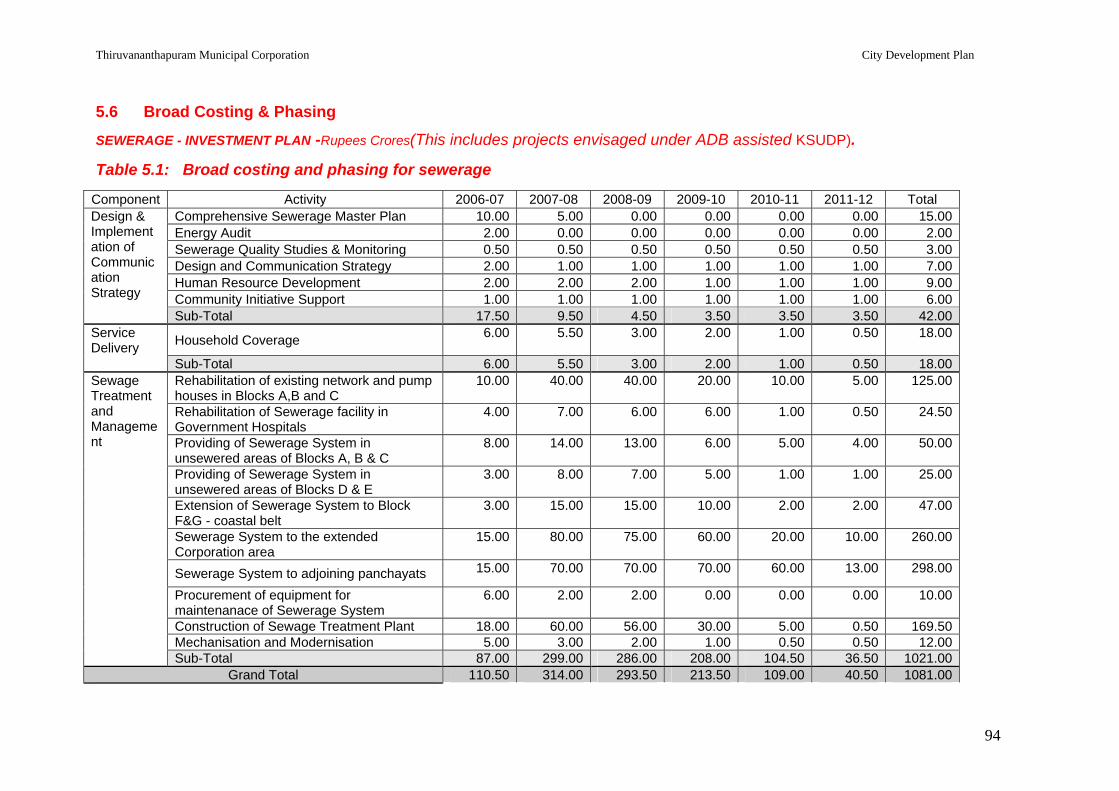
Thiruvananthapuram Municipal Corporation City Development Plan
94
5.6 Broad Costing & Phasing
SEWERAGE - INVESTMENT PLAN -Rupees Crores(This includes projects envisaged under ADB assisted KSUDP).
Table 5.1: Broad costing and phasing for sewerage
Component Activity 2006-07 2007-08 2008-09 2009-10 2010-11 2011-12 Total Comprehensive Sewerage Master Plan 10.00 5.00 0.00 0.00 0.00 0.00 15.00Energy Audit 2.00 0.00 0.00 0.00 0.00 0.00 2.00Sewerage Quality Studies & Monitoring 0.50 0.50 0.50 0.50 0.50 0.50 3.00Design and Communication Strategy 2.00 1.00 1.00 1.00 1.00 1.00 7.00Human Resource Development 2.00 2.00 2.00 1.00 1.00 1.00 9.00Community Initiative Support 1.00 1.00 1.00 1.00 1.00 1.00 6.00
Design & Implementation of Communication Strategy
Sub-Total 17.50 9.50 4.50 3.50 3.50 3.50 42.00Service Delivery Household Coverage 6.00 5.50 3.00 2.00 1.00 0.50 18.00
Sub-Total 6.00 5.50 3.00 2.00 1.00 0.50 18.00Rehabilitation of existing network and pump houses in Blocks A,B and C
10.00 40.00 40.00 20.00 10.00 5.00 125.00
Rehabilitation of Sewerage facility in Government Hospitals
4.00 7.00 6.00 6.00 1.00 0.50 24.50
Providing of Sewerage System in unsewered areas of Blocks A, B & C
8.00 14.00 13.00 6.00 5.00 4.00 50.00
Providing of Sewerage System in unsewered areas of Blocks D & E
3.00 8.00 7.00 5.00 1.00 1.00 25.00
Extension of Sewerage System to Block F&G - coastal belt
3.00 15.00 15.00 10.00 2.00 2.00 47.00
Sewerage System to the extended Corporation area
15.00 80.00 75.00 60.00 20.00 10.00 260.00
Sewerage System to adjoining panchayats 15.00 70.00 70.00 70.00 60.00 13.00 298.00
Procurement of equipment for maintenanace of Sewerage System
6.00 2.00 2.00 0.00 0.00 0.00 10.00
Construction of Sewage Treatment Plant 18.00 60.00 56.00 30.00 5.00 0.50 169.50
Sewage Treatment and Management
Mechanisation and Modernisation 5.00 3.00 2.00 1.00 0.50 0.50 12.00 Sub-Total 87.00 299.00 286.00 208.00 104.50 36.50 1021.00
Grand Total 110.50 314.00 293.50 213.50 109.00 40.50 1081.00

Thiruvananthapuram Municipal Corporation City Development Plan
95
6.0 STORM WATER DRAINAGE
6.1 Existing Drainage Network Recurrent floods as a result of insufficient drainage are the perpetual problems faced by
Thiruvananthapuram city since several years. Transitory measures to tide over the situations
are tried from time to time to ease the graveness of the situation. Even now, it can be seen
that an abrupt rain of high intensity disrupts the city life considerably. Deterioration of water
quality as well as the problems associated with stagnation and pollution are being faced by
the city. Water bodies and low-lying marshy areas are being reclaimed due to demand for
land for development. Most of the flood moderation zones inside the city had already been
converted into concrete dwellings and apartments resulting in excessive run off. Improper
maintenance of the already existing drains coupled with excessive run off is the root cause
of flooding inside the city. In-depth study of the present status of the drains, their carrying
capacity, anticipated flood discharge and the probable routing / rerouting may be devised
and implemented for restoring / enhancing the status of drainage network inside the city to
solve the issue to a significant extent.
The drainage network of the city consists of two major rivers, few canals, their feeders and
lakes.
A. Karamana River
Karmana river starts from Chemmutty at Agastyarkudam at an altitude of 1717m and flows
through, Aryanad, Aruvikkara, Vattiyoorkavu and enters the city area. The Thodayar,
Veyyappadiyar, Kaviyar, Attayar are the main forest rivers merging into this river. Lots of
other small water bodies are also joining this river at various places. The Killiyar merges with
Karamana river at Pallathukadavu. The Vellayani thodu which orginates from the
Vellayanikayal (the fresh water lake of the city) also joins the Karamana river at
Moolakkadavu near Thiruvallom. The Karamana river and Killiyar flow together from
Pallathukadavu up to the downstream of Thiruvallom bridge where the river again splits as
two tributaries one of which falls into the Arabian Sea and other joins the Parvathy Puthanar
forming an island in between known as Edayar island. Karamana River is 68 km, of which
about 17 km flows through city area.
Karamana river is the only major river flowing through the city and there is no doubt that it is
the live wire of the city. A dam is built across this river at Aruvikkara and from this reservoir
all the domestic as well as industrial and agricultural water requirement of the city is being
met. Over exploitation of the river on account of the alarming rate of increase in population is
the main reason for the present status of most of the rivers. Karamana river is no exemption
to this general status. Dumping of domestic and non domestic wastes and discharge of

Thiruvananthapuram Municipal Corporation City Development Plan
96
sewage directly into the river add to the situation. Waste from slaughter houses, markets and
hotels and domestic wastes are dumped into this river daily. Unscientific and indiscriminate
methods of sand mining result in bed and bank erosion and leads to water shortage and salt-
water intrusion. In some places the domestic sewage is openly let out into this river through
underground pipes. This results in pollution of the river and increase in E-coli count. As the
river had already lost its regime and reduced the cross sectional area considerably flooding
of Karamana river is also experienced.
B. Killi river
The Killi river originates from Nedumangad area. The river is having a width of 20 to 25m
with bed slope of 1:750 to 1:1000 up to the city limit and thereafter maintaining a bed slope
of 1:2000 to 1:3000. The Killi river merges in to the Karamana river at Pallathukadavu. The
river passes through the city for a length of 12.50 km and then flows into the sea through
Edayar island in Thiruvallom panchayat.
The river reaches in Maruthankuzhy, Pangode, Vivekanandanagar, Jagathy, Iranimuttom,
Pallathukadavu are the important reaches inside the city. The river needs protection as the
river passes through highly residential area. Major portion of the river reaches inside the city
have already been taken up for stabilization. The left over areas need to be attended. For
the entire stretch of 12.50 km, passing through the city on either bank, the density of
population is very high. Hence, disposal of waste into the river is a major issue as in the
case of Karamana river. The waste so deposited settles on the down stream and reduces
the depth of the river. Due to the sharp meandering of the river, the bank erosion is
experienced. This eroded material also gets deposited in the river bed and results in the
formation of small islands thereby reducing the capacity of the river resulting in flash floods
during down pour.
All wastes and debris generated in the city area like dismantled waste during demolishing of
structures, during construction, wastes from hotels and hospitals are conveniently dumped in
to the river. The disposal of drainage and organic and inorganic waste from the household
into the river by the local inhabitants, markets and poultry waste also contribute to the
degradation of the river system. Sand mining from the river is also noticed in several parts of
the river. The health hazard and unhygienic situation in Killi river is very serious and
repeated clamour for the upkeep still remain unheard.
C. Drains and leading drains in the city area
Flooding is usually noticed in Thampanoor and East Fort areas. The canal starting from
observatory hills carries the surface water of the upstream reaches and passes through
Thampanoor, crosses the railway line and reaches East Fort area. This stretch of canal

Thiruvananthapuram Municipal Corporation City Development Plan
97
seems to be tricky. Detailed analysis of the drainage pattern of the catchments of this drain
reveals the following:
The carrying capacity of the canal reach at Thampanoor is sufficient to discharge the run off
of its catchments along with the run off of the area adjacent to the railway station and bus
stand. The water collected during a down pour in the area adjacent to the railway station and
bus stand is not being discharged to this drain quickly as the carrying capacity of the leading
drains including the one around Ponnara Sreedharan Park is not sufficient. So the water
collected in the area gets stagnated for a period of time and that causes flooding in
Thampanoor area. So also the cross sectional area of the drain passing through the railway
yard is being reduced year after year due to the accumulation of debris and silt inside the
canal.
The leading drains to Pazhavangadi thodu from the area adjacent to the railway station and
bus stand should be redesigned and reconstructed to carry the water and drain off the area
to the thodu without any stagnation. It is to be ensured that the railway culverts as well as
the canal portion below the railway tracks are frequently cleared off the silt and debris.
The capacity of the drain downstream of Ganapathy temple up to Thakaraparambu is
sufficient to carry the flood discharge of the upstream catchments only. The storm water
collected in Putharikandam maidan and adjacent areas were directed to the drain leading to
Thekkenakara thodu through the drain under the present Lucia Hotel and the nearby
buildings. All the leading drains in the area are either chocked or defunct resulting in the
flash flow of storm water to Pazhavangadi thodu, which does not have the carrying capacity
for this additional flow too. Moreover the water collected in the built up areas like
Padmanagar colony also find its way to the Pazhavangadi thodu
The network of drains in the East Fort, City Bus stand area is to be restored and revamped
so that a major share of the storm water is directed to Thekkenakara thodu. A new scheme
is to be worked out to link Pazhavangadi thodu and Thekkenankara thodu at East Fort, so
that a portion of storm water will be carried by Thekkenakara thodu as was done in earlier
days. Cross section of the canal reach downstream of Ganapathi temple in Pazhavangadi is
to be increased to accommodate the balance flow also. The culverts and cross drainage
works are also to be remodelled to carry the additional discharge.
Chain link fencing on both sides of the city canals to prevent dumping of debris and wastes
in the canal are also to be provided in a continuous fashion.
Other important drains contributing storm water to the city canals are Amayizhanchan thodu,
Kannamoola thodu, Ulloor thodu, Pattom thodu, Kariyil thodu, Choozhampala thodu,
Thiruvananthapuram Municipal Corporation City Development Plan
98
Anathanathodu, Edanada thodu, Arayalloor Ela thodu, Thiruvallom Pallathukadavu thodu,
Azhankal thodu, Koori thodu.
Along with the increase in population, the need for housing complexes and colonies also
increased. Connected development activities intruded with the drainage system and fresh
drains have become the imperative need of the day to cleanse the locality.
Out of the 86 wards in the city, additional drains at an average of 1 km per ward (Details to
be worked out from field study) may suffice for the proper draining of the area.
1. Pazhavangadi thodu
Pazhavangadi thodu starts from observatory hills and merges into Amayizhanjan thodu near
Kannamoola and is having a length of about 5.6 km. It is the main discharge channel of
Thiruvananthapuram City and it traverses through the key areas like Thampannoor,
Pazhavangadi, Thakaraparambu, Vanchiyoor, Pattoor etc. The width of the thodu varies
from 3 to 6 m. Many road drains discharge into this thodu. The road culverts, which were
noticed to be the main hindrance for the free flow of discharge through the thodu have been
re-constructed to ensure free flow. The re-construction of the culvert and desilting of the
thodu has decreased the hazards of flooding to a certain limit. But periodic desilting is
essential in this portion since it passes through the heart of the Trivandrum City covering
Bakery jn, Bus stand, Railway station, Vanchiyoor, Patoor etc.
2. Uloor thodu
Uloor thodu had its orgin from Pothencodu area and passes through the northern part of the
city namely Mannanthala, Ulloor, Chalakuzhy, Murinjapalam and reaches Kannamoola
where it joins the Amayizhanjan thodu. The city area from Edavakode to Kannanmoola is
having a length of 8km and an average width of 10 to 15 m. This portion is highly polluted
and the flow is stagnant in several reaches. During rainy season due to the solid wastes and
heavy mass of silt deposit inside the thodu flooding occurs in the low lying areas. The dhobis
in the city area are polluting this thodu by washing and in slum areas drainage disposal is
diverted into this canal making the contamination level high.
Several housing colonies, houses, commercial establishments, slums are located on the
banks of this thodu and also in certain places semi permanent huts are seen encroached
into the thodu. Whenever the flash flood occurs in the rainy season the thodu overflows at
certain specific locations and cause havoc to the residents. This thodu is having several
rivulets before it reaches Kannanmoola to join the Amayizhanjan thodu. These rivulets also
bring enough silt and other solid wastes. Due to the facts explained above an urgent
restoration is necessary in this reach.

Thiruvananthapuram Municipal Corporation City Development Plan
99
3. Pattom thodu
Pattom thodu is a natural drain having an average width of 12m and has a length of 6.5 km.
It starts from the upper reaches of Kudappanakunnu, on the eastern part of the city and
passes through the major parts of the Thiruvananthapuram City. It collects surface water as
well as storm water from the city area and finally connects to the Amayizhanjan thodu at
Kannammoola. This drain has a major role in controlling the flood in Thiruvananthapuram
City. This thodu is now fully silted and it causes flooding in the city during the monsoon.
Also there is a tendency of public encroachment on the silted area inside the canal which
in turn reduces the carrying capacity of the canal. Hence this drain is to be urgently desilted
and the sides protected.
4. Kannanmoola thodu (Amayizhanjan thodu)
Kannanmoola thodu other wise called Amayizhanjan thodu starts from the up stream side of
Kannanmoola bridge and ends in Akkulam lake .The Kannanmoola thodu is having a width
of 20m to 30m and a length of 6km. Pazhavangadi thodu, Ullor thodu and Pattom thodu join
this thodu near pump house on the upstream side of Kannanmoola bridge. As in the other
canals Kannanmoola thodu is also in a very poor condition in view of its carrying capacity,
bank erosion and low velocity. Unless the condition is improved flooding in these areas are
most likely and the hygienic condition will further worsen.
5. Thekkenekara canal
The Thekkenekara canal is one of the main flood water canals which starts from Karimadom
colony at East Fort and passes through the most populous areas like East Fort,
Padamanabhaswamy Temple,Sreevaraham, Muttathara, N H bye pass and ends in
Parvathy Puthanar near Puthenpalam. The entire stretch is now choked with silt and debris
.About half of the portion is covered with slab and desilting is very tedious in this stretch.
Thekkenekara canal is having a length of 2.5 km and and an average width of 2.5m to 5m
.Several small drains join this canal in various portions and in many places these are to be
reconstructed. The flood water passing through Pazhavangadi thodu can be diverted to this
canal at East Fort and flooding in the city area can be reduced to a certain extent if a
connecting canal is constructed.
6. Kariyil Thodu
Kariyil thodu is a natural drain having an average width of 4m and has a length of 6.00km. It
starts from the upper reaches of Iranimuttom and is passing through Muttathara and
Manacadu villages of Thiruvananthapuram City. It collects drain water as well as storm
water from the city area and finally ends at Parvathy Puthanar. The main branches of the
thodu are Nilama ela thodu and Punnassery ela thodu. These thodus are now fully water

Thiruvananthapuram Municipal Corporation City Development Plan
100
logged due to the silting in the Kariyil thodu. Hence the Kariyil thodu has a major role in
controlling the flood in Thiruvananthapuram City. Hence this drain is to be urgently desilted
and the sides should be protected.
7. Natural drains
Tettiyar and Pangapparathodu are natural drains which, if restored may help drain out water
from the marshy and waterlogged areas near Technopark and College of Engineering,
Thiruvananthapuram.
(i) Tettiyar thodu
The Thettiyar thodu is running in the premises of Technopark and is being silted up.
Protection of this thodu will prevent flooding and water logging in the surroundings of the
Technopark area. Also this thodu is passing through the boundary of Thiruvananthapuram
City.
(ii) Pangappara thodu
This thodu is running in the proximity of Kariyavattom campus and College of Engineering
Thiruvananthapuram. Major portion of the thodu is not in a stable condition to sustain the
seasonal rain water flow. Protection of this thodu is a successful solution of the total flooding
problems in the area and may help prevent water logging.
(iii) Kaimanam-Azhamkal thodu
This drain starts from Kaimanam and runs parallel to Karamana river and finally discharges
into Karamana river. The drain has to be desilted and side protection works are required for
1km.
(iv) Amathara thodu
This drain runs through Nalanda Junction, Charachira and leads to Plamoodu via Kanaka
Nagar in the city. The drain is blocked and ineffective at several places and needs urgent
repairs.
(v) Koori thodu
This canal once used for navigation is one of the leading drains of Parvathy Puthanar. The
entire length is blocked now. This canal is essential for controlling the water logging in
Chakkai area.
(vi) Vattakkayal Thodu
This canal discharges into Paravathy puthanar. The canal starts from a big pond at Chackai
and covers a length of 500m.

Thiruvananthapuram Municipal Corporation City Development Plan
101
(vii) Additional drains
Several natural drains even inside the city had been chocked, defunct and even encroached
upon. As such even the traces of the original drains are not available. The influence areas
of these drains find their way to drain off water either creating a water stagnant condition or
flooding. For such redundant drains some suitable alternative leading drains are to be
constructed or the same located and restored. A rough assessment shows that an average
length of 2km per ward needs to be newly constructed for this purpose.
Other important drains contributing storm water to the city canals are Choozhampala thodu,
Anathanathodu, Edanada thodu, Arayalloor Ela thodu, Thiruvallom Pallathukadavu thodu.
Apart from this the road side drains carrying storm water also form part of the drainage
system in the city, the improvement of which has been included under the sector on traffic
and transportation.
8. Parvathy Puthanar (T.S. Canal)
Major man made drain in the city is Parvathy Puthanar. 36 small drains from the city
discharge into this canal. This canal runs parallel to
the sea in the coastal belt of Thiruvananthapuram
city. Badly damaged reaches of the canal need to
be protected. Certain reaches identified in Parvathy
puthanar for improvement include Moonnattumukku
to Vazhavila, Thekkenekara feeder canal, Kariyil
thodu and Panathura to Kovalam. Although
desilting of the canal has been arranged using other
funds, side protection and strengthening are to be taken up.
9. Edayar Island
Karamana River and Killi river meet the upstream of Edayar near Thiruvallam and passes
around Edayar island. Edayar island is bounded by TS canal and Arabian sea on the west.
The river outlet at Poonthura (poonthura pozhi) is adjacent to this island and hence the back
flow of water at the pozhi causes damage to the island constantly eroding the island.
Moreover this island is fit to be developed as a tourist centre. Suitable retaining structures
are to be constructed to protect the island since this canal around this island is the discharge
route of two rivers into the sea.
10. Lanka Island
This island is situated near the famous Sree Parasurama swamy temple. Banks of the island
are prone to severe erosion and needs urgent stabilization. Smooth flow of flood water is
also obstructed due to the bank erosion.

Thiruvananthapuram Municipal Corporation City Development Plan
102
6.2 Water Conservation Inspite of the so called abundant water resources, the city is facing water scarcity. Studies
show that we are reaching water shortage condition in the very near future. So conservation
of water has become the need of the day and we are bound to conserve every drop of water.
Awareness campaign throughout the city is to be held quite frequently and all possible
measures resorted to save as much water as possible. The dilapidated tanks, ponds and
wells are to be regenerated and new ones constructed wherever possible. Due to the fast
development in construction activities especially those associated with Technopark and its
surrounding areas, where large scale filling of wet lands has resulted in blockage of natural
drains and reduction in ground water recharge.
A. Conservation of Ponds (Tanks)
There are 350 ponds in Thiruvananthapuram taluk as per revenue records. Out of this, 212
tanks up to 0.5 ha area within the city need to be revamped to conserve water. The ponds in
the adjacent panchayats of the UA also need conservation.
B. Rain Water Harvesting
Coastal areas are devoid of drinking water facility and some provision for rainwater
harvesting mechanism will be very much appreciated. Rough assessment of the needs in
the coastal belt gives the requirements of 300 tanks/ward. Poundkadavu, Vettukadu.
Kannamthura, Sanghummugham, Chakkai, Vallakadavu, Valiyathura, Muttathara,
Beemapalli, Beemapalli East, Manikavilakom, Puthenpalli, Poonthura, Velar, are some of the
identified wards to be provided with water harvesting mechanisms.
Apart from the above, rain water harvesting needs to be promoted in Public buildings in the
city which can contribute to a substantial part of the water requirement which otherwise
would be discharged as surface runoff. Large number of buildings under the public and semi
public category exists in the city. Also the Kerala Municipality Building Rules 1999 provides
for rain water harvesting in all new constructions which would take care of this aspect in new
developments.
C. Vellayani lake
Vellayani lake, one of the largest fresh water lakes in the State, situated to the south-east of
Thiruvananthapuram city is one of the unique fresh water lakes of Kerala. It is located in
Venganoor, Kalliyoor panchayaths and in some parts of Thiruvananthapuram Corporation.
The exact location is towards north-west of Vellayani Temple and towards East of
Agricultural College surrounded by high lands.
Thiruvananthapuram Municipal Corporation City Development Plan
103
The lake as well as the surrounding places are low lying areas with boundaries stretching
from Nemom on the North-East, Vellayani on the East, Kakkamoola on the South, Kalliyoor
and Vandithadam on the west and Karumom on the North side. Due to the geographical
conditions, the area surrounding the lake is always water logged. The original extent of the
lake was 750 Ha., of which 165 Ha was with Kerala Agricultural University with the reservoir
area of 28 Ha. The balance 557 Ha is with Government and private individuals. It is a fact
that, there is considerable reduction in the area of the lake due to various reasons such as
encroachments.
The main source of submergence is the runoff water getting accumulated in the above area
due to geographical conditions. Also the area being low lying the water table is above the
ground level thus creating the area permanently water logged.
The peculiarity of Vellayani Kayal is that the bed of the Kayal is comparatively at a higher
level than the surrounding submerged areas. This stimulates water percolation thereby
keeping a steady water level which even in summer period will not come down. Even though
the original Kayal area comprises land below reservoir bund, the same is now dewatered to
make it suitable for cultivation. The area where cultivation is now practiced are Pandarakari,
Punjakari, Nilamelkari, Mankilikari and Kanjirathady. The present total area of all these
cultivated land is about 150 hectares.
Dewatering of the entire Kayal was done up to 1992 where third crop of paddy was
practiced. After 1992, cultivation is confined only in the lower part of reservoir bund and is
still continuing.
The main outlet canal Kannukalichal originates from the lake and joins Karamana river. This
is about 2.50 km long and 13 m wide. This water way is heavily silted up with thick growth of
vegetation, making smooth flow of water virtually impossible. The side bunds have been
eroded at many places and as the thodu flows at a higher level than the fields, it causes
flood and damage during rainy season. Similarly there are many canals for flood discharge,
which are also in a state of disrepair for the last several years. The de-watering process is
being carried out for cultivation around the kayal. There are at present four 50 H.P. motors
with petty and para for smooth operation. These are housed in four pump houses located in
both banks of Kannukalichal thodu.
D. Aakulam lake
Aakulam lake is one of the important tourist centres in the capital city and it attracts tourists
very much. Amayizhinjan thodu the major discharge canal drains into the Aakulam lake and
a heavy mass of silt and debris is deposited in this lake .Other main problems faced by the
lake are the weeds and erosion.

Thiruvananthapuram Municipal Corporation City Development Plan
104
E. Kochar thodu
This is an artificial thodu constructed by the erstwhile Maharaja of Travancore.This drain
conveys fresh water from Maruthankuzy weir towards Padmatheertham of Sree
Padmanabha Swamy Temple. It is an artificial river diversion system used for cleaning and
refilling the holy temple tank at East Fort. During summer and rainy season it was used to
divert water from Maruthankuzhy river regulator. This artificial thodu has a length of 6.32km
and is flowing under gravity through a pipe line. Now it is damaged and no water is now
flowing through it. If it is maintained it will help to clean Padmanabha Swamy Temple tank
which is situated in the heart of the city and can keep the city cool and clean.
6.3 Key Issues, Challenges & Goals
Key Issues & Challenges
Reduction in carrying capacity of the existing canals/ drains due to heavy silt deposition, discharge of solid wastes into the canals/drains and growth of vegetation in the canals/ drains and encroachments;
Inadequate cross-section in certain culverts that obstruct normal flow in the canals/drains;
Poor condition of some of the existing culverts resulting in overflow and flooding of adjoining areas;
About 60 % of the storm water drains in the city are uncovered. These drains are more prone to discharge of solid wastes and growth of vegetation resulting in reduction/ stagnation of normal flow;
Missing links in the existing drainage network; Lack of awareness and public responsibility regarding disposal of wastes; Lack of co-ordination and maintenance of the existing canals and storm water drains
by the responsible agencies; and Non separation of city wastes (both liquid and solid) from the storm water.
Goals
Achieve efficient storm water drainage for the city, avoid regional flooding; Increase the life of the road network by providing adequate drains; Assist and promote Inland Navigation wherever possible to match with our National
Inland Water Transport Policy; Preservation of water bodies, environmental regeneration of water bodies,
protection of coastal belt; and To achieve 100 % drainage coverage in the city.

Thiruvananthapuram Municipal Corporation City Development Plan
105
6.4 Priority Project Components
A. Storm Water Drainage
1. Karamana River
In order to tide over the existing situations and to have a sustainable improvement of the
river condition the following suggestions are made.
i. River Training works for a length of about 20km on both sides
ii. Construction of flood bunds for a length of 14 km
iii. Construction of cross structures
iv. Construction of 4 two lane bridges to improve conveyance facilities
v. Construction of 25 foot bridges
vi. Construction of 2 cross weirs to recharge the subsurface water
vii. Plantation of Bamboo and other soil retaining plants on the river banks
viii. Putting up parks on river banks at 4 locations
ix. Repairs to the damaged retaining walls already constructed in Karamana river.
x. Easing of curves & removal of islands to facilitate easy and smooth flow
xi. Construction of cross drains for a length of 15 km in the river
xii. Detailed investigation for providing boundary stones
On implementation of the above proposal the present pathetic condition of the river may
change resulting in a healthier living environment in the city. Probable cost of the proposal is
worked out as follows, however detailed analysis of each item of work need to be done
before implementation.
Cost Estimate:
1. River Training works (20 km) Rs. 15.00 crores 2. Construction of flood bunds (14 km) Rs. 2.00 crores
3. Construction of Cross structures Rs. 1.30 crores 4. Construction of bridges Rs. 6.0 crores 5. Construction of foot bridge (25 nos) Rs. 6.50crores 6. Construction of Cross Weirs (2 nos) Rs. 2.0 crores 7. Plantation of soil retaining plants Rs. 0.2 crores 8. Construction of parks on river banks Rs.0.50 crores 9. Maintenance of damaged retaining walls Rs. 2.00 crores 10. Easing of curve and removal of islands Rs. 1.00 crores 11. Construction of cross drains Rs. 1.50 crores 12. Detailed investigation Rs. 0.20 crores Total Rs. 38.20crores

Thiruvananthapuram Municipal Corporation City Development Plan
106
2. Killi River
The proposals for the upkeep of the river portion inside the city are as hereunder:
I. The river retaining structures for a length of 5 km has to be raised in order to protect the bund at different locations;
II. Lack of sufficient leading drains to take storm water to the river constantly erodes the river bunds. To tackle this issue, surface drains are to be constructed along the bund on the land side to take the storm water for a length 5 km on either side at the required locations along with inlet structures;
III. In order to reduce the velocity of flow and to retain water for retention and storage construction of (10 Nos) cross bars are required in the river portion. This may act as silt traps also;
IV. Crossing the bridge at three places are required to be provided to meet the increasing demand of traffic. Also the provision of 15 foot bridges at different locations within the city is included for public convenience; and
V. To curb dumping of waste in to the river at crossing portions like bridges fencings are to be provided. Also lamp posts and benches are proposed at the bathing ghats to make better ambience.
The civic sense among the people and the feeling of ownership of public property are to be
inculcated through constant awareness programmes and media. The implementation of
these proposals can yield sustainable benefits only if participation of its beneficiaries is
assured.
Cost Estimate:
1. Raising retaining structures for a length of 5 km : Rs.1.0 crore 2. Surface drains for a length 5 km on either side : Rs.0.25 crores 3. Construction of cross bar, 10 nos at various points : Rs.0.65crores 4. Construction of 3 bridges across the river : Rs.2.0 crores 5. 15 foot bridges to make conveyance easier : Rs. 0.20crores 6. Fencing at bridges to prevent dumping of waste : Rs.0.35 crores 7. Providing Lamp post toilets and benches at the bathing ghats : Rs.0.50crores 8. Awareness program : Rs.0.05crores Total amount required for the project : Rs 5.0 crores
3. Drains and leading drains in the city area
(i) Pazhavangadi Thodu
The proposal detailed below is aimed at the total restoration of the Pazhavangadi thodu .The
places where protective works are to be done are identified throughout the reach and
programme has been chalked out to arrest erosion. The entire length of thodu bed will be
desilted and the unwanted vegetative growths will be removed so as to ensure free flow of
surface water. Canal fencing has been recommended in the thickly populated areas near the

Thiruvananthapuram Municipal Corporation City Development Plan
107
thodu to avoid solid waste dumping. Provision is also made for the construction of foot
bridges.
There will be a total face lift of the city drainage system once the above proposals are
implemented and the public made aware of the need and necessity of its upkeep.
Cost Estimate: Desilting from observatory to Kannanmoola Rs.0.60crores Construction of retaining wa ll Rs.0.43crores Dismantling and reconstruction of damaged portion of
retaining wall Rs.0.23crores
Construction of silt pit (4 nos ) Rs.0.06 crores Providing fencing Rs.0.192crores
Providing foot slabs (4nos) Rs.0.08crores Providing leading drains for 2 km Rs.0.88crores Shifting of pipe lines from the main thodu, painting and
repairing of the existing fencing, planting of trees, etc. Rs.0.20crores
Providing concrete bed for 2 km length of the thodu Rs.0.80 crores Construction of sump at Thampanoor Ponnara Park with
facilities for pumping and construction of cross drains
Rs.2.00crores
Construction of cross drain to Thekkenakara canal for a length of 500m
Rs.0.50crores
Total Rs.5.972crores (ii) Uloor thodu Proposal is for the improvement of the reach from Edavakode to Kannanmoola. The places
where protective works are to be done are identified at site through out the reach and
provision for arresting the side erosion has also been made. The silt deposit is proposed to
be removed from the entire stretch of the thodu. The cost estimate is prepared on the actual
requirements as hereunder.
Cost Estimate:
1. Cleaning and desilting of the thodu from Edavakode to Kannanmoola 2km in length
Rs0.60crores
2. Construction of retaining wall for 2.5 km Rs.1.075crores 3. Construction of foot bridge(7nos) Rs.0.14crores 4. Fencing in the junctions and the thickly populated areas Rs.0.10 crores 5. Bund formation including turfing Rs.0.30crores 6. Construction of walkway and beautification Rs.0.25crores 7. Construction of cross drains Rs.0.80crores
Total Rs.3.265crores (iii) Pattom thodu This drain is to be urgently desilted and the sides protected. The condition of the canal will
be improved considerably on implementation of the selected works in the canal. An
Thiruvananthapuram Municipal Corporation City Development Plan
108
approximate proposal for the restoration works is listed below, which needs to be analysed
in detail for actual implementation.
Cost Estimate:
1. Cleaning and desilting of the thodu : Rs.0.20crores
2. Construction of retaining wall for 2.5 km : Rs.0.20 crores
3. Construction of culverts (4nos) : Rs.0.75 crores
4. Renovation/Construction of leading drains : Rs.0.05crores
Total Rs.1.20crores
(iv) Kannanmoola thodu (Amayizhanjan thodu)
This proposal is aimed at the total restoration of the Kannanmoola thodu .The places where
protective works are to be done are identified through out the reach and provision to ease
the flow and arrest erosion has been made in the programme.
Cost Estimate:
1. Desilting from Kannanmoola to Akkulam Rs.2.50crores 2. Construction of retaining wall for 4km Rs.1.72crores 3. Construction of leading drains for 2 km Rs.0.88crores 4. Providing fencing on the sides 2 km Rs.0.24crores 5. Earthern bund formation for 3km Rs.0.60crores 6. Construction of foot bridge (4nos) Rs.0.24crores 7. Planting trees on the riverbank Rs.0.02 crores 8. Construction of walkway and beautification Rs.0.50crores
Total Rs.6.70crores
(v) Thekkenekara canal This proposal is aimed at the total restoration of the Thekkenekara canal. The places where
protective works are to be done are identified at site through out the reach and proposal has
been made to arrest the side erosion. The entire length of canal bed will be desilted and the
unwanted vegetation growth will be removed so as to ensure free flow of water. The thickly
populated areas near the canal where the public has access will be covered with fencing so
as to avoid solid waste dumping. Provision has been given for connecting the drains
between Thekkenekara and Pazhavangadi thodu.
Cost Estimate:
1. Desilting canal, Karimadom pond and adjoining canals : Rs.0.54 crores 2. Construction of retaining wall for 4 km length : Rs. 0.1428crores 3. Construction of retaining wall of average height 2.30m on
the sides of canal 1500m : Rs 0.405crores
Thiruvananthapuram Municipal Corporation City Development Plan
109
4. Providing fencing on the sides of canal 1.8km : Rs 0.216 crores 5. Construction of leading drains
a. Thampanoor thodu to Thekkenekara Canal & manacaud area to canal 550m
: Rs 0.3465crores
b. Leading branch canal at other places 1000m : Rs 0.210crores 6. Construction of foot bridges ( 4 nos ) : Rs.0.08 crores 7. Planting trees and other beautification works at
Karimadom : Rs. 0.50crores
Total : Rs.2.4403 crores
(vi) Kariyil Thodu
Kariyil drain is to be urgently desilted and the sides should be protected.
Cost Estimate
1. Desilting Kariyil thodu approximately 6 km length : Rs.0.50crores 2. Construction of retaining wall for 4 km length : Rs 0.15crores 3. Construction of leading drains : Rs.0.25crores 4. Providing foot slabs and renovation of Canal bund : Rs.0.25crores
Total : Rs.1.15crores
(vii) Natural drains
Maintenance of Tettiyar thodu, Pangappara thodu, Kaimanam-Azhamkal thodu, Amathara
thodu, Koori thodu, Vattakkayal Thodu and construction of additional drain is required.
Approximate amounts for these are shown below:
1. Tettiyar thodu : Rs. 3.0crores 2. Pangappara thodu : Rs. 2.0crores 3. Kaimanam-Azhamkal thodu (Desilting, side protection and
other essential works) : Rs.0.20crores
4. Amathara thodu (Desilting, protecting and other essential works)
: Rs.0.20 crores
5. Koori thodu (rejuvenating the canal) : Rs.0.50 crores 6. Vattakkayal Thodu (cleaning and protecting the canal) : Rs.0.20crores 7. Additional drains (construction of additional drains) : Rs. 5.0 crores
Total : Rs 11.10crores
4. Parvathy Puthanar
Protection works are required at Kovalam to Panathura, Moonnattumukku to SM lock,
Vazhavila to Akkulam, fencing the canal to prevent pollution and Renovation of Poonthura to
Akkulam reach of Parvathy Puthanar is proposed.

Thiruvananthapuram Municipal Corporation City Development Plan
110
Cost Estimate:
Protection works from Kovalam to Panathura Rs.2.05crores Protection works from Moonnattumukku to SM lock Rs.0.82crores Protection works from Vazhavila to Akkulam Rs.1.50croress Fencing the canal to prevent pollution Rs.5.00crores Renovation of Poonthura - Akkulam reach of Parvathy Puthanar Rs. 1.00crore Construction of a walkway and beautification of canal bank Rs 6.00crores Total Rs.16.37crores
5. Edayar Island
A proposal to improve the conditions of the island, its stabilization has been proposed in
detail costing nearly 4 crores.
6. Lanka Island
Urgent protective works would cost an amount of Rs.100.00Lakhs
Abstract of Cost estimate for drainage and flood control in the City:
1. Karamana River : Rs.38.20 crores
2. Killi River : Rs. 5.00crores
3. Pazhavangadi Thodu : Rs. 5.97crores
4. Ulloor Thodu : Rs. 3.265crores
5. Pattom Thodu : Rs. 1.20crores
6. Kannanmoola Thodu : Rs. 6.70crores
7. Thekkenenkara Thodu : Rs. 2.4403crores
8. Kariyil Thodu : Rs. 1.15crores
9. Thettiyar : Rs. 3.00crores
10. Pangappara : Rs. 2.00 crores
11. Kaimanam-Azhamkal thodu : Rs. 0.20crores
12. Amathara : Rs. 0.20 crores
13. Koori thodu : Rs. 0.50 crores
14. Vattakkayal : Rs. 0.20crores
15. Construction of additional drains : Rs. 5.00crores
16. Parvathy Puthanar : Rs 16.37 crores
17. Edayar Island : Rs. 4.00crores
18. Lanka Island : Rs. 1.00 crores
Total : Rs.96.40crores

Thiruvananthapuram Municipal Corporation City Development Plan
111
B. Water Conservation
The projects on water conservation include:
1. Conservation of ponds (tanks) in the city area: Out of the 350 tanks present, 212
tanks up to 0.5 ha area within the city need to be revamped to conserve water. (112 Tanks
@ Rs.5lakhs and 100 tanks @ Rs.10 lakhs amounting to Rs.15.60crores).Ponds in the city
which has heritage significance is not considered under this.
2. Conservation of ponds (tanks) in the adjacent panchayats in the UA : The ponds
in the adjacent panchayats in the UA also need to be improved, for which an amount of Rs.
8.0 crores is estimated.
3. Water harvesting:
Water harvesting in the coastal areas & Rain water harvesting in public & Semi public
buildings @ Rs 1 lakh per building. = Rs 15crores
4. Vellayani kayal conservation:
The major threat to the Vellayanin kayal is encroachments. To avoid it in future, construction
of boundary in pucca form and proper fencing to safegaurd against dumping of solid wastes
is required. A walkway on its outer periphery to enjoy its beauty and for enabling
maintenance in future is also required.
Contamination of water is yet another problem faced by the lake. The fertilisers and
pesticides used for agricultural activities in the nearby area get intruded into the lake, for
which necessary barriers need to be constructed. Desiltation of the lake is also necessary for
increasing its capacity. Desiltation and removal of age old wastes & rubbish thrown into it
will reduce the BOD level of water, thus helping to enhance the aquatic life in it. Fish
cultivation may also be started along with this, which inturn will be an added benefit to the
society.
The pump houses located on both banks of Kunnukalichal thodu need urgent Civil,
Mechanical and Electrical works for its proper functioning. In the present context the
cultivated area should be kept as such separated from the kayal for the effective
conservation of the Kayal.
The most important requirement is to dredge and deepen the lake, as it has been silted up
heavily. Silt traps and drains should be constructed wherever required along the periphery.
The main bund running East-West on the eastern side of the lake is about 980 m long. This
is the vital structure separating the lake and submerged fields from Pandarakari
padasekharam. This bund resists very high water pressure on one side which is about 3.65

Thiruvananthapuram Municipal Corporation City Development Plan
112
T/m. During rainy season water level in the lake and submerged portions rise sharply
resulting in overflow. To prevent these, the sides have to be protected suitably. The
damaged bridge is also to be replaced by a two-span bridge for vehicle traffic 4 m. wide.
The worn out mechanical and electrical parts of the pumping systems is to be replaced
urgently for effective de-watering. There are 7 pump sets of 50 H.P. capacities installed near
Madhu Bridge to pump out excess water from the lake. The shutter arrangements are
meant to prevent the intrusion of salt water from the sea. For smooth functioning the pumps
and motor should be in an operational condition through out the year. The conservation of
Vellayani Lake including restoration and regeneration works out to Rs 20.0 crores.
5. Aakulam Lake: Proposal is given in this to desilt the lake, construction of walk way and planting of trees
Cost Estimate:
Providing walk way along the periphery of the lake : Rs.4.00 crores
Desilting the lake by dredging : Rs.14.00 crores
Beautification & Landscaping : Rs.2.00 crores
Total : Rs.20.00 crores
6. KocharThodu:
The approximate cost for maintenance of this artificial thodu comes to Rs.0.75 crores
Cost Part for Water Conservation
1. Conservation of 212 ponds in the city : Rs.15.60 crores
2. Conservation of ponds in the adjacent panchayats
in the UA : Rs.8.00 crores
2. Rain water harvesting : Rs.15.00crores
3. Vellayani kayal conservation : Rs.20.00crores
4. Akkulam lake conservation : Rs.20.00crores
5. Kochar drain : Rs.0.75crores
Total : Rs.79.35 crores
Grand total for storm water drainage : Rs 175.75 crores

Thiruvananthapuram Municipal Corporation City Development Plan
113
6.5 Broad Costing & Phasing STORM WATER DRAINAGE - INVESTMENT PLAN (Rupees in crores)
Table 6.1: Broad costing and phasing for storm water drainage Sl.No.
Name of Works 2006-07 2007-08 2008-09 2009-10 2010-11 2011-12 Total
I Drainage and Flood Control 1 Karamana Rivar 4.00 8.00 10.00 8.00 5.00 3.20 38.20 2 Killi Rivar 0.50 1.00 1.50 1.00 0.50 0.50 5.00 3 Pazhavangadi Thodu 0.60 1.20 1.80 1.80 0.57 0 5.97 4 Ulloor Thodu 0.30 1.00 1.00 0.70 0.26 0 3.27 5 Pattom Thodu 0.10 0.30 0.30 0.50 0 0 1.20 6 Kannanmoola thodu 0.70 2.00 2.00 2.00 0 6.70 7 Thekkanakkara Canal 0.25 1.00 1.19 0 0 0 2.44 8 Kariyil thodu 0.50 0.65 1.15 9 Thettiyar 0.40 0.50 0.50 0.50 1.00 0.10 3.00
10 Pangappara thodu 0.60 0.40 0.40 0.40 0.20 2.00 11 Kaimanam Azhamkal thodu 0.20 0.20 12 Amathara 0.20 0.20 13 Koori thodu 0.50 0.50 14 Vattakkayal 0.20 0.20 15 Additional drains 1.50 2.00 1.00 0.50 5.00 16 Parvathy Puthanar
a. Protection works from Kovalam to Panathura 0.50 0.45 0.50 0.60 2.05 b. Protection works from Moonnattumukku to SM
lock 0.40 0.42 0.82
c. Protection works from Vazhavila to Akkulam 0.40 0.50 0.60 1.50 d. Fencing the canal to prevent pollution 0.50 0.50 1.00 1.00 1.00 1.00 5.00
e. Renovation of Poonthura to Akkulam reach of Parvathy Puthanar
0.40 0.60 1.00
f. Construction of a walkway and beautification of canal bank
1.00 2.00 2.00 1.00 6.00

Thiruvananthapuram Municipal Corporation City Development Plan
114
Sl.No.
Name of Works 2006-07 2007-08 2008-09 2009-10 2010-11 2011-12 Total
17 Edayar island 1.00 2.50 0.50 4.00 18 Lanka island 0.25 0.50 0.25 1.00
Total 15.00 25.52 2454.03 18.00 8.54 4.80 96.4 2. Water Conservation
1 Repairs of 212 ponds (tanks) inside city 1.60 4.00 4.00 4.00 2.00 15.60
2 Repairs of ponds (tanks) in the adjacent Panchayats in the UA
2.00 3.00 3.00 8.00
3 Rain water harvesting 3.00 5.00 5.00 2.00 15.00
4 Vellayani kayal conservation including restoration and regeneration
1.00 5.00 9.00 3.00 2.00 20.00
5 Restoration and regeneration of Akkulam lake 2.00 6.00 6.00 3.00 3.00 20.00 6 Kochar drain 0.50 0.25 0.75 Total 10.10 23.75 27.00 12.00 7.00 79.35
Grand Total 25.10 48.77 51.54 30.00 15.54 4.80 175.75

Thiruvananthapuram Municipal Corporation City Development Plan
115
7.0 ENVIRONMENT
7.0 INTRODUCTION The Kerala State Pollution Control Board (PCB) is a statutory body constituted under the
Central Environment Protection Act and has the mandatory responsibility to monitor and take actions regarding water, air and noise pollution. Any project under implementation or in operation is being reviewed by the PCB to see whether the project is within the allowable tolerance level with regard to pollution. On their own PCB can initiate litigation against any such activity which violates environmental pollution levels. Therefore, projects of any local body, government department, parastatal agency or private sector will come under the scrutiny of the PCB.
Any discussion on environment in Thiruvananthapuram highlights the issue of raw sewage being let off into the ‘Parvathy Puthenar’ which is on the coastal zone. In addition to this the second issue that is highlighted is on storm water stagnation in certain low lying areas of the city. Solutions to these two environmental issues are not included under the Project ‘Environment’ in the CDP, since construction of STP and sewerage improvements are covered under the Project on Sewerage. Similarly improvements to Parvathy Puthenar (canal) and proposals for surface water drainage are proposed under the Project ’Surface Water Drainage’.
Similarly environmental upgradation of coastal belt is a major component under the Sub mission for BSUP, which includes coastal area development.
7.1 AIR POLLUTION The causes for the contamination of air are the industrial operations, commercial
establishments and automobile emission. The major causes are increasing energy demand
and consumption, the use of poor quality fuels such as coal with high sulphur content,
inefficient methods of energy production and use, increasing number of vehicles, traffic
congestion, poor automobile and road conditions, use of leaded fuel, resulting in emission of
sulphur dioxide, nitrogen oxides, suspended particle matter, lead, carbon monoxide.
The Kerala State Pollution Control Board is continuously monitoring the ambient air quality at
13 stations through out the State. Of these, 4 monitoring stations are located in
Thiruvananthapuram city area. While adopting ambient air quality standards at national level
the areas are classified into four according to the type of activity or the type of development.
These are the industrial area, the residential area, rural & other area and the sensitive area.
The 4 ambient air quality monitoring stations in Thiruvananthapuram are situated at the
premises of the High-tech, Chacka (Industrial area); SMV School Premises (Residential,
rural and other area); Residential Premises at Sasthamangalam (Residential area); and in
the premises of PRS Hospital (Sensitive area). National ambient air quality standards are
laid down for parameters including sulphurdioxide, oxides of nitrogen; Respirable suspended
Particulate Matter and Suspended Particulate Matter.
The monitoring results, obtained from the air quality monitoring stations in
Thiruvananthapuram show that the quality of air is satisfactory. In the case of

Thiruvananthapuram Municipal Corporation City Development Plan
116
Thiruvananthapuram city the Respirable Particulate Matter & Particulate Matter are
occasionally exceeding the quality limits.
However the trend shows that the concentration of the pollution parameters are steadily
increasing mainly due to various developmental activities in the city area in general and the
increase in the density of automobile population and the road conditions in particular.
7.2 Water Pollution The water pollution in the city can be broadly classified into two as pollution in the surface
water bodies and coastal pollution. The three main surface water bodies in
Thiruvananthapuram are the Karamana River, Killi River and the Parvathy Puthanar, a man
made canal. The Kerala State Pollution Control Board is continuously monitoring all the
three water bodies. All these water bodies are contaminated with coliform indicating the
contamination due to sewage. Particularly the quality of water in the lower reaches of the
rivers is not satisfactory.
A. Parvathy Puthanar
Major source of environmental pollution of the city is Parvathy Puthanar canal which was
being used in olden days for inland navigation. Parvathy Puthanar runs through the heart of
the city and discharges waste water in to the sea through the Veli pozhi and the Punthura
pozhy. The Parvathy Puthanar with its feeders is the main recipient of the storm water run off
from the southern part of the city. Kannamoola thodu, Thekkenakara canal, Kariyil thodu
and Karamana river are the major feeders of Parvathy Puthanar main canal. Now this canal
is the most polluted one seriously affecting the health and sanitation of the local inhabitants.
Even the untreated sewage from the Kuriathy sewage treatment plant finds its way to
Parvathy Puthanar canal through Karimadom tank. The untreated effluents from the local
households and the discharge of canals like highly polluted Thekkenekkara make the
situation far more worse. Added to this pathetic plight of the canal, solid wastes dumped in to
the canal like hotel and hospital wastes in sacs obstruct the flow and tend to be stagnant.
There are openings from this canal to the sea at Poonthura and Veli, which facilitate flushing
of the canal. But these openings will be closed most of the time adding concentration of the
pollutants. The Akkulam Veli Lake is now a pool of grimy and mucky water due to the
stagnation of water behind the Veli sand bars. Veli and Akkulam lakes are potential tourist
centres and hence it is imperative to make them presentable by restoring their regime
condition and making them environmentally sound.

Thiruvananthapuram Municipal Corporation City Development Plan
117
Problems identified
1. The living conditions of the local inhabitants are highly deplorable. It is estimated that
Akkulam Lake is degraded due to the ingress of 21 mld of sewage from the drains inflowing
in to the lake. The oxygen demand level of the water body is too high, indicating unfair
situation for the growth of biological and aquatic species. The only solution to the dreadful
condition is to improve the hygienic status of the canal and lake having an approximate area
of 64 ha, in all possible ways.
First and foremost is to treat the inflow in to the lake to have desired level of quality, and to
control the sewage inlet to the canal and inflow of domestic effluents. Badly damaged
reaches of the canal need to be protected. Certain reaches identified in Parvathy Puthanar
for improvement include Moonnattumukku to Vazhavila, Thekkenekara feeder canal, Kariyil
thodu, Panathura to Kovalam. Sewage treatment plants are to be energized. Processes of
supplementing the flushing system are to be ensured. Providing groynes at the mouth of the
inlets to the sea will be helpful in ensuring free flow of water from the stream to the sea.
Proper investigation and studies are to be carried out before designing the system. The lake
itself is to be desilted and cleaned. With the implementation of the above works, the
southern part of the city would have a direct benefit. The flood prone and waterlogged areas
that would be benefited are Ambalathura, Kamaleswaram, Muttathara, Srivaraham,
Poonthura and Edayar island affecting about 25% of the city population.
2. Coir Wretting activities in large scale are carried out by few societies and individuals
in the TS canal reach near Kovalam. It can be seen that the activity of wretting is spread
over major portion of Kovalam lagoon. The decayed coconut husk along with the resultant
polluted atmosphere causes environmental degradation of the area. The industries provide
food for many and it is not advisable to stop them, but alternatives to be worked out which

Thiruvananthapuram Municipal Corporation City Development Plan
118
will not be detrimental to the local environment. Dry wretting with modern machinery can be
resorted to tide over the situation. Such machinery can be procured and given to the
societies on proper agreement so that the present state of wretting and the resultant ill
effects can be controlled.
3. Sanitation of the local residents by the side of Parvathy Puthanar is to be improved
considerably. Most of the households have simply kept the outlets of their toilets and latrines
direct to the canal for economic reasons.
Table 7.1 Environmental level in Thiruvananthapuram Environment services Quality
Water
Water quality in the two rivers flowing through the city has been steadily declining over the last two decades, due to encroachments, waste dumping, and sewage disposal. River and pond conservation projects included in the CDP may alleviate these problems.
Waste Water
30% of the city area is sewered. Attempts are proposed for total coverage under sewerage system, construction of STP, rehabilitation of existing sewerage system etc.
Solid Waste
TMC has implemented project for house level collection of solid waste. Segregation is also attempted. Collection is done through voluntary groups. Such collected waste is collected in TMC trucks and transported to disposal site. This collection arrangement is extended now to all the 86 wards. Disposal is through composting plant operated by private sector. Satisfactory level of service does not exist now.
Air*
SO2 – Industrial –Low Residential – L NO2 – Industrial –Low Residential – L SPM – Industrial –Low Residential – Moderate Vehicle pollution is brought down by insisting on ‘PUC’ ( pollution under control) certificate issued every 6 months by approved testing laboratories.
B. Coastal Pollution
The major activities that are responsible for coastal pollution are discharge and
dispersal of untreated domestic and industrial wastes, discharge of coolant waters, harbour
activities such as dredging, cargo handling, dumping of ship wastes, spilling of cargo
chemicals, oil transport, fishing activities etc. Domestic wastes are discharged mostly in
untreated conditions due to lack of treatment facilities.
7.3 Noise Pollution The activities of man generate sound. As high noise levels are causing lot of health
problems at present there is regulation to prevent unnecessary sound generation and control

Thiruvananthapuram Municipal Corporation City Development Plan
119
the noise levels. Certain studies conducted in Thiruvananthapuram city area show the noise
levels are very high in certain areas. While laying noise level standards, the areas are
classified into four namely industrial area, commercial area, residential area and sensitive
area. The studies reveal that the high levels of noise in major streets and commercial areas
are due to crowding of automobiles resulting in blowing horns. This is due to paucity of
designated exclusive vehicle parking areas, narrow roads, road conditions, etc. In order to
avoid such noise generation, construction of adequate parking areas in all major commercial
areas is essential and near the vicinity of bus stations, railway stations, public office
complexes, etc. Projects under these are covered under Traffic and Transportation sector.
7.4 Industrial Pollution Thiruvananthapuram city is not having many industries. Most of the industries are located at
Veli industrial area and its vicinity. The industries, which are making discharge of
wastewater, are brought under the consent administration of the Water (Prevention and
Control of Pollution) Act, 1974. There is full proof mechanism to deal with any violation from
the part of industries. In the case of emission from industries also all the industrial units
making emissions are brought under the purview of the Water (Prevention and control of
Pollution) Act 1981.
7.5 Disaster Management Kerala is a coastal State. Due to its location and geographical features, the state is
vulnerable to a number of natural disasters like coastal erosion, floods, land slides in high
ranges, earthquakes and Tsunami.
i. Coastal erosion
Kerala has a long coastal stretch of 590 kms, and more than half of it is subjected to coastal
erosion. Unlike other parts of the country, Kerala seacoast is thickly populated and as a
result the loss due to sea erosion is relatively very high.
Coastal Zone Management
The Government of India notification in 1991 declared 500 m of land from the High Tide Line
as Coastal Regulation Zone (CRZ) on the coasts of the seas, estuaries and backwaters.
Activities such as starting of new industries, dumping of wastes, reclamation etc are
prohibited. Construction of bridges is permissible. Environmentally sensitive areas like
mangrove ecosystem, fish spawning and breeding areas are protected by prohibiting all
types of construction activities.

Thiruvananthapuram Municipal Corporation City Development Plan
120
The Kerala State Coastal Zone Management Authority (KCZMA), constituted in January
2002 has the powers to examine the proposals for changes or modifications in classification
of coastal regulation zone area and in the coastal zone management plan and making
specific recommendation to the National Coastal Zone Management Authority. The KCZMA
examines applications for development projects in the coastal areas and issue clearances
for the deserving cases. The Panchayats in the extended Corporation area are still in CRZ III
and needs to be modified and converted to CRZ II.
ii Flood:
The short duration intense rainfall, insufficient drainage etc. create conditions leading to
flood. Flood proofing and identifying the flood prone areas are more important in managing
the flood. In Thiruvananthapuram city region, domestic sewage is openly let out into the
Karamana river and Killi river. The waste so deposited settles on the down stream and
reduces the cross sectional area of the rivers. Also sharp meandering of the rivers leads to
bank erosion which results in the deposit of the eroded material in the river bed forming
small islands thereby reducing the capacity of the river. These result in flash floods during
heavy rain.
The water collected during a down pour in the area adjacent to Thampanoor and East Fort
are not quickly discharged to the canal discharging the runoff water, as the carrying
capacities of the leading drains are not sufficient. This causes stagnation of water for a
period of time and causes flooding in Thampanoor. Construction of flood bunds in Karamana
river & Killi river, construction of cross structures, easing of curves and removal of islands,
periodic desilting of thodus and removal of unwanted vegetative growths, reconstruction of
road culverts which hinders the discharge through the thodu etc are the solutions for
controlling flood. Projects under these are covered under the sector on storm water
drainage.
iii. Other Disasters
Landslides in High Ranges, earthquake and tsunami are the likely havocs in future.
7.6 Projects Identified and their Costing:
A. Air Pollution
In order to reduce air pollution, it is proposed to install 5 automatic ambient air quality monitoring stations at major stations in the city with digital display arrangements as the air quality deterioration directly affects the health of people. The suggested stations are at Thampanoor, Palayam, East Fort, Ullor and Vellayambalam. All results from these monitoring stations are proposed to be transmitted to a control room in City Police Commissioner’s office. Based on the

Thiruvananthapuram Municipal Corporation City Development Plan
121
information received necessary instructions such as diverting traffic, actions to avoid congestion, etc. can be given according to the pollution level. The data also can be utilised for the effective enforcement of automobile emission.
The trend clearly indicates the smoke or particulate matter emission from automobiles is to be minimized. In this connection, detailed study has to be conducted on the replacement of diesel with CNG.
Adequate attention will be given for maintaining better road condition, timely removal of construction waste and debris from the roads, even taking action to remove small amount of sand and soil from the road, etc.
Cost Estimate:
1. Installation of 5 automatic monitoring stations
@ Rs.90 lakh per station (90 X 5). = Rs.4.50 crores.
2. Detailed study on the replacement of diesel with CNG = Rs. 0.50crores.
Total = Rs. 5.00crores
B. Water Pollution
Desilting of the Parvathy Puthanar canal has been arranged using other funds. Side protection and strengthening are to be taken up. Protection works from Kovalam to Panathura, Moonnattumukku to SM lock, Vazhavila to Akkulam and fencing the canal to prevent pollution. Projects under these are covered under the sector on surface water drainage.
The drainage connections to the Parvathy Puthanar canal and to all public water bodies are necessarily to be cut off and septic tanks covered under the network to be provided for all the houses. Details are to be worked out by thorough investigation of the sites. The costing for this project has been included under this as a special case of environment protection measure.
Planting trees along the river and canal banks and by the side of the roads are the healthiest practices for keeping up fresh and free environment. It serves as shelter to birds, shades to the pedestrians and sets control for dust spreading. The species suiting the location and environment are to be selected carefully. The maintenance and upkeep of these trees shall be entrusted with some agency lest the very purpose will be defeated. The roads where there are no trees on the sides also need to be covered under this (Rs.50 lakhs).
Modern machinery for dry wretting, in places of coir wretting on the sides of T.S canal, can be procured and given to the societies on proper agreement so that the present state of wretting and the resultant ill effects can be controlled.
Cost Estimate:
1. Sanitation latrines/septic tank : Rs.2.00 crores.
2. Planting trees along canal/river banks : Rs.50 crores.
3. Purchase of Coir wretting machines : Rs.2.00 crores.
Total : Rs.4.50 crores

Thiruvananthapuram Municipal Corporation City Development Plan
122
C. Disaster Management:
Shelter belts can be constructed as complementary structures along the coastal line to provide adequate safety to coastal erosion. The entire coast of Kerala should be protected by coastal belt and appropriate mechanical structure whenever needed.
The present practice of sea wall construction is to be supplemented with the plantation of Mangroves, and other suitable species of trees/vegetation to suit the soil condition which is most suited for stabilizing the banks. Mangrooves and other trees can be used wherever the conditions are congenial. Havoc due to tsunami can be addressed thus.
An alternate method for preventing sea erosion using artificial offshore reefs is an environment friendly practice, which is much more sophisticated than simple rock walls and groynes. This is a multi purpose perspective that goes beyond the simple aim of protecting a stretch of the coast. It is constructed with large sand filled geo-textile bags having life up to 40 years. These reefs are safe and secure during storms and dampen wave activity so that the beach grows out and lost land is recovered. The reef acts as fish aggregation device and increases fish stock through extra habitat. The reefs promote tourism as it supports recreation, water sports and surfing. Such reefs can be introduced in some areas nearer to the tourist spots. Detailed study and consultancy is recommended. This issue has been addressed under the costing for the Basic Services for Urban Poor.
Kerala falls in the Zone III of seismic map. Hence safety devices like fire hydrants need to be provided in the identified congested areas in the city centre. Also in newly developing areas strict adherence to the Kerala Municipality Building Rules 1999 can ensure availability of recreational open spaces in sub divisions for residential development.
D. Other Projects
1) Environmental upgradation of coastal belt: In the coastal belts of the city, density of
population is more and due to lack of proper sanitation facilities, the locals do make the
beaches dirty and unhygienic. To avoid this, common sanitation facilities as well as
independent latrine facilities are proposed to be provided in all coastal wards. As this is
separately dealt with in the Basic Services to the Urban Poor, its cost is not included in this
section.
2) Construction of cut-off line Structures: To solve the problems like destruction of houses
built on encroachments to the beaches, arised due to roughness of sea, a permenant gabion
wall is proposed to be constructed along the beach. This will make a line of cut off to future
encroachments, leaving maximum wide beach thereafter towards sea. This structure can
also be used as a walkway, as an extension to the existing walkway at Sankhumugham
beach, towards both sides. Towards south, it can be extended upto Valiyathura Kadalpalam
and from there to Poonthura. Towards north, it is proposed to be extended upto
Kannanthura, Vettukad, Kochuveli and Veli. This will also help in to have a direct link

Thiruvananthapuram Municipal Corporation City Development Plan
123
between the two tourist centres -Sankhumugham beach and Veli Tourist Village. An amount
of Rs.900 lakhs is estimated for this.
3) Fishermen Park: Three parks adjacent to the proposed walkway could be constructed for
the fishermen community in the coastal area. An amount of Rs 60 lakhs is estimated for this.
4) Bathing Ghats: Three bathing ghats with proper dressing rooms are also proposed to be
constructed along the shore. This will add facilities to the tourists as well. An amount of Rs
60 lakhs is estimated for this.
5) Coastal afforestation: Planting of trees is proposed along the entire 20 km stretch of
coastal belt. Rs 50 lakhs is estimated for afforestation.
6) Creating Artificial Forests in the City: Plants and trees control the ecological balance.
Forests are normally too far off from the city and young/ future generations of the city seldom
get any chance for acquaintance with forests. Hence artificial forests are proposed to be
created in the city. The surplus government land available in sewage farm & in Chitranjali
Studio Complex and Edayar island can be utilised for this. In Sewage farm alone, 75 acres
of land can be made available for this purpose. Besides ecological and environmental
upgradation, it also helps in conserving water. An amount of Rs 400 lakhs is estimated for
this project.
Cost estimate:
Mangroves : Rs.0.13crores
Canal cut off line structure : Rs.9.0 crores.
Fishermen Park : Rs.0.6crores.
Bathing ghats : Rs.0.6crores.
Afforestation : Rs.0.5crores.
Total : Rs.10.70crores
Creating artificial forests in the City
(Sewage farm, Chitranjali studio etc) : Rs.4.00crores
Total : Rs.14.83crores

Thiruvananthapuram Municipal Corporation City Development Plan
124
7.7 Broad Costing and Phasing ENVIRONMENT – INVESTMENT PLAN (Rupees Crores)
Table 7.2: Broad costing and phasing for environment SL NO
Components 2006-07 2007-08 2008-09 2009-10 2010-11 2011-12 Total
1 Five automatic ambient air quality monitoring stations
0.10 2.00 1.00 1.00 0.90 5.00
Other works 2 Sanitation latrines/septic tank 0.40 0.40 0.40 0.50 0.30 2.00
3 Coir wretting machines 0.40 1.40 0.20 2.00
4 Planting trees along canal/river banks
0.20 0.20 0.10 0.50
5 Mangroves 0.13 0.13
6 Canal cut off line structure, Fishermen Park, Bathing ghats & afforestation
0.70 3.00 3.00 4.00 10.70
7 Creating artificial forests in the City (Sewage farm, Chitranjali studio etc)
0.60 1.50 1.00 0.50 0.40 4.00
Total 2.40 8.63 5.70 6.00 1.60 24.33

Thiruvananthapuram Municipal Corporation
125
8.0 SOLID WASTE MANAGEMENT
8.1 Generation of Solid Waste in the City
Solid Waste Management is one of the most important mandatory functions of the Urban
Local Bodies. ULB is the only agency involved in solid waste management. However, the
performance of ULBs in Kerala in this area of work is only average resulting in problems of
health, sanitation and environmental degradation. Though there has been a lot of
developments in this sector during the last decade, lack of political will, inadequate financial
resources, lack of commitment, absence of appropriate technology, institutional weakness,
lack of manpower, lack of proper training and public apathy had contributed to improper solid
waste collection and disposal. However, during the last few years there has been a quantum
shift in ULB attitudes towards collection and disposal of solid waste. Attempts have been
made in this field. More concerted efforts are needed to improve SWM system to ensure a
better urban environment.
Sources and quantity of solid waste generated
About 270 MT of Municipal solid waste is generated in Thiruvananthapuram Corporation
every day. The per capita waste generation is estimated to be 350 g/cap/day. Out of this
about 200 tons is collected by the Corporation every day.

Thiruvananthapuram Municipal Corporation
126
The major sources of solid waste generation are as given in table 8.1
Table 8.1: Source of solid waste generation S
No Source Waste generated tons/day % to Total
1 Domestic 140.95 53.03 2 Commercial 20.59 7.75 3 Marriage & function halls 1.56 0.59 4 Restaurants 11.85 4.46 5 Hotels 4.85 1.82 6 Lodges 0.65 0.24 7 Markets 15.43 5.79 8 Slaughter houses 2.50 0.94 9 Schools & Institutions 3.50 1.32 10 Street sweepings 48.11 18.10 11 Temples 0.60 0.23 12 Museum & zoo 3.00 1.13 13 Domestic component of BMW 9.72 3.66 14 Construction 2.50 0.94
Total 265.81 100.00
Domestic waste accounts for more than 50% of the municipal solid waste produced in
Thiruvananthapuram. Street sweeping accounts for 18% of the waste. Commercial waste
and waste from hotels and markets are also significant.
Classification of waste based on its components has not been done. The wastes generated
from the various sources are shown in the figure given below.
Source of Solid Waste
1.8%
0.6%4.5%
0.2%
1.3%
0.9%
53.0%
18.1%
7.8%
5.8%
0.2%1.1% 3.7%
0.9%
DomesticCommercialMarriage & function hallsRestaurantsHotelsLodgesMarketsSlaughter housesSchools & InstitutionsStreet sweepingsTemplesMuseum & zooDomestic component of BMWConstruction
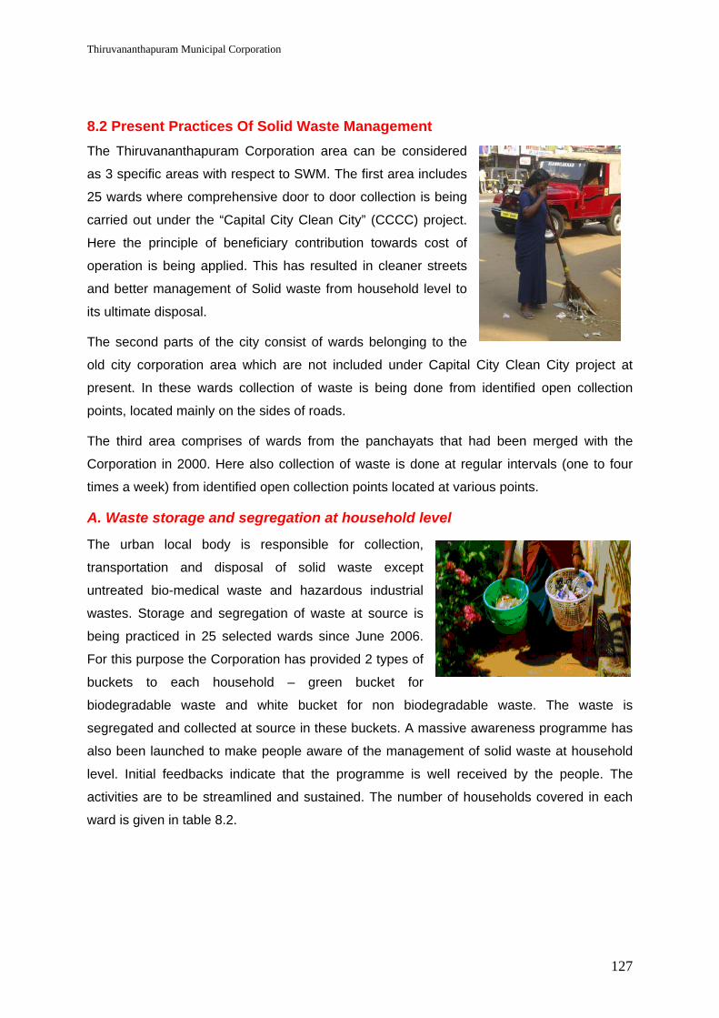
Thiruvananthapuram Municipal Corporation
127
8.2 Present Practices Of Solid Waste Management The Thiruvananthapuram Corporation area can be considered
as 3 specific areas with respect to SWM. The first area includes
25 wards where comprehensive door to door collection is being
carried out under the “Capital City Clean City” (CCCC) project.
Here the principle of beneficiary contribution towards cost of
operation is being applied. This has resulted in cleaner streets
and better management of Solid waste from household level to
its ultimate disposal.
The second parts of the city consist of wards belonging to the
old city corporation area which are not included under Capital City Clean City project at
present. In these wards collection of waste is being done from identified open collection
points, located mainly on the sides of roads.
The third area comprises of wards from the panchayats that had been merged with the
Corporation in 2000. Here also collection of waste is done at regular intervals (one to four
times a week) from identified open collection points located at various points.
A. Waste storage and segregation at household level
The urban local body is responsible for collection,
transportation and disposal of solid waste except
untreated bio-medical waste and hazardous industrial
wastes. Storage and segregation of waste at source is
being practiced in 25 selected wards since June 2006.
For this purpose the Corporation has provided 2 types of
buckets to each household – green bucket for
biodegradable waste and white bucket for non biodegradable waste. The waste is
segregated and collected at source in these buckets. A massive awareness programme has
also been launched to make people aware of the management of solid waste at household
level. Initial feedbacks indicate that the programme is well received by the people. The
activities are to be streamlined and sustained. The number of households covered in each
ward is given in table 8.2.

Thiruvananthapuram Municipal Corporation
128
Table 8.2: Households covered under Capital City Clean City project
Sl. No
Name of ward Total households
Households surveyed
Households supplied with
buckets
% of households
covered 1 Nanthancode 2343 1714 1211 59.062 Kuravankonam 2013 1846 1521 72.523 Sasthamangalam 2664 1812 1566 78.914 Kaudiar 1807 1595 1595 82.225 PTP Nagar 2343 1268 808 44.006 Vazhuthacaud 1830 1830 1350 57.377 Palayam 1966 1441 1362 70.258 Kunnukuzhi 1926 1161 913 53.829 Jagathy 2179 1856 1243 97.85
10 Poojapura 2217 1125 742 59.0511 Vanchiyoor 1057 1752 1185 60.5112 Sreekanteswaram 1892 1133 1323 77.6813 Fort 1314 1219 1101 42.0214 Chalai 1380 1100 825 66.8715 Thycaud 1821 1104 832 50.9516 Aranoor 2074 1465 1430 59.2417 Karamana 2015 1957 1725 42.9618 Secretariat 1759 395 331 74.4519 Thampanoor 1465 1007 901 65.8120 Valiyasala 1721 1321 806 47.4121 Medical College 2020 1920 1140 64.9222 Kannamoola 2218 2100 2144 62.4723 Kesavadasapuram 2158 1890 1545 15.8724 Pattom 1181 2130 1660 52.6425 Gowreesapattom 2478 2300 965 67.19
TOTAL 47410 38441 30224 63.75
B. Collection at the ULB Level
Collection of waste in 25 wards covered at present by
the “Capital City Clean City” project is carried out by
direct door to door collection by women groups
formed under the Kudumbashree project and similar
groups of other organisations. The waste so collected
is directly transferred to Corporation vehicles at
specific transfer points at scheduled time without
touching the ground.
In all other wards the collection is done from identified collection points which are roadside
points specially earmarked for dumping of waste. At present there are no dustbins at these

Thiruvananthapuram Municipal Corporation
129
sites and the wastes are being dumped in the open from where they are directly collected in
Corporation lorries manually.
C. Transportation to Treatment Plant
The waste collected from the various wards is
then transported to the processing centre at
Vilappilsala for treatment. 34 garbage trucks
are used for transportation of waste.
Transportation of waste to Vilappilsala waste
treatment centre, located in the adjacent
Panchayat of Vilappil is done only during
night hours so as not to disturb the regular
activities of the Panchayat area during day
time.
D. Processing and Disposal
A mechanical compost treatment plant is set up
and operated by a private operator (Poabs) at
Vilappilsala. The plant was set up for an
estimated 300 tons of waste every day. The plant
is located about 16 km from the city.
There is no engineered landfill site in Thiruvananthapuram.
There are no recycling plants within the city. The city corporation also does not operate any
recycling plant. Waste suitable for recycling are collected from the households and from
commercial establishments by private sector agents and transported to centres outside the
State.
E. Solid Waste Generation Trends
Even though no studies are available on the per capita waste generation trends, there is no
doubt that the quantity of waste generated is bound to increase substantially in future. But
the trend during the last 3 years show a quantum increase in quantity of waste collected and
transported from 132 tons/ day in 2003 to over 200 tons/day now. Perhaps this is mainly due
to a better collection and transportation arrangement and not due to increase in quantity of
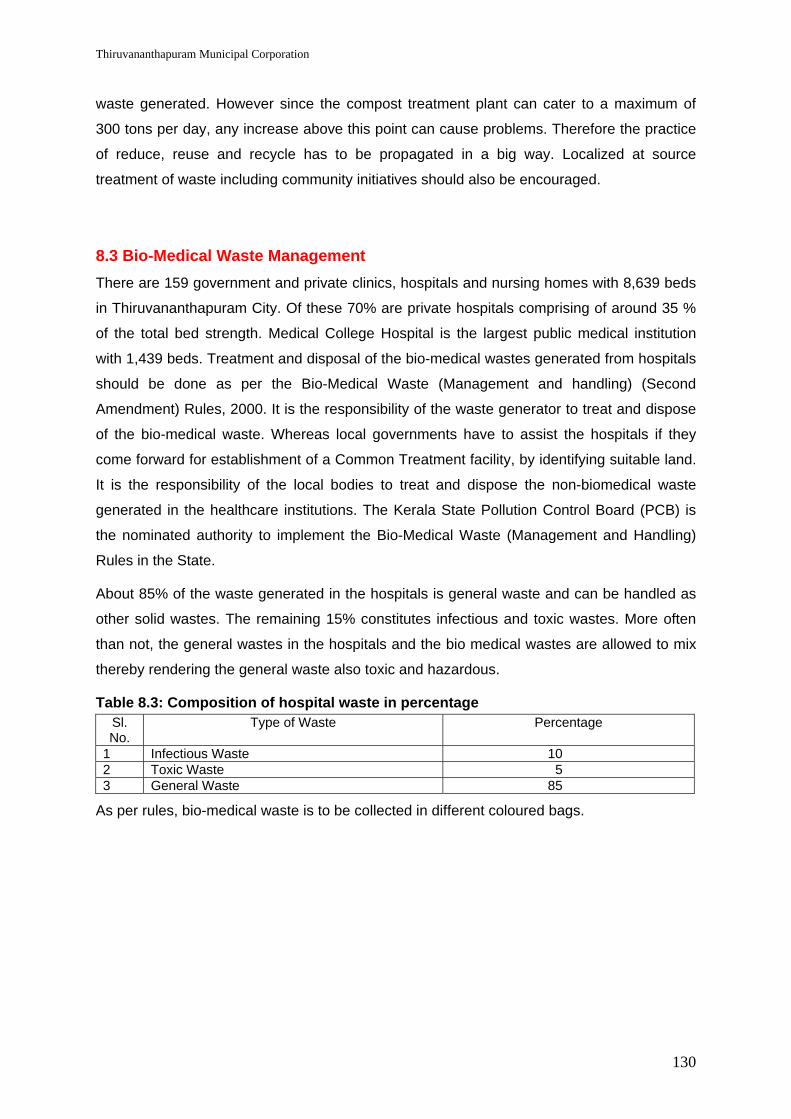
Thiruvananthapuram Municipal Corporation
130
waste generated. However since the compost treatment plant can cater to a maximum of
300 tons per day, any increase above this point can cause problems. Therefore the practice
of reduce, reuse and recycle has to be propagated in a big way. Localized at source
treatment of waste including community initiatives should also be encouraged.
8.3 Bio-Medical Waste Management There are 159 government and private clinics, hospitals and nursing homes with 8,639 beds
in Thiruvananthapuram City. Of these 70% are private hospitals comprising of around 35 %
of the total bed strength. Medical College Hospital is the largest public medical institution
with 1,439 beds. Treatment and disposal of the bio-medical wastes generated from hospitals
should be done as per the Bio-Medical Waste (Management and handling) (Second
Amendment) Rules, 2000. It is the responsibility of the waste generator to treat and dispose
of the bio-medical waste. Whereas local governments have to assist the hospitals if they
come forward for establishment of a Common Treatment facility, by identifying suitable land.
It is the responsibility of the local bodies to treat and dispose the non-biomedical waste
generated in the healthcare institutions. The Kerala State Pollution Control Board (PCB) is
the nominated authority to implement the Bio-Medical Waste (Management and Handling)
Rules in the State.
About 85% of the waste generated in the hospitals is general waste and can be handled as
other solid wastes. The remaining 15% constitutes infectious and toxic wastes. More often
than not, the general wastes in the hospitals and the bio medical wastes are allowed to mix
thereby rendering the general waste also toxic and hazardous.
Table 8.3: Composition of hospital waste in percentage Sl. No.
Type of Waste Percentage
1 Infectious Waste 10 2 Toxic Waste 5 3 General Waste 85
As per rules, bio-medical waste is to be collected in different coloured bags.

Thiruvananthapuram Municipal Corporation
131
Table 8.4: Guidelines for bio-medical waste collection
Sl No Type of waste Type of container Method of disposal
1. Human body parts Yellow coloured bags
Incineration
2. Disposable items like i.v. sets, blood & urine bags etc
Red coloured bags Autoclaving / Chemical treatment, cut into small pieces & disposal
3. Waste sharps (used / unused needles, syringes)
Blue / White translucent bags
Autoclaving/Microwaving/ Chemical Treatment and destruction/shredding
4. Discarded medicines, incinerator ash, chemical waste etc.
Black coloured bags
Disposed of in secured landfill sites
Minimum required facilities to be installed in a hospital for biomedical waste treatment
include one incinerator, one Autoclave and one Shredder. According to a rough cost
estimate each hospital may have to make a capital investment of Rs 10 lakhs for acquiring
these facilities. Therefore, installation of Common Treatment Facility for a selected group of
hospitals appears to be a more viable option. In a 5,000 bedded hospital, 7.5 tons of waste
is generated per day. Out of this 1.25 tons would be bio-medical waste. The estimated
capital cost for establishing a common treatment facility for biomedical waste generated from
5,000 hospital beds comes to Rs 130 lakhs. The annual O& M cost will come to Rs 30 lakhs
per year.
8.4 Key Issues & Challenges
Key issues
Non segregation of waste at source Incomplete collection & transportation Unscientifically designed transport vehicles Environmental issues in relation to the compost plant Lack of sanitary landfill
Challenges
Bringing about behavioral change in the people Designing of proper equipments & vehicles Solving issues related to compost plant & sale of compost

Thiruvananthapuram Municipal Corporation
132
8.5 Goals, Strategies & Projects It is proposed to implement an Integrated Solid Waste Management Plan in the city. The
Capital City Clean City programme already successfully implemented in 25 wards is to be
extended to cover all 86 wards with regional modifications considering the local nature of
land holdings and behavior of the population.
Goals
Table 8.5: Time frame for implementing goals Time Frame 2006 2011 2016 2026
Source Segregation 30% 100% 100% 100%
Door to Door Collection 50% 100% 100% 100%
Collection 100% 100% 100% 100%
Treatment & Disposal 60% 100% 100% 100%
Cost Recovery of O & M 0% 30% 40% 70%
Strategies
To achieve these goals the following strategies are planned:
1. Training
One of the areas which have not gained attention except in very recent period is the training
of all involved in SWM. There are any number of instances where a person has joined
service worked in SWM for 25 to 30 years and left service without having any training on
SWM. There is an urgent need to start training the personal involved in SWM. A beginning
has been made in Capital City Clean City project but this has to be institutionalized with
provision for regular training of persons directly involved in SWM.
2. Awareness Campaign
A sustained regular periodic (pulse like) awareness campaign is needed to bring about
significant change in the attitude of the people towards SWM. Reduction, Reuse, Recycle,
Recover concepts have to be emphasized so that the quantity of SWM coming for
processing is kept stable. Moreover segregated storage at source also requires sustained
campaign
3. Storage of Waste at Source
Storage of waste at source is the most important pre-requisite of a successful solid waste
management system. Segregated storage at source was not practiced in
Thiruvananthapuram city till recently. But under the Capital City Clean City project the same
has been introduced in about 40,000 households at present. It is suggested that it should be

Thiruvananthapuram Municipal Corporation
133
made 100% at the earliest. Two bin system of Solid Waste storage already established in
about 40,000 households is expected to be extended to about 150000 households by the
end of the current financial year.
4. Collection
Waste is deposited by households and other waste generators at various open collection
points in the city except in 25 wards where Capital City Clean City project has been
launched. In these wards door to door collection through community organizations is
implemented. The community door to door collection has to be strengthened and extended
to cover the entire city in the coming years. The door to door collection is to be implemented
in households were there is no chance of treatment at source. In case of larger land holdings
especially in the peripheral parts of the city at source management of waste is to be
encouraged so as to reduce the quantity of waste to be collected and transported. In low
income areas and slums community storage bins are to be introduced within the area (slum).
It has been generally decided not to put storage bins in the streets. Sufficient number of
dumper containers is to be placed in the markets also wherever localized treatment as
biogas plant is not possible. Debris service for collection of building waste and system for
collection of garden waste on payment basis is to be introduced. In order to facilitate easy
primary collection autos and push carts are envisaged. All existing wheel barrows are to be
replaced by containerized push carts or autos.
Door to Door Collection of Solid waste is being carried out in 25 of the 86 wards in the Corporation at present. It is planned to extend the same to all 86 wards by 2007. The budget provides for Rs. 1 crore in 2006 and 1.18 crores in 2007. With this amount most of the infrastructure requirement will be met and door to door collection can be done in all 86 wards. However all households may not be using the facility initially. As more and more households join the scheme additional infrastructure will be needed. For this an additional amount of 20 lakhs is provided in 2009. The infrastructure so created will be sufficient to achieve 100 % coverage by door to door collection and hence additional funds are not earmarked in subsequent years. Cent percent door to door coverage will be achieved in four years.
5. Transportation
Transportation is a very critical area in SWM. This is more important in areas where door to
door collection is implemented as waste collected by community groups are to be handed
over to the vehicles at a specified transfer point at a specified time. The success will depend
on precise co-ordination between the door to door collector and the vehicle. For this it is
absolutely necessary to have a vehicle tracking cum communication system.
There is shortage of vehicles and the same has to be rectified with purchase of vehicles and
replacement of old vehicles. 30% additional vehicles are to be made available to meet break

Thiruvananthapuram Municipal Corporation
134
downs as waste collected on door to door basis cannot be carried away even if one vehicle
does not operate leading to collapse of the system. Additional vehicles are needed for debris
services as well as for removal of garden waste as per demand on payment basis. The O &
M cost of vehicles used for debris collection and garden waste collection are to be met from
the payment collected. A separate system can be considered for operating the paid services
to avoid bottlenecks and speed up service delivery
Dumper containers are necessary in slums, markets and institutions producing bulk waste.
Dumper placers to lift the dumper containers are also needed and the same has to be
procured. There is also an urgent need to establish few transfer stations where the contents
of dumper containers can be transferred to bigger vehicles for optimum utilization of
resources. These transfer stations can also receive waste from door to door collection teams
if needed.
A workshop for maintenance of the vehicles is also proposed.
6. Processing & Disposal
Thiruvananthapuram is fortunate to have a state of the art compost production unit at
Vilappilsala which can process Solid Waste Management. The plant is expected to process
300 tons/day. At present it is processing the entire waste collected by the Corporation which
varies from 190 to 220 tons/ day. There has been a drastic increase in quantity of waste
collected in areas where door to door collection is implemented. The compost produced is
about 30% of the waste collected. Thus there is a substantial non compostible component in
the waste which is being dumped at present leading to environmental problems. With the
introduction of segregated collection and transportation the production efficiency of the plant
is expected to improve.
Yet there is an urgent need to scientifically cap the existing waste dump to overcome the
environmental problems. The process of capping has been already planned and initiated. A
scientifically designed engineered sanitary landfill is also absolutely essential for the rejects
of the compost plant. In order to reduce the quantity of waste being used for land fill thereby
prolonging its life it is proposed to have a plastic recycling unit as well as a secondary sale
market where rejects which can be reused can be sold off at an acceptable minimum cost.
Establishment of a sorting and storage facility for recyclable waste is also essential. As far
as possible all recoverable materials should be used. Other recycling units can also be
promoted. Community initiatives are to be encouraged in this field also.

Thiruvananthapuram Municipal Corporation
135
7. Framing of byelaws
There is a need for a comprehensive byelaw with regard to management of solid waste. This
will be prepared as part of the project taking into consideration the relevant provisions of the
Municipal Solid Waste Management and Handling Rules and finalized by due process of law
as per the Kerala Municipality Act 1999.
8. Decentralised SWM
The compost treatment plant was planned for 300 MT of waste every day. There has been a
drastic increase in the quantity of waste collected and reaching the compost facility during
the last few years increasing from 111 MT reaching the plant in 2002 to an average of 210
MT now (2006). It is not desirable to increase the quantity of waste reaching the streets.
Hence a concerted effort to reduce the waste at source should be planned. Decentralised
treatment of waste should also be given priority so as to save on cost and to mitigate the ill
effects of big plants. Various options are available for household process of biodegradable
solid waste. This includes household burial, aerobic / anaerobic composting, vermi
composting, bio-gas production etc. Ward level decentralised vermi composting or biogas
production can also be considered. Biogas plants (waste to energy plants) can be
considered in markets, slaughter house, schools and other such institutions based on
quantity & nature of waste. Decentralised SWM requires massive awareness campaign to
bring about a change in behaviour of the public.
9. SWM in surrounding panchayats- Kazhakuttam, Sreekariyam, Kudappanakunnu, Vattiyoorkavu and Vizhinjam
The Solid waste from the surrounding panchayats which are part of the urban agglomeration
is simply being dumped on the streets at present and there is no collection system. The
decentralised approach is to be adopted in these panchayats wherein a massive awareness
programme for treatment of waste at source is to be launched. The principles of 4 R’s -
Reduce, Reuse, Recycle & Resource recovery shall be an integral part of the awareness
programme. Household vermi composting, biogas, aerobic / anaerobic composting is to be
encouraged. Necessary training and equipments may be provided. One or more market
based integrated SWM plants can also be set up. Each integrated SWM plant shall have a
biogas plant, vermi composting unit and a waste segregation facility. Each panchayat will
also set up a collection facility for non biodegradable waste which is to be sorted out and
sold off for recycling. This work can be entrusted to CBOs or NGOs. Payment may be
collected from each household for removal of such waste.

Thiruvananthapuram Municipal Corporation City Development Plan
136
8.6 Broad Costing and Phasing Solid Waste Management – Investment Plan (Rupees Crores)
Table 8.6: Broad costing and phasing for solid waste management Sl. No
Components 2006-07
2007-08
2008-09
2009-10
2010-11
2011-12
TOTAL
TRAINING
1 Training of functionaries
0.15
0.30
0.31
0.33
0.35
0.35
1.79
IEC
2 Awareness Campaign
0.15
0.30
0.25
0.30
0.25
0.25
1.50
PRIMARY COLLECTION
3 Door to door collection
1.00
1.18
- 0.20
- - 2.38
STREET SWEEPING
4 Equipments for SWM (brooms, gum boots, plate etc)
0.06
0.12
0.12
0.13
0.13
0.14
0.70
5 Containerised push carts
0.25
0.25
- 0.15
- 0.10
0.75
6 Drain cleaning equipments
- 0.13
- - 0.13
- 0.26
7 Road sweeping machine
0.30
- - 0.30
- - 0.60
STORAGE & TRANSPORTATION
8 Establishment of transfer stations
0.15
0.30
- 0.15
- - 0.60
9 Autos with tipping facility
- 0.20
0.20
- - - 0.40
10 Cutting machine for cutting of heavy pieces of wood etc
- 0.03
- - 0.03
- 0.06

Thiruvananthapuram Municipal Corporation City Development Plan
137
Sl. No
Components 2006-07
2007-08
2008-09
2009-10
2010-11
2011-12
TOTAL
11 Lorries for SWM transportation
1.50
3.00
- 1.50
1.50
1.50
9.00
12 Tipper lorries for removal of sand & debris
0.24
0.60
- 0.36
- - 1.20
13 Excavator cum Loader (JCB)
0.24
- 0.24
- - - 0.48
14 Mini JCB
- 0.30
- - 0.30
- 0.60
15 Bob cat
- 0.20
- 0.20
- - 0.40
16 Dumper placers
0.24
0.36
- 0.36
0.24
- 1.20
17 Dumper containers
0.06
0.09
- 0.09
0.06
- 0.30
18 Vehicle service centre
0.10
0.15
- - - - 0.25
19 Vehicle maintenece workshop
- 0.15
0.10
- 0.10
- 0.35
20 Vehicle parking facility
0.20
0.30
010
0.10
0.10
0.80
MONITORING
21 Vehicle for SWM monitoring 0.10 0.05 0.05 0.05 0.05 0.05 0.35
22 Establishment of vehicle weighing system
- 0.08
- - - - 0.08
23 Establishment of complaint redressel mechanism
- 0.10
0.03
0.04
0.04
0.05
0.26
24 Development of Computerised monitoring system & MIS
- 0.40
0.01
0.01
0.02
0.02
0.46
25 Vehicle tracking cum communication system & GIS
0.25
0.50
0.20
0.20
0.15
0.10
1.40

Thiruvananthapuram Municipal Corporation City Development Plan
138
Sl. No
Components 2006-07
2007-08
2008-09
2009-10
2010-11
2011-12
TOTAL
RESOURCE RECOVERY
26 Secondary market for reusables
0.20
0.30
- - 0.40
- 0.90
27 Plastic recycling unit
- 0.20
- - - - 0.20
28 Scientific closure of abandoned dump site
0.40
1.10
- - - - 1.50
29 Engineered Sanitary landfill
- - 1.00
1.00
- - 2.00
30 Common facility for hospital waste management (including O & M cost)
- 1.60
0.30
0.30
0.30
0.30
2.80
31 Health surveillance of sanitation & community workers
0.10
0.20
0.25
0.30
0.30
0.35
1.50
DECENTRALISED WASTE MANAGEMENT
32 Support ot community initiatives
0.25
1.00
1.00
1.00
1.00
1.00
5.25
33 Decentralised waste management in extended area
1.00
3.00
2.00
2.00
1.00
1.00
10.00
VECTOR CONTROL ACTIVITIES
34 Vector control activities
0.05
0.05
0.07
0.07
0.10
0.10
0.44
35 Vehicle mounted Fogging machine
- 0.12
- - 0.12
- 0.24
TOTAL
6.99
16.66
6.13
9.14
6.67
5.41
51.00

Thiruvananthapuram Municipal Corporation
139
9.0 TRAFFIC & TRANSPORTATION
9.1 Importance of Transportation in Thiruvananthapuram City Region The importance of the City region of Thiruvananthapuram can be assessed from the
following major activities/ functions located in the city and its environs.
State capital with all top level decision making authorities located in the city As a city of higher learning – with the existence of a large number of educational
institutions of advanced studies and central and state level research institutions As a world tourism destination with famed Kovalam Beach, backwaters, heritage
areas/buildings, forest, ecotourism and unspoilt mountain resort of Ponmudi I.T hub with techno park, the first I.T Park in India now an SEZ and Techno city, on
the anvil Space Research Centre with VSSC / ISRO employing many scientists and
supporting personnel World health tourism destination with ayurvedic spas and health clinics, providing
traditional holistic health care with modern comforts and ambience International Container Transshipment Terminal (ICTT) comming up at Vizhinjam,
20 km south of the city – at an investment of Rs.8,000 crores in 2 phases, offering thousands of direct and indirect jobs.
Development of new civil station premises at Kudappanakkunnu which would boost up the supporting developmental activities in and around Kudappanakkunnu.
There is increasing demand to make quantitative and qualitative improvement to transport
facilities. Traffic volume is increasing in geometric proportions in the city road corridors and
in the regional corridors. Rail networks are also stressed beyond capacity.
It is in this context that the Government of Kerala took up Thiruvananthapuram Capital
Region Development (TCRD) in 2004. The Comprehensive Traffic & Transportation Study
(CTTS) prepared for Thiruvananthapuram Urban Region (TRIDA area) in 2002 came handy
to prioritize Thiruvananthapuram City road improvements as the first task under TCRD. 13
road corridors were identified for widening and improvement based on the road network
study carried out under CTTS. This work is now under implementation.
The present city road improvement project is only a partial attempt to tackle the traffic &
transportation issues in the Capital City. A comprehensive approach, not only for problem
solving measures but also for developing transportation systems, needed for the future
growth of the Capital City is now envisaged under JNNURM.

Thiruvananthapuram Municipal Corporation
140
9.2 Road Network The road network within the TMC and TRIDA area is generally of ring and radial pattern. The
city has five major regional roads:
NH 47 (Kanyakumari-Salem) passing through Thiruvananthapuram-Kollam-Alappuzha & Ernakulam – entering the city from the south from Nagercoil and exiting on the north-west towards Kollam.
SH 1- M.C. Road (Main Central Road) taking off from Kesavadasapuram in the city and leading to Kottayam & Angamali through Nalanchira and Mannanthala located in the north of the city.
State Highway to Shenkottah (in Tamil Nadu border) via Peroorkkada in the city and through Nedumangad town situated within 20 km of the city.
Thiruvananthapuram-Kattakada road taking off from Poojappura in the city towards east via Thirumala and Malayinkeezh
Thiruvananthapuram-Vizhinjam-Poovar road taking off from East Fort (in the city centre) towards south-west and acting as a coastal road in Thiruvallam, Ambalathara and Kovalam
All these five regional roads radiate from the city and the other major roads of the city
connect these roads as ring roads. The Thiruvananthapuram city by-pass for NH47 is
aligned along the coast from Kazhakuttam Junction to Kovalam-Vizhinjam and Parasala –
meeting NH47 at Parasala. Kazhakuttam-Kovalam stretch is completed now with two-lane
carriageway and service roads on either side. Other major roads in the city are Mahatma
Gandhi road, Palayam-Ulloor/ Nalanchira road, Palayam-Peroorkada road, Pettah-Medical
College-Ulloor road, Vellayambalam-Sasthamangala-Vattiyoorkavu road and Chalai by pass.
9.2.1 EXISTING ROADS
The total road length in TMC area is 2586 km of which 56% are surfaced. As per the existing
land use plan, the roads in the TMC area cover nearly 7% of urban land area with road
density of 18 km per sq. km area. In the TRIDA area (the city area and surrounding 10
Panchayat areas), the share of roads in the land use is only 3%1. This indicates that the
outer region has less road network. Most of the roads in the city are narrow and are unable
to cater to the growing traffic volumes, often resulting in transportation gridlocks during peak
hours. As per the Comprehensive Traffic & Transportation Study (2002), about 76% of major
roads have right of way (ROW) between 7m and 14m and 10% with ROW between 14m and
21 m. Only 0.3% of the major roads have a divided carriageway. About 40% roads have
shoulders up to 2m wide on either side. Footpaths are inadequate or absent in most of the
Development Plan for Trivandrum (2001), Department of Town Planning, Government of Kerala.

Thiruvananthapuram Municipal Corporation
141
roads as only 25 km of roads have footpaths. Generally, the road surface was found to be
poor with cracks, rutting and potholes.
Table 9.1: Road Network in Thiruvananthapuram City Road Category Length (Km) % Share
Black Top Road 901 34.84 Metal Road 305 11.79 Concrete Road 560 21.66 Others 820 31.71 Total 2,586 100.00 Source: Directorate of Urban Affairs, Govt. of Kerala.
Thiruvananthapuram Road Improvement Project now under implementation considers 42 km
length of city roads as 4-lane / 3-lane or 2-lane roads based on projected traffic volume for
15 years and based on a road network pattern.
9.2.2 ROAD HIERARCHY AND OWNERSHIP
Most arterial and sub-arterial roads are under Public Works Department (Roads and Buildings Division and National Highways Division) with collector roads under the TMC. Each agency is responsible for its own road development and maintenance. Of the available road network, a length of 390 km constitutes major roads and is classified as indicated in the table below. Table 9.2: Classification of Major Roads in Thiruvananthapuram
Road Classification Length (Km) Distribution (%) Arterial roads 74.9 19.2 Sub arterial roads 103.7 26.6 Collector roads 211.4 54.2 Total 390.0 100.0 Source: 'Draft Report on Short, Medium & Long Term Measures and Feasibility for Integrated Mass Transport System', July 2002 under Thiruvananthapuram CTTS submitted to the Department of Transport (DoT), GoK.
9.2.3 MAJOR ISSUES
Problem of congestion on main roads and intersections is a result of a combination of factors. Most of the arterial roads have inadequate capacity, substandard road geometry and carry a significant amount of intercity traffic in addition to the local traffic.
Prime issues include:
a) Inadequate parking facilities, resulting in on street parking, reducing capacity of the available carriage way
b) Inefficient management of road space;
c) Absence of pedestrian facilities;
d) Poor geometry for the roads connecting important activity centers.

Thiruvananthapuram Municipal Corporation
142
e) Absence of by-pass or ring roads, because of which a major percentage of traffic is made to go through the central city roads, adding to traffic congestion.
f) Absence of delineated hawker zones leading to increased street vendors using precious road space for conducting petty trade activities.
g) Regular traffic blockages due to demonstrations and other similar events, Thiruvananthapuram being the capital of the State.
9.3 Traffic Flow and Travel Demand 9.3.1 TRAFFIC FLOW
The average annual daily traffic (AADT) on some of the main roads indicate that traffic was
in the range of 35,000 to 53,000 passenger car units (PCU) in the inner city road sections,
18,000 to 24,000 PCU for intermediate city road sections and in the range of 10,000 to
18,000 PCU on roads in the city’s periphery. It is estimated that the AADT on inner city roads
would reach 43,000-64,000 PCU during the year 2004. This high traffic volume exerts
pressure on the existing narrow urban roads, causing frequent congestion and accidents.
Table 9.3: Peak Hour Traffic Distribution at Selected Locations Sl. No.
Road Section AADT (PCU)-2000
Peak Hour Traffic (PCU)-2000
Peak Hour Factor
(%)-2000
Estimated AADT (PCU)-2004
Estimated Peak Hour
Traffic (PCU) - 2004*
1.0 Outer City Sections 1.1 Manacaud-Vizhinjam 17,755 1,521 8.6 21,581 1,849 1.2 Sasthamangalam -
Vattiyoorkavu 17,759 1,730 9.7 21,586 2,103
1.3 Vazhuthacaud-Pangode
10,532 1,184 11.2 12,802 1,439
2.0 Intermediate City Sections 2.1 Karamana-Poojapura 18,021 1,640 9.1 21,905 1,993 2.2 Uppilamoodu-
Kaithamukku 24,304 2,432 10.0 29,542 2,956
2.3 Palayam-Pettah Road 24,369 2,533 10.4 29,621 3,079 2.4 Jagathy-Poojapura
Road 24,433 2,211 9.0 29,698 2,687
3.0 Inner City Sections 3.1 Thampanoor-Killipalam 35,088 2,947 8.4 42,650 3,582 3.2 Killipalam-Karamana 34,900 3,101 8.9 42,421 3,769
3.3 Over bridge-East Fort 52,802 3,848 7.3 64,181 4,677
* - Estimated with 5% annual growth rate.

Thiruvananthapuram Municipal Corporation
143
Source: 'Draft Report on Short, Medium and Long Term Measures and Feasibility for Integrated Mass Transport System', July 2002 submitted to Department of Transport, Govt. of Kerala.
As per the studies under the Kerala Sustainable Urban Development Project (ADB assisted
project) - City Report for Thiruvananthapuram, most of the road sections have reached their
maximum capacity and need widening. The details of some of the road stretches are
mentioned below.
Table 9.4: Peak-hour Traffic Volume on Selected Road Stretches Sl. No. Link Name Peak-hour traffic
volume (PCU) Capacity in PCU
1 Manacaud-Kamaleswaram Section 2,650 2,1432 Ulloor-Karyavattom Section of NH 47 4,676 2,1433 Ulloor-Kesavadasapuram Section of NH 47 3,068 2,1434 Poojapura-Pangode Section 4,106 1,7145 Sasthamangalam-Maruthankuzhi Section 3,13 1,7146 Paruthipara-Ambalamukku Section 2,433 1,7147 Pettah-Anayara Road 1,673 8008 Anayara-Veli Road 280 800
Source: Primary survey by ADB PPTA (2004).
The average annual traffic growth rate for the city roads during the period 2000-04 is 5.2%.
This growth rate is only indicative as it is based on a few road sections.
Table 9.5: Traffic Growth Rate during 2000-04 Peak hour traffic Sl.
No Location
PCU (2000)* PCU (2004)** Annual Growth Rate during 2000-04 (%)
1 Manacaud Junction 2,918 3,187 2.232 Vazhuthacaud-Pangode Road 1,184 1,570 7.31
3 Sasthamangalam-Vattiyoorkavu Road
1,730 2,105 5.03
4 Pettah-Aanayara Road 588 1,007 14.40* - CES Study Traffic Survey in 2000 ** - Primary Survey under ADB PPTA in 2004
Various issues like on-street parking, street vendors, etc. result in speed reduction during
peak-hours on city roads. The average peak-hour speed at the outer city road sections is
only in the range of 16 to 23 km per hour against a desired peak-hour speed of about 30 to
35 km per hour.

Thiruvananthapuram Municipal Corporation
144
Table 9.6: Speed and Delay Characteristics at Selected Links
Peak Hour Off-peak Hour Sl No
Name of the Road Length (Km) Journey
Speed (Km/hr)
Delay (Sec)
Running Speed (Km/hr)
Journey Speed (Km/hr)
Delay (Sec)
Running Speed (Km/hr)
1 Kazhakoottam-Kesavadasapuram Road
8.4 18.72 533 27.95 27.77 21 28.31
2 Paruthippara-Ambalamukku Road
2.3 23.46 58 28.07 38.69 13 41.19
3 Nettayam-Shasthamangalam Road
5.2 23.03 84 25.68 26.29 10 26.67
4 Karamana-Peyad Road 8.2 21.92 196 25.65 26.19 56 27.56
5 Venpalavattom-West Fort Road 5.8 16.04 521 26.73 25.13 79 27.77
6 Attakkulangara-Thiruvallam Road
4.7 23.83 96 27.56 38.37 31 41.27
7 PMG-Pottakuzhi Road 1.6 28.80 10 30.32 43.97 6 46.08
8 Venpalavattom-Veli Road 2.4 21.65 110 29.90 27.69 4 28.05Source: Primary Survey under ADB PPTA (2004).
9.3.2 THROUGH TRAFFIC
Volume of commercial vehicles passing through the city is estimated as 2,000 vehicles per
day with 19% of commercial traffic passing through the city in the absence of a bypass. 87%
of through traffic plies along major radial roads.
Of the existing radial roads, five roads are on major corridors with high inter-city vehicular
traffic entering / leaving the city. Traffic on these five roads constitutes 83% of the total inter-
city vehicular traffic. These roads are:
a) NH 47, towards Neyyatinkara;
b) NH 47, towards Kollam;
c) Peroorkada - Nedumangadu Road (Thiruvananthapuram Shenkottah road);
d) Main Central Road (Thiruvananthapuram - Kottayam road); and
e) Poojapura - Kottakada Road.

Thiruvananthapuram Municipal Corporation
145
Table 9.7: Details of through Traffic of Commercial Vehicles Commercial Traffic (No. of
vehicles) – 2000 Estimated Commercial
Traffic (No. of vehicles) –2004
Sl. No.
Outer Cordon Road Section
Total per day
External -
External Traffic
% Share
Total per day
External -
External Traffic
% Share
1 Vizhinjam-Balaramapuram Road
320 19 5.9 389 23 5.9
2 NH 47 towards Neyyatinkara
3,403 690 20.3 4,136 839 20.3
3 Peyad-Malayinkeezhu Road 733 88 12.0 891 107 12.04 Vattiyoorkavu-Nettayam
Road 530 54 10.2 644 66 10.2
5 Peroorkada-Nedumangadu Road
722 88 12.2 878 107 12.2
6 MC Road 610 94 15.4 741 114 15.47 Kattaikonam-Pothencodu
Road 235 26 11.1 286 32 11.1
8 NH 47 towards Kollam 2,239 578 25.8 2,722 703 25.89 Station kadavu-
Perumathurai (Coastal Road)
83 2 2.4 101 2 2.4
Total 8,875 1,639 18.5 10,788
1,992 18.5
Source: 'Draft Report on Short, Medium & Long Term Measures and Feasibility for Integrated Mass Transport System', July 2002 submitted to Department of Transport, Govt. of Kerala.

Thiruvananthapuram Municipal Corporation
146
9.3.3 PEDESTRIAN FACILITIES
Apart from all the major road corridors in the inner and intermediate city area, the locations
of commercial, hospital and educational activities in the city indicated heavy pedestrian
traffic for parallel and crossing movement. Even the outer city road sections indicated
considerable pedestrian traffic, particularly during peak hours, as indicated in the Table
below. Critical sections with heavy pedestrian traffic include Chalai, Railway Station Road,
VJT Hall, Secretariat, Power House Road, Palayam, East Fort and Cotton Hill School. Peak
hour pedestrian traffic at these locations is projected to cross 6,000 persons by 20062.
Except a few sections, many of the roads do not have footpaths.
Table 9.8: Mid-block Pedestrian Count at Selected Outer City Locations Sl. No.
Section Name Peak Hour Pedestrian Volume (No)
1 Manacaud-Kamaleswaram Section 3.15-4.15 PM 6382 Paruthippara-Ambalamukku Section 3.15-4.15 PM 6183 Ulloor-Kesavadasapuram 8.30-9.30 AM 6214 Ulloor-Karyavattam 4.45-5.45 PM 3755 Sasthamangalam-Maruthakhuzhi 8.30-9.30 AM 9006 Poojappura-Pangode 8.00-9.00 AM 774
Source: Primary Survey under ADB PPTA 2004.
9.4 Vehicular Growth and Composition Due to lack of data at city level, district level growth trend of motor vehicles during the last
five years was studied. The trend shows that the percentage increase in 2005 is highest in
case of 2-wheelers (12.64%) followed by car/jeep/taxi (11.34%), buses (9.90%) and goods
vehicle (9.29%). The lowest increase was observed in the growth of 3-wheelers (5.19%).
Table 9.9: District level growth trend of motor vehicles
Year 2-wheeler Car/Jeep/ Taxi
3-Wheeler Buses Goods Vehicles
Others Total
2005 281382 78143 31551 16909 21676 3807 4334682004 249817 70183 29993 15386 19834 3550 3887632003 224274 62668 28042 13862 18460 3149 3504552002 203658 56163 26750 12717 17657 3116 3200612001 184519 52064 25386 11877 16485 2868 2931992000 165615 48266 23673 10312 15565 2742 266173
Source: Motor Vehicles Department, Government of Kerala.
2 Traffic Engineering and Management Study – Trivandrum, December 1991, KUDP (CES, New Delhi).
Thiruvananthapuram Municipal Corporation
147
9.5 Mode Split and Modal Split The modal distribution of the trips performed by the residents show a heavy dependence on
personalized vehicles inside the city area.
Table 9.10: Modal Distributions in the City and Panchayat area Region Personalized
Vehicles IPT
Mass
Transport Total
City Corporation 50.74 13.90 35.36 100.00Panchayats 33.65 4.11 62.24 100.00TRIDA 42.65 9.32 48.03 100.00Source: Comprehensive Traffic and Transportation Study of Thiruvananthapuram Urban Area, conducted by CES in association with ICF Kaiser and PEMS for Department of Transport, Government of Kerala, 2003
The overall share of mass transport, including institutional vehicles does not appeal in the
modal distribution. This result in a high share of personalized vehicles which makes the
roads congested and indicates the operational problems of public transport.
9.6. Public Transport System Though the recent years have seen tremendous effort in improving the transport network in
the region, lot needs to be done to provide an efficient public transport system. Road
improvement projects are in progress under the KSUDP and the City Road Improvement
Project. The traffic condition is expected to show some sign of relief in a few of the busy
corridors once these projects are completed. Recent years have seen doubling of the rail
lines providing better rail connectivity to Thiruvananthapuram. Electrification of the rail line,
which is underway, will further improve the rail system. But the economic benefits
achievable through these partial improvements of the transport system would multiply
several folds by improvement of the public transport system. The issues currently faced by
the road system and inadequacy of public transport system needs to be resolved. The city
badly needs a mass transport system to provide connectivity to the outskirts where large
scale activities concentrate in a few development zones. It also needs an improved, clean,
cost efficient public transport system to provide service within the city area.
9.6.1 BUS TRANSPORT
The city bus service is mainly operated by the Kerala State Road Transport Corporation
(KSRTC) and supplemented by private bus operators. KSRTC also operates both inter-city
and intra-city services. There are five depots for city bus services and one regional terminal
at Thampanoor for inter-city / inter-state services. Some of the areas with city bus depots are
very crowded and congested and need redevelopment or shifting of depots to better

Thiruvananthapuram Municipal Corporation
148
locations. All the buses ply on the same carriageway as that of other private vehicles and
thus the level of service offered by bus system is severely limited by the congested road
network. The mode split of KSRTC is 9% and the modal split share caters to more than
35%3. This indicates that the existing bus system is unable to cater to the peak hour
passenger demand, resulting in over crowded buses, long waiting time and slower speeds.
In total KSRTC operates 449 buses in 790 routes with a total trip length of 95680 km
(average trip length of 16 km)4 and private buses operate 103 buses (1714 trips per day)
with a total route length of 1770 km (average route length of 16.2 km)5.
As an effort to improve the quality of services, KSRTC is in the process of reducing the
average age of buses put to operation. Thiruvananthapuram district was among the three
districts that showed the highest General Accident Proneness (GAP) index. Studies
available reveal that majority of the bus accidents are linked with road conditions and driver
behaviour. Performance of KSRTC was also studied by NATPAC. (Source: “Performance
Analysis of Kerala State Road Transport Corporation”, NATPAC, Thiruvananthapuram, April
1994). Compared to the operation of KSRTC at state level, performance of
Thiruvananthapuram city bus operations were poorer. The study brought out issues like high
level average load factor, low fleet/ vehicle utilisation, high staff ratio and low punctuality for
corrective actions.
Some of the areas that need development of bus depots or construction of new ones have
been identified in consultation with various stakeholders. They are listed as below.
Redevelopment of KSRTC bus terminal at Thampanoor for city and district level services
Shifting the city bus terminal from East Fort to KSRTC bus terminal at Thampanoor and maintaining a sub-operating terminal at East Fort.
Development of inter-district and inter-State bus terminal at Eanchakkal, by the side of the NH bypass.
Development of city-level sub-operating terminals at Kochuveli, Medical College / Ulloor, Thirumala, Nalanchira, Kudappanakunnu, Ponnumangalam and near the proposed international airport terminal, by the side of NH bypass.
9.6.2 RAIL TRANSPORT
Thiruvananthapuram is connected by a broad gauge railway line running north-south, linking
Nagercoil-Kanyakumari on the south to Kollam-Kochi on the north. The city is well connected 3 Motor Vehicles Department, Government of Kerala 4 Economic Review 2003, State Planning Board, Govt. of Kerala 5 Compiled by National Transportation Planning and Research Centre (NATPAC), Thiruvananthapuram

Thiruvananthapuram Municipal Corporation
149
to other parts of the State and the country through the rail network. On an average around
50 trains are serving the city every day. The daily commuter traffic coming from the north
and south of the city mainly depend upon the rail transport system. The railway line divides
the city into two parts. The old city is on the south and the new development of the city
aremainly on the north. The growth of the city is taking place along the railway line towards
the north.
There are three railway stations serving the city, which are, Trivandrum Central at
Thampanoor (city centre), Pettah (secondary station in the city) and Kochuveli (on the
outskirts). The second terminal of the city is being developed at Kochuveli (Veli) to allow a
few long distance trains to terminate at this station without entering the city centre. Other
small stations in the TRIDA area include Kazhakkoottam, Nemom and Balaramapuram.
Six rail-over-bridges (ROBs) provide uninterrupted access between the two parts of the city.
Three level crossings at Melarannur, Pettah and Kochuveli in the city obstructs road traffic
due to frequent gate closures. Traffic at Pettah level crossing is about 0.63 million train
vehicle unit (TVU) per day, whereas Kochuveli and Melarannur level crossings will reach 0.1
million TVU soon. This justifies the requirement of ROBs at these locations.
Development proposals with regards to Railways to improve rail travel facilities to
Thiruvananthapuram include the following:
(a) Double laning of Thiruvananthapuram-Nagercoil route;
(b) Running of commuter trains between Thiruvananthapuram & Kollam and Thiruvananthapuram & Parassala (perhaps Nagercoild-Kollam EMUs based on traffic surveys);
(c) To encourage further inter-relationships between Thiruvananthapuram and Kochi, as the two prime activity nodes of the state, fast train connections, with less than three hour travel time and better comforts, need to be established between these two cities;
(d) Establishment of Thiruvananthapuram-Vizhinjam rail link to serve ICTT at Vizhinjam Port; and
(e) Establishment of Thiruvananthapuram-Nedumangad-Palode-Thenmala rail link to serve the north-eastern corridor and to link with Kollam-Shencottah rail line, which is undergoing gauge conversion (in the second phase, this link can be connected to Kollam-Kottayam railway line).

Thiruvananthapuram Municipal Corporation
150
Terminal facilities
(a) Redevelopment of Thiruvananthapuram Central Railway Station with the following
features:
Construction of a multi-level vehicle parking facility, separate areas for four-wheeler and two-wheeler parking, and separate areas for long duration and short duration parking with computerized parking ticket facility and also monthly parking fee arrangement;
Lift and ramp facilities to link all the platforms (PPP); Free service luggage trolleys which can be operated by the passengers; Better traffic management in the front yard with taxi parking area shifted from front
yard to the old Arya Bhayan – C.P. Sathram area; and Pedestrian over bridge to be extended up to KSRTC bus terminal.
(b) Development of Kochuveli (Veli) second terminal with good passenger facilities and also with facilities for overnight stay;
(c) Rail coach and engine serving facility at Nemom; (d) Kochuveli-Kazhakuttom transport facility along the NH bypass; and (e) Goods terminal at Kochuveli and at Vizhinjam.
9.6.3 AIR TRANSPORT
Thiruvananthapuram has an International Airport catering to both domestic and international
flights. During the year 2002-2003, 10,524 flights were operated from this airport of which
62% were international. Little more than one million air passengers boarded or alighted at
this airport and this was 5.6% more than the air traffic in the previous year. The new airport
terminal is being developed with access from NH bypass. The increasing air traffic exerts
pressure on the city road network. Adequate mode change facilities to public transport are
required from the airport.
9.6.4 WATER TRANSPORT
Except for tourism, water transport is seldom used in the region, though an inland water
network of about 16 km exists on the western part of the city.connecting the north and south
of Kerala.
The Kovalam - Veli reach of the West Coast Canal has a length of about 16 km. The
waterway is passing through Veli, Akkulam, Thiruvananthapuram city, Poonthura and
Moonnattumukku near Kovalam. Veli and Poonthura are the two sea openings in this
section. Some of the portions of the canal are presently navigable by small country boats.
This stretch of land in the city has tremendous potential as it also provides connectivity
Thiruvananthapuram Municipal Corporation
151
between the airport and the famous tourist destination at Kovalam on the south and to the
Technopark at Kazhakuttam.
9.6.5 INTERMEDIATE PUBLIC TRANSPORT (IPT)
Lack of efficiency in intra-city Public Transport System has forced people in the middle and
lower income groups to opt for IPT. The most popular mode of IPT is the three-wheeler
(autorickshaw). However, increasing use of autorickshaws within the city area tend to
increase traffic congestion and accidents.
There are a few intra-city road corridors, which are not well served by KSRTC buses. It is
roughly assessed that about 40 percent of jobs in the organized sector and about 60 percent
of jobs in the unorganized sectors (especially in the construction industry) are availed by
worker community daily from the immediate region around. They depend partly on the
illegally operated IPT modes like vans and mini buses. These vehicles regularly operate in
the following corridors:
(a) Thiruvananthapuram – Kattakada;
(b) Thiruvananthapuram – Vizhinjam;
(c) Thiruvananthapuram – Nedumangad and;
(d) Thiruvananthapuram – Attingal
These IPT operations need to be brought under surveillance.
The Airport does not have Public Transport linkage and the proposed railway terminal at Veli
also need road transport transfer facilities.
9.7 Vehicular Parking
9.7.1 PROBLEMS AND ISSUES
On-street parking is a major issue due to the absence of off-street parking facilities. Heavy
parking demands on the major corridors reduce the usage of carriageway, causing
congestion and blocking connecting roads. In most of the critical areas the mode
predominant on the on-street parking is two-wheeler as shown in the table below.

Thiruvananthapuram Municipal Corporation
152
Table 9.11: Peak Hour On–Street Parking Accumulation
Location Predominant Mode in Peak Hour
Peak Hour Parking Accumulation (No.)
Predominant Mode Accumulation in Peak Hour (No.)
Vazhuthacaud Car 247 85 Power House Road 2 wheeler 205 109 Pulimoodu-MG Road 2 wheeler 112 70 Pulimoodu-Press Road 2 wheeler 108 55 SMV High School-MG Road 2 wheeler 86 52 Pulimoodu-Kaithamukku Road 2 wheeler 82 63 Secretariat 2 wheeler 78 38 Vellayambalam-Sasthamangalam Road 2 wheeler 77 67 East Fort Car 70 35 Museum 2 wheeler 70 39 Station Road 2 wheeler 55 33 Palayam 2 wheeler 54 37 VJT Hall 2 wheeler 52 44
Source: 'Draft Report on Short, Medium & Long Term Measures and Feasibility for Integrated Mass Transport System', July 2002 submitted to Department of Transport, Govt. of Kerala.
9.7.2 PARKING DEMAND AND CRITICAL AREAS
The life line of Thiruvananthapuram is the MG Road passing through the central area. The
volume of traffic moving through this road is very high because it cuts across the CBD and
commercial centres and administrative offices of the State including the State Secretariat are
located on this road. A parking demand study conducted in 20036 estimated a deficiency of
1867 Equivalent Car Spaces (ECS) on the MG Road alone. The study projected the parking
deficiency as below.
Table 9.12: Parking Deficiencies on MG Road Year Demand in ECS Supply in ECS Deficiency in ECS 2003 4108 2241 18672008 5092 2459 26332013 6232 2671 35612018 7260 2738 45222023 8215 2738 54772028 9170 2738 6432
Source: Parking Management Plan for MG Road, prepared by National Transportation Planning and Research Centre (NATPAC), Kerala State Science, Technology and Environment Council, Government of Kerala.
The inability to supply parking spaces to meet the parking demand on the arterial roads
within the city, in areas like Medical College, East Fort, the markets in Palayam, Chalai,
6 Parking Management Plan for MG Road, prepared by National Transportation Planning and Research Centre (NATPAC), Kerala State Science, Technology and Environment Council, Government of Kerala

Thiruvananthapuram Municipal Corporation
153
Manakkadu and Edappazhanji have resulted in the use of scarce road space for parking
thus reducing the effective road width for moving traffic. Major parking demand corridors in
the city are at:
East Fort, Thampanoor, Statue, Vellayambalam, Sasthamangalam, Vazhuthacaud, Palayam, Pulimoodu, Over bridge, Power House Road, Museum, Medical College, Pattom, Peroorkada, Kesavadasapuram, Pazhavangadi and, Fort area
The concentration of commercial and institutional activities along the MG Road between
Palayam and East Fort has generated heavy on-street parking demand on this section and
its connector roads.TMC has identified three locations along the MG Road and one at
Pattom for providing multi-level off-street parking facilities. The three locations identified
along MG Road are:
Statue area; Near G.P.O. junction; and Near Overbridge junction.
9.8 Traffic and Transportation Safety In 2003, Thiruvananthapuram District had 350,455 registered motor vehicles, of which
majority of them were in the city region. This suggests that on average, there are 106 motor
vehicles for every 1,000 persons and 160 vehicles per sq. km of area. This is significantly
higher than the State average (78 motor vehicles per 1,000 persons and 65 vehicles per sq.

Thiruvananthapuram Municipal Corporation
154
Percentage vehicles involved in accidents
Two wheelers
46.37%
Autos
17.13 %
Cars
16.86 %
Others
19.65 %
km area). During the period 1991-2003, the average annual growth of vehicle population
was 11%. From 2001 to 2003 a declining trend is seen (9.30%)7.
Table 9.13: Details of Road Accidents in Thiruvananthapuram District Annual Growth Rate Sl
No. Year / Annual Growth Rate
Accidents (%) Persons injured (%)
Persons killed (%)
1 2001-02 -0.71 -0.79 5.682 2002-03 14.63 29.83 3.58
Average Annual Growth Rate 1 2001-03 6.96 14.52 4.63
Source: Economic Review 2002 and 2003, State Planning Board, Govt. of Kerala.
Growth of motor vehicles and its pressure on the road network is significant, resulting in over
utilization of road network in the region with frequent traffic problems like congestion and
accidents. Available statistics indicate that road accidents are a major concern in
Thiruvananthapuram District with 7% average annual growth rate during 2001-03.
4951
6326
289279264
6037
46504687
4929
0
1000
2000
3000
4000
5000
6000
7000
2000-01 2001-02 2002-03
No.
of
pers
ons
affe
cted
No. of persons killed No. of persons injured Total no. of persons
Source: Economic Review 2002 and 2003, State Planning Board, Govt. of Kerala.
Out of the 4,662 accidents reported in
Thiruvananthapuram district during
the year 2002, about 39% of the
accidents (1,818 accidents involving
2,616 vehicles) were from
Thiruvananthapuram city. 58% of the
reported accidents in
7 Compiled from Economic Review 2002 and 2003, State Planning Board, Govt. of Kerala.

Thiruvananthapuram Municipal Corporation
155
Thiruvananthapuram city occurred at road junctions8. Of the 2,616 vehicles involved in city
accidents, the major share was that of two-wheelers (1,213 vehicles) followed by three
wheelers (448 vehicles) and car/jeep (441 vehicles). These three together constitute 80% of
the total number of vehicles involved in accidents. Available accident analysis indicates that
pedestrians (38.45%) and cyclists (10.19%) are the most affected persons in
Thiruvananthapuram and together constitute 49% of the total road accident victims.
9.9 Street Lighting Urban roads are generally provided with streetlights of different categories. As per the CES
Study (2000), about 80% of major roads in the city are provided with adequate streetlights.
Thiruvananthapuram MC maintains the streetlights through Kerala State Electricity Board
(KSEB). Road inventory survey conducted under the PPTA at selected major roads, mostly
in the outer-city area, revealed that roads are adequately lit with tubes (45%) and Sodium
Vapour Lamps (51%). Average distance between lampposts on major roads was 39 m.
About 19% of streetlights at selected road sections were not working due to delay in
maintenance.
Table 9.14: Details of Street Light Availability at Selected Road Sections No. of lights Lights not
working on the survey day
Sl. No.
Road Section Length (km)
Bulbs Tubes MVL SVL Total
Avg. space between
street lights (m) No. %
1. Attakulangara-Manacaud-Thiruvallom Bypass Junction
5.20 2 12 101 - 115 45 18 15.65
2. Karamana-Pangode-Peyad Section
8.15 2 115 113 - 230 35 49 21.30
3. Kesavadasapuram-Ulloor - Kazhakootam Section
9.32 19 78 94 14 205 45 40 19.51
4. Paruthipara-Ambalamukku Section
2.27 - 56 4 - 60 38 15 25.00
5. PMG-Pottakuzhi Section 1.63 - 25 26 - 51 32 13 25.496. Sasthamangalam-Vattiyoorkavu
- Nettayam Section 5.06 2 33 107 - 142 36 26 18.31
7. West Fort-Pettah-Anayara Section
5.35 4 109 59 - 172 31 27 15.70
8. Anayara-Veli Section 2.40 1 28 7 - 36 67 6 16.67 Total 39.38 30 456 511 14 1,011 39 194 19.19
Source: Primary Survey under PPTA, 2004.
8 Hand Book on Road Accident Statistics, (2004), NATPAC.

Thiruvananthapuram Municipal Corporation
156
A few intersections and major road corridors, including the NH Bypass portion, are
insufficiently lit. The existing maintenance system needs improvement as 20% of the street
lights do not work or they lack maintenance. The Capital Region Road Development lays
emphasis on providing adequate streetlights. The 42 km of city roads are proposed for
widening and improvement under Thiruvananthapuram City Road Development Project,
which is now under implementation.
9.10 On-Going and Proposed Projects
9.10.1 ON-GOING PROJECTS
Table 9.15: Thiruvananthapuram City Road Improvement Projects Sl No Road description Length
(km) 1 Student centre – Vellayambalam – Kowdiar & Vellayambalam – Sasthamangalam 3.7512 LMS – Attakulangara (MG Road) 3.373 Museum – Bakery Jn. - Thampanoor – Over bridge
(Including Bakery flyover & Palayam underpass) 3.905
4 Asan Square – Pettah – Airport 9.5035 Collectorate – Pattoor and Uppidamoodu – Sreekanteswaram 4.4856 Nalumukku –Sreekanteswaram – Mele pazhavangadi – Choorakkattu Palayam 7 Vanross - Oottukuzhy – Secretariat 1.428 Pattom – Marappalam – Kowdiar 2.39 Pattom –Medical College – Ulloor – Kochulloor 3.210 Kowdiar – Peroorkada – Vazhayila 3.47311 Attakulangara – SreeVaraham - NH Bypass (Puthen Street) 1.4712 Thakaramparambu to NH Bypass (Arat Road) 1.4313 Murinjapalam to NH Bypass (Poonthi Road) 3.76
Total 42.067 Table 9.16: Road projects under KSUDP with ADB assistance. Sl No Road description Length
(km) A Road upgrading 1 NH Bypass – Veli Tourist Village road 1.902 PMG – Law College Junction 0.503 Peroorkada – Pipinmoodu – Sasthamangalam – Edapazhanji – Jagathy - Killipalam 8.104 Ulloor – Kesavadasapuram section of NH 47 1.005 Poojapura – Thirumala – Peyad road 5.806 Attakulangara – Manacadu – Thiruvallom – NH Bypass road 5.20B Street Lighting Total 22.50

Thiruvananthapuram Municipal Corporation
157
9.10.2 PROPOSED PROJECTS
Different agencies are involved in planning, construction and maintenance of the urban road
network in Thiruvananthapuram region. Recently, a major thrust on road improvement was
initiated through the Thiruvananthapuram City Road Improvement Project and other
initiatives. These include:
a) Under the Capital Region Road Development Program (through Kerala Urban Development Project and Kerala Road Fund Board under PWD (R&B)), 13 major road corridors covering 42 km are being widened (with improvements to 64 intersections and other road safety aspects) and another 52 km of access roads are being improved at a cost of Rs.2,000 million;
b) Thiruvananthapuram Development Authority (TRIDA) road improvement schemes (improvement to Bakery-Poojapura Road, and Manacaud-Attukal-Chiramukku-Kaimanam Road);
c) PWD (R&B), City Roads Schemes capacity augmentation to Ulloor-Aakulam Road; d) PWD (NH) scheme of widening Nalanchira-Kesavadasapuram-Plamoodu Section; e) Tourism Department schemes - Model Road Scheme for Kesavadasapuram-Pattom
Section of NH 47 and improvements to the access road at Veli Tourist Complex.
9.10.3 Provision of transport to the poor
Other than the roads taken under slum area development and the transport facilities proposed , the roads in the City too directly benefit the poor. These Corporation roads are functioning as link roads to major traffic corridors through the arterial/radial roads considered in the CDP. Specific benefits of these roads to the poor will be discussed separately in the DPR.
9.10.3.1 Expectations of common citizens with respect to transport sector
The projects under the transport sector are prepared on the basis of a series of consultations made with various forums representing the public. Since transport sector issues are visible and experienced on a day-to-day basis, a large number of suggestions have come for this sector. Such suggestions are broadly appended to the CDP. The priority road components included in the CDP are derived based on these suggestions and the study of the road network system and the present and future traffic volume on these roads.
Generally the expectation of the citizens had been for a good road network with improved riding surface and capacity, good mass transportation facilities and specific off-street parking facilities.
Importance given to mass transport system by road and rail are expected to satisfy the travel needs of the common man. The thrust given to safety aspects in designing road improvement schemes and in building road safety awareness are further meant for a reassurance to the common man in meeting his travel needs.

Thiruvananthapuram Municipal Corporation
158
9.10.3.2 Institutional issues
o Multiplicity
The transport sector development is possible only with the contribution of private and public sectors. Within the public sector, three broad sectors emerge – road, water and rail. Except rail, the other two sectors are developed / maintained with State intervention. Within the road sector itself, multiple agencies manage the roads viz. PWD (NH), PWD (B&R) and City Corporation. Each of these agencies has their own way of developing and maintaining the roads under them, in accordance with the functions of each.
o Overlapping responsibilities
Since there is a clear demarcation regarding the roads under each agency, the responsibilities of the agencies are also clearly defined. There is no overlapping of responsibilities.
o Coordination
Road sector as a whole expects to carry out the works in coordination with utility providers and agencies whose networks use road space. Coordination is required before construction, during construction and also after the construction. To enable such coordination under the Thiruvananthapuram Road Development Project a Road Protocol was drafted and approved. This example would be emulated. • Institutional mechanism Since the JNNURM will not support Land Acquisition (LA), and since some of the road development requires LA, there need to be an institutional mechanism to make the land available for road constructions. The form and constitution of such a mechanism will be finalized in consultation with the Government.
9.11 Key Issues and Challenges Various studies on traffic and transportation for the city and the city region have
been undertaken in different contexts which have brought out the salient issues, which need to be tackled as short term measures and long term measures. Therefore it is possible to directly identify the priorities for project preparation and implementation.
A few major activity nodes have either already developed or are being developed immediately around the city. These activity zones, which become major job providers, attract heavy traffic converging to them from the city. Therefore it is necessary to address the issue of improved connectivity to these development zones.
Urban activities have a tendency to converge into the city centre causing increased traffic density and greater stress on infrastructure. This trend can be positively utilised for urban development if these new growth factors can be guided to selected

Thiruvananthapuram Municipal Corporation
159
development corridors, which are planned and developed not only to accommodate these activities, but also to provide for the required infrastructure support.
Road corridors which link to the regional roads should be prioritized for development and these radial links should be interconnected by ring roads. Such a network would avoid convergence of traffic unnecessarily to the city centre.
Maximisation of the available ROW (right of way) of roads, by suitable rehabilitation measures and planned use of the road space avoiding non-traffic activities getting located within the ROW.
Planned parking facilities for vehicles. The city does not generally have planned off-street parking spaces, whether at grade or multilevel. As a result of this precious road space is invaded for on-street parking, affecting traffic movement, especially in a situation where 70 percent of the roads have V/C ratio (volume capacity ratio) greater that 0.70. (Source: CTTS).
Surveys reveal that the share of public (mass) transport system in the city region is only slightly more than 50 percent. This is decreasing every year. This results in the city roads being flooded with single passenger occupied vehicles, invading precious road space. This situation is due to various factors like, inefficiency of the existing bus transport system and vehicle market getting flooded with two and four wheelers luring the public with financial assistance. An efficient urban transport system has to attract at least 60 to 70 percent of the travelling public to the mass transport system. This would not only reduce traffic volume on the city roads, but would also reduce accident rate and reduce expenditure on road development and maintenance.
High accident rate at the road intersections (junctions) – need for signalization of intersections where traffic volumes are high.
‘Status hazard’ of being a capital city – attracting frequent demonstrations and road blocks- always leading to ad hoc traffic diversion measures – lack of ‘intelligent transport systems’.
Increasing road accidents. Poor road lighting. Inadequate pedestrian facilities. Need for greater coordination of agencies / departments.
9.12 Vision Goals and Strategies
Vision
Thiruvananthapuram Capital City aspires to have a road network with an efficient transport system linking residential zones, work places, commercial centres and recreational places providing safe, fast and affordable travel which pollutes little and which contributes to the urban environment .
Thiruvananthapuram Municipal Corporation
160
The following goals are set towards realizing the vision: Road safety: To bring down the average rate of growth of accidents from 7% to 0% in 15 years. Speed of traffic: To achieve average speed of 30 to 35 km per hour in peak hours in the main traffic corridors of the city in 7 years Public transport system: To increase the share of public transport system from the present 35% in the city area to 50% in 15 years.
Strategies
1. Thiruvananthapuram City Road Improvement Project which is under implementation has prioritized a few road stretches, selected from the road network study carried out under CTTS, for widening and improvement. If this project has to become effective it is necessary to select some more road stretches for widening and improvement;
2. It is necessary to strengthen the linkages of the city roads with the regional roads;
3. It is imperative to improve connectivity to the development zones and also to improve the road network within the development zones;
4. Roads which are important in the city road network and which are not considered for widening and improvement on priority must be considered for total rehabilitation, by removing obstructions, removing encroachments, maximizing utility of available ROW, providing pedestrian facilities and road furniture and improving the service networks under the road surface;
5. Effecting substantial improvements to Mass Transport Systems;
6. Improvements to road intersections;
7. Improvements to rail transport;
8. Better mode change transport facilities to and from airport, railway stations, and bus terminals;
9. Establishing water transport facilities; and
10. Due importance for environment and greenery in transport projects.
9.13 Priority Project Components
A. Projects that strengthen linkages with regional roads
i. Kesavadasapuram-Ulloor-Kochulloor-Sreekariam
– Chavadimukku road (part of NH 47) 4 km 4 lane road
ii. Ulloor – Akkulam – NH Bypass road 5 km 4 lane road
iii. Kariavattom – Thrippadapuram -
Arasummoodu – Kuzhivila – NH Bypass 8 km 3 lane road

Thiruvananthapuram Municipal Corporation
161
iv. Manacaud – NH Bypass road 3 km Std.2 lane
vi. Mannanthala – Vattappara S.H. 1 6 km 4 lane road
B. Projects forming major links in the city road network
i. Pettah – Kannammoola – Kumarapuram 3.50 km 3 lane road
ii. Kumarapuram – Medical College Jn. 1.00 km 4 lane road
iii. R.B.I. Jn. - Vazhuthacaud - Jagathy-
Poojapura - Thirumala - Thachottkavu road 7 km 4 lane road
iv. Attakulangara – Thiruvallam road 6 km 4 lane road
v. Thycaud – Choorakkattupalayam – Aryasala road 2 km 4 lane road
vi. Aryasala – Chalai bypass road 1 km 2 lane road
vii. Poojapura – Mudavanmugal – Kunnapuzha 5 km 3 lane road
viii. Panavila Jn. – Oottukuzhy road 0.50 km 2 lane road
ix. Oottukuzhy – KSHB Jn.- SS Kovil 1.00 km 3 lane road
x. Model School Jn.-
Govt. Press- SMSM Jn. 0.50 km 3 lane road
xi. Karamana – Thaliyal – Kalady road 4 km 3 lane road
xii. Sasthamangalam – Maruthankuzhy road 0.50 km 4 lane road
xiii. Maruthankuzhy – Valiyavila – Peyad – Malayinkizh 7 km 3 lane road
xiv. Maruthankuzhy – Vattiyurkavu- Nettayam –
Vazhayila – Kudappanakunnu road 10.50 km 3 lane road
xv. Manacaud – Attukal – Kalady – Maruthoorkadavu 3.50 km Std. 2 lane
xvi. Ambalamukku – Muttada – Paruthippara 2.00 km 3 lane road
C. Intermediate and Inner Ring Road
Intermediate ring road is the eastern outer ring road for the city opening out areas for
development with partial investment recovery mechanism by land development and disposal
& levy of development charges for non-acquired land abutting this development corridor
NH Byapass – Kulatur – Engineering College – Sreekariam – Poudikonam – Mannanthala –
Kudappanakunnu – Peroorkada – Vattiyoorkavu – Thirumala – Thrikkannapuram –
Kaimanom– Maruthoorkadavu – Thiruvallam NH Bypass.

Thiruvananthapuram Municipal Corporation
162
The proposed inner ring road connects Killipalam – Melarannur – Jagathy – Edappazhanji –
Sasthamangalam – Pipinmoodu and Kowdiar, thus completing the inner ring with Kowdiar –
Killipalam link presently undertaken under City road improvement works.
Feasibility Study and Detailed Project Report are to be prepared.
D. Outer Ring Road for the City Region
Eastern outer ring road for the city region opening out areas for development activities
requiring large extent of land. Serviced land can be provided for such activities. This
development corridor can be constructed with full investment recovery mechanism by land
development and disposal and levy of development charges as envisaged in the Town
Planning Acts for non-acquired land abutting this development corridor.
N H 47 from Mangalapuram – Pothencode - Kanyakulangara – Karakulam – Kachani –
Vellaikadavu – Peyad – Pallichal- N H Bypass - Vizhinjam crossing N H Bypass
Feasibility Study and DPR are to be prepared.
E. Development of roads in and around the major activity Zones
To improve better accessibility to the development zones and for better traffic management
within the zone identified roads including secondary roads/streets would be considered for
widening / rehabilitation and improvement under a package. Such activity zones include
Kazhakuttam, Kudappanakunnu, Ulloor-Medical College Hospital, Vattiyoorkavu, Peyad,
Chackai – Airport zone (including three access roads across the TS canal to the new airport
terminal) and Vizhinjam.
The proposed port at Vizhinjam is expected to cater to the growing container transshipment
demand of the country. The port location at Vizhinjam has the advantage that it can cater to
the largest container vessels operating in the region and the natural water depth of more
than 20 meters available could attract future mega container carriers as well. This mega
project is estimated to cost Rs 4360 crores and is structured throgh PPP.
The project is to be provided with the following support infrastructure as envisaged in the
project report of Vizhinjam Port:
i) Road connectivity from Vizhinjam to NH bypass exclusively for container movement
ii) Road connectivity from Vizhinjam to NH bypass and connecting the outer ring road to
other traffic

Thiruvananthapuram Municipal Corporation
163
iii) Two lane road parallel to NH bypass for container movement to and from Vizhinjam port
for about 30 km that falls within the JNNURM project area
F. Reconstruction and new construction of road bridges
Widening and reconstruction of the following bridges:
a. Kundamankadavu
b. Mulavana kampipalam
c. Vallakadavu
d. Ponnara palam
Construction of the following new bridges:
a. Mudavanmukal – Vettikuzhi leading to NH 47
b. Parayilkadavu – Thrivikramangalam – Papanamcode
c. Vellayani – Kudathravilakom – Nemom
d. Bund road – Soman nagar
e. Kalady – Kalladimukhom
f. Edavancode –Kannanmoola – Ulloor thodu
g. Kulasekharam
h. Malamukal – Cheriyakonni
i. Myladikadavu
j. Footbridge at Ukkachavila slum to Kannettumukku
k. Railway overbridge near Karamana
G. Truck Terminals
The wholesale and warehousing activities in the CBD area of the city generates demand for
truck parking. Uncontrolled concentrations of goods carriers and transshipment activities
cause environmental and traffic problems. To facilitate efficient and economic operation of
goods transport, infrastructural facilities for truck terminals are proposed at Enchakkal
(major), Vallakadavu (minor) and Chalai Bypass (minor).
Facilities proposed include vehicle service facilities, booking offices, crew facilities like rest
rooms, changing rooms, toilets and eateries, fuel outlet, and storage facility.

Thiruvananthapuram Municipal Corporation
164
H. Grade Separators for identified road intersection
In the Central Business area and places where major work centres are located, the
pedestrian is in sharp conflict with vehicular traffic. In Thiruvananthapuram, pedestrians
cross the roads at grade. Where a high volume of pedestrians cross a road of an equally
heavy volume of vehicular traffic, proper grade separated pedestrian facilities should be
provided. Atleast in some location, these grade separations could be constructed with
private participation by suitably incorporating commercial use attached to the facility. Traffic
studies in the city has identified a few road intersections on the major roads which now have
nearly 10000 PCUs per hour and the traffic projections show substantial increase in traffic
volume. At grade solutions like signaling have been counterproductive leading to queuing up
of vehicles especially at peak hours, disruption of traffic flow and resulting in increase in
accidents.
Possible solution to this (apart from better mass transport facilities) is to construct grade
separators (flyovers or underpasses). Road junctions identified are:
Pattom, PMG Jn., Medical College Jn., Vellayambalam, Sreekariam, Ulloor Jn., Widening &
improvements to Thampanoor flyover, Pettah – Anayara road, Peroorkada etc.
I. Parking Facilities
Absence of off street parking facilities have caused traffic obstructions on many a road in the
city by on street haphazard vehicle parking. Off street parking facilities are proposed as
ground level facility, underground facility and/or multilevel facility.
A few critical locations are identified below.
Palayam, Statue – Secretariat area, Vazhuthcaud, near Museum & Zoo, Ulloor – Medical
College Hospital area, Peroorkada, East Fort – Chalai area, Thampanoor area &
Vellayambalam – Sasthamangalam road.
J. Pedestrian facilities
Improvements to pedestrian facilities include footpaths along the roads (for the road
corridors included in the widening / rehabilitation and improvement programme, provision of
footpaths is a component), foot over bridges, subways, at grade pedestrian road crossing
facilities, exclusive pedestrian pathways etc.
About 12 locations have been identified for providing pedestrian road crossing facilities.
They are Thampanoor, East Fort, SMV School, Statue, Medical College, Pattom,
Thiruvananthapuram Municipal Corporation
165
Kesavadasapuram, Cotton Hill, General Hospital Jn., Karamana, Vazhuthcaud and
Manacaud.
K. Public Transport System Improvement
Proposed project components include improvement to existing bus transport facilities (fleet
strengthening, construction of bus terminals, improvements to depots/workshops,
computerization of organizational management & operational management etc.), introduction
of HCBS (high capacity bus system) in selected corridors, reservation of selected road
corridors only for mass transport system with improved level of service etc.
Construction of bus operating centres for private long distance omni buses - It is proposed
to construct such a facility by the side of N H By-pass near Enchakkal with bus parking
facilities, booking offices, passenger amenities and crew facilities.
Introduction of LRTS (Light Rail Transit System) or Electric Multiple Units (EMU) along
selected high density traffic corridors. Preferred stretch in the first phase is Kazhakuttam (I.T.
Centre) – along NH bypass – Veli – Akkulam (tourism centre, water transport terminal &
second railway terminal) – Airport – (Kovalam – Vizhinjam in the second phase) – Manacaud
– Chalai bypass – Killipalam.
This Mass Transport System can be extended from the Airport to Vizhinjam ICTT, when the
ICTT is commissioned. The MTS can also be extended from Kazhakuttam to Ulloor so as to
enable linking with High Capacity Bus System (HCBS), proposed to be operated from Ulloor
to Palayam – East Fort – Peroorkada.
Thiruvananthapuram Capital City region Mass Transport System shall have the following
components:
The present bus system – with improvements HCBS in selected corridors City region rail transport system in selected stretches Water transport system
In order to propose an integrated approach in planning, development and management of all
these mass public transport systems, it is proposed to constitute a single Transport Agency,
perhaps as ‘Thiruvananthapuram City Region Transport Authority’, suitably delinking with the
all Kerala single agency set up, but retaining interrelationships with KSTRC in certain
aspects.

Thiruvananthapuram Municipal Corporation
166
Development of water transport facilities utilising the existing canal systems in the city, and
also taking into account the fact that the National Waterway (NW3) now terminating at
Kollam may in future be extended to Thiruvananthapuram, with a Water Transport Terminal
at Veli and further extending upto Kovalam via T.S.canal, now considered for improvement.
Improved rail connectivity and passenger facilities at Thiruvananthapuram Central Railway
Terminal, the second Terminal at Veli and Servicing Terminal at Nemom.
L. Projects for road rehabilitation and maintenance
Within Thiruvananthapuram City region, the major roads including highways, MDRs & ODRs
are with the State PWD for improvements and maintenance. Feeder roads, collector roads
and neighbourhood levels, which can grouped under secondary rooads are under the City
Corporation. Whenever new housing developments take place, those newly formed atreets
are also surrendered to the TMC for maintenance and upkeep.
The TMC now has about 2000 km length of roads for maintenance and management. About
450 km of these streets are concreted. Financial resources now available with the TMC do
not permit even resurfacing of the roads once in 5/7 years. Regular maintenance programme
has to be devised for these roads. Many of the roads require removal of obstructions,
construction of drains, adequate street lighting etc.
The project component identified under JNNURM envisages rehabilitation of 400 km of
roads and maintenence of 600 km of roads, now under the City Corporation.
M. Traffic Management and Environmental Management
The National Urban Transport Policy aims to introduce Intelligent Transport System for traffic
management. The policy is meant to improve safety, efficiency and economic productivity of
transport system in an urban area. Though the full adaptation of the ITS available today is
yet to get implemented in India, Area Traffic Control System (ATCS) which is one of the
components of ITS, is applied to manage traffic here. NATPAC has carried out a studyon the
various technologies which can be implemented in India in the Immediate future (Source:
“Intelligent Transport System”, NATPAC, Thiruvananthapuram, 2005). ATCS is implemented
in 63 intersections in Delhi. The same is under implementation in Mumbai. While both these
systems rely on imported know how, CDAC, Thiruvananthapuram has already developed an
ATCS for Indian conditions and implemented in Pune. The system is in place for the last six
months and cover 38 intersections in the first phase. A similar traffic control system is
proposed in Thiruvananthapuram. Other specific projects required for traffic enforcement

Thiruvananthapuram Municipal Corporation
167
and management, which become essential part of the Road Development & Transport
Improvement Programme are included are the following.
Capacity building by setting up a training institute under NATPAC, the R & D Centre of Kerala State Council for Science, Technology and Environment, Government of Kerala. The training institute is meant to cater to all categories of road users and its managers, including planners, engineers and police;
Traffic enforcement and monitoring with the help of camera stations and centralised traffic regulation;
Planting suitable trees on and off the street with public transportation; Ornamental and information gates to the city at Kazhakkuttam, Kovalam, Pallichal,
Malayinkeezhu, Karakulam, Vembayam and Pothencode. These gates will have an information centre, police aid post and a camera system for surveillance;
Phased CNG conversion for public utility vehicles, signages etc.; and Public utilities near high density pedestrian streets. Each unit of the proposed public
utilities will have two closets and two urinals, drinking water facilities, space for a service person and an information centre.

Thiruvananthapuram Municipal Corporation City Development Plan
168
.
9.14 Broad Costing and Phasing
TRAFFIC AND TRANSPORTATION – INVESTMENT PLAN (Rupees Crores)
Table 9.17: Broad costing and phasing for Traffic and Transportation Sl. No
Components Cost (in Rs. Crores)
2006-07
2007-08
2008-09
2009-10
2010-11
2011-12
A Projects that strengthen linkages with NH & regional roads 26 km @ Rs 2.50 crores per km
65.00 5 15 20 25
B Projects for improvement of major links in the city road network 53 km @ Rs 2.5 crores per km
106.00 5 15 20 30 30 06
C Intermediate and inner ring road 211.00 DPR 15 20 50 75 51 D Outer ring road for city region 231.00 DPR 15 30 70 85 31 E Development of roads in and around major activity zones -
Kazhakuttom, Chackai -Airport - Kochuveli, Vizhinjam, Kudappanakunnu, Medical College Hospital, Karakulam & Peyad
75.00 5 10 15 15 15 15
F. Dedicated two-lane road connectivity from Vizhinjam Port to National Highway (parallel to NH by-pass) exclusively for container movement (30 km) @Rs.7 crores per km
210.00 DPR DPR 50 60 50 50
G Construction/ Reconstruction of Road Bridges 36.00 6 10 10 10 - - H Truck Terminals - Vallakadavu, Chalai & Enchakkal 8.00 2 3 3 - - - I Grade Separators - flyovers & underpasses 130.00 DPR 20 30 50 30 - J Parking facilities for vehicles(at grade & multi level) 54.00 4 15 21 10 - - K Pedestrian facilites - foot over bridges, sub ways, at grade crossing
facilities, foot paths 72.00 2 20 20 30 - -
L Public Transport System Improvement i LRTS /EMU train from Kazhakuttam - Anayar - Air port - Manacaud -
Chalai - Killipalam (Ist phase) 12 km including Feasibility study & DPR @ Rs. 65 crores per km
780.00 DPR 20 60 200 300 200
ii LRTS / EMU train / additional link to Ulloor 369.25 DPR 50 100 100 100 19.25 iii Introduction of HCBS (High Capacity Bus System) along selected
corridors and regulation to discourage personal vehicles along these road corridors (Feasibility studies & Implementation through PPP)
100.00 DPR 50 25 25 - -

Thiruvananthapuram Municipal Corporation City Development Plan
169
Sl. No
Components Cost (in Rs. Crores)
2006-07
2007-08
2008-09
2009-10
2010-11
2011-12
Quality up gradation of KSRTC services HR training 5.00 Improvement of existing infrastructure like bus depots, workshops 40.00 10 30 50 50 50 40.60
Computerisation of depots and corporate office 5.60
iv
Augmentation and replacement of old buses 180.00 Bus terminals (for KSRTC & Private Buses) Upgradation of Thampanoor bus stand & new bus stand at Enchakkal 30.00
Kochu Veli, Kodappanakkunnu, Kovalam, Thirumala, Medical College 10.00 5 10 10 10 10 -
v
Construction of Operating Terminals for private long distance omni buses
5.00
Development of Railway stations Pettah IR Kochu Veli IR
vi
Augmentation of infrastructure facilities at Trivandrum Central Railway Station
IR
vii New rail link to Vizhinjam from Balaramapuram 16.00 DPR 10 6 viii Commuter trains between Neyyattinkara and Varkala IR ix Inland Water Transport Sector a Improvement of Kovalam to Veli section of WCC for navigation 7.26 3 4.26 - - - - b Waterway development from Kovalam to Kolachal 142.00 DPR 2 40 50 50 - c Waterway connection to airport 5.00 - 5 - - - - Total (Public Transport System Improvement) 1698.11 18 171.26 295 441 510 259.85 M Projects for road rehabilitation & maintenance i Mobile road repair units (Private participation) 5.00 ii Rehabilitation of TMC roads - secondary roads (400 km) @ Rs.50 lakhs
per km 200.00
iii Heavy maintenance of TMC roads - secondary roads (600 km) @ Rs.30 lakhs per km
180.00

Thiruvananthapuram Municipal Corporation City Development Plan
170
Sl. No
Components Cost (in Rs. Crores)
2006-07
2007-08
2008-09
2009-10
2010-11
2011-12
iv Rehabilitation of PWD roads (150 km) 210.00 v New footpaths by covering drains with RCC slabs, and providing service
ducts for all major roads for cables and pipes 20.00
Total (Projects for road rehabilitation & maintenance) 615.00 15 100 150 150 100 100 N Traffic Management i Bus bays with shelter (100 nos) 3.00 ii Signal system in identified intersections (50 nos) 6.00 iii Intelligent transport system for the project area
Seed Capital for establishing Capital Region Transport Authority 135.00
iv Capacity Building: Training Institute for Road Users (under NATPAC) 30.00 v Enforcement & monitoring, Camera Stations, Centralised traffic
regulation 10.00
Total (Traffic Management) 184.00 14 50 50 50 20 - O Projects for Environmental Management i Erosion protection cum road (15 km) 37.5 ii Green Corridors Planting of suitable trees on and off the streets 1.00 iii Ornamental and information gates to the city at 7 locations 0.28
Pollution control CNG conversion of public transport vehicles 55.00
iv
Providing public utilities near high density pedestrian areas (25 nos) 0.65 Total (Projects for Environmental Management) 94.43 5 20 20 20 20 9.43 Grand Total 3786.54 81 479.26 758 1011 935 522.28

Thiruvananthapuram Municipal Corporation City Development Plan
171
10.0 URBAN REGENERATION
The central areas of any city undergo a process of gradual decay and incompetence to cope
with the changing land use and space requirements. The central areas often referred to as
the CBD (Central Business District) is the most sought after space for commercial interests.
Being the oldest area of the city, the CBD might have received the highest attention in
provision of infrastructure. Moreover the CBD area fetches the highest land value.
The Project envisages, at the initial phase, redevelopment of the central parts of the city
where, though land value is high in view of location advantages, optimum developments
have taken place. The inner pockets do not have adequate access roads leaving them with
FAR below 1.00; some of such parcels of land are also left vacant in the absence of
adequate access. About 90 percent of the buildings are old and dilapidated. These exist and
continue to serve commercial uses only with some cosmetic treatments. In spite of all these,
very minimum redevelopment and reconstruction takes place in the central areas of the city
due to many factors. A few of them are noted below:
The land owners are scared to reconstruct the buildings since the existing Building Byelaws may not permit the same plot coverage that they enjoy now and also that during reconstruction they may have to provide vehicle parking facilities as required under the rules.
Buildings belonging to different owners are joined together by common walls or boundaries and demolition of one building may endanger the other building.
The land or shop owners might have leased the space to a tenant a few decades ago and now the premises may fetch only low rent compared to the present rental rates in the central area. With the liability of allotting the space to the same tenant at a much lower rent than the market rent even after reconstruction, the land and building owners consider it not a worthwhile exercise to take all the pains for reconstruction.
Legal complications deter any owner from reconstruction. The tenant, who rented in the space many years ago, might have sub let the premises to another and there are cases where third or fourth successive tenants now occupy. The rightful tenants in many cases are not alive leaving a host of inheritors. Land owners find it difficult to resolve these legal complications.
During the process of road widening and development, as observed in the Pattom –
Kesavadasapuram stretch or in the Killipalam – Karamana stretch of the NH, new land
developers step in and reconstruct one plot depth of properties abutting the widened road,
leaving the vacant land or properties with old buildings and poor accesses in their old
conditions. This does not help wholesome regeneration of the central area properties.

Thiruvananthapuram Municipal Corporation City Development Plan
172
The age old alternative was for a governmental agency like the municipal government or
Development Authority to step, acquire the entire land, reconstruct based on a Town
Planning Scheme and sell or lease the built spaces. This often results in area specific
development process and not people friendly development, since the old land owners,
tenants, sub tenants and persons who have been doing business in the area are thrown out
or considered on par with the new traders or business establishments.
Alternatively, a method of central city area regeneration can be evolved enabling all the land
owners, tenants and subtenants in a particular block to join together, under a mutually
agreed platform, and develop the area with due apportioning of rebuilt space. However, it is
seen that such an understanding and cooperative movement cannot originate from within,
due to the following factors:
Complex tenancy, sub-tenancy problems. Most of the present occupiers are tenants, many of whom already have long
pending litigations/ disputes with land owners. Varying financial capabilitiy to participate in the development process- -some of the
tenants are financially not capable for putting in money for redevelopment. General misapprehension/ distrust in a pooled development system.
To overcome such constarints and enable a process of participatory development, a
government agency like TMC or TRIDA has to step in as a catalyst promoting a discussion
among the various stakeholders, to draft an acceptable programme of participation, to detail
out a participatory funding programme, to cause preparation of a ‘Participatory
Reconstitution Plan’ as envisaged in the Town Planning Acts and to work out the
implementation mechanism. A dedicated project team handpicked from the Department of
Town & Country Planning, TMC, TRIDA and two experts with previous experience in Plot
Reconstitution Technique (PRT) / Schemes shall be constituted for the purpose.
The areas requiring such Land Pooling Schemes in the city are:
Land on either side of Chalai bazaar; and Land on either side of M.G. Road from Statue junction upto Ayurveda College
junction. Based on reconnaissance surveys and preliminary studies, it was felt that Chalai bazaar
area – the stretch from Aryasala to East fort and the M.G. Road area – the stretch from
District Treasury Building to S.M.V. School (Overbridge) could be considered for the renewal
project.
Chalai bazaar area is the old part of the city, which is still considered as the main market
street. Exclusive streets also exist for specialized market activities, as noted below:

Thiruvananthapuram Municipal Corporation City Development Plan
173
• Vegetables and fruits
• Rice bazaar
• Iron & steel, building materials and the like
• Groceries etc.
The Chalai area also consists of residential inner pockets, which are also considered under
the urban renewal project. It should be possible to take up renewal project block by block.
Each block would consist of area/plots/buildings comprised within four surrounding streets.
There could be 4 blocks each on either side of Chalai bazaar road. The project basically
would involve grouping all the land and building owners and occupiers together and
encourage them to redevelop the area under a participatory process with TMC acting as a
catalyst to promote the redevelopment process. Technical input will come from TMC, with
external experts associating with TMC. Initial expenditure on provision of infrastructure
would come from TMC; however this expenditure could be recouped as soon as the project
is completed. The revolving fund created for the purpose can be utilized for the second block
and so on. It is also possible to undertake redevelopment of more than one block at a time,
provided adequate technical trained manpower is available.
It is seen that three blocks of land on either side of M.G. Road may also be considered for
redevelopment. Each block may have an area of 10 to 15 acres.
This Urban Regeneration project need not be limited to the above two roads only. Any area
comprising of old buildings and having unplanned layouts (including such housing areas),
requiring redevelopment can be considered under the project. This project is to a large
extent self sustaining and capable of meeting the development resource requirements from
within, necessitating only TMC intervention, technical inputs and initial funds for initiating the
process.
For each block of area considered for Land Pooling and Development, a Special Purpose
Vehicle can be formed with the participation of the land owners and tenants within the block.
Though the entire development cost can be recouped after the development is completed,
part funding may be required during the construction phase. It may be necessary to
constitute a Revolving fund to support the PRT project.
With the adoption of Land Pooling Scheme using PRT, it is possible to avoid land
acquisition, but at the same time make available land required for roads & infrastructure.
This method of development results in optimum utilisation of land in the central city area.
PRT can be tried out for planned development in other areas also.
Revolving fund for Reconstitution Schemes in the Central City Area: Rs 200 crores

Thiruvananthapuram Municipal Corporation City Development Plan
174
11.0 HERITAGE & TOURISM
11.1 HERITAGE 11.1.1 INTRODUCTION
Thiruvananthapuram the capital city of Kerala State, has a continuous cultural heritage of
more than thousand years. It was an important town during the period of the kingdom of
Venad (between the 12th century and 18th century) and later it became the capital of
Travancore state from 1800 AD. The genesis of the town was around Sri Padmanabha
Swamy temple which had been referred to in an inscription of the 11th century AD. Even
before that the Aryasala temple, also known as Kanthallur Sala Mahadevar temple, had
been referred to in an inscription of the 9th century AD. The region in between these temples
and the surrounding area of these temples gradually developed as a town from 12th century
AD. The rulers of Venad patronized all these temples and allowed the growth of markets like
Pazhayangadi (Old market) and Chalai Bazaar. They constructed palaces and offices inside
the mud fort, which they built around the Padmanabha Swamy temple. At the same time
there were also settlements in coastal areas and interior regions. After the shifting of the
capital of Venad or Travancore around 1800 the town began to grow in all directions making
the temple and the fort (which had been converted as a granite – cum – burnt brick – cum –
mud fort) almost in the middle. The first step to the development of the town was the
construction of the Public Office Buildings or Hajur Kachery, which later became popular as
Secretariat after the Independence. Gradually the then rulers planned and constructed other
buildings to boost up public administration, education and health. Though the first public
building constructed by the then government with the direction of the British engineers was
in Western style all the subsequent buildings were built in a blended style of Eastern and
Western style of architecture – as a result of the advice given by the then Madras Governor
Lord Napier who attended the inaugural function of the Public Office Buildings in 1865. Thus
we inherit a number of beautiful buildings some of which were given a peculiar brick red
colour like the Napier Museum and its two entrance gates, University College, Fine Arts
College, Govt Arts College, Old S.M.V School Building (Present District Court Buildings at
Vanchiyoor), and the traditional style buildings like General Hospital, Ayurveda College
Hospital, Malayalam Department of University College etc.
Along with the construction of office buildings residential areas were also developed in the
surrounding area of the above public buildings. Simultaneously Temples, Churches and
Mosques also have been constructed in the suburban areas of the temple town of
Thiruvananthapuram, which gradually developed as a cosmopolitan township.

Thiruvananthapuram Municipal Corporation City Development Plan
175
11.1.2 SITUATION ANALYSIS
The heritage of the city covers traditional residential streets, planned fortified settlement,
temples, churches (during the colonial period), historic palaces, ponds/sacred tanks,
educational institutions, historic public buildings, historic public gardens and remains of old
cantonment. An inventory on this has already been made and documented by the Art &
Heritage Commission of Government of Kerala during 2004-06.
The areas which require conservation of precincts including restoration and preservation of
heritage buildings and natural heritage in Thiruvananthapuram, can be broadly classified as
follows:
Fort Area Heritage Zone’
Palayam Area
Shanghumughom Area Thycaud Area
Of the above Fort area is of prime importance.
Heritage Significance of Fort Area:
The significance of the settlement in the Fort area region reached its pinnacle, since the
capital of Travancore kingdom was shifted from Padmanabhapuram to Fort Area here during
the reign of Dharma Raja (1758-98 AD).
Inside of fort was a well-planned settlement
surrounding Padmanabha Swamy temple. This
includes numerous other temples, teertha (sacred
tanks), centres of learning & religious institution,
places of food storage & distribution, buildings to
accommodate Tanthris, scholars etc, palaces of the
royal families & other aristocratic families, row houses of Tamil & Tulu Brahmins and other
upper caste Hindu population. Cleanliness of public places
featured high priority during that period.
Sree Padmanabha Swamy temple, standing in the elevated
focal point of Kottakkakom (inside of the fort), is the best
specimen of the Dravidian architecture in Kerala State. At the
same time, it is also recognised as the splendid monument for
the fusion of Dravidian and Kerala architectural features.
Thiruvananthapuram was the spiritual capital of Venad kingdom,
being the seat of Sree Padmanabha, the family deity of the
rulers of Venad. The temple spreads in a compound measuring 570 ft x 510 ft (around 7

Thiruvananthapuram Municipal Corporation City Development Plan
176
acres) known as Mathilakom. The 100 ft high, seven-storied gopuram on the eastern
entrance to the temple (built in granite and brick with elaborate sculptures and ornamental
works) dominates the skyline of the Fort area and is the premier landmark of the capital.
The Fort Wall, originally constructed by H. H. Marthanda Varma the great in 1749 AD, was
partly demolished by the British after the uprising of Velu Thampi Dalawa so as to lessen the
security in an act of retribution and was reconstructed with mud. However, a good portion of
this historic mud wall portion was demolished in the post-independence period due to lack of
awareness on the importance of preserving such historic structure. Each of the seven gates
of the Fort depicts different architectural styles. The fort wall is a notified protected
monument by the state Archaeology Department and Stage I of its conservation was done
with the financial assistance of 11th Finance Commission.
The main Palace Complex in the Fort Area is located at the southeastern side of the Sree
Padmanabha Swamy temple. Palaces of royal family and their relatives are also located at
different locales within and outside the Fort. The layout and decoration of older palaces such
as those of H.H. Marthanda Varma the great and H.H. Swathi Thirunal; illustrate the
Padmanabhapuram style, though later buildings show influence of western style.
Being the capital of the erstwhile Travancore kingdom, the Fort area had to accommodate
various office buildings, most of which; including that of Peshkar
(Minister); are located on the south-eastern corner of the palace
complex. Though the Nithya Chelavu bungalow [office for daily
money transactions] is located in this area to the north of Thekke
Theruvu, the Chellamvaka [royal treasury] is located within the
palace complex precinct, closer to the street towards the main
entry to the temple of Sree Padmanabha Swamy; the absolute ruler of the kingdom.
In addition to palaces, Madhoms especially those of Thantris of Sree Padmanabha Swamy
temple at Mithranandapuram, Agraharams of Thulu Brahmins, and residences of other upper
caste Hindu population often accompanied with individual temples dominate the rest of Fort
area and its immediate environs. Many other places of great heritage significance other than
residences adorn west and north-west areas such as the Vilwamangalm samadhi, Nelpura
(granary), Mithranandapuram pond, Fort School, Fort Hospital, old jail, Ramanamadhom
complex, Saraswathi Vilasom palace, Valiya Koyikkal Palace etc. These structures are not
only specimens of architectural practices, but also reflect the cultural traditions, festivities
and life styles during different periods.

Thiruvananthapuram Municipal Corporation City Development Plan
177
Arat Road to the west of Fort, is characterised by residential buildings –Ammaveedu, on
both sides giving the street a unique character. Annually, festivals are held twice at the
temple and on the concluding day, the deity of Sree Padmanabha Swamy will be carried in
procession (lead by the Maharaja) through this road to Sanghumughom beach for bathing
and worshipping the deity.
Governmental Interventions for Conservation of Fort Area
The Government feels that immediate interventions are needed for the revitalisation of Fort
Area, as this is the premier heritage area in the state, which declares the ancient history,
culture and tradition of the state. The following are the governmental interventions in
conservation of heritage in the Fort Area and its environs:
1. The Department of Archaeology, Government of Kerala has declared 27 buildings/monuments within and around Fort Area as Protected Monuments under Archaeological Sites and Remains Act.
2. First draft list of heritage buildings in Fort Area and environs were made and graded by the Art & Heritage Commission, through the Department of Town & Country Planning, Government of Kerala.
3 The First Stage of Conservation Project was formulated by the Art & Heritage Commission and has availed the 11th Finance commission grant for Rs. 200 lakhs. The project, which focussed on restoration of portions of historic buildings, which required immediate interventions, was successfully executed by the Department of Archaeology, Government of Kerala. The portions of the main palace complex covered under this conservation project include roof of Karuvelappura Malika, Portions on the eastern side of main palace, part of the passage to the Neerazhi (pond), bath building, padipuura towers, the outhouse abutting Thekke theruvu and portions of Nithya Chelavu building. In addition, portions of Sreepadam palace and a few structures near Ramana madom in the Vadakke Nada environs were restored under this project. Portions of fort wall and all fort gates were also restored.
4. The Department of Archaeology has also executed restoration works using various state government funds in the Fort area. This include parts of the historic palace complex ( portions of Rangavilasom Palace, Bhajanappura Malika, Nithyachelavu building), Portions of Old jail (Central Archives Building), Saraswathi vilasom palace, Sundara vilasom palace, old Peshkar office, , Taluk office, excise office, KSRTC buildings, revenue office buildings, and a few buildings adjoining Padma theertha (including mandapams) in addition to portions of the fort wall. Works carried out to

Thiruvananthapuram Municipal Corporation City Development Plan
178
promote heritage tourism include 'Paithruka Veedhi’ and paved pathway (partly) to facilitate walking tour.
5. The Art and Heritage Commission for Kerala constituted by the state government treat the Fort area as a Heritage Zone. Under provisions in the Kerala Municipal Building Rules 1999, a committee constituted by the commission renders advice on individual applications for building constructions in this area, regarding the architectural character and façade treatment in addition to advice on protection of heritage buildings.
6. The restoration works in Fort Area, Thiruvananthapuram have already won many national and international awards and recognition.
Conservation of Heritage: Strengths & Opportunities
1. Kerala is already recognized as an internationally reputed Tourist destination. Thiruvananthapuram is the Gateway to South Kerala, with highest tourist inflow in the region. Conservation of heritage will improve the imageability of the city and contribute to sustainable tourism development of the region.
2. Increased tourism activity can be effectively channeled to pave way for value addition of heritage buildings, there by ensuring their better upkeep by the owners. Culture Tourism in Thiruvananthapuram shall be given emphasis. The good number of heritage buildings in this region can thus find out adaptive reuses, remunerative enough to ensure their maintenance and upkeep.
3. In addition to conserving the rich historic, architectural and cultural heritage, the economic base of the region can be improved considerably by way of sustainable tourism.
4. The first phase of the Conservation Projects in Fort Area at Thiruvananthapuram was successfully carried out by the Government of Kerala in the first half of this decade. Many awards and recognitions at National and International level won for this project point to the capability of the Government to undertake such a delicate task.
In general, investment in conservation of heritage in this region will have a considerable positive impact on the economic development of the city.
Attempts On Conservation Of Heritage
A. Legislative Measures:
1. The Parasurama temple complex at Thiruvallom in the city corporation area is a centrally protected monument. The buildings and precincts of archaeologically significant areas (other than those notified by ASI) are notified as protected under the Archaeological Sites and Remains Act The state also declared some buildings as protected, most of which (27nos) are concentrated in and around the Old Fort area.
2. The Art & Heritage Commission was constituted in 2000 by the Government of Kerala. The Commission has done listing of heritage in the district. Construction in the Fort Area heritage zone in the city is being regulated with the advice of the Commission under the provisions in the Kerala Municipality Building Rules, 1999.

Thiruvananthapuram Municipal Corporation City Development Plan
179
3 A draft of regulation for ensuring and promoting conservation of heritage buildings, heritage precincts and natural heritage’ was prepared by the Commission and is under the consideration of Government. The Draft regulations once brought into force, will pave way for listing and grading of heritage, regulatory and promotive measures to conserve heritage. The first list for notification of heritage (once the regulations come into force) has already been prepared by the Art & Heritage Commission.
4. Town Planning Act 1108 ME has provisions to prepare Town Planning Schemes with due consideration to conservation of heritage. Detailed Town Planning Schemes for Fort area and Museum-Kaudiar Avenue are examples of such schemes prepared for heritage significant areas.
B. Conservation Projects:
1. The First phase of the project for Conservation of Fort Area Heritage Zone was carried out with the financial assistance (Rs. 200 lakhs) from the 11th Finance Commission.
2. Though piecemeal, conservation of heritage buildings in Government possession such as Government Secretariat, VJT Hall etc. were also carried out by the Government.
(i). Palayam Heritage Zone
The old cantonment area and its immediate environs constitute the Present Palayam Area
and today forms the heart of the city. The area assumes great significance being the location
of many historic buildings with great historic, cultural and architectural significance.
The buildings and premises of heritage significance in this area include: Kanakakkunnu
Palace, Old PHED office, Waterworks Compound, Public office buildings, Napier Museum,
Sreechitra Art Gallery, Museum Gates, Natural Museum building, University Men’s Hostel,
Public Library, Fine Arts College, University College Compound, Linguistic Department
Blocks, Kerala University old building, Science & Technology Museum old building, AG’s
office old building, historic churches, garden furniture and structures in public gardens and
other historic premises etc. The compound walls of the premises in the street have distinct
character and needs to be restored/ transplanted/ reconstructed as the case may be.

Thiruvananthapuram Municipal Corporation City Development Plan
180
(ii). Sanghumughom Area
Sanghumughom beach area assumes both historic, cultural and architectural heritage of the
city. This beachfront area is the place where the idols of the Sree Padmanabha temple are
carried in procession and ritually bathed (arat) twice annually. The rituals originally led by the
Maharajas themselves are practiced even today. The mandapams, palaces and
Sakratheertha Kulam and Devi temple are of historic, cultural and architectural significance.
At present the Airport road cuts across the middle part of the precinct. Hence, it is essential
to realign the road close to the airport boundary so as to make the larger part of the precinct
into a contiguous area. In order to sustain the present recreational use of the precinct, it is
also proposed to develop infrastructure facilities for the visitors, without spoiling the heritage
value and in harmony with the precincts visual characteristics.
iii). Thycaud Area
Residency Hills at Thycaud was the seat of the British resident. The precinct has the
Residents palace, Old flagpole used to hoist the British flag, an ancillary building currently
used as Stamp House are the major heritage structures within the compound. Many
buildings constructed during the rule of Travancore Kings and presently housing Model
school, Arts College, Swathi Thirunal Music College, Womens’ college, City Police
Commissioner’s office, PWD rest house, residences etc are a blend of native and colonial

Thiruvananthapuram Municipal Corporation City Development Plan
181
architecture. The said buildings require restoration efforts, with due consideration to their
heritage value.
(iv). Other Buildings & Open Spaces
Considering the historic, architectural and cultural value of some of the public buildings built
by Travancore rulers or in their period but falling outside the areas mentioned above, are
also included in the conservation project; namely:
(1) Poojappura Mandapam and premises;
(2) Vanchiyoor Court (Old Buildings & its premises);
(3) Women and Childern Hospital, Thycaud (old building);
(4) General Hospital main old building, GH Jn.;
(5) Vellayambalam palace;
(6) Old main building of Police HQ;
(7) Bank House Building;
(8) TRIDA main building;
(9) Parasurama Temple, Thiruvallam (Centrally Protected Monument);
(10) A Grade Heritage Buildings in Private Sector in Thiruvananthapuram city;
(11) Churches in Thiruvananthapuram City including Palayam CSI Church, LMS Church etc. and Palayam Mosque;
(12). Mandapams – wayside rest places – wooden as well as granite; wooden mandapam at Mankattukadavu, madapam at Kaimanam, Karamana etc.;
(13) Different heritage structures like railings and lamp posts around the statue of Sir T. Madhava Rao, the Rama Rao Lamp at LMS Junciton, Chumatuthangis at Poojapura, Pappanamkode etc, the Vallakkadavus at Karamana, Killippalam, Vallaakkadavu on the way to Sankummukham, at Thiruvallam etc to be conserved scientifically.;
(14) The city of Thiruvananthapuram is replete with ancient temples, which may have existence for more than thousand years. The temples of Mitranandapuram, Padmanabhaswamy temples, Aryasala temple, Pazhaya Sreekanteswaram temple, Karakanteswaram temple, Chenthitta Devi Temple, Neeramankara temple, Chirakkara Vishnu temple etc are to be conserved scientifically;
(15) Putharikandam Maidan: Putharikandom Maidan is the open ground having an extent of 8.5 acres adjacent to the CBD (Chalai area), opposite to East Fort wall. This area is presently used for conducting conventions, exhibitions, trade fairs and other meetings. This open area has to be preserved as such, without any constructions in the future. Parking facilities, multi-purpose stage for conducting meetings and conventions etc can be thought of as the revenue collected from these can be made use of for maintaining the above maidan; and

Thiruvananthapuram Municipal Corporation City Development Plan
182
(16) Creating Heritage Awareness & Preserving Our Cultural Remains:
The strength of a society lies in the depth of awareness the people have on their own heritage. The evidences of the past culture like historic monuments and cultural precincts can be preserved for the coming generations only with active support of general public. Thiruvananthapuram is city of temples has numerous temples, churches and mosques, which organize different rituals and festivals. Every aspect of cultural heritage should be studied and preserved with the help of awareness programmes which can be held by different institutions in the city. Educational institutions like schools and colleges, residence associations and voluntary organizations can donate to the cause. Heritage clubs can be formed in these selected institutions and the project can be successfully implemented through them. The functions of the heritage clubs should centralize the following areas.
Organising heritage awareness programmes in their respective areas, conducting discussions and seminars on related matters, listing of heritage objects and monuments in their area and organising detailed study of the same, collection of material as well as verbal heritage materials (Folklore), small scale documentations and preparing printed materials, preparing a volunteer force for the follow up etc.
Archaeology department can act as a nodal agency in this project. It is a long term project in which heritage awareness programmes for different age groups have to be carried out in different heritage aspects and the outcome should be assessed properly. A well awared society will always be a strong back force for the protection and preservation of our cultural and historic monuments and precincts.
11.1.3 KEY ISSUES, CHALLENGES AND VISION
Lack of adequate regulatory mechanism to conserve heritage structures and precincts and to notify them as protected.
Making available the traditional building materials for the maintenance of heritage structures and also services of skilled traditional craftsmen.
Threat due to climatic variation, termite attack, fire etc.. In order to maintain the heritage value of the city, owners of private heritage
buildings are often not permitted to build and earn in tune with the development trend in that area which calls for incentives as compensatory measures.
Sensitisation on the need for conservation of Heritage buildings and precincts.
Vision
“Conserve heritage and promote tourism.”
Strategies
1. Most of the heritage buildings are located in the CBD and in areas with high development potential under both public and private ownership. Due to the commercial potential of such land parcels, the heritage structures are always under the threat of demolition for maximum remunerative use of prime land. Since

Thiruvananthapuram Municipal Corporation City Development Plan
183
economic factors are major players in deciding the sustainability and the very existence of heritage buildings and precincts, proper regulatory mechanisms to conserve heritage structures/precincts is essential, in addition to well-planned approach towards tourism promotion. Besides, the buildings with archaeological significance conserved in the project shall be notified as protected monuments under the existing statutes.
2. Wood is a major structural as well as decorative element in all these heritage buildings. The basic reason for deterioration of buildings is the heavy rains, coupled with absence of timely repairs. This becomes significant, as there are two monsoon seasons, with heavy seasons. Broken/missing tiles, gutters etc lead to leakage of rainwater, affecting the strength of the wooden structural members. Hence, to over come this issue, the new concept of providing aluminium sheet coats between the reapers and rafters will be done in all buildings taken up for restoration. Wherever necessary, the false ceiling will also be provided in missing areas to hide the protective aluminium sheets.
3. In order to extend the life of masonry works in lime mortar/lime plastering, inappropriate materials (such as cement mortar/ plaster) if any used will be replaced with appropriate materials. In addition, removal/dismantling of recent/later additions/constructions, which are not in harmony with the heritage structures or their premises, will also form part of the project.
4. The climate also poses additional threats to the heritage structures. The showers are accompanied by lightning, which calls for provisions for lightning arresters to safe guard the buildings, which are rich in combustible materials such as wood. Appropriate protective coatings for wooden members also have to be made, with due regard to the climate. Another major issue in this area is termite attack. Wood is highly prone to termite attack. Hence anti termite treatment to the buildings have to be ensured.
5. It is also worthwhile to mention that many of the heritage buildings proposed to be conserved in this project are examples of exquisite craftsmanship in wood. This also necessitates protective measures against fire in all the buildings. Hence fire-extinguishing measures has been included as part of the conservation project. Smoke detectors are also required for important buildings.
6. As part of the conservation work, it is also essential to lay pathways and provide illumination works within the precincts to facilitate heritage tourism. Redoing the electrical works are also necessary in most cases.
7. Often Heritage buildings are considered as ‘burdens’ due to high maintenance cost, under-utilisation of prime land in relation to buildable floor space and their structural safety- the ultimate result of long period of negligence in maintenance. It is sad to notice that these reasons are put forward to pull down or disturb such invaluable buildings to pave way for ‘modern well planned utilitarian’ buildings. The role of Government in acquiring such monuments and areas for conservation has serious limitations. Hence proper awareness measures shall be arranged. Tourism

Thiruvananthapuram Municipal Corporation City Development Plan
184
department has also come out with schemes like Grihasthali, which in one way is aimed at promoting conservation of heritage buildings.
11.1.4 PRIORITY PROJECT COMPONENTS
The proposed projects are grouped under the following 4 Heritage zones for convenience;
1. Fort Area Heritage Zone;
2. Palayam heritage Zone;
3. Sanghumughom Area; and
4. Thycaud Area
The buildings/items which are not included in any of the above zones are grouped under
‘others’.
The proposed conservation works of buildings/area generally includes the following
components;
Replacement of decayed/ missing structural wooden members; Restoration of laterite/brick masonry works in lime mortar; Lime plastering; Restoration of storm water drainage works; Restoration of decorative works in wood; Repairs of doors & windows and providing suitable fixtures; Repairs & restoration of ceiling; Aluminum sheet protective cover for roof; roof tiling; Paving with appropriate flooring materials; Electrification works; Removal of recent additions and alterations and surface coatings to/on the historic
structures & premises and corrections if any required with appropriate material; Protective coatings on wood; Correcting sunken basements; Providing smoke detecting & fire extinguishment arrangements; Protective mesh to prevent entry of bats; Lightning arresters and anti-termite treatment; Clearing away debris by lorry load far away from the vicinity of heritage zone; Lighting & illuminating the buildings & premises; Landscaping; Restoration of water bodies; Construction of protective retaining walls; and Site clearance and removal of destructive vegetation; paving pathways etc.

Thiruvananthapuram Municipal Corporation City Development Plan
185
11.1.5 BROAD COSTING AND PHASING
The proposals with the project components and rough cost estimates under various heritage
zones are given in Table 11.1, 11.2, 11.3, 11.4 and 11.5.
1. FORT AREA HERITAGE ZONE
Table 11.1: Heritage Projects for Fort Area Heritage Zone Sl. No Proposed Conservation Work App. Cost
(Rs. in crores) i) Palace Complex Heritage Precinct 1 Kuthira Malika & Koppupura 5.00 2 Karuvelappura, portions of main palace and ancillary 4.00 3 Kuzhi Malika, Neerazhi & Ancillary Structures 1.00 4 Rangavilasom & Ancillary Structures 2.00 5 Levy Building, Ananthavilasom, Krishnavilasom & Ancillary Structures 3.00 6 Bhajanappura Malika, Valiya Neerazhi and bath building 1.00 ii) Valiya Koyikkal Heritage Precinct 1 Saraswathi Vilasom 0.50 2 Fort School, Hospital, Nelpura & Valiya Koyikkal 6.00 iii) Arat Road Heritage Precinct 5.00 iv) Vadakkenada environs heritage precinct 2.00 v) Others 1 Fort’s Girl’s High School Building 1.00 2 Court Building and Precincts 2.00 3 Iron Villa Park 0.50 4 Fort High School 1.00 5 Panchajanyam Kalyana Mandapam and Nelpura 1.00 6 Heritage street at chalai 5.00 Total 40.00
2. PALAYAM HERITAGE ZONE
Table 11.2: Heritage Projects for Palayam Heritage Zone Sl. No.
Proposed Conservation Work App. Cost (Rs. in crores)
1 AG’s office and improvement of precincts 1.002 Fine Arts College Building 1.503 CSI Church Palayam 0.504 Vellayambalam Palace and precincts 2.005 Heritage buildings in LMS compound 2.006 Napier Museum and precincts 2.007 Post Master general’s Office, Palayam 2.008 Government Secretariat and precincts 3.009 Public Library 1.0010 Vadasserry Ammaveedu and surrounding heritage buildings 1.0011 St. Joseph’s Cathedral, Palayam 2.0012 General Hospital Building 2.0013 University College and precincts 3.514 PWD Office, PMG 1.0015 St. Joseph’s School Building 1.0016 Science and Technology Museum and precincts 2.0017 VJT Hall 0.5018 Barton Hill Bungalow 1.0019 University Boy’s Hostel 1.0020 Palayam Mosque 0.50 TOTAL 30.50

Thiruvananthapuram Municipal Corporation City Development Plan
186
3. SANGHUMUGHOM HERITAGE AREA
Table 11.3: Heritage Projects for Sanghumughom Heritage Area Sl. No
Proposed Conservation Work App. Cost (Rs. in crores)
1 Valiathura Pier 2.002 Palace, Thoonila Kottaram building and precincts Shanghumukham 3.003 Total 5.00
4. THYCAUD AREA
Table 11.4: Heritage Projects for Thycaud Area Sl. No
Proposed Conservation Work App. Cost (Rs. in crores)
1 Residency Bunglow (KITT’s building) 2.002 Government Art’s College Building and Model School 2.003 Bakthivilasam Bungalow, Vazhuthakad and precincts 1.004 City Police Commissioner’s Office 0.505 Bank House Building (Police H/Q) 2.006 Mudavan Mughal Kottaram, Poojappura (Sree Chitra Research Institute) 1.007 Swathi Tirunal Music College 2.008 Ayurveda maternity Hospital, Poojappura 0.509 Rose House 0.5010 TRIDA Building 0.5011 Xanadu, Vazhuthakad 0.5012 Women’s College 2.0013 W&C Hospital Thycaud 2.00 Total 16.50
5. OTHER BUILDINGS
Table 11.5: Heritage Projects for other buildings Sl. No
Proposed Conservation Work App. Cost (Rs. in crores)
1 Cliff House 1.002 Manmohan Bunglow 0.503 Vizhinjam cave temple and Bhagavathi temple 0.504 Parasurama Temple Thiruvallam 1.005 Golf Club and precincts 1.006 Restorations of kavus and kovils in and around Thiruvananthapuram 1.007 Restoration of village ponds 5.008 Restoration and up-keeping of various monuments and statues 2.009 Dynamic/heritage lighting of important heritage building and monuments 10.0010 Heritage lighting in heritage streets and areas 5.0011 Creating Heritage Awareness & Preserving Our Cultural Remains 1.0012 Beautification of Putharikandam Maidan 5.40 Total 33.40
ABSTRACT OF PROJECT ESTIMATE
Fort Area Heritage Zone : Rs.40.00 crores
Palayam Heritage Zone : Rs.30.5 crores
Sanghumughom Area : Rs.5.00 Crores

Thiruvananthapuram Municipal Corporation City Development Plan
187
Thycaud Area : Rs.16.50 Crores
Others : Rs.33.40 Crores
Total : Rs.125.40 Crores
(Rupees one hundred and twenty five crores)
Phasing of Projects
Table 11.6: Phasing of Heritage Projects Sl. No:
Name of Project 2007-08
2008-09
2009-10
2010-11
2011-12
Total Cost (Rs. Crores)
1 Fort Area Heritage Zone 5.00 10.00 10.00 10.00 5.00 40.002 Palayam Heritage Zone 5.00 10.00 7.50 5.00 3.00 30.503 Sanghumughom Area 1.00 3.00 1.00 0.00 0.00 5.004 Thycaud Area 2.00 3.00 4.00 3.00 4.50 16.505 Others 6.00 7.40 9.00 7.00 4.00 33.40 Total 19.00 33.4 31.50 25.00 16.50 125.40
11.2 TOURISM
11.2.1 PRESENT STATUS
a. Tourism in the State of Kerala
Government of Kerala consider ‘Tourism’ as one of the few economic alternatives to develop
the State economy on account of its potential for generating income, creating employment
opportunities and helping regional development. In the context of poor prospects of the
manufacturing sector and the severe threats facing agricultural and traditional sectors,
tourism is considered as one of the sectors, which can drive Kerala economy to take the
State to the pinnacle of socio-economic development.
Kerala, the God’s own country, is continuing as the prime tourist destination of South Asia. In
2005, the foreign tourist arrival to the state has crossed 3.46 lakhs and domestic tourist
arrivals crossed 59.46 lakhs. During the last 5 years from 2001 to 2005 the foreign tourist
arrivals alone has increased from 2.09 lakhs to 3.47 lakhs showing an annual growth rate of
13.19%. The domestic tourist arrival has increased from 52.4 lakhs in 2001 to 59.5 lakhs
showing an annual growth rate of 2.7%. According to the study of World Travel and Tourism
Council (WTTC) on tourism sector in the State, Travel and Tourism generates as much as
7.7% of GSP and 6.2 % of total employment. Visitor export (tourism receipts) is worked out
as14.3% of the total export of the State.
The importance of Travel and Tourism to Kerala’s economy is indisputable and current
forecast by WTTC projects a very rosy future for this industry in the State. According to

Thiruvananthapuram Municipal Corporation City Development Plan
188
WTTC, over the next 10 years, the average annual growth in visitor exports is forecast at
13.8%, and the growth in Travel and Tourism economy GSP and employment will be 10.7%
and 10.9% respectively.
The tourism sector in the state attracts about Rs.1000 crores of investment per year and
provides employment to lakhs of persons. The income to the state from tourism is in the
order of Rs.7700 crores during the year 2005 with a foreign exchange earning of Rs.1550
crores.
b. Tourism in Thiruvananthapuram district
Thiruvananthapuram district is bounded by the Arabian Sea in the west and Tamil Nadu in
the east. The wooded highlands in the Western Ghats in the eastern and northeastern
borders give Thiruvananthapuram some of the most enchanting picnic spots. A long
shoreline, with internationally renowned beaches (Kovalam, Varkala), historic monuments,
backwater stretches, Hill Stations (Ponmudi) and a rich cultural heritage make this district a
much sought-after tourist destination.
Thiruvananthapuram is one of the leading districts on the basis of tourist arrival to Kerala. It
is continuing as the second leading district in terms of foreign tourist arrivals and third
leading district in terms of domestic tourist arrival to the State. The following table gives the
number of foreign and domestic tourist arrivals to the district and its share in the state.
Table 11.7: Details of Tourists arrival
Foreign Tourist Arrivals Domestic Tourist Arrivals Year Number % contribution in
the state Number % contribution in
the state 2001 63197 30.26 749968 14.31
2002 65240 28.05 775225 13.92
2003 94835 32.19 865048 14.73
2004 103558 29.97 855787 14.33
2005 119940 34.61 837211 14.08
The tourist arrival to this district is showing an increasing trend over the years. The foreign
tourist arrival has increased from 0.63 lakhs in 2001 to 1.2 lakhs in 2005, an increase of
89.78%. The Domestic tourist arrival has increased from 7.5 lakhs in 2001 to 8.37 lakhs in
2005, an increase of 11.63%. Also this district is contributing to more than 34% of the total
foreign tourist arrivals and more than 14% of the Domestic tourist arrivals to the State.

Thiruvananthapuram Municipal Corporation City Development Plan
189
11.2.2 IMPORTANT TOURIST DESTINATIONS IN THE DISTRICT
1. Kovalam Beach: The internationally renowned
beach resort has been a favourite haunt of
tourists since the 1930s. It is located 16 km south
of Thiruvananthapuram.
2. Neyyar Dam: This popular picnic spot, located
32 km away from the town has a watch tower,
crocodile farm, lion safari park, and deer park.
Boating facilities are also available.
3. Varkala: Varkala is a seaside resort and spa. It
is also an important Hindu centre of pilgrimage as
it is the resting place of the great social reformer,
Sree Narayanaguru. The cliffs at Varkala are very
famous
4. Ponmudi: Located at 61 kms away from
Thiruvananthapuram City, it is an idyllic hill resort
with narrow, winding pathways, and cool, green,
wooded environs. Ponmudi is located about 1000
m above mean sea level.
5. Padmanabha Swamy temple: The temple is
located inside the East Fort. Dedicated to Lord
Vishnu, the temple is a blend of the Kerala and
Dravidian style of architecture. It is known for its
Mural paintings and stone carvings.
6. Kuthiramalika Palace Museum: The palace was
built by Maharaja Swathi Thirunal Balarama Varma
– the king of Travancore, who was a great poet,
musician, social reformer and statesman. This rare
specimen of workmanship in the traditional
Travancore style of architecture also has exquisite
wood carvings.
The palace museum displays paintings and various priceless collections of the royal family

Thiruvananthapuram Municipal Corporation City Development Plan
190
7. Napier Museum: Built in the 19th century, the Indo-Saracenic structure boasts of a natural
air-conditioning system and houses a rare collection of archaeological and historic artefacts,
bronze idols, ancient ornaments, temple chariot and ivory carvings.
8. Sree Chithra Art Gallery: This Art Gallery
displays select paintings of Raja Ravi Varma,
Svetlova, and Nicholas Roerich and exquisite
works from the Rajput, Mughal, and Tanjore
schools of art in India.
9. Shangumugham Beach: Just 8 km from
the city, this is a favourite haunt of sunset
watchers. An indoor recreation club, the
Mermaid, Traffic Park etc. are added
attractions to this exotic beach.
10. Veli Tourist Village: This picnic spot
where the Veli Lake meets the Arabian Sea
offers boating facilities, landscaped garden,
floating restaurant, swimming pools etc.
11. Akkulam Tourist Village: It is a picnic
spot with boating facilities and children’s
park.
The other tourist attractions in the
Thiruvananthapuram city and
surroundings include Kanakakunnu
Palace, Observatory Hills, Zoological park
apart from large number of heritage
buildings and monuments.

Thiruvananthapuram Municipal Corporation City Development Plan
191
11.2.3. KEY ISSUES AND CHALLENGES
The specific issues with respect to tourism in Thiruvananthapuram city and surroundings
include:
1. Lack of drinking water, drainage, transportation, and sewage disposal schemes at Kovalam;
2. Poor accessibility to Poovar, Akkulam, Neyyar Dam, Ponmudi etc.;
3. Unplanned growths at Kovalam, Sangumughom etc.;
4. Lack of variety of tourism products;
5. Solid and liquid waste management issues at all the destinations
Connectivity between the destinations; and
6. Lack of sufficient accommodation, convention and recreation facilities.
11.2.4 VISION & STRATEGIES
The strategies in tourism development include the following;
Implementation of "Tourism Vision 2025" with focus on sustainable development by conservation and preservation of heritage;
Development of selected tourist destination with proper planning for development so as to retain high quality of aesthetic and environmental beauty and to develop the destinations in a sustainable and eco-friendly manner;
Development of basic infrastructure and ensure cleanliness of tourist destinations; Development of specialized tourism- eco-tourism, health tourism, rural tourism,
adventure tourism and plantation tourism besides back water tourism; To develop Infrastructure through private sector and Public- Private Partnership with
Government acting as a facilitator and catalyst; Continuation of extensive and aggressive marketing of Kerala at National and
International markets as a unique tourism destination for up-market clientele with specific reference to Thiruvananthapuram;
Promotion of domestic tourism especially pilgrim tourism; Strengthening local tourism initiated by local Governments; Ensure quality in tourism services and facilities; Human resource development; To ensure the safety and security of tourists; To develop and promote souvenir, handicrafts, artefacts & shopping industry; and Formation of new tourism zones.

Thiruvananthapuram Municipal Corporation City Development Plan
192
11.2.5 PROPOSED PROJECTS, COSTING AND PHASING
As seen above the major problem faced by the tourism industry in the state is lack of quality
basic infrastructure at the destinations and the following infrastructure projects have to be
taken up on priority;
1. Development of Kovalam – Poovar Road;
2. Development of Akkulam Road;
3. Improving connectivity to surrounding destinations such as Neyyar Dam, Ponmudi, Aruvikkara, Veli – Sankhumughom;
4. Water Supply Scheme at Kovalam;
5. Sewerage and STP at Kovalam;
6. Water Conservation at various centres;
7. Road, walkways and Junction improvement at Kovalam;
8. Parking areas and transport terminal at Kovalam;
9. Solid and Liquid waste management at various destinations;
10. Beach Conservation and Beach Front development from Kovalam to Veli;
11. Development of Parvathi Puthanar Canals from Akkulam to Kovalam;
12. Environmental regeneration of Akkulam – Veli backwater; and
13. Sewage Treatment Plants to treat the sewage and drainage discharged into Parvathi-Puthanar canal and Akkulam backwater.
As all these projects are to be taken up by various line departments, the estimates are not
included under tourism. However the following specific tourism projects also need to be
given priority.
Table 11.8: Proposed projects under Tourism
Sl. No
Name of Project Cost (Rs Crores.)
1 Tourist Facilitation and entertainment complex at Kovalam 30.002 Beautification and landscaping of waterfront and other areas at
Kovalam 20.00
3 Development of Edakkallu and surrounding at Kovalam 2.004 Development of Kerala Gramam at Kovalam 5.005 Development of various undeveloped beach stretches in and
around Kovalam for the dispersal of tourism activities 10.00
6 Beautification and providing Tourist facilities at Parvathi Puthanar Canals from Akkulam to Kovalam
10.00
7 Beautification and providing tourist facilities at Karamana River including facilities for river cruising
10.00
8 Development of Valiathura -Shanghumukom Beach as a leisure 10.00

Thiruvananthapuram Municipal Corporation City Development Plan
193
Sl. No
Name of Project Cost (Rs Crores.)
zone including tourist facilities, childrens park, landscaped area etc
9 Development of veli including parking area, shopping malls, conference facilities, children’s park, landscaping, fountains etc
20.00
10 Waterfront development at Akkulam including walkways 10.0011 Development of Akkulam tourist village and surrounding 15.0012 Development of Arts and Crafts Village 10.0013 Development of Tourist facilitation complexes at Vizhinjam and
Kochuveli 5.00
14 Lighting of Tourist Destinations and enroute 10.00
15 Tourism Signages including welcoming arches, road Signages, Signages at the destinations etc
5.00
16 Improving tourist facilities such as facilitation centres, information centres, quality toilets, and beautification of different public spaces enroute
5.00
17 Development of Helicopter/Seaplane terminals at Kovalam and Akkulam
5.00
18 Development of Exhibition centres at Suryakanthi Utsavanagari 10.0019 Facelifting of Public Office and other important public buildings
abutting major road corridors 5.00
Total 197.00 (Rupees One Hundred and ninety seven crores only)
Table 11.9: Phasing of Tourism Projects
Sl. No:
Name of Project 2007-08
2008-09
2009-10
2010-11
2011-12
Total Cost (Rs in
crores.) 1 Tourist Facilitation and
entertainment complex at Kovalam
0.00 5.00 10.00 15.00 0.00 30.00
2 Beautification and landscaping of waterfront and other areas at Kovalam
2.00 5.00 8.00 5.00 0.00 20.00
3 Development of Edakkallu and surrounding at Kovalam
1.00 1.00 0.00 0.00 0.00 2.00
4 Development of Kerala Gramam at Kovalam
0.00 0.00 3.00 2.00 0.00 5.00
5 Development of various undeveloped beach stretches in and around Kovalam for the dispersal of tourism activities
2.00 2.00 2.00 2.00 2.00 10.00
6 Beautification and providing Tourist facilities at Parvathi Puthanar Canals from Akkulam to Kovalam
0.00 2.00 2.00 6.00 0.00 10.00
7 Beautification and providing tourist facilities at Karamana River including facilities for river cruising
2.00 4.00 4.00 0.00 0.00 10.00
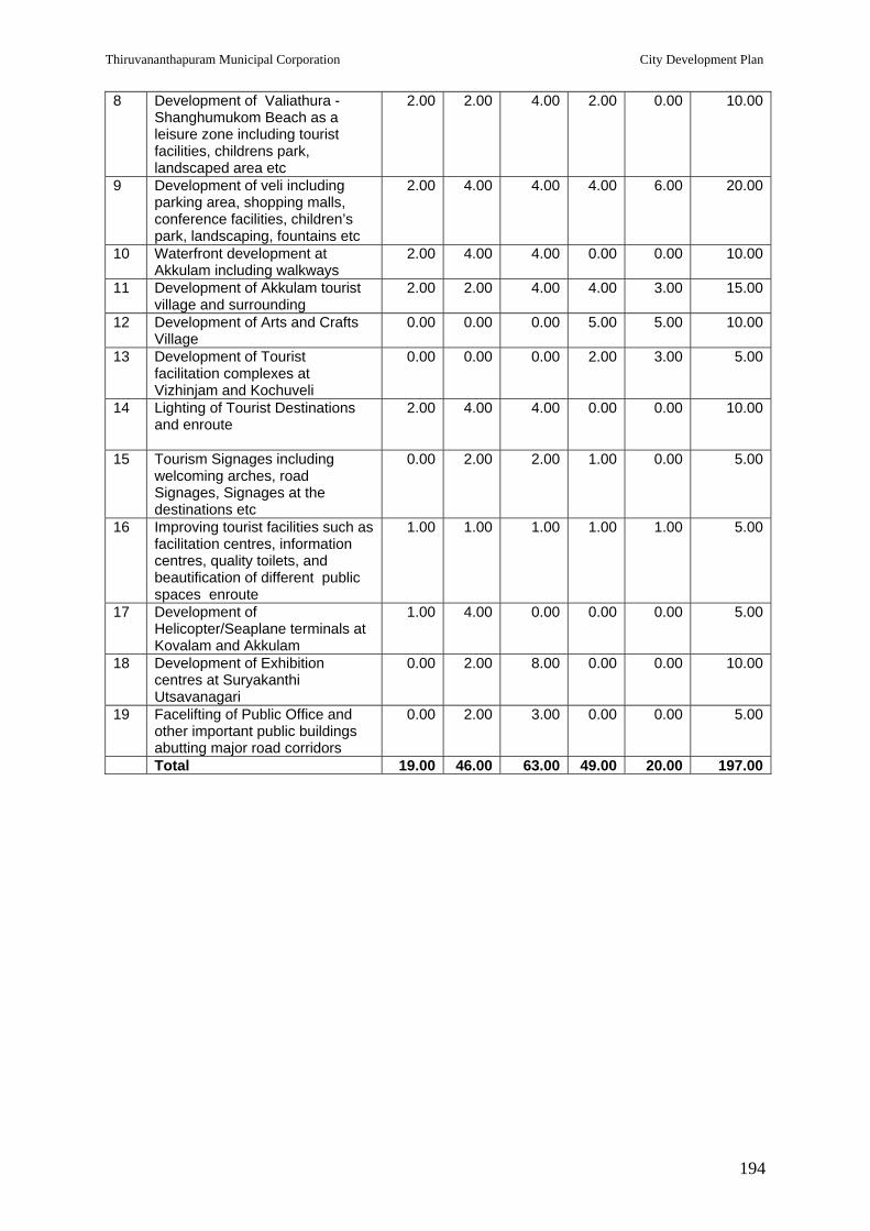
Thiruvananthapuram Municipal Corporation City Development Plan
194
8 Development of Valiathura -Shanghumukom Beach as a leisure zone including tourist facilities, childrens park, landscaped area etc
2.00 2.00 4.00 2.00 0.00 10.00
9 Development of veli including parking area, shopping malls, conference facilities, children’s park, landscaping, fountains etc
2.00 4.00 4.00 4.00 6.00 20.00
10 Waterfront development at Akkulam including walkways
2.00 4.00 4.00 0.00 0.00 10.00
11 Development of Akkulam tourist village and surrounding
2.00 2.00 4.00 4.00 3.00 15.00
12 Development of Arts and Crafts Village
0.00 0.00 0.00 5.00 5.00 10.00
13 Development of Tourist facilitation complexes at Vizhinjam and Kochuveli
0.00 0.00 0.00 2.00 3.00 5.00
14 Lighting of Tourist Destinations and enroute
2.00 4.00 4.00 0.00 0.00 10.00
15 Tourism Signages including welcoming arches, road Signages, Signages at the destinations etc
0.00 2.00 2.00 1.00 0.00 5.00
16 Improving tourist facilities such as facilitation centres, information centres, quality toilets, and beautification of different public spaces enroute
1.00 1.00 1.00 1.00 1.00 5.00
17 Development of Helicopter/Seaplane terminals at Kovalam and Akkulam
1.00 4.00 0.00 0.00 0.00 5.00
18 Development of Exhibition centres at Suryakanthi Utsavanagari
0.00 2.00 8.00 0.00 0.00 10.00
19 Facelifting of Public Office and other important public buildings abutting major road corridors
0.00 2.00 3.00 0.00 0.00 5.00
Total 19.00 46.00 63.00 49.00 20.00 197.00

Thiruvananthapuram Municipal Corporation City Development Plan
195
12.0 SOCIAL INFRASTRUCTURE
12.1 DEVELOPMENT OF MARKETS
A. Existing Market Activities in the City
There are two distinct locational factors which influence the market activities in
Thiruvananthapuram City. One is that the city is in the border district with the neighbouring
State of Tamil Nadu and the second is that Thiruvananthapuram is the mother city catering
to the service needs of a vast hinterland region consisting of the towns of Nedumangad,
Neyyattinkara, Attingal and Varkala.
The city has historically been acting as the collection and distribution centre of hill produces,
agricultural produces, consumer goods, fish and construction materials. In spite of
improvements in road and rail transport facilities, the status of Thiruvananthapuram as the
market centre for the wide region around continues.These markets though not located in
slums mainly benefit the urban poor category by way of getting access to improved facilities
as well as accommodating the informal sector market activities which calls for priority.
B. Existing Markets for Agricultural Produces
Unpublished studies conducted earlier by Thiruvananthapuram Development Authority and
by the Department of Agriculture, Kerala have exposed that nearly 70 per cent of the
agricultural produces consumed in the city region arrive from the neighbouring states of
Tamil Nadu, Karnataka and Andhra Pradesh. Vegetables and fruits mainly arrive from Tamil
Nadu and Karnataka. Flowers arrive in huge quantities from these two states. Grains and
pulses arrive mainly from Tamil Nadu and Andhra Pradesh.
The main agricultural produces market in the city is in Chalai area. Chalai main bazar road
has one side road exclusively dealing with grains & pulses. Another side road deals with
vegetables and fruits. The third side road has concentration of shops dealing with iron &
steel and other building materials. In the absence of exclusive areas earmarked for flowers,
this activity spreads to the narrow sub lanes inconveniencing pedestrian movements and
other activities. The main bazar road has a mix of all kinds of trades without any
specialisation.
The first side road is known as ‘Rice Bazar Road’ and the second side road is called
‘Vegetable Market Road’. One feature of the marketing activities here in Chalai is that both
whole sale and retail activities are mixed. Chalai market continues to be the prime market in
the city. The agricultural market network in the city is outlined below:
Main Market at Chalai;

Thiruvananthapuram Municipal Corporation City Development Plan
196
Sub-Market at Palayam; Sub-Market specialised in Plantains at Manacaud; Zonal markets at Vattiyoorkavu, Peroorkkada, Pettah, Thirumala and Poojappura; Vendor markets at Karamana, Kuravankonam; Informal roadside markets at Vazhuthacaud, Kaithamukku, Kesavadasapuram,
Manacaud, Pettah, Secretariat (Chengalchoola) & Kumarapuram; Vegetable & fruit stalls in various housing colonies; and Vendors carrying basket loads as head load or in bicycles to households.
It is roughly estimated that about 200 tons of vegetables & fruits are transacted in the city
everyday. The locally grown vegetables and fruits contribute to only 30% of the whole trade.
The market for rice and pulses are supported by FCI. However, the main player is the private
wholesale dealers who procure rice and other cereals and pulses from other states in the
country.
C. Earlier Market Development Activities
(a) The Department of Town Planning had prepared a Detailed Town Planning Scheme for Chalai area. This DTP scheme approved by Government envisaged development of a parallel road to Chalai bazar road (Chalai by-pass) and acquisition and development of new markets by the side of this road.
The State PWD has since formed this road and the TRIDA has acquired land received for market development. This land is low lying vacant; perhaps some additional land required for market development is yet to be acquired. Steps are in process for the acquisition of 1.50 acres. TRIDA has in possession 5.0 acres of vacant land.
(b) The Department of Agriculture had in 1995 received assistance from the European Economic Community (EEC) for agricultural market development. It was decided to develop wholesale agricultural produces markets in Thiruvananthapuram, Kochi and Kozhikode. Based on some studies, it was decided to construct a major market in the above 3 cities and sub markets in one of the peripheral towns of the cities. In Thiruvananthapuram, the main market was constructed at Anayara by the side of NH by-pass and the sub market in Nedumangad town. The wholesale agricultural produces market constructed at Anayara is only partially operating due to various reasons.
(c) Thiruvananthapuram Municipal Corporation has taken steps to improve the zonal markets at Thirumala, Pettah, Peroorkkada & Vattiyoorkavu. TMC has also carried out improvements to sub-zone markets at Karamana, Kuravankonam, Anayara.
Projects Identified and Costing
The Chalai main market is far too congested
without adequate pedestrian facilities, facilities for
petty vendors, carriageways blocked by haphazard
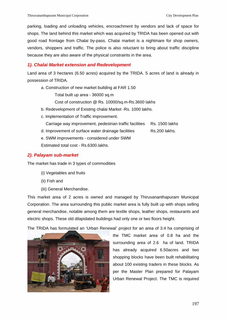
Thiruvananthapuram Municipal Corporation City Development Plan
197
parking, loading and unloading vehicles, encroachment by vendors and lack of space for
shops. The land behind this market which was acquired by TRIDA has been opened out with
good road frontage from Chalai by-pass. Chalai market is a nightmare for shop owners,
vendors, shoppers and traffic. The police is also reluctant to bring about traffic discipline
because they are also aware of the physical constraints in the area.
1). Chalai Market extension and Redevelopment
Land area of 3 hectares (6.50 acres) acquired by the TRIDA. 5 acres of land is already in
possession of TRIDA.
a. Construction of new market building at FAR 1.50
Total built up area - 36000 sq.m
Cost of construction @ Rs. 10000/sq.m-Rs.3600 lakhs
b. Redevelopment of Existing chalai Market -Rs. 1000 lakhs.
c. Implementation of Traffic improvement.
Carriage way improvement, pedestrian traffic facilities Rs. 1500 lakhs
d. Improvement of surface water drainage facilities Rs.200 lakhs.
e. SWM improvements - considered under SWM
Estimated total cost - Rs.6300.lakhs.
2). Palayam sub-market
The market has trade in 3 types of commodities
(i) Vegetables and fruits
(ii) Fish and
(iii) General Merchandise.
This market area of 2 acres is owned and managed by Thiruvananthapuram Municipal
Corporation. The area surrounding this public market area is fully built up with shops selling
general merchandise, notable among them are textile shops, leather shops, restaurants and
electric shops. These old dilapidated buildings had only one or two floors height.
The TRIDA has formulated an ‘Urban Renewal’ project for an area of 3.4 ha comprising of
the TMC market area of 0.8 ha and the
surrounding area of 2.6 ha of land. TRIDA
has already acquired 6.50acres and two
shopping blocks have been built rehabilitating
about 100 existing traders in these blocks. As
per the Master Plan prepared for Palayam
Urban Renewal Project. The TMC is required
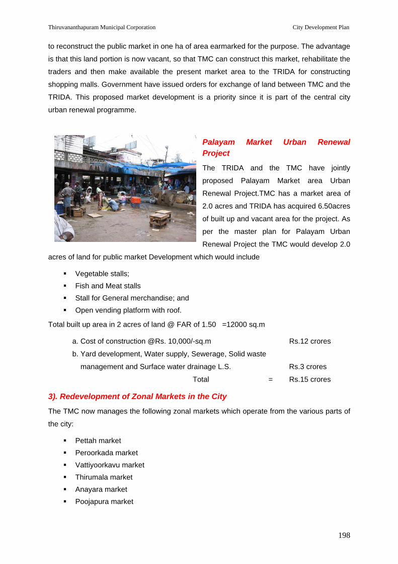
Thiruvananthapuram Municipal Corporation City Development Plan
198
to reconstruct the public market in one ha of area earmarked for the purpose. The advantage
is that this land portion is now vacant, so that TMC can construct this market, rehabilitate the
traders and then make available the present market area to the TRIDA for constructing
shopping malls. Government have issued orders for exchange of land between TMC and the
TRIDA. This proposed market development is a priority since it is part of the central city
urban renewal programme.
Palayam Market Urban Renewal Project
The TRIDA and the TMC have jointly
proposed Palayam Market area Urban
Renewal Project.TMC has a market area of
2.0 acres and TRIDA has acquired 6.50acres
of built up and vacant area for the project. As
per the master plan for Palayam Urban
Renewal Project the TMC would develop 2.0
acres of land for public market Development which would include
Vegetable stalls; Fish and Meat stalls Stall for General merchandise; and Open vending platform with roof.
Total built up area in 2 acres of land @ FAR of 1.50 =12000 sq.m
a. Cost of construction @Rs. 10,000/-sq.m Rs.12 crores
b. Yard development, Water supply, Sewerage, Solid waste
management and Surface water drainage L.S. Rs.3 crores
Total = Rs.15 crores
3). Redevelopment of Zonal Markets in the City
The TMC now manages the following zonal markets which operate from the various parts of
the city:
Pettah market Peroorkada market Vattiyoorkavu market Thirumala market Anayara market Poojapura market

Thiruvananthapuram Municipal Corporation City Development Plan
199
TMC has been carrying out improvement projects in
the above markets; though the improvements carried
out are inadequate, since the people feel that
improved and enlarged informal sector marketing
facilities are required in these markets, to cater to the
needs of the less affordable low and middle income
customers. TMC proposes to improve these markets
and also to build a few markets, to provide for paved yard with roof for vendors, goods yard
drainage, washing facilities and toilet. Single storied facilities are sufficient for these vendors.
However in order to make the projects viable, shop buildings are also proposed.
4). Wayside Markets
The lower level of marketing of vegetables, fish and fruits is to carry them in pushcarts to
specific locations by the side of important road margins. In most of the cases, it is seen that
these pushcarts do not move eventually and they are slowly made permanent stalls. Another
prevalent method is to bring baskets of vegetables, fish and fruits by small time vendors and
to squat on the road margins to do brisk business during the morning hours or in the evening
hours. Such morning / evening bazaars operate in a few locations on the road margins on a
daily basis. These informal markets affect the pedestrians and automobile traffic. However
these markets are looked upon as a facility by the people. Therefore, TMC has to provide
organized spaces for such informal markets in various locations within the city. (Informal
roadside markets at Vazhuthacaud, Kaithamukku, Kesavadasapuram, Manacaud, Pettah,
Secretariat (Chengalchoola) & Kumarapuram).
The cost estimate of this is considered under Basic Services to the Urban Poor.
5). Development of zonal markets
TMC has proposals to develop the following existing markets, which are managed by TMC.
Name of Market Project cost
Main Markets
1. Manacaud market Rs.10.00crores
2. Peroorkada market Rs.1.50crores
3.Vattiyurkkavu market Rs.5.00crores
4.Punnakkamughal market Rs.2.00crores
5. Pettah market Rs. 2.00crores
Total Rs.20.50 crores
Thiruvananthapuram Municipal Corporation City Development Plan
200
Small Markets
1. Ulloor Market
2. Sreevaraham Market
3. Kadakompally Market
4. Poonkulam Market
5. Kuravankonam Market
6. Pachalloor Market
7. Mannanthala Market
8. Pongumudu Market
9. Poonthura Market
10. Vallakkadavu Market
11. Valiyathura Market
12. Thirumala Market
13. Poojapura Market
@ Rs.10 lakhs each Rs.1.30 crores.
Total Cost Rs.21.80crores
6). Wholesale Market for Fish
Thiruvananthapuram has a major fish wholesale market at Pangode. Fish are transacted
here everyday. Fish is brought here in trucks from Vizhinjam (fishing harbour) in
Thiruvananthapuram district, Neendakara (fishing harbour) in Kollam district, Alappuzha and
from Mangalore, in Karnataka. About 25 truck loads of fish reach everyday.
This fish market lacks adequate space for loading and unloading, parking space for trucks,
cars, mini vans, motor cycles and cycles of traders and primary consumers. The wholesale
fish market also has a retail part, where lower level individual fish vendors operate.
The requirements for improvement of the fish market are listed below:
a. Auction platforms for wholesale trade;
b. Trade cubicles for negotiating sale;
c. Waiting area for traders;
d. Loading and unloading facilities;
e. Parking space for trucks;
f. Space for truck / booking agencies;
g. Dormitory and toilet facilities for truck operators;
h. Retail trading space;

Thiruvananthapuram Municipal Corporation City Development Plan
201
i. Cold storage facility;
j. Space for safe keeping of fish trading baskets and other materials/ equipments of traders;
k. Parking space for small vehicles of traders and consumers;
l. Facilities washing, drainage, fur fighting, etc.; and
m. Environmental Engineering.
TMC has arranged for preparation of a Project Design and Report through consultancy
services. It is estimated that the project cost may be Rs.1100 lakhs.
Redevelopment of whole sale fish market at Pangodu
Total cost of Redevelopment as per the project report already prepared = Rs.12 crores.
7). Building Material Market
The TMC area has witnessed unprecedented construction boom in the last decade. It is
expected that with the pace of development activities projected for the city and surrounding
areas, the construction sector would be further strengthened. Large quantities of building
materials are brought in to the city. The city at present does not provide adequate space or
storing and trading such materials.
Two kinds of space requirements are posted:
Shop spaces for materials like sanitary wares, flooring and wall tiles, plumbing materials, etc.
Yard space for heavy space intensive building materials like sand, crushed metal, rubble, steel, bricks, cement, etc.
Built space for the first variety of construction materials are provided by private traders. But
open land, truck parking facilities, toilet facilities for the crew, trading space, storage
facilities, etc. for the second variety of materials are generally not available within the city.
Therefore, at many places traders and truck operators make use of road space for parking of
vehicles and for striking deals with consumers. This obstructs traffic flow along these
corridors. The police are constantly driving these traders away from the road margins, often
resulting in quarrels and bribing. This situation can be averted only if the Corporation is able
to provide space required for such trading. This is the lifeline of the construction sector and
therefore it is necessary to formalize trading in bulk building materials.
The proposal is to plan an open yard at various locations in the city for building materials
market supported by adequate amenities required for the traders, truck operators and the
consumers.

Thiruvananthapuram Municipal Corporation City Development Plan
202
Construction of building Material Markets
4 numbers at 4 different locations in the city.
a) Ulloor
b) Ambalathara
c) Peroorkada
d) Pappanamcodu
Cost of construction (excluding land cost) :Rs. 300 lakhs each
Total cost = Rs.12 crores
Total Cost for Market Development
Chalai Market extension and Redevelopment - Rs.63 croress Palayam Market Urban Renewal Project - Rs.15crores Development of zonal markets - Rs.21.80crores Redevelopment of whole sale fish market at Pangodu - Rs.12 crores Construction of building Material Markets - Rs.12 crores
Grand Total = Rs.123.80 crores
In public markets, part of the area may be occupied by shopping complexes. This area is not included under the project. Only marketing stalls & yards, where the poor vendors temporarily occupy spaces to trade their wares brought in baskets, are included. In addition public toilets, storage facilities, if any required, water supply etc. are proposed to be included in the project.Most of these facilities would be auctioned out to the private sector for upkeep and maintenance.
Phasing of projects under Market Development (Rs. Crores)
Table 12.1: Phasing of Projects under market development Sl. No
Market 2006-07
2007-08
2008-09
2009-10
2010-11
Total Remarks
1 Chalai Market Development
- 10 20 20 13 63
2 Palayam Renewal Project
- 5 5 5 - 15 Land
ac
quire
d by
TR
IDA
3 Zonal Markets – Main markets
1 5 6 6 3.5 20.5
4 Zonal Markets- Small Markets
- 0.5 0.8 - - 1.3
5 Wholesale fish market at Pangodu
1 1 3 3 3 11
Land
av
aila
ble
with
C
orpo
ratio
n
6 Building Materials Market
- 2 3 3 4 12 Land to be mobilised
Total 2 23.5 37.8 37 23.5 123.8

Thiruvananthapuram Municipal Corporation City Development Plan
203
12.2 Service Abattoirs within the City Thiruvananthapuram city area of 141.74 sq km accommodating a population of 7.44 lakhs is
at present served by only one Service Abattoir, maintained by the City Corporation. This is
wholly inadequate. Providing ‘service abattoirs’ is one of the mandatory responsibilities of
Thiruvananthapuram Municipal Corporation. Service Abattoirs run under the supervision of
the health wing of the TMC and closely monitored and certified by Veterinary Surgeon
ensure hygienic meat to the citizens.
The present service abattoir at Kunnukuzhy is able to provide service to less than 20 percent
of the requirement of the city. It is estimated that on an average only 20 large animals and
50 small animals (goats) are brought to this abattoir, giving out less than 3000 kg. of meat,
whereas the average daily meat requirement in the city is about 10000 kg.
Due to non availability of service abattoirs in close proximity, unauthorized killing of animals
for meat is very prevalent in the city. In such centres killing of animals and collection of meat
is going on in unhygienic environs. The animals procured for killing are not examined for
illness or contamination. Moreover, the waste generated in the operation is haphazardly
strewn around with general garbage. This spoils the city environment. The situation in
Thiruvananthapuram is that the meat seller himself is the meat producer. He procures the
animals, takes them to the service abattoir maintained by the TMC and the staff in the
abattoir prepares the animals. The meat produced is collected by the seller on payment of
service charges prescribed by the TMC. He himself transports the meat to his shop for
selling to the consumers.
Based on the stipulations issued by the Supreme Court of India, Government of India has
issued guidelines with regard to killing of animals for meat, transport of meat, and for storage
of meat for sale. But these instructions are rarely followed. Any PIL pointing out specific
instances may lead to litigation against the TMC. To avoid such unpleasant happenings, the
TMC is duty bound to make arrangements for hygienic facilities for meat production.
Government has a responsibility on the health of the people. The LSGI has the responsibility
for overseeing health affairs and ensuring that the food consumed in the city by the people
are not contaminated. If the citizens have to get hygienic meat produced under the
supervision of veterinarians, the TMC has to construct 5 more abattoirs at different locations
in the city.
Construction of partially mechanized modern abattoirs in the different identified zones in the
city may considerably reduce ‘unauthorised slaughtering’. Such modern abattoirs shall have
the following facilities:

Thiruvananthapuram Municipal Corporation City Development Plan
204
Clean built space with regular washing and cleaning arrangements Lairage where animal are kept waiting (it is stipulated in the guidelines that the
animals waiting should not see an animal being stunned and killed) Stun gun Bleeding chamber and arrangement for collecting blood Hoisting equipment and rails, to ensure the animals are not dragged on the floor and
also to facilitate the workmen (butchers) to stand by the side of the carcass for beheading, embowelling, dehiding, removal of horns and hoof, cleaning etc.
Collection arrangement for disembowelled waste, viscera, hides, horns & hoof Segregated clean areas after the above unclean operations Cleaning with warm water (boilers) Cutting and collection of meat Storage facility for meat Delivery counters and office space Veterinarians chamber with changing rooms and wash rooms Staff changing and wash rooms and staff resting rooms Sanitary waste disposal arrangements, including incinerators
Separate abattoir chamber have to be provided for small animals (goats) and large animals
(oxen).
The TMC proposes that the existing abattoir at Kunnukuzhy may be modernized. In addition
construction of new abattoirs at the following locations is proposed:
Ambalathara; Kadakampally / Attinkuzhy; Kunchalummoodu; and Kudappanakunnu Nemom
In all the above locations the TMC hopes to provide adequate land required for construction
of abattoirs. It is hoped that with the TMC effort in making available the facility of service
abattoir close to the places where unauthorized slaughtering is going on in a big way, it
should be possible to considerably reduce the problem of unauthorized slaughtering.
The infrastructure for abattoirs would be created by the TMC and the operation and maintenance would be leased to selected operators on payment of annual fee. These operators would employ butchers and cleaning staff. Abattoir is a must service facility to be provided by the TMC to ensure safe meat to the citizens and to prevent the unhealthy practice of unauthorised slaughtering.

Thiruvananthapuram Municipal Corporation City Development Plan
205
Broad Costing
a. Modernisation of existing Abattoir at Kunnukuzhy: Rs.1crores
b. Construction of 5 new abattoirs: Rs. 7.50 crores
c. Procurement of refrigerated Meat Vans
Five numbers @ Rs. 10 lakhs each Rs.0.50 crores
Total Cost for six modern abattoirs Rs.9.00crores
Phasing of projects (Rs. Crores)
Table12.2: Phasing of projects under service abattoirs Sl. No
Abattoirs 2006-07
2007-08
2008-09
2009-10
2010-11
2011-12
Total
1 Modernisation of existing Abattoir at Kunnukuzhy
- 1.00
1.00
2 Construction of 5 new abattoirs
- 2.00 2.50 2.00
1.00 7.50
3 Procurement of refrigerated Meat Vans (five numbers)
- 0.50
0.50
Total
1.00 2.50 2.50 2.00
1.00 9.00
12.3 CREMATION GROUNDS Providing public cremation grounds within the city is one of the responsibilities of the TMC.
The need for such facility becomes essential when the percapita availabilty of land in the city
gets reduced every year. For a city of 141.74 sq.km accommodating a population of 7.44
lakhs (2001), the TMC maintains just 2 cremation grounds – one at Thycaud and the other at
Puthenkottah.
The TMC has undertaken reconstruction of Thycaud Crematoria, providing three electric
furnaces and other allied facilities. The cremation ground at PuthenKottah, perhaps the
oldest in the city, still functions without any improvement and is operated with fire wood or
coconut husk burning, polluting the densely populated residential area around.
In different parts of the city, specific communities / castes own land, which are used for
decades as cremation grounds. They are functioning without any regulations or TMC
interventions, with regard to pollution etc. Perhaps, with some financial subsidy for
improvement, these private cremation grounds can be made to provide enclosed furnaces
with non polluting fuel, high smoke flues, water & electricity facilities and landscaped

Thiruvananthapuram Municipal Corporation City Development Plan
206
premises. Technical assistance can be provided by the TMC. These cremation grounds
would continue to be under private operation.
A few of the slum areas also have small cremation grounds within the slum area. They do
not have walled enclosures, water supply or buffer planting. These can be provided to
improve livability in the slum areas
The project components include:
i. Improvements/modernisation of Thycaud Crematorium : Rs 1crores
ii. Improvements to Puthenkottah Public Crematorium : Rs 1.50crores
iii. Subsidy to improve community cremation grounds
with specific projects with matching resource from
the community : Rs 4.crores
iv. Improvements to crematoria in slum areas : Rs 2crores
Sub total of project cost : Rs 8.50 crores
Phasing of projects (Rs. Crores)
Table 12.3: Phasing of projects under cremation grounds Sl. No
Cremation Grounds 2006-07
2007-08
2008-09
2009-10
2010-11
2011-12
Total
1 Improvements/ modernisation of Thycaud Crematorium
- 1.00 1.00
2 Improvements to Puthenkottah Public Crematorium
- 1.50 1.50
3 Subsidy to improve community cremation grounds with specific projects with matching resource from the community
- 1.00 1.00 1.00 1.00
4.00
4 Improvements to crematoria in slum areas
- 1.00 1.00 2.00
Total 2.00 3.50 1.00 1.00 1.00 8.50
12.4 EDUCATION Kerala has achieved a high literacy rate of 90.92% (Census 2001) as against an all India
average of 65.38%. Literacy rate of Thiruvananthapuram district is 89.22%. 57% of primary
school students study in government schools, 21% primary students depends on aided
schools and the remaining 22% depend on unaided schools (Vikasana Rekha 2002-07 of
TMC).

Thiruvananthapuram Municipal Corporation City Development Plan
207
Adult Literacy Programme is being effectively implemented. Findings from the baseline
survey reveal that of the total respondents, there are 12% illiterate women and 8% illiterate
men. Majority illiterates are from the poor category. Schools exhibit a healthy enrolment and
retention rate up to secondary education; however, from the higher secondary level the
dropout rate is high, especially among the poor.
The Grandhasala Movement had taken roots years back and has grown ever since. In every
village, in almost all the wards of panchayats, there is invariably at least one library and a
reading room. The State Central Library, which came into existence in 1829, has a sizable
collection of valuable books and periodicals. The British Council Library and the University
Library are the other two important libraries helping in study and research notable for
reference, in the city.
Thiruvananthapuram is a major academic hub. The University of Kerala is located here. The
city also has several professional education institutions including 15 engineering colleges, 3
medical colleges, 2 ayurveda colleges, 2 law colleges, 1 homeopathic college, 2 nursing
colleges, 1 dental college, 2 MCA college, I music college, 3 teacher education college , 1
agricultural college and 5 poly technic colleges. Thiruvananthapuram Medical College, the
premier health institute of the state is also ranked as one of the finest in the country. The
College of Engineering, Thiruvananthapuram is one of the prominent engineering institutions
in the country. The Asian School of Business and IIITM-K are two of the other top class
institutions in the city, both situated inside Technopark. The number of Arts and Science
colleges in the district is 20 and the strength of students is estimated to be 15,926. The
University of Kerala has its research and higher education centres at Kariavattom, 20 km
north of the capital city. There are 41 teaching and research departments in the University.
Colleges from Thiruvananthapuram, Kollam, Alappuzha and Pathanamthitta districts
numbering 87, are affiliated to the University. The Sree Sankaracharya University of
Sanskrit with Kalady as headquarters, has its regional centre in Thiruvananthapuram and
offers courses at degree and post graduate levels.
There are about 900 schools in Thiruvananthapuram district. The public schools are run
directly by the state government and follow the syllabus prescribed by the state government.
In addition to this there are also four Kendriya Vidyalayas run directly by the central
government, which follow the CBSE syllabus and private schools run by educational trusts or
boards which follow CBSE and/or ICSE syllabus. An international school is also located in
the suburbs.

Thiruvananthapuram Municipal Corporation City Development Plan
208
12.5 HEALTH Kerala has the most extensive medical infrastructure among all states in India. In
Thiruvananthapuram, apart from the major health institutions in the Government set up like
Medical College, Sree Chithra Thirunal Institute of Science and Technology, Regional
Cancer Centre, Ayurveda Medical College and Homeo Medical College,
Thiruvananthapuram there are a number of private health care institutions which cater to the
curative needs of a large number of people from the city and outside. The other health
institutions in public sector which are managed by the Municipal Corporation include the
following
5 Hospitals - Peroorkada taluk headquarters hospital , Fort hospital, Nemom hospital, Iranimuttam hospital and Sidha hospital, Vallakadavu.
2 Government dispensaries of modern medicine – one at Valiyathura and one at Karamana.
5 Primary Health Centres at Poonthura, Veli, Kadakampally, Ulloor and Thiruvallam. 20 Maternity & Child Welfare Centres (MCWs) at Palkulangara, Perunthanni,
Kalippankulam, Chackai, Pettah, Valiyathura, Sankumugham, Attukal, Vettucad, Ambalathara, Poonthura, Thrikannapuram, Kanjirampara, Vattiyoorkavu, Karamana, Secretariat, Kamaleswaram, Kannamoola, Barton hill and Bheemapally.
Apart from the allopathic health facilities, alternate medicine has its presence in the form of
7 ayurvedic dispensaries at Poojapura, Kalady, Kadakampally, Ulloor, Nemom, Secretariat and Attipra.
7 homeo dispensaries at Valiyavila, Muttathara, Kadakampally, Thiruvallam, Nemom, Beemapally and Attipra.
The Primary Health Centres (PHCs) and Maternity & Child Welfare Centres (MCWC) cater
to the primary health care of the population. The PHCs have reasonable staff strength and
facilities and are providing good service. The condition of MCWCs is not satisfactory. Each
MCWC has one Junior Public Health Nurse (JPHN) and one attender/ sweeper. Moreover
most of the JPHNs also function as Community Organizers of the Kudumbashree project.
There is no Medical Officer in the MCWC as there is only one post for all the 20 MCWC and
its functioning is intermittent and not capable of satisfying the health needs of the people.
Health care infrastructure needs to be strengthened.
12.6 LEISURE & RECREATION Leisure: Thiruvananthapuram City is one of the important centres of recreational activities in
the Thiruvananthapuram district. Zoo, Museum, Art Gallery, Parks in the Water Works
compound, Science & Technology Museum, Kanakakkunnu Palace, Sanghumugham
Beach, Veli Lake, Putharikandam Maidanam etc are the major recreation centres in the city.

Thiruvananthapuram Municipal Corporation City Development Plan
209
There are 29 cinema houses in the city. Most of the cinemas and other multipurpose halls
are located within the central zone of the city.
In the city region, the total extent under organised parks and play areas amounts to 52
hectares for 9.07 lakhs population. This works out to only about 0.06 hect/1000 population,
against a recommended standard of about 1.50 hectare per 1000 population. (i.e. 10 percent
of the city area)
There are good number of Kalyanamandapams (wedding halls) in the City Region. Tagore
Theatre, V.J.T Hall, Priyadarsini hall and a few other auditoria are other places of
congregation in the city.
The city does not have a civic centre accommodating big and small conference venues,
catering facilities, business venues, exhibition halls, press rooms etc. Similarly,
Thiruvananthapuram city also does not have a good convention centre, where state level,
national level and international levels conventions can be hosted.
The city lacks organised parks and open spaces. Details of existing open spaces are as
given below:
1. Organised open spaces and parks 56 ha
2. Stadium 10 ha
3. Open spaces attached to major institutions 62 ha
4. Uncultivable paddy fields 650 ha
Leisure and recreation facilities are proposed to be developed and maintained through private sector participation. The support of local Residents’ Associations, which are now municipal recognised bodies, would be sought for this. These possibilities would be detailed out when preparing DPR.
12.7 SPORTS
The most popular sports are football and cricket. Basketball, badminton and volleyball are
also popular, mostly in schools. The Kerala Cricket Association (KCA) is Head Quartered in
Thiruvananthapuram. The HQ complex of KCA, has training facilities including two practice
turfs with nets, bowling machines, gymnasium with multi-gym and equipment for aerobic
training, lecture hall and library, an astro-turf indoor coaching facility, fully furnished
accommodation for coaches and players, a physiotherapy clinic, functional office facilities
and guest rooms. KCA has decided to establish an international cricket stadium in the city
suburbs. Chandrasekharan Nair Stadium is a prominent football stadium and has hosted
both national and international matches. The facilities available are inadequate to host

Thiruvananthapuram Municipal Corporation City Development Plan
210
national events. The University stadium has hosted two international cricket matches. This
stadium is under University of Kerala and is equipped with synthetic tracks for athletics and
games.
The Jimmy George Sports Complex, the GV Raja Sports School and Lakshmi Bhai National
College for Physical Education (LNCPE) are the other major sports establishments in the
city. The city also has a Golf Club, one of the oldest in India, and a Tennis Club (Trivandrum
Tennis Club/TTC) both located at Kaudiar. The golf course is widely accepted as the oldest
course outside Great Britain.
The city fields two football clubs SBT-Trivandrum and Titanium, both in the second division
of the National Football League.
12.7.1 KEY ISSUES AND CHALLENGES:
Eventhough the status of the sectors under social infrastructure such as education, health
etc are discussed in this chapter, detailed studies have to be conducted for identifying the
issues pertaining to each of these sectors. While preparing Development Plan for the City,
all these issues need to be addressed coming out with suitable suggestions in consultation
with the departments concerned. However, the glaring issues under sports sector have been
highlighted here.
12.7.2 Sports Sector
In Thiruvananthapuram the infrastructure available for development of sports sector is far
below the required standards. There is no stadium satisfying International standards to
conduct International events. This is a major lacuna which if addressed properly would not
only solve this problem in the sports sector but also lead to enhancement in the quality of
basic infrastructure including promoting of Tourism which would boost the economic base of
Kerala in general and Thiruvananthapuram in particular.
The following projects need to be taken up on priority basis with a view to elevate the status
of sports sector in Thiruvananthapuram.
1. Provision of standard 8 lane synthetic track for the Central Stadium and the Chandrasekharan Nair Stadium
2. Pavilion to the Central stadium (including changing rooms, dormitories and hall for indoor games)
3. Board of Control for Cricket in India (BCCI) may be able to partly finance if land required for the stadium can be made available for constructing International Standard Cricket Stadium (25 to 30 acres of land is required).
4. Provision of playfields, volley ball, basket ball and Kabadi courts can be considered in housing colonies.

Thiruvananthapuram Municipal Corporation City Development Plan
211
5. Swimming pool under KWA premises may be improved and retained for district and state level events and for trainers. The city shall have a major swimming pool complex with practice pool, major event pools, ancillary facilities etc for holding national and international events. Suitable site in the city suburbs can be located for the purpose.
6. The indoor stadium at Sanghumugham housed in a prestigious building needs to be improved with quality infrastructure.
7. The Kerala Olympic Association requires a training hostel.
8. Renovation of Jimmy George Stadium is necessary to make it fit for international standard Table Tennis, Ball Badminton, Shuttle Badminton etc.
With in the frame work of the guidelines under JNNURM the following projects need to be taken up on a priority basis for which costing has been incorporated.
1. Shankumugham Beach Development (Rs. 4 crores).
2. Development of selected school playgrounds as community open spaces (6 crores).
3. Development of selected neighbourhood level/zone level open spaces (5 crores).
Total = 15 crores
Table 12.4: Phasing of projects under Leisure and Recreation Sl. No
Leisure and Recreation 2006-07
2007-08
2008-09
2009-10
2010-11
2011-12
Total
1 Shankumugham Beach Development
0.4 0.8 1.2 0.8 0.4 0.4 4.0
2 Development of selected school playgrounds as community open spaces
0.6 1.2 1.8 1.2 0.6 0.6 6.0
3 Development of selected neighbourhood level/zone level open spaces
0.5 1.0 1.5 1.0 0.5 0.5 5.0
Total 1.5 3.0 4.5 3.0 1.5 1.5 15.0
Grand Total under social infrastructure = 156.30 crores