pp2o assessment of environmental effects (aee ... · pp20 assessment of environmental effects (aee)...
TRANSCRIPT

PP2O Assessment of Environmental
Effects (AEE) - Terrestrial Ecology Report


PP20 Assessment of Environmental Effects (AEE) - Terrestrial Ecology Report
3-55537.62
22nd
February 2013 i
Contents
Executive Summary ...................................................................................................................... 1
1 Introduction .......................................................................................................................... 4
1.1 Purpose ........................................................................................................................ 4
1.2 Scope ........................................................................................................................... 4
2 Background .......................................................................................................................... 4
2.1 The Project ................................................................................................................... 4
3 Methodology ........................................................................................................................ 5
3.1 Overview....................................................................................................................... 5
3.2 Vegetation Survey ........................................................................................................ 6
3.3 Wetland Condition Assessment of the Railway Wetland ............................................... 6
3.4 Bird Survey ................................................................................................................... 8
3.5 Bat Survey .................................................................................................................... 9
3.6 Reptile Survey ............................................................................................................ 10
3.7 Native Frog Surveys ................................................................................................... 11
3.8 Invertebrate Survey .................................................................................................... 11
4 Ecological Description and Survey Results ..................................................................... 12
4.1 Overview..................................................................................................................... 12
4.2 Habitat Features of Recognised Ecological Significance ............................................. 12
4.3 Unregistered Sites Supporting Indigenous Vegetation ................................................ 13
4.4 Railway Wetland Condition Assessment ..................................................................... 15
4.5 Fauna ......................................................................................................................... 16
5 Legislative and Policy Considerations ............................................................................. 18
5.1 Resource Management Act (1991) and Proposed National Policy Statement on
Indigenous Biodiversity ........................................................................................................ 18
5.2 NZTA‟s Environmental Plan ........................................................................................ 19
5.3 The Wildlife Act 1953 .................................................................................................. 19
6 Assessment Criteria .......................................................................................................... 20
6.1 Regional Criteria ......................................................................................................... 20
6.2 Kāpiti Coast District Council Criteria ........................................................................... 21
6.3 Assessment of Ecological Values at the Site Level along the Alignment ..................... 22
6.4 Species Level Assessment Criteria ............................................................................. 22
7 Assessment of Ecological Values against Criteria .......................................................... 23
7.1 Significant Indigenous Vegetation and Significant Habitat of Indigenous Fauna ......... 23
7.2 Wetland Condition Assessment .................................................................................. 25
7.3 Species of Ecological Significance .............................................................................. 25
7.4 Maori Perspective on Ecological Values ..................................................................... 26
PP20 Assessment of Environmental Effects (AEE) - Terrestrial Ecology Report
3-55537.62
22nd
February 2013 ii
8 Nature and Significance of Effects ................................................................................... 27
8.1 Positive Effects ........................................................................................................... 27 8.2 Summary of Adverse Effects ....................................................................................... 27
8.3 Habitat Loss ................................................................................................................ 28
8.4 Hydrological Effects on the remaining the Ōtaki Railway Wetland and the Mary Crest
Bush and Wetland ............................................................................................................... 29
8.5 Habitat Fragmentation ................................................................................................ 30
8.6 Edge Effects Resulting from tree removal from the edges of bush habitat .................. 31
8.7 Effects on Individual Plant Species ............................................................................. 31
8.8 Effects on Individual Fauna Species ........................................................................... 31
8.9 Direct Effects on Wildlife Resulting from Construction Activities and the Provisions of
the Wildlife Act 1953 ............................................................................................................ 32
8.10 Effects of the NIMT ..................................................................................................... 32
9 Avoidance/Remediation/Mitigation of Effects .................................................................. 33
9.1 Approach .................................................................................................................... 33
9.2 Avoidance of Effects ................................................................................................... 33
9.3 Minimisation of effects ................................................................................................ 34
9.4 Offset .......................................................................................................................... 34
9.5 Landscape planting ..................................................................................................... 38
10 Conclusion ......................................................................................................................... 39
References
Appendix A - Maps
Appendix B - Figures
Appendix C - Photographs
Appendix D - Mary Crest Plant Species List
Appendix E - Wetland Record Sheets
Appendix F - Wetland Plot Sheets
Appendix G - Soil and Leaf Sample Analysis Data
Appendix H - Invertebrate Taxa List
PP20 Assessment of Environmental Effects (AEE) - Terrestrial Ecology Report
3-55537.62
22nd
February 2013 1
Executive Summary
The purpose of this report is to provide an assessment of effects on terrestrial, wetland and
riparian ecology of the proposed construction and operation of the Peka Peka to North
Ōtaki section of the Kāpiti Expressway ("Expressway") and associated works such as local
roads. The report will form part of the AEE that will accompany the Notices of Requirement
(NOR) for designation and consent applications. In order to construct this section of the
Expressway the North Island Main Trunk (NIMT) will need to be re-aligned in Ōtaki.
Consequently, this assessment of effects also considers the effect of the shift of the NIMT
on affected ecosystems.
The effects on aquatic ecosystems (rivers and streams) are described and assessed in a
separate report that has been prepared by Scott Larned of NIWA.
The assessment was based on the following:
• review of existing background information relating to the Project and Project Corridor
including: project plans, existing ecological reports and databases, aerial
photographs, the Operative and Proposed Kāpiti Coast District Plans and the
Greater Wellington Proposed Regional Policy Statement;
• vegetation survey;
• wetland condition assessment;
• bird survey;
• bat survey;
• reptile survey; and
• invertebrate survey.
Survey for native frog was not undertaken as the Project1 passes through an area that is
located outside the known range of all native frog species.
The review of existing information and survey results were used to assess the nature and
significance of effects on ecosystems and associated species, and to develop the
necessary measures to avoid, remedy and mitigate significant adverse effects. Liaison with
other disciplines within the Project team was a key part of developing suitable measures to
address adverse effects.
The ecological values of the sites affected by the Project were assessed against the criteria
contained in the Policy 22 of the Proposed Regional Policy Statement (Greater Wellington
Regional Council, 2010) and also section 8.3 c) of the Operative Kāpiti Coast District Plan;
and with reference to the Proposed National Policy Statement on indigenous Biodiversity
where appropriate. The Operative Regional Policy Statement (Greater Wellington, 1995)
1 The term “Project” is used to describe all aspects of the proposed works including the Expressway, the NIMT, and changes to local
roads.

PP20 Assessment of Environmental Effects (AEE) - Terrestrial Ecology Report
3-55537.62
22nd
February 2013 2
was also reviewed however the criteria contained within it relating to ecosystems are more
high level. Consequently, the more specific criteria contained in the Proposed Regional
Policy Statement were considered most appropriate for the purposes of this assessment.
At the species level the importance of individual flora and fauna species was assessed
against various published documents and papers that list threatened and at risk species.
Most of the Project footprint affects a highly modified landscape supporting little or no
indigenous vegetation and no significant habitat of indigenous fauna. There are however a
few areas of indigenous vegetation and habitats of indigenous fauna affected by the
alignment. There is one significant area of wetland located in Ōtaki (the Railway Wetland -
c.0.8ha) and more than half of it (c.0.5ha) will be lost to the Expressway footprint. 0.3ha of
the wetland will remain following construction. In addition, the edges of several remnants of
native bush will also be affected by the Expressway with a total area of c.0.5ha lost.
Although this is only a small area, these effects are more than minor and require mitigation
to compensate for their loss. One significant area of bush and associated wetland at Mary
Crest would have been significantly affected by the Expressway as it was originally
proposed in the early stages of the Project. However, the Expressway was subsequently
re-aligned to avoid this area.
The 0.3ha of the Railway Wetland that will remain following construction of the Expressway
will be rehabilitated. To offset the part of the Railway Wetland lost (c.0.5ha) it is proposed to
create two new areas of wetland within the designation (total area c.1.1ha). The largest of
these will be in the vicinity of Mary Crest (c.0.7ha) with another area, the Kennedy Wetland
(c.0.4ha), created in Ōtaki. Given the modified and human induced nature of the Ōtaki
Railway Wetland, the creation of wetland of similar ecological values (although not identical
values) to the wetland lost should be possible within a relatively short timeframe (2-3yrs).
Since the area created will be greater than the area lost, the no net loss in biodiversity
objectives contained within the Proposed National Policy Statement on Indigenous
Biodiversity and NZTA‟s Environmental Plan (Transit New Zealand, 2008) will be achieved
by the Project, and potentially there could be a net gain in biodiversity.
The loss of bush habitat will be mitigated either by planting new areas of bush or protecting
an existing area of bush that is threatened by on-going degradation in quality through
grazing and/or plant and animal pests. The preferred option is to protect and enhance an
existing area of bush in the vicinity of the Project. A site close to the Expressway where this
could be achieved is currently under investigation. However, if the implementation of this
option does not prove to be possible, there is an area of land within the designation and
adjacent to existing bush and wetland at Mary Crest that could be planted to create a new
area of bush and achieve suitable offset. Whichever option is adopted, it will be adequate to
meet the no net loss in biodiversity objectives contained within the Proposed National
Policy Statement on Indigenous Biodiversity and NZTA‟s Environmental Plan (Transit New
Zealand, 2008).
No threatened or at risk terrestrial or wetland species of flora or fauna were identified along
or immediately adjacent to the Project footprint, whose populations could be significantly
affected by the Project. No species specific mitigation is therefore necessary for threatened
or at risk species. (Note: this conclusion excludes freshwater fish and aquatic invertebrate
species which are dealt with in a separate report prepared by Scott Larned of NIWA).
PP20 Assessment of Environmental Effects (AEE) - Terrestrial Ecology Report
3-55537.62
22nd
February 2013 3
While no species specific mitigation is considered necessary for threatened or at risk
species of fauna, the provisions of the Wildlife Act 1953 still apply to any killing of wildlife to
which the Act applies, even non-threatened species. A permit is therefore likely to be
required from the Director-General of Conservation to undertake site clearance works in
advance of construction which may kill individuals of a native bird or reptile species. The
requirements that will need to be met for the granting of the permit will need to be
ascertained from the Director-General of Conservation prior to the start of construction
when permits are applied for. It is however expected that Director-General of Conservation
will take into account the expected insignificant effects on the populations of the species
that could be affected in determining the conditions which may accompany the granting of a
permit.
Recommendations have been made concerning minimising effects on one non-threatened
species - peripatus (a small worm-like creature with short legs of ancient origin). This has
been proposed as a precaution due to the taxonomy of the species being under review
which could result in new species being identified. Given that only a small proportion of the
affected habitat is being lost, the risk of significant impact on these animals is relatively low.
Overall, it is considered that, with proposed mitigation offsets undertaken the effects of the Project on terrestrial ecology will be minor. The proposed mitigation will ensure that there will be no net loss in ecological values.
The proposed re-alignment of the North Island Main Trunk will not affect any habitats or
species of ecological significance. The terrestrial ecology effects of the re-alignment are
therefore considered to be insignificant.
PP20 Assessment of Environmental Effects (AEE) - Terrestrial Ecology Report
3-55537.62
22nd
February 2013 4
1 Introduction
1.1 Purpose
The purpose of this report is to provide an assessment of effects on terrestrial, wetland and
riparian ecosystems of the proposed construction and operation of the Peka Peka to North
Otaki section of the Kāpiti Expressway and associated works such as local roads. The
report will form part of the AEE that will accompany the Notices of Requirement (NOR) for
designation and consent application. In order to construct this section of the Expressway
the North Island Main Trunk (NIMT) will need to be re-aligned in Ōtaki. Consequently, this
assessment of effect also needs to consider the effects of the NIMT on the relevant
ecosystems.
The effects on aquatic ecosystems (rivers and streams) are described and assessed in a
separate report that has been prepared by Scott Larned of NIWA.
1.2 Scope
This ecological assessment covers the following with respect to terrestrial, wetland and
riparian ecosystems:
• a description of the terrestrial, wetland and riparian habitats, and their associated
flora and fauna;
• an assessment of the ecological values of the habitats and species potentially
affected by the Project;
• details of the nature and scale of the Project‟s actual or potential adverse effects,
and the likely significance of those effects; and
• details of the measures necessary to avoid, remedy, mitigate or offset any effects.
2 Background
2.1 The Project
2.1.1 Main Alignment
The Wellington Northern Corridor RoNS runs from Wellington Airport to Levin and
completing it will assist regional and national economic growth. The Project is one of eight
sections of the Wellington Northern Corridor RoNS.
The NZTA proposes to designate land and obtain the resource consents to construct,
operate and maintain the Expressway. The Project extends from Te Kowhai Road in the
south to Taylors Road just north of Ōtaki, an approximate distance of 13km.
The Expressway will provide two lanes of traffic in each direction. Connections to local
roads, new local roads and access points over the Expressway to maintain safe
connectivity between the western and eastern sides of the Expressway are also proposed
PP20 Assessment of Environmental Effects (AEE) - Terrestrial Ecology Report
3-55537.62
22nd
February 2013 5
as part of the Project. There is an additional crossing of the Ōtaki River proposed as part of
the Project, along with crossings of other watercourses throughout the Project length. Maps
1 to 4 in Appendix 1 show the Project footprint. Detailed descriptions of the ecological
character and values of the land impacted by the footprint are provided in Section 4.0.
On completion, it is proposed that the Expressway becomes State Highway 1 (SH1) and
that the existing SH1 between Peka Peka and North Ōtaki becomes a local road, allowing
for the separation of local traffic. The power to declare roads to be State Highways or
revoke status resides with the Chief Executive of the Ministry of Transport, not with the
NZTA.
2.1.2 NIMT
KiwiRail proposes to designate land in the Kāpiti Coast District Plan for the construction,
operation and maintenance of a re-aligned section of the North Island Main Trunk (NIMT)
through Ōtaki. Map 1 in Appendix A shows the proposed re-alignment of the NIMT. Detailed
descriptions of the ecological character and values of the land impacted by the footprint are
provided in Section 4.0.
3 Methodology
3.1 Overview
This assessment was based on the following desktop work and surveys:
• review of existing background information relating to the Project and Project Corridor
including: project plans, existing ecological reports and databases, aerial
photographs, the Operative and Proposed Kāpiti Coast District Plans and the
Proposed Regional Policy Statement (Greater Wellington Regional Council, 2010);
• vegetation survey (undertaken January 2011, July 2011, March 2012);
• wetland condition assessment (undertaken May 2012);
• bird survey (undertaken January 2011, July 2011, March 2012);
• bat survey (undertaken March 2012);
• reptile survey (March-April 2012); and
• invertebrate survey (undertaken March 2012).
Survey for amphibians was not considered necessary as none of the habitats affected by
the Project provide suitable habitat for native amphibian species.
The review of existing information and survey results were used to assess the nature and
significance of effects on ecosystems and associated species, and to develop the
necessary measures to avoid, remedy and mitigate adverse effects. Liaison with other
disciplines within the Project team was a key part of developing suitable measures to
address adverse effects.
PP20 Assessment of Environmental Effects (AEE) - Terrestrial Ecology Report
3-55537.62
22nd
February 2013 6
3.2 Vegetation Survey
Vegetation surveys focussed on areas of native bush, the wetland in Ōtaki and riparian
margins where vegetation other than pasture, horticulture or urban land-use was dominant.
The survey of the indigenous bush involved a walk-through survey. The canopy species,
sub-canopy and ground cover were recorded in sufficient detail to provide a description of
character and values. The bush vegetation was described, classified and named according
to the Atkinson vegetation classification system (Atkinson, 1985). The Atkinson system
describes the structural character of the vegetation e.g. forest and the composition of the
main canopy species. Typically species exceeding 20% of the canopy are included the
compositional name e.g. totara-titoki forest. In the case of the Mary Crest site (Site G, Map
3, in Appendix A), the most species rich site along the alignment, a full native species list
was compiled based on the results of several site visits undertaken during the course of the
field investigation. Surveys were also undertaken in the pasture to the immediate south of
the Mary Crest bush as some native wetland species were also present in parts of these
wet pastures. The description of the areas of bush also noted their condition and pressures
affecting their condition e.g. presence/absence of sub-canopy and/or ground cover as
determined by grazing pressure.
The most significantly impacted area of native vegetation along the alignment is the area of
wetland located in Ōtaki, referred to hereafter as the “Railway Wetland” (Site A, Map 1 in
Appendix A). Most of this wetland will be lost to the Project and this loss will need to be
mitigated. It was therefore considered important to determine the condition of the wetland
in order to help inform the assessment of values (in Section 4.4) and development of
appropriate mitigation (in Section 9.3.1).
The riparian vegetation assessment focussed on determining the value in terms of
significant indigenous vegetation and habitat for indigenous terrestrial fauna. The
assessment did not consider the functional value for in-stream aquatic life which is covered
in the aquatic ecology report. Sections of stream or river supporting riparian vegetation
other than pasture were inspected to determine plant species present and habitat potential
for indigenous fauna.
3.3 Wetland Condition Assessment of the Railway Wetland
3.3.1 Survey Aims
The principal aim of the survey was to determine in detail the species present in the
wetland, assess the current condition of the wetland and also future threats. The survey
methodology was based broadly on that recommended by the “Handbook for Monitoring
Wetland Condition” (Clarkson et. al., 2004). The survey comprised the following
components:
plant community mapping and classification;
recording of indicators of wetland condition and pressures;
detailed recording of selected vegetation quadrats; and
baseline soil sampling and plant foliage sampling and analysis.
PP20 Assessment of Environmental Effects (AEE) - Terrestrial Ecology Report
3-55537.62
22nd
February 2013 7
3.3.2 Plant Community Mapping and Classification
The main plant communities in the wetland were mapped on aerial photographs obtained
from Google (image date 2007). High quality aerial photographs are an effective means of
visually determining boundaries between vegetation communities that can be difficult to
demarcate on the ground.
The mapped vegetation types were classified and named according to the Atkinson
vegetation classification System (Atkinson, 1985) as recommended by Clarkson et. al.
(2004).
3.3.3 Indicators of Wetland Condition and Pressures
The method proposed by Clarkson et. al., (2004) allows wetland condition to be assessed
based on the following indicators:
changes in hydrological integrity;
changes in physiochemical parameters;
changes in ecosystem intactness;
changes in browsing, predation and harvesting regimes; and
changes in the dominance of native plants.
Reference is also made to other pressures that may be impacting on the wetland:
modifications to catchment hydrology;
water quality within the catchment;
animal access;
key undesirable species; and
% catchment in introduced vegetation.
This information was recorded on a standard form using the scoring system prescribed by
Clarkson et. al. (2004). Scores are assigned according to the degree of modification. The
results of this scoring are provided in Appendix E.
3.3.4 Vegetation Quadrats
Vegetation 2m x 2m quadrats were recorded in order to characterise vegetation in greater
detail within the main plant communities identified within the wetland. Species and
percentage cover of the principal vegetation layers was recorded on standard recording
sheets (Clarkson et. al., 2004). Four quadrats in total were recorded.
The variation in land management that has occurred within the different properties that
encompass the Railway Wetland has led to the development of a varied mosaic of
PP20 Assessment of Environmental Effects (AEE) - Terrestrial Ecology Report
3-55537.62
22nd
February 2013 8
vegetation communities. While many parts of the wetland contained similar plant species,
the relative abundance within different areas varied considerably. It was difficult, and also
considered unnecessary, to sample this variation in minute detail. Quadrat locations were
therefore selected to encompass the dominant species/plant community types within the
wetland. The quadrat sampling was supported by mapping the vegetation communities
(Figure 7, Appendix B) to provide a more detailed picture of the variation in the vegetation
communities contained in the wetland. The quadrats were also positioned to try to
determine any variation in nutrient levels through the wetland between northern and
southern parts of the wetland along an approximate north-south transect through the
wetland.
3.3.5 Soil and Foliage Sampling
When assessing wetland condition it is important to gather supporting evidence from soil
and foliage analysis to support the vegetation recording and observations existing
pressures on the wetland. Soil samples were taken from within or as close to the quadrat
as vegetation cover would permit. Three replicates were taken and then combined to make
a composite sample and analysed for soil moisture and dry weight, volume weight, pH,
conductivity, Total Carbon, Total Nitrogen and Total Phosphorus.
Foliage samples comprising leaves/culms taken from plant growing tips were collected in
the vicinity of each quadrat and analysed for Total N and Total P. Ideally the samples
should be collected from the same plant species in each quadrat to allow comparison
between impact and reference sites. However, due to variation between plant communities
and the lack of consistently occurring suitable plant material, different species were used in
this case.
3.4 Bird Survey
The bird species which occur in highly modified landscapes, where farming activities
dominate, can generally be predicted with a high degree of accuracy. Typically these
habitats support common native and introduced bird species. Furthermore, small fragments
of native bush typically also support common native and introduced species, with “at risk”
and threatened species rarely encountered. Given that the habitats present along the
alignment indicated a very low probability of encountering “at risk” or “threatened” bird
species, systematic surveys (e.g. 5 minute bird counts) were not undertaken. However,
observations were made of bird species present along the alignment when undertaking
vegetation surveys (indigenous bush, wetland and riparian habitat).
The wetland habitat, notably the Railway Wetland in Ōtaki, raises the need to consider
possible use by Australasian bittern (threatened - endangered), spotless crake (at risk -
relict) and North Island fernbird (at risk - declining) (Miskelly et. al., 2010). While some of
the habitat characteristics of this wetland would favour these species, its very small size
and immediate proximity to human habitation with associated predators i.e. domestic cats,
suggests a low probability of these species being resident in the wetland. Consequently,
intensive surveys using playback calls, often used to survey for these cryptic (difficult to
observe) species were not undertaken. Observations were made of wetland bird species
during the wetland condition assessment described in section 4.3.
PP20 Assessment of Environmental Effects (AEE) - Terrestrial Ecology Report
3-55537.62
22nd
February 2013 9
3.5 Bat Survey
3.5.1 Background
Long-tailed bats (Chalinolobus tuberculatus, currently classified „nationally vulnerable‟ -
O‟Donnell et. al., 2011), are known to persist in modified habitats in the North Island,
including rural agricultural landscapes (Griffiths, 1996). The species is known to inhabit
Kāpiti Island and the Tararua Forest Park. Occasional records exist of lesser short-tailed
bats (Mystacina tuberculata, „declining‟ - O‟Donnell et. al., 2011) in the Wellington region
(Lloyd, 2005), from the eastern Tararua Ranges.
Very recent studies in and around Hamilton have found long-tailed bats in areas where
previously they were not expected to occur, including highly modified relatively open
landscapes on the periphery of the City, with roosting occurring in exotic as well as native
trees. In view of the experience of finding this species in modified habitat close to Hamilton,
and the presence of known long-tailed bat populations on Kāpiti Island and in the Tararua
Forest Park, a survey of likely bat habitats along the Expressway alignment was
undertaken.
The occurrence of lesser short-tailed bats within the habitat present along the Expressway
alignment was considered highly improbable given their habitat requirements for extensive
tracts of native forest. However, the equipment used automatically records echolocation
calls made by both species so a survey for both species was undertaken.
3.5.2 Site Selection
Six sites offering the highest potential for bat habitat along the Expressway designation
were identified for survey by reviewing scheme plans and aerial photographs of the
Expressway alignment, followed by on-site confirmation of habitat suitability. All sites were
selected on the basis that there was sufficient mature vegetation (native and/or exotic) with
the potential to support roosting bats. Sites generally consisted of a mix of fragmented
mature native stands and exotic hedgerows situated within a highly modified and open
agricultural landscape (Figures 1 to 6, Appendix B).
3.5.3 Acoustic Monitoring Procedure
At each site, bats were non-invasively monitored using automated heterodyne bat detectors
(automatic bat monitoring boxes - ABMs) custom made in New Zealand (manufactured by
the Department of Conservation (DoC), Wellington). Both long-tailed bat (40 kHz) and
lesser short-tailed bat (28 kHz) echolocation calls were passively recorded on two
concurrently operating frequency channels. ABMs operate remotely by recording and
storing each echolocation bat pass with a date and time „stamp‟ onto a 4GB SanDisk card
for later retrieval and analysis.
All ABMs were synchronised for time and date, and were secured onto structures in close
proximity to mature exotic and native trees and open edge habitats likely to be used by
roosting and foraging bats. ABMs were orientated upwards at an angle of c. 45° (where
possible) at heights of between 1m to 2m (see recommendations developed by Le Roux,
2010). Wherever possible, ABMs were separated by at least 25m to maximise the

PP20 Assessment of Environmental Effects (AEE) - Terrestrial Ecology Report
3-55537.62
22nd
February 2013 10
possibility that each detector monitored bats independently. Bats were monitored from
30 minutes before sunset until 30 minutes after sunrise each night. All nightly
environmental data (i.e. hourly temperature) was obtained from NIWA‟s CLIFLO Database
(http://cliflo.niwa.co.nz/).
3.5.4 Sound File Analysis
Sound files were to be inspected both visually and acoustically using Bat Search 1.02
software (Department of Conservation, Wellington). Bat echolocation passes would be
clearly distinguishable from noise files (e.g. wind, rain and insect generated sounds) which
were discarded. Total numbers of bat passes were to be recorded, along with time and
date of recording. In addition, passes including the following call types were to be noted:
feeding buzzes - high repetition echolocation sounds made as individuals approach and
attempt to capture moving prey mid-flight (Parsons et al., 1997); and
multi-bat passes - two or more bats are flying simultaneously and search phase calls
are recorded on the same sound file.
3.6 Reptile Survey
3.6.1 Background
Native herpetofauna occupying sites along the Expressway route may be affected by
construction. The Wildlife Act 1953 protects all native herpetofauna, including non-
threatened species, and a presence survey was undertaken in order to identify species
inhabiting the Expressway. Although for the most part the designated route lies directly
adjacent to the existing SH1, suitable habitat, particularly for terrestrial species does exist
along the Expressway alignment. Arboreal (tree dwelling) species were considered less
likely to be present directly along the Expressway alignment given the highly modified
nature of the landscape, the close presence of SH1, and the scarcity of suitable habitat, but
surveys were conducted at specific sites to confirm this.
3.6.2 Site Selection
Sites to be surveyed were selected based on review of scheme plans and aerial
photographs of the Expressway alignment, followed by on-site confirmation of habitat
suitability. Four sites were chosen as most suitable for survey (Figures 1 to 4, Appendix B).
These included suitable refugia and basking habitat for terrestrial species, potentially
suitable trees and shrubs for arboreal species, or both. All consisted of remnant fragments
of native vegetation in varying states of intactness, with abundant edge habitat thought
suitable for lizards.
3.6.3 Terrestrial Surveys
Surveys for terrestrial reptile species were conducted using pitfall traps (Whitaker, 1994),
artificial retreats (ARs; Lettink & Cree, 2007; Whitaker, 1994) and manual searching.
Locations for trapping and monitoring were chosen at each site based on close proximity to
refugia (e.g. long grass, thick undergrowth, piles of bricks) and basking areas (rocks, bricks,
logs in sunny positions). At each survey site, 5 pitfall traps and 5 ARs were deployed for

PP20 Assessment of Environmental Effects (AEE) - Terrestrial Ecology Report
3-55537.62
22nd
February 2013 11
survey. Manual searches involved careful lifting and searching of any suitable refugia (e.g.
brick piles, logs, large rubbish items).
3.6.4 Pitfall Traps
Traps consisted of 2-litre paint tins buried to the rim. Pitfalls included drainage holes, cover
(foliage & grass) in the base for any lizards captured, and pieces of tinned pears as bait.
Lids were suspended c.15mm above the tin to protect from rainfall and sun. Traps were
deployed over 3 consecutive nights and checked daily for lizards. On the fourth morning
the pitfalls were removed and holes filled.
3.6.5 Artificial Retreats
ARs were cut from sheets of Onduline roofing material into pieces approximately 320mm x
400mm. Two sheets were used at each AR to form a double layer, separated by
approximately 10-15mm. ARs were checked for lizard presence after 3 nights, and again
after 6 weeks, after which they were removed.
3.6.6 Arboreal Surveys
All four sites were surveyed for arboreal lizards. Powerful LED Lenser torches were used
by two surveyors to search tree trunks, branches & foliage for geckos. Tree stands on all
four properties were searched systematically on clear, warm nights (Figures 1 to 4,
Appendix B). Two surveyors slowly walked back and forth through the fragment for one
hour at each site totalling two man-hours per site.
3.7 Native Frog Surveys
Native frog surveys were not undertaken as the Expressway passes through an area that is
located outside the known range of all native frog species (Electronic Atlas of the
Amphibians & Reptiles of New Zealand - http://www.doc.govt.nz/conservation/native-
animals/reptiles-and-frogs/reptiles-and-frogs-distribution-information/atlas-of-the-
amphibians-and-reptiles-of-nz/electronic-atlas/). Furthermore, even if the Project was within
the range of any of the frog species native to New Zealand, the habitats present along the
alignment are highly unlikely to be suitable for them.
3.8 Invertebrate Survey
A terrestrial macro-invertebrate survey was completed using pitfall traps at each of the four
locations surveyed for lizards (Figures 1 to 4, Appendix B). Pasture-dominated sites were
not surveyed as invertebrate communities within such sites are likely to be highly modified
and dominated by introduced species (Harris & Burns, 2000). At each location, five pitfall
traps (Moeed & Meads, 1985; Watts & Gibbs 2000) were laid in a single transect within the
forest fragment for three consecutive nights. Transects were sited near the end of the
fragment closest to the Expressway alignment, in a random direction. Pitfall traps consisted
of 120mm-deep plastic containers (115mm diameter), each containing 150ml of
monopropylene glycol, buried to the rim at ground level and separated by approximately
5m. A lid suspended c.15mm above prevented rain and detritus filling the container. The
traps were removed and holes filled on the morning following the final night. Captured
PP20 Assessment of Environmental Effects (AEE) - Terrestrial Ecology Report
3-55537.62
22nd
February 2013 12
invertebrates were initially sorted into broad taxonomic groups and then identified to genus
level by entomologist Peter Maddison.
In addition to the deployment of pitfall traps searches were made of rotting timber for
Peripatus (also known as velvet worms) where rotting timber was encountered during the
surveys.
4 Ecological Description and Survey Results
4.1 Overview
The Expressway alignment passes through a landscape that has been highly modified by
agriculture, and to a lesser extent horticulture, viticulture and urbanisation. Most of the
alignment affects areas that support no indigenous vegetation and is likely to be of limited
value as habitat for indigenous fauna. There are however a small number of features of
ecological significance affected by the alignment. Maps 1 to 4 in Appendix A show the
locations of the ecological features referred to below.
4.2 Habitat Features of Recognised Ecological Significance
Part I of the Operative Kāpiti Coast District Plan contains the KCDC Heritage Register.
Table E of the Heritage Register lists ecological sites (areas of significant indigenous
vegetation and significant habitat of indigenous fauna). Many of the sites included in the
KCDC Heritage Register were taken from ecological site surveys and ranking assessments
undertaken by Wildland Consultants Ltd. (Wildland Consultants Ltd., 2003). Wildland
categorised sites as being internationally, nationally, regionally or locally significant. Kāpiti
Coast District Council subsequently replaced the term local significance with district
significance.
Table 1 below details the sites listed in the KCDC Heritage Register affected by the
alignment and their ranking.
Table 1: Ecological Sites listed in the KCDC Heritage Register
Site Name Description Ranking
K134 - Ōtaki Railway Wetland (see Site A, Map 1, Appendix A)
Small wetland. Grazed in part. Raupo Typha orientalis abundant. Threatened by plant pests.
District
K038 - Hautere Bush F
(see Site C, Map 2, Appendix A)
Totara-matai forest. Grazed beneath and lacking an understorey.
District
K037 - Cottle‟s Bush (see Site F, Map 2, Appendix A)
Totara-titoki-matai forest. Recovering from grazing.
District
The Railway Wetland in Ōtaki is described in section 4.5 below which provides a detailed
assessment of the condition of the wetland.

PP20 Assessment of Environmental Effects (AEE) - Terrestrial Ecology Report
3-55537.62
22nd
February 2013 13
Hautere Bush F (Photo 1, Appendix C) is described as totara-matai forest in the KCDC
Heritage Register. The survey of the bush conducted as part of this investigation found that
totara Podocarpus totara was dominant, with a few matai Prumnopitys taxifolia specimens
present. Titoki Alectryon excelsus was a frequent component of the canopy indicating that
this bush remnant is best described as totara-titoki-matai forest. A few lancewood
Pseudopanax crassifolius specimens were also present. The bush supports little sub-
canopy and virtually no ground flora as it is grazed by domestic stock and also rabbits.
Poataniwha Melicope simplex was however frequently encountered in the sub-canopy,
although stock damage was evident on some of these plants. Weed species including
hawthorn Crataegus monogyna, Berberis sp. and gorse Ulex europaeus were also present
in small amounts. The canopy height was c.10-12m with the largest totara c.0.9m diameter
at breast height (dbh).
Searches were made for native mistletoe in all of the areas of bush and mature native trees
surveyed however only one specimen was found. This was a specimen of green mistletoe
Ileostylus micranthus in a poataniwha shrub on the edge of Hautere Bush F. The specimen
is at least 30m outside the edge of the designation and will not be affected.
Areas of forest such as Hautere Bush F are highly vulnerable to on-going degradation
through grazing by domestic animals. Grazing prevents regeneration from occurring and as
mature trees die they are not replaced. Eventually such areas of bush disappear from the
landscape unless protection occurs and domestic grazers are excluded.
Cottle‟s Bush (Photo 2, Appendix C) is described as totara-titoki-matai forest in the KCDC
Heritage Register. Totara was the dominant species in this area of bush with titoki and
matai much less evident in the canopy. There was a sparse sub-canopy with karaka
Corynocarpus laevigatus, lancewood, kawakawa Macropiper excelsum and poataniwha
present in varying abundance. Ground cover is minimal, although the fern shining
spleenwort Asplenium oblongifolium was present. Domestic grazing animals appear to be
excluded from this bush by fencing.
4.3 Unregistered Sites Supporting Indigenous Vegetation
4.3.1 Native Bush
In addition to sites listed in the KCDC Heritage Register a number of other areas supporting native flora and fauna were identified at least partially affected by the alignment.
mature native trees situated between Hautere Bush F and Cottle‟s Bush (Site D, Map 2, Appendix A);
mature native trees adjacent to Cottle‟s Bush (Site E, Map 2, Appendix A);
an area of indigenous forest and wetland at Mary Crest (Site F, Map 3, Appendix A); and
an area of indigenous forest on the Steven‟s Property (Site I, Map 4, Appendix A).
The scattered and grouped mature trees between Hautere Bush F and Cottle‟s Bush (Site
D, Map 2, Appendix A) were located within pasture (Photo 3, Appendix C). They are a
remnant of the native bush which once covered this area. The trees were predominantly
totara Podocarpus totara up to 11-14m high. Many of the trees were <0.4m dbh but a few

PP20 Assessment of Environmental Effects (AEE) - Terrestrial Ecology Report
3-55537.62
22nd
February 2013 14
larger specimens of 0.8-0.9m dbh were also present. The area has been significantly
impacted by regular grazing and there was no sub-canopy beneath the tree canopy. Two
rewarewa Knightia excelsa specimens and one red matipo Myrsine australis were also
present.
Similarly there are approximately 11 mature totara trees scattered through pasture to the
west of Cottle‟s Bush (Site E, Map 2, Appendix A) and one specimen of small-leaved milk
tree Streblus heterophyllus. Most trees are <0.4m dbh but some are up to 1.2m dbh. This
area has also been significantly affected by grazing and there is no sub-canopy.
At Mary Crest (Site G, Map 3, Appendix A) there are two stands of mature native bush with
associated areas of wetland (Photo 4, Appendix C). These stands of vegetation support a
wide variety of native species. A full list of the native species recorded is provided in
Appendix D. They comprise areas of swamp forest dominated by kahikatea Dacrycarpus
dacrydioides and pukatea Laurelia novae-zelandiae drier areas dominated by totara and
tawa Beilschmiedia tawa. Some of the totara reach a height of c.15m and 2.5m dbh. The
bush is best described as kahikatea-pukatea forest in the wetter parts and totara-tawa on
the drier slopes (Atkinson, 1985). The largest kahikatea has a dbh of c.1.5m (Photo 5,
Appendix C). The sub-canopy supports a wide variety of species including kanono
Coprosma grandifolia, hangehange Genistoma ligustrifolium var. ligustrifolium, nikau
Rhopalostylis sapida, mamaku Cyathea medullaris and wheki Dicksonia squarrosa.
Supplejack Ripogonum scandens is also abundant in places as are rata species
Metrosideros spp. The pockets of wetland found at the edges of the bush support a variety
of wetland plant species including cabbage tree Cordyline australis, flax Phormium tenax
and various Carex sp. (Photo 6, Appendix C).
While the Mary Crest bush does have high ecological values there is evidence of dieback of
some of the trees, particularly pukatea. It was not well fenced and grazing has occurred,
although damage is limited. The bush is also threatened by invading noxious weed
species, the most notable of these being wandering jew Tradescantia flumensis.
Tawa, karaka, mahoe and titoki formed most of the canopy of the small fragment of bush on
the Steven‟s property (Site I, Map 4, Appendix A & Photo 7, Appendix C). The bush is best
described as tawa-karaka-titoki forest. A small number of kohekohe Dysoxylum spectabile
trees were also present The bush was fenced from domestic grazing animals and
consequently had a well-developed sub-canopy comprising abundant kohekohe and
kawakawa, with karaka, mahoe Melicytus ramiflorus and nikau palm frequently occurring.
Supplejack and kanono were also present. Ground cover was sparse but common fern
species, including shining spleenwort, were present.
Note: since this assessment was originally undertaken the Mary Crest forest and wetland,
and also the forest on the Steven‟s property, have been included in the updated KCDC
Heritage Register contained in the Proposed Kapiti Coast District Plan, notified in
November 2012. Their inclusion in the Heritage Register does not change the assessment
of values, effects or the proposals for mitigation contained in this report.
PP20 Assessment of Environmental Effects (AEE) - Terrestrial Ecology Report
3-55537.62
22nd
February 2013 15
4.3.2 Mature Native Trees
There are also two additional locations to the areas identified in sections 4.2 and 4.3.1
above where very small numbers of mature native trees and shrubs will be also be directly
affected; the paddock immediately to the south of Ōtaki Gorge Road (Site B, Map 2,
Appendix A) and the paddock immediately to the north of Te Kowhai Road (Site J, Map 4,
Appendix A). Trees found in the paddock to the south of Ōtaki Gorge Road included a few
(<10) specimens of totara and red matipo. In the paddock to the north of Te Kowhai Road
were four mature kahikatea trees.
4.3.3 Pasture to the South of Mary Crest
There were small stands of cutty grass Carex geminata and raupo Typha orientalis on the
southern edge of the eastern Mary Crest bush remnant (Photo 8, Appendix C). The
remainder of the pasture to the south of the bush was largely dominated by exotic plant
species with Yorkshire fog and creeping buttercup locally abundant components of the
vegetation cover. Locally rush species including soft rush Juncus effuses and Juncus
sarophorus formed a significant component of the vegetation. There were however some
patches of vegetation where sharp spike sedge Eleocharis acuta forms up to 50% of the
pasture (within the area shown as Site H, Map 3, Appendix A). Overall however, apart from
the stands of cutty grass and raupo on the edge of the Mary Crest bush, the vegetation is
considered to be highly modified and to bear little resemblance to a natural wetland system.
4.3.4 Riparian Vegetation
Most of the streams crossed by the Expressway are grazed along their margins and are
typified by closely cropped pasture grasses. Three watercourses support vegetation that is
substantially different to this. Willows dominate the riparian margins of the Ōtaki River
(Photo 9, Appendix C) at the bridge crossing point and in addition to willows there are also
tree Lucerne and lupin at the Waitohu Stream (Photo 10, Appendix C) crossing. There is
almost no naturally occurring native vegetation along any of the waterways where they are
crossed by the Expressway. However, native species have been planted along the edge of
the Mangapouri Stream where it passes through the Pare-o-Matangi Reserve in Otaki
(Photo 11, Appendix C) with species present including flax, cabbage tree, karamu and
koromiko.
4.4 Railway Wetland Condition Assessment
4.4.1 Aerial Photographs
Google provides a high quality aerial photograph image (image date 2007) for the Railway
Wetland. This image was used to map the vegetation communities that comprise the
wetland (Figure 7, Appendix B).
4.4.2 Vegetation Description and Physical Character
The general condition of the wetland and pressure for future adverse change due to
catchment modification, water quality, domestic animal access and threats from undesirable
plant and animal species, is recorded in the wetland record sheet provided in Appendix E.

PP20 Assessment of Environmental Effects (AEE) - Terrestrial Ecology Report
3-55537.62
22nd
February 2013 16
Four quadrats were recorded to sample the vegetation and provide a record of the plant
species present (Appendix F). The results of soil and foliage samples are provided in
Appendix G.
The Ōtaki Railway Wetland is best characterised as swamp. The four quadrats recorded
show that native wetland plant species dominate the vegetation. Certain parts of the
wetland are dominated by raupo (Plot 1, Photo 12, Appendix C), while others parts are
dominated by Isolepis prolifera (Plots 2 and 3, Photos 13 & 14, Appendix C) and spiked
rush (Plot 4, Photo 15, Appendix C). Other native species frequently encountered included
Hydrocotyle pterocarpa, Galium trilobum, Carex secta, Carex virgata and cabbage tree.
The wetland also supports a variety of introduced plant species including eucalypts, Lotus
pedunculatus, Yorkshire fog, creeping buttercup and fool‟s watercress. There are also
weed species present including grey willow Salix cinerea, crack willow Salix fragilis, gorse
and blackberry Rubus fruticosus around the margins. The percentage of introduced
species ranged between 33% and 75% of the total number of plant species present within
the plots recorded, however in all the plots native wetland species were dominant in terms
of overall vegetation cover.
The wetland condition assessment scored 13.3/25 and the pressure assessment 25/30
(Appendix E). The significance of these scores is discussed section 7.2 below.
4.5 Fauna
4.5.1 Birds
The birdlife observed along the alignment is typical of farmland with fragments of native
bush and wetland. Small bush fragments within a farming landscape rarely support
threatened bird species and this was confirmed during surveys of these locations along the
alignment. Common native and introduced species are present including; fantail Rhipidura
fuliginosa, silvereye Zosterops lateralis, tui Prosthemadera novaeseelandiae, New Zealand
Pigeon Hemiphaga novaeseelandiae, harrier Circus approximans, kingfisher Halcyon
sancta, goldfinch Carduelis carduelis, chaffinch Fringilla coelebs, blackbird Turdus merula,
song thrush Turdus philomelos, pukeko Porphyrio porphyrio and magpie Gyminorhina
tibicens. Peacock Pavo cristatus, an introduced species, were abundant in the vicinity of
Mary Crest. No threatened bird species were encountered during the walkover survey, and
given the nature and quality of habitats present along the route no threatened bird species
are expected to be significantly impacted by the Project.
Certain bird species classified as “at risk” such as black shag (naturally uncommon) and
little shag (naturally uncommon), and threatened species such as pied shag (nationally
vulnerable) (Miskelly et. al., 2010) range widely over the New Zealand landscape and can
use many different streams, rivers and lakes to feed. From time to time they are likely to
use the Ōtaki River and other waterbodies on or close to the Expressway alignment for
feeding. Shag species can be found nesting in colonies in willows and other trees adjacent
to rivers. However, no nesting shags were observed in trees and shrubs within the vicinity
of river or stream crossing points along the Expressway.
PP20 Assessment of Environmental Effects (AEE) - Terrestrial Ecology Report
3-55537.62
22nd
February 2013 17
While walking through the Ōtaki Railway Wetland during a 4 hour period and undertaking
the wetland condition assessment, the bird species observed during the survey were noted.
Mallard and pukeko were recorded.
4.5.2 Bats
No bat calls were recorded at any of the sites surveyed. This suggests that either there are
no bats present or there is a very low level of activity. If there are low levels of bat activity
then this will almost certainly be long-tailed bat as lesser short-tailed bats are never usually
found in open landscapes of this type. It is reasonable to conclude from the survey results
that the risk of a significant roost site being present in areas affected by the Expressway is
very low. Accordingly, it is considered that there is no requirement for further consideration
or action with regard to bats.
4.5.3 Reptiles
Over all of the sites surveyed, only one lizard was captured in the pitfall traps (no.6). This
was identified as a juvenile common skink (Oligosoma aeneum), a species classified as
non-threatened. Two specimens of the same species were found in two of the Onduline
artificial retreats (AC13 and AC15). No arboreal species were observed at any property
during the spotlight surveys.
The railway corridor running parallel to SH1 was unable to be accessed for survey due to
safety constraints but it is likely to be inhabited by skinks, and this includes the section that
will require re-alignment. In this highly modified landscape these are likely to be the non-
threatened species e.g. common skink.
No threatened reptile species were recorded by the survey and this finding is consistent
with the high degree of habitat modification encountered along the alignment i.e. highly
modified landscapes, with small fragments of modified indigenous vegetation, under
pressure from grazing and predators are unlikely to provide habitat for threatened reptile
species. The results of the survey indicate a low probability of threatened reptile species
being present along the alignment.
4.5.4 Invertebrates
Captured invertebrate taxa are listed in Appendix H. No threatened species were identified
from any site. Taxa identified were typical of lowland forest floor ecosystems, with large
numbers of animals associated with decaying fruit, wood and fungi (possibly due to the time
of year sampling took place). Only one weta specimen was taken during the survey, from
Mary Crest. Very few Carabidae (carabid beetles) were found in general, with no
Saphobius (dung beetles) and only one Leiodidae (round fungus beetles) specimen (taxa
normally characteristic of forest floor samples). Siphonaptera (rat/mouse fleas) were taken
at Mary Crest, indicating the presence of pest mammals; this may partly explain the low
numbers of wetas and Carabids. One Brouniphylax sp. (a species of beetle) specimen was
also taken at Mary Crest; this genus is normally associated with relatively undisturbed
forest sites.
PP20 Assessment of Environmental Effects (AEE) - Terrestrial Ecology Report
3-55537.62
22nd
February 2013 18
Two peripatus (Velvet worms) specimens were located in a rotting log within the forest
fragment on the Steven‟s property. It is likely they belong to the Peripatoides
novaezelandiae complex. These are likely to be part of a remnant population which was
once more widespread in the Ōtaki landscape, but which is now confined to isolated sites of
suitable habitat such as at this property.
5 Legislative and Policy Considerations
5.1 Resource Management Act (1991) and Proposed National Policy Statement on
Indigenous Biodiversity
Determination of the ecological value of a habitat and its associated species is a critical part
of assessing the significance of the ecological impact associated the Project. Section 6(c)
of the Resource Management Act (RMA) 1991 requires the protection of significant
indigenous vegetation, and significant habitats of indigenous fauna. This is to be
recognised and provided for by local authorities as a matter of national importance.
Consequently the identification of sites that are representative of significant indigenous
vegetation and significant habitat of indigenous fauna is an important part of assessing
ecological values and determining the significance of ecological effects.
The Proposed National Policy Statement on Indigenous Biodiversity (January 2011) sets
out the objective and policies to manage New Zealand‟s natural and physical resources to
maintain indigenous (native) biological diversity (biodiversity) under the RMA. While it is
recognised that this proposed NPS has no statutory effect, it does reflect some considered
opinion. Amongst the policies contained in the Statement the following are particularly
pertinent to this Project:
Policy 2 states that:
“In considering the effects of any matter, local authorities shall, in addition to any area
of significant indigenous vegetation or a significant habitat of indigenous fauna
identified in, or by, provisions of any relevant regional policy statement, or regional or
district plan, regard the following as significant indigenous vegetation or significant
habitat of indigenous fauna:
(a) the naturally uncommon ecosystem types listed in Schedule One;
(b) indigenous vegetation or habitats associated with sand dunes;
(c) indigenous vegetation or habitats associated with wetlands;
(d) land environments, defined by Land Environments of New Zealand at Level IV
(2003), that have 20 per cent or less remaining in indigenous vegetation cover;
(e) habitats of threatened and at risk species.”
Policy 5 states that:
“In addition to the inclusion in plans of any other provisions that the plan has or is
required to have relating to section 6(c) of the Act, local authorities must manage the
effects of activities through district and relevant regional plans (or be satisfied that the
effects are managed by methods outside of district or regional plans) to ensure „no net
PP20 Assessment of Environmental Effects (AEE) - Terrestrial Ecology Report
3-55537.62
22nd
February 2013 19
loss‟ of biodiversity of areas of significant indigenous vegetation and significant
habitats of indigenous fauna by:
(a) avoiding adverse effects; and
(b) where adverse effects cannot be avoided, ensuring remediation; and
(c) where adverse effects cannot be remedied, ensuring mitigation; and
(d) where adverse effects cannot be adequately mitigated, ensuring any residual
adverse effects that are more than minor, are offset in accordance with the
principles set out in Schedule 2.”
Where “no net loss means no overall reduction in:
(a) the diversity of (or within) species;
(b) species‟ population sizes (taking into account natural fluctuation), and species
long-term viability;
(c) area occupied and natural range inhabited by species; and
(d) range and ecological health and functioning of assemblages of species, community
types and ecosystems”.
5.2 NZTA’s Environmental Plan
NZTA‟s Environmental Plan (June 2008) establishes an environmental policy for state
highways and outlines specific actions to improve NZTA's environmental performance
enabling the integration of environmental and social considerations into all aspects of state
highway planning, construction and maintenance. Section 2.7 of the Environmental Plan
which deals with ecological resources states the following objectives:
“E1 Promote biodiversity on the state highway network.
E2 No net loss of native vegetation, wetlands, critical habitat or endangered
species.
E3 Limit the spread of plant pests”.
5.3 The Wildlife Act 1953
The Wildlife Act 1953 absolutely protects all wildlife (which includes native terrestrial
mammals, birds, reptiles and amphibians), except for wildlife specified in Schedules 1, 2, 3,
4 or 5 of that Act. It also protects terrestrial and freshwater invertebrates listed in Schedule
7 of the Act, although none of these species listed in Schedule 7 are found along the
alignment.
The protection applies to non-threatened as well as threatened species. A permit is
required from the Director-General of Conservation to undertake activities that are likely to
kill animals to which protections in the Act apply.
PP20 Assessment of Environmental Effects (AEE) - Terrestrial Ecology Report
3-55537.62
22nd
February 2013 20
6 Assessment Criteria
6.1 Regional Criteria
Policy 22 of the Proposed Regional Policy Statement (PRPS) sets out guidance on the
criteria that must be used in identifying indigenous ecosystems and habitats with significant
biodiversity values. Criteria need to be considered in all assessments but the PRPS states
that the relevance of each will depend on individual cases (Greater Wellington Regional
Council, 2010).
The PRPS requires that district and regional plans identify indigenous ecosystems and
habitats with significant indigenous biodiversity values that meet one or more of the
following criteria:
(a) “Representativeness: high representativeness values are given to particular
ecosystems and habitats that were once typical and commonplace in a district or in
the region, and:
(i) are no longer commonplace (less than about 30% remaining); or
(ii) are poorly represented in existing protected areas (less than about 20%
legally protected)”.
(b) “Rarity: the ecosystem or habitat has biological physical features that are scarce or
threatened in a local, regional or national context. This can include individual
species, rare and distinctive biological communities and physical features that are
unusual or rare”.
(c) “Diversity: the ecosystem or habitat has a natural diversity of ecological units,
ecosystems, species and physical features within an area”.
(d) “Ecological context of an area: the ecosystem or habitat:
(i) enhances connectivity or otherwise buffers representative, rare or diverse
indigenous ecosystems and habitats; or
(ii) provides seasonal or core habitat for protected or threatened indigenous
species”.
(e) “Tangata whenua values: the ecosystem or habitat contains characteristics of
special spiritual, historical or cultural significance to tangata whenua, identified in
accordance with tikanga Maori”.
The Operative Regional Policy Statement (Greater Wellington, 1995) was also reviewed as
part of this assessment. However the criteria contained within it relating to ecosystems are
more high level. Consequently, the more specific criteria contained in the Proposed
Regional Policy Statement were considered most appropriate for the purposes of this
assessment.
PP20 Assessment of Environmental Effects (AEE) - Terrestrial Ecology Report
3-55537.62
22nd
February 2013 21
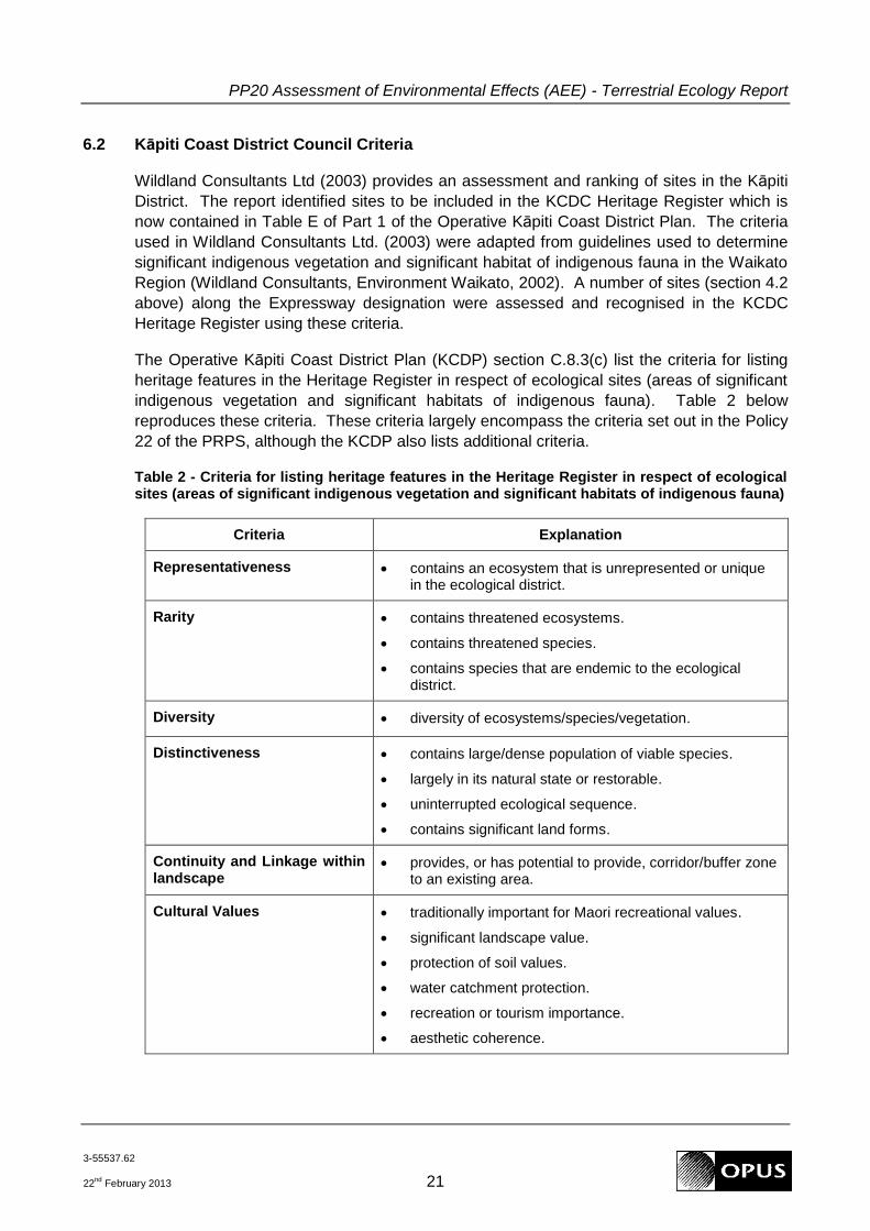
6.2 Kāpiti Coast District Council Criteria
Wildland Consultants Ltd (2003) provides an assessment and ranking of sites in the Kāpiti
District. The report identified sites to be included in the KCDC Heritage Register which is
now contained in Table E of Part 1 of the Operative Kāpiti Coast District Plan. The criteria
used in Wildland Consultants Ltd. (2003) were adapted from guidelines used to determine
significant indigenous vegetation and significant habitat of indigenous fauna in the Waikato
Region (Wildland Consultants, Environment Waikato, 2002). A number of sites (section 4.2
above) along the Expressway designation were assessed and recognised in the KCDC
Heritage Register using these criteria.
The Operative Kāpiti Coast District Plan (KCDP) section C.8.3(c) list the criteria for listing
heritage features in the Heritage Register in respect of ecological sites (areas of significant
indigenous vegetation and significant habitats of indigenous fauna). Table 2 below
reproduces these criteria. These criteria largely encompass the criteria set out in the Policy
22 of the PRPS, although the KCDP also lists additional criteria.
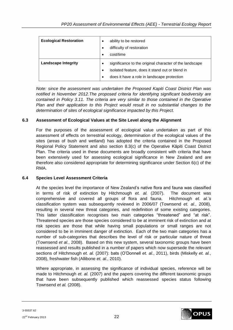
Table 2 - Criteria for listing heritage features in the Heritage Register in respect of ecological sites (areas of significant indigenous vegetation and significant habitats of indigenous fauna)
Criteria Explanation
Representativeness contains an ecosystem that is unrepresented or unique in the ecological district.
Rarity contains threatened ecosystems.
contains threatened species.
contains species that are endemic to the ecological district.
Diversity diversity of ecosystems/species/vegetation.
Distinctiveness contains large/dense population of viable species.
largely in its natural state or restorable.
uninterrupted ecological sequence.
contains significant land forms.
Continuity and Linkage within landscape
provides, or has potential to provide, corridor/buffer zone to an existing area.
Cultural Values traditionally important for Maori recreational values.
significant landscape value.
protection of soil values.
water catchment protection.
recreation or tourism importance.
aesthetic coherence.
PP20 Assessment of Environmental Effects (AEE) - Terrestrial Ecology Report
3-55537.62
22nd
February 2013 22
Ecological Restoration ability to be restored
difficulty of restoration
cost/time
Landscape Integrity significance to the original character of the landscape
isolated feature, does it stand out or blend in
does it have a role in landscape protection
Note: since the assessment was undertaken the Proposed Kapiti Coast District Plan was
notified in November 2012.The proposed criteria for identifying significant biodiversity are
contained in Policy 3.11. The criteria are very similar to those contained in the Operative
Plan and their application to this Project would result in no substantial changes to the
determination of sites of ecological significance impacted by this Project.
6.3 Assessment of Ecological Values at the Site Level along the Alignment
For the purposes of the assessment of ecological value undertaken as part of this
assessment of effects on terrestrial ecology, determination of the ecological values of the
sites (areas of bush and wetland) has adopted the criteria contained in the Proposed
Regional Policy Statement and also section 8.3(c) of the Operative Kāpiti Coast District
Plan. The criteria used in these documents are broadly consistent with criteria that have
been extensively used for assessing ecological significance in New Zealand and are
therefore also considered appropriate for determining significance under Section 6(c) of the
RMA.
6.4 Species Level Assessment Criteria
At the species level the importance of New Zealand‟s native flora and fauna was classified
in terms of risk of extinction by Hitchmough et. al. (2007). The document was
comprehensive and covered all groups of flora and fauna. Hitchmough et. al.‟s
classification system was subsequently reviewed in 2006/07 (Townsend et. al., 2008),
resulting in several new threat categories, and redefinition of some existing categories.
This latter classification recognises two main categories “threatened” and “at risk”.
Threatened species are those species considered to be at imminent risk of extinction and at
risk species are those that while having small populations or small ranges are not
considered to be in imminent danger of extinction. Each of the two main categories has a
number of sub-categories that describes the level of risk or particular nature of threat
(Townsend et al., 2008). Based on this new system, several taxonomic groups have been
reassessed and results published in a number of papers which now supersede the relevant
sections of Hitchmough et. al. (2007): bats (O‟Donnell et. al., 2011), birds (Miskelly et. al.,
2008), freshwater fish (Allibone et. al., 2010).
Where appropriate, in assessing the significance of individual species, reference will be
made to Hitchmough et. al. (2007) and the papers covering the different taxonomic groups
that have been subsequently published which reassessed species status following
Townsend et al. (2008).
PP20 Assessment of Environmental Effects (AEE) - Terrestrial Ecology Report
3-55537.62
22nd
February 2013 23
7 Assessment of Ecological Values against Criteria
7.1 Significant Indigenous Vegetation and Significant Habitat of Indigenous Fauna
The KCDC Heritage Register sites identified in Table 1 above have already been assessed
against criteria set out in Wildland Consultants Ltd (2003) as being examples of significant
indigenous vegetation and/or significant habitat of indigenous fauna.
The assessment undertaken as part of this investigation has applied the criteria set out in
the Proposed Regional Policy Statement and also section 8.3(c) of the Operative Kāpiti
Coast District Plan to assessing the significance of these sites. Ōtaki Railway Wetland,
Hautere Bush F and Cottle‟s Bush are all examples of under-represented habitats i.e. <30%
of their original extent remains, and are sufficiently intact to be considered examples of
significant indigenous vegetation. This assessment therefore concurs with the original
assessment made by Wildland Consultants Ltd that these sites are significant. However,
while they meet the test of significance, the values of all these habitats have been impacted
by human activity. In particular, the integrity of Hautere Bush F has been historical impacted
and continues to be impacted by grazing. Cottle‟s Bush, while having a more developed
sub-canopy, also shows signs of historic grazing pressure i.e. discontinuous age structure.
In the case of the Ōtaki Railway Wetland, while it is dominated by native wetland plants, its
current state has been substantially influenced by the interventions of man (discussed
further in section 7.2).
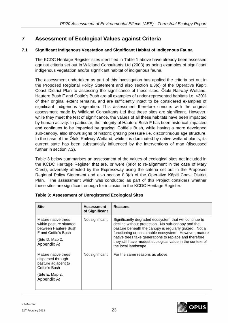
Table 3 below summarises an assessment of the values of ecological sites not included in
the KCDC Heritage Register that are, or were (prior to re-alignment in the case of Mary
Crest), adversely affected by the Expressway using the criteria set out in the Proposed
Regional Policy Statement and also section 8.3(c) of the Operative Kāpiti Coast District
Plan. The assessment which was conducted as part of this Project considers whether
these sites are significant enough for inclusion in the KCDC Heritage Register.
Table 3: Assessment of Unregistered Ecological Sites
Site Assessment of Significant
Reasons
Mature native trees within pasture situated between Hautere Bush F and Cottle‟s Bush
(Site D, Map 2, Appendix A)
Not significant Significantly degraded ecosystem that will continue to decline without protection. No sub-canopy and the pasture beneath the canopy is regularly grazed. Not a functioning or sustainable ecosystem. However, mature native trees take generations to replace and therefore they still have modest ecological value in the context of the local landscape.
Mature native trees dispersed through pasture adjacent to Cottle‟s Bush
(Site E, Map 2, Appendix A)
Not significant For the same reasons as above.
PP20 Assessment of Environmental Effects (AEE) - Terrestrial Ecology Report
3-55537.62
22nd
February 2013 24
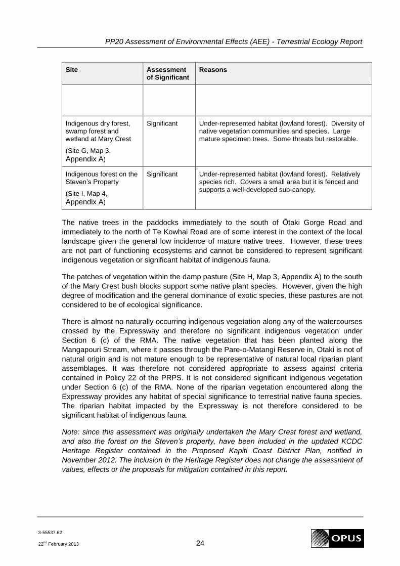
Site Assessment of Significant
Reasons
Indigenous dry forest, swamp forest and wetland at Mary Crest
(Site G, Map 3, Appendix A)
Significant Under-represented habitat (lowland forest). Diversity of native vegetation communities and species. Large mature specimen trees. Some threats but restorable.
Indigenous forest on the Steven‟s Property
(Site I, Map 4, Appendix A)
Significant Under-represented habitat (lowland forest). Relatively species rich. Covers a small area but it is fenced and supports a well-developed sub-canopy.
The native trees in the paddocks immediately to the south of Ōtaki Gorge Road and
immediately to the north of Te Kowhai Road are of some interest in the context of the local
landscape given the general low incidence of mature native trees. However, these trees
are not part of functioning ecosystems and cannot be considered to represent significant
indigenous vegetation or significant habitat of indigenous fauna.
The patches of vegetation within the damp pasture (Site H, Map 3, Appendix A) to the south
of the Mary Crest bush blocks support some native plant species. However, given the high
degree of modification and the general dominance of exotic species, these pastures are not
considered to be of ecological significance.
There is almost no naturally occurring indigenous vegetation along any of the watercourses
crossed by the Expressway and therefore no significant indigenous vegetation under
Section 6 (c) of the RMA. The native vegetation that has been planted along the
Mangapouri Stream, where it passes through the Pare-o-Matangi Reserve in, Otaki is not of
natural origin and is not mature enough to be representative of natural local riparian plant
assemblages. It was therefore not considered appropriate to assess against criteria
contained in Policy 22 of the PRPS. It is not considered significant indigenous vegetation
under Section 6 (c) of the RMA. None of the riparian vegetation encountered along the
Expressway provides any habitat of special significance to terrestrial native fauna species.
The riparian habitat impacted by the Expressway is not therefore considered to be
significant habitat of indigenous fauna.
Note: since this assessment was originally undertaken the Mary Crest forest and wetland,
and also the forest on the Steven‟s property, have been included in the updated KCDC
Heritage Register contained in the Proposed Kapiti Coast District Plan, notified in
November 2012. The inclusion in the Heritage Register does not change the assessment of
values, effects or the proposals for mitigation contained in this report.

PP20 Assessment of Environmental Effects (AEE) - Terrestrial Ecology Report
3-55537.62
22nd
February 2013 25
7.2 Wetland Condition Assessment
The wetland condition assessment scored the Ōtaki Railway Wetland at 13.3/25 which
reflects a high degree of modification. This modification is a function of a highly modified
catchment where the western boundary is formed by the NIMT, the eastern boundary is
formed by residential property, the northern boundary by lifestyle horticulture and farming,
and the southern boundary by the existing SH1 road embankment. These modifications to
the catchment will have undoubtedly modified the hydrology of the wetland and have
contributed to the very high levels of total and available nitrogen found in the wetland.
Although native vegetation currently constitutes a significant proportion of the vegetation in
the wetland, this appears to have been strongly influenced by human activities. Indeed the
railway line and the road embankment are likely to have caused impeded drainage which
assisted the development of the wetland in its current form. The presence of stock fences
across the wetland delineating property boundaries suggests that the area may once have
been drier and used for grazing stock. The northern most paddock is still used for grazing
sheep. The ponds within the wetland are not natural features and have been excavated.
The small size of the wetland when considered in the context of this modified catchment
makes it extremely vulnerable to external pressures such as weed invasion, which is
already occurring, on-going inputs of nitrogen and easy access by wild mammalian
predators, as well as domestic cats. Not surprisingly the pressure rating for the wetland
scored 25/30 representing a high degree of pressure likely to lead to future degradation in
the absence of management.
Wetlands are nationally and regionally under-represented and most remaining wetlands
supporting a high proportion of native vegetation still constitute significant indigenous
vegetation and indigenous fauna, as does this wetland. However, when considering the
effects of the loss of this wetland it must be acknowledged that it has been highly modified
and its current state and condition have largely been determined by significant interventions
by man i.e. impeded drainage caused by the NIMT and SH1 embankment. It should also
be recognised that it will suffer significant on-going pressure that may lead to further
degradation due to the highly modified nature of the catchment and its small size.
7.3 Species of Ecological Significance
7.3.1 Plants
No threatened plant species were recorded in areas affected by the Project. The effects on
populations of individual plant species as a result of the Project are expected to be less
than minor.
7.3.2 Birds
No threatened bird species were recorded during the walkover survey, or are likely to be
significantly impacted by the Project, given its alignment and the habitats present along the
corridor. Effects on bird populations resulting from the Project are expected to be less than
minor.

PP20 Assessment of Environmental Effects (AEE) - Terrestrial Ecology Report
3-55537.62
22nd
February 2013 26
7.3.3 Bats
No bats were recorded at any of the survey locations along the alignment. While a nil result
does not necessarily prove that bats are not present it is considered that the effects of the
Project on bats, if present, will be less than minor.
7.3.4 Reptiles
No threatened reptile species were recorded during the survey. This result supports the
assessment of the habitat potential of the land affected by the Project as being low for
threatened reptile species. The effects of the Project on individual reptile species are
therefore expected to be less than minor.
7.3.5 Invertebrates
No threatened invertebrate species were recorded by the invertebrate survey. This was not
surprising given the modified nature of the habitats affected by the Project. The effect of
the Project on the populations of individual species of invertebrates is therefore expected to
be less than minor.
7.4 Maori Perspective on Ecological Values
At a meeting and site visit held on Friday 29th July 2011 ecological issues of importance to
the Iwi were discussed. The Railway Wetland in Ōtaki was of significant interest being of
importance from an archaeological and cultural perspective, as well as ecological. The
possibility of recreating the wetland as mitigation was discussed, as was the possibility of
„capturing‟ the source of the spring located in the northern part of the wetland.
One solution discussed was to preserve the source of the spring in its current location,
creating a wetland or riparian zone alongside the Expressway following the existing
“natural” flow path. Rehabilitation and planting this area with wetland plants would then be
undertaken along this flow path creating a narrow wetland strip/riparian zone. This
treatment is essentially the treatment envisaged for the remnant of the Railway Wetland
(Map 5, Appendix A).
To offset the residual loss of the Railway Wetland in Ōtaki one of the options discussed was
the incorporation of ecological values into stormwater wetland ponds. This is essentially
what is now being proposed in creating the Kennedy Wetland in Ōtaki (Map 5, Appendix A)
where a stormwater attenuation pond will be designed to incorporate biodiversity values
(discussed in Section 9.4.2). An additional area of wetland is to be created adjacent the
Mary Crest Bush (Map 6, Appendix A). The primary function of this wetland is biodiversity
offset. The design principles to be followed in developing biodiversity values of these
wetlands have been included in the draft Ecological Management Plan submitted to the
EPA. However, further inputs from Iwi should be sought before completion of the final
detailed designs.
Bush to the west of the Railway Wetland (beyond the Expressway) was considered very
significant and Iwi are working with Tim Park at GWRC to look at enhancement/fencing
opportunities. This area is not impacted by the Project.
PP20 Assessment of Environmental Effects (AEE) - Terrestrial Ecology Report
3-55537.62
22nd
February 2013 27
Avoiding the bush and wetland at Mary Crest was viewed as a very positive step for the
Project to have taken. There was also recognition that the Project has brought the area to
the attention of Iwi and other stakeholders. Iwi are keen to pursue protection and
enhancement of the area with the land owner and other stakeholders. The proposed
creation of offset wetland in this area will further enhance the ecological values of this area.
The treatment and water quality enhancement opportunities provided by stormwater
wetland ponds are of significant interest to Iwi and seen as a positive potential
enhancement that the Project can provide.
Iwi also generally support efforts to minimise loss of bush from other sites along the
alignment. Where native trees are unavoidably lost, recovery of timber for carving or other
traditional uses is advocated.
8 Nature and Significance of Effects
8.1 Positive Effects
While it is often possible to avoid sites of ecological significance by designing alignments to
bypass certain habitats, net positive gains that are a direct consequence of building a road
are rare. It is however possible to achieve no net loss of habitat and associated ecological
values by avoiding, remedying and mitigating adverse effects.
The Expressway was initially designed to pass through the Mary Crest bush and wetland,
however the route has been refined and this significant area has been avoided. While the
avoidance Mary Crest is not in itself a positive benefit of building the road, the need to
consider the effects of the Project on this site has highlighted the ecological importance of
an area that was previously not recognised in the District Heritage Register and was largely
unknown by local people. The increased knowledge of the ecological characteristics and
values of Mary Crest is a positive benefit that has occurred as a result of the studies
undertaken to support the designation of the Expressway.
8.2 Summary of Adverse Effects
The following is a summary of the key adverse effects of the Expressway on terrestrial,
wetland and riparian ecosystems that have been considered by this assessment:
habitat loss to the Project;
potential effects on the hydrology of the Mary Crest bush and wetland and the remaining part of the Railway Wetland in Ōtaki;
habitat fragmentation;
edge effects resulting from removing trees along the edge of stands of bush;
effects on specific flora and fauna species.
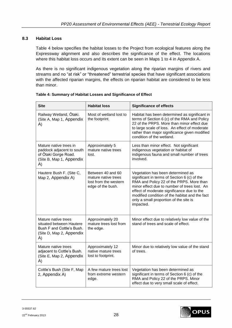
PP20 Assessment of Environmental Effects (AEE) - Terrestrial Ecology Report
3-55537.62
22nd
February 2013 28
8.3 Habitat Loss
Table 4 below specifies the habitat losses to the Project from ecological features along the
Expressway alignment and also describes the significance of the effect. The locations
where this habitat loss occurs and its extent can be seen in Maps 1 to 4 in Appendix A.
As there is no significant indigenous vegetation along the riparian margins of rivers and
streams and no “at risk” or “threatened” terrestrial species that have significant associations
with the affected riparian margins, the effects on riparian habitat are considered to be less
than minor.
Table 4: Summary of Habitat Losses and Significance of Effect
Site Habitat loss Significance of effects
Railway Wetland, Ōtaki.
(Site A, Map 1, Appendix A)
Most of wetland lost to the footprint.
Habitat has been determined as significant in terms of Section 6 (c) of the RMA and Policy 22 of the PRPS. More than minor effect due to large scale of loss. An effect of moderate rather than major significance given modified condition of the wetland.
Mature native trees in paddock adjacent to south of Ōtaki Gorge Road.
(Site B, Map 1, Appendix A)
Approximately 5 mature native trees lost.
Less than minor effect. Not significant indigenous vegetation or habitat of indigenous fauna and small number of trees involved.
Hautere Bush F. (Site C,
Map 2, Appendix A)
Between 40 and 60 mature native trees lost from the western edge of the bush.
Vegetation has been determined as significant in terms of Section 6 (c) of the RMA and Policy 22 of the PRPS. More than minor effect due to number of trees lost. An effect of moderate significance due to the modified condition of the habitat and the fact only a small proportion of the site is impacted.
Mature native trees situated between Hautere Bush F and Cottle‟s Bush.
(Site D, Map 2, Appendix A)
Approximately 20 mature trees lost from the edge.
Minor effect due to relatively low value of the stand of trees and scale of effect.
Mature native trees adjacent to Cottle‟s Bush.
(Site E, Map 2, Appendix A)
Approximately 12 native mature trees lost to footprint.
Minor due to relatively low value of the stand of trees.
Cottle‟s Bush (Site F, Map
2, Appendix A)
A few mature trees lost from extreme western edge.
Vegetation has been determined as significant in terms of Section 6 (c) of the RMA and Policy 22 of the PRPS. Minor effect due to very small scale of effect.

PP20 Assessment of Environmental Effects (AEE) - Terrestrial Ecology Report
3-55537.62
22nd
February 2013 29
Site Habitat loss Significance of effects
Forest and wetland at Mary Crest (Site G, Map
3, Appendix A)
Road re-aligned to avoid. No habitat loss.
Forest on the Steven‟s
Property (Site I, Map 4, Appendix A)
c.15% of the bush lost from the eastern edge
Vegetation has been determined as significant in terms of Section 6 (c) of the RMA and Policy 22 of the PRPS. Alignment modification has reduced loss of habitat. More than minor effect due to extent of the habitat lost.
Mature kahikatea in paddock to north of Te Kowhai Road. (Site J,
Map 4, Appendix A)
Four mature kahikatea trees lost.
Less than minor effect. Not significant indigenous vegetation or habitat of indigenous fauna and small number of trees involved.
The cumulative area of native forest that will be lost from sites determined to be significant
in terms of Section 6 (c) of the RMA and Policy 22 of the PRPS (Hautere Bush F, Cottle‟s Bush
and bush on the Steven‟s Property) is approximately 0.5ha.
More than half (c.0.5ha) of the Ōtaki Railway Wetland (total area c.0.8ha) will be
permanently lost to the footprint. The remaining area of wetland (c.0.3ha) is at risk of
significant disturbance during the construction period. However, the modified nature and
pressures from weed species that already exist along the remaining edge mean that
intervention would be required to create a higher quality habitat than already exists
regardless of how much impact the road construction has.
Outside of the areas determined to be significant in terms of Section 6 (c) of the RMA and
Policy 22 of the PRPS mature native trees will be lost from a number of locations along the
Expressway. The cumulative total number of mature trees lost from these areas will be
about 40.
8.4 Hydrological Effects on the remaining the Ōtaki Railway Wetland and the Mary Crest
Bush and Wetland
The existing Ōtaki Railway Wetland is supplied by surface water flow during rain events
from the catchment to the north and east. Ground water also enters the wetland via spring
seepages around the north-eastern edge of the wetland. Surface water flow from the parts
of the catchment to the north and east that remain after the Expressway construction, and
from the spring seepages, are expected to continue to feed into the remaining wetland
area. Low permeability soils will be used to create an impermeable zone between the
wetland and the new Expressway embankment to prevent water from the wetland draining
through the more permeable embankment materials. The remaining wetland area is
therefore expected to continue to be permanently wet, although water levels may
temporarily fluctuate during rain events.
Water currently exits the wetland via a small surface channel at the southern end of the
wetland. Once the Expressway is constructed water will exit the southern end of the

PP20 Assessment of Environmental Effects (AEE) - Terrestrial Ecology Report
3-55537.62
22nd
February 2013 30
remaining wetland via a culvert. It is expected that the hydrological conditions of the
remaining wetland area will be similar to those found in the existing wetland.
Wet pasture occurs to the south of the Mary Crest bush and wetland. There is also a drain
that flows from east to west along the southern edge of the bush/wetland. This drain then
converges with a stream that flows west through the wet pasture. Observations of the
surface drainage within the wet pasture indicate that there is no surface connection
between the pasture and the bush/wetland. There are likely to be ground water connections
between the wet pasture, surface drainage within the pasture and wet areas within the Mary
Crest bush area. While the Expressway construction will involve a diversion of the Edwin
Stream (see Map 6, Appendix A) the surface water flow volumes into the wet pasture area
are expected to be similar post construction to those that exist at the present time. With
regard to the impact of the Expressway on ground water levels to the west of the new road,
it is not expected that there will be any significant long-term effects that may be detrimental
to the Mary Crest wetland and swamp forest i.e. permanent lowering of ground water levels.
8.5 Habitat Fragmentation
Habitat fragmentation is most easily understood in terms of the effects of breaking areas of
habitat into smaller areas principally by severance. However, substantially reducing the
extent of habitat in a given location not only leads to direct loss of habitat but can also
exacerbate existing fragmentation impacts. Habitat fragmentation can result in a number of
negative effects such the isolation of populations of plants and animals, reduction in habitat
area available to a given species and increased edge effects. All of these effects can
reduce the ecological viability of the remaining habitat and the populations of the plants and
animals they support. Fragmentation of habitat by infrastructure corridors such as roads
can therefore compound direct habitat loss effects. However, in the case of the
Expressway, there are unlikely to be substantial fragmentation effects. The bush/wetland at
Mary Crest has now been avoided by re-alignment and therefore there will be no habitat
fragmentation in this location. Of the remaining areas of native bush affected by the Project
footprint, habitat is only lost from the edge and therefore there is no habitat severance.
While there will be some edge effects, as discussed in Section 8.6 below, the relatively
small scale of habitat loss from these areas is such that there should be no major effects
on the viability of plant and animal populations in these areas.
The Ōtaki Railway Wetland will be significantly reduced in area. While there will be no
severance of habitat, resulting in the division of the habitat into smaller areas, edge effects
will be increased in this location e.g. increased vulnerability to weed invasion and the
incursions by mammalian predators. However, the wetland is already highly vulnerable to
these pressures due to its small size. While the integrity of this wetland as a functioning
ecosystem will be compromised by the construction of the Expressway, there are not
expected to be any major adverse effects at the species level as it has not been found to
support species that are likely to be vulnerable to these kinds of changes i.e. the common
species that are present are adaptable, and for the most part likely to persist in the
remaining area of wetland.
PP20 Assessment of Environmental Effects (AEE) - Terrestrial Ecology Report
3-55537.62
22nd
February 2013 31
8.6 Edge Effects Resulting from tree removal from the edges of bush habitat
Where trees and shrubs are cleared from the edge of areas of bush, the exposed trees can
be more prone to wind-throw. Further, where a sub-canopy or ground cover is present this
is likely to be more prone to desiccation. This is particularly the case in exposed coastal
areas. The magnitude of edge effects is difficult to predict given the variability in the
resilience of vegetation in a given location to wind effects and the variable nature of
weather patterns.
A number of locations along the Expressway will require removal of mature vegetation from
the edge of stands of bush assessed as being significant (Hautere Bush F, Cottle‟s Bush
and bush on the Steven‟s Property) thus exposing trees that may be more susceptible to
wind damage. Trees will be removed from the western edges of Hautere Bush F and
Cottle‟s exposing them to prevailing winds. In the case of Hautere Bush F the main concern
is wind-throw of remaining mature trees. Effects on the sub-canopy and ground cover are
not a significant concern as grazing by cattle has largely removed these layers. It is
important to note that in the context of this location edge effects are much less of a threat to
the remaining habitat than the on-going grazing pressure.
In the case of Cottle‟s Bush, although the sub-canopy and ground cover layers are sparsely
vegetated there is some regeneration occurring in this habitat. Desiccation effects on sub-
canopy and ground cover species could therefore be an issue in addition to the risk of wind-
throw of mature. However, the length of exposed edge in this location will be a maximum of
40m which is a small proportion of the total edge seaward facing edge of the bush.
The exposed edge of bush on the Steven‟s Property will be facing east, away from the
prevailing winds and therefore edge effects should be less than those associated with a
west facing edges. However, there are still risks of wind-throw and desiccation which could
compound the habitat loss effects in these locations. Furthermore, species such as
peripatus are highly susceptible to desiccation.
Overall, edge effects at these locations are unlikely to be major issues but there are risks of
some additional damage to the remaining habitat. Measures to minimise these effects will
be incorporated into the design e.g. planting a wind break of fast growing wind tolerant
species.
8.7 Effects on Individual Plant Species
No populations of individual species of plants are expected to be significantly affected by
the Project. No avoidance, remediation or mitigation is necessary for individual plant
species.
8.8 Effects on Individual Fauna Species
No populations of individual species of fauna are not expected to be impacted in a major
way by the Project. However, there could be some minor effects on the population of
peripatus that inhabits the native bush on the Steven‟s property (Map 4, Appendix A).
Peripatus inhabit rotting timber in cool, damp shady environments. Some of the rotting logs
where peripatus were found at the Steven‟s Property are close to the Project footprint

PP20 Assessment of Environmental Effects (AEE) - Terrestrial Ecology Report
3-55537.62
22nd
February 2013 32
where there will be loss of native trees and shrubs along the edge of the bush. As well as
loss of shade trees, which could result in desiccation of the logs, it is also possible that the
logs may be directly affected.
While individuals of the Peripatoides novaezealandiae complex are not classified as
threatened or at risk, the taxonomy of peripatus in New Zealand is currently under review.
Currently, five peripatus species from two genera are recognised, however it is possible
that there may be as many as 25 separate species amongst those currently classified as
five species (Gleeson & Ruhberg, 2010). Given the isolated nature of such remnant
populations and the likelihood that a more extensive complex of species may exist than is
currently recognised, it is recommended that populations such as at the Steven‟s property
remain in situ (in this case within the remaining area of bush), to maintain genetic integrity
until more is known of their taxonomy.
Measures are proposed in section 9.2.2 to minimise the impact on the peripatus in this
location. These are the only mitigation measures that are considered necessary for
individual species of fauna likely to be affected by the Project.
8.9 Direct Effects on Wildlife Resulting from Construction Activities and the Provisions
of the Wildlife Act 1953
The nature of site clearance activities prior to construction (i.e. vegetation removal and soil
stripping) means that there is a risk that some animals to which protections in the Act apply
could be killed in the process. The groups of animals at risk along the alignment are
common non-threatened young native birds (in the nest during the breeding season) and
non-threatened reptile species. Even if the construction of the road results in the loss of
some individuals from populations, this is likely to be an insignificant proportion of the total
populations of species given their population size. Consequently, the effects on the
populations of the species potentially impacted are expected to be less than minor.
Given that effects on the populations of these species are insignificant there is no necessity
to avoid, remedy or mitigate effects under the provisions of the RMA. However, the
provisions Wildlife Act 1953 still apply to any killing of protected wildlife, even non-
threatened species. A permit is therefore likely to be required from the Director-General of
Conservation to undertake site clearance works in advance of construction which may kill
individuals of a native bird or reptile species. The requirements that will need to be met for
the granting of the permit will need to be ascertained from the Director-General of
Conservation prior to the start of construction when permits are applied for. It is however
expected that Director-General of Conservation will take into account the expected
insignificant effects on the populations of the species that could be affected in determining
the conditions which may accompany the granting of the permit.
8.10 Effects of the NIMT
Since the re-alignment of the NIMT will affect only highly modified habitats i.e. pasture, rush
pasture and patches of blackberry with no associated flora and fauna species of
conservation significance, it is not expected that it will have any significant ecological effect
on terrestrial or wetland ecosystems. Overall, the effect of the NIMT on terrestrial ecology
is expected to be insignificant.
PP20 Assessment of Environmental Effects (AEE) - Terrestrial Ecology Report
3-55537.62
22nd
February 2013 33
9 Avoidance/Remediation/Mitigation of Effects
9.1 Approach
The Standard on Biodiversity Offsets published by the Business and Biodiversity Offsets
Programme (BBOP) in 2012 uses the following mitigation hierarchy as an approach to
ecological mitigation (BBOP, 2012):
“a. Avoidance: measures taken to avoid creating impacts from the outset, such as careful
spatial or temporal placement of elements of infrastructure, in order to completely avoid
impacts on certain components of biodiversity.
b. Minimisation: measures taken to reduce the duration, intensity and / or extent of impacts
(including direct, indirect and cumulative impacts, as appropriate) that cannot be completely
avoided, as far as is practically feasible.
c. Rehabilitation/restoration: measures taken to rehabilitate degraded ecosystems or
restore cleared ecosystems following exposure to impacts that cannot be completely
avoided and/ or minimised.
d. Offset: measures taken to compensate for any residual significant, adverse impacts that
cannot be avoided, minimised and / or rehabilitated or restored, in order to achieve no net
loss or a net gain of biodiversity. Offsets can take the form of positive management
interventions such as restoration of degraded habitat, arrested degradation or averted risk,
protecting areas where there is imminent or projected loss of biodiversity.”
Depending on the nature of the Project and the scale of effects some or all of the steps in
the hierarchy may be applicable. Where appropriate the steps in this hierarchy have been
applied to this Project.
9.2 Avoidance of Effects
The Expressway design has taken account of the need to minimise effects on features of
ecological value along the alignment. In the case of Mary Crest the route has been
realigned to avoid the bush thereby avoiding both habitat loss and habitat fragmentation
effects. This measure has significantly reduced the overall effect of the alignment on
terrestrial ecosystems.
In other locations along the Expressway where the edges of native bush have been
impacted, every effort has been made to minimise the intrusion of the footprint into these
areas, although some residual loss could not be completely avoided. In the case of the
Ōtaki Railway Wetland, this habitat could not be avoided and more than half of the area will
be permanently lost. Where loss of habitat could not be avoided offset mitigation has been
proposed to compensate for this loss (refer to Section 9.4).
PP20 Assessment of Environmental Effects (AEE) - Terrestrial Ecology Report
3-55537.62
22nd
February 2013 34
9.3 Minimisation of effects
9.3.1 Protection of Bush Edges from Wind-throw and Desiccation
Where mature native trees are removed from the existing edges of bush wind breaks
should be planted along the edge to provide protection. These should be dense plantings
of early succession, wind tolerant species e.g. ngaio, kanuka, wineberry, Pittosporum
tenuifolium and Coprosma repens. It is important that these are locally sourced from the
coastal zone to ensure that they are genetically adapted to salt and wind tolerance. Ideally
the wind break should be at least 10m wide. Where there is limited room within the
designation to plant on the flat the embankments of the road should be planted.
9.3.2 Peripatus
If the footprint is likely to directly affect logs inhabited by peripatus at the Steven‟s property,
or if the logs are likely to be exposed to desiccation due to the removal of tree cover, these
should, with the land owner‟s permission, be moved further into the bush. In addition,
placement of a few sections of wood from trees felled along the Expressway within the
remaining bush adjacent to existing rotting timber currently inhabited by peripatus would
provide future habitat for the species as they start to decay.
9.4 Offset
9.4.1 Approach
Where there are effects that cannot be avoided i.e. direct loss of habitat, ecological offsets
are required to compensate for the habitat lost. Achievement of “no net loss” or “preferably
a net gain” in biodiversity, using the principal of “like for like” compensation, is an underlying
principle of the BBOP Standard on Biodiversity Offsets. The Standard however stresses
that there is no single best approach to the design and implementation of biodiversity
offsets.
The Project will result in unavoidable losses of native bush (c.0.5ha) and wetland (c.0.5ha)
determined as being significant under Section 6 (c) of the RMA. Offset of these losses will
therefore be necessary. In determining the nature and an amount of offset appropriate to
compensate for the habitat losses associated with this Project consideration has been given
to the following:
amount (area) of habitat lost;
value and condition of the habitat lost;
timeframe in which meaningful offset can be achieved;
likelihood of success in creating offset habitat;
opportunities for offset within the immediate Project locality.
When determining the amount (area) of habitat necessary to offset the habitat lost there is
often much discussion around compensation ratios i.e. the amount of offset needed to
achieve no net loss. Compensation ratios used on one Project are often cited as “best

PP20 Assessment of Environmental Effects (AEE) - Terrestrial Ecology Report
3-55537.62
22nd
February 2013 35
practice” and “the standard” to be adopted by another. However, there are no national
standards on biodiversity compensation ratios. Furthermore, appropriate offsets need to
take account of the values of habitat lost which vary considerably between sites and
individual Projects, as well as the time taken to achieve an offset result. Compensation
ratios are therefore Project specific. The compensation ratios used on this Project and
reasons for their adoption is discussed in the sections below.
9.4.2 Wetland Habitat Rehabilitation and Creation
Approximately 0.3ha of the existing Ōtaki Railway Wetland will remain once the
Expressway has been constructed (see Map 5, Appendix A). This residual area of wetland
will continue to receive water from the catchment during rain events and ground water
seepage in the north eastern corner of the wetland which will not be covered by the Project
footprint. This remaining wetland is expected to be permanently wet, with water draining
out via culvert from its southern extremity. The wetland remnant will be rehabilitated
following construction. This rehabilitation will include re-contouring as necessary, removal
of weed species and replanting with the species currently found in the wetland.
To offset the loss of wetland habitat it is proposed to create two new areas of wetland. The
Kennedy Wetland (c.0.4ha – see Map 5, Appendix A) and a new area of wetland adjacent
to the Mary Crest bush (c.0.7ha – see Map 6, Appendix A). The cumulative area of these
two wetlands is c.1.1ha. The Kennedy Wetland will receive water from outflow of the
remnant of the Ōtaki Railway Wetland. This is expected to provide permanent flow through
the Kennedy Wetland and keep this wetland permanently wet.
It is proposed to create the new area of wetland adjacent to the Mary Crest bush in an area
that is currently damp pasture. The area is low lying and the plant species present indicate
high water content in the soil. It is proposed to increase the wetness of the area by digging
down into the water table. By doing this it is expected that conditions will be created where
native wetland plant species can be introduced and wetland habitat created. The area
where it is proposed to create the wetland does slope gently from east to west.
Consequently a low bund with impermeable lining may be required around the western
edge of the wetland to assist in water retention. A weir is likely to be required to control
water outflow from the wetland.
Exact replication of the existing vegetation communities within the Ōtaki Railway Wetland
within the new wetlands is not a realistic objective due the high degree of variability of
composition within the wetland. Nor is it necessarily a desirable objective given substantial
influence of human activities in determining the present species and composition of the
vegetation within the wetland. A more realistic objective is to create wetland conditions
suitable for the key species present in the existing wetland e.g. raupo, Isolepis prolifera,
spiked rush, Carex secta, Carex virgata and cabbage tree, and plant these into the new
wetland areas. Over a period of time these species will find their own compositional
equilibrium. Plant material would be salvaged from the existing wetland prior to construction
or obtained from nursery plant stock grown from locally sourced seeds. Inclusion of deeper
water zones (1.5m) in the Kennedy Wetland and the wetland proposed at Mary Crest would
provide open water areas that would create habitat diversity wetland that would be more
attractive to waterfowl.
PP20 Assessment of Environmental Effects (AEE) - Terrestrial Ecology Report
3-55537.62
22nd
February 2013 36
Given the modified nature of the wetland lost it is expected that the new wetlands will
quickly (within 2-3 years) achieve values although not necessarily identical, at least
comparable to those lost. On this basis it could be reasonably argued that a compensation
ratio of 1:1 could achieve “no net loss” within a relatively short timeframe. However, the
amount of wetland it is proposed to create for this Project will exceed this ratio i.e. c.1.1ha
will be created against c.0.5ha lost. This is a compensation ratio of over 2:1. The Project
should therefore comfortably meet the “no net loss” objectives contained within the
Proposed National Policy Statement on Indigenous Biodiversity and NZTA‟s Environmental
Plan with regard to wetland habitat, and is likely to achieve a net gain2.
9.4.3 Mitigation for Native Bush Loss
There are two options by which the loss of native bush could be mitigated:
Protection and enhancement of an existing area of native bush; and/or
Planting new areas of bush.
Protection and enhancement of an existing area of native bush
There are a number of existing areas of native bush in the vicinity of the proposed
Expressway that are under threat from grazing and/or plant and animal pests. In some
cases the remaining areas of bush are unlikely to survive in the long-term without
intervention. This is especially true where regular grazing by domestic animals takes place.
In these stands of bush, no natural regeneration takes place and as mature trees die they
are not replaced. Over time, that bush disappears. By fencing and covenanting such areas
to ensure long-term protection, the long-term viability of such areas can be significantly
enhanced, particularly when supported by plant pest removal. However, protecting existing
areas of bush will require agreements to be made with landowners and this cannot be
guaranteed.
When considering the amount of bush (compensation ratio) that should be protected to
compensate for that lost in this case, consideration has been given to the condition of the
bush being lost and long-term prognosis for its survival. The greater part of the bush being
lost (c.0.35ha) has been, and continues to be grazed beneath the canopy, to the extent that
there is no forest ground dwelling species, minimal sub-canopy and no regeneration of
canopy species. The long-term prognosis for this area in the absence of intervention
(protection from grazing as a minimum) is that it will continue to diminish and eventually
disappear. Under the circumstances, the loss of this area of bush to the Expressway
footprint is accelerating a process that is already occurring, although this process may take
many decades to run its course. There is no easily developed formula that can determine
2 It has been noted that Policy 3.5 c) of the Proposed Kapiti Coast District Plan, notified in November 2012, requires that “there should
be a substantial, significant, demonstrable and measureable net environmental benefit as opposed to mere mitigation of effects” to
demonstrate that offsetting has been achieved. However, the Plan is still in early stages of development and submissions have not yet
closed.

PP20 Assessment of Environmental Effects (AEE) - Terrestrial Ecology Report
3-55537.62
22nd
February 2013 37
what an appropriate compensation ratio is in this case. However, a ratio of 2:1, as a
minimum, has been chosen in this case to reflect the compromised condition of the bush
and the likelihood of on-going degradation in the absence of intervention. It could be argued
that a 1:1 would be appropriate. However a 2:1 ratio takes account of some of the
uncertainties concerning the future of the existing bush e.g. it is possible that in the future
intervention could occur, and also risks to protected areas of bush in the future such as
fires, drought or breaches of fences by stock.
An area of bush, with the potential for long-term protection, has been identified close to the
Project corridor that supports habitat very similar in character and condition to much of the
area of bush that is being lost to the Project footprint. Negotiations are on-going to try to
secure this area of bush for protection. If agreement is secured with the land owner it is
proposed to covenant the bush to provide long-term protection. This will ensure that it
remains fenced from stock. It is also proposed to undertake planting of suitable edge and
sub-canopy tree and shrub species around the edge of the bush and in gaps in the canopy
within the bush interior to provide a “kick-start” to the regeneration process. This will be
supported by a 3 year weed control programme.
The protection of an existing area of bush is the preferred option to compensate for bush
lost due to the fact that mature canopy trees (the element of a forest that takes the longest
to develop) are already in place. Furthermore, given the length of time it takes for trees to
mature, it makes little sense planting new areas of bush, when an existing bush in the area
is in need of protection to prevent its‟ disappearance. The area of bush currently being
investigated is c.2.4ha in area. If protection of this area of bush was secured the area
protected would be well in excess of the 2:1 compensation ratio. This would be a
substantial offset to compensate for the bush lost and would achieve the “no net loss”
objectives contained within the Proposed National Policy Statement on Indigenous
Biodiversity and NZTA‟s Environmental Plan.
Planting new areas of bush
If the protection of an existing area of bush cannot be achieved, an area has been identified
adjacent to the existing Mary Crest bush, and within the designation, where new bush
habitat can be established by planting (Map 6, Appendix A). In this case a minimum
compensation ratio of 3:1 has been chosen. This takes account of the extended timeframe
which is required for the new bush habitat to develop significant ecological values (50 to
100 years), comparable to those being lost. However, the ratio also recognises the fact that
areas of bush impacted are not pristine habitat and much of that lost is severely threatened
by on-going grazing. The new area of bush by contrast will be within the designation, which
will provide long-term protection from adverse effects such as grazing.
Most of the bush lost (>80%) is from Hautere Bush F and Cottle‟s Bush which are located
on lowland river terrace where the soils are free draining, and prone to summer drought.
Totara and titoki which tolerate dry summer conditions are dominant species in this zone.
The bush on the Stevens Property is located seaward of the edge of the river terraces in
the lee of the stable coastal dunes.
The Mary Crest site, where it is proposed to plant native bush, if a suitable area of existing
bush cannot be secured, is also located on the seaward edge of the river terraces with the
PP20 Assessment of Environmental Effects (AEE) - Terrestrial Ecology Report
3-55537.62
22nd
February 2013 38
stable dunes system that extends along most of the Kapiti Coast. Within the site are dunes
characterised by free draining sand dunes with thin soils and dune hollows where peats are
present but which are also influenced by deposition from streams flowing through these low
lying areas. The character of the forest that can be established in this location is more
varied than that lost. The presence of both drier stable dunes and low lying wetter areas
means that areas of forest dominated by totara and titoki can be created and also areas
favoured by kahikatea and pukatea. Establishment of the forest would require a staged
approach as certain species such as titoki and pukatea are vulnerable to frost in the
absence of shelter. The drier areas, including lower slopes of the road embankment, would
be planted with totara, kanuka Kunzea ericoides, karamu Coprosma robusta, taupata
Coprosma repens and mahoe Melicyus ramiflorus. Low lying damp areas will be planted
with kahikatea, flax, cabbage tree, mingimingi Coprosma propinqua and manuka. These
areas will need to be kept free from weeds for a period of at least five years, or until
monitoring indicates that the area is likely to be self-sustaining, usually indicated by a
closed tree and shrub canopy. In year three frost sensitive species; titoki, pukatea and
kohekohe will need to be planted into the appropriate ecological zones.
The compensation ratio of 3:1 requires the creation of a minimum of 1.5ha of new bush
adjacent to Mary Crest. The area available within the designation for planting at Mary Crest
is c.3.0ha. If 1.5ha. of this area is planted with bush, and other recommended measures are
implemented to ensure successful establishment and introduction of late successional
species, it is expected that the no net loss in biodiversity objectives contained within the
Proposed National Policy Statement on Indigenous Biodiversity and NZTA‟s Environmental
Plan will be achieved.
9.5 Landscape planting
It is proposed to include native tree and shrub species in the landscape planting for the
Expressway alignment, including riparian planting along sections of stream within the
designation. While not primarily included to compensate for loss of biodiversity this planting
will in time contribute to the biodiversity along the Expressway. Furthermore, this planting
will offset the loss of mature native trees and shrubs were not determined to be significant
Section 6(c) of the RMA but which nevertheless have some modest ecological values in the
context of the local landscape i.e. Site B (Map 1), Site D (Map 2), E (Map 2) and J (Map 4)
(all shown in Appendix A).

PP20 Assessment of Environmental Effects (AEE) - Terrestrial Ecology Report
3-55537.62
22nd
February 2013 39
10 Conclusion
Most of the Expressway affects a highly modified landscape supporting little or no indigenous vegetation and no significant habitat of indigenous fauna.
However, one area of wetland located in Ōtaki (Ōtaki Railway Wetland - c.0.8ha) of which c.0.5ha will be lost to the Project footprint. In addition, the edges of several remnants of native bush, with a total area of c.0.5ha, will also be lost to the Expressway. These effects are more than minor and require mitigation to compensate for the loss. One significant area of bush at Mary Crest would have been significantly affected by the alignment as initially proposed however the road was subsequently re-aligned to avoid this area of bush.
The 0.3ha of the Railway Wetland that will remain following construction of the Expressway will be rehabilitated. To offset the part of the Railway Wetland lost (c.0.5ha) it is proposed to create two new areas of wetland within the designation (total area c.1.1ha). The largest of these will be in the vicinity of Mary Crest (c.0.7ha) with another area, the Kennedy Wetland (c.0.4ha), created in Ōtaki. Given the modified and human induced nature of the Ōtaki Railway Wetland, the creation of wetland of similar ecological values (although not identical values) to the wetland lost should be possible within a relatively short timeframe (2-3yrs). Since the area created will be greater than the area lost, the no net loss in biodiversity objectives contained within the Proposed National Policy Statement on Indigenous Biodiversity and NZTA‟s Environmental Plan (Transit New Zealand, 2008) will be achieved by the Project, and potentially there could be a net gain in biodiversity.
The loss of bush habitat will be mitigated either by planting new areas of bush or protecting an existing area of bush that is threatened by on-going degradation in quality as a result of grazing and/or plant and animal pests. The preferred option is to protect and enhance an existing area of bush in the vicinity of the Project. A site close to the Expressway where this could be achieved is currently under investigation. However, if this option proves unsuccessful, there is an area of land within the designation and adjacent to existing bush and wetland at Mary Crest that could be planted to create a new area of bush and achieve suitable offset. Whichever of the two options is adopted, it will be adequate to meet the no net loss in biodiversity objectives contained within the
PP20 Assessment of Environmental Effects (AEE) - Terrestrial Ecology Report
3-55537.62
22nd
February 2013 40
Proposed National Policy Statement on Indigenous Biodiversity and NZTA‟s Environmental Plan (Transit New Zealand, 2008).
No threatened or at risk terrestrial or wetland species of flora or fauna were identified along or immediately adjacent to the Project footprint, whose populations could be significantly affected by the Project. No species specific mitigation is therefore considered necessary for threatened or at risk species. However, the provisions of the Wildlife Act 1953 will still apply to non-threatened species to which the Act applies. In the case of this Project this is likely to be restricted to young native birds in the nest and common reptiles. This conclusion excludes freshwater fish and aquatic invertebrate species which are dealt with in a separate report prepared by Scott Larned of NIWA.
Recommendations have been made concerning minimising effects of the Project on one non-threatened species - peripatus. This has been proposed as a precaution due to the taxonomy of the species being under review which could result in new species being identified.
Overall, it is considered that, with proposed mitigation offsets undertaken the effects of the Project on terrestrial ecology will be minor. The proposed mitigation will ensure that there will be no net loss in ecological values.
The proposed re-alignment of the North Island Main Trunk will not affect any habitats or species of ecological significance. The effects of the re-alignment are therefore considered to be nil.

PP20 Assessment of Environmental Effects (AEE) - Terrestrial Ecology Report
3-55537.62
22nd
February 2013
References
Allibone, R.; Bruno, D.; Hitchmough, R.; Jellyman, D.; Ling, N.; Ravenscroft, P.; Water, J.
2010. Conservation status of New Zealand freshwater fish, 2009. New Zealand Journal of
Marine and Freshwater Research 1- 17.
Atkinson, I. A. E. 1985. Derivations of vegetation mapping units for an ecological survey of
Tongariro National Park, North Island, New Zealand. New Zealand Journal of Botany
23: 361-378.
BBOP. 2012. Standard on Biodiversity Offsets. Forest Trends, 2012.
Clarkson, B. R., Sorrell, B. K., Reeves, P. N., Champion, P. D., Partridge, T. R. and
Clarkson, B. D., 2004. Handbook for Monitoring Wetland Condition. A Ministry for the
Environment Sustainable Management Fund Project (5105).
Environment Waikato; Wildland Consultants Ltd. 2002: Areas of Significant Indigenous
Vegetation and Habitats of Indigenous Fauna in the Waikato Region: Guidelines to applying
Regional Criteria and Determine Level of Significance. Environment Waikato Technical
Report TR 2002/15.
Gleeson, D.M.; Ruhberg, H. 2010. Chapter 3. Phylum Onychophora: velvet worms,
peripatus. Pp. 36-39 in: Ed. Gordon, D.P. New Zealand Inventory of Biodiversity Volume
Two Kingdom Animalia, Chaetognatha, Ecdysozoa, Ichnofossils. Canterbury University
Press.
Greater Wellington Regional Council. 2010. Proposed Regional Policy Statement for
Wellington Region. Greater Wellington Regional Council, May 2010.
Harris, R.J.; Burns, B. 2000. Beetle assemblages of kahikatea forest fragments in a
pasture-dominated landscape. New Zealand Journal of Ecology 24: 57-68.
Hitchmough, R.; Bull, L.; Cromarty, P. (comps) 2007. New Zealand Threat Classification
System lists - 2005. Department of Conservation, Wellington 194p.
Johnson, P.; Gerbeaux, P. 2004. Wetland Types in New Zealand. Department of
Conservation.
Le Roux, D.S. 2010. Monitoring long-tailed bat (Chalinolobus tuberculatus) activity and
investigating the effect of aircraft noise on bat behaviour in a modified ecosystem.
Unpublished MSc thesis, University of Waikato.
Lettink, M.; Cree, A. 2007. Relative use of three types of artificial retreats by terrestrial
lizards in grazed coastal shrubland, New Zealand. Applied Herpetology 4: 227-243.
Lloyd, B. 2005. Lesser short-tailed bat. In: The Handbook of New Zealand Mammals (King,
C.M. Ed.). Oxford University Press.
PP20 Assessment of Environmental Effects (AEE) - Terrestrial Ecology Report
3-55537.62
22nd
February 2013
Miskelly, C.M.; Dowdling, J. E.; Elliott, G.P.; Hitchmough, R.A.; Powlesland, R.G.;
Robertson, H.A.; Sagar, P.M.; Scofield, R.P.; Taylor, G.A. 2008. Conservation Status of
New Zealand birds, 2008. Notornis, 2008, Vol. 55: 117-135.
Moeed, A.; Meads, M.J. 1985. Seasonality of pitfall trapped invertebrates in three types of
native forest, Orongorongo Valley, New Zealand. New Zealand Journal of Zoology 12: 17-
53.
Parsons, S.; Thorpe, C.W.; Dawson, S.M. 1997. Echolocation calls of the long-tailed bat: a
quantitative analysis of types of calls. Journal of Mammalogy 78(3): 964-976.
O‟Donnell, C.F.J.; Christie, J.E.; Hitchmough, R.A.; Lloyd, B.; Parsons, S. 2011. The
Conservation Status of New Zealand bats 2009. NZ Journal of Zoology.
Townsend, A.J.; de Lange, P.J.; Duffy, C.A.J.; Miskelly, C.M.; Molloy, J.; Norton, D. 2008.
New Zealand Threat Classification System manual. Wellington, Department of
Conservation. 35 p.
Transit New Zealand. 2008. Environmental Plan: improving environmental sustainability
and public health in New Zealand. Transit New Zealand, Version 2, June 2008.
Watts, C.H.; Gibbs, G.W. 2000. Species richness of indigenous beetles in restored plant
communities on Matiu-Somes Island, Wellington Harbour, New Zealand. New Zealand
Journal of Ecology 24: 195-200.
Whitaker, A.H. 1994. Survey methods for lizards. Ecological Management 2: 8-16.
Wildland Consultants Ltd., 2003. Kapiti Coast District Council: 2002-2003 Ecological Site
Surveys. Contract Report No. 662.