potomod lite contest. “city of badajoz (spain ) at years 1945 and
TRANSCRIPT

POTOMOD Lite contest. “City of Badajoz (Spain ) at years 1945 and 1956” by Francisco Bascón Arroyo [email protected]
1
1. CONTACT
Project tittle: City of Badajoz (Spain) at years 1945 and 1956.
Company: Autoself employed, future web site: www.topoaerea.com
Name & email: Francisco Bascón Arroyo. [email protected]
2. PROJECT INFO
Input data description. This work is about two historic photogrammetric flights in Badajoz city
(Spain). This flights was complete by the USAF in the 1940´s and the 1950´s. They are the
oldest complete photogrammetric coverage from the spanish territory and other european
countries too:
a) The first flight was in 1945-46. Using the Fairchild K-17 reconnaissance camera with 9 x
9 size and 6” EFL. Scale 1:43000. Ground control points (GCP) taken from current
vector maps at 1:5000 and 1:10000 scale, I didn´t survey GCP with GPS. The images
are provided by CECAF at 1200 dpi and 8 bits using ZEISS Photoscan TD
b) The second flight in 1956. Using the Fairchild T-11 mapping or photogrammetric
camera with 9 x 9 size and 6” CFL. Scale 1:30000. Ground control and images data are
the same from the before 1940´s flight.
Hardware profile.
Component Description
Micro Pentium I3, 8 Gb RAM and 500 Gb HD
Graphics Nvidia Quadro FX 4600
GPU Nvida Tesla C1060
3D system Benq XL2420T monitor & Nvidia Vision2 glasses
Table 1. Hardware profile
Project Workflow description.
The first main step was to compute a good camera calibration parameters because the flights
are 65 years old and today there aren´t calibration certificate or any other info aviable about it
in Spain. So I needed to make a reseach to know what camera they used and many other data
or info about the flights. This research was done at several countries with the same flights:
Italy, Portugal and Spain. In the USA too, because they made the flights. I only could do the
research by email request but It worked so good.
The next step was another but minor problems. It was find GCP because 65-50 years later
many of them are not remain today. I needed make georreferencing of half aerial photographs
using GIS, so it was more easy and quickly to find the GCP. The bad radiometry has been
POTOMOD Lite contest. “City of Badajoz (Spain ) at years 1945 and 1956” by Francisco Bascón Arroyo [email protected]
2
improve correcting vignetting effect but the brightness across strips still remains. It will need
MatLab procces to enhace.
The flight at 1956 is more accurate so I only drew stereovector on the 1956 flight for the
features that appears at both, 1945 & 1956. Later PhotoMod computed the auto match points,
they was different for the two projects. The DEM was obtain with auto points and
stereovector. The final orthophoto was obtained.
The historic research time was about 6 months and later the photogrammetric procces was
about three weeks. Both procces aren´t at full time.
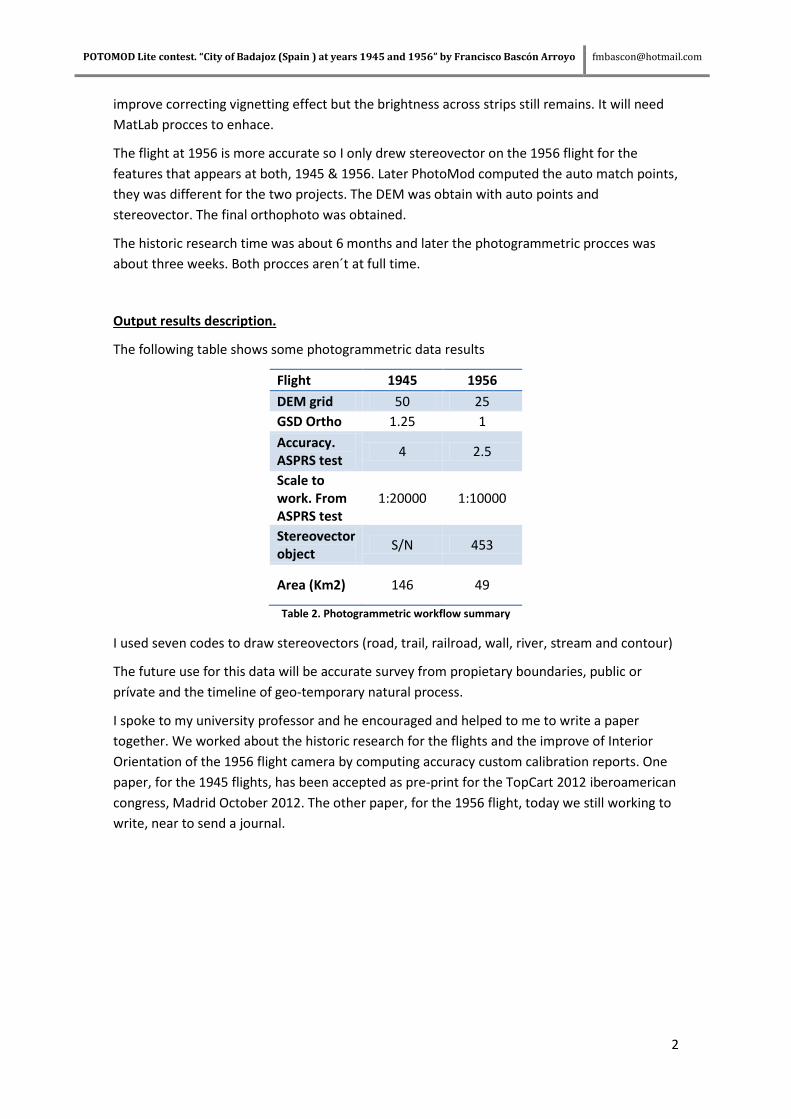
Output results description.
The following table shows some photogrammetric data results
Flight 1945 1956
DEM grid 50 25
GSD Ortho 1.25 1
Accuracy. ASPRS test
4 2.5
Scale to work. From ASPRS test
1:20000 1:10000
Stereovector object
S/N 453
Area (Km2) 146 49
Table 2. Photogrammetric workflow summary
I used seven codes to draw stereovectors (road, trail, railroad, wall, river, stream and contour)
The future use for this data will be accurate survey from propietary boundaries, public or
prívate and the timeline of geo-temporary natural process.
I spoke to my university professor and he encouraged and helped to me to write a paper
together. We worked about the historic research for the flights and the improve of Interior
Orientation of the 1956 flight camera by computing accuracy custom calibration reports. One
paper, for the 1945 flights, has been accepted as pre-print for the TopCart 2012 iberoamerican
congress, Madrid October 2012. The other paper, for the 1956 flight, today we still working to
write, near to send a journal.

POTOMOD Lite contest. “City of Badajoz (Spain ) at years 1945 and 1956” by Francisco Bascón Arroyo [email protected]
3
Graphic samples.
Picture 1. Block layout from 1945 flight. You can see the brightnees strips
Picture 2. Block layout from 1956, flight with stereo vector. Black area is Portugal, agreement excluded thirds nations involved

POTOMOD Lite contest. “City of Badajoz (Spain ) at years 1945 and 1956” by Francisco Bascón Arroyo [email protected]
4
Picture 3. South city of Badajoz at 1956 with Vauban fortifications stereovector, semi-demolished and not complete
Picture 4. Badajoz railway station and Guadiana river joins his afluent Gévora. Left part at 2007 and right at 1945.

POTOMOD Lite contest. “City of Badajoz (Spain ) at years 1945 and 1956” by Francisco Bascón Arroyo [email protected]
5
Picture 5. Front ortho from Badajoz city at 2007, middle at 1956 and back at 1945.
Picture 6.From left to right, Badajoz city at 1945, 1956 and 2007.