potential wind power plant development zone
TRANSCRIPT

1
- Regional coherence project - Potential wind power plant development zone
CASE STUDY: Groups of communes of Couhé, Civraisien
and Pays Charlois [Vienne (86), FRANCE]
Thesis for the degree of Master of Science
ROMAIN BELLUT
Department of Energy and Environment
CHALMERS UNIVERSITY OF TECHNOLOGY
Göteborg, Sweden, 2009

2
- Regional coherence project - Potential wind power plant development zone
CASE STUDY: Groups of communes of Couhé, Civraisien
and Pays Charlois [Vienne (86), FRANCE]
ROMAIN BELLUT
Supervisor / Examiner : Associate professor Ola Carlson
Department of Energy and Environment
CHALMERS UNIVERSITY OF TECHNOLOGY
Göteborg, Sweden, 2009

3
- Regional coherence project - Potential wind power plant development zone
CASE STUDY: Groups of communes of Couhé,
Civraisien and Pays Charlois [Vienne (86), FRANCE]
CONTENTS
CONTENTS ...................................................................... 3
ABSTRACT: ...................................................................... 4
ACKNOWLEDGEMENTS ................................................. 5
I. INTRODUCTION ............................................................ 6
II. METHODOLOGY AND GOAL ...................................... 9
III.CONSTRAINTS INVENTORY .................................... 10
III.1 Technical constraints ....................................................................................... 10
III.2 Environmental constraints ............................................................................... 19
III.3 Patrimonial and landscape constraints ............................................................. 22
IV. POTENTIAL WIND POWER PLANT DEVELOPMENT ZONES DEFINITION ...................................................... 23
IV.1 Potential wind power plant development zone ................................................ 23
IV.2 Technical characteristics of the potential wind power plant development zones
.................................................................................................................................. 23
V. POTENTIAL WIND POWER PLANT DEVELOPMENT ZONES EVALUATION .................................................... 37
VI. CONCLUSION ........................................................... 39
BIBLIOGRAPHY ............................................................. 40
GLOSSARY (French acronyms) ..................................... 42

4
ABSTRACT:
This document presents a methodology to highlight the location on which the wind turbines could be implemented. This study was performed in the framework of the wind power plant development on the land of the communes groups of Couhé, Civraisien and Pays Charlois located in the west of France in the Vienne department [86]. The work has been done in the Encis Wind company for WKN France which is a Wind Power developer company. The major interest of this study is to provide a detailed and neutral analysis about the potential wind power plant zone to WKN France which desires to develop wind power plant projects on the studied territory The methodology consists in an inventory of the technical, environmental and patrimonial constraints that will determine the locations that can potentially receive wind turbines. The used methodology is updated and enhanced by the work in this thesis. The following work is a pre-study that should be used to define and evaluate the wind power plant possibilities. Indeed, the regional coherence project about the potential wind power plant development zones is a tool for the decision maker WKN France. Keywords: Potential Wind power plant development zone; energy generation; territorial coherence project; technical, environmental, heritage landscape constraints.

5
ACKNOWLEDGEMENTS
First I would like to thanks Sylvain Leroux who supervised my master thesis
work as tutor during this work placement. I am also really thankful toward Ola Carlson who accepted to be my
supervisor for this work. Finally I would like to thanks a lot both Chalmers University and Encis Wind
for their welcoming. In Chalmers, I learned a lot by meeting many Swedish and international
students, by talking a lot with open-minded teacher or PHD students and finally by studying the sustainable energy system program which is greatly interesting. Studying in Sweden in such a university like Chalmers is one of the richest experiences of my life and I will never forget it.
In the same way than for Chalmers, I would like to thank a lot Encis Wind and its whole staff that always helped me during my work and for the nice things we shared during this 5 months. During this study, the work has been done with the project manager and I actively assist him in all the steps of the methodology.
Finally, I would like to dedicate all the success I had during my study to my parents that encourage me and help me to reach goals. I also want to say to my girlfriend Olivia that I love her…
Thank you all!

6
I. INTRODUCTION
This chapter starts with generalist parts as the world and French energetic context, the wind technology and its current regulation. Then the description of the project leader followed by the one of the project manager give a better understanding of the work about wind power plant development zones and the different actor in a wind power project. One will also get an overview of the problem treated here, its limitations and a description of project scope.
I.1) World energetic context The global energy demand is getting higher and higher because of the production method, the demographic explosion and the standard of living rising. To face this rising needs, the fossil fuels (coal, gas, oil) will not be enough, their resources are limited and will be exhausted in the future. Moreover the fossil fuels combustion causes the release of greenhouse effect gases that harm the observed global warming. For these reasons, human kind aims to the development of sustainable energies that generate really weak environmental and health impacts and that allow the future electricity production.
I.2) Background and context of wind turbines in France
France has the second best wind potential in Europe while it is currently one of the less equipped countries in Europe, far away from Germany and Spain. In the current international and European framework really favourable for the development of sustainable energy, France acquired in June 2001 an attractive call price in favour of wind power production. Today, there are around 2500 wind turbines implemented in France. One of the goals defined in the framework of the “Grenelle de l’environnement” (which is a group of political meeting that sets some goals to achieve in parallel with the Kyoto protocol) is of 10000 wind turbines in operation in France in 2020.
I.3) The wind turbines technology
A wind turbine is a mechanical and electrical device that turns the kinetic energy of the wind into useful electric power. Indeed the blades turn by the effect of the wind as a classical mill and drive a rotor which is an electricity generator. Most of the time, the produced electricity is injected into the grid to be distributed. Just below, you can see the most implemented type of wind turbines, its rotor has an horizontal axe and three blades of 40m each. The tower has a height of 100m and is supported by a foundation made of 30 concrete tonnes. It makes a huge construction.
Fig.1: Main parts of a classical wind turbines

7
A wind velocity of 3m/s is required to drive the blades in rotation and a brake is activated when the wind velocity is over 30m/s because with such a velocity, the wind turbine could be damaged. The wind power technology has progressed a lot these last fifteen years on many points like electricity production, aestheticism or acoustic impact reduction. On an economical standpoint, wind power is the most competitive sustainable energy with the hydro power and will produce 35 times more energy than it is needed to build it.
I.4) Current regulation
As its European partner, France is engaged to increase the sustainable energies development. The 2001/77/CE European directive of the 27th of September 2001 related to the promotion of produced electricity from renewable sources is an example of engagement. This directive which defines some goals to reach is the translation of the Kyoto protocol signed in 1997. One of the French goals is to reach a 21% of sustainable energy consumption in 2010 (near 14% in 2008). The costs of the wind power electricity production has regularly decreased and its competitiveness compare to the fossil fuels energy systems should be reach in few years. Indeed the prices of the fossil energies are higher and higher. Then, wind power with a potential of 25000MW toward 2020 (Grenelle de l’environnement) will have a significant role to reach the government goals. In this context, a regulation framework that supports the wind power development has been established. Then the n°2000-108 law of the 10th of February 2000 related to the modernisation and to the electricity public service has implemented the purchase obligation of the electricity produced by metropolitan wind farm. The n°2005-781 law of the 13th of July 2005 (P.O.P.E law) sets the political energetic orientation and offers good development conditions to the sustainable energies by consolidating the dynamic rising of wind power and by promoting its reasonable local insertion. From now, the purchase obligation of the electricity produced by wind power plant is set aside for the implementation in wind power plant development zone (Ecology and sustainable development minister, 19 juin 2006; Instructions détaillées relatives aux zones de developpement de l’éolien terrestre). Then the implementation of wind turbines into a wind power plant development zone is required for the economical viability of a project. According to the 19th June 2006 circular, after the proposition of the wind power plant development zones that is done by the project developer, these are the prefects that valid or reject the wind power plant development zones. Their choices are based on the wind resources, the grid connection possibility, the environmental and landscape sensitivity…
I.5) Regional coherence project actors
-Project leader: WKN France is a subsidiary company of WKN Windkraft Nord AG which acts on the whole France land. WKN was founded in 1990 and the first WKN wind farm started operating in Hedwigenkoog (Germany) in 1993 with the erection of ten turbines. WKN is one of the leading companies for turnkey construction and operation of wind farms. WKN France is wishing to get a synthesis document that analyses the potential wind power plant development zones on the Couhé, Civraisien and Pays Charlois groups of communes in order to do the request to the prefects of Vienne. As the request in order to valid or reject a wind power plant development zone is quite long (sometimes more than one year), the developer as WKN requires a deep study which will be used as a decision tool before this request.
8
-Project manager: Encis Wind is a French company specialised in the wind power field. It was founded in 2004 by a doctor in geography specialised in wind power and two professors from the geography department of the Limoges University (France). The staff leads one of the first citizen projects of France until the building permit by working in close collaboration with some farmers of the Limousin region. Encis Wind also develops its activities in other sectors, it provides and implements wind measurement devices and sensors, photovoltaic electricity production system and services related to land, energy and environment management.
I.6) Scope definition and limitation
A regional coherence project allows defining the different potential wind power plant zone by focusing on the technical, environmental and patrimonial aspects. The landscape aspect that is not analysed and assessed in this work is also one of the most important criteria in the definition of potential wind power plant zones. To complete the study on a landscape point of view, WKN France ordered a landscape study to l’Atelier Mathilde Martin that is specialised into the analysing of wind power plant into the landscape. Encis and l’Atelier Mathilde Martin worked together on the regional coherence project but this master thesis presents only the parts that Romain Bellut actively worked on. Then this study does not contain a further analyse of the landscape but just a brief visual impact and the historical monuments presence have been performed on the most interesting zone but a deeper analyse is needed to take a better conclusion.

9
II. METHODOLOGY AND GOAL
The goal of this project is to identify the location of the communes groups of Couhé, of Civraisien and of the Pays Charlois where it is more valuable to define a wind power plant development zone. It is a tool which is used to help the developer WKN France to determine which site is the most interesting for a coherent development of wind power plant.
The methodology follows three main steps in the order indicated below:
Fig.2: Three steps of the methodology
FIRST STEP: Inventory of the technical and environmental constraints on the
territory of the communes community of Couhé, of Civraisien and of the Pays Charlois. These constraints will be classified and from it, some analysis maps will be done for each constraint. The more constraints there are on the land, the less space there are to be defined as potential wind power development zone.
SECOND STEP: Definition of the potential wind power plant development
zone according to the constraints quoted in the inventory. The zones where there are no or just few constraints have been identified and selected as potential wind power development zone.
THIRD STEP: Potential wind power plant development zone assessment that
is performed according to many criteria (wind potential, distance to the electrical transformer stations around, capacity of the wind power plant that can be implemented…)

10
III.CONSTRAINTS INVENTORY
In this part the different constraints that generally exist and the one that we have in the case study of the potential wind power development zone in the groups of communes of Couhé, of the Civraisien and of the Pays Charlois. We separated the constraints into technical and environmental ones on which one emphasise but a brief study of the patrimonial and landscape aspect has been done too. All the maps that illustrate the different constraints can be referred in the cartographic appendix. Indeed, the cartographic appendices give an illustration and are the best way to synthesize the different constraints. That’s why the reader should read the following report in parallel with the cartographic appendices.
III.1 Technical constraints
The technical constraints that can be present on a land can be:
Wind resources
Connection to the grid
High voltage overhead cables
Radio easement
Civil and military air circulation
Roads an railway track
Gas pipeline
Housing… First, these technical constraints will be stated separately and described in details in the general case. Then we will consider our case study about the groups of communes of Couhé, of the Civraisien and of the Pays Charlois.
III.1.1) Wind resource There are two main reasons to implement wind power plant where the wind resources are the best. The first one is an environmental reason, indeed a huge wind resources involves that a high amount of green electricity will be produced. Then it will contribute significantly to reach the 21% of electricity coming from sustainable source in France. The second reason deals with the economical balance because the more electricity is produced, the more money the wind power plant manager will earn. As the implementation of a wind power is really costly, it’s really important to find a reliable wind resource. Most of the time, the data that is used to represent the wind resource is the annual average velocity at the height of 80m (in m/s). 80m is generally the height of the nacelle. Another regulation aspect is taken into account to define a wind power development zone. According to the circular of the 19 June 2006 (Ecology and sustainable development minister, 19 juin 2006; Instructions détaillées relatives aux zones de developpement de l’éolien terrestre), the prefect that will analyse the request for a wind power development zone can reject it for the only reason that the annual average velocity is lower than 4 m/s at 50m everywhere in the zone.

11
To assess the potential wind resource on the studied territory, the document “Atlas Eolien de la Vienne” (General council of Vienne,2006 ;Guide pratique pour des Zone de Développement Eolien en Vienne) was used. The map edited in the appendix 1 is based on this wind atlas. Thanks to it we can notice that the annual average velocity of the wind is much higher than the minimum stated in the regulation with an annual average velocity varying between 5.5 and 6.5 m/s at a 50m height. A large site where the wind resource is the highest is located in the middle of the studied territory. By taking into account the data from the “Atlas Eolien de la région Poitou-Charentes”, a great wind resource potential to develop is noticeable.
III.1.2) Connection to the grid
The electricity production of the wind turbines have to be injected in the grid. Some electrical facilities are required to do it.
Fig.3: Connection to the grid of a wind turbine
The wind turbine generator produces a three-phase alternative low tension electricity of 690V (LT). The 690/20000V transformer at the wind turbine bottom increases the voltage level to 20000V (HTA) in order to reduce the current injected in the delivery station which is implemented close from the wind power plant implementation site. The electrical connection from the wind turbines to the delivery station is realised by the burying of electrical cables. From this delivery point, the medium level voltage (HTA) is delivered to a substation which transforms it into high level voltage (HTB) of 63000V or 90000V. The connection to the grid is a key factor to define a wind power development zone. Actually, the electrical capacity and transformer capacity which transforms the medium level voltage (HTA) to the high level voltage (HTB) are the two criteria that partly define the maximum size of the wind power farm power that can be located in the wind development zone. The grid always changes and is currently evolving a lot to enhance the possibilities of connecting to the grid. On an economical and technical standpoint, the wind power plant development zone should be situated close from the substation to avoid the losses in the electrical cables and to reduce the connection cost. The higher is the wind power plant capacity, the higher the cost for the connection to the grid can be.

12
Two sources of information are used, the first one is the internet website of “Réseaux de Transports d’Electricité” (www.rte-france.fr) and the second one is the contact with the people responsible for the grid management. In the following table, the substations located inside and at least at 15km away from the territory of the groups of communes of Couhé, of Civraisien and of Pays Charlois. Table.1: Capacities table of the substation in the 15km perimeter around the groups
of communes
We can notice that there are many substations to link on but the capacities seem to be a little bit weak in general if the projects on the waiting list are achieved. As it has been said previously, the capacities can be increased but they can also decrease if there are other project ongoing on the same territory. On the cartographic appendices 3 and 12, we can see the locations of the substations and their electrical and transforming capacities are also stated. The electrical capacity is related to the capability of the grid lines to transport a power. A significant voltage line allows to transport a high power. The transformer capacity is the capability of the substation to transform the electricity produced by the wind turbines into electricity that is accepted by the transportation grid. Both electrical and transformer capacity have to be significant enough in order to inject the electricity produced into the grid. The distance between the substation and the potential wind power plant zone is really significant in the project because it’s very costly to connect the delivery station to the substation. Then this factor will determine the economical feasibility of the project.
III.1.3) High voltage lines
During the wind power plant design, the mechanical fatigue of the materials and the dynamic behaviour of the structure are carefully studied. The wind turbines are designed by the manufacturer in order to resist at a large range of extreme climatic conditions. The varying intensity of the force applied on the blades in function of the wind fluctuation must also be taken into account. The blades of the wind turbines are usually under repeated bending effect, it involves that some internal structural weakness can appear in the blades if they are badly designed or manufactured. On a statistical standpoint, the falling of a wind
Substations (department) Electrical capacity (MW)
Project on waiting list (MW)
Transformer capacity (MW)
La Cour (86) 25 - 0
Civray (86) 30 24 70
Les Minières (86) 55 - 0
Anche-Voulon (86) 0 - 0
Saint-Saviol (86) 0 - 0
Bodu (86) 0 - 0
Longchamp (16) 30 33 65
Isle Jourdain (86) 53 - 30
Lusignan (86) 45 16 0
La Planche (86) 55 - 0
Papault (86) 65 - 15
Jousseau (86) 0 - 0
Chardes (86) 0 - 0

13
turbine tower is really unusual whereas the falling of a blade happens more often. When the first machines was installed in the early eighty’s, they were tooled up with blades made of metals, which favour the creation of crack.
Today, this problem is totally solved thanks to the use of composites materials to design the blades which is lighter than the metallic ones and that enhance the resistance. The falling of blade is now almost impossible. Nevertheless the grid manager (Réseau de Transport d’Electricité) apply the precautionary principle by advising a distance between the wind turbines and the high voltage lines that is higher than the height of the tour added to the height of a blade (around 150m). The excluded area du to the presence of high voltage lines should be higher when it’s a 400000V line than a 66000V line.
Fig.4: Picture of a high voltage line (Source : Encis wind)
The groups of communes of Couhé and of the Civraisien have a high voltage line on their territory on the south-north axe passing trough the communes of Lizant, Voulême, Saint Macoux, Saint Saviol, Saint Pierre d’Exideuil, Blanzay, Romagne and Vaux. Another high voltage line goes through the commune of Anche and Voulon in the north of the studied territory (cf. appendix 3). The presence of such a constraint decreases the available space for the future wind power plant development zone. It’s not a decisive factor in the definition of a potential wind power plant zone but it can pass through it and then decrease the area of the zone.
III.1.4) Radio easement The television and radio waves transmission is performed through radio-relay beam from the radio stations.
Fig.5: Radio relay station of Civray

14
The radio station and the way of the radio-relay beams are designed in order to avoid any obstacles. The wind turbines, because of their quite high height and their composites materials, are considered like an obstacle for the spreading of the waves. Such disturbances has been noticed around some wind farm but it is still unusual and most of the time the quality of the waves propagation is not affected. Nevertheless in few cases, it has created some consequences on the radio-relay transmission that’s why the authorization of the manager is required. This issue must be considered because it’s a constraint for the wind power plant development. The disturbances should be less and less important with the increased use of the digital television because the wave transportation is done through satellites, digital wireless beam or optical fiber. The cartographic appendix 4 presents the radio-relay station of the group of communes of Couhé, of the Civraisien and of the Pays Charlois. Two radio-relay stations are implemented in Chaunay and Civray. A radio relay beam passes through the communes of Savigné, Champniers and Romagne has is start point at the radio-relay of Civray. From the radio-relay station of chaunay, no wave propagation was noticed. Another radio relay beam is situated in the north of the group of communes and cross Anche and Voulon. In the same way than for the high voltage line, the presence of radio-relay stations and radio relay beams can reduce the available space for wind power plant development zone.
III.1.5) Civilian and military air circulation
Anthropogenic activities like the civilian and military air circulation have to be considered on a land where wind power plant development zone has to be defined. Aeronautical activity is one of the most significant constraints for the wind turbines project. A good knowledge of the territory and of the location of the air easements, the radars and the other air activities like the ultra light motorized machine is required to respect the cohabitation with the wind turbines.
a) Air easement The air flow circulation of civilian and military airplane lay down both an air
space and a ground space to protect. A limited height is generally set in such place (for instance the buildings or the wind turbines).
As it is shown on the cartographic appendix 5, there are different constraints
which appear on the territory, they are ranked from the strongest constraint to the weakest one:
- The approaching zone of the military airport of Cognac. The entire territory is concerned about it even if the airport is quite far away. Every wind project in this zone depends on the advice of Air military service. (General council of Vienne,2006 ;Guide pratique pour des Zone de Développement Eolien en Vienne )
- The civilian airport of Couhé-Verac lay down an exclusion zone all around the landing zone. The “Direction Générale de L’aviation Civile” (DGAC) which is the national French manager of the civilian air circulation should be questioned to know if there is any exclusion zone or maximum height for the wind power plant development zone.
b) Radars
15
The civilian and military air activities require radars in order to communicate and to manage the air space. The ways of communication, of navigation, of landing help and of detection are considered as easement. There are nearly 80 radars in France and they are not systematically located close from the aeronautical activities center (ADEME, 2003; Guide du développeur de parc éolien,). No wind turbines can be tolerated in a 5km radius around every primary or secondary radars (Agence Nationale des Fréquences [Commission Consultative de la Compatibilité Electromagnétique], 2008; Rapport CCE5 n°2). Indeed, some disturbances can be generated by the wind turbines blades because they can reflect the electromagnetic waves and so interfere with the radars facilities. No radars are situated close from the studied group of communes.
c) Free flight and leisure
There is not a precise law or rule concerning the free flight but one have to look after the cohabitation between this activity and the wind power plant implementation. A safety perimeter has to be established in function of the kind of practised activities. The presence of a free flight landing is considered as a constraint to set the limitation of the wind power plant development zone. In the concerned territory, there are two free flight activities:
- Flying club of Romagne. A protection zone around the private airport is suggested (General council of Vienne,2006 ;Guide pratique pour des Zone de Développement Eolien en Vienne). This zone defined as a sensitive one is situated in the north-east part of Romagne.
- Motorized airplane modelling club. This flying activity is quite unexpected but the restriction due to its presence should not be hard.
III.1.6) Ways of transports and communications The presence of roads can be as much an inconvenient as an advantage.
Indeed, the roads close from the future wind farm are used to bring all the different facilities required in the building of a wind turbine but also at a much lower level, during the exploitation phase. Nevertheless, the roads have to be at least at the wind turbine falling distance (around 150m) for the departmental and national roads. As there are a lot of communication and transport ways in the group of communes of Couhé, of Civraisien and of Pays Charlois, the roads will be only studied around the potential wind power plant development zone and their assessment will depend on the space setting. On the cartographic appendix 6, only the national roads and the main departmental roads are represented for a better readability. We will consider further in the study the other departmental road where it is interesting. Like the road, the railway is considered as an easement, that’s why wind turbines cannot be installed close to it.
III.1.7) Gas pipeline
Even if the likelihood of the discharge of a blade or the falling of the nacelle, is very low, it could damage the gas pipeline and then make the gas free. That’s why a protection zone has to be defined. The easement itself is of 12.5m on both side of the gas pipeline. The decision of the protection zone setting has to be decided by the gas pipeline manager. According to the weight and height of the wind turbines and the

16
gas pipeline characteristics, he determines the safety distance required the gas pipeline and the possible implementation zone of the wind turbines. An other sort of gas easements are the gas expansion station which is used to decrease the gas pressure just before injecting it in the transportation and distribution grids until the final customers (www.cndp.fr). Like the gas pipeline, the gas grid manager is the decision maker to define the protection zone. The presence of gas easements on the territory decreases the available space for the potential wind power development zone. Nevertheless, after a study on the regional gas grid and a discussion with the authorities, no gas easement was found in the group of communes of Couhé, of Civraisien and of Pays Charlois.
Fig.6: Picture of a gas expansion station (source: Encis Wind)
III.1.8) Housing
A wind turbine must be enough far away from any housing for two main reasons: the visual and acoustical impacts that are the only two impacts of the wind power technology. For people that live close from any wind power plant, the visual impact is obvious because of the size of the machines. Nevertheless this impact is more or less high according to the different perceptions that people have of it. Some of them would characterize the wind turbines as a “visual pollution” and the others would say that they look like a kind of “huge metallic flower that produces sustainable energy” (ADEME, 2008 ; Une énergie dans l'air du temps : les éoliennes). The visual perceptions vary a lot in function of the distance between the viewer and the wind turbine. As it is showed on the figure below, the more one go away from the wind turbine, the more they seem small. Finally the visual impact of a wind turbine decreases exponentially with the distance.

17
Fig.7: Visual perception of a wind turbine in function of the distance
When wind turbines are operating under the wind influence, they emit two kind of noise: the mechanical and the aerodynamic noises that have two different origins. The first generation of wind turbines was really noisy. Today, thanks to technological enhancing like the decreasing of the blades operating speed, the precision gears, the transmission shaft assembly on shock absorber or the nacelle padding, they are more and more silent. According to EWEA, the European Wind Energy Association, at the bottom of a wind turbine, the acoustic level is of 55 decibels (dB) whereas this level is about 45 dB at 250m and 35 dB at 500m which corresponds to a low voice conversation. For the study on the territory of Couhé, of Civraisien and of Pays Charlois, we chose a perimeter of 650m around each and every houses or any building by taking into account the acoustic impact because the visual impact is a personal point of view and depends a lot on the topography of the land. At 650m, the acoustic impact is considered as low. According to the acoustic regulation (decree 95-408, 18 april 1995; decree relative to neighbourhood noises), a wind turbine can be installed at a lower distance but the 650m distance has been chosen as the minimal distance between a wind power plant development zone and the housing in order to minimize this impact on people. A further work that will determine the distance to respect in function of the acoustic impact on each house will be performed in the framework of a wind project. On the studied land, the housing is relatively concentrated around the biggest town as we can see on the cartographic appendix 7. But the exclusion zone diminishes a lot the land that can take a wind power development zone.
18
III.1.9) Town and country planning The compatibility of the implementation of wind turbines with the town planning documents that are currently in force have to be fully appreciated. Some communes are allocated to such town planning regulation like:
- “Plan d’Occupation des Sols” (POS) : the land use plan is a regulation that enumerates the listing of the constructions and implementations that are authorized on the natural zones. When this listing does not mention the wind turbines or the collective interest facilities or technical facilities required for the operating of the public services, the authorization just can be delivered after the modification of the revision of this document.
- “Plan Local d’Urbanisme” (PLU) : the local town plan gives the choices to the communes to accept or reject the wind turbines or the collective interest facilities on the agricultural zones or the natural zones. On the agricultural zones, only the constructions and the facilities required for the agriculture, the public services or the collective interest services are authorized. The wind turbines that inject the produced electricity into the grid (in opposition with the stand alone system) can be implemented in this zone because they are considered as a public and collective service. In the natural zone, the town planning regulation does not limit the nature of the admitted building but if the zone is under a nature protection regulation because of the landscape or the biodiversity for instance, the wind power plant cannot be admitted for such reasons.
It is necessary to know the town and country planning of the communes to know if the implementation of wind turbines is authorized.
III.1.10) The ongoing wind power plant project The proximity of a wind farm or a future wind farm involves some positive or negative effects according to the landscape context. Indeed the proximity of two wind farms can be seen as a concentration and then contribute to the development of a wind power plant cluster. On one hand, the distance between two wind farms of the same cluster should be of 5km away maximum to avoid any “scatter effect” on the land. On the other hand, it is necessary to propose some space among the wind projects and to be coherent in comparison with the co-visibility among wind farms. The zone that has been studied for the group of communes of Couhé, of Civraisien and of the Pays Charlois is the 10km perimeter around the communes. As this land has a great potential for wind energy development, there are already some wind energy projects on it. First it has been noticed that only the wind farm of Villefagnan in the south is operating. However there are other projects that go to completion because the commune of Saint-Macoux (Civraisien) granted the building permit for a wind farm and a request for a building permit is currently analysing by the authority of the commune Genouillé. There are couples of projects more or less advanced on the communes of Romagne and Blanzay. It seems that almost everywhere around the studied zone, there are wind power plant development zone that are studied for the choice of the most favourable zone for wind power plant implementation.

19
Fig.8: Steps state of the wind power plant development zone on the adjoining groups
of communes of the studied groups of communes
III.2 Environmental constraints The compilation of the natural heritage protection zone (www.DIREN-Poitou-Charentes.fr) on the groups of communes of Couhé, of Civraisien and of Pays Charlois shows a quite small sensitivity. Nevertheless, there are some groups of communes located around that are protected zone. The environmental richness of these places must be preserved and some tools like the classification Natura 2000, ZPS, ZICO or ZNIEFF are used.
The main disturbance due to the wind turbines is for the wildlife and the flora during the construction and the connection to the grid of the civil work. That’s why these works are performed when it’s not the reproduction period. After the civil work, the excavated earth is replaced and plants conquer the land over the foundation and trench. During the exploitation period, the wildlife is present again and is not affected anymore.
The implementation of wind power plant should be done at a certain distance away from the protection zone like the ZNIEFF, ZICO… Sometimes the weakness of the impacts on the fauna and flaura can be justified precisely, then the implementation of the wind power plant can happen in some of these protected zones. But this zone should be avoided.
As we can see on the cartographic appendix 9, the following environmental
constraints must be taken into account: -Natura 2000 -ZNIEFF 1 and 2 -ZICO -ZPS
It can be noticed that these zones are present on the studied groups of communes and the adjoining ones.
20
III.2.1) Natura 2000 The Natura 2000 zones contain the lands that have an ecological importance
and then that are strongly protected. The projects that are foreseen on the Natura 2000 sites are under the judgement of the prefect, after his investigation he will give his opinion to the communes and to the shared by several communes public establishment of cooperation.
This Natura 2000 grid is an important tool for the preservation of the biodiversity in Europe. The different European countries agreed on the fact of taking appropriate measure to avoid the deterioration of this environment.
On the territory of the groups of communes of Couhé, of Civraisien and of
Pays Charlois, there are no environmental constraints due to the presence of a Natura 2000 zone. However, there are two Natura 2000 zones located near the studied group of communes:
Plaine de la Mothe-Heray-Lezay
Région de Pressac, Etang de Combourg The territory called “Plaine de la Mothe-Heray-Lezay” located at the west of
the studied groups of communes and adjoining with Chaunay, Brux and Couhé is relatively huge and is classified as a Natura 2000 zone of special protection [ZPS]. .
The zones which contain the « Région de Pressac » and « Etang de Combourg » located at the east of Charroux is also a Natura 2000 zone with special protection.
III.2.2) ZNIEFF
The « Zones Naturelles d’Intérêt Ecologique, Faunistique et Floristique » [ZNIEFF] has been used first in 1982 by the ministry of environment. It has the objective of covering some zones that are interesting on an ecological point of view in order to enhance the knowledge of the natural national heritage and to provide a tool related to environment and land management for the different decision makers.
This inventory is based on the richness of the natural surrounding or the presence of scarce or threatened animals, plants or any leaving organisms. Two kind of ZNIEFF can be distinguished:
- Type 1 ZNIEFF : these are geographical limited areas which have an important biological value. A deep care is performed during the elaboration of every land management project related. They represent a significant constraint toward the implementation of wind turbines.
- Type 2 ZNIEFF : these are natural places that are rich and little modified or that offer some important biological potentialities They have to be systematically taken into account in the development programs. They represent a moderated constraint toward the creation of a wind farm.
There are some type 2 ZNIEFF on the territory of the communes group of
Couhé, of Civraisien and of Pays Charlois. On the communes group of Couhé, we can notice that one of them covers the vallée de Bouleure located at Chaunay and Brux. Another one is situated in the forêt d’Héronnière at the west of Couhé.
On the Civraisien Group of communes land, the forêt de Leray area is a type 1 ZNIEFF between Saint-Pierre-d’Exideuil and Saint-Saviol. The commune of Civray has such a zone and this is the bois d’Ages and the Coteau de l’Etourneau situated in the middle of the Voulême commune is also a type 1 ZNIEFF.
On the Pays Charlois group of communes, only the bois de Breuil is a type 1 ZNIEFF in the Charroux commune. It is also important to note that the presence of a type 1 ZNIEFF in the adjoining communes have to be considered.
21
In the following table is presented the different type 1 ZNIEFF that are located in the studied groups of communes and the one that are in the adjoining communes:
Table.2 : Table of the the type 1 ZNIEFF (http://sigore.observatoire-environnement.org/)
ZNIEFF I Commune (Group of communes) Sites names
Chaunay and Brux (Couhé) -Vallée de la Bouleure
Couhé (Couhé) -Bois de la Heronniere
Saint-Pierre-d’Exideuil and Saint-Saviol (Civraisien) -Bois de Leray
Civray (Civraisien) -Bois des Ages
Voulême (Civraisien) -Coteau de l’Etourneau
Charroux (Charlois) -Bois de Breuil
Château Garnier and Usson-du-Poitou (adjoining to the groups of communes)
-Etangs de la Pétolée, -Bois et Landes des Grandes Forges -Marnières de la Barrelière
Limalonges (adjoining to the groups of communes) -Bois de Glassac
Pleuville (adjoining to the groups of communes) -Etang du Besson et de la Boucherie Saint Martin l'Ars (adjoining to the groups of communes)
-Etang de Saint-Liguaire -Bois de Lareau
Champagné-Saint-Hilaire (adjoining to the groups of communes)
-Patural des Chiens -Coteau de la Cueille
Taize-Aizie (adjoining to the groups of communes) -Foret de Ruffec
Some type 2 ZNIEFF are identified on the concerned territory. On the group of communes of Couhé is located the forêt Domaniale of Saint-Sauvant whereas the another type 2 ZNIEFF can be found on the Deux-Sèvres department and is adjoined with the communes of Brux and Chaunay and the type 1 ZNIEFF (Heronnière wood).
Table.3 : Table of the the type 2 ZNIEFF (http://sigore.observatoire-environnement.org/)
ZNIEFF II Commune (Group of communes) Sites names Payre (Couhé) AND Celle-Levescault, Saint-Sauvant, Lusignan (adjoining to the groups of communes) Forêt Domaniale de Saint-Sauvant
Couhé (Couhé) Bois d’Heronniere
III.2.3) ZICO
The European directive n°79-409 of the 6th April 1979 relative to the conservation of the wild birds (directive °79-409, 6th April 1979; directive relative to the conservation of the wild birds), applied to all the members of the European Union, recommend to take all the required measures in order to preserve, maintain and restore the biodiversity and a minimum habitats area for all the species of birds living in a natural surroundings on the European territory. In this European context, France has decided to establish an inventory of the “Zones Importantes pour la Conservation des Oiseaux” [ZICO]. It is dealing with major interest sites that house wild birds species and that have a common and European importance. On the groups of communes, no ZICO is compiled but it can be noticed that the zone of the Pressac region and the Combourg bond located at the east of Charroux is inventoried as ZICO. Some noticeable species like the grey heron and the crimson heron live there.

22
III.3 Patrimonial and landscape constraints
A first approach of the patrimonial constraint has been done by taking into account the historical monuments and their protection perimeters of 500m. The cartographic appendix 9 presents it.
The studied groups of communes (and the adjoining groups of communes) have a rich heritage, particularly a significant number of registered and listed historical monuments that are strongly protected and conserved. The sites like the Cibioux castle, the Epanvilliers castle or the old Charroux abbey are registered or listed on the studied groups of communes. The 500m perimeters surround them and avoid any wind turbines implementation.
The cartographic appendices 13 and 14 respectively show the location of the different historical monuments and they are all compiled on the Couhé, Civraisien and Pays Charlois groups of communes.

23
IV. POTENTIAL WIND POWER PLANT DEVELOPMENT ZONES DEFINITION The previous parts of the study are tools to compile and classify the different constraints that exist on the territory of the groups of communes where a wind power plant implementation is to foresee. The next step that is detailed below deals with the definition of the different potential wind power development zone perimeters.
IV.1 Potential wind power plant development zone
The definition of the potential wind power development zone relies on the superposition of all the constraints layers thanks to a geographical information system: technical, environmental, patrimonial and landscaping. The constraints synthesis map (cartographic appendix 10) that presents all the constraints on one map show the different zone where there are a lot of constraints applied and the one that are free of constraints. The zones that are out from the exclusion zones determined thanks to the methodology are really favourable to include a potential wind power development zone. More than 30 zones appeared after the superposition of the exclusion zones but some of them cannot be selected because of a matter of technical viability (insufficient area, none adequate topography, land occupation) for a wind power plant project. The overall of this potential wind power plant development is presented on the cartographic appendix 11. It has to be noticed that all the zones, even if they are not under any constraints, should be approved by a study performed by the air army (military airport of Cognac R149).
IV.2 Technical characteristics of the potential wind power plant development zones
The following work consist in giving a detailed description of each and every potential wind power development zones according to the criteria listed on the previous part. The stated transportation capacities take into account the project on the waiting list. Potential wind power development zone 1: Location: West of Brux Average wind velocity:

24
5.5 to 6 m/s at 50m height Linking to the grid possibility: a) On the Minières substation; distance = 15km [Transportation capacity of the public grid=55MW; transformation capacity=0MW] b) On the Civray substation; distance = 18 km [Transportation capacity of the public grid =6MW; transformation capacity=70MW] c) On the Lusignan substation; distance = 22 km [Transportation capacity of the public grid=29MW ; transformation capacity =0MW] Maximal theoretical capacity (for an hypothesis of a west/south-west/north-east): 12 to 14MW (6 to 7 wind turbines of 2MW each) Environmental sensibility: Adjoining with a sensible zone inventoried ZNIEFF, ZPS and ZICO. Technical constraints: The proximity with the Brux airport must be considered. The north part of the zone is occupied by some woods. The south part of the zone is cut by a thalweg. Potential wind power development zone 2: Location: North-west of Chaunay. Average wind velocity: 6 to 6.5 m/s at 50m height Linking to the grid possibility: a) On the Civray substation; distance = 14 km [Transportation capacity of the public grid=6MW ; transformation capacity=70MW] b) On the Minières substation; distance = 17 km [Transportation capacity of the public grid=55MW ; transformation capacity=0MW] c) On the Melle substation; distance = 25 km [Transportation capacity of the public grid=26MW ; transformation capacity =65MW] Maximal theoretical capacity (for an hypothesis of a west/sud-west/north-east):

25
12 to 16MW (6 to 8 wind turbines of 2MW each) Environmental sensibility: Adjoining with a sensible zone inventoried ZNIEFF, ZPS and ZICO. Technical constraints: The accessibility of the zone is good, it is flat and just little wooded, which offer a great wind power plant development potentiality. The proximity with the Brux airport must be considered. Potential wind power development zone 3: Location: South of Chaunay. Average wind velocity: 5.5 to 6.5 m/s at 50m height Linking to the grid possibility: a) On the Civray substation; distance = 11 km [Transportation capacity of the public grid=6MW ; transformation capacity=70MW] b) On the Longchamps substation; distance = 20 km [Transportation capacity of the public grid=0MW ; transformation capacity=65MW] c) On the Minières substation; distance = 22 km [Transportation capacity of the public grid=55MW ; transformation capacity=0MW] Maximal theoretical capacity for an hypothesis of a west/sud-west/north-east): 12 to 18MW (6 to 9 wind turbines of 2MW each. Environmental sensibility: Adjoining with a sensible zone inventoried ZNIEFF, ZPS and ZICO. Moreover, the zone is covered by a grid of hedged farmland.
26
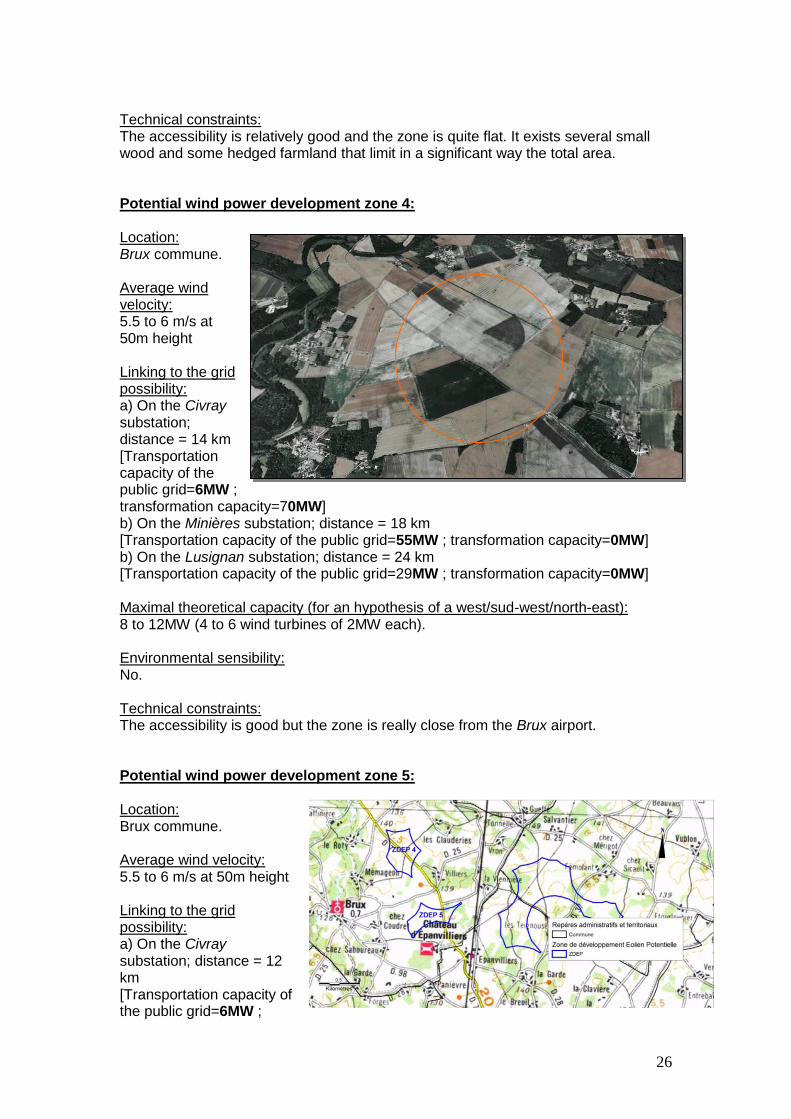
Technical constraints: The accessibility is relatively good and the zone is quite flat. It exists several small wood and some hedged farmland that limit in a significant way the total area. Potential wind power development zone 4: Location: Brux commune. Average wind velocity: 5.5 to 6 m/s at 50m height Linking to the grid possibility: a) On the Civray substation; distance = 14 km [Transportation capacity of the public grid=6MW ; transformation capacity=70MW] b) On the Minières substation; distance = 18 km [Transportation capacity of the public grid=55MW ; transformation capacity=0MW] b) On the Lusignan substation; distance = 24 km [Transportation capacity of the public grid=29MW ; transformation capacity=0MW] Maximal theoretical capacity (for an hypothesis of a west/sud-west/north-east): 8 to 12MW (4 to 6 wind turbines of 2MW each). Environmental sensibility: No. Technical constraints: The accessibility is good but the zone is really close from the Brux airport. Potential wind power development zone 5: Location: Brux commune. Average wind velocity: 5.5 to 6 m/s at 50m height Linking to the grid possibility: a) On the Civray substation; distance = 12 km [Transportation capacity of the public grid=6MW ;

27
transformation capacity=70MW] b) On the Minières substation; distance = 20 km [Transportation capacity of the public grid=55MW ; transformation capacity=0MW] c) On the Lusignan substation; distance = 26 km [Transportation capacity of the public grid=29MW ; transformation capacity=0MW] Maximal theoretical capacity: 8 to 10MW (4 to 5 wind turbines of 2MW each) for an hypothesis of a west/sud-west/north-east. astérix Environmental sensibility: No. Technical constraints: The accessibility is good but the zone is really close from the Brux airport. Potential wind power development zone 6 and 7: Location: East of Chaunay. Average wind velocity: 5.5 to 6 m/s at 50m height Linking to the grid possibility: a) On the Civray substation; distance = 8 km [Transportation capacity of the public grid=6MW ; transformation capacity=70MW] b) On the Minières substation; distance = 22 km [Transportation capacity of the public grid=55MW ; transformation capacity=0MW] c) On the Longchamps substation; distance = 23 km [Transportation capacity of the public grid=0MW ; transformation capacity=65MW] Maximal theoretical capacity for an hypothesis of a west/sud-west/north-east: 12 to 16MW (6 to 8 wind turbines of 2MW each). Environmental sensibility: No. Technical constraints: The wind power development zone 7 is covered by many trees. Some local roads and a railway track also pass

28
through the zone 7, which add some constraints.
Potential wind power development zones 8: Location: Between Blanzay and Romagne. Average wind velocity: 6 to 6.5 m/s at 50m height Linking to the grid possibility: a) On the Civray substation; distance = 11 km [Transportation capacity of the public grid=6MW ; transformation capacity=70MW] b) On the Minières substation; distance = 20 km [Transportation capacity of the public grid=55MW; transformation capacity=0MW] c) On the Lusignan substation; distance = 28 km [Transportation capacity of the public grid= 29MW ; transformation capacity=0MW] Maximal theoretical capacity (for an hypothesis of a west/sud-west/north-east): 20MW (10 wind turbines of 2MW each). Environmental sensibility: Only some woods. Technical constraints: The wind power development zone 8 is really favourable on a technical point of view for the wind power plant development because it is huge territory with open fields and a regular topography. There also have a high voltage line to take into account. Potential wind power development zones 9: Location: Between Vaux-En-Couhé and Saint-Pierre-d’Exideuil. Average wind velocity:

29
6 to 6.5 m/s at 50m height Linking to the grid possibility: a) On the Minières substation; distance = 16 km [Transportation capacity of the public grid=55MW ; transformation capacity=0MW] b) On the Civray substation; distance = 17 km [Transportation capacity of the public grid=6MW ; transformation capacity=70MW] c) On the Lusignan substation; distance = 25 km [Transportation capacity of the public grid= 29MW ; transformation capacity=0MW] Maximal theoretical capacity for an hypothesis of a west/sud-west/north-east: 10MW (5 wind turbines of 2MW each). Environmental sensibility: No. Technical constraints: A high voltage line passes through the potential wind power development zone and there also have wet zone covered by a thalweg. Potential wind power development zones 10: Location: South-east of Blanzay. Average wind velocity: 6 to 6.5 m/s at 50m height Linking to the grid possibility: a) On the Civray substation; distance = 6 km [Transportation capacity of the public grid=6MW ; transformation capacity=70MW] b) On the Longchamps substation; distance = 20 km [Transportation capacity of the public grid=0MW ; transformation capacity=65MW] c) On the Lusignan substation; distance = 35 km [Transportation capacity of the public grid= 29MW ; transformation capacity=0MW] Maximal theoretical capacity: 16MW (8 wind turbines of 2MW each). Environmental sensibility: No.
30
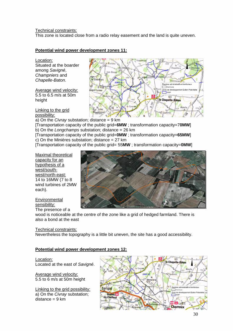
Technical constraints: This zone is located close from a radio relay easement and the land is quite uneven. Potential wind power development zones 11: Location: Situated at the boarder among Savigné, Champniers and Chapelle-Baton. Average wind velocity: 5.5 to 6.5 m/s at 50m height Linking to the grid possibility: a) On the Civray substation; distance = 9 km [Transportation capacity of the public grid=6MW ; transformation capacity=70MW] b) On the Longchamps substation; distance = 26 km [Transportation capacity of the public grid=0MW ; transformation capacity=65MW] c) On the Minières substation; distance = 27 km [Transportation capacity of the public grid= 55MW ; transformation capacity=0MW] Maximal theoretical capacity for an hypothesis of a west/south-west/north-east: 14 to 16MW (7 to 8 wind turbines of 2MW each). Environmental sensibility: The presence of a wood is noticeable at the centre of the zone like a grid of hedged farmland. There is also a bond at the east Technical constraints: Nevertheless the topography is a little bit uneven, the site has a good accessibility. Potential wind power development zones 12: Location: Located at the east of Savigné. Average wind velocity: 5.5 to 6 m/s at 50m height Linking to the grid possibility: a) On the Civray substation; distance = 9 km
31
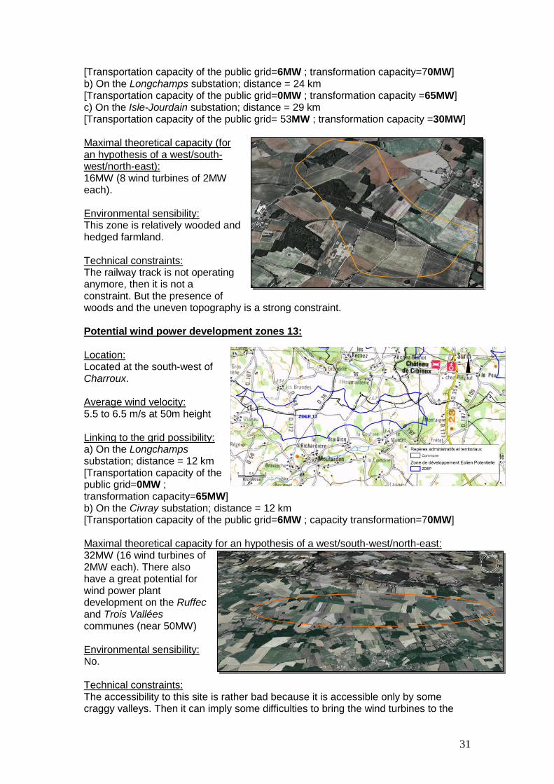
[Transportation capacity of the public grid=6MW ; transformation capacity=70MW] b) On the Longchamps substation; distance = 24 km [Transportation capacity of the public grid=0MW ; transformation capacity =65MW] c) On the Isle-Jourdain substation; distance = 29 km [Transportation capacity of the public grid= 53MW ; transformation capacity =30MW] Maximal theoretical capacity (for an hypothesis of a west/south-west/north-east): 16MW (8 wind turbines of 2MW each). Environmental sensibility: This zone is relatively wooded and hedged farmland. Technical constraints: The railway track is not operating anymore, then it is not a constraint. But the presence of woods and the uneven topography is a strong constraint. Potential wind power development zones 13: Location: Located at the south-west of Charroux. Average wind velocity: 5.5 to 6.5 m/s at 50m height Linking to the grid possibility: a) On the Longchamps substation; distance = 12 km [Transportation capacity of the public grid=0MW ; transformation capacity=65MW] b) On the Civray substation; distance = 12 km [Transportation capacity of the public grid=6MW ; capacity transformation=70MW] Maximal theoretical capacity for an hypothesis of a west/south-west/north-east: 32MW (16 wind turbines of 2MW each). There also have a great potential for wind power plant development on the Ruffec and Trois Vallées communes (near 50MW) Environmental sensibility: No. Technical constraints: The accessibility to this site is rather bad because it is accessible only by some craggy valleys. Then it can imply some difficulties to bring the wind turbines to the

32
zone. Otherwise this zone is really interesting on a technical point of view, it is a huge and open field. Nevertheless there are some huge roads around the different plots of land. Potential wind power development zones 14: Location: Located at the north of Charroux on the Saint Romain and Chapelle Bâton communes. Average wind velocity: 6 to 6.5 m/s at 50m height Linking to the grid possibility: a) On the Civray substation; distance = 16 km [Transportation capacity of the public grid=6MW ; transformation capacity=70MW] b) On the Isle-Jourdain substation; distance = 25 km [Transportation capacity of the public grid=53MW ; transformation capacity=30MW] Maximal theoretical capacity for an hypothesis of a west/south-west/north-east: 10MW (5 wind turbines of 2MW each) for an hypothesis of a west/south-west/north-east. Astérix Environmental sensibility: No. Technical constraints: The site is passed through a thalweg (difference in height of 25m) and it implies another topographic constraint with the small size of the zone. Potential wind power development zones 15: Location: Located at the north-east of Charroux. The zone is also stretched on the Chapelle Bâton and the Payroux communes. Average wind velocity: 5.5 to 6 m/s at 50m height Linking to the grid possibility: a) On the Isle-Jourdain substation; distance = 20 km [Transportation capacity of the public grid=53MW ; transformation capacity=30MW]
33
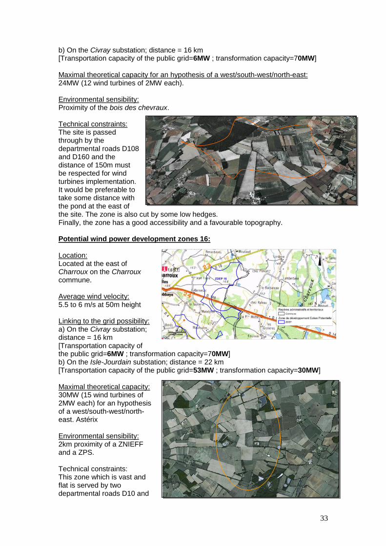
b) On the Civray substation; distance = 16 km [Transportation capacity of the public grid=6MW ; transformation capacity=70MW] Maximal theoretical capacity for an hypothesis of a west/south-west/north-east: 24MW (12 wind turbines of 2MW each). Environmental sensibility: Proximity of the bois des chevraux. Technical constraints: The site is passed through by the departmental roads D108 and D160 and the distance of 150m must be respected for wind turbines implementation. It would be preferable to take some distance with the pond at the east of the site. The zone is also cut by some low hedges. Finally, the zone has a good accessibility and a favourable topography. Potential wind power development zones 16: Location: Located at the east of Charroux on the Charroux commune. Average wind velocity: 5.5 to 6 m/s at 50m height Linking to the grid possibility: a) On the Civray substation; distance = 16 km [Transportation capacity of the public grid=6MW ; transformation capacity=70MW] b) On the Isle-Jourdain substation; distance = 22 km [Transportation capacity of the public grid=53MW ; transformation capacity=30MW] Maximal theoretical capacity: 30MW (15 wind turbines of 2MW each) for an hypothesis of a west/south-west/north-east. Astérix Environmental sensibility: 2km proximity of a ZNIEFF and a ZPS. Technical constraints: This zone which is vast and flat is served by two departmental roads D10 and

34
D 148. Two ponds have to be considered in the centre-east of the zone. Potential wind power development zones 17: Location: Located at the south-west of Charroux on the Charroux and Asnoix commune. Average wind velocity: 5.5 to 6 m/s at 50m height Linking to the grid possibility: a) On the Civray substation; distance = 16 km [Transportation capacity of the public grid=6MW ; transformation capacity=70MW] b) On the Isle-Jourdain substation; distance = 26 km [Transportation capacity of the public grid=53MW ; transformation capacity=30MW] Maximal theoretical capacity (for a hypothesis of a west/south-west/north-east): 26MW (13 wind turbines of 2MW each). Environmental sensibility: 3km proximity of a ZNIEFF and a ZPS. Technical constraints: Two departmental roads (D4 and D103) that follow a crest line pass through the zone. This zone is well oriented towards the prevailing wind. The plots of land are relatively open even if there are some hedged farmlands. Potential wind power development zones 18: Location: Situated at the south of Charroux on the Surin and Châtain communes. Average wind velocity: 5.5 to 6.5 m/s at 50m height Linking to the grid possibility:

35
a) On the Civray substation; distance = 15 km [Transportation capacity of the public grid=6MW ; transformation capacity=70MW] b) On the Longchamps substation; distance = 23 km [Transportation capacity of the public grid=0MW ; transformation capacity=65MW] Maximal theoretical capacity for a hypothesis of a west/south-west/north-east: 20MW (10 wind turbines of 2MW each). Environmental sensibility: Presence of some woods and proximity with the Charente valley. Technical constraints: This zone which is located on a plateau between Surin and Châtain is relatively high compare to the rest of the zone (180m). There are many scattered difference in level places and few wooded area. Even if there are some hedged farmlands, certain parts are quite open. The accessibility for the wind turbines to the site seems to be possible through the west way. Potential wind power development zones 19: Location: Located at the south-east of Genouillé on the Surin and Genouillé communes. Average wind velocity: 5.5 to 6.5 m/s at 50m height Linking to the grid possibility: a) On the Civray substation; distance = 11 km [Transportation capacity of the public grid=6MW ; transformation capacity=70MW] b) On the Longchamps substation; distance = 19 km [Transportation capacity of the public grid=0MW ; transformation capacity=65MW] Maximal theoretical capacity (for a hypothesis of a west/south-west/north-east): 10 to 18MW (5 to 9 wind turbines of 2MW each). Environmental sensibility: No. Technical constraints: This zone, already small, is passed through a thalweg (low level that is not favourable for wind turbines implementation) and two roads.

36
Potential wind power development zones 20: Location: Located at the south-west of Genouillé on the Lizan and Genouillé communes. Average wind velocity: 5.5 to 6 m/s at 50m height Linking to the grid possibility: a) On the Civray substation; distance = 11 km [Transportation capacity of the public grid=6MW ; transformation capacity=70MW] b) On the Longchamps substation; distance = 16 km [Transportation capacity of the public grid=0MW ; transformation capacity=65MW] Maximal theoretical capacity (for an hypothesis of a west/south-west/north-east): 14 to 18MW (7 to 9 wind turbines of 2MW each). Environmental sensibility: No. Technical constraints: This zone which is on the plateau of Genouillé is really open and flat. It is the perfect zone to take wind turbines.
37
V. POTENTIAL WIND POWER PLANT DEVELOPMENT ZONES EVALUATION
In this final part, the potential wind power plant development zones are
assessed according to a weighting method. In order to evaluate the different zones that we determined thanks to the previous parts of the wind power plant territorial coherence project, the following criteria will be considered and a score will be attributed to each values:
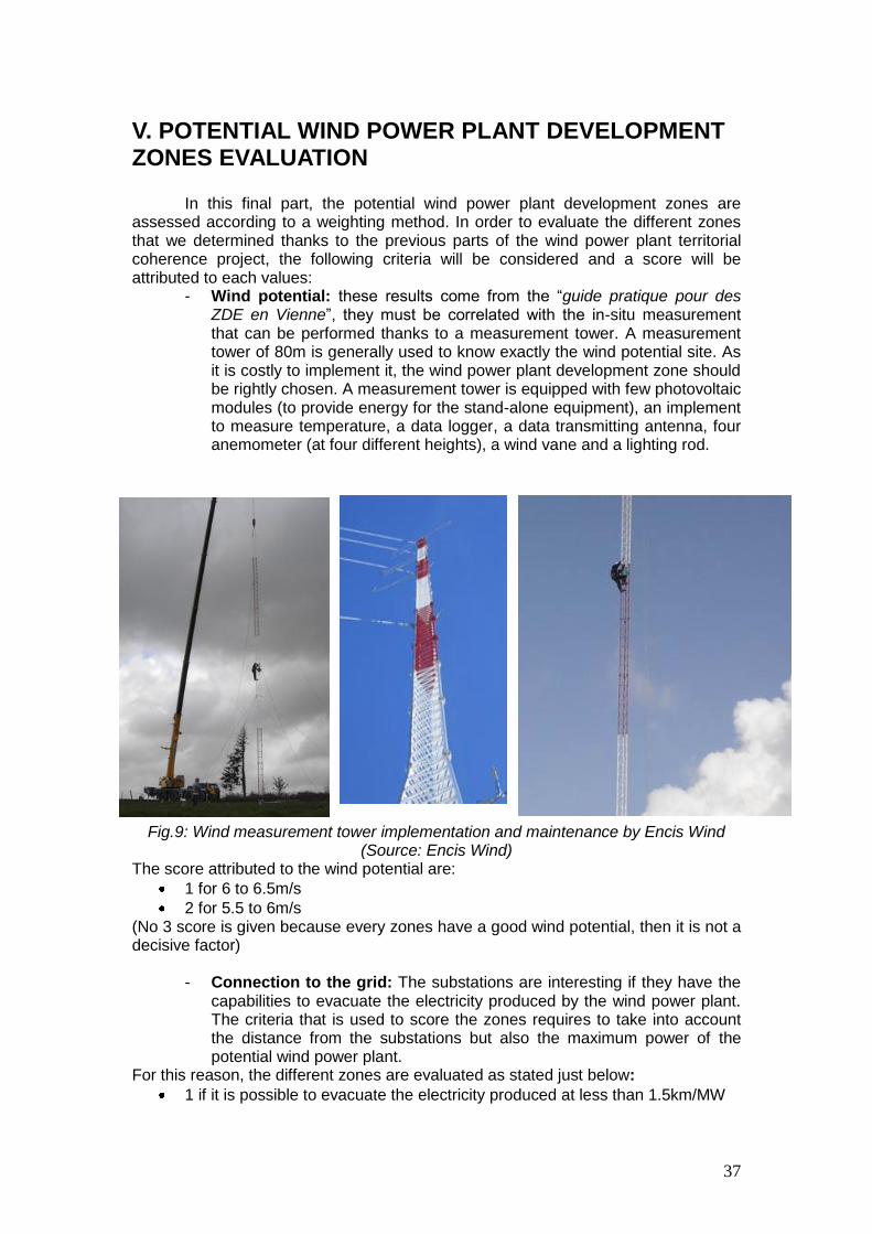
- Wind potential: these results come from the “guide pratique pour des ZDE en Vienne”, they must be correlated with the in-situ measurement that can be performed thanks to a measurement tower. A measurement tower of 80m is generally used to know exactly the wind potential site. As it is costly to implement it, the wind power plant development zone should be rightly chosen. A measurement tower is equipped with few photovoltaic modules (to provide energy for the stand-alone equipment), an implement to measure temperature, a data logger, a data transmitting antenna, four anemometer (at four different heights), a wind vane and a lighting rod.
Fig.9: Wind measurement tower implementation and maintenance by Encis Wind
(Source: Encis Wind) The score attributed to the wind potential are:
1 for 6 to 6.5m/s
2 for 5.5 to 6m/s (No 3 score is given because every zones have a good wind potential, then it is not a decisive factor)
- Connection to the grid: The substations are interesting if they have the capabilities to evacuate the electricity produced by the wind power plant. The criteria that is used to score the zones requires to take into account the distance from the substations but also the maximum power of the potential wind power plant.
For this reason, the different zones are evaluated as stated just below:
1 if it is possible to evacuate the electricity produced at less than 1.5km/MW

38
2 if it is possible to evacuate the electricity produced between 1.5km/MW and 2km/MW
3 if it is possible to evacuate the electricity produced at more than 2km/MW
- Theoretical maximal power: As it was explained earlier, each zone can take a certain size of power plant according to its orientation toward the prevailing wind and especially its area.
The different score will be basically attributed according to the theoretical maximum power that can be implemented on the zone:
1 if the maximum power is more than 20MW
2 if the maximum power is between 10MW and 20MW
3 if the maximum power is less than 10MW
- Environmental sensibility: This criteria is tricky to assess but as no zones are in a listed zones such Natura2000, ZICO or ZPS.
Nevertheless the following score are given to the zones:
1 if there is no environmental constraint in the zone and adjoining of it.
2 if there is environmental constraints such Natura2000, ZICO or ZPS adjoining to the zone or a significant amount of hedged farmlands (that are rich in and cover wild species and plants)
- Other constraints: They are mainly constraints due to easements and
accessibility of the site. The score attributed to the other constraints is the following :
1 if the zone is free of any other constraints
2 if the zone is located close from an easement such airport or if the accessibility is not so good.
3 if the zone has a really bad accessibility due to the topography or other elements
It is obvious that the potential wind power plant development zones that get the
lower score are the ones to be favoured by the decision maker. A synthesis table compiles the different criteria on which the zones will be assessed on the appendix 16. A technical global score based on the criteria stated below has been calculated for the twenty potential wind power plant development zones. From the global technical score, a technical priority is attributed for all he zones.
A heritage and landscape sensibility score based on the constraints such parts of
the landscape or the presence of a historical monuments has been given :
1 if there is no heritage and landscape sensibility
2 if there is co-visibility with a historical monument or landscape sensibility
3 if there is a significant co-visibility with a historical monument In order to appreciate the landscape sensibility, the visual influence maps have
been performed for the zones 2, 3, 8, 11 and 15 on which it was interesting to perform it.
Finally, an average of the global technical score and the heritage and landscape
score has been calculated. Then the priority potential wind power plant development zones can be selected. But this evaluation method is a decision help tool that cannot be limited to the only attributed scores.
39
VI. CONCLUSION
According to the technical and landscape analyses of the existing project, among the twenty studied sites, one advice to set at maximum one zone per group of studied communes to start the administrative process for the request of a wind power plant zone. On the Couhé group of communes, the zones to be favoured are: - Potential wind power plant development zone 2 (The “Direction Générale de L’aviation Civile” (DGAC) which is the national French manager of the civilian air circulation should be questioned to know if there is any exclusion zone or maximum height for the wind power plant development zone.) - Potential wind power plant development zone 3 (The “Direction Générale de L’aviation Civile” (DGAC) which is the national French manager of the civilian air circulation should be questioned to know if there is any exclusion zone or maximum height for the wind power plant development zone.) - Potential wind power plant development zone 8 (An ongoing project leaded by Ecotecnia already exist close from the site) - Potential wind power plant development zone 9 On the Civraisien group of communes, the zones to be favoured are: - Potential wind power plant development zone 8 (An ongoing project leaded by Ecotecnia already exist close from the site) - Potential wind power plant development zone 10 (possible) - Potential wind power plant development zone 11 - Potential wind power plant development zone 13
On the Pays Charlois group of communes, the zones to be favoured are: - Potential wind power plant development zone 15 - Potential wind power plant development zone 16 (possible) - Potential wind power plant development zone 17 (possible) Moreover, the Environment Minister stated about the sustainable energy development scheme at the regional scale that the government will enhance the land development management of wind power plant by favouring the implementation of huge wind farms in the pre-identified zones. For this reason, it is necessary to consider the existing wind farm, the existing wind power plant development zones, the ones in instruction and also the advanced project in order to be in line with the whole territorial project.
The south of Vienne, the north-east of Charentes and the south-west of Deux-Sèvres seems to be appropriated for the wind power plant development (open field and flat topography). It is strongly possible that the Poitou-Charentes region will be selected in the framework of the sustainable energy development scheme elaboration. The environmental minister Mr Borloo confirmed the calling price of 8.2c€/kwh and announced an enhancement of the territorial management, of the regulation framework and of the local cooperation. He also recommends the gathering of wind turbines in opposition with the scattering of them to minimize the impacts. In order to follow the environmental minister recommendations, one propose to consider three main pole on the studied territory in function of the wind power plant development zones in instruction, the accepted building permit and the existing projects. These three poles are represented on the cartographic appendix 17. In this scenario, these three poles are rightly viable to take a significant wind power plant and they are 10-15km spaced. It can allow a respiration area among every wind power plant development zones and a better compatibility with the territory.

40
BIBLIOGRAPHY
Documents :
Agence Nationale des Fréquences [Commission Consultative de la
Compatibilité Electromagnétique], 2008; Rapport CCE5 n°2
ADEME, meeting synthesis of the 6th of december 2002, La programmation
spatiale des projets éoliens
ADEME, 2003; Guide du développeur de parc éolien
ADEME, 2003 ; Un projet d'éoliennes sur votre territoire
ADEME, 2004, Guide de l'étude d'impact sur l'environnement des parcs
éoliens
ADEME, 2004, Ministère de l'Ecologie et du Développement Durable
ADEME, 2008 ; Une énergie dans l'air du temps : les éoliennes
COMBRET Aurélien, mai 2004, Pertinence, rentabilité, ... deux maîtres mots
d'un projet éolien, Blaise Pascal University
Comité de Liaison Energies Renouvelables et ADEME, april 2002, Des
éoliennes dans votre environnement ?
DDE Vienne, 2005 ; Document de recommandations concernant les
éoliennes dans la Vienne
Ecology and sustainable development minister, 19 juin 2006; Instructions
détaillées relatives aux zones de developpement de l’éolien terrestre
General council of Vienne, 2006; Guide pratique pour des Zone de
Développement Eolien en Vienne
GERMAIN Pascal, writting from the meeting of the 23th of mai 2003,
Eoliennes, quels impacts environnementaux ?
GASCH.R et Twele.J, 2002, Wind Power Plants, ed.SOLARPRAXIS
Ministère de l’Equipement, 2004 ; Le paysage rural et régional : contribution à
la méthodologie des études d’aménagement
Regulations :
Decree 95-408, 18th april 1995; decree relative to neighbourhood noises
Directive °79-409, 6th April 1979; directive relative to the conservation of the
wild birds

41
Directive n°94-88, 21th november 1994, directive relative to the protection
and the value of the landscape
Site Internet :
www.ademe.fr
www.centre.ecologie.gouv.fr/fiches_zonage_liste.htm#Zico
www. cndp.fr
ecologie.gouv.fr
www.diren-Poitou-Charentes.fr
www.energiespourdemain.net
www.estivol.com
www.natura2000.fr
natura2000.environnement.gouv.fr/sites/
www.parcs-naturels-regionaux.tm.fr
www.rte-france.com
http://sigore.observatoire-environnement.org/
CD-Rom :
CD Rom Aéronautique FRANCE OACI Edition 2006 – IGN SIA
Cartography and Geographical Informatic System :
IGN maps 1/25 000, 1/50 000 et 1/100 000
Data from the SIG de la DIREN Centre : ZNIEFF, Natura 2000, PNR, ZICO,
RAMSAR
Database Carthage
Database Land Corin Cover

42
GLOSSARY (French acronyms)
ADEME - Agence De l'Environnement et de la Maîtrise de l'Energie
DRAE - Direction Régionale de l'Architecture et de
l'Environnement
DDAF - Direction Départementale de l’Agriculture et de la Forêt
DDE - Direction Départementale de l'Equipement
DGAC - Direction Générale de l'Aviation Civile
DIREN - Direction Régionale de l'Environnement
DRIRE - Direction Régionale de l’Industrie, de la Recherche et de
l’Environnement
IGN - Institut Géographique National
RTE - Réseau de Transport d'Electricité
TNT - Télévision Numérique Terrestre
ZDE - Zone de Développement de l'Eolien
ZICO - Zone Importante pour la Conservation des Oiseaux
ZNIEFF - Zone Naturelle d'Intérêt Ecologique, Faunistique et
Floristique