potential water storage sites on arizona state trust land
TRANSCRIPT

Potential Water Storage Sites on Arizona State Trust Land
POTENTIAL SITES IDENTIFIED BY THE ARIZONA DEPARTMENT OF WATER RESOURCES AND THE ARIZONA STATE LAND DEPARTMENT AS REQUIRED BY SB 1399 (2016)

I. BACKGROUND
In 2016, the Arizona State Legislature passed SB 1399, directing the State Land Commissioner and the
Director of the Department of Water Resources to work together to develop a report that identifies
potential water storage sites on State Trust land by December 31, 2017. Specifically, the legislation
requires the agencies to "[d]evelop a plan to create additional water storage in this state that includes a
preliminary investigation of acceptable sites to construct new water storage facilities on State Trust land
and the identification of the six most potentially acceptable sites." In addition, the legislation states that
the potential water storage sites identified "may be water storage facilities on the earth's surface or
underground storage facilities as defined in section 45-802.01, Arizona Revised Statutes."
Subsequent to SB 1399's passage and approval by the Governor on May 11, 2016, staff from the Arizona
State Land Department (ASLD) and the Arizona Department of Water Resources (ADWR) began a series
of meetings for the purpose of completing the required evaluation.
ADWR began the initial identification of potential storage sites, which then were further refined and
prioritized by ASLD. The initial site identification netted sites in nearly every groundwater basin and
watershed in the State including the Salt and Verde River system, Little Colorado River, Gila River, San
Pedro River and the Santa Cruz River. Over 21 surface storage sites and 331 underground storage sites
were initially identified by ADWR. To meet the criteria in the legislation, ASLD selected and prioritized six
sites; four potential surface water dam/reservoir sites and two potential underground storage facility
sites.
II. POTENTIAL DAM/RESERVOIR SITES
A. METHODOLOGY
ADWR began the analysis by dividing general hydrological characteristics of surface water drainages on a
statewide basis. The State of Arizona is divided into 84 Hydro logic Units or watersheds, each of which is
commonly referred to as a HUC-8 watershed . These HUC-8 watersheds in Arizona range in area between
approximately nine and 4,200 square miles. The HUC-8 watersheds that generally met the following
conditions were eliminated from further consideration by ADWR:
• Smaller than 500 square miles.
• No bedrock (unsuitable dam foundation, reservoir containment). • No land owned by the State of Arizona as State Trust land. • An existing water storage reservoir within the watershed.
B. IDENTIFICATION OF POTENTIALLY ACCEPTABLE SURFACE WATER STORAGE SITES
Applying the above conditions, ADWR reduced the number of HUC-8 watersheds for further analysis to 21 potential dam/reservoir sites (Figure 1).
Based on ADWR's HUC-8 analysis, ASLD applied additional criteria that reduced the number of potential dam/reservoir sites from 21 to four. These criteria included:
1
• Potential dam sites in current general stream adjudication watersheds were eliminated from
further consideration.
• Reservoir Geometry - Potential sites that would result in reservoirs with large surface areas and relatively shallow depths were eliminated. In some cases, potential sites were relocated to add additional storage capacity.
• Risk Factors - Sites that were deemed to be potential risks to downstreall) populations or infrastructure were eliminated (i.e. those sites within five miles of the potential dam break}.
• Reservoir Limitations - Potential sites were also eliminated based the suitability of the underlying soils and geology to minimize losses from the water that would be stored in the reservoir. This evaluation was based on the Natural Resources Conservation Service's (NRCS's) published Soi,I Maps and the Arizona Geological Survey's (AZGS's) Geology of Arizona maps. ,
ASLD's identified list of potentially acceptable dam site locations are shown on Figure 3 and are listed
below. More specific information on possible dam and reservoir configurations and capacities are
contained in the attached table.
C. POTENTIALLY ACCEPTABLE SURFACE WATER STORAGE SITES
1. Santa Maria River - Dam/Reservoir. This site is in Yavapai County, Bill Williams Watershed,
and the Bill Williams Groundwater Basin . Potential storage estimate: 1,500 - 3,000 acre-feet.
2. Havasu Creek - Dam/Reservoir. This site is in Coconino County, Colo(ado River Watershed,
Coconino Plateau Groundwater Basin. Potential storage estimate: 500 - 1,000 acre-feet.
3. Black Draw - Dam/Reservoir. This site is in Cochise County, Rio Yaqui Watershed, San
Bernardino Groundwater Basin. Potential storage estimate: 1,000 - 2,000 acre-feet.
4. Buck Creek - Dam/Reservoir. This site is in Cochise County, Rio Yaqui Watershed, San
Bernardino Groundwater Basin. Potential storage estimate: 300 - 600 acre-feet.
Ill. POTENTIAL UNDERGROUND STORAGE FACILITY SITES
A. METHODOLOGY
Potential Underground Storage Facilities (USFs) located along streams that cross State Land parcels that
overlie basin-fill or local alluvial stream deposits were evaluated on a statewide basis. In some cases,
factors such as proximity of potential sites to potential places of recovery and use and/or multiplicity of
potential sites located on the same stream were used to eliminate isolated or potentially redundant sites.
Sites located along canals, near the Colorado River and in areas with many existing USF sites were also
eliminated. Initially, ADWR identified 331 potential Underground Storage sites (Figure 2). ADWR made
no prioritization of potential storage sites with relative locations regarding locations within or outside
Active Management Areas (AMAs) or Irrigation Non-Expansion Areas (INAs) as protections for such stored
water is limited in either location. However, ASLD prioritized preferred locations to within AMAs and INAs
as they felt it provided greater protections to State Land requirements.
Based on ADWR's analysis, ASLD applied additional criteria that reduced the number of potential USFs
from 331 to two. These criteria included:
2
• Potential locations in current general stream adjudication watersheds were eliminated from
further consideration.
• Potential locations limited to areas in which water management overlays will protect water
stored in USFs or will directly benefit State Trust land: Active Management Areas (AMAs),
Irrigation Non-Expansion Areas (INAs), and groundwater basins designated as permissible
"transportation basins" under Title 45, Article 8.1 of t he Arizona Revised Statutes.
• Hydrologic properties of basin-fill or stream alluvium at potential sites.
• Depth to water.
• Locations of existing recharge facilities.
B. IDENTIFICATION OF POTENTIALLY ACCEPTABLE UNDERGROUND STORAGE SITES (See Table 1 for
more detail)
1. Cunningham Wash - USF. This site is in La Paz County, Colorado River Watershed, Butler
Valley Groundwater Basin. This basin is authorized for groundwater transportation under
A.R.S. § 45-553. Potential storage estimate: > 20,000 acre-feet.
2. Whitewater Draw - USF. This site is in Cochise County, Douglas INA, Rio Yaqui Watershed,
San Bernardino Groundwater Basin . Potential storage estimate is unknown at this time.
IV. CHALLENGES
1. Consistency with Arizona Enabling Act, Constitution, and Statutes
Any use of State Trust land for water storage purposes must be done consistent with Arizona laws
requiring that the Trust be compensated adequately for that use, whether via a land sale (by auction), a
short-term lease (< 10 years), or long-term lease (>10 years). For context, it is important to understand
why the Trust exists, how it was formed, and how restrictions on use of State Trust lands are applied .
Endowment of public lands for educational purposes was a practice established by the Northwest
Ordinance in 1787. Congress established the Territory of Arizona on February 24, 1863, and granted
sections 16 and 36 of each township across Arizona for the benefit of the Common Schools. The Enabling
Act, passed by the U.S. Congress on June 20, 1910, allowed for Arizona Statehood. In addition to the
previous designated sections of land, the Enabling Act assigned sections 2 and 32 of each township to be
held in trust for the Common Schools. The needs of other public institutions were considered by Congress,
and more than two million additional acres were allocated for their use.
On May 20, 1912, an act of the First Legislature of Arizona created the three-member State Land
Commission to serve as Arizona's temporary Land Department. The Commission was charged with
assessing, evaluating, and making recommendations about the Trust land granted by Congress to the
State. The Commission was to report back to the Legislature with its findings and conclusions by the end
of the second Legislative session.
The Commission concluded that Arizona should not sell its Trust land outright, as other states had done.
Instead, it should put the lands to their highest and best use. The decision to sell or lease the land should
3

be based upon the potential use of each parcel. The Commission recommended the creation of the State
Land Department " ... in order that the multitudinous detail attached to the State's varied land interests
may have constant attention and to prevent irretrievable loss."
The ASLD and the system by which Trust lands were to be managed was established in 1915 by the State
Land Code. The Enabling Act and the State Constitution require that the Trust be financially compensated
for the use or sale of State Trust land, and the natural products derived from them. In compliance with
the Enabling Act and the State Constitution, the State Land Code gave the ASLD authority over all Trust
lands and the natural products from Trust land.
Since the ASLD's inception, its mission has been to manage the assets of the multi-generational perpetual
Land Trust, in a manner that maximizes its value and revenues for the beneficiaries. All uses of the land
must benefit the Trust, a fact that distinguishes it from the way public land, such as parks or national
forests, may be used or managed. While public use of Trust land is not prohibited,.it is regulated to ensure
protection of the land and compensation to the beneficiaries for its use. Today, the ASLD manages 9.2
million acres of Trust land.
1. Ownership
This study assumes that any potential facility identified in this preliminary study would be owned and
operated by an entity that is not ADWR or ASLD. Neither ADWR nor ASLD are capable of owning,
operating, or maintaining a water storage facility.
2. Construction costs
ASLD and ADWR are not engaged in the practice of constructing dams and therefore are unable to
accurately estimate the cost of building any of the potential facilities identified herein. Nevertheless, it is
likely that the cost of building any dam/reservoir facility would be significant.
3. Surface Water Rights
Any attempt to build a water storage facility on or adjacent to an existing watercourse in Arizona is likely
to encounter significant questions or conflict regarding the potential impacts to existing water rights or
water right claims.
4. Access
This preliminary analysis did not include an examination of any access issues that might pertain to the
identified potential sites, nor did it examine any potential surrounding landowner conflicts. In most
instances, legal access would need to be obtained, roads built, power provided, etc.
5. Recovery
This preliminary analysis did not include an examination of how recovery of stored water might occur.
Questions about how the water would be recovered and transported would have to be further analyzed.
6. Federal and other permitting
Constructing, operating, and maintaining a water storage facility of any kind will certainly require
numerous permits and approvals that are beyond the scope of this preliminary analysis.
4
V. CONCLUSION
ADWR and ASLD followed the guidelines of SB 1399 and completed this preliminary analysis of potential
sites for water storage facilities, both on the surface and underground. As noted throughout, this analysis
is a preliminary identification of potentially acceptable sites. It is not a recommendation or endorsement
of any of the identified potentially acceptable sites, as there are numerous challenges that require further
contemplation, many of which have yet to be identified, as well as engineering studies, environmental
analyses, cultural resource analyses, and other examinations that will need to be carefully considered
prior to moving forward .
(
5

S.B. 1399 - Figure 1 Initial Review of Potentially Acceptable
Surface Water Stora e Sites I" '. 1·· f . ·'
• Polonllal dam/resevolr sttes
• Existing Jur1sdlctional Dams
..,..__ River
Streams
L] HUC-8 Watsrshed
c:l County
AZ State land
1 Hardrock 15
~ ,r (I
, . ., ..
N
A M Oes
30 60 90 120
C,aaa.:!6~~20.:D l 7 .Mtoo'.ar>tf'-,.dl'l.alloi~ 0.~c lt!knrufol !'rm.--i llral. 1m W. W&1~.ha'-5t..Sitl 10 ft~AZUoo, l!o:l!-TT I -Mla

·, , . ,, ., .
.\ ... ~
,,.
;
\ SL'I, ., ' Fd lpe
, . ,I ". ·1
CJ Groundwater Basin
~ Potential USF sites
~ River
Streams
CJ County
S.B. 1399 - Figure 2 Initial Review of Potentially Acceptable
Underground Storage Sites (USFs)
J,
/.!. .•,.
\. ',.- I
N
A --===--==-----=====-----15 30 60 00 120
c,.~611: 0.(...-.ll tt ~.21)17 ""1:0-11De,p&."tnWC d~Vwir ft--,,, Gtofi,p!llc. W,tm,1b'I S ;1 '-m iJo,,\ l l !O V.. ~•1,.v.1r.g1on 51 . $\1 J10 f?ICric,"2.l:S007 t.lU11-&500

Figure 3
Map of the Six Most Potentially Acceptable Water Storage Sites Identified
POTENTIAL SB-1 399 DAM SITES & UNDERGROUND STORAGE FACILITIES
NV
CA
Black Draw
""""" Buck C,nk
.-..._.. Hava1u Creek
-...,. Sanla Marlo River
• Pot•nfio!Sg..1399oomSII•
{~} ~•=:~~!~~::,•9• Frtcil!ty
• StoteTuntlo.'\d
Prtvo1e
' . . . . ,,
Fores!Senic.e
Indian Commi.nty
Mililory
Oty Of C<Nnty Pgrh
SU,\
Stole Porli
Wl!dllfe Refuge
Olhe,
Notional Parb
- CAPConol
A
UT
D So,,to Crvz AIM ~cry
D PreKolt AJM !!ou,dory
D Pnol AMA B~ory
8
Phoe,nlx AMA Bovodory
• Tuc100 AMA &ovndory • !NA&o.rodary
... -- ✓
...... -.. .. --.•- · ... ..-. ,,.:: . .-n.,.,
co
NM
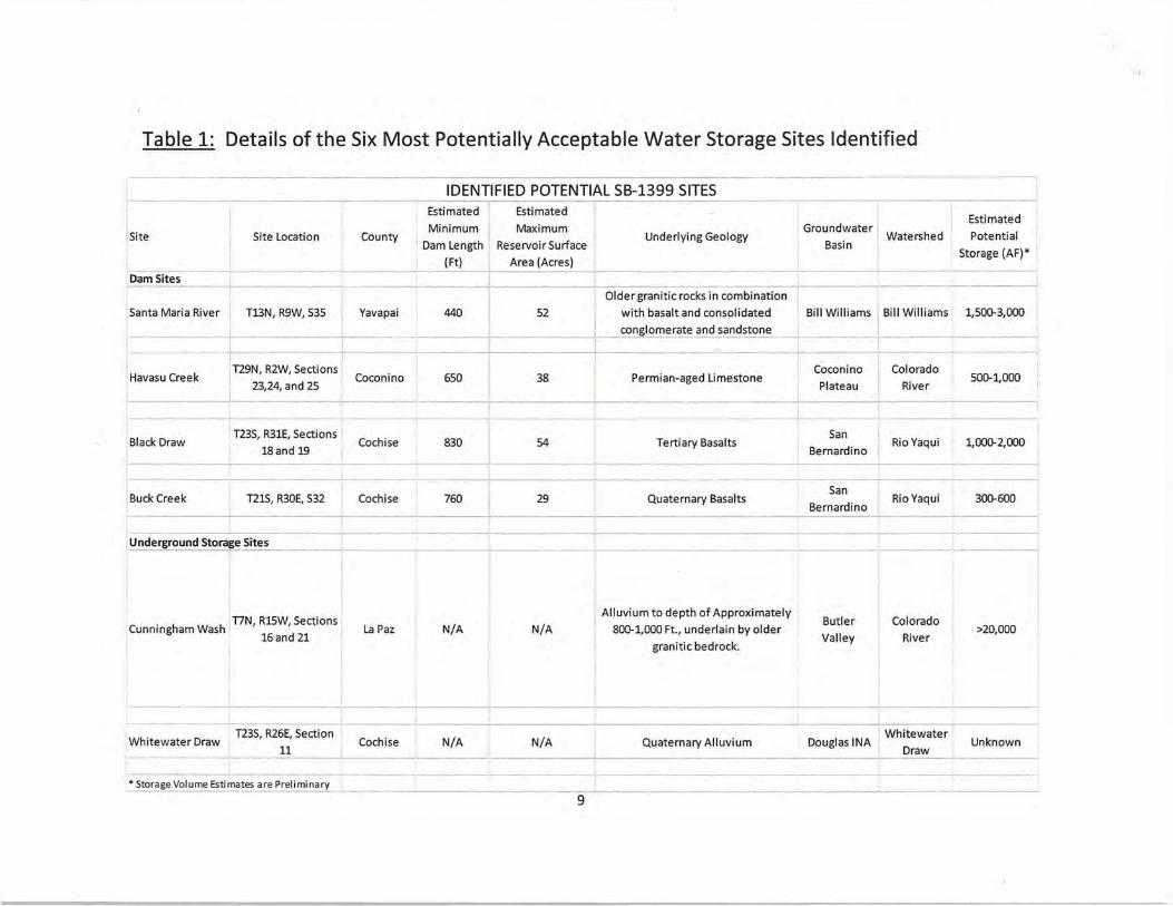
Table 1: Details of the Six Most Potentially Acceptable Water Storage Sites Identified
!site Site Location
Dam Sites I
Santa Maria River I T13N, R9W, 535 I --------- I
I
Havasu Creek IT29N, R2W, Sections
I 23,24, and 25
Black Draw T23S, R31E, Sections I
I 18and 19
Buck Creek I T21S, R30E, 532 I I
Underground Storage Sites
I I I
. h h I T7N, R15W, Sections Cunning am Was 16 and 21 I
Whitewater Draw I
T23S, R26E, Section 11
County
Yavapai
Coconino
Cochise
Cochise
La Paz
Cochise
IDENTIFIED POTENTIAL SB-1399 SITES 1 Estimated Estimated
i Minimum I Maximum I Dam Length Reservoir Surface
(Ft) Area (Acres) I
440 52
i I
I I 650 38 I !
830 I I 54 I
760 29
N/A N/A
N/A N/A
Underlying Geology
I
Groundwater
Basin Watershed
I Older granitic rocks in combination ' I j with basalt and consolidated Bill Williams J Bill Williams
conglomerate and sandstone
I I
I I Coconino Colorado Permian-aged Limestone I Plateau I River
I
Tertiary Basalts San
Rio Yaqui Bernardino I
Quaternary Basalts San
Rio Yaqui I I Bernardino
Alluvium to depth of Approximately Butler Colorado
800-1,000 Ft., underlain by older Valley River
granitic bedrock. I
Quaternary Alluvium Douglas INA l Whitewater Draw
• Storage Volume Estimates are Preliminary ---·---~---- --------------- ------~--------9
I
Estimated
Potential
Storage (AF)* '
I
1,500-3,000
I I
500-1,000
1,000-2,000
300-600
>20,000
Unknown
•