post-palaeozoic evolution of weathered landsurfaces in...
TRANSCRIPT

Ž .Geomorphology 25 1998 173–192
Post-Palaeozoic evolution of weathered landsurfaces in Ugandaby tectonically controlled deep weathering and stripping
R.G. Taylor ), K.W.F. HowardGroundwater Research Group, Department of Geology, UniÕersity of Toronto, 1265 Military Trail, Scarborough, Ontario,
Canada M1C 1A4
Received 4 September 1997; revised 18 March 1998; accepted 23 March 1998
Abstract
A model for the evolution of weathered landsurfaces in Uganda is developed using available geotectonic, climatic,sedimentological and chronological data. The model demonstrates the pivotal role of tectonic uplift in inducing cycles ofstripping, and tectonic quiescence for cycles of deep weathering. It is able to account for the development of key landforms,such as inselbergs and duricrust-capped plateaux, which previous hypotheses of landscape evolution that are based onclimatic or eustatic controls are unable to explain. Development of the Ugandan landscape is traced back to the Permian.Following late Palaeozoic glaciation, a trend towards warmer and more humid climates through the Mesozoic enabled deepweathering of the Jurassicrmid-Cretaceous surface in Uganda during a period of prolonged tectonic quiescence. Upliftassociated with the opening South Atlantic Ocean terminated this cycle and instigated a cycle of stripping between the
Ž .mid-Cretaceous and early Miocene. Deep weathering on the succeeding Miocene to recent African surface has occurredfrom Miocene to present but has been interrupted in the areas adjacent to the western rift where development of a newdrainage base level has prompted cycles of stripping in the Miocene and Pleistocene. q 1998 Elsevier Science B.V. Allrights reserved.
Keywords: landform evolution; tectonics; weathering; erosion; Uganda
1. Introduction
In those terrains unaffected by Pleistocene glacia-tion or aeolian erosion, landscapes are transformedprincipally by the action of meteoric water in theform of groundwater recharge and surface runoff.Groundwater recharge is made acidic by microbial
Ž .activity in the soil i.e., regolith and weathers under-
) Corresponding author. Tel.: q1-416-287-7237; Fax: q1-416-287-7279; E-m ail: taylor@ [email protected]
lying rock. This in situ alteration of bedrock pro-duces a mantle of unconsolidated weathered rockand is known as ‘deep weathering’. Surface runoff,
Ž .aided by gravitational forces e.g., mass movement ,removes weathered rock from the surface by ‘strip-ping’.
Whereas deep weathering and stripping operatecontemporaneously, the cyclical dominance of oneprocess over the other is well-demonstrated by thedevelopment of landforms such as inselbergs and
Ž .duricrust-capped plateaux. Inselbergs ‘island hills’are considered to result from a period of deep weath-
0169-555Xr98r$ - see front matter q 1998 Elsevier Science B.V. All rights reserved.Ž .PII: S0169-555X 98 00040-3

( )R.G. Taylor, K.W.F. HowardrGeomorphology 25 1998 173–192174
Žering which is followed by stripping Linton, 1955;Budel, 1957, 1982; Ollier, 1960; Thomas, 1965;¨
.Doornkamp, 1968; Giardino and Mackel, 1985 .¨Bedrock lithologies, which are more resistant toweathering because of variations in structure or min-
Ž .eralogy Pye, 1986 , are less denuded by deepweathering. During a subsequent cycle of stripping,more resistant bedrock is exposed to form an insel-berg, whereas the surrounding, more deeply weath-ered and unconsolidated mantle is removed. The
Ž .genesis of duricrusts e.g., ferricrete, calcrete re-flects prolonged weathering in the absence of signifi-cant stripping. Rainfall-fed, groundwater rechargeremoves chemically mobile constituents from the
Ž .weathered mantle regolith on which the crust isdeveloping, whereas less mobile elements such asiron and aluminum become concentrated towards thetop of the mantle and accrete to form a residual crustŽMcFarlane, 1983, 1991; Nahon, 1986; Nahon and
.Tardy, 1992 .
1.1. PreÕious studies of landscape eÕolution
Reconciling the development of landforms, suchas inselbergs and duricrusts by cycles of deep weath-ering and stripping with a viable model of landscapeevolution, has historically proved difficult. The the-
Ž .ory of pediplanation King, 1962 , in which landsur-Ž .faces pediments are produced by retreating scarps,
stresses the role of surface runoff in shaping land-scapes but effectively ignores the function ofgroundwater recharge in deep weathering. Contem-poraneous deep weathering and stripping is proposed
Ž .by Budel 1957, 1982 in his theory of double-plana-¨Ž .tion surfaces ‘doppelten Einebnungsflachen’ . This¨
hypothesis, however, along with Thomas’ concept ofŽ .‘dynamic etchplanation’ Thomas, 1965, 1989a,b ,
which involves cycles of deep weathering and strip-Ž 4 .ping that coincide with Quaternary 10 a climatic
Ž .oscillations see Fig. 3 in Thomas, 1989a , cannotadequately account for the genesis of thick residual
Ž 6 .duricrusts which require protracted periods 10 a ofŽdeep weathering to form from crystalline rock e.g.,
.Nahon, 1986; McFarlane, 1991 .An alternative model of landscape evolution, in-
volving long cycles of deep weathering and strip-Ž .ping, is put forward by Fairbridge and Finkl 1980 .
In their theory of a ‘cratonic regime’, they contend
that deep weathering occurs during long stable peri-Ž 7 8 .ods 10 to 10 a of high sea level with a
Žvegetation-rich, moist climate and low relief their.‘thalassocratic–biostatic state’ . Stripping of weath-
ered materials during a subsequent, shorter period issuggested to result from low sea level which pro-duces unstable, polyclimatic conditions and high re-
Ž .lief their ‘epeirocratic–rhexistatic state’ . A lack ofevidence for deep weathering prior to the Mesozoicconstrains field validation of this proposed relation-ship between long-term cycles of deep weatheringand stripping, and eustatic oscillations. The compara-tive stability of climates during high sea levels inrelation to low sea levels is also speculative. Theconcept that landscape evolution may result fromlong-term, alternating periods of deep weatheringand stripping rather than multiple cycles within theQuaternary, as in Thomas’ ‘dynamic etchplanation’,
Žis, however, supported by workers in Australia Hill. Žet al., 1995 and southern Africa Partridge and. Ž .Maud, 1987 . In Uganda, Ollier 1960, 1993 has
argued that only one cycle of deep weathering duringthe Mesozoic occurred. A subsequent cycle of strip-ping is suggested to result from downfaulting of the
Ž .western Albertine graben in the Miocene. Themodern landscape is, thus, considered to be essen-tially a relict feature reflecting past climatic and
Ž .hydrological regimes Pain and Ollier, 1996 . Noevidence has been presented, however, to suggestthat deep weathering or stripping of weathered man-tles has ceased.
1.2. Rationale of this study
The uncertainties of landscape evolution includethe periodicity of deep weathering and stripping, andthe mechanisms driving these cycles such as climateand sea level. In this paper, a model of landscapeevolution in Uganda is developed from availablegeotectonic, sedimentological, climatic and chrono-logical evidence which resolves these uncertainties.
Ž .Except for a brief overview by Ollier 1993 , norecent discussion of landscape evolution in Ugandahas occurred since the work of Bishop and TrendallŽ . Ž .1967 , de Swardt and Trendall 1969 and McFar-
Ž .lane 1974 . Following publication of this early work,much progress has been made in understanding of
Žferricrete development e.g., McFarlane, 1983, 1991;

( )R.G. Taylor, K.W.F. HowardrGeomorphology 25 1998 173–192 175
.Nahon, 1986; Nahon and Tardy, 1992 , the historyŽof sedimentation in the western rift of Uganda Pick-
.ford et al., 1989, 1992 , as well as associated fossilŽassemblages and the palaeoclimatic setting van
.Damme and Pickford, 1995 . Furthermore, in the last
20 yr, a proliferation of research has developed onŽthe Quaternary e.g., Gasse, 1980; Livingstone, 1980;
Hamilton, 1982; Rossignol-Strick, 1983; Taylor,. Ž1990 and pre-Quaternary e.g., Pickford, 1992, 1995;
.Jacobs and Deino, 1996 climates in east Africa.
Ž .Fig. 1. Bedrock geology in Uganda adapted from Geochemical Atlas of Uganda Geological Survey and Mines Department, Uganda, 1973 .

( )R.G. Taylor, K.W.F. HowardrGeomorphology 25 1998 173–192176
Synthesis of interrelated geotectonic, geomorphic andclimatic histories in Uganda is now possible. Mor-phoclimatic activity during the late Cenozoic is par-ticularly well-constrained by the improved under-standing of rift deposits which enable sedimentationin the western rift to be reconciled with cycles ofweathering and erosion on landsurfaces in Uganda tothe east. Similar approaches have been successfully
Žapplied in southern Africa Partridge and Maud,. Ž .1987 and Australia Hill et al., 1995 .
2. Geological setting
The geology of Uganda is not well-understood butconsists predominantly of Archaean granulites andgneisses, as well as metasedimentary rocks of Pro-
Ž .terozoic age Fig. 1 . Granulites occur in patchesacross northern and western Uganda and were meta-
Ž .morphosed Watian event in the middle ArchaeanŽ .Spooner et al., 1970 . Granitic and biotitic gneisses,
Žobserved in northern and south-central areas Leggo.et al., 1971, Leggo, 1974; Bjørlykke, 1975 , derive
from the retrograde metamorphism of the granuliteŽ .facies assemblage Almond, 1969 during late Ar-Ž .chaean tectonism Aruan event arising from colli-
sional events that consolidated Archaean cratonicŽ .nuclei Goodwin, 1991 between 2600 and 2550 Ma
Ž .Table 1 . The geology of central Uganda has not yetŽ . Ž .been mapped Fig. 1 . Discrete ground level out-
crops and inselbergs sampled in central Uganda
Ž . Ž .Table 1 are, however, highly silicic Table 2a andpossess a quartzofeldspathic composition, based upon
Ž . Ž .normative CIPW calculations Table 2b , that areconsistent with Archaean gneiss observed in northernand south-central areas. Interestingly, sampled insel-bergs demonstrate a lower plagioclase to orthoclase
Ž .ratio than discrete bedrock outcrops Table 2b . ThisŽ .is consistent with the observations of Pye 1986 in
Kenya, where relatively lesser denudation of insel-bergs was attributed to the greater resistance oforthoclase to weathering.
Three suites of supracrustal rocks were producedin Uganda during the Proterozoic. Rifting acrosssouthern Uganda in the early Proterozoic isolated the
ŽTanzanian craton from the rest of Uganda Goodwin,.1991 . Low- to medium-grade metamorphism of vol-
canic and clastic sedimentary infill, associated withthe weathering of adjacent cratons, yielded the
Ž .Buganda–Toro Supergroup Rwenzori Fold Belt ofphyllites, quartzites, schists and gneisses. The meta-morphic grade increases roughly from east to westwhere uplifted schists and gneiss form the Rwenzori
Ž .Mountains Fig. 1 . The second phase of Proterozoictectonism is associated with continental rifting of the
Ž .Kibaran orogeny 1800–1400 Ma . Analogous to theearlier events in Uganda, rifting induced sedimenta-
Ž .tion and volcanism 1400–1200 Ma that was fol-lowed by low-grade metamorphism marking the con-vergence of Kasai and Tanzania cratons. Quartzites,phyllites, hematitic sandstones and conglomerates ofsouthwestern Uganda derived from this Middle Pro-
Table 1Observed outcrops and inselbergs of granitic gneiss associated with the Aruan complex
Ž . Ž . Ž .Sample Site Number Latitude N Longitude E Bedrock type Age Ma ReferencesX X Ž .Bobi outcrop 1 2835 32821 granitic gneiss 2550"10 Leggo et al., 1971X X Ž .Biso quarry 2 1845 31826 banded granulite 2550"10 Leggo, 1974X X Ž .Tank Hill quarry 3 0815 32835 granitic gneiss 2600"50 Leggo, 1974X X Ž .Iganga 4 0829 33827 granitic gneiss 2600"50 Leggo, 1974X X Ž .Mutoga quarry 5 0825 32830 granitic gneiss n.a. Bjørlykke, 1975X X Ž .Ibuje inselberg 6 1855 32823 augen gneiss n.a. this workX X Ž .Amii outcrop 7 1857 32824 amphibolite n.a. this workX X Ž .Ngetta inselberg 8 2817 32856 biotite gneiss n.a. this workX X Ž .Bala outcrop 9 2811 32843 granitic gneiss n.a. this workX X Ž .Ayer outcrop 10 2816 32852 biotite gneiss n.a. this work
Samples 6 to 10 are situated in central Uganda where the geology remains unmapped.For site locations, see Fig. 1.n.a.: Not available.

()
R.G
.Taylor,K
.W.F
.How
ardr
Geom
orphology25
1998173
–192
177
Table 2Ž .a Elemental composition of analysed outcrops in central Uganda
aSample SiO Al O CaO MgO Na O K O Fe O MnO TiO P O LOI Total2 2 3 2 2 2 3 2 2 5Ž . Ž . Ž . Ž . Ž . Ž . Ž . Ž . Ž . Ž . Ž . Ž .% % % % % % % % % % % %
Ibuje 65.1 14.7 3.0 1.0 3.5 4.8 5.0 0.1 1.0 0.3 0.6 99.1Amii 72.8 13.4 0.7 0.4 4.8 4.2 1.7 0.0 0.3 0.1 0.4 98.8Ngetta 70.3 13.9 2.1 0.7 3.3 4.8 3.4 0.0 0.6 0.2 0.2 99.5Bala 69.6 14.1 1.1 0.5 3.9 4.6 2.9 0.0 0.3 0.1 1.6 98.7Ayer 59.6 18.2 4.0 2.0 4.2 4.2 5.0 0.1 0.7 0.2 0.4 98.6Mutoga 64.2 17.4 3.3 1.7 4.2 3.3 4.9 0.1 0.6 0.3 1.4 101.4
Ž . Ž .b Selected normative CIPW mineralogical parameters
Sample Quartz Feldspar Orthoclase Plagioclase PlagioclaserŽ . Ž . Ž . Ž .Q ORqABqAN OR ABqAN orthoclaseŽ . Ž . Ž . Ž . Ž . Ž .% % % % ABqAN r OR
Ibuje inselberg 20 69 29 40 1.4Amii outcrop 27 69 25 44 1.8Ngetta inselberg 28 65 28 37 1.3Bala outcrop 28 67 28 39 1.4Ayer outcrop 8 80 25 55 2.2Mutoga quarry 18 70 20 50 2.5
Compositions are given as oxides.a LOI: loss on ignition.

( )R.G. Taylor, K.W.F. HowardrGeomorphology 25 1998 173–192178
terozoic metamorphism form the Karagwe–Ankoleancomplex. The end of the Precambrian is marked by
Žthe collision of east Gondwanaland Antarctica,.Madagascar, India and Australia and west Gond-
Ž .wanaland Africa and South America forming theMozambique mobile belt along the eastern boundary
Ž .of Uganda Cahen et al., 1984; Goodwin, 1991 . Themobile belt is recognised in Uganda as the Karasukgroup of metasedimentary rocks overthrust onto
Ž .Aruan gneisses Leggo, 1974 . The intensity of theMozambique metamorphism was noted by Harper et
Ž .al. 1972 who recorded Late Proterozoic K–Ar agesfor the majority of 31 rocks analysed in central andnorthern Uganda. Apparently, this tectonism wasable to overprint partially or completely the isotopicrecord of Archaean events. The resulting discordantages make it difficult to define ‘basement’ with any
Ž .certainty. Schluter 1994 , thus, proposes the term¨‘granulite–gneissic complex’ in place of ‘basementcomplex’ to describe the granulitic and gneissic ter-rain of central and northern Uganda.
3. Morphoclimatic evolution of Uganda
Close examination of available geotectonic, sedi-mentological, climatic, and chronological evidencein Uganda provides a model for morphoclimaticevolution from the end of the Palaeozoic to thepresent that is characterised by cycles of strippingand deep weathering. Stripping follows the develop-ment of relief from tectonic uplift, whereas deepweathering is shown to occur on newly formedsurfaces during subsequent periods of tectonic quies-cence. In the model, six broad stages are recognised.
3.1. Stage I: erosion of the Palaeozoic landscape by( )Carboniferous glaciation presumed
Development of weathered landsurfaces in UgandaŽduring the Palaeozoic was inhibited by early Ordo-
. Ž .vician and late Carboniferous Palaeozoic glacia-tions. These glacial cycles occurred as Ugandadrifted, as part of Gondwana supercontinent, along aconvoluted trajectory remaining in a high-latitudeposition roughly between 308S and 608S throughout
Ž .the Palaeozoic Eyles, 1993; Dalziel, 1997 . A pe-riod of warmer, non-glacial conditions during theSilurian and Devonian was marked by the prolifera-
Ž .tion of vascular plants Knoll and James, 1987 .Erosion of accumulated Palaeozoic sediments onGondwanaland has been attributed to Carboniferous
Ž .glaciation in west Africa Thomas and Thorpe, 1985Žand Australia Fairbridge and Finkl, 1980; Hill et al.,
.1995 . Evidence of late Palaeozoic glacial depositionŽ .e.g., tillites , noted elsewhere in east AfricaŽ .Wopfner and Kreuser, 1986 , was inhibited by
Ž .Uganda’s high-standing interbasin position. Dark,Ž .unfossiliferous shales Ecca series—Fig. 1 , believed
to have derived from glacial meltwaters in the earlyŽ .Permian King, 1962 , are the only remaining sup-
port for Carboniferous Palaeozoic glaciation inUganda.
3.2. Stage II: Mesozoic deep weathering and thedeÕelopment of the Jurassicrmid-Cretaceous sur-face
Deglaciation at the end of the Palaeozoic is asso-ciated with the northward migration of Gondwana-
Ž .land to lower latitudes Caputo and Crowell, 1985 .Gondwana then collided with Laurasia to form
Ž .Pangea in the late Triassicrearly Jurassic Fig. 2a , aperiod characterised by arid, continental climatesŽ .Crowley and North, 1991 during which weathering
Žand denudation are believed to be minimal King,.1962 . Subsequent warming related to the low-lati-
Ž .tude position of Gondwana in the Jurassic Fig. 2bserved to enhance weathering. Prolonged deepweathering of Precambrian bedrock surfaces pro-duced a thick weathered mantle in many areas of
Ž .Gondwanaland Fig. 3 including east AfricaŽRadwanski and Ollier, 1959; Ollier, 1959, 1960;
.McFarlane et al., 1992; Ollier, 1993 , west AfricaŽ .Thomas, 1965, 1966; Thomas and Thorpe, 1985
Ž .southern Africa Partridge and Maud, 1987 , SouthŽ . ŽAmerica Schaefer et al., 1995 , India Demangeot,
. Ž1975 and Australia Mabbutt, 1965; Fairbridge and.Finkl, 1980; Hill et al., 1995 .
Ž .King 1962 postulated that these weathered sur-faces formed an extensive, almost featureless plainŽ .pediplain that covered the Gondwana superconti-nent. Highest level surfaces on continents of theformer Gondwana are widely viewed as relics of a‘Gondwana surface’ that was stripped following
ŽGondwana fragmentation e.g., McFarlane et al.,1992; Ollier, 1993; Thomas, 1994; Schaefer et al.,

( )R.G. Taylor, K.W.F. HowardrGeomorphology 25 1998 173–192 179
Ž . Ž . Ž . Ž .Fig. 2. Plate tectonic reconstructions of Gondwana adapted from Scotese 1991 . a Early Jurassic. b Late Jurassic. c Early Cretaceous.Ž .d Mid-Cretaceous.
.1995 . Modern reconstructions using plate tectonicsŽ .Scotese, 1991 show the hypothesis of superconti-
Ž .nental-wide weathering of King 1962 followed bysimultaneous rupture of Gondwana into its con-
Žstituent continents see Table IX in Fig. 20 in King,.1962 to be invalid. Separation of east and west
Gondwanaland was complete by the early Creta-Ž .ceous Fig. 2c and preceded the mid-Cretaceous
development of the south Atlantic that isolated AfricaŽ .from South America Fig. 2d . Thus, if a deeply
weathered surface did form across Gondwanalandduring the Jurassic, this surface cannot constitute thehighest level surface of west Gondwanaland in Africaand South America because this was subjected tofurther weathering through to the mid-Cretaceous‘thermal optimum’. Indeed, prolonged and intense
deep weathering may explain the prominence ofmassive vermiform laterites, which form under veryadvanced stages of leaching by infiltrating rainfallŽ .McFarlane, 1991 , on the highest level surface in
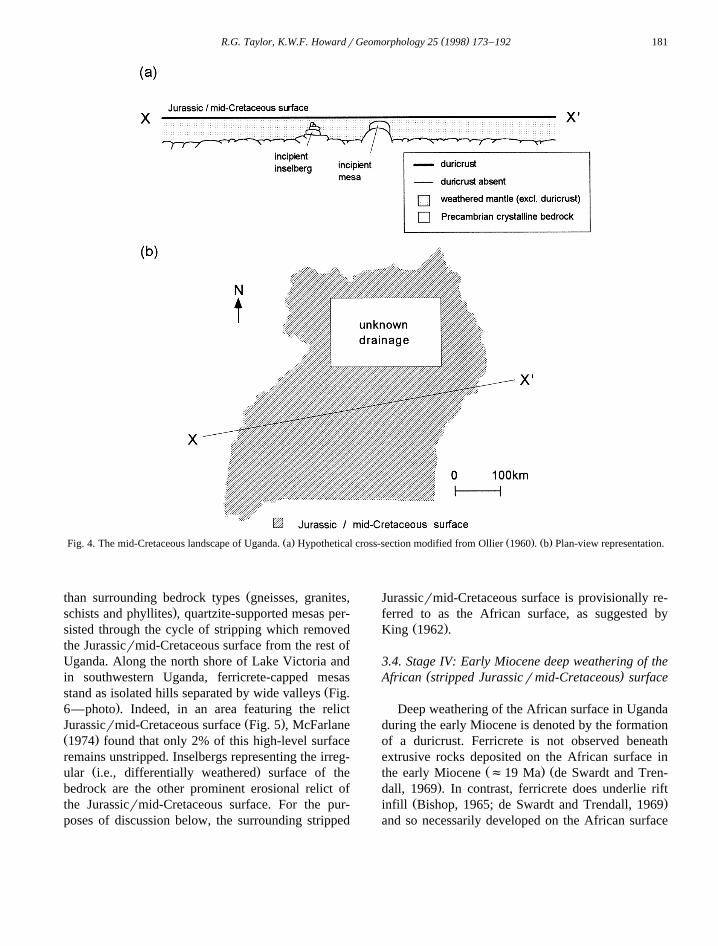
Ž .Uganda McFarlane, 1974 .As summarised in Fig. 4, the late Mesozoic land-
scape of Uganda consisted of deeply weathered man-tle produced by the in situ alteration of Precambrianbedrock primarily from the Jurassic to mid-Creta-ceous. Deep weathering over this period fashionedan irregular bedrock surface due to differential
Ž .weathering Fig. 4a . The formation of a duricrustcap on the weathered mantle reflects accumulation ofless mobile elements through prolonged leaching by
Ž .infiltrating rainfall groundwater recharge . Thedeeply weathered surface is considered to have ex-

( )R.G. Taylor, K.W.F. HowardrGeomorphology 25 1998 173–192180
Ž . Ž . Ž . Ž . Ž .Fig. 3. Global distribution of observed Mesozoic deep weathering. a Schaefer et al. 1995 . b Thomas and Thorpe 1985 . c ThomasŽ . Ž . Ž . Ž . Ž . Ž . Ž . Ž . Ž . Ž .1966 . d Ollier 1993 . e McFarlane et al. 1992 . f Partridge and Maud 1987 . g Demangeot 1975 . h Finkl and ChurchwardŽ . Ž . Ž . Ž . Ž . Ž .1973 . i Mabbutt 1965 . j Hill et al. 1995 and Pleistocene glaciation modified from John, 1979 .
Ž .tended across Uganda Fig. 4b but, to avoid confu-Ž .sion with the ‘Gondwana surface’ of King 1962 ,
which is referred to here as the ‘Jurassicrmid-Creta-ceous surface’. In the absence of any data, mid-Cretaceous drainage patterns in Uganda are unknownŽ .Fig. 4 .
( )3.3. Stage III: Late Cretaceous to Early Miocene ?stripping of the deeply weathered mantle
The development of the South Atlantic Ocean inthe mid-Cretaceous prompted eastward incision alongthe failed rift that gave rise to the Congo drainagewhich extended across equatorial Africa to present-day Kenya. Incision induced widespread stripping of
Žthe deeply weathered mantle in Uganda Bishop andTrendall, 1967; de Swardt and Trendall, 1969; Mc-
.Farlane, 1974 where east–west trending drainageŽ .channels of the Kafu, Katonga and Kagera Fig. 5Žformed headwaters of the Congo basin Temple,
.1970 . Volcanic tuffs overlying the stripped Juras-sicrmid-Cretaceous surface in eastern Uganda
Ž .Fig. 5a are, on the basis of fossil evidence andŽ . ŽK–Ar dating, of early Miocene age f19 Ma Bi-
.shop, 1958, 1965; Bishop and Trendall, 1967 . As aresult, the cycle of stripping that extensively re-moved the Jurassicrmid-Cretaceous surface from
Ž .Uganda Fig. 5 was necessarily completed by theearly Miocene. An earlier Oligocene age for the endof stripping has been deduced in southern Africa by
Ž .Partridge and Maud 1987 from an absence of off-shore deposition. Significantly, the tuffs in easternUganda predate mid-Miocene initiation of the west-
Ž . Ž .ern Albertine graben Pickford et al., 1992 . Thus,alternative hypotheses which link stripping of theJurassicrmid-Cretaceous surface in Uganda to
ŽMiocene rifting Doornkamp and Temple, 1966; van.Stratten, 1977; Ollier, 1993 , are untenable.
Remnants of the Jurassicrmid-Cretaceous surfaceŽ .in Uganda Fig. 5 are restricted to ferricrete-capped
mesas underlain by quartzites of the Buganda–ToroŽand Karagwe–Ankolean complexes Doornkamp and
.Temple, 1966; de Swardt and Trendall, 1969 . Be-cause quartzites are more resistant to weathering
( )R.G. Taylor, K.W.F. HowardrGeomorphology 25 1998 173–192 181
Ž . Ž . Ž .Fig. 4. The mid-Cretaceous landscape of Uganda. a Hypothetical cross-section modified from Ollier 1960 . b Plan-view representation.
Žthan surrounding bedrock types gneisses, granites,.schists and phyllites , quartzite-supported mesas per-
sisted through the cycle of stripping which removedthe Jurassicrmid-Cretaceous surface from the rest ofUganda. Along the north shore of Lake Victoria andin southwestern Uganda, ferricrete-capped mesas
Žstand as isolated hills separated by wide valleys Fig..6—photo . Indeed, in an area featuring the relict
Ž .Jurassicrmid-Cretaceous surface Fig. 5 , McFarlaneŽ .1974 found that only 2% of this high-level surfaceremains unstripped. Inselbergs representing the irreg-
Ž .ular i.e., differentially weathered surface of thebedrock are the other prominent erosional relict ofthe Jurassicrmid-Cretaceous surface. For the pur-poses of discussion below, the surrounding stripped
Jurassicrmid-Cretaceous surface is provisionally re-ferred to as the African surface, as suggested by
Ž .King 1962 .
3.4. Stage IV: Early Miocene deep weathering of the( )African stripped Jurassicrmid-Cretaceous surface
Deep weathering of the African surface in Ugandaduring the early Miocene is denoted by the formationof a duricrust. Ferricrete is not observed beneathextrusive rocks deposited on the African surface in
Ž . Žthe early Miocene f19 Ma de Swardt and Tren-.dall, 1969 . In contrast, ferricrete does underlie rift
Ž .infill Bishop, 1965; de Swardt and Trendall, 1969and so necessarily developed on the African surface

( )R.G. Taylor, K.W.F. HowardrGeomorphology 25 1998 173–192182
Ž . Ž . Ž .Fig. 5. The early Miocene landscape of Uganda. a Hypothetical cross-section modified from Ollier 1959, 1960 ; for key, see Fig. 3a. bŽ .Plan-view representation based upon a palaeohydrological reconstruction by Temple 1970 and physiographic mapping of de Swardt and
Ž .Trendall 1969 .
Žbefore it was downfaulted to form the western Al-. Ž .bertine graben in the mid-Miocene f13 Ma . Na-
Ž .hon 1986 has shown in Senegal that 6 Ma issufficient time for ferricrete to form in situ fromcrystalline rock. Because stripping of theJurassicrmid-Cretaceous surface in Uganda did not
Ž .proceed down to bedrock Ollier, 1959 , ferricretedevelopment was assisted by the fact that it occurred
on pre-weathered rock. Climatic conditionsfavourable for deep weathering, namely that precipi-tation exceeds evapotranspiration to produce rainfall-fed groundwater recharge, are indicated by limited
Žpalaeoclimatic data Axelrod and Raven, 1978; Pick-.ford, 1995 that show humid conditions capable of
sustaining rainforest cover in east Africa during theearly Miocene.

( )R.G. Taylor, K.W.F. HowardrGeomorphology 25 1998 173–192 183
Fig. 6. Photograph showing the Jurassicrmid-Cretaceous surface preserved on a quartzite-supported mesa, taken near Kajansi, 10 km southŽ . Žof Kampala along Entebbe Road, looking eastward R. Taylor . The mesa on the left is situated slightly more than a kilometre behind east
.of the mesa on the right.
3.5. Stage V: Miocene rifting and localised strippingof the African surface
Commencement of rifting in the mid-Mioceneproduced a shallow downwarp and induced local
Ž .stripping of the African surface Fig. 7a . Ensuinginfill initiated a sedimentary sequence which pro-vides a continuous record of subsequent morphocli-matic activity on landsurfaces draining into the rifttrough from the east. Rift sediments at the northern
Ž .and southern end of Lake Albert Fig. 8 have beenŽ .studied in detail Bishop, 1965; Pickford et al., 1989
and a correlation of observed sedimentary assem-Žblages is given in Fig. 9. Basal deposits Kisegi and
.Namsika beds contain coarse, relatively unweath-ered clasts indicative of downcutting into lower, lessweathered zones of deeply weathered profiles by the
Žrejuvenation of westward drainage Bishop, 1965,
.1971; Pickford et al., 1989 . Such strata exhibitindicators of westward-directed palaeocurrents re-sulting from continued flow into the Congo basinŽ .Bishop, 1965; Bishop and Trendall, 1967 .
Ž .Increased tectonism in the late Miocene 8 Maformed a deep graben and led to the establishment of
Ž .palaeolake Obweruka Fig. 7 . This transition wasmarked in the rift by a depositional change fromcoarse, fluvial sediments to more highly weathered
Žand ferruginised, lacustrine strata Kaiso series;Oluka, Nyaburogo, Nyakabingo, Katarago and
.Nyabusosi formations . This shift reflects reduceddowncutting east of the rift and inflow of iron-saturated water to the lake. As such, it indicates atransition on landsurfaces east of the rift from strip-ping to deep weathering, a change recorded by thedevelopment of a ferricrete crust on the Namsika
Ž .beds Fig. 9 during more humid conditions of the

( )R.G. Taylor, K.W.F. HowardrGeomorphology 25 1998 173–192184
Ž . Ž .Fig. 7. The late MiocenerPliocene landscape of Uganda. a Hypothetical cross-section; for key, see Fig. 3a. b Plan-view representationŽ . Ž .based upon a palaeohydrological reconstruction by Temple 1970 , proposed palaeolake Obweruka of van Damme and Pickford 1995 , and
Ž .physiographic mapping of de Swardt and Trendall 1969 .
Žlate Miocene and early Pliocene Dechamps et al.,.1992; Jacobs and Deino, 1996 . The areal extent to
which the African surface was modified during theŽ .Kisegi stage is unclear Fig. 7 but mid-Pleistocene
Ž .upwarping and renewed stripping discussed beloware likely to have destroyed evidence of Miocenestripping on landsurfaces to the east of the rift.
The drainage outlet for the western rift from thetime water began to collect in Lake Obweruka in thelate Miocene until evidence of northward flow to the
Ž .Nile in the late Pleistocene Livingstone, 1980 is theŽ .subject of speculation. Adamson and Williams 1980Ž .cited the model of rift development of Veevers 1977
and argued that westward flow to the Congo basin

( )R.G. Taylor, K.W.F. HowardrGeomorphology 25 1998 173–192 185
Ž . Ž .Fig. 8. The late Quaternary landscape of Uganda. a Hypothetical cross-section; for key, see Fig. 3a. b Plan-view representation basedŽ .upon a modified physiographic map of de Swardt and Trendall 1969 .
was blocked by an arch whose crest later down-warped to produce the western rift. Deposition ofclaystones in southern Sudan was later attributed to
northward overflow from the western rift duringŽ .much of the late Tertiary Adamson et al., 1993 . A
continued westward link to the Congo basin from the

( )R.G. Taylor, K.W.F. HowardrGeomorphology 25 1998 173–192186
Ž . Ž . Ž . Ž .Fig. 9. Rift deposition and inferred geomorphology. a van Damme and Pickford 1995 . b Bishop, 1965. c Pickford et al., 1989, 1992.Ž . Ž . Ž . Ž .d Dechamps et al., 1992. e Dechamps et al., 1992; Jacobs and Deino, 1996. f Pickford, 1992. g Axelrod and Raven, 1978; Pickford,
Ž .1995; Jacobs and Deino, 1996. h Bishop and Trendall, 1967. Dashed lines indicate estimated sediment ages. Shading links rift depositionto cycles of stripping during the Miocene and Pleistocene.
late Miocene to late Pliocene is, however, indicatedby the genealogy of molluscan fauna in rift sedi-
Ž .ments van Damme and Pickford, 1995 . Prolifera-tion of fresh-water molluscs, studied by van Damme
Ž .and Pickford 1995 , denies the possibility that thelake became saline through prolonged closure de-spite the late Pliocene aridity noted by Dechamps et
Ž .al. 1992 .
3.6. Stage VI: Mid-Pleistocene uplift and stripping ofAfrican surface
In the late Pliocene, Lake Obweruka was cut inhalf by the upthrusting of the Rwenzori horst to form
Ž .lakes Albert and Edward Fig. 8 . Nevertheless, adistinct shift in rift deposition did not occur until the
mid-Pleistocene when fluviolacustrine, drab gray towhite sands of Paraa and Wasa beds, truncated highly
Ž .weathered, lacustrine strata Fig. 9 . The transitionfrom Kaiso series to Wasa beds marks a period ofuplift followed by stripping where inflow of iron-saturated water ceased and downcutting into fresh
Žrock was accelerated by rejuvenated streamflow Bi-.shop, 1965 . Uplift parallel to, but approximately 30
km east of, the rift escarpment exceeded westwardŽ .incision and reversed river flows Fig. 8 . In areas
east of the axis of uplift, termed the ‘inter-arch’Žbasin i.e., between the Albert rift in Uganda and
. Ž .Gregory rift in Kenya by Veevers 1977 , a reduc-Žtion in relief the westward tilt being marginally
.reversed has led to the collection of surface water inthe wide drainage channels associated with formerly

( )R.G. Taylor, K.W.F. HowardrGeomorphology 25 1998 173–192 187
westward-flowing headwaters of the Congo. Con-versely, between the axis uplift and the rift escarp-
Ž .ment, the ‘intra-arch’ basin of Veevers 1977 in-creased relief that has led to incision of narrowdrainage channels within the wide valley topography.The impact of this reversal on drainage patterns in
Ž .western Uganda, near Masindi Fig. 1 , is depicted inFig. 10. The extent of intra-arch stripping on the
Ž .African surface Fig. 8 is difficult to define with
precision but conforms more closely with rejuve-nated drainage into the rift trough than strictly topo-
Ž .graphic criteria i.e., axes of uplift , suggested byŽearlier physiographic maps de Swardt and Trendall,
. Ž .1969; Ollier, 1984 . This phase of intra-arch strip-ping, resulting from uplift, is recorded by rift deposi-tion, whereas the reversal of westward drainage inthe inter-arch basin is logged in sediments deposited
Ž .along the Kagera river channel at Nsongesi Fig. 8 .
Ž .Fig. 10. Surface drainage in the vicinity of Biso, near Masindi in western Uganda modified from Ollier, 1993 showing broad, swamp-filleddrainage channels east of the upwarped drainage divide and narrower, more incised drainage pattern trending west from the divide to the rifttrough.
( )R.G. Taylor, K.W.F. HowardrGeomorphology 25 1998 173–192188
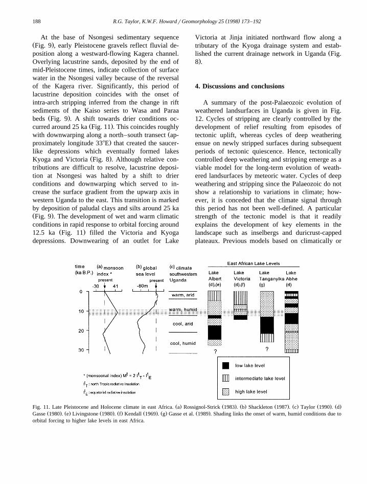
At the base of Nsongesi sedimentary sequenceŽ .Fig. 9 , early Pleistocene gravels reflect fluvial de-position along a westward-flowing Kagera channel.Overlying lacustrine sands, deposited by the end ofmid-Pleistocene times, indicate collection of surfacewater in the Nsongesi valley because of the reversalof the Kagera river. Significantly, this period oflacustrine deposition coincides with the onset ofintra-arch stripping inferred from the change in riftsediments of the Kaiso series to Wasa and Paraa
Ž .beds Fig. 9 . A shift towards drier conditions oc-Ž .curred around 25 ka Fig. 11 . This coincides roughly
Žwith downwarping along a north–south transect ap-.proximately longitude 338E that created the saucer-
like depressions which eventually formed lakesŽ .Kyoga and Victoria Fig. 8 . Although relative con-
tributions are difficult to resolve, lacustrine deposi-tion at Nsongesi was halted by a shift to drierconditions and downwarping which served to in-crease the surface gradient from the upwarp axis inwestern Uganda to the east. This transition is markedby deposition of paludal clays and silts around 25 kaŽ .Fig. 9 . The development of wet and warm climaticconditions in rapid response to orbital forcing around
Ž .12.5 ka Fig. 11 filled the Victoria and Kyogadepressions. Downwearing of an outlet for Lake
Victoria at Jinja initiated northward flow along atributary of the Kyoga drainage system and estab-
Žlished the current drainage network in Uganda Fig..8 .
4. Discussions and conclusions
A summary of the post-Palaeozoic evolution ofweathered landsurfaces in Uganda is given in Fig.12. Cycles of stripping are clearly controlled by thedevelopment of relief resulting from episodes oftectonic uplift, whereas cycles of deep weatheringensue on newly stripped surfaces during subsequentperiods of tectonic quiescence. Hence, tectonicallycontrolled deep weathering and stripping emerge as aviable model for the long-term evolution of weath-ered landsurfaces by meteoric water. Cycles of deepweathering and stripping since the Palaeozoic do notshow a relationship to variations in climate; how-ever, it is conceded that the climate signal throughthis period has not been well-defined. A particularstrength of the tectonic model is that it readilyexplains the development of key elements in thelandscape such as inselbergs and duricrust-cappedplateaux. Previous models based on climatically or
Ž . Ž . Ž . Ž . Ž . Ž . Ž .Fig. 11. Late Pleistocene and Holocene climate in east Africa. a Rossignol-Strick 1983 . b Shackleton 1987 . c Taylor 1990 . dŽ . Ž . Ž . Ž . Ž . Ž . Ž .Gasse 1980 . e Livingstone 1980 . f Kendall 1969 . g Gasse et al. 1989 . Shading links the onset of warm, humid conditions due to
orbital forcing to higher lake levels in east Africa.

( )R.G. Taylor, K.W.F. HowardrGeomorphology 25 1998 173–192 189
Fig. 12. Schematic diagram showing the post-Palaeozoic evolution of weathered landsurfaces in Uganda. Stage refers to tectonicallycontrolled cycles of deep weathering and stripping identified in this study and described in the text.
eustatically controlled episodes of deep weatheringŽand stripping Thomas, 1989a; Fairbridge and Finkl,
.1980 do not adequately account for the evolution ofthese landforms.
The role of tectonic uplift in driving landscaperenewal by inducing episodes of stripping has been
Žrecognised by other studies King, 1962; Demangeot,.1975; Partridge and Maud, 1987 . Indeed, the
chronology of denudation in Uganda is comparable
to terrestrial geomorphic events in southern AfricaŽrecorded by off-shore sedimentation Partridge and
.Maud, 1987 and, to a lesser degree, the worldwideŽ .‘pediplanation cycles’ proposed by King 1962 . A
time lag between the separation of east and westGondwanaland in the early Cretaceous and the sepa-ration of Africa and South America by the mid-Cretaceous, which is recognised in this study, ques-
Žtions King’s hypothesis, commonly adopted e.g.,

( )R.G. Taylor, K.W.F. HowardrGeomorphology 25 1998 173–192190
.Ollier, 1993; Schaefer et al., 1995 , that a Gond-wana-wide peneplain existed, was stripped followingdismemberment of the supercontinent, and therebyconstitutes the relict, highest-level surface in Africaand South America.
A tectonically-driven model of deep weatheringand stripping counters the assertion that these pro-cesses are discontinuous and have each occurred
Žover only one interval Ollier, 1960, 1993; Hill et al.,.1995; Pain and Ollier, 1996 . Based upon work in
Uganda, comparatively lesser effects of deep weath-ering on the continental-weathered landsurfaces dur-ing the Cenozoic, as compared with higher-levelMesozoic surfaces are viewed not as a lack of‘cyclicity’ in deep weathering and stripping but asfunction of a shorter timescale, and different andpossibly more variable climates. Recognition thatweathered landsurfaces are not entirely relict, butcontinue to be shaped by contemporary processes, isimportant because it implies that the analysis of deepweathering and stripping in the present is relevant tolong-term landscape evolution.
Acknowledgements
This study emanated from hydrogeological inves-tigations conducted under the Hydrogeology-UgandaPhase II project sponsored by the International De-
Ž .velopment Research Centre IDRC , Canada, withassistance from the Directorate of Water Develop-
Ž .ment DWD , Ministry of Natural Resources,Uganda, and the University of Toronto, Canada.Development of the presented thesis benefitted sig-nificantly from discussions with Professor Nick EylesŽ .University of Toronto , in particular, as well as
Ž .Professor Tony Price University of Toronto and Dr.Ž .Peter van Straaten University of Guelph . We are
also grateful for helpful correspondence with Profes-Ž .sors Cliff Ollier Australian National University ,Ž .Marty McFarlane University of Botswana , Michael
Ž .Thomas University of Stirling , Daniel LivingstoneŽ . ŽDuke University , Martin Williams University of
.Adelaide , as well as Mssrs. Dribidu and Oconga ofthe DWD. Discussions with Mr. Tindimugaya Callistof the DWD during field reconnaissance of reversedriver flows in western Uganda in November, 1996
Ž .also proved useful. Normative CIPW mineralogical
parameters were calculated from a PC-based pro-gramme supplied by Professor John Westgate of theUniversity of Toronto. Finally, during the prepara-tion of this manuscript, the first author benefittedfrom the provision of a University of Toronto OpenFellowship and a Graduate Scholarship from theGovernment of Ontario.
References
Adamson, D., Williams, F., 1980. Structural geology, tectonicsand the control of drainage in the Nile basin. In: Williams,
Ž .M.A.J., Faure, H. Eds. , The Sahara and the Nile. Balkema,Rotterdam, pp. 225–252.
Adamson, D., McEvedy, R., Williams, M.A.J., 1993. Tectonicinheritance in the Nile basin and adjacent areas. Isr. J. EarthSci. 41, 75–85.
Almond, D.C., 1969. Structure and metamorphism of the base-ment complex of north–east Uganda. Overseas Geol. Miner.Resour. 10, 146–163.
Axelrod, D.I., Raven, D.H., 1978. Late Cretaceous and TertiaryŽ .vegetation history of Africa. In: Werger, M.J.A. Ed. , Bio-
geography and Ecology of Southern Africa. Junk, The Hague,pp. 77–130.
Bishop, W.W., 1958. Miocene mammalia from the Napak vol-canics, Karamoja, Uganda. Nature 182, 1480–1482.
Bishop, W.W., 1965. Quaternary geology and geomorphology inthe Albertine Rift Valley and Frey Valley, Uganda. In: Wright,
Ž .Jr., H.E., Frey, D.G. Eds. , International Studies on theQuaternary. pp. 293–321.
Bishop, W.W., 1971. The Late Cenozoic history of east Africa inŽ .relation to hominoid evolution. In: Turekian, K.K. Ed. , Late
Cenozoic Glacial Ages. pp. 493–527.Bishop, W.W., Trendall, A.F., 1967. Erosion-surfaces, tectonics
and volcanic activity. Q. J. Geol. Soc., London 122, 385–420.Bjørlykke, K., 1975. Mineralogical and chemical changes during
weathering of acid and basic rocks in Uganda. Nor. Geol.Tidsskr. 55, 81–89.
Budel, J., 1957. Die ‘doppleten Einebnungsflachen’ in den¨ ¨feuchten Tropen. Z. Geomorphol. N.F. 1, 201–288.
ŽBudel, J., 1982. Climatic geomorphology, Fischer, L., Busche, D.¨.Trans. Princeton University Press, Princeton, 443 pp.
Cahen, L., Snelling, N.J., Delhal, J., Vail, J.R., Bonhomme, M.,Ledent, D., 1984. The Geochronology and evolution of Africa.Clarendon Press, Oxford, 512 pp.
Caputo, M.V., Crowell, J.C., 1985. Migration of glacial centersacross Gondwanaland during the Paleozoic Era. Geol. Soc.Am. Bull. 96, 1020–1036.
Crowley, T.J., North, G.R., 1991. Palaeoclimatology. OxfordŽ .monographs on geology and geophysics, 18 339 pp.
Dalziel, I.W.D., 1997. Neoproterozoic–Paleozoic geography andtectonics: review, hypothesis, environmental speculation. Geol.
Ž .Soc. Am. Bull. 109 1 , 16–42.Dechamps, R., Senut, B., Pickford, M., 1992. Fruits fossiles

( )R.G. Taylor, K.W.F. HowardrGeomorphology 25 1998 173–192 191
pliocenes amd pleistocenes du Rift Occidental ougandais.` ´ `Signification palaeoenvironmentale. Comput. Rend. Acad. Sci.,´
Ž .Paris 314 II , 325–331.Demangeot, J., 1975. Recherche geomorphologiques en Inde du´
Sud. Z. Geomorphol. N.F. 19, 229–272.de Swardt, A.M.J., Trendall, A.F., 1969. The physiographic devel-
opment of Uganda. Overseas Geol. Miner. Resour. 10, 241–288.
Doornkamp, J.C., 1968. The role of inselbergs in the geomorphol-ogy of southern Uganda. Trans. Inst. Br. Geogr. 44, 151–162.
Doornkamp, J.C., Temple, P.H., 1966. Surface, drainage andtectonic instability in part of southern Uganda. Geogr. J. 132,238–252.
Eyles, N., 1993. Earth’s glacial record and its tectonic setting.Earth Sci. Rev. 35, 1–248.
Fairbridge, R.W., Finkl, C.W. Jr., 1980. Cratonic regime, uncon-formities and peneplains. J. Geol. 88, 69–86.
Finkl, C.W. Jr., Churchward, H.M., 1973. The etched surfaces ofŽ .southwestern Australia. J. Geol. Soc. Aust. 20 3 , 295–307.
Gasse, F., 1980. Late Quaternary changes in lake-levels anddiatom assemblages on the south-eastern margin of the Sahara.
Ž .In: van Zinderen Bakker, Sr., Coetzee, J.A. Eds. , Palaeoecol-ogy of Africa and the Surrounding Islands. Balkema, Rotter-dam, Vol. 12, pp. 333–350.
Gasse, F., Ledee, V., Massault, M., Fontes, J.C., 1989. Water-level´ ´fluctuations of Lake Tanganyika in phase with oceanic changesduring the last glaciation and deglaciation. Nature 342, 57–59.
Geological Survey and Mines Department, Uganda, 1973. Geo-chemical Atlas of Uganda. Government of Uganda, 43 pp.
Goodwin, A.M., 1991. Precambrian Geology. Academic Press,New York, 666 pp.
Giardino, J.R., Mackel, R., 1985. Correlative development of¨dambos and dwalas: plateau regions of Zambia. Z. Geomor-phol. N.F. 52, 187–200.
Hamilton, A.C., 1982. Environmental History of East Africa.Academic Press, London, 328 pp.
Harper, C.T., Weintraub, G.S., Leggo, P.J., Shackleton, R.M.,1972. Potassium–argon retention ages from the basementcomplex and associated Precambrian metasedimentary rocksof Uganda. Geol. Soc. Am. Bull. 83, 3449–3456.
Hill, S.M., Ollier, C.D., Joyce, E.B., 1995. Mesozoic deep weath-ering and erosion: an example from Wilson’s Promontory,Australia. Z. Geomorphol. N.F. 39, 331–339.
Jacobs, B.F., Deino, A.L., 1996. Test of climate–leaf physiog-nomy regression models, their application to two Miocenefloras from Kenya, and 40Arr39Ar dating of the Late MioceneKapturo site. Palaeogeogr. Palaeoclimatol. Palaeoecol. 123,259–271.
John, B., 1979. The Winters of the World—Earth Under the IceAges. David and Charles, London, 256 pp.
Kendall, R.L., 1969. An ecological history of the Lake VictoriaŽ .basin. Ecol. Monographs 39 2 , 121–176.
King, L.C., 1962. Morphology of the Earth. Oliver and Boyd,London, 699 pp.
Knoll, M.A., James, W.C., 1987. Effect of the advent and diversi-fication of vascular land plants on mineral weathering throughgeologic time. Geology 15, 1099–1102.
Leggo, P.J., 1974. A geochronological study of the basementcomplex of Uganda. J. Geol. Soc., London 130, 263–277.
Leggo, P.J., Aftalion, M., Pidgeon, R.T., 1971. Discordant zirconU–Pb ages from the Uganda basement. Nature 231, 81–84.
Linton, D.L., 1955. The problem of tors. Geogr. J. 121, 470–481.Livingstone, D.A., 1980. Environmental changes in the Nile head-
Ž .waters. In: Williams, M.A.J., Faure, H. Eds. , The Sahara andthe Nile. Balkema, Rotterdam, pp. 339–359.
Mabbutt, J.A., 1965. The weathered land surface in central Aus-tralia. Z. Geomorphol. 9, 82–114.
McFarlane, M.J., 1974. Laterization and landscape developmentin Kyagwe, Uganda. Q. J. Geol. Soc., London 126, 501–539.
Ž .McFarlane, M.J., 1983. Laterites. In: Goudie, A.S., Pye, K. Eds. ,Chemical Sediments and Geomorphology: Precipitates andResidua in the Near-Surface Environment, Chap. 2. AcademicPress, New York, pp. 7–58.
McFarlane, M.J., 1991. Some sedimentary aspects of lateriticweathering profile development in the major bioclimatic zones
Ž .of tropical Africa. J. Afr. Earth Sci. 12 1–2 , 267–282.McFarlane, M.J., Chilton, P.J., Lewis, M.A., 1992. Geomorpho-
logical controls on borehole yields: a statistical study in anarea of basement rocks in central Malawi. In: Wright, E.P.,
Ž .Burgess, W.G. Eds. , Hydrogeology of Crystalline BasementAquifers in Africa. Geological Society Special Publication 66pp. 131–154.
Nahon, D., 1986. Evolution of iron crusts in tropical landscapes.Ž .In: Colman, S.M., Dethier, D.P., Eds. , Rates of Chemical
Weathering of Rocks and Minerals. Academic Press, NewYork, pp. 169–191.
Nahon, D., Tardy, Y., 1992. The ferriginous laterites. In: Butt,Ž .C.R.M., Zeegers, H. Eds. , Regolith Exploration Geochem-
istry in Tropical and Sub-tropical Terrains, Handbook of Ex-Ž .ploration Geochemistry 4 pp. 41–55.
Ollier, C.D., 1959. A two-cycle theory of tropical pedology. J.Ž .Soil Sci. 10 2 , 137–148.
Ollier, C.D., 1960. The inselbergs of Uganda. Z. Geomorphol. 4,43–52.
Ollier, C.D., 1984. Weathering, 2nd edn. Longman, Edinburgh,270 pp.
Ollier, C.D., 1993. Age of soils and landforms in Uganda. Isr. J.Earth Sci. 41, 227–231.
Pain, C.F., Ollier, C.D., 1996. Regolith stratigraphy: principlesŽ .and problems. Aust. J. Geol. Geophys. 16 3 , 198–202.
Partridge, T.C., Maud, R.R., 1987. Geomorphic evolution ofŽ .southern Africa since the Mesozoic. S. Afr. J. Geol. 90 2 ,
179–208.Pickford, M., 1992. Evidence for an arid climate in Western
Uganda during the middle Miocene. C.R. Seances Acad. Sci.Ž .315 2 , 1419–1424.
Pickford, M., 1995. Fossil land snails of East Africa and theirŽ .palaeoecological significance. J. Afr. Earth Sci. 20 3–4 ,
167–226.Pickford, M., Senut, B., Roche, H., Mein, P., Ndaati, G., Obwona,
P., Tuhumwire, J., 1989. Uganda Palaeontology Expedition:Ž .resultats de la deuxieme mission 1987 dans la region de´ ` ´
Ž .Kisegi–Nyabusosi Bassin du lac Albert Ouganda . C.R.Ž .Seances Acad. Sci. 308 2 , 1751–1758.

( )R.G. Taylor, K.W.F. HowardrGeomorphology 25 1998 173–192192
Pickford, M., Senut, B., Roche, J.P., Ambrosi, J.P., Dechamps,R., Faure, M., van Damme, D., Texier, P.J., Baguma, Z.,Musiime, E., 1992. Revision de la biostratigraphie du Neogene´ ´ `
Ž .du Rift Occidental Ouganda–Zaire . C.R. Seances Acad. Sci.Ž .315 2 , 1289–1292.
Pye, K., 1986. Mineralogical and textural controls on the weather-ing of granitoid rocks. Catena 13, 47–57.
Radwanski, S.A., Ollier, C.D., 1959. A study of an east AfricanŽ .catena. J. Soil Sci. 10 2 , 149–170.
Rossignol-Strick, M., 1983. African monsoons, an immediateclimate response to orbital insolation. Nature 304, 46–49.
Schaefer, C., Dalrymple, V., Dalrymple, J., 1995. Landscapeevolution in Roraima, North Amazonia: planation, paleosols
Ž .and paleoclimates. Z. Geomorphol. 39 1 , 1–28.Schluter, T., 1994. The Precambrian of East Africa. 177 pp.¨Scotese, C.R., 1991. Jurassic and Cretaceous plate tectonic recon-
structions. Palaeogeogr. Palaeoclimatol. Palaeoecol. 87, 493–501.
Shackleton, N.J., 1987. Oxygen isotopes, ice volume and sealevel. Q. Sci. Rev. 6, 183–190.
Spooner, C.M., Hepworth, J.V., Fairbairn, H.W., 1970. Whole-rock Rb–Sr investigation of some east African granulites.Geol. Mag. 107, 511–521.
Taylor, D.M., 1990. Late Quaternary pollen records from twoUgandan mires: evidence for environmental change in theRukiga Highlands of southwest Uganda. Palaeogeogr. Palaeo-climatol. Palaeoecol. 80, 283–300.
Ž .Temple, P., 1970. The lakes of Uganda. In: Ominde, S.H. Ed. ,Studies in East African Geography and Development. Heine-mann, London, pp. 86–98.
Thomas, M.F., 1965. An approach to some problems of landform
analysis in tropical environments. In: Whittow, J.B., Wood,Ž .P.D. Eds. , Essays in Geography for Austin Miller. University
of Reading, pp. 118–143.Thomas, M.F., 1966. Some geomorphological implications of
deep weathering patterns in crystalline rocks in Nigeria. Trans.Inst. Br. Geogr. 40, 173–193.
Thomas, M.F., 1989a. The role of etch processes in landformdevelopment: I. Etching concepts and their applications. Z.
Ž .Geomorphol. N.F. 33 2 , 129–142.Thomas, M.F., 1989b. The role of etch processes in landform
development: II. Etching and the formation of relief. Z. Geo-Ž .morphol. N.F. 33 3 , 257–274.
Thomas, M.F., 1994. Geomorphology in the Tropics. Wiley,Chichester, 460 pp.
Thomas, M.F., Thorpe, M., 1985. Environmental change andepisodic etchplanation in the humid tropics of Sierra Leone:
Ž .the Koidu etchplain. In: Douglas, I., Spencer T. Eds. , Envi-ronmental Change and Tropical Geomorphology, Chap. 12.George Allen, London, pp. 239–267.
van Damme, D., Pickford, M., 1995. The late Cenozoic ampullari-Ž .dae mollusca, gastropoda of the Albertine Rift Valley
Ž .Uganda–Zaire . Hydrobiologia 316, 1–32.van Stratten, H.P., 1977. Morphotectonic investigations along the
Western Rift in the Masindi area, Bunyoro District, Uganda.Geol. Rund. 66, 217–228.
Veevers, J.J., 1977. Rifted arch basins and post-breakup rimbasins on passive continental margins. Tectonophysics 41,T1–T5.
Wopfner, H., Kreuser, T., 1986. Evidence for Late Palaeozoicglaciation in southern Tanzania. Palaeogeogr. Palaeoclimatol.Palaeoecol. 56, 259–275.