positional improvement of land registry and statutory charges mapping
DESCRIPTION
Positional Improvement of Land Registry and Statutory Charges Mapping. Introduction. - PowerPoint PPT PresentationTRANSCRIPT

Positional Improvement of Land Registry and Statutory Charges
Mapping

Introduction The Registrar of Titles for Northern Ireland is responsible for creating and
maintaining information relating to title to land in Northern Ireland. This incorporates the Land Registry, the Registry of Deeds and the Statutory Charges Register.
The Land Registry is a successor to the Registration scheme introduced to Ireland in 1891 under the Local Registration of Title (Ireland) Act 1891. The 1891 scheme was replaced in NI by the Land Registration Act (NI) 1970.
Section 62 (1) of the act provides that
“There shall be maintained by or on behalf of the Registrar a series of maps based on Ordnance maps”
Since 2011 the LPS Mapping & Valuation Directorate has been updating and positionally improving the LPS OSNI mapping in line with Global Positioning Satellite technology under the LPS/DARD LPIS Project

Impact for Northern Ireland PLC
The draft Programme for Government 2011-15 which is currently out for public consultation, has a Priority 1 objective. Growing a Sustainable Economy and investing in the future.

Benefit for Northern Ireland PLC
‘…secure property rights are positively correlated with a country’s level of investment and economic growth.’ (Besley, Knack & Keefer)
‘…secure and well defined property rights transform assets into resources that can be used to generate additional capital and obtain credit.’ (De Soto) ’

Benefit for Northern Ireland PLC
De Soto goes on to suggest that
‘…in USA approximately 70% of new business credit comes from using titles to other assets as collateral.’
The CML have suggested that
‘…£400m per annum is generated in property conveyencing.’

Registration PI Project – Why Now
• Why is PI so important• PI has always been around!• PI is not unique to Northern Ireland this is happening all over the
world• With the advent of digital mapping changes have become more
apparent• LPS OSNI PI programme will impact on all customers including
Registration• The PI project will ensure the data contained on the map register is
accurate• Accurate Registration information critical to property market

An Example of Positional Improvement

Example of Localised ComparisonPre PI Mapping Urban

Example of Localised Comparison
Post PI Mapping Urban
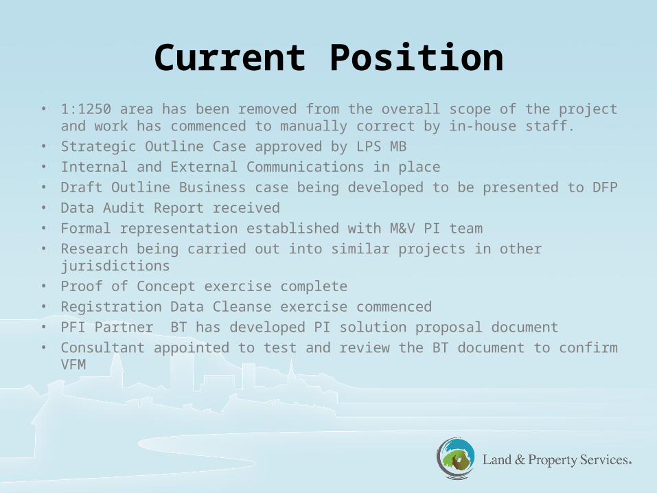
Current Position• 1:1250 area has been removed from the overall scope of the project and
work has commenced to manually correct by in-house staff.
• Strategic Outline Case approved by LPS MB
• Internal and External Communications in place
• Draft Outline Business case being developed to be presented to DFP
• Data Audit Report received
• Formal representation established with M&V PI team
• Research being carried out into similar projects in other jurisdictions
• Proof of Concept exercise complete
• Registration Data Cleanse exercise commenced
• PFI Partner BT has developed PI solution proposal document
• Consultant appointed to test and review the BT document to confirm VFM

So what if LPS did nothing
• State guarantee of title compromised• Reduced confidence in Title for owners and lenders• Significant constraint in attracting inward investment• Increased volume of land disputes• Lengthier and contentious conveyancing• Increased number of lands tribunal cases• Increased compensation (paid by the consolidated fund)

Registration Staff Contact
Details
Ashlin Sharvin – PI Communication Manager
Clare McMillan – PI Operations Manager