portuslimen: rome’s mediterranean ports (romp) · 2016. 1. 22. · basin to the north. the...
TRANSCRIPT

Portuslimen: Rome’s Mediterranean Ports (RoMP) Workshop on Archaeological Fieldwork 28th and 29th January 2016
British School at Rome
Programme Abstracts

28th January 1. Introductory Papers: 9.10-9.35. S. Keay (Southampton/BSR), Introduction to the Project Rome was connected to its Mediterranean provinces by commercial routes channelled through networks of ports acting as poly-functional nodes. Ships, people and goods moved along these, drawing the micro-regions of the Mediterranean into a closer economic and commercial relationship with the City. Central to the success of these networks were the major ports through which were channelled major commercial flows moving between Rome and its maritime hub at Portus and key ports in its Mediterranean provinces, and the relationships of these to lesser regional ports and anchorages. All of them can be described in terms of loosely configured “port-systems” that ensured the movement of ships and their cargoes around the Mediterranean. The Rome’s Mediterranean Ports Portuslimen project address specific questions relating to the capacities of and inter-connections between a range of c 30 selected ports in the east and west Mediterranean in ways that allow us to better understand their role in promoting the cohesion and integrity of the Roman Mediterranean during the imperial era. These concern (1) the layout of Roman ports, (2) the organization of commercial activity focused at them, (3) hierarchies of ports, and (4) pan-Mediterranean commercial and social connections between ports. In addressing them, the project applies suites of existing techniques in archaeology and palaeo-environmental studies, as well as undertaking historical and epigraphic analyses. This paper will present a brief overview of the project and its methodologies, as well as presenting some preliminary results relating to the archaeological work. This workshop, the second to have taken place so far, is dedicated towards discussing the results of fieldwork at project port sites, in the context of the results of from other related projects. 1. Introductory Papers: 9.30-10.0. P. Arnaud (Université Lumière / Lyon 2 and Institut Universitaire de France) Written and archaeological evidence: a joint venture The most common use of written evidence in support of archaeological investigation is historical topography in its wider sense: locating places and identifying their main features or infrastructure. This has often been the work of unskilled scholars who were satisfied in picking up information without consideration of context or intertextuality, and reassembling these elements driven from different sources in a supposed consistent topographic and historical reconstruction. A better understanding of the sources would improve the assessment of the documentary value of this evidence and the quality of possible reconstructions. It may suggest surveying strategies. The case-study of Utica provides a good example of the risks and potential of using ancient written evidence. At the other hand the importance of archaeological evidence for the understanding of ancient written sources has generally been under-estimated. Not only does it provide grounds for dating texts or layers in the genesis of texts. Any time reality does not fit entirely (or does not fit all)

with written records (usually not first-hand ones), it provides us with elements for understanding the genesis of this mistakes, and as a result for understanding the genesis of the texts that provide us with these mistakes. Rome: 10.00-10.20. R. Sebastiani and A. Contini (SS-COL) Recent work in the Piana Subavaentina (Testaccio) The valley of Testaccio spreads out for 600,000 mq and shows an urban fabric rich of historical evidences. From the 2nd century BC, and then between the 1st and 2nd century AD, when the ancient docking of Rome near the Foro Boario became inadequate for the city needs, the Testaccio plain was destined to the construction of a new port (Emporium), buildings for goods conservation and storage (Porticus Aemilia, Horrea Galbana, Lolliana, Severiana, etc.), and a large organized dump of imperial oil amphoras (Monte dei Cocci or Monte Testaccio). Between the 5th and the 7th century AD, the plain was involved in a gradual process of ruralization, and since the Middle Ages and Renaissance it was used for vegetable gardens and vines. In particularly we will focus our attention on the Nuovo Mercato Testaccio and Porticus Aemilia excavations carried out between 2005 and 2013 by the SS-COL. The first archaeological site is the result of a preventive archaeological excavation for the building of the New Market of the Rione. The excavation, a four-sided area extending for one hectare, started from the street level (15 m ASL), and reached a depth of about 9 m, providing an uninterrupted stratigraphy from the Early Roman Imperial age until the Contemporary age. The Early Imperial period (Augustan age Flavian period; I century AD) in the north-east and then in the western part of the excavation brought to light a system of roofed rooms and open courts served by a network of service roads, which are peculiar for the building material used. All the “walls” of the structure are in fact made up of amphorae emptied and reused piling them on top of each other. The following Middle Imperial period (the ages of Trajan and Hadrian; end of the I century AD, first half of the II century AD) in the western sector is characterized by the excavation of the building levels of a trapezoidal edifice, identified as a horreum, made up of rows of rectangular rooms facing a wide central porticoed square, partially effaced by the moderns streets Via B. Franklin (west) and Via A. Manunzio (north). The Porticus Aemilia excavation belongs to a regeneration project that aims to regenerate, investigate and re-open to the public the abandoned area around the standing remains of the so-called Porticus Aemilia, one of the largest buildings of ancient Rome. The Porticus Aemilia building complex was built in the early 2nd century BC and measured almost 500 meters in length. Traditionally considered a storage warehouse over the years, the Porticus has been the subject matter for other interpretation as to its use, including that of a construction connected with tax control on provisions or that of a military wet dock on the Tiber (Navalia). The excavations allow us to reconstruct the long term biography of this building, from antiquity to the present. They have been particularly revealing with regard to the late first and early 2nd

century AD, when parts of the building were restructured to accommodate horrea, public granaries. Rome: 10.20-10.40. K. Strutt (Southampton) Geophysical Survey at the Mattatoio di Testaccio
Fig: Detail of the Forma Urbis showing the area of Monte Testaccio and the Campo Boario
Between the 1st and 3rd July 2011 a geophysical survey was conducted at the site of the Ex-Mattatoio to the east of the river Tiber and south-west of Monte Testaccio in Rome (see figure). The survey was commissioned by Renato Sebastiani and the Soprintendenza Archeologica di Roma with the aim of locating possible Republican and Imperial remains associated with the Port of Rome and the Foro Boario, including port buildings and associated warehouses between the Tiber and Monte Testaccio. The presence of remains illustrated in the Forma Urbis, and the nature of excavations to the north-east of the survey area indicated that Roman material may be present under the structures of the Ex-Mattatoio. Surveys of such industrial complexes elsewhere in Italy, for instance the Ex-Mattatoio of Rosarno, indicated the presence of both modern infrastructure and underlying archaeological remains. It was therefore anticipated that the survey at the Ex-Mattatoio in Rome would produce clear results indicating the different phases of occupation at the site. The post-medieval industrial heritage of this part of the Roman townscape masks the earlier adoption of the zone surrounding Monte Testaccio as an industrial area in ancient Rome, particularly in the Republican period in 2nd and 1st centuries BC, and in the Imperial period from 1st century to the end of the 3rd century AD. The mattatoio is located alongside and over the Horrea Seiana and Lolliana alongside the Tiber, several hundred metres south of the Porticus Aemelia, and less than 100m from Monte Testaccio. The Forma Urbis indicates buildings in the area to the west of the Ex-Mattatoio, with the modern structures located on the Campo Boario. The location of the warehouses of the Foro Boario is known from epigraphic records, and the area is represented on the Forma Urbis.

The geophysical survey at the Ex-Mattatoio was successful in locating and mapping the nature and extent of buried archaeological features across the site. Many of the shallower deposits are associated with the function and infrastructure of the livestock market and abattoir of the mattatoio, including remains of the fencing relating to pens for the livestock, and the drainage system of the Mattatoio. The deeper deposits, however, indicate the presence of possible earlier features which seem to correlate with the pattern of structures represented in the Forma Urbis for the area, and may indicate Republican and Imperial Roman buildings associated with the port and warehouses to the west of Monte Testaccio. Portus and beyond: 11.00-11.20. S. Keay (Southampton/BSR) and R. Sebastiani (SSCOL) Summary of Recent Portus Project Excavations in the Palazzo Imperiale and the Imperial Shipyard This paper presents the results of the last three seasons of excavation at the Palazzo Imperiale and the Imperial Shipyard at Portus. These two sites, which are located upon an isthmus of land at the centre of the port, were originally built late in the reign of the emperor Trajan and had long and complex functional lives down until the 6th c AD. Both structures were part of the same architectural conception and played an important role in the life of the port. The former was a c. 2.5Ha three storey palatial complex that combined functions related to coordination of the flows of ships and cargoes in and out of the port and the periodic residence of very high ranking officials and possibly the emperor himself. Excavations between 2013 and 2015 have concentrated upon the two major adjacent spaces at the eastern end of the range of rooms that defined the northern side of the Palazzo Imperiale. The first of these (Room 3) was a large functional rectangular space built around a central peristyle that was used for the manufacture of glass from the early 3rd c AD onwards. Immediately to the west, by contrast, excavations uncovered a luxurious residential area (Room 8). This survives to two stories, with a cistern acting as its focus on the ground floor, and a peristyle on the first floor. It was luxuriously decorated with mosaic floors and wall-plaster, and afforded magnificent views over the Claudian basin to the north. The Imperial Shipyard was situated immediately to the east of the Palazzo Imperiale. It was a long rectangular building that was originally c. 240m long by 58m wide and c. 18m high, and subdivided into three building sections. It opened on to the Trajanic basin to the south, but was also accessible from the Claudian basin to the north. Excavations in 2013, 2014 and 2015 have concentrated upon accessing the Trajanic flooring of the building in order to better understand its function.

Fig: Aerial view of excavated rooms at the Palazzo Imperiale of Portus
Portus and beyond: 11.20-11.40. J.P. Goiran (CNRS/MOM) Comparison between the ancient harbour basins of Portus (Italy) and Alexandria (Egypt) The ancient harbours of Alexandria (built in the 4th c. BC) and Portus (built during the 1st and 2nd centuries AD) have 3 mains basins. Alexandria has two harbour environments (the Magnus Portus and the Eunostos harbour), one on each side of the Heptastadium, a causeway linking the island of Pharos to the town. The Magnus Portus hass a well protected environment but the Eunostos harbour (the westernmost harbour) is under the influence of storms and marine currents. A third, very well protected basin has been reported in the western harbour, called Kibotos. For Portus, the complex consisted of two main coalescent basins. The first, the vast basin of Claudius (about 200 ha), was subjected to storms and silting-up. Claudius subsequently provided his harbour with a darsena, a highly protected basin. A third basin, hexagonal in shape, was later built under Trajan’s rule. The borehole samples recovered in these six « basins » show sedimentary stratigraphy that confirms certain ideas and elements (given by ancient written sources) but inva-lidates others. It is also interesting to try to compare these two huge Mediterranean harbour systems in terms of bathymetry, sedimentology (well protected or not), mole configurations, basin area, dredging phases, life span etc…

2. Reports by Project Partners (i) Utica: 12.00-12.20. A. Wilson (Oxford), I. Ben Jerbania (Institut National du Patrimoine, Tunis), L. Fentress (Oxford), F. Ghozzi (Institut National du Patrimoine, Tunis), J. Crawley Quinn (Oxford), Introduction to the Utica Project
This paper provides a general introduction to the aims and principal results of the Anglo-Tunisian Utica project, summarising the key findings of excavations and fieldwork between 2010 and 2015. It discusses the evidence for Utica’s importance as a port in antiquity, and the project’s search for the location of the ancient port, now buried because the progradation of the river Medjerda’s delta since antiquity has left the site over 10 km from the sea. It summarises the evidence for the urban economy, notably the discovery and excavation of a number of pottery kilns, and other production activities, as well as the evidence for imported goods from other provinces. Finally, it offers a hypothesis to explain the unexpectedly early decline in urban fortunes, by the mid fourth century AD, linking this to silting of the harbour.
Utica: 12.20-12.40. S. Hay (Southampton/BSR) Geophysical Survey at Utica (2014 and 2015) The port of Utica was an important centre throughout the Punic and Hellenistic eras and then flourished in the Roman period. Its location at the head of the Medjerda Valley, the corridor to the rich imperial agricultural estates in Tunisia, made it one of the most important ports of Roman North Africa. This talk will present the geophysical survey conducted by The University of Southampton and the British School at Rome, which in two seasons has spectacularly revealed the urban plan of the ancient city of Utica. The survey results change our understanding of the scale and scope of this port town in antiquity, and the details identified within some of the insulae allow us to glimpse at evidence of colonnaded porticos, shop fronts, large open areas and production sites such as kilns. Utica: 12.40-13.00. E. Pleuger (Liège), A. Gadhoum (Institut National du Patrimoine, Tunis), H. Abichou (Tunis), J.P. Goiran (CNRS/MOM), J. Quinn (Oxford), E. Fentress (Oxford), A. Wilson (Oxford), I. Ben Jerbania (Institut National du Patrimoine, Tunis), F. Ghozzi (Institut National du Patrimoine, Tunis) and N. Fagel (Liège) Geoarchaeology of the Ancient Harbour of Utica in a Deltaic Context (2014 and 2015). Ancient authors mention Utica as a maritime and port city and estimate its origin around the 11th c. BC. However, in the present state of research, no archaeological evidence is earlier than the 9thc. BC, and the location of the Phoenician and Roman port infrastructures remains
unknown. Today, the ancient city is located on a promontory in the heart of the Medjerda delta, 10 km inland. Based on this observation, our geoarchaeological research focuses on two main issues:
- Was there a marine environment around the promontory of Utica, which could shelter harbour structures?
- Why the city, formerly a seaport city, is today located 12 km from the coast? Can the wadi be solely responsible of such an important sediment accumulation in a few millennia? Have any natural or anthropogenic factors influenced this deltaic progradation over the centuries?
First results permitted drawing an hypothesis of the coastline during Antiquity to the effect that the Utica promontory was surrounded by the sea in an earlier era. (1) Effectively, the «North compartment» of the delta was covered by the sea at a given time, which will be determined by the next radiocarbon dating. But the sea still brushed the north side of the promontory during the Roman period, as evidenced by the potsherds found in one of the cores. This deep marine bay could be a potential location for harbour infrastructure prior to clogging of the bay by the sediments carried by the wadi. (2) The «corridor» area, materialised by the promontories of Utica and Kalâat el-Andalous, was also invaded by the sea at one time. The many artifacts found in this core attest the occupation of this area, outside of the maximal extension of the ancient city according to A. Lézine. Dating of the marine units in the two cores will bring essential data: * to establish the chronological framework of the retreat of the coastline and of the clogging of the bay; * to understand the passage of the Medjerda into the «North compartment» by the corridor Utica-Kalâat. The geoarchaeological results corroborate ancient sources. Utica was able to welcome important harbour structures, since the presence of a deep marine environment is attested around the promontory, but these remains are probably 5 m deep under the alluvium of the Wadi Medjerda.

Fig: Evocation of Utica in 46 BC according Daux, 1869
E. Pleuger1, A. Gadhoum2, H. Abichou3, J.-Ph. Goiran4, J. Quinn5, E. Fentress5, A. Wilson7, I. Ben Jerbania8, F. Ghozzi8, N. Fagel1 (1)UR Argiles, Géochimie et Environnements sédimentaires (AGEs), Département de Géologie, Université de Liège, Liège, Belgium ([email protected]) (2)Département d'Archéologie Sous-Marine, Institut National du Patrimoine, Tunis, Tunisia (3)Laboratoire de Cartographie Géomorphologique des Milieux, des Environnements et des Dynamiques, Faculté des Sciences Humaines et Sociales de Tunis, Tunis 1007, Tunisia (4)Maison de l’Orient et de la Méditerranée, CNRS UMR 5133, 69007 Lyon, France (5)Worcester College, University of Oxford, Oxford, United Kingdom (7)Institute of Archaeology, University of Oxford, Oxford, United Kingdom (8)Institut National du Patrimoine, Tunis, Tunisia Ephesos: 14.10-14.30. S. Ladstätter and M. Steskal (OAI) Introduction to the Ephesos Project. From the very start of research on Ephesos in the late 19th century the importance of the city’s connection to the sea and the existence of functioning harbours were undisputed for this region. It is quite suprising that, in spite of the cultural and historical importance of the harbours of Ephesos, they have not yet been studied indepth. Instead, research on Ephesos has concentrated much more on the evaluation of the historical sources. A focal point lay with the identification and localisation of historically recorded harbours. Archaeological fieldwork was limited to isolated excavations along the border of the Roman harbour basin conducted in the

1980s. During these excavations the quay wall as well as moles were temporarily brought to light. Already in the 1990s paleogeographers began to reconstruct the coastal geography using geoarchaeological investigations, from which important information regarding the coastal and harbour geography of the Hellenistic-Roman city of Ephesos was obtained. An actual archaeological engagement with the admittedly complex Ephesian harbour landscape, as well as an integration of geoarchaeological investigations in the form of actual interdisciplinary work, was first included in the most recent research plan for Ephesos, which has been running since 2008. Recent paleogeographical and geophysical research as well as pollen analyses have broadened our knowledge substantially: We have an impressive unique harbour landscape in front of us, one which grew over centuries and consists of a large harbour basin of the Roman Imperial Period, a long, partly artificial and partly natural channel, as well as at least three archaeologically confirmed outer-harbours. The modern appearance of the Ephesian harbour landscape is the product of a development that took many centuries. Ephesos did not shy away from any efforts, nor – so it seems – from any costs in order to keep the direct access to the sea open. As a result, Ephesos remained competitive as a harbour city and in consequence as a trading centre for as long as possible and as long as it was required.
Figure: Roman Harbour of Ephesos (photo: L. Fliesser, © ÖAI)
Sabine Ladstätter – Martin Steskal

Ephesos: 14.30-14.50. S. Seren (ZAMG), R. Totschnig (ZAMG), S. Ladstätter (ÖAI) Geophysical Survey of the Harbour Area of Ephesos For more than 10 years the ZAMG, in cooperation with the Austrian Archaeological Institute (ÖAI), has been carrying out archaeological prospections using magnetics and georadar (GPR), at the harbour area of Ephesos, Turkey. In 2005, 2008, 2010 - 2015 an area of roughly 250.000 m2 surrounding the harbour and the channel of Ephesos was surveyed, partly with very difficult field conditions.
Fig. 1: Magnetics fieldwork Fig. 2: GPR fieldwork in Ephesos.
For the GPR a Noggin and a PE PRO (Sensors & Software) were used with a survey grid of 50 x 5 and/or 25 x 5 cm. The magnetic prospection was carried out using a Multisensor Cäsiumgradiometer MEP750 in 3-Sensor Konfiguration (PICODAS) and a 4-sensors Fluxgate magnetometer (FÖRSTER9. The survey grid was 50 x 16 cm. The magnetic and GPR data were processed using the software APMAG and APRadar developed by ZAMG (1). The resulting images were imported into a GIS environment and archaeologically interpreted together with all other information available – excavation data, terrain models, digital city maps, aerials and historical photographs. The data show quite clearly the border between the built-up area surrounding the port basin to the east and the so-called “harbour necropolis” west of the point where the city walls meet the harbour canal. Further to the west, adjacent to the necropolis, the remains of a roman villa could be identified. REFERENCES: (1) S. Seren, A. Eder-Hinterleitner, W. Neubauer, K. Löcker, P. Melichar, Extended comparision of different GPR systems and antenna configurations at the Roman site of Carnuntum. Near Surface Geophysics, Vol. 5, Nr. 6, Page 389-394, 2007.

Fig. 3: Top: Results of the GPR surveys surrounding the harbour and harbour canal in Ephesos (black: high amplitudes - reflective, white: low amplitudes - absorbing). Bottom: Archaeological interpretation
S. Sirri SEREN1, Ralf TOTSCHNIG1, Sabine LADSTÄTTER2 1) Zentaralanstalt für Meteorologie und Geodynamik, Hohe Warte 38, A-1190 Wien, Austria. [email protected]; [email protected]; 2) Österreichisches Archäologisches Institut, Franz-Kleingasse 1, A-1190 Wien, Austria. [email protected] Keywords: Magnetics, GPR, GIS, archaeological interpretation.

Ephesos: 14.50-15.10. K. Strutt (Southampton) ERC Geophysical Survey of the Outer Harbour area of Ephesos (2015)
Fig: Panorama photograph of the outer harbour complex at Ephesos
As part of the ongoing survey component of the Portuslimen (ROMP) Project, geophysical survey was carried out by the team at the site of Ephesos in August and September 2015. The work focuses on the harbor complexes of the site, and is designed to complement the extensive geophysical survey work conducted by the the Österreichisches Archäologisches Institut (ÖAI) under the direction of Dr Sirri Seren of the Central Institute for Meteorology and Geodynamics (https://www.zamg.ac.at/cms/en/news). The survey work in 2015 focused on the area of the outer harbour at Ephesus, including the harbour area, the promontory to the east, and the area to the north of the modern river channel. Magnetometry and Electrical Resistivity Tomography (ERT) were applied for the 2015 survey season. Magnetometry is a passive technique which uses sensors to measure variations in the strength of the Earth's magnetic field in nanotesla (nT). ERT utilised an electrical current to measure the varying resistivity of buried deposits. At Ephesus the two techniques were applied for different reasons. The magnetometry was used to map the nature and extent of shallow buried archaeological remains in different areas close to the inner and outer harbours, and along the river channel running from Ephesos to the sea at Pamucak. The ERT was applied in single profiles to collect data and the nature of deeper archaeological and fluvial deposits in the landscape, as a complementary method to existing coring data collected at the site. In addition to the geophysical survey a programme of surface collection was undertaken to help establish a chronology for the results of the magnetometry, and to understand the varying densities of material in some of the survey areas. Surface collection was undertaken for the principal survey areas around the outer harbour. The survey results from the geophysical survey season indicate the presence of archaeological remains in a number of locations to the north and west of the outer harbour, associated with the port complex of Ephesos and its environs. In particular the results of the magnetometer survey, complemented by surface collection, provide evidence of the development of the harbour system around the so-called outer harbour, and to the north of the extant modern channel between Ephesos and the coast at Pamucak. To the east, north and west of the outer harbour a significant number of archaeological features are represented in the results of the magnetometry. A series of structures span the area between the outer harbour and the modern channel for a distance of over 220m, suggesting a wharf or jetty fronting on the channel to the north, with structures also running along the edge of the outer harbour. To the north of the modern channel a complex of structures and waterways was located in the results.

The surface collection across the principal survey areas around the outer harbour provide some idea of the chronological range of the anomalies visible in the geophysics, and the density of material across the different areas. The results of the 2015 geophysical survey season indicate the presence of settlement and port structures ranging from the 6th century BC to at least the 6th century AD, with an emphasis of different focal points of activity through time. The nature of deposits in the area of the outer harbour is complex, suggesting different developments in the area through time. In addition, structures to the north and west of the canal of the inner Roman harbour indicate the presence of port infrastructure across the floodplain. Ephesos: 15.10-15.30. F. Stock and H. Brückner (Cologne) The Geoarchaeology of the Roman harbour of Ephesus
The Holocene palaeogeographic changes in the embayment of the Küçük Menderes on the western coast of Turkey are counted amongst the most dramatic ones monitored in the Mediterranean. About seven millennia ago, the marine transgression filled the Küçük Menderes graben up to 20km inland. Due to the progradation of the delta of this river and its tributaries, the coastline has continuously shifted westwards since then. With the continuous advance of the delta, Ephesus lost its connection to the sea, subsequently leading to the construction of a harbour canal. Besides other natural factors like sea level fluctuations and tectonics, the speed of delta progradation was mainly governed by riverine sediment load, which, in turn, was mainly dependent on the human impact on the vegetation cover of the drainage basins. The delta advance was the main reason why the settlement sites and the harbours of Ephesus had to be relocated several times.
Cores up to a depth of 19 m were retrieved from the environs of the different harbours. For a better understanding of the depositional environments, geochemical, sedimentological and palynological analyses, and the determination of the macro- and microfossils were carried out. AMS-14C and luminescence dating as well as information from archaeological excavations, diagnostic ceramic finds and literary sources helped to determinate the chronostratigraphy.
The currently silted-up Roman harbour basin is a valuable geo-bio-archive. From the 2nd century BC to the 1st century AD, the high sedimentation rate indicates the proximity of the delta front. With the construction of a protected harbour basin and the harbour canal, the depositional environment changes: A 1.30 m thick stratified layer, starting with traces of dredging, clearly proves the intensive harbour use between the Hellenistic period and the 6th/7th century AD; this is evidenced by high concentrations of heavy metals (Cu, Pb) and PAHs (Abietane, Retene), fruit tree pollen, eggs of intestinal parasites (Trichuris, Ascaris) and lagoonal microfauna (ostracods, foraminifers). The stratified layer bears the imprint of the discharge of the city’s sewage and waste into the harbour basin. The deposition of peat from the 13th/14th century AD onwards indicates the complete siltation and the loss of the connection to the sea. Other harbours, such as the one at Çanakgöl, were already in use during the Late Roman period.

Fig: The harbour at Ephesus
Friederike Stock, Helmut Brückner Institute of Geography, University of Cologne, Zülpicher Str. 45, Cologne (Köln), Germany
Tarragona: 16.10-16.30: J.M. Macias (ICAC) and P. Terrado (URV) Introduction to Archaeological Problems concerning the port of Roman Tarragona Despite not having a precise knowledge of the Portus Tarraconensis, we can affirm that it consisted of an urban and economic reality. This fact was a fundamental aspect during the classical period of the city of Tarraco. The presence of a natural roadstead, the hydrological resources from a subterranean lake and a coastal promontory 80m above sea level were the main reasons for the establishment of an Iberian settlement the VI century BC, and, at the end of the III century BC, the Roman military occupation during the Second Punic War. After this episode, the harbour began its expansion followed by urban contraction, a reflection of the vitality and fall of the ancient Tarraco until the VIII century AD. The capital of the Hispania Tarraconensis is considered Rome’s gateway to ancient Iberia. Even though the material culture recovered from the excavations reveal economic dynamism, we barely know about the architectural ensemble and the harbour’s organization. The archeological excavations carried out in the last two decades have provided isolated information that witness some of the harbour's infrastructure. We recorded the existence of

facilities built during the Early Empire: a mole built in opus pilarum, part of two sewer pipes that flow into the harbour, a subterranean aqueduct – cuniculus – and a horrea. When the harbour reached its apogee it possessed a large ludic area where the theatre and the public baths were located. These thermae were close to the cardo maximus which connected the harbour to the city. During the III century AD the public baths were built, and they were repaired shortly after by the praeses provinciae at the beginning of the next century. Thus, current documentary studies supply evidence of an urban quarter close to the river built through to the VIII century. Nowadays, the Roman harbour’s remains are hidden following the expansion of the modern city during the second half of the XIX century. The current research aims to understand the ancient processes that took place in this area which could have reached 4-8 hectares in size depending on the historical period. We are also trying to define the transformation of the republican military harbour into a commercial exchange point during the Early Empire, including construction of a mole that it has not yet been identified. The nearness of the harbour and the mouth of the Tulcis suggests a hypothetical opposite breakwater as protection. For Late Antiquity, the current research interest is on the private transformation of the harbour’s ensembles and the siltation of the harbour basin. This process is still unknown, but it must have been significant because during the Middle Ages the harbour of Tarragona was no longer used, the shipping having moved to other close anchorages.
Fig: Tarragona Phase IV

Tarragona: 16.30-16.50: K. Strutt (Southampton) Geophysical Survey in the Harbour of Tarragona
Fig: GPR survey with a 500MHz antenna being conducted close to the Roman theatre
As part of the ERC funded RoMP/Portuslimen project a season of geophysical survey was undertaken in 2015 at the city of Tarragona, in Catalonia, Spain. Work was undertaken by a team of surveyors from the Department of Archaeology at the University of Southampton in collaboration with staff from the Institut Català d'Arqueologia Clàssica (ICAC) and the Universitat Rovira i Virgili. The field season focused on Ground Penetrating Radar (GPR) survey of the modern streets of the town to locate remains of the Roman port, together with topographic survey of the streets and trial of the use of Electrical Resistivity Tomography (ERT) on paved areas. The results of the survey at Tarragona provide evidence of some of the layout of the Roman port. The topographic survey along the streets indicates the low elevation of the area in the centre of the modern port town with a higher ridge of terrain running south from the central axis of the Roman theatre. In spite of the elevations being derived from the modern topography this gives some indication as to the location of the ancient harbour basin. In the central area of the town a number of possible Roman structures are visible in the northern part of the GPR survey, and a possible edge to the structures, and thus the edge of the ancient harbour, is visible to the north of the Plaça del Infants. The pattern of structures continues to the east, around the area of the Roman baths and further to the south.

Results of the ERT survey indicate some of the changes in rubble and sediment in the area of the port. The ERT profile along the Carrer del Vapor to the north of Plaça del Infants indicates 1-1.5m of modern rubble overlying lower resistivity sediments. The results of the geophysical survey at Tarragona highlight a number of key areas of the ancient port, showing remains of structures continuing under the modern street plan. In the vicinity of the Roman theatre, baths and the Visigothic port, a large number of structures are visible in the results. A hypothetical line for the edge of the Roman harbour can be given on the basis of the results, although the exact location of the eastern Roman mole remains elusive, with the change in the GPR and the location of a high resistivity anomaly in the ERT suggesting that the mole and harbour edge are located alongside the junction of the Carrer de Castellarnau and the Carrer del Mar. Tarragona: 16.50-17.10: F. Salomon (Southampton) A good harbour at Tarraco? Preliminary results from the study of the sedimentary archives
“(Tarraco) has no harbour, indeed, but it is situated on a bay and is adequately supplied with all
other advantages (…). Eratosthenes says that the city has also a roadstead, although, as Artemidorus, contradicting him, has already stated, it is not particularly blessed even with places
of anchorage” (Strabo, III, 4, 7; Translated by H. L. Jones). This translation of a text from Strabo shows that the presence of a good harbour at Tarraco has been discussed by ancient authors since the origin of the Roman settlement late 3rd c. BC. In the context of the ERC-RoMP/PortusLimen Project, we drilled two cores in the hypothesised location of the Roman harbour of Tarragona in order to evaluate the record of the sedimentary archives. Preliminary results seems to confirm the presence of the Roman harbour at the south of Tarragona. Firstly, palaeoenvironmental analyses allow us also to estimate the degree of closure of the harbour, its degree of artificialisation and the maximum depth reached by the harbour in the areas drilled. Further analyses will provide us more information about the hydrodynamism, the balance between marine and fluvial influences and the chronology of the stratigraphic sequence of the harbour.

Fig: Core drilling at Plaça dels Infants, Tarragona (02/12/2015) (F. Salomon, ERC-
RoMP/PortusLimen) Ferréol Salomon Department of Archaeology, Faculty of Humanities, University of Southampton, Avenue Campus, Southampton SO17 1BF, Great Britain - + 44(0)2380 59 7428 - [email protected]

29th January Puteoli: 9.00-9.20: L. Amato, A. Benini and C. Gialanella (Soprintendenza Archeologia della Campania) La Costa ed il Porto di Puteoli: dalle Prime Scoperte alle Indagini Strumentali Dopo l'ampia notorietà rivestita dalla ripa puteolana in età antica, l'avanzamento della linea di costa per i noti fenomeni bradisismici flegrei ha portato nell'oblio la maggior parte dell'antica fascia litoranea, salvo alcune porzioni di murature che il mare non era riuscito a sommergere completamente e segnalate, nelle opere dei principali cartografi a partire dal XVI secolo. La reale estensione e consistenza della ripa puteolana venne casualmente riscoperta solo a partire dagli anni 50 del secolo scorso e con il diffondersi delle immersioni subacquee sportive iniziarono una lunga serie di recuperi, per lo più casuali, di beni archeologici. Solo trent'anni più tardi sarà possibile iniziare delle vere indagini archeologici per la documentazione e lo studio di alcune aree-campione. Lo studio e la tutela di un'area archeologica sommersa, che si estende per oltre 50 ettari, richiede inevitabilmente l'utilizzo di indagini strumentali che solo negli ultimi decenni è stato possibile impiegare per lo studio del porto puteolano e della sua topografia costiera. Ma uno studio esaustivo di questo complesso ed articolato territorio è ancora ben lontano dall'essere completato. Baelo: 9.20-9.40: D. Bernal Casasola (Cádiz), F. Salomon (Southampton) & K. Strutt (Southampton) The seaside of Baelo Claudia (Baetica, Hispania): geophysical and geoarchaeological survey planned for 2016 Baelo Claudia (modern Bolonia, Tarifa, province of Cádiz) is one of the most well-known Roman cities in ancient Hispania, located on the coast to the north of the Strait of Gibraltar, in the Conventus Gaditanus. The settlement in its bay became important in the mid-second century BC, related to marine resource exploitation (salted tuna fish & garum production). In Augustan times the urban area of the city was defined with most of the classical elements of a provincial town, whose main prosperity continued until the mid-second century AD. From that time onwards the city declined until late antiquity, when it was abandoned before the Muslim invasion. No later occupation occurred in the area, leaving the site with a high state of preservation, and making it one of the most well preserved Roman municipia at a regional scale. The city of Baelo Claudia is located on a low slope facing the sea, and this position was linked to most of its activities. During the Roman period, the city, according to Strabo, was related to exploitation of marine resources and to an important harbour linking southern Spain and Tingis, the main northern port of ancient Mauretania Tingitana. Previous archaeological fieldwork at the site has focused on geophysical survey and excavation of the main Roman town, together with some investigation of the modern beach to the south of the town.

Recent archaeological research conducted by the University of Cádiz and the “Conjunto Arqueólogico” from the regional Government (Junta de Andalucía), within the frame of the Project “Maritime Economy and Halieutic activities at Baelo Claudia” (2010-2015) has discovered a new extended suburb along the shore. Inside it, the so-called Maritime Baths (“Termas Marítimas”) have been unearthed, being an important building erected in the 2nd century AD, whose decoration included a marble copy of the Doryphoros of Polykleitos. This new excavation and on-going archaeological research has re-evaluated the stratigraphy in the southern quarter of the city, including the well-known earthquakes attested at the site in the first century AD, in late antiquity and beyond.
This paper aims to focus on the recent archaeological evidence concerning the maritime facade of Baelo Claudia. In addition we will propose a joint strategy of research between the PortusLimen Project and the University of Cadiz, which will be undertaken before summer 2016.The focus of this research is to reconstruct the seashore of the city using geophysical survey and sedimentary cores. Three objectives have been defined: (1) to evaluate the coastal changes since the Roman period; (2) to define the role of the rivers on the evolution of the city and the mobility of the shoreline; (3) to identify the scale and nature of the harbour.
Fig. Aerial view of Baelo Claudia.
Darío Bernal-Casasola*, Ferréol Salomon**, Kristian Strutt** * Senior Lecturer in Archaeology. University of Cádiz ([email protected]). ** Department of Archaeology, University of Southampton

Narbonne: 9.40-10.00: C. Sanchez (CNRS UMR 5140) and N. Carayon (Southampton) Introduction to the Narbonne Project and Rationale to the ERC Geophysical Survey 2016. Since 2005, the collective project of research “Les ports antiques de Narbonne”, led by C. Sanchez (CNRS) and M.-P. Jézégou (DRASSM), has investigated the area of the lagoons of Narbonne and the lower course of the river Aude, ancient Atax, in order to define the harbour system of the capital of the Roman province of Gallia Narbonensis. This interdisciplinary project uses a range of methods (archaeological survey, geophysical survey, coring, and excavations) on a large number of sites involved in the activities of the “emporion of all Gaul” according to Strabo (IV 1, 12). The fieldwork has focussed on three major sites located at the entrance of the lagoon: Saint-Martin’s island occupied by a monumental complex built c. 20 BC; the mouth of the ancient Atax at Castélou-Mandirac and the bottom of the lagoon at La-Nautique. The most impressive results come from the site of Castélou-Mandirac where the artificial lower course and the mouth of the river have been found by geophysical survey and excavated. A 50m wide and 5m deep canal was built in the mid part of the first century AD and was maintained until the 5th century AD. This canal was built in order to facilitate the maritime access toward the colony of Narbonne, 10km upstream, and to provide two parallel harbour areas built on both sides of the canal. Last year, further geophysical survey led by V. Mathé (University of La Rochelle) followed the course of this artificial waterway as far as the edge of the urban area of Narbonne and raised the question of its continuity through the city and further upstream. Thanks to a partnership with the ERC Rome’s Mediterranean Ports project, a new geophysical survey will be undertaken within the urban area in 2016 by a team from Southampton. This paper will present the results of the collective project of research “Les ports antiques de Narbonne” and the archaeological and historical problematic of the further fieldwork in the city centre of Narbonne.

Fig: Artistic reconstruction of the canal at Castélou-Mandirac (PCR Les ports antiques de
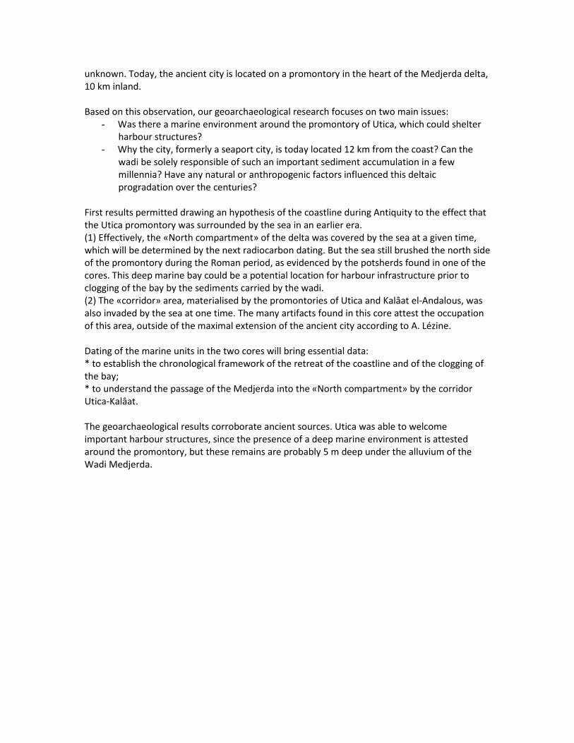
Narbonne) 10.00-10.20: Modelling: F. Salomon (Southampton), S. Keay (Southampton) and J.P. Goiran (CNRS, MOM) Understanding the potential of ancient harbour basins for shipping: the Palaeo-Environmental Age-Depth Model (PADM chart). The PortusLimen Project includes geoarchaeological fieldwork on several Roman harbours across the Mediterranean Sea. The aim is to reconstruct the potential of these ancient basins for shipping: what was their degree of closure? What was their degree of artificialisation? What was the water column available? Their reconstruction attempts to take into account the palaeogeography, the archaeological structures related to the harbour (moles, quays, etc.), the ancient sea level, and the draught of the ships. Part of the difficulty comes from the integrated visualisation of all these elements across time. In the light of these observations, we propose a different approach using a new interpretative diachronic chart called a “Palaeoenvironmental Age-Depth Model” (or “PADM” chart).
Fig: Navigability of the Canale Traverso at Portus using the data from Core CT-1
Ferréol SALOMON1, Simon KEAY1, Nicolas CARAYON1, Jean-Philippe GOIRAN2 1Department of Archaeology, Faculty of Humanities, University of Southampton, Avenue Campus, Southampton SO17 1BF, Great Britain - + 44(0)2380 59 7428 - [email protected], [email protected], [email protected] 2 Centre National de la Recherche Scientifique (CNRS), UMR 5133-Archéorient, MOM, 7 rue Raulin, 69007 Lyon, France - +33(0)4 72 71 58 44 - [email protected] 4. Invited Papers from Other Projects 11.00-11.20: S. Fontaine (French Ministry of Culture), C. Rousse (Aix-Marseille, Centre Camille Jullian), M. El-Amouri (Ipso Facto) and F. Marty (PIPC- Ouest Provence) Introduction to the Fossae Marianae Project In the Gulf of Fos, in the south coast of France lie the impressive submerged remains of a harbour system dating to the Late Roman Republican and the Roman Imperial period. The harbour complex is situated in the extremity of the presumed river channel dug by the troops of Marius to bypass the dangerous mouth of the Rhone. Mentioned as Fossis Marianis on the map of Peutinger, this major harbour complex has been for centuries one of the main harbours of north-western Mediterranean, ideally located as access point to the Rhone Valley. If the wealth, abundance and concentration of archaeological remains, leave little doubt to the importance and the density of the port's activity during the Early Empire, the layout of Fossae Marianae, the topography of the harbour sector and the ancient settlement, the dating and the functionality of the facilities are still not well defined. Paradoxically, the harbour sector is very little studied given its archaeological and historical importance and its potential in comparative studies of contemporary large-scale harbour systems. The underwater archaeological excavations, as well as the marine geophysical prospections undertaken since 2012 have revealed extensive facilities preserved in situ. The entire Gulf of Fos and the Fossae Mariannae will be studied in the next year in the framework of a large-scale

Research Project, conducted by a multidisciplinary team, with the main objective of interconnected studies between the harbour sector, the coastal settlements and the Marius Channel.
Fig: Ostia Fluminis Rhodani and Fossis Marianis (Tabula Peutingeriana, segment III. ONB Bildarchiv,
Wien, Cod. 324) Souen FONTAINE (French Ministry of Culture, Department of Underwater Archaeological Research): [email protected] Corinne ROUSSE (Aix-Marseille University, Centre Camille Jullian) : [email protected] Mourad EL-AMOURI (Ipso FACTO): [email protected] Frédéric MARTY (PIPC Ouest-Provence): [email protected] 4. Invited Papers from Other Projects: 11.20-11.40: D. Malfitana (CNR) & M.L. Scrofani (CNR) Introduction to the OpenSiracusa Project. A WebGIS for the Preservation and Enhancement of the Cultural Heritage. The Institute for Archaeological Heritage of the National Research Council (IBAM-CNR) has been using its multidisciplinary capabilities and competences in the field, both in Italy and abroad, for over ten years. The Catania branch, is involved in a series of innovative projects aimed at investigating and increasing knowledge of several urban contexts that are of particular

significance from a historical and archaeological point of view. Important projects have been created with this in mind, including the OPENCiTy project, the first WebGIS platform in Sicily, which aims to link urban archaeology, the management, and use of the extraordinary archaeological heritage of Catania, a city so rich in history. It is against this background that the OpenSiracua project was created, the subject of a doctoral thesis undertaken within the course on Information and Communication Technologies at Palermo University and as part of IBAM-CNR’s activities. This research was born out of the need to bring together all knowledge acquired thus far about a multi-layered city such as Syracuse, which has seen continuous occupation from remotest times until the present day. A condition which, when associated with specific problems makes the question of the relationship between past and present, between the need to safeguard and enhance the cultural heritage and the necessities of a modern city, most topical and urgent. Such problems include the high concentration of archaeological deposits often within a depth of a few centimetres, the radical transformations in the city’s landscape, both in its geology and its urban development, and the notable fragmentation of archaeological knowledge, often the result of random investigations. This research proposal for the creation and publication of a WebGIS platform dedicated to the cultural and archaeological heritage of Syracuse was created as a response to such problems. The OpenSiracusa platform, based on a purposely-designed GIS structure and a relational database, will have the capacity to archive, manage, analyse, and share an extremely uniform database, containing both archaeological and other types of information (e.g. regarding geology, aerial photogrammetry, land registry etc.). Therefore, it primarily takes shape as a powerful tool in the specialist field of research, thanks to the possibility of benefiting from a large system of datasets encompassing the entire history of the research and archaeological heritage of Syracuse and the possibility of carrying out analyses that can be integrated with multiple and different data available within it. In fact, thanks to a queries system and the possibility of incorporating information from other disciplines, the platform will make it possible to extrapolate all types of data from the point of view of chronology, function etc. In addition, it will enable research to be directed towards new fields of investigation as well as reconsidering problems that still remain unsolved under a new light various, for example the identification of the ancient harbours of Syracuse. Furthermore, the project will guarantee a real development of the governance system in the management of cultural heritage. Indeed, it is hoped that putting the platform on line and its interoperability will provide a valid contribution to a profitable dialogue between the various bodies in charge of safeguarding and management, facilitating concerted and sustainable urban planning. The entire project embraces the Open philosophy, from the choice of software to the management and divulgation of the data contained within it. Daniele Malfitana, Maria Luisa Scrofani

4. Invited Papers from Other Projects: 11.40-12.00: M.F. Pipere (Roma La Sapienza) Elaiussa Sebaste: note sulla topografia portuale e marittimo-costiero di una città della Cilicia The paper is aimed at illustrating some preliminary results yielded by the ongoing research at the coastal site of Elaiussa Sebaste (present-day Ayaş-Mersin, Turkey) in ancient Rough Cilicia, with its two prominent harbours. The ancient city shows a lively continuity from the late Hellenistic through the early Byzantine periods. The Italian Archaeological Mission at Elaiussa Sebaste has been operating on the site since 1995, and research whas been undertaken underwater and on land at the site since 2012. The groundbreaking approach to the coastal and maritime topography focusses on understanding the influences and the impulses of different natures which affected the settlement, transformation, development and decline of the site. Elaiussa Sebaste, the prominent city of Roman Rough Cilicia, played an important role in the whole region “connecting East with the West” thanks to its geographic location. Later the city was an episcopal seat in the early Byzantine period, becoming an important amphora production centre along the pilgrim route to Jerusalem through Tarsus and other martyrial sites. The oldest nucleus of Elaiussa Sebaste was built on a broad rocky promontory - this is what ancient authors called “the Island of Elaiussa”, but geological investigations revealed it was connected to the mainland by a narrow isthmus overlooking the city's two ports in historical times. The northern harbour was the wider one, protected by the promontory from the dominant winds but still exposed to the prevailing marine currents of the area; the southern one was smaller and exposed to the prevailing winds. Both harbours are now almost totally silted, and partly covered by modern facilities. The natural maritime and port vocation of the city is well attested as early as the Late Hellenistic period, and it found full definition during the Augustan age, flourishing after Vespasian's definitive annexation of Cilicia to the Empire down to the mid-VII century AD, when the gradual abandonment of the city started. The necessarily interdisciplinary approach to such a complexity ranges from the analysis of ancient written sources and archaeological evidence, together with the evaluation of geomorphology, paleohydrography, meteo-maritime elements, cartography and portolan-charts, and lastly, also the localization and the study of underwater deposits, shipwrecks and related cargoes. The final purpose of the project is the reconstruction of the pattern of organization, extension and complexity of sea routes and trades that Elaiussa Sebaste and the whole region were involved in the Late Hellenistic through the Early Byzantine periods. The research is aimed at a thorough comprehension of the environmental, functional, topographic, technological and connective complexity which is implied in any coastal or harbour site. With the final results of this study it will be possible to outline the natural, historical, social, cultural, logistic, commercial or military transformations that affected the coastal and maritime topography of the site through the centuries.

Fig: Elaiussa Sebaste: city localization and 3D view of the site's orthophoto (D'Amelio et alii
2009) Maria Francesca Pipere Sapienza-Università di Roma [email protected] 4. Invited Papers from Other Projects: Naples: 12.00-12.40: V. Carsana (Assistant to Soprintendenza Archeologia della Campania), M. Di Vito (INGV), D. Giampaola (Soprintendenza Archeologia della Campania), V. Liuzza (Naples), C. Morhange (Aix-Marseille), P. Romano (Naples), and M. Ruello (Naples), The excavation of the ancient harbour of Naples: archaeology and geomorphology (piazza Municipio 2004-2015). The archaeological investigations performed in 2004 for the Line 1 underground construction in Naples allowed the real position of the old city harbour to be located in Piazza Municipio, in the south west sector of a bay which extended north up to Piazza G. Bovio. The results of these investigations were presented in preliminary archaeological and geomorphological scientific contributions between 2004 and 2011. These data have since been significantly updated thanks to the excavation activities, still currently underway, over a huge area that extends beyond Line 1, Line 6 and the connection tunnel between the stations and the present harbour (about 12,000sqm). The integration between the stratigraphic investigations and the geoarchaeological probing campaigns allowed the collection of important information about the geomorphology of the harbour inlet, its topography and its building organization.

The area of Piazza Municipio most probably coincides with the early settlement’s port of Parthenope (beginning of 7th century B.C.) and the archaic and classic Neapolis port, “the new city” founded between the end of 6th century and beginning the of 5th century B.C. The discovery of an extended sea bottom dredging operation, dated between the 3rd and 2nd century B.C., provided documentary evidence of a refunctionalization of the Hellenistic-Roman port basin. The port remained active during the entire Roman Imperial age until the beginning of 5th century A.D. Due to the formation of a lagoon environment and because it was progressively silted up, the port was moved eastwards. The old shoreline shape with its transformations and different submerged and exposed layers has been revealed thanks to paleo environmental examinations reconstructing the elevation profile of the Neapolitan yellow tuff and by performing paleo ecological and sedimentological analysis. The discovery of an erosional line characterized by the presence of oysters on a dock and on an Augustan age quay clarified the sea level between the 1st and 5th century A.D. The present investigations are revealing Hellenistic structures made with tuff blocks for terracing purposes and a ramp probably for mooring purposes. The completion of the excavation activities could provide more information about the related sea level and the confirmation of the coastline in this period. The newly found Augustan age harbour infrastructures consist of a quay in the internal inlet zone and a system of docks to protect the entrance of the port basin. The usage of the coastal area overlooking the port pool is also important: during the Augustan age, this was characterized by a route, probably the via per cryptam from Neapolis to the Phlegraean Fields, and by thermal bath buildings, built in the 1st century A.D. and in the second half of the 2nd century A.D. After the 5th century A.D., when the harbour silted up, these buildings were abandoned or used for different purposes. In addition, the excavation of the sea bed strata performed in 2004 and 2015 allowed the recovery of seven shipwrecks dated 2nd century B.C., end of 1st century A.D. and end of 2nd century A.D.

Fig: Naples. Line 6 underground. Municipio station. Augustan age quay
Vittoria Carsana1, Mauro Di Vito2, Daniela Giampaola3, Viviana Liuzza4, Christophe Morhange5, Paola Romano4, Maria Ruello4, 1 Assistant of the Superintendence Archaeology Campania 2 National Institute of Geophisics and Volcanology, Naples 3 Superintendence Archaeology Campania 4 Department of Earth Sciences, Federico II University of Naples 5 Aix-Marseille University, France 5. Reports by Project Partners (ii) Kane: 14.00-14.20: E. Laufer and F. Pirson (German Archaeological Institute, DAI) Archaeological Survey around the Kane Peninsula (2014 and 2015) The mountainous Kane Peninsula is situated ca. 30 km west of Pergamum, opposite the island of Lesbos. It has a rocky coastline with few small peninsulas and sandy beaches suitable for cabotage in ancient times. Its two major ports well known by ancient sources are Kane/Kanai (at the northwestern corner of the peninsula, near today’s Bademli) and Pitane (south coast, modern Çandarlı). Both cities have been explored in 2014-2015 by an interdisciplinary team of archaeologists, geophysicists and geoarchaeologists, under the auspices of the German Archaeological Institute department Istanbul/Pergamum Excavation.

The archaeological data from Kane indicate a small polis flourishing in the Greek period, with its peak in late classical to Hellenistic times. In this era, the city could probably benefit from its connection to the regional maritime routes of traffic, the neighbourhood of the capital of the Attalid kingdom and its well-protected harbours. Its role as a naval base of major fleets is attested by the written sources for 406 and 190 B.C. The decline of the city during the Roman imperial period is surprising but might correspond to drastic alterations in the settlement pattern known from other sites in the hinterland. The architectural remains of housing areas, a city wall, breakwaters and other building structures once flanking the city’s seasides extend from the modern beaches into the shallow water of the two harbour bays. The coastal zone of ancient Pitane is unfortunately largely covered by the modern city and today’s sea level, but its role as an important commercial harbor during the Roman imperial Period is indicated by the extensive pottery production of the so-called Çandarlı-Ware (Eastern Sigillata C). The main aim of the Kane Survey Project is the attempt to analyse a local network of cabotage beyond these seaports. Therefore, minor sites along the coast of the Kane Peninsula have been studied as well. Situated directly on the beach (ca. 5km south of the city of Kane), the architectural remains of two Roman bath buildings using hot springs have been documented; thermal bathing is a phenomenon well-attested for the Pergamene region in the Roman period. The second example is an impressive building complex on the island of Mardalıç Adası dating from the Roman imperial period as well. It has been interpreted convincingly by A. Hoffmann in 1993 as a villa marittima, which should be attributed to a high-ranking person of the province’s elite.
Fig: The site of ancient Kane (DAI, Pergamum Excavation 2015)

Kane: 14.20-14.40: S. Hay (Southampton/BSR) Geophysics at Kane (2014 and 2015) and Pitane (2015) Kane and Pitane lie on promontories edging out into the Aegean Sea. At both sites, the Hellenstic and Roman harbours were impeded by the poor infrastructure connecting them to inland settlements. The geophysics surveys sought to understand how these intriguing ports functioned and reveal the nature of their layout. The results of the two seasons of geophysical survey work will be presented and will show how the fragmentary traces of buried remains can help us understand the towns and cemeteries associated with these ports.
Fig. View towards the site of the harbour of ancient Kane.
Kane: 14.40-15.00: A. Fediuk, D. Wilken, T. Wunderlich and W. Rabbel (Kiel) Marine Geophysics along the Kane Peninsula. The ancient harbour settlement Kane is located on the Kane peninsula, modern Karadaǧ peninsula. It is situated in western Anatolia, 40km west of ancient Pergamum. The archaeological site is located on a promontory which is 400m long, 150m wide and up to 20m
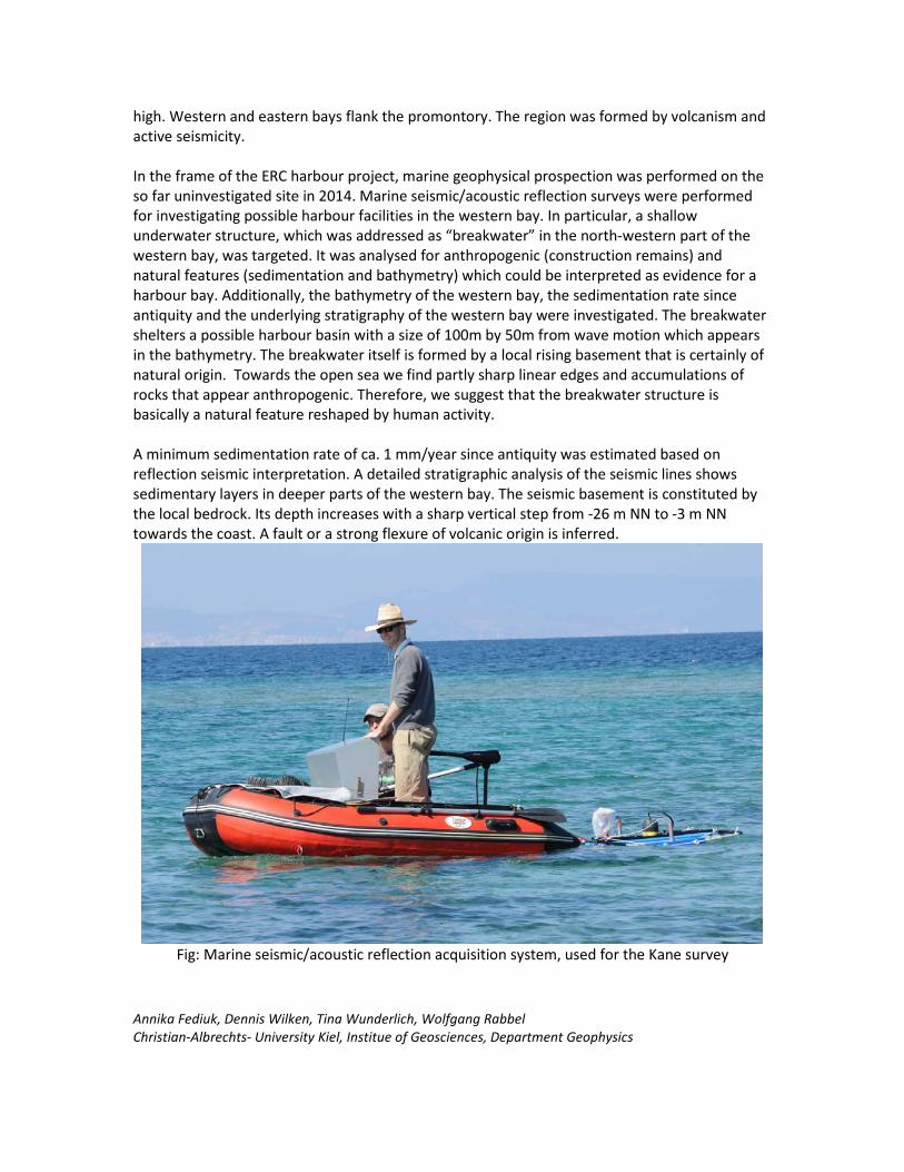
high. Western and eastern bays flank the promontory. The region was formed by volcanism and active seismicity. In the frame of the ERC harbour project, marine geophysical prospection was performed on the so far uninvestigated site in 2014. Marine seismic/acoustic reflection surveys were performed for investigating possible harbour facilities in the western bay. In particular, a shallow underwater structure, which was addressed as “breakwater” in the north-western part of the western bay, was targeted. It was analysed for anthropogenic (construction remains) and natural features (sedimentation and bathymetry) which could be interpreted as evidence for a harbour bay. Additionally, the bathymetry of the western bay, the sedimentation rate since antiquity and the underlying stratigraphy of the western bay were investigated. The breakwater shelters a possible harbour basin with a size of 100m by 50m from wave motion which appears in the bathymetry. The breakwater itself is formed by a local rising basement that is certainly of natural origin. Towards the open sea we find partly sharp linear edges and accumulations of rocks that appear anthropogenic. Therefore, we suggest that the breakwater structure is basically a natural feature reshaped by human activity. A minimum sedimentation rate of ca. 1 mm/year since antiquity was estimated based on reflection seismic interpretation. A detailed stratigraphic analysis of the seismic lines shows sedimentary layers in deeper parts of the western bay. The seismic basement is constituted by the local bedrock. Its depth increases with a sharp vertical step from -26 m NN to -3 m NN towards the coast. A fault or a strong flexure of volcanic origin is inferred.
Fig: Marine seismic/acoustic reflection acquisition system, used for the Kane survey
Annika Fediuk, Dennis Wilken, Tina Wunderlich, Wolfgang Rabbel Christian-Albrechts- University Kiel, Institue of Geosciences, Department Geophysics
Kane: 15.00-15.20: M. Seeliger and H. Brückner (Cologne) First Results from the Geoarchaeological research of Kane Peninsula. Under the umbrella of the ROMP project, geoarchaeological research was carried out on Kane Peninsula in September 2015. The fieldwork focussed on the surroundings of the ancient city of Kane near the modern village of Bademli, including flights with an UAV (unmanned aerial vehicle) and sediment coring. This was later supplemented by various laboratory analyses. During antiquity, literary sources mention three islands off the modern Dikili peninsula. The so-called Arginusae were the site of the naval battle in 406 BC, when an Athenian fleet defeated a Spartan fleet. Many centuries later, the famous map of the Ottoman admiral Piri Reis from AD 1513 shows only two islands, the modern Garip islands. Using evidence from sediment cores, we rediscovered the “lost” third island, which is where the ruins of the ancient city of Kane are located. This former island had been transformed into a peninsula due to coastal dynamics and siltation processes. The discovery made the headline news of various media organisations. Ongoing laboratory analyses will provide insights for the water depths of the channel that once separated the third Arginus island from the mainland, and 14C and OSL dating will provide a chronological framework for the transformation process. Studies of microfauna will help to decipher the changes in the milieu of deposition. In the context of our research on Pergamum’s harbour city Elaia, which is situated to the south of Kane peninsula, a pollen chart has been developed – one of only a few for NW Turkey. To correlate these results with other locations, a drill core has been collected from the shore of the crater lake of Kane Mountain (Kara Göl). This sediment column is presently being investigated for the preservation of pollen. To generate high-resolution aerial photographs, UAV flights were performed in the area of the channel and the city hill of Kane. The digital terrain model will allow for the creation of ancient landscape scenarios.

Fig: (a) The wider Bergama region with Dikili peninsula. The research area sensu stricto of Kane peninsula near Bademli is highlighted. Kara Göl is a crater lake of the volcanic Karadağ Mountains. Elaia was the harbour city of ancient Pergamum. (b) The shore of Kane. The ruins of the ancient city are on the hill. The beach deposits consist of construction debris, pebble, and rolled fragments of ceramics and bricks. (c) Orthophoto of the area of Kane as seen from an octocopter flight. In the water, some of the harbour installations are visible. Sources (a) Landsat 8, 2014, composite image based on bands 4, 3, 1; (b) Helmut Brückner, 17 Sep 2015; (c) Andreas Bolten, Aug 2015.
Martin Seeliger & Helmut Brückner Institute of Geography, University of Cologne, Albertus-Magnus-Platz, 50923 Cologne/Germany

6. Related Papers: 15.40-16.00: B. Millet (MIO) Modelling Hydro-dynamism in Ancient Mediterranean Harbour Basins: the Examples of Alexandria and Portus. The prevention of sediment deposition in harbour basins was certainly a major challenge for engineers in Antiquity. We used a 2D numerical model to compute the distribution of the depth-averaged current velocity, bed shear-stress, and kinetic energy induced within the ancient harbors by the prevailing local winds, considered unchanged from the Antiquity. Our results suggest that ancient societies might have designed harbor structures intended to prevent the navigation zones and the landing areas from rapid sediment infilling.
A first question: how did the Heptastadion impact the water circulation and sediment re-suspension within the ancient harbors of Alexandria ?
Model results (Millet and Goiran, 2007) suggest considering the western harbor of Alexandria as a basin featuring active erosion processes induced by the dominant NW 315°-8 m.s-1 wind, both without and in the presence of the Heptastadion, with a high level of bed shear-stress (2.67 and 2.93 N.m−2, respectively) and high cumulated sediment re-suspension rates (1.5 and 1.07 kg.s−1, respectively). Thus, we suggest considering the western harbor, before the construction of the Heptastadion, as a major source of eroded sediment for the eastern harbor, flowing eastward with a water flux of 306 m3.s−1 between both harbors. Inversely, model results suggest the eastern harbor of Alexandria, after the construction of the Heptastadion, was a basin featuring a sediment budget relatively equilibrated considering: 1) no more inflow of sand particles from the western harbor; 2) a presumed mass balance between the offshore sediment import through Diamond pass and export through Silsiley pass; 3) the disappearance of the sandy sediment resuspension caused by the drastic decreasing of both the bed shear-stress (from 5.27 to 2.64 N.m−2) and the cumulated re-suspension rate (from 1.83 to 0.028 kg.s−1). Therefore, we suggest that the Heptastadion was not only a link structure to reach the Pharos island, but a structure liable to reduce the sandy sediment dynamics in the eastern harbour, and to prevent the landing structures of the eastern harbour of Alexandria from becoming inaccessible due to sediment infilling by the allochthonous sand drift. A second question: how did the north-eastern channel impact the water circulation and sediment re-suspension within Portus during the Trajanic period ?
Firstly, model results (Millet et al., 2014) demonstrate that the wind-induced circulation patterns within the one-channel harbor configuration present, under all the local wind situations considered (SE 135°, S 180°, SW 247° and NE 22°), eddy currents associated with low kinetic energy values that promote sediment deposition, especially in the western harbor basin. Secondly, results confirm the weak hydrodynamics and persistent conditions for sediment infilling over the entire western harbor basin, even when the north-eastern channel is operating; these conditions being present for 61.3% (40.3%) of the summer period and up to 68% (44.2%) of the

winter period in the southwestern (northwestern) harbor basin. Thirdly, the results show that favorable conditions for navigation occur throughout the central and the north-eastern harbor basins, leading to the landing installations, under the S 180°, SE 135°, and NE 22° winds only when the north-eastern channel is operating; these conditions being present for 21% of the summer period and up to 51.3% of the winter period. Therefore, we suggest that the harbor of Portus did not operate for a long period only using the western channel, but benefited from the opening of the north-eastern channel to ensure the maintenance of good conditions for navigation. A recent question: how do the waves and harbor structures interact in Portus ? We have recently adapted the well known Ref/Dif software to Portus during the Trajanic period (two-channels configuration) in order to compute the characteristics of the swell propagating inside the domain and interacting with the harbor structures. Results (still unpublished) clearly demonstrate the judicious design of the central pier of the harbor, able to protect the inner landing installations from the swell. Actually, results emphasized that the extremity of the pier exactly fits with the northern limit of the zone featured by the highest heights of the NW 247° most frequent swell. All these results might encourage new collaborations to develop further numerical experiments in other ancient sites!
Fig: Synthetic representation of the computed water circulation within Portus during the
Trajanic period with both western and north-eastern channels operating under the NE 22° winter wind.

References Millet, B., and J.P. Goiran. 2007. Impacts of Alexandria’s Heptastadion on coastal hydro-sedimentary dynamics during the Hellenistic period: A numerical modelling approach. The International Journal of Nautical Archaeology 36, 1: 167–176. doi: 10.1111/j.1095-9270.2006.00131.x Millet, B., H. Tronchère, and J.P. Goiran. 2014. Hydrodynamic modelling of the Roman Harbor of Portus in the Tiber delta: The Impact of the North-Eastern Channel on Current and Sediment Dynamics. Geoarchaeology, 29, 5: 357-370. doi:10.1002/gea.21485. Bertrand Millet, Mediterranean Institute of Oceanography, Aix-Marseille University [email protected] Geo-archaeological Perspectives and Challenges: 16.00-16.20: H. Brückner (Cologne) Challenges and Perspectives for Geoarchaeology – Experience from the Eastern Mediterranean By definition, geo-archaeology is the interdisciplinary science that integrates both natural sciences (geology, geophysics, physical geography, etc.) and the humanities (archaeology, historical sciences). There is, thus, the principal challenge of bringing together disciplines with very different research tools, strategies, and cultures. The eastern Mediterranean is ideal for this kind of research since it has a very long-lasting record of human –environment interaction. It is a challenge to unravel this story with the highest possible resolution. While historical records, diagnostic ceramics, and coins may narrow the time window to a decadal slot, 14C ages (at the 2 sigma confidence interval) are less precise. Potential pitfalls can be, e.g., age inversions, dating of reworked material, and misestimation of the palaeo-reservoir effect. In some cases the problem of 14C-plateaus may be alleviated by a cross-check with the application of luminescence dating techniques.
Harbours are excellent geo-bio-archives, often telling the city’s story in a sedimentary mode. A new approach is to link their pollution (faeces, heavy metals, PAHs) to sewage, industry, trade and sea-faring. They also have the potential of preserving the pollen record. However, a major constraint is stratigraphic gaps due to dredging activities.
For the past couple of years we have focussed our attention on the impact of natural risks on societies and settlements. This holds especially true for extreme wave events, i.e., tsunamis (“harbour wave”) and severe storms. There is an ongoing debate on how to detect and differentiate their footprints in a sedimentary record. Tsunamites and tempestites can, e.g., be evidenced in the Theodosian Harbour at Yenikapı, Istanbul, of the early Byzantine Period.
Changes in sea level, e.g., due to glacio-eustasy, tectonics, and sedimentation, have always been of high importance for the rise and fall of harbour cities. It is a challenge to deduce them from good sea-level indicators and produce reliable sea-level curves, esp. when faced with sediment compaction and earthquake displacement.
The synthesis of all efforts is the visualisation of landscape and settlement evolution in highly resolved spatio-temporal 3D scenarios. Ultimately, geoarchaeological research may considerably improve, the very much needed, predictive modelling (archaeoprognosis).

The lecture will give an overview of the human-environment interactions in harbour cities of Western Turkey (Miletus, Elaia, Troy, Ainos), with an in-depth study on the Lion harbour of Miletus (Brückner et al. 2014).
Fig. Miletos in Hellenistic-Roman times, and position of the shoreline in three time slices: 2500 BC (maximum marine transgression), Archaic times, and Roman Imperial times. Around
2500 BC, the Milesian Archipelago consisted of several islands. The position of the four harbours mentioned by Strabo in the first half of the 1st cent. AD is indicated. The Lion
Harbour was the most prominent one.

Reference:
Brückner, H., Herda, A., Müllenhoff, M., Rabbel, W., Stümpel, H., 2014. On the Lion Harbour and other harbours in Miletos: recent historical, archaeological, sedimentological, and geophysical research. Proceedings of the Danish Institute at Athens, vol. VII: 49-103. Aarhus.
Helmut Brückner Institute of Geography, University of Cologne, Zülpicher Str. 45, Cologne (Köln), Germany Geo-archaeological Perspectives and Challenges: 16.20-16.40: H. Delile (CNRS/MOM Lyon) Lead palaeo-pollution trapped in the sedimentary archives of the ancient harbour basin of Naples
Since the discovery of the ancient harbour of Naples in 2004, geoarchaeological studies undertaken on the archaeological excavations have revealed the main stratigraphic and palaeo-environmental levels of the harbour site near the Piazza Municipio. Subsequently in 2011, a partnership between the Soprintendenza Speciale per i Beni Archeologici di Napoli e Pompei and the geographers / geochemists of the University of Lyon was set up to study the geochemical signal of the lead palaeo-pollution (lead concentrations and isotopes) trapped in the deposits of the ancient harbor basin of Naples. To do this, high-resolution sampling of the harbor stratigraphic sections was carried out between 2011 and 2013 on the harbor deposits well dated by archeological materials.
The comparison of the geochemical signals of the harbor sediments with those of the travertine deposits (or calcareous sinters) taken in the Aqua Augusta aqueduct revealed that the local water distribution system of the Bay of Naples was a source of lead contamination of the water, as was also the case in Rome. In addition, our analyses show that the great eruption of Somma-Vesuvius in AD79 necessitated swift and widespread repairs to the water supply networks of the Bay of Naples at the end of the 1st c. AD, since two distinct Pb isotopic compositions are recorded in the harbor sediments after and before this natural disaster.
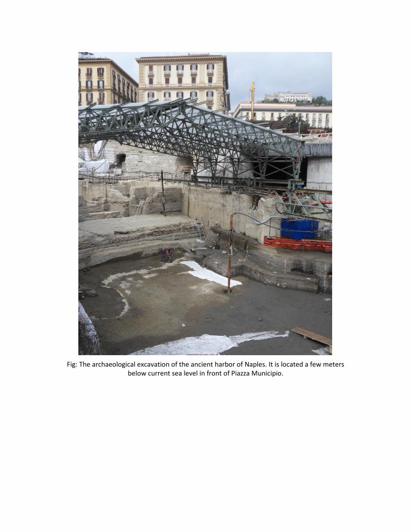
Fig: The archaeological excavation of the ancient harbor of Naples. It is located a few meters
below current sea level in front of Piazza Municipio.