ports and waterways safety assessment workshop report
TRANSCRIPT

PAWSA Workshop Report for Passamaquoddy Bay, ME 3-4 October 2006
Ports and Waterways Safety Assessment Workshop Report
Passamaquoddy Bay, ME Introduction
Risk identification and mitigation are and have been ongoing activities within the Passamaquoddy Bay area. As a step toward standardizing methodology, a formal Ports and Waterways Safety Assessment (PAWSA) for Passamaquoddy Bay was conducted in Bangor, ME, on 3-4 October 2006. A group of experts examined the waterway using the risk model pictured here.
The results of that workshop are provided in this report and include the following information:
• Geographical Area
• Numerical results for the factors above from the following activities: − Team Expertise − Risk Factor Rating Scales − Absolute Risk Levels − Present Risk Levels − Intervention Effectiveness
• Brief description of the process used for the assessment
• List of participants
• Planned Actions: Summary of risks and mitigations discussion
• Survey results presented in tabular form
1

Report Documentation Page Form ApprovedOMB No. 0704-0188
Public reporting burden for the collection of information is estimated to average 1 hour per response, including the time for reviewing instructions, searching existing data sources, gathering andmaintaining the data needed, and completing and reviewing the collection of information. Send comments regarding this burden estimate or any other aspect of this collection of information,including suggestions for reducing this burden, to Washington Headquarters Services, Directorate for Information Operations and Reports, 1215 Jefferson Davis Highway, Suite 1204, ArlingtonVA 22202-4302. Respondents should be aware that notwithstanding any other provision of law, no person shall be subject to a penalty for failing to comply with a collection of information if itdoes not display a currently valid OMB control number.
1. REPORT DATE OCT 2006 2. REPORT TYPE
3. DATES COVERED 00-00-2006 to 00-00-2006
4. TITLE AND SUBTITLE Ports and Waterways Safety Assessment Workshop Report forPassamaquoddy Bay, ME
5a. CONTRACT NUMBER
5b. GRANT NUMBER
5c. PROGRAM ELEMENT NUMBER
6. AUTHOR(S) 5d. PROJECT NUMBER
5e. TASK NUMBER
5f. WORK UNIT NUMBER
7. PERFORMING ORGANIZATION NAME(S) AND ADDRESS(ES) U.S. Coast Guard Academy ,31 Mohegan Avenue ,New London ,CT,06320-8103
8. PERFORMING ORGANIZATIONREPORT NUMBER
9. SPONSORING/MONITORING AGENCY NAME(S) AND ADDRESS(ES) 10. SPONSOR/MONITOR’S ACRONYM(S)
11. SPONSOR/MONITOR’S REPORT NUMBER(S)
12. DISTRIBUTION/AVAILABILITY STATEMENT Approved for public release; distribution unlimited
13. SUPPLEMENTARY NOTES
14. ABSTRACT
15. SUBJECT TERMS
16. SECURITY CLASSIFICATION OF: 17. LIMITATION OF ABSTRACT Same as
Report (SAR)
18. NUMBEROF PAGES
37
19a. NAME OFRESPONSIBLE PERSON
a. REPORT unclassified
b. ABSTRACT unclassified
c. THIS PAGE unclassified
Standard Form 298 (Rev. 8-98) Prescribed by ANSI Std Z39-18

PAWSA Workshop Report for Passamaquoddy Bay, ME 3-4 October 2006
Geographic Area:
The participants defined the geographic bounds of the waterway area to be discussed. The transit route from sea to Eastport consists of passage through the Bay of Fundy to Head Harbor Passage and Friar Roads. Vessels calling on Bayside continue past Friar Roads and then traverse Western Passage towards Passamaquoddy Bay.
Numerical Results
Book 1 – Team Expertise
In Book 1, the participants were asked to assess their level of expertise compared to the other participants in the workshop for each of the six categories in the Waterway Risk Model. Overall, 41% of the participant teams placed themselves in the upper third, 34% in the middle third, and 25% in the lower third of all teams. This distribution is fairly typical because the participants were chosen for their acknowledged expertise.
Book 2 – Risk Factor Rating Scales
The purpose of Book 2 is to produce the risk scale numbers that are used in Book 3. Participants calibrated intermediate points on the risk assessment scale for each risk factor. On average, participants from this waterway calculated the intermediate risk points as 2.9 and 5.4, which are close to the national values (2.9 and 5.5) established by the prior PAWSA workshop participants from around the country.
A tabular display of the results of Book 2 is found at the end of this report.
Book 3 – Absolute Risk Levels with no mitigations
The participants evaluated the absolute risk level in the waterway by selecting a qualitative descriptor for each risk factor that best described conditions in the Passamaquoddy Bay area. Those qualitative descriptors were converted to numerical values using the scales from the Book 2 results. On those scales,
1.0 represents low risk (best case) and 9.0 represents high risk (worst case), with 5.0 being the mid-risk value.
In the Passamaquoddy Bay area, 9 of the 24 risk factors were scored at or above the mid-risk value. They were (in descending order):
Risk Category Score Risk Category Score Visibility Restrictions 7.9 Configuration 7.7 Environmental 7.5 Aquatic Resources 7.5 Small Craft Quality 6.9 Commercial Fishing Vessel
Quality 6.4
Water Movement 6.4 Economic 5.9
2

PAWSA Workshop Report for Passamaquoddy Bay, ME 3-4 October 2006
Hazardous Materials Release
5.3
Specific hazardous locations identified. :
Only one location was identified as hazardous. It was the southern tip of Deer Island where the turn up north exceeds 45 degrees.
Book 4 – Present Risk Levels after applying existing mitigations The participants examined all risk factors including those associated with the inclusion of LNG ships calling at proposed to be constructed LNG terminals and the effects of existing mitigations on those risks involving the construction of LNG facilities and movement of LNG ships in waterway. For 1 risk factor, the participants were in consensus that the risk was well balanced by existing mitigations. Consensus is defined as 2/3 of the participant teams being in agreement. For 21 risk factors, the participants were in consensus that new risks were NOT adequately balanced by existing mitigations. For the other 2 risk factors, there was not good consensus on whether existing mitigations adequately reduced risk. Book 5 – Intervention Effectiveness The participants selected those interventions that would be most effective in providing the largest risk improvement. For 5 of the 21 risk factors needing additional risk reduction action, the most selected intervention category had the largest risk improvement.
Risk Category Selected Intervention Category Specific Actions
Vessel Conditions Active Traffic Mgmt • Provide regulations that rule vessel movement (includes VTS, designated traffic lanes, and radar requirements)
• Require radar, AIS and VTS • Improve radio coverage • Have design in place to make the vessel safe • Conduct updated WAMS • Conduct inspections (U.S. and Canada) • Provide better communications (AIS, radio repeaters) • Provide designated traffic lanes • Provide VTS and AIS
Traffic Conditions Active Traffic Mgmt • Specify traffic lanes. Develop non meeting traffic situations.
• Require designated one way traffic zones. • Provide designated holding zones • Provide VTS with enhanced radar coverage
3
PAWSA Workshop Report for Passamaquoddy Bay, ME 3-4 October 2006
• Enhance radar and communications capabilities • Improve/upgrade ATON. Provide NDBC buoy
Waterway Conditions Active Traffic Mgmt • One way traffic zones. Establish designated no passing zones.
• Conduct a WAMS. Stovers Ledge, Clarks Ledge • Provide Tugs • Provide updated hydrographic survey
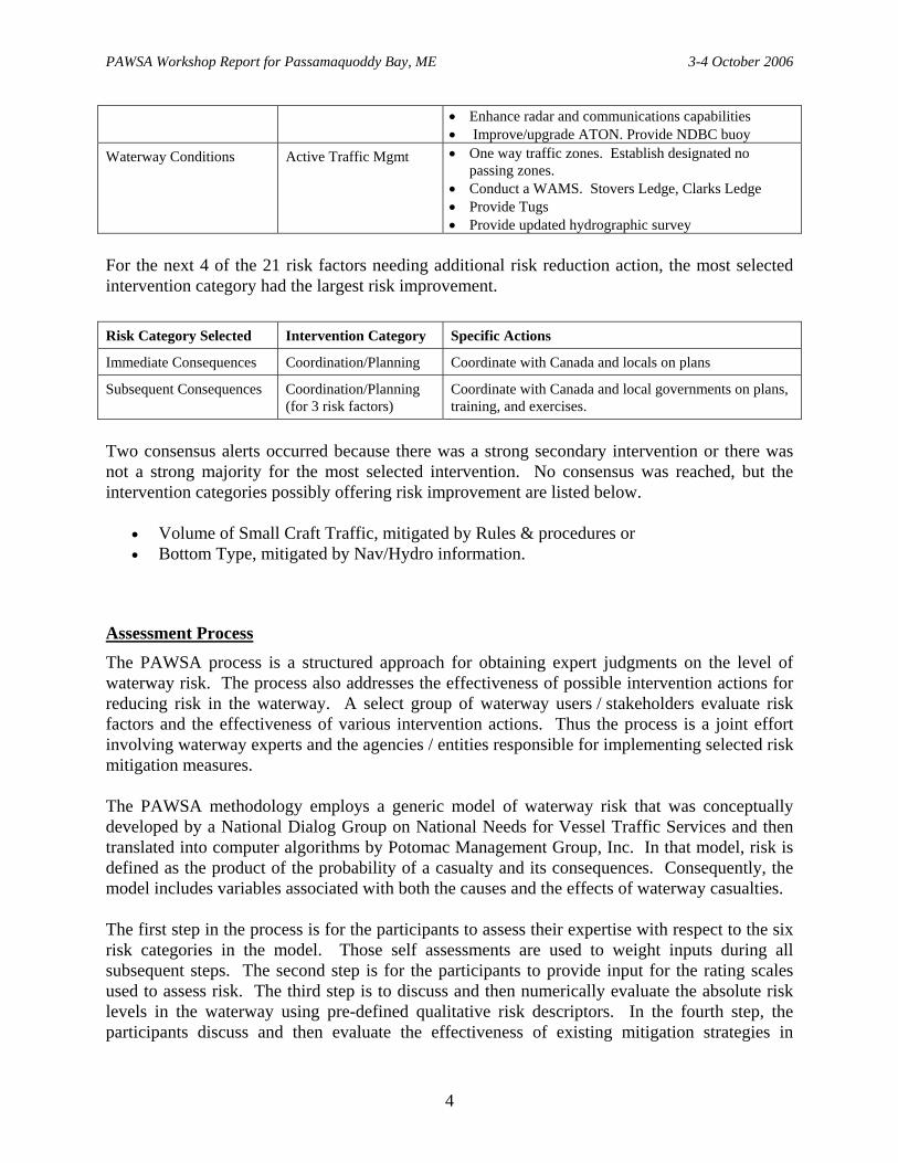
For the next 4 of the 21 risk factors needing additional risk reduction action, the most selected intervention category had the largest risk improvement.
Risk Category Selected Intervention Category Specific Actions
Immediate Consequences Coordination/Planning Coordinate with Canada and locals on plans
Subsequent Consequences Coordination/Planning (for 3 risk factors)
Coordinate with Canada and local governments on plans, training, and exercises.
Two consensus alerts occurred because there was a strong secondary intervention or there was not a strong majority for the most selected intervention. No consensus was reached, but the intervention categories possibly offering risk improvement are listed below.
• Volume of Small Craft Traffic, mitigated by Rules & procedures or • Bottom Type, mitigated by Nav/Hydro information.
Assessment Process
The PAWSA process is a structured approach for obtaining expert judgments on the level of waterway risk. The process also addresses the effectiveness of possible intervention actions for reducing risk in the waterway. A select group of waterway users / stakeholders evaluate risk factors and the effectiveness of various intervention actions. Thus the process is a joint effort involving waterway experts and the agencies / entities responsible for implementing selected risk mitigation measures. The PAWSA methodology employs a generic model of waterway risk that was conceptually developed by a National Dialog Group on National Needs for Vessel Traffic Services and then translated into computer algorithms by Potomac Management Group, Inc. In that model, risk is defined as the product of the probability of a casualty and its consequences. Consequently, the model includes variables associated with both the causes and the effects of waterway casualties. The first step in the process is for the participants to assess their expertise with respect to the six risk categories in the model. Those self assessments are used to weight inputs during all subsequent steps. The second step is for the participants to provide input for the rating scales used to assess risk. The third step is to discuss and then numerically evaluate the absolute risk levels in the waterway using pre-defined qualitative risk descriptors. In the fourth step, the participants discuss and then evaluate the effectiveness of existing mitigation strategies in
4

PAWSA Workshop Report for Passamaquoddy Bay, ME 3-4 October 2006
reducing risk. Next, the participants are asked to offer new ideas for further reducing risk, for those factors where risk is not well balanced with existing mitigations. Finally, the effectiveness of various intervention actions in reducing unmitigated risk is evaluated. The process produces the group’s consensus of risks in this waterway and is an excellent tool for focusing risk mitigation efforts. However, risk factors evaluated as being adequately balanced may still be worthy of additional risk mitigation actions. Any reasonable steps for minimizing or preventing the impacts of marine accidents should be encouraged for the benefit of the waterway community. Participants
The following is the list of waterway users and stakeholders who participated in the process:
Participants Organization Phone Email
Mr. Harold Bailey Roosevelt Campobello International Park
506-752-2922 [email protected]
Mr. Mihai Balaban Transport Canada 902-426-3477 [email protected]
Mr. Mark Corbishley BMC – IBET 207-883-0684
Mr. Sinclair Dewis Environment Canada [email protected]
CDR Brian Downey USCG Sector Northern New England
207-741-5464 [email protected]
Capt. John J. Egan Downeast LNG – Marine Advisor 860-608-2986 [email protected]
Mr. George “Bud” Finch
City of Eastport 207-853-2300 [email protected]
Mr. Robert S. Gardner Maine Emergency Management Agency
207-624-4400 [email protected]
CAPT Stephen Garrity USCG Sector Northern New England
207-767-0320 [email protected]
Capt. Patrick Gates Atlantic Pilotage Authority 902-426-6389 [email protected]
Mr. Clifford A. Goudey Massachusetts Institute of Technology
617-253-7079 [email protected]
Mr. Michael F. Hinerman
Washington County EMA 207-255-3931 207-263-5990
Mr. Gavin Insley Transport Canada, Marine Safety Saint John
506-636-4748 [email protected]
Ms. Kristen Koyama NOAA / NMFS 978-281-9300 ext. 6531
Mr. Steve Lehmann NOAA / SSC 617-223-8016 [email protected]
Mr. Tim Leitzell Athenian Energy Inc. 713-654-0067 [email protected]
Mr. George Lindsay Environment Canada 506-452-3286 [email protected]
Mr. Stan Lord F/V Fundy Trails 744-2486
5

PAWSA Workshop Report for Passamaquoddy Bay, ME 3-4 October 2006
Participants Organization Phone Email
Mr. Brendan McAvoy Maine Maritime Academy – Chief Mate
207-326-2423 [email protected]
Mr. Al McLarty Canadian Coast Guard 902-426-9022 [email protected]
LT Daniel McLean USCG MSD Belfast 207-338-8395 [email protected]
Mr. Kareem Monib FERC / OEP / LNGE Branch 202-502-6265 [email protected]
Mr. Alan Moore USCG Sector Northern New England
207-767-0338 [email protected]
Mr. Gerry Moores F/V Examiner [email protected]
Capt. Gerald Morrison Eastport Pilots USA [email protected]
Mr. Brian Nutter Maine Port Authority and Maine Pilotage Commission
207-624-3564 [email protected]
Capt. Bob Peacock Quoddy Pilots USA 207-263-6403 [email protected]
Mr. Michael Power Bayside Port Corporation 902-863-8368 [email protected]
Mr. Roland Skip Rogers Federal Marine Terminals 207-853-6096 [email protected]
BMCM Kurt Rugenius OIC, USCGC Moray 207-497-2340 [email protected]
Mr. Robert N. Stewart Moran Towing Corp. [email protected]
Mr. David Turner Town of Perry, ME, Board of Selectman Chairman
207-853-9404 [email protected]
Mr. Thomas W. Varney Maine DEP 207-941-4573 [email protected]
Mr. Laurence V. Wade Maine Maritime Academy 207-326-2425 [email protected] [email protected]
Sgt. John Welcher RCMP New Brunswick, CA 506-452-3482 [email protected]
Observers Organization Phone Email
Cst. John Beck RCMP – IBET 506-465-2803 506-467-7889
Mr. Paul B. “Skip” Cole Roosevelt Campobello International Park
506-752-2922 [email protected]
Ms. Marcia Gartley District Representative for Congressman Mike Michaud
202-225-4502 [email protected]
Mr. Robert Godfrey Save Passamaquoddy Bay 207-853-2922 [email protected]
Mr. Robert Jette Bayside Port Corporation 506-633-3824 [email protected]
Mr. Lars Lund Retired Master Mariner 506-755-1889 [email protected]
Mr. Brian Smith Quoddy Bay LNG 207-853-6631 [email protected]
Mr. Earle Stanhope Jr. Stanhopes Trucking 207-454-3341 [email protected]
CWO2 Kurt D. Strauch USCG SNNE 207-244-4234 [email protected]
6

PAWSA Workshop Report for Passamaquoddy Bay, ME 3-4 October 2006
Observers Organization Phone Email
Mr. Adam Wilson Quoddy Bay LNG 207-853-6631 405-625-6185
[email protected] [email protected]
Ms. Carol Woodcock State Office Representative (U.S. Senator S. Collins)
[email protected]. gov
Mr. Rob Wyatt Downeast LNG 207-214-5926 [email protected]
Facilitation Team Organization Phone Email
LT Keith Pierre USCG COMDT (G-PWN) 202-372-1554 [email protected]
Mr. Ward Fisher Potomac Management Group 703-836-1037 [email protected]
Mr. Chuck Klingler Potomac Management Group 703-836-1037 [email protected]
Ms. Stephanie Muska Potomac Management Group 703-836-1037 [email protected]
Planned Actions
The catalog of risks and possible mitigation strategies derived from the Passamaquoddy Bay PAWSA workshop is set forth directly below. This provides an excellent foundation from which the local harbor safety organization can further examine and take appropriate risk mitigation actions for both near-term action and for future risk mitigation planning. The section has been annotated to include those initial actions that appear appropriate in response to the participants’ expressed concerns. Identification of initial actions will help focus subsequent discussions with the local maritime community, waterway users, and stakeholders regarding each risk, permitting the testing of each proposed action for validity and appropriateness prior to implementation. The listing of initial possible actions should be viewed as a starting point for continuing dialogue between the local maritime community, leading to clear identification of risks and well conceived mitigation measures.
Each new idea is listed along with how many times it was suggested by the participant teams in Book 5.
7

PAWSA Workshop Report for Passamaquoddy Bay, ME 3-4 October 2006
Vessel Conditions: Deep Draft Vessel Quality
Today: • Problems from ten years ago have been
corrected. • Risk is minimum. • Communications concerns due to limited
radio coverage of Fundy Traffic; radar coverage is non existent.
• Bulkers are older than other vessels, but have suffered no casualties, yet.
• Some ships do not maintain their cranes. • Canadians have not completed a formal aids
to navigation study.
Trends: • Deep draft vessel quality is improving • LNG cargo and deep draft ships may be
coming into the area. . Will require additional fire fighting
• Number of service vessels that support LNG will increase.
• Hazardous materials introduced into area may increase. Currently 1 ship per day calls on a port in the area.
Existing Mitigations: • International and domestic standards have been
improved. • Crew training standards must be me (STCW). • Standards on LNG ships is higher than normal. • Vessels are in compliance with MARPOL
requirements. US and Canada conduct port state inspections.
• Systems are in place to monitor risk. • Fundy Traffic provides shipping information to
the mariners.. • Ferry operators are very competent as they
navigate through the whirlpool area. All operators speak English.
• US has compulsory pilotage requirement. • The pilots have their own stand alone navigation
system. • Ship owners are going to redundancy to reduce
insurance costs. • Canada has a vessel clearance system that
includes an advanced notice of arrival. Trends (if LNG ships begin to call):
• Increased service vessels Additional tugs will help.
• Increased fire fighting equipment. • Additional security issues will be added. • USCG security zones will be added as necessary. • ½ mile safety zone around ship transferring LNG
cargo – US only. • Training is improving • Better communications • Better radar. • Radar traffic control • AIS
8

PAWSA Workshop Report for Passamaquoddy Bay, ME 3-4 October 2006
New Ideas Idea Times Risk Mitigation Category
• Provide regulations that rule vessel movement (Includes VTS, designated traffic lanes, and radar requirements)
10 Active Traffic Management
• Require radar, AIS and VTS 7 Active Traffic Management • Improve radio coverage 6 Radio Communications • Have design in place to make vessels safe 5 Rules and Procedures • Conduct updated WAMS 5 Waterway Changes • Inspections and Oversight 4 Enforcement • Provide appropriate (number, size) assist/support
boats…tugs, escorts, and service vessels. 4 Other Actions
• Consider vessel vetting 4 Coordination and Planning • W.R.T. international agreements, consider the
arrangements with Canada in Puget Sound and along the Detroit River as a possible best practice. Include pilots.
3 Coordination and Planning
• Add compulsory pilotage 2 Rules and Procedures • Required mandatory training 2 Rules and Procedures • Possibly restrict cargo 1 Rules and Procedures • Provide size restrictions 1 Other Actions • Provide Education and Training 1 Voluntary Training • Use technology 1 Other Actions • Increased Liability 1 Enforcement • Provide terminal specific equipment. 1 Other Actions • Build vessel to meet the unique environmental. 1 Other Actions • Provide safety management system. 1 Other Actions • Provide Infrastructure Improvements 1 Other Actions
Vessel Conditions: Shallow Draft Vessel Quality
Today: • Tow/tug boats crews are not licensed (less
authority and oversight); also not inspected
Trends: • Regulations are coming. • STCW and Responsible Carrier Program
have improved the tug/barge fleet • Tourism and number of boats will increase. • More responder vessels. • Increased construction. • Need greater education to deal with
additional LNG ships. • Need to coordinate with ferries.
Existing Mitigations: • Tugs and tows are STCW qualified. • Additional regulations are coming to inspect
tow/tug boats. • More navigational aids to navigation.
Trends (if LNG ships begin to call):
• More responder vessels.
9

PAWSA Workshop Report for Passamaquoddy Bay, ME 3-4 October 2006
New Ideas Idea Times Risk Mitigation Categories
• Conduct vessel inspections (US and Canada) 9 Enforcement • Provide Better Communication (AIS, radio
repeaters) 7 Radio Communications
• Provide designated traffic lane 4 Active Traffic Management • Provide VTS and AIS 3 Other Actions • Require additional crew size. 3 Rules and Procedures • Provide better instrumentation 2 Other Actions • Examine multipurpose uses of the support craft. 2 Coordination and Planning • Education and Training 2 Voluntary Training • Require mandatory training 1 Rules and Procedures • Provide Safety Zone 1 Active Traffic Management • Develop Contingency Plans 1 Rules and Procedures • Develop updated WAMS 1 Nav/Hydro Info • Provide Infrastructure Improvements 1 Other Actions • Provide Public Service Announcements 1 Other Actions • Crossing vessels to set and follow schedules 1 Other Actions • Mandatory Training 1 Enforcement
Vessel Conditions: Commercial Fishing Vessel Quality
Today: • Professionalism of operators is moderate to
poor. • Vessel material condition moderate to poor. • Seem to average two groundings per year. • There have been some recent deaths on
fishing boats • Inland fisheries are fished by vessels that are
marginally maintained..
Trends: • Varied fisheries that require configuration
changes may result in stability problems.
• More violations of rules of the road. • Need greater education to deal with
additional LNG ships.
Existing Mitigations: • F/V traffic is minimal. The boats only go out
good weather. Go out for day trips. • Canadian fishing boats are well maintained. • The increased market value of product is allowing
for boat improvement. • CG inspections have resulted in improved
maintenance and quality of boats.
Trends: • USCG and Canada are considering licensing
requirements.
10

PAWSA Workshop Report for Passamaquoddy Bay, ME 3-4 October 2006
New Ideas Idea Times Risk Mitigation Categories
• Consider citizenship requirements 1 Not Defined • Provide for more enforcement of regulations,
conduct more at sea boarding. 1 Not Defined
• Require mandatory or standardized equipment 1 Not Defined • Provide more state enforcement presence 1 Not Defined • Provide for a grant for vessel modification.
Consider an excise tax break. 1 Not Defined
• Require stability criteria 1 Not Defined • Provide better safety procedures within
recreational community 1 Not Defined
• Provide tariffs on imports. 1 Not Defined
Vessel Conditions: Small Craft Quality
Today: • Number of small craft increasing. Have
recorded the highest number this year. Risk is still considered minimal.
• Increased from 3 marine event permits to 12; range from kayak races to regattas.
• USCG boardings went from 50 to 170 in three years.
Trends: • Number of kayaks increasing (maybe
involving operation with inebriation) • STCW and Responsible Carrier Program
have improved the tug/barge fleet
Existing Mitigations: • Very few jet skis. • Guides take out first time kayakers. • Coast Guard conducts boating education classes. • Locals know the area and what to expect and
how to dress.
11
PAWSA Workshop Report for Passamaquoddy Bay, ME 3-4 October 2006
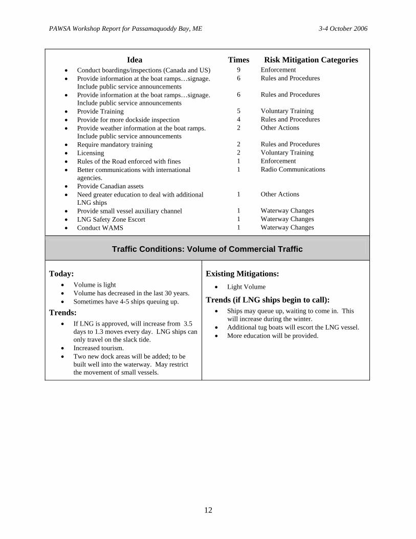
Idea Times Risk Mitigation Categories • Conduct boardings/inspections (Canada and US) 9 Enforcement • Provide information at the boat ramps…signage.
Include public service announcements 6 Rules and Procedures
• Provide information at the boat ramps…signage. Include public service announcements
6 Rules and Procedures
• Provide Training 5 Voluntary Training • Provide for more dockside inspection 4 Rules and Procedures • Provide weather information at the boat ramps.
Include public service announcements 2 Other Actions
• Require mandatory training 2 Rules and Procedures • Licensing 2 Voluntary Training • Rules of the Road enforced with fines 1 Enforcement • Better communications with international
agencies. 1 Radio Communications
• Provide Canadian assets • Need greater education to deal with additional
LNG ships 1 Other Actions
• Provide small vessel auxiliary channel 1 Waterway Changes • LNG Safety Zone Escort 1 Waterway Changes • Conduct WAMS 1 Waterway Changes
Traffic Conditions: Volume of Commercial Traffic
Today: • Volume is light • Volume has decreased in the last 30 years. • Sometimes have 4-5 ships queuing up.
Trends: • If LNG is approved, will increase from 3.5
days to 1.3 moves every day. LNG ships can only travel on the slack tide.
• Increased tourism. • Two new dock areas will be added; to be
built well into the waterway. May restrict the movement of small vessels.
Existing Mitigations: • Light Volume
Trends (if LNG ships begin to call): • Ships may queue up, waiting to come in. This
will increase during the winter. • Additional tug boats will escort the LNG vessel. • More education will be provided.
12

PAWSA Workshop Report for Passamaquoddy Bay, ME 3-4 October 2006
New Ideas: Idea Times Risk Mitigation Categories
• Specify traffic lanes. Develop non meeting traffic situations. Require designated one way traffic zones. Provide designated holding zones
12 Active Traffic Management
• Provide VTS with enhanced radar coverage 8 Active Traffic Management • Enhance radar and communications capabilities. 7 Radio Communications • Improve/upgrade ATON. Provide NDBC buoy 7 Nav/Hydro • Provide better scheduling 5 Active Traffic Management • Provide tug assistance. Require pilots. 3 Rules and Procedures • Provide more and better training for the pilots 1 Rules and Procedures • More US/Canadian presence 1 Enforcement
Traffic Conditions: Volume of Small Craft Traffic
Today: • Three-month seasonal activity, only in the
summertime.
Trends: • Rapidly growing numbers, especially
trailered boats.
Existing Mitigations: • Activity occurs in good weather and seasonality. • Education is available
New Ideas: Idea Times Risk Mitigation Categories
• Establish small vessel traffic lanes, safety and security zones.
5 Rules and Procedures
• Enhance radar and communications capabilities. Monitor N to M information.
5 Radio Communications
• Enhance VTS, provide traffic lanes 4 Active Traffic Management • Provide training, workshops, education. Provide
Public Service Announcement 3 Voluntary Training
• Mandatory Education/training 3 Rules and Procedures • Require Licensing 2 Rules and Procedures • Enhanced state, Canadian and USCG presence 2 Enforcement • Provide Weather, current (NDBC) buoy 1 Nav/Hydro • Provide mandatory AIS 1 Active Traffic Management
13

PAWSA Workshop Report for Passamaquoddy Bay, ME 3-4 October 2006
Traffic Conditions: Traffic Mix
Today: • Waterway is multiple use. • Traffic mixes and mingles. • Aquaculture farms exist.
Trends: • Aquaculture is currently flat but will return
to the bay; includes sea urchins, mussels. • Additional escort vessels and service vessels
will arrive. • LNG ships will be going in or out of Grand
Manan.
Existing Mitigations: Well-marked channels show boaters the channels where ships must transit.
Trends (if LNG ships begin to call): • Better trained and quality vessels as the new
escort vessels are added. • Safety zones may be used to address present
meeting situations. • Compulsory pilotage will be required in US and
Canadian waters. (two pilots will be onboard) • Number of pilots will increase.
New Ideas: Idea Times Risk Mitigation Categories
• Establish traffic patterns (maybe formally establish a one way traffic scheme); also safety zones
10 Active Traffic Management
• Provide routing and scheduling. 6 Coordination and Planning • Enhance VTS, AIS 4 Active Traffic Management • Provide better communications between boats,
association, and community. Provide public service announcements
4 Radio Communications
• Conduct a WAMS, update Coast Pilot, consider NDBC buoy
4 Nav/Hydro
• Under education, provide a symposium/seminar. 4 Voluntary Training • Provide an auxiliary traffic lane, VTS, day/night
rules 3 Rules and Procedures
• Provide enforcement presence (USCG and Canada) and training.
2 Enforcement
• Require VHF monitoring of security channels 2 Radio Communications • Provide recommended routes around fixed fishing
gear 1 Not Developed
• Complete an updated WAMS. 1 Not Developed • Keep Fundy Traffic system; maybe add a radar
atop the CG Eastport station for more coverage; also add communication repeaters.
1 Not Developed
• Tie together agreed risk mitigations with the construction of the LNG facility
1 Not Developed
14

PAWSA Workshop Report for Passamaquoddy Bay, ME 3-4 October 2006
Traffic Conditions: Congestion
Today: • There is a ferry system to Deer Island and
also kayaks that sometimes compete with the deep draft for waterway use..
Trends: • Number of head boats (whale boats) is pretty
steady. • Number of recreation boats increasing. • Small cruise liners may be entering the
waterway. • LNG vessels will queue up.
Existing Mitigations: • There is minimal risk.
Trends (if LNG ships begin to call):: • VTS may come. • AIS will be improved • Increase number of pilots. • Greater USCG presence.
New Ideas: Idea Times Risk Mitigation Categories
• Consider recommended routing for deep draft vessels; also safety and security zones. Formalize anchorage policies.
16 Active Traffic Management
• Require AIS on large vessels. Enhance VTS and radar
8 Active Traffic Management
• Mandatory monitoring of security channels. Enhanced communications
6 Radio Communications
• Provide traffic scheduling 4 Coordination and Planning • Conduct a WAMS, update Coast Pilot, consider
NDBC 4 Nav/Hydro
• Provide navigation instruments, equipment and publications
2 Other Actions
• Limit Hazardous cargoes 1 Rules and Procedures • Update Coast Guard – add information on types of
vessel transiting. 1 Not Developed
• Upgrade USCG resources 1 Not Developed
15
PAWSA Workshop Report for Passamaquoddy Bay, ME 3-4 October 2006
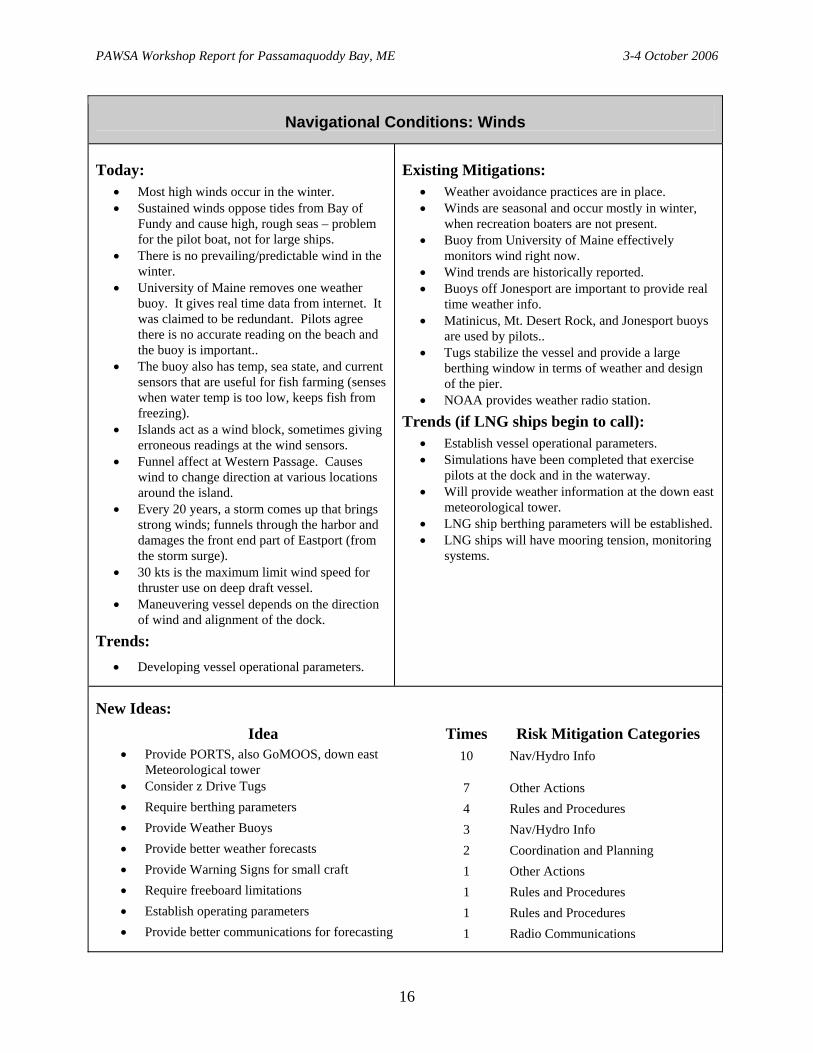
Navigational Conditions: Winds
Today: • Most high winds occur in the winter. • Sustained winds oppose tides from Bay of
Fundy and cause high, rough seas – problem for the pilot boat, not for large ships.
• There is no prevailing/predictable wind in the winter.
• University of Maine removes one weather buoy. It gives real time data from internet. It was claimed to be redundant. Pilots agree there is no accurate reading on the beach and the buoy is important..
• The buoy also has temp, sea state, and current sensors that are useful for fish farming (senses when water temp is too low, keeps fish from freezing).
• Islands act as a wind block, sometimes giving erroneous readings at the wind sensors.
• Funnel affect at Western Passage. Causes wind to change direction at various locations around the island.
• Every 20 years, a storm comes up that brings strong winds; funnels through the harbor and damages the front end part of Eastport (from the storm surge).
• 30 kts is the maximum limit wind speed for thruster use on deep draft vessel.
• Maneuvering vessel depends on the direction of wind and alignment of the dock.
Trends: • Developing vessel operational parameters.
Existing Mitigations: • Weather avoidance practices are in place. • Winds are seasonal and occur mostly in winter,
when recreation boaters are not present. • Buoy from University of Maine effectively
monitors wind right now. • Wind trends are historically reported. • Buoys off Jonesport are important to provide real
time weather info. • Matinicus, Mt. Desert Rock, and Jonesport buoys
are used by pilots.. • Tugs stabilize the vessel and provide a large
berthing window in terms of weather and design of the pier.
• NOAA provides weather radio station.
Trends (if LNG ships begin to call): • Establish vessel operational parameters. • Simulations have been completed that exercise
pilots at the dock and in the waterway. • Will provide weather information at the down east
meteorological tower. • LNG ship berthing parameters will be established. • LNG ships will have mooring tension, monitoring
systems.
New Ideas: Idea Times Risk Mitigation Categories
• Provide PORTS, also GoMOOS, down east Meteorological tower
10 Nav/Hydro Info
• Consider z Drive Tugs 7 Other Actions • Require berthing parameters 4 Rules and Procedures • Provide Weather Buoys 3 Nav/Hydro Info • Provide better weather forecasts 2 Coordination and Planning • Provide Warning Signs for small craft 1 Other Actions • Require freeboard limitations 1 Rules and Procedures • Establish operating parameters 1 Rules and Procedures • Provide better communications for forecasting 1 Radio Communications
16

PAWSA Workshop Report for Passamaquoddy Bay, ME 3-4 October 2006
Navigational Conditions: Water Movement
Today: • 13 Knots current at Blueback Narrows.
• Tide and current tables are good predictors except when there are high-wind conditions that alter water levels. Study shows that predictions of slack water are less reliable.
• Small vessels are unfamiliar with currents.
Trends: • None discussed.
Existing Mitigations: • Tide and current prediction tables and software.
• Voyage planning to avoid strong currents.
• Pilot boat precedes ship and gives traffic report. Will also act as a safety observer if radar is lost.
• Will be a current meter at down east.
• Specific transit timing based on slack water.
New Ideas: Idea Times Risk Mitigation Categories
• Transit at slack water 9 Coordination and planning • Provide PORTS systems 8 NAV/Hydro • Provide tugs 6 Other Actions • Provide Weather Buoys 2 Nav/Hydro Info • Require berthing parameters 2 Rules and Procedures • Consider transit tide restrictions 1 Rules and Procedures • Establish Operational Parameters 1 Rules and Procedures • Follow/enforce required rules of the road 1 Active Traffic Management
17

PAWSA Workshop Report for Passamaquoddy Bay, ME 3-4 October 2006
Navigational Conditions: Visibility Restrictions
Today: • Occur June and July…for 30 days…24 hours
a day. Sometimes no fog…no predictability. • Work with sea smog in winter. • Occasionally snow can cause vessels to be
weather-bound for days. Harder to navigate in a snow storm.
• Fog is generally localized in the bay. • No fog at Bayside.
Trends: • Less fog over the past 20 years. • Do not want to respond to a casualty in the
fog. • Can not see an LNG plume in fog.
Existing Mitigations: • Radar (increasing number of boaters have it but
may not be able to use it well). • GPS gives precise position. • Automatic fog signals on electronic equipment. • Commercial vessels
− Are using chart plotting software programs (ECIDS), but may over-rely upon it.
− Radar interpretation instruction / license endorsement.
• NOAA electronic navigation charts are free (S57 standard vector charts). See http://chartmaker.ncd.noaa.gov.
Trends: • Tug/barge will soon be required to carry AIS. • May reduce movement due to reduced visibility. • Establish vessel operating procedures.
New Ideas: Idea Times Risk Mitigation Categories
• Improve Fundy Radar. 9 Active Traffic Management • Enhance radio communication 7 Radio Communications • Conduct a WAMS. Provide RACONS. Provide
better ATON. Provide WAMS. It briefly addressed LNG additions
7 Waterway Changes
• Regulate vessel movements 6 Rules and Procedures • Limit movement by visibility standards 4 Rules and Procedures • Provide Weather Buoys 2 Nav/Hydro Info • Provide PORTS 2 Nav/Hydro Info • AIS 2 Nav/Hydro • Establish operational parameters 2 Rules and Procedures • Monitor VHF Security calls 1 Radio Communications
18

PAWSA Workshop Report for Passamaquoddy Bay, ME 3-4 October 2006
Navigational Conditions: Obstructions
Today: • 28 foot tide range.
• Ice seldom obstructs navigation. One-in-twenty year cycle.
• Once a month (about )…debris from high tide...can include telephone poles.
• Fish pens…off all the islands.
• Consider right whales…not necessarily in the area…North and East of Campabello Island…not in the interior…in the summer. Can also see them on the eastern bay, off Eastport.
Trends: • New piers are being built. • LNG ships may be at anchor.
Existing Mitigations: • Deep draft will slow and stop in the presence of
whale. • Pilot boat will listen for whales in the fog.. • LNG ships are not allowed to anchor in Canadian
waters.
New Ideas: Idea Times Risk Mitigation Categories
• Conduct a WAMS. Sovers Ledge 15 Nav/Hydro Info • NOAA Hydrographical survey 7 Nav/Hyrdo Info • Limit pier length 1 Coordination and Planning • Provide enhanced VTS 1 Active Traffic Management
19

PAWSA Workshop Report for Passamaquoddy Bay, ME 3-4 October 2006
Waterway Conditions: Visibility Impediments
Today: • Waterway blocked by island when leaving
head harbor passage off Cherry Island…making the corner.
• Back scatter from lights on the reservation.
Trends: • Increased LNG traffic.
• New LNG ships will moor at new piers.
• Small boats must go around piers.
Existing Mitigations: • .Cherry Island Light increased in intensity to take
care of backscatter from Eastport.
• Use Fundy Traffic to place vessels in the waterway.
• Use AIS to place vessels in waterway.
Trends: • For LNG ships, can see over the trees.
• Channel is wide enough to provide sufficient room. Simulated casualties outboard of the moored vessels with positive results.
• Moored ships will block out shore lights.
• Small boat education.
• Provide ATON around the piers.
New Ideas: Idea Times Risk Mitigation Categories
• Conduct a WAMS. Sovers Ledge 15 Nav/Hydro Info
•
Waterway Conditions: Dimensions
Today: • Head Harbor Passage is narrow (1500 ft.
wide between Dog Island and Indian Point)
Trends: • No trends discussed.
Existing Mitigations: • .Will pass two small vessels. • Policy is to not move deep draft ships opposing
each other through the geographic area. It is all one way.
20

PAWSA Workshop Report for Passamaquoddy Bay, ME 3-4 October 2006
New Ideas: Idea Times Risk Mitigation Categories
• One way traffic zones. Establish designated no passing zones.
10 Active traffic management
• Conduct a WAMS. Stovers Ledge 7 Nav/Hydro Info • Provide Tugs 5 Other Actions • Speed Restrictions 4 Other Actions • Establish operational parameters 3 Rules and Procedures • Provide recommended routes and VTS 3 Active Traffic Management • Limit vessel length 1 Rules and Procedures • Provide aid such as GoMOOS and PORTS 1 NAV/Hydro
Waterway Conditions: Bottom Type
Today: • Bottom is hard…rock.
• F/V grounds periodically.
• S/V ground periodically.
Trends: • No trends discussed.
Existing Mitigations: • Shoaling well marked with buoys.
• Charting, Coast Pilot, and hydrologic publications.
New Ideas: Idea Times Risk Mitigation Categories
• Provide updated hydrographic survey. 13 Nav/Hydro
• Conduct a WAMS. Stovers Ledge 2 Nav/Hydro Info • Reduce Speed 2 Rules and Procedures • Set operational parameters. Movement based on
tide 2 Rules and Procedures
Waterway Conditions: Configuration
Today: • One turn exceeds 45 degrees. • Seasonal risk of crossing traffic…during the
summer. Trends:
•
Existing Mitigations: • None required
• Vessel operators talk to one another on the radio..
21

PAWSA Workshop Report for Passamaquoddy Bay, ME 3-4 October 2006
• New Ideas. Risks and mitigations were balanced. There were no ideas captured..
Immediate Consequences: Personal Injuries
Today: • In the past, have had small cruise ships.
• Ferries are small vessels….45 people…passenger vessel to Campabello, car ferry and another one to Campobello.
• 500 meter zone established by Sandia is tank ship is breeched.
• Lacking in spill response personnel and equipment.
Trends: • 110-120 PAX vessel. Possibly increasing to
300-400 PAX vessels.
• LNG vessels moving throughout the waterway.
• Must establish an international joint response to an LNG casualty.
• USCG responders are inside the destruction zone.
• Minimal response capability for both U.S. and Canada. The mill, 25 miles away, is the only available hazmat response.
• Roadways may be obstructed by tree strewn roads. Route 1 is primary road for assistance to travel.
• Need additional training for response to LNG release/explosion.
Existing Mitigations: • No cruise ships.
• Joint Marine Contingency Plan…has an exception for LNG
Trends: • New crews and shape.
• LNG emergency response people will hold meeting with local responders.
• Regulation process will identify safety assets that must be supplied for the emergency plan before the process can move forward.
22

PAWSA Workshop Report for Passamaquoddy Bay, ME 3-4 October 2006
New Ideas: Idea Times Risk Mitigation Categories
• Update and develop training plans. Include international
11 Voluntary Training
• Provide emergency radio channels and an additional radio tower. Provide enhanced communications to all agencies and bi national
10 Radio Communications
• Develop/update contingency plans, include international. Provide egress routes
10 Rules and Procedures
• Enhance cell phone coverage 6 Other Actions • Provide emergency medical personnel and medical
clinics and life flight 4 Coordination and Planning
• Provide warning system and emergency broadcast 3 Other Actions • Conduct interagency/international
training/simulations/exercises 2 Voluntary Training
• Limit hazardous cargos 1 Rules and Procedures • Conduct safety audit inspection 1 Enforcement
Immediate Consequences: Petroleum Discharge
Today: • 200 annual ship transits by deep draft
vessels…2,000 tons (500,000 gallons) of bunkers per ship. Two vessels are present in the waterway at any one time.
• Petroleum products
− Eastport and Bayside does not handle petroleum cargo.
Trends: • Will need plan to fuel all the support vessels.
Existing Mitigations: • Joint bi-national agreement between US and
Canada for oil spill response.
• Canadian spill response equipment in St. Johns; USCG response equipment in Portland, ME.
• Six hours to respond.
23

PAWSA Workshop Report for Passamaquoddy Bay, ME 3-4 October 2006
New Ideas: Idea Times Risk Mitigation Categories
• Provide more response/preposition teams and equipment; include OSROs
10 Coordination and Planning
• Provide more response training 6 Voluntary Training • Provide better cell coverage and a tower. 6 Radio Communications • Designate response vessels as multi purpose escorts
and spill response vessels 4 Rules and Procedures
• Re-establish Quoddy Oil Spill Coop. 4 Coordination and Planning • Provide speed limits 1 Rules and Procedures • Improve bi-lateral agreements 1 Coordination and Planning • Provide tug escort 1 Other Actions • Consider ship/cargo owner liability 1 Other Actions
Immediate Consequences: Hazardous Materials Release
Today: • Bulk ammonium nitrate is shipped to
Bayside and Eastport. One ship a year….2,000 tons.
Trends: • Increasing due to LNG.
Existing Mitigations: • .None in place.
24
PAWSA Workshop Report for Passamaquoddy Bay, ME 3-4 October 2006
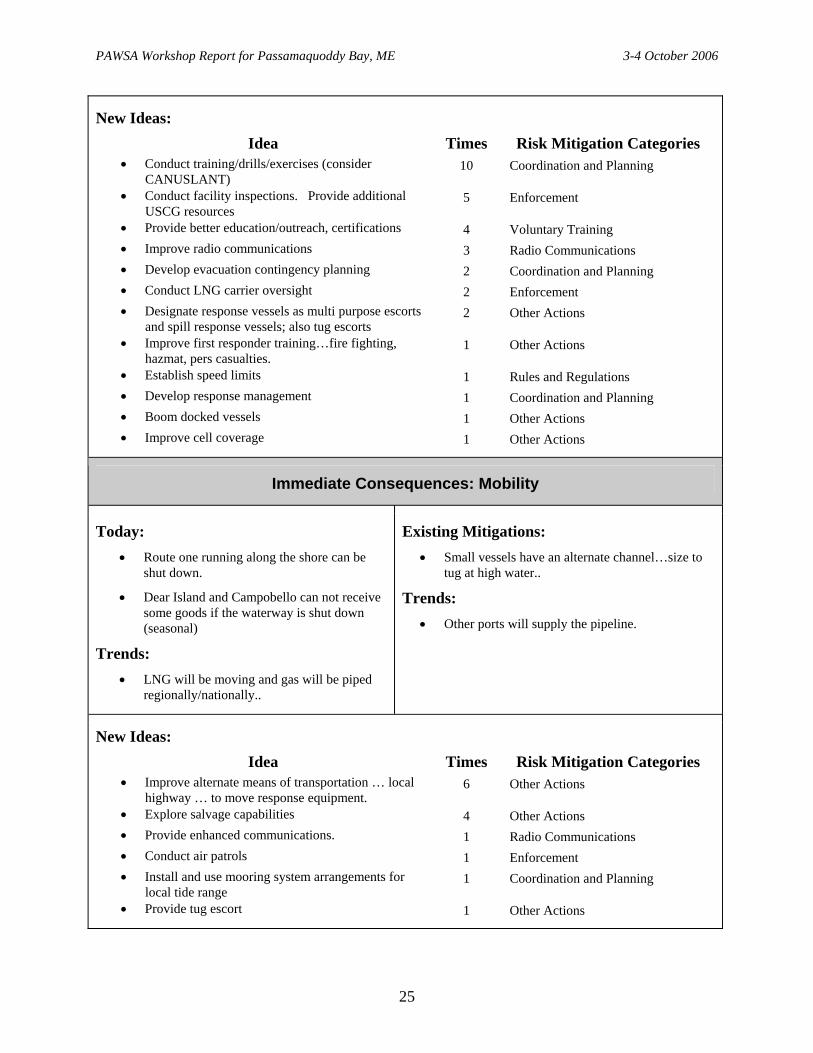
New Ideas: Idea Times Risk Mitigation Categories
• Conduct training/drills/exercises (consider CANUSLANT)
10 Coordination and Planning
• Conduct facility inspections. Provide additional USCG resources
5 Enforcement
• Provide better education/outreach, certifications 4 Voluntary Training • Improve radio communications 3 Radio Communications • Develop evacuation contingency planning 2 Coordination and Planning • Conduct LNG carrier oversight 2 Enforcement • Designate response vessels as multi purpose escorts
and spill response vessels; also tug escorts 2 Other Actions
• Improve first responder training…fire fighting, hazmat, pers casualties.
1 Other Actions
• Establish speed limits 1 Rules and Regulations • Develop response management 1 Coordination and Planning • Boom docked vessels 1 Other Actions • Improve cell coverage 1 Other Actions
Immediate Consequences: Mobility
Today: • Route one running along the shore can be
shut down.
• Dear Island and Campobello can not receive some goods if the waterway is shut down (seasonal)
Trends: • LNG will be moving and gas will be piped
regionally/nationally..
Existing Mitigations: • Small vessels have an alternate channel…size to
tug at high water..
Trends: • Other ports will supply the pipeline.
New Ideas: Idea Times Risk Mitigation Categories
• Improve alternate means of transportation … local highway … to move response equipment.
6 Other Actions
• Explore salvage capabilities 4 Other Actions • Provide enhanced communications. 1 Radio Communications • Conduct air patrols 1 Enforcement • Install and use mooring system arrangements for
local tide range 1 Coordination and Planning
• Provide tug escort 1 Other Actions
25

PAWSA Workshop Report for Passamaquoddy Bay, ME 3-4 October 2006
Subsequent Consequences: Health and Safety
Today: • Relative to Passamaquoddy Bay, everything
is still a rural area – population is 1500-3500 persons.
• Eastport has up to 2000 population
• Consider WSA…1000 people per quarter mile.
• A discharge may affect fish processors.
• Ammonium Nitrate posses an explosion problem.
• No formal evacuation plans.
• Lack of firefighting capability.
Trends: • LNG ships will be entering the area.
Existing Mitigations: • Prevailing wind would disperse a gas.
• Calas is nearest hospital…20 miles away…bed capacity of 25. Eastern Maine Medical Center….move by helicopters.
• Area is rural with few people in a large area.
• Planning with nuclear plan has been completed with both countries.
• Multiple fire fighting organizations have worked together to combat shore side fires (forest fires).
Trends: • Have identified the disaster area.
New Ideas: Idea Times Risk Mitigation Categories
• Develop/update contingency plans, include international. Provide egress routes
9 Rules and Procedures
• Provide warning system and emergency broadcast 7 Other Actions • Update and develop training plans. Include
international. Include marine firefighting. Provide PSAs
5 Voluntary Training
• Pre position equipment 4 Coordination and Planning • Provide enhanced firefighting capability; land and
water 4 Other Actions
• Formalize US Canadian agreements 3 Coordination and Planning • Provide emergency medical personnel and medical
clinics and life flight 2 Coordination and Planning
• Enhance cell phone coverage. . 1 Other Actions • Limit hazardous cargos 1 Rules and Procedures • Conduct interagency/international
training/simulations/exercises 1 Voluntary Training
• Conduct predictive modeling 1 Coordination and Planning • Develop web page 1 Other
26

PAWSA Workshop Report for Passamaquoddy Bay, ME 3-4 October 2006
Environmental
Today: • 250 feet around the island of
Eastport….developmemt setback. • Cobcook Bay is a sensitive area. • Endangered species is high. • Cultural Resources for tribal based,
archeological based in area. •
(no. 2) when entering port. No. 2 oil will taint fish where black oil bunkers will not.Some ship use no. 2.
Some ships change from bunkers to diesel
ips will enter the waterway, resulting
• )
er
•
cargo
•
•
Trends: • LNG sh
in more traffic. More emissions will result…air, noise, invasive species.
Pure methane is not an issue (non fire formto the environment. If on fire, will drop down to a couple of inches below the wat
Vessel strike risk to the right whale.
• Current LNG ships use boil off fromtanks. Some use IFO fuel. IFO taints fish.
New ships…bunker tanks are double hulled…may not be used here.
Existing Mitigations: • Ballast water program required.
• Right whale monitoring…voluntary.
• Fundy traffic notifies ships of whale sighting.
Trends: • LNG ships do not deballast.
• New ships use diesel fuel, heavy fuel oil…2000 tons.
27

PAWSA Workshop Report for Passamaquoddy Bay, ME 3-4 October 2006
New Ideas: Idea Times Risk Mitigation Categories
• Conduct training/drills/exercises (consider CANUSLANT) and develop priorities
7 Coordination and Planning
• Better real time for Nav/hydro information, PORTS 7 Nav/Hydro Info • Provide response/equipment training 4 Voluntary Training • Conduct predictive modeling 3 Other Actions • Develop evacuation contingency planning and spill
response 2 Coordination and Planning
• Develop routing for environmentally sensitive areas 2 Active Traffic Management • Develop and formalize an environment/whale
information system 2 Other Actions
• Provide prepositioned resources. 2 Coordination and Planning • Contract with NRC 1 Other Action • Provide better data on bunkers 1 Rules and Procedures • Develop response management, OSROs 1 Coordination and Planning • Provide better education/outreach, certifications 1 Voluntary Training • Improve radio communications 1 Radio Communications • Develop Web Page 1 Other Actions
28

PAWSA Workshop Report for Passamaquoddy Bay, ME 3-4 October 2006
Subsequent Consequences: Aquatic Resources
Today: • Many species are harvested throughout the
geographic area:
• Fish farming (Agricultural more impacted/conducted than commercial and recreational fishing)…clammers operate in the area. Sea cucumbers, herring.
• Recreational fishing…extensive in the summer.
• Includes life cycle…lobster, scallops, herring. Will probably use that year of fishing in the event of a spill.
• Ecotourism is increasing.
• Extensive fisheries throughout of the Bay:
− Commercial shell fishing, lobster, quahog, scallops; and fin fish…a year-round activity.
− Recreational fishing is very active.
Trends: • Fishing and Ecotourism is increasing.
• LNG ships increase will restrict the water and reduce the number of spaces to fish.
Existing Mitigations: • Existing authorities to close shellfish beds.
• NOAA has the only sensory analysis lab available to test and chemically analyze fitness of fish product.
− State and local capabilities.
• Seasonality of a pollution event can protect the resource to some degree.
• Whale alerts are provided by Fundy Traffic.
New Ideas: Idea Times Risk Mitigation Categories
• Establish fisheries opening and closing protocols. Include Canada
6 Rules and Regulations
• Improve communications, call down list 6 Radio Communications • Develop and formalize an environment/whale
information system 2 Other Actions
• Develop Web Page 2 Other Actions • Develop response management, Aquacultures 1 Coordination and Planning • Provide better education/outreach, certifications 1 Voluntary Training
29

PAWSA Workshop Report for Passamaquoddy Bay, ME 3-4 October 2006
Subsequent Consequences: Economic
Today: • Fish contaminated with hazardous material
cannot be sold. • For definition purposes, in the Aqua
fisheries, impact is great and felt internationally. More than $2M per year. Would do a fisheries closure for potential area of impact.
• Severe economic effects would be felt in within two weeks of a port closure.
• Salmon is sold along the east coast. • Lobster is sold along the east coast and
internationally. • Sea urchins are sold internationally. • Income from tourism and fishing would be
affected, even if there is just an impression that the area has been “tainted” by spills, etc.
• Repayment for loss of income from oil spill. • May not be able to get product to
market…may affect the region and nation. • A major casualty would affect tourism…St.
Andrews is a major resort community. This includes whale watching tours.
• 350K tons a year paper mill would not be able to ship.
• Bayside…depends on how long…lose one ship a week.
• Letit Passage at 1500 feet wide could affect the small boat traffic.
Trends: • LNG industry will increase jobs, support
vessels.
• People may stop coming to tourist area in Canada (St. Andrews)…a less environmentally pristine area...also at Campobello Island.
• Additional traffic may push the whales elsewhere.
• Consider tax issues.
• Most issues will be local and regional.
Existing Mitigations: • Energy Policy Act (US only):
o Provide emergency response plan
o Provide cost sharing plan to provide additional resources. Between company and local community.
• Possible new international agreements in the making.
Trends: • People like to look at big ships.
• May add $250M to a taxable base
• Young people may remain in the area.
• Will provide site specific compensation package to local fishermen.
• Will provide trap replacement program…US Canadian.
30

PAWSA Workshop Report for Passamaquoddy Bay, ME 3-4 October 2006
New Ideas: Idea Times Risk Mitigation Categories
• Marine System Recovery 10 Coordination and Planning • MOU joint Canada US response 7 Other Actions • Fishermen compensation plan 5 Other Actions • Trap replacement program 2 Other Actions • LNG via offshore terminal 1 Coordination and Planning • Develop web page. 1 Other Actions
31

PAWSA Workshop Report for Passamaquoddy Bay, ME 3-4 October 2006
Book 2 Tabular Results:
Risk Factor A Value B Value C Value D ValueDeep Draft Vessel Quality 1.0 3.0 5.6 9.0Shallow Draft Vessel Quality 1.0 3.0 5.6 9.0Commercial Fishing Vessel Quality 1.0 3.0 5.6 9.0Small Craft Quality 1.0 3.0 5.6 9.0Volume of Commercial Traffic 1.0 3.0 5.3 9.0Volume of Small Craft Traffic 1.0 2.8 5.7 9.0Traffic Mix 1.0 2.3 4.7 9.0Congestion 1.0 2.7 5.0 9.0Winds 1.0 2.5 5.2 9.0Water Movement 1.0 2.9 5.0 9.0Visibility Restrictions 1.0 2.9 5.7 9.0Obstructions 1.0 2.0 4.5 9.0Visibility Impediments 1.0 3.1 5.5 9.0Dimensions 1.0 3.1 5.5 9.0Bottom Type 1.0 2.4 5.1 9.0Configuration 1.0 2.8 5.3 9.0Personnel Injuries 1.0 3.1 5.7 9.0Petroleum Discharge 1.0 3.8 6.2 9.0Hazardous Materials Release 1.0 3.7 6.2 9.0Mobility 1.0 3.0 5.3 9.0Health and Safety 1.0 3.1 5.6 9.0Environmental 1.0 3.2 5.9 9.0Aquatic Resources 1.0 2.8 5.5 9.0Economic 1.0 3.1 5.7 9.0
32

PAWSA Workshop Report for Passamaquoddy Bay, ME 3-4 October 2006
Book 3 Tabular Results:
Vessel Conditions
Traffic Conditions
Navigational Conditions
Waterway Conditions
Immediate Consequences
Subsequent Consequences
Deep DraftVessel Quality
Volume of Commercial
TrafficWinds Visibility
ImpedimentsPersonnel
InjuriesHealth and
Safety
1.3 1.3 4.5 3.9 3.0 2.5
Shallow Draft Vessel Quality
Volume ofSmall Craft
Traffic
WaterMovement Dimensions Petroleum
Discharge Environmental
1.7 1.6 6.4 3.3 2.1 7.5
Commercial Fishing
Vessel Quality
TrafficMix
Visibility Restrictions
BottomType
Hazardous MaterialsRelease
Aquatic Resources
6.4 3.1 7.9 7.0 5.3 7.5
Small Craft Quality Congestion Obstructions Configuration Mobility Economic
6.9 2.1 3.5 7.7 3.2 5.9
33
PAWSA Workshop Report for Passamaquoddy Bay, ME 3-4 October 2006
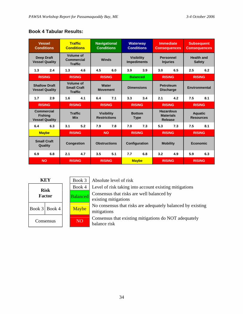
Book 4 Tabular Results:
1.3 2.4 1.3 4.6 4.5 6.0 3.9 3.9 3.0 6.5 2.5 6.2
1.7 2.9 1.6 4.1 6.4 7.1 3.3 3.4 2.1 4.2 7.5 8.1
6.4 6.3 3.1 5.2 7.9 7.8 7.0 7.3 5.3 7.3 7.5 8.1
6.9 6.8 2.1 4.7 3.5 5.1 7.7 6.8 3.2 4.9 5.9 6.3
Immediate Consequences
Subsequent Consequences
Vessel Conditions
Traffic Conditions
Navigational Conditions
Waterway Conditions
Deep DraftVessel Quality
Volume of Commercial
TrafficWinds Visibility
ImpedimentsPersonnel
InjuriesHealth and
Safety
Shallow Draft Vessel Quality
Volume ofSmall Craft
Traffic
WaterMovement Dimensions Petroleum
Discharge Environmental
RISING RISING
Mobility Economic
Commercial Fishing
Vessel Quality
TrafficMix
Visibility Restrictions
BottomType
Small Craft Quality Congestion Obstructions Configuration
Hazardous MaterialsRelease
Aquatic Resources
RISING RISING
RISING Balanced RISING RISING
RISING RISING
RISING RISING
Maybe RISING NO RISING
RISING RISING
RISING RISINGNO RISING RISING Maybe
KEY Book 3 Absolute level of risk Book 4 Level of risk taking into account existing mitigations
Risk Factor Balanced Consensus that risks are well balanced by
existing mitigations
Book 3 Book 4 Maybe No consensus that risks are adequately balanced by existing mitigations
Consensus
NO Consensus that existing mitigations do NOT adequately balance risk
34

PAWSA Workshop Report for Passamaquoddy Bay, ME 3-4 October 2006
Book 5 Tabular Results:
1.8 4.1 5.9 6.4 5.9
2.7 3.9 Caution 6.4 2.8 3.7 6.9
4.7 7.2 6.7 Caution 7.2 8.0
6.5 4.0 4.8 4.8 6.2
Mobility EconomicSmall CraftQuality Congestion Obstructions Configuration
Commercial Fishing
Vessel Quality
TrafficMix
Visibility Restrictions
BottomType
Shallow Draft Vessel Quality
Volume ofSmall Craft
Traffic
WaterMovement Dimensions
PersonnelInjuries
Health andSafety
Deep DraftVessel Quality
Volume of Commercial
TrafficWinds Visibility
Impediments
Vessel Conditions
Traffic Conditions
Navigational Conditions
Waterway Conditions
Immediate Consequences
Subsequent Consequences
Active Traffic Mgmt Active Traffic Mgmt Nav / Hydro Info Balanced
Enforcement Rules & Procedures Rules & Procedures Active Traffic Mgmt
Rules & Procedures Nav / Hydro Info
Radio Communications Other Actions
Other Actions Coordination / Planning
Petroleum Discharge Environmental
Hazardous MaterialsRelease
Aquatic Resources
Coordination / Planning Coordination / Planning
Voluntary Training Active Traffic Mgmt Nav / Hydro Info Balanced Other Actions Coordination / Planning
Balanced Active Traffic Mgmt
KEY
Risk Factor Intervention category that was judged most effective
in further mitigating risk
Intervention Expected improvement in risk level if new mitigation measures were implemented
Risk Improvement Caution
No consensus alert
35

PAWSA Workshop Report for Passamaquoddy Bay, ME 3-4 October 2006
Legend:
The intervention category listed is the one category that most participant teams selected for further reducing risks. The Risk Improvement is the perceived reduction in risk when taking the actions specified by the participants. A green Balanced indicates that no intervention is needed and risk is balanced in the waterway, and a yellow Caution indicates that there was a difference between the most effective category and the category most selected by the participants for action. Intervention category definitions are:
Coordination / Planning Improve long-range and/or contingency planning and better coordinate activities / improve dialogue between waterway stakeholders
Voluntary Training Establish / use voluntary programs to educate mariners / boaters in topics related to waterway safety (Rules of the Road, ship/boat handling, etc.)
Rules & Procedures Establish / refine rules, regulations, policies, or procedures (nav rules, pilot rules, standard operating procedures, licensing, RNAs, require training and education, etc.)
Enforcement More actively enforce existing rules / policies (navigation rules, vessel inspection regulations, standards of care, etc.)
Nav / Hydro Info Improve navigation and hydrographic information (PORTS, BNTM, charts, coast pilots, AIS, tides and current tables, etc.)
Radio Communications Improve the ability to communicate bridge-to-bridge or ship-to-shore (radio reception coverage, signal strength, reduce interference & congestion, monitoring, etc.)
Active Traffic Mgmt Establish/improve a Vessel Traffic Service (info, advice and control) or Vessel Traffic Information Service (information and advice only)
Waterway Changes Widen / deepen / straighten the channel and/or improve the aids to navigation (buoys, ranges, lights, LORAN C, DGPS, etc.)
Other Actions Risk mitigation measures needed that do NOT fall under any of the above strategy categories
36

PAWSA Workshop Report for Passamaquoddy Bay, ME 3-4 October 2006
37