portfolio of xiaoyan
DESCRIPTION
urban designer / architect Master of urban design 2007-2009 work from 2004 - 2007TRANSCRIPT
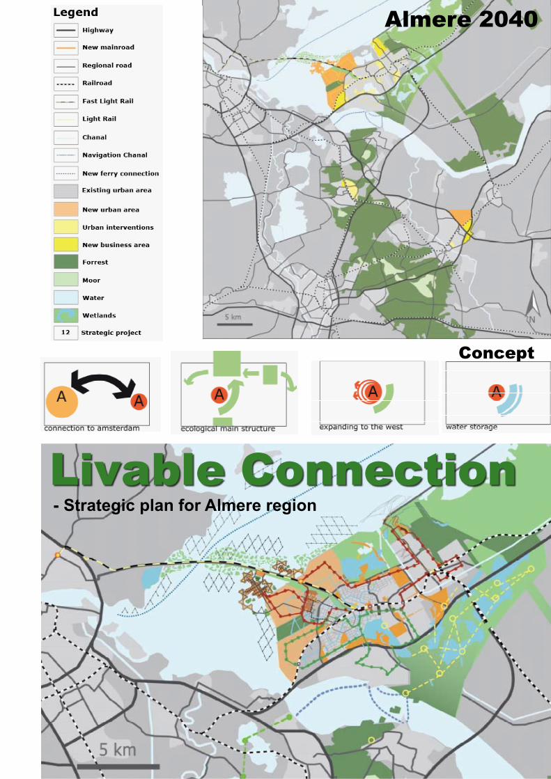
Concept
Livable Connection- Strategic plan for Almere region
Almere 2040
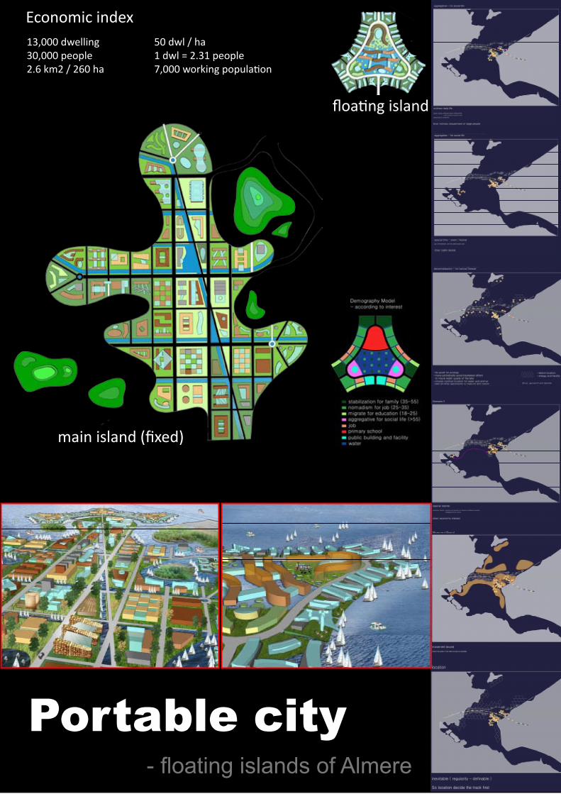
13,000 dwelling30,000 people2.6 km2 / 260 ha
50 dwl / ha1 dwl = 2.31 people7,000 working population
main island (fixed)
floating island
Economic index
Portable city- floating islands of Almere

- strategic location in regional perspective- more spatial problems: natural barrier
University
High-tech industry park
Why choose south as study area
River as spatial barrier block the integration of south bank with the city
1million car /day 0
5KM
motor traffic amount
3
12
4
56
7
1.38 KM
2.84
KM
3.25
KM
3.30
KM
4.10 KM
4.36 KM
2.64
KM
A1
2.54
KM
2.33
KM
4.63
KM
4.06
KM
1.43
KM
A2
A3
A4
A5
A
B
B2
B3
B4
B5
B1
Two routes connect south bank with the city
South bank - KNOWLEDGED PERIPHERY- agglomerate high-tech industry and university
South bank as KNOWLEDGED PERIPHERY is a new part of Shenyang with less than 15 years history. Therefore, besides the improvement of living quality of the south and to connect south with traditional downtown are two main focus points in this thesis.

University area: 78 haFloor space: 1.150.000 sqm11. 000 studentsUrban culture related with university: 55 ha
railway line
railway station
existing subway
proposed metro line
proposed tram line
university
knowledge clusters
and downtown area
Site
railway line
railway station
existing subway
proposed metro line
proposed tram line
university
knowledge clusters
and downtown area
Site
proposed tram line - connect south with the cityPublic transport
railway station
transit
transit
3 transit station
250m * 90m grid: flexible urban formnorth to south - mainly for Motor Vehiclewest to east - mainly for pedestrian
Road structure
new HST station
city memory
constructing culture centertechnology college
art collegebu
sine
ss c
olle
ge
media market
university as spatial instruments to organize sorrounding urban
3 UNIVERSITY aS 3 axIS
Plan area: 576 ha100,000 new inhabitants40,000 housingLand for residential: 376 haDensity: 106 housing/ha

STRaTEGIC PLaN
River view

THE BUND of SHaNgHai
New BUND
the river is eternal
the river makes billowing, curving forms
key issues to resolvetourists vs. the local community
functions vs. form
access to water vs. flood protectionthe
past vs. the future
Band One: Lingering Lane Band Two: Strolling PathwayBand Three: Fragrant ForestBand Four: Fluttering Water
飘带一:徜徉之路飘带二:漫步小径飘带三:芳香森林飘带四:舞动之水

BUND = Compatible Public Space + Innovative Ecology
外滩=兼容性的公共空间+创新性的生态系统
Sculpted Planes and Flood Wall 塑性的坡面和防汛墙
Node 1- bridging plaza节点1(苏州河口)—绿桥广场
Node 2 - river dance floor节点2(南京东路)—水上舞池
Node 3 - theater + water park节点3(福州路)—水上剧场+公园
Node 4 - long bar节点4(延安东路)—”长”酒吧
Node 5 - concert plaza节点5(新开河路)—音乐广场
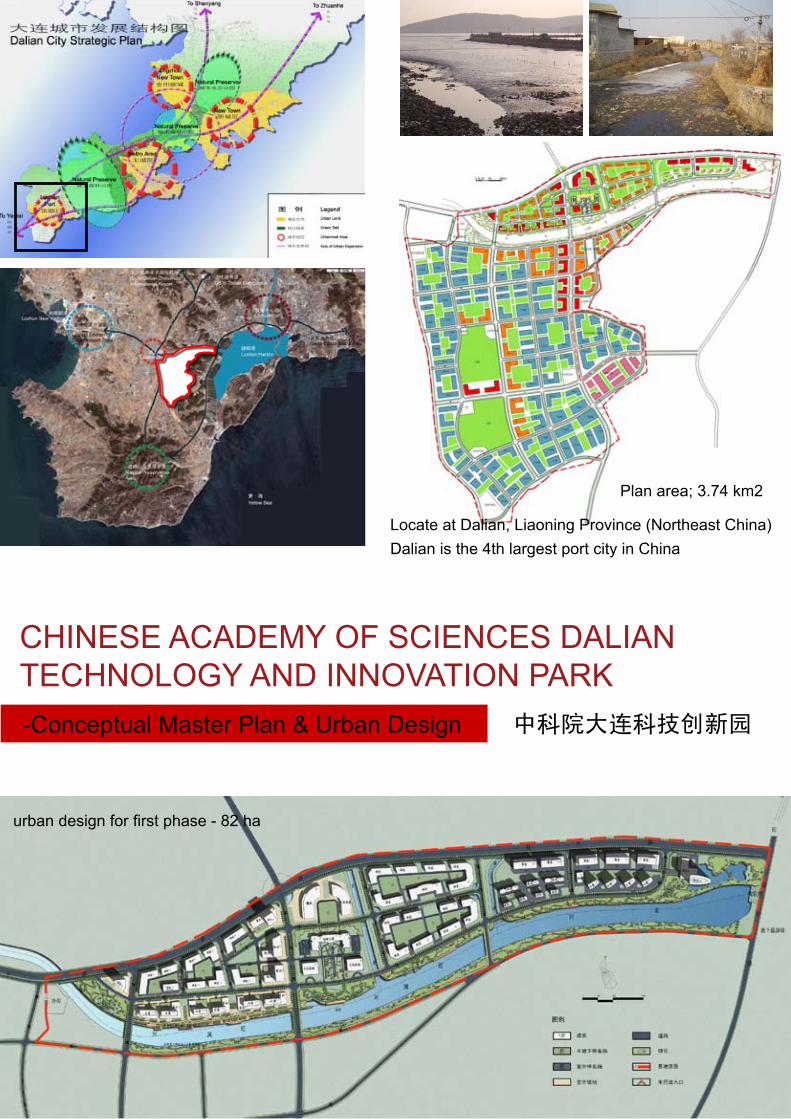
Chinese aCademy of sCienCes daLian TeChnoLoGy and innoVaTion PaRK
中科院大连科技创新园-Conceptual master Plan & Urban design
Plan area; 3.74 km2
urban design for first phase - 82 ha
Locate at Dalian, Liaoning Province (Northeast China)Dalian is the 4th largest port city in China

land use
density
green and bule
traffic flow

