polish geodetic antarctic studies. · this short historical outline will remind the main milestone...
TRANSCRIPT

WARSAW UNIVERSITY OF TECHNOLOGYINSTITUTE OF GEODESY AND GEODETIC ASTRONOMY
00-661 Warsaw, Pl. Politechniki 1Voice: +48 22 622 8515; Fax: +48 22 621 0052
E-mail: [email protected]
POLISH GEODETIC ANTARCTIC STUDIES.A SHORT HISTORICAL OUTLINE
Janusz SledzinskiMember of the First Polish Antarctic Expedition 1958/59
Paper presented at the Second Antarctic Geodesy Symposium 1999AGS99
Warsaw, Poland14 - 16 July 1999

Polish Geodetic Antarctic Studies.A short historical outline
Janusz SledzinskiMember of the First Polish Antarctic Expedition 1958/59
Active exploration of the Antarctic Continent by Polish scientists began in late fifties and wasfocused mainly on different scientific investigations (geophysic, geodetic, biologic, ecologic etc.)carried out in two Polish Antarctic stations: Station A.B.Dobrowolski located in Bunger Oasis andStation H. Arctowski, Admiralty Bay, King George Island. This short historical outline will remindthe main milestone works of Polish geodesists carried out in these two Antarctic stations.
First Station in Bunger Oasis was taken over by Polish scientists from their Soviet colleagues on23 January 1959 and was named Station A.B.Dobrowolski. The station is situated in a veryspecific Antarctic "oasis" where the nunatac stones appear above the ice, where there blow verystrong winds, there is very high solar radiation and very high temperature gradient, bigdifferences of the day and night temperature; in summer time the day temperature is usuallyabove zero and the humidity is very low.

Fig.1 A. B. Dobrowolski Station
Fig.2 Author in front of the gravimetric pavilion.

Fig.3 Vicinity of the A. B. Dobrowolski Station (Bunger Oasis)
During Antarctic summer 1958/59 first magnetic observations were made by Dr. WojciechKrzeminski (†) but probably the most valuable achievement of this first expedition to theA.B.Dobrowolski Station was the establishment of the gravimetric point in one of the pavilionsof the Station and direct connection of this point to the main Polish gravimetric network. Thegravimetric point was embedded in the stone ground and marked by special brass plate. For themeasurement of the gravity difference the four-pendulum gravity-meter Askania Werke wasused. It is to be reminded that this gravity-meter was commonly recognised at that time as veryprecise and sophisticated instrument. The gravity value determined by Z.Zabek and J.Sledzinskifor the Antarctic Station (f = 66016.3' S, ? = 100045.0' E, H = 35.4 m) was
gAnt. = 982 424.4 mGal ± 0.4 mGal.Coordinates of geodetic network points, gravity values and free-air and Bouguer anomalies
No. X Y f H g Free-airanomaly
Bougueranomaly
[m] [m] [0 ‘ “] [m] [mGal] [mGal] [mGal}
ASTROCSF1F2F3MF4F5F6F7F8F9F10PCPG1PG2PG3PG4PG5PG6PG7PG8PG9PG10PG11PG12
5000.004704.624617.704905.185382.024886.995253.995988.785785.195864.135473.484947.064550.335038.595461.485373.715425.255594.605364.955686.305592.205247.255387.805225.664895.344792.26
5000.005235.254084.383988.644290.394533.264604.344223.395032.665984.155994.725997.416040.115025.104604.594788.874953.834977.575175.635469.555528.325308.195638.505665.245723.135106.24
66016’30.0” 39.5 42.3 33.1 17.7 33.6
16 21.815 58.116 04.7
02.1 14.7
31.7 44.5 28.8 15.1 17.9 16.3 10.8 18.2 17.9 10.9 22.0 17.5 22.7 33.4 36.7
35.2659.2352.1624.9176.1648.5276.0380.1663.4950.4180.4655.8429.6238.2051.0541.8145.9655.6031.0284.7450.1234.3240.0657.2128.1311.72
982 438.41431.42
439.46428.85434.12428.74428.19432.14434.73427.66432.35437.95437.60434.49436.13435.40433.49438.18426.56434.43437.16436.57432.11438.35442.40
76.9477.17
74.7476.6780.2380.0081.1778.4679.8580.4377.2074.4777.0678.1776.9177.4878.6675.6280.7777.9075.5576.8177.5574.6173.55
73.9872.20
72.6572.6073.8473.6374.4574.2374.5373.6072.5272.0073.8673.8973.4173.6274.0173.0273.6773.7072.6773.4572.7672.2672.57

Fig.4 Bouger anomalies
Next geodetic works in the A.B.Dobrowolski Station were carried out during the third Antarcticexpedition organized by Polish Academy of Sciences in 1978/79. The broad scientific programincluded the following works: establishment of a geodetic network in the Bunger Oasis,establishment of an astronomical reference point, magnetic observations, photogrammetricsurveys aiming at developing maps of the vicinity of the Station at the scales 1:500 and 1:5000(Z. Battke – author of the maps). Also the gravimetric measurements were continued. Establishedgeodetic network consisted of 26 points and was measured by Dr. A. Pachuta and Dr. J. Cisakusing theodolites Wild T2 and distancemeters Zeiss EOK.
The established astronomical point (measured by Dr. J. Cisak) was determined by Kawrajskimethod from pairs of stars at equal heights using a theodolite Wild T2. The result of thedetermination was:
f = 660 16’ 34.4”S ± 1.6”

? = 1000 45’ 00.7”E ± 0.3”
During the third expedition the Station has visited Dr. Vincent Morgan, a scientist from Australia,who determined the coordinates of the astronomical point by satellite Doppler technique. Hisresult gained from only three satellite passes was:
f = 660 16’ 30” E? = 1000 45’ 03” E
Magnetic works performed in 1979 by S. Mroczek focused on measurement of the magneticdeviation of navigation devices of two helicopters Mi-2 available at the Station and determinationof the magnetic declination in the vicinity of the Station. The value of the declination wasdetermined as
DDobrow. = - 890 36.4’ .
The time variation of the declination with respect to the measurements from 1958 were alsodetermined.
The programme of gravimetric works included the gravity surveys in the region of the StationDobrowolski and the gravimetric connection Station Dobrowolski – Mirnyj (Soviet Antarcticstation). The gravimetric surveys in the vicinity of the Station was made by using the Canadiangravimeter Sharpe CG-2. For gravimetric connection of the Mirnyj station there were carried out4 flights by either Soviet helicopter Mi-8 or Polish helicopters Mi-2. As a result the new value ofgravity for the point in Mirnyj was established; the gravity difference was determined as
?gMirnyj-Dobrow. = 34.37 mGal ± 0.05 mGal.
Hence, for the gravimetric point at Mirnyj:
f = 660 33.1’ S? = 930 09.5” EH = 35.058 m
the following gravity value referenced to the pendulum point of Station Dobrowolski wasachieved:
gMirnyj. = 982 390.0 mGal ± 0.4 mGal.
This value is in a good agreement with other determinations performed for Mirnyj by German,American and Soviet scientists. The gravimetric works were done by Dr. A. Pachuta from theInstitute of Geodesy and Geodetic Astronomy of the Warsaw University of Technology.
It is to be outlined that Polish geodesists have introduced some Polish names on maps developed
during the expedition 1978/79. We mention only the following: Zatoka Polskich Geodetów (Bayof Polish Geodesists), Beskid, Giewont (peaks of the mountains south Poland), Skala fok (Rockof Seals), Gniazdo Skuy (Nest of Skuy Birds), Czarna Skala (Black Rock), Wzgórze Kaminskiego(Kaminski Hill), Dolina Manczarskiego (Manczarski Valley), Góra Rózyckiego (Rózycki Peak)etc.
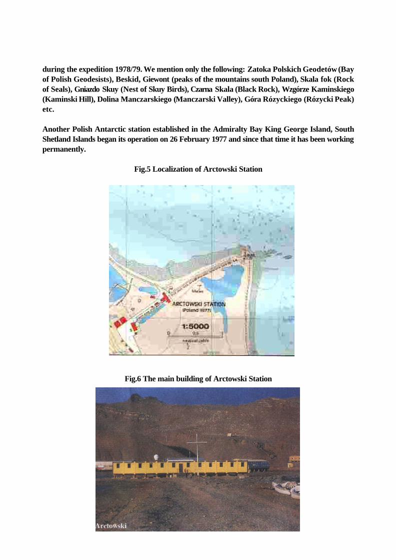
Another Polish Antarctic station established in the Admiralty Bay King George Island, SouthShetland Islands began its operation on 26 February 1977 and since that time it has been workingpermanently.
Fig.5 Localization of Arctowski Station
Fig.6 The main building of Arctowski Station

Fig.7 Arctowski Station in winter
One of the first geodetic works was the establishment of the reference astronomic point. locatednear the lighthouse. However, the unfavourable weather conditions and very short nights duringthe summer expedition 1977/78 allow Dr J. Jasnorzewski (†) to determine the astronomiccoordinates with very low accuracy:
f = - 620 09' 51" ±12"? = 3h 53m 51s ±0.8s
This accuracy was well improved about ten years later by J.Cisak, M.Dobrzycka. They obtained:f = - 620 09' 39" ±2"? = 3010 31' 32" ±2s
They also determined the coordinates of the reference point in the Station H. Arctowski bycarrying out the Doppler observations in the frame of the Intercosmos Doppler ObservationCampaign ICDOC. The coordinates of this point determined from 311 satellite passes related tothe WGS72 system are:
f = - 620 09' 41"? = 3010 31' 49"H = 30.60 m

The broad geodetic programme of the expedition 1978/1979 and the next expeditions includedalso the photogrammetric works aimed at preparation of maps of various parts of the vicinity ofthe Station H. Arctowski. We mention the following maps: the map of the Admiralty Bay StationH. Arctowski area at the scale 1:25000 (Dr. K. Furmanczyk, Dr. A. Marsz), maps at scales1:5000 and 1:50000 of the vicinity of the Station of H. Arctowski (Dr. Z. Battke). map of a specialprotected area "Lions Rump" (Dr. J. Cisak and Dr. Z. Battke), map of the vicinity of the Spanishstation at the Livingstone Island at the scale 1:5000 (Dr. P. Madejski). All the maps worked outby the geodesists were also used for the aims of biological studies (determination of the locationof flora and fauna) as well as for geomorphologic and ecologic studies.
Fig. 8 1:50 000 map of the vicinity of the H. Arctowski Station
More than 1000 scientists have worked at the Station H. Arctowski since 1978. The scientistsfrom other countries visited and worked at the station; they came from Argentina, Brazil,Belgium, Canada, former Czechoslovakia, Germany, Monaco, New Zealand, Peru, former SovietUnion, Spain, United Kingdom and USA. Long-term projects were commonly realised in1990/1991 by Polish and Dutch scientists. Almost 20 000 tourists have visited the Station since1976.

It is to stress that permanent activity of the Antarctic Station H. Arctowski was leadedsuccessfully by the Institute of Ecology of the Polish Academy of Sciences, now is organized bythe Department of Antarctic Biology of the PAS and personally by the Director of thisDepartment Prof. S. Rakusa-Suszczewski. His personal engagement is gratefully acknowledged.
When speaking on Polish exploration of polar Antarctic regional we must not forget the activitiesof two Polish geodesists who died ten and eighteen years ago.
Dr. Wojciech Krzeminski as the young boy scout took part in the Warsaw Upraise during the lastworld war. Wounded he was than taken prisoner in Nazi Stalag IXB in Zeltchen near Dresden.In 1945-1946 he was a soldier of the Polish Army in Italy and in England. He returned to Polandin 1947. In 1947-1952 he was student of the Faculty of Geodesy and Cartography of the WarsawUniversity of Technology. He began to work in 1951 and the whole his activities were focused onmagnetic surveys as well on selected problems of the geodetic metrology. He was a head of theFirst Polish Antarctic Expedition 1958/1959 and the Polish Antarctic Expedition 1978/1979. Hisinternational activity and cooperation was very active in the frame of the scientific organizationsof International Association of Geodesy of the International Union of Geodesy and Geophysics,SCAR, KAAPG and others. He died on 9 April 1981
Dr. Jerzy Jasnorzewski graduated from Warsaw University of Technology, Faculty of Geodesyin 1932 began work at the Astronomical Observatory in Cracow and than at the WarsawUniversity of Technology. His specialisation were geodetic astronomy, geodetic instruments andgeodetic metrology. He took part in two polar expeditions to Spitsbergen and to Station H.Arctowski in Antarctica where he established reference astronomic stations. From 1959 heworked for 10 years as a Deputy Director of the International Bureau des Poids et Mesures inSèvres. He died on 14 May 1989.

BIBLIOGRAPHY
Z.Zabek, J.Sledzinski. Liaison gravimétrique Varsovie-Antarctique (Station A.B.Do-browolski).Communication presentée à la International Commission de Gravimétrie Paris, 1959 (inFrench).
J.Sledzinski, Z.Zabek. Sprawozdanie z nawiazania grawimetrycznego Warszawa-Antarktydaprzeprowadzonego w ramach Polskiej Wyprawy Antarktycznej 1958/59 (Report ongravimetric connection Warsaw-Antarctic carried out in the frame of Polish AntarcticExpedition 1958/59). Biuletyn Informacyjny nr 2/28. Komitet MiedzynarodowejWspólpracy Geofizycznej PAN, Warszawa, 1959 (in Polish).
Z.Zabek, J.Sledzinski. Wyprawa do Bialego Ladu Expedition to the White Continent). PrzegladGeodezyjny, nr 8/9, 1959 (in Polish).
Z.Zabek, J.Sledzinski. Liaison gravimétrique entre Varsovie et la Station A.B.Dobrowolski enAntarctique. Communication presentée à la douzième Assemblée Générale del'Association de Géodésie de I'UGGI, Helsinki, 1960 (in French).
Z.Zabek, J.Sledzinski. Nawiazanie grawimetryczne Warszawa-Stacja im. A.B.Dobro-wolskiegona Antarktydzie (Gravimetric connection Warsaw - Station A.B. Dobrowolski in Antarctic.Geodezja i Kartografia, t. IX, zesz. 3-4, 1960 (in Polish).
A. Pachuta. Nawiazanie grawimetryczne Mirnyj-Dobrowolski oraz zdjecie rozpoznawcze stacjiDobrowolskiego (The gravimetric connection Mirnyj-Station Dobrowolski and detailedsurveys in the vicinity of the station Dobrowolski). Warsaw University of Technology,Institute of Geodesy and Geodetic Astronomy, Warsaw 1979. Unpublished Report (inPolish).
J.Cisak. Pomiar wspólrzednych astronomicznych punktu geodezyjnego w Oazie Bungera(Determination of astronomical coordinates of the geodetic station in Bunger Oasis). Przeglad Geodezyjny, No. 6, 1980 (in Polish).
J.Cisak Polscy naukowcy na szóstym Kontynencie (Polish scientists on the Sixth Continent. Horyzonty Techniki, No. 5, 1980, (in Polish).
J.Jasnorzewski. Astronomical observations for determining the latitude and longitude of thereference point at the Arctowski Station King George Island. Polish Polar Research,vol.2, No. 3-4, 1981.
I Sympozjum "Prace geodezyjne w polskich wyprawach polarnych 1932-1982 (Proceedings of theFirst Symposium "Geodetic works in Polish Antarctic Polar Expeditions 1932-1982),

Stowarzyszenie Geodetów Polskich, Glówna Komisja d/s Badañ Polarnych, Warszawa,1982 (in Polish).
J.Cisak, W.Mizerski. Udzial Instytutu Geodezji i Kartografii w badaniach polarnych (Contributionof the Institute of Geodesy and Cartography to the polar studies). Biul. Inf. BOINTE.Geod. i Kart. t. 30, No. 1-2, 1985 (in Polish).
J.Cisak, M.Dobrzycka, Z.Drozdzewski. Contribution of Henryk Arctowski Polish Polar Stationto the INTERCOSMOS Doppler Campaign. Proceedings of the 6th InternationalSymposium "Geodesy and Physics of the Earth", Potsdam, 22-27 August 1988.
Z.Batke, J.Cisak, M.Dobrzycka. Geodetic works carried out during the 12th Expedition to theArctowski Station in Antarctic region. Prace IGiK, 36, 1989.
J.Cisak, S.Dabrowski. Polish geodetic and cartographic studies in the Arctic and Antarcticregions. Polish Polar Research, 11, 1990
Zatoka Admiralicji. Antarktyka. Ekosystem strefy przybrzeznej morskiej Antarktyki (AdmiraltyBay. Antarctic. Ecosystem of the coastal zone of Antarctic). Editor S.Rakus-Suszczewski.Oficyna Wydawnicza Instytutu Ekologii PAN, Dziekanów Lesny, 1992 (in Polish).