plot 2, hopes carr phase 2, stockport - welcome to the oa ... 2, hopes carr... · trenches across...
TRANSCRIPT

Plot 2,
Hopes CarrPhase 2,
Stockport
ArchaeologicalEvaluation
Oxford Archaeology North
February 2015
Seddon Construction Ltd
Issue No: 2014-15/1614
OA North Job No: L10643
NGR: 389903 390280

Document Title: PLOT 2, HOPES CARR PHASE 2, STOCKPORT
Document Type: Archaeological Evaluation
Client: Seddon Construction Ltd
Issue Number: 2014-15/1614
OA Job Number: L10643
National Grid Reference: 389903 390280
Prepared by: Graham Mottershead
Position: Project Officer
Date: February 2015
Prepared by: Ian Miller Signed
Position: Senior Project Manager
Date: February 2015
Approved by: Alan Lupton Signed
Position: Operations Manager
Date: February 2015
Oxford Archaeology North Oxford Archaeology Ltd (2015)Mill 3 Janus House
Moor Lane Mills Osney Mead
Moor Lane Oxford
Lancaster OX2 0EA
LA1 1GF
t: (0044) 01524 541000 t: (0044) 01865 263800
f: (0044) 01524 848606 f: (0044) 01865 793496
w: www.oxfordarch.co.uk
Oxford Archaeology Limited is a Registered Charity No: 285627
Disclaimer:
This document has been prepared for the titled project or named part thereof and should not be relied upon or used for any other
project without an independent check being carried out as to its suitability and prior written authority of Oxford Archaeology Ltd
being obtained. Oxford Archaeology Ltd accepts no responsibility or liability for the consequences of this document being used
for a purpose other than the purposes for which it was commissioned. Any person/party using or relying on the document for
such other purposes agrees, and will by such use or reliance be taken to confirm their agreement to indemnify Oxford
Archaeology Ltd or all loss or damage resulting therefrom. Oxford Archaeology Ltd accepts no responsibility or liability for this
document to any party other than the person/party by whom it was commissioned.
Plot 2, Hopes Carr Phase 2, Stockport: Archaeological Evaluation 1
For the use of Seddon Construction Ltd © OA North: February 2015
CONTENTS
SUMMARY .....................................................................................................................2
ACKNOWLEDGEMENTS.................................................................................................3
1. INTRODUCTION ........................................................................................................4
1.1 Circumstances of the Project.............................................................................4
1.2 Site Location .....................................................................................................4
2. METHODOLOGY.......................................................................................................6
2.1 Evaluation Trenching ........................................................................................6
2.2 Archive..............................................................................................................6
3. BACKGROUND..........................................................................................................7
3.1 Introduction .......................................................................................................7
3.2 The Development of Hopes Carr ......................................................................7
4. SUMMARY OF RESULTS .........................................................................................10
4.1 Introduction .....................................................................................................10
4.2 Evaluation Trenching ......................................................................................10
5. SIGNIFICANCE AND IMPACT ..................................................................................12
5.1 Significance.....................................................................................................12
5.2 Impact..............................................................................................................12
BIBLIOGRAPHY ...........................................................................................................13
APPENDIX 1: PROJECT DESIGN..................................................................................14
ILLUSTRATIONS ..........................................................................................................26
List of Figures .............................................................................................................26

Plot 2, Hopes Carr Phase 2, Stockport: Archaeological Evaluation 2
For the use of Seddon Construction Ltd © OA North: February 2015
SUMMARY
Seddon Construction Ltd has obtained planning consent to deliver the proposed
redevelopment of land at Hopes Carr in Stockport (centred on NGR 389903 390280).
The site was occupied formerly by a number of industrial premises, the archaeological
importance of which has been highlighted in a desk-based assessment of the site that
was produced by the University of Manchester Archaeological Unit in 2004. In the
light of the conclusions drawn from the desk-based study, the Greater Manchester
Archaeological Advisory Service recommended that a programme of archaeological
investigation was carried out in advance of development.
In March 2013, Oxford Archaeology North (OA North) was commissioned by Seddon
Construction Ltd to carry out an appropriate scheme of works which, in the first
instance, comprised an archaeological building investigation of the Orchard Street
range of the former Churchgate Mill, and the excavation of a series of evaluation
trenches across two of the proposed development plots.
Three evaluation trenches were excavated across Plot 4 in 2014, and a single trench
was placed across Plot 2 in February 2015. The trench excavated across Plot 2
comprised of a single trench measuring 3.2m long, which was placed within the area
to the rear of the properties that fronted Churchgate. This trench was intended to
investigate the presence or absence of any remains pertaining to medieval burgage
plots that may have occupied this area, together with the remains of insubstantial
structures shown on historical mapping to have occupied the end of these plots.
The results obtained from the evaluation trenching demonstrate that there are no
buried remains of archaeological interest surviving within Plot 2, as the area has been
subject to considerable earth-moving and landscaping works in the late nineteenth or
twentieth century. It has been concluded that no further archaeological investigation
of Plot 2 is merited in advance of development.

Plot 2, Hopes Carr Phase 2, Stockport: Archaeological Evaluation 3
For the use of Seddon Construction Ltd © OA North: February 2015
ACKNOWLEDGEMENTS
Oxford Archaeology North (OA North) would like to thank Seddon Construction Ltd
for commissioning and supporting the project. Thanks are also expressed to Norman
Redhead of the Greater Manchester Archaeological Advisory Service (GMAAS), and
Crispin Edwards, the Conservation Officer for Stockport Metropolitan Borough
Council, for their advice and guidance. OA North is also grateful to Paul Simpson of
Bowker Sadler Partnership Ltd for his support.
The excavation was undertaken by Lewis Stitt. The report was written by Lewis Stitt,
and the illustrations were prepared by Mark Tidmarsh. The report was edited Ian
Miller, who was also responsible for project management.

Plot 2, Hopes Carr Phase 2, Stockport: Archaeological Evaluation 4
For the use of Seddon Construction Ltd © OA North: February 2015
1. INTRODUCTION
1.1 CIRCUMSTANCES OF THE PROJECT
1.1.1 Seddon Construction Ltd has obtained planning consent for the redevelopment
of land at Hopes Carr in Stockport. The site was occupied formerly by a
number of industrial premises, the archaeological importance of which has
been highlighted in a desk-based assessment of the site that was produced in
2004 by the University of Manchester Archaeological Unit (UMAU 2004).
This report concluded that the site merited further archaeological investigation
in advance of development. In the light of the conclusions drawn from the
desk-based study, the Greater Manchester Archaeological Advisory Service
(GMAAS), which provides planning advice for Stockport Metropolitan
Borough Council, recommended that a programme of archaeological
investigation was carried out in advance of development.
1.1.2 In March 2013, Oxford Archaeology North (OA North) was commissioned by
Seddon Construction Ltd to carry out the required scheme of works. The
precise scope of works was specified in a Written Scheme of Investigation that
was devised by OA North (Appendix 1), and approved by GMAAS. In the first
instance, this allowed for an archaeological building investigation of part of a
former textile mill, followed by the excavation of several evaluation trenches.
The first element of the evaluation trenching was carried out in 2014 (OA
North 2015), with a second stage undertaken out in February 2015. This
second stage comprised the excavation of a single trench across land to the
rear of the rear of Lavenders Brow, referred to as Plot 2. The results obtained
from the evaluation trenching of Plot 2 are presented in this report.
1.2 SITE LOCATION
1.2.1 The site (centred on NGR 389903 390280) lies on the south-eastern fringe of
Stockport town centre (Fig 1). It is bounded to the north by Wellington Street,
to the east by Hopes Carr, to the south by Lower Carrs, and to the east by the
Hempshaw Brook (Plate 1). Plot 2 lies at the north-eastern side of Lavenders
Brow, off Churchgate, The land drops steeply from Churchgate down to
Hopes Carr to the south-west with the eastern half of the site lying at an height
of 67m above Ordnance Datum (aOD) and descending to c 63m aOD to the
south-west.
1.2.2 Plot 2 is the site of demolished buildings that are shown on historical mapping
to have formed an L-shaped group extending from No 66a Churchgate
eastwards to Lavenders Brow. A building is shown in this location on the 1750
plan of the Glebe, whilst the other buildings are depicted on a map of 1824.
1.2.3 The superficial geology comprises glacial tills overlying Permian and red
Triassic sandstones.

Plot 2, Hopes Carr Phase 2, Stockport: Archaeological Evaluation 5
For the use of Seddon Construction Ltd © OA North: February 2015
Plate 1: Aerial view of the study area in 2008, following the demolition necessitated by fires in 2006

Plot 2, Hopes Carr Phase 2, Stockport: Archaeological Evaluation 6
For the use of Seddon Construction Ltd © OA North: February 2015
2. METHODOLOGY
2.1 EVALUATION TRENCHING
2.1.1 A single trench, measuring 3.2m long, was excavated across Plot 2, and was
placed within the area to the rear of the properties that fronted Churchgate.
The trench was intended to establish the presence or absence of any deposits
deriving from medieval burgage plots, and insubstantial structures shown on
historical mapping to have occupied the end of these plots. It had been
intended originally to excavate another trench across Plot 2, close to the
Churchgate street frontage, although this was not possible due to logistical
considerations.
2.1.2 Excavation of the modern ground surface was undertaken by a machine of
appropriate power using a toothless ditching bucket to the top of the first
significant archaeological level. The work was supervised closely by a suitably
experienced archaeologist. Thereafter, all archaeological deposits were
cleaned manually to define their extent, nature, form and, where possible, date.
The trench was recorded following the methodology set out in the Written
Scheme of Investigation (Appendix 1).
2.2 ARCHIVE
2.2.1 A full archive of the work has been prepared to a professional standard in
accordance with current English Heritage guidelines (1991) and the Guidelines
for the Preparation of Excavation Archives for Long Term Storage (UKIC
1990). The archive will be deposited with the Stockport Museum on
completion of the project. In addition, a copy of the report will be forwarded
to the County Historic Environment Record (HER).

Plot 2, Hopes Carr Phase 2, Stockport: Archaeological Evaluation 7
For the use of Seddon Construction Ltd © OA North: February 2015
3. BACKGROUND
3.1 INTRODUCTION
3.1.1 An understanding of the historical background of a site provides the local
context within which the extant structures can be assessed archaeologically.
The following section provides a summarised chronological account of the
development of the study area, and has been compiled largely from a detailed
desk-based assessment of the site that was produced in 2004 (UMAU 2004),
and the sequence of available historic maps.
3.2 THE DEVELOPMENT OF HOPES CARR
3.2.1 Hopes Carr was the second place in Stockport to see the establishment of a
silk mill, with a factory being built on the site shortly after 1759 and expanded
in 1765 (Hadfield 1934-5). The mill changed hands several of times between
1759 and 1781, at which time the decline of the silk industry led to the
conversion of the mill for cotton production (Ashmore 1975). By 1799, the
property was in the hands of Thomas Hope, giving rise to the name Hopes
Carr, by which time three mills had been established on the site, the Lower,
Middle and Upper Carr Mills (UMAU 2004).
3.2.2 One of the earliest detailed maps of the area is that produced by Thornton in
1824 (Plate 2). This shows a small L-shaped building on the western bank of
the Hempshaw Brook that may have been the original silk mill complex
(UMAU 2004), and the larger Lower, Middle and Upper Carr Mills situated a
short distance to the south. Of these mills, only the site of the L-shaped
building lies within the present study area.
Plate 2: Extract from Thornton’s map of 1824, with arrow marking the original silk mill

Plot 2, Hopes Carr Phase 2, Stockport: Archaeological Evaluation 8
For the use of Seddon Construction Ltd © OA North: February 2015
3.2.3 It is considered likely that the L-shaped building was of a late eighteenth-
century date, as a list from 1785 describes a five-storey warehouse with a
single-storey factory block that formed part of the original Carr Mills (UMAU
2004). A building annotated as a warehouse is depicted in the same location
on the Ordnance Survey map of 1851 (Plate 3). This accurate map shows the
building as a north-west/south-east-aligned linear range, rather than an L-
shaped building, seemingly comprising two blocks of unequal size with a
narrower structure linking the two. A detached square structure close to the
north-western corner of the building may represent a chimney, although it is
not labelled. It is uncertain whether this is the same building that was surveyed
by Thornton in 1824, or a complete replacement.
Plate 3: Extract from the Ordnance Survey map of 1851
3.2.4 By 1872 the warehouse shown on the Ordnance Survey map of 1851 had been
replaced by a larger hat manufactory, listed as belonging to F Woodhams and
then taken over in 1874 by MacQueen, Battersby and Mead, who held the
property until the 1880s (UMAU 2004). The layout of the new factory
complex is shown on the Ordnance Survey map of 1895, which shows a dense
group of buildings occupying the site (Plate 4). The principal block lies in the
centre of the group and, in contrast to the earlier building, is aligned north-
east/south-west, suggesting that is represented a complete redevelopment of
this part of the site. A similar configuration of buildings is shown on the
subsequent edition of Ordnance Survey mapping, which was surveyed in 1907
and published in 1910. This map annotates the position of a chimney,
occupying the north-western corner of the main factory block.

Plot 2, Hopes Carr Phase 2, Stockport: Archaeological Evaluation 9
For the use of Seddon Construction Ltd © OA North: February 2015
Plate 4: Extract from the Ordnance Survey map of 1895
3.2.5 The next edition of Ordnance Survey mapping, surveyed in 1917 and
published in 1922, shows the south-western range to have been modified and
extended, with some of the smaller ancillary structures having seemingly been
demolished (Fig 5). Further remodelling had been carried out by the time of
the next edition of Ordnance Survey mapping, published in 1934, which
principally involved the addition of a new rectangular range adjacent and
parallel to Hopes Carr.
3.2.6 The site had been extensively remodelled for use as an engineering works by
1960. It appears that the works had gone out of use by 1975, and was
described at that date as a three-storey mill, built in brick, with a square-
section chimney at the south and a two-storey building to the east (Ashmore
1975). The two-storey building was described by McKnight in 1996 as a range
for hat finishing and trimming, and was said to have single-storey sheds to the
rear (McKnight 1996). The ‘L’-shaped block on the west and south sides of
the complex was described in 2004 as having a two-storey elevation on Hopes
Carr and a three-storey elevation on Lower Carrs. A three-storey east/west-
aligned range descended to Hempshaw Brook, and on the south-east was a
single-storey range with a four ridge saw-tooth roof (Arrowsmith 2004). The
complex was demolished between 2004 and 2009 with a few fragmentary
standing walls left in-situ around the boundary of the complex.
Plot 2, Hopes Carr Phase 2, Stockport: Archaeological Evaluation 10
For the use of Seddon Construction Ltd © OA North: February 2015
4. SUMMARY OF RESULTS
4.1 INTRODUCTION
4.1.1 It had been intended initially to excavate two evaluation trenches across Plot 2.
However, due to a new housing block that had been constructed at the northern
end of the plot, it was only possible to excavate a single trench (Trench 2).
This was placed within the area to the rear of the properties on Lavenders
Brow.
4.2 EVALUATION TRENCHING
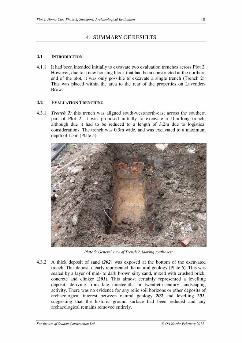
4.3.1 Trench 2: this trench was aligned south-west/north-east across the southern
part of Plot 2. It was proposed initially to excavate a 10m-long trench,
although due it had to be reduced to a length of 3.2m due to logistical
considerations. The trench was 0.9m wide, and was excavated to a maximum
depth of 1.3m (Plate 5).
Plate 5: General view of Trench 2, looking south-west
4.3.2 A thick deposit of sand (202) was exposed at the bottom of the excavated
trench. This deposit clearly represented the natural geology (Plate 6). This was
sealed by a layer of mid- to dark brown silty sand, mixed with crushed brick,
concrete and clinker (201). This almost certainly represented a levelling
deposit, deriving from late nineteenth- or twentieth-century landscaping
activity. There was no evidence for any relic soil horizons or other deposits of
archaeological interest between natural geology 202 and levelling 201,
suggesting that the historic ground surface had been reduced and any
archaeological remains removed entirely.

Plot 2, Hopes Carr Phase 2, Stockport: Archaeological Evaluation 11
For the use of Seddon Construction Ltd © OA North: February 2015
4.3.3 Levelling deposit 201 was overlain with demolition rubble (200), which
consisted of mid-greyish-brown sandy silt mixed with fragments of concrete,
crushed brick and plastic. The inclusion of modern material indicated a mid- to
late twentieth-century depositional date.
Plate 6: North-western section of Trench 2, looking south-east
4.3.4 No structures or features of archaeological interest survived in Trench 2. The
short sequence of demolition and levelling deposits that were revealed indicate
that the area had been heavily disturbed during the late nineteenth or twentieth
century, and any earlier archaeological remains had been destroyed entirely.

Plot 2, Hopes Carr Phase 2, Stockport: Archaeological Evaluation 12
For the use of Seddon Construction Ltd © OA North: February 2015
5. SIGNIFICANCE AND IMPACT
5.1 SIGNIFICANCE
5.1.1 The archaeological evaluation to the rear of Plot 2 has demonstrated clearly
that this part of the development site has been subject to considerable earth-
moving works in the late nineteenth or twentieth century, with the resultant
loss of any buried archaeological remains. There was no indication for buried
soil horizons, and no artefacts were recovered. It is thus concluded that the
rear part of Plot 2 is of low archaeological significance.
5.2 IMPACT
5.2.1 The results obtained from the evaluation trench demonstrate that there is little
or no potential for buried archaeological remains of interest to survive in-situ.
It is thus unlikely that any deep earth-moving works associated with the
proposed development would have a negative impact on the buried
archaeological resource, and it is considered unlikely that any further intrusive
investigation of Plot 2 is merited.

Plot 2, Hopes Carr Phase 2, Stockport: Archaeological Evaluation 13
For the use of Seddon Construction Ltd © OA North: February 2015
BIBLIOGRAPHY
CARTOGRAPHIC SOURCES
R Thornton's Map of Stockport, 1824
Ordnance Survey 6in to 1 mile Lancashire sheet 112, surveyed 1845, published 1850
Ordnance Survey 60in to 1 mile Stockport sheet 8, surveyed 1849, published 1851
Ordnance Survey 1:2500 Cheshire sheet X.15, revised 1872, published 1874,
reprinted 1893
Ordnance Survey 60in to 1 mile Stockport sheet WI, Second Edition, surveyed 1893,
published 1895
Ordnance Survey 1:2500 Cheshire sheet X.15, Edition of 1910, revised 1907,
published 1910
SECONDARY SOURCES
Arrowsmith, P, 1997 Stockport: A History, Stockport
Ashmore, O, 1975 The Industrial Archaeology of Stockport, University of Manchester
Dept of Extra Mural Studies
English Heritage, 1991 Management of Archaeological Projects, 2nd edn, London
English Heritage, 2006 Understanding Historic Buildings: A Guide to Good
Recording Practice, London
Hadfield, B, 1934-5 The Carr Silk Mill, Stockport, The Manchester School, 5, 124-8
Heginbotham, H, 1882 Stockport: Ancient and Modem, 2, London
McKnight, P, 1996 Christy’s Hat Works, Stockport: The Site, Buildings and Industrial
Processes from 1742 to 1996, unpubl thesis
OA North, 2013 Orchard Street Wing, Churchgate Mill, Lavenders Brow, Stockport:
Archaeological Building Investigation, unpubl rep
OA North, 2015 Plot 4, Hopes Carr Phase 2, Stockport: Archaeological Evaluation,
unpubl rep
United Kingdom Institute for Conservation (UKIC), 1990 Guidelines for the
preparation of archives for long-term storage, London
UMAU, 2004 Hopes Carr, Stockport: An Archaeological Desk-based Assessment,
unpbl rep

Plot 2, Hopes Carr Phase 2, Stockport: Archaeological Evaluation 14
For the use of Seddon Construction Ltd © OA North: February 2015
APPENDIX 1: PROJECT DESIGN
HOPES CARR,
STOCKPORT,
GREATERMANCHESTER
Archaeological BuildingRecording and Evaluation
Written Scheme ofInvestigation
OXFORD ARCHAEOLOGY NORTH
July 2013
Planning Permission DC043701
Seddon Construction Ltd
OA North Job No: T13131
NGR: 389955 390237

Plot 2, Hopes Carr Phase 2, Stockport: Archaeological Evaluation 15
For the use of Seddon Construction Ltd © OA North: February 2015
1. INTRODUCTION
1.1 PROJECT BACKGROUND
1.1.1 Seddon Construction Ltd is to carry out the redevelopment of land at Hopes
Carr in Stockport (centred on NGR 389955 390237). The site was occupied
formerly by a number of historic industrial premises, the archaeological
importance of which has been highlighted in a desk-based assessment of the
site that was produced by the former University of Manchester Archaeological
Unit (UMAU 2004). The survival of buried remains in part of the site was
confirmed during an initial archaeological evaluation of the site, which was
carried out in 2011 (OA North 2011).
1.1.2 Whilst considering an application for the next stage in the proposed
redevelopment of the site, Stockport Metropolitan Borough Council (SMBC)
has attached a series of conditions to planning approval (Planning Permission
DC043701). One of these conditions (Condition 7) aims to secure
archaeological interests, and reads:
‘No demolition or development shall take place within the area indicated on
Drawing 09-082-100 Location Plan (Scale 1:1250) until a programme of
archaeological works has been completed or carried out in accordance with a
Written Scheme of Investigation to be first submitted to and approved in
writing by the local planning authority.
Reason: In order to secure the provision of an archaeological excavation and
the subsequent recording of any remains in accordance with Policy HC3, "
PROTECTION OF ARCHAEOLOGICAL SITES", of the Stockport Unitary
Development Plan Review.’
1.1.3 The Heritage Management Director for the Greater Manchester
Archaeological Advisory Service (GMAAS), who provides planning advice
for SMBC, has recommended that a programme of intrusive investigation is
merited. The sites that should be targeted for investigation are those
highlighted in the desk-based assessment of the site that was completed in
2004 (UMAU 2004). In addition, it has been recommended that a former wing
of Churchgate Mill, which survives as a single-storey block but is proposed
for demolition, is subject to an archaeological building survey.
1.1.4 This Written Scheme of Investigation (WSI) has been formulated to meet the
requirements of the archaeological condition attached to outline planning
consent. It presents a scheme of archaeological building recording and
intrusive archaeological investigation, which allows for the excavation of a
series of targeted evaluation trenches across the proposed development Plots 2
and 4. The trenches will be intended to determine the extent, depth, character
and relative significance of any buried archaeological remains that survive, in
line with the National Planning Policy Framework, Paragraph 128. In the
event of significant archaeological remains being discovered in the trenches,
further archaeological investigation is likely to be required. Any such
additional works will be carried out in accordance with an Updated WSI.

Plot 2, Hopes Carr Phase 2, Stockport: Archaeological Evaluation 16
For the use of Seddon Construction Ltd © OA North: February 2015
1.2 OXFORD ARCHAEOLOGY
1.2.1 Oxford Archaeology is an educational charity under the guidance of a board of
trustees with over 35 years of experience in archaeology, and can provide a
professional and cost-effective service. We are the largest employer of
archaeologists in the country (we currently have more than 300 members of staff),
and can thus deploy considerable resources with extensive experience to deal with
any archaeological obligations you or your clients may have. OA is an Institute
for Archaeologists Registered Organisation (No 17). We have offices in Lancaster
and Oxford, trading as Oxford Archaeology North (OA North) and Oxford
Archaeology South (OA South) respectively, enabling us to provide a truly
nationwide service. All work on the project will be undertaken in accordance with
relevant professional standards, including:
• IfA’s Code of Conduct (1999); Code of Approved Practice for the
Regulation of Contractual Arrangements in Field Archaeology (1999);
Standard and Guidance for Archaeological Evaluations (1999);
• English Heritage’s Management of Archaeological Projects, 1991;
• The European Association of Archaeologists Principles of Conduct for
Archaeologists Involved in Contract Archaeological Work (1998).
1.2.2 OA North has unrivalled experience in the assessment, evaluation and
excavation of former industrial and associated residential sites, particularly in
the context of Manchester. We have an extensive portfolio of excavating the
buried remains of former textile mills in Manchester, including Salvins’
Factory, New Islington Mill, and Waller’s Mill as part of the New Islington
Millennium Village, Moore’s Mill on the New Islington Wharf development,
Peter Drinkwater’s Mill and Shepley Street Mill in Piccadilly, and the Bengal
Street Mill in Ancoats to name but a few. OA North has also carried out
several evaluations and excavations former textile-finishing works, including
the Adelphi Dye Works in Salford, Tootill Bleach Works near Bolton,
Springwater Printworks in Whitefield, and Tottington Printworks near Bury.
Plot 2, Hopes Carr Phase 2, Stockport: Archaeological Evaluation 17
For the use of Seddon Construction Ltd © OA North: February 2015
2. OBJECTIVES
2.1 The main research aim of the investigation, given the commercial nature of the
development, will be to provide a record of the surviving fabric of the wing of
Churchgate Mill that is to be demolished, and to establish the presence or
absence of buried archaeological remains on the site and, if present,
characterise the level of preservation and significance, and provide a good
understanding of their potential.
2.2 The objectives of the initial element of the archaeological investigation will be
to:
• to undertake a programme of archaeological intrusive investigation to
determine the presence, character, date, and extent of any buried
archaeological remains of interest, and establish their potential;
• to inform a decision as to whether further archaeological investigation
will be required in advance of development ground works;
• to compile an archival record of any archaeological remains within the
development area.

Plot 2, Hopes Carr Phase 2, Stockport: Archaeological Evaluation 18
For the use of Seddon Construction Ltd © OA North: February 2015
3. METHOD STATEMENT
3.1 ARCHAEOLOGICAL BUILDING RECORDING
3.1.1 Following consultation with GMAAS, it has been recommended that an
archaeological building investigation commensurate with an English Heritage
Level 2/3-type survey should be carried out of the single-storey wing of
Churchgate Mill, which will be demolished as part of the proposed
development.
Recent aerial view of the former wing of Churchgate Mill, marking the buildings of interest
3.1.2 Photographic Archive: a photographic archive will be produced utilising a
high-resolution digital camera. A full photographic index will be produced and
the archive will comprise the following:
(i) the external appearance and setting of the buildings, including a
mixture of general shots and detailed views taken from perpendicular
and oblique angles;
(ii) general shots of the surrounding landscape;
(iii) the general appearance of principal rooms and circulation areas;
(iv) any external or internal detail, structural or architectural, which is
relevant to the design, development and use of the buildings and which
does not show adequately on general photographs;
(v) any internal detailed views of features of especial architectural interest,
fixtures and fittings, or fabric detail relevant to phasing the buildings.
3.1.3 Site Drawings: existing plans (if available) will be annotated on site to
produce the drawings. These drawings will then be used as the basis of CAD
drawings, which will be included within the final report as figures:

Plot 2, Hopes Carr Phase 2, Stockport: Archaeological Evaluation 19
For the use of Seddon Construction Ltd © OA North: February 2015
(i) a ground-floor plan for the building;
(ii) a cross-section through the short axis of the buildings;
(iii) principal elevations.
3.1.4 Where existing drawings are not available (eg for cross-sections and
elevations), the following survey techniques will be applied as appropriate:
• Reflectorless Electronic Distance Measurer (REDM) survey: the
proposed elevations and cross-sections will be surveyed by means of a
reflectorless electronic distance measurer (REDM). The REDM is
capable of measuring distances to a point of detail by reflection from
the wall surface, and does not need a prism to be placed. The
instrument to be used will be a Leica TCR805. This emits a viable laser
beam, which can be visually guided around points of detail. The digital
survey data will be captured within a portable computer running
TheoLT software;
• Detail captured by the instrument survey will include such features as
window and door openings, evidence for power transmission, outline
of decorative detail, evidence for machinery, an indication of ground
and ceiling level, and changes in building material. The drawings will
usually be produced at a scale of 1:50. The existing drawings will be
digitised into an industry standard CAD package (AutoCAD MAP
2004) for the production of the final drawings;
• Photographic Survey Techniques: large elements of the principal
elevation can be captured by a process of rectified photography. These
photographs will be tied into the survey data produced by the
instrument survey, to produce more a detailed elevation drawing;
• Manual Survey Techniques: hand-measured survey techniques will be
utilised to record areas that are not accessible for instrument or
photographic survey. The drawings will be tied into the remained of the
survey through the use of a survey control established by the
instrument survey;
• CAD System: the drawings will be manipulated in AutoCAD MAP
2004. The advantage of a CAD system is that it allows for efficient
manipulation and editing of drawings. The adoption of a layering
system has significant benefits during the analysis stage as it allows for
the display of information such as feature types, fabric and phasing as
necessary to the requirements of the analysis, without the necessity to
produce further drawings;
• Visual Inspection: a visual inspection of the buildings will be
undertaken utilising the OA North building investigation pro forma
sheets. A description will be maintained to English Heritage (2006)
Level 2/3 standard. The records will be essentially descriptive and
provide a systematic account of the origin, development and use of the
building, which will include a description of the plan, form, fabric,
function, age and development sequence of the complex.

Plot 2, Hopes Carr Phase 2, Stockport: Archaeological Evaluation 20
For the use of Seddon Construction Ltd © OA North: February 2015
3.2 TRENCHING RATIONALE
3.2.1 The Hopes Carr site has been divided into five development plots. The first of
these, Plot 1, was developed in 2011-12, following an archaeological
investigation of an early textile mill. Of the remaining plots (Plots 3 – 5; Fig
1), the desk-based assessment concluded that Plot 3 was unlikely to have any
archaeological potential, and has thus been omitted from the proposed scheme
of archaeological investigation. Plots 2 and 4 clearly merit investigation,
although this is likely to be carried out in separate stages, commencing with
Plot 2. The final plot (Plot 5) may also require archaeological investigation,
although this will be covered in a separate Written Scheme of Investigation,
which will also allow for an assessment of the extant Churchgate House.
3.2.2 Plot 2: the archaeological interest in Plot 2 is focused on the site of
demolished buildings that are shown on historical mapping to have formed an
L-shaped group extending from No 66a Churchgate eastwards to Lavenders
Brow. A building is shown in this location on the 1750 plan of the Glebe,
whilst the other buildings are depicted on a map of 1824.
3.2.3 It is proposed that Plot 2 is investigated in the first instance via the excavation
of two trenches. Trench 1 will be placed across the footprint of the buildings
that fronted onto Churchgate. The trench will be aligned broadly north-
west/south-east, and will be excavated for a distance of 15m (Figs 2-4).
Trench 2 will be 10m long, and will investigate the area to the rear of the
properties, which may have been the vestiges of medieval burgage plots, and
insubstantial structures shown on historical mapping to have occupied the end
of these plots (Figs 2-4).
3.2.4 Plot 4: this plot is occupied currently by the reduced remains of a wing of
Churchgate Mill, a steam-powered textile factory that had been established
before 1807. This wing is to be demolished, once an archaeological survey has
been completed. The mill is shown on the map of 1824 as a square-shaped
block, whilst a plan of 1842 shows a four-storey factory on Orchard Street and
a smaller factory of the same height at the north end. Another building formed
part of a north range running along Lavenders Brow. The map also shows a
narrow east range of three storeys, which abutted another three-storey block
that housed the mill’s steam-power plant; these latter two blocks lie within the
footprint of the proposed development in Plot 4, and will be targeted by the
archaeological evaluation (Figs 2-4).
3.2.5 The footprint of the mill will be investigated initially via the excavation of
three trenches. Trench 3 will be placed approximately north-east/south-west
across the mill block that fronted onto Orchard Street, and will be excavated
for a distance of 15m (Figs 2-4). Trench 4 will measure 30m long, and will be
placed across the mill’s east range and along the footprint of the southern
range. Trench 5 will be excavated for a distance of 15m, and will be aligned
north-west/south-east to investigate the remains of the mill’s steam-power
plant and chimney.

Plot 2, Hopes Carr Phase 2, Stockport: Archaeological Evaluation 21
For the use of Seddon Construction Ltd © OA North: February 2015
3.3 EVALUATION TRENCHING
3.3.1 In all trenches, the excavation of the modern ground surface will be
undertaken by a machine of appropriate power using a toothless ditching
bucket to the top of the first significant archaeological level. The work will be
supervised closely by a suitably experienced archaeologist. Spoil from the
excavation will stored adjacent to the trench, and will be backfilled upon
completion of the archaeological works. Thereafter, all archaeological deposits
will be cleaned manually to define their extent, nature, form and, where
possible, date. It should be noted that no archaeological deposits will be
entirely removed from the site. If the excavation is to proceed below a depth of
1.2m, then the trenches will be widened sufficiently to allow the sides to be
stepped in.
3.3.2 All information identified in the course of the site works will be recorded
stratigraphically, using a system adapted from that used by the Centre for
Archaeology Service of English Heritage. Results of the evaluation will be
recorded on pro-forma context sheets, and will be accompanied with sufficient
pictorial record (plans, sections and both black and white and colour
photographs) to identify and illustrate individual features. Primary records will
be available for inspection at all times.
3.3.3 Context Recording: all contexts will be recorded using pro-forma sheets, and
details will be incorporated into a Harris matrix. Similar object record and
photographic record pro-formas will be used. All written recording of survey
data, contexts, photographs, artefacts and ecofacts will be cross-referenced
from pro-forma record sheets using sequential numbering.
3.3.4 Photography: a full and detailed photographic record of individual contexts
will be maintained and similarly general views from standard view points of
the overall site at all stages of the evaluation will be generated. Photography
will be undertaken using 35mm cameras on archivable black and white print
film, and all frames will include a visible, graduated metric scale. Extensive
use of digital photography will also be undertaken throughout the course of the
fieldwork for presentation purposes. Photographs records will be maintained
on special photographic pro-forma sheets.
3.3.5 Planning: the precise location of the evaluation trench will be surveyed by
EDM tacheometry using a total station linked to a pen computer data logger.
This process will generate scaled plans within AutoCAD, which will then be
subject to manual survey enhancement. The drawings will be generated at an
accuracy appropriate for 1:20 scale, but can be output at any scale required.
Sections will be manually drafted as appropriate at a scale of 1:10. All
information will be tied in to Ordnance Datum.
3.3.6 Human remains are not expected to be present, but if they are found they will,
if possible, be left in-situ covered and protected. If removal is necessary, then
the relevant Home Office permission will be sought, and the removal of such
remains will be carried out with due care and sensitivity as required by the
Burials Act 1857.

Plot 2, Hopes Carr Phase 2, Stockport: Archaeological Evaluation 22
For the use of Seddon Construction Ltd © OA North: February 2015
3.3.7 Any gold and silver artefacts recovered during the course of the excavation
will be removed to a safe place and reported to the local Coroner according to
the procedures relating to the Treasure Act, 1996.
3.3.8 Finds policy: finds recovery and sampling programmes will be in accordance
with best practice (following current Institute for Archaeologists guidelines)
and subject to expert advice in order to minimise deterioration. OA North
employs in-house artefact and palaeoecology specialists, with considerable
expertise in the investigation, excavation, and finds management of sites of all
periods and types, who are readily available for consultation. Finds storage
during fieldwork and any site archive preparation will follow professional
guidelines (UKIC). Emergency access to conservation facilities is maintained
by OA North with the Department of Archaeology, the University of Durham.
OA North employs palaeoecology and soil micromorphology specialists with
considerable expertise in the investigation, excavation and analysis of sites of
all periods and types, who are readily available for consultation.
3.4 HEALTH AND SAFETY
3.4.1 Full regard will be given to all constraints during the course of the project. OA
North provides a Health and Safety Statement for all projects and maintains a
Safety Policy. All site procedures are in accordance with the guidance set out
in the Health and Safety Manual compiled by the Standing Conference of
Archaeological Unit Managers.
3.4.2 OA North undertakes to safeguard, so far as is reasonably practicable, the
health, safety and welfare of its staff and of others who may be affected by our
work. OA North will also take all reasonable steps to ensure the health and
safety of all persons not in their employment, such as volunteers, students,
visitors, and members of the public (this includes trespassers).
3.4.3 OA North is fully familiar with and will comply with all current and relevant
legislation, including, but not limited to:
• The Health and Safety at Work Act (1974);
• Management of Health and Safety at Work Regulations (1999);
• Manual Handling Operations Regulations 1992 (as amended in 2002);
• The Construction (Design and Management) Regulations (2007);
• The Control of Asbestos Regulations (2006);
• Construction (Health, Safety and Welfare) Regulations (1996);
• The Health and Safety (Miscellaneous Amendments) Regulations
(2002);
• The Work at Height Regulations (2005);
• The Health and Safety (First-Aid) Regulations (1981);
• The Provision and Use of Work Equipment Regulations (1998);
• Lifting Operations and Lifting Equipment Regulations (1998).
3.4.4 OA North has professional indemnity to a value of £2,000,000, employer's
liability cover to a value of £10,000,000 and public liability to a value of
£15,000,000. Written details of insurance cover can be provided if required.

Plot 2, Hopes Carr Phase 2, Stockport: Archaeological Evaluation 23
For the use of Seddon Construction Ltd © OA North: February 2015
3.4.5 Normal OA North working hours are between 9.00 am and 5.00 pm, Monday
to Friday, though adjustments to hours may be made to maximise daylight
working time in winter and to meet travel requirements.
3.5 PROJECT MONITORING
3.5.1 The aims of monitoring are to ensure that the archaeological works are
undertaken within the limits set by the Written Scheme of Investigation, and to
the satisfaction of the curatorial archaeologist at the Greater Manchester
Archaeological Advisory Service (GMAAS). The curatorial archaeologist will
be given at least five days’ notice of when work is due to commence, and will
be free to visit the site by prior arrangement with the project director. It is
anticipated that there will be at least one formal monitoring meeting during the
course of the evaluation.
3.6 POST-EXCAVATION AND REPORT PRODUCTION
3.6.1 Report: a report will be produced within four working weeks of the completion
of the fieldwork, and will include:
• a summary statement of the findings;
• the background to the archaeological investigation;
• an outline of the methodology of the survey;
• a description of the site’s setting, including topography and geology;
• an account of the documented historical background to the site;
• a summary, assessment, and interpretation of the results of the building
survey and the evaluation;
• an assessment of any finds and samples recovered from the trenches;
• a description of the significance of the site in its local and regional
context;
• recommendations for any further archaeological investigation that is
considered merited to mitigate the impact of the development works;
• a catalogue of archive items, including a list of photographs, and
details of the final deposition of the project archive.
3.6.2 Archive: the results of the archaeological investigation will form the basis of a
full archive to professional standards, in accordance with current English
Heritage guidelines (The Management of Archaeological Projects, 2nd edition,
1991) and the Guidelines for the Preparation of Excavation Archives for Long
Term Storage (UKIC 1990). The project archive represents the collation and
indexing of all the data and material gathered during the course of the project.
The deposition of a properly ordered and indexed project archive in an
appropriate repository is considered an essential and integral element of all
archaeological projects by the IfA in that organisation’s code of conduct. As
part of the archiving process, the on-line OASIS (On-line Access to Index of
Archaeological Investigations) form will be completed.

Plot 2, Hopes Carr Phase 2, Stockport: Archaeological Evaluation 24
For the use of Seddon Construction Ltd © OA North: February 2015
3.6.3 The paper and finds archive for the archaeological work undertaken at the site
will be deposited with Stockport Museum. This archive can be provided in the
English Heritage Centre for Archaeology format, both as a printed document
and on CD (as appropriate). The archive will be deposited with the museum
within six months of the completion of the fieldwork. Except for items subject
to the Treasure Act, all artefacts found during the course of the project will be
donated to the receiving museum.
3.7 DISSEMINATION
3.7.1 It may be anticipated that the results obtained from the archaeological
investigation will merit a level of publication commensurate with their
significance. Whilst the appropriate form of publication cannot be established
until the fieldwork element of the project has been completed, it is likely that
the presentation of the results in a dedicated volume of the ‘Greater
Manchester’s Past Revealed’ series will be an appropriate output.
4. WORK TIMETABLE
4.1 A five-day period should be allowed to complete the archaeological buildingsurvey.
4.2 An eight-day period should be allowed to excavate and record all theevaluation trenches, although this is unlikely to be carried out as a continuousprogramme of work. On the first day of the fieldwork, OA North willaccurately locate through measured survey the exact position of the trenches tobe excavated. The trench locations will then be scanned for live services with aCAT prior to any mechanical excavation.
4.3 In the event of significant archaeological remains being discovered in theevaluation trenches, a programme of further investigation may be anticipated.The time required for any additional investigation cannot be determined untilthe results of the evaluation are known.
4.4 A report will be submitted within four weeks of the completion of thefieldwork.
5. STAFFING PROPOSALS
5.1 The project will be under the overall charge of Ian Miller BA FSA (OA North
Senior Project Manager) to whom all correspondence should be addressed. Ian
has over 20 years experience of commercial archaeology, and has a particular
interest in the archaeology of the Industrial Period, and particular that of
Greater Manchester and Lancashire. He managed the excavation of the
Percival, Vickers & Co Flint Glass Works in Manchester, and was responsible
for managing the archaeological elements of the Murrays’ Mills Major Repairs
Project in Manchester. He has also managed many other evaluations and
excavations of former industrial sites in Manchester.
Plot 2, Hopes Carr Phase 2, Stockport: Archaeological Evaluation 25
For the use of Seddon Construction Ltd © OA North: February 2015
5.2 His role will be to ensure that the Written Scheme of Investigation is
implemented within the framework of the Project Objectives. He will be
responsible for all aspects of staff and resource logistics, ensuring the smooth
running of the project programme. He will liase with the Client and GMAAS
with regard to progress, and will maintain relationships with other contractors.
5.3 The fieldwork is likely to be undertaken by Graham Mottershead BA (OA
North Project Officer). Graham is an highly experienced field archaeologist,
with over 20 years continuous experience of field archaeology. It is not
possible to provide details of specific technicians that will be involved with the
fieldwork at this stage, but all shall be suitably qualified archaeologists with
proven relevant experience. It is anticipated that up to two technician will be
required for the initial stage of the fieldwork.
5.4 Assessment of any finds recovered from the evaluation will be undertaken by
OA North's in-house finds specialist Christine Howard-Davis BA (OA North
Finds Manager). Christine has extensive knowledge of all finds of all periods
from archaeological sites in northern England, and is a recognised expert in the
analysis of post-medieval artefacts.

Plot 2, Hopes Carr Phase 2, Stockport: Archaeological Evaluation 26
For the use of Seddon Construction Ltd © OA North: February 2015
ILLUSTRATIONS
LIST OF FIGURES
Figure 1: Trench location plan
Figure 2: Trench location plan

