planning for freight on inland waterways · of inland waterways for freight transport. it is...
TRANSCRIPT

Planning for Freight on Inland Waterways
Freight

Acknowledgements
The Association of Inland Navigation Authorities (AINA)commissioned this Guide on behalf of the Department forTransport and the Department for Environment, Food andRural Affairs.
The Office of the Deputy Prime Minister was consultedduring the production of the Guide.
The following organisations were involved in theAINA project steering group:
• Associated British Ports
• Association of Inland Navigation Authorities
• British Waterways
• Department for Environment, Food and Rural Affairs
• Department for Transport
• Environment Agency
• Inland Waterways Association
• Local Government Association
• Maritime and Coastguard Agency
• Port of London Authority/United Kingdom Major PortsGroup
• Commercial Boat Operators’ Association
The following organisations were also consultedduring the production of the Guide:
• Association of Inland Shipping Operators
• East Riding of Yorkshire Council
• Fenland Waterways Partnership
• Greater Manchester Local Transport Planning team
• Humber Barges
• KD Marine
• Kingston Upon Hull City Council
• Manchester Ship Canal Company
• North Yorkshire County Council
• North West Regional Assembly
• Sea and Water
• Stockport Borough Council
• Stroud District Council
• Trafford Metropolitan Borough Council
• Wakefield Metropolitan District Council/West YorkshireLTP group
• Worcester City Council
MDS Transmodal and Atkins prepared the Guide on AINA's behalf.

Contents
Why this Guide? 3
How this Guide is Organised 3
1 Introduction to Inland Waterways 4
2 Waterborne Freight and its Potential 6
3 Participating in the Planning System: 10How to Influence Positive Outcomes for Waterborne FreightA Introduction to the Planning System in England 10B Commenting on Planning Policy 11C Planning Applications 14
4 Other Planning Tools 18
5 Effective Planning for Freight Transport on Inland Waterways 21
6 Good Practice Case Studies 291 Regional Planning Guidance for Yorkshire and the Humber 302 Effective Partnership for Promoting Sustainable Transport; Promoting Modal Interchange 32
Between Short Sea Shipping/Road/Rail/Inland Waterways3 The Planning Hierarchy at Work - Safeguarding Dunball Wharf 344 London Wharf Safeguarding 365 Non-Transport Policies Protecting Wharves and Potential Waterway Users 386 Noise Sensitive Development Near Wharves 407 Yorkshire Evening Press 418 Need for Conditions on Planning Permissions, Grand Union Canal Aggregates Traffic 429 West Yorkshire Local Transport Plan 4310 Regeneration of Diglis Basin, River Severn,Worcester 44
7 Planning the Way Forward for Waterborne Freight 46
Appendices 47A1 Background 47A2 Existing National Planning Policy Guidance from a Waterborne Freight Perspective 50A3 Funding 59A4 Health and Safety 61A5 Bibliography 63A6 Useful Contacts 65
1

2

Why this Guide?
The Government wants to encourage more freight to travelby water instead of road where this makes sense.
To achieve this will often require engagement with theplanning process. It is vitally important that the planningprocess is used effectively.
This Good Practice Guide has been produced for theGovernment by the Association of Inland NavigationAuthorities to show, through practical advice and examples,how good planning can help support and encourage the useof inland waterways for freight transport.
It is designed to help policy makers and planners, bodiesresponsible for the management and use of waterways,carriers, regional development agencies and any otherbodies with an interest in exploiting the potential of inlandwaterways.
Case studies highlight how different organisations haveworked together to resolve specific issues by implementinggood practice.
How this Guide is Organised
This Guide is divided into seven chapters. Each chapter canbe read in isolation or as part of the overall Guide.
Chapter 1 describes the main characteristics of theinland waterways of England and Wales, in particularthose relevant to their use for freight transport;
Chapter 2 describes the current and future potentialof the inland waterways for freight transport. It alsoincludes an overview of modal interchanges and theirbenefits;
Chapter 3 is divided into three sub-sections:
A Introduction to the Planning System in England -an overview of the current system at a national,regional and local level;
B Commenting on Planning Policy - details of howan individual or body can comment at differentstages of the development of planning policy.This section also includes a brief introduction tothe proposed reform of the planning system;
C Planning Applications - describes how to submit aplanning application and how to object to alodged application;
Chapter 4 describes the other tools, in addition toplanning policy measures and guidance, available toplanners to promote the use of inland waterways forfreight transport;
Chapter 5 describes the policy and practical issuesthat can be implemented to encourage freighttransport by water. These include effective policyformulation, effective development control,partnerships, and encouraging the public sector to usethis mode of transport;
Chapter 6 includes ten case studies describing howdifferent organisations have worked together toresolve specific issues by implementing good practice;
Chapter 7 summarises how communication and goodplanning can encourage freight transport by water.
The Guide also contains a number of appendices:
Appendix 1 describes the background to the Guideand includes an extract from the Government’sresponse to the Freight Study Group’s report Freight
on Water - A New Perspective;
Appendix 2 contains extracts from the variousPlanning Policy Guidance notes that are relevant to thecarriage of freight by water. Some of these policies areactually targeted at inland waterway freight transport;others are applicable but intended for a widerapplication;
Appendix 3 includes details of the fundingopportunities available to promote freight transport bywater. Although often not the direct responsibility ofLocal Authorities, an awareness of these opportunitieswill help authorities and other agencies promotewaterborne transport within their areas;
Appendix 4 describes the relevant legislation andregulations that apply to handling goods and navigatingvessels on the inland waterways;
Appendix 5 is a bibliography that contains details ofall texts referred to in the preparation of this guide;
Appendix 6 lists useful contacts.
3

1 Introduction to InlandWaterways
This Chapter describes the main characteristics of the inlandwaterways of England and Wales, in particular those relevantto their use for freight transport.
1.1 The inland waterways of England and Wales areextremely diverse and comprise a wide variety ofnatural and artificial watercourses and other waters.Currently, there are approximately 5,100km of fullynavigable waterways in England and Wales. Most of thesystem (4,650km) is non-tidal and consists mainly ofcanals, and rivers that have been made navigable. Thetidal waterways consist mainly of naturally navigablerivers and their estuaries.
1.2 There is no national governing body for the inlandwaterways. About half (approximately 2,600km) ofthe navigable system is managed by British Waterways,and a further quarter by the Environment Agency(approximately 1,000km) or by the Broads Authority(approximately 160km). The remainder is theresponsibility of about 27 other Navigation Authoritiesdrawn from the public, private and voluntary sectors.
1.3 Port or harbour authorities often manage the majortidal waterways. As with the inland waterways, thereis no central governing authority for ports. They areoperated and regulated by a variety of bodies includingprivate companies, port and harbour trusts, LocalAuthorities and Government bodies.
1.4 In England and Wales there are four main categories ofwaterway:
Estuaries and tidal rivers;
Large non-tidal waterways;
Broad waterways;
Narrow canals.
1.5 The Department for Transport Benchmark Report for200236 contains details of the navigable waterwayscovered by the traffic statistics published byGovernment, listing them by type of authority, type ofwaterway, classification etc. The Benchmark report is avery detailed inventory of waterway track, a list of thewharves and jetties that could be used for handlingfreight and an inventory of waterway craft. It is avaluable tool for planners who can consult a single
reference source to see what facilities there areavailable in their areas. The main characteristics ofthese waterways are summarised in Table 1. Waterwaydimensions vary considerably, which has acorresponding effect on the size of vessel that can beaccommodated.
1.6 All types of waterway have some potential for use forfreight transport. Generally the large waterways withaccess to ports and the coast will have the greatestpotential for carrying significant volumes of freight.The broad waterways and narrow canals are lesssuitable but may nevertheless be suitable for localised,specialist markets.
4
The Manchester Ship Canal extends 35 miles from Eastham on the RiverMersey to Manchester. The Canal can accommodate seagoing ships of up to8,000 tonne cargo capacity in its upper reaches. The lower reaches of the Canalaccommodate much larger vessels that serve the petroleum and chemicalindustries along its banks at Stanlow and Ellesmere Port. In 2002 the Canalhandled 6.7 million tonnes of cargo. Runcorn Docks is a busy small port on theCanal specialising in handling bulk commodities for the potteries amongst otherindustries. In 2002 it handled 350,000 tonnes of minerals, sands and fertilizer.Runcorn is a good example of the type of small port that can make a largecontribution to the sustainable transport agenda for a local hinterland. Theplanning system needs to ensure the continuation of facilities of this kind bytaking positive steps to encourage and facilitate appropriate industrial location.(Source: Manchester Ship Canal Company)

1.7 Waterways have four characteristics that areparticularly relevant in considering their use for freighttransport:
Waterways are corridors. It is rare for one to lieentirely within the area of a single LocalAuthority. Action by neighbouring authoritiesneeds to be carefully co-ordinated to avoidinterruption to the corridor, which would make itunusable for freight transport;
Wharves are necessary for the loading andunloading vessels and for the onward distributionof cargoes;
Waterways are almost always singular routes. Itis very unusual for an alternative waterway forfreight transport to exist that can be used whenthe main route is temporarily or permanentlyblocked;
Most non-tidal waterways are nowpredominantly used for leisure purposes. Carefulmanagement by Navigation Authorities is
required to make sure that both freight andleisure use can co-exist, especially in the case ofthe smaller waterways.
1.8 These factors mean that waterways are vulnerable toill-considered development, or poor management ofinfrastructure crossing the waterway. The ability of awaterway to be used for freight depends on:
The whole corridor being respected;
The loading and unloading facilities beingprotected;
The corridor not being interrupted for non-navigational reasons, either temporarily orpermanently.
5
Table 1: Waterway Categories and Characteristics
Category Characteristics Other Roles Management Examples
Estuaries and • Channel size determines size of vessel • Maritime and port uses • Generally port and • River Thamestidal rivers • Seagoing traffic extending journey inland, • Land drainage harbour authorities • Mersey Estuary
reducing length of road journey • Aggregate extraction • River Trent• Traffic moving between tidal and non-tidal water • Some leisure use • River Yare• Suitable for bulk carriage and containers • River Ouse• Suitable for abnormal indivisible loads • River Medway
Large non-tidal • Lock size determines craft size • Land drainage • British Waterways • Aire & Calder waterways • Lock size considerably larger than broad • Some leisure use • Manchester Ship Navigation
waterways Canal Company • River Weaver• Vessel payload in hundreds of tonnes • Environment Agency • River Severn• Seagoing traffic extending journey inland, if lock • Manchester Ship Canal
size sufficient • River Thames• Traffic moving between tidal and non-tidal water • Gloucester &• Suitable for bulk carriage, may be suitable for Sharpness Canal
containers• Suitable for abnormal indivisible loads
Broad • Locks approx 4.5 metres wide and up to • Significant leisure use • British Waterways • Grand Union CanalWaterways 30 metres long which may restrict • Environment • Leeds & Liverpool
• Vessel payload 50 to 100 tonnes capacity for freight Agency Canal• Suited to specialist markets, • Land drainage • River Great Ouse
e.g. aggregates, waste • Leisure use of towpath• Not suitable for abnormal indivisible loads• Unlikely to be suitable for containers
Narrow Canals • Locks approx 2.1 metres by 21 metres • Significant leisure use • Mostly British • Trent & Mersey Canal• Vessel payload typically 20-25 tonnes which may restrict Waterways • Oxford Canal• Long lock free lengths may accommodate capacity for freight • Monmouthshire
larger vessels • Land drainage & Brecon Canal• Not suitable for abnormal indivisible loads • Leisure use of towpath • Birmingham Canal
or containers Navigations

2 Waterborne Freight andits Potential
This Chapter describes the current and future potential ofthe inland waterways for freight transport. It also includesan overview of modal interchanges and their benefits.
2.1 It is Government policy to promote alternatives toroad transport for both passenger and freightmovements. This is partly to reduce congestion andpartly to reduce the environmental impact of roadtransport. Inland waterways have the potential toassist in both these objectives.
2.2 Currently, most of the freight traffic carried on theinland waterways is ‘traditional’, that is high bulk, lowvalue, and non-urgent. Examples include coal, fuel oil,aggregates, steel, timber, grain and waste.
2.3 49 million tonnes of cargo were moved on the UKinland waters in 200237. Four million tonnes of thiswas purely internal, i.e. within the inland waterwaysystem. Dry bulks dominate this traffic and aggregates(sand, gravel and stone) form the greatest volumetransported by inland waterways.
2.4 Encouraging more freight traffic on inland waterwayslargely depends on the potential future demand forthese movements. Evidence given to the House ofCommons Environment,Transport and Rural AffairsCommittee (ETRAC)38 suggested that there issignificant traffic potential. One barge company claimedthat, “without trying at all”, there was half a milliontonnes of freight that could be transferred from roadtransport and that the Aire & Calder Navigation couldquite easily take 2,000 lorries a day off local roads.
2.5 The Freight Study Group’s Report Freight on Water: A
New Perspective22 identified the traffics seen as havingmost potential on a number of waterways. These areshown in Table 2.
2.6 The majority of these are high bulk and low valuecommodities. Some are hazardous and better suitedto carriage by barge or rail than road. Others, such aswaste and recyclables, are carried on behalf of thepublic sector in a highly regulated market.
2.7 The potential for moving containerised goods couldalso be added to this list, in particular, the coastalfeeder movement of deep-sea containers, or as part of
a supply chain into waterside premises or a watersidemulti-modal freight interchange. For example, PeelHoldings is developing plans for Port Salford, a tri-modal freight village on the upper reaches of theManchester Ship Canal. This type of developmentcould help Planning Authorities achieve sustainabledistribution targets since it links distributionwarehouses to both water and railways. Promotingmodal interchange between inland waterways andother modes is discussed below.
6
‘Rix Eagle’ loaded with 500 tonnes of gas oil from Immingham seen here passingthrough Lemonroyd Lock on the Aire and Calder Navigation en route to BayfordFuels depot at Fleet, near Leeds. Petroleum products and other liquid bulks areparticularly suited to waterway transport because they are easy to pump in andout of barges directly to or from waterside tank storage facilities. Waterbornefreight is a safe and reliable mode of transport for such hazardous cargoes. Thisbarge is saving around 42 road tanker trips between Immingham and Leeds:clearly a more environmentally sustainable means of freight transport. This trafficis another example of Government assistance in the form of a Freight FacilitiesGrant (to Bayford Fuels) making a contribution to modal shift from road to water.(Source: Mike Brown)
Table 2: Commodities Identified by the Freight Study Group’sReport as Having Most Potential on Particular Waterways
Route Commodity
Tidal River Thames, Waste and recyclables, aggregates,London Canals construction materials, scrap,
containerised traffic
Mersey Docks & Harbour, Bulk liquids, aggregates, minerals, scrapManchester Ship Canal,River Weaver
Aire & Calder Navigation Aggregates, waste, petroleum,chemicals, fertiliser
River Trent Aggregates, petroleum
River Ouse Aggregates, waste, timber
Calder & Hebble Navigation Aggregates

2.8 The transport of abnormal indivisible loads (AILs) oninland waterways is an area that has generated someinterest in recent years. Moving AILs by water (forexample to power stations) offers environmentalbenefits and avoids the significant traffic disruptioncaused by large slow-moving road vehicles.
2.9 Transport of waste by water has stimulated the mostrecent interest in using waterways for freight. TheRiver Thames is the only inland waterway in thecountry presently carrying significant quantities ofwaste materials. On average, 2,500 tonnes per day ofmunicipal waste is loaded onto barges and taken tolandfill sites in Essex. One tug and barge convoyjourney is the equivalent of 40 to 50 lorry journeys.This traffic, being low value, bulky and non-urgent isideal for transport by water.
2.10 Research carried out by the Resource RecoveryForum – Inland Waterways and the Transport of Waste39
concluded, “in environmental terms, transport of waste on
the Thames has historically performed better than road
transport”.
2.11 British Waterways considers that waste is an area oftraffic growth potential in both London and its NorthEast region. Studies have been carried out on theSevern and, by Peel Holdings, on the Manchester ShipCanal to investigate the potential for the transport ofwaste on these waterways.
2.12 The Freight Study Group’s report22 considered thatthere is scope to increase the use of the traditionalnarrow and broad canals for freight movement.Domestic fuel, scrap, waste, canal maintenance andwaterside site construction material and aggregatesprovide some existing traffic and potential for growth.The Group believed that these canals have thepotential to reduce commercial vehicles traffic in citycentres and residential areas. Water runs through theheart of many cities and large centres of populationsuch as London, Birmingham, Manchester, Nottingham,Coventry and Milton Keynes. One option is theestablishment of transhipment points close to where aring road crosses the waterway. Goods could then becarried through the urban centre by water and betranshipped again for onward distribution by road.
Promoting Modal InterchangeBetween Short Sea Shipping, Road,Rail and Inland Waterways
Modal interchange takes place at terminals thataccommodate two or more transport modes. Traditionallythe ports have provided the first step in the exchange fromsea freight to inland distribution by road and rail.
2.13 The Government has been clear in its support formodal interchange with its policies for sustainabledistribution. For example, Sustainable Distribution: A
Strategy31 describes a framework for major freightinterchanges that will:
7
Waddington’s ‘Lonsdale’ having just arrived at AMA Rotherham with 300 tonnesof Lithuanian steel loaded the previous day at Goole (ex ship). It was part of aconsignment of over 1,500 tonnes on this occasion. Baltic States steel is aregular traffic to AMA Rotherham, along with fluorspar and nickel. Althoughaggregates, grain and petroleum products are commodities commonly carried bybarge, this steel traffic demonstrates that barges are not restricted to carryingbulk cargoes. Given appropriate industrial location and attention to safeguardingviable wharf sites, waterway freight transport can make a significant contributionto sustainable transport. (Source: Mike Brown)
Cory Environmental tug pulling a pair of dumb barges carrying containers ofhousehold refuse that have been loaded at one of four waterside waste transferstations further upstream on the River Thames. The company is one of the UK’sleading waste management companies operating in over 30 locations. Corytransports over 600,000 tonnes of waste a year on the River Thames fordisposal in Essex. This constitutes 15% of London’s overall waste and keeps over100,000 lorry movements off the capital’s congested streets. (Source: Port ofLondon Authority)

Promote their contribution to national andregional competitiveness;
Improve their operational and environmentalperformance;
Encourage the full use of existing interchangefacilities;
Promote the best environmental standards fornew developments.
A key part of this strategy is to improve theintegration of the road network with major transportinterchanges so as to promote greater use of rail andwater transport for freight.
2.14 Clearly, locating logistics centres (groups ofdistribution or warehousing buildings) adjacent toports, waterways and railheads will promotesustainable distribution.
2.15 This type of grouping will allow individual warehousesto benefit from the overall scale of business providedby its neighbours. This could in turn, justify a range ofdirect rail or shipping services to be offered from asingle location.
2.16 There is already some policy support for this type ofregional logistics site. For example, the West MidlandsRegional Planning Guidance (RPG11)12 considers thespatial implications of increasing activity inwarehousing and distribution in relation to strategicemployment and traffic impact.
2.17 The North West Regional Freight Strategy (RFS)24
recognises that a number of intermodal terminals, rail-linked warehouses and distribution centres need to bedeveloped at key locations around the region, tocontribute to a wider UK and European network ofsimilar facilities. The combined effects of few ideallocations, long lead times to cover land acquisition, theplanning process, infrastructure construction etc.,could mean that demand outstrips capacity supply ofthese type of terminals. Clearly, it is desirable thatearly delivery of additional terminal capacity isfacilitated. The RFS points out that the location ofsuch terminal developments will be market led, itincludes a set of location criteria recommended forinclusion within Regional Planning Guidance. Thefollowing criteria are orientated towards rail terminalsbut they provide a useful frame of reference for similarcriteria to be established for road/water orroad/rail/water sites:
Accordance with the Spatial DevelopmentFramework Policies SD1-SD9 and Policy EC7(Warehousing and Distribution) as set out inRPG13, and the North West DevelopmentAgency’s (NWDA) Economic Strategy 2003;
The degree and ease of access to the RegionalHighway Network as set out in RPG13 andconsistent with its operation and management asset out in Policy T3;
The degree and ease of access to the RegionalRail Network as set out in RPG13 and consistentwith its operation and management;
Compatibility with the SRA’s strategies forfreight, capacity and network utilisation, and SRARegional Planning Assessments;
8
Policy PA9: Regional Logistics Sites (RLS)
Within the portfolio of employment sites, provisionshould be made for Regional Logistics Sites (RLS), thepurpose of which will be to provide opportunities forthe concentrated development of warehousing anddistribution uses.
RLS will be identified within Development Plans. TheRegional Planning Body (RPB) should be consulted onsuch proposals. The criteria for identifying such sitesshould generally:
a Be large sites likely to be in the order of 50hectares or larger;
b Possess good quality access on to both theregional rail and highway networks;
c Have easy access to an appropriate laboursupply, linked by good quality public transportlinks, or capable of having such links provided;
d Serve or proposed to be served by multi-modal transport facilities and broad-band ITinfrastructure;
e Aim to minimise compromise to the localenvironment.
The Region should have a choice of RLS available atany point in time and consideration and priorityshould be given to bringing forward previouslydeveloped sites.

The capability of the site in terms of it being ofsufficient size and configuration to accommodatean appropriate road and rail layout, to enableintermodal transfer, to allow for the developmentof added value activities and to cater for futuregrowth;
Ideally, but not exclusively, be identified as aStrategic Investment Site by the NWDA.
2.18 To establish criteria for a multi-modal interchangeinvolving a waterway, the degree and ease of access toa waterway of sufficient size to accommodateintermodal units (containers), needs to be added tothe above list. Within England and Wales there are fewsites that meet such criteria. However, Peel Holdingshas recently lodged a planning application for a tri-modal (rail, road, water) distribution park at Salford, onthe Manchester Ship Canal. The Canal is large enoughto accommodate container feeder ships which couldbring deep-sea containers from the large south coastports into the heart of the Manchester conurbation.There, rail linked distribution buildings would allowadded value activities to be undertaken with the goodsthen despatched onwards by rail or road. Units could
also be moved by barge on the River Mersey andManchester Ship Canal, provided this was economicallyviable.
2.19 Policies are beginning to emerge that provide aframework for the promotion of multi-modal terminalslinked to distribution sites. However, achieving thegoal of significant modal shift to sustainable modesrequires effective partnership between RegionalPlanning Bodies (RPBs), Local Authorities, developersand the transport industry.
2.20 Recognition that waterborne freight currently makes asignificant contribution to the removal of heavy lorriesfrom roads in particular areas will assist planners andpolicy makers to identify further areas where there ispotential.
2.21 Most of the larger waterways have significant sparecapacity for freight and can make a contribution toreducing the growth of heavy goods vehiclemovements at a local and regional level. Where inlandwaterways are accessible to seagoing vessels, modalshift for longer domestic journeys is also possible.Smaller waterways can achieve significant benefits byavoiding or reducing localised impacts. It isGovernment policy to promote an alternative to roadtransport, and there can be real regional and localbenefits in doing so in terms of reduced congestionand reduced amenity impact from heavy lorries onunsuitable roads.
9
John Dean’s pusher tug pushing two LASH (Lighter Aboard Ship) barges on theRiver Ouse at Selby in Yorkshire. Each LASH barge holds approximately 380tonnes of rice, from the Mississippi region of the USA. A ‘mother’ ship loads acomplement of LASH barges for the transatlantic voyage to Rotterdam where thefeeder vessel Spruce takes on the LASH barges bound for the UK. Around 15loaded barges are discharged in the Humber every seven to eight days at a jettyin Immingham. Barges are pushed in pairs to various moorings to await the tripto Selby. Westmill Foods mill in Selby has gradually increased the tonnagereceived by LASH barges, which are discharged by grab crane at a wharfimmediately next to the mill. Approximately three full barges per week arehandled in Selby removing the necessity for the equivalence of 95 lorry trips perweek in and out of the mill. The mill is able to call up the barges to meet itsrequirements. The empty LASH barges are taken back down the Ouse and intothe Humber, often loading steel from Corus in Scunthorpe for export to the USA.(Source: Mike Brown)
3 Participating in thePlanning System:How to InfluencePositive Outcomes forWaterborne Freight
This Chapter is divided into three sub-sections:
A Introduction to the Planning System in England - anoverview of the current system at a national, regionaland local level.
B Commenting on Planning Policy - details of how anindividual or body can comment at different stages ofthe development of planning policy. This section alsoincludes a brief introduction to the proposed reformof the planning system.
C Planning Applications - describes how to submit aplanning application and how to object to a lodgedapplication.
A Introduction to the PlanningSystem in England
The current system consists of two main parts:
1 A framework of plans;
2 Development control.
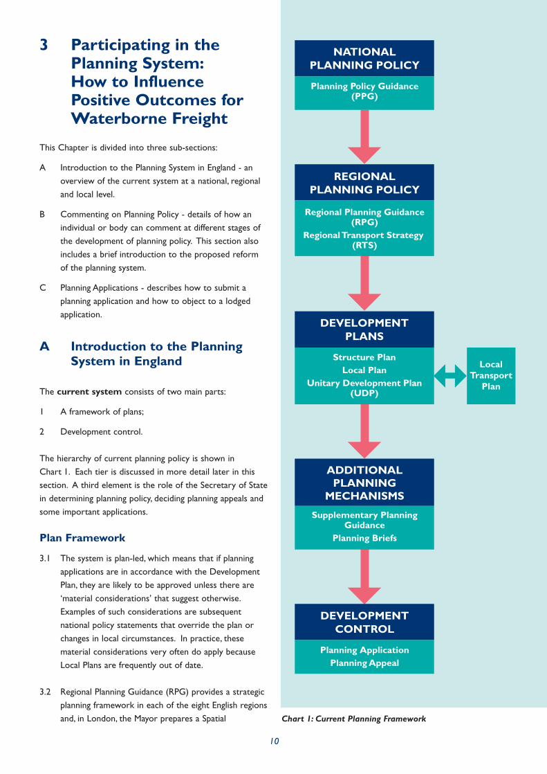
The hierarchy of current planning policy is shown inChart 1. Each tier is discussed in more detail later in thissection. A third element is the role of the Secretary of Statein determining planning policy, deciding planning appeals andsome important applications.
Plan Framework
3.1 The system is plan-led, which means that if planningapplications are in accordance with the DevelopmentPlan, they are likely to be approved unless there are‘material considerations’ that suggest otherwise.Examples of such considerations are subsequentnational policy statements that override the plan orchanges in local circumstances. In practice, thesematerial considerations very often do apply becauseLocal Plans are frequently out of date.
3.2 Regional Planning Guidance (RPG) provides a strategicplanning framework in each of the eight English regionsand, in London, the Mayor prepares a Spatial
NATIONALPLANNING POLICY
Planning Policy Guidance(PPG)
REGIONALPLANNING POLICY
Regional Planning Guidance (RPG)
Regional Transport Strategy (RTS)
DEVELOPMENTPLANS
Structure PlanLocal Plan
Unitary Development Plan(UDP)
ADDITIONAL PLANNING
MECHANISMS
Supplementary PlanningGuidance
Planning Briefs
DEVELOPMENTCONTROL
Planning ApplicationPlanning Appeal
LocalTransport
Plan
Chart 1: Current Planning Framework
10

Development Strategy. Development Plans areproduced by county authorities (Structure Plans),district councils (Local Plans) and, in unitaryauthorities, a Unitary Development Plan (UDP) whichcombines elements of both. National parks alsoproduce their own plans.
3.3 Development Plans have two purposes:
To describe the intended use of land in an area;
To provide an objective basis for theconsideration of planning applications.
3.4 Inevitably, there will be differences of view about theneed for new development and where it should takeplace. The planning system seeks to resolve these onthe basis that, if an application is in accordance withthe Development Plan, it is likely to be approved.
3.5 Local Plans are the means by which Local Authoritiesexpress the land-use implications of their policies andshape the future of their communities. In producingtheir plans, Local Authorities have to take account ofpolicies determined at the national and regional levels.The plan provides a framework to engage people inthe way in which their communities might grow andchange. For business, it provides an essential source ofinformation about where to propose new developmentand the type of development likely to be appropriate.
3.6 At present, Local Plans are prepared in the context ofplanning policies set at national, regional and, in someareas, county level. National Planning Policy Guidance,published by Government, sets out national policypriorities. Regional Planning Guidance (RPG), preparedat a regional level but issued by the Secretary of Stateafter consultation and a non-statutory publicexamination, sets longer-term development strategiesfor individual regions. RPG also provides a regionalcontext for the preparation of Local AuthorityDevelopment Plans and Local Transport Plans.Guidance on sub-regional issues is increasingly beingprovided as part of RPG.
Development Control
3.7 This is the process by which decisions are made onapplications to develop land or buildings or to changetheir use. This is the point at which people are mostlikely to encounter the planning system. Developmentcontrol authorities are normally the districts andunitary authorities responsible for putting Local Plans
in place. Planning applications are submitted to theseauthorities and decided either by their electedcouncillors or by Local Authority officers accountableto them. If adopted, the statutory Development Planprovides the primary basis for all decisions. Decisionsmust also take account of other materialconsiderations, including the Government’s Nationaland Regional Planning Guidance and materialrepresentations from interested parties.
B Commenting on Planning Policy
3.8 There are many ways that those affected by theplanning system can participate in influencing decisionsand the land uses that result. The most obvious isthrough submitting a planning application for adevelopment, or a change of use, of a site but this isjust the tip of the iceberg. In fact, any individual orbody can contribute at any stage of the developmentof planning policy.
3.9 Any organisation seeking to influence policy should doat the appropriate level. For example, there would beno point in debating the merits of National PlanningPolicy in a consultation exercise for the preparation ofa Development Plan. This is because that nationalpolicy is part of the statutory context in which theplan has to be prepared. The relationship betweentiers in the planning process and at which pointparticipation may occur is shown in Chart 2 (onpage 17).
Planning Policy Guidance/Planning PolicyStatements (PPG/PPS)
3.10 There are currently 25 PPG notes covering a widerange of subjects. Those with policies relevant towater freight are detailed in Appendix 2. PPG/PPS areprepared by central Government and initially issued asconsultation drafts. These drafts are circulated to allregional and local government and other bodies havinga specific interest in the subject covered. For example,Sea and Water, the new inland waterway and short seashipping forum, would normally be invited to commenton a revised version of PPG13 Transport.
3.11 Any individual or body can also comment to centralGovernment on the content of draft PPG/PPS, within aspecific deadline. Drafts are posted on the Internetand are also available from HMSO.
11

3.12 All comments (both supportive and critical) are notedand may be acted upon. Supportive comments arehelpful since they may add weight to the case made bydraft guidance in the face of criticism. For example, ifproposals to change guidance over wharf safeguardingwere ever put forward, it would be helpful ifcomments from developers about reducing theavailability of top quality waterside sites werecountered by comments from freight interests andothers on the need for wharves to retain watertransport options.
3.13 It is unlikely that major changes will be made toPPG/PPS between the consultation draft and the finalversion being issued. Much thought and preparation isinvolved in the production of the draft documents sothey are generally robust. But changes occur and anyuser who feels that a draft PPG/PPS contains proposalsdetrimental to their interests (or favourable to them)would be well advised to comment or ensure thattheir representative body has commented.
Regional Planning Guidance/RegionalSpatial Strategies (RPG/RSS)
3.14 RPG/RSS refine PPG/PPS to a regional context,reflecting differences in the geography, infrastructureand socio-economic structure of each particularregion. Regional Planning Bodies (RPBs) prepare theRPG/RSS.
3.15 The proposed changes to the planning system, whichare currently before Parliament, will make afundamental change to the status of RPG/RSS (see boxopposite)
3.16 At present, RPG is issued as a consultation draft inmuch the same way as PPG/PPS. However, as RSS isstatutory it will be placed on a more formal depositduring which everyone is entitled to support theproposals or object to them. The basic principle is thesame, but the support or objection is more formal. Ineffect, the new RSS will take on the role currently heldby the Structure Plan.
3.17 RPG/RSS is available in much the same way asPPG/PPS, although the Regional Assembly rather thanHMSO publish it. Policies will not generally be sitespecific unless a given site is of regional importance,such as a major port or airport. Details of anyconsultation period will be available with the draftRPG/RPS, and the process is normally advertised on
the Internet and in regional and local GovernmentOffices.
3.18 As with PPG/PPS all comments made on draftRPG/RSS are noted and may be acted upon. It is wellworth making supportive comments because they maystrengthen the case made by draft guidance in the faceof critical comments. In view of the statutory natureof RSS, any individual or organisation that feelsproposed policies adversely affect their interest wouldbe strongly advised to ensure their views arerepresented.
3.19 The substantial part of a draft RPG/RSS would not beexpected to change from draft to final, but significantchanges to individual policies, including the deletion ofpolicies, occur. It is worth making representationsbecause significant changes can be made to draftRPG/RSS provided that there is justification.
Regional Transport Strategies (RTS)
3.20 At present RTS are prepared as part of the RegionalPlanning Guidance (RPG) process and may form partof the RPG or be a separate document to which theRPG refers. Regional Transport Strategies provide adirection for strategic investment in all modes oftransport, and give guidance to both DevelopmentPlans and Local Transport Plans (LTPs). It is expectedthat this arrangement will continue with RSS. Intheory, the consultation process is the same as forRPG/RSS but, in practice, freight operators aregenerally specifically invited to comment on thedevelopment of RTS. The road haulage industry makesa particular effort to inform this process and activeparticipation by the water freight industry will assist inensuring balanced consideration of all modes.
3.21 Membership of a regional freight forum such as theNorth West Freight Advisory Group (see Case Study 2in Chapter 6) is an effective way of getting involved tosupport and promote waterborne freight.
Development Plans/Local DevelopmentFrameworks (DP/LDFs)
3.22 Development Plans currently consist of Structure Plansand Local Plans for two tier Local Authorities, that is,where there are both county and district councils, andUnitary Development Plans for unitary authorities.Local Plans are also prepared separately for mineralsand waste disposal. Local Development Frameworks(LDFs) will replace Local Plans and Unitary
12

13
A new structure for plan making has been proposed,based on two tiers: a tier of strategic plan making, whichwill be at the regional level; and a tier of local decisionmaking, at the district and unitary council level. This will:
Reduce complexity;
Ensure greater consistency from the strategicthrough to the local level;
Make plan preparation and adoption moreunderstandable and accessible to the community;
Enable plans to be put in place in a more flexibleand timely way.
Regional Planning Guidance will be replaced by statutoryRegional Spatial Strategies (RSS). The main purpose ofthe RSS will be to provide a spatial framework withinwhich Local Development Frameworks (LDFs) and LocalTransport Plans can be prepared. The RSS will provide aspatial framework for the region over a fifteen to twentyyear period. The aim should be an integrated, strategicapproach with regional and sub-regional priorities forhousing being formulated together with priorities forenvironmental protection and improvement, transport,other infrastructure, economic development, agriculture,minerals and waste treatment and disposal.
Regional Spatial Strategies will be more regionally specificthan Regional Planning Guidance and should reflectregional diversity. There will be greater flexibility for RSSto depart from national policy where that is justified byregional circumstances. The Regional Planning Body(RPB) will prepare draft reviews of the RSS.
The RPB will be expected to consult widely on preparingthe revised RSS. It will be expected to have regard to:
The purpose of planning (see Planning PolicyStatement);
Current national policies and guidance;
Current Regional Spatial Strategies for adjoiningregions or the Spatial Development Strategy forLondon if appropriate;
The resources likely to be available forimplementing the Regional Spatial Strategy;
Any other matters which may be prescribed by theSecretary of State.
The RPB will be required to carry out a sustainabilityappraisal as an integral part of the process of reviewingand updating the RSS. This emphasis on economic, socialand environmental matters should facilitate theprotection and promotion of inland waterway freight inthe new system.
Local Development Frameworks (LDFs) will replaceLocal Plans and Unitary Development Plans and, alongwith the RSS, replace Structure Plans. Responsibility forpreparing those plans will lie with the unitary or districtLocal Planning Authority. However, where districts wishto combine together to produce a joint LDF (for goodplanning reasons or to pool resources) and/or toproduce their LDF jointly with the county councilconcerned, they will be able to do so. LDFs will facilitatethe inclusion of current planning policies (including thoserelated to freight and waterways) in Local Plans. The newsystem can be reviewed in parts to reflect any policychanges as, and when, they happen. Review of (whole)plans in the current system is very time consuming andone benefit of the new system will be its responsiveness.
The Local Development Framework will comprise afolder of documents for delivering the spatial strategy forthe area consistent with the community strategy and ingeneral conformity with the RSS. Some of thesedocuments will be subject to statutory requirements asto consultation and formal testing through anindependent procedure. The policies in such documentswill be given primacy when decisions are taken onplanning applications. However, there will also be scopefor the preparation of less formal non-statutorydocuments similar to the existing Supplementary PlanningGuidance. These should also go into the LocalDevelopment Framework folder.
Full details of the proposed reforms can be found on theOffice of the Deputy Prime Minister’s web site,www.odpm.gov.uk, by following the links to Planning.
Proposed New Planning Framework

14
Development Plans and, along with the RSS, replaceStructure Plans. They will concentrate on areas wheregreatest change is expected. The fundamental role ofthese documents will not change in that they willallocate specific sites for development, specifying thetype of development that will be granted permissionon each site. The LDF will also have criteria basedpolicies to cover development on sites not specificallyallocated. These are generally known as windfall sites,as their development was not anticipated at the timeof preparing the Development Plan/LDF.
3.23 Development Plans/LDFs are prepared by the relevantLocal Authority and are placed on deposit for commentby any interested party. Anyone may object toDevelopment Plan/LDF policies, whether or not theyhave an interest in the policy or any land affected.Often the plan is revised and placed on deposit asecond time, known as the revised deposit draft. Again,anyone may comment at this second stage, but only onchanges from the original deposit draft version. Moredetails can be found in Local Plans and Unitary
Development Plans: Guide to Procedures available from theplanning section on the Office of the Deputy PrimeMinister’s web site, www.odpm.gov.uk. The relationshipbetween consultation and participation in the planningprocess is shown in Chart 2.
3.24 Anyone making an objection to any policy in thedeposit draft or revised deposit draft can eitherpresent their objection in writing or appear at thepublic inquiry. Development Plans go through a publicinquiry if there are objections lodged, before beingadopted by the Local Authority. Quite major changescan occur, especially over site-specific allocations, as aresult of this process.
Local Transport Plans
3.25 Local Transport Plans (LTPs) give a clear direction onwhere transport investment is expected to occurwithin a Local Authority area but also form the basisof a funding bid to central Government for money toimplement schemes. LTPs bring together a package ofmeasures, relate them to development proposals inDevelopment Plans and demonstrate that privatesector funding from these development proposals isforthcoming. Unlike RTS, LTPs are not part of theDevelopment Plan, although it is expected that eachplan will refer to the other.
3.26 Primarily because there is a bid for funding attached toa LTP, these plans are drawn up very much from a basisof consultation and partnership. There are significantopportunities for the water freight industry to becomeinvolved with this process, especially given thepotential for water freight to contribute to modal shift.LTPs contain targets for traffic reduction and carriageof freight by non-road modes.
3.27 In practice it is likely that the same forum of freightoperators will inform the RPG/RSS, RTS, DevelopmentPlan/LDF and LTP. Chapter 5, Effective Planning,describes the value of forming partnerships betweenLocal Authorities and industry in order to exchangeinformation and views on freight transport. A possiblemodel is described in Case Study 2 in Chapter 6.
C Planning Applications
3.28 Individuals, or organisations, seeking to develop a pieceof land submit planning applications.
3.29 Planning applications are correctly termed applications
for planning permission. Planning permission is requiredfor any development as defined in the Town andCounty Planning Act 1991, including a material changeof use of a site. In practice, many small scaledevelopments do not require planning permission asthese are covered by the Town and Country Planning(General Permitted Development) Order (GPDO)1995, which is updated periodically. There are alsoclasses of land use; change within a land use class doesnot normally require permission. It should be notedthat wharves do not have a land use class, beingancillary to the site of which they are part and,therefore, do not require planning permission.
3.30 Some bodies, such as some Navigation Authorities, also donot require planning permission for works performed ontheir own land that are related to their own operations.
3.31 There are two different categories of application thatare of interest to anyone involved in freight carriage:
As an applicant - Navigation Authorities orfreight carriers seeking to create facilities forfreight carriage;
As an objector - Navigation Authorities or freightcarriers seeking to resist development by othersthat would adversely affect freight carriage or thepotential for freight related activity.
15
These two cases are discussed in turn below.
Making a Planning Application
3.32 To make changes to a parcel of land, it is necessary toseek planning permission. The person or organisationseeking permission is known as the applicant. Theapplication must be accompanied by a plan of the siteand the appropriate fee. The procedure is the sameregardless of the purpose of the application. A freightoperator seeking new handling facilities has to gothrough the same process as a developer looking tobuild houses on a wharf. The description here isgeared towards a development benefiting waterfreight.
3.33 There are two types of planning application: outlineand detail. Outline, in effect, simply establishes theprinciple of the development and is often a first stage.In particular, outline permission will dictate the valueof the site, as obtaining permission for the detailedproposals is then usually relatively straightforward.Detailed permission will be required beforedevelopment can commence and will cover all aspectsof the development including access, site layout, heightand visual appearance.
3.34 Local Planning Authorities are amenable to pre-application discussions on any development and, at thisstage in the process, can advise of any particularrequirements they may have. Applicants should notehowever that Local Authorities are not bound by thesediscussions, and cannot be bound by them. The lawrequires that any application must be considered. Inother words, the Local Authority cannot make adecision before the application is submitted. Inaddition, the pre-application discussions will be withofficers who often only make a recommendation tocouncil. It is generally the elected councillors whohave the final say, and they are not required to followtheir officers’ recommendations.
3.35 The fact that most schemes for providing freightfacilities will affect watercourses means that variousother regulatory authorities such as the EnvironmentAgency and English Nature are likely to be involved insome aspects of schemes.
3.36 It is also important that all those authorities fromwhich permission is required are made aware of thewider perspective. For example, wharf developmentmay have a localised environmental impact but facilitate
carriage over a long distance thereby having an overallbeneficial environmental impact. The body that decidesif development can proceed or not, needs to be madeaware of the overall scheme and its effects.
3.37 It is recommended that applicants applying for planningpermissions prepare a supporting statement identifyingthe overall benefits of the improvement. This shouldbe copied with any other applications for permissionsor licenses. The case should be as full in detail aspracticable, without overloading the determiningauthority with unnecessary information. In particular,the supporting statement should spell out instraightforward language such issues as the overallimprovement to navigation achieved, or the particulartraffic facilitated. It should also identify otherpermissions being sought as part of the improvementscheme. The statement should also include therelevant policy context and point to particular policiesoutlined in this Guide as part of the case for theapplication. This will add considerable weight to thecase made for the application.
3.38 In addition to any supporting statement, the LocalAuthority may require, depending on scale andcircumstances, any, or all, of the following:
Environmental impact assessment;
Transport Assessment;
Landscape assessment;
Archaeological assessment.
Where required, these will need to be submitted withthe application. Local Authorities will give guidance ontheir particular requirements for each assessment.
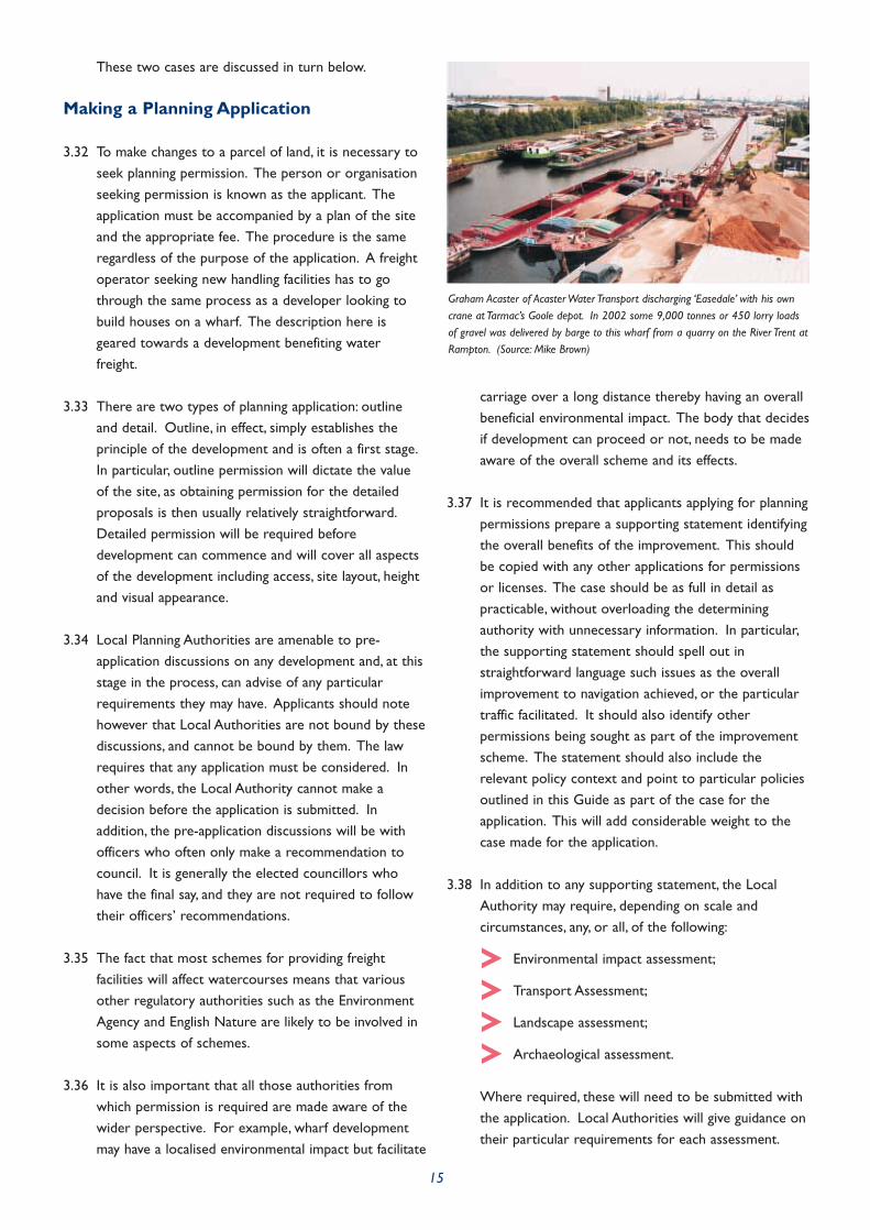
Graham Acaster of Acaster Water Transport discharging ‘Easedale’ with his owncrane at Tarmac’s Goole depot. In 2002 some 9,000 tonnes or 450 lorry loadsof gravel was delivered by barge to this wharf from a quarry on the River Trent atRampton. (Source: Mike Brown)

16
3.39 In the event that planning permission is refused thereis a right of appeal to the Secretary of State. Anappeal must be lodged within six months of refusal.The refusal notice contains details of how to appealagainst the decision. At present, appeals are free ofcharge although this is under consideration. Applicantsshould be aware that only around one in three appealsare successful.
3.40 There are three formats for an appeal:
Written representations - all evidence issubmitted in writing;
Informal hearings - the inspector hears allviewpoints in a ‘round table’ discussion;
Public inquiry - each party has professionalrepresentation, usually in the form of barristersand often accompanied by specialist consultants.
Objecting to a Planning Application
3.41 Where a planning application is lodged, it is possible toobject to the application, and those with an interest inwater freight will wish to do this if the proposal isdetrimental to water freight. The most difficult part ofthis can simply be learning that an application has beenlodged. British Waterways is a Statutory Consulteeand must always be advised of an application affectingone of its waterways. Other Navigation Authoritiesare not Statutory Consultees and do not have thisprivilege (the Environment Agency is a StatutoryConsultee but not in respect of its navigationfunctions). This Guide recommends that PlanningAuthorities consult both Navigation Authorities andfreight operators when an application affecting awaterway is received. Wider consultation is necessarywhen the developer is also a Statutory Consultee.The determining authority should also consider theimpact of the application on:
Operators that currently move freight on waterthrough the authority;
Land use implications in adjacent authorities.
The application must be notified on site andadvertised in the local press.
3.42 The applicant need not be the landowner, although thelandowner must be notified of an application forchanges on their land by third parties on their land.Thus, a developer cannot apply for planning permissionon a wharf without the wharf owner’s knowledge. Anytenant having an interest in the land extending formore than seven years must also be notified of theapplication.
3.43 Any party wishing to object to the application mayexamine the application at the Local Authority offices.There will be a timescale identified for objections tobe received and, as with all other aspects ofconsultation, any person or party may objectregardless of their interest. In framing an objection itis generally advisable to cite the real concern. Thereare instances of objectors using spurious grounds thatthey believe will carry more weight, such as theinadequacy of access to a site, when the real concernmight be loss of a facility. The problem with thisapproach is that the real grounds for objection arenever heard and cannot therefore be considered, whilethe spurious grounds offered may be capable ofresolution.
3.44 If planning permission is denied and the applicantappeals, the objections to the application will be putbefore the inspector at the appeal. Objectors maywish to elaborate on their objection as part of theappeal process.

NATIONALPLANNING POLICY
Planning Policy Guidance(PPG)
REGIONALPLANNING POLICY
Regional Planning Guidance (RPG)
Regional Transport Strategy (RTS)
DEVELOPMENTPLANS
Structure PlanLocal Plan
Unitary Development Plan(UDP)
DEVELOPMENTCONTROL
Planning ApplicationPlanning Appeal
LocalTransport
Plan
STATUTORYPARTICIPATION
POLICY LEVEL NON STATUTORYPARTICIPATION
Comment onConsultation Draft
Inform and Contributeto Strategic Policy
e.g. Sea and Water;Inland Shipping Group;
Freight Transport Association
Comment onDeposit Draft
Examination in Public
Inform and Contributeto Strategic Policy
e.g. Local Freight Forums;Freight Quality Partnerships
Comment onDeposit Draft
Objection to PlanPublic Enquiry
Applicant
Statutory Consultee
e.g. British Waterways
Objector
e.g. Navigation AuthorityFreight operatorAny other party
Other Consultees
e.g. Navigation Authority;Freight operator
(Become statutory ifthey object to an
application)
17
Chart 2: Participation and the Planning Process

4 Other Planning Tools
This Chapter describes the other tools, in addition toplanning policy measures and guidance, available to plannersto promote the use of inland waterways for freighttransport.
4.1 These tools are primarily of use at the developmentcontrol stage or in formulating Local Plans, UnitaryDevelopment Plans (UDPs) or Local DevelopmentFrameworks (LDFs) where site-specific proposals aremade. They can be broadly divided into twocategories:
A Information to help make decisions on land useand planning applications:
Information on wharves;
Department for Transport Benchmark
Report 2002 and other reference sources;
Transport Assessments.
B Delivery mechanisms to make sure a planprovides the appropriate framework to meet theplanner’s objectives:
Planning conditions;
S106 Agreements and obligations;
Supplementary Planning Guidance.
These are discussed in turn.
Information on Wharves
4.2 One of the major issues facing water freight is theprotection of wharves. Wharf audits and wharfstrategies can help Local Planning Authoritiesdetermine which wharves should be protected. BritishWaterways performs audits of its own wharves,assessing the usefulness of a wharf and the likelihoodof potential traffic. These can be used to inform therelevant Local Authorities. Other Local Authoritiesmay have no such tools available so may need to drawtheir own conclusions. In practice, Local Authoritiesshould retain an open mind even when the NavigationAuthority has a wharf audit or wharf strategy in place,especially if the Navigation Authority is the owner ofthe wharf in question.
4.3 One possible solution is demonstrated by the WestYorkshire Local Transport Plan (see Case Study 9 inChapter 6). Here, a supplementary guide has beenproduced identifying all waterside development sitesand commenting on any potential for the sites to beoccupied by water freight users.
4.4 Use of criteria based assessments for wharf protectionshould also be considered. These will need to bedetermined locally. For example, the criteria used inLondon are:
The redevelopment of safeguarded wharves should only be
accepted if the wharf is no longer viable nor capable of
being made viable for cargo handling uses. The only
exceptional circumstance to this would be for a strategic
proposal of essential benefit for London, which cannot be
planned for or delivered on any other site in Greater
18
West Yorkshire Partners for Quality in Integrated Transport have produced aguidance document with the aim of providing details of freight transfer facilitiesand potential sites that could be developed with rail or water access. Thehandbook covers freight grants, schedule of sidings, potential rail freight sites,potential waterway sites and pointers to further information. This is an excellentexample of metropolitan authorities co-operating to produce supporting guidancefor their joint Local Transport Plan. The guide aims to provide advice andinformation of assistance to potential users of rail and waterway and socontribute to national policy objectives for modal shift and sustainable freighttransport.

London. The viability of a wharf is dependent on:
• The wharf ’s size, shape, orientation, navigational access,
road access, rail access (where possible), planning history,
environmental impact and surrounding land use context;
• The geographical location of the wharf, in terms of
proximity and connections to existing and potential
market areas;
• The existing and potential contribution that the wharf
can make towards reducing road based freight
movements;
• Existing and potential relationships between the wharf
and other cargo-handling sites or land uses;
• The location and availability of capacity at comparable
alternative wharves, having regard to current and
projected Port of London and wharf capacity and
market demands;
• In the case of non-operational sites, the likely timescale
within which a viable cargo-handling operation can be
attracted to the site, having regard to the short term
land use policy, and long term trade forecasts, and
national and regional planning and transport policy.
If a wharf is no longer viable, redevelopment proposals
must incorporate water based passenger transport, leisure
and recreation facilities and water transport support
facilities first, before non-river related uses that do not
require a riverside location.
(Draft London Plan, Annex 2 paragraph 45 and 46)21
Department for TransportBenchmark Report 200236
4.5 If a Local Authority has any doubts regarding thesuitability of a waterway for freight transport theDepartment for Transport Benchmark Report 200236 maybe able to help. It includes indicative dimensions ofthose waterways defined broadly as able toaccommodate craft with a payload of 50 tonnes capacityor greater. This publication does not include the narrowcanal network. Another Department for Transportpublication, Waterborne Freight Statistics 200237 providescurrent freight traffic statistics for regions, and bysignificant waterway. There are also various commercialguides to the inland waterways and maps available fromBritish Waterways and other sources40.
4.6 Of course, Local Planning Authorities should notconfuse use with potential use. The fact a waterway
has little, or no, traffic at present does not mean that ithas no potential for such traffic.
Transport Assessment
4.7 Many planning applications require a TransportAssessment to be submitted with the application,identifying impacts on the local transport networks.The intention of this is two-fold:
To allow Planning Authorities to assess mitigationthat may be required as a result of thedevelopment;
To make developers consider alternatives to carbased passenger transport and road based freighttransport.
4.8 The threshold for requiring a Transport Assessmentvaries between Planning Authorities. As a generalguide,Transport Assessments are usually required, forany part of the highway network if traffic resultingfrom the development will form 5% or more of theoverall traffic or where the existing network is alreadycongested.
4.9 Planning Authorities may wish to make TransportAssessments a requirement for any site that has thepotential for water access. Another option is toinclude consideration of water transport as a featureof any Transport Assessment for watersidedevelopments. This would force developers toconsider the use of water transport. They would thenhave to give a reasoned argument for using roadtransport. Transport Assessments also coverconstruction traffic, so transport of this traffic bywater would also be included in the assessment.
Planning Conditions
4.10 Planning conditions are attached to planningpermissions and limit the scope of the permissions invarious ways. Conditions related to transport are notuncommon and can relate to the means of access, theroute for access and even the mode of access.Planning Authorities may wish to place a condition ona development that requires certain traffic to or fromthe site to be carried by water. The only criterion isthat the traffic must be sufficiently well defined for thecondition to be enforceable.
19

4.11 Even if a proposed land use has no obvious potentialfor traffic to be carried by water, for example an officeor residential development, there may be benefits inconditioning the permission such that constructiontraffic, especially materials in and waste out of the site,are carried by water. For central urban sites this canavoid a large number of HGV movements oncongested and often unsuitable roads.
Section 106 Agreements andObligations
4.12 Major developments include a requirement forconsiderable infrastructure that is not necessarilyintegral to the development but is required becausethe development is occurring. A basic example is theneed for extra classrooms at a school as a result of alarge housing development. In these cases, thedeveloper agrees to provide the facility (or is obligedto provide the facility) through an agreement madeunder Section 106 of the Town and Country PlanningAct 1991 (a Section 106 Agreement).
4.13 The form of Section 106 Agreement varies dependingupon the nature of the infrastructure required and thepreference of the Local Authority. As a general rule:
On-site infrastructure is provided by thedeveloper as part of the development;
Off-site infrastructure is paid for by thedeveloper but actually constructed by the LocalAuthority.
4.14 There are several possible uses for Section 106Agreements, but one of the most useful is wharfmitigation in the event that a developer has permissionfor development on an existing wharf. A Section 106Agreement could be used to ensure that thedeveloper provides an alternative facility elsewhere.There will be instances where reuse of previouslydeveloped land justifies the loss of a wharf, but someform of provision should be made elsewhere in thelocality. This will especially be the case when the needfor regeneration is greatest and the potential for thewharf is realistic but not pressing. In thesecircumstances alternative provision can be achievedthrough a Section 106 Agreement.
Supplementary Planning Guidance(SPG)
4.15 Supplementary Planning Guidance (SPG) is a termcovering any additional guidance over and above thatgiven by planning guidance and Development Plans.For particular sites, supplementary guidance will oftentake the form of development briefs. These willdescribe the Planning Authority’s aspirations for thesite and give a clear indication of the type ofdevelopment for which the authority expects to grantpermission. Supplementary Planning Guidance mayspecify the nature of development (e.g. light industrialunits, high quality office space) and also any aspirationsfor site layout. Infrastructure requirements may alsobe expressed in SPG. For example, a PlanningAuthority could specify that a particular site should bedeveloped for businesses that can take advantage ofwater transport and that a wharf should be provided.Alternatively, if a development will result in the loss ofa wharf, Planning Authorities can use SPG to indicatethat a replacement wharf is required, and the locationand form of the replacement.
20
Diglis Dock at Worcester off the River Severn has not handled freight for manyyears. It is clear from the picture that considerable work would need to becarried out in order to return Diglis to a serviceable freight wharf. The dock isadjacent to a run-down industrial area and suffers from poor road access, whichwould hamper its development for regular freight handling. Diglis Lock is arestricting factor on the size of vessel that can use the dock. Providing mitigationfor the loss of this wharf by constructing a new wharf downstream of the lockmay prove a better option than preserving the dock. It is, however, importantthat the potential of the River Severn to make a contribution to sustainabletransport is protected by having wharfage available close to Worcester. (Source:Sharon Cox)

5 Effective Planning forFreight Transport onInland Waterways
This Chapter describes the policy and practical issues thatcan be implemented to encourage freight transport bywater. These include effective policy formulation, effectivedevelopment control, partnerships and encouraging thepublic sector to use this mode of transport.
5.1 Protecting and promoting inland waterway freightrequires development to be targeted in such a way that:
The ability of waterways to carry freight is notimpaired;
The markets to be served by waterways arelocated where waterways can be effective.
It would not be good practice, for example, to locatehousing next to a large waterway or to force anaggregates batching plant to be located where onlyroad access is available.
Policy Issues to Encourage FreightTransport by Water
5.2 Planning can influence the following key elements:
The protection of existing wharves and freighttraffic facilities;
The promotion of new wharves and facilities;
Encouragement for new land uses requiringplanning permission to make use of watertransport;
Ensuring that waterside sites with real potentialfor water freight are not used by businesses orland uses that do not benefit from access towater transport;
Promotion of the development corridor conceptalong the length of a waterway with potential forfreight use;
The availability of dry docks.
5.3 Terminal facilities and wharves are absolutelyfundamental to freight waterways. However, it is clearthat some existing wharves are either no longerrequired, or are no longer suitable, for modern dayfreight requirements. There has been intense pressure
on some wharves, particularly those near city centres,for residential and commercial development, and manyhave been lost over the last two decades. The likelyscale of operation, and of the vessels used, means thatcommercial wharves on larger waterways areindustrial in character, with a degree of noise andunsightliness. If waterborne freight is to be a realisticoption, then wharves that have a potential for trafficmust be retained and sites for new wharves identifiedwhere this is appropriate.
5.4 Other infrastructure issues, such as the availability ofdry docks, will also affect the suitability of thewaterway for commercial traffic. If, as expected,national vessel standards are introduced, there will bea new statutory requirement for regular dry-dockingfor any vessel with a national certificate. This couldexacerbate the existing shortage of dry docks andrepair facilities that are needed by operators tomaintain their fleet.
5.5 In some cases, maintaining the waterway for freighttransport is not the only consideration. Many waterwayspass through declining industrial areas in need ofimprovement to the physical and economic environment.Regeneration of such brownfield sites is a key objectiveof central Government policy. Due to structural changesin the UK economy over the last 50 years not everyformer industrial site can be reused for industrialpurposes. However, when considering regeneration, it isa requirement of PPG4 that the option for reuse bywater-served industries is considered. Whereredevelopment results in a loss of industry fromwaterside sites, care should be taken to ensure that theredevelopment does not affect the use of the waterwayby other industrial users. The use of water transport forconstruction traffic, inwards for materials such as cementand aggregates, outwards for demolition andconstruction waste, should always be considered.
5.6 For planning to be effective in encouraging waterbornefreight, the National Planning Policies identified inAppendix 2 must be effectively translated into actionon the ground. This can be achieved by:
Effective policy formulation at regional and locallevel to protect and promote inland waterwayfreight;
Effective development control to enforce thesepolicies.
Each of these is discussed in turn below.
21

Effective Policy Formulation
Regional Planning Guidance (RPG) andDevelopment Plan Policies
5.7 As described in Chapter 3, Regional Planning Guidance(RPG) translates Planning Policy Guidance (PPG) into aregional context. This includes policies on protectingand promoting freight traffic on inland waterways. AllEnglish Regions have an estuary, tidal river or a largenon-tidal navigation (as defined in Table 1 on page 5)within their area. RPG13 (South West) and RPG11(Yorkshire and Humber) both contain examples ofhow policies in RPG may protect and promote the useof inland waterways. See Case Study 1 in Chapter 6.
5.8 RPG or Regional Spatial Strategies (RSS), in theproposed new system sets the policy context forDevelopment Plans or Local Development Frameworks(LDFs). If the planning system is to be effective,RPG/RSS must give a strong lead on the role of inlandwaterway freight within each region.
This can include:
Identifying strategic waterway corridors fordevelopment, for which particular policies willapply;
The use of criteria based policies, to give a leadto Development Plans/LDFs in site allocation andthe formulation of LDF criteria based policies;
Guidance/policy on the regional priorities wherenational policies may be in conflict, for examplethe desire to promote sustainable transportobjectives set against the desire for regeneration.
5.9 Navigation Authorities and water freight operatorshave an in-depth knowledge of the waterways in theirarea and of issues facing freight operations. RegionalPlanning Bodies should seek their views in the processof formulating their pro-water freight policies. Forexample, a regional freight forum in the North Westhas facilitated this exchange of views. This may be auseful model for others to follow. See Case Study 2 inChapter 6.
22
Branford Barge Services ‘Eskdale’ approaching Lafarge Aggregates’WhitwoodDepot loaded with 300 tonnes of gravel. Lafarge Aggregates was required tovacate its site at Goodman Street in Leeds because Goodman Street and itsimmediate vicinity were to be included in a regeneration scheme for Leeds citycentre. Helped by a substantial Freight Facilities Grant (FFG), Lafarge relocatedto a new facility near Wakefield Europort (Whitwood). Thousands of tonnes ofaggregate each week are now being delivered to Whitwood, totalling around200,000 tonnes per year, sourced both from Rampton and a new quarry wharfat Besthorpe, Newark on the River Trent. (Source: Mike Brown)
Sites alongside the Thames provide the greatest pressure for re-use for residentialor office purposes. Clearly there have been considerable benefits for theDocklands area from regeneration of a derelict industrial environment. In thiscase redundant port facilities have been redeveloped, providing housing andemployment, thus boosting the local economy. Planners need to find a balance,however, between regeneration of this nature and providing the opportunities forthe Thames to realise its full potential contribution to an equally importantsustainable transport agenda. It is vital to halt the loss of available sites forcargo handling along the banks of the Thames. Great strides have been madethrough the Safeguarding of Wharves Direction but Local Authorities need to becommitted to finding ways of accommodating the requirements for handlingfreight with their aspirations for improving the urban environment in theirparticular areas of jurisdiction. (Source: Sharon Cox)

5.10 Development Plans/LDFs need to reflect theguidance/policies in RPG/RSS. Taking each of thepossibilities listed above in turn, DevelopmentPlans/LDFs would need to:
Identify appropriate land use allocations adjacentto a strategic waterway corridor, and developcriteria based policies to cover windfalldevelopments and proposals on land with nospecific allocation (‘white land’) not covered bysite-specific policies;
Allocate sites for development in accordancewith RPG/RSS criteria based policies, andformulate Development Plan/LDF criteria basedpolicies in line with RPG/RSS. For example,RPG/RSS might state that all operational wharveson strategic waterway corridors should beprotected. Development Plans/LDFs would haveto identify these and formulate a policyprotecting them;
Development Plans/LDFs would need to reflectthe RPG/RSS priorities. In the case of LDFs,these may need to be included in Area ActionPlans. Again, if RSS were to state thatregeneration must not compromise navigation byfreight vessels or the ability to use wharves thenthis would have to be included.
5.11 RPG13 (South West), the Somerset County StructurePlan and Sedgemoor District Local Plan provide a goodexample of a continuous policy thread through alllevels of policy making. In the case study example thepolicy is wharf protection, but the principle shouldapply to all aspects of policy related to water freight.See Case Study 3 in Chapter 6.
5.12 In London, safeguarding of wharves has been raised tothe status of a Ministerial Direction because of theunique circumstances. Whilst this has not resolved thepressures for redevelopment of waterside sites it hasprovided strategic protection for sites that areessential to the ability of the Thames to fulfil a role inwaterborne freight transport. See Case Study 4 inChapter 6.
23
Dunball on the River Parrett in Somerset is strongly protected by the planningpolicies outlined in the Regional Planning Guidance and the Structure Plan. Inaddition, Somerset Minerals Local Plan 1997-2011 Revised Deposit Version hasthe following designation and notes: “The existing wharf at Dunball is used toland sand dredged from the Bristol Channel, as well as for other non-mineralpurposes. The dredging of the material is outside the jurisdiction of the MineralsPlanning Authority (MPA). Landing facilities do fall within the MPA’s remit but, asthe wharf is used for general purposes, it has not required a specific permission.The MPA has designated a Mineral Consultation Area at the site to safeguard itfrom incompatible development that might hinder its future operation.”(Source: Sedgemoor Local Plan, Revised Deposit; Somerset Minerals Local Plan)
JJ Prior delivering aggregates to RMC’s Comley Wharf in Fulham, which is one ofthe original safeguarded wharves. The aggregates, sand and gravel, originatefrom Prior’s quarry at Fingringhoe on the River colne near Colchester. Prior ownsseven aggregate carrying vessels ranging in size from 250 to 600 tonne cargocarrying capacity. The vessels load directly from the quarry and deliver directly toupriver aggregates facilities, carrying approximately 160,000 tonnes per year.These small ships make a huge contribution to keeping heavy lorries off London’sstreets. In recognition of this, the company has received several Freight FacilitiesGrants towards the cost of vessel refurbishment.(Source: Port of London Authority)

Secondary Policies
5.13 There are a number of policies in the PPG systemthat, although not primarily targeted at water freight,nevertheless can be used to protect and promotefreight use of inland waterways. These include PPG4Industrial Land and PPG24 Noise. PPG4 promotesappropriate locations for industrial uses while PPG24protects noise sensitive developments, such as housingand schools, from excess noise.
There are two elements to this:
A To avoid locating new noise generators adjacentto noise sensitive properties;
B To ensure that new noise sensitive developmentsare not located in noisy areas.
The second is especially relevant to protectingwharves on inland waterways, as these are often eithernoisy in their own right by virtue of mechanicalhandling or processing of aggregates for example, orserve industry that may generate noise.
5.14 Again, when formulating Development Plan/LDFpolicies Local Planning Authorities will find it useful toseek the views of Navigation Authorities and localwater freight operators. These bodies have detailedknowledge of issues relating to freight operation, andcan provide a useful input.
24
Fingringhoe on the Colne in Essex is the source of approximately 160,000tonnes of sand and gravel delivered by ship to concrete plants in Fulham,Vauxhalland Battersea, an asphalt plant in Dagenham and Brewery Wharf in Deptford.On average, it takes ten hours to reach London loaded and eight hours to returnto the Colne estuary though tides dictate when ships are able to berth. Therestriction on road access at Fingringhoe makes it essential that the aggregatesproduced there are distributed mainly by river.(Source: Sharon Cox)
KD Marine’s ‘Gina D’ loaded with 900 tonnes of grain (ex-Seaforth GrainTerminal, Liverpool) entering Mode Wheel Locks on the Manchester Ship Canal.The grain is bound for Rank Hovis mill in Trafford, Manchester. Trafford Park isan industrial area home to varying sizes of enterprise engaged in diverseactivities, some of which are dirty and dusty, such as scrap metal processing.Trafford planners recognise the importance of protecting this industrial area as asignificant employment source. The Ship Canal has the potential toaccommodate more traffic to or from this area, depending on the economics.The Rank Hovis mill once received grain directly from ocean-going ships via aconveyor into the plant but this ended with the gradual increase in size of bulkcarriers transporting grain from deep-sea origins. The construction of theImperial War Museum (North) on the mill’s previous quayside frontage will notnow allow direct discharge, hence the road haul for KD Marine to deliver to theplant. A Freight Facilities Grant helped to tip the economic scales in favour ofwater transport away from road feeding grain into the mill.(Source: Manchester Ship Canal Company)
River Sea Trading’s ‘Geminus’, at Manchester Dry Docks in Trafford Park,Manchester, discharging 700 tonnes of grain for Rank Hovis. KD Marine holdsthe contract with Rank Hovis and uses ‘Geminus’ on charter to supplement itsown fleet of barges. KD Marine received a Freight Facilities Grant in 1999 tohelp with the cost of the first barge and the handling equipment seen hereabove. Grain is sucked out of the vessel’s holds and held in a small silo, whichthen discharges into lorries for the short road trip into the mill. This traffic flowcorresponds to more than 80,000 tonnes per year, replacing the equivalent ofapproximately 26 lorry trips between Liverpool and Manchester every workingday. (Source: Mike Brown)

Effective Development Control
5.15 The Government is quite clear that developmentcontrol must not occur in a vacuum, and this isreiterated in draft PPS11 and PPS12. Local PlanningAuthorities need to ensure that their developmentcontrol decisions reflect policy, especially when underpressure from developers for waterside sites.
5.16 In reaching decisions on waterside sites, it is essentialthat the views of the Navigation Authority and freightoperators are obtained. Freight operators in particularwill have a view on whether a waterside site has thepotential for freight use. Occasionally this may conflictwith the view of the Navigation Authority if the latteris also the landowner and potential developer. Wharfmitigation may provide a solution to such issues, wherethe landowner/developer offers alternative equivalentfacilities.
5.17 If a new wharf is proposed as part of a newdevelopment, or if a new development can takeadvantage of an existing wharf, Local PlanningAuthorities can consider placing a condition on anyplanning permission to secure access by water ratherthan by road. Since a wharf is ancillary to the use ofthe site of which it is part, its use can only becontrolled by condition. This type of planningcondition will not guarantee that the traffic will alwaystravel by water but they will require the user to justifyany change in transport operation since the user willneed to apply to have the condition lifted.
5.18 There are instances, however, where such a conditionmay prejudice a developer in seeking grant aid in orderto make the wharf viable. In particular, many watersidesites may be eligible for Freight Facilities Grant (FFG)funding. This is described in more detail in Appendix 3.The Freight Grants Unit at the Department forTransport administers the FFG. Funding, whereeligible, is available to encourage the choice of waterborne transport. If a planning condition compels adeveloper to use water transport and road transportis no longer an option the development will not beeligible for FFG funding (which may prevent thedevelopment form occurring). Whilst it could beargued that the development would occur elsewhereinstead, with road access only, this is a difficultargument to sustain.
5.19 Planning Authorities should be aware that FFG itself isdesigned to secure the carriage of the specified trafficfor a number of years. Where a temporary planningpermission is in place, for example, for the abstractionof aggregates, this may be adequate, as long as thelifespan of the permission matches the condition of thegrant. For longer permissions, or for permanentpermissions, conditioning might be desirable to ensurethat freight does not switch to road immediately uponcompletion of the grant aid period. In practice, thereis no recorded instance of this happening but PlanningAuthorities need to be aware of the possibility.
25
Yorkshire Evening Press premises on the River Foss in York received newsprint by barge from Goole up until 1997. At its peak in the mid nineties the traffic amountedto just over 13,000 tonnes per year. This was a rare example of water being used for the delivery of bulky cargo, in this case heavy rolls of newsprint, directly into aworks in the heart of a city. The works ceased to receive newsprint by water in 1997, apparently due to a different route being chosen for the delivery of newsprintthat no longer involved movement on ships through the port of Goole. It is always possible that traffic flows on water may be affected by external factors such aschanging origins for commodity flows or changes in company structure and ownership. Nevertheless, it is important that industries alongside waterways should beencouraged to examine the possibilities for water freight transport. Planning conditions should be considered to protect sustainable freight activity. In this case, therewas local outcry over deliveries being made by lorry instead of by barge but nothing could be done about it in the absence of a planning condition.(Source: Graham Acaster)

5.20 If an authority is considering conditioning a site with awater carriage condition, then they should ask thedevelopers if an application for FFG is intended or inprocess. If this is the case, the authority shouldcontact the Freight Grant Unit to discuss theprobability of a grant award and any conditions thatwill apply. The Planning Authority should then havedue regard to the position identified above.
Practical Measures to EncourageFreight Transport by Water
5.21 While policy can do much to protect and promote theconcept of waterborne freight, there are limitations onhow much policy alone can achieve. In practice, thereis a need for further efforts beyond planning policy toencourage a shift towards water transport. This Guidedescribes two such practical aspects:
Forming partnerships;
Encouraging public sector use of water transport.
Partnerships
5.22 The issues facing anyone attempting to promote theuse of waterways for freight transport vary accordingto the nature of the organisation and the project inquestion. For the public sector, the goal is to deliverthe policy objectives of sustainability, economic
prosperity and social inclusion. The private sector isfocused on running a profitable business. Thevoluntary sector, in the context of freight andwaterways, comprises a range of organisations withvarying concerns from environmental protection andconservation to promotion of environmentally friendlymodes of transport - such objectives may not alwaysbe in harmony. The sectors may not always be inaccord. The key to success is to determine commongoals and then draw upon the skills and expertise ofeach type of organisation. In this case, the commongoal would be to increase the role of inland waterwaysin sustainable transport provision. Partnerships at aregional level can make a particularly effectivecontribution to regional policy.
5.23 In order to help achieve the policy aims, in particularfor sustainable distribution, the Government hasencouraged the creation of Freight QualityPartnerships (FQPs). These are a means by which localgovernment, businesses, freight operators,environmental groups, the local community and otherinterested parties can work together to addressspecific freight transport problems. The partnershipsaim to develop an understanding of freight transportissues and problems and to promote constructivesolutions. They provide a forum to achieve bestpractice in environmentally sensitive, economic, safeand efficient freight transport.
5.24 There is, however, no prescription for a Freight QualityPartnership. They operate in varying guises withdifferent names: Freight forum, Freight Advisory Group,Freight Transport Liaison Group, SustainableDistribution Partnership, Partnership for Freight, andrange in scope from very localised objectives toinforming regional planning. The principal aim of thesegroups is to provide the mechanism for achievingeffective partnership between industry and localGovernment in order to produce tangible outcomes.The Department for Transport has produced a GoodPractice Guide, How to Set Up and Run Freight Quality
Partnerships with a sister volume of Good PracticeCase Studies25. These documents contain a great dealof advice and information regarding the aspirations andpractical outcomes of partnerships between the publicand private sector. Free copies of these publicationscan be obtained using the details given in Appendix 5.
26
The Grand Union Canal in Buckinghamshire is benefiting from a major contractto move 450,000 tonnes of aggregates from a quarry site to a processing depot.New barges have been designed and constructed to carry the cargo. Theyrepresent the most recent investment in new inland waterway freight vesselsdedicated to a particular traffic. This movement was made possible by theconsiderable efforts of the partner organisations involved and was partly fundedthrough Freight Facilities Grant. (Source: British Waterways)

5.25 The Freight Transport Association (FTA) has animportant role to play in bringing together the variousparties, particularly at a regional level. Officers of theAssociation have played a significant role in the NorthWest Freight Advisory Group (NWFAG), for example,in initially bringing together a wide ranging group offreight interests to inform the regional decision makingprocess, and in supplying the secretariat for theNWFAG. A body such as the NWFAG provides ameans for understanding and addressing theimportance of freight movements to the economicdevelopment of a region. Case Study 2 in Chapter 6provides more details on this forum.
5.26 Whether or not the FQP approach is appropriate inevery situation there are some practical principles tobe considered when setting up a partnership with theobjective of promoting waterborne freight. These are:
Establishing the main issue intended to beaddressed by the partnership;
Clarity on the delivery mechanism of thepartnership;
Consultation at all levels at the early stages ofstrategy and project development;
Establishing the objectives of the partnership;
Identifying the participants in the partnership;
Establishing the management process for thepartnership.
5.27 The participants in the partnership are key to itssuccess. In addition to those from the public sectorthere are a number of other potential partnersinterested in waterborne freight that could usefully beincluded. The NWFAG membership shows the benefitof involving the Navigation Authorities, portcompanies, Freight Transport Association (FTA), RoadHaulage Association (RHA), etc. Other appropriateorganisations, depending on the on the nature of theissues, or project, in hand, include:
Sea and Water, a new forum, constituted with theaim of promoting short sea shipping and inlandwaterway freight. Sponsored by Governmentfollowing the recommendations of the FreightStudy Group, Sea and Water aims to representthe water freight industry’s voice;
Association of Inland Navigation Authorities(AINA) represents the Navigation Authoritiescollectively;
Association of Inland Shipping Operators (AISO)is a trade association representing thecommercial and technical interests of a large partof the present water freight carrying industry;
Commercial Boat Operators Association(CBOA) is a group also representing the waterfreight carrying industry with a number ofmembers owning narrow boats;
Inland Shipping Group is a committee of theInland Waterways Association, part of thevoluntary sector dedicated to the promotion ofinland waterway freight transport and theprovision of information.
Contact details for all these organisations are includedin Appendix 6.
Public Sector Use of Water Transport
5.28 A significant amount of freight is carried on behalf ofthe public sector, most notably waste and recyclablematerials. In addition, many construction projects arepublic sector funded or part of a Private FinanceInitiative (PFI) proposal where the public sector hassome influence. If the private sector is expected tomake use of waterborne transport, public sectorcommitment to this mode is important.
5.29 Several opportunities exist. Public sector constructionprojects should consider the practicality of watertransport for construction traffic. This could result insignificant transfer of HGV traffic, since public sectorconstruction projects can be on a massive scale.
For example, local Government needs to transportand store significant quantities of constructionmaterials, such as salt, grit and road stone. A watersidedepot could be served by water for the supply side ofthis process.
5.30 However, the most obvious possibility for public sectoruse of water transport is waste and recyclables. Whilemuch of the waste disposal sector is managed by theprivate sector, the entire industry is public sector led,and thus subject to public sector influence and direction.Waste and recyclables fulfil the high bulk/low valuecharacteristics typifying water freight commodities, andalso travel on predictable, regular routes. They are thusideally suited to water transport, assuming bulking anddisposal points (land fill, incinerators, recycling processingplants) are located waterside.
27

5.31 At present, only London makes significant use of watertransport for waste carriage, but there is clearlypotential for other authorities to do the same ifwaterways penetrate the urban area. Newtechnologies are currently being piloted, such as theuse of modern refuse collection vehicles in the Waste
by Water initiative in north London. These vehicleshave removable bodies that allow the efficient transferof closed containers directly from road vehicle tobarge. The road vehicle can then pick up anothercontainer and continue its collection schedule whilethe barge, when fully loaded with containers, carriesthem to the central recycling/disposal facility.
5.32 Such new technologies will enable waste authorities toconsider the use of water transfer for both waste andrecyclables, and enable an overall reduction in fleetmileage and consequent reduction in vehicle impact.Environmentally friendly methods of transportingwaste that assist in removing vehicles from the roadswill help to achieve environmental objectives and toportray a positive image of the waste industry. Thuswaste authorities may wish to routinely investigate thepossibility of using inland waterways to carry waste aspart of any review of their operations.
28

29
6 Good Practice Case Studies
This Chapter includes ten case studies describing howdifferent organisations have worked together to resolvespecific issues by implementing good practice.

30
Organisations:
Government Office for Yorkshire andthe Humber
Yorkshire and Humber Assembly
Good Practice:
The ability of Regional PlanningGuidance (RPG) to provide acomprehensive framework forencouraging freight on inlandwaterways
The Yorkshire and Humber region has an extensive networkof waterways either in active use for freight or withsignificant potential. These waterways extend navigationinland from the sea via the Humber for seagoing vessels andhave a significant proportion of movements entirely withinthe inland waterway system. PPG12 seeks to promote useof this network and many of the policy measures describedare transferable to other regions with larger inlandwaterways in their area.
In the first instance, PPG12 recognises the need tocoordinate with adjoining regions, as transportinfrastructure is often trans-regional:
7.4 The inter-relationship between Yorkshire and theHumber and adjoining regions in Transport terms is animportant issue. There needs to be compatibilitybetween policies within this and neighbouring regions toavoid inappropriate competition as a result of, forexample, parking policies. Inter-regional issues requiringco-operation include:
• Water transport (among others)
Yorkshire and Humber has identified that the inlandwaterway activities in the region are interrelated withactivities in other regions. The Humber connects to the seagiving access to other parts of the UK and abroad forcoastal and international shipping; the Trent flowssouthwards into the East Midlands.
RPG12 organises its transport policies by purpose ratherthan mode, and thus waterways are covered under freighttransport. This policy (T3) is unusually comprehensive onthe subject of inland waterway freight:
In preparing Development Plans and Local Transport Plansopportunities should be sought to deliver an integratedfreight distribution system which makes the most efficientand effective use of road, rail and water (inland and coastal).In particular policies should be developed which:
a) Seek to maximise the use of rail or water for freightmovements from new developments and significantchanges of use;
b) Seek to locate developments which generate high levelsof freight and commercial traffic closest to intermodalfreight facilities, rail freight facilities, ports and wharves or roads designed and managed as traffic distributors;
d) Identify and protect existing and proposed sites forintermodal interchanges for road/rail, road/water, androad/rail/water. In South and West Yorkshire, in particular,seek improvements to road/waterway transfer facilities;
f) Identify and protect appropriate facilities for the loadingand unloading of water-borne freight, having regard toissues such as landside transport links and potentialconflicts of use and disturbance.
The publication, Transporting Freight by Rail and Inland
Waterways in West Yorkshire - a Guide for Potential Users,referred to elsewhere in this Guide, takes the first steps infulfilling point d) and f) of policy T3 within West Yorkshireand, as a result, helps West Yorkshire authorities fulfil a) andb). This demonstrates the value of Regional Guidance inassisting policy formulation at the local level.
Case Study 1
Regional Planning Guidance for Yorkshire and the Humber

31
RPG12 goes on to address the need for transport investmentin order for the policies of promotion to be effective:
Policy T10Transport investment priorities
Investment in strategic road, rail, air, water and sea linksshould be consistent with overall RPG policies and help todeliver the Regional Spatial Strategy. Priority should begiven to making the best use of existing infrastructure byimproving management and maintenance. Investment innew infrastructure should be based on a multimodalapproach to establishing investment priorities which shouldfocus on:
b) Delivering a safer, more efficient and integrated transportnetwork by:
ii) the take up of the unused potential at WakefieldEuroport and on the Calder and Hebble Navigation,the Aire & Calder Navigation and the Rotherham and Humber modernisation in South Yorkshire;
Although no reference to specific investment is included, theguidance recognises that the existing freight waterways inthe area could accommodate much more freight thanpresently and that priority should be given to making thebest use of the existing capacity. This point, in particular, isapplicable to other waterways across the UK.
Finally RPG12 goes on to consider the implications for themany organisations affected by the delivery of these policies.With respect to waterways the following is included:
Implications for freight operators
7.116 Freight operating companies need to:
• Develop further Freight Quality Partnerships inconjunction with Local Authorities;
• Work with Local Authorities, infrastructure providersand other freight operators to improve integrationbetween road, rail and water-based freighttransport.
Thus the guidance has addressed the need for trans-regionalintegration, the requirement to locate industry such thatwater transport is available, the spare capacity available foruse and the implications for those affected by these policies.In many ways this provides a model for other regions tofollow. This approach could be improved still further byincluding the following:
Identification of waterway corridors: the Yorkshire andHumber guidance makes text references but has nomap of the key corridors. The map included in theguidance shows all waterways in the area, some ofwhich are unsuitable or even closed to navigation;
In identifying corridors, the guidance could thenfurther seek enhancement of these corridors in termsof wharf provision, removal of bottlenecks orimprovements to navigational obstacles;
The implications for Navigation Authorities could alsobe addressed, as the guidance covers implications forthe Strategic Rail Authority. This is particularlyrelevant as there are four Navigation Authorities in theYorkshire and Humber Region, whose waterways are,or have recently been, used by freight traffic (BW,ABP,Hull City Council,York City Council);
Attention could also be given to the implications ofincreased waterway use for highway authorities. Manyof the region’s waterways have swing and lift bridges andan increase in the use of these may need to beaddressed with mitigation measures for the roadsystem.
For more information, contact:
Yorkshire and Humber Assembly18 King StreetWakefieldWest YorkshireWF1 2SQ
Tel: 01924 331555www.rayh.gov.uk

32
Case Study 2
Effective Partnership for Promoting Sustainable Transport;Promoting Modal Interchange Between Short SeaShipping/Road/Rail/Inland Waterways
Organisations:
North West Regional FreightAdvisory Group
Good Practice:
Building partnership between publicsector and industry
Policies promoting inland waterwayfreight transport
The North West Freight Advisory Group (NWFAG) wasestablished in 1999 following the recognition, in the RegionalEconomic Strategy, of the importance of freight movementsto the economic development of the region. TheNorthwest Development Agency asked the FreightTransport Association to pull together a wide ranging groupof freight interests to inform the regional decision makingprocess. Members of the group are constantly appraisingthe impact of legislation and policy issues which affect theway in which freight movements are conducted in theregion. Thus, one of the primary aims of the group is towork in partnership to address such issues and to achievemeasurable objectives which are central to the group’sagenda, including:
Influencing transport infrastructure development;
Understanding the Government to industry agenda;
Offering industry to Government feedback;
Industry to industry information sharing;
Encouragement and promotion of best practice.
The NWFAG members are:
Associated British PortsBritish WaterwaysCentral RailwayConfederation of British IndustryEnglish Welsh & Scottish Railways LtdFreight Transport AssociationFreightliner LtdGovernment Office for the North WestHighways AgencyLittlewoods Retail LtdLiverpool John Lennon AirportLiverpool Chamber of CommerceManchester Airport plcManchester Chamber of CommerceManchester Ship Canal CompanyMersey Docks & Harbour CompanyNetwork RailNorthwest Development AgencyNorth West Regional AssemblyNorth West Regional Transport Advisory GroupRoad Haulage AssociationStrategic Rail AuthorityVauxhall Motors Ltd
In November 2003, the NWFAG launched The North WestRegional Freight Strategy with the aim of providing aninformation base to inform Regional Planning Guidance, theRegional Transport Strategy and assist Local Authorities indeveloping their own freight strategies within their LocalTransport Plans. This process clearly illustrates the benefitsof the public and private sectors working together.
The aims and objectives of the Regional Freight Strategy are:
To assist the promotion of sustainable economicgrowth by:
• Maximising efficient use of existing transportinfrastructure and services;
• Implementing selective enhancements wherenecessary;

• Minimising the environmental and social impacts offreight transport;
• Taking full account of the inter-relationship of land-use planning and freight transport;
• Ensuring that all decisions are taken within thecontext of an integrated transport and land-usestrategy;
To underpin the competitiveness of indigenousbusiness, attract and retain inward investment andreduce the threat of peripherality in Europe byimproving accessibility to, from and within the NorthWest for those who use or operate freight transport;
To provide a vibrant, efficient and safe freight industryin the North West by developing and maintaining arange of high quality transport networks and services;
To involve both private and public sector interests byencouraging partnership working to facilitate a betterunderstanding amongst stakeholders of the needs ofmodern supply chains.
In setting the strategic context within which the next roundof Local Transport Plans are to be developed, the RegionalFreight Strategy provides a framework and guidance to assistLocal Authorities in the North West to achieve the status ofa ‘good’ Local Transport Plan with respect to freight.
While the Regional Freight Strategy covers issues relating toall freight modes there is important information relating toinland waterways; components of the Action Plan involvewaterborne freight. The section on Ports and Waterwayshas the following actions:
PW7 To instigate an assessment of sites where significantopportunities exist for multi-modal freight facilitieswithin or adjacent to ports and inland waterways
PW8 To instigate an investigation of the opportunitiesacross the region for modal shift to coastal/short seashipping and inland waterways, including theManchester Ship Canal, for selected cargoes (e.g.containers, bulks and wastes)
PW9 To promote the use of Freight Facilities Grants so asto maximise the scope for the development of railand barge transhipment facilities
PW10 To encourage the Partial Review of Regional PlanningGuidance to incorporate policies to safeguard landfor the development of multi-modal (road/water orroad/rail/water) facilities, wharfage and warehousingadjacent to inland waterways.
In addition to the above, the Action Plan for SustainableDistribution has the following objective:
SD9 To monitor inter modal movements and promotemodal shift wherever possible.
The Regional Freight Strategy describes the need to havecomprehensive, efficient networks of transportinfrastructure and the integration of services using road, rail,sea and air; in this way, industry can maximise the supplychain benefits of each mode. It specifically identifies thepotential of the Manchester Ship Canal Corridor and theWeaver Navigation to accommodate industries prepared tolocate adjacent to inland waterways and to use waterwaysfor the movement of freight and waste transfer. However,the Strategy points out that sustainable movement of freightrequires the necessary multi-modal (road/water orroad/rail/water) facilities, wharfage and warehousing; and thatthis in turn requires land to be safeguarded in DevelopmentPlans.
33
For more information, contact:
North West Freight Advisory Groupc/o Freight Transport AssociationSpringwood HouseLow LaneHorsforthLeedsLS18 5NU
Tel: 0113 258 9861

34
Case Study 3
The Planning Hierarchy at Work - Safeguarding DunballWharf
Organisations:
Government Office for the SouthWest
Somerset County Council
Good Practice:
Effective policy formulation atregional and county level
Safeguarding of wharves
PPG13 gives guidance to Planning Authorities on protectingtransport infrastructure including wharves. For this to beeffective this policy guidance needs to be fed through thehierarchy of planning policy to enable effective developmentcontrol decisions. This example is drawn from the southwest of England.
RPG10: Planning Policy Guidance for the South West,contains the following policy:
Policy TRAN8Ports and inland waterways
Local Authorities, ports and transport operators and otheragencies should work together to encourage thedevelopment of waterborne services and facilities. Inparticular they should:
• support the development of each port in its individualrole by safeguarding land for economically beneficial portuse that can occur without significant environmentaldamage;
• support the improvement of land based links to theregion’s ports, subject to the outcome of multi-modalstudies, with the emphasis on the most sustainable meansof transport;
• support the maintenance and enhancement of reliableservices to the Isles of Scilly;
• support the use of inland waterways for commerce and recreation, as appropriate.
The South West has comparatively few inland waterways,and this policy is geared as much to coastal ports as inlandwharves. Nevertheless, it clearly applies to inland waterwayssuch as the Gloucester & Sharpness Canal, the Exeter ShipCanal, and the River Parrett. The Parrett is Somerset’s onlyinland waterway able to accommodate large vessels andincorporates Somerset’s only operational port. Takingaccount of PPG13 and RPG10, the Somerset and ExmoorNational Park Joint Structure Plan has the following policy:
Policy 58Ports and wharves
Existing port and wharf facilities should be safeguarded fromdevelopment which would prejudice their potential in thetransport network. Any proposal for new facilities should bewithin or related to settlements.
The supporting text states that coastal shipping can make asignificant contribution to the transport of goods into andout of the Plan area and that the last operating commercialport in the Plan area is that of Bridgwater, which has berthsat Dunball and Combwich. Dunball Wharf is particularlywell located, close to Junction 23 of the M5 and the Town ofBridgwater. The supporting text also notes that there are anumber of other closed ports and wharves in the Plan area,and that the transport potential of these facilities should besafeguarded from development that would prejudicepotential for their future use, including tourism and otheraspects of shipping. The plan states that future developmentof these facilities will be considered through district-wideLocal Plans. Thus, the Structure Plan requires that allwharves, not just operational ones, are considered, whileaccepting that some will not have a future for shipping. TheStructure Plan also finds relevance in the fact thatBridgwater is the only operational port in the county, andtherefore presently the sole option if water transport is tobe available to the county.

Dunball Wharf is in the jurisdiction of the Port ofBridgwater but its location on the River Parrett means it isan inland port on an inland waterway. The Department forTransport records traffic using it as inland traffic. TheSedgemoor District Local Plan contains the following policy:
Policy TM7Port facilities
Proposals for development which would prejudice thefollowing existing port facilities defined on the proposalsmap will not be permitted:
• Dunball Wharf; and
• Combwich Wharf
Sedgemoor is fortunate to have port facilities at Dunball andCombwich. Dunball is particularly well located close to amotorway junction and has potential for future growth.These facilities will be safeguarded and their useencouraged.
Thus, through these three steps the aspirations of PPG13have been interpreted as a firm policy protecting a particularwharf in Somerset. It would be very difficult for Sedgemoor,or a planning inspector, to justify granting planningpermission that would inhibit the use of these wharves.
35
For more information, contact:
Government Office for the South West2 RivergateTemple QuayBristolBS1 6ED
Tel: 0117 900 1700www.gosw.gov.uk
Somerset County CouncilCounty HallTauntonSomersetTA1 4DY
Tel: 01823 355455www.somerset.gov.uk

Case Study 4
London Wharf Safeguarding
Organisations:
Mayor of London
London Assembly
Port of London Authority
London Boroughs
Good Practice:
The effectiveness of safeguarding
Applying the principle ofsafeguarding outside London
Within the Greater London Area, the Mayor of London hasunique powers to safeguard wharves for commercial traffic.This power originates from concerns expressed by theLondon Planning Advisory Committee (LPAC). In 1994,LPAC’s Advice to Government on Strategic PlanningGuidance for London identified a need to ensure thatexisting and potential sites for wharves, maintenancefacilities and other essential infrastructure were identifiedand safeguarded. This advice was endorsed by the Ministerfor Transport, who established the River Thames WorkingGroup to examine the transport uses on the Thames. TheThames Strategy published in April 1995, endorsed by theSecretary of State, took the work of this Group forward.The Strategy recommended that the remaining commercialwharves and essential river-related uses should be retained.Development proposals that would result in their lossshould be notified to the Secretary of State, who can call inany planning application for these wharves.
On 3 July 2000, the Mayor assumed responsibility forassessing planning applications on safeguarded wharves.These sites now fall within Part IV of the Town and CountryPlanning (Mayor of London) Order 2000 and, as such, anyapplication lodged on a site should be treated as a strategicreferral to the Mayor under the procedures set out in theOrder. This effectively gives the Mayor the power to refusean application on a safeguarded wharf.
In April 2003, the London Assembly reported that 26 of the29 safeguarded wharves should retain their safeguardedstatus, and a further 26 wharves should be added to thesafeguarded list.
Safeguarding can be lifted to allow redevelopment of a wharfbut the onus is shifted to the developer to make a case thatthe wharf is no longer required. This is a test of viabilitythat will expose tactics such as levying excessive fees for useof the wharf or turning traffic away. The Mayor of Londonalso has the power to compulsorily purchase any wharf thatis not being brought into use by the wharf owner. Currentlythree wharves are being purchased in this way to protectthem and make them available to handle freight.
Safeguarding has many advantages. The wharf is effectivelytaken out of any development land bank as far as theplanning system is concerned and the owners are stronglydiscouraged from pursuing alternative uses for the site asthe chance of achieving these is very remote. In addition,should a major redevelopment be proposed of which thewharf is only a small part, there is an awareness from theoutset that the wharf exists and is safeguarded, thus allowingan informed decision on the future of the wharf at an earlystage in scheme development. The primary role ofsafeguarding is to protect strategically important wharves ina Thames-wide perspective from development for purelylocal benefit.
Outside London, the formal safeguarding powers are notavailable, however, a robust policy at all levels of plan making(RPG, Structure Plan, Local Plan) can be as effective. In theexample of Dunball Wharf in Somerset, each level of policyeffectively sets the parameters for the next level down,ensuring that at the local decision making level, strategicobjectives are met. Sedgmoor District Council would havedifficulty defending a Local Plan revision that did not protectDunball wharf in view of the policies made at RPG andStructure Plan Level. With that policy in place, any decisionto allow development that threatened the wharf would besubject to challenge through the courts. The key differenceis that outside London there is no strategic requirement tonotify a higher authority such as the Regional Assembly orthe County. The Regional Assembly could still call an
36

application in if so desired, but there is no presumption thatthis will happen.
The Mayor of London has Compulsory Purchase Order(CPO) powers over safeguarded wharves, which is not thecase elsewhere. Moreover, other Local Authorities maystruggle to raise the necessary funds. However, LocalAuthorities have CPO powers for comprehensive planningpurposes.
Compulsory Purchase powers can be used for land that is:
Town and Country Planning Act 1990,section 226
…suitable for and required in order to secure the carryingout of development or for a purpose which is necessary toachieve in the interests of the proper planning of an area inwhich the land is situated.
Any CPO decision will need to be defended but a LocalAuthority has the power to CPO a wharf that was deemednecessary, or desirable, to ensure the viability of an existingor proposed industrial area. Thus, while the specific powersof the Mayor of London are not available elsewhere, thesame objectives can be achieved by other means.
37
For more information, contact:
The Mayor of LondonCity HallThe Queen’s WalkLondon SE1 2AA
Tel: 020 7983 4000www.london.gov.uk
The Port of London AuthorityBakers’ Hall7 Harp LaneLondon EC3R 6LB
Tel: 020 7743 7900www.pola.co.uk

Case Study 5
Non-transport Policies Protecting Wharves and PotentialWaterway Users
Organisations:
Trafford Metropolitan BoroughCouncil
KD Marine
Rank Hovis
Manchester Ship Canal Company
Good Practice:
Protecting industries with potentialto use water transport
Need for specific safeguarding ofwharves
The upper reaches of the Manchester Ship Canal have beentransformed by the development of Salford Quays on thenorth bank and similar developments on the south bank inTrafford. As a result, only one operational wharf remains onthe uppermost reach of the canal, at Manchester DryDocks. Grain from Liverpool Seaforth grain terminal andGarston is discharged at the wharf for Rank Hovis, whosemill is around 200m from the wharf. This short transfer ismade by lorry.
The carrier presently works on contract for the mill,providing barge transport, handling at the wharf and deliveryof the grain into the mill by lorry. The wharf, part ofManchester Dry Docks, is leased from the owners,Manchester Ship Canal Company, which is in turn owned bya major property developer. If this wharf were lost, theroad haul would be significantly longer, probably making thebarge traffic uneconomic, and therefore leading to the entirejourney being made by road.
Consignments transported by barge can be more than 700tonnes per trip. The barges carrying the grain are also usedfor storage until the grain is required and/or can beaccommodated by the mill. If this traffic were to transfer toroad, not only would each barge be replaced by 28 lorrytrips each way, but also extra storage on land may need tobe provided.
At present the site is not specifically protected as a wharf.Examples elsewhere in this guide show how it could beprotected. It is however located in part of the Trafford Parkcore industrial area, which is covered by the following policyin the revised deposit draft Unitary Development Plan:
Part II Proposal TP1Trafford Park core industrial area
(Revised Deposit Consultation Altered Proposal)
Within the area identified on the Proposals Map the Councilwill permit development for business, industry, storage anddistribution (B1, B2 and B8) and similar appropriate uses inaccordance with Proposal E7. Within this Core Area theCouncil will not permit the development of other uses.
Justification
This Proposal seeks to protect the core industrial area fromincursion from other, often higher value, land uses and tosafeguard the integrity of the industrial area and furtheropportunities for new investment. Adequate provision for awide range of other uses is made elsewhere in the TraffordPark area by other Proposals in this Chapter.
While this policy does not protect Manchester Dry Docksas a wharf, it does protect it from other predatory land usessuch as housing and retail. The policy also serves to protectthe industrial land uses most likely to make use of wharffacilities. Such a policy would be useful in other instances,not only to protect wharves but to ensure that they stillhave a market to serve, by protecting the surroundingindustrial areas. Trafford’s policy could be strengthened stillfurther with specific policy safeguarding the wharf.
At locations such as this where the Navigation Authorityowns the wharf it would be appropriate for the PlanningAuthority to consult with operators when a planningapplication is submitted as the Navigation Authority couldbe party to the planning application.
It must be emphasised that this wharf is not underimmediate threat but, given the proximity of other high valuedevelopment, the possibility must be considered. Similarsituations arise in other areas and on other waterways.
38

For more information, contact:
Trafford Metropolitan Borough CouncilTrafford Town HallTalbot RoadStretfordManchesterM32 OYT
Tel: 0161 912 2000www.trafford.gov.uk
KD MarineThe BoathouseMersey RoadRuncornCheshireWA7 1DF
Tel: 01928 567359www.kdmarineuk.co.uk
39

Case Study 6
Noise Sensitive Development Near Wharves
Organisations:
Salford City Council
Trafford Metropolitan BoroughCouncil
Westminster City Council
Vauxhall London Bridge Council
Good Practice:
The need to avoid noise sensitivedevelopments near operational orsafeguarded wharves
Local Authorities need to protectwharves from developments inadjacent authorities
Local Authorities should respectwharves in adjacent authorities
PPG24 gives clear guidance on the need to avoid locatingnoise sensitive developments such as housing near to existingnoise generators. This is to avoid any possibility that theindustry responsible for the noise finds its operation fetteredby complaints from neighbours. Waterway operations arepeculiarly at risk in this regard, as the pressure for prestigewaterside development can be difficult to resist. Often awaterway is the boundary between two authorities, creatingproblems where one authority has waterside industry on theopposite bank to a residential or other noise sensitiveproposal in another authority’s area.
Trafford Metropolitan Borough Council is the PlanningAuthority with responsibility for Trafford Park, a largeemployment provider on the south bank of the ManchesterShip Canal. Many traditional industries are located here.The vitality of Trafford Park is also a major factor in theeconomic health of Trafford. Some industries are alreadyserved by the Ship Canal and there is obvious potential forgreater use of the canal for freight in this vicinity.
The north bank of the canal is in the Salford City Councilarea and, following years of industrial decline, prestigeresidential developments have been built as part of the
ongoing regeneration of the area. This development is acrossthe canal from a large industrial area in an adjacent authority.This has apparently led to complaints from residents aboutnoise from the canal-side industry. As yet these complaintshave not led to action by Salford’s Environmental HealthOfficers, but any change to the industrial processes inTrafford Park, including the loading/unloading of barges andships, has the potential to be halted by objections fromresidents in a neighbouring authority.
On the Thames in London, a more serious situation arosebetween a wharf in Vauxhall and residential development inWestminster. The residents in Westminster lodged acomplaint with Westminster Environmental Health against thenoise from an RMC aggregates wharf in Vauxhall. Thisresulted in an enforcement notice for the removal of astatutory nuisance against the wharf and barge operators.The fact that the wharf pre-dated the residential developmentand the residents were aware of its existence when theymoved in is not relevant, as Environmental Health legislationmakes no allowance for this. It is therefore very importantnot to place noise sensitive developments near to existingnoise generating land uses. This particular issue was resolvedwith noise mitigation measures. However, the construction ofthe dwellings and the subsequent action by the residents havethe potential to render the wharf unusable.
40
For more information, contact:
Trafford Metropolitan Borough CouncilTrafford Town HallTalbot RoadStretfordManchesterM32 OYT
Tel: 0161 912 2000www.trafford.gov.uk
Westminster City CouncilP.O. Box 240Westminster City Hall64 Victoria StreetLondonSW1E 6QP
Tel: 020 7641 6000www.westminster.gov.uk

Case Study 7
Yorkshire Evening Press
Organisations:
City of York Council
Acasters Water Transport
Yorkshire Evening Press
Good Practice:
The need for planning conditions to protect/encourage sustainabletransport
In 1986, the Yorkshire Evening Press moved from premisesalongside the River Ouse in the city centre to new premisesalongside the River Foss, also within the city. Over the nextthree years, the River Foss was dredged and wharf facilitieswere constructed to allow newsprint to be delivered directto the premises by water. The newsprint was consignedfrom mainland Europe and transported to Goole by shipwhere it was transferred to barge.
This arrangement worked well for a number of years,keeping a heavy bulk load off the local streets. Around10,000 tonnes was carried in 1996, some 500 lorry loadequivalents. However, there was no planning conditionattached to the new site that required water transport tobe used and, when the company was taken over in 1996, theuse of water transport was soon discontinued. Althoughviability was stated as the reason, the new owners alsostated that they had a policy of using road transport.However, the American-owned purchasers already movednewsprint in ships to a large warehouse in the London area,servicing a range of different customers. The companyconsidered that it would not have been practical to servethe Yorkshire facility in an exceptional way, so YorkshirePress was served by road from 1997.
The lesson to be learnt from this example is that the use ofa planning condition would at least have made the newowners justify in far greater detail a transfer from water toroad. This justification could have been on the grounds ofviability, water being too expensive, or change of suppliersuch that water transport was no longer appropriate.However, without a planning condition no such justificationwas required.
41
For more information, contact:
City of York CouncilThe GuildhallYorkYO1 9QN
Tel: 01904 613161www.york.gov.uk

Case Study 8
Need for Conditions on Planning Permissions, Grand UnionCanal Aggregates Traffic
Organisations:
Buckinghamshire County Council
Hanson Aggregates
Harleyford Aggregates
Department for Transport, FreightFacilities Grant Unit
British Waterways
Good Practice:
Sometimes planning conditions arenot needed
Smaller canals can make asignificant contribution tosustainable transport under the right conditions
Planning conditions are only one way of ensuring thatcarriage by water is achieved where practical and conditionsshould be applied to permission only where carriage cannotbe guaranteed by other means.
A new traffic in aggregates has recently commenced on theGrand Union Canal, between Denham in Buckinghamshireand West Drayton near Uxbridge. Buckinghamshire CountyCouncil, as mineral Planning Authority, determined theplanning permission for the aggregate extraction at Denham.Neither the county Structure Plan nor the minerals LocalPlan make specific reference to carriage by water, althoughthe Structure Plan does identify that freight generatorsshould be conveniently located on strategic transport routes.
The applicant, Harleyford Aggregates, identified anopportunity to carry the aggregates from the extraction siteat Denham to their batching plant at West Drayton via theGrand Union Canal. The economic case was marginal and,as a result, the company applied for Freight Facilities Grantfunding (FFG). FFG can only be awarded in cases where thefreight would otherwise go by road, and a condition of thefunding is that the identified cargo is carried by water for anagreed period of time, or the grant must be refunded. Inthis case, the FFG was conditioned such that the aggregatemust be carried by canal from the abstraction site for thelifetime of the extraction. Consequently, there was no needfor Buckinghamshire to place further conditions on thepermission, as carriage by water was assured through thegrant. Imposing further conditions was unnecessary andpotentially counter-productive as it may have threatened thegrant funding.
Extraction began in 2003 and is scheduled to continue forsix years. 450,000 tonnes of aggregates, equivalent to45,000 lorry trips, will be transported by canal in 90 tonnescapacity barges, over this period.
42
For more information, contact:
British Waterways Willow GrangeChurch RoadWatfordWD17 4QA
Tel: 01923 226422www.britishwaterways.org

Case Study 9
West Yorkshire Local Transport Plan
Organisations:
City of Bradford MetropolitanDistrict Council
Calderdale Metropolitan BoroughCouncil
Kirklees Metropolitan Council
Leeds City Council
Wakefield Metropolitan DistrictCouncil
Good Practice:
LTP Policies in support of waterfreight Identification of watersidesites with freight potential
The districts of the former West Yorkshire MetropolitanCounty have prepared a single Local Transport Plan coveringthe county area. This plan identifies clear aspirations totransfer freight from road to rail and water, and theappendices include examples of water freight. WestYorkshire is well served in this respect, having a number ofsignificant traffics on the Aire & Calder Navigation, one ofBritain’s larger inland waterways.
The West Yorkshire Local Transport Plan clearly identifiesthe objectives of freight transfer and the mechanisms forachieving this:
Chapter 13Freight and sustainable distribution
13.5 Our objectives for sustainable distribution are:
• to reduce the impact of road freight on the environmentand local communities in both urban and rural locations;
• to encourage the transfer of freight from road to rail andwaterway.
Freight transfer from road to rail andwaterway: “Take heavy lorries off motorways- put freight on rail or canal”
13.8 This will be encouraged by:
• assessment of rail freight facilities to determine the scopefor expanding the use of operating sites and thereopening of disused sites;
• safeguarding land for future rail and water freight initiatives;
• identifying the commercial waterways and relatedinfrastructure that could form the basis for developingintermodal facilities and inland ports;
• considering with the industries the role of urbandistribution centres;
• developing the major freight transport interchanges andinvestigating the potential for new intermodal facilities;
• producing a handbook to clarify the process for obtaininginformation and guidance to transfer from road to rail orwaterway;
• promoting the development of travel plans by businessand industry;
• promoting the use of existing freight transfer facilities.
In 2000, the West Yorkshire Partners for Quality inIntegrated Transport produced a guide, Transporting Freight by
Rail and Water in West Yorkshire - A Guide for Potential Users insupport of the West Yorkshire Local Transport Plan. One ofthe most important aspects of this guidance is an inventoryof waterside development sites that is intended to raiseawareness of the availability of these sites for potentialwaterway users. However, as this guide is also available toall development control planners in the districts covered bythe plan, it identifies for them sites that have the potential tobe used by businesses requiring water freight facilities. Thisenables these planners to consider whether an incomingapplication is the most appropriate use of any given site.
43
For more information, contact:
Wakefield Metropolitan District CouncilDevelopment DepartmentNewton BarLeeds RoadWakefieldWest YorkshireWF1 2TX
Tel: 01924 306661www.wakefield.gov.uk

Case Study 10
Regeneration of Diglis Basin, River Severn,Worcester
Organisations:
Worcester City Council
British Waterways
Good Practice:
Advancing waterside redevelopmentwhile accommodating futuredevelopment of water transport
The regeneration of the Diglis area of Worcester presents agood example of the issues facing regeneration of watersidesites adjacent to waterways large enough to accommodatepotentially viable water freight activities. Diglis is an inter-war industrial area that has been in decline for a number ofyears. It was originally developed to give access to the RiverSevern and the adjacent canal basins. The Worcester &Birmingham Canal in Worcester is a narrow and heavilylocked canal, and thus has very limited potential for freight.This section of the River Severn, however, can accommodateboats of up to 300 tonnes cargo carrying capacitydownstream of Diglis Locks. The last traffic, petrol, handledat the wharf, was over 20 years ago. The petrolsubsequently transferred to pipeline rather than roadtransport. Nevertheless, the old wharf is still in existence,and provides the only facility around Worcester where alarge barge could load or unload.
The site represents an opportunity for Worcester to have aprestigious waterfront development project. Provision ofsignificant housing on the site will enable Worcester toexceed the national target of 60 per cent of new housingdevelopment within the plan period on brownfield land. Theentire Structure Plan allocation will then be accommodatedon brownfield land.
The decline of the Diglis area needs to be reversed if it isnot to damage Worcester’s economy and leave previouslydeveloped land underused. Modern industrial units havemoved to sites near the M5 motorway, the road access tothe Diglis area being unsuitable for modern industrial uses.In addition, the canal basins are now well frequented byrecreation boats, thus redevelopment of that part of the site
needs to reflect modern leisure use. The site has potentialto be a major landmark in the West Midlands given sensitiveredevelopment.
In addition to this, Diglis wharf is not in a readily serviceablecondition: a barge could moor there but no unloadingfacilities are available. Facilities would need to be installed atthe wharf before a regular traffic could be established. Anyoccasional traffic would require a mobile crane or similarbrought in via the poor local road access. Worcester CityCouncil, in conjunction with British Waterways (theNavigation Authority and owner of the wharf) concludedthat even if river traffic were to be revived, Diglis Wharf wasnow in the wrong place for modern requirements; it shouldtherefore be redeveloped as part of the overall siteregeneration. The only alternative to this conclusion wouldhave been to protect a wharf that was not in a useablecondition, apparently had no user interested in taking itover, and had seen no trade for over 20 years. In addition,protecting the industrial use of the wharf would adverselyaffect the prospect for redevelopment of the rest of thesite. However, this still leaves a contradiction with theWorcestershire Structure Plan, which states that:
Freight/Goods TransferPolicy T15
The transfer of freight, waste, aggregates and minerals fromroads to other forms of transport such as rail, water andpipeline will be promoted. In order to reduce the impact onthe highway network and the environment:
(i) the location of new industrial and warehousedevelopment will be sited such that access to railwaysand/or waterways and pipe termini is maximised.
River SevernPolicy T18
The improvement of the River Severn up to Worcester forfreight transport, where it is environmentally andecologically acceptable, will be supported.
In discussions with Worcester City Council, it is nowaccepted that there is a need to identify an alternative sitefor a replacement wharf to ensure that water transport toWorcester remains an option. Initial proposals for a wharf ashort distance downstream, where there is potentially
44

better access to the highway network, are being considered.This site could also have the advantage of being a source ofaggregates for construction and water transport, and thewharf would be accessible for abnormal indivisible loadsbrought by water. The need to maintain river transportoptions is addressed in the revised deposit draft, whichstates:
Water
5.85A historically the River and Canal were important trade routes. Freight is no longer carried on thesewaterways in the City, but there is support inprinciple for its reintroduction. In particularStructure Plan policy T18 supports the improvementof the River Severn up to Worcester for freighttransport, where it is environmentally andecologically acceptable. The implications forWorcester are unknown, and in the absence of anyfirm proposals, no safeguarding policies are includedin this plan. The situation will be monitored and reviewed during the plan period.
Thus, the City Council is progressing a much neededregeneration scheme while recognising that policy needs toaccept the principle of water transport. Safeguarding wouldnot be appropriate in this case but the plan accepts theneed to accommodate water freight in the future onalternative sites. This alternative could be provided bymeans of a Section 106 Agreement.
45
For more information, contact:
Worcester City CouncilThe GuildhallHigh StreetWorcesterWR1 2EY
Tel: 01905 723471www.cityofworcester.gov.uk

7 Planning the WayForward for WaterborneFreight
This Chapter summarises how communication and goodplanning can encourage freight transport by water.
7.1 This Guide has described a number of issues that theplanning system must address if waterborne freight isto be a realistic option. However, it must beremembered that the planning system is largely one ofcontrol through allocation of land-use and regulationof permissions for development. Policy makers andplanners can contribute to providing a land-useframework and context to encourage the use of inlandwaterways for freight. The full potential of thisframework will only be realised when developers, theowners of the land, see a commercial return on theirinvestment. Waterborne freight will only be successfulwhere it is an economically viable transport option.While this may be obvious, land use allocations can domuch to influence economic viability by ensuring thatthe developments that can benefit from waterbornetransport have access to it.
7.2 The Government has made its aspirations forsustainable waterborne freight transport clear throughvarious policy documents and Planning Policy Guidance(PPGs). Regional Planning Guidance (RPGs) follow thisthrough and inform the Development Plans. Policiesare emerging where there is overt reference to thedesirability of encouraging waterborne freight andpractical guidelines for assessing the potential ofregional freight sites. This Guide has outlined therelevant national policies and shown examples ofappropriate interpretation and translation intoRegional Planning Guidance. The Guide also presentsmany examples of viable freight activities currentlyhappening on the inland waterways. This should giveplanners confidence when reviewing strategic policiesand their translation into Plans, by providingreassurance and encouragement that waterbornefreight is a practical reality. Inland waterway freightcan have a positive effect and a large beneficial impactin local areas. This Guide provides evidence tosupport this.
7.3 It is at the regional level where significant practicalsteps can be taken to facilitate expansion of the use ofinland waterways for freight. Building partnershipsbetween the Regional Assemblies, Government Offices,Development Agencies, Local Authorities, industryrepresentatives, port and Navigation Authorities andthe freight transport associations and operators willprovide a proactive means of encouraging examinationof the potential for waterborne freight. Such forumsenable issues to be aired and solutions to be found.
7.4 At the local level, the Local Authorities that mustdetermine planning applications will then have a verystrong basis on which to base their planning decisions.They have a variety of planning tools to apply toplanning permissions. These can be used to promotewaterborne freight at both the Development Plan anddevelopment control levels.
7.5 Continuous dialogue between policy-makers, plannersand those interested in pursuing the business ofmoving freight particularly, but not exclusively, bywater, is not only beneficial but also essential.Understanding the planning system will assist thefreight industry to work with it. Understanding theinland waterways and the potential for waterbornefreight will enable the planners to implement policyand plans appropriately in the pursuit of sustainabletransport objectives. Water is a realistic option; itshould be taken as seriously as rail and road for freightmovements.
46

A1 Background
This Appendix describes the background to the Guide andincludes a relevant extract from the Government’s responseto the Freight Study Group’s report Freight on Water – A New
Perspective22.
The Guide has its origins in the Government’s promise in itsresponse to the Freight Study Group’s report Freight on
Water – A New Perspective22 to support the preparation of aguide by a body such as AINA showing how good planningcould help support and encourage freight transport on thewaterways.
The Freight Study Group was set up by the Department ofthe Environment,Transport and the Regions in November2000 following the publication in June 2000 of Waterways for
Tomorrow28. It comprised representatives of BritishWaterways, other members of AINA, commercial operators,waterway user groups, Local Authorities and the privatesector, and was given the task of examining cost-effectiveand practical ways in which freight transport on inlandwaterways could be increased.
The Group’s report Freight on Water – A New Perspective22
was published in June 2002. Its overall conclusion was that,given the right support, there was potential for increasingthe volume of freight carried on the larger inland waterwaysand that, while the historic narrow and broad canals wereunsuited to carrying large volumes of freight, theynonetheless provided opportunities for niche markets.
The report made a number of detailed recommendations inthe interests of encouraging waterborne freight. Inparticular, it recommended that a good practice guideshould be produced in support of PPG13 Transport and itwelcomed AINA’s willingness to produce a documentsummarising Planning Policy Guidance relevant to thewaterways.
The report was welcomed by Government, whichacknowledged the Group’s main findings. In its response,the relevant part of which is set out below, the Governmentagreed to take a number of steps to encourage an increase
in freight carrying on the waterways including supportingthe preparation of a guide showing how good planning couldhelp support and encourage freight transport on thewaterways.
Extract from the Government’s response to Freight on Water
– A New Perspective22:
Planning policy
1.9 Despite the generally supportive statements incurrent planning guidance, more needs to be donethrough the planning system to promote thetransport of freight by water and to safeguardwaterside sites for freight purposes.
1.10 The Group recommends that the followingactions be taken:
a. A good practice guide should be produced insupport of the new PPG13 Transport, drawingattention (inter alia) to ways in which thetransport of freight by water can be encouraged.It should include a cross-reference to PPG25Development in Flood Plains because of the riskthat overstrict interpretation of the latter couldinhibit freight-related waterside development (theconsiderations are not the same as for housing).
The Government has no plans to produce a good practiceguide in support of PPG13. However it would be willing tosupport a body such as the Association of InlandWaterway Authorities (AINA) producing a guide showinghow good planning can help support and encouragefreight transport on the waterways, with a view to it beingpublished jointly with the Department for Transport, theOffice of the Deputy Prime Minister and DEFRA.
PPG25 recognises the need for some watersidedevelopment in areas at high risk of flooding e.g. fornavigation, water-based recreation uses, agriculture andessential transport and utilities infrastructure. Somefreight-related waterside development could therefore beregarded as appropriate. An important factor in assessingthe risk from flooding is the nature and currently expectedlifetime of proposed development and the extent to whichit is designed to deal with flood risk. Paragraphs 37-38 ofPPG25 draw attention to the fact that canals do notpresent so much of a risk as rivers and otherwatercourses. But, even within developed areas at highrisk of flooding there is no bar on waterside developmentprovided the appropriate minimum standard of defencecan be maintained for the lifetime of the development.
47
Appendices

PPG25 recognises that the requirements for commercialand industrial development differ from those for housingin that it specifies a minimum standard of defence for newhousing but expresses this only as an aim for commercialand industrial development.
b. A major role of Regional Transport Strategies is toprotect and develop transport systems such asinland waterways which extend across LocalAuthority boundaries. Local Authorities should beencouraged to produce an inventory of wharvesand waterside facilities as part of theirDevelopment Plans or Local Transport Plans(LTPs), and where these are significant to re-affirm their commitment to promote watertransport as one aspect of their policies forintegrated transport development.
The Government’s Guidance on Full Local Transport Plans(March 2000) requires local transport authorities, as partof their sustainable distribution strategies, to maximise thepotential of waterways in their area and to set out theirproposals in their Local Transport Plans (LTPs). They arealso required to provide evidence in their LTPs thatopportunities for greater use of water freight are beingtaken into account in land use planning decisions.
Local Transport Planning is based on the principle thatlocal solutions should be found for local problems. TheGovernment does not therefore think it would beappropriate to require Local Authorities to compile aninventory of wharves and waterside facilities. However itwould encourage them to do so where this would be auseful planning tool in their own local context.
c. In particular, there should be encouragement forbusinesses with water freight potential to belocated on waterside sites, as recommended byETRAC.
PPG4 Industrial and Commercial Development and SmallFirms (November 1992) makes it clear that DevelopmentPlans should “encourage new development in locationsthat can be served by more energy efficient modes oftransport”. It also says that exploiting the developmentpotential of appropriate sites close to water, forsustainable transport reasons, is important; and that“Planning Authorities may indicate that they will givepreference to proposals from industrial and commercialusers who would benefit from efficient rail or waterservices rather than for retail or housing proposals whichcould be located elsewhere.”
The Government has said in its Green Paper on planningreform, Planning: Delivering a Fundamental Change, that itwill review PPG4. It will consider this issue further in thecontext of the review of PPG4.
d. Stronger protection is needed for wharves withgood freight potential. In the Thames area,Ministerial Directions are in place to safeguard 29of the remaining riverside wharves but experiencesuggests that such Directions need to bereinforced by the selective use of compulsorypurchase powers to prevent landowners leavingsites to become derelict in the hope of a futurechange of policy.
The Government considers that Navigation Authoritiesshould work together with Local Planning Authorities toidentify and seek to retain wharves with good freightpotential.
The Mayor is responsible for the protection of wharves inLondon. His document,Towards the London Plan, indicatesthat the Strategic Development Strategy (SDS) for Londonwill cover “safeguarding wharves and protecting watersideinfrastructure, including basins and docks, to increasecommercial and freight use” in the context of a widerstrategy for the Thames. The draft SDS will be issued forconsultation in June this year. It will be for the Mayor toconsider in the light of responses to the proposals thedegree to which compulsory purchase powers are neededto reinforce the policy of safeguarding wharves with goodfreight potential.
e. The Group considers that a documentsummarising current planning guidance relevantto waterways is needed and welcomes thewillingness of the Association of Inland NavigationAuthorities (AINA) to produce such a guide.
Appendix 3 of Waterways for Tomorrow summarises theplanning guidance current at the time of its publication(June 2000) and explains its relevance to the waterways.The Government would have no objection to AINAproducing an up to date guide to waterway-relatedplanning guidance but it thinks that it would be of greateruse for it to consider producing a good practice guidefocusing on the use of the waterways for freight (seeresponse to recommendation 1.10a).
f. In reaching decisions on development proposals,which may adversely affect navigation on inlandwaterways, care should be taken that the views ofthose expert in these matters are fully taken intoaccount, bearing in mind that waterways areoften interlinked so that an obstacle on one mayhave a much wider impact. Where NavigationAuthorities are Statutory Consultees their remitshould be extended to take into account theimpact of any planning proposal on waterbornefreight.
48
Local Planning Authorities are required to consult a varietyof organisations and bodies about planning applications,the identity of the bodies depending on the type ofdevelopment involved. British Waterways and theEnvironment Agency are Statutory Consultees.
The Green Paper, Planning: Delivering a FundamentalChange, suggests that the present arrangements forconsultation are not working as effectively as they might.In particular, the distinction between statutory and non-Statutory Consultees has become blurred and consultationcan often be a source of delay. The Green Paper proposesthat the basis on which bodies are given StatutoryConsultee status should be clarified, and the number ofconsultees reduced. It suggests that only those bodieswhose advice has health and safety implications or whichoperate another parallel consent regime – such as listedbuilding, playing field or environmental consents – will begiven Statutory Consultee status.
No decisions have yet been made on how the proposals inthe Green Paper will be taken forward. The Governmentwill, in making a decision on Statutory Consultees, takeinto account the important safety role played byNavigation Authorities and the need to treat all authoritieson a consistent basis. It will also consider the case forextending the remit of Navigation Authorities to take intoaccount the impact of any planning proposals onwaterborne freight.
49

A2 Existing NationalPlanning Policy Guidancefrom a WaterborneFreight Perspective
This Section contains extracts from the various PlanningPolicy Guidance (PPG) notes that are relevant to thecarriage of freight by water. Some of these policies areactually targeted at inland waterway freight transport; others
are applicable but intended for a wider application. Thepolicies are notionally in order of importance, but all thepolicies identified have a very valuable role to play inprotecting and promoting inland waterway freight.
Brief implications for waterborne freight and RegionalPlanning Guidance (and future Regional Spatial Strategy),Development Plans (and future Local DevelopmentFrameworks), Development Control Systems are included.Specific details are discussed in Chapter 5.
50
Paragraph 45Freight
The Government has set out itspolicy framework on freight in itsSustainable Distribution Strategy(March 1999). While roadtransport is likely to remain themain mode for many freightmovements, land use planningcan help to promote sustainabledistribution, including wherefeasible, the movement of freightby rail and water. In preparingtheir Development Plans and indetermining planningapplications, Local Authoritiesshould:
• Identify and, whereappropriate, protect sites androutes, both existing andpotential, which could be criticalin developing infrastructure forthe movement of freight (suchas major freight interchangesincluding facilities allowing roadto rail transfer or for watertransport) and ensure that anysuch disused transport sitesand routes are not
unnecessarily severed by newdevelopments or transportinfrastructure. In relation to railuse, this should be done inliaison with the SRA which isbest placed to advise on thesites and routes that areimportant to delivering widertransport objectives;
• Where possible, locatedevelopments generatingsubstantial freight movementssuch as distribution andwarehousing, particularly of bulkgoods, away from congestedcentral areas and residentialareas, and ensure adequateaccess to trunk roads;
• Promote opportunities forfreight generating developmentto be served by rail orwaterways by influencing thelocation of development and byidentifying and whereappropriate protecting realisticopportunities for rail orwaterway connections toexisting manufacturing,distribution and warehousing
sites adjacent or close to therail network, waterways orcoastal/estuarial ports;
• On disused transport sitesconsider uses related tosustainable transport first,before other uses.
Paragraph 47
Minerals can only be workedwhere they are found and thetransport of minerals and spoil aswell as material for landfill sitescan have significantenvironmental impacts. LocalAuthorities should seek to enable
the carrying of material by rail orwater wherever possible, throughpartnership with extractors andrail and water operators,appropriate planning conditionsand obligations, the use of DETRfreight grants and promotingfacilities for landing of aggregatesby sea and distribution by rail orwater. Mineral PlanningAuthorities should encourage theestablishment of voluntarymineral site transport plans inconsultation with localcommunities.
PPG13 TRANSPORT6
Implications for Waterborne Freight
• Wharves and infrastructure can (and should) be protectedfrom detrimental development.
Implications for RPG (and future RSS);Development Plans (and future LDFs);Development Control Systems
• PPG13 gives specific policy guidance justifying the protectionand retention of wharves and infrastructure for waterbornefreight carriage.
Annex B Paragraph 10Ports and shipping
Government policy on ports andshipping is set out in theTransport White Paper, with moredetail in Modern Ports and inBritish Shipping: Charting a NewCourse. Local Authorities should,where appropriate, work with theports and shipping industrieswhen preparing Development
Plans and dealing withdevelopment proposals, takingaccount of RTS. They should aimto promote the role of ports insustainable distribution, byencouraging good access by rail,shipping and waterways as wellas road where possible, and bypromoting interchange facilitiesand wharves and harbours whereviable.
Implications for Waterborne Freight
• To achieve these policy objectives it is crucial that RPBs andLPAs work in partnership with ports and NavigationAuthorities, Freight Quality Partnerships and freight operators.
Implications for RPG (and future RSS);Development Plans (and future LDFs);Development Control Systems
• RPG/Development Plans should include policies thatencourage intermodal linkages that include inland waterwaycarriage.

51
Annex B Paragraphs 12 and 13Inland waterways
Government policy on thetransport use of inland waterwaysis set out in the Transport WhitePaper and is developed in theGovernments policy documentWaterways for Tomorrow (June2000). Local Authorities shouldwork with all those concerned inthe inland waterways industry –British Waterways (BW) andother Navigation Authorities,private operators and thevoluntary sector concerned withrestoring currently disusedwaterways – to develop thepotential of inland waterways. Indrawing up Development Plansand determining planningapplications, they should seek tore-use disused wharves andbasins, to retain boatyards andother services used in connection
with water-based recreation, andto protect and enhance thewaterway environment, wherethese are viable options. BW, theEnvironment Agency and theAssociation of Inland NavigationAuthorities can provide LocalAuthorities with information onwaterways.
In general, proposals forwaterside development shouldseek to enhance the use,enjoyment and setting of theadjacent waterway. Developmentproposals, Local Plan policies, ornew and improved infrastructure,such as road proposals, shouldnot adversely affect inlandwaterways. Where this mayhappen, Local Authorities shouldconsult BW or other NavigationAuthorities, the EnvironmentAgency in its regulatory capacity,the Inland Waterways Associationand local waterway organisations.
In liaison with these bodies, LocalAuthorities should identify andwhere appropriate protectdisused waterways (by allocatingthe land in Development Plansand ensuring sites and routes arenot severed by new development
or transport infrastructure) wherethere is a reasonable degree ofcertainty of a restoration projectproceeding, in whole or in part,within the Development Planperiod.
Implications for Waterborne Freight
• This is encouragement to work with Navigation Authoritiesto explore waterborne freight transport opportunities ofspecific waterway networks and to undertake wharf audits inorder to identify “strategically important wharves”. ThisGuide gives guidance on the suitability of each type of inlandwaterway for different traffics in Table 1 (page 4).
Implications for RPG (and future RSS);Development Plans (and future LDFs);Development Control Systems
• RPG/Development Plans to include policies that protectwharves and infrastructure that are either in use or have been subject to an audit that finds there is a reasonableprospect of use.
Annex C TransportInfrastructureMitigating the impact ofnew transport infrastructure
1. Care must be taken to avoidor minimise the environmentalimpact of any new transportinfrastructure projects, orimprovements to existinginfrastructure; this includes theimpacts which may be causedduring construction (including
the need to transportmaterials to and from the site,and dispose of spoil).Wherever possible, appropriatemeasures should beimplemented to mitigate theimpacts of transportinfrastructure. Furtherguidance is given in theTransport White Paper (CM3950) and Minerals andPlanning Policy GuidanceNotes.
Implications for Waterborne Freight
• This could apply to any development project. Opportunitiesto transport materials on and off site by water duringconstruction period should be explored.
Implications for RPG (and future RSS);Development Plans (and future LDFs);Development Control Systems
• Determination of planning applications – help define theconditions attached to planning permission.
Annex C Paragraphs 8 – 10Planning for new railways,tramways and inlandwaterways
The RTS provides a strategicsteer on the role and futuredevelopment of new railways,tramways and inland waterways.The construction of railway,tramway and other guidedtransport systems, is normallyauthorised by means of
Ministerial Orders made undersections 1 and 3 of the Transportand Works Act 1992. SuchOrders can also authorise inlandwaterway schemes and worksinterfering with navigation rights,although they cannot be madewhere the primary objectivecould be achieved by means ofan Order under the Harbours Act1964.
Implications for Waterborne Freight
• Identifies mechanisms for promotion of new waterways
Implications for RPG (and future RSS);Development Plans (and future LDFs);Development Control Systems
• RPG/Development Plan to be guided by RTS and include newwaterways and new waterway infrastructure in policy as perother transport infrastructure.

52
Paragraph 6.3Main aims of RegionalTransport Strategy
6.3 The RTS should provide:
• regional priorities for transportinvestment and management,across all modes, to supportthe regional strategy, includingthe role of trunk roads andlocal highway authority roadsof regional or sub-regionalsignificance;
• a strategic steer on the roleand future development ofrailways, airports, ports andinland waterways in the region,for both passenger and freight,consistent with national policy;
Implications for Waterborne Freight
• Encouragement of waterborne freight and increasedprotection of facilities.
Implications for RPG (and future RSS);Development Plans (and future LDFs);Development Control Systems
• The Regional Transport Strategy can be used as a tool topromote carriage of freight by water, by identifying waterwaysfor either improvement or protection. This will strengthenpolicies to protect waterside facilities in Development Plansand LTP.
Paragraph 6.5Stakeholder involvement inpreparing the RTS
In preparing the RTS, therefore, itis important that the RPB(including the local planning andhighway authorities representedon it) works closely with a widerange of relevant bodies. Thesewill include the airport and port
authorities, freight associations,inland water transport bodiesincluding British Waterways, andtransport user committees. Thesebodies should be invited to outlinetheir current transport plans andproposals for the region and todiscuss how these support thesustainable developmentobjectives for the region.
Implications for Waterborne Freight
• Define list of inland water transport bodies & port authorities.
Implications for RPG (and future RSS);Development Plans (and future LDFs);Development Control Systems
• Recommendation that navigation & port authorities shouldcontribute to policy/strategy development to explore theopportunities to transport by water. This will include carriersand Navigation Authorities.
Annex B Paragraph 25Freight and ports
With the close involvement of thefreight operators and otherrelevant interests, including theSRA, RPBs should ensure that theRTS provides regional strategicadvice on an integrated freightdistribution network. In particularit should look at the siting ofrail/road terminals and port and
airport links to rail and inlandwaterways. In doing so it shouldhelp promote the carriage offreight by rail and water.
Implications for Waterborne Freight
• Carriage of freight by water should be incorporated andpromoted by RPB and RTS
Implications for RPG (and future RSS);Development Plans (and future LDFs);Development Control Systems
• RPG – Recommendation that navigation & port authoritiesand representatives of freight operators should contribute topolicy / strategy development to explore the opportunities totransport by water.
Paragraph 16.5Contextual Indicators
RPBs should also consideridentifying contextual indicatorswhich help to assess theperformance of the strategies inachieving changes in regionaloutcomes which will only to alimited extent have beeninfluenced by RPG. Theseindicators may also assistunderstanding of the evolvingcontext in which the strategies
operate. Examples of thesecontextual indicators includemodal split, particularlyproportions of trips by foot, cycle,cars and public transport; road,rail and waterborne freight.
Implications for Waterborne Freight
Recommended other Contextual Indicators:
• transport e.g. increase proportion of waterborne freighttransport;
• minerals e.g. proportion of transport of minerals by water;
• waste e.g. proportion of use of water transport for wastetransfer.
Implications for RPG (and future RSS);Development Plans (and future LDFs);Development Control Systems
• RPG may include performance indicators for increases in themodal share of water transport.
PPG11 REGIONAL PLANNING4
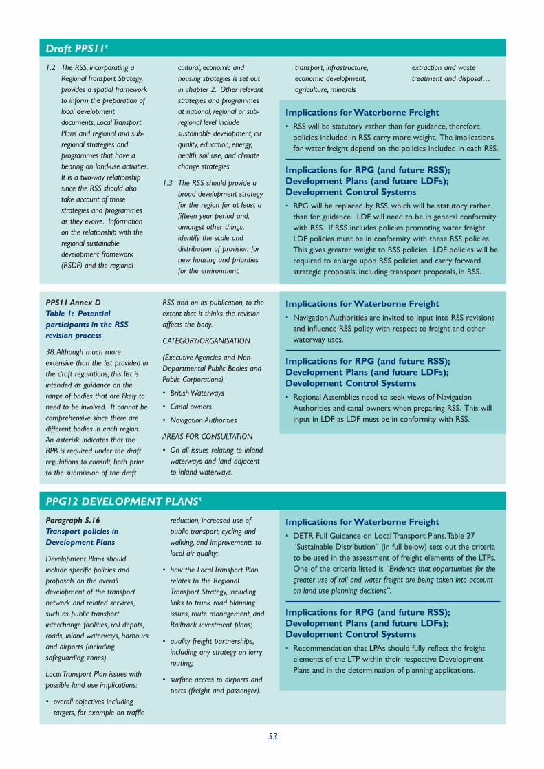
53
PPS11 Annex DTable 1: Potentialparticipants in the RSSrevision process
38.Although much moreextensive than the list provided inthe draft regulations, this list isintended as guidance on therange of bodies that are likely toneed to be involved. It cannot becomprehensive since there aredifferent bodies in each region.An asterisk indicates that theRPB is required under the draftregulations to consult, both priorto the submission of the draft
RSS and on its publication, to theextent that it thinks the revisionaffects the body.
CATEGORY/ORGANISATION
(Executive Agencies and Non-Departmental Public Bodies andPublic Corporations)
• British Waterways
• Canal owners
• Navigation Authorities
AREAS FOR CONSULTATION
• On all issues relating to inlandwaterways and land adjacentto inland waterways.
Implications for Waterborne Freight
• Navigation Authorities are invited to input into RSS revisionsand influence RSS policy with respect to freight and otherwaterway uses.
Implications for RPG (and future RSS);Development Plans (and future LDFs);Development Control Systems
• Regional Assemblies need to seek views of NavigationAuthorities and canal owners when preparing RSS. This willinput in LDF as LDF must be in conformity with RSS.
Paragraph 5.16Transport policies inDevelopment Plans
Development Plans shouldinclude specific policies andproposals on the overalldevelopment of the transportnetwork and related services,such as public transportinterchange facilities, rail depots,roads, inland waterways, harboursand airports (includingsafeguarding zones).
Local Transport Plan issues withpossible land use implications:
• overall objectives includingtargets, for example on traffic
reduction, increased use ofpublic transport, cycling andwalking, and improvements tolocal air quality;
• how the Local Transport Planrelates to the RegionalTransport Strategy, includinglinks to trunk road planningissues, route management, andRailtrack investment plans;
• quality freight partnerships,including any strategy on lorryrouting;
• surface access to airports andports (freight and passenger).
Implications for Waterborne Freight
• DETR Full Guidance on Local Transport Plans,Table 27“Sustainable Distribution” (in full below) sets out the criteriato be used in the assessment of freight elements of the LTPs.One of the criteria listed is “Evidence that opportunities for thegreater use of rail and water freight are being taken into accounton land use planning decisions”.
Implications for RPG (and future RSS);Development Plans (and future LDFs);Development Control Systems
• Recommendation that LPAs should fully reflect the freightelements of the LTP within their respective DevelopmentPlans and in the determination of planning applications.
1.2 The RSS, incorporating aRegional Transport Strategy,provides a spatial frameworkto inform the preparation oflocal developmentdocuments, Local TransportPlans and regional and sub-regional strategies andprogrammes that have abearing on land-use activities.It is a two-way relationshipsince the RSS should alsotake account of thosestrategies and programmesas they evolve. Informationon the relationship with theregional sustainabledevelopment framework(RSDF) and the regional
cultural, economic andhousing strategies is set outin chapter 2. Other relevantstrategies and programmesat national, regional or sub-regional level includesustainable development, airquality, education, energy,health, soil use, and climatechange strategies.
1.3 The RSS should provide abroad development strategyfor the region for at least afifteen year period and,amongst other things,identify the scale anddistribution of provision fornew housing and prioritiesfor the environment,
transport, infrastructure,economic development,agriculture, minerals
extraction and wastetreatment and disposal…
Implications for Waterborne Freight
• RSS will be statutory rather than for guidance, thereforepolicies included in RSS carry more weight. The implicationsfor water freight depend on the policies included in each RSS.
Implications for RPG (and future RSS);Development Plans (and future LDFs);Development Control Systems
• RPG will be replaced by RSS, which will be statutory ratherthan for guidance. LDF will need to be in general conformitywith RSS. If RSS includes policies promoting water freightLDF policies must be in conformity with these RSS policies.This gives greater weight to RSS policies. LDF policies will berequired to enlarge upon RSS policies and carry forwardstrategic proposals, including transport proposals, in RSS.
Draft PPS119
PPG12 DEVELOPMENT PLANS5

54
Table 27 Sustainable distribution
Minimum Requirements:
• Description of policy for thedevelopment of an integrated,sustainable distribution systemwhich takes into account thedominant role of road freightand the potential for modaltransfer to rail or inlandwaterways
• Evidence that the strategic roleof freight distribution in thegrowth or regeneration of thelocal and regional economy hasbeen assessed
• Evidence that efforts havebeen made to bring freighttransport operators, businessesand the local community intothe strategic thinking andplanning processes
• Clear evidence of effectivepartnership with NavigationAuthorities, rail infrastructureproviders and freight operatingcompanies to promote greateruse of alternative modes forfreight distribution
• Evidence that opportunities forthe greater use of rail andwater freight are being takeninto account in land useplanning decisions.
Characteristics of a good LTP:
• Evidence of progress inestablishing freight qualitypartnerships, identifying keyorganizations and companiesinvolved
• Clear strategies to helpindustry develop andimplement best practice
• Comprehensive assessments ofexisting operational and non-operational freight facilitieswithin the area, evidence ofconsideration of potential forfreight grants
• Clear strategies andidentification of flows thatcould be transferred toalternative modes, including anassessment of the lorryjourneys to be saved
• Strategy to balance therequirement for efficient goodsdistribution with the social andenvironmental effects,particularly in an urbanenvironment
• Clear evidence of lorry routingstrategies
Paragraphs 5.22 and 5.23Safeguarding transportroutes
5.22 Where Planning Authoritieswish to safeguard land fora future transport scheme(e.g. a new road, rail linkor restored canal), theyshould do so through aproposal in the Local Plan.When the precise route ofa particular proposal isknown at the time ofpreparation of the plan,this should be clearlyshown on the proposalsmap as the route to besafeguarded. Where theprecise route is not knownbut where the proposalsare sufficiently advanced,the authority may defineon the proposals map thearea over which it intends
to apply a safeguardingpolicy. However, insafeguarding land LocalAuthorities will need to berealistic about theprospects for the start ofthe project in the planperiod and sensitive to theimplications of blight (seeparagraphs 6.24 – 6.26).They should consult withappropriate transportinfrastructure authoritiese.g. the Strategic RailAuthority for rail schemes)to ensure the feasibility ofa scheme commencingwithin the lifetime of aplan. For the sake ofclarity plans should list anytransport schemes whichhave previously beensafeguarded and are nowto be abandoned.
5.23 The Government’s WhitePaper on Transport makesit clear that DevelopmentPlans should give betterprotection to those sitesand routes (both existingand potential) which couldbe critical in developinginfrastructure to widentransport choices. Similarprotective policies areappropriate for rail andwaterway connections toexisting or proposedmanufacturing, distribution,
and warehousing sitesadjacent or close to therail and inland waterwaynetworks and to coastalports. Local Authoritiesmay also wish tosafeguard sites fortransport relateddevelopment which mightotherwise be lost to otherdevelopment, such as sitesadjoining railway sidings orwharves alongsidewaterways and ports.
Implications for Waterborne Freight
• Possibility of protecting corridors for new waterways or forenlargement/improvement of existing waterways.
Implications for RPG (and future RSS);Development Plans (and future LDFs);Development Control Systems
• Need to identify waterway corridors and links to existingwaterways where development could threaten futureenhancement/improvement.
Annex CConsultees for DevelopmentPlans
In addition, Local Authoritiesshould consider the need toconsult the following agencies andorganisations in respect of theissues outlined below:…
British Waterways, canal ownersand Navigation Authorities -
On all issues relating to inlandwaterways and land adjacent toinland waterways.
Implications for Waterborne Freight
• Navigation Authorities to be consulted.
Implications for RPG (and future RSS);Development Plans (and future LDFs);Development Control Systems
• Navigation Authorities to be consulted on ANY proposal thatmay affect waterway operation.

55
Annex C: ConsulteesBritish Waterways, canalowners and NavigationAuthorities
Implications for Waterborne Freight
• Navigation Authorities are invited to input into LDF revisions and influence LDF policy withrespect to freight and other waterway uses.
Implications for RPG (and future RSS); Development Plans (and future LDFs);Development Control Systems
• Local Authorities need to seek views of Navigation Authorities and canal owners when preparingLDF.This will supplement input in RSS.
Development Plandocuments
2.2.1 The Development Plandocuments which Local PlanningAuthorities must prepare includethe following elements: i. Corestrategy; ii. Site specific allocationsof land; iii. Area action plans(where needed); and iv. Proposalsmap (with inset maps, wherenecessary)
THE CORE STRATEGY
2.2.2 The core strategy shouldset out the key elements of theplanning framework for the area.It should comprise a vision andstrategic objectives for the area,along with a spatial strategy, anumber of core policies and amonitoring and implementationframework. It must be kept up-to-date and, once adopted, allother Development Plandocuments must be in conformitywith it.
SITE SPECIFIC ALLOCATIONSAND POLICIES
2.2.10 Where land is allocatedfor specific uses (including mixeduses) this should be made in aDevelopment Plan document.The identification of sites shouldbe founded on a robust andcredible assessment of thesuitability and availability of landfor particular uses or a mix ofuses. Where it is not possible toidentify site specific allocations tomeet the identified needs of thearea, criteria-based policiesshould be used to set theframework for assessing anyunforeseen proposals, such aswindfall development.
2.2.11 Policies relating to thedelivery of the site specific
allocations, such as any criticalaccess requirements, any broaddesign principles or any planningobligations which may be sought,must be set out in aDevelopment Plan document.They may form part of the corestrategy Development Plandocument, be an area action planor be a separate DevelopmentPlan document. Further detail, inthe form, for example, ofdevelopment briefs, may beincluded in supplementaryplanning documents.
AREA ACTION PLANS FOR KEYAREAS OF CHANGE ORCONSERVATION
2.2.12 Area action plans shouldbe used to provide the planningframework for areas wheresignificant change or conservationis needed. A key feature of areaaction plans will be the focus onimplementation. They should:
i. deliver planned growth areas;
ii. Stimulate regeneration;
iii. Protect areas sensitive tochange;
iv. Resolve conflicting objectivesin areas subject to developmentpressures; or
v. focus the delivery of areabased regeneration initiatives.
2.2.13 Authorities may setcriteria in their core strategy foridentifying locations and prioritiesfor area action plan preparation.
2.2.14 In areas of change, areaaction plans should identify thedistribution of uses and theirinter- relationships, includingspecific site allocations, and setthe timetable for the
implementation of the proposals.Further detail, such as the layoutof uses within these allocationsand design requirements etc, maybe provided in the relevant areaaction plan or in one or moresupplementary planningdocuments. In areas ofconservation, area action plansshould set out the policies andproposals for action to preserveor enhance the area, includingdefining areas where specificconservation measures areproposed and areas which will besubject to specific controls overdevelopment.
PROPOSALS MAP
2.2.15 The proposals mapshould illustrate on an OrdnanceSurvey base map all the policiesand proposals contained inDevelopment Plan documentsand saved policies. It should be aseparate Development Plandocument which must be revisedas new Development Plandocuments are prepared and itshould always reflect the up-to-date planning strategy for thearea. The proposals map should:
i. identify areas of protection,such as nationally protectedlandscape and local natureconservation areas, Green Beltland and Conservation Areas; and
ii. illustrate locations and definesites for particular land use anddevelopment proposals includedin any Development Plandocument and identify the areasto which specific policies apply(i.e. illustrate in map form all sitespecific policies and proposals inany adopted Development Plandocument).
ANNEX A: DEFINITIONS ANDILLUSTRATIVE MATERIAL
1.1.1 The Development Plan: willconsist of Regional SpatialStrategies (spatial DevelopmentPlans in London) andDevelopment Plan documentscontained within the LocalDevelopment Framework.
1.1.3 Local DevelopmentFramework (LDF): will comprise aportfolio of local developmentdocuments which will provide theframework for delivering thespatial planning strategy for thearea.
Implications for Waterborne Freight
• Increased opportunity for wharf protection as part ofregeneration, through use of Area Action Plans.
Implications for RPG (and future RSS);Development Plans (and future LDFs);Development Control Systems
• LDF will identify land use patterns including wharves andinfrastructure for transport. Area Action Plans likely to beused as part of regeneration schemes; wharves are especiallyvulnerable to these, and the use of Area Action Plans gives anenhanced opportunity for protection of wharves as part ofconsultation/preparation.
Draft PPS125

56
Transporting waste material
A10 Waste transfer facilitiesrequire sites of sufficient sizeand of appropriateaccessibility to receive thedelivery of collected wasteand to transfer it to bulktransport for delivery byroad, rail, or water, either toa waste processing site or tofinal disposal.
A14 There may be significantenvironmental and economicadvantages when:
c) rail or water transportcan be used instead ofroad vehicles.
A51 There are numerous factorswhich may influence thelocation of new wastemanagement facilities. Newsites might for instance, belocated, if appropriate, withinor adjacent to:
g) other suitable siteslocated close to railwaysor water transportwharves, or majorjunctions in the roadnetwork.
Implications for Waterborne Freight
• Waste authorities set strategic objectives on the location andnumber of facilities.
Implications for RPG (and future RSS);Development Plans (and future LDFs);Development Control Systems
• Waste identified as a topic to be addressed within RegionalPlanning Guidance (& future Regional Spatial Strategies).Recommendation that navigation & port authorities shouldcontribute to policy/strategy development to explore theopportunities to transport by water.
PPG10 PLANNING AND WASTE MANAGEMENT3
Paragraphs 10,11 and 12
10 The locational demands ofbusinesses are therefore a keyinput to the preparation ofDevelopment Plans.Development Plan policiesmust take account of theseneeds and at the same timeseek to achieve widerobjectives in the publicinterest (see paragraph 11).Development Plans offer theopportunity to:
• encourage new developmentin locations which minimisethe length and number oftrips, especially by motorvehicles;
• encourage new developmentin locations that can beserved by more energyefficient modes of transport…
More generally, thepreparation of DevelopmentPlans is now the mainmechanism by which majornew development proposalscan be assessed alongside thetransport improvementsneeded to serve them; and bywhich transport proposals canbe linked to the developmentopportunities they create
11 The Government’s policy, setout in “This CommonInheritance” and subsequentWhite Papers, is to seek tocontrol the emissions ofgreenhouse gases which leadto global warming. Locationalpolicies in Development Planscan help to achieve thatobjective through reducing theneed to travel, andencouraging development inareas that can be served bymore energy efficient modesof transport – such as rail orwater (including coastalshipping). … Port authoritiesshould be encouraged tocontribute…. It will beimportant to consider not onlyland adjacent to existinginfrastructure which is in usebut also locations next todisused facilities which havebeen safeguarded underarrangements described inparagraphs 5.35 and 36 ofPPG12 (5.33 and 34 ofPPG12 (Wales)) and whichmight be returned to freightuse if demand increases.Where land for suchdevelopment opportunities isscarce, Planning Authoritiesmay indicate that they will givepreference to proposals fromindustrial and commercial
users who would benefit fromefficient rail or water servicesrather than for retail orhousing proposals which couldbe located elsewhere. Suchpolicies need to beapproached with flexibility andcare. Their purpose is tomaximise the potential use oftransport infrastructure otherthan roads.
12 Some types of moderndistribution facility have a lowdensity of employment, andare served by a very largenumber of lorries. Retaildistributors, for example,depend on efficient distributionsystems and require strategiclocations capable of servingregional, national andEuropean markets. Extensive,
well-planned out-of-towndistribution parks can offereconomies of scale andconsequent benefits toconsumers or businessessupplied. Sites for suchdevelopments are best locatedaway from urban areas, wherethe nature of the traffic islikely to cause congestion, andwherever possible should becapable of access by rail andwater transport. Such sitesshould be reserved for thosewarehousing uses whichrequire them, and not releasedfor other uses unless there is aclear surplus of suitable sitesin the area, and no realisticprospect of development forthat purpose in theforeseeable future…
Implications for Waterborne Freight
• These paragraphs clearly encourage the allocation of sitesserved by water and rail to businesses that can benefit fromaccess to these modes. The policy encourages uses such asretail away from waterside locations as these do not benefitfrom waterside access.
Implications for RPG (and future RSS);Development Plans (and future LDFs);Development Control Systems
• RPG and Development Plans may identify sites that havewater access and promote policies which encourageproposals that make use of this access.
PPG4 INDUSTRIAL, COMMERCIAL DEVELOPMENT AND SMALL FIRMS2

57
Paragraph 42Release of industrial land
Implications for Waterborne Freight
• Where Local Authorities release land allocated for industrial use there is a risk that watersidesites will be the most attractive for alternative uses, especially housing. Releasing water sideindustrial sites for housing while retaining industrial allocations that only have road access willinhibit the use of waterways for freight.
Implications for RPG (and future RSS); Development Plans (and future LDFs);Development Control Systems
• When reviewing RPG and Development Plan policies it is important to consider the potential ofallocated industrial sites to be served by water transport when making any decision over whichsites should be released.
PPG3 HOUSING1
Paragraph 27
27 Local Planning Authoritiesshould adopt a risk-basedapproach to proposals fordevelopment in or affectingflood-risk areas. Theassessment of risk shouldtake account of:
• the area liable to flooding;
• the probability of itoccurring, both now andover time;
• the extent and standardof existing flood defencesand their effectivenessover time;
• the likely depth offlooding; the rates of flowlikely to be involved;
• the likelihood of impactsto other areas, propertiesand habitats;
• the effects of climatechange;
• the nature and currentlyexpected lifetime of thedevelopment proposedand the extent to which itis designed to deal withflood risk.
Implications for Waterborne Freight
• Many developments related to major commercial waterwayswill be in flood plains, as the waterways themselves are eithermain river (as defined by the Environment Agency) or onlateral canals adjacent to the river. PPG 25 advises ondevelopment in flood plains, and permission will also beneeded for any development in floodplains under the LandDrainage Act. The guidance does not amount to a ban onfloodplain development, but flooding elsewhere must not beexacerbated.
Implications for RPG (and future RSS);Development Plans (and future LDFs);Development Control Systems
• RPG and Development Plans must consider the nature of anydevelopment allocations within floodplains. Where theseallocations relate to water freight activities, which bydefinition cannot be located anywhere else, RPG andDevelopment Plans must consider floodplain implications inmaking any allocation.
PPG25 DEVELOPMENT AND FLOOD RISK8
General principles
2 The impact of noise can be amaterial consideration in thedetermination of planningapplications. The planningsystem has the task of guidingdevelopment to the mostappropriate locations. It willbe hard to reconcile some landuses, such as housing, hospitalsor schools, with other activitieswhich generate high levels ofnoise, but the planning systemshould ensure that, whereverpracticable, noise-sensitivedevelopments are separatedfrom major sources of noise
(such as road, rail and airtransport and certain types ofindustrial development). It isequally important that newdevelopment involving noisyactivities should, if possible, besited away from noise-sensitiveland uses. Development Plansprovide the policy frameworkwithin which these issues canbe weighed but carefulassessment of all these factorswill also be required whenindividual applications fordevelopment are considered.Where it is not possible toachieve such a separation of
land uses,Local PlanningAuthorities should considerwhether it is practicable tocontrol or reduce noise levels,or to mitigate the impact ofnoise, through the use ofconditions or planningobligations.
Noise policies inDevelopment Plans
6 The Secretary of Stateconsiders that housing,hospitals and schools shouldgenerally be regarded as noise-sensitive development, butPlanning Authorities may wish
to include other developmentsor uses within this definition,depending on localcircumstances and prioritiesand, if so, these should beexplained in the DevelopmentPlan.
7 Where it is particularly difficultto separate noise-sensitivedevelopment from noisyactivities, plans should containan indication of any generalpolicies which the LocalPlanning Authority propose toapply in respect of conditionsor planning obligations.
PPG24 PLANNING AND NOISE7

58
Development ControlNoise sensitive development
12 Local Planning Authoritiesshould consider carefully ineach case whether proposalsfor new noise-sensitivedevelopment would beincompatible with existingactivities. Such developmentshould not normally bepermitted in areas which are -or are expected to become -subject to unacceptably highlevels of noise. Whendetermining planningapplications for developmentwhich will be exposed to anexisting noise source, LocalPlanning Authorities should
consider both the likely levelof noise exposure at the timeof the application and anyincrease that may reasonablybe expected in theforeseeable future, forexample at an airport. Annex3 gives guidance on theassessment of noise fromdifferent sources. Authoritieswill also wish to bear in mindthat, while there will be siteswhere noise is significantlylower at night than during theday, other sites may besubjected to night-time noise,for example from traffic, at alevel which is little below thedaytime level. These siteswarrant particular protection:
noise-sensitive developmentshould not normally bepermitted where high levels ofnoise will continue throughout
the night, especially during thehours when people arenormally sleeping (23.00 to07.00).
PPG24 PLANNING AND NOISE7 (continued)
Implications for Waterborne Freight
• Boat Yards and Wharves should be protected fromdevelopment proposals that are noise sensitive and mayhinder operations. This will apply to any infrastructureidentified under other policy guidance for protection.
Implications for RPG (and future RSS);Development Plans (and future LDFs);Development Control Systems
• RPG/Development Plans to include policies that protect boatyards and wharves from noise sensitive developmentproposals, including avoiding the allocation of such sites inDevelopment Plans.

59
A3 Funding
This Section includes details of the funding opportunitiesavailable to promote freight transport by water. Althoughoften not the direct responsibility of the Local Authority, anawareness of these opportunities will help Local Authoritiesand other agencies promote waterborne transport withintheir areas.
Freight Facilities Grant
Freight Facilities Grant (FFG) is available to assist with theextra costs generally associated with moving freight bywater by offsetting the capital costs of providing waterfreight handling facilities. It is also available to helpcompanies reinvest in existing water freight facilities. Thegrant is awarded and administered by the Freight FacilitiesGrant Unit at the Department for Transport.
Most capital expenditure on facilities needed to handle orcarry freight by water is likely to be eligible for FFG. But, inrecognition of EU State Aid rules, grant will not be payablefor the acquisition or modification of ships i.e. self-propelledvessels which require certification to operate outsidedomestic smooth water limits. Changes in the grant schemebeing considered currently will enable grant to be paidtowards operating aid. This will follow similar lines to thoseproposed for the Marco Polo programme and be limited toa maximum of 30% and spread over the first three years ofwater operating costs.
Marco Polo
Marco Polo is the name given to the EuropeanCommission’s proposed 10-year operating aid subsidyprogramme (from 1 January 2003 to 31 December 2010) tohelp achieve modal shift to environmentally friendly modes,in line with the objectives set out in its recent TransportWhite Paper. Marco Polo is a successor to the recentlyconcluded Pilot Actions for Combined Transport (PACT)programme. The draft regulation sets out the way in whichthe Marco Polo programme would operate, includingproposed financial provisions.
Marco Polo subsidy will support commercial actions thatachieve modal shift. It therefore differs from the pre-competitive support given through the Community R&Dprogrammes and the Trans-European Network (TEN)programme. It will apply only to international projects(intra-EU and EU-neighbouring States) normally involving the
co-operation of two or more undertakings established indifferent States. Responsibility for purely national projectscontinues to rest with Member States, subject toCommission State aid approval.
Aggregates Levy Sustainability Fund
The aim of the fund is to address the environmental andsocial costs of aggregate extraction by deliveringenvironmental improvements, minimising the demand forprimary aggregates, promoting environmentally friendlyextraction and transport, encouraging the use of recycledand alternative materials and reducing the local effects ofaggregate extraction. It should be noted that the fund mayonly be utilised for proposals which can not be fundedthrough existing mechanisms.
In England, the Fund will be distributed through EnglishNature, the Countryside Agency, English Heritage, the Wasteand Resources Action Programme (WRAP), DTI’sConstruction Innovation and Research ManagementProgramme. Also, a special provision of £800,000 has beenmade for pilot projects for Leicestershire, Derbyshire andSomerset County Councils, and the Minerals IndustryResearch Organisation has been invited to take part inresearch into sustainable mineral extraction.
Interreg IIIB
INTERREG IIIB is a European source of funding for spatialplanning projects, involving trans-national partnerships oflocal and regional authorities and private sectororganisations. Transport projects are likely to addressissues of European regional significance of cross-borderrelevance such as how to remove trucks from the roads onenvironmental grounds and how to address congestion intransport bottlenecks used for international freight.Therefore this is only likely to be of relevance where trafficis part of a European transport chain.
Local Transport Plan (LTP)Settlement
This is the only source of funding directly available to LocalAuthorities in respect of transport provision, and is basedon an annual settlement to fund a package of proposals fortransport provision. LTP funding replaced the previousTransport Policy and Programme Grant which exclusivelyfunded road schemes. The intention of the LTP system is toavoid pure funding of road schemes and replace it with a
package where sustainable alternatives are also providedsuch as bus priority measures, cycle tracks and park andride. In principle there is no reason why LTP funding shouldnot be used to promote water transport as part of apackage, and more significantly, LTP funding is likely to beavailable to help mitigate the road traffic effects of increaseduse of commercial waterways.
Private Sector Funding
It is unlikely that any major private sector funding sourceswill come forward except by way of Section 106Agreements as part of planning permissions granted fordevelopment. On many occasions, where a developer isrequired to provide replacement facilities, that developerwill also have to pay for these facilities and they may well bebetter than those replaced, by virtue of location or simplybeing more modern. The Section 106 mechanism isintended to promote the concept of planning gain andimproved facilities as part of a development would fulfil thisaim.
60

A4 Health and safety
This Section describes the relevant legislation andregulations that apply to all aspects of handling goods andnavigating vessels on the inland waterways.
Public and private bodies and organisations involved in theencouragement, development and facilitation of freighttransport on inland waterways need to be aware of thevarious Regulations that apply to all aspects of handlinggoods and navigating vessels on the inland waterways. Theprincipal agencies charged with regulatory control relatingto waterborne transport are the Health and SafetyExecutive (HSE) and the Maritime and Coastguard Agency(MCA). A Memorandum of Understanding exists betweenHSE and MCA .
Health and Safety Executive
The work of the marine section of the Heath and SafetyExecutive (HSE) includes overseeing legislation dealing withthe health and safety of people working in docks, shipyardsand inland waterways. Under the Memorandum ofUnderstanding with MCA, HSE’s enforcement role generallyends at the gangway. However, HSE enforces The Health and
Safety at Work Act (1974) and the Docks Regulations (1988)
where they apply to shore based dock workers who maywork on ships. HSE also enforces the Dangerous Substances
in Harbour Areas Regulations 1987.
Following the Thames Safety Inquiry there was a review ofHSE responsibilities in relation to ‘inland waterway safety’.HSE policy has remained that it would have no involvementin matters concerning the design and safety standardsincorporated in the construction, testing and operationaluse of ships and any navigation or similar issues. Matters ofmanning, navigation, design and structural integrity of vessels,protection of workers against navigational or other risks tohealth or safety arising from the marine environment wouldbe the responsibility of the Secretary of State for Transportthrough MCA.
Local Authorities are also responsible for enforcing healthand safety on certain activities on, or adjacent to, inlandnavigations which are prescribed in the Health and Safety
(Enforcing Authority) Regulations 1998. These principally relateto leisure activities, catering services and the hiring out ofpleasure craft.
Maritime and Coastguard Agency(MCA)
The MCA enforces health and safety on ships. The MCA’smain functions are to develop, promote and enforce highstandards of marine safety, to minimise the loss of lifeamongst seafarers and coastal users, and to minimisepollution from ships of the sea and coastline. The MCA’sstatutory powers and responsibilities derive primarily fromthe Coastguard Act 1925, the Merchant Shipping Act 1995 andthe Merchant Shipping and Maritime Security Act 1997 andassociated secondary legislation. The Director of Logisticsand Maritime Transport at the Department for Transport isresponsible for policy oversight and co-ordination of theMCA and the Marine Accident Investigation Branch (MAIB).
MCA is responsible for enforcing all merchant shippingregulations in respect of occupational health and safety,safety of vessels, safe navigation and operation (includingmanning levels and crew competency). For inland andcoastal waters, a vessel is considered to be used innavigation, and therefore under the jurisdiction of MCA, if itoperates on waters listed in the Annexe to Merchant Shipping
Notice MSN 1776 (M) Categorisation of Waters, andsubsequent revisions.
MCA is currently consulting on Technical Standards forInland Waterway Vessels, the harmonisation of Boatmaster’sLicences for inland waterway operations and implementationof the Working Time Directive for mobile workers on inlandwaterways. The Technical Standards comprise regulationsregarding shipbuilding requirements; steering systems, enginedesign, electrical equipment, rigging/outfit, accommodationand other ancillary equipment. These will apply tonewbuilds in the first instance. In the area of crewcompetence, Boatmaster’s Licences would cover suchmatters as navigation rules, vessel manoeuvring and handling,knowledge of vessel construction and stability, engines,accident prevention, actions in the event of damage ordanger, use of rescue and first aid equipment and preventionof fire and pollution.
The Merchant Shipping (Working Time: Inland Waterways)
Regulations 2003 will come into force in 2003 and beenforced by MCA. The Working Time Regulations, whichimplement the European Working Time Directive (93/104/EC),provide protection for the workforce against health andsafety dangers from excessive working hours.
61

British Waterways (BW)
British Waterways (BW) is presently implementing its ownregistration scheme for vessels and certificates of crewcompetence primarily designed to ensure safe operations onits waterways. British Waterways Freight Vessel Conditions 2003
and British Waterways Carriage of Freight Conditions came intoforce in April 2003. The Freight Vessel Conditions requireowners or operators of freight vessels operating on BWwaterways to register the vessel with BW. To be able toregister, the vessel is subject to an annual fitness-for-purposesafety inspection; the vessel must have adequate publicliability insurance. The Conditions of Carriage of Freightrequire the freight contractor to agree an operationalschedule with BW. This includes route, competent crewrequired, lock/bridge/tide times and manning, carriage ofcargo risk assessment and risk assessment for load anddischarge of goods where it is across BW owned orcontrolled property.
Other Safety Interests
Other Navigation Authorities have a safety role on theirown waters, in part to fulfil their duty of care under Section3 of the Health and Safety at Work Act. Port and HarbourAuthorities may also have byelaws which cover variousaspects of operational or vessel safety. The Port MarineSafety Code is an important document in this respect. Itsets out a summary of the legal duties and powers ofharbour authorities relating to marine safety and aims topromote good practice.
62
A5 Bibliography
This Bibliography contains details of all texts referred to inthe preparation of this Guide.
Planning Policy Guidance Notes
1 Planning Policy Guidance Note 3: Housing:DTLR, 2001
2 Planning Policy Guidance Note 4: Industrial,Commercial Development and Small Firms: Department
of the Environment, 1992
3 Planning Policy Guidance Note 10: Planning and WasteManagement: DETR, 1999
4 Planning Policy Guidance Note 11: Regional Planning:DTLR, 2000
5 Planning Policy Guidance Note 12: Development Plans:DTLR, 1999
6 Planning Policy Guidance Note 13:Transport:DTLR, 2001
7 Planning Policy Guidance Note 24: Planning and Noise:Department of the Environment, 1994
8 Planning Policy Guidance Note 25: Development inFlood Plains: ODPM, 2001
9 Draft Planning Policy Statement 11: Regional SpatialStrategies: ODPM, 2003
10 Draft Planning Policy Statement 12: Local DevelopmentFrameworks: ODPM, 2003
Regional Planning Guidance Notes
11 Regional Planning Guidance for the North West (RPG13): Government Office of the Northwest, 2003
12 Regional Planning Guidance for the West Midlands(RPG11): Government Office of the West Midlands, 2001
13 Regional Planning Guidance for the Yorkshire &Humberside (RPG 12): Government Office for Yorkshire
and the Humber, 2001
14 Regional Planning Guidance for the South West (RPG10): Government Office for the South West, 2001
Development Plans
15 Trafford Borough Revised Unitary Development Plan:Trafford Metropolitan Borough Council, 2002
16 Worcestershire County Structure Plan: Worcestershire
County Council: Adopted, June 2001
17 City Of Worcester Local Plan Revised Deposit Draft:City of Worcester Council, 2002
18 Somerset and Exmoor National Park Joint StructurePlan Review: Somerset County Council and Exmoor
National Park Authority: Adopted April 2000
20 Sedgemoor District Local Plan-Revised Deposit Draft:Sedgemoor District Council, 2001
21 The Draft London Plan: Mayor of London, 2001
Other Documents
22 Freight on Water - A New Perspective: The Report of
the Freight Study Group: DEFRA, 2002
The Government’s Response to the Report of the
Freight Study Group: DEFRA and DfT, 2002
23 Planning a Future for the Inland Waterways - A GoodPractice Guide: Inland Waterways Amenity Advisory
Council, 2001
24 North West Regional Freight Strategy: North West
Freight Advisory Group, 2003
25 Good Practice Guide 335,A Guide on How to Set Upand Run Freight Quality Partnerships, and GoodPractice Case Study 410: TransportEnergy BestPractice
on behalf of the Department for Transport, 2003. Free
copies available from www.transportenergy.org.uk or by
calling 0845 602 1425
26 Freight Toolkit for the North East: The Northern Freight
Group, 2002
27 Transporting Freight by Rail and Inland Waterways inWest Yorkshire - A Guide for Potential Users: West
Yorkshire Partners for Quality Integrated Transport, 2000
28 Waterways for Tomorrow: DETR, 2000
29 Waterways and Development Plans: British Waterways,
2003
30 The White Paper A New Deal for Transport: Better for
Everyone: DETR, 1998
31 Sustainable Distribution:A Strategy: DETR, 1999
32 Modern Ports: DETR, 2000
63

33 Safeguarding Wharves on the Thames: ConsultationDraft: Greater London Authority, 2003
34 Port Marine Safety Code: DETR, 2000
35 Moving Freight from Road to Inland Waterway andMaritime Transport – Post-consultation Response: DfT,
Scottish Executive and Welsh Assembly Government, 2002
36 Benchmark Report 2002: DfT, 2003
37 Waterborne Freight Statistics in the UK 2002:DfT, 2003
38 Fourth Report Inland Waterways (HC 317-1):House of Commons Environment,Transport and Rural
Affairs Committee, 2001
39 Inland Waterways and the Transport of Waste: Resource
Recovery Forum, 2000
40 Nicholson Guides, for various individual inlandwaterways
64

A6 Useful Contacts
Department for TransportFreight Facilities Grant UnitZone 2/24 Great Minster House76 Marsham StreetLondon SW1P 4DR
Tel: 020 7944 [email protected]
Department for Environment,Food and Rural AffairsMarine and Waterways DivisionZone 3/B5Ashdown House123 Victoria StreetLondonSW1E 6DE
Tel: 020 7082 8177www.defra.gov.uk
Office of the Deputy Prime MinisterPlanning DirectorateEland HouseBressenden PlaceLondonSW1E 5DU
Tel: 020 7944 3000www.odpm.gov.uk
Association of Inland Navigation AuthoritiesWillow GrangeChurch RoadWatfordWD17 4QA
Tel: 01923 201286www.aina.org.uk
Association of Inland Shipping OperatorsThe BoathouseMersey RoadRuncornCheshireWA7 1DF
Tel: 01928 567359
British WaterwaysWillow GrangeChurch RoadWatfordWD17 4QA
Tel: 01923 226422www.britishwaterways.org
Commercial Boat Operators AssociationP.O. Box 7065Milton KeynesMK13 8YQ
Tel: 01908 [email protected] www.cboa.org.uk
Freight Transport AssociationHead OfficeHermes HouseSt John’s RoadTunbridge WellsKent TN4 9UZ
Tel: 01892 526171www.fta.co.uk
Inland Shipping GroupInland Waterways Association3 Norfolk CourtNorfolk RoadRickmansworthWD3 1LT
Tel: 01923 [email protected]
Sea and WaterShortsea and Waterways Solutions202 Lambeth RoadLondonSE1 7JW
Tel: 020 7928 [email protected]
65

TransportEnergy BestPractice programme provides authoritative, independent information and advice to helpimplement sustainable transport initiatives. This information is disseminated through publications, videos andsoftware, together with seminars, workshops and other events. For further information visit our web site atwww.transportenergy.org.uk/bestpractice or contact the Helpline 0845 602 1425
Crown Copyright. April 2004. GPG2122.
Printed on paper containing 75% post-consumer waste and 25% elemental chlorine free pulp.