planning, design and development committee item d3 for ... committee 20… · overview: • a...
TRANSCRIPT

ReportM- _ BRAMPTON Planning Design andbramptoiua FlOWef Oty Development Committee
Committee of the Council of The Corporation of the City of Brampton
Date January 25 2011
File City File C03E16002 PLANNING DESIGN ampDEVELOPMENT COMMITTEE Subdivision File 21T-09010B
Subject INFORMATION REPORT
Application to Amend the Official Plan and the Zoning By-Law and an Application for a Draft Plan of Subdivision KLM PLANNING PARTNERS INC - GARDEN MANOR CONSTRUCTION INC SANDRINGHAM PLACE INC WOLVERLEIGH CONSTRUCTION LTD 655339 ONTARIO INC (To permit the development of the lands within a subdivision for employment uses a commercial village area a highway commercial use and an auto mall by creating 7 employment blocks 1 stormwater management block 1 drainage channel and a total of 4 subdivision roads) Lot 16 and 17 Concession 3 EHS Ward 9
Contact Allan Parsons Manager Planning Design and Development Department
OVERVIEW
bull A statutory public meeting was previously held for this application on December 7 2009 After the public meeting the application was revised to include a proposal to amend the Official Plan to allow additional land uses (an auto mall a gas station and limited retail and office uses)
bull The subject property is designated Industrial and Open Space in the Official Plan
bull The Countryside Villages Secondary Plan (Area 48) designates the subject lands Prestige Industrial Vaileyland Wetland and Terrestrial Feature Stormwater Management Facility
bull The existing zoning on the subject lands is Agricultural (A) Agricultural - Section 847 (A- Section 847) and Institutional Two shySection 748 (12 - Section 748) by By-Law 270-2004 as amended
4b Information Report
Recommendations
1 THAT the report from Allan Parsons Manager of Development Services Planning Design and Development Department dated January 25 2011 to the Planning Design and Development Committee Meeting of March 7 2011 re Application to Amend the Official Plan and the Zoning By-Law and an Application for a Draft Plan of Subdivision KLM PLANNING PARTNERS INC - GARDEN MANOR CONSTRUCTION INC SANDRINGHAM PLACE INC WOLVERLEIGH CONSTRUCTION LTD 655339 ONTARIO INC (To permit the development of the lands within a subdivision for employment uses a commercial village area a highway commercial use and an auto mall by creating 7 employment blocks 1 stormwater management block 1 drainage channel and 4 subdivision roads) Ward 9 File C03E16002 be received and
2 THAT staff be directed to report back to Planning Design and Development Committee with the results of the Public Meeting and a staff recommendation subsequent to the completion of the circulation of the application and a comprehensive evaluation of the proposal
Background
The above noted Application to Amend the Official Plan and the Zoning By-law and the Application for a Draft Plan of Subdivision has been filed with the City to develop the lands for employment uses an auto mall a highway commercial use and limited retail and office uses This application initially proposed an amendment to the Zoning By-law and a plan of subdivision The auto mall service station retail and office uses now being proposed were not anticipated at that time and necessitate an Official Plan Amendment An amendment to the Official Plan was not presented at the statutory public meeting that was held on December 7 2009 and with the addition of these proposed uses a second statutory public meeting under the Planning Act is mandatory to consider the revised proposal
Proposal Details of the proposal are as follows
The subject lands are proposed to be developed with a range of employment uses an auto mall a highway commercial use and limited retail and office uses within the proposed subdivision The land is proposed to be subdivided as follows (Refer to Map 1 - Draft Plan of Subdivision)
bull 7 employment blocks (586 ha) - Blocks 1 to 7 bull 1 Storm Water management Block (66 ha) - Block 8 bull 1 Drainage Channel Block (39 ha) - Block 9 bull 2 Open Space (11 ha) - Blocks 10 and 11
Vi-3 bull 2 Wetland Blocks and associated buffer areas (combined total of 48 ha) shy
Blocks 12-15 bull 4 Streets (45 ha) and bull Road Widening Blocks - Blocks 18 to 20
Property Description and Surrounding Land Use (See Map 2 Location)
The subject property has the following characteristics
bull is bound by Mayfield Road to the north Dixie Road to the east Countryside Drive to the south and Highway410 to the west
bull has a site area of 785 hectares (194 acres)
bull has frontage on Countryside Drive Dixie Road Mayfield Road and Highway 410
The surrounding land uses are described as follows
North Mayfield Road beyond which is vacant agricultural land located within the Town of Caledon
South Countryside Drive beyond which are lands subject to a draft plan of subdivision and application to amend the Official Plan and Zoning By-law (C03E15009) to permit the development of 520 low and medium density housing units and a registered plan of subdivision (M-1829) to be developed with 315 townhouse dwellings and 17 single detached dwellings
East Dixie Road beyond which are vacant agricultural lands subject to a Community Block Plan and draft plan of subdivision (C04E16002 and C04E17002) for LowMedium Density Residential Medium Density Residential Commercial Live Work and Mixed Use land uses
West Highway 410 beyond which are vacant agricultural lands subject to an application to amend the Zoning By-law and a draft plan of subdivision for employment uses (C03E16004)
Outstanding Issues
bull A comprehensive review of the proposed uses will be completed to ensure that the employment density targets outlined in the Secondary Plan will be maintained This review will include an analysis of the size and extent of the proposed auto mall highway commercial office and retail uses within the subdivision to ensure compliance with Official Plan policy
t-i+ bull Appropriate measures will be required to ensure impacts to the natural
heritage system are mitigated
bull Community design guidelines will need to include adequate details to ensure the development of an attractive and pedestrian friendly environment throughout the subdivision
Further details on the technical aspects of this application can be found in the Information Summary contained in Appendix 5
Respectfully submitted
Dan Kraszewski MCIP RPP Director Land Development Commissioner Planning Design Services and Development
Authored by Carmen Caruso
APPENDICES
Appendix 1 Official Plan (Schedule A General Land Use Designations) Extract
Appendix 2 Secondary Plan (Land Use Schedule)
Appendix 3 Zoning Extract
Appendix 4 Existing Land Uses
Appendix 5 Information Summary
frl-k
SUBJECT LANDS
MAP 1 - DRAFT PLAN OF SUBDIVISIONH BRAMPTON jgf KLM PLANNING PARTNERS INC sssra FlowerCity ^ Garden Manor Construction Inc Sandringham Place Inc PLANNING DESIGN ANDDEVELOPMENT Wolverleigh Construction Ltd amp 655339 Ontario Ltd
Date20110127 Drawn By MA CITY FILE C03E16002 AND 21T-09010B
Sca
le 1
10
00
0
Scale
15
00
00
SU
BJE
CT
LA
ND
PR
OP
ER
TY
LIN
E
SC
HO
OL
OP
EN
SP
AC
E
I
WA
RD
BO
UN
DA
RY
HIG
HW
AY
NO
TE
O
PE
N S
PA
CE
IS
AN
EX
TR
AC
T F
RO
M S
CH
ED
UL
E A
(G
EN
ER
AL
L
AN
D U
SE
DE
SIG
NA
TIO
NS
) FR
OM
TH
E B
RA
MP
TO
N O
FF
ICIA
L P
LA
N
MA
P 2
-
LO
CA
TIO
N
KL
M P
LA
NN
ING
PA
RT
NE
RS
IN
C
Gar
den
Man
or
Co
nst
ruct
ion
Inc
S
and
rin
gh
am
Pla
ce I
nc
W
olv
erle
igh
Co
nst
ructi
on
Ltd
amp
6
55
33
9 O
nta
rio
Ltd
CIT
Y F
ILE
C
03
E1
60
02
amp 2
1T
-09
01
0B
BS
BRA
MPT
ON
Mbram
plonca
FlOWe
Ci
ty D
raw
n B
y M
A
PLA
NN
ING
D
ESI
GN
amp D
EV
EL
OPM
EN
T
Date
2
01
1 0
1 2
7
M-g _A
-BRshy
9 2
plusmn iLu rTlt3MABR0OKmdash6RESshy
T 1 EXTRACT FROM SCHEDULE A(GENERAL LAND USE DESIGNATIONS) OF THE CITY OF BRAMPTON OFFICIAL PLAN
I nnnrnur IMHIICTDIAI MampS2SL-trade LOCAL ROADINDUSTRIAL
PROVINCIAL
SUBJECT LAND WATERCOURSE
HIGHWAYOPEN SPACE HIGHWAYS
MAJOR ROADRESIDENTIAL CITY LIMIT
APPENDIX 1|i BRAMPTON OFFICIAL PLAN DESIGNATIONS brcmptonco FlOWer Qty KLM PLANNING PARTNERS INC PLANNING DESIGN ampDEVELOPMENT Garden Manor Construction Inc Sandringham Place Inc
50 100 Wolverleigh Construction Ltd amp655339 Ontario Ltd Drawn By MA
Metres CITY FILE C03E16002 amp 21T-09010B Date 2011 01 27
Tgti-q
EXTRACT FROM DRAFT SCHEDULE SP48(A) OF THE DOCUMENT KNOWN AS THE SANDRINGHAM - WELLINGTON NORTH SECONDARY PLAN
GATEWAYI K-5 PUBLIC JUNIOR ELEMENTARY SCHOOL SITE SUBJECT LAND
HIGHWAY 410 CORRIDORSEPARATE ELEMENTARY SCHOOL SITE LOW DENSITY RESIDENTIAL
OFFICE CENTREVALLEYLANDMEDIUM DENSITY RESIDENTIAL m
PRESTIGE INDUSTRIALWETLANDLIVE WORK
iru^srj
NEIGHBOURHOOD PARK MIXED USE V2222 terrestrial feature NP
SPECIAL POLICY AREA 1(SWMJ STORMWATER MANAGEMENT FACILITYMOTOR VEHICLE COMMERCIAL
SPA 48 BOUNDARYlt gt POTENTIAL INTERSECTIONNEIGHBOURHOOD RETAIL
COLLECTOR ROADbullmdash mdash mdash MINOR ARTERIAL ROADMAJOR ARTERIAL ROAD
APPENDIX 2bull BRAMPTON SECONDARY PLAN DESIGNATIONS bramptoncn FlOWer Gty KLM PLANNING PARTNERS INC PLANNING DESIGNamp DEVELOPMENT Garden Manor Construction Inc Sandringham Place Inc
0 50 100 Wolverleigh Construction Ltd amp655339 Ontario Ltd Drawn By MA
Metres CITY FILE C03E16002 amp 21T-09010B Date 2011 01 27
fc-o
-MAYF1EU3
HIGHWAYRESIDENTIALCOMMERCIALSUBJECT LAND
INSTITUTIONALFLOODPLAINZONING BOUNDARY
| | CITY LIMITOPEN SPACEAGRICULTURAL
APPENDIX 3bull BRAMPTON ZONING DESIGNATIONS braraplonca HOWei GtV KLM PLANNING PARTNERS INC PLANNING DESIGN amp DEVELOPMENT Garden Manor Construction Inc Sandringham Place Inc
0 50 100 Wolverleigh Construction Ltd amp655339 Ontario Ltd Drawn By MA
Metres CITY FILE C03E16002 amp 21T-09010BDate20110127
ESdl __
bullj - _1 ^
MAYFIEL-0
COUNTRrsTDE~~WGNTRYSn r DB
AERIAL PHOTO DATE MARCH2010
SUBJECT LAND COMMERCIAL AGRICULTURAL
OPEN SPACE INDUSTRIAL CITY LIMIT
RESIDENTIAL INSTITUTIONAL
APPENDIX 4S BRAMPTON AERIAL amp EXISTING LAND USE brarapiono Flower Gty KLM PLANNING PARTNERS INC PLANNING DESIGNamp DEVELOPMENT Garden Manor Construction Inc Sandringham Place Inc
0 50 100 Wolverleigh Construction Ltd amp 655339 Ontario Ltd Drawn By MA
Metres CITY FILE C03E16002 amp 21T-09010BDate 2011 01 27
fci-v APPENDIX 5
Origin
Applicant
Owner
Official Plan
INFORMATION SUMMARY
Date Submitted February 2011
KLM PLANNING PARTNERS INC
Garden Manor Construction Inc Sandringham Place Inc Wolverleigh Construction Ltd 655339 Ontario Limited
The subject property is designated Industrial and Open Space on Schedule A of the Official Plan
The Industrial Designation provides for the development of light to heavy industrial uses such as manufacturing processing repair and service warehousing and distribution Corporate head offices and high performance industrial uses such as research and development facilities are also permitted In addition limited service and retail uses are permitted where practical and appropriate
Schedule D Natural Heritage Features identifies the Open Space designation as being comprised of ValleylandWatercourse features as well as Provincially Significant Wetlands The applicant has submitted an Environmental Impact Study to address the impact of the proposed development to these features and to identify preservation and mitigation measures The studies are currently being reviewed to ensure that environmental issues are addressed
The Cultural Heritage Map of the Official Plan identifies Class B Heritage Resources on the subject lands The applicant has submitted a Cultural Heritage Impact Assessment to determine if conservation measures should be incorporated The Assessment is currently being reviewed by City Staff
Schedule H Community Block Plan Areas identifies the subject lands as being within Block Plan Area 48-1 Section 1011 of the Countryside Villages
Secondary Plan
INFORMATION SUMMARY
Secondary Plan states that the lands within Secondary Plan Area 48a which include the subject lands do not require a Community Block Plan The proposal to subdivide the subject lands for employment uses and limited commercial office service and retail uses is in keeping with the Official Plan policies An amendment to the Official Plan is not required
The elements of the planning vision for the employment lands of the Countryside Villages Secondary Plan (Area 48a) are
bull Establish an employment area consisting of prestige industrial and office uses that are developed to a high standard of urban design
bull Protect enhance and restore the natural heritage areas and features and developing open space networks with views and vistas
bull Include a range of employment based uses that are planned to be dynamic and highly accessible in order to maximize their
development potential in the GTA market place and achieve the employment targets
bull A street network balancing function and urban design that supports higher frequency transit service
The subject lands are primarily designated Prestige Industrial in the Countryside Villages Secondary Plan (Area 48a) This designation permits a range of industrial uses that include research and
development facilities manufacturing and processing assembling packaging repairing fabricating warehousing and distribution Permitted commercial uses include office uses hotels conferenceconvention centres business support services restaurants and ancillary commercial and retail
There are several Natural Heritage and Environmental Management designations within the subject lands that include Valleyland Wetland and Terrestrial Feature The precise locations configurations and boundaries of these features
S-iH
INFORMATION SUMMARY
Zoning By-law
Environmental Issues
Documents Submitted In
Support of Application
shall be confirmed through the Environmental Impact Study that has been submitted and is being reviewed by City Staff Further the required studies will address the impact on these features and identify preservation and mitigation measures With regard to the proposed uses on the site the Secondary Plan does permit ancillary and accessory retail uses However the use of an auto mall a service station and the extent to which the village commercial is being proposed was not anticipated within the subject lands The subject development proposal requires an amendment to the Secondary Plan to facilitate these uses
The subject lands are zoned Agricultural (A) Agricultural (A) - Section 847 and Institutional Two (12) - Section 748 in By-Law 270-2004 as amended An amendment to the Zoning By-law will be required to permit the development of the subject lands for employment and commercial uses
The subject lands contain a number of environmentally significant features (ie Valleyland Provincially Significant Wetlands and Terrestrial Feature designations) The extent to which these areas must be protected will be confirmed through the review of the submitted Environmental Impact Study to the satisfaction of the City of Brampton in consultation with the Toronto and Region Conservation Authority
The following studies were submitted in support of the application
Environmental Impact Study Planning Justification Brief Functional Servicing Report Detailed Traffic Impact Study Urban Design Brief Cultural Heritage Impact Assessment
Proposed Servicing
Agency Comments Received
Growth Management
Heritage Impact
Public Meeting Notification Area
fcVraquo5 INFORMATION SUMMARY
A Functional Servicing Report is submitted to provide details with respect to services and service connections Full municipal services are proposed for this development
The application has been circulated to internal and external departments and agencies Complete comments and conditions that are received will be provided in the forthcoming Recommendation Report
The subject lands are located within Bramptons Greenfield area As required by the Provincial Growth Plan Greenfield Areas are to be planned to achieve a density of 50 people and jobs combined per hectare across the Region Development on the subject site should support the Region-wide density target for Greenfield Areas Also Policy 5212 of the Secondary Plan 48(a) requires that the Countryside Villages Secondary Plan (Chapters 48(a) and 48(b) shall accommodate employment in the order of 7500 jobs resulting in a density of 54 persons and jobs per hectare Both Secondary Plan Chapters shall be combined to achieve the Growth Plan density target for Greenfield Areas This application will be reviewed further to confirm if these policies will be satisfied by the proposal
The Cultural Heritage Map in the 2006 Official Plan identifies Class B Heritage Resources at the northeast corner of the subject lands (southwest corner of Mayfield Road and Dixie Road) A Heritage Impact Assessment is submitted and being reviewed to determine if it adequately considers the heritage resource and proposes acceptable mitigation measures
Notice of the Public Meeting was given by prepaid first class mail to all persons assessed in respect of land to which the proposal applies and within 900 metres of the area to which the proposal applies within the City of Brampton and 120 metres within
INFORMATION SUMMARY
the Town of Caledon as shown on the last revised assessment roll and by public notification in the Brampton Guardian
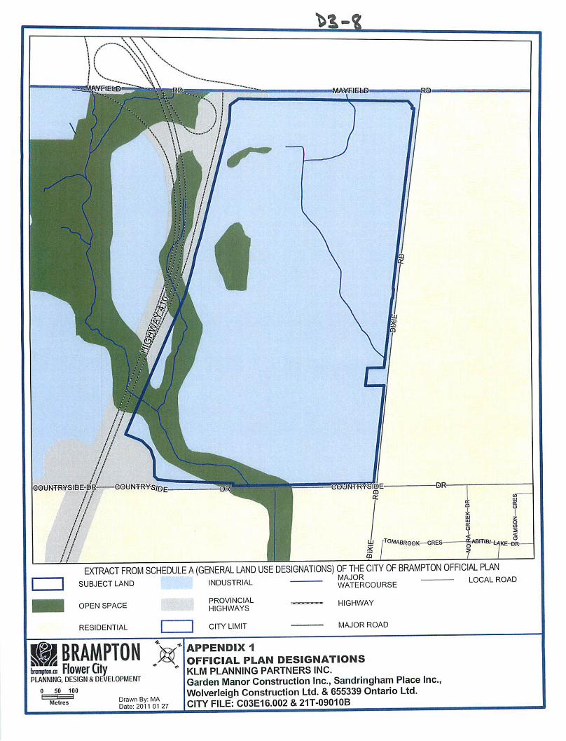
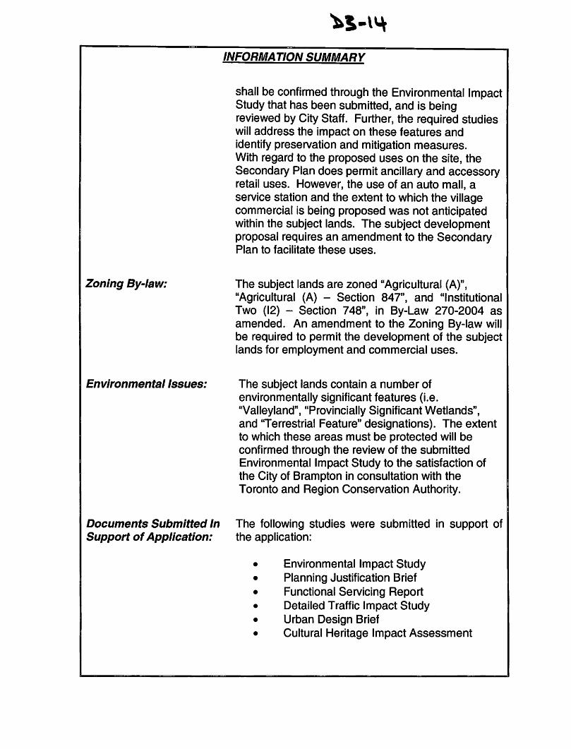

INFORMATION SUMMARY
the Town of Caledon as shown on the last revised assessment roll and by public notification in the Brampton Guardian