planning criteria for offshore wind energy north sea
TRANSCRIPT
Planning Criteria for Offshore Wind Energy
North Sea region overview
SEANSE Project Report
Work Package 1 – Baseline Study
SEANSE // WP 1 // Planning Criteria for Offshore Wind Energy – North Sea region overview
2
Table of contents
Introduction .................................................................................................................... 1
Overview on offshore wind development...................................................................... 2
General siting criteria ..................................................................................................... 4
OWF and shipping routes ............................................................................................... 6
OWF and fisheries .......................................................................................................... 8
OWF and marine protected areas (MPAs) ................................................................... 10
OWF and species protection ........................................................................................ 12
OWF and flight safety ................................................................................................... 14
OWF and cables, pipelines ........................................................................................... 16
Other planning issues ................................................................................................... 18
Siting and layout criteria within a windfarm ................................................................ 20
Summary and conclusion ............................................................................................. 21
Editor:
Marie Dahmen
Bundesamt für Seeschifffahrt und Hydrographie (BSH)
Authors:
SEANSE project partners (Rijkswaterstaat, the Netherlands; Bundesamt für Seeschifffahrt und Hydrographie, Germany; Marine Scotland, United Kingdom) and SG1 cooperation partners (Ministry of Environment, Belgium; Ministry of Petroleum and Energy, Norway).
The content of this report is based on information provided by the SEANSE project partners and SG1 cooperation partners and was collected between July and October 2019.
We would like to thank everyone who contributed to this report.
SEANSE // WP 1 // Planning Criteria for Offshore Wind Energy – North Sea region overview
1
Introduction
The development of renewable energies, in particular offshore wind energy, is one of the main drivers of maritime spatial planning (MSP) in the North Sea. A lot of space is required for the production of offshore wind energy and the potential environmental impacts are an important planning factor for the allocation of offshore wind farms (OWF). The challenge for the North Sea countries is to cooperate across borders to plan wind energy sites efficiently and with a minimum of adverse effects on the ecology and on other uses of the marine space.
The SEANSE (Strategic Environmental Assessment North Sea Energy) project was initiated to help North Sea countries face this challenge. The overall objective of SEANSE is to support the establishment and implementation of maritime spatial plans, in line with the EU Directive on MSP. In this project report, planning criteria for the allocation of offshore wind energy are compiled and compared with the aim to share information on established standards, on safety zones and different ways of managing conflicting marine uses. This can support the identification of key planning issues for which transboundary planning solutions could be developed in future collaboration.
For this baseline study on planning criteria, SEANSE partners jointly performed a sampling and comparison of planning criteria in MSP. To begin with, an overview on MSP and offshore wind development in the North Sea countries is given. Next, general siting criteria are compared. The main part of the report concerns the presentation of the various sectoral arrangements for OWF in relation to other marine uses in the North Sea region. Conflicts arise between various claims for the use and protection of the marine space, particularly concerning OWF and shipping routes, fisheries, flight safety, cables and pipelines, as well as marine protected areas and species protection.
For each planning arrangement on OWF and other marine uses, the following categories can usually be applied:
1) strict regulation (exclusion/restriction), 2) to be considered (partial restriction/adjustments), or 3) possible parallel usage (multi-use).
In the North Sea region, different spatial designations, rules and conditions are applied when planning areas for offshore energy. The different national approaches for sectoral arrangements are presented and compared in a similar sequence:
Specifications = spatial determinations, defined requirements, rules, and conditions
Exception = exceptions from specifications or planning determinations
Adjustments = possible change/adjustment of planning determinations for other uses, e.g. to solve conflicts on a case-by-case assessment
Transboundary issues = planning specifications that have or might have a transboundary relevance or impact
Siting and layout criteria within a wind farm are also covered in the report. For some planning themes, remarkable approaches or planning solutions are introduced in case studies.
At the SEANSE final conference, a workshop was conducted on MSP and planning criteria with a focus on main conflicts with offshore wind energy and possible planning solutions. The workshop report with further information and results is available at www.northseaportal.eu.
SEANSE // WP 1 // Planning Criteria for Offshore Wind Energy – North Sea region overview
2
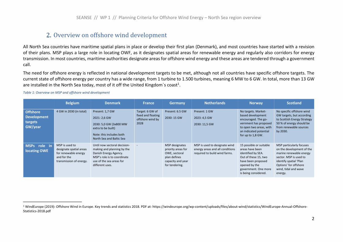
Overview on offshore wind development
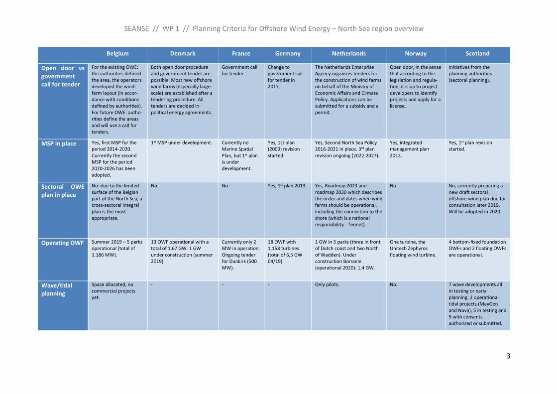
All North Sea countries have maritime spatial plans in place or develop their first plan (Denmark), and most countries have started with a revision of their plans. MSP plays a large role in locating OWF, as it designates spatial areas for renewable energy and regularly also corridors for energy transmission. In most countries, maritime authorities designate areas for offshore wind energy and these areas are tendered through a government call.
The need for offshore energy is reflected in national development targets to be met, although not all countries have specific offshore targets. The current state of offshore energy per country has a wide range, from 1 turbine to 1.500 turbines, meaning 6 MW to 6 GW. In total, more than 13 GW are installed in the North Sea today, most of it off the United Kingdom´s coast1.
Table 1: Overview on MSP and offshore wind development
Belgium Denmark France Germany Netherlands Norway Scotland
Offshore Development targets GW/year
4 GW in 2030 (in total) Present: 1,7 GW
2021: 2,6 GW
2030: 5,0 GW (3x800 MW extra to be built)
Note: this includes both North Sea and Baltic Sea
Target: 6 GW of fixed and floating offshore wind by 2028
Present: 6.5 GW
2030: 15 GW
Present: 1 GW
2023: 4,5 GW
2030: 11,5 GW
No targets. Market-based development encouraged. The go-vernment has proposed to open two areas, with an indicated potential for up to 1,8 GW.
No specific offshore wind GW targets, but according to Scottish Energy Strategy 50 % of energy should be from renewable sources by 2030.
MSPs role in locating OWE
MSP is used to designate spatial areas for renewable energy and for the transmission of energy.
Until now sectoral decision-making and planning by the Danish Energy Agency. MSP’s role is to coordinate use of the sea areas for different uses.
- MSP designates priority areas for OWE, sectoral plan defines capacity and year for tendering.
MSP is used to designate wind energy areas and all conditions required to build wind farms.
15 possible or suitable areas have been identified by SEA. Out of these 15, two have been proposed opened by the government. One more is being considered.
MSP particularly focuses on the development of the marine renewable energy sector. MSP is used to identify spatial ‘Plan Options’ for offshore wind, tidal and wave energy.
1 WindEurope (2019): Offshore Wind in Europe. Key trends and statistics 2018. PDF at: https://windeurope.org/wp-content/uploads/files/about-wind/statistics/WindEurope-Annual-Offshore-Statistics-2018.pdf
SEANSE // WP 1 // Planning Criteria for Offshore Wind Energy – North Sea region overview
3
Belgium Denmark France Germany Netherlands Norway Scotland
Open door vs government call for tender
For the existing OWE: the authorities defined the area, the operators developed the wind-farm layout (in accor-dance with conditions defined by authorities). For future OWE: autho-rities define the areas and will use a call for tenders.
Both open door procedure and government tender are possible. Most new offshore wind farms (especially large-scale) are established after a tendering procedure. All tenders are decided in political energy agreements.
Government call for tender.
Change to government call for tender in 2017.
The Netherlands Enterprise Agency organizes tenders for the construction of wind farms on behalf of the Ministry of Economic Affairs and Climate Policy. Applications can be submitted for a subsidy and a permit.
Open door, in the sense that according to the legislation and regula-tion, it is up to project developers to identify projects and apply for a license.
Initiatives from the planning authorities (sectoral planning).
MSP in place Yes, first MSP for the period 2014-2020. Currently the second MSP for the period 2020-2026 has been adopted.
1st MSP under development. Currently no Marine Spatial Plan, but 1st plan is under development.
Yes, 1st plan (2009) revision started.
Yes, Second North Sea Policy 2016-2021 in place. 3rd plan revision ongoing (2022-2027).
Yes, integrated management plan 2013.
Yes, 1st plan revision started.
Sectoral OWE plan in place
No: due to the limited surface of the Belgian part of the North Sea, a cross-sectoral integral plan is the most appropriate.
No. No. Yes, 1st plan 2019. Yes, Roadmap 2023 and roadmap 2030 which describes the order and dates when wind farms should be operational, including the connection to the shore (which is a national responsibility - Tennet).
No. No, currently preparing a new draft sectoral offshore wind plan due for consultation later 2019. Will be adopted in 2020.
Operating OWF Summer 2019 – 5 parks operational (total of 1.186 MW).
13 OWF operational with a total of 1,67 GW. 1 GW under construction (summer 2019).
Currently only 2 MW in operation. Ongoing tender for Dunkirk (500 MW).
18 OWF with 1,158 turbines (total of 6,5 GW 04/19).
1 GW in 5 parks (three in front of Dutch coast and two North of Wadden). Under construction Borssele (operational 2020): 1,4 GW.
One turbine, the Unitech Zephyros floating wind turbine.
4 bottom-fixed foundation OWFs and 2 floating OWFs are operational.
Wave/tidal planning
Space allocated, no commercial projects yet.
- - - Only pilots. No. 7 wave developments all in testing or early planning. 2 operational tidal projects (MeyGen and Nova), 5 in testing and 5 with consents authorised or submitted.
SEANSE // WP 1 // Planning Criteria for Offshore Wind Energy – North Sea region overview
4
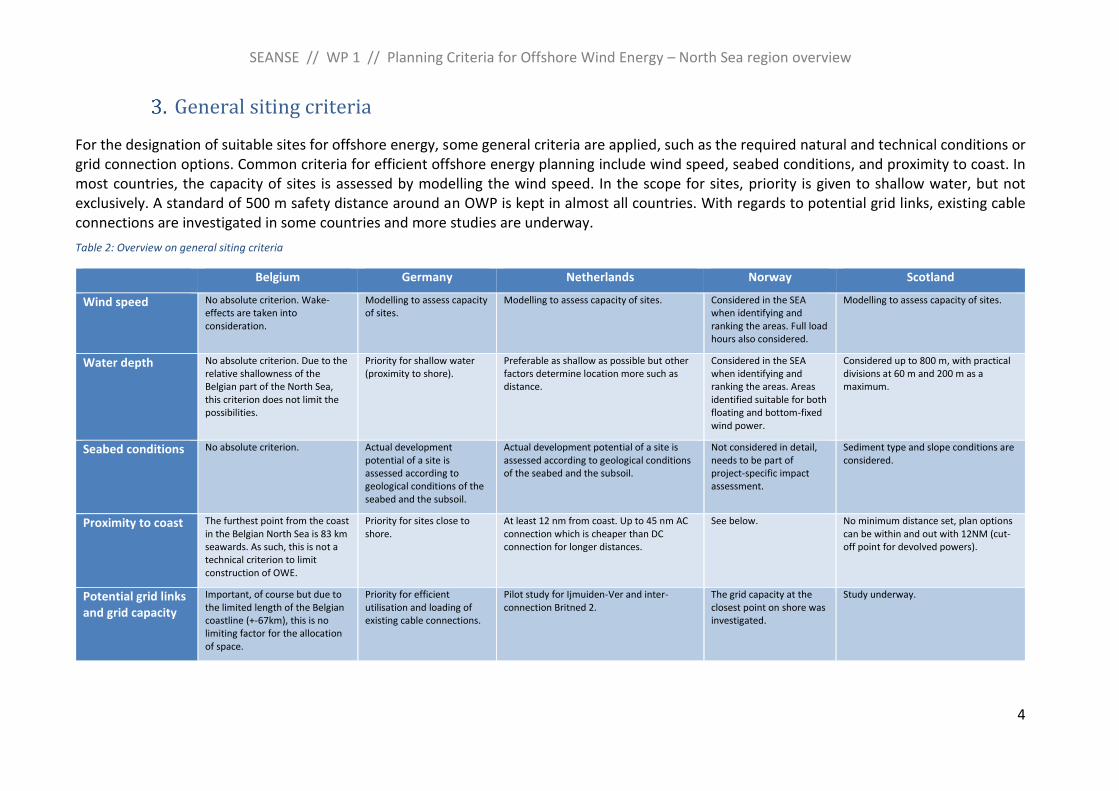
General siting criteria
For the designation of suitable sites for offshore energy, some general criteria are applied, such as the required natural and technical conditions or grid connection options. Common criteria for efficient offshore energy planning include wind speed, seabed conditions, and proximity to coast. In most countries, the capacity of sites is assessed by modelling the wind speed. In the scope for sites, priority is given to shallow water, but not exclusively. A standard of 500 m safety distance around an OWP is kept in almost all countries. With regards to potential grid links, existing cable connections are investigated in some countries and more studies are underway.
Table 2: Overview on general siting criteria
Belgium Germany Netherlands Norway Scotland
Wind speed No absolute criterion. Wake-effects are taken into consideration.
Modelling to assess capacity of sites.
Modelling to assess capacity of sites. Considered in the SEA when identifying and ranking the areas. Full load hours also considered.
Modelling to assess capacity of sites.
Water depth No absolute criterion. Due to the relative shallowness of the Belgian part of the North Sea, this criterion does not limit the possibilities.
Priority for shallow water (proximity to shore).
Preferable as shallow as possible but other factors determine location more such as distance.
Considered in the SEA when identifying and ranking the areas. Areas identified suitable for both floating and bottom-fixed wind power.
Considered up to 800 m, with practical divisions at 60 m and 200 m as a maximum.
Seabed conditions No absolute criterion. Actual development potential of a site is assessed according to geological conditions of the seabed and the subsoil.
Actual development potential of a site is assessed according to geological conditions of the seabed and the subsoil.
Not considered in detail, needs to be part of project-specific impact assessment.
Sediment type and slope conditions are considered.
Proximity to coast The furthest point from the coast in the Belgian North Sea is 83 km seawards. As such, this is not a technical criterion to limit construction of OWE.
Priority for sites close to shore.
At least 12 nm from coast. Up to 45 nm AC connection which is cheaper than DC connection for longer distances.
See below. No minimum distance set, plan options can be within and out with 12NM (cut-off point for devolved powers).
Potential grid links and grid capacity
Important, of course but due to the limited length of the Belgian coastline (+-67km), this is no limiting factor for the allocation of space.
Priority for efficient utilisation and loading of existing cable connections.
Pilot study for Ijmuiden-Ver and inter-connection Britned 2.
The grid capacity at the closest point on shore was investigated.
Study underway.
SEANSE // WP 1 // Planning Criteria for Offshore Wind Energy – North Sea region overview
5
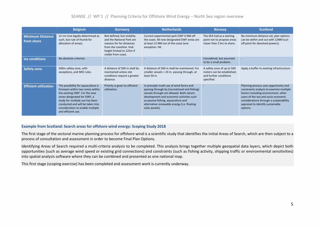
Belgium Germany Netherlands Norway Scotland
Minimum Distance from shore
12 nm (not legally determined as such, but rule of thumb for allocation of areas).
Not defined, but visibility and the National Park are reasons for far distances from the coastline. Hub height limited to 125m if visible from coast.
Current experimental park OWF 6 NM off the coast. All new designated OWF areas are at least 12 NM out of the coast (one exception: HK.
The SEA had as a starting point not to propose areas closer than 2 km to shore.
No minimum distance set, plan options can be within and out with 12NM (cut-off point for devolved powers).
Ice conditions No absolute criterion. - - Considered, but assumed to be a small problem.
-
Safety zone 500m safety zone, with exceptions, and IMO rules.
A distance of 500 m shall be maintained unless site conditions require a greater distance.
A distance of 500 m shall be maintained. For smaller vessels < 24 m. passing through, at least 50 m.
A safety zone of up to 500 meters can be established, and further conditions specified.
Apply a buffer to existing infrastructure.
Efficient utilization The possibility for aquaculture is foreseen within two zones within the existing OWF. For the new zones designated for OWF, a study for multiple use has been conducted and will be taken into consideration to enable multiple and efficient use.
Priority is given to efficient utilization.
In principle multi-use of wind farms and passing through by (recreational and fishing) vessels through are allowed. Both nature development and economic activities such as passive fishing, aquaculture and alternative renewable energy (i.e. floating solar panels).
- Planning process uses opportunity and constraints analysis to examine multiple factors including environment, other users of the sea and socio-economic considerations through a sustainability appraisal to identify sustainable options.
Example from Scotland: Search areas for offshore wind energy: Scoping Study 2018
The first stage of the sectoral marine planning process for offshore wind is a scientific study that identifies the initial Areas of Search, which are then subject to a process of consultation and assessment in order to become Final Plan Options.
Identifying Areas of Search required a multi-criteria analysis to be completed. This analysis brings together multiple geospatial data layers, which depict both opportunities (such as average wind speed or existing grid connections) and constraints (such as fishing activity, shipping traffic or environmental sensitivities) into spatial analysis software where they can be combined and presented as one national map.
This first stage (scoping exercise) has been completed and assessment work is currently underway.
SEANSE // WP 1 // Planning Criteria for Offshore Wind Energy – North Sea region overview
6
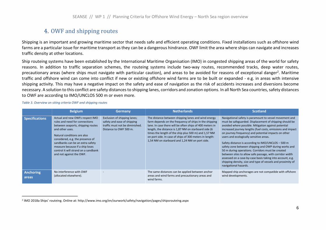
OWF and shipping routes
Shipping is an important and growing maritime sector that needs safe and efficient operating conditions. Fixed installations such as offshore wind farms are a particular issue for maritime transport as they can be a dangerous hindrance. OWF limit the area where ships can navigate and increases traffic density at other locations.
Ship routeing systems have been established by the International Maritime Organisation (IMO) in congested shipping areas of the world for safety reasons. In addition to traffic separation schemes, the routeing systems include two-way routes, recommended tracks, deep water routes, precautionary areas (where ships must navigate with particular caution), and areas to be avoided for reasons of exceptional danger2. Maritime traffic and offshore wind can come into conflict if new or existing offshore wind farms are to be built or expanded - e.g. in areas with intensive shipping activity. This may have a negative impact on the safety and ease of navigation as the risk of accidents increases and diversions become necessary. A solution to this conflict are safety distances to shipping lanes, corridors and zonation options. In all North Sea countries, safety distances to OWF are according to IMO/UNCLOS 500 m or even more.
Table 3. Overview on siting criteria OWF and shipping routes
Belgium Germany Netherlands Scotland
Specifications Actual and new OWFs respect IMO rules and need for connections between seaports, shipping routes and other uses.
Natural conditions are also considered, e.g. the presence of sandbanks can be an extra safety measure because if a ship loses control it will strand on a sandbank and not against the OWF.
Exclusion of shipping lanes; safety and ease of shipping traffic must not be diminished. Distance to OWF 500 m.
The distance between shipping lanes and wind energy farm depends on the frequency of ships in the shipping lane. In case there will be often ships of 400 meters in length, the distance is 1,87 NM on starboard side (6 times the length of the ship plus 500 m) and 1,57 NM on port side. In case of ships of 300 meters in length: 1,54 NM on starboard and 1,24 NM on port side.
Navigational safety is paramount to vessel movement and must be safeguarded. Displacement of shipping should be avoided where possible. Mitigation against potential increased journey lengths (fuel costs, emissions and impact on journey frequency) and potential impacts on other users and ecologically sensitive areas.
Safety distance is according to IMO/UNCLOS – 500 m safety zone between shipping and OWP during works and 50 m during operations. Corridors must be created between sites to allow safe passage, with corridor width assessed on a case-by-case basis taking into account, e.g. shipping density, size and type of vessels and proximity of navigational hazards.
Anchoring areas
No interference with OWF (allocated elsewhere).
- The same distances can be applied between anchor areas and wind farms and precautionary areas and wind farms.
Mapped ship anchorages are not compatible with offshore wind developments.
2 IMO 2018a Ships’ routeing. Online at: http://www.imo.org/en/ourwork/safety/navigation/pages/shipsrouteing.aspx
SEANSE // WP 1 // Planning Criteria for Offshore Wind Energy – North Sea region overview
7
Belgium Germany Netherlands Scotland
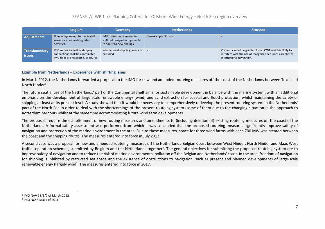
Adjustments No overlap, except for dedicated vessels and some designated activities.
IMO routes not foreseen to shift but designations possible to adjust to new findings.
See example NL case. -
Transboundary issues
IMO routes and other shipping connections shall be coordinated. IMO rules are respected, of course.
international shipping lanes are excluded.
- Consent cannot be granted for an OWF which is likely to interfere with the use of recognised sea lanes essential to international navigation.
Example from Netherlands – Experience with shifting lanes
In March 2012, the Netherlands forwarded a proposal to the IMO for new and amended routeing measures off the coast of the Netherlands between Texel and North Hinder3.
The future spatial use of the Netherlands’ part of the Continental Shelf aims for sustainable development in balance with the marine system, with an additional emphasis on the development of large scale renewable energy (wind) and sand extraction for coastal and flood protection, whilst maintaining the safety of shipping at least at its present level. A study showed that it would be necessary to comprehensively redevelop the present routeing system in the Netherlands’ part of the North Sea in order to deal with the shortcomings of the present routeing system (some of them due to the changing situation in the approach to Rotterdam harbour) whilst at the same time accommodating future wind farm developments.
The proposals require the establishment of new routing measures and amendments to (including deletion of) existing routeing measures off the coast of the Netherlands. A formal safety assessment was performed from which it was concluded that the proposed routeing measures significantly improve safety of navigation and protection of the marine environment in the area. Due to these measures, space for three wind farms with each 700 MW was created between the coast and the shipping routes. The measures entered into force in July 2013.
A second case was a proposal for new and amended routeing measures off the Netherlands-Belgian Coast between West Hinder, North Hinder and Maas West traffic separation schemes, submitted by Belgium and the Netherlands together4. The general objectives for submitting the proposed routeing system are to improve safety of navigation and to reduce the risk of marine environmental pollution off the Belgian and Netherlands' coast. In the area, freedom of navigation for shipping is inhibited by restricted sea space and the existence of obstructions to navigation, such as present and planned developments of large-scale renewable energy (largely wind). The measures entered into force in 2017.
3 IMO NAV 58/3/2 of March 2012 4 IMO NCSR 3/3/1 of 2016
SEANSE // WP 1 // Planning Criteria for Offshore Wind Energy – North Sea region overview
8
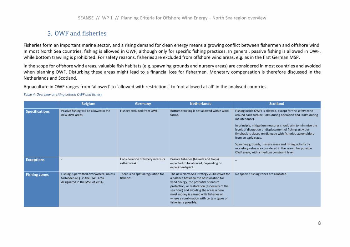
OWF and fisheries
Fisheries form an important marine sector, and a rising demand for clean energy means a growing conflict between fishermen and offshore wind. In most North Sea countries, fishing is allowed in OWF, although only for specific fishing practices. In general, passive fishing is allowed in OWF, while bottom trawling is prohibited. For safety reasons, fisheries are excluded from offshore wind areas, e.g. as in the first German MSP.
In the scope for offshore wind areas, valuable fish habitats (e.g. spawning grounds and nursery areas) are considered in most countries and avoided when planning OWF. Disturbing these areas might lead to a financial loss for fishermen. Monetary compensation is therefore discussed in the Netherlands and Scotland.
Aquaculture in OWF ranges from `allowed´ to `allowed with restrictions´ to `not allowed at all´ in the analysed countries.
Table 4: Overview on siting criteria OWF and fishery
Belgium Germany Netherlands Scotland
Specifications Passive fishing will be allowed in the new OWF areas.
Fishery excluded from OWF. Bottom trawling is not allowed within wind farms.
Fishing inside OWFs is allowed, except for the safety zone around each turbine (50m during operation and 500m during maintenance).
In principle, mitigation measures should aim to minimise the levels of disruption or displacement of fishing activities. Emphasis is placed on dialogue with fisheries stakeholders from an early stage.
Spawning grounds, nursery areas and fishing activity by monetary value are considered in the search for possible OWF areas, with a medium constraint level.
Exceptions - Consideration of fishery interests rather weak.
Passive fisheries (baskets and traps) expected to be allowed, depending on experiment/pilot.
-
Fishing zones Fishing is permitted everywhere, unless forbidden (e.g. in the OWF area designated in the MSP of 2014).
There is no spatial regulation for fisheries.
The new North Sea Strategy 2030 strives for a balance between the best location for wind energy, the potential of nature protection, or restoration (especially of the sea floor) and avoiding the areas where most money is earned with fisheries or where a combination with certain types of fisheries is possible.
No specific fishing zones are allocated.
SEANSE // WP 1 // Planning Criteria for Offshore Wind Energy – North Sea region overview
9
Belgium Germany Netherlands Scotland
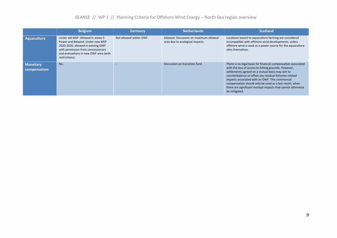
Aquaculture Under old MSP: Allowed in zones C-Power and Belwind. Under new MSP 2020-2026: allowed in existing OWF with permission from concessionary and everywhere in new OWF area (with restrictions).
Not allowed within OWF. Allowed. Discussion on maximum allowed area due to ecological impacts.
Locations leased to aquaculture farming are considered incompatible with offshore wind developments, unless offshore wind is used as a power source for the aquaculture sites themselves.
Monetary compensation
No. - Discussion on transition fund. There is no legal basis for financial compensation associated with the loss of access to fishing grounds. However, settlements agreed on a mutual basis may aim to counterbalance or offset any residual fisheries related impacts associated with an OWF. This commercial compensation should only be used as a last resort, when there are significant residual impacts that cannot otherwise be mitigated.
SEANSE // WP 1 // Planning Criteria for Offshore Wind Energy – North Sea region overview
10
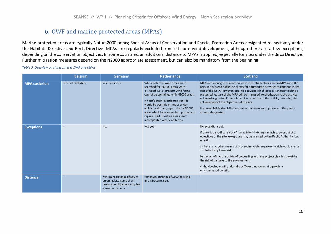
OWF and marine protected areas (MPAs)
Marine protected areas are typically Natura2000 areas; Special Areas of Conservation and Special Protection Areas designated respectively under the Habitats Directive and Birds Directive. MPAs are regularly excluded from offshore wind development, although there are a few exceptions, depending on the conservation objectives. In some countries, an additional distance to MPAs is applied, especially for sites under the Birds Directive. Further mitigation measures depend on the N2000 appropriate assessment, but can also be mandatory from the beginning.
Table 5: Overview on siting criteria OWF and MPAs
Belgium Germany Netherlands Scotland
MPA exclusion No, not excluded. Yes, exclusion. When potential wind areas were searched for, N2000 areas were excluded. So, at present wind farms cannot be combined with N2000 areas.
It hasn’t been investigated yet if it would be possible or not or under which conditions, especially for N2000 areas which have a sea floor protection regime. Bird Directive areas seem incompatible with wind farms.
MPAs are managed to conserve or recover the features within MPAs and the principle of sustainable use allows for appropriate activities to continue in the rest of the MPA. However, specific activities which pose a significant risk to a protected feature of the MPA will be managed. Authorisation to the activity will only be granted if there is no significant risk of the activity hindering the achievement of the objectives of the site.
Proposed MPAs should be treated in the assessment phase as if they were already designated.
Exceptions - No. Not yet. No exceptions yet.
If there is a significant risk of the activity hindering the achievement of the objectives of the site, exceptions may be granted by the Public Authority, but only if:
a) there is no other means of proceeding with the project which would create a substantially lower risk;
b) the benefit to the public of proceeding with the project clearly outweighs the risk of damage to the environment;
c) the developer will undertake sufficient measures of equivalent environmental benefit.
Distance - Minimum distance of 500 m, unless habitats and their protection objectives require a greater distance.
Minimum distance of 1500 m with a Bird Directive area.
-
SEANSE // WP 1 // Planning Criteria for Offshore Wind Energy – North Sea region overview
11
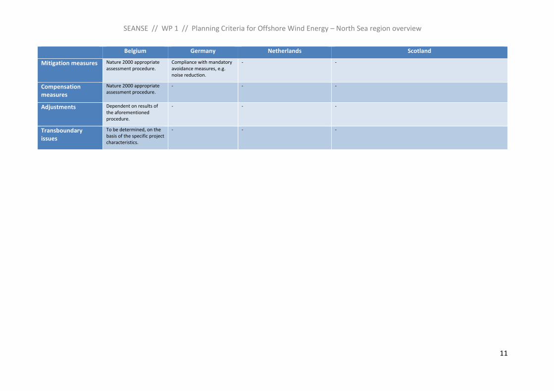
Belgium Germany Netherlands Scotland
Mitigation measures Nature 2000 appropriate assessment procedure.
Compliance with mandatory avoidance measures, e.g. noise reduction.
- -
Compensation measures
Nature 2000 appropriate assessment procedure.
- - -
Adjustments Dependent on results of the aforementioned procedure.
- - -
Transboundary issues
To be determined, on the basis of the specific project characteristics.
- - -
SEANSE // WP 1 // Planning Criteria for Offshore Wind Energy – North Sea region overview
12
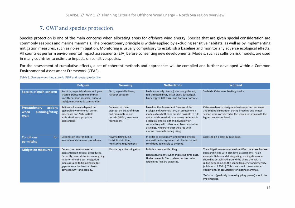
OWF and species protection
Species protection is one of the main concerns when allocating areas for offshore wind energy. Species that are given special consideration are commonly seabirds and marine mammals. The precautionary principle is widely applied by excluding sensitive habitats, as well as by implementing mitigation measures, such as noise mitigation. Monitoring is usually compulsory to establish a baseline and monitor any adverse ecological effects. All countries perform environmental impact assessments (EIA) before consenting new developments. Models, such as collision risk models, are used in many countries to estimate impacts on sensitive species.
For the assessment of cumulative effects, a set of coherent methods and approaches will be compiled and further developed within a Common Environmental Assessment Framework (CEAF).
Table 6: Overview on siting criteria OWF and species protection
Belgium Germany Netherlands Scotland
Species of main concern Seabirds, especially divers and great crested grebe; marine mammals (mostly harbour porpoise, but also seals); marcobenthic communities.
Birds, especially divers, harbour porpoise.
Birds, especially divers, (common guillemot, red-throated diver, lesser black-backed gull, Black-legged kittiwake) and harbour porpoise.
Seabirds, Cetaceans, basking sharks.
Precautionary actions when planning/siting OWF
Actions will mainly depend on (general) environmental permit procedure and Natura2000-authorisation (appropriate assessment).
Exclusion of main distribution areas of divers and mammals (in and outside MPAs); low-noise foundations.
Based on the Assessment Framework for Ecology and Accumulation, an assessment is made as to whether or not it is possible to rule out an offshore wind farm having undesirable ecological effects, either individually or cumulatively with other wind farms and other activities. Pingers to clear the area with marine mammals during piling.
Cetacean density, designated nature protection areas and seabird distribution during breeding and winter season were considered in the search for areas with the highest constraint level.
Conditions for permitting
Depends on environmental assessments in several procedures.
Always defined, e.g. restrictions in time, monitoring requirements.
In order to prevent any undesirable effects, rules will be incorporated into the terms and conditions applicable to the plot.
Assessed on a case-by-case basis.
Mitigation measures Depends on environmental assessments in several procedures. Currently, several studies are ongoing to determine the best mitigation measures and to fill in knowledge gaps to have the best symbiosis between OWF and ecology.
Mandatory noise mitigation. Bubble screens while piling.
Lights adjustments when migrating birds pass. Under research: Stop turbine decision when large birds flux are expected.
The mitigation measures are identified on a case by case basis and in line with plan level assessments. As an example: Before and during piling, a mitigation zone should be established around the piling site, with a radius depending on the sound frequency and intensity (minimum of 500m). This zone should be monitored visually and/or acoustically for marine mammals.
‘Soft-start’ (gradually increasing piling power) should be implemented.
SEANSE // WP 1 // Planning Criteria for Offshore Wind Energy – North Sea region overview
13
Belgium Germany Netherlands Scotland
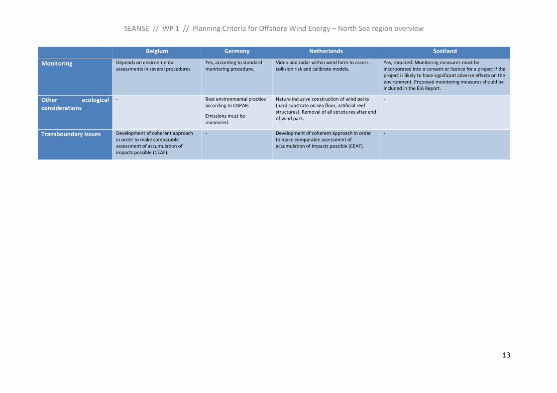
Monitoring Depends on environmental assessments in several procedures.
Yes, according to standard monitoring procedure.
Video and radar within wind farm to assess collision risk and calibrate models.
Yes, required. Monitoring measures must be incorporated into a consent or licence for a project if the project is likely to have significant adverse effects on the environment. Proposed monitoring measures should be included in the EIA Report.
Other ecological considerations
- Best environmental practice according to OSPAR.
Emissions must be minimized.
Nature inclusive construction of wind parks (hard substrate on sea floor, artificial reef structures). Removal of all structures after end of wind park.
-
Transboundary issues Development of coherent approach in order to make comparable assessment of accumulation of impacts possible (CEAF).
- Development of coherent approach in order to make comparable assessment of accumulation of impacts possible (CEAF).
-
SEANSE // WP 1 // Planning Criteria for Offshore Wind Energy – North Sea region overview
14
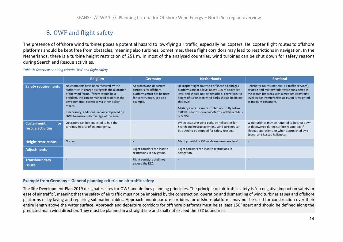
OWF and flight safety
The presence of offshore wind turbines poses a potential hazard to low-flying air traffic, especially helicopters. Helicopter flight routes to offshore platforms should be kept free from obstacles, meaning also turbines. Sometimes, these flight corridors may lead to restrictions in navigation. In the Netherlands, there is a turbine height restriction of 251 m. In most of the analysed countries, wind turbines can be shut down for safety reasons during Search and Rescue activities.
Table 7: Overview on siting criteria OWF and flight safety
Belgium Germany Netherlands Scotland
Safety requirements No comments have been received by the authorities in charge as regards the allocation of the wind farms. If there would be a problem, this can be managed as part of the environmental permit or via other policy means.
If necessary, additional radars are placed on OWF to ensure full coverage of the area.
Approach and departure corridors for offshore platforms must not be used for construction, see also example.
Helicopter flight routes to offshore oil and gas platforms are at a level above 300 m above sea level and should not be disturbed. Therefore, tip height of turbines in wind parks should be below this level.
Military aircrafts are restricted not to fly below 1200 ft. near offshore windfarms, within a radius of 5 NM.
Helicopter routes (national air traffic services), aviation and military radar were considered in the search for areas with a medium constraint level. Radar interferences at 140 m is weighted as medium constraint.
Curtailment for rescue activities
Operators can be requested to halt the turbines, in case of an emergency.
- When assessing wind parks by helicopter for Search and Rescue activities, wind turbines can be asked to be stopped for safety reasons.
Wind turbines may be required to be shut down or depowered during surface rescue-boat/ lifeboat operations, or when approached by a Search and Rescue helicopter.
Height restrictions Not yet. - Max tip height is 251 m above mean sea level. -
Adjustments - Flight corridors can lead to restrictions in navigation.
Flight corridors can lead to restrictions in navigation.
-
Transboundary issues
- Flight corridors shall not exceed the EEZ.
- -
Example from Germany – General planning criteria on air traffic safety
The Site Development Plan 2019 designates sites for OWF and defines planning principles. The principle on air traffic safety is `no negative impact on safety or ease of air traffic´, meaning that the safety of air traffic must not be impaired by the construction, operation and dismantling of wind turbines at sea and offshore platforms or by laying and repairing submarine cables. Approach and departure corridors for offshore platforms may not be used for construction over their entire length above the water surface. Approach and departure corridors for offshore platforms must be at least 150° apart and should be defined along the predicted main wind direction. They must be planned in a straight line and shall not exceed the EEZ boundaries.
SEANSE // WP 1 // Planning Criteria for Offshore Wind Energy – North Sea region overview
15
Along the flight corridors of an offshore platform with helicopter landing deck, it shall be ensured that sufficient free space is available for the exercise of an emergency flight manoeuvre. Ensuring this free space can lead to restrictions in navigation. Within the safety zone of an OWF, appropriate measures and regulations are therefore necessary to avoid collisions between shipping and air traffic. The same applies to the safety zone of an offshore platform with helicopter landing deck outside an OWF.
The wind turbines along the flight corridors must be marked. Where possible, helicopter traffic zones (HTZ) or - if necessary - helicopter protection zones (HPZ) or helicopter traffic areas (HTA) must be established by the competent authority around offshore platforms with helicopter landing decks.
SEANSE // WP 1 // Planning Criteria for Offshore Wind Energy – North Sea region overview
16
OWF and cables, pipelines
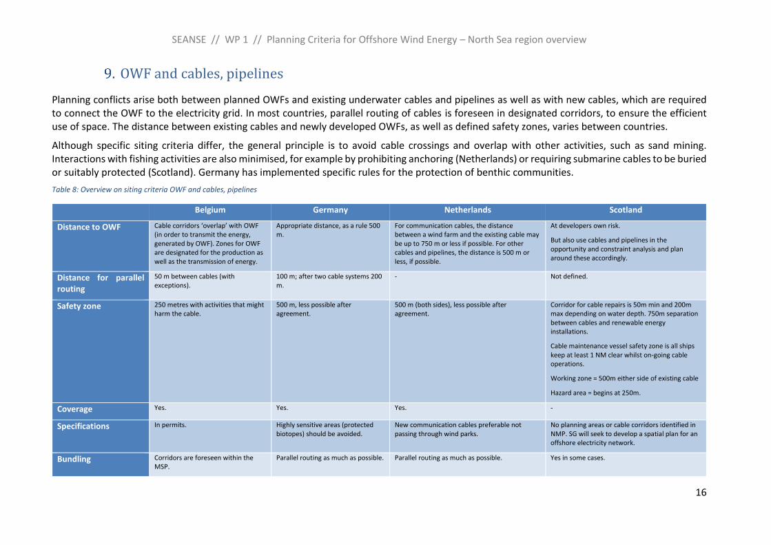
Planning conflicts arise both between planned OWFs and existing underwater cables and pipelines as well as with new cables, which are required to connect the OWF to the electricity grid. In most countries, parallel routing of cables is foreseen in designated corridors, to ensure the efficient use of space. The distance between existing cables and newly developed OWFs, as well as defined safety zones, varies between countries.
Although specific siting criteria differ, the general principle is to avoid cable crossings and overlap with other activities, such as sand mining. Interactions with fishing activities are also minimised, for example by prohibiting anchoring (Netherlands) or requiring submarine cables to be buried or suitably protected (Scotland). Germany has implemented specific rules for the protection of benthic communities.
Table 8: Overview on siting criteria OWF and cables, pipelines
Belgium Germany Netherlands Scotland
Distance to OWF Cable corridors ‘overlap’ with OWF (in order to transmit the energy, generated by OWF). Zones for OWF are designated for the production as well as the transmission of energy.
Appropriate distance, as a rule 500 m.
For communication cables, the distance between a wind farm and the existing cable may be up to 750 m or less if possible. For other cables and pipelines, the distance is 500 m or less, if possible.
At developers own risk.
But also use cables and pipelines in the opportunity and constraint analysis and plan around these accordingly.
Distance for parallel routing
50 m between cables (with exceptions).
100 m; after two cable systems 200 m.
- Not defined.
Safety zone 250 metres with activities that might harm the cable.
500 m, less possible after agreement.
500 m (both sides), less possible after agreement.
Corridor for cable repairs is 50m min and 200m max depending on water depth. 750m separation between cables and renewable energy installations.
Cable maintenance vessel safety zone is all ships keep at least 1 NM clear whilst on-going cable operations.
Working zone = 500m either side of existing cable
Hazard area = begins at 250m.
Coverage Yes. Yes. Yes. -
Specifications In permits. Highly sensitive areas (protected biotopes) should be avoided.
New communication cables preferable not passing through wind parks.
No planning areas or cable corridors identified in NMP. SG will seek to develop a spatial plan for an offshore electricity network.
Bundling Corridors are foreseen within the MSP.
Parallel routing as much as possible. Parallel routing as much as possible. Yes in some cases.
SEANSE // WP 1 // Planning Criteria for Offshore Wind Energy – North Sea region overview
17
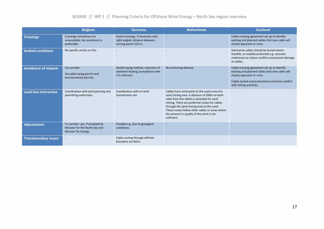
Belgium Germany Netherlands Scotland
Crossings Crossings sometimes are unavoidable, but avoidance is preferable.
Avoid crossings, if necessary only right-angled; distance between turning points 250 m.
- Cable crossing agreement set up to identify existing and planned cables that new cable will closely approach or cross.
Seabed conditions No specific article on this. - - Submarine cables should be buried where feasible, or suitably protected e.g. concrete mattresses to reduce conflict and prevent damage to cables.
Avoidance of impacts Via corridor;
Via cable laying permit and environmental permits.
Gentle laying method, reduction of sediment heating (compliance with 2 K criterion).
No anchoring allowed. Cable crossing agreement set up to identify existing and planned cables that new cable will closely approach or cross.
Cables buried and protected to minimise conflict with fishing activities.
Land-Sea-Interaction Coordination with land planning and permitting authorities.
Coordination with on-land transmission net.
Cables from wind parks to the coast cross the sand mining area. A distance of 500m on both sides from the cables is excluded for sand mining. There are preferred routes for cables through the sand mining area to the coast. These routes follow other cables or areas where the amount or quality of the sand is not sufficient.
-
Adjustments To corridor: yes, if accepted by Minister for the North Sea and Minister for Energy.
Possible e.g. due to geological conditions.
- -
Transboundary issues - Cable routing through defined boundary corridors.
- -
SEANSE // WP 1 // Planning Criteria for Offshore Wind Energy – North Sea region overview
18
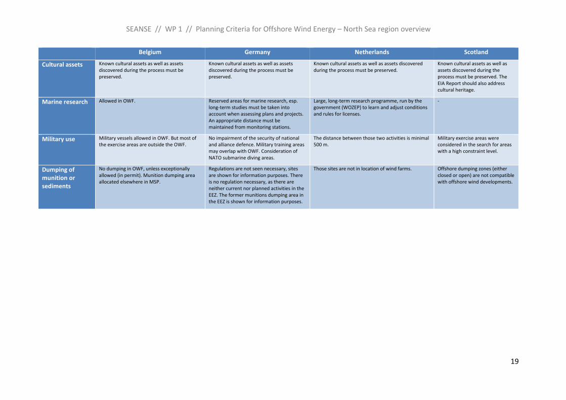
Other planning issues
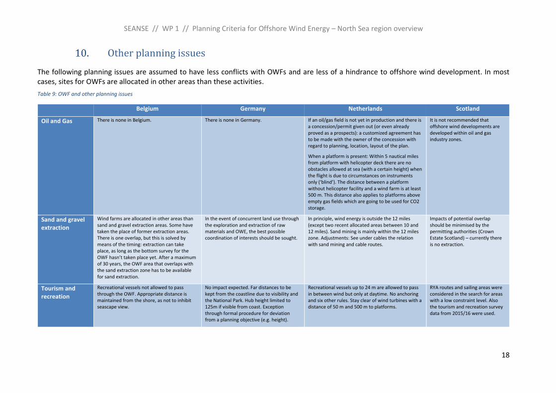
The following planning issues are assumed to have less conflicts with OWFs and are less of a hindrance to offshore wind development. In most cases, sites for OWFs are allocated in other areas than these activities.
Table 9: OWF and other planning issues
Belgium Germany Netherlands Scotland
Oil and Gas There is none in Belgium. There is none in Germany. If an oil/gas field is not yet in production and there is a concession/permit given out (or even already proved as a prospects): a customized agreement has to be made with the owner of the concession with regard to planning, location, layout of the plan.
When a platform is present: Within 5 nautical miles from platform with helicopter deck there are no obstacles allowed at sea (with a certain height) when the flight is due to circumstances on instruments only (‘blind’). The distance between a platform without helicopter facility and a wind farm is at least 500 m. This distance also applies to platforms above empty gas fields which are going to be used for CO2 storage.
It is not recommended that offshore wind developments are developed within oil and gas industry zones.
Sand and gravel extraction
Wind farms are allocated in other areas than sand and gravel extraction areas. Some have taken the place of former extraction areas. There is one overlap, but this is solved by means of the timing: extraction can take place, as long as the bottom survey for the OWF hasn’t taken place yet. After a maximum of 30 years, the OWF area that overlaps with the sand extraction zone has to be available for sand extraction.
In the event of concurrent land use through the exploration and extraction of raw materials and OWE, the best possible coordination of interests should be sought.
In principle, wind energy is outside the 12 miles (except two recent allocated areas between 10 and 12 miles). Sand mining is mainly within the 12 miles zone. Adjustments: See under cables the relation with sand mining and cable routes.
Impacts of potential overlap should be minimised by the permitting authorities (Crown Estate Scotland) – currently there is no extraction.
Tourism and recreation
Recreational vessels not allowed to pass through the OWF. Appropriate distance is maintained from the shore, as not to inhibit seascape view.
No impact expected. Far distances to be kept from the coastline due to visibility and the National Park. Hub height limited to 125m if visible from coast. Exception through formal procedure for deviation from a planning objective (e.g. height).
Recreational vessels up to 24 m are allowed to pass in between wind but only at daytime. No anchoring and six other rules. Stay clear of wind turbines with a distance of 50 m and 500 m to platforms.
RYA routes and sailing areas were considered in the search for areas with a low constraint level. Also the tourism and recreation survey data from 2015/16 were used.
SEANSE // WP 1 // Planning Criteria for Offshore Wind Energy – North Sea region overview
19
Belgium Germany Netherlands Scotland
Cultural assets Known cultural assets as well as assets discovered during the process must be preserved.
Known cultural assets as well as assets discovered during the process must be preserved.
Known cultural assets as well as assets discovered during the process must be preserved.
Known cultural assets as well as assets discovered during the process must be preserved. The EIA Report should also address cultural heritage.
Marine research Allowed in OWF. Reserved areas for marine research, esp. long-term studies must be taken into account when assessing plans and projects. An appropriate distance must be maintained from monitoring stations.
Large, long-term research programme, run by the government (WOZEP) to learn and adjust conditions and rules for licenses.
-
Military use Military vessels allowed in OWF. But most of the exercise areas are outside the OWF.
No impairment of the security of national and alliance defence. Military training areas may overlap with OWF. Consideration of NATO submarine diving areas.
The distance between those two activities is minimal 500 m.
Military exercise areas were considered in the search for areas with a high constraint level.
Dumping of munition or sediments
No dumping in OWF, unless exceptionally allowed (in permit). Munition dumping area allocated elsewhere in MSP.
Regulations are not seen necessary, sites are shown for information purposes. There is no regulation necessary, as there are neither current nor planned activities in the EEZ. The former munitions dumping area in the EEZ is shown for information purposes.
Those sites are not in location of wind farms. Offshore dumping zones (either closed or open) are not compatible with offshore wind developments.
SEANSE // WP 1 // Planning Criteria for Offshore Wind Energy – North Sea region overview
20
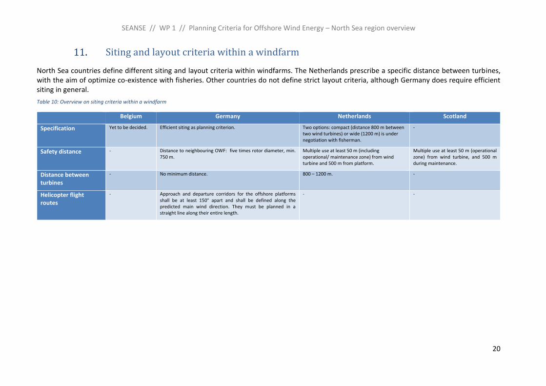
Siting and layout criteria within a windfarm
North Sea countries define different siting and layout criteria within windfarms. The Netherlands prescribe a specific distance between turbines, with the aim of optimize co-existence with fisheries. Other countries do not define strict layout criteria, although Germany does require efficient siting in general.
Table 10: Overview on siting criteria within a windfarm
Belgium Germany Netherlands Scotland
Specification Yet to be decided. Efficient siting as planning criterion. Two options: compact (distance 800 m between two wind turbines) or wide (1200 m) is under negotiation with fisherman.
-
Safety distance - Distance to neighbouring OWF: five times rotor diameter, min. 750 m.
Multiple use at least 50 m (including operational/ maintenance zone) from wind turbine and 500 m from platform.
Multiple use at least 50 m (operational zone) from wind turbine, and 500 m during maintenance.
Distance between turbines
- No minimum distance. 800 – 1200 m. -
Helicopter flight routes
- Approach and departure corridors for the offshore platforms shall be at least 150° apart and shall be defined along the predicted main wind direction. They must be planned in a straight line along their entire length.
- -
SEANSE // WP 1 // Planning Criteria for Offshore Wind Energy – North Sea region overview
21
Summary and conclusion
Maritime Spatial Planning (MSP) is a forward-looking planning instrument for the sustainable development of the sea, which coordinates sectoral interests and protection needs. MSP plays an important role in locating offshore wind farms, as it designates areas for renewable energy and regularly also corridors for energy transmission. For this baseline study, general siting criteria and various sectoral arrangements were examined and compared to provide an overview on planning criteria for offshore wind in the North Seas countries.
All North Sea countries have maritime spatial plans in place or develop their first plan (Denmark), and most countries started a revision of their plans. Planning conflicts exist between offshore wind developments and, among others, shipping routes, fisheries, marine protected areas, species protection, flight safety and cables and pipelines. Specific siting criteria differ between the countries, but safety zones for shipping, ecological buffer zones, specifications on the type of allowed activities (fisheries), and restricted areas (marine protected areas) are some of the common ways to prevent or minimise conflicts.
It can be concluded, that on MSP level, the precautionary principle should be applied by avoiding environmentally sensitive areas and highly frequented shipping routes for the siting of OWF. Spatial designations, rules and conditions for marine sectors should be specified as detailed as possible in order to minimise conflicts.
Through the comparison of the different national planning approaches, criteria, and standards, some key planning issues were identified for which transboundary planning solutions shall be discussed in future collaboration. The main concern for the development of offshore wind energy are associated adverse environmental effects. It is planned to further research and discuss this issue in the environmental subgroup of the North Sea Energy Cooperation. Spatial planning issues of transboundary nature include, among others, coordinated grid planning, multi-use of space, data quality and accessibility. The support group 2 on maritime spatial planning of the Energy Cooperation intends to develop concepts and scenarios on these planning topics and to exchange experiences and best practice on spatial planning, site preparation and permitting of offshore wind farms5.
Overall, the multitude of planning conflicts underlines the need for MSP as a tool to balance the spatial needs of different sectors in the North Sea, while at the same time protecting the environment and biodiversity.
5 Work programme of the North Sea Energy Cooperation: Online at: https://en.kefm.dk/global-cooperation/north-seas-energy-cooperation/