planning committee report (09/12/10)
DESCRIPTION
planning committee reportTRANSCRIPT
Planning Applications Report
Planning Committee
9 December 2010
Bolton Council has approved a Guide to Good Practice for Members and Officers Involved in the
Planning Process. Appendix 1 of the Guide sets down guidance on what should be included in Officer
Reports to Committee on planning applications. This Report is written in accordance with that guidance. Copies of the Guide to Good Practice are available at www.bolton.gov.uk
Bolton Council also has a Statement of Community Involvement. As part of this statement, neighbour
notification letters will have been sent to all owners and occupiers whose premises adjoin the site of these applications. In residential areas, or in areas where there are dwellings in the vicinity of these
sites, letters will also have been sent to all owners and occupiers of residential land or premises,
which directly overlook a proposed development. Copies of the Statement of Community Involvement are available at www.bolton.gov.uk
The plans in this report have been annotated with the symbol ● to show where a letter of objection
has been received from an owner or occupier of a property shown on the Report Plan.
The plans in this report have been annotated with the symbol to show where a letter of support
has been received from an owner or occupier of a property shown on the Report Plan.
The plans in the report are for location only and are not to scale. The application site will generally be in the centre of the plan edged with a bold line.
The following abbreviations are used within this report: -
UDP The adopted Unitary Development Plan 2005 RSS Regional Spatial Strategy for the North West of England 2008
PCPN A Bolton Council Planning Control Policy Note
PPG Department of Communities and Local Government Planning Policy Guidance Note
MPG
SPG
SPD
Department of Communities and Local Government Minerals Planning Guidance Note
Bolton Council Supplementary Planning Guidance
Bolton Council Supplementary Planning Document PPS Department of Communities and Local Government Planning Policy Statement
TPO Tree Preservation Order EA Environment Agency
SBI SSSI
Site of Biological Importance Site of Special Scientific Interest
GMEU The Greater Manchester Ecology Unit
The background documents for this Report are the respective planning application documents which can be found at:-
www.bolton.gov.uk/planapps
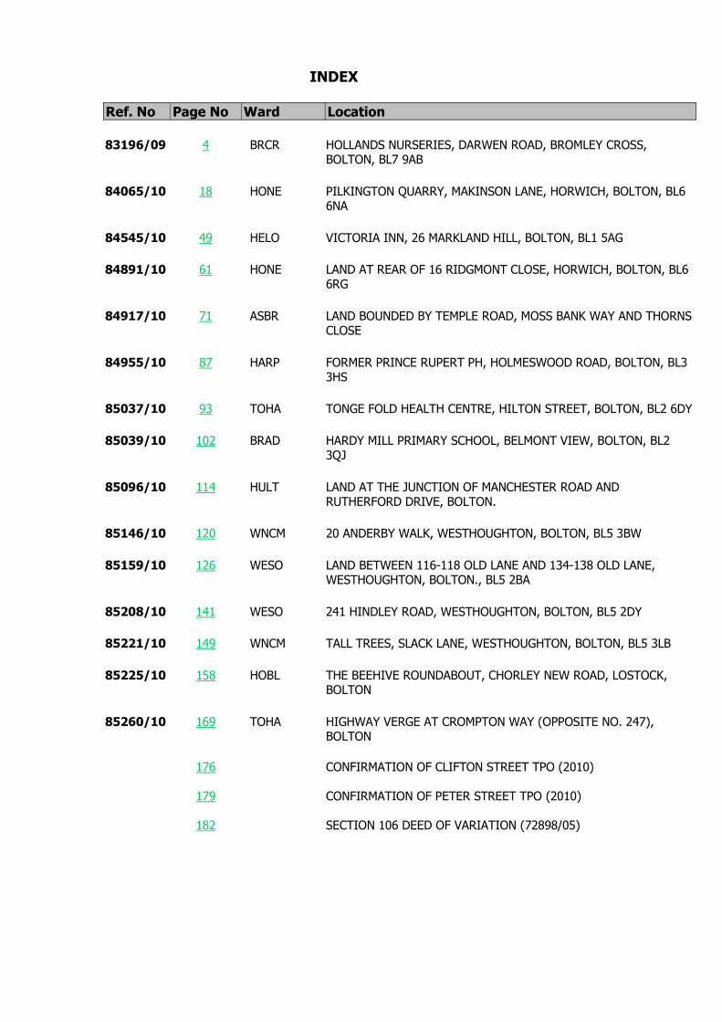
INDEX
Ref. No Page No Ward Location
83196/09 4 BRCR HOLLANDS NURSERIES, DARWEN ROAD, BROMLEY CROSS,BOLTON, BL7 9AB
84065/10 18 HONE PILKINGTON QUARRY, MAKINSON LANE, HORWICH, BOLTON, BL66NA
84545/10 49 HELO VICTORIA INN, 26 MARKLAND HILL, BOLTON, BL1 5AG
84891/10 61 HONE LAND AT REAR OF 16 RIDGMONT CLOSE, HORWICH, BOLTON, BL66RG
84917/10 71 ASBR LAND BOUNDED BY TEMPLE ROAD, MOSS BANK WAY AND THORNSCLOSE
84955/10 87 HARP FORMER PRINCE RUPERT PH, HOLMESWOOD ROAD, BOLTON, BL33HS
85037/10 93 TOHA TONGE FOLD HEALTH CENTRE, HILTON STREET, BOLTON, BL2 6DY
85039/10 102 BRAD HARDY MILL PRIMARY SCHOOL, BELMONT VIEW, BOLTON, BL23QJ
85096/10 114 HULT LAND AT THE JUNCTION OF MANCHESTER ROAD ANDRUTHERFORD DRIVE, BOLTON.
85146/10 120 WNCM 20 ANDERBY WALK, WESTHOUGHTON, BOLTON, BL5 3BW
85159/10 126 WESO LAND BETWEEN 116-118 OLD LANE AND 134-138 OLD LANE,WESTHOUGHTON, BOLTON., BL5 2BA
85208/10 141 WESO 241 HINDLEY ROAD, WESTHOUGHTON, BOLTON, BL5 2DY
85221/10 149 WNCM TALL TREES, SLACK LANE, WESTHOUGHTON, BOLTON, BL5 3LB
85225/10 158 HOBL THE BEEHIVE ROUNDABOUT, CHORLEY NEW ROAD, LOSTOCK,BOLTON
85260/10 169 TOHA HIGHWAY VERGE AT CROMPTON WAY (OPPOSITE NO. 247),BOLTON
176 CONFIRMATION OF CLIFTON STREET TPO (2010)
179 CONFIRMATION OF PETER STREET TPO (2010)
182 SECTION 106 DEED OF VARIATION (72898/05)

4
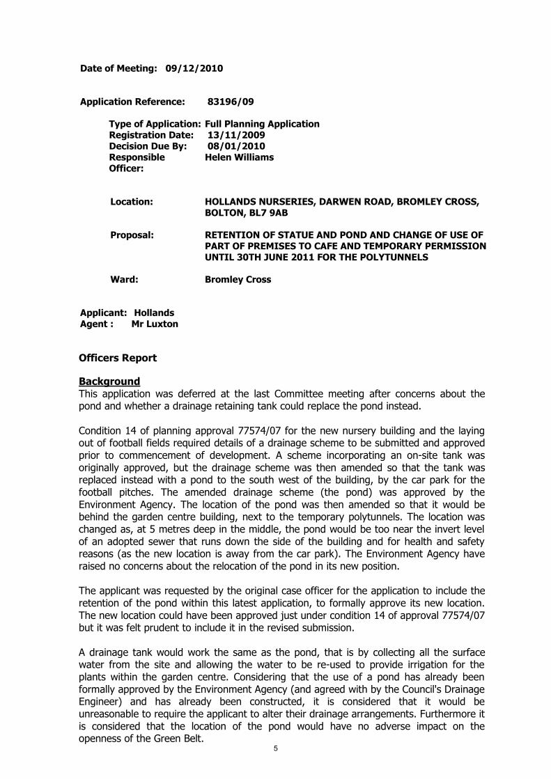
Date of Meeting: 09/12/2010
Application Reference: 83196/09
Type of Application: Full Planning ApplicationRegistration Date: 13/11/2009Decision Due By: 08/01/2010ResponsibleOfficer:
Helen Williams
Location: HOLLANDS NURSERIES, DARWEN ROAD, BROMLEY CROSS,BOLTON, BL7 9AB
Proposal: RETENTION OF STATUE AND POND AND CHANGE OF USE OFPART OF PREMISES TO CAFE AND TEMPORARY PERMISSIONUNTIL 30TH JUNE 2011 FOR THE POLYTUNNELS
Ward: Bromley Cross
Applicant: HollandsAgent : Mr Luxton
Officers Report
BackgroundThis application was deferred at the last Committee meeting after concerns about thepond and whether a drainage retaining tank could replace the pond instead.
Condition 14 of planning approval 77574/07 for the new nursery building and the layingout of football fields required details of a drainage scheme to be submitted and approvedprior to commencement of development. A scheme incorporating an on-site tank wasoriginally approved, but the drainage scheme was then amended so that the tank wasreplaced instead with a pond to the south west of the building, by the car park for thefootball pitches. The amended drainage scheme (the pond) was approved by theEnvironment Agency. The location of the pond was then amended so that it would bebehind the garden centre building, next to the temporary polytunnels. The location waschanged as, at 5 metres deep in the middle, the pond would be too near the invert levelof an adopted sewer that runs down the side of the building and for health and safetyreasons (as the new location is away from the car park). The Environment Agency haveraised no concerns about the relocation of the pond in its new position.
The applicant was requested by the original case officer for the application to include theretention of the pond within this latest application, to formally approve its new location.The new location could have been approved just under condition 14 of approval 77574/07but it was felt prudent to include it in the revised submission.
A drainage tank would work the same as the pond, that is by collecting all the surfacewater from the site and allowing the water to be re-used to provide irrigation for theplants within the garden centre. Considering that the use of a pond has already beenformally approved by the Environment Agency (and agreed with by the Council's DrainageEngineer) and has already been constructed, it is considered that it would beunreasonable to require the applicant to alter their drainage arrangements. Furthermore itis considered that the location of the pond would have no adverse impact on theopenness of the Green Belt.
5
The description of the proposal has been amended so that the temporary permission forthe polytunnels will be until 30th June 2011 (just over 6 months from now) instead of theoriginally proposed two year period, which Officers felt would be unacceptable.
The application was previously deferred at the Committee meeting of 1st April for furtherinformation relating to the following:
1. Material has allegedly been deposited at the rear of the site2. Further comments from the Ecology Unit3. Guidance on when a nursery become a garden centre4. A response from the Council's Legal Officers regarding the evidence provided by
the applicant in respect of past and current activity at the premises5. Advice on the status of this Green Belt site in the future6. Analysis of the cafe and its impact on other similar facilities in the local area
The information relating to points 1 to 5 was reported within the background section tothe Officer's report for application 83194/09. This application was approved by Membersat the last Committee meeting. The analysis of the cafe (point 6) is found below in thesection of the report entitled “Impact on the Vitality and Viability of Local Centres”.
ProposalThe application has four elements:-
1. The retention of a statue of St George, which has been placed in front of the entranceto the building within the car parking and circulation area. The statue and stone plinth areapproximately 5 metres high and the plinth is 3 metres by 1.5 metres in size. A signstating "Welcome to Holland Gardening Centre” is displayed on the front of the plinth.
2. The retention of an area of the main building which is used as a cafe.
3. The retention of an irregularly shaped pond with a maximum width of 26 metres and alength of 31 metres with a capacity of 3510 cubic metres located to the rear of the site.It is proposed that the pond will ultimately discharge into land drains on the playingfields. The pond has been constructed instead of an underground water holding tankwhich was originally approved to collect the surface water from the site and it is locatedon a part of the site that was shown to be used for car parking for the playing fields.Subsequent to the approval of the holding tank an amendment showing a pond whichalso impacted upon car parking space to the south west of the buildings was approved;the present pond was built instead.
4. The temporary retention of five polytunnels that are located to the rear of the newnursery buildings. The area occupied by the polytunnels is some 31 metres by 40 metresin size. The planning permission granted in 2007 for the new building was subject to acondition that the polytunnels would be removed once the replacement nursery buildinghad been constructed, or within 3 years, whichever period was the shorter. Thepolytunnels are presently being used for the storage/growing on of plants which are to beretailed. There is no retailing from these polytunnels.
Site CharacteristicsThe application site lies to the south of Darwen Road between Birtenshaw Hall School andthe railway line between Hall i'th' Wood and Bromley Cross railway stations. It is occupiedby a single storey predominantly glass building with a footprint of some 80 metres x 43metres, which has, from the time that it was constructed, has been largely used for theretailing of plants and garden products. Part of the building is utilised as a cafe. To thefront of the site is a car parking area and access is taken from a shared driveway withBirtenshaw School which leads onto Darwen Road. To the rear of the site is an area ofopen ground upon which planning permission has been granted for the laying out ofplaying fields.
6
PolicyPPG2 Green BeltsPPS4 Planning for Sustainable Economic Growth
RRS13 Policies: DP1 Spatial Policies; DP2 Promote Sustainable Communities; DP4 Makethe Best Use of Existing Resources and Infrastructure; DP5 Manage Travel Demand; DP7Promote Environmental Quality; RDF4 Green Belts; W5 Retail Development; RT2Managing Travel Demand; RT9 Walking and Cycling; EM1(B) Natural Environment.
UDP policies: D1, D2 Design; D3 Landscaping; A5 Road Network; A6 Car ParkingStandards; G1 and G2 Green Belt; G3 Reuse of Buildings in the Green Belt; R5 LandscapeCharacter; S4 Retail and Leisure; N3 Sites of Biological Importance; EM10 Surface WaterRun Off.
AnalysisSection 38 of the Planning and Compulsory Purchase Act 2004 requires applications to bedetermined in accordance with policies in the Development Plan unless materialconsiderations indicate otherwise.
Applications which are not in accordance with Development Plan policies should berefused unless material considerations justify granting permission.
Similarly, proposals which accord with Development Plan policies should be approvedunless there are material considerations which would justify a refusal of permission.
It is therefore necessary to decide whether this proposal is in accordance with theDevelopment Plan and then take account of other material considerations.
The main impacts of the proposal are:-
impact on the Green Beltimpact on the character and appearance of the areaimpact on the highwayimpact on the vitality and viability of local centresimpact on land drainageimpact on the Birtenshaw Covenant
Impact on the Green BeltPPG2 Green Belts and UDP policies G1 and G2 seek to maintain the openness of theGreen Belt and to protect it from inappropriate development. Essentially this means thatonly development which is agricultural or recreational in nature is likely to be acceptablewithin the Green Belt. Very special circumstances should be demonstrated to justifydevelopment which is inappropriate and by definition harmful to the Green Belt.
Policy G3 relates to the change of use of existing buildings in the Green Belt and statesthat the reuse of existing buildings within the Green Belt will be considered to beappropriate development providing there is no greater impact upon the openness of theGreen Belt than the existing use of the building. New uses will only be acceptable if thereis likely to be no additional harm to the visual amenities of the Green Belt or the purposesof including land within it.
The statue of St George is located within a car parking area and it is viewed against thebackdrop of the buildings on the site. Whilst it constitutes inappropriate development, it isnot considered to be prejudicial to the visual amenities of the Green Belt and given itssize and location it does not impact upon the openness of the area. It is not considered toconflict with policies G1 and G2 of the UDP.
The acceptability of the use of part of the building as a cafe is more finely balanced as7

the erection of a new building as a cafe would have constituted inappropriatedevelopment. However, as detailed in the report on the companion application 83194/09the use of the site has long been that of a garden centre and the space occupied by thecafe could be used alternatively for the display and retailing of garden products. It wouldbe difficult to argue that the existing limited refreshment use or even a more developedrestaurant use would have any greater impact on the Green Belt particularly as thebuilding is already in situ.
Whilst a cafe/restaurant use would be likely to make the site a more attractive destinationfor a different clientele there is unlikely to be any additional demand for vehicular parkingon the site given the alternative use to which the area of the building could be put. It istherefore considered that the use of this part of the building as a cafe would not harm theopenness of the Green Belt nor give rise to any additional adverse impacts on theamenities of the area. However, in order to prevent the establishment of an independentrestaurant use it is proposed to make the use personal to the applicant and ancillary tothe garden centre use of the site.
The pond has no adverse impact on the openness or the visual amenities of the GreenBelt. It is a necessary feature which facilitates the drainage of the site and it does notprejudice the aims and objectives of Green Belt policy.
The polytunnels were granted planning permission in 2007 but for only a temporaryperiod until the replacement building was completed or for three years, whichever periodwas the shortest. The applicant now seeks planning permission for the retention of thepolytunnels for a further 2 years. It is apparent that the development of the replacementmain building has now been completed and that the polytunnels are being used for thestorage and some growing on of plants for sale in the main building. The retention ofthese buildings significantly increases the size and scale of the built development on thissite and effectively allows more of the main building to be utilised for the retailing ofimported produce and plants rather than any storage and growing on of plants whichused to take place within the old buildings which stood on this site.
Given the polytunnels limited use for agricultural purposes they are not considered torepresent appropriate development and they harm the visual amenities and openness ofthe Green Belt contrary to policies G1 and G2 of Bolton's UDP. Should the application begranted approval it is recommended that the applicant be given a period of 6 monthsbefore they need to remove the polytunnels completely so that they have adequateopportunity to reorganise.
Impact on the Character and Appearance of the AreaGreen Belt policies and UDP policy R5 seek to ensure that the character and appearanceof the area will not be harmed.
For the reasons stated above it is not considered that the statue or pond harm the visualamenities of the area and the cafe is an internal feature. The retention of the polytunnelsis considered to be contrary to policy R5 of the UDP in that they are visible from vantagepoints accessible to the public and they harm the visual amenities of the area by reasonof the increased area of the site which has built development upon it.
Impact on the HighwayUDP policies A5 and A6 aim to ensure that new developments will not have an adverseimpact on highway safety and that developments are provided with adequate car parkingbased on the Council's maximum car parking standards.
Highway Engineers have commented that the access road to the site is used bypedestrians and by wheelchair users and their carers as it also serves Birtenshaw HallSchool and carries a public footpath. The provision of the cafe is considered likely by8

Engineers to lead to increase pedestrian activity when there is no safe pedestrian routefrom Darwen Road . A new footway for pedestrians is required if planning permissionwere to be granted for the cafe use. The permission will therefore be conditionedaccordingly.
The pond is located on an area of land which was shown on the approved plan to havebeen occupied by 34 car parking spaces within an overspill car parking area for theplaying fields although this has freed up that part of the site which was to have beenoccupied by the pond and this will allow for 27 spaces to be constructed. It is notconsidered that this reduction in spaces will give rise to additional parking on thehighway.
The polytunnels are located on a part of the site which on the approved plans wereshown to be for additional overspill car parking of 60 spaces. These spaces were to havebeen made available in the event of demand arising from users of the playing fields.Whilst in the short term pending the construction of the playing fields there is clearly noneed for these spaces, the removal of the polytunnels will allow for the provision of thesespaces should there be a need when the playing fields are brought into use. The retentionof the buildings would therefore be contrary to UDP policy A5.
Impact on the Vitality and Viability of Local CentresOfficers visited the café on the morning of 30th September 2010 and noted the followingalterations to the café since previous visits:1. The extension of the seating area. There were about half a dozen tables outside thecafé area on the area illustrated as decking on the plans, both outside and within part ofarea 2.2. A food counter containing cakes and cold drinks had replaced a wooden counter.3. A kitchen was now visible to the rear of the counter as a window had been insertedinto the partition wall. This area is described on the submitted plans as the area fortoilets, not a kitchen. Two cookers and a preparation table were visible. 4. The café formerly had the appearance of a self-service area, with only vendingmachines. The introduction of the glass counter and kitchen gave Officers the impressionthat the area had become more of a café facility than it previously was. There were stillhowever vending machines within the café for cold drinks and snacks.
It was hard for Officers to ascertain the types and degree of hot and cold food beingserved in the café as there were no customers present at the time of the visit, nor anymenus. The owner was questioned about this and explained that the types of food onoffer changed on a daily basis dependent on the ingredients/stock they had. He alsoconfirmed that there was no takeaway service available and only limited hot food wasserved. There were no members of staff present at the café when Officers visited so it ispresumed that staff only serve at the café when they have customers (there is nodedicated member of staff for the café facility).
The café certainly has the appearance of a facility ancillary to the main use of thebusiness and it seems doubtful that the café would be a visitor destination in its ownright, particularly given that it is located within the centre of the building and that it isonly accessible by walking through the shop area (area 1). The café is also not openwhen the garden centre is closed. It is noted that the café area may have grown andchanged in character to some extent since earlier this year, but it is still relatively small inscale and function compared to the rest of the building. To keep the café ancillary to themain use of the building it is therefore suggested that conditions are added to anyconsent to restrict the size of the area used as a café and to restrict the hours of openingto that of the garden centre. Furthermore, a personal permission for the cafe is to begiven to the applicant so that the cafe cannot become established as an independent use.
At the Committee meeting of 1st April 2010 it was asked what impact the café at9
Holland’s would have/is having on similar facilities in the local area. The following foodestablishments are located near to Holland’s Nurseries and are shown on the attachedplan:
1. Café ancillary to the Co-op supermarket, 196 Darwen Road, Bromley Cross –recently opened.
2. 211 Darwen Road, Bromley Cross – previously Ray’s Bookmakers but has consentfor a café (A3) in 2010. Currently not open.
3. Bromley Crust, 450 Darwen Road, Bromley Cross – sandwich shop (A1) withindoor seating.
4. Tea Rooms, Last Drop Village, Bromley Cross – A3 use but possibly ancillary to thewider retail/leisure use of the complex.
5. Jumbles Country Park Café, off Bradshaw Road – A3 café.
The following are also local, but not near enough to Holland’s to be shown on the plan:6. Relish, The Mill, Deakins Business Park, Dunscar – A3 café.7. Poppy’s, 160a Blackburn Road, Egerton – A3 café.8. Woody’s, 273a Blackburn Road, Egerton – sandwich shop (A1) with outdoor
seating.9. Rushton’s Café, 10 The Hillock, Harwood – A3 café.
Planning is not able to consider commercial competition. Local Planning Authorities canonly seek to ensure that the vitality and viability of town and other centres are notharmed by developments. Indeed PPS4 Planning for Sustainable Economic Growth inreality aims to promote competition between retailers and enhance consumer choice. Ofthe cafés listed above, only the café in the Co-op, the premises with A3 permission onDarwen Road and Rushton’s Café are located within an allocated centre. The café in theCo-op and the premises with permission have actually opened or got planning permissionafter the café in Holland’s was established. It therefore appears that the owners of thesepremises are not concerned about the impact of Holland’s on their business proposals. Itis also likely that the other cafés and establishments in the local area have a wider choiceof menu than Holland’s currently does and are destination facilities in their own right.
It is therefore considered that the ancillary café in Holland’s will not have a negativeimpact in its own right on other similar facilities in the area, compliant with Policy S4 ofthe UDP.
Impact on Land DrainageUDP policy EM10 seeks to ensure that surface water run off is minimised and managed soas to reduce the environmental impact of developments.
The planning permission for the development of the site was subject to conditions whichrequired details of surface water management and a flood risk assessment was required.Details were submitted pursuant to the condition which required an on site tank and pondwith the run off directed onto the playing fields; these details were approved by theEnvironment Agency. The developer subsequently obtained planning permission for apond in the south west corner of the site and the present pond has been constructed inlieu of this approved amendment. Whilst the pond will in due course discharge into theplaying field drainage system, details have been submitted which show it discharging intoan existing surface water culvert and this arrangement is acceptable to the Council'sDrainage Engineers.
The proposal therefore complies with UDP policy EM10 on surface water management.
Impact on the Birtenshaw CovenantAlthough the impact on the Covenant is a consideration in the determination of theapplication, the application falls to be determined in the light of the Council's planningpolicies and a separate consent will be required from the Council under the terms of the10
Covenant.
The Covenant was entered into in order to preserve the land as a private open space andfor the benefit and amenity of the district. It was agreed that all existing buildings shouldbe preserved and maintained and that no building other than structures for agriculturalpurposes should be erected on the land and nor should any streets, roads or footpaths bemade. The agreement allowed the use of the land for agricultural purposes or any otherpurpose which would preserve it as private open space.
When planning permission was granted for the nursery building under application77574/07, this was deemed not to be a breach of the Covenant because this was deemedto be an application for an agricultural use and the polytunnels were treated in the sameway. As the proposed use of part of the building is a cafe, the Council's Legal Officersconsider that this would constitute a breach of the Covenant. The statue is also a minorbreach of the Covenant. However, the pond would not constitute a breach as it wouldpreserve the land as private open space. The polytunnels would not be in breach of theCovenant if they were used for agricultural purposes. The applicant has indicated that anapplication for consent under the terms of the Covenant will be made in the very nearfuture.
ConclusionFor the reasons detailed in this report it is recommended that planning permission begranted for the retention of the statue, pond an ancillary cafe. The retention of thepolytunnels represents inappropriate development in the Green Belt which would give riseto the additional commercial development taking place from the site which would impactadversely on the openess of the Green Belt. The application for the polytunnels istherefore recommended only for a 6 month permission so as to allow for thereorganisation of the business and so that the space is available for parking provision forthe playing fields.
Representation and Consultation Annex
RepresentationsLetters:- 14 letters of objection have been received plus a letter from the Turtonbranch of the Bolton and District Civic Trust objecting on the grounds that thedevelopment is:
* contrary to Green Belt policy and harms openness* breaches the terms of the Birtenshaw Covenant* will result in extra traffic congestion* set a precedent for further development* cause additional noise and pollution* drive away wildlife* the pond is excessively large
40 letters of support have been received; writers comment that the development has:
* improved the appearance of the site and the character of the area* created employment and investment in the area* is an attractive venue in an area devoid of infrastructure and facilities* the Statue of St George represents a national symbol* a cafe and meeting room would be valuable local facilities
ConsultationsAdvice was sought from the following consultees; Council Highway and DrainageEngineers, the Greater Manchester Ecological Unit and the Environment Agency.
11

Planning HistoryApplication 77574/07 Erection of replacement nursery building and associateddevelopment together with the laying out of playing fields. Permission granted 8thOctober 2007.
Application 75599/06 Erection of a replacement nursery building (including office, growingand sales areas) together with car parking areas, boundary fencing and security lighting,change of use of land to playing fields, erection of changing rooms and associated carparking, and erection of a temporary growing/storage building. Refused May 2007.
Application 71687/05 for change of use to provide sports facilities (10 pitches), erectionof changing rooms, nursery building (incorporating restaurant, offices, growing and salesareas), 190 car parking spaces and temporary polycarbonate growing area. Withdrawn.
Application 70318/05 for use of land to provide sports facilities (9 pitches) and associatedchanging, community and clubhouse facilities and parking (180 spaces) together withrelocation of nursery to provide nursery, garden centre facilities and car park (90 spaces).Withdrawn.
Application 61632/02 for demolition of existing office/store and erection of replacementbuilding for ancillary staff accommodation and product sales. Withdrawn.
Application 5412/03 for prior approval for the installation of a 15 metretelecommunications pole, 3 no. antennae, 1 no. 300mm dish and equipment cabin withassociated works. Refused August 2003.
Application 61023/02 for installation of a 15 metre timber monopole with 3 no. antennaeand 1 no. 300mm dish, and equipment cabin and development ancillary thereto.Approved on appeal in 2002.
Application 51523/97 for erection of a hard standing for the handling of materials in theconstruction of a combined sewer outfall. Withdrawn in 1997.
Application 51523/89 for erection of glass houses and a storage building to formhorticultural nurseries. Approved 1989.
Recommendation: Approve subject to conditions
Recommended Conditions and/or Reasons
1. The permission for a cafe shall enure for the sole benefit of the applicant Mr D Faulkner and shall befor the period during which the premises are occupied by the applicant, after which time the usehereby approved shall cease. For the avoidance of doubt the cafe shall only be used ancillary to theprimary use of the site as a garden centre.
Reason
In the view of the personal circumstances of the applicant and in the light of the assurances given asto how the development applied for will be carried out.
2. The cafe shall not be open to customers except between the hours of 0900 and 1700 Monday toSaturday and between the hours of 1000 and 1600 on Sunday.
Reason
To safeguard the amenity and character of the area and to safeguard the living conditions of nearbyresidents particularly with regard to noise and/or disturbance.
3. No deliveries shall be taken at or dispatched from the site except between the hours of 0800 and12

1800 Mondays to Fridays, 0800 and 1300 on Saturdays and no deliveries shall be taken at ordispatched from the site on Sundays or Bank Holidays.
Reason
To safeguard the amenity and character of the area and to safeguard the living conditions of nearbyresidents particularly with regard to noise and/or disturbance.
4. A landscape scheme for the pond shall be submitted to and approved by the Local Planning Authoritywithin 3 months of the date of this permission. Such scheme shall be carried out within 6 months ofthe approval of the plans any trees and shrubs that die or are removed within five years of plantingshall be replaced in the next planting season with others of similar size and species.
Reason
To soften the development proposed and to enhance and improve the setting of the developmentwithin the landscape of the surrounding locality.
5. The polytunnels hereby permitted shall only be used for the growing or growing on of plants, shrubsor trees and for the avoidance of doubt shall not otherwise be used for storage or retail purposes orthe display of plants or products for sale. The public shall not have access to these buildings.
Reason
Because the site lies within the Green Belt and a non agricultural use would constitute inappropriatedevelopment.
6. The polytunnels hereby permitted shall be removed from the site by 30th June 2011 or prior to thecommencement of the development of the playing fields permitted under application 77574/07,whichever shall be the sooner.
Reason
To prevent the further encroachment of development into the Green Belt.
7. Within 3 months of the date of this permission the pond hereby permitted shall be connected to theexisting surface water culvert as shown on the approved plan P1001:DF:001B in accordance withdetails which shall be submitted to and approved in writing by the Local Planning Authority.
Reason
To ensure the satisfactory drainage of the site.
8. Within 3 months of the date of this permission the means of vehicular access from Birtenshaw accessroad including a mini-roundabout and the re-alignment of existing accesses shall be constructed andlaid out entirely in accordance with the approved plans.
Reason
In the interests of highway safety.
9. Within 3 months of the date of this permission full details of the highway works at the site accessroad comprising a splitter island and road markings shall be submitted to and approved by the LocalPlanning Authority and implemented in full. Such works to be retained thereafter.
Reason
In the interests of highway safety.
10. Within 3 months of the date of this permission full details of the highway works at the access toBirtenshaw School comprising a 2.0 metre wide footway from the site entrance to the junction withDarwen Road and for a further 10.0 metres along the Darwen Road frontage in an easterly directionshall be submitted to and approved by the Local Planning Authority. The approved footway shallthereafter be constructed within 6 months of the date of this permission. Such works to be retainedthereafter.
Reason
In the interests of highway safety. 13

11. The floor area of the cafe shall be restricted to the floor area as shown on the approved plan.
Reason
For the avoidance of doubt as to what is permitted and to retain the cafe as an ancillary use to thegarden centre.
. The Council has granted planning permission, subject to the conditions listed above, because theproposed development is in accordance with all relevant policies of the Development Plan (the UDPand the Regional Spatial Strategy Plan for the North-West), as is required by Section 38 of thePlanning and Compulsory Purchase Act 2004. There are no material considerations, as specified inthe Planning Officer Report, that outweigh this justification to support the grant of planningpermission. A summary of the relevant Development Plan policies pursuant to Article 22 of the Townand Country Planning (General Development Procedure) (England) (Amendment) Order 2003 andhow the proposed development relates to these policies is set out below.
Unitary Development Plan
G1, G2 and G3 as the proposed development will not have an adverse affect on the openness of theGreen Belt to a greater extent than the previous development.
R5 as the development will not adversely affect the landscape character of the area;
N3 as the proposed change of use will not affect the nearby Site of Biological Importance;
EM10 as the development will not result in an unacceptable increased rate of surface run-off;
D1 and D2 as the application displays good urban design which would preserve local distinctiveness;
D3 as there is scope for sufficient landscaping ;
A5 as the development proposals take into account provision for roads, paths, servicing and parking;
A6 as the development is to provide car parking based on the Council's maximum car parkingstandards;
S4 as the proposal will not harm the vitality and viability of local retail centres.
Regional Spatial Strategy
DP1, 2, 4, 5 and 7 as the development would reuse an existing building, be in an accessible locationand be of suitable design quality.
RDF4 as the development will retain the openness of the Green Belt;
W5 as the development will not harm existing centres;
RT2 as the existing highway network will be maintained;
RT9 as the development will provide facilities for cycling and walking;
EM1(B) as the development will maintain the existing biodiversity of the surrounding area.
14

15
16

17
18
Date of Meeting: 09/12/2010
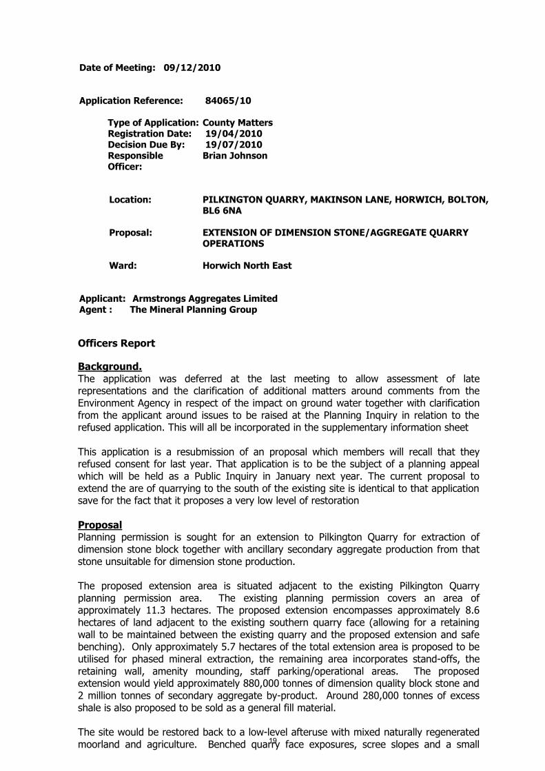
Application Reference: 84065/10
Type of Application: County MattersRegistration Date: 19/04/2010Decision Due By: 19/07/2010ResponsibleOfficer:
Brian Johnson
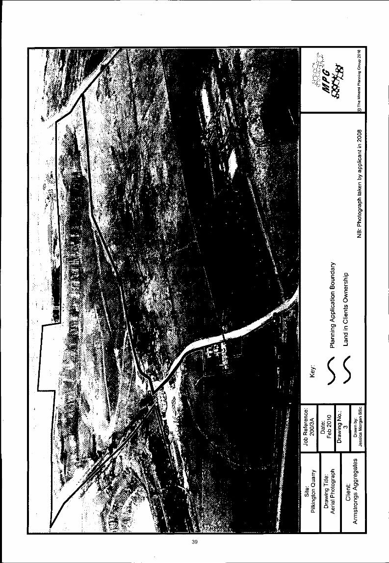
Location: PILKINGTON QUARRY, MAKINSON LANE, HORWICH, BOLTON,BL6 6NA
Proposal: EXTENSION OF DIMENSION STONE/AGGREGATE QUARRYOPERATIONS
Ward: Horwich North East
Applicant: Armstrongs Aggregates LimitedAgent : The Mineral Planning Group
Officers Report
Background.The application was deferred at the last meeting to allow assessment of laterepresentations and the clarification of additional matters around comments from theEnvironment Agency in respect of the impact on ground water together with clarificationfrom the applicant around issues to be raised at the Planning Inquiry in relation to therefused application. This will all be incorporated in the supplementary information sheet
This application is a resubmission of an proposal which members will recall that theyrefused consent for last year. That application is to be the subject of a planning appealwhich will be held as a Public Inquiry in January next year. The current proposal toextend the are of quarrying to the south of the existing site is identical to that applicationsave for the fact that it proposes a very low level of restoration
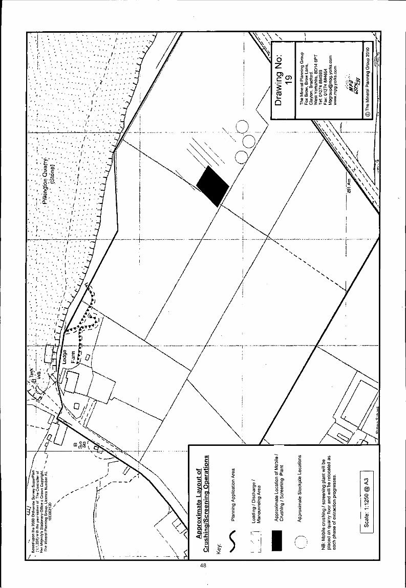
ProposalPlanning permission is sought for an extension to Pilkington Quarry for extraction ofdimension stone block together with ancillary secondary aggregate production from thatstone unsuitable for dimension stone production.
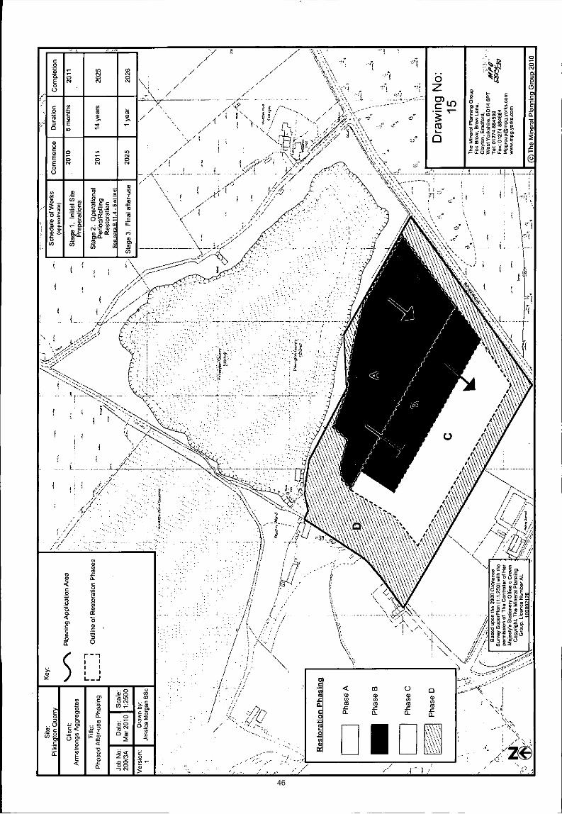
The proposed extension area is situated adjacent to the existing Pilkington Quarryplanning permission area. The existing planning permission covers an area ofapproximately 11.3 hectares. The proposed extension encompasses approximately 8.6hectares of land adjacent to the existing southern quarry face (allowing for a retainingwall to be maintained between the existing quarry and the proposed extension and safebenching). Only approximately 5.7 hectares of the total extension area is proposed to beutilised for phased mineral extraction, the remaining area incorporates stand-offs, theretaining wall, amenity mounding, staff parking/operational areas. The proposedextension would yield approximately 880,000 tonnes of dimension quality block stone and2 million tonnes of secondary aggregate by-product. Around 280,000 tonnes of excessshale is also proposed to be sold as a general fill material.
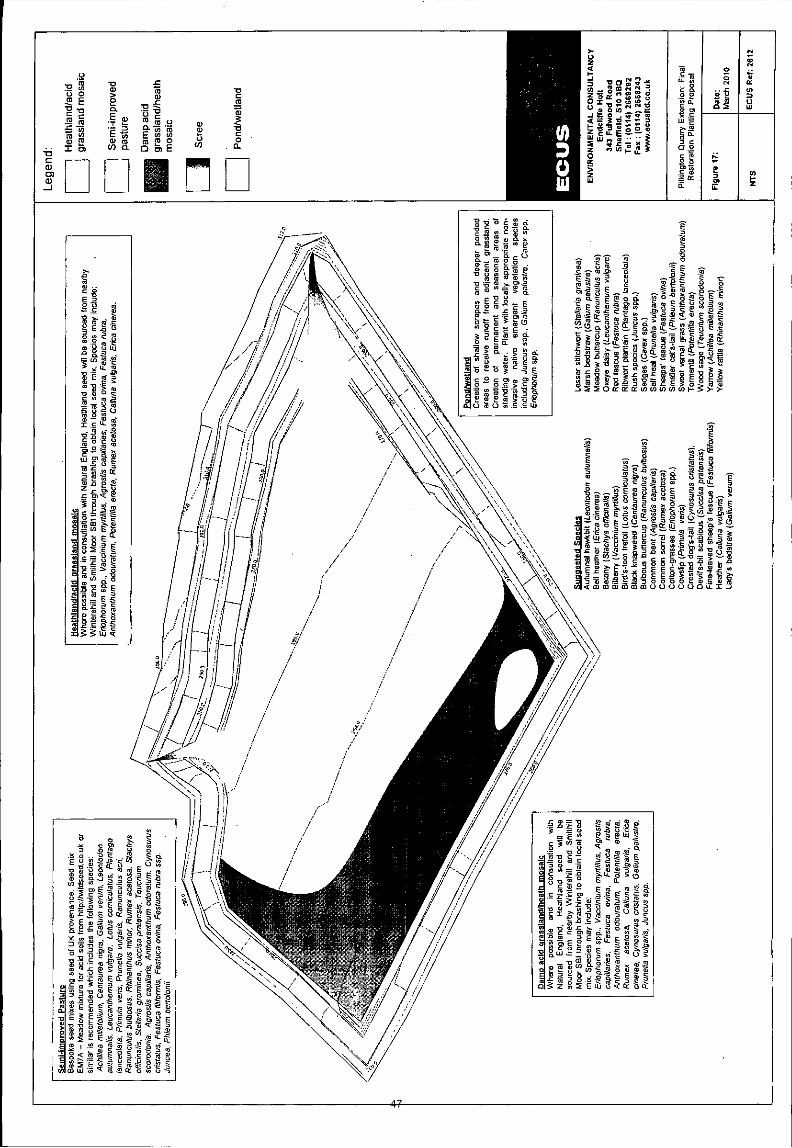
The site would be restored back to a low-level afteruse with mixed naturally regeneratedmoorland and agriculture. Benched quarry face exposures, scree slopes and a small19
marsh area would increase biodiversity and widen ecological niches in the locality uponcompletion.
The site is proposed to be worked the same as the permitted hours for the mineralextraction operations within the existing quarry as outlined below:
07:30 – 18:00 hours Monday to Friday 07:30 – 12:30 hours Saturdays
No production work would be undertaken on Saturday afternoons, Sundays or BankHolidays, when only maintenance of the plant and equipment would be carried out.
The winning and working of minerals and secondary aggregate operations would continuefor approximately 15 years (proposed end date of 2026).
Access to the site would be via the existing private access from Makinson Lane into thesite which is proposed to be fully resurfaced and selectively widened prior to mineralextraction commencing within the proposed extension area. A 10 mph speed limit isimposed on this access road. Within the site internal haul routes would be utilised. A fullwheel cleaning facility will be installed at the entrance to the site to prevent thedeposition of dust or other materials on the public highways.
It is proposed to include a passing-bay at the junction of Makinson Lane to MatchmoorLane. This would increase the visibility splay of this junction whilst allowing more thanadequate width for two HGV’s to safely pass. The widening of Makinson Lane to thenorth will also improve safety for HGV’s providing improved passing space.
The applicant has confirmed that the proposed extension will result in an increase of HGVmovements of up to 70 in and 70 out per day above the existing quarry traffic flow,resulting in a maximum of 120 HGV’s in and 120 HGV’s out per day. However, it shouldbe noted that the proposed traffic movements are fewer than those that have occurred inthe past at the quarry.
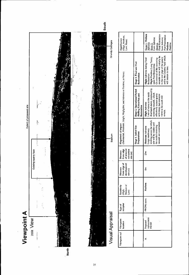
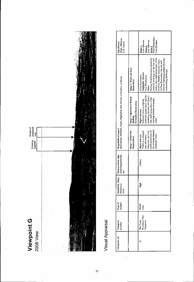
The northern, eastern and southern edges of the quarry have public footpaths runningadjacent to them (HOR053, HOR054 and HOR055). Footpath HOR057 runs along sidethe quarry access road, Makinson Lane.
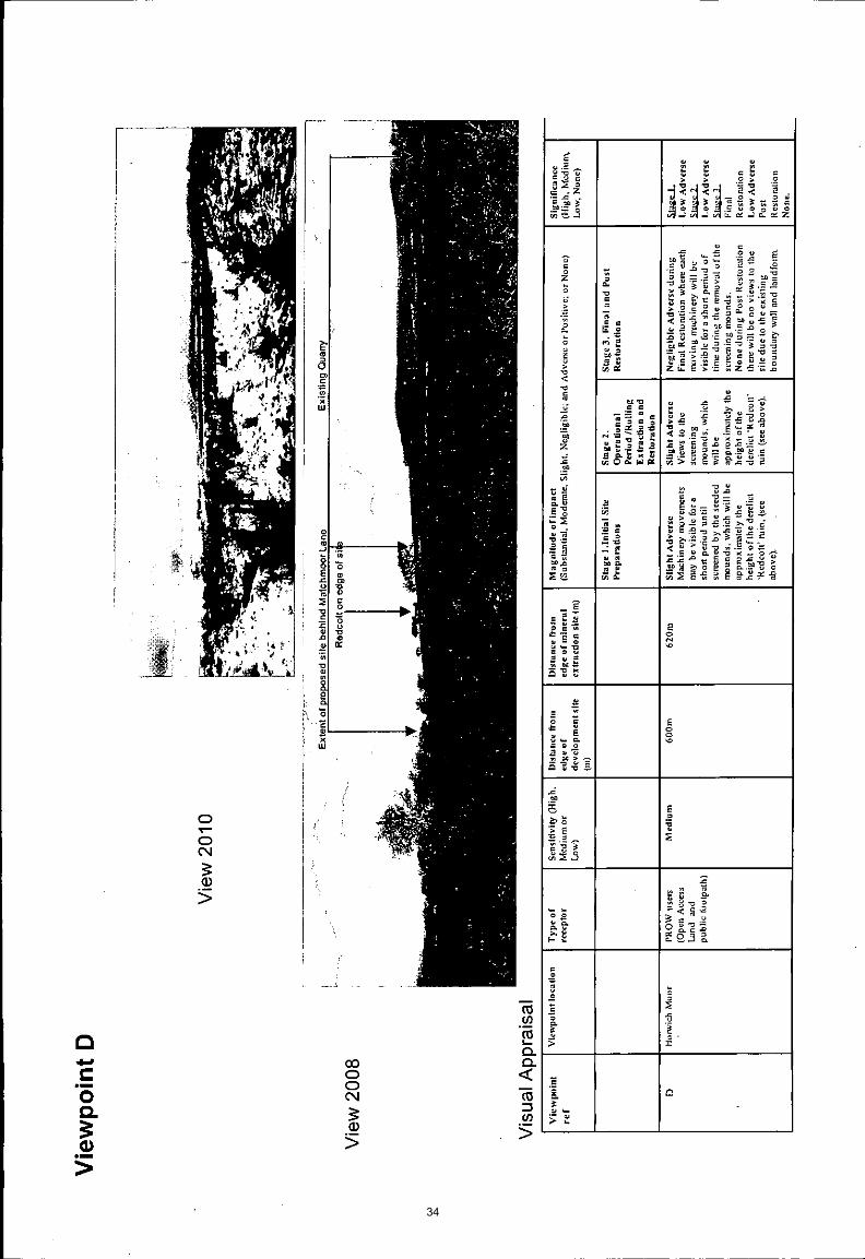
Footpath HOR054 has been partially quarried away (by the previous owner of the site)and so cannot be walked at present. The applicant, following discussions with BoltonCouncil, is proposing, as part of the application, to divert this footpath to a safer andmore accessible location along the southern boundary of the proposed extension area.
Site CharacteristicsPilkington Quarry is located approximately 2 kilometres east of Horwich on the outskirtsof Bolton. The site is surrounded on its northern and southerly sides by agricultural land,to its easterly side by Matchmoor Lane which continues out onto Horwich Moor and isadjacent to Montcliffe Quarry to its western side.
The adjacent Pilkington Quarry site is currently utilised for the extraction of high qualitysandstone. The existing planning permission at Pilkington Quarry runs until February2042 and the proposed quarry extension operations would be limited to 15 yearsextraction including rolling restoration with a 5 year land management and aftercareperiod.
The proposed extension site is low-grade agricultural rough-pasture land to the south ofthe existing quarry the vast bulk of which is within an Area of Search forgritstone/sandstone as delineated in the published Bolton UDP proposals map.20
PolicyThe proposed extension area falls within the Green Belt and is located within an ‘Area ofSearch’ for sandstone/gritstone in the adopted Bolton UDP proposals map.
The following policies from the Bolton UDP (Adopted October 2005) are consideredrelevant for this proposal:
G1 – Green BeltN1 – Nature ConservationO7 – Public Rights of WayM1 – MineralsM2 – Minerals Area of SearchM3 – Determining Planning ApplicationsM5 – Aggregate Mineral Workings
The following Regional policy is also relevant to this proposal.
Regional Planning Guidance for the North West (RPG13 (March 2003)The North West Plan – Submitted Draft Regional Spatial Strategy for the NorthWest (January 2006)
The following National Policy documents are relevant to this proposal:
PPS1 – Delivering Sustainable DevelopmentPPG2 – Green BeltsPPS7 – Sustainable Development in Rural AreasPPS9 – Biodiversity and Geological ConservationMPS1 – Planning and MineralsMPS2 – Controlling and Mitigating the Environmental Effects of Minerals Extractionin EnglandMPG7 – The Reclamation of Mineral Workings
Also relevant is the ODPM document “Planning for the Supply of `Natural Building andRoofing Stone in England and Wales” published in March 2004.
AnalysisSection 38 of the Planning and Compulsory Purchase Act 2004 requires applications tobe determined in accordance with policies in the Development Plan unless materialconsiderations indicate otherwise.
Applications which are not in accordance with Development Plan policies should berefused unless material considerations justify granting permission.
Similarly, proposals which accord with Development Plan policies should be approvedunless there are material considerations which would justify a refusal of permission.
It is therefore necessary to decide whether this proposal is in accordance with theDevelopment Plan and then take account of other material considerations.
The main impacts of the proposal are:-
impact on the local environment and residential amenityimpact on the highway networkimpact on the character and appearance of the area
Impact on the local environment and residential amenity21
The studies carried out as part of the Environmental Impact Assessment, have confirmedthat working within the quarry would be within Government guidelines for noise levelsand that dust would not cause any issues at the site. Furthermore, the extended areahas been shown to be an area that will produce significant levels of dimension stonerather than the smaller aggregate products most recently extracted from the existingquarry and, as such, no blasting is proposed, with all extraction by hydraulic excavator tomaximise dimension stone block yields. There will, therefore, be no disturbance to localresidents from blasting. Whilst there is a level of mineral waste that can be reasonablyprocessed and marketed as an aggregate, this is essentially a byproduct from the mainvalue extraction of the dimension stone.
Road conditions are to be substantially improved by widening and resurfacing ofMakinson Lane to a similar standard to Georges Lane, this will significantly improve localliving conditions for the nearest residents by reducing noise from vehicles using the lane.This, in turn, along with the installation of the wheel wash facility, should also reduce anyissues with debris being deposited on Makinson Lane. Likewise, the new surface willfacilitate the use of a mechanical road sweeper to ensure clean conditions are regularlymaintained.
Impact on the highway network
The policies of the development plan, in particular Policy M3, seeks to ensure thatproposals for mineral development do not adversely affect the safety of highway users inits vicinity and that existing transport routes are maintained and protected.
The proposed access into and out of the site would be via Makinson Lane and wouldutilise an existing road but with significant improvements such as resurfacing and theinclusion of passing bays.
The proposed operations would involve an average of 240 HGV movements (120 in and120 out per day).
Due to the previous historical HGV movements to and from the quarry being significantlyhigher than those proposed in this application, it is not considered that there are highwaygrounds for an objection to the proposal. Highway Management are satisfied that thedevelopment would not give rise to any unacceptable traffic or road safety problemssubject to the provision and maintenance of appropriate visibility splays.
Impact on the character and appearance of the areaThe site is within the Green Belt. However, PPG2 states that mineral extraction need notbe inappropriate development and that it need not conflict with the purposes of includingland in the Green Belt, provided that high environmental standards are maintained andthe site is well restored.
It has already been established that the extension area is within an Area of Search forgritstone in the Bolton UDP, which support the release of the land for this purpose subjectto environmental and other considerations.
Policy G1 of the Bolton UDP seeks to ensure that those proposals for development withinthe Green Belt do not adversely prejudice the purpose and objectives of the Green Belt.The main objectives for the use of land within the Green Belt are to provide opportunitiesfor access to the open countryside and recreation for the urban population and to retainattractive landscapes near to where to people live.
It is considered that the proposed operations would not significantly affect the opennessof the green belt and progressive restoration to create the proposed after-use wouldcontribute towards the achievement of the objectives for the use of land in Green Belt22
and would not conflict with the purposes of including land in Green Belt. As the vastbulk of the proposed extension area is allocated as an “Area of Search” for gritstone inthe most up-to-date adopted Bolton UDP quarrying is recognised as an appropriate usewithin the Green Belt by Bolton Council.
The applicant has also submitted details proving that special circumstances do exist hereto allow for the prudent use of resources through production of secondary aggregatefrom stone won that is not suitable for high-end dimension stone within the Green Beltarguing that Bolton Councils’ “Environment Strategy 2006 – 2011’ specifies the Councilsobjective of increasing recycling”.
The concern by the Ramblers Association that due to the time scale of the proposedextension quarry, the restoration of the site could not be guaranteed is not justifiable.The extension area would have a life around 15 years. Restoration of the site will be‘rolling’ and would continue in a phased manner. The restoration of the site would beassessed at regular site monitoring visits. In this way restoration is regularly monitoredand can be enforced if necessary. Recent legislation allows for such monitoring of sites tobe charged to the operator and there is, therefore, no budgetary constraints to necessarymonitoring by officers.
Footpath HOR054 has been partially quarried away (by the previous owner of the site)and so cannot be walked at present. The applicant, following discussions with BoltonCouncil, is proposing, as part of this application, to divert the footpath to a safer andmore accessible location along the southern edge of the proposed extension areaincluding the construction of locally distinctive stone stiles. It is also noted that theproposal includes for the undergrounding of existing overhead power lines that cross theextension area and this would be a positive landscape benefit. The proposed diversion isconsidered to be a sensible one, which would be commodious.
ConclusionIt is considered that in view of Government guidance, the extraction ofsandstone/gritstone (and ancillary activities) would not be inappropriate development inGreen Belt and the proposed restoration of the site would contribute to the achievementof objectives for the use of land within Green Belts. A number of proposed conditions(see below) should ensure that high environmental standards are maintained and that thesite is well restored in accordance with the approved plans.
The application/ES has investigated all potential issues that may arise from the proposeddevelopment, all of which have been confirmed by formal consultees to have nounacceptable negative impact on the surrounding landscape, environment or localresidents.
The proposed extraction of primary sandstone block would facilitate the continued supplyof indigenous dimension stone products within the area, contributing to and helping tomaintain local distinctiveness. The production of aggregate as a secondary by-productfrom that stone found unsuitable for dimension stone block is fully in accord withgovernment guidance which encourages the prudent use of resources. The proposedlow-level restoration of the extension area to an agricultural/moorland use without theneed for importation of fill material has taken on-board members previous concernsregarding the earlier application and likewise significantly reduces the overall number oflorry movements proposed.
Members are recommended that, after first taking into consideration the environmentalinformation, as defined in the Town and Country Planning (Environmental ImpactAssessment) (England and Wales) Regulations 1999, submitted in connection with theapplication, planning permission be subject conditions.
23
Representation and Consultation Annex
RepresentationsLetters and petitions of objection: - At the time of writing this report 98 letters ofobjection have been received together with 5 petitions which raise the followingconcerns:
PollutionAggregate recycling could cause airborne particles, noise, spillage from vehicles;The extension could cause a decline in air quality;
NoisePotential of noise pollution
Traffic
Slow moving lorries increase the risk of accidents as other motorists attempt toovertake;Lorries exceed speed limits;The HGV’s will cause road surface erosion;The road sweeper employed by Armstrong's is very noisy and ineffective;Georges Lane is a B-road and is not designed to take a constant stream of HGV’s;Extra traffic will be added to roads which will be dangerous to those who usethem;Traffic would cause dangers to walkers and other recreational activities;Mud and debris on the roads;Water from the quarry freezing on the roads could dangerous;
SitingThe effect on wildlife of the area;The site will effect an area of natural beauty (NB: this site is not in an AONB);Effect on the Green Belt;
Other concernsThe applicants are poorly thought of locally due to the fire (NB: arson attack) attheir other site;Decrease in property values (not a planning matter)Inadequate drainage at the quarry leads to water pouring down Georges Lane.Increased business in an area of outstanding natural beauty (NB: this site is not inan AONB);The proposals will have a detrimental effect on Arcon Village.
Letters and petitions of support:- 71 letters of support and have been received.These letters support the proposal for the following reasons:
Jobs would be created/maintained for local people;The existing quarry is already well screened and the proposals would have verylittle visual impact;The extension area is allocated as an ‘Area of Search’ for gritstone in the BoltonUDP;Historical importance of the quarry (e.g. stone used for Bolton Town Hall);Impressive restoration proposals;High quality stone produced from the site;
Town Council:- No comments or to be reported
ConsultationsAdvice was sought from the following consultees;
Greater Manchester Geological Unit: - All concerns raised in the previous application24
have now been addressed.
Greenspace Management (Wildlife Liaison Officer): - The land overlying theproposed extension area is not considered to be of great value or benefit to wildlife.Should consent for the application be considered, then the proposals for after-use designshould be welcomed, in line with policies N1 and N5 of the Councils current UDP.
Ramblers Association (Bolton Group): - Are aware of the need for building stoneand the preferred option of expanding existing quarries rather than opening new ones.Are concerned about the working practices of the quarry operator, the impact on thegreen belt, the additional lorry movements increasing danger and annoyance, increase inmud, slime and debris on the road and the time scale envisaged may mean restoration onthe site will not take place as promised.
Greater Manchester Transport Unit: - No comment
Environment Agency: - Have raised no objections in principle subject to the impositionof a number of conditions which would control the process of the development and therequirements for the treatment of the site for restoration and after use.
Highways and Engineering Development:- The proposal is unlikely to have anysignificant impact on highway safety or capacity subject to the widening of MakinsonLane. Appropriate conditions suggested.
United Utilities: - No objection.
Greater Manchester Ecological Unit: - No comment.
Greenspace Management (Landscape Development and Design): - passing bay isrecommended. Full details of the final restoration scheme should be provided.
Public Rights of Way Team: - Subject to the provision of a suitable alternative route(for footpath 54 Horwich) along the proposed diversion line, the group support theintention to divert the footpath to again make it walkable. Support the application.
Greater Manchester Archaeological Unit: - No comment.
Planning HistoryPlanning permission was granted for the extraction of clay and coal from beneath thequarry in 1949 (ref 12/5/43).
Planning permission for stone extraction was granted at the existing Pilkington Quarry onthe 26th June 1950 (ref: 12/5/103).
In 1968 a further permission was granted for stone extraction from 4 hectares of landwithin the 1950 permission area (ref: 12/5/1642). Why this application was submittedwhen the site already had planning permission is not known.
In 1999, Santime Limited (the previous owners/operators of the quarry) obtained adetermination of new conditions under Schedule 13 of the Environment Act 1999 inrespect of the 1950 permission (ref: 50252/97).
Further planning permission was granted in November 2002 for a variation of condition23 of the Determination of New Conditions (ref: 61530/02) to permit the importation ofinert materials for stabilization of the existing northern quarry face and restoration works.The stabilization works on the buttress are complete – restoration works are ongoing.25

When Armstrong Aggregates Limited acquired Santime Limited a correction was made topermission 50252/97 and 61530/02 to amend the end-date to the 22nd February 2042following the ‘Earthline’ case in 2003 which clarified the law on this issue. The decision onthe relevant applications was confirmed by Committee at it's last meeting.
A planning application (ref: 80931/08) for an extension to the quarry with associatedaggregate recycling and restoration infill over the whole site was refused by BoltonCouncil against officers recommendations in November 2009. This current application is aresubmission of this application but with the infill restoration element of the extensionarea removed.
26
Recommendation: Approve subject to conditions
Recommended Conditions and/or Reasons
1. The development hereby permitted shall be begun before the expiration of 3 years from the date ofthis permission.
Reason
Required to be imposed pursuant to section 91 of the Town and Country Planning Act 1990 asamended by Section 51 of the Planning and Compulsory Purchase Act 2004.
2. This permission is for the winning and working of minerals shall cease not later than 31 December2026. The site shall be fully restored, in accordance with a scheme approved under conditions 16,and all plant, machinery and structures associated with the development shall be removed from site,not later than 31 December 2027.
Reason.To provide for the completion and progressive restoration of the site within the approved timescale tominimise the duration of disturbance from the development hereby permitted in the interests of localamenity.
3. Not more than 120 HGV movements to and 120 HGV movements from the site to which this noticerelates shall take place during any single day. No HGV’s shall enter or exit the site on Sundays, Bankor Public Holidays.
Reason.In the interests of the amenities of local residents, highways safety and the protection of thesurrounding highway infrastructure.
4. No HGV’s shall enter or leave the site and no working shall take place within the site to which thisnotice relates except between the hours of: -
07.30 hours to 18.00 hours Monday to Friday; and07.30 hours to 12.30 hours on Saturdays.There shall be no working on Sundays, Bank and Public Holidays.
Reason.To protect the amenities of the local residents
5. Noise from any activity shall not exceed the equivalent free field continuous sound level (LAeq,1h)measured over a 1 hour period of 55 dB(A), as measured 3 metres from the facade of those noisesensitive properties located at Heather Hall, Lodge Farm and Grundy Cottages, except for operationsrelated to topsoil stripping, construction of screening mounds and restoration works, where amaximum equivalent continuous sound level (LAeq,1h) of 70 dB(A) applies, and such operationsleading to these latter noise levels shall not exceed more than 8 weeks in any 12 month period.
Reason.To protect the amenities of the local residents
6. Monitoring noise from the site operations shall be undertaken once a month and for a one hourperiod on any working day, or at any time interval to be agreed with the Mineral Planning Authorityat the noise points referred to in condition 5 for a period of 6 months from the date of this planningpermission. Monitoring beyond this period shall be in accordance with a scheme to be first submittedto and agreed in writing with the Mineral Planning Authority. Monitoring shall similarly be carried outat Lodge Farm at a point to be agreed with the Mineral Planning Authority within 3 months from thedate of this planning permission and in accordance with the requirements of this planning condition.
The results of this monitoring shall be recorded and submitted to the Mineral Planning Authority onthe last working day of each month for the 6 month period and shall include:-
27

(a) the measured one hour LAeq in dB;(b) date and time of measurement;(c) description of site activities at the time of the measurement;(d) details of the measuring equipment; and;(e) details of weather conditions including wind speed and direction of wind and temperature;(f) location of monitoring.
Reason.To protect the amenities of the local residents
7. No plant or machinery shall be used on the site unless fitted and operated with efficient noiseattenuation equipment. Such equipment shall be maintained in a good condition at all times inaccordance with the manufacturers specification and recommendations.
Reason.To protect the amenities of local residents and footpath users
8. Within 6 months from the date of this planning permission a scheme and programme of themeasures to be adopted for the suppression of dust shall be submitted to the Local PlanningAuthority for approval in writing. Such measures shall include, where necessary, the watering ofhaulage and access roads, restricting vehicle speed, watering of stockpiles, fitting of suitable dustsuppression equipment to drill rigs and restricting earthworks, stockpile movements outside drywindy weather conditions. The scheme shall be implemented within 28 days from the date ofapproval by the Mineral Planning Authority.
Reason.To control fugitive dust and protect the amenities of local residents
9. Those details of wheel cleaning facilities to the access points on Makinson Lane and Matchmoor Laneas approved and implemented under 50252/97 and 61530/02 shall be maintained and remainavailable for use as necessary throughout the life of the site in order to prevent the deposition ofdetritus on the highway. Any offending material deposited on the highway shall be immediatelyremoved, where practicable, and in any event at the end of each working day.
Reason.To prevent mud, dirt or debris being carried onto the public highway in the interests of HighwaysSafety.
10. All vehicles transporting material other than block stone to and from the site shall be suitably sheetedto prevent the deposition or loss of materials from the vehicle.
Reason.To prevent mud, dirt or debris being carried onto the public highway in the interests of HighwaysSafety.
11. No development within the quarry extension area shall be undertaken until the applicant has securedthe implementation of a programme of archaeological work (watching brief) in accordance with awritten scheme of investigation approved by the Mineral Planning Authority.
Reason.To make a record of any buried archaeological remains for archive and research purposes.
12. Any proposed liquid storage tanks for fuel oils or process chemicals, shall be located within a bundedarea having a capacity of not less than 110% of the combined volume of the tanks. The floor andwalls of the bund shall be impervious to oil and water and shall also be resistant to any storedchemicals. All inlet/outlet/vent pipes and gauges shall be within the bunded area.
Reason. To prevent pollution of the water environment.
13. Any oil or chemical drums used as storage containers shall be stored in a compound with animpervious base with the floor graded in such a manner that the contents of the largest drum areretained in the event of spillage.
28

Reason.To prevent pollution of the water environment.
14. There shall be no discharge of foul or contaminated drainage from the site into either ground wateror any surface water, whether direct or via soakaways.
Reason.To prevent pollution of the water environment.
15. Within 6 months of the date of this permission, a detailed scheme for the final restoration of the siteshall be submitted to the Mineral Planning Authority for approval in writing. such scheme as isapproved shall be implemented in full on completion of final restoration and shall include details ofthe provision of natural water features, and reinstatement of localised habitats (including existingdrainage ditches) and how the impact of the development on such habitats can be ultimatelymitigated.
Reason.To ensure that the site is reclaimed in a timely manner to a condition capable of beneficial after use,in the interests of visual amenity, landscape character and the objectives for the use of land withinthe Green Belt.
16. Not later than 1 November 2020, a scheme for the aftercare of the site following final restorationshall be submitted to the Local Planning Authority for approval in writing. The approved aftercarescheme shall be carried out for a period of five years after the completion of restoration.
Reason.To ensure that the reclaimed land is correctly husbanded and to bring the land to the standardrequired for agriculture/Country Park utilising latest ‘best practice’ methods
17. No waste materials shall be burnt on the site.
Reason.For avoidance of doubt.
18. The site shall be drained in accordance with a drainage scheme to be submitted to and approved inwriting by the Local Planning Authority within 3 months of the date of the planning permission.
Reason.To ensure a satisfactory form of drainage.
19. No development shall be commenced unless and until full details of the highway works at MakinsonLane comprising the widening of the carriageway, provision of passing bay and re surfacing havebeen submitted to and approved by the Local Planning Authority, and none of the development shallbe brought into use until such details as approved are implemented in full. Such works to beretained thereafter.
Reason
In the interests of highway safety.
20. The development hereby approved/permitted shall not be brought into use unless and until that partof the site to be used by vehicles has been laid out, drained and surfaced in accordance with detailsto be submitted to and approved by the Local Planning Authority and shall thereafter be madeavailable for the parking of cars at all times the premises are in use.
Reason
To encourage drivers to make use of the parking and circulation area(s) provided.
21. The development hereby approved/permitted shall not be brought into use unless and until fulldetails of the provision to be made within the curtilage of the site for the parking, turning, loadingand unloading of vehicles in connection with the proposed development have been submitted to andapproved by the Local Planning Authority; such facilities shall be provided and marked out before the29
development hereby permitted is first brought into use and thereafter such facilities shall be retainedand not be used for any purpose except the parking, turning, loading or unloading of vehicles.
Reason
In the interests of highway safety.
22. There shall be no blasting of stone within the site unless otherwise agreed in writing with the localPlanning Authority. Any subsequent blasting shall be undertaken in accordance with the noiserestrictions set out in condition 05 above and shall be subject to 48 hours notice to the LocalPlanning authority and all residential property within 200 metres of the site boundary.
Reason.In the interest of protecting the living conditions of nearby residents.
23. No mineral extraction shall commence unless and until full details of the amenity mounds s to thesouth east and west of the site, include details of landscape treatment, have been submitted to andapproved in writing by the Local Planning Authority. The mounds shall be constructed in accordancewith the approved details and retained for the extent of the life of the mineral extraction andsubsequent restoration.
Reason.To minimise the visual impact of the development of the surrounding landscape.
1. The Council has granted planning permission, subject to the conditions listed above, because theproposed development is in accordance with all relevant policies of the Development Plan (the UDPand the Regional Spatial Strategy Plan for the North-West), as is required by Section 38 of thePlanning and Compulsory Purchase Act 2004. There are no material considerations, as specified inthe Planning Officer Report, that outweigh this justification to support the grant of planningpermission. A summary of the relevant Development Plan policies pursuant to Article 22 of the Townand Country Planning (General Development Procedure) (England) (Amendment) Order 2003 andhow the proposed development relates to these policies is set out below.
Unitary Development Plan
N1 as the development proposals would not adversely affect the natural environment andbiodiversity;
N7 as new tree planting and maintenance together are proposed together with habitat managementand creation through landscape improvements and the benefit of the development outweighs the lossof some trees and hedgerows;
N9 as the Applicant has demonstrated that any impact on protected species or its habitat can besuccessfully mitigated and monitored and a planning condition is to secure the provision of futurealternative habitats;
EM2 as the development would avoid unacceptable impacts on existing uses or likely futuredevelopment by reason of pollution;
EM3 as the development would not have adverse effects on levels of air, water, land, noise and lightpollution;
EM10 as the development would not result in an unacceptable increased risk of flooding;
D14 as the development would not adversely affect nationally important archaeological sites ormonuments or their setting;
A5 as the development proposals take into account provision for roads, paths, servicing and parking;
A6 as the development is to provide car parking based on the Council's maximum car parkingstandards;
O7 as the integrity of public rights of way through the development will be retained;
30
31

32
33
34
35
36
37

38
39

40

41

42

43

44

45
46
47
48

49

Date of Meeting: 09/12/2010
Application Reference: 84545/10
Type of Application: Full Planning ApplicationRegistration Date: 05/07/2010Decision Due By: 30/08/2010ResponsibleOfficer:
Helen Williams
Location: VICTORIA INN, 26 MARKLAND HILL, BOLTON, BL1 5AG
Proposal: ERECTION OF BOLLARD LIGHTS, GROUND LIGHTS AND WALLLIGHTS
Ward: Heaton and Lostock
Applicant: K Shaw and Sons Ltd.Agent : Makin Architecture
Officers Report
BackgroundIt was requested at the last Committee meeting of 11th November that the application bedeferred to this December meeting to allow the applicant to submit further information toaddress the concerns of the objector. Members agreed to this deferral at the meeting.
Following the deferral of the application on 16th September the applicant has changedthe light head of one of the already erected bollards to an opaque head. This has resultedin there being less glare from the bollard than the others with the original light heads (aswill be shown to Members in the photographs to be projected at the meeting). The caseofficer viewed the 'new' bollard at dusk and is of the opinion that the use of the newopaque head is a vast improvement and should be applied to all of the bollards in the carpark should the application be approved. A condition requesting that all bollards are fittedwith the new head within 28 days of permission is therefore suggested.
Following a landscaping report commissioned by the objector to the scheme, it is alsosuggested that a condition is attached to any approval to ensure that the applicantplants cherry laurel at a height of 1.75 to 2 metres tall on the boundary between the pubcar park and the properties of Lydsam Lea and Marshcotes.
Other measures proposed by the applicant to mitigate the impacts of the proposedlighting scheme on surrounding residents' properties will be reported directly to Membersat the meeting.
ProposalPermission is sought for the erection of 20 round topped, stainless steel bollard lightsmeasuring 0.98 metres in height, which will be installed around the north, east and southboundaries of the car park and by the two disabled parking bays, and nine recessed LEDground lights on the terrace and at the entrance to the pub. A number of wall lights arealso proposed around the building, which will replace the former external lighting on thebuilding.
The new light fittings are intended for provide low level lighting for pedestrians and usersof the car park. 50

Site CharacteristicsThe application site consists of The Victoria Inn (a public house) and its curtilage. Thepub is currently been upgraded following planning consent for extensions and alterations(83477/10 and 83478/10). The original building was constructed in the 1790s. It isunderstood that the pub was a former coaching house and therefore has a longestablished use as a drinking establishment.
Car parking for the pub is situated to the north and east of the building.
To the north and south of The Victoria Inn are groups of trees protected by TreePreservation Orders 5 Bolton (Heaton) 1960 and 430 Bolton (Markland Hill) 1998. Thereare also a couple of single trees within the site that are also protected by the Orders.
The site is located within Chorley New Road Conservation Area, which is characterised inthe main by large dwellings set in large wooded grounds.
The surrounding area is predominantly residential in character. The nearest dwellings tothe public house are to the east of the site (Marshcotes, Oakwood Drive and Lydsam Lea,Marshdale Road).
PolicyPPS5 Planning for the Historic EnvironmentPPS23 Planning and Pollution Control
RSS13 Policies: DP7 Promote Environmental Quality; EM1 Integrated Enhancement andProtection of the Region's Environmental Assets.
UDP Policies: N7 Trees, Woodland and Hedgerows; N8 Protected Trees; EM2Incompatible Uses; EM3 Pollution; D2 Design; D7 Conservation Areas; A5 Road Network.
PCPN10 Planning out Crime
AnalysisSection 38 of the Planning and Compulsory Purchase Act 2004 requires applications tobe determined in accordance with policies in the Development Plan unless materialconsiderations indicate otherwise.
Applications which are not in accordance with Development Plan policies should berefused unless material considerations justify granting permission.
Similarly, proposals which accord with Development Plan policies should be approvedunless there are material considerations which would justify a refusal of permission.
It is therefore necessary to decide whether this proposal is in accordance with theDevelopment Plan and then take account of other material considerations.
The main impacts of the proposal are:-
* impact on the amenity of neighbouring residents* impact on the character of the conservation area* impact on trees
Impact on the Amenity of Neighbouring ResidentsPolicy EM2 of the UDP states that the Council will not permit development that will resultin unacceptable impacts on existing uses or likely future development by reason of noise,smell, safety, health, lighting, disturbance, traffic or other pollution. Policy EM3 of the51

UDP states that the Council will permit developments which do not adversely affect levelsof air, water, land, noise or light pollution.
The proposed lighting is intended to illuminate the car park and outside areas of thepublic house in a more sensitive way than the previous lighting on and around thebuilding. The metal halide flood lights that originally projected from the eaves of thepublic house and illuminated the car park will be replaced with new wall light fittings thatonly shine up and down the walls. The car park will instead be illuminated by 20 stainlesssteel bollard lights that measure 0.98 metres in height and will be located around thenorth, east and south boundaries of the car park. The louvres of these lights are angledso that their light is directed downwards. This style of lighting has been chosen by theapplicant as it will provide light only where required. Nine LED ground lights are proposedon the newly built terraced area and at the entrance to the building at the rear of thesite. These again are at a low level, being only 3 watts.
At 0.98 metres high, the proposed bollard lights along the boundary of the car park areawill be lower in height than the boundary fencing. As the louvres are directed downwardsand therefore it is unlikely that there will be any light spillage from these lights into thesurrounding properties, particularly as they have a low level of luminance. The lights onthe pub building are again low in luminance and will only shine up and down the walls,not out into the car park as the former lights on the building did.
The Council's Pollution Control Officers have not raised any objection to the proposal andhave requested that the lighting is no more than 5 LUX when measured from the nearestresidential properties. The applicant has since sent in a report confirming the LUX levelsof all the proposed lighting with the site, which shows that there will be a LUX level of 0at the neighbouring residential properties.
The objectors to the application also raise concerns that the proposed lighting willencourage more activity and noise around the pub than previously was the case. As therewere lights already on the walls of the building prior to this application, it is notconsidered that the proposal would result in more patrons using the outdoor areas thanpreviously. The impact of the new terraced area on the amenity of neighbouring residentswas assessed during the determination of applications 83477/10 and 83478/10.
The application was deferred at the original Committee meeting of 19th August to allowfor a comparison to be made between the previous lighting scheme at the public houseand the scheme now proposed. This was found to be as follows:
Total number of lights proposed on the building and within the site Former NewFlood lights 14 1Wall lights 1 19Emergency lights 1 2Lanterns 3 3Mini ground recessed LEDs 0 21Bollards in car park 0 20
Although the total number of lights within the site have been increased the applicant hasstated that the number of brighter lights have been reduced significantly. Two plansattached to the report illustrate the effects of the former lighting scheme (consistingpredominantly of flood lighting) and the light spill from the building, compared with thatof the new lighting scheme. It is clear from the plans that the new lighting scheme hasless light spill and less of an effect on neighbouring properties. Whilst the number offittings has increased, the use of less powerful fittings helps to keep the lightconcentrated close to the edge of the building where it is required. The applicant wouldalso like to point out that all the LED lights together produce a much lower light output52

than just one of the previous flood lights. It is also noted that the applicant is required toprovide lighting to allow people to leave safely as part of the licensing agreement.
As detailed in the background section of this report, the applicant has actively sought toreduce the glare of the bollards, following concerns from objectors and Members, byproviding new opaque light head to the bollards. Though the applicant has only replaceone bollard head so far (as an example) it is their intention to change the light heads ofall the bollards should Members approve the application. It is suggested that thisreplacement of bollard heads be conditioned.
The applicant has also agreed to provide new planting between the car park and theproperties of Lydsam Lea and Marshcotes, which will be conditioned, and to turn thelights off after closing time each night.
It is considered that the proposed lighting features, subject to the proposed conditions,will not harm the amenity of neighbouring residents given their siting, direction and levelof luminance, therefore complying with Policies EM2 and EM3 of the UDP.
Impact on the Character of the Conservation AreaPolicy D2 of the UDP states that the Council will permit development proposals thatcontribute to good urban design and that are compatible with, or improve, theirsurroundings. Policy D7 of the UDP states that the Council will permit developmentproposals that preserve or enhance the character or appearance of conservation areas.
The public house is within Chorley New Road Conservation Area. The proposed"up/down" lighting on the building will replace what are considered to be rather unsightlyflood lights, which are either on the walls are under the eaves of the building. It isconsidered that the replacement lighting on the building will improve its appearance. Thelow level lighting around the boundaries of the car park will also be sympathetic to thecharacter of the area.
It is therefore considered that the proposed lighting would be compatible with thecharacter and appearance of the area, compliant with Policies D2 and D7 of the UDP.
Impact on TreesPolicy N7 of the UDP seeks to protect and conserve existing trees, woodlands andhedgerows where possible when considering development proposals. Policy N7 goes on tostate that the Council will not permit development proposals which would result in theloss of trees, woodland areas or hedgerows of visual, historic or amenity importance andrequiring replacement planting where it is considered that the benefit of the developmentoutweighs the loss of some trees or hedgerows. UDP Policy N8 refers specifically toprotected trees.
The applicant has amended the siting of four of the proposed bollard lights followingconcerns from the Council's Tree Officer, who felt that they were originally too close toprotected trees within the site. The amended siting (shown in revision C) is nowconsidered to be acceptable by the Tree Officer and therefore it is considered that theproposal complies with Policies N7 and N8 of the UDP.
ConclusionIt is considered that the proposed lighting will not harm residential amenity, will becompatible with the conservation area and will not harm any of the protected trees withinthe site. Members are therefore recommended to approve the application.
53
Representation and Consultation Annex
RepresentationsLetters:- Two letters of objection has been received from resident of Lydsam Lea,Marshdale Road and Marshcotes, 67 Oakwood Drive. This letter raises the followingconcerns:
There is more lighting proposed than there was on site previously; less lighting shouldbe proposed;The lights are brighter than the residents expected;The lighting will be directly opposite residential properties;The external lighting on the building should also be assessed;The proposal is excessive, unnecessary and inappropriate, particularly in aconservation area;The increased lighting will promote and facilitate increased activity and noise wherepreviously there was none;The hours of luminance should be conditioned;The applicant should be requested by a condition to provide additional planting alongthe boundary with the residents' properties;Concerns around parking at the public house.
Elected Members:- A letter was received from Cllr. Bob Allen (a ward councillor) on12th September supporting the objector to the proposal. He stated that he believed thatthe significantly enhanced lighting scheme would encourage people to spend timeoutside, not just on the terrace but on the various patios and on the car park and that thebollards are too many in numbers and are too bright, impacting on the amenity ofneighbouring residents.
A further letter from Cllr. Allen on 8th November states that he has seen the bollard thatthe applicant has fitted a diffuser to and comments that he believes it is a significantimprovement interms of reduced glare. If the diffuser is applied to all the bollard lightsthen it will be aa step in the right direction by the applicant.
ConsultationsAdvice was sought from the following consultees; Pollution Control Officers, Tree Officer,Design and Conservation Officer and Highways Engineer.
Planning HistoryPermission was granted at Committee in April this year for the demolition of an existingextension, outhouse and smoking shelter and the erection of a single storey extension,first floor extension, entrance porch, ramps, steps and terrace (83477/10 and 83478/10for the Conservation Area Consent).
Permission was granted in March 2009 for the felling of two hawthorn trees (81725/09).
A smoking shelter was granted permission in April 2007 (76570/07).
A lounge extension was granted in September 1993 (43572/93).
Permission was granted for four signs in December 1991 (39615/91).
An application for the erection of canopies over both entrances, the formation of a newdoor and the erection of fencing was granted permission in January 1991 (37950/90).
A single storey extension with basement to form a restaurant and catering kitchen wasapproved in September 1988 (31950/88).
54

Recommendation: Approve subject to conditions
Recommended Conditions and/or Reasons
1. The development hereby permitted shall be begun before the expiration of 3 years from the date ofthis permission.
Reason
Required to be imposed pursuant to section 91 of the Town and Country Planning Act 1990 asamended by Section 51 of the Planning and Compulsory Purchase Act 2004.
2. The lighting in the scheme should be erected, directed and shielded so as to avoid nuisance toresidential accommodation in close proximity. The lighting should provide a standard maintainedillumination (LUX) as measured at the nearest residential properties affected of 5 LUX or less. Noother lighting equipment may then be used within the development other than as approved by theLocal Planning Authority.
Reason
To safeguard the amenity and character of the area and to safeguard the living conditions of nearbyresidents.
3. The lights hereby approved on the building and within the curtilage of the building shall not be litlater than the public house's approved licensing hours unless otherwise agreed in writing by the LocalPlanning Authority.
Reason
To safeguard the character and amenity of the area and to safeguard the living conditions of nearbyresidents.
4. Within 28 days of this decision being issued all the approved bollards shall have an opaque light headfitted to them. These heads shall be identical to that already attached to one of the bollards withinthe car park, which was viewed by the Local Planning Authority on 19th October 2010. Thereplacement heads on each bollard shall be retained thereafter, unless otherwise agreed to in writingby the Local Planning Authority.
Reason
To safeguard the amenity and character of the area and to safeguard the living conditions of nearbyresidents.
5. A cherry laurel hedge (prunus laurocerasus rotundifolia) shall be planted the full length of theboundary between the car park and the boundary of Lydsam Lea in accordance with a scheme to besubmitted to and approved by the Local Planning Authority with 21 days of this decision. The hedgeshould be 1.75 to 2 metres tall when planted, in 25 litre pots and planted at 80cm centres, withmulching. Such a scheme shall be carried out within 28 days of the decision. Any shrubs that die orare removed within five years of planting shall be replaced in the next planting season with others ofsimilar size and species. It is recommended that the hedge be allowed to grow to 2.4 metres tall,then topped.
Reason
To safeguard the amenity of neighbouring residents.
1. The Council has granted planning permission, subject to the conditions listed above, because theproposed development is in accordance with all relevant policies of the Development Plan (the UDPand the Regional Spatial Strategy Plan for the North-West), as is required by Section 38 of thePlanning and Compulsory Purchase Act 2004. There are no material considerations, as specified inthe Planning Officer Report, that outweigh this justification to support the grant of planningpermission. A summary of the relevant Development Plan policies pursuant to Article 22 of the Townand Country Planning (General Development Procedure) (England) (Amendment) Order 2003 and55

how the proposed development relates to these policies is set out below.
Unitary Development Plan
N7 and N8 as the proposal does not affect the trees protected by Tree Preservation Order;
EM2 as the development would avoid unacceptable impacts on existing uses or likely futuredevelopment by reason of pollution;
EM3 as the development would not have adverse effects on levels of light pollution;
D1 and D2 as the application displays good urban design which would preserve local distinctiveness;
D7 as the development would preserve the character and appearance of the Conservation Area;
A5 as the development proposals take into account provision for roads, servicing and parking.
56

revdescription date
THE VICTORIA INNBOLTON
Car ParkProposed alterations to Existing Layout
COPYRIGHT OF MAKIN ARCHITECTUREDO NOT SCALE FROM THIS DRAWING DIMENSIONS TO BE CHECKED ON SITE
D
SK sketch P proposed T tender C construction AB asbuilt
www.makinarchitecture.com
scheme
scale
drawn date
1322
RAB
1:100@A1
P(115)rev
7-12-09
no.
t 0161 236 0051e [email protected]
1500
ramp1:15
ramp1:15
B
B
B
C C
C C
C
C
E
E
F
J
J
C
C
H
B
E
E
D
D
D
D
B
B
B
Lighting to existing signage replaced like - for - like
C E
Laylandii hedging alongside neighbouring property, planted at minimum 1.5 meters high
A
A
A
A
AAAA
A
A
A A A AA
A A
A
A
A
A
A
A
AA
G
A
A A
B
C
D
E
F
H
J
KEYA Low level bollard lighting, blue circle shows actual size of 177mm diameter. Louvres
angle lighting downwards
Cable trenching local to tree bases to be hand dug
Up / down wall light, orange circle shows actal size of 125mm diameter. Fixed at a height of 1800mm above walkway deck and terrace to nagate headroom issues
3 watt recessed LED ground light
recessed LED ground light
LED stair light recessed into stair stringer
Flood light, orange rectangle shows actual size of fitting. Fixed at a height of 1800mm above ground to negate headroom issues
Street light to low level garden, 2040mm high
Emergency fitting, illuminated only in emergency situation
Integral emergency wall light
C2 no bollards omitted 20-07-10BExternal Lighting Added 20-07-10ACurb to Markland Hill added 20-07-10
DHedging added 02-09-10
57
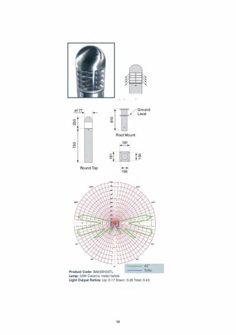
58
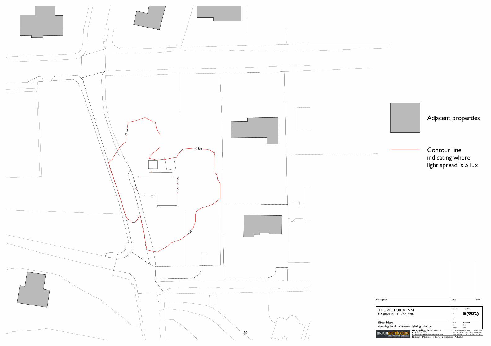
revdescription date
THE VICTORIA INNMARKLAND HILL - BOLTON
Site Plan showing levels of former lighting scheme
COPYRIGHT OF MAKIN ARCHITECTUREDO NOT SCALE FROM THIS DRAWING DIMENSIONS TO BE CHECKED ON SITE
-
SK sketch P proposed T tender C construction AB asbuilt
www.makinarchitecture.com
scheme
scale
drawn
date
1322
RAB
1:500@A3
E(902)rev
date
no.
t 0161 236 0051e [email protected]
Adjacent properties
Contour line indicating where light spread is 5 lux
5 lux
5 lux
5 lu
x
59
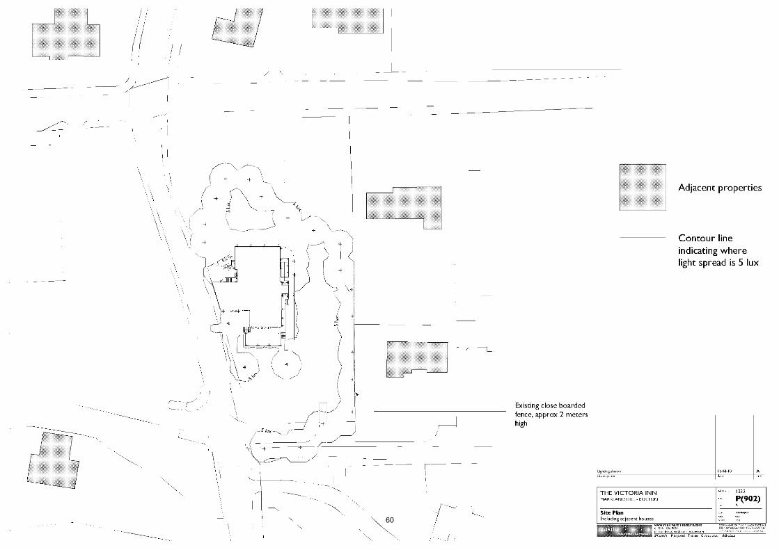
60

Date of Meeting: 09/12/2010
Application Reference: 84891/10
Type of Application: Full Planning ApplicationRegistration Date: 02/09/2010Decision Due By: 28/10/2010ResponsibleOfficer:
Jodie Turton
Location: LAND AT REAR OF 16 RIDGMONT CLOSE, HORWICH, BOLTON,BL6 6RG
Proposal: CHANGE OF USE OF LAND TO GARDEN AND ERECTION OFRETAINING WALL AND FENCE
Ward: Horwich North East
Applicant: Mr P ParryAgent : Mr D Slater
Officers Report
ProposalThe application proposes the change of use of a vacant section of land to the rear of 16Ridgmont Close to form a garden extension. The site area measures approximately 4metres in depth and 20 metres in length.
The site slopes downwards significantly from the applicants garden to the back street atthe rear of properties 11 - 17 Higher Barn. In order to provide a useable rear gardenextension the land would require levelling and a retaining wall of 1.5 metres in heightwould be constructed along the boundary with the back street and a fence erected abovethis to form the boundary to the garden.
Site CharacteristicsThe site is a sloping strip of land, which forms the boundary to the back street at the rearof properties on Higher Barn. Trees and shrubs dominate the site currently, providing anattractive screen to the rear of properties on Ridgmont Close.
PolicyUDP policies: D1 and D2 Design; N7 and N8 Trees.
PCPN7 Trees: Protection and Planting in New Developments
AnalysisSection 38 of the Planning and Compulsory Purchase Act 2004 requires applications tobe determined in accordance with policies in the Development Plan unless materialconsiderations indicate otherwise.
Applications which are not in accordance with Development Plan policies should berefused unless material considerations justify granting permission.
Similarly, proposals which accord with Development Plan policies should be approvedunless there are material considerations which would justify a refusal of permission.
62

It is therefore necessary to decide whether this proposal is in accordance with theDevelopment Plan and then take account of other material considerations.
The main impacts of the proposal are:-
* impact on the character of the area residential amenity* impact on trees
Impact on the Character of the Area and Residential AmenityUDP policies D1 and D2 seek to ensure that development proposals contribute to goodurban design. Proposals should be compatible with, or improve, their surroundings, interms of their layout, height, massing, materials and landscaping.
The proposed retaining wall and fence are 9 metres away from the rear of the propertieson Higher Barn.
The applicant has not provided details of the height of the proposed rear boundary fence,however this would need to be between 1.8 and 2.0 metres in height in order to retainprivacy for the applicant. Due to the significant change in levels between Ridgmont Closeand Higher Barn, any lower than this and the applicant would be able to look directly intothe rear gardens and windows of houses to the rear on Higher Barn.
The retaining wall at 1.5 metres would not alone provide an overbearing feature for theproperties on Higher Barn, however when taking into consideration the fence which wouldbe above this providing the rear boundary treatment to the garden it would present anoverbearing feature, which would impact detrimentally on the amenity of residents at 13and 15 Higher Barn.
Furthermore, providing a wall and fence boundary to the back street, where presentlythere are attractive trees and shrubs would impact detrimentally on the character of thearea and thus be contrary to UDP policies D1 and D2.
Impact on TreesUDP policies N7 and N8 recognise the importance and amenity value of trees and seek toprotect them in new development.
The Council's Tree and Woodland Officers have visited the site and they have confirmedthat the existing trees provide an attractive feature and are important to the amenity ofthe area. The construction of the retaining wall and the consequent change in levelswould result in the loss of these trees, which would be detrimental to the character andamenity of the area and thus contrary to UDP policies N7 and N8, as well as PCPN7.
Value Added to the DevelopmentN/A
ConclusionThe proposed garden extension and construction of a 1.5 metre high retaining wall isconsidered to be contrary to UDP policies D1, D2, N7 and N8, due to the impact onneighbouring residential amenity and the impact on trees and the character and amenityof the area. The proposal is therefore duly recommended for refusal.
63

Representation and Consultation Annex
RepresentationsLetters:- two letters of objection have been received from 13 and 15 Higher Barn,raising the following concerns:
Reduction in sunlight and daylight to the rear of their properties;Overlooking;Excessive height of the fence and retaining wall together would be overbearing;Impact on the trees which currently provide privacy;The back street is used for refuse collection and the proposal would prevent this;View of an unattractive brick wall and fence.
Town Council:- Horwich Town Council are in support of the application.
ConsultationsAdvice was sought from the following consultees: BMBC Tree and Woodland Officers.
Planning HistoryPlanning permission was approved for the following extensions:Two storey side extension and single storey rear extension, approved May 2010(83787/10)Two storey side extension and single storey rear extension, approved November 2009(82815/09)Single storey rear and side extensions, approved February 2006 (73034/05)
Recommendation: Refuse
Recommended Conditions and/or Reasons
1. The proposed development would be contrary to Policies N7 and N8 of Bolton's Unitary DevelopmentPlan in that it would result in the unacceptable loss of trees from the site, to the detriment of thecharacter, appearance and amenity of the application site and the area in which it is set.
2. The proposed retaining wall and fence would, by virtue of its design, height and siting be detrimentalto the character and appearance of the area and in particular would impact detrimentally on theoutlook and living conditions of neighbouring residents at 13 and 15 Higher Barn and is contrary toPolicies D1 and D2 of Bolton's Unitary Development Plan.
64
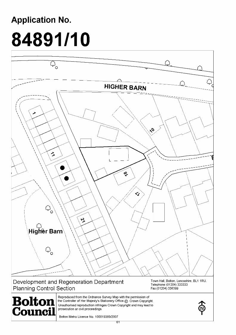
61

65
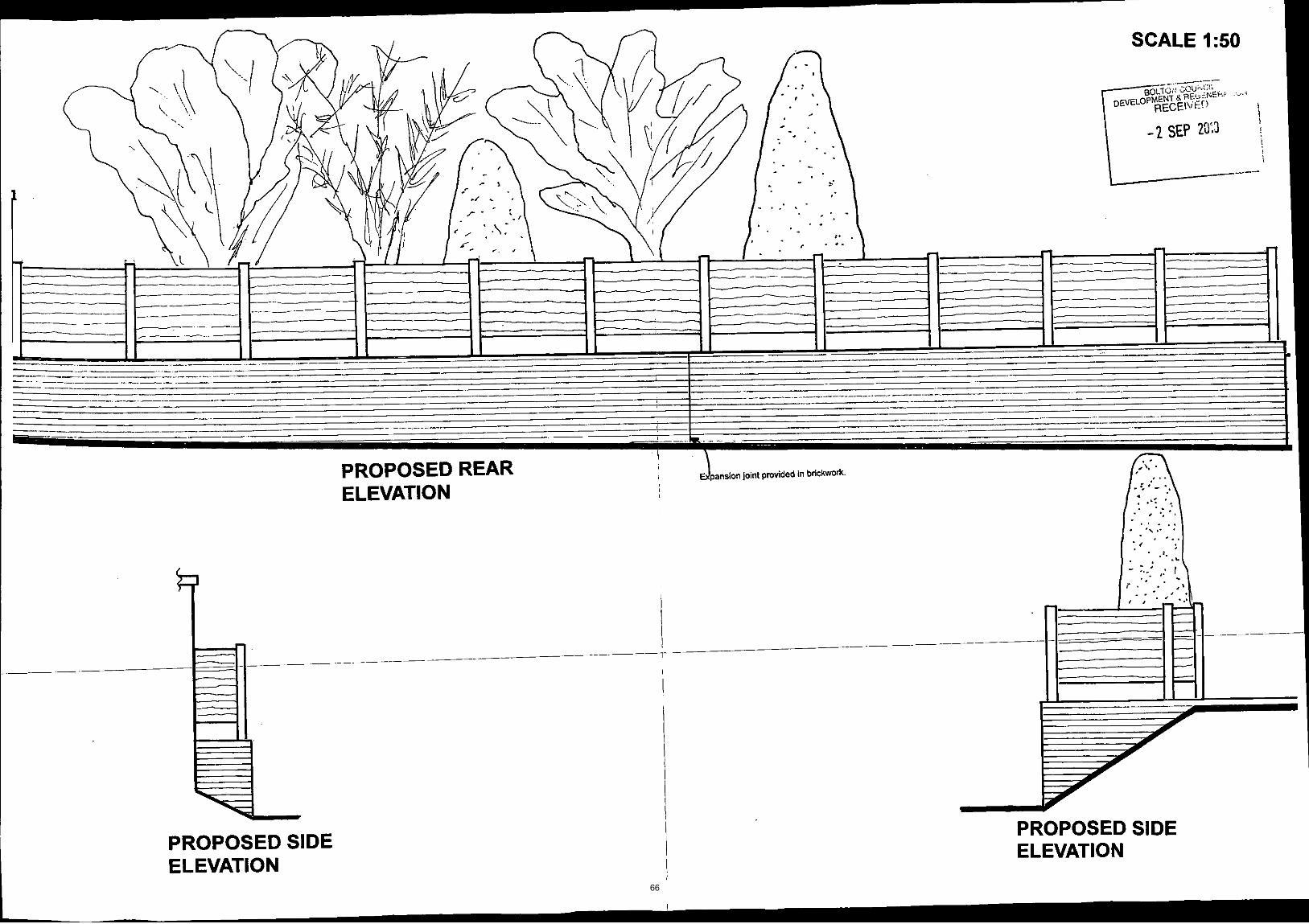
66
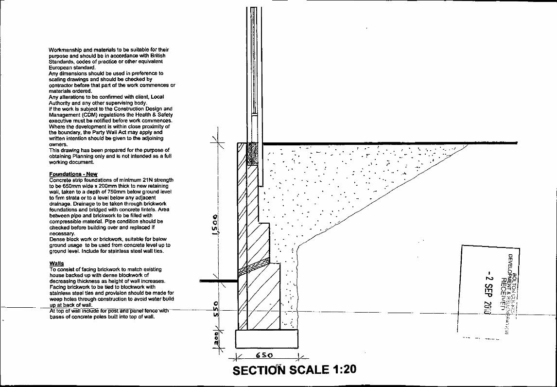
67

68

69

70

71
Date of Meeting: 09/12/2010
Application Reference: 84917/10
Type of Application: Full Planning ApplicationRegistration Date: 08/09/2010Decision Due By: 03/11/2010ResponsibleOfficer:
Martin Mansell
Location: LAND BOUNDED BY TEMPLE ROAD, MOSS BANK WAY ANDTHORNS CLOSE
Proposal: ALTERATION TO ACCESS ROAD TO PREVIOUSLY APPROVEDRESIDENTIAL DEVELOPMENT (74577/06 AND 74821/06)CONSISTING OF THE CONSTRUCTION OF TWO BRIDGES ANDA FOOTWAY / CYCLE PATH
Ward: Astley Bridge
Applicant: Bovis Homes Ltd.Agent : Bovis Homes Ltd.
Officers Report
ProposalProposal seeks consent for the construction of two bridges crossing over Astley Brooktogether with a 2.5 metre wide combined footway / cycleway in an area of defined publicopen space to the rear of residential properties on Thorns Close. The bridges would linkwith Temple Road East, providing a pedestrian and cycle access to the partiallyconstructed residential development at the former Beldam Crossley site. The proposalwould also involve associated street lighting and as there would be some loss of trees,replacement planting is proposed.
The original residential consent was granted in November 2002 and a condition wasimposed preventing the site from being brought into use unless and until the access tothe site had been constructed to a minimum width of 5.5 metres with 10 metres radii toMoss Bank Way and 1.8 metre wide footways. This was subsequently varied in 2006,relaxing the access standards by requiring instead a 4.8 metres carriageway (at thenarrowest point) with a single 2 metre footway on the southern side of Temple Road.
Despite commencement and partial construction it has not proved possible for thedeveloper and the owner of the land to the south to agree a satisfactory price for thestrip of land needed to fulfill the requirements of the access condition imposed on the2006 consent. As a result of this, the developer sought the consent of the Council toprovide a "shared" access, with motor vehicles, cyclists and pedestrians making use of thesame highway. This application was refused in 2008 and the Council successfullydefended its decision to refuse planning permission at a subsequent Public Inquiry. ThePlanning Inspector concluded that the absence of a separate defined route would be"prejudicial to highway safety, in particular that of pedestrians and cyclists".
The proposal now before Committee therefore results from the developers attempts toprovide access to the site for pedestrians and cyclists to and from Moss Bank Way.
72
The application is accompanied by the relevant plans including works to the carriageway,a tracking analysis plan, a stage one road safety audit, a street lighting plan, aarboricultural implications assessment and a hydraulic assessment of the bridges.
Site CharacteristicsThe site includes part of the length of the eastern section of Temple Road, together withits junction with Moss Bank Way. It also includes the line of the Astley Brook togetherwith an area of adopted and protected open space, defined as such in the Bolton UnitaryDevelopment Plan 2005 and bounded by the Astley Brook, Moss Bank Way and the rearboundaries of properties fronting Thorns Close and Moss Bank Way. The recreationalspace appears well-maintained, with little or no evidence of fly-tipping or anti-socialbehaviour and contains the frame of a children's swing. A former access point from MossBank Way appears to be now permanently locked and so the sole access to the site(other then navigating the Astley Brook and its retaining wall) is via a narrow ginnellalong the side of 38 Thorns Close. Thorns Close itself is a typical suburban residentialstreet, consistent with the wider Thorns Road area.
Three Public Rights Of Way converge close to the beginning of the residentialdevelopment. One, a public bridleway, heads broadly south, rising steeply to thenorthwest end of Cobden Street and therefore facilitating pedestrian access via HandelStreet and Harvey Street to Halliwell Road close to the Crofters Arms public house. Asecond heads east, following the line of the Astley Brook and emerging at Sharples Vale("the Mop"). The other bridleway heads north emerging on Thorns Road. As things stand,pedestrians wishing to travel to the junction of Temple Road East and Moss Bank Waywould share the highway with vehicles as there is no footway.
PolicyPPS1 Delivering Sustainable DevelopmentPPS3 HousingPPS9 Biodiversity and Geological ConservationPPG13 TransportPPS25 Development and Flood Risk
RSS13 Regional Spatial Strategy (North West)DP1 Spatial Principles, DP2 Promoting Sustainable Communities, DP4 Making the Best Useof Existing Resources and Infrastructure, DP5 Managing Travel Demand; Reducing theNeed to Travel, and Increasing Accessibility, DP7 Promoting Environmental Quality, DP9Reducing Emissions and Adapting to Climate Change, RT2 Managing Travel Demand, RT3Public Transport Network
UDP Policies D1, D2 Design, D3 Landscaping, A1 Accessibility, A5 Roads, Paths, Parkingand Servicing, A10 Traffic Management and Calming, A16 Pedestrians, A17 Cyclists, N1Nature Conservation, N4 Green Corridors, N6 Biodiversity, N7, N8 Trees and Woodland,N9 Species Protection, EM1 Environmental Management, EM11 Flood Protection, EM12Water Resources and Quality, O1 Open Space and Recreation, O2 Protection ofRecreational Open Space, O6 New Development at Waterside Location, O7 Public Rightsof Way, H1 Housing
PCPN21 Highways
AnalysisSection 38 of the Planning and Compulsory Purchase Act 2004 requires applications tobe determined in accordance with policies in the Development Plan unless materialconsiderations indicate otherwise.
Applications which are not in accordance with Development Plan policies should berefused unless material considerations justify granting permission.73
Similarly, proposals which accord with Development Plan policies should be approvedunless there are material considerations which would justify a refusal of permission.
It is therefore necessary to decide whether this proposal is in accordance with theDevelopment Plan and then take account of other material considerations.
The main impacts of the proposal are:-
* impact on highway safety and accessibility* impact on the character and appearance of the area* impact on the natural environment* impact on the living conditions of nearby residents* impact on recreational provision* impact on housing development* impact on flood risk and water management
Impact on Highway Safety and AccessibilityUDP Policy A1 encourages sustainable means of transport. Policy A5 states that theCouncil will permit those developments that have taken into account provision forpedestrians and cyclists; road design, layout and construction; vehicle servicing andaccess arrangements; car, cycle and motor-cycle parking; and access to, and by, publictransport. Development proposals should not adversely affect the safety of highwayusers, including pedestrians, as well as the safe and efficient circulation of vehicles.Policy A10 seeks to avoid the needs of cyclists, pedestrians and public transport usersbeing subordinate to those of the private motorist. Policies EM1, A16 and A17 seek toimprove the environment for pedestrians and cyclists.
Policy DP1 of the Regional Spatial Strategy for the North West (RSS13) seeks to promotesustainable communities, manage travel demand, reduce the need to travel, and increaseaccessibility. Policy DP2 seeks to promote sustainable communities by fosteringsustainable relationships between homes, workplaces and other concentrations ofregularly used services and facilities without unacceptably harming opportunities for sportand formal / informal recreation. Policy DP5 seeks to manage travel demand, reduce theneed to travel, and increase accessibility. Policy DP9 seeks to reduce emissions and adaptto climate change by promoting walking and cycling. Policies RT2 and RT9 promotewalking and cycling. Policy RT3 seeks to enhance accessibility by and to public transport,cycling and walking.
The Council's Highway Engineers consider that the proposed development represents anacceptable technical solution to the problem of access to the site by pedestrians andcyclists. Highway Engineers were involved at an early pre-application stage and havesupported the principle of this scheme. They requested that an independent Stage 1 RoadSafety Audit be carried out and their recommendations be incorporated into the scheme.As this has now been done, they have no objection to the proposal on highway safetygrounds. A S278 agreement would be entered into, with a commuted sum providing forthe future maintenance of the structures.
The proposal has been designed to minimise the actual and apparent distance travelledby pedestrians and cyclists, and the means of access can be engineered in such a way asto discourage use of the carriageway by pedestrians and cyclists.
The owners of the land to the south, JPS Real Estate, have arranged for their ownhighway engineers to comment on the proposal. Their views are described in therepresentations section and they consider that the application should be refused. TheCouncil's Highway Engineers state that relevant issues raised by the third partylandowners highway consultant have been referred back to the applicants and74
amendments have been made to the proposed highway scheme. The highway consultantis aware of these changes and no further comments have been received since the finalamendments.
Greater Manchester Police have commented to state that the proposed developmentshould be adequately lit and designed in such a way as to maximise natural surveillance.
Other options have been considered by the applicant and by the Council's PlanningOfficers and Highway Engineers:-
Implementation of Approved Scheme (74577/06)This is the best solution for access to the site. It would allow for the widening of TempleRoad to the north and the provision of a 4.8 metres carriageway with a single 2 metrefootway on the northern site of Temple Road. However, as noted above, the applicantand the owner have been unable to agree a price for the land necessary and there is noevidence of agreement being reached. It is considered therefore that the present proposalmust be assessed on its own merits and a decision reached.
Shared carriageway and footwayThis proposal was previously refused by the Council and the subsequent appeal dismissedat a public inquiry. The Planning Inspectorate found that this solution was not acceptablein highway safety terms. For this reason, it is not considered that this option should berevisited.
Cantilevered footway to the north, suspended over Astley BrookThe Applicant has provided evidence to show that the Environment Agency would notpermit this solution, on the grounds of flood risk and access for maintenance
Narrowing of Astley Brook to allow widening of Temple Road to the northThis would have required extensive remodelling of the watercourse up river and haverequired land outside of the Applicant's control and within the ownership of riparianowners.
Temple Road as carriageway only, with pedestrians using the bridleways (possiblyupgraded) to Thorns Road and Cobden StreetThe Planning Inspectorate noted that Temple Road provides the most direct access to thebus stops on Moss Bank Way, to the educational establishments on Smithills Dean Roadand for walkers seeking to access the Raveden woods and the West Pennine Moorsbeyond. For similar reasons, Highway Engineers do not support this solution as the risk ofpedestrians using an unsegratated carriageway is considered to be too high.
As other options have been considered, and the reasons for them being discounted havebeen accepted, the proposal should be considered on its merits. No objection has beenraised to the proposal by the Council's Highway Engineers and the proposal is consideredto comply with policies relating to highway safety and accessibility. Furthermore, it isclear from the UDP and RSS policy assessment above that improved pedestrianpermeability and accessibility (to and from the site, to and from the area of public openspace and to and from Thorns Close) are considered to deliver planning benefits.
Impact on the Character and Appearance of the AreaSection 39 of the Planning and Compulsory Purchase Act 2004 places a general duty onLocal Planning Authorities that in the exercise of their powers they have regard to thedesirability of achieving good design.
UDP Policy D2 requires new development to be compatible with its surroundings, tocreate a safe and secure environment which minimizes the possibility of crime, and isaccessible and useable to people of a range of mobility and physical ability. Policy O675

seeks to avoid adverse effects to the visual and physical quality and natural historyinterest of the town's watercourses.
Policy DP2 of RSS 13 notes that promoting sustainable communities will involve, amongstother things, improving the built and natural environment, conserving the region’sheritage and promoting community safety and security. Policy DP7 encourages thepromotion of environmental quality by, amongst other things, understanding andrespecting the character and distinctiveness of places and landscapes together with theprotection and enhancement of the historic environment, promoting good quality designin new development and ensuring that development respects its setting.
The site lies outside of the Hill Top Conservation Area and will have no impact upon it.
The development proposed consists of the provision of two bridges and a combinedfootway / cycleway together with associated lighting and replacement planting. It is notconsidered to be unusual for bridges and areas of hardstanding to be seen within areassuch as this - many of the town's rivers and streams have such features. Thedevelopment is considered to be compatible with its surroundings. The issue of tree losswill be considered in the section relating to the natural environment, and the issue ofdesigning out crime will be considered in the section on living conditions.
Impact on the Natural EnvironmentUDP Policy N1 seeks to ensure that new development does not adversely affect thenatural environment or biodiversity. Policies N4 and N6 seek to ensure that the integrityand continuity of the green corridor and biodiversity are not adversely affected. PoliciesN7, N8 seeks tree retention where possible, and minimising impact and replanting whereother considerations are thought to outweigh the harm. Policy N9 seeks to ensure that noprotected species would be adversely affected. Policies EM11 and EM12 seek to avoidflood risk or harm to watercourses, respectively.
RSS Policy EM 1 seeks to avoid unacceptable impact on landscape character or thenatural environment. Policy EM 3 seeks to ensure that green infrastructure and itsaccessibility and connectivity are maintaioned and protected. Policy EM 5 seeks to avoidflood risk or harm to water management.
The proposal will involve the removal of seventeen trees across the site. However, thesetrees have been assessed as being either of no or low retention value and there are noobjections to the proposal from the Council's Tree and Woodland Manager or fromGreater Manchester Ecology Unit - subject to replanting and final agreement of the line ofthe bridges on site. The area is generally well-wooded and it is considered that the areaand the green corridor can accommodate this loss and replanting without unacceptableharm.
The Council's Tree and Woodland Manager notes that whilst there will be significantimpact on the amenity of the Moss Bank Way frontage, this will be offset by newplanting.
The Environment Agency have confirmed that they have no objection to the proposeddevelopment, and therefore the impacts on flood risk and water management areconsidered to be acceptable.
Subject to conditions requiring fencing during development, new planting and preventingtree loss during the key times for wildlife, the proposal is considered to comply withpolicies relating to the natural environment.
Impact on the Living Conditions of Nearby ResidentsUDP Policy D2 requires new development to be compatible with its surroundings, to76

create a safe and secure environment which minimizes the possibility of crime.
Local residents have expressed very strong opposition to the scheme. Whilst all thegrounds are described in the representations section below, and assessed within the mainbody of this report, the key issue for residents is the opening of access to the public openspace from Temple Road and thereby to Thorns Close via the existing narrow access fromthe area. Their concerns relate to the potential for anti-social use of the open space,increased access to the rear of their properties by persons with criminal intent and alsogreater use of Thorns Close by pedestrians with further risk of anti-social behaviour.
The concerns of local residents are noted. However, planning policies do not seek toprotect the existing private situation of one group over those of another. Whilst theplanning system does seek to ensure that reasonable living conditions are maintained inthe whole of the Borough, it is necessary to assess whether the resulting situation isgenerally acceptable or not in terms of what are considered to be acceptable livingconditions. It is not unusual for areas of defined public open space to have more than oneaccess point - indeed, the reverse is generally true - it is unusual, in general, for an areaof public open space to have a single sole point of access. Similarly, the vast majority ofresidential streets in the town can be accessed, by pedestrians, from more than oneaccess point. It is not in anyway unusual for a street to allow for the passage ofpedestrians - in fact, it is an aim of both Bolton's Unitary Development Plan and theRegional Spatial Strategy for the North West to increase pedestrian permeability andaccessibility, where possible and appropriate. It is also not unusual for residentialproperties to have access to their rear boundaries - in fact, this is already the situation forthe properties bounding the public open space, albeit that access to the site is limited tothe sole access point at present. Provided that ordinary security measures (such as thefences already situated at the rear boundaries) are in place, then the risks of crime oranti-social behaviour is not considered to be so great that the application should beresisted on these grounds.
A plan has been provided showing the bridges and combined cycleway / footway havebeen located as far away from the residential properties as possible. It is not unusual forsuch features to be located in this arrangement - there are other properties, includingthose nearby, which share boundaries with public rights of way. The use of thedevelopment is unlikely to be excessively high, and therefore the risks to loss of privacyor disturbance are not considered to unacceptable.
The issue of potential light pollution has been raised. It will of course be necessary tobalance the need for the bridges and combined cycleway / footway to be attractive andsafe to use by pedestrians, whilst taking the impact of light into account. However, aswith the points above, it is not unusual for residential properties to have an amount oflighting to their rear. Whilst it would be possible to construct an argument against the useof this land as a floodlit recreational facility, it is not considered that the same impactwould apply in terms of this proposal.
Furthermore, there has been evidence of anti-social and criminal behaviour taking placeat the partially constructed housing development. Bringing the housing site into use willincrease activity and natural surveillance and is likely to significantly decrease the risk ofsuch behaviour in this location. Indeed, a letter of support has been received from aresident of Cobden Street on these grounds.
The proposed development will result in a change from the existing situation in terms ofaccess by members of the public and the provision of street lighting. However, it isnecessary to come to a view on what the impacts and risks are likely to be. As theresulting situation will be similar to that which exists in many parts of the Borough(indeed, in many towns and cities) in is not considered that a reason for refusal can besubstantiated on living condition grounds - particularly when the benefits of occupation of77
the housing development are taken into account. The proposal is considered to complywith the relevant policies.
Impact on Recreational ProvisionUDP Policies O1 and O2 seek to avoid the unacceptable loss of or damage to recreationalopen spaces. RSS Polices DP2 and L1 recognise the benefits of such facilities and similarlyseek their protection.
The proposal will improve access to an area of public open space presently accessed by asole access point. In this regard, it is considered to deliver recreational provision benefitsto the Borough.
The proposed combined cycleway / footway will cross the area of open space, leading toa net reduction in grassed area consistent with its size, location and area and will to adegree fragment the space. However, it is not uncommon for such spaces to containpaths such as this. The area is not laid out formally for sport or similar formal recreationand sufficient land remains for such uses. There has been no objection from the Council'sGreenspace Management section.
On balance, the impact on recreational provision is considered to be acceptable.
Impact on Housing ProvisionUDP Policy H1 and RSS Policies DP1, DP2, DP4 and L4 set out the development planapproach to providing sufficient housing for identified needs.
There is an existing and partially implemented consent for residential development at theformer industrial site. The principle of residential development cannot be revisited in thedetermination of this application.
The consent is for 85 dwellings, consisting of:-
36 x 2 bed roomed apartments (2, 3 & 4 storeys)12 x 2 bed roomed cottages (2 storeys)3 x 2 bed roomed coach houses (2.5 storeys)11 x 3 bed roomed apartments (3 storeys)23 x 3 bed roomed townhouses (2.5 storeys)
It is considered to be self-evident that the resolution of access issues at this site willdeliver land use planning benefits in terms of the provision of housing.
ConclusionIt is accepted that a preferable solution exists in terms of physical space and engineering,but there is no evidence that agreement will ever be reached on a deal that would seethe approved access arrangements implemented. In any case, the existence of analternative scheme is considered to carry little weight in the planning balance - theproposal before the Local Planning Authority must be assessed on its own merits. If theproposal before Committee is considered to be acceptable in its own rights, it should beapproved - whatever the potential for an alternative solution.
The concerns of objectors have been taken into account and the strength of theiropposition noted. However, it is not considered that the grounds of objection, as analysedabove, represent sufficient grounds for the proposal to be refused. It is not consideredthat living conditions, residents safety, the natural environment or the public open spaceitself would be so degraded by the proposed development that they would outweigh theland use planning benefits, particularly when mitigation in the form of new planting istaken into account. These planning benefits have been identified as the bringing into useof the partially constructed housing development, the environmental and public safety78

benefits that would derive from this, together with increased accessibility to an area ofpublic open space maintained at public expense and improved permeability andenvironment for pedestrians and cyclists.
The proposal is recommended for approval, subject to conditions relating to new planting,the protection of remaining trees and the approval of a lighting scheme.
79
Representation and Consultation Annex
RepresentationsLetters:- The owners of the land to the south, JPS Real Estate, have arranged for theirown planning consultants to comment on the proposal. The grounds of objection are:-
the land needed to widen the road to the south remains available for purchasethe plans appear to show that land in the ownership of JPS Real Estate would beneeded (Members are advised that this would not represent a reason to resist theproposal)swept path analysis should be provided (this has now been provided and accepted bythe Council's Highway Engineers)a Stage 1 Road Safety Audit should be provided (this has now been provided andaccepted by the Council's Highway Engineers)the highways information is insufficient in terms of drainage, lighting and construction(it is quite normal for these matters to be the subject of conditions and control via aS278 agreement)the proposal will result in damage to and loss of the public open spacethe bridges and combined footway / are unlikely to be used and would not be safe forusers in any casethere is insufficient room for cyclists and pedestrians to use the surfacethe impact on the adjacent Conservation Area should be assessedinsufficient information with regard to ecological features and the Green Corridor havebeen providedthe loss of trees is unacceptable, including their use by wildlifethe impact on the river corridor is unacceptablethe lighting will cause light pollution
Letters of objection have been received from the occupants of 6, 7, 8, 10, 13, 14, 21, 24,25, 25b, 26, 27, 28, 29, 33, 35, 36, 37, 38, 40 Thorns Close and from 17 Norton Street.The grounds of objection can be summarised as:-
the proposal will allow unrestricted access to Thorns Closethe proposal will allow unrestricted access to the rear of properties on Thorns Closewhich share a boundary with the play areathe proposal will allow unrestricted access to the play areathe proposal will result in the loss of or damage to the play areachildren will no longer be able to play safelythere will be a loss of privacy by way of use of the bridges, footway and play area byway of increased activity and overlookingthere is a greater risk of anti-social behaviour, criminal damage, theft and burglarythe application incorrectly refers to fly tippingthe area has a covenant relating to use for play onlythe existing footpaths to Thorns Road, Cobden Street and Sharples Vale are sufficientthere will be an unacceptable impact on trees, wildlife and the natural environmentthe issues of access should have already been resolved without residents having tosuffer from itthe occupation of the partially constructed housing is to be welcomed, but not by wayof the proposed solution. Other solutions must exist
One letter of support has been received from a resident of Cobden Road, stating thatenabling the properties to be sold would reduce the incidences of vandalism.
Elected Members:- Councillor John Walsh (Astley Bridge Ward) requested a Committeedetermination and an advanced site visit. Councillor Hilary Fairclough (Astley BridgeWard) has expressed opposition to the scheme and support for the grounds of objectionof local residents. 80
ConsultationsAdvice was sought from the following consultees: Highways Engineers, Tree andWoodland Manager, Greater Manchester Ecology Unit, Greater Manchester Police,Environment Agency, Design and Conservation, Pollution Control
Planning HistoryPermission was refused and a subsequent appeal dismissed at a public inquiry for anamended access road consisting of a shared surface road for vehicles, pedestrians andcyclists (79596/08)A Reserved Matters applcation, seeking consent for the occupation of some of thedwellings without completing the access for pedestrians and cyclist was refused(79595/08)A Reserved Matters application for the erection of 85 dwellings was was approved in 2006(74821/06)An outline application for residential development with a variation of the accessarrangements was approved in 2006 (74577/06)Permission was granted for the relaxation of the Council's requirements for affordablehousing in 2003 (66177/03)Outline consent for residential development was granted in 2002 (60985/02)
Recommendation: Approve subject to conditions
Recommended Conditions and/or Reasons
1. The development hereby permitted shall be begun before the expiration of 3 years from the date ofthis permission.
Reason
Required to be imposed pursuant to section 91 of the Town and Country Planning Act 1990 asamended by Section 51 of the Planning and Compulsory Purchase Act 2004.
2. Before the first occupation of the dwellings approved by 74577/06 and 74821/06, external lightingequipment shall be erected on Temple Road and the approved footway / cycleway, details of whichare to be submitted to and approved by the Local Planning Authority. The lighting in the schemeshould be erected, directed and shielded so as to avoid nuisance to residential accommodation inclose proximity. The lighting should be designed to provide a standard maintained illumination (LUX)as measured at the nearest residential properties affected, of between 5 and 20 LUX with the lowerlevel being the preferable one. No other lighting equipment may then be used within thedevelopment other than as approved by the Local Planning Authority.
Reason
To safeguard the amenity and character of the area and to safeguard the living conditions of nearbyresidents.
3. No dwelling approved by 74577/06 and 74821/06 shall be occupied until the works approved by thisconsent have been constructed in accordance with the approved plans. The bridges, footway andcycleway shall be retained as constructed thereafter.
Reason
In the interests of highway safety.
4. No development shall be started until the trees within or overhanging the site have been surroundedby fences of a type to be agreed in writing with the Local Planning Authority. The approved fencingshall extend to the extreme circumference of the spread of the branches of the trees (in accordancewith BS 5839) or as may otherwise be agreed in writing with the Local Planning Authority; suchfences shall remain until all development is completed.
Reason 81

In order to avoid damage to trees within the site which are of important amenity value to the area.
5. No development shall be started until a minimum of 14 days notice in writing has been given to theLocal Planning Authority that the protective fencing referred to in Condition 14has been erected.
Reason
In order that the Local Planning Authority can inspect the protective fencing with a view to toavoiding damage to trees within the site which are of important amenity value to the area.
6. Trees and shrubs shall be planted on the site in accordance with a landscape scheme to be submittedto and approved by the Local Planning Authority before development is started. Such scheme shallbe carried out within 6 months of the occupation of any of the buildings or the completion of the newdevelopment, whichever is the sooner, or in accordance with phasing details included as part of thescheme and subsequently approved by the Local Planning Authority; any trees and shrubs that die orare removed within five years of planting shall be replaced in the next planting season with others ofsimilar size and species.
Reason
To soften the development proposed and to enhance and improve the setting of the developmentwithin the landscape of the surrounding locality.
. The Council has granted planning permission, subject to the conditions listed above, because theproposed development is in accordance with all relevant policies of the Development Plan (the UDPand the Regional Spatial Strategy Plan for the North-West), as is required by Section 38 of thePlanning and Compulsory Purchase Act 2004. There are no material considerations, as specified inthe Planning Officer Report, that outweigh this justification to support the grant of planningpermission. A summary of the relevant Development Plan policies pursuant to Article 22 of the Townand Country Planning (General Development Procedure) (England) (Amendment) Order 2003 andhow the proposed development relates to these policies is set out below.
Unitary Development Plan
D1 Design as the development would be acceptable in urban design terms and would preserve localdistinctiveness
D2 Design as the development is compatible with its surroundings, would not create an unacceptablerisk of crime and would be accessible to people of a range of ability and mobility
D3 Landscaping as new planting is proposed and would be required by condition
A1 Accessibility as the proposal would contribute positively to sustainable means of transport
A5 Roads, Paths, Parking and Servicing as the access to the site is considered to be acceptable inhighway safety terms,
A10 Traffic Management and Calming as the proposal would result in an acceptable means ofpedestrians and cyclists accessing the site where presently there is none
A16 Pedestrians as the proposal would improve the environment for pedestrians
A17 Cyclists as the proposal would improve the environment for cyclists
N1 Nature Conservation as the proposal would not adversely affect the natural environment orbiodiversity
N4 Green Corridors as the integrity and continuity of the green corridor would not be adverselyaffected
N6 Biodiversity as the integrity and continuity of the green corridor would not be adversely affected
N7, N8 Trees and Woodland as, subject to appropriate replanting, the impact on trees is consideredon balance to be acceptable
N9 Species Protection as no protected species would be adversely affected
EM1 Environmental Management as the proposal would improve the environment for pedestrians and82
cyclists
EM11 Flood Protection as no flood risk has been identified
EM12 Water Resources and Quality as no adverse impact has been identified
O1 Open Space and Recreation as the protected open space will not be unacceptably affected
O2 Protection of Recreational Open Space as the development proposal will not result in the loss ofor damage to the protected open space
O6 New Development at Waterside Location as the development proposal will not adversely affectthe visual and physical quality and natural history interest of the Astley Brook
O7 Public Rights of Way as the nearby public rights of way will not be adversely affect
H1 Housing as the development proposal will result in the nearby residential development beingbrought into use
Regional Spatial Strategy
Policy DP 1 as the proposed development is considered to promote sustainable communities, makethe best use of existing resources and infrastructure, manage travel demand, reduce the need totravel, and increase accessibility.
Policy DP 2 as the proposed development is considered to promote sustainable communities byfostering sustainable relationships between homes, workplaces and other concentrations of regularlyused services and facilities without unacceptable harming opportunities for sport and formal /informal recreation.
Policy DP 4 as the proposed development is considered to make the best use of existing resourcesand infrastructure by allowing a sustainably located residential development on a brownfield site tobe brought into use
Policy DP 5 as the proposed development is considered to manage travel demand, reduce the need totravel, and increase accessibility by improving accessibility to the residential site by public transport,walking and cycling
Policy DP 7 as the proposed development is not considered to unacceptably harm environmentalquality
Policy DP 9 as the proposed development will assist in reducing emissions and adapting to climatechange by promoting walking and cycling
Policy L1 as the proposed development will not unacceptably harm opportunities for sport and formal/ informal recreation.
Policy L 4 as the proposed development would allow a sustainably located residential development ona brownfield site to be brought into use
Policy RT 2 as the proposed development would promote walking and cycling
Policy RT 3 as the proposed development would enhance accessibility by and to public transport,cycling and walking
Policy RT 9 as the proposed development would promote walking and cycling
Policy EM 1 as, subject to mitigation, unacceptable impact on landscape character or the naturalenvironment can be avoided
Policy EM 2 as land contamination issues can be acceptably addressed
Policy EM 3 as green infrastructure will not be unacceptable harmed and its accessibility andconnectivity will be improved
Policy EM 5 as no flood risk or harm to water management has been identified
83

84
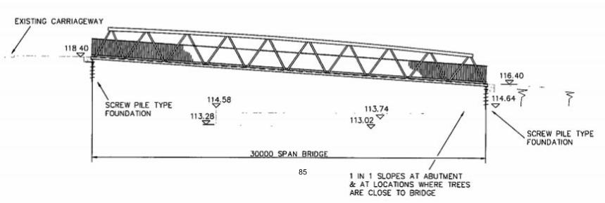
85
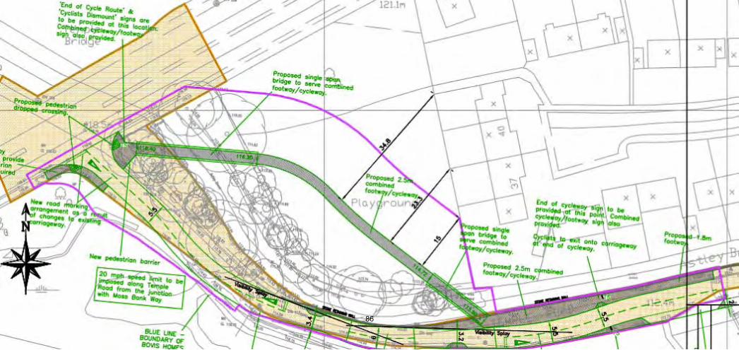
86

87
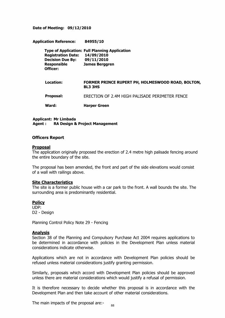
Date of Meeting: 09/12/2010
Application Reference: 84955/10
Type of Application: Full Planning ApplicationRegistration Date: 14/09/2010Decision Due By: 09/11/2010ResponsibleOfficer:
James Berggren
Location: FORMER PRINCE RUPERT PH, HOLMESWOOD ROAD, BOLTON,BL3 3HS
Proposal: ERECTION OF 2.4M HIGH PALISADE PERIMETER FENCE
Ward: Harper Green
Applicant: Mr LimbadaAgent : RA Design & Project Management
Officers Report
ProposalThe application originally proposed the erection of 2.4 metre high palisade fencing aroundthe entire boundary of the site.
The proposal has been amended, the front and part of the side elevations would consistof a wall with railings above.
Site CharacteristicsThe site is a former public house with a car park to the front. A wall bounds the site. Thesurrounding area is predominantly residential.
PolicyUDP:D2 - Design
Planning Control Policy Note 29 - Fencing
AnalysisSection 38 of the Planning and Compulsory Purchase Act 2004 requires applications tobe determined in accordance with policies in the Development Plan unless materialconsiderations indicate otherwise.
Applications which are not in accordance with Development Plan policies should berefused unless material considerations justify granting permission.
Similarly, proposals which accord with Development Plan policies should be approvedunless there are material considerations which would justify a refusal of permission.
It is therefore necessary to decide whether this proposal is in accordance with theDevelopment Plan and then take account of other material considerations.
The main impacts of the proposal are:-88
* impact on the character and appearance of the area
Impact on the character and appearance of the areaUDP Policy D2 requires new developments to be compatible with, or improve, theirsurroundings. PCPN29 contains guidance on the use of palisade fencing. It states that'this type of fencing has previously been used predominantly around industrial premisesand is of a utilitarian appearance'. 'At this height (2.4 metres), palisade fencing canproduce an intimidating appearance and introduce a fear of crime'.
The initial scheme proposed palisade fencing around the whole boundary of the site.Given that the character and appearance of the area is generally open, it was consideredthat the amount of palisade was unacceptable. It is acknowledged that the site hassuffered from vandalism and instances of anti social behaviour but it was considered thatthis did not outweigh the harm to the street scene. There are examples of palisadefencing in the area but not in such a prominent location.
Following negotiation with the applicant, it was agreed that the front boundary and partof the side boundary would consist of a wall with railings above. This design is consideredto be much more aesthetically pleasing and would not detrimentally affect the characterand appearance of the area. The remaining sections of the boundary would be palisadefencing. It is considered that the main views from the street scene would not be affectedto a degree that would warrant refusal of the application, whilst also improving security atthe site.
ConclusionThe amended proposal is considered to be acceptable and in accordance with Councilpolicy and guidance. The application is therefore recommended for approval.
89

Representation and Consultation Annex
RepresentationsLetters:- None received
Elected Members:- Councillor Clare has requested that the application go beforeCommittee with an advanced site visit.
ConsultationsAdvice was sought from the following consultees; Highways
Planning HistoryNone relevant to this application.
90
Recommendation: Approve subject to conditions
Recommended Conditions and/or Reasons
1. The development hereby permitted shall be begun before the expiration of 3 years from the date ofthis permission.
Reason
Required to be imposed pursuant to section 91 of the Town and Country Planning Act 1990 asamended by Section 51 of the Planning and Compulsory Purchase Act 2004.
2. The fencing hereby approved/permitted shall be painted/powdercoated green and shall be retainedso coloured thereafter.
Reason
To safeguard the visual appearance of the area.
1. The Council has granted planning permission, subject to the conditions listed above, because theproposed development is in accordance with all relevant policies of the Development Plan (the UDPand the Regional Spatial Strategy Plan for the North-West), as is required by Section 38 of thePlanning and Compulsory Purchase Act 2004. There are no material considerations, as specified inthe Planning Officer Report, that outweigh this justification to support the grant of planningpermission. A summary of the relevant Development Plan policies pursuant to Article 22 of the Townand Country Planning (General Development Procedure) (England) (Amendment) Order 2003 andhow the proposed development relates to these policies is set out below.
Unitary Development Plan
D1 and D2 as the application displays good urban design which would preserve local distinctiveness.
91
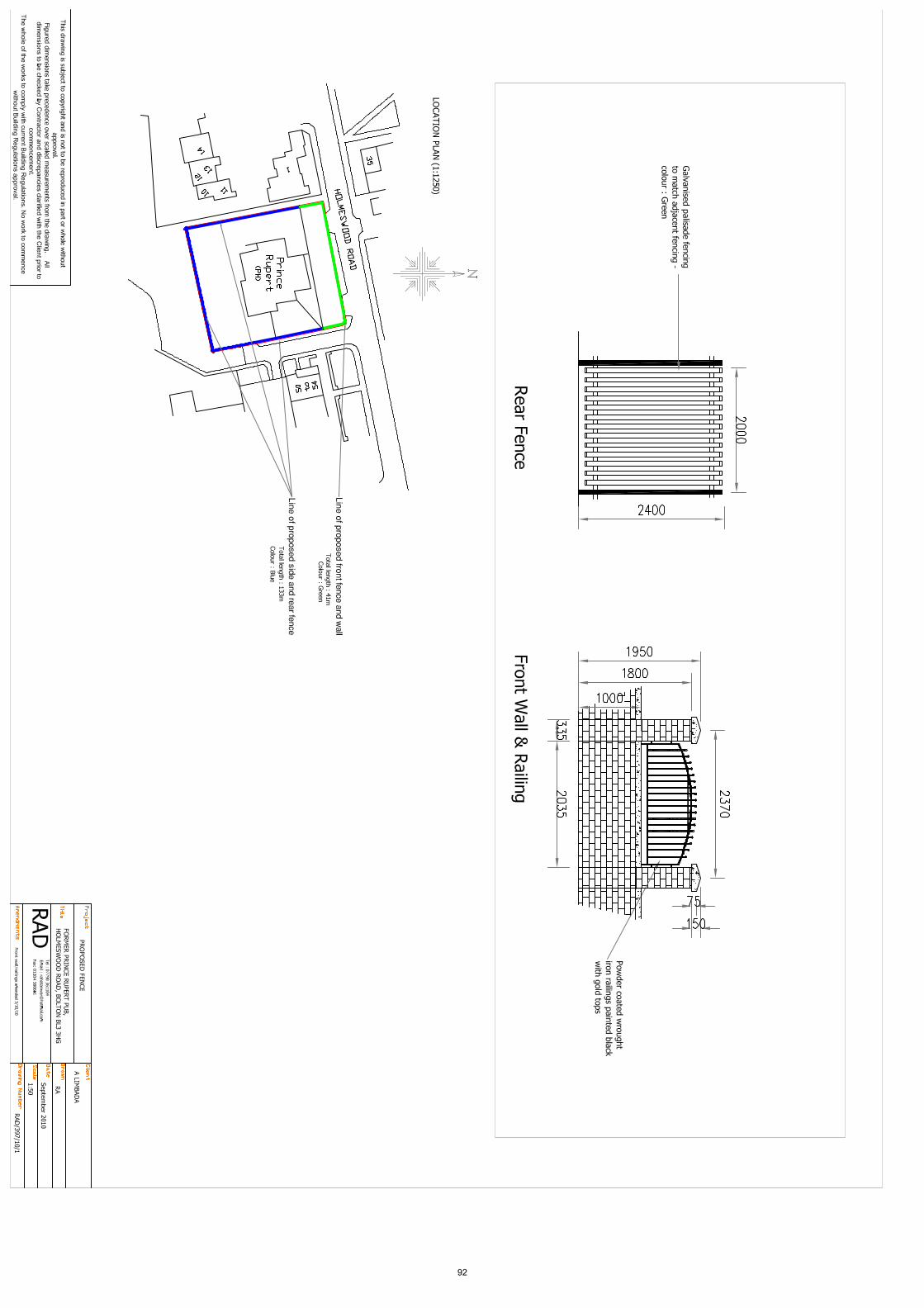
92
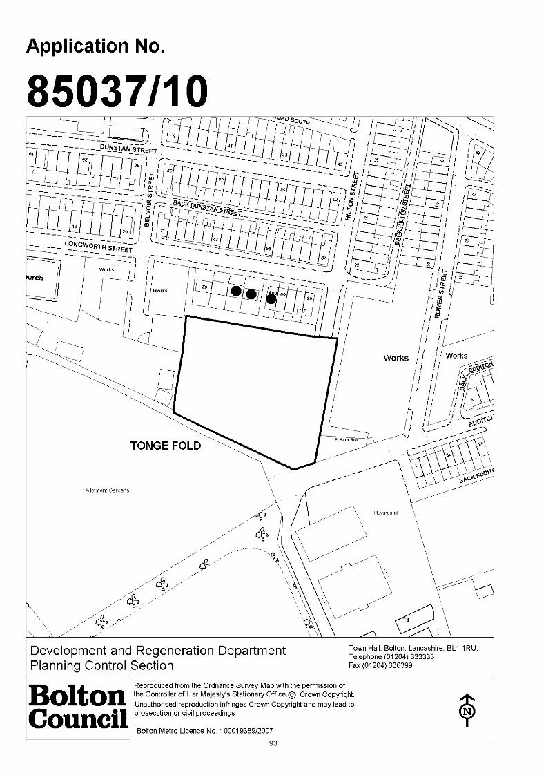
93
Date of Meeting: 09/12/2010
Application Reference: 85037/10
Type of Application: Outline Planning PermissionRegistration Date: 05/10/2010Decision Due By: 04/01/2011ResponsibleOfficer:
Jodie Turton
Location: TONGE FOLD HEALTH CENTRE, HILTON STREET, BOLTON, BL26DY
Proposal: ERECTION OF 18 HOUSES FOLLOWING DEMOLITION OFHEALTH CENTRE (OUTLINE APPLICATION, ALL MATTERSRESERVED)
Ward: Tonge with the Haulgh
Applicant: Dr Faulkner & PartnersAgent : David Young Architect
Officers Report
ProposalThis is an outline application for the erection of 18 houses (all matters reserved).
The proposal is for the demolition of the existing health centre building and itsreplacement by 18, 4-bedroom, two and a half storey houses. The indicative plans showthat each of the houses will have a front garden, incorporating one off street parkingspace and a private garden to the rear.
Six separate visitor parking spaces are also proposed to increase parking provision on thesite.
Site CharacteristicsThe site currently accommodates Tonge Health Centre, which is a large single storeypurpose built building, with car parking to the north east and west.
The site is within a mixed use area, with industrial units to the eastern boundary of thesite and to the north west, to the north are residential properties and to the south is achildren's playground and allotments.
Despite the mixed use nature of the immediate area, the wider local area ispredominantly residential.
Two public footpaths bound the site to the east and south.
Access to the site is from Hilton Street to the north east corner.
PolicyPPS1 Sustainable Development and Climate Change; PPS3 Housing.
Regional Spatial Strategy for the North West (RSS13): DP1 Spatial Strategies; DP294

Promote Sustainable Communities; DP7 Promote Environmental Quality.
UDP policies: D1 and D2 Design; N7 and N8 Trees; EM2 and EM3 Incompatible Uses; A5Highway Considerations; A6 and Appendix 7 Car Parking Standards; H3 Housing; H4Affordable Housing.
PCPN2 Space Around DwellingsPCPN7 Trees: Protection and Planting in New DevelopmentPCPN10 Planning Out CrimePCPN21 Highway ConsiderationsPCPN27 Housing Development
AnalysisSection 38 of the Planning and Compulsory Purchase Act 2004 requires applications tobe determined in accordance with policies in the Development Plan unless materialconsiderations indicate otherwise.
Applications which are not in accordance with Development Plan policies should berefused unless material considerations justify granting permission.
Similarly, proposals which accord with Development Plan policies should be approvedunless there are material considerations which would justify a refusal of permission.
It is therefore necessary to decide whether this proposal is in accordance with theDevelopment Plan and then take account of other material considerations.
The main impacts of the proposal are:-
* impact on urban regeneration* impact on the design and character of the area* impact on residential amenity* impact on trees* impact on the highway and public rights of way
Impact on Urban RegenerationThe objectives of PPS3 are to: deliver high quality housing that is well designed and builtto a high standard; a mix of housing types, both market and affordable; sufficientquantity of housing and in suitable locations, which offer a good range of communityfacilities and access to jobs and services; and the effective and efficient use of previouslydeveloped land. In addition, there is a focus on delivering sustainable developmentobjectives.
PPS3 encourages the use of suitable locations for housing development, which should beachieved by making effective use of land, giving priority to the use of previouslydeveloped land. Sustainable development objectives are a requirement in consideringhousing applications, to ensure that sites are in sustainable locations, with good access topublic transport, community facilities and access to jobs and services. PPS1 providesguidance on sustainable development objectives.
The application site is within an existing predominantly residential area, with close links tolocal shops and services, on nearby Tonge Old Road and Bradford Road, as well as closeto good public transport links. The site is previously developed and is considered to be asustainable location which will contribute to the sustainable development of the borough,and thus complies with the policy requirements of PPS1, PPS3 and UDP policy H3.
Impact on the Design and Character of the AreaUDP policies D1 and D2 seek to ensure that development proposals contribute to good95
urban design. Proposals should be compatible with, or improve, their surroundings, interms of their layout, density, height, massing, architectural style, materials andlandscaping; as well as, creating a safe and secure environment.
The proposed houses are two and a half storey town houses, which will be set around acul-de-sac. The outline application is all matters reserved, therefore no detailed designhas been shown at this stage. From the information provided however, it is consideredthat the setting and indicative layout of the scheme show a proposal that will becompatible with the surrounding area, which is characterised by traditional terracehouses, and dependent on the finer design details at the reserved matters stage ascheme which is both compatible with and in fact has the potential to enhance the localityis proposed. The proposal thereby complies with UDP policies D1 and D2.
Impact on Residential AmenityPCPN2 provides guidance on space around dwellings, it outlines the appropriate interfacedistances between residential dwellings to ensure that any impact on residential amenityand privacy is minimised. Guidance is also provided on garden and private amenityspace, stating that private garden space should normally be to the rear of the dwellingand each rear garden should be 65 sq metres.
The indicative plans show that the interface distances between the proposed dwellingsare in line with the requirements of PCPN2, with a minimum distance of 21 metresbetween the fronts of the proposed dwellings. To the north of the site are the rear of theterraced houses on Longworth Street. The plans show a distance of 17.4 metres betweenthe rear of the existing properties and the side elevation of the closest proposed house.The proposal meets the policy requirements of PCPN2 on the basis that there are noprincipal windows in the side elevation of the proposed house.
To the east and north west of the site are industrial units. The large unit to the east hasno windows in the side elevation and is a distance of 18.5 metres from the rear of theproposed houses. The distance complies with interface distances set out in PCPN2.Given the predominantly residential nature of the area, the industrial units already existwithin a largely residential environment. The relationship between the industrial unitsand the proposed houses is no greater than the existing relationship between industrialand residential and therefore the proposal is not considered to present an unacceptableimpact as detailed in UDP policies EM2 and EM3.
The rear gardens of the proposed dwellings are a minimum size of 55 square metres,which although below the 65 sq m recommendation detailed in PCPN2, it is consideredthat for the area the gardens are above average size, provide a useable amenity space,and taking into account the close proximity of the children's play area, the amenity spaceis considered to be sufficient.
The proposal complies with the policy guidance contained in PCPN2.
Impact on TreesUDP policies N7 and N8 recognise the importance and amenity value of trees and seek toprotect them in new development. PCPN7 supports this policy aim.
There are a number of mature trees on the site, clustered along the eastern, northwestern and western boundaries. A majority of trees on the site are to be retained. Theproposed scheme identifies two trees for removal, which the Council's Tree and WoodlandOfficers (CTWO) consider to be acceptable. The CTWO also recommends that a furthertree should be removed a suitable replacement tree planted as the tree has beenvandalised and is not therefore worthy of retention.
The proposal also incorporates a number of additional trees, which will form part of the96
landscape scheme at the reserved matters stage.
The proposal complies with UDP policies N7 and N8.
Impact on the Highway and Public Rights of WayUDP policy A5 states that development proposals should not adversely affect the safety ofhighway users, including pedestrians, as well as the safe and efficient circulation ofvehicles, this policy aim is supported by PCPN21. UDP policy A6 and Appendix 7 providesguidance on parking standards.
The plans indicate that the site can accommodate one parking space per dwelling, inaddition to six visitor parking spaces. Highway Engineers have made a number of minorrecommendations to improve the width of carriageways and pedestrian circulation, whichcan easily be accommodated within the site and can be dealt with via condition or at thereserved matters stage. Highway Engineers also recommend two spaces per dwelling.However, given the proximity of the site to good public transport links and easy access tothe town centre one space per dwelling is considered acceptable.
The site is bound by public footpaths to the east and south. The application proposal willnot impact upon the line of or access to the footpaths. However, the fencing to the rearof gardens will enclose the footpath to the east of the site. A condition will be placed onthe planning permission to ensure that the footpath is lit to retain the perception ofopenness and safety.
The proposal is considered to comply with UDP policies A5 and A6, as well as PCPN21.
Value Added to the Development
ConclusionThe outline proposal is considered to offer a positive development potential for the site.The plans indicate that 18 houses can be easily accommodated on the site, leavingsufficient interface distances between proposed and existing houses, as well as sufficientinterface distances to adjacent industrial units. The scheme incorporates the retention oftrees on the site and thus complies with UDP policies N7 and N8. Adequate parking andaccess is proposed in line with the requirements of UDP policies A5 and A6. Overall, theproposal is considered to comply with policy and is therefore recommended for approval.
97
Representation and Consultation Annex
RepresentationsLetters:- Three letters of objection have been received from 56, 58, 60a LongworthStreet, raising the following concerns:
Impact on privacy;Traffic congestion;Noise from future residents;Loss of parking for Leverhulme Park, which will result in more parking congestion;Four bedroom houses will produce more cars and therefore more impact in terms ofparking congestion.
Other issues raised which are not material planning considerations are that due to thecurrent economy the properties are likely to be slow to sell and may therefore be rentedor vacant, which would be detrimental to the area.
ConsultationsAdvice was sought from the following consultees: BMBC Highway Engineers, Tree andWoodland Officers, Public Rights of Way Team, Pollution Control; Greater Manchester Fireand Rescue; Peak and Northern Footpath Society; Ramblers Association; The OpenSpaces Society; United Utilities.
Planning HistoryPlanning permission was approved for 2.4 metre high fencing in December 2002(63264/02)
Recommendation: Approve subject to conditions
Recommended Conditions and/or Reasons
1. Application for the approval of Reserved Matters must be made not later than the expiration of threeyears beginning with the date of this permission and the development must be begun not later thanthe expiration of two years from the final approval of the reserved matters or, in the case of approvalon different dates, the final approval of the last such matter to be approved.
Reason
Required to be imposed pursuant to section 92 of the Town and Country Planning Act 1990 asamended by Section 51 of the Planning and Compulsory Purchase Act 2004.
2. Approval of the following details (hereinafter referred to as "The Reserved Matters") shall be obtainedfrom the Local Planning Authority in writing before any development commences:-
LayoutThe way in which buildings, routes and open spaces within the development are provided, situatedand orientated in relation to each other and to buildings and spaces outside the development;
ScaleThe height, width and length of each building proposed in relation to its surroundings;
AppearanceThe aspects of a building or place within the development which determine the visual impression itmakes, including the external built form of the development, its architecture, materials, decoration,lighting, colour and texture;
AccessThis covers accessibility to and within the site for vehicles, cycles and pedestrians in terms of thepositioning and treatment of access and circulation routes and how these fit into the surroundingaccess network; and
Landscaping 98
The treatment of land (other than buildings) for the purpose of enhancing or protecting the amenitiesof the site and the area in which it is situated and includes screening by fences, walls or other means,the planting of trees, hedges, shrubs or grass, the formation of banks, terraces or other earthworks,the laying out or provision of gardens, courts or squares, water features, sculpture, or public art, andthe provision of other amenity features.
Reason
The application is for outline planning permission and these matters were reserved by the applicantfor subsequent approval.
3. Pursuant to the details in condition 2, in respect of highway details, the submitted information shallinclude:
1) The existing health centre access road is private from the junction with Longworth Street and willneed to be improved to adoptable standards (construction, drainage, street lighting, etc).
2) The proposed carriageway width should be reduced to 5.5 m. A 2 m wide footway is requiredaround both sides of the access road, including the turning heads and at the rear of number 66Longworth Street. The terminal turning head should be 5.5 m wide. Visitor parking must be set backbehind the back of footway.
3) Vehicle driveways must be 6 m long.
4) Public footpath 263 runs to the South of the proposed site and should be improved to adoptionstandards.
4. Upon the submission of the reserved matters application details of the provision for affordablehousing should be submitted to the Local Planning Authority, in line with the requirements of UDPpolicy H4 of Bolton's Unitary Development Plan and Bolton Council's Affordable Housing PlanningGuidance Note.
Reason
For the avoidance of doubt.
5. Phase I ReportNo development shall commence unless or until a Phase I Report (Preliminary Risk Assessment) toassess the actual and/or potential contamination risks at the site has been submitted to, andapproved in writing by, the Local Planning Authority. The Report shall include a desk top study, sitewalk over, conceptual model, basic hazard assessment and recommendation regarding the need orotherwise for a Phase II Report.
Phase II ReportShould the Phase I Report recommend that a Phase II Report is required, then prior tocommencement of any site investigation works, design of the Phase II site investigation shall besubmitted to, and approved in writing by, the Local Planning Authority. Site investigations shall becarried out in accordance with the approved design and a Phase II Report shall then be submitted to,and approved in writing by, the Local Planning Authority prior to commencement of development.The Phase II Report shall include the site investigation data, generic quantitative risk assessment,detailed quantitative risk assessment (if required) and recommendations regarding the need orotherwise for remediation.
Should the Phase I Report recommend that a Phase II Report is not required, but during constructionand prior to completion of the development hereby approved, contamination or gas migration isfound or suspected, the developer shall contact the Local Planning Authority immediately and submitproposals for investigation and remediation of the contamination or gas migration within seven daysfrom the date that it is found or suspected to the Local Planning Authority for approval in writing.
Options AppraisalShould the Phase II Report recommend that remediation of the site is required then unless otherwiseagreed in writing with the Local Planning Authority, no development shall commence unless or untilan Options Appraisal has been submitted to, and approved in writing by, the Local PlanningAuthority. The Options Appraisal shall include identification of feasible remediation options,evaluation of options and identification of an appropriate Remediation Strategy.
Implementation of Remediation Strategy
No development shall commence, unless otherwise agreed in writing with the Local PlanningAuthority, until the following information relating to the approved Remediation Strategy has been
99

submitted and approved by the Local Planning Authority:
i) Detailed remediation design, drawings and specification;
ii) Phasing and timescales of remediation;
iii) Verification Plan which should include sampling and testing criteria, and other records to beretained that will demonstrate that remediation objectives will be met; and
iv) Monitoring and Maintenance Plan (if appropriate). This should include a protocol for long termmonitoring, and response mechanisms in the event of non compliant monitoring results.
The approved Remediation Strategy shall be fully implemented in accordance with the approvedphasing and timescales and the following reports shall then be submitted to the Local PlanningAuthority for approval in writing:
v) A Verification Report which should include a record of all remediation activities, and datacollected to demonstrate that the remediation objectives have been met; and
vi) A Monitoring and Maintenance Report (if appropriate). This should include monitoring data andreports, and maintenance records and reports to demonstrate that long term monitoring andmaintenance objectives have been met.
Reason
To ensure that the development is safe for use.
100

373200
409200
Works
6658
TONGE FOLD
52 60a
Works
60
El Sub Sta
62 6454 56
living/dining
wc
kitchen
hall
line of formerheath centredashed line
footpath maintained
side garden
visitor parking
new trees
new treesnew trees
new trees
new trees
new trees
visitor parking
T1
T3
T4
T5
T6
T7
T8
T9 (defective)to be removed
T10 to be replaced
T11
T12
T13
living/dining
wc
kitchen
hall
T2
living/dining
wc
kitchen
hall
15m radius
footpath
carriageway
footpath
side garden
side garden
living/dining
wc
kitchen
hall
living/dining
wc
kitchen
hall
living/dining
wc
kitchen
hall
living/dining
wc
kitchen
hall
living/dining
wc
kitchen
hall
living/dining
wc
kitchen
hall
parking planting
access to rear gardens gate
living/dining
wc
kitchen
hall
living/dining
wc
kitchen
hall
living/dining
wc
kitchen
hall
living/dining
wc
kitchen
hall
living/dining
wc
kitchen
hall
living/dining
wc
kitchen
hall
landscape
refuse &recycling bins
cycle storage /garden sheds
living/dining
wc
kitchen
hall
living/dining
wc
kitchen
hall
living/dining
wc
kitchen
hall
13500 10340 5700 2000 5600 2000 5700
10340
13500
21000
rear (& side) gardens55m2 minimum
60002000 40000
37 TEMPLE DRIVE : SWINTON : MANCHESTER : M27 4EATEL 0161 793 0737 MOBILE 07774 181 336
D A V I D Y O U N G A R C H I T E C T PROPOSED SITE PLAN DWG : 01revA
REV A: Nov 2010 - Trees T1 and T2 retained
1 : 200 SCALE @ A2 size HILTON STREET BOLTON BL2 6DY
side garden
new trees
101

102

Date of Meeting: 09/12/2010
Application Reference: 85039/10
Type of Application: Full Planning ApplicationRegistration Date: 29/09/2010Decision Due By: 24/11/2010ResponsibleOfficer:
James Berggren
Location: HARDY MILL PRIMARY SCHOOL, BELMONT VIEW, BOLTON,BL2 3QJ
Proposal: ERECTION OF SINGLE STOREY EXTENSIONS AND GAMESCOURT TOGETHER WITH FORMATION OF NEW VEHICULARAND PEDESTRIAN ACCESS FROM HARDY MILL ROAD
Ward: Bradshaw
Applicant: Bolton MBCAgent : Bradshaw Gass & Hope
Officers Report
ProposalIn order to respond to the increasing demand for primary school places, resultingprincipally from the rising birth rate in certain areas of Bolton, Bolton Council hasidentified a number of schools that are capable of expansion. The schools identified forexpansion reflect areas where demand is at its greatest and also schools where annualapplications for pupil places regularly exceed the current number of spaces available.Hardy Mill Primary School is one school identified for expansion. The school is a one formentry school with 30 places per academic year plus a 26 place nursery.
The application proposes the erection of single storey extensions together with newvehicular and pedestrian access from Hardy Mill Road. A drop off facility is provided offHardy Mill Road with vehicular access from Hardy Mill Road being for short term parkingfor the picking up and dropping off of children. For vehicles that require to be able topark in close proximity to the building, such as the emergency services and deliveryvehicle, the site entrance from Belmont View would be used and access gained via therear service door. The access from Belmont View would otherwise only be available as astaff access.
In response to the increase in pupils, the scheme proposes external works within theschool grounds and the new main entrance off Hardy Mill Road including:
The formation of a 4 metre wide pedestrian path from the road to the school mainentrance door. This rises in a series of ramps.A 45 metre by 27 metre games area, surfaced in tarmac and marked out for teamgames. This will also be used as a pick up and drop off area, which would be used forshort term parking at the beginning and end of the school day. During school time thearea would be used as a games facility for pupils. The tarmaced area will be markedout with 42 car parking bay markings which would be slightly larger than the standard4.8m x 2.4m bays, at 4.8m x 2.75m.The current playground will be extended to the north.The staff car park will be reconfigured to allow a greater number of bays.
103

Site CharacteristicsThe school site comprises approx 1.5 hectares of playing field with the school buildinglocated in the south east corner. The site is bounded to the north by Hardy Mill Road andon the other three sides by residential development. Access, both vehicular andpedestrian is currently situated on Belmont View to the south, a residential housing area.The main entrance to the school is located on the Belmont View elevation.
PolicyRSS (2008) DP1 Spatial Principles, DP2 Promote Sustainable Communities, DP4 Best Useof Existing Resources and Infrastructure, DP5 Manage Travel Demand, DP7 PromoteEnvironmental Quality, L1 Health, Sport, Recreation, Cultural and Education ServicesProvision, RT9 Walking and cycling, EM1 (A) Landscape and EM1 (D) Trees, Woodlandsand Forests.
UDP (2005): N7 Trees,Woodland and Hedgerows, EM3 Pollution, EM4 ContaminatedLand, D1/D2 Design, D3 Landscaping, O3 Protection of Education Recreation Facilities, A5Roads, paths, servicing and car parking, A6 Maximum Car Parking Standards, A16Pedestrians, A17 Cyclists, CP1 Community Facilities and CP3 Expansion of EducationFacilities.
Planning Control Policy Notes:- No. 7 Trees: Protection and Planting in NewDevelopments, No. 10 Planning Out Crime and No. 21 Highways Considerations.
AnalysisSection 38 of the Planning and Compulsory Purchase Act 2004 requires applications tobe determined in accordance with policies in the Development Plan unless materialconsiderations indicate otherwise.
Applications which are not in accordance with Development Plan policies should berefused unless material considerations justify granting permission.
Similarly, proposals which accord with Development Plan policies should be approvedunless there are material considerations which would justify a refusal of permission.
It is therefore necessary to decide whether this proposal is in accordance with theDevelopment Plan and then take account of other material considerations.
The main impacts of the proposal are:-
* impact on the character and appearance of the area* impact on residential amenity* impact on school provision* impact on the highway
Impact on the Character and Appearance of the AreaUDP policies D1 and D2 seek to ensure that development proposals contribute to goodurban design and are compatible with, or improve, their surroundings in terms of layout,density, height, massing, architectural style, materials and landscaping. RSS policies DP1and DP7 require new development to promote environmental quality. Policy DP2 of theRSS aims to improve the built and natural environment and conserve the region'sheritage.
The design of the proposed extensions is considered to be acceptable as it mirrors that ofthe existing school in scale and overall appearance and therefore as such will not undulyimpact on the character or appearance of the site and its surroundings.
104
Impact on Residential AmenityThe Council's guidance on minimum interface distances between dwellings and privateamenity space standards are contained with PCPN2 "Space Around Dwellings".
PCPN2 states that for new single storey and two storey buildings a distance of not lessthat 21 metres shall be maintained between fronts of dwellings
The relevant interface distances between the site and the surrounding residentialproperties, for both extensions, are more than adequately met and on this basis it isconsidered that the proposed extensions would not unduly impact on the living conditionsof the surrounding properties.
Impact on School ProvisionPolicy CP3 of the UDP allows the expansion of education facilities in accessible locationswhich are well served by public transport.
The extensions are intended to facilitate an increase in pupil numbers at the school. Thesite has been identified by the Local Authority as a school capable of expansion and assuch the proposed extensions would cater for this increase. The extensions would provideadditional and much required space that would allow the school to meet the needs of itspupils and provide improved learning facilities for students. The site is well served bypublic transport and is close to a large residential catchment area. The applicant hassubmitted a school travel plan which aims to reduce the reliance on travel to and from theschool by car.
Impact on the HighwayPolicy A5 of the UDP requires new development to take into account provision for accessarrangements, road design, layout and construction. Development proposals should notadversely affect the safety of highways users.
Bolton Council's Highways and Engineering Delivery Services have assessed the proposalto form a main school entrance off Hardy Mill Road. Various issues have had to beaddressed to form a junction that will enable traffic to turn safely into the school site.Traffic speeds along Hardy Mill Road have been recorded as averaging 38 MPH in a30MPH zone. The proposal involves a variety of traffic calming measures along Hardy MillRoad, these consist of a widening of the existing footway outside of the school site and tothe front of number 92 Hardy Mill Road, provision of a hatched central reservation andpedestrian refuge. 'Keep Clear' zig zag lines will be marked out in front of the new schoolentrance, together with double yellow lines. The proposed double yellow lines will startjust before Patterdale Road and extend up to 92 Hardy Mill Road. On the opposite side ofthe road the proposed double yellow markings extend from opposite Patterdale Road upto 91 Hardy Mill Road.
The Council's Highways Engineer has commented that due to excessive vehicle speeds onHardy Mill Road, it would be beneficial for pupil safety to extend the traffic calmingscheme to Stich-Mi-Lane with mini-roundabouts introduced at Patterdale Road andStich-Mi-Lane. It is considered by Officers that the requirements for two mini roundaboutsare not warranted by virtue of the proposed traffic calming measures within theapplication proposal. The measures have been designed by Bolton Council's HighwaysDepartment and were considered appropriate for the development at the site to reducevehicle speeds on Hardy Mill Road and to improve highway safety. Planning Officersconsider the proposed traffic calming measures in the application are appropriate andthe addition of mini roundabouts to be unnecessary, given the highway improvementsproposed being considered acceptable.
Objections have been received, both from residents of Hardy Mill Road and Belmont View,and mainly concern the impact upon the highway and highway safety resulting from the105
development proposed. Residents of Belmont View have expressed concerns that shouldthe existing entrance, on Belmont View, not be closed, then the existing problems with onstreet parking will continue or will be exacerbated. The residents living near to theproposed entrance on Hardy Mill Road are generally concerned with the impact that thenew entrance will have on Hardy Mill Road in terms of vehicular movements and parentspicking up and dropping off children at the school. In order to alleviate these fears, thescheme proposes a new pick up and drop off facility, accessed from Hardy Mill Road. Thefacility will only be available at the beginning and end of the school day. It is intendedthat this will reduce the impact of parent parking prevent vehicles decanting on nearbyresidential side streets and also prevent parking on Hardy Mill Road.
The existing access from Belmont View will be closed to parents and pupils, it will only beused for staff parking and deliveries etc. The existing staff car park is also to be enlarged.It is considered that this will alleviate the existing problems faced by residents of BelmontView, in terms of parking during the morning and early afternoon hours of the school day.The new entrance from Hardy Mill Road will provide a 42 space, short term car park anda drop off and pick up facility that will serve to reduce any significant adverse impactupon the highway to a degree that would warrant refusal of the application. Theenlargement of the staff car park off Belmont View will serve to further alleviate parkingproblems on Belmont View. The staff parking area is constrained in terms of its size andthe proposed extension of the car park is considered to be acceptable.
ConclusionThe proposed extensions would provide for an expansion of the education facilitiesprovided at this School. As the proposed extensions complement the existing School, thekey issue is the provision of a drop off/pick up facility to ease congestion in and aroundthe school at drop off/pick up time. An integral part of the proposal would be to providea large drop off/pick up facility within the School grounds and proposed traffic calmingmeasures. This would assist in easing congestion on site, especially given that theexisting entrance on Belmont View is to be closed to pupils and would also serve toreduce vehicle speeds on Hardy Mill Road.
As a result it is considered that the proposal complies with policy and Members arerecommended to grant permission subject to conditions.
106

Representation and Consultation Annex
RepresentationsLetters:- 43 letters of objection and 3 letters of support were received from residents ofBelmont View, Heathfield, Patterdale Road and Hardy Mill Road.
Grounds of objection:Proposal will exacerbate parking problems on Belmont View.Hardy Mill is very dangerous and an entrance off this road will make existing problemsworse.Average speed of vehicles on Hardy Mill Road is in excess of 39 MPH.Adverse impact on highway safety.Parking restrictions will not work.The footway, in parts, on Hardy Mill Road is very narrow.The current access from Belmont View should remain open.Noise and light pollution to rear of properties on Patterdale Road resulting from theschool buildings and car headlights.Problems with teacher parking on Belmont View should be addressed further.The access from Belmont View should not be open to nursery pupils.Pollution from car engines being left running.Parking restrictions should be imposed on Belmont View, Heathfield, Patterdale Roadand Meadow Lane. (Parking restrictions in the form of double yellow lines have beenproposed in locations that are considered appropriate to ensure highway safety,within the proposal).The expense of the project cannot be justified in the current economic climate. (Not amaterial planning consideration).The play area/drop off area would be hazardous to children playing if cars leavedebris behind e.g. oil etc. (The health and safety of the site is a matter for the schoolto manage effectively).Accidents along Hardy Mill Road have never been recorded.The 42 space car park is not sufficient and would not even meet current need.
Petitions:- 3 petitions of objection and 1 petition of support were received.
One petition (objection) is a generic letter (5 letters) from residents of Bryngs Drive.One petition (objection) contains 21 signatures with the lead address from Hardy MillRoad.One petition (objection) contains 202 signatures with the lead address being from HardyMill Road.
The petition of support contains 121 signatures, predominantly from Heathfield andBelmont View.
ConsultationsAdvice was sought from the following consultees: Highways, Environmental Health, BMBCSchool Travel Adviser, GMP Architectural Liaison Unit and BMBC Sustainable DevelopmentTeam.
Planning History84061/10 - Erection of single storey covered play area with balustrades and infilling partof courtyard to form store room. Approved with conditions.74026/06 - Erection of extensions within courtyard to form additional teaching areas,offices and stock room. Approved with conditions.42214/92 - Erection of single storey infants classroom extension. Approved withconditions.
Recommendation: Approve subject to conditions107

Recommended Conditions and/or Reasons
1. The development hereby permitted shall be begun before the expiration of 3 years from the date ofthis permission.
Reason
Required to be imposed pursuant to section 91 of the Town and Country Planning Act 1990 asamended by Section 51 of the Planning and Compulsory Purchase Act 2004.
2. No development shall be commenced until samples of the facing materials to be used for the externalwalls and roof(s) have been submitted to and approved in writing by the Local Planning Authority.
Reason
To ensure the development either fits in visually with the existing building and safeguards thecharacter and visual appearance of the locality or ensures the development safeguards the characterand visual appearance of the locality.
3. Trees and shrubs shall be planted on the site in accordance with a landscape scheme to be submittedto and approved by the Local Planning Authority before development is started. Such scheme shallbe carried out within 6 months of the occupation of any of the buildings or the completion of the newdevelopment, whichever is the sooner, or in accordance with phasing details included as part of thescheme and subsequently approved by the Local Planning Authority; any trees and shrubs that die orare removed within five years of planting shall be replaced in the next planting season with others ofsimilar size and species.
Reason
To soften the development proposed and to enhance and improve the setting of the developmentwithin the landscape of the surrounding locality.
4. No development shall be commenced unless and until full details of the highway works at Hardy MillRoad comprising traffic calming measures, waiting restrictions and a footway in front of 92 Hardy MillRoad have been submitted to and approved by the Local Planning Authority, and none of thedevelopment shall be brought into use until such details as approved are implemented in full. Suchworks to be retained thereafter.
Reason
In the interests of highway safety.
5. Before development commences details of all external lighting equipment shall be submitted to andapproved by the Local Planning Authority. The lighting in the scheme should be erected, directed andshielded so as to avoid nuisance to residential accommodation in close proximity. The lighting shouldbe designed to provide a standard maintained illumination (LUX) as measured at the nearestresidential properties affected, of 5 LUX. No other lighting equipment may then be used within thedevelopment other than as approved by the Local Planning Authority.
Reason
To safeguard the amenity and character of the area and to safeguard the living conditions of nearbyresidents.
6. Prior to first use of the extensions hereby approved the proposed drop off/pick up facility shall beconstructed and available for use. The drop off/pick up facility shall be used by parents during themorning drop off period and afternoon pick up period in accordance with a management plan whichshall be submitted to and approved in writing by the Local Planning Authority prior to commencementof development. The approved management plan shall be implemented in full in accordance with theapproved details.
ReasonIn the interests of highway safety.
7. Before development commences details of the provision to be made for cycle parking within the siteshall be submitted to and approved by the Local Planning Authority. Such details as are approved
108
shall be implemented in full before the development hereby approved is first brought into use andretained thereafter.
Reason
To encourage cycle use and provide adequate facilities for cyclists.
8. No development shall be commenced unless and until an application has been made to the LocalHighway Authority forthe implementation of a Traffic Regulation Order at Hardy Mill Road. The scheme as agreed shall beimplemented in full prior to first use of the development hereby approved and retained thereafter.
Reason
In the interests of highway safety.
9. No development shall be commenced until full details of existing and proposed ground levels withinthe site and on land adjoining the site by means of spot heights and cross-sections; proposed sitingand finished floor levels of all buildings and structures, have been submitted to and approved by theLocal Planning Authority. The development shall then be implemented in accordance with theapproved level details.
Reason
To ensure the development safeguards the character and visual appearance of the locality and tosafeguard the living conditions of nearby residents particularly with regard to privacy and outlook.
109
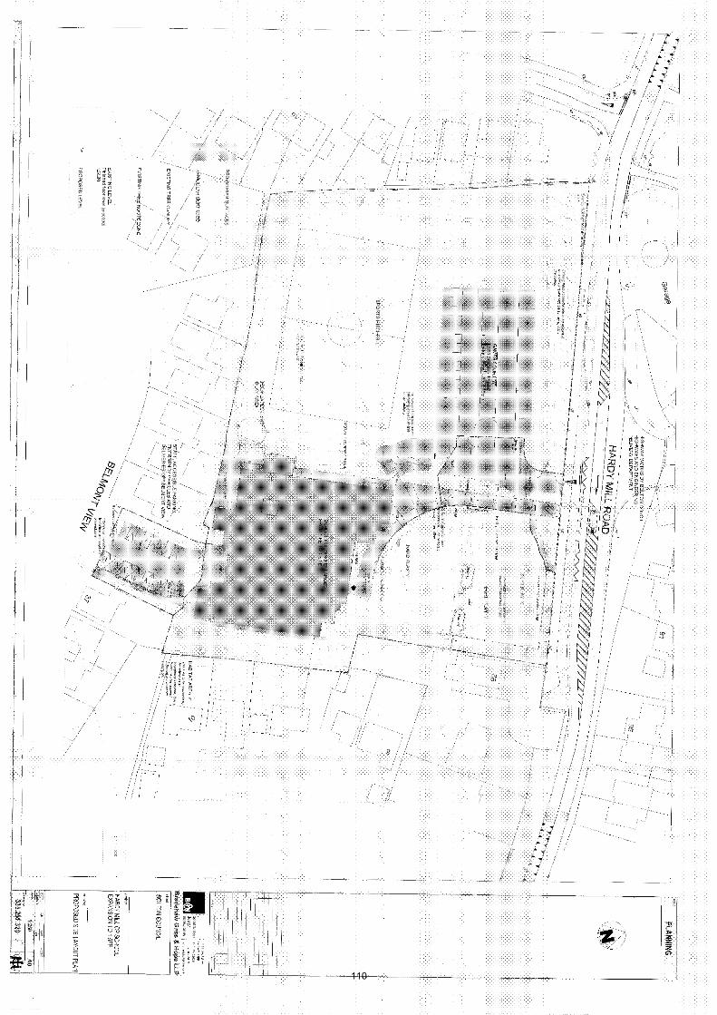
110
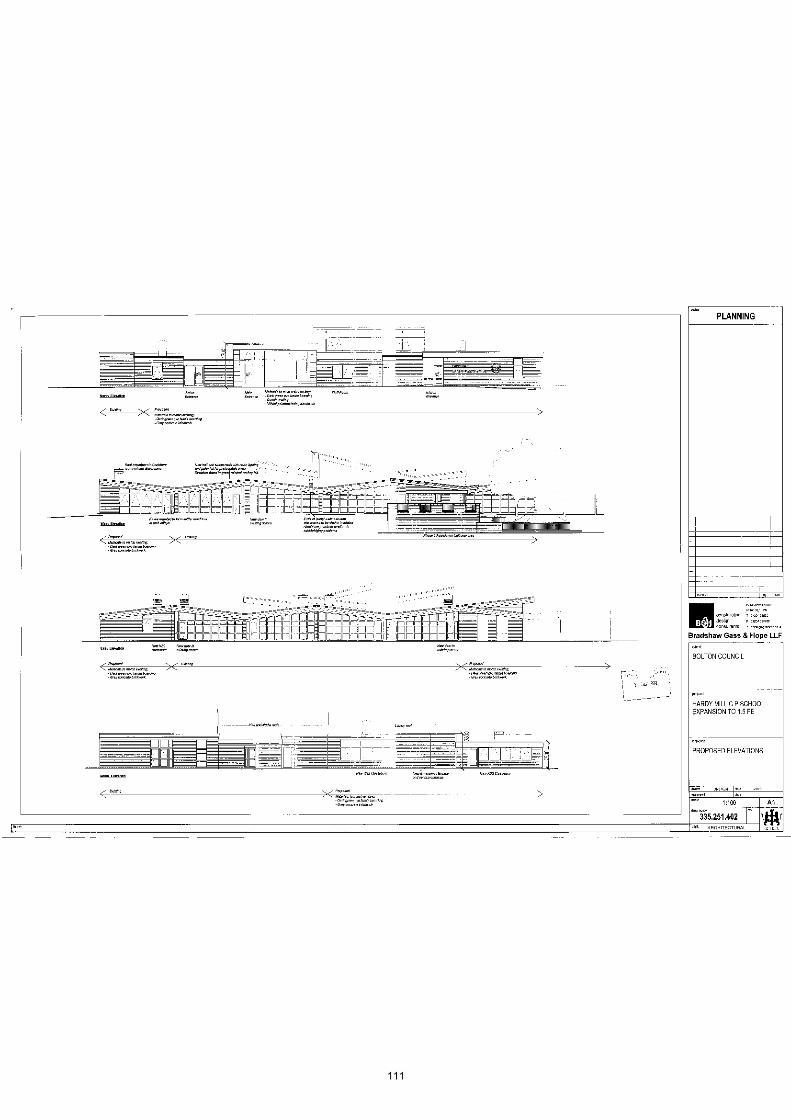
111

112

113

114
Date of Meeting: 09/12/2010
Application Reference: 85096/10
Type of Application: Full Planning ApplicationRegistration Date: 12/10/2010Decision Due By: 07/12/2010ResponsibleOfficer:
Jodie Turton
Location: LAND AT THE JUNCTION OF MANCHESTER ROAD ANDRUTHERFORD DRIVE, BOLTON.
Proposal: CHANGE OF USE OF LAND TO FORM CAR SALES AREATOGETHER WITH SITING OF PORTABLE BUILDING TO BEUSED AS SALES OFFICE AND ERECTION OF DOUBLE GARAGETO BE USED FOR VALETING. INSTALLATION OF 1.8 METREHIGH PALADIN FENCING TO BOUNDARIES ADJOININGMANCHESTER ROAD AND RUTHERFORD DRIVE
Ward: Hulton
Applicant: KCB Car Sales LtdAgent : Whitehead & Company
Officers Report
ProposalThe application proposes the change of use of a vacant piece of land to a site for carsales. The application includes the erection of a portacabin in the centre of the site foruse as a sales office and also the erection of a garage for the valeting of vehicles in thesouth western corner of the site.
Access for pedestrians and vehicles will be from the existing access of Rutherford Drive.
A visitor parking area is proposed to the rear of the site, along the southern boundary,providing six parking spaces. Two staff parking spaces are proposed sited on either sideof the portacabin. The remainder of the site will be for the parking of cars for sale, whichwill be sited around the remainder of the site perimeter as well as in the central area.
Site CharacteristicsThe site is currently vacant, however was previously in use as a garage (Rutherford'sGarage) and Bolt Works (Industrial Use). The site was cleared some time ago in order toimplement a now expired residential scheme for 15 apartments (76055/06), and there isno evidence of the previous uses on the site. A recent appeal decision (September 2009)stated that due to the site clearance, with a view to redeveloping it for the residentialscheme, any lawful use of the site was abandoned, thereby leaving the land with nil use(APP/N4205/C/08/2105146).
The site occupies a prominent position on Manchester Road and it is in close proximity tothe Four Lane Ends junction with Newbrook Road, Salford Road and St Helens Road.
Although there are a number of small retail units, a public house at the Four Lane Endsjunction, as well as a garage close by on Newbrook Road, the remainder of the area is
115
entirely residential in nature. The application site is closely surrounded by residentialproperties.
PolicyRegional Spatial Strategy for the North West (RSS13): DP1 Spatial Strategies; DP2Promote Sustainable Communities; DP7 Promote Environmental Quality.
UDP policies: D1 and D2 Design; EM1 and EM2 Incompatible Uses; A5 HighwayConsiderations.
PCPN21 Highway Considerations
AnalysisSection 38 of the Planning and Compulsory Purchase Act 2004 requires applications tobe determined in accordance with policies in the Development Plan unless materialconsiderations indicate otherwise.
Applications which are not in accordance with Development Plan policies should berefused unless material considerations justify granting permission.
Similarly, proposals which accord with Development Plan policies should be approvedunless there are material considerations which would justify a refusal of permission.
It is therefore necessary to decide whether this proposal is in accordance with theDevelopment Plan and then take account of other material considerations.
The main impacts of the proposal are:-
* impact on urban regeneration and the character of the area* impact on residential amenity* impact on the highway
Impact on Urban Regeneration and the Character of the AreaUDP policies D1 and D2 seek to ensure that development proposals contribute to goodurban design. Proposals should be compatible with, or improve, their surroundings, interms of their layout, density, height, massing, architectural style, materials andlandscaping; as well as, creating a safe and secure environment.
The site has previously been subject of an enforcement appeal for the unauthorised useof the site for car sales and vehicle washing. The Inspector's decision notice inSeptember 2009 concluded that the use of the site for this purpose,
"is neither compatible with, nor improves, its surroundings, as required byUDP policy D2. Instead the current uses of the site cause material harm to thecharacter and appearance of the area, and I regard that harm as a clear-cutreason not to grant planning permission."
The Inspector also took the view that the portacabin type structure used as a sales office,as proposed in the application currently being considered was:
"conspicuous in the street scene ... This is a structure better suited to abuilding site or industrial area, and I consider it looks out-of-place in thispredominantly residential area."
There has been no change of circumstances from September 2009 when the appealdecision was issued. The surrounding area remains residential and although vacant, theuse of the site for car sales, surrounding by 1.8 metre high paladin fencing, with parked116
cars dominating the site and an unattractive and incongruous portacabin sited in thecentre of the site, would present a form of development neither compatible with, norimproving, its surroundings and would be detrimental to the urban regeneration of thearea, and is thus contrary to UDP policies D1 and D2.
Impact on Residential AmenityUDP policy EM2 states that the Council will not permit development that will result inunacceptable impacts on existing uses or likely future development by reason of noise,smell, safety, health, lighting, disturbance, traffic or other pollution.
The site is surrounded by residential properties to all sides. The gardens of 44 CornwallAvenue, 970 Manchester Road and 22 Rutherford Drive abut the site, and a block of flatsto the east on Rutherford Drive overlook the site. The proposed car valeting garage isproposed in the south eastern corner of the site abutting the gardens of 44 CornwallAvenue and 22 Rutherford Drive. The application submission does state that only handtools and manual labour will be utilised for valeting the cars and that no third party carswill be valeted on the site, however to have the washing and maneuvering of vehicles ona commercial scale in such close proximity to the boundary of these gardens wouldcertainly have a detrimental impact on residential amenity.
Furthermore, the noise, disturbance and impact on the outlook of the neighbouringresidents is considered to be contrary to UDP policies EM1 and EM2.
Impact on the HighwayUDP policy A5 states that development proposals should not adversely affect the safety ofhighway users, including pedestrians, as well as the safe and efficient circulation ofvehicles.
The Council's Highway Engineers consider the proposal acceptable from a highwayperspective. Minor amendments would be required to the access in order to alleviate anyhighway issues.
The proposal therefore complies with UDP policy A5.
ConclusionThe proposed use of the site for car sales is neither compatible with, nor improves, itssurroundings, and would cause material harm to the character and appearance of thearea and is thus contrary to UDP policies D1 and D2. Furthermore, the proposal wouldhave a detrimental impact on the outlook and living conditions of nearby residentialproperties and is therefore contrary to UDP policies EM1 and EM2. For these reasons, theproposal is therefore recommended for refusal.
117
Representation and Consultation Annex
RepresentationsLetters:- Three letters of objection have been received from: 11, 22 Rutherford Driveand 41 Cornwall Avenue, raising the following concerns:
Parking congestion;Traffic congestion;The proposal would be detrimental to the area;The land should be used for residential development;The proposed use has already been refused at appeal by the Planning Inspectorate;The site is not suitable for commercial development due to: extra road traffic, visitors,parking issues, privacy, noise and drainage.
Some concerns were also raised about a car wash, however for clarification, a car wash isnot proposed at the site.
One letter of support have been received from 12 Firs Road stating that the site iscurrently an eyesore and car sales is a natural continuation of the previous uses on thesite.
ConsultationsAdvice was sought from the following consultees: BMBC: Highway Engineers, PollutionControl Officers; GM Fire and Rescue.
Planning HistoryEnforcement Appeal was dismissed by the Inspectorate in September 2009 for theunauthorised use of the site for car sales and vehicle washing(APP/N4205/C/08/2105146).
Permission was granted for the demolition of the existing garage and bolt works, togetherwith the erection of 15 no. apartments (76055/06).
Outline permission was granted for residential development, all matters reserved(66354/03).
Recommendation: Refuse
Recommended Conditions and/or Reasons
1. The proposed development fails to contribute to good urban design, it is not compatible with, nordoes it improve, its surroundings, and thus would be detrimental to, and cause material harm to, thecharacter and appearance of the area and is thus contrary to Policies D1 and D2 of the UnitaryDevelopment Plan.
2. The proposed development represents the introduction of an incompatible use within apredominantly residential area which will lead to increased activity in and around the applicationpremises to the detriment of the living conditions of nearby residential properties, and is contrary toPolicies EM1 and EM2 of Bolton's Unitary Development Plan.
118

119
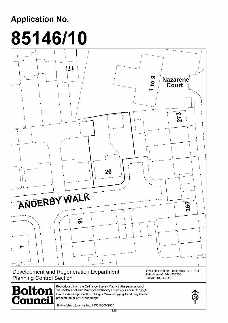
120

Date of Meeting: 09/12/2010
Application Reference: 85146/10
Type of Application: Full Planning ApplicationRegistration Date: 19/10/2010Decision Due By: 14/12/2010ResponsibleOfficer:
Andrew McGlone
Location: 20 ANDERBY WALK, WESTHOUGHTON, BOLTON, BL5 3BW
Proposal: ADDITIONAL USE OF PROPERTY TO OPERATE CHAUFFEURINGBUSINESS WITH TWO PRIVATE HIRE VEHICLES
Ward: Westhoughton North
Applicant: Miss Frances KingAgent :
Officers Report
ProposalPermission is sought to use the existing double berth garage as a base for two vehicles tooperate a chauffeuring business from the address.
The operation would be run by one person. Two vehicles would form the basis of thebusiness. Bookings would be taken by telephone or email, no customers would visit theproperty.
Site CharacteristicsNo. 20 is found in a modern residential complex off Church Street. Access is taken offWellington Street before opening out into a 't' shaped access road (Anderby Walk). Theapplication site is at the end of one of the cul de sacs. A detached double garage is setback from the detached dwelling, there is a shared access with the adjoining single berthgarage. Properties fronting onto Church Street back onto the side elevation/garages.There are no on street parking restrictions.
PolicyPPS4 Planning for Sustainable Economic Growth
RSS Policy RT2 Existing Highway Network
UDP Policies A5 Highway Safety; A6 Parking Provision; EM2 Incompatible Uses
AnalysisSection 38 of the Planning and Compulsory Purchase Act 2004 requires applications tobe determined in accordance with policies in the Development Plan unless materialconsiderations indicate otherwise.
Applications which are not in accordance with Development Plan policies should berefused unless material considerations justify granting permission.
Similarly, proposals which accord with Development Plan policies should be approved121

unless there are material considerations which would justify a refusal of permission.
It is therefore necessary to decide whether this proposal is in accordance with theDevelopment Plan and then take account of other material considerations.
The main impacts of the proposal are:-
* impact on Character of the Area* impact on Living Conditions of Neighbours* impact on Highway Safety and Parking Provision
Impact on Character of the AreaNo. 20 is set in a modern housing development which does not contain a commercialpremises. There are examples along Church Street, whilst industrial units are on JamesStreet.
The scale of the operation would mirror that of a person operating a private hire vehiclefrom their own home. There are many instances where this form of operation in theborough does not generate an adverse impact on the character of the local area. It isconsidered this would a similar case and is therefore acceptable.
Impact on Living Conditions of NeighboursThere are residents in close proximity to the application site. The business revolvesaround two vehicles which will pick clients up away from the site. Effectively bookings willbe taken at the property; this would not caused any undue disturbance to surroundingresidents. The two vehicles would use the garage/driveway space. The street is well usedby vehicles, so the noise/disturbance generated by two additional vehicles is notconsidered to be unacceptable.
Impact on Highway Safety and Parking ProvisionOff street provision is available for up to four vehicles, two in the garage and two on thedriveway. Policies A5 and A6 aim to ensure highway safety is maintained at all timesthrough providing suitable accesses and sufficient off street parking provision for thelocation.
It is the considered view of the Highway engineer that as with all new developmentsthere is insufficient off street parking and parking currently takes place in the access road.The property does not have adequate off street parking to accommodate two businessvehicles and the application should be refused.
The property benefits from a detached double garage and a driveway allowing for twovehicles to park in front of the garage. The driveway does extend further before reachingthe highway and could support vehicular parking, however this is angled and would notrepresent an ideal parking area. Nevertheless the property still benefits from four offstreet parking spaces including the garages. This would enable the applicant toaccommodate two business vehicles and two private vehicles on site. The standard iscompliant with policies A5 and A6
ConclusionThe application seeks to use the property as a base for a chauffeuring business. Oneperson shall operate the business with bookings being taken by telephone and email. Nocustomers shall be visiting the property. On this basis it is considered there would be alimited impact on the character and living conditions of Anderby Walk. Four off streetparking spaces are available; this is considered to be an appropriate provision. Membersare therefore recommended to approve the application with conditions.
122
Representation and Consultation Annex
RepresentationsLetters:- one objection letter has been submitted. The grounds for objection are:
we have concerns that this will add to the present traffic problems faced by us on adaily basis as we find neighbouring residents park on Anderby Walk and WellingtonStreet;also many train users park on the road instead of using perfectly adequate parkingprovision at the station;if we were subject to more vehicles it would become unbearable and I remainsurprised there have been no major traffic accident to date;if the application is successful can we at least have some double yellow lines inportions of the road to ensure access is safe.
Town Council:- raise objection to the proposal because a chauffeuring business is notcompatible with a residential area.
ConsultationsAdvice was sought from the following consultees, highway engineer.
Planning HistoryNone relevant to the proposal.
Recommendation: Approve subject to conditions
Recommended Conditions and/or Reasons
1. The development hereby permitted shall be begun before the expiration of 3 years from the date ofthis permission.
Reason
Required to be imposed pursuant to section 91 of the Town and Country Planning Act 1990 asamended by Section 51 of the Planning and Compulsory Purchase Act 2004.
2. This permission shall enure for the sole benefit of the applicant Miss Frances King and shall be for theperiod during which the premises are occupied by the applicant, after which time the developmenthereby approved shall cease and all materials and equipment brought on to the premises inconnection with the development shall be permanently removed and any alterations carried out tothe property shall be reinstated in accordance with details to be submitted to and approved by theLocal Planning Authority. Such alterations shall be carried out within two months of the cessation ofthe use or two months from the date of their approval whichever is the later.
Reason
In the view of the personal circumstances of the applicant and in the light of the assurances given asto how the development applied for will be carried out.
3. The premises shall be used as a base for 2 no. motor vehicles in connection with the applicant'schauffeuring business. At no such time shall;
anyone be employed at the property who does not normally live at no. 20 Anderby Walk;the premises be used as a waiting facility;nor shall there be any visible signs of the work or business activity & no advertisement displayed.
Reason
For the avoidance of doubt as to what is permitted.
123

1. The Council has granted planning permission, subject to the conditions listed above, because theproposed development is in accordance with all relevant policies of the Development Plan (the UDPand the Regional Spatial Strategy Plan for the North-West), as is required by Section 38 of thePlanning and Compulsory Purchase Act 2004. There are no material considerations, as specified inthe Planning Officer Report, that outweigh this justification to support the grant of planningpermission. A summary of the relevant Development Plan policies pursuant to Article 22 of the Townand Country Planning (General Development Procedure) (England) (Amendment) Order 2003 andhow the proposed development relates to these policies is set out below.
Unitary Development Plan
EM2 as the development would avoid unacceptable impacts on existing uses or likely futuredevelopment by reason of pollution;
A5 as the development proposals take into account provision for roads, paths, servicing and parking;
A6 as the development is to provide car parking based on the Council's maximum car parkingstandards;
Regional Spatial Strategy
RT2 as the existing highway network will be maintained;
124

125
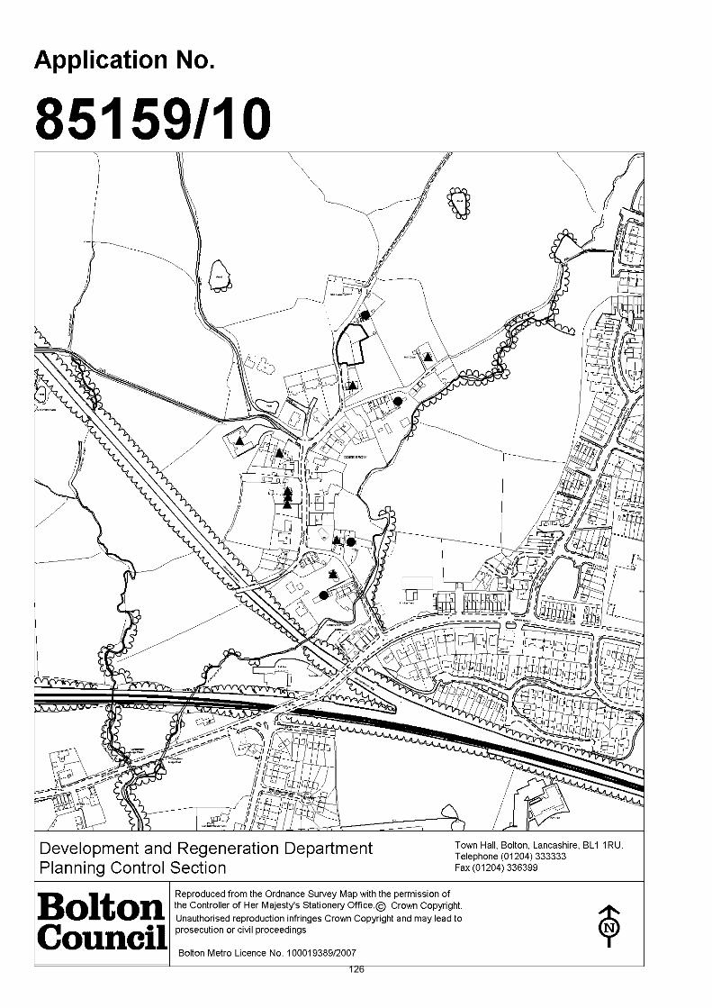
126
Date of Meeting: 09/12/2010
Application Reference: 85159/10
Type of Application: Full Planning ApplicationRegistration Date: 20/10/2010Decision Due By: 15/12/2010ResponsibleOfficer:
Alex Allen
Location: LAND BETWEEN 116-118 OLD LANE AND 134-138 OLD LANE,WESTHOUGHTON, BOLTON., BL5 2BA
Proposal: ERECTION OF TWO FOUR-BEDROOM HOUSES WITH GARAGES
Ward: Westhoughton South
Applicant: Mr I HoldenAgent : Mr D Lonergan
Officers Report
ProposalThe application is a resubmission of one half of the scheme which members considered atthe October 2010 Planning Committee. The applicant seeks the erection of two dwellings at the rear of No's 116 - 118 Old Lane. The dwellings would be identical being twostorey in height with an integral garage at ground floor level with four bedrooms at firstfloor level.
The dwellings would have a small porch, a hipped roof and chimney. The footprint ofeach dwelling would be 14.3 metres in width and just over 8 metres in depth to a totalheight of 8.5 metres to the apex of the roof. Each property would have a double carwidth driveway to provide 3 off road car parking spaces.
The footprint of the proposed dwellings would be located within the application site whichreceived planning permission from the Planning Inspectorate in 2007. whilst the reargarden areas of the two dwellings would be located in the area of scrubland which islocated to the east of the dwellings and to a partially wooded area adjacent to No.134/135 Old Lane.
The applicant is proposing to widen the road fronting the development site to 5.5 metresin width.
Site CharacteristicsThe application site forms a number of distinct areas. The earlier approved housing siteforms the garden area of No. 116 and No. 118 Old Lane whilst the land to the east formspart of scrubland which extends further to the east (i.e. between Hillcrest and No. 118Old Lane) land to the north which forms a partially wooded area which forms theboundary with No's 134 and 136 Old Lane.
PolicyPPS1 Delivering Sustainable Communities, PPS3 Housing, PPG13 Transport and PPS 25Development and Flood Risk
127
Unitary Development Plan (2005): D1/D2 Design, D3 Landscaping, EM1 IncompatibleUses, EM2 Pollution, EM5 Derelict Land and Buildings, EM10 Surface Water Run -off,EM11 Flood ProtectionO4 Provision of Open Space in new developments, A5 Roads, paths, servicing and carparking;A6 Maximum car parking standards, A17 Cyclists, H3 Determining Housing Applications,H4 Affordable Housing, E5 Protection/regeneration of existing employment areas andAppendix 7 - Car, cycle and motorcycle parking standards.
Planning Control Policy Notes:No. 2 Space About Dwellings, No. 7 Trees: Protection and Planting in New Developments, No. 10 Planning Out Crime, No. 21 Highway Considerations, No. 27 HousingDevelopments.
AnalysisSection 38 of the Planning and Compulsory Purchase Act 2004 requires applications tobe determined in accordance with policies in the Development Plan unless materialconsiderations indicate otherwise.
Applications which are not in accordance with Development Plan policies should berefused unless material considerations justify granting permission.
Similarly, proposals which accord with Development Plan policies should be approvedunless there are material considerations which would justify a refusal of permission.
It is therefore necessary to decide whether this proposal is in accordance with theDevelopment Plan and then take account of other material considerations.
The main impacts of the proposal are:-
* principle of residential development;* impact on the character and appearance of the area;* impact on the living conditions of existing/future residents;* impact on highway safety; and* impact infrastructure.
Principle of residential developmentNational policy on residential development is contained in PPS3 Housing. In order topromote more sustainable patterns of development, PPS3 makes it clear that the focusfor additional housing should be existing towns and urban areas. It is important thatnew housing is located where it is accessible to jobs, shops and services by modes oftransport other than the car. The inefficient use of land should be avoided and to this endmaximum use should be made of previously developed land. UDP Policy H3 and PCPN 27Housing are reflective of the contemporary approach to sustainable housingdevelopments and the approach is consistent with that contained in PPS3.
The applicant has an extant consent for the erection of one detached house on themajority of this site. This permission in effect has been implemented due to thecommencement of the road widening scheme adjacent to No. 11 Dobb Brow Road. Thekey differences being the provision of one additional dwelling and the enlargement of thesite to incorporate additional land to the east and north. The previously approved plansare contained at the end of this report.
Members will be aware that the Government has recently changed the definition ofpreviously-developed land to now exclude garden curtilage. This means that the site isnow defined as greenfield. Very recent advice from the Council's Principal DevelopmentOfficer (Planning Strategy) states:- 128
"The change to PPS3 to reclassify gardens as greenfield means that this source of landsupply is no longer technically priority for development under PPS3. The Council couldchoose to apply current UDP policy very strictly and refuse all such applications againstPolicy H2. However consideration of these schemes tends to revolve more around sitespecifics, including design and its context and the alternative may be a more measuredcase by case approach."
The site lies within the urban area, is well served by public transport along Wigan Roadand is in a sustainable location. The development will contribute to the range of housingtypes and designs in the Dobb Brow and Westhoughton areas and will not make asignificant demand upon the existing infrastructure.
As the proposed dwelling is considered to be consistent with the existing pattern ofdevelopment, is in an urban and sustainable location, does not contravene interfacestandards and would have its own direct access to the highway, the benefits of oneadditional new dwelling are considered to outweigh the disadvantages of the loss of asmall amount of the adjacent scrubland.
The proposal will have a positive impact in housing provision terms.
It is considered that application complies with policy.
Impact on the character and appearance of the areaPPS3, UDP Policies D1, D2, seek to ensure that the design, landscaping and context ofnew residential developments, reflect their surroundings and make a contribution to goodurban design.
The character of Dobb Brow is very mixed with a variety of house types. The site ispredominantly residential in character located on the western edge of the urban area ofBolton. The original character of the area was one of linear development along the roadwith small two storey cottages. The overall character of the area has changed overtimewith a number of infill sites coming forward for the development of larger housesincluding the 'Grange' development and properties at Old Lane Farm.
Furthermore, a previous Planning Inspector when assessing the character of the DobbBrow area stated:
'...the character of Dobb Brow Road is unremarkable...'.
The proposed development whilst representing new residential development wouldaddress the street scene (Old Lane and Dobb Brow Road) whilst providing replacementhedge planting and other landscaping which would reflect the character of the area andresult in an improvement to the scrubland .
It is considered that the proposal is in character with the area.
Impact on the living conditions of existing/future residentsUDP policy D2 seeks to ensure that new development proposals are compatible in termsof layout and design. In addition, guidance contained within PCPN No.2 provides adviceon interface distances to ensure adequate privacy between existing and newdevelopments.
The proposal would comply with the Council's interface distances from properties whichfront Dobb Brow Road and which also overlook the application site.
Impact on highway safety 129

UDP Policy A5 states that the Council will permit those developments that have taken intoaccount provision for pedestrians and cyclists; road design, layout and construction;vehicle servicing and access arrangements; car, cycle and motor-cycle parking; andaccess to, and by, public transport. Development proposals should not adversely affectthe safety of highway users, including pedestrians, as well as the safe and efficientcirculation of vehicles.
The applicant has agreed to the provision of two car parking spaces at the front of No.118 Old Lane and the widening of the road in front of the proposed development site.
The proposed use is not considered to be likely to give rise to significant changes in thenature of vehicular or other movements over and above the existing situation in this area.The size and shape of the plots make adequate provision for car parking within the site.It is also noted that the Council's Highway Engineers do not raise objection.
If members are minded to grant permission approve this proposal it is consideredappropriate to condition the implementation of the commenced highway improvementworks prior to
Impact on infrastructure
ConclusionThe proposal represents development which would be in character with the broad mix ofhousing types which make up the character and appearance of the Dobb Brow area whilstproviding a broader mix of housing in the locality. The proposal makes adequateprovision for vehicular movement and off road car parking. The proposal complies withpolicy and is recommended for approval subject to conditions.
130
Representation and Consultation Annex
RepresentationsLetters:- a total of 16 (no.) letters have been received in support of the application, 6(no) objection letters and two comment letters have also been received:
13 of the 16 support letters are from residents on Dobb Brow Road /Dobb Brow area with6 of the letters originating from 3 properties. The issues raised are as follows:
The site has permission for one house already;The site is previously developed;The proposal would improve the character and appearance of the site and wider area;The proposal would prevent fly tipping and litter on the land;The approved road widening scheme is well underway.
Of the 6 objection letters, 5 are from residents who live on Dobb Brow Road raising thefollowing issues
The site is greenfield / green belt;Improvements to the existing road network are required;Insufficient lighting along Dobb Brow Road;Development would not be in character with the area;Entrance to Dobb Brow Road is dangerous;The road widening scheme has halted;Letters of support are not from the local area / are from persons with an interest inthe development of Dobb Brow;No more development should be allowed until the road widening scheme has beencompleted;Traffic speeds have increased as a result of the road widening;Overdevelopment of an area of natural beauty and historic importance.
Petitions:- none received.
Town Council:- matter deferred until the 29 November Westhoughton Town Councilmeeting. Town Council comments will be reported at the Planning Committee meeting.
Elected Members:- no comments received.
ConsultationsAdvice was sought from the following consultees; United Utilities, Trees and WoodlandOfficer, Open Spaces Society, Ramblers Association, Public Rights of Way Team, Peak andNorthern Footpath Group, Highways Engineers, Environmental Health Officers, LandscapeArchitects and the Architectural Liasion Officer of Greater Manchester Police.
Planning HistoryPlanning permission was granted in January 2008 (Ref: 76901/07) for the erection of onedwelling house at the rear of 118 Old Lane in addition to road improvements adjacent toNo. 11 Dobb Brow Road. The road improvements to Dobb Brow Road are currently beingimplemented.
Planning permission (Ref: 84441/10) for the erection of two new dwelling to be located atthe rear of 116 and 118 Old Lane with the provision of two additional dwellings within thegarden area of Hill Crest which is located off Dobb Brow Road. This proposal wasrefused for the following reasons:
131

1) The site of the proposed development is greenfield and the applicant has not providedevidence in support of the plans which would warrant the granting of consent contrary toPPS3 - Housing and Policy and policy H3 of Bolton's Unitary Development Plan 2005; and
2) The access to the site is sub-standard in highway terms to the detriment of highwaysafety and the proposal is therefore contrary to Policy A5 of Bolton's Unitary DevelopmentPlan.
Recommendation: Approve subject to conditions
Recommended Conditions and/or Reasons
1. The development hereby permitted shall be begun before the expiration of 3 years from the date ofthis permission.
Reason
Required to be imposed pursuant to section 91 of the Town and Country Planning Act 1990 asamended by Section 51 of the Planning and Compulsory Purchase Act 2004.
2. No development shall be commenced until samples of the facing materials to be used for the externalwalls and roof(s) have been submitted to and approved in writing by the Local Planning Authority.
Reason
To ensure the development either fits in visually with the existing building and safeguards thecharacter and visual appearance of the locality or ensures the development safeguards the characterand visual appearance of the locality.
3. Trees and shrubs shall be planted on the site in accordance with a landscape scheme to be submittedto and approved by the Local Planning Authority before development is started. Such scheme shallbe carried out within 6 months of the occupation of any of the buildings or the completion of the newdevelopment, whichever is the sooner, or in accordance with phasing details included as part of thescheme and subsequently approved by the Local Planning Authority; any trees and shrubs that die orare removed within five years of planting shall be replaced in the next planting season with others ofsimilar size and species.
Reason
To soften the development proposed and to enhance and improve the setting of the developmentwithin the landscape of the surrounding locality.
4. No development shall be started until the trees within or overhanging the site which are the subjectof a Tree Preservation Order have been surrounded by fences of a type to be agreed in writing withthe Local Planning Authority. The approved fencing shall extend to the extreme circumference of thespread of the branches of the trees (in accordance with BS 5839) or as may otherwise be agreed inwriting with the Local Planning Authority; such fences shall remain until all development iscompleted.
Reason
In order to avoid damage to tree(s) within the site which are of important amenity value to the area.
5. No development shall be started until a minimum of 14 days notice in writing has been given to theLocal Planning Authority that the protective fencing referred to in Condition ** has been erected.
Reason
In order that the Local Planning Authority can inspect the protective fencing with a view to toavoiding damage to tree(s)/shrub(s)/hedgerow(s) within the site which are of important amenityvalue to the area.
6. Before development commences details of the treatment to all boundaries to the site shall besubmitted to and approved by the Local Planning Authority. Such details as are approved shall beimplemented in full before the development is first occupied or brought into use and retained
132
thereafter.
Reason
To ensure adequate standards of privacy are obtained and to enhance the setting of the developmentwithin the landscape character of the locality.
7. Phase II ReportShould the approved Phase I Report recommend that a Phase II Report is required, then prior tocommencement of any site investigation works, design of the Phase II site investigation shall besubmitted to, and approved in writing by, the Local Planning Authority. Site investigations shall becarried out in accordance with the approved design and a Phase II Report shall then be submitted to,and approved in writing by, the Local Planning Authority prior to commencement of development.The Phase II Report shall include the site investigation data, generic quantitative risk assessment,detailed quantitative risk assessment (if required) and recommendations regarding the need orotherwise for remediation.
Should the Phase I Report recommend that a Phase II Report is not required, but during constructionand prior to completion of the development hereby approved, contamination or gas migration isfound or suspected, the developer shall contact the Local Planning Authority immediately and submitproposals for investigation and remediation of the contamination or gas migration within seven daysfrom the date that it is found or suspected to the Local Planning Authority for approval in writing.
Options AppraisalShould the Phase II Report recommend that remediation of the site is required then unless otherwiseagreed in writing with the Local Planning Authority, no development shall commence unless or untilan Options Appraisal has been submitted to, and approved in writing by, the Local PlanningAuthority. The Options Appraisal shall include identification of feasible remediation options,evaluation of options and identification of an appropriate Remediation Strategy.
Implementation of Remediation Strategy
No development shall commence, unless otherwise agreed in writing with the Local PlanningAuthority, until the following information relating to the approved Remediation Strategy has beensubmitted and approved by the Local Planning Authority:
i) Detailed remediation design, drawings and specification;
ii) Phasing and timescales of remediation;
iii) Verification Plan which should include sampling and testing criteria, and other records to beretained that will demonstrate that remediation objectives will be met; and
iv) Monitoring and Maintenance Plan (if appropriate). This should include a protocol for long termmonitoring, and response mechanisms in the event of non compliant monitoring results.
The approved Remediation Strategy shall be fully implemented in accordance with the approvedphasing and timescales and the following reports shall then be submitted to the Local PlanningAuthority for approval in writing:
v) A Verification Report which should include a record of all remediation activities, and datacollected to demonstrate that the remediation objectives have been met; and
vi) A Monitoring and Maintenance Report (if appropriate). This should include monitoring data andreports, and maintenance records and reports to demonstrate that long term monitoring andmaintenance objectives have been met.
Reason
To ensure that the development is safe for use.
8. No development shall be commenced until full details of existing and proposed ground levels withinthe site and on land adjoining the site by means of spot heights and cross-sections; proposed sitingand finished floor levels of all buildings and structures, have been submitted to and approved by theLocal Planning Authority. The development shall then be implemented in accordance with theapproved level details.
Reason
To ensure the development safeguards the character and visual appearance of the locality and tosafeguard the living conditions of nearby residents particularly with regard to privacy and outlook.
9. The development hereby approved/permitted shall not be brought into use until the means ofvehicular access from Old Lane has been constructed and laid out entirely in accordance with detailswhich will have been submitted to and approved by the Local Planning Authority.133
Reason
In the interests of highway safety.
10. The development hereby approved/permitted shall not be brought into use unless and until a visibilitysplay measuring 2.4 metres by 33 metres is provided at the junction of the site access with Old Lane,and subsequently maintained free of all obstructions between the height of 1 metre and 2 metres (asmeasured above carriageway level).
Reason
To ensure traffic leaving the site has adequate visibility onto the highway.
11. The development hereby approved/permitted shall not be brought into use unless and until not lessthan 2 car parking spaces have been marked out and provided within the curtilage of the site, inaccordance with the approved/submitted details. Such spaces shall be made available for the parkingof cars at all times the premises are in use.
Reason
To ensure that adequate provision is made for vehicles to be left clear of the highway.
12. The development hereby approved/permitted shall not be commenced until the highwayimprovement scheme adjacent to No. 11 Dobb Brow Road has been completed to the satisfaction ofthe highway authority and retained thereafter.
Reason
In the interests of highway safety.
1. The Council has granted planning permission, subject to the conditions listed above, because theproposed development is in accordance with all relevant policies of the Development Plan (the UDPand the Regional Spatial Strategy Plan for the North-West), as is required by Section 38 of thePlanning and Compulsory Purchase Act 2004. There are no material considerations, as specified inthe Planning Officer Report, that outweigh this justification to support the grant of planningpermission. A summary of the relevant Development Plan policies pursuant to Article 22 of the Townand Country Planning (General Development Procedure) (England) (Amendment) Order 2003 andhow the proposed development relates to these policies is set out below.
Unitary Development Plan
N5 as the development would protect the integrity and continuity of landscape features;
N7 as new tree planting and maintenance together are proposed together with habitat managementand creation through landscape improvements and the benefit of the development outweighs the lossof some trees and hedgerows;
EM4 as investigation into land contamination has been carried out and suitable mitigation measureswould be secured by a planning condition;
D1 and D2 as the application displays good urban design which would preserve local distinctiveness;
D3 as there is scope for sufficient landscaping within the site(s) which will be secured by condition;
A5 as the development proposals take into account provision for roads, paths, servicing and parking;
A6 as the development is to provide car parking based on the Council's maximum car parkingstandards;
H3 as the housing development site is accessible; the development would help to provide a widerchoice and better mix of housing types, sizes and tenures; the existing and potential infrastructurehas the capacity to absorb the development; and the site has been previously developed.
Regional Spatial StrategyDP1 as the development would be of suitable design quality.
134

135
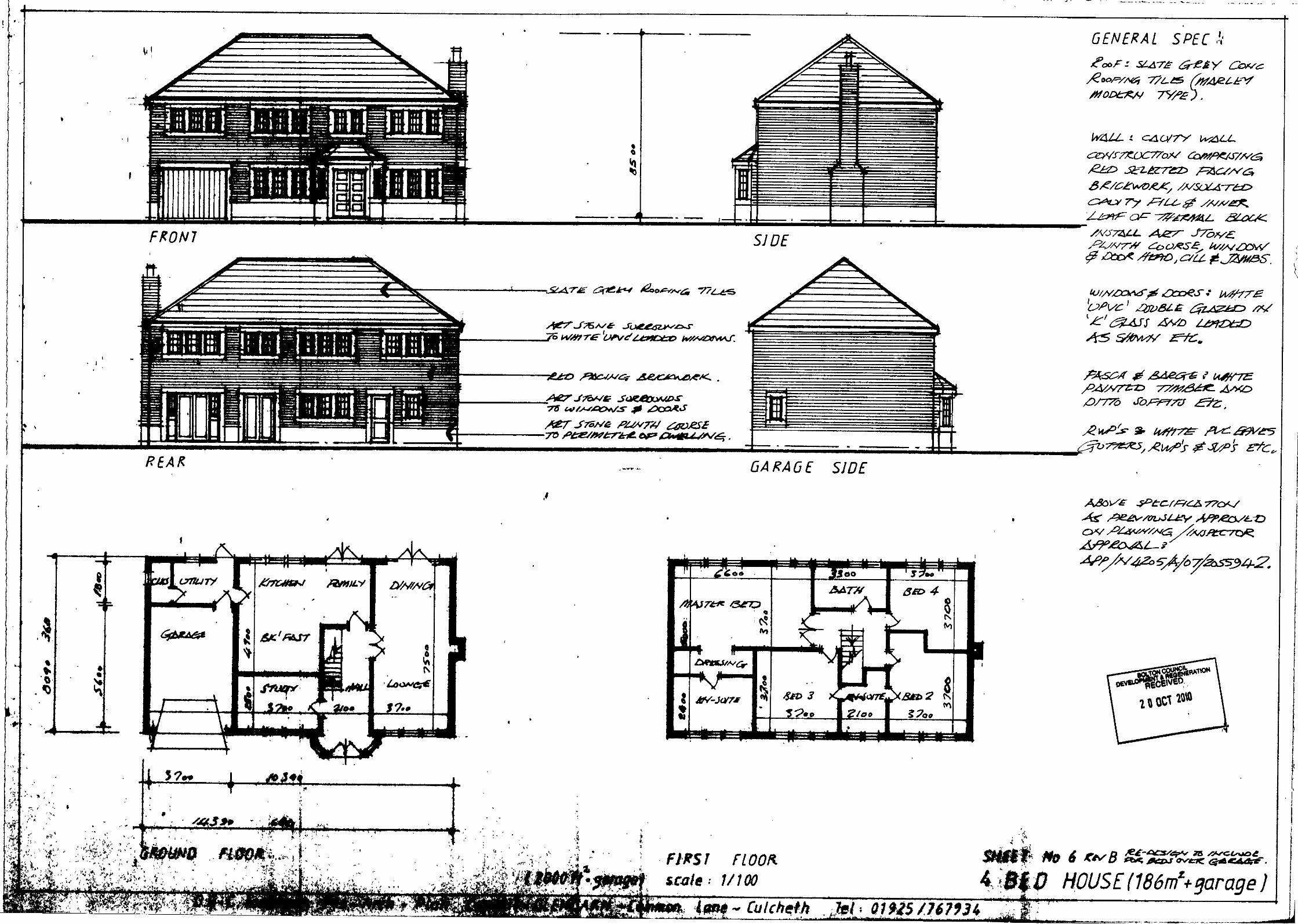
136

137

138
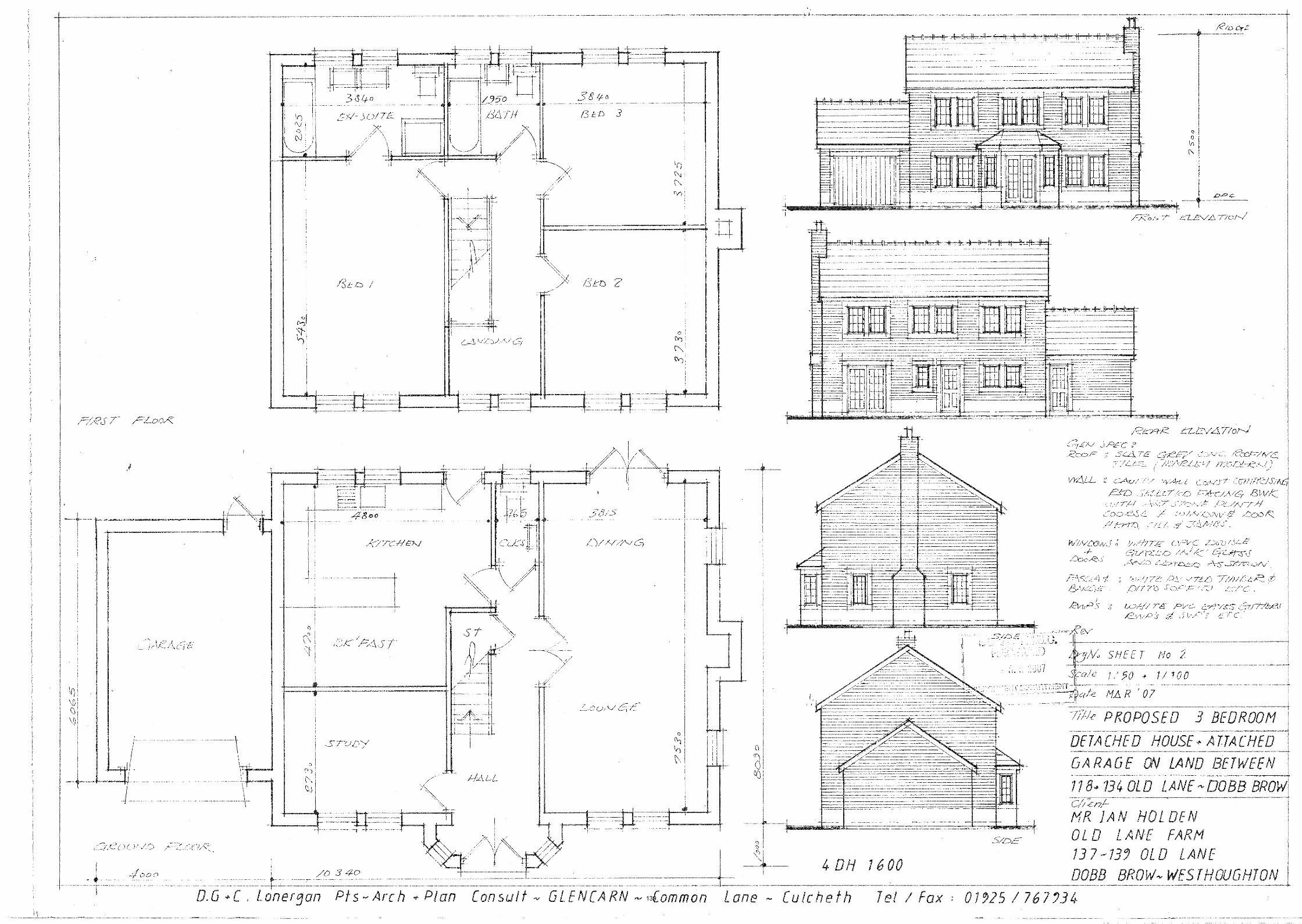
139
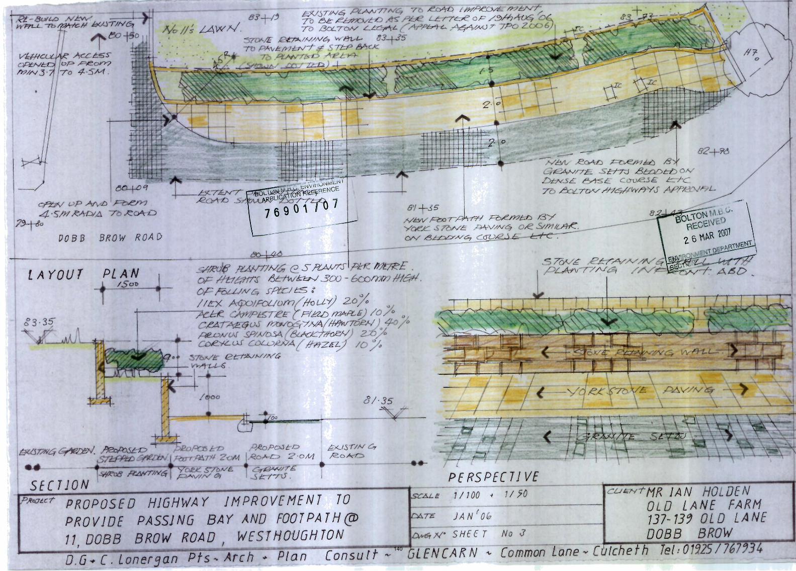
140
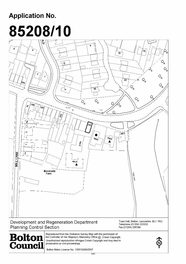
141
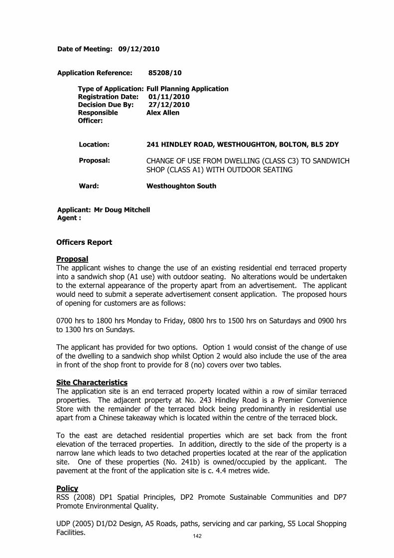
Date of Meeting: 09/12/2010
Application Reference: 85208/10
Type of Application: Full Planning ApplicationRegistration Date: 01/11/2010Decision Due By: 27/12/2010ResponsibleOfficer:
Alex Allen
Location: 241 HINDLEY ROAD, WESTHOUGHTON, BOLTON, BL5 2DY
Proposal: CHANGE OF USE FROM DWELLING (CLASS C3) TO SANDWICHSHOP (CLASS A1) WITH OUTDOOR SEATING
Ward: Westhoughton South
Applicant: Mr Doug MitchellAgent :
Officers Report
ProposalThe applicant wishes to change the use of an existing residential end terraced propertyinto a sandwich shop (A1 use) with outdoor seating. No alterations would be undertakento the external appearance of the property apart from an advertisement. The applicantwould need to submit a seperate advertisement consent application. The proposed hoursof opening for customers are as follows:
0700 hrs to 1800 hrs Monday to Friday, 0800 hrs to 1500 hrs on Saturdays and 0900 hrsto 1300 hrs on Sundays.
The applicant has provided for two options. Option 1 would consist of the change of useof the dwelling to a sandwich shop whilst Option 2 would also include the use of the areain front of the shop front to provide for 8 (no) covers over two tables.
Site CharacteristicsThe application site is an end terraced property located within a row of similar terracedproperties. The adjacent property at No. 243 Hindley Road is a Premier ConvenienceStore with the remainder of the terraced block being predominantly in residential useapart from a Chinese takeaway which is located within the centre of the terraced block.
To the east are detached residential properties which are set back from the frontelevation of the terraced properties. In addition, directly to the side of the property is anarrow lane which leads to two detached properties located at the rear of the applicationsite. One of these properties (No. 241b) is owned/occupied by the applicant. Thepavement at the front of the application site is c. 4.4 metres wide.
PolicyRSS (2008) DP1 Spatial Principles, DP2 Promote Sustainable Communities and DP7Promote Environmental Quality.
UDP (2005) D1/D2 Design, A5 Roads, paths, servicing and car parking, S5 Local ShoppingFacilities.
142
Planning Control Policy Notes: No. 10 Planning Out Crime and No. 21 HighwaysConsiderations.
AnalysisSection 38 of the Planning and Compulsory Purchase Act 2004 requires applications tobe determined in accordance with policies in the Development Plan unless materialconsiderations indicate otherwise.
Applications which are not in accordance with Development Plan policies should berefused unless material considerations justify granting permission.
Similarly, proposals which accord with Development Plan policies should be approvedunless there are material considerations which would justify a refusal of permission.
It is therefore necessary to decide whether this proposal is in accordance with theDevelopment Plan and then take account of other material considerations.
The main impacts of the proposal are:-
* principle of retail development;* impact on the character and appearance of the property/area;* impact on highway safety;* impact on the living conditions of adjoining residential occupiers.
Principle of retail developmentUDP policy S5 states the Council will permit development proposals for small scaleshopping facilities designed to meet the needs of the immediate locality in residentialareas provided they do not affect the amenities of adjacent units due to increased noiseand traffic. Small scale retail facilities are classed as stores of approximately 100 sq.mand which serve local needs.
The proposal would create 46.45 square metres of floorspace with a sandwich shopforming the front of the property with a preparation area at the rear of the property. It isconsidered that the proposal would provide a small retail facility for the local area incompliance with UDP policy S5.
Impact on the character and appearance of the property/areaThe proposal would not change the external appearance of the property and therefore isconsidered to comply with the relevant RSS and UDP policies.
Impact on highway safetyUDP policy A5 seeks to ensure that new development proposals take into accountprovision a number of issues including for pedestrians and vehicle servicing and accessarrangements. The application site has no curtilage car parking. There is a small amountof car parking in front of the application site combined with parking in front of theexisting Premier Convenience Store. Double yellow lines / a traffic regulation order startsoutside the application site and continues around the bend in the road towards the centreof Daisy Hill to the east.
The Council's Highways Engineers have raised no objections to the change of use.However, they raise concerns with the provision of a seating area outside the proposedshop. Highways Engineers raise concerns that the seating area would disrupt the freeflow of pedestrians along this stretch of footpath. It is recommended that Membersapprove the change of use of the application site but exclude any reference to theoutdoor seating area.
143
Impact on the living conditions of adjoining residential occupiersUDP policies EM2, EM3 and S5 all seek to ensure that new development proposalsincluding changes of use do not have unacceptable impacts on existing uses by way ofnoise, smell, safety, lighting, disturbance, traffic or other pollution.
The application site has a retail property to one side and a narrow road accessing tworesidential properties to the side. The nearest residential property would be 239b HindleyRoad which is set back from the front of the application site. Due to the small scale ofthe proposed use it is unlikely that the proposal would have a detrimental impact on theliving conditions of the occupants of No. 239b Hindley Road. The adjacent PremierConvenience store and this property are likely to create only local demand. The hours ofuse of the premises would be restricted to in the main office uses with the premisesproposing to close at 1800 hrs Monday to Friday, 1500 hrs on Saturdays and 1300 hrs onSundays.
It is considered that the proposal is unlikely to result in unacceptable impacts on existinguses for the above reasons. It is considered the proposal complies with policy.
ConclusionThe proposal is for a small scale retail use in a mixed use area. The application propertyis detached from nearby residential properties and due to this relationship with residentialproperties and the small scale nature of the proposal it is considered that the proposal isunlikely to have an unacceptable effect on local residents or generate significant levels ofcar parking at the front of the property. It is considered that the proposal complies withpolicy and is recommended for approval subject to conditions.
144
Representation and Consultation Annex
RepresentationsLetters:- 3 support letters have been received from the residents of No. 239 a HindleyRoad, 241b Hindley Road (the applicants wife) and No. 5 Old Vicarage Mews raising thefollowing issues:
The area is highly populated with a need of an outlet of this nature;Local chip shops have become too expensive and this venture would create healthycompetition (not a material planning consideration);Proposal is ideal and would save going into Westhoughton for such a 'retail offer'.
One objection letter has been received from the owner/occupant of 239b Hindley Roadraising the following concerns:
Expansion of the existing Premier Convenience store from a small shop to a largerretail concern has resulted in car parking problems, parked half on/off the pavementto the detriment of highway/pedestrian safety;No requirement for a sandwich shop as the existing store sells these products;Existing problems of litter and noise;Existing shop has been ramp raided on a number of occasions;Demand for affordable housing is greater so the property should be retained inresidential use;Reduction in the value of their property (not a material planning consideration).
Petitions:- none received.
Town Council:- raise objection to the proposal as it is considered that the outdoorseating area would cause obstructions to pedestrians.
Elected Members:- no comments received.
ConsultationsAdvice was sought from the following consultees: the Greater Manchester PedestrianAssociation, the Council's Highways Engineers, Pollution Control officers and Housing andPublic Health officers.
Planning HistoryNo relevant planning history.
Recommendation: Approve subject to conditions
Recommended Conditions and/or Reasons
1. The development hereby permitted shall be begun before the expiration of 3 years from the date ofthis permission.
Reason
Required to be imposed pursuant to section 91 of the Town and Country Planning Act 1990 asamended by Section 51 of the Planning and Compulsory Purchase Act 2004.
2. No development shall be commenced unless and until a detailed scheme showing the design, locationand size of a bin store has been submitted to and approved by the Local Planning Authority and suchworks that form the approved scheme shall be completed before the development is brought intouse, and retained thereafter.
Reason145
To ensure the development safeguards the character and visual appearance of the locality and theliving conditions of nearby residents.
3. The ground floor of the premises shall be used for A1 purposes only and for no other purpose andthis use shall be confined to this floor only.
Reason
For the avoidance of doubt as to what is permitted.
4. The premises shall not be open to customers except between the hours of 0700 hrs to 1800 Mondayto Friday, between the hours of 0800 and 1500 hours on Saturday and between 0900 hrs to 1300hrs on Sundays and Bank Holidays.
Reason
To safeguard the amenity and character of the area and to safeguard the living conditions of nearbyresidents particularly with regard to noise and/or disturbance.
5. No activities and/or operations shall take place on the site which release odorous emissions to theatmosphere without first submitting a scheme to the Local Planning Authority for approval showingdetails of the means of extraction and filtration of the odorous emissions and methods to beemployed to prevent noise disturbance. The approved scheme shall be implemented in full beforesuch operations and/or activites are first commenced and retained thereafter at all times.
Reason
To safeguard the living conditions of neighbouring residents particularly with regard to the effects ofodours.
1. The Council has granted planning permission, subject to the conditions listed above, because theproposed development is in accordance with all relevant policies of the Development Plan (the UDPand the Regional Spatial Strategy Plan for the North-West), as is required by Section 38 of thePlanning and Compulsory Purchase Act 2004. There are no material considerations, as specified inthe Planning Officer Report, that outweigh this justification to support the grant of planningpermission. A summary of the relevant Development Plan policies pursuant to Article 22 of the Townand Country Planning (General Development Procedure) (England) (Amendment) Order 2003 andhow the proposed development relates to these policies is set out below.
Unitary Development Plan
EM2 as the development would avoid unacceptable impacts on existing uses or likely futuredevelopment by reason of pollution;
EM3 as the development would not have adverse effects on levels of air, water, land, noise and lightpollution;
D1 and D2 as the application displays good urban design which would preserve local distinctiveness;
A5 as the development proposals take into account provision for roads, paths, servicing and parking;
A6 as the development is to provide car parking based on the Council's maximum car parkingstandards;
S5 as the approved change of use would be for a small scale retail use which would serve the localcommunity and not be detrimental to the living conditions of local residents.
Regional Spatial Strategy
DP1, DP2 and DP7 as the development would be of suitable design quality.
146
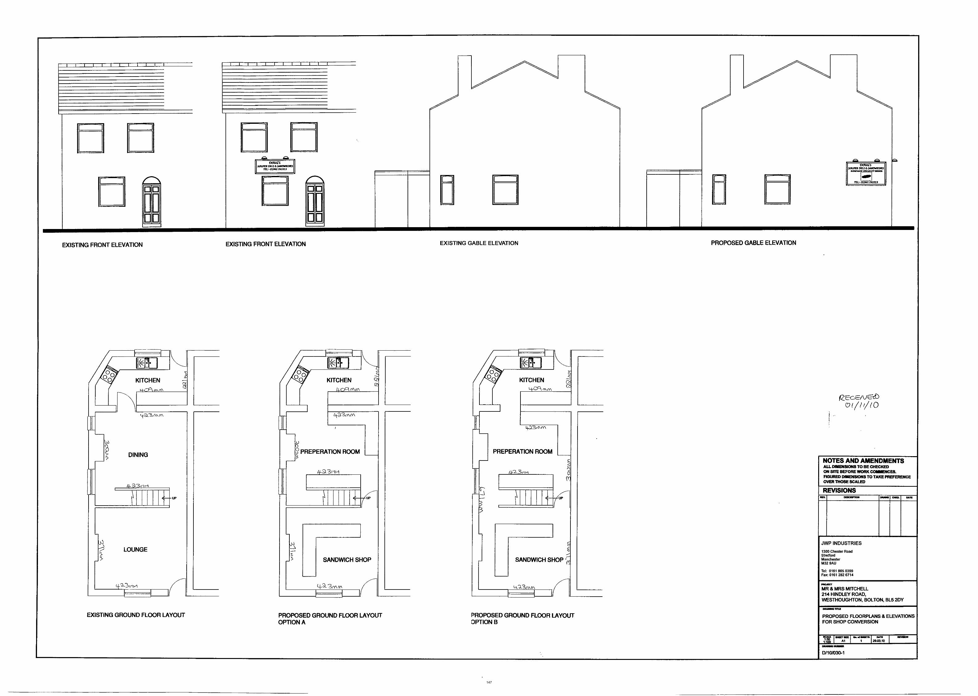
147
148
149

Date of Meeting: 09/12/2010
Application Reference: 85221/10
Type of Application: Full Planning ApplicationRegistration Date: 04/11/2010Decision Due By: 30/12/2010ResponsibleOfficer:
Andrew McGlone
Location: TALL TREES, SLACK LANE, WESTHOUGHTON, BOLTON, BL53LB
Proposal: CHANGE OF USE TO SHOWMEN'S SITE FOR THE SITING OF 1NO. MOBILE HOME, 2 NO. CARAVANS, 1 NO. MAINTENANCEBUILDING, 3 NO. FAIRGROUND RIDES AND 1 NO. HGV LORRYTOGETHER WITH LAYING CRUSHED STONE FOR ATEMPORARY PERIOD OF THREE YEARS
Ward: Westhoughton North
Applicant: SKC LeisureAgent :
Officers Report
ProposalThis application seeks consent for a change of use of the land to a showman's site.Permission is also sought to site 1 no. mobile home, 2 no. caravans, 1 no. maintenancebuilding, 4 no. fairground rides (2 of which are contained in the HGV lorry) , 1 no. HGVlorry, together with laying crushed stone for a temporary period of three years.
The applicant is currently on site as their previous pitch is no longer available. They seethis as a short term solution and are actively seeking a permanent pitch to reside at.
The site would provide accommodation for five persons.
Site CharacteristicsLand on which the applicant seeks consent is located at a sharp bend in Slack Lane.Vehicular access is available from Manchester Road, however this is around 250 metresaway. A limited amount of development surrounds the site. An electricity sub station is atthe junction of Slack Lane and Manchester Road, whilst work has been started on theadjoining land which was formerly occupied by Beech House, destroyed by fire. To theeast are fields attached to Ditcher's Farm which extend up to the M61. To the south is alarge residential development which has properties overlooking the site and the railwayline which separates the respective portions of land.
To the south is a public footpath and some trees. Palisade fencing borders twoboundaries on site; this has been present for a number of years. The applicant haserected some harris fencing to the rear of the mobile home for additional security.Generally levels are flat, although it does slightly slope in the north eastern corner. Inprevious years a HGV trailer has been sited on the land and there have been occasions offly tipping; both subject of a planning enforcement case and later removed.
150
Permissions have been sought to erect a two storey detached dwelling and a dormerbungalow on this land. The second application sought to establish special circumstances,however both the council and the planning inspectorate did not consider those tooutweigh the conflict with policies relating to protected open land.
PolicyPPS1 Delivering Sustainable Development; PPS3 Housing
UDP Policies D1 and D2 Design; D3 Landscaping; H3 Housing; H6 Travelling Showpersons; A5 Highway Safety; A6 Parking Provision; R2 Protected Open Land; R5Landscape Area; N4 and N6 Green Corridor Site
PCPN2 Space around Dwellings; PCPN10 Crime
Government Circular 04/2007 Planning for Travelling Show persons
AnalysisSection 38 of the Planning and Compulsory Purchase Act 2004 requires applications tobe determined in accordance with policies in the Development Plan unless materialconsiderations indicate otherwise.
Applications which are not in accordance with Development Plan policies should berefused unless material considerations justify granting permission.
Similarly, proposals which accord with Development Plan policies should be approvedunless there are material considerations which would justify a refusal of permission.
It is therefore necessary to decide whether this proposal is in accordance with theDevelopment Plan and then take account of other material considerations.
The main impacts of the proposal are:-
* impact on the Principle of Residential Development* impact on the Character and Appearence of the Area* impact on Protected Open Land* impact on the Green Corridor* impact on Vehicular Access
Impact on the Principle of Residential DevelopmentPPS3 defines greenfield land and previously developed land. Previously developed land isoutlined as land which is or was occupied by a permanent structure including the curtilageof the developed land and any associated fixed surface infrastructure. The definitionexcludes land that is or has been occupied by agricultural or forestry buildings. Policy H3of the UDP stipulates if the application site has not been previously developed and othersites in the borough have been demonstrated to be physically and environmentallyconstrained that they cannot be developed for housing then developments will bepermitted.
Policy H6 of the UDP states the council will permit proposals for gypsy and travellingshow people sites providing they are located within reasonable distance of local servicesand facilities, they do not adversely affect the amenity of the occupiers of neighbouringproperties and the site is not located in the green belt.
Applying PPS3 and policy H3 has previously been considered for a detached dwelling andbungalow. In both cases there was conflict at both national and local policy level as thesite is outside the urban area and is not previously developed.
151

Circular 04/2007 Planning for Travelling Show people replaces Circular 22/91 in Englandand complements Circular 01/2006 Planning for Gypsy and Traveller Caravan Sites. Thecircular addressees the specific and distinct needs of travelling show people that arisefrom the nature of their business. Paragraph 50 of the Circular emphasises the need fortravelling show people to secure sites that are suitable in planning policy terms.Paragraph 46 outlines that local landscape and local nature conservation designationsshould not be used in themselves to refuse planning permission for travelling showpeople's sites.
Although Slack Lane and the site are not in the town centre and are not directly in theurban area the occupants are within walking distance of regular bus services onManchester Road or a short drive to local centres containing amenities for individuals touphold a good standard of life and access services such as doctors and dentists. Althoughthe site is not located in the green belt the site does fall into the category of beingprotected open land and a green corridor site. The green corridor designation does notqualify for the application to be refused.
Show persons sites are multi use sites with a mix of residential, storage and amaintenance area. The residential unit on the adjoining land is in close proximity to thesite, whilst Ditcher's Farm is to the north east. A working farm could reasonably generatenoise and disturbance through the use of machinery etc. A good interface distanceremains between the farm complex, where the majority of activity would take place andthe residential development/application site. Placing residential next to residential is notconsidered to generate any undue privacy and amenity issues as there are much closerforms of development elsewhere than this site. Vehicle movements and maintenance ofequipment is very likely to cause noise and disturbance. Although the dwelling has yet tobe completed on the neighbouring dwelling it is likely that during the duration of atemporary consent there would be a time when the property is occupied.
Impact on the Character and Appearance of the AreaPolicies D1 and D2 of the UDP strive to ensure new developments preserve, respect andenhance the setting in which they are proposed by virtue of the architectural style,design, height, massing and scale. This should also include not adversely affecting viewsin and around the area.
The visual appearance of the site as a whole represents a cluttered form of development.The tight layout and form of accommodation (mobile home, caravans and maintenancebuilding) are not considered to represent a good standard of urban design. Compared tothe bungalow subject of the applications 81885/09 and 82668/09 this proposal does notoffer an equal or improved appearance. It is accepted that consent is sought for atemporary three year period and it would not be reasonable to require the applicant todevelop a substantial brick built structure. However structures such as a timber cabincould be utilised which may provide a more sympathetic form of development consideringthe sites setting.
PCPN2 offers guidance on interface distances between residential developments. Giventhe type of development proposed this is not a conventional relationship to the dwellingbeing built on the adjoining land. The gable elevation and a single storey garage shallface the application site. Although the elevation contains windows none are classed asserving principal rooms. An interface in excess of 13.5 metres is observed which iscompliant with PCPN3.
Impact on Protected Open LandPolicy R2 stipulates that the Council will permit development proposals within the definedareas of other Protected Open Land, provided they represent a limited infilling within anestablished housing area, form part of the maintenance of an existing employmentsource, the proposal requires a location outside of the urban area or the development152
would be appropriate within the green belt.
It is accepted that a replacement dwelling is under construction on the adjoining piece ofland, however this was a long standing individual dwelling, which bar Ditcher's Farm isisolated from other residential development.
It is evident that the proposal does not represent a limited infilling into an establishedhousing area. This principle has been accepted by two previous appeal decisions andcircumstances have not changed. If this site was within the green belt consent would notbe forthcoming for a dwelling/temporary means of accommodation unless it was relatedto agriculture or a conversion of an existing building.
The proposal fails to satisfy policy R2 of the UDP.
Impact on the Green CorridorThe site falls within an area designated as a green corridor site. UDP policies N4 and N6outline the Councils stance that development shall not be permitted if it will impair thephysical continuity and integrity of the corridor, reduce the areas habitat value oradversely affect any protected or priority species known to be dependent on the corridor.
Slack Lane falls within a corridor stretching from the railway line to the south through toChurch Lane to the north. The M61 curtails the eastern aspect. Views are prevalentacross and through the corridor from the application site, to the south, east and northwest. A farm complex is sited to the north, this contains a number of buildings. It restrictsviews to the north and breaks a natural sight line or the green corridor in this direction.
The proposal would create a barrier to the openness of the green corridor, especiallywhen viewed from the public footpath through the M61. In the last application and appealdecision it was accepted that the site offered little or no habitats for wildlife and did notrepresent a site suitable for recreation or have any significant amenity value. It wasconcluded that the proposal would have no significant adverse impact on the objectives ofthe green corridor.
The form of development is not considered to be equal or an enhancement on thebungalow last considered. However the principle remains that the site is of poor qualitycompared to other areas of the green corridor, therefore the scheme would comply withpolicies N4 and N6.
Impact on Vehicular AccessPolicies A5 and A6 require developments to provide a safe and useable access andprovide sufficient off street parking.
Access is gained via Slack Lane at its junction with Manchester Road (A6). Initially this iswell surfaced and has foot ways either side, however the part extending up to theapplication site and round to Ditcher's Farm is not. The principle of using Slack Lane as anaccess is considered to be acceptable. However the use of HGV's along Slack Lane andmore importantly circulation areas to ensure vehicles can enter and leave the site inforward gear is problematic.
The applicant uses the HGV plus other trailers to take rides out to locations across thenorth west. This is generally once per week, although this could increase during times ofdemand. The applicant reverses the HGV along Slack Lane from the junction withManchester Road. Although Slack Lane is not well used it is not an appropriatemanoeuvre. The highway engineer is of the view that the site is inadequate toaccommodate the proposed level of activity and over spill onto the adjacent highway isinevitable. Policy A5 of the UDP is not complied with.
153

The site layout is tight when all the equipment is present, however there is space forvehicles to park off Slack Lane. This is considered to comply with policy A6 of the UDP.
ConclusionNotwithstanding the benefits of utilising this site which has been subject to fly tipping andparking of a HGV the proposal fails to comply with policy. The applicant has sought atemporary consent whilst they seek alternative permanent sites elsewhere in Bolton andneighbouring boroughs, however it is evident that the type of built form is not compatiblewith this location through design and use of protected open land. Furthermore reversingHGV's from the junction of Slack Lane and Manchester Road is far from ideal, whilst thereis insufficient space on site to support the movement of such vehicles.
The 'exceptional circumstances' do not, it is considered, outweigh the fact that theproposal fails to meet the policy requirements of the UDP.
Members are therefore recommended to refuse the application.
154
Representation and Consultation Annex
RepresentationsLetters:- Four representations have been submitted as follows.
Two letters of objection have been submitted, the grounds contained in the three lettersare as follows:
there is a negative visual impact of this application as vehicles and equipment havealready moved onto site despite permission not being approved;we are also concerned how household and sanitary waste will be cleared from the siteand this may lead to more unsightly fly tipping on Slack Lane;the application will destroy the view and will be an eyesore;the application could lower property value (not a material planning consideration);the change is totally out of keeping with the original use of the site as a farmhouse soit seems unreasonable and unfair that the change of use will be industrial.
Two letters from the same address have been submitted commenting on the proposal.(they shall only be counted as one) The comment is as follows:
'The site for this application is clearly visible from my property, which I purchased in2007. I understand that the land is common land and my purchase decision was partiallybased on the uninterrupted view of Rivington Pike and Winter Hill from it. Thisapplication, if being considered, presumably means that it is not common land and ifapproved will destroy that view. I note that there are vehicles on the land at this stage ofthe application.'
One letter of support has been submitted:
there has been no fly tipping which must be saving the council money;there is no dodge dealing with cars parked side by side on the lane;no quad and scramble bikes use the nearby field;we now feel very safe in the knowledge that someone lives nearby.
Town Council:- no comments received to date.
Elected Member:- Councillor Wild has concerns with this application as the site is toosmall to accommodate so many vehicles and now that a substantial building has beenerected there is even less space than previously. The access is an unmade track and thesize of the vehicles will damage the surface especially in winter when wet conditionsprevail, this will prohibit access to others who have to use the track to get to theirhouses. If you feel that you may give delegated consent to the application, I would likethe application to go before the planning committee.
ConsultationsAdvice was sought from the following consultees, highway engineer, greenspace.
Planning HistoryPermission was refused and later dismissed at appeal for the erection of a bungalow. Ref:82668/09; (Appeal Ref: APP/N4205/A/10/2126662)
Planning permission was refused for the erection of one dwelling. Ref: 81885/09;
Outline permission was refused for one dwelling and later dismissed at appeal. Ref:59646/01;
An enforcement notice was served in respect of the creation of a compound on the land,155

fence over 2 metres high, together with the storage of a caravan, articulated lorry andtrailer. The notice was complied with the case closed.
Full permission was granted following an outline consent for the erection of a dwelling onthe former site of Beech House which was demolished following a fire. Permission wasgranted on the basis the proposal was a replacement dwelling. Ref's: 63318/02,70529/05, 80535/08.
Recommendation: Refuse
Recommended Conditions and/or Reasons
1. The proposed development would, by virtue of its design and siting be detrimental to the characterand appearance of the area and is contrary to Policies D1 and D2 of Bolton's Unitary DevelopmentPlan.
2. HGV access to the site is sub-standard in highway terms to the detriment of highway safety and theproposal is therefore contrary to Policy A5 of Bolton's Unitary Development Plan.
3. The proposal will result in the loss of open land to the detriment of the character and appearance ofthe area, and is therefore contrary to Policy R2 of Bolton's Unitary Development Plan which areaimed at protecting areas of open land, not included within the Green Belt, from inappropriatedevelopment.
156

157
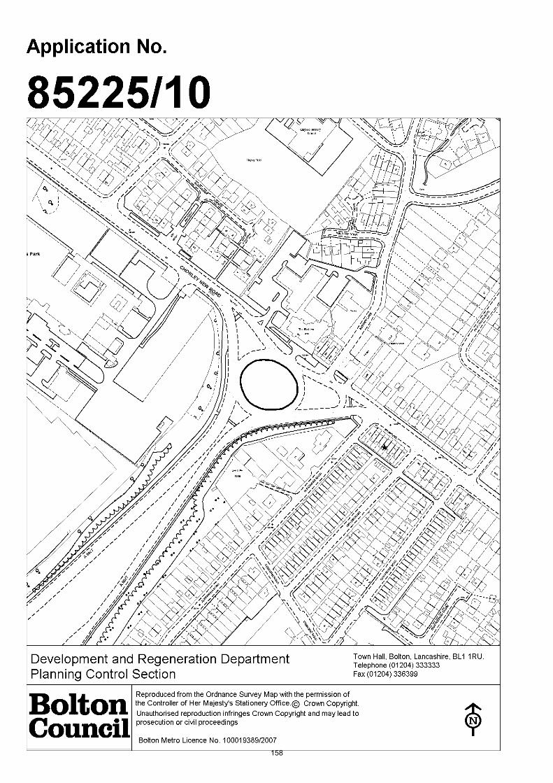
158

Date of Meeting: 09/12/2010
Application Reference: 85225/10
Type of Application: Advertisement ConsentRegistration Date: 05/11/2010Decision Due By: 31/12/2010ResponsibleOfficer:
Alex Allen
Location: THE BEEHIVE ROUNDABOUT, CHORLEY NEW ROAD, LOSTOCK,BOLTON
Proposal: ERECTION OF TWO POLE-MOUNTED SIGNS
Ward: Horwich and Blackrod
Applicant: Bolton Council Communications and Marketing AgencyAgent :
Officers Report
ProposalThe applicant seeks to erect two advertisements on the Beehive roundabout in Horwich. The sign board would be a total of 0.6 metres in height mounted on poles which wouldmean the whole sign was no more than a maximum of 0.8 metre above existing groundlevel. One sign would be on the eastern edge of the roundabout whilst the other signwould be placed in the north west corner of the roundabout facing the Bolton bound legof the roundabout.
The applicant has confirmed that each of the advertisements would be sited a minimumof 2 metres away from the edge of the roundabout.
Site CharacteristicsThe Beehive roundabout is a large elliptical shaped roundabout located at the junction ofChorley New Road (A673) and De Havilland Way (A6027). The Beehive Public House andhotel are located to the north, Georgia Pacific manufacturing factory to the south westand residential properties to the south east of the site. The residential properties to thesouth east are screened by existing established planting.
On the roundabout itself there are 3 chevron signs together with some landscaping in thecentre of the roundabout. The character of the remainder of the roundabout is made upof a large grassed area.
PolicyPPG 19 Outdoor Advertisement Control
UDP (2005):- D4 Advertisements.
Planning Control Policy Notes:- No. 6 The Display of Signs and Advertisement.
AnalysisSection 38 of the Planning and Compulsory Purchase Act 2004 requires applications tobe determined in accordance with policies in the Development Plan unless materialconsiderations indicate otherwise.
Applications which are not in accordance with Development Plan policies should berefused unless material considerations justify granting permission.
Similarly, proposals which accord with Development Plan policies should be approvedunless there are material considerations which would justify a refusal of permission.
It is therefore necessary to decide whether this proposal is in accordance with theDevelopment Plan and then take account of other material considerations.
The main impacts of the proposal are:-
* impact on character and appearance of the area;* impact on highway safety.
Impact on the character and appearance of the areaThe principle of advertisements on roundabouts has been accepted previously on othersites within the Borough (see planning history section). However, it is important toanalyse the individual aspects of each proposal on it's merits.
UDP policy D4 seeks to ensure that advertisements do not adversely affect the amenity ofthe site and wider area by reason of design, size, materials, illumination, colour andnumber. The application proposes the erection of two advertisements located at oppositesides of the existing roundabout. The advertisements would be restricted to a maximumheight of 0.8 metres above existing ground level. This is similar in height to the existingchevron signs located on the existing roundabout. The signs would not be illuminated.
Apart from the existing 3 chevron signs there are no other signs contained within theroundabout. It is considered that the proposed two advertisements would be compatiblewith the existing roundabout and the wider area. The proposal would not result in clutterand complies with UDP policy.
Impact on highway safetyUDP policy D4 also states that signs which prejudice highway safety will not be permitted. The Council's Highways Engineer has commented that to minimise distraction to driversat this roundabout the applicant must ensure the following:
The top of the signs are no higher than 800 mm above ground level;Advertisements must be at least 2 metres from the edge of the roundabout;That Council policy is to only permit the sponsors name;
In terms of the first two issues, the applicant has confirmed that the signs would be nomore than 800 mm above ground and would be a minimum of 2 metres from the edge ofthe roundabout. This fully complies with the Highways Engineers requirements.
The issue of the level of information on each sign is not something which the LocalPlanning Authority can control. However, the level of information which is provided oneach sign will be controlled by the Council as a whole. The signs are being commissioned

by the Council's Communication and Marketing agency and the level of informationprovided on each advertisement would be controlled complying with the Council'sbranding policies.
ConclusionIt is considered that the two proposed advertisements would comply with UDP policy D4and guidance contained within PCPN No. 6 in that they would be compatible with theexisting roundabout and surrounding area and would not cause a distraction to drivers.The proposal complies with policy and is recommended for approval subject to conditions.
Representation and Consultation Annex
RepresentationsLetters/petitions:- none received.
Town Council:- raise objection to the proposal with regard to the proliferation ofsignage on the roundabout and also concerns regarding highway safety due to increaseddistraction to motorists at a busy junction.
Elected Members:- no comments received.
ConsultationsAdvice was sought from the following consultees: the Council's Highways Engineers.
Planning HistoryNo specific site history.
Advertisement consent was granted by Planning Committee members in April 2009 forthe erection of 4 free standing pole mounted advertisements on Chequerbentroundabout. The proposed signs measured a maximum 2.1 metres in height. It is notedthat the Chequerbent roundabout (c. 140 m x 109 m) is about double the size of theBeehive roundabout (55m x 46 m).
Recommendation: Approve subject to conditions
Recommended Conditions and/or Reasons
1. 1. No advertisement is to be displayed without the permission of the owner of the site or anyother person with an interest in the site entitled to grant permission.
2. No advertisement shall be sited or displayed so as to—a) endanger persons using any highway, railway, waterway, dock, harbour or
aerodrome (civil or military);(b) obscure, or hinder the ready interpretation of, any traffic sign, railway signal or aid
to navigation by water or air; or(c) hinder the operation of any device used for the purpose of security or surveillance
or for measuring the speed of any vehicle.3. Any advertisement displayed, and any site used for the display of advertisements, shall be
maintained in a condition that does not impair the visual amenity of the site.4. Any structure or hoarding erected or used principally for the purpose of displaying
advertisements shall be maintained in a condition that does not endanger the public.5. Where an advertisement is required under these Regulations to be removed, the site shall
be left in a condition that does not endanger the public or impair visual amenity.
Reason
Required to be imposed pursuant to Regulation 14 of the Town and Country Planning (Control ofAdvertisements) (England) Regulations 2007.
2. The advertisement(s) hereby approved/permitted shall be situated no less than 2 metres from theedge of the roundabout and shall not exceed 800 mm above the existing/original ground level. ReasonTo ensure traffic leaving the site has adequate visibility onto the highway.
1. The Council has granted planning permission, subject to the conditions listed above, because the

proposed development is in accordance with all relevant policies of the Development Plan (the UDPand the Regional Spatial Strategy Plan for the North-West), as is required by Section 38 of thePlanning and Compulsory Purchase Act 2004. There are no material considerations, as specified inthe Planning Officer Report, that outweigh this justification to support the grant of planningpermission. A summary of the relevant Development Plan policies pursuant to Article 22 of the Townand Country Planning (General Development Procedure) (England) (Amendment) Order 2003 andhow the proposed development relates to these policies is set out below.
Unitary Development Plan
D4 as the proposed advertisements would be compatible with the roundabout and wider area and notbe detrimental to highway safety.
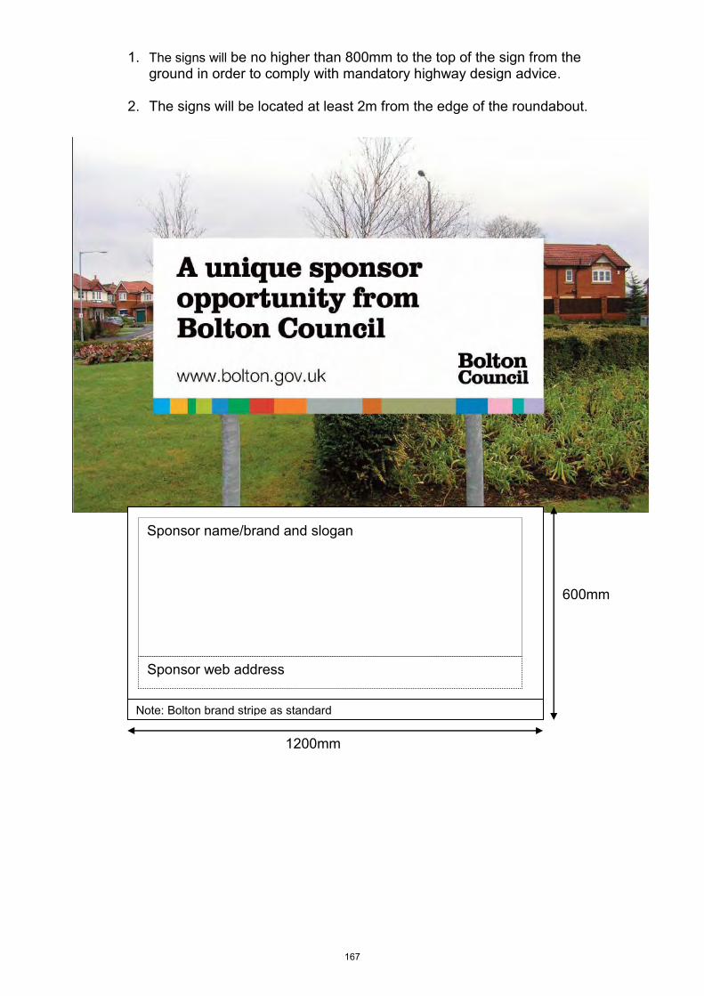
1. The signs will be no higher than 800mm to the top of the sign from the ground in order to comply with mandatory highway design advice.
2. The signs will be located at least 2m from the edge of the roundabout.
Sponsor web address
Sponsor name/brand and slogan
Note: Bolton brand stripe as standard
1200mm
600mm
167

168

169

Date of Meeting: 09/12/2010
Application Reference: 85260/10
Type of Application: Prior Notification (all)Registration Date: 11/11/2010Decision Due By: 05/01/2011ResponsibleOfficer:
Jodie Turton
Location: HIGHWAY VERGE AT CROMPTON WAY (OPPOSITE NO. 247),BOLTON
Proposal: PRIOR NOTIFICATION FOR THE ERECTION OF A 14.8 METREHIGH TELECOMMUNICATIONS MONOPOLE TOGETHER WITHASSOCIATED EQUIPMENT CABINET
Ward: Tonge with the Haulgh
Applicant: Vodafone LtdAgent : Mono Consultants
Officers Report
Proposal
This is an application for Prior Approval.
The proposal comprises the erection of a 14.8 metre high street monopole installation,supporting six antennae within a 480mm shroud, together with two equipment cabinetsand an adjoining small scale dual operator meter pillar.
The equipment cabinets will be painted green and will be sited adjacent to the monopoleinstallation, amended plans are awaited showing the precise siting of the equipmentcabinets as the plans have been amended to meet the requirements of highwayengineers.
The equipment cabinets each measure: 1.580 metres (length) x 0.38 metres (width) x1.350 metres (height).
The adjoining meter pillar measures: 1.0 metres (length) x 0.2 metres (width) x 0.8metres (height).
The proposed equipment will enhance the coverage of 3rd Generation networks in thearea for Vodafone and O2.
Site CharacteristicsThis is a proposed new telecommunications site. The monopole and equipment cabinetswould be situated to the rear of the footway on Crompton Way, close to the junction withThicketford Road. To the rear of the site are allotment gardens and beyond this isThicketford Brow. The surrounding area is pre-dominantly residential in nature.
There are no schools in direct close proximity to the application site. The nearest schoolsare:Tonge Moor Primary School - 364 metres 170
Moorgate County Primary School - 430 metres
PolicyPPG8 (revised) Telecommunications.
UDP policies: D6 Telecommunications; A5 Impact on the Highway.
PCPN21 Highway ConsiderationsPCPN25 Telecommunications
AnalysisPPG8 states that applications for Prior Approval must be considered on siting andappearance grounds only. Policies in the Development Plan relating to siting andappearance are relevant.
Applications which are acceptable in siting and appearance terms and comply with theprovision of the Development Plan in terms of siting and appearance, should be grantedPrior Approval.
Similarly applications which are unacceptable in siting and appearance terms, and whichare contrary to the provisions of the Development Plan in terms of siting and appearance,should be refused Prior Approval.
It is therefore necessary to decide whether this application is acceptable in terms of sitingand appearance, with due regard being had to relevant Development Plan policies, anddetermine the accordingly.
The Government's policy is to facilitate the growth of new and existingtelecommunications systems whilst keeping the environmental impact to a minimum.___________________________________________________________________
Consideration of Alternative Sites and Mast SharingPPG8 and UDP policy D6 place strong emphases on the use and reuse of existing sites, inparticular the use of existing masts, buildings and other structures. The Governmentencourages applicants to hold pre-application discussions on with the Local PlanningAuthority and interested third parties regarding the consideration of alternative sites.
The lack of consideration of alternative sites can be a reason to refuse applications, butthe Local Planning Authority must give clear and specific reasoning, having borne in mindthe technical constraints of the Operators.
The applicant has assessed the surrounding area and they have not put forward anyalternative sites for consideration. The justification that they provide for this is, "Giventhe densely residential nature of the area, coupled with the dense tree cover and thetopography, there are not other potential options identified."
Whilst it is normally a requirement that telecommunications applications assessalternative sites within the surrounding area to ensure that the best possible site hasbeen found. In this instance, given the dense residential nature of the surrounding area,the application site is considered to be relatively removed from residential properties, withnone directly to the rear and furthermore there are no schools within close proximity.The proposed site is therefore considered to be acceptable, despite the lack ofconsideration of alternative sites.
Technical JustificationPPG8 states that Operators may be expected to demonstrate the need for the proposal.UDP policy D6 requires that the size of the mast is justified in terms of operational171

efficiency, structural capacity and its relative importance in the network.
The applicants have supplied existing and proposed Cell Coverage Diagrams. Theproposed equipment will improve the existing 3rd Generation service for Vodafone andO2, an area approximately extending to the north and south along Crompton Way and tothe east and west along Thicketford Road and the adjacent residential streets.
Engineered Communications Solutions Ltd (ECS) have been consulted on the application,however their comments have not yet been received. These will be reported toCommittee Members on the late list.
Impact on the HighwayUDP policy A5 and PCPN21 seek to ensure that development proposals do not adverselyaffect the safety of highway users, including pedestrians, as well as the safe and efficientcirculation of vehicles.
The pavement in the area of the application site is 2.5 metres wide. The original schemeproposed a large equipment cabinet of 1.0 metres in depth, which would have served toreduce the width of the pavement to 1.5 metres, which is significantly below the optimum2.0 metres. The applicant has therefore agreed to significantly reduce the size of theequipment cabinet to ensure that pedestrian manoeuvrability is not impeded, howeverthis will mean that two equipment cabinets are required in order to house the necessaryequipment.
The equipment cabinets have been reduced from 1.0 metres in depth to 0.38 metres,amended plans are awaited to show the precise siting and this along with Highwaycomments will be reported on the late list.
Design and Visual Amenity IssuesUDP policy D6 requires that the siting, scale and external appearance of the apparatus,and any associated landscaping, have been designed to minimise, eliminate or mitigatenegative impact on amenity, visual intrusion and, if applicable, the appearance ofstructures on which they are mounted.
The proposed telecommunications mast is a 14.8 metre high street pole. The mast andassociated equipment cabinets will be sited to the rear of the pavement, against awooden fence. To the south and south east there are a number of trees which the mastwill be viewed against, which will serve to screen the mast from the south and south eastand provide a backdrop when viewed from the north and west.
The mast will be viewed against the existing street furniture, which incorporates lamposts(10 metres in height), railings and traffic lights.
In order to ensure that the equipment cabinets do not impinge on pedestrianmanoeuvrability two slimline equipment cabinets are to be provided, rather than the onelarger unit proposed in the application submission. The provision of two equipmentcabinets is not considered to have any greater impact on the character of the area giventhe siting of the monopole and cabinets close to the junction with Crompton Way andThicketford Road, where there is an abundance of street furniture which the proposal willintegrate with.
When taking into consideration the surrounding environment, the proposal is notconsidered to have a detrimental impact on the character and appearance of thesurrounding area. The proposed street pole will blend in with existing street furniture,and although higher than adjacent lampposts, at 14.8 metres, it will not appearincongruous at this busy junction.
172

The proposal is therefore considered to comply with UDP policy D6.
Health ConsiderationsThe Central Government view is that if the output levels of the proposed equipment arebelow the guidelines recommended by the International Commission on Non-IonizingRadiation Protection, there should be no need for further consideration on healthgrounds.
PPG8 advises that Operators should provide Local Planning Authorities with ICNIRPcompliance statements. The applicants have provided an ICNIRP compliance statementfor this application.
ConclusionThe proposal for a 14.8 metre high telecommunications mast and associated equipmentcabinets, sited to the rear of the pavement, on Crompton Way, close to the junction withThicketford Road, is considered, in policy terms, to be an acceptable location. The mastwill not present an incongruous feature when viewed against existing street furniture andthe nearby trees. The applicant has shown a need for the increase in coverage for thetwo operators (Vodafone and O2). There will be no detrimental impact on highwaysafety. The proposal complies with policy and is therefore recommended for approval.
173

Representation and Consultation Annex
RepresentationsLetters:- one letter of objection has been received from 136 Thicketford Road, raisingthe following concerns:
Hazard for pedestrians.There is good coverage in the area already.
ConsultationsA site notice was posted on site on 19/11/2010.
The following local residents were consulted:- 136 - 142, 150 - 162 Thicketford Road;Taylor Buildings Crompton Way; 237 - 245 Crompton Way.
Advice was sought from the following consultees: Highway Engineers; EngineeredCommunications Solutions Ltd.
Planning HistoryN/A
Recommendation: Prior Approval Granted with Conditions
Recommended Conditions and/or Reasons
1. The development hereby permitted shall be begun before the expiration of 3 years from the date ofthis permission.
Reason
Required to be imposed pursuant to section 91 of the Town and Country Planning Act 1990 asamended by Section 51 of the Planning and Compulsory Purchase Act 2004.
2. The external finish and colour of the telecommunications mast and equipment hereby approved shallbe painted/powdercoated as follows:
Telecommunications Street Pole Installation - galvanised steel finish;Equipment cabinet and Operator Meter Pillar - Green (RAL 6009).
Such details as are approved shall be completed within 28 days of the installation of the equipmentwhich shall be retained so coloured thereafter.
Reason
To ensure the development safeguards the character and visual appearance of the locality.
174

175

Report concerning the revoking of the Bolton (Land adjacent to 72 Clifton Street,
Kearsley) TPO 2010 and the outcome of the new TPO, Bolton (Land adjacent to 72
Clifton Street, Kearsley No.1) TPO 2010.
At the Planning committee on 14th October 2010 Members instructed officers that a tree
preservation order be placed on trees at Clifton Street, Kearsley as an application for outline
residential development had been received.
The trees were protected and the Bolton (Land adjacent to 72 Clifton Street, Kearsley) TPO
2010 served on two groups of trees consisting of two sycamores and three Hawthorns.
Subsequently it was found that two of the Hawthorn trees were outside the site and a further
TPO, Bolton (Land adjacent to 72 Clifton Street, Kearsley No.1) TPO 2010, was made
deleting the two Hawthorns. The two omitted Hawthorns are on Council owned land so are
already protected.
Four letters have been received regarding the making of this order from Mr and Mrs J.M. &
E.J Green, Iain Tavendale, Arboricultural consultant and Arbortec, Tree Surgeons and Ms.
Helen Blackburn. The letter from Iain Taverndale is a formal objection.
The objections and comments of the Council’s Tree and Woodland Officer (CT&WO) are as
follows:-
The validity of the order was queried as two of the three Hawthorn trees are outside
the site - When The CT&WO inspected the trees on the site with the benefit of the
recent topographical survey, it was found that two of the Hawthorns were outside the
site one by approximately 100 mm and the other by 500 mm
The amenity value of the trees were questioned - it is considered that the trees
collectively on the site do have an amenity as they can be seen from the public
areas adjacent to the site and from one or two more distant views.
The CT&WO concurred that the three trees within G1 and T1 (the three protected
trees on the site) are in poor condition with a limited life expectancy in a report
commenting on the trees that formed part of the planning application for development
he stated that:-
A large mature Sycamore tree has been removed from the centre of the site recently to
enable the development of the site.
The remaining trees around the boundary are not of high quality although collectively they
provide a screen to the properties on Station Road. Their removal is likely due to the
constraints of the site. If development is to be approved then there should be a landscape
condition for replacement tree planting along the southern boundary.
The matter of expediency was raised – It was noted that one mature Sycamore had
been removed from the site prior to the planning application being made. Further
176
trees were cut on the site prior to the making of the order. It was therefore considered
that the other trees were at risk of removal.
The issue of some of the trees in G2 of the Tree preservation order being outside of
the site is also raised – A new TPO was made and now there is only one of the
Hawthorn trees (Denoted as T1 in the report) within the site.
The CT&WO considered that the Hawthorn T1 is not part of a hedge and is a tree in
its own right despite having been reduced in height in the past.
There does not seem to be any reason why the existence of a footpath adjacent to
the trees would preclude the making of an order.
The CT&WO considers the evidence that T1 is damaging the fence posts is unclear
as the soil in the vicinity is being eroded away leaving the concrete wall and posts
unsupported.
The report by Arbortec recommends the felling of the Sycamore trees because they
are lifting the wall. As stated in the previous paragraph the movement of the fence
posts is unclear and certainly would not be caused a tree which is some distance
from the concrete fence.
The close proximity of the trees in G1 to the dwelling was raised but it is considered
that the distances between the two are acceptable with little probability of damage.
The black spots on the leaves are harmless to the tree so it is disputed that they are
in poor condition.
The trees can be pruned to alleviate some of the shading problems mentioned
Conclusion
After due consideration, the two Hawthorn trees in G2 which are off the site have been
omitted from the new TPO (these trees are on Council land). The three remaining trees, two
within G1 and the remaining Hawthorn T1 are in poor condition with a limited life expectancy.
Recommendation
It is recommended that the Bolton (land adjacent to 72 Clifton Street, Kearsley) TPO 2010
should be revoked and based on the technical assessment provided by the Council’s T and
WO be accepted and that a decision be made not to protect the remaining trees which are
currently included in the Bolton (Land adjacent to 72 Clifton Street, Kearsley No.1) TPO
2010. Subject to any grant of consent for the development of the site, it is recommended that
within the landscape proposals better and more appropriate trees could be secured by
condition.
177

178

Report concerning the revoking of the Bolton (Land opposite 5-11 Peter Street,
Westhoughton) TPO 2010 and the outcome of the new TPO, Bolton (Land opposite 5-
11 Peter Street, Westhoughton No. 1) TPO 2010
At the Planning committee on 14th October 2010 Members advised that a tree preservation
order be placed on trees at land at Peter Street, Westhoughton as an application for garages
had been received.
The trees were protected and Bolton (Land opposite 5-11 Peter Street, Westhoughton) TPO
2010 made protecting two individual trees (an Ash and a cypress) and one group of trees
consisting of nine Cypress and one Rowan.
Subsequently it was found that there had been a clerical error with the group having four
Cypress less. A further TPO, Bolton (Land opposite 5-11 Peter Street, Westhoughton No. 1)
TPO 2010, was made deleting the four Cypress from Group 1 to read 5 Cypress and one
Rowan.
On 11th November 2010 members approved the application for garages and fencing on the
land at Peter Street, Westhoughton.
The order initially was made on 12 trees on the site which later was revised to 8 trees due to
a clerical error.
The eight trees consist of 6 Cypress, one Ash and one Rowan tree.
The amenity of the trees is limited and they can only be seen from the nearby houses and
the road that serves them.
The conifers are variable in size measuring from 3 metres to 10 metres and are considered
to be out of keeping with the rural setting of this site. Two of the conifers are in poor
condition. The Rowan tree is in poor condition and being a relatively short lived species has
a limited life expectancy. The Ash tree is in fair condition.
Four letters of objection have been received from Mrs J.E. Gregory, Mr Paul Gregory , Dr
C.Gregory and Mr Philip Gregory.
The objections relating to the trees and the comments of the Council’s Tree and Woodland
Officer are as follows:-
The trees in question are not rare - Trees do not have to be rare to justify a Tree
Preservation Order.
The Conifers will outgrow their situation and become a threat to people’s homes. –
The conifers are a mixture of Cypress and many of these are slow growing varieties.
There is one Leylandii tree which will grow relatively fast. There is no reason why
they should become a threat to people’s homes.
179

The conifers screen the more attractive countryside - It is agreed that the conifers are
out of context with the rural setting.
The imposition of a TPO will require unnecessary paperwork for minor pruning - The
frequency that trees require pruning should not place an undue burden on the owner.
The trees provide the owners with privacy so they would not wish to remove them all-
The proposed application for new garages shows the retention of the more significant
trees on the boundary of the land.
The order is incorrect as it specifies the wrong number of trees- The order has been
remade with the correct number of trees shown.
The map contained within the order should be of sufficient scale- A 1:1250 scale plan
is a common scale for TPO plans.
The reason for making the order is not clear- Members of the Planning Committee
felt that the trees should be protected.
There are too many conifers in a small area for them to grow properly - The trees
have relatively good spacing at the current time.
The trees are not visible except from Peter Street- it is agreed that the trees are of
limited amenity.
Conclusion
It is considered that the trees are of limited quality and amenity. The conifers are out of
context with the rural setting and their preservation in this instance is not beneficial. The
owners are not advocating the removal of all the trees on the site and indeed they have
other trees on their land which they have maintained.
Recommendation
It is recommended that the Bolton (Land opposite 5-11 Peter Street, Westhoughton) TPO
2010 be revoked and that Members therefore do not confirm the new TPO, Bolton (Land
opposite 5-11 Peter Street, Westhoughton No. 1) TPO 2010.
180

181
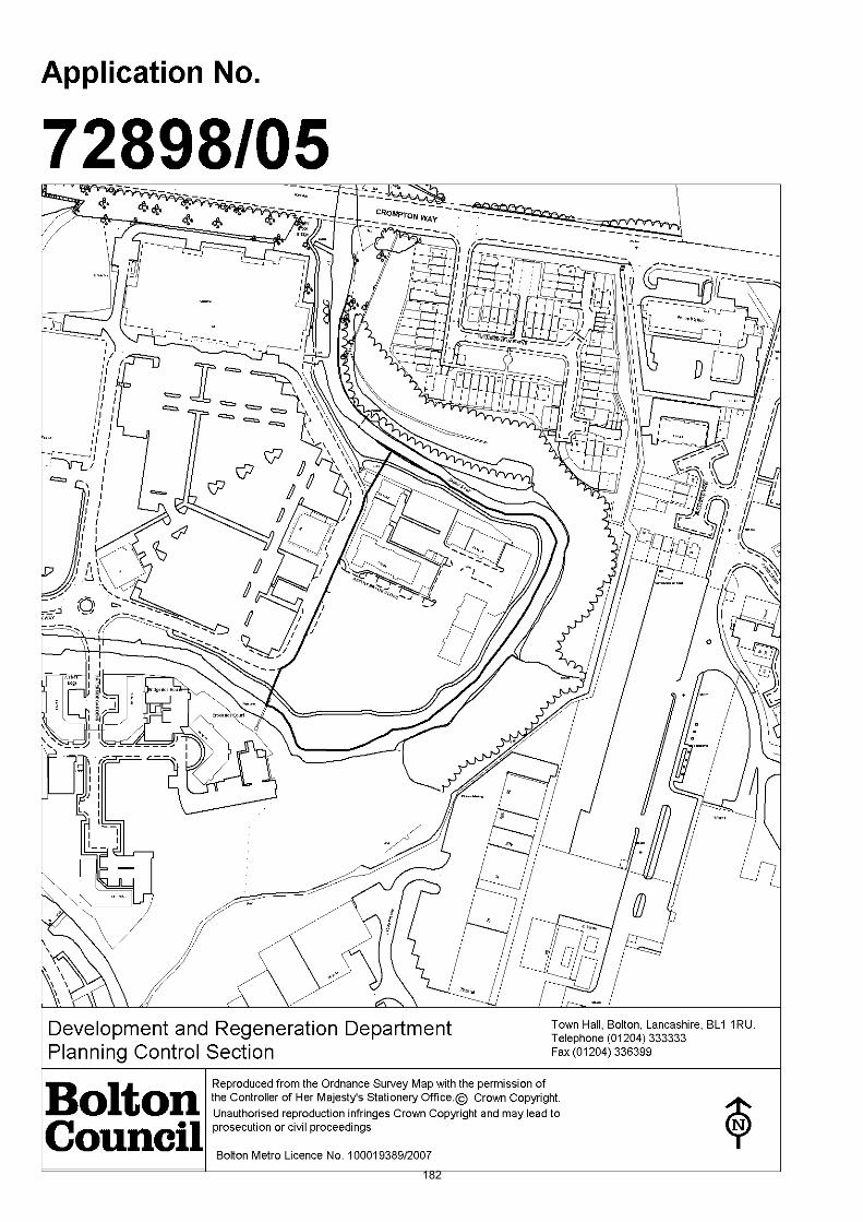
182
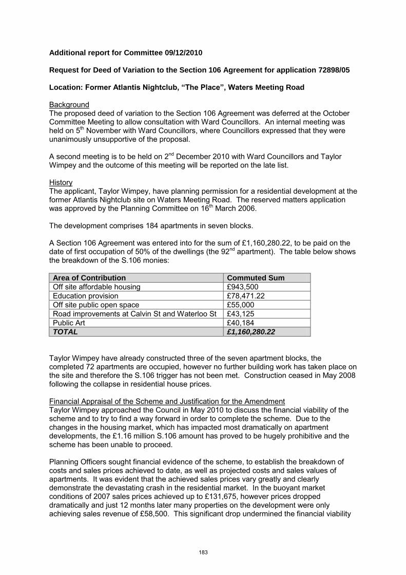
Additional report for Committee 09/12/2010 Request for Deed of Variation to the Section 106 Agreement for application 72898/05 Location: Former Atlantis Nightclub, “The Place”, Waters Meeting Road Background The proposed deed of variation to the Section 106 Agreement was deferred at the October Committee Meeting to allow consultation with Ward Councillors. An internal meeting was held on 5th November with Ward Councillors, where Councillors expressed that they were unanimously unsupportive of the proposal. A second meeting is to be held on 2nd December 2010 with Ward Councillors and Taylor Wimpey and the outcome of this meeting will be reported on the late list. History The applicant, Taylor Wimpey, have planning permission for a residential development at the former Atlantis Nightclub site on Waters Meeting Road. The reserved matters application was approved by the Planning Committee on 16th March 2006. The development comprises 184 apartments in seven blocks. A Section 106 Agreement was entered into for the sum of £1,160,280.22, to be paid on the date of first occupation of 50% of the dwellings (the 92nd apartment). The table below shows the breakdown of the S.106 monies:
Area of Contribution Commuted Sum
Off site affordable housing £943,500
Education provision £78,471.22
Off site public open space £55,000
Road improvements at Calvin St and Waterloo St £43,125
Public Art £40,184
TOTAL £1,160,280.22
Taylor Wimpey have already constructed three of the seven apartment blocks, the completed 72 apartments are occupied, however no further building work has taken place on the site and therefore the S.106 trigger has not been met. Construction ceased in May 2008 following the collapse in residential house prices. Financial Appraisal of the Scheme and Justification for the Amendment Taylor Wimpey approached the Council in May 2010 to discuss the financial viability of the scheme and to try to find a way forward in order to complete the scheme. Due to the changes in the housing market, which has impacted most dramatically on apartment developments, the £1.16 million S.106 amount has proved to be hugely prohibitive and the scheme has been unable to proceed. Planning Officers sought financial evidence of the scheme, to establish the breakdown of costs and sales prices achieved to date, as well as projected costs and sales values of apartments. It was evident that the achieved sales prices vary greatly and clearly demonstrate the devastating crash in the residential market. In the buoyant market conditions of 2007 sales prices achieved up to £131,675, however prices dropped dramatically and just 12 months later many properties on the development were only achieving sales revenue of £58,500. This significant drop undermined the financial viability
183
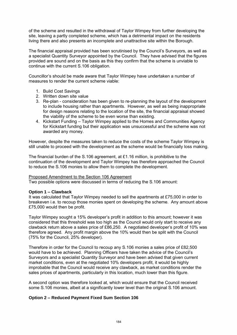
of the scheme and resulted in the withdrawal of Taylor Wimpey from further developing the site, leaving a partly completed scheme, which has a detrimental impact on the residents living there and also presents an incomplete and unattractive site within the Borough. The financial appraisal provided has been scrutinised by the Council‟s Surveyors, as well as a specialist Quantity Surveyor appointed by the Council. They have advised that the figures provided are sound and on the basis as this they confirm that the scheme is unviable to continue with the current S.106 obligation. Councillor‟s should be made aware that Taylor Wimpey have undertaken a number of measures to render the current scheme viable:
1. Build Cost Savings 2. Written down site value 3. Re-plan - consideration has been given to re-planning the layout of the development
to include housing rather than apartments. However, as well as being inappropriate for design reasons relating to the location of the site, the financial appraisal showed the viability of the scheme to be even worse than existing.
4. Kickstart Funding – Taylor Wimpey applied to the Homes and Communities Agency for Kickstart funding but their application was unsuccessful and the scheme was not awarded any money.
However, despite the measures taken to reduce the costs of the scheme Taylor Wimpey is still unable to proceed with the development as the scheme would be financially loss making. The financial burden of the S.106 agreement, at £1.16 million, is prohibitive to the continuation of the development and Taylor Wimpey has therefore approached the Council to reduce the S.106 monies to allow them to complete the development. Proposed Amendment to the Section 106 Agreement Two possible options were discussed in terms of reducing the S.106 amount: Option 1 – Clawback It was calculated that Taylor Wimpey needed to sell the apartments at £75,000 in order to breakeven i.e. to recoup those monies spent on developing the scheme. Any amount above £75,000 would then be profit. Taylor Wimpey sought a 15% developer‟s profit in addition to this amount; however it was considered that this threshold was too high as the Council would only start to receive any clawback return above a sales price of £86,250. A negotiated developer‟s profit of 10% was therefore agreed. Any profit margin above the 10% would then be split with the Council (75% for the Council, 25% developer). Therefore in order for the Council to recoup any S.106 monies a sales price of £82,500 would have to be achieved. Planning Officers have taken the advice of the Council‟s Surveyors and a specialist Quantity Surveyor and have been advised that given current market conditions, even at the negotiated 10% developers profit, it would be highly improbable that the Council would receive any clawback, as market conditions render the sales prices of apartments, particularly in this location, much lower than this figure. A second option was therefore looked at, which would ensure that the Council received some S.106 monies, albeit at a significantly lower level than the original S.106 amount. Option 2 – Reduced Payment Fixed Sum Section 106
184
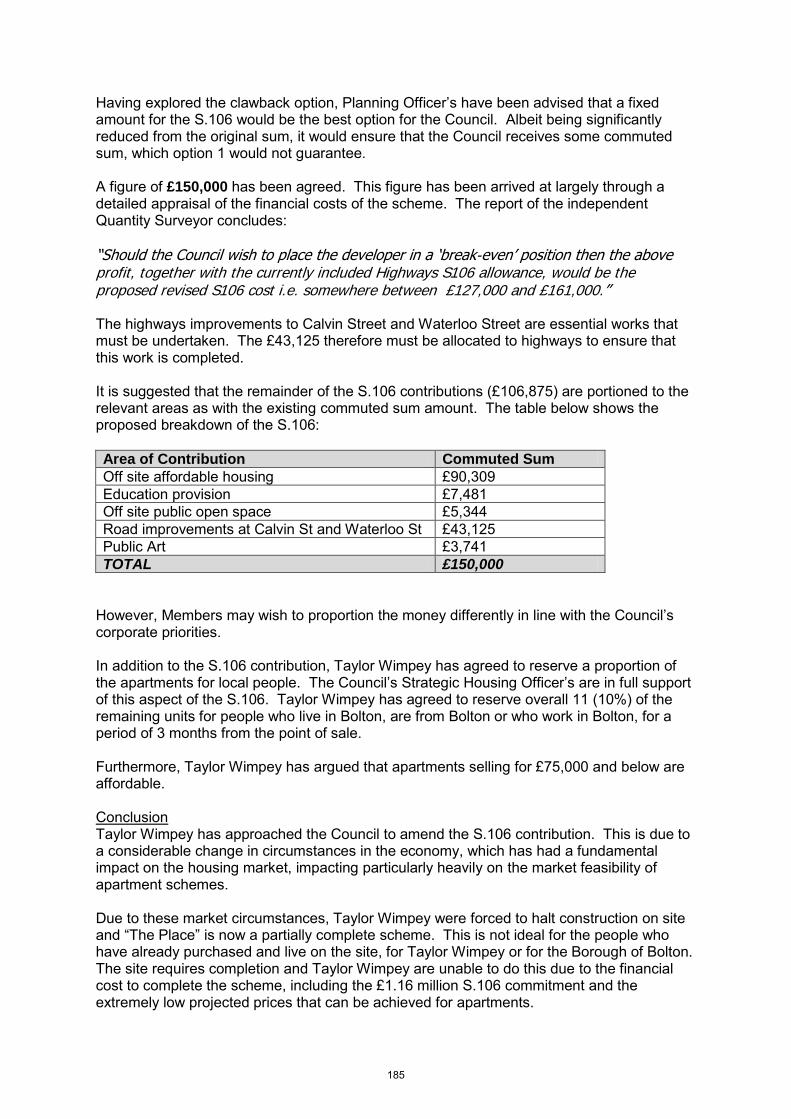
Having explored the clawback option, Planning Officer‟s have been advised that a fixed amount for the S.106 would be the best option for the Council. Albeit being significantly reduced from the original sum, it would ensure that the Council receives some commuted sum, which option 1 would not guarantee. A figure of £150,000 has been agreed. This figure has been arrived at largely through a detailed appraisal of the financial costs of the scheme. The report of the independent Quantity Surveyor concludes:
“Should the Council wish to place the developer in a „break-even‟ position then the above profit, together with the currently included Highways S106 allowance, would be the proposed revised S106 cost i.e. somewhere between £127,000 and £161,000.” The highways improvements to Calvin Street and Waterloo Street are essential works that must be undertaken. The £43,125 therefore must be allocated to highways to ensure that this work is completed. It is suggested that the remainder of the S.106 contributions (£106,875) are portioned to the relevant areas as with the existing commuted sum amount. The table below shows the proposed breakdown of the S.106:
Area of Contribution Commuted Sum
Off site affordable housing £90,309
Education provision £7,481
Off site public open space £5,344
Road improvements at Calvin St and Waterloo St £43,125
Public Art £3,741
TOTAL £150,000
However, Members may wish to proportion the money differently in line with the Council‟s corporate priorities. In addition to the S.106 contribution, Taylor Wimpey has agreed to reserve a proportion of the apartments for local people. The Council‟s Strategic Housing Officer‟s are in full support of this aspect of the S.106. Taylor Wimpey has agreed to reserve overall 11 (10%) of the remaining units for people who live in Bolton, are from Bolton or who work in Bolton, for a period of 3 months from the point of sale. Furthermore, Taylor Wimpey has argued that apartments selling for £75,000 and below are affordable. Conclusion Taylor Wimpey has approached the Council to amend the S.106 contribution. This is due to a considerable change in circumstances in the economy, which has had a fundamental impact on the housing market, impacting particularly heavily on the market feasibility of apartment schemes. Due to these market circumstances, Taylor Wimpey were forced to halt construction on site and “The Place” is now a partially complete scheme. This is not ideal for the people who have already purchased and live on the site, for Taylor Wimpey or for the Borough of Bolton. The site requires completion and Taylor Wimpey are unable to do this due to the financial cost to complete the scheme, including the £1.16 million S.106 commitment and the extremely low projected prices that can be achieved for apartments.
185
Taylor Wimpey has researched a number of ways to try to reduce costs and resume the development, including applying for „Kick Start‟ funding, however despite all attempts to do so, the costs of completing the scheme remain much higher than the total market value of the apartments. Taylor Wimpey has therefore approached the Council to amend the S.106 agreement. Two potential amendments to the S.106 have been looked into by Planning Officers, these being a clawback scheme or a fixed sum. The Council‟s Surveyors and a specialist Quantity Surveyor have advised the Council to agree upon a fixed sum S.106 of £150,000. Although this is significantly reduced from the original S.106 amount, the market conditions for apartment schemes must be taken into consideration as well as the benefits to the Borough of having a completed site, which is currently in a half finished state. In addition to the £150,000 Taylor Wimpey has also agreed to allocate 10% of the scheme to local people to ensure that they have a fair and reasonable opportunity to purchase apartments at the low market rates. Recommendation Members are recommended to approve the proposed deed of variation to the Section 106 Agreement at the “The Place” Waters Meeting Road.
186