planning commission report - santa monica...square-foot mixed project consisting of 40 residential...
TRANSCRIPT

Planning Commission Report
1
Planning Commission Meeting: December 6, 2017 Agenda Item: 5-B
To: Planning Commission From: Jing Yeo, AICP, City Planning Division Manager Subject: Development Review Permit No. 15ENT-00115 and Vesting Tentative
Parcel Map No. 16ENT-0155 to allow a new four-story (50 feet) 33,584 square-foot mixed project consisting of 40 residential units, 6,324 square-feet of ground floor commercial space, and 93 automobile parking spaces within a three-level subterranean parking garage.
Address: 601 Wilshire Boulevard Applicant: WNMS Properties
Recommended Action
It is recommended that the Planning Commission take the following actions subject to findings and/or conditions contained in Attachment B: 1. Approve Development Review Permit No. 16ENT-0115 based upon the findings
and subject to the conditions contained in the Statement of Official Action. 2. Approve Vesting Tentative Parcel Map No. 16ENT-0155 based upon the findings
and subject to the conditions contained in the Statement of Official Action. 3. Adopt the Statement of Official Action
Executive Summary
The applicant requests approval of a Development Review Permit (DRP) and a Vesting Tentative Map to construct a Tier 2, four-story (50 feet) mixed-use project with 40 residential units and 6,324 square-feet of ground floor commercial space. The project includes 93 vehicle parking spaces in a three-level subterranean parking garage and 75 bicycle parking spaces (10 short term, 65 long-term). The project site is located on the northeast corner of Wilshire Boulevard and 6th Street in the Mixed Use Boulevard (MUB) District. Pursuant to Santa Monica Municipal Code (SMMC) Section 9.40.020, a Development Review Permit (DRP) is required for any project that exceeds Tier 1 standards. The maximum Tier 1 limits for the MUB District are 3 stories (39 feet) in height, floor area ratio (FAR) of 1.5 for projects consisting of 100% residential uses above the ground floor, and include on-site affordable housing in compliance with the minimum requirements of the Affordable Housing Production Program (AHPP). The proposed four-story (50 feet) height and 2.25 FAR exceed the Tier 1 maximum limits and therefore, a DRP is required.
2
The Downtown Community Plan does not apply to pending projects where applications were deemed complete prior to November 16, 2016. Both applications for the proposed project were filed and deemed complete prior to November 16, 2016. Further, the applicant submitted a vesting tentative parcel map application on September 19, 2016. The purpose of the map is to subdivide the airspace between the residential and commercial components of the project for the applicant’s financing purposes. This is not a condo map which would permit the residential units to be sold individually. The application was determined complete on September 19, 2016. As a result, the Downtown Community Plan would not apply to this project since it is being reviewed under the development standards and regulations of the zoning ordinance in effect at the time the map application was deemed complete. Development Review Permit A DRP permit is intended to allow the construction of certain projects for which the design, siting, and use could result in an adverse impact on the surrounding area. As such, the DRP allows for discretionary review of the location, size, massing, and placement of the proposed structures and the location of the proposed uses on a site. Accordingly, the required findings identified in Section 9.40.050 of the Zoning Ordinance shall be made in the affirmative to approve a DRP. In addition to the required DRP findings provided in this report, the following issues should be considered by the Planning Commission in its review of the proposed project.
Whether the location, size, massing, and placement of the proposed structures on the site are appropriate and compatible with the surrounding neighborhood;
Whether the location of the proposed uses within the project are appropriate and compatible with the surrounding neighborhood;
Whether the project conforms with established standards in the Zoning Ordinance including consistency with the required community benefits in SMMC Chapter 9.23;
Wither the proposed siting and design should be permitted by weighing the public need for the benefit to be derived from the proposed site plan use against the impact which it may cause;
Whether the project is generally consistent with the Municipal Code and General Plan; and
Whether the project promotes the general welfare of the community. Project / Site Information The following table provides a brief summary of the project location. Additional information regarding the project’s compliance with applicable municipal regulations and the General Plan is available in Attachment A.

3
Table1: Project and Site Information
Site Location Map
Zoning District: Mixed Use Boulevard (MUB)
Land Use Element Designation: Mixed Use Boulevard
Parcel Area: 15,000 square feet
Parcel Dimensions: 100’ x 150’
Existing On-Site Improvements (Year Built): One-story commercial building (1977) (FedEx Office) Two-story commercial and office building (1922)
Rent Control Status: Commercial (Exempt)
Adjacent Zoning Districts and Land Uses: North: R2 (low density residential) East: MUB (commercial) South: DCP (mixed-use) West: MUBL (SGI-USA)
Historic Resource Inventory Not listed on HRI.
Existing Site Description
The project site consists of 15,000 square-feet and is located on the northeast corner of 6th Street and Wilshire Boulevard in the Mixed Use Boulevard (MUB) District. The

4
existing building improvements consist of one- and two-story commercial and office buildings (most notably identified as the site where FedEx Office is located). Adjacent uses on Wilshire Boulevard (across 6th Court alley) are a mix of office and retail uses and the adjacent uses on 6th Street are multi-unit residential. The proposed site encompasses a 100 feet by 150 feet property on a relatively flat parcel.
Figure 1: View of Existing Development on Wilshire Boulevard
Figure 2: View of Existing Development on 6th Street
Background
The applicant submitted the Development Review Permit (DRP) application for a Tier 2 project on August 9, 2016, and the Vesting Tentative Map application on September 19, 2016. Subsequent to plan revisions required for compliance with the development standards of the Zoning Ordinance, as well as changes to the project design in response to the comments provided by City staff, the project was presented to the Architectural Review Board (ARB) for a preliminary conceptual review, pursuant to Section 9.40.040 of the Zoning Ordinance.

5
Architectural Review Board Concept Review
The project concept was presented to the Architectural Review Board (ARB) on April 17, 2017. All Board members agreed the architectural idea was strong, appreciated the color and materials palette, and the lightness of the building. The ARB also made the following preliminary comments: Site Planning
The corner is an important gateway to Downtown. Consider providing a gathering space at the corner or along Wilshire Boulevard.
Pedestrian experience along Wilshire should be enhanced. Bike racks should be relocated so they don’t compete with outdoor dining. Movable pots are not encouraged.
Courtyard space must be developed as an amenity space, a space for social gatherings.
Provide improvements for units in the back.
Massing
Project massing is a concern. Recommend a break in the massing along Wilshire Boulevard, potentially a break in the bands, and/or create a stronger corner element.
Projecting balconies appear tacked on and should be better integrated into the design.
Materials and Details
Detailing of copper/glass panels is important. Use of 3 x 3 steel frame to support will appear too heavy.
Storefront design appears corporate with too much glazing. Consider breaking up tenant spaces.
Roof program or elements such as umbrellas, trees, canopies, trellises should not be visible, even from across the street.
The applicant has responded to the preliminary ARB comments by incorporating the following design revisions into the project: Site Planning
The ground floor has been broken-up with varied depths of the retail setback and solid walls have been added at the ground floor to reduce the amount of glazing.
The upper-level courtyard has been revised and now opens up to Wilshire Boulevard compared to the original proposal that featured an enclosed upper-level courtyard. The courtyard includes a seating/lounge area with landscaping.
Short-term bike racks have been located along Wilshire Boulevard and 6th Street.

6
Massing
A break in the building mass has been created on the upper floors on Wilshire Boulevard where a courtyard is now located.
The horizontal bands have been further refined as thinner elements towards the corners to further emphasize the framed glass.
The cantilevered balconies at the corner and side elevations have been recessed and integrated into the glass volume.
The roof deck has been set in approximately eight feet from the edge of the parapet walls. No tall landscaping, umbrellas, or canopies have been designed adjacent to the parapet walls that would be visible from the street level.
Materials and Details
The steel frame supporting the laminated glass with copper screen insert has been reduced to a 2 x 2 steel frame.
The ground floor glazing has been broken up with solid walls and staggering setback wall locations.
Condition of Approval No. 2 has been included in the Statement of Official Action (STOA) for the ARB to pay particular attention to the following design elements:
The break in the building on Wilshire Boulevard;
Detailing of copper/glass panels;
Potential breaks in the horizontal bands; and
Landscaping along Wilshire Boulevard and 6th Street.
Project Analysis Project Description The project is a four-story building with a maximum height of 50 feet consisting of 6,324 square-feet of ground floor commercial space, 40 residential units within 27,142 square feet, and a floor area ration (FAR) of 2.25. Additionally, the project includes 5,816 square-feet of open space consisting of 2,221 square-feet of common open space and 2,595 square-feet of private open space. The project includes 93 vehicle parking spaces in a three-level subterranean parking garage for the commercial tenants, residential tenants, and guests of the building. Bicycle parking spaces are proposed at grade and within the subterranean garage totaling 75 spaces (10 short-term spaces and 65 long-term spaces). The project’s residential component consists of 40 residential units with the following overall unit mix identified in Table 2.

7
Table 2: Project Unit Mix
Unit Type Number of Units Percentage
Studio 5 12.5%
1-BR 20 50%
2-BR 9 22.5%
3-BR 6 15%
The proposed affordable unit mix for the project would consist of the following:
One 1-bedroom units for 30% income households (Average size: 755 square-feet).
Two 2-bedrrom units for 30% income households (Average size: 875 square-feet).
As detailed further in this staff report, the proposed project complies with the required community benefits identified in Chapter 9.23 (Community Benefits) of the Zoning Ordinance for Tier 2 projects, which include at least 50% more affordable housing units than would otherwise be required by SMMC Section 9.64.050 (Affordable Housing Production Program) of the Zoning Ordinance, a unit mix of at least 15% 3-bedroom units, at least 20% 2-bedroom units, and no more than 15% studio units. Also, the average number of bedrooms for all of the affordable units in a Tier 2 project shall be equal to or greater than the average number of bedrooms for all the market rate units in the project. Project Design + Site Planning As illustrated in Figure 2 below, the proposed building design is modern/contemporary. The ground floor is comprised of expansive glazing at the commercial frontage for transparency at the pedestrian level and space for outdoor seating/dining. The upper-floors feature a significant amount of glazing, horizontal bands, vertical elements, and a break in the building along Wilshire Boulevard that features a 917 square-foot deck overlooking Wilshire Boulevard. The floor plan layouts feature single-loaded corridors with opportunity for cross ventilation. The roof features a 1,304 square-foot common deck space over-looking 6th Street and Wilshire Boulevard.

8
Figure 4: Rendering at the Corner of 6th Street and Wilshire Boulevard
Figure 5: Rendering of Wilshire Boulevard
9
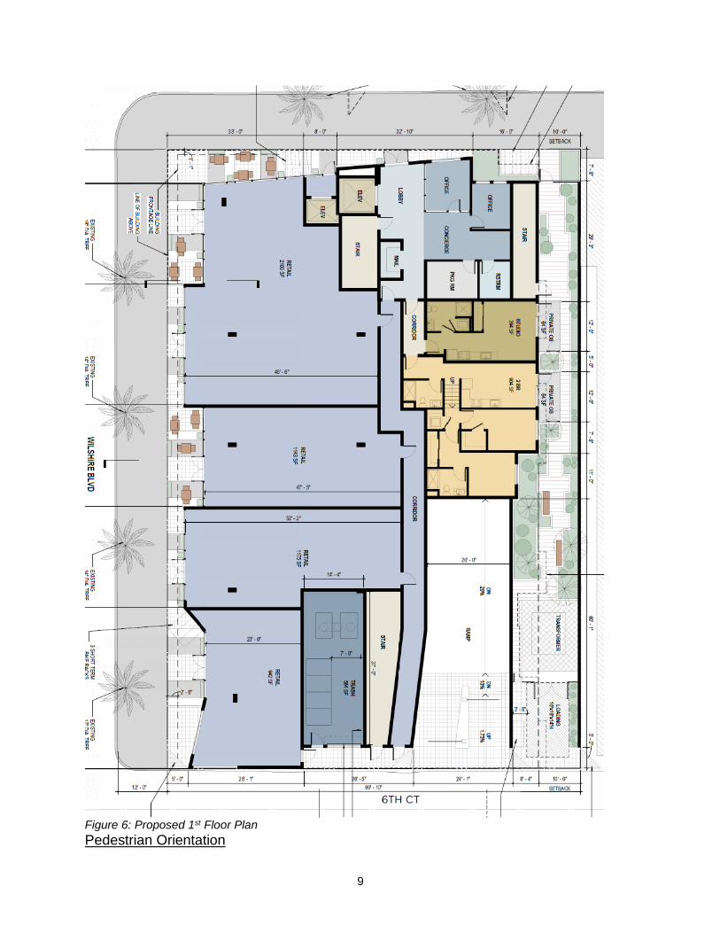
Figure 6: Proposed 1st Floor Plan Pedestrian Orientation

10
Although not required, the building is proposed to be setback four feet from the property line along Wilshire Boulevard resulting in the building being setback 16-foot-6-inches from the curb. For reference, the Downtown Community Plan would have required a 15-foot ground floor setback on Wilshire Boulevard. Additionally, the proposed setback is within the maximum front setback allowed in the MUB District for buildings with ground floor nonresidential uses, as required by section SMMC Section 9.11.030(C). The intent of this ‘Build-to Line’ development standard is to enhance the building’s prominence of nonresidential uses at the ground level by requiring a significant portion of the building to be placed near the front property line thereby enhancing its pedestrian orientation and activating the sidewalk. The proposed 16-feet-6-inch wide building setback from the curb would provide opportunities for outdoor dining. Active Commercial Design and Use
Figure 7: Wilshire Blvd Elevation showing 75% transparent façade of the commercial street frontage.
The ground floor commercial tenant space has a depth that ranges from approximately 33 feet to 52 feet (average of 42 feet 8 inches) for approximately 62 percent of the ground floor street frontage. Additionally, a floor-to-floor height of approximately 15 feet is proposed for the commercial ground floor areas. As proposed, the design complies with the MUB District standards for Active Commercial Design that require a minimum depth of 40 feet and a minimum floor-to-floor height of 15 feet for at least 60 percent of the ground floor frontage. Additionally, a significant amount of glazing is provided along the storefront that satisfies the transparency requirement for street-facing façades in SMMC Section 9.11.030(A)(3), whereby a minimum of 70% of the façade facing a commercial street shall be transparent and include windows, doors, and other openings between 2.5 and 8 feet above finished grade. Furthermore, SMMC Section 9.11.030(A)(2) restricts the uses allowed within the Active Commercial Design area identified above to accommodate certain active and pedestrian-oriented uses such as retail sales, restaurants, and personal services. The proposed project design complies with the applicable design and use requirements; however, the following recommended Conditional of Approval (No. 1) is included in the attached Draft Statement of Official Action to further reinforce the requirement that the project satisfy the Active Commercial Design and Active Use requirements on the Zoning Ordinance.

11
1. The project shall comply with subsections (A), (B), and (C) of SMMC Section 9.11.030, regulating the Active Commercial Design, Active Use, Pedestrian-Oriented Design, and Build-to Line requirements for the ground floor street frontage of new buildings on commercial boulevards.
Open Space According to SMMC Section 9.11.030, the project must provide a minimum 100 square-feet of open space per unit of which a minimum of 60 square-feet per unit must be provided as private open space. Moreover, according to SMMC Section 9.21.090, common outdoor living areas located on the ground floor shall be no less than 20 feet by 20 feet in dimension, and roof decks shall be at least 15 feet by 15 feet. Private outdoor area located at the ground level shall be no less than 10-feet-long by 4-feet-deep, and private outdoor areas located above the ground level shall be no less than 6-feet-long by 4-feet-deep. The proposed project contains 40 units, which requires a minimum of 4,000 square-feet of overall open space for the project. As described previously, the project includes 5,816 square-feet of open space consisting of 2,221 square-feet of common open space and 3,595 square-feet of private open space. The 3,595 square-feet of private open space proposed would be provided as balconies and distributed amongst the 40 units for an average of 89 square-feet of private open space per unit. Further, all individual balconies would be a minimum of 60 square-feet which complies with the minimum private open space requirements identified above. A breakdown of the 2,221 square-feet of common open space proposed for the project is identified in Table 2 below: Table 2: Common Open Space. Shown on Sheet A120 and A150 of Project Plans.
Open Space Type Location Size
Courtyard Second Floor 917 Sq. Ft.
Deck Roof 1,304 Sq. Ft.
Total 2,221 Sq. Ft.
As proposed, the project complies with the minimum open space requirements of the Zoning Ordinance by providing overall open space in the amount of 5,816 square-feet (average of 145 square-feet per unit), of which, 3,959 square feet (average 89 square-feet per unit) is private open space. Building Mass + Modulation The proposed height of the building is four stories and 50 feet, consistent with the Tier 2 limits established for the MUB District. The project site is only 15,000 square-feet, so the project does not exceed the Tier 2 maximum footprint of 35,000 square-feet. The building’s glass façade is framed by a horizontal band with an average setback of 5 feet 6 inches on 6th Street and Wilshire Boulevard, which complies with the minimum 5-foot Zoning Ordinance upper-story setback requirement. Lastly, the north elevation complies with the daylight plane adjacent to residential development standard, and measuring 25

12
feet in height at the parcel line abutting the residential property to the north, and sloping upward at a 45-degree angle toward the subject property. By combining all of these MUB District design standards for Tier 2 projects, the applicant has designed a project that has an appropriate mass and scale for a mixed-use project on this block of Wilshire Boulevard that is adjacent to residential and commercial uses.
Figure 7: 6th Street Showing Massing Daylight Plane Adjacent to Multi-Unit Residential District
Vehicle Parking and Access and Bicycle Parking Vehicle Parking The three-level subterranean garage is designed with a driveway access from 6th Court (alley). The subterranean garage includes 93 parking spaces for residents, guests, and commercial uses. The first level of the subterranean garage contains 21 commercial spaces and 8 guest parking spaces for residential units. The second and third levels in the subterranean garage contain the remaining required 62 residential parking spaces as further detailed in the following table: Table 3: Vehicle Parking
Use Parking Requirement Parking Required
Residential Units Studio 1-bedroom 2-bedroom 3-bedroom Affordable 1-bedroom Affordable 2-bedroom Guest
5 units @ 1 spaces 20 units @ 1.5 spaces 7 units @ 2 spaces 6 units @ 2 spaces 1 unit @ 0.75 spaces 2 units @ 1 spaces 5 units @ 1/5 spaces
5 spaces 30 spaces 14 spaces 12 spaces 0.75 spaces 2 spaces 8 spaces
Commercial Tenant Space 6,324 / 300 spaces 21 spaces
Total Required 92 spaces
Proposed 93 spaces

13
Bicycle Parking The project includes 75 bicycle parking spaces which consist of 10 short-term spaces and 65 long-term spaces, as further detailed by assigned use in the following Table: Table 4: Bicycle Parking
Use Parking Requirement Parking Required
Residential 40 units 61 bedrooms
Long-term 1 space / bedroom Short-term 10% of long-term; 2 spaces
61 spaces 6 spaces
Commercial 6,338 square feet
Long-term 1 space per 3,000 square feet; minimum 4 spaces. Short-term 1 space per 4,000 square feet; minimum 4 spaces.
4 spaces 4 spaces
Long-term 65 spaces
Short-term 10 spaces
As shown, the proposed number of bicycle parking spaces comply with the minimum requirements of the Zoning Ordinance. Long-term bicycle parking for the residents would be located in the P2 level in the subterranean parking garage in a secured area. Short-term bicycle parking for both the residents and commercial users of the building would be located on the ground floor along 6th Street and Wilshire Boulevard. The design, number, and location of bicycle parking stalls will be reviewed by the City’s Mobility Division for compliance with the requirements of the Zoning Ordinance as part of the plan check process prior to the issuance of building permits. Zoning Code Compliance The DRP application was submitted on August 8, 2016. The applicant subsequently submitted a tentative vesting map on September 19, 2016, which was determined complete prior to the adoption of the Downtown Community Plan (DCP). As a result, the project is being processed under the development standards and regulations of the 2015 Zoning Ordinance in effect at the time the application was determined complete. The project is located in the MUB District, which establishes property development standards that govern height, FAR, and setbacks of the proposed building. Furthermore, the MUB District was intended to facilitate the transformation of sections of boulevards into vibrant, highly walkable areas with broad, pedestrian friendly sidewalks, trees, landscaping, and local-serving uses with new buildings that step down in relationship to the scale and character of adjacent low density districts. According to SMMC Section 9.40.020, a Development Review Permit (DRP) is required for any project that exceeds the Tier 1 maximum standards. The established Tier 1 limits in the MUB District are three stories / 39 feet in height and a floor area ratio (FAR)

14
of 1.5 for projects including on-site affordable housing. The proposed project is four stories / 50 feet in height with a FAR of 2.25. As such, a DRP is requested for the project. Development standards for the project in the MUB District for a Tier 2 project allow for a maximum of 50 feet (no limitation of stories) and 2.25 FAR. As indicated above, the project is within the established maximums to qualify as a Tier 2 project. Additionally, the Zoning Ordinance contains general development standards that are applicable to all commercial and mixed-use districts addressing active commercial retail, pedestrian orientation, build-to line, and daylight plan adjacent to residential districts. As proposed, the project complies with all development standards applicable to the site. Attachment A to this staff report contains a detailed comparison of these development standards and the proposed project. Tier 2 Community Benefits In accordance with SMMC Section Chapter 9.23 (Community Benefits), projects that exceed the maximum height or FAR allowed for Tier 1 projects are required to provide the community benefits outlined in subsection 9.23.030 of the Chapter. The purpose of the community benefits is to ensure that projects are allowed to exceed the base height and FAR of a respective zoning district, and in return provide community benefits that enhance the City’s community character. The project would provide the following community benefits in accordance of Chapter 9.23: 1. Affordable Housing
Pursuant to SMMC Section 9.23.030(A)(1)(a), the project shall incorporate at least 50 percent more affordable housing units than would be required pursuant Section SMMC Section 9.64.050 (Affordable Housing Production Program (AHPP) – On-site Option). The applicant is proposing on-site residential units affordable to 30 percent income households. Per the AHPP, a minimum of five percent of the total units of a residential project shall be provided at this income level. As such, the AHPP requires a minimum of two residential units affordable to 30 percent income households. The applicant is proposing three residential units at the 30 percent income level of affordability, which equals 7.5 percent of the total project and a 50 percent increase over the minimum 5 percent required by the AHPP. The proposed three residential units affordable to 30 percent income households (7.5 percent of the total 40 units) to be provided on-site are as follows:
One 1-bedroom unit
Two 2-bedroom units

15
2. Unit Mix
According to SMMC 9.23.030, projects shall incorporate the following unit mix requirements:
Market rate units:
o Minimum 15% 3-bedroom units o Minimum 20% 2-bedroom units o Maximum 15% studios o Average number of bedrooms for market rate units combined shall
be 1.2 or greater.
Affordable housing units:
o The average number of bedrooms for all of the affordable housing units shall be equal to or greater than the average number of bedrooms provided for all of the market rate units.
Tables 4 and 5 below show the market rate unit mix and average number of bedrooms, as they relate to Chapter 9.23 requirements for the proposed project.
Unit Type Number of Units Percentage Number of bedrooms
Studio 5 12.5% (Max. 15% allowed)
0
1-BR 20 50% 20
2-BR 9 22.5% (Min. 20% required)
18
3-BR 6 15% (Min. 15% required)
18
TOTAL 40 -- 56
Average Number of Bedrooms 1.4
Table 5: Market Rate Unit Mix
Unit Type Number of Units Percentage Number of bedrooms
1-BR 1 2.5% 1
2-BR 2 5% 4
TOTAL 3 7.5 5
Average Number of Bedrooms 1.66
Table 6: Affordable Unit Mix
As proposed, the market rate units meet the unit mix requirements, as established in Section 9.23.030(A)(2)(a) of the Zoning Ordinance. Additionally, the average number of bedrooms for the market rate units combine is greater than the minimum 1.2 required. Lastly, the average number of bedrooms for all affordable units combined is greater than the average number of bedrooms for all of the market rate units, as required by subsection (b) of the same section.

16
3. Affordable Housing Commercial Linkage Fee Program
Non-residential and mixed-use projects shall pay a housing mitigation fee 14 percent above the base Affordable Housing Commercial Linkage Fee as required by SMMC Chapter 9.68, for that portion of the commercial floor area above the maximum Tier 1 floor area. Additionally, the ordinance establishing the fee allows for a credit in the calculation of the Affordable Housing Commercial Linkage Fee for the amount of square footage demolished in an existing building. The demolished retail floor area of 7,727 square feet associated with the existing building is greater than the 6,324 square feet of retail floor area to be developed; therefore, the applicant fee credit is greater than the assessed fee amount. The estimated fee is: $0.
4. Transportation Impact Fee Program
Non-residential and mixed-use projects shall pay a Transportation Impact Fee (TIF) 14 percent above the base TIF, as required by SMMC Chapter 9.66, for that portion of the floor area above the maximum Tier 1 floor area. Additionally, the ordinance establishing the fee allows for a credit in the calculation of the TIF for the amount of square footage demolished in an existing building. Based on a calculated MUB District Tier 1 floor area of 22,500 square feet (1.5 FAR), 40 residential units, and the credit for the existing retail floor area of 7,727 square feet to be demolished, the estimated fee is: $149,137.
5. Parks and Recreation Development Impact Fee Program
All Tier 2 projects shall either pay an additional Open Space Fee (OSF) 14 percent above the base fee required by Chapter 9.67, Open Space Fee Program, for that portion of the floor area above the maximum Tier 1 floor area. Additionally, the ordinance establishing the fee allows for a credit in the calculation of the fee for the amount of square footage demolished in an existing building. Based on a calculated Tier 1 floor area 22,500 square feet (1.5 FAR), 40 units, and the credit for the existing retail floor area of 7,727 square feet to be demolished, the estimated fee is: $225,548.
6. Transportation Demand Management (TDM) Plan
All Tier 2 projects shall include the following Transportation Demand Management measures in addition to those required by Chapter 9.53, Transportation Demand Management: 1. For non-residential components of projects, provide the following:
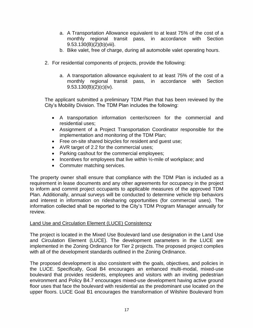
17
a. A Transportation Allowance equivalent to at least 75% of the cost of a monthly regional transit pass, in accordance with Section 9.53.130(B)(2)(b)(viii).
b. Bike valet, free of charge, during all automobile valet operating hours.
2. For residential components of projects, provide the following:
a. A transportation allowance equivalent to at least 75% of the cost of a monthly regional transit pass, in accordance with Section 9.53.130(B)(2)(c)(iv).
The applicant submitted a preliminary TDM Plan that has been reviewed by the City’s Mobility Division. The TDM Plan includes the following:
A transportation information center/screen for the commercial and residential uses;
Assignment of a Project Transportation Coordinator responsible for the implementation and monitoring of the TDM Plan;
Free on-site shared bicycles for resident and guest use;
AVR target of 2.2 for the commercial uses;
Parking cashout for the commercial employees;
Incentives for employees that live within ½-mile of workplace; and
Commuter matching services.
The property owner shall ensure that compliance with the TDM Plan is included as a requirement in lease documents and any other agreements for occupancy in the project to inform and commit project occupants to applicable measures of the approved TDM Plan. Additionally, annual surveys will be conducted to determine vehicle trip behaviors and interest in information on ridesharing opportunities (for commercial uses). The information collected shall be reported to the City’s TDM Program Manager annually for review. Land Use and Circulation Element (LUCE) Consistency
The project is located in the Mixed Use Boulevard land use designation in the Land Use and Circulation Element (LUCE). The development parameters in the LUCE are implemented in the Zoning Ordinance for Tier 2 projects. The proposed project complies with all of the development standards outlined in the Zoning Ordinance. The proposed development is also consistent with the goals, objectives, and policies in the LUCE. Specifically, Goal B4 encourages an enhanced multi-modal, mixed-use boulevard that provides residents, employees and visitors with an inviting pedestrian environment and Policy B4.7 encourages mixed-use development having active ground floor uses that face the boulevard with residential as the predominant use located on the upper floors. LUCE Goal B1 encourages the transformation of Wilshire Boulevard from

18
a vehicle dominated street into a livable, enhanced pedestrian open space that is well served by transit and includes a local-serving mix of uses. Specifically, Policy B1.9 seeks to ensure that new commercial or mixed-use buildings adjacent to residential districts are contained within a prescribed building envelope that steps down toward the residential district to maintain access to light and air. The proposed project complies with these goals and policies in that it is a mixed-use building with ground floor uses that face Wilshire Boulevard with residential as the proposed use on the upper floors. Additionally, the proposed building complies with the building height volume that steps down toward the low-density multi-family residential neighborhood adjacent to the north side of the property. Environmental Status
The proposed four-story mixed use building is exempt from the provisions of the California Environmental Quality Act (CEQA) pursuant to Section 21155.1 of the CEQA Guidelines, which exempts a special class of Transit Priority Project (TPP) determined to be a Sustainable Communities Project (SCP) by the local jurisdiction. As provided in Attachment D, the proposed project meets all of the following requirements set forth in Section 21155.1 as a Sustainable Communities Project:
1. The project is consistent with the general land use designation, density, building, intensity, and policies in the Southern California Association of Governments’ adopted Sustainable Communities Strategy.
2. The project is at least 50 percent residential use based on area and greater than 0.75 FAR.
3. The project is at least 20 units/acre. 4. The project is located within ½ mile of a major transit stop or high quality transit
corridor included in SCAG’s Regional Transportation Plan. 5. The project can be adequately served by existing utilities and the project
applicant will pay in-lieu or development fees. 6. The project will not impact wetlands or other biological species. 7. The project site is not located on a list of hazardous waste sites compiled
pursuant to Section 65962.25 of Government Code. 8. The project site has been subject to a preliminary endangerment assessment to
determine the existence of any release of hazardous substance on the site and to determine the potential for exposure to significant health hazards.
9. The project will not have an impact on historical resources. 10. The project site is not subject to wildland fire hazards, high fire risk or explosion,
risk of a public health exposure, seismic risk, or landslide or flood hazard. 11. The project site is not located on developed open space. 12. The project is 15 percent more efficient than Title 24 standards and using 25
percent less water than the regional average household. 13. The project site is less than 8 acres. 14. The project is less than 200 units.

19
15. The project will not result in any net loss in the number of affordable housing units.
16. The project does not include any single level building exceeding 75,000 sf. 17. The project will incorporate any applicable mitigation measure or performance
standards adopted in the prior LUCE EIR. 18. The project would not conflict with nearby operating industrial uses, as no such
uses exist nearby. 19. The project site is located within ½ mile of a rail station included in the RTP or
within ¼ mile of a High Quality Transit Corridor included in the RTP. 20. The project meets the requirement that at least five percent of the housing will be
available to very-low-income households for at least 55 years. Therefore, based on the above, the proposed project is considered a Sustainable Communities Project that is exempt from CEQA pursuant to Section 21155.1. Alternative Actions:
In addition to the recommended action, the Planning Commission could consider the following with respect to the project if supported by the evidentiary record and consistent with applicable legal requirements:
A1. Continue the project for specific reasons (note as applicable), consistent with applicable deadlines and with agreement from the applicant
A2. Articulate revised findings and/or conditions to Approve OR Deny, with or without prejudice, the subject application
Conclusion The applicant requests approval of a Development Review Permit to construct a Tier 2, 50-foot-tall, 4-story, mixed-use apartment building with 40 units and 6,324 square-feet of ground floor commercial space. The project includes 93 vehicle parking spaces and in a three-level subterranean parking garage, as well as 75 bicycle parking spaces (10 short-term, 65 long-term) throughout the project site. The Tier 2 project would provide the standard community benefits outlined in the Municipal Code including a minimum unit mix, a minimum average number of bedrooms, 50% more affordable housing than required by the AHPP, enhanced development impact fees, and a TDM plan. Staff recommends approval of this proposed project. Prepared by: Russell W. Bunim, AICP, Acting Senior Planner Attachments A. General Plan and Municipal Code Compliance Worksheet B. Draft Statement of Official Action C. Public Notification D. CEQA Exemption Checklist and Documentation E. Project Plans

20 Attachment A General Plan & Municipal Code Compliance Worksheet
ATTACHMENT A GENERAL PLAN AND MUNICIPAL CODE COMPLIANCE WORKSHEET
Project Location and Permit Processing Time Limits
Project Address: 601 Wilshire Boulevard
Application Filing Date: Deemed Complete:
16ENT-0115 (DR): August 9, 2016 16ENT-0155 (VTPM): September 19, 2016 16ENT-0115 (DR): November 7, 2016 16ENT-0155 (VTPM): October, 27, 2016
CEQA Deadline: April 26, 2017
PSA Deadline: December 6, 2017 with extension
Total Process Review Time (Days):
395 days
General Plan and Municipal Code Compliance Worksheet
CATEGORY
LAND USE ELEMENT
MUNICIPAL CODE
PROJECT
Permitted Use Mixed-use Boulevard
Mixed-use Boulevard Mixed-use project. Residential and commercial.
Height of Building Tier 2. 50 feet. Tier 2. 50 feet. 50 feet.
Number of Stories Tier 2 with affordable housing on site. No limit.
Tier 2 with affordable housing on-site. No limit.
4 stories.
Setbacks Street facing
Interior side yard Stepbacks
N/A N/A N/A
Average 5’ for street facing façades. Interior side: 10’. Side daylight plane for interior side adjacent to residential district.
Wilshire Blvd: 5.58 feet.
6th Street: 5.43 feet.
10 feet.
Plans show dimensions and daylight plane compliance.
Building Height Projections
N/A Parapets as required by law. Mechanical rooms: 12 feet. Stairwells: 14 feet Elevators: 18 feet
42 inches Mechanical room: 5 feet Stairwells: 12 feet Elevators: 18 feet
F.A.R. Tier 2: 2.25 Tier 2: 2.25 2.5

Attachment A General Plan & Municipal Code Compliance Worksheet
21
Parking Access Alley access is encouraged when alley exists.
Alley access is required when alley exists, with exceptions per Sec. 9.28.120(B).
Alley access is provided.
Parking Space Number N/A Commercial: 6,342 / 300 = 21 Residential: 64 Guests: 8 Total: 93
93 spaces provided.
Compact Parking % N/A 40% maximum = 37 spaces.
27 compact spaces.
Bicycle Parking N/A Commercial: Short term: 4 Long term: 4 Residential Short term: 6 Long term: 61
Commercial: Short term: 4 Long term: 4 Residential Short term: 6 Long term: 61
75 Total
Loading Spaces N/A 1 space required.
9.28.080
1 loading space provided.
Trash Area N/A Trash enclosure with minimum 5'- 8' solid wall and gate is required.
Secured trash room provided at ground level at rear of building.
Mechanical Equipment Screening
N/A Mechanical equipment extending more than 12" above roof parapet shall be fully screened from a horizontal plane.
Mechanical equipment located on the roof and screened.
Location of Mechanical Equipment
N/A Not permitted on side of building if adjacent to a residential building on an adjoining lot.
Mechanical equipment located on the roof and screened.
Parking Area Screen N/A Screening required. Subterranean.
Private Open Space N/A 100 square feet per unit.
Minimum 60 square feet private open space per unit.
Average 145 square feet per unit.
Average 89 square feet private open space per unit
Planting Areas N/A Setback areas adjoining streets.
Interior or rear. At least 50% or 3 ft in width.
All street sides contain walking and dining for pedestrian orientation.
The north side contains 3 ft wide landscaping.

Attachment A General Plan & Municipal Code Compliance Worksheet
22
Inclusionary Units/Fees N/A Must provide 3 deed restricted units affordable to 30% income households.
3 deed restricted affordable units affordable to 30% income households.
Park and Recreation Development Impact Fee Private Developer Cultural Arts Requirement Child Care Linkage Requirements Affordable Housing Commercial Linkage Fee Transportation Impact Fee Transportation Demand Management Fee
$225,548.10 $129,388.00 $6,032.40 $0.00 $149,137.20 $0.00
Historic Resources Inventory
N/A
Project not listed on HRI.

23 Attachment B Draft Statement of Official Action
ATTACHMENT B DRAFT STATEMENT OF OFFICIAL ACTION
City of Santa Monica City Planning Division
PLANNING COMMISSION STATEMENT OF OFFICIAL ACTION
PROJECT INFORMATION CASE NUMBER: 16ENT-0115 LOCATION: 601 Wilshire Boulevard APPLICANT: Jesse Ottinger, Killefer Flammang Architects PROPERTY OWNER: WNMS Architects CASE PLANNER: Russell W. Bunim, AICP, Acting Senior Planner REQUEST: Development Review Permit No. 16ENT-0115 and
Vesting Tentative Parcel Map No. 16ENT-0155 to allow a new four-story (50 feet) 33,584 square-foot mixed project consisting of 40 residential units, 6,324 square-feet of ground floor commercial space, and 93 automobile parking spaces within a three-level subterranean parking garage.
AFFORDABLE HOUSING: 3 units affordable to 30% income households
One 1-BR units
Two 2-BR units CEQA STATUS: The proposed five-story mixed use building is exempt
from the provisions of the California Environmental Quality Act (CEQA) pursuant to Section 21155.1 of the CEQA Guidelines, which exempts a special class of Transit Priority Project (TPP) determined to be a Sustainable Communities Project (SCP) by the local jurisdiction.
Attachment B Draft Statement of Official Action
24
PLANNING COMMISSION ACTION
December 6, 2017 Determination Date
Approved based on the following findings and subject to the conditions below.
Denied.
Other:
EFFECTIVE DATES OF ACTIONS IF NOT APPEALED:
16ENT-0155: December 17, 2017 16ENT-0115: December 21, 2017
EXPIRATION DATE OF ANY PERMITS GRANTED:
16ENT-0155: December 17, 2019 16ENT-0115: December 21, 2019
LENGTH OF ANY POSSIBLE EXTENSION OF EXPIRATION DATES*:
16ENT-0155: Maximum three (3) years with Planning Commission approval 16ENT-0115: One year
* Any request for an extension of the expiration date must be received in the City
Planning Division prior to expiration of this permit. Each and all of the findings and determinations are based on the competent and substantial evidence, both oral and written, contained in the entire record relating to the Project. All summaries of information contained herein or in the findings are based on the substantial evidence in the record. The absence of any particular fact from any such summary is not an indication that a particular finding is not based in part on that fact. FINDINGS: DEVELOPMENT REVIEW FINDINGS A. The physical location, size, massing, and placement of proposed structures on
the site and the location of proposed uses within the project are compatible with and relate harmoniously to surrounding sites and neighborhoods, in that the proposed project includes a mixed-use commercial and residential building that complies with the Mixed Use Boulevard (MUB) District development standards. The proposed commercial and residential land uses relate harmoniously to the existing residential development along 6th Street and the mix of uses along Wilshire Boulevard. The building is proposed to be setback four feet from the property line along Wilshire Boulevard resulting in the building being setback 16-foot-6-inches from the curb. For reference, the Downtown Community Plan would have required a 15-foot ground floor setback on Wilshire Boulevard. Additionally, the proposed setback is within the maximum front setback allowed in the MUB District for buildings with ground floor nonresidential uses, as required by section SMMC Section 9.11.030(C). The intent of this ‘Build-to Line’ development standard is to enhance the building’s prominence of nonresidential

Attachment B Draft Statement of Official Action
25
uses at the ground level by requiring a significant portion of the building to be placed near the front property line thereby enhancing its pedestrian orientation and activating the sidewalk. The proposed 16-feet-6-inch wide building setback from the curb would provide opportunities for outdoor dining. Lastly, the north elevation complies with the daylight plane adjacent to residential development standard, and measuring 25 feet in height at the parcel line abutting the residential property to the north, and sloping upward at a 45-degree angle toward the subject property.
B. The rights-of-way can accommodate autos and pedestrians, including parking
and access, in that the project will provide 93 parking spaces in a three-level subterranean garage with vehicle access from 6th Street Court (alley). Furthermore, the project includes pedestrian entrances to the residential units from 6th Street and commercial tenant spaces from 6th Street and Wilshire Boulevard. Ten (four commercial and six residential) short-term bicycle spaces are conveniently located on along the building frontages on 6th Street and Wilshire Boulevard.
C. The health and safety services (police, fire, etc.) and public infrastructure (e.g.
utilities) are sufficient to accommodate the new development, in that the proposed development is located in and urbanized area that is already adequately served by existing City infrastructure. No new safety services or public infrastructure will be required for this project.
D. The project is generally consistent with the Municipal Code and General Plan, in
that the project is located in the Mixed Use Boulevard land use designation in the Land Use and Circulation Element (LUCE). The development parameters in the LUCE are implemented in the Zoning Ordinance for Tier 2 projects. The proposed project complies with all of the development standards outlined in the Zoning Ordinance. The proposed development is also consistent with the goals, objectives, and policies in the LUCE. The project is located in the Mixed Use Boulevard land use designation in the Land Use and Circulation Element (LUCE). The development parameters in the LUCE are implemented in the Zoning Ordinance for Tier 2 projects. The proposed project complies with all of the development standards outlined in the Zoning Ordinance. The proposed development is also consistent with the goals, objectives, and policies in the LUCE. Specifically, Goal B4 encourages an enhanced multi-modal, mixed-use boulevard that provides residents, employees and visitors with an inviting pedestrian environment and Policy B4.7 encourages mixed-use development having active ground floor uses that face the boulevard with residential as the predominant use located on the upper floors. LUCE Goal B1 encourages the transformation of Wilshire Boulevard from a vehicle dominated street into a livable, enhanced pedestrian open space that is well served by transit and includes a local-serving mix of uses. Specifically, Policy B1.9 seeks to ensure that new commercial or mixed-use buildings adjacent to residential districts are contained within a prescribed building envelope that steps down toward the

Attachment B Draft Statement of Official Action
26
residential district to maintain access to light and air. The proposed project complies with these goals and policies in that it is a mixed-use building with ground floor uses that face Wilshire Boulevard with residential as the proposed use on the upper floors. Additionally, the proposed building complies with the building height volume that steps down toward the low-density multi-family residential neighborhood adjacent to the north side of the property.
E. Based on environmental review, the proposed project has no potentially significant environmental impacts in that the proposed four-story mixed-use building is exempt from the provisions of the California Environmental Quality Act (CEQA) pursuant to Section 21155.1 of the CEQA Guidelines, which exempts a special class of Transit Priority Project (TPP) determined to be a Sustainable Communities Project (SCP) As provided in the CEQA exemption report, dated November 20, 2017, and attached to the staff report as Attachment D, the proposed project meets all of the following requirements set forth in Section 21155.1 as a Sustainable Communities Project: 1. The project is consistent with the general land use designation, density,
building, intensity, and policies in the Southern California Association of Governments’ adopted Sustainable Communities Strategy.
2. The project is at least 50 percent residential use based on area and greater than 0.75 FAR.
3. The project is at least 20 units/acre. 4. The project is located within ½ mile of a major transit stop or high quality
transit corridor included in SCAG’s Regional Transportation Plan. 5. The project can be adequately served by existing utilities and the project
applicant will pay in-lieu or development fees. 6. The project will not impact wetlands or other biological species. 7. The project site is not located on a list of hazardous waste sites compiled
pursuant to Section 65962.25 of Government Code. 8. The project site has been subject to a preliminary endangerment
assessment to determine the existence of any release of hazardous substance on the site and to determine the potential for exposure to significant health hazards.
9. The project will not have an impact on historical resources. 10. The project site is not subject to wildland fire hazards, high fire risk or
explosion, risk of a public health exposure, seismic risk, or landslide or flood hazard.
11. The project site is not located on developed open space. 12. The project is 15 percent more efficient than Title 24 standards and using
25 percent less water than the regional average household. 13. The project site is less than 8 acres. 14. The project is less than 200 units. 15. The project will not result in any net loss in the number of affordable
housing units. 16. The project does not include any single level building exceeding 75,000 sf.

Attachment B Draft Statement of Official Action
27
17. The project will incorporate any applicable mitigation measure or performance standards adopted in the prior LUCE EIR.
18. The project would not conflict with nearby operating industrial uses, as no such uses exist nearby.
19. The project site is located within ½ mile of a rail station included in the RTP or within ¼ mile of a High Quality Transit Corridor included in the RTP.
20. The project meets the requirement that at least five percent of the housing will be available to very-low-income households for at least 55 years.
Therefore, based on the above, the proposed project is considered a Sustainable Communities Project that is exempt from CEQA pursuant to Section 21155.1. F. The project promotes the general welfare of the community in that it allows for
the redevelopment of existing, underutilizing properties with a mixed-use project that is compliant with the LUCE vision for the area. The proposed project provides 40 residential units and features space for a neighborhood serving ground-floor commercial use. Further, the project would provide community benefits including three residential units (7.5% of the project) affordable to 30% income level households, a specified market-rate unit mix of 15% studios, 50% one-bedrooms, 20% two-bedrooms, and 15% three bedrooms, an average number of bedrooms for the market-rate units of at least 1.2, enhanced development impact fees (i.e. Transportation Impact Fee, Parks & Recreation Impact Fee) 14% above the base fee, and enhanced Transportation Demand Management elements such as 75% transportation allowance and free bike valet for the commercial uses if vehicle valet is provided.
G. The project has no unacceptable adverse effects on public health or safety in that the project is mixed-use project consisting of residential uses and is designed to accommodate neighborhood-serving commercial uses. The commercial uses are located along Wilshire Boulevard, which is a principal commercial corridor adjacent to existing commercial uses. The project complies with all development standards in the Zoning Ordinance and conditions of approval for project operations ensure that the project will no adversely affect public health or safety.
H. The project provides Community Benefits consistent with Chapter 9.23 of the Zoning Ordinance in that it would be provide 50% more affordable housing units than would be required by the City’s Affordable Housing Production Program, a minimum unit mix, a minimum average number of bedrooms, and enhanced development fees 14% above the base fee for the Transportation Impact Fee and Parks and Recreation Impact Fee (i.e. Open Space). As a result, the project would provide community benefits including three residential units (7.5% of the project) affordable to 30% income level households, a specified market-rate unit mix of 15% studios, 50% one-bedrooms, 20% two-bedrooms, and 15% three bedrooms, an average number of bedrooms for the market-rate units of at least 1.2, enhanced development impact fees (i.e. Transportation Impact Fee, Parks &

Attachment B Draft Statement of Official Action
28
Recreation Impact Fee) 14% above the base fee, and enhanced Transportation Demand Management elements such as 75% transportation allowance and free bike valet for the commercial uses if vehicle valet is provided.
TENTATIVE PARCEL MAP FINDINGS 1. The proposed map is consistent with applicable general and specific plans as
specified in Government Code Section 65451. Specifically, while the subject property is not located in an area governed by a specific plan as specified in Government Code Section 65451, compliance with the City’s General Plan is required. For the purpose of subdividing the subject parcel, there are two pertinent policies that must be evaluated with the map; those policies relate to building height and unit density. As noted and shown on the subject map, the project complies with applicable policies, including unit density and height standards for the subject land use designation.
2. The design or improvement of the proposed subdivision is consistent with
applicable general and specific plans. Specifically, while the subject property is not located in an area governed by a specific plan, compliance with the City’s General Plan is required. As noted and shown on the subject map, the proposed improvements will not exceed land use designation limits to building height and unit density.
3. The site is physically suitable for the type of development. Specifically, the
subject parcel is a standard-sized parcel located within an urbanized area adequately served by existing roadways and infrastructure. The property is physically able to accommodate the proposed development.
4. The site is physically suitable for the proposed density of development.
Specifically, the subject parcel is a standard-sized parcel located within an urbanized area adequately served by existing roadways and infrastructure. Moreover the type of development and unit density is consistent with policies set forth in the City’s General Plan and other improvements in the general vicinity.
5. The design of the subdivision or the proposed improvements are not likely to
cause substantial environmental damage or substantially and avoidably injure fish or wildlife or their habitat, in that the proposed subdivision is located in an urbanized area that does not contain habitats or would otherwise injure fish and wildlife.
6. The design of the subdivision or the type of improvement is not likely to cause
serious public health problems. The proposed subdivision is for a property located in an urbanized area and is consistent with other similar improvements in the area. As noted and shown on the map, the project complies with height and unit density limitations set forth in the General Plan. The subdivision of the parcel

Attachment B Draft Statement of Official Action
29
does not have the potential to disrupt the urban environment or otherwise cause serious public health problems.
7. The design of the subdivision or the type of improvements will not conflict with
easements, acquired by the public at large, for access through or use of, property within the proposed subdivision in that there are no public easements located within the proposed subdivision.
8. The proposed subdivision is consistent with any ordinance or law of the City of
Santa Monica. Specifically, the project has demonstrated compliance with applicable unit density and height limitations set forth in the underlying land use designation. Moreover, as conditioned, the project must comply with all applicable provisions of the Zoning Ordinance, which will be comprehensively evaluated during the City’s plan check review process, prior to issuance of a building permit.
CONDITIONS OF APPROVAL: PLANNING AND COMMUNITY DEVELOPMENT Project Specific Conditions
1. The project shall comply with subsections (A), (B), and (C) of SMMC Section 9.11.030, regulating the Active Commercial Design, Active Use, Pedestrian-Oriented Design, and Build-to Line requirements for the ground floor street frontage of new buildings on commercial boulevards.
2. The ARB to pay particular attention to the following design elements:
The break in the building on Wilshire Boulevard;
Detailing of copper/glass panels;
Potential breaks in the horizontal bands; and
Landscaping along Wilshire Boulevard.
3. Pursuant to SMMC Section 9.23.030(D) the project shall provide the following community benefits: a. Affordable Housing: Pursuant to Santa Monica Municipal Code (SMMC)
Chapter 9.64, the project is subject to the City's Affordable Housing Production Program which requires the proposed 40-unit housing project to provide five percent of the total units of the project for 30% income households, ten percent of the total units of the project for 50% income households, or twenty percent of the total units of the project for 80% income households. Pursuant to SMMC Section 9.23.030(A)(1), the applicant is required to provide at least 50% more affordable housing units than would be required pursuant to Section 9.64.050. The applicant elected to provide 3 units affordable to 30% income households.

Attachment B Draft Statement of Official Action
30
b. Unit Mix: Pursuant to SMMC Section 9.23.030(A)(2), the project is
required to have a market-rate unit mix of at least 15% three-bedroom units, at least 20% two-bedroom units, and no more than 15% studio units. Moreover, the average number of bedrooms for the market-rate units shall be greater than 1.2, and the average number of bedrooms of the affordable units shall be equal to or greater than the market rate units.
c. Affordable Housing Commercial Linkage Fee: Pursuant to SMMC Section
9.23.030(A)(3), no building permit shall be issued for the project until the applicant pays an Affordable Housing Commercial Linkage Fee of 14 percent above the base fee applicable at the time of issuance of the building permit for that portion of the commercial floor area above the maximum Tier 1 floor area allowed by the Zoning Ordinance.
d. Transportation Impact Fee: Pursuant to SMMC Section 9.23.030(B), no
building permit shall be issued for the project until the applicant pays a Transportation Impact Fee of 14 percent above the base fee applicable at the time of issuance of the building permit for that portion of the floor area above the maximum Tier 1 floor area allowed by the Zoning Ordinance.
e. Parks and Recreation Development Impact Fee: Pursuant to SMMC
Section 9.23.030(C), no building permit shall be issued for the project until the applicant pays a Parks and Recreation Development Impact Fee of 14 percent above the base fee applicable at the time of issuance of the building permit for that portion of the floor area above the maximum Tier 1 floor area allowed by the Zoning Ordinance.
f. Transportation Demand Management: The applicant shall include the
TDM measures required by SMMC Section 9.23.030(D) in the project’s TDM Plan.
g. Pursuant to SMMC Section 9.64.090, the Parks and Recreation
Development Impact Fee described in SMMC Chapter 9.67, the Transportation Impact Fee described in SMMC Chapter 9.66, and the Child Care Linkage Fee described in SMMC Chapter 9.65 shall be waived for required affordable housing units. Prioritization of potential occupants of the on-site affordable housing unit(s) shall be in accordance with the Affordable Housing Production Program Ordinance Guidelines. Developer hereby acknowledges that in approving a Development Review Permit for the Project, the City is waiving fees and modifying development standards otherwise applicable to the Project such as increasing the Floor Area Ratio and Building Height, reducing parking standards, and other property development standards. In exchange for such forms of assistance from the City, which constitute direct financial contributions to the Developer, Developer will enter into a contract with the City prior to issuance of a

Attachment B Draft Statement of Official Action
31
building permit which among other conditions will require Developer to provide and maintain five units on site that are available to and occupied by Thirty Percent Income Households at Affordable Rent, as defined by Santa Monica Municipal Code Chapter 9.64. The Developer agrees and acknowledges that this contract will provide forms of assistance to the Developer within the meaning of Civil Code Section 1954.52(b) and Chapter 4.3 of the State Planning and Zoning Laws, Government Code Section 65915 et seq.
4. The applicant shall record prior to final map approval a deed restriction or other
instrument in form acceptable to the City Attorney, which: a. Ensure that the air space lots have access to appropriate public rights-of-
way by means of or more easement or other entitlements to use, in a form satisfactory to the City Engineer; and
b. Restrict each lot so that minimum lot size, dimension and area
requirements, parking requirement, setback requirements, building density limitations, building envelope limitations, yard requirements, landscaping requirements, inclusionary housing requirements, Building Code, and other technical code requirements, and other standards affecting the development of the property are determined for the air space lots as if all lots in the air space subdivision were merged into the same lot.
Administrative 5. The Planning Commission’s approval, conditions of approval, or denial of
Development Review Permit 16ENT-0115 may be appealed to the City Council if the appeal is filed with the Zoning Administrator within fourteen consecutive days following the date of the Planning Commission’s determination in the manner provided in Section 9.40.070. An appeal of the approval, conditions of approval, or denial of a subdivision map must be filed with the City Clerk within ten consecutive days following the date of Planning Commission determination in the manner provided in Section 9.54.070(G). Any appeal must be made in the form required by the Zoning Administrator. The approval of this permit shall expire if the rights granted are not exercised within two years from the permit’s effective date. Exercise of rights shall mean issuance of a building permit to commence construction.
6. An appeal of the approval, conditions of approval, or denial of Vesting Tentative
Parcel Map 16ENT-0155 must be filed with the City Clerk within 10 consecutive days following the date of the Planning Commission determination in the manner provided in Section 9.54.070(G). Any appeal must be made in the form required by the Zoning Administrator.

Attachment B Draft Statement of Official Action
32
7. The tentative map shall expire 24 months after approval, except as provided in the provisions of California Government Code Section 66452.6 and Subchapter 9.54.090 of the Santa Monica Municipal Code. During this time period the final map shall be presented to the City of Santa Monica for approval. No building permit for the project will be granted until such time as the final map is approved by the Santa Monica City Council.
8. Within ten days of City Planning Division transmittal of the Statement of Official
Action, project applicant shall sign and return a copy of the Statement of Official Action prepared by the City Planning Division, agreeing to the conditions of approval and acknowledging that failure to comply with such conditions shall constitute grounds for potential revocation of the permit approval. By signing same, applicant shall not thereby waive any legal rights applicant may possess regarding said conditions. The signed Statement shall be returned to the City Planning Division. Failure to comply with this condition shall constitute grounds for potential permit revocation.
9. Within thirty (30) days after final approval of the project, a sign shall be posted on
site stating the date and nature of the approval. The sign shall be posted in accordance with the Zoning Administrator guidelines and shall remain in place until a building permit is issued for the project. The sign shall be removed promptly when a building permit is issued for the project or upon expiration of the Design Compatibility Permit.
10. In the event permittee violates or fails to comply with any conditions of approval
of this permit, no further permits, licenses, approvals or certificates of occupancy shall be issued until such violation has been fully remedied.
Indemnity 11. Applicant shall defend, indemnify, and hold harmless the City and its boards,
commissions, agents, officers, and employees (collectively, "City") from any claims, actions, or proceedings (individually referenced as "Claim" and collectively referenced as "Claims") against the City to attack, set aside, void, or annul, the approval of this Conditional Use Permit concerning the Applicant's proposed project, or any Claims brought against the City due to the acts or omissions in any connected to the Applicant's project. City shall promptly notify the applicant of any Claim and shall cooperate fully in the defense. Nothing contained in this paragraph prohibits the City from participating in the defense of any Claims, if both of the following occur:
(1) The City bears its own attorney's fees and costs. (2) The City defends the action in good faith.
Applicant shall not be required to pay or perform any settlement unless the settlement is approved by the Applicant.
Attachment B Draft Statement of Official Action
33
In the event any such action is commenced to attack, set aside, void or annul all, or any, provisions of any approvals granted for the Project, or is commenced for any other reason against the City for the act or omissions relating to the Applicant's project, within fourteen (14) days following notice of such action from the City, the Applicant shall file with the City a performance bond or irrevocable letter of credit, or other form of security satisfactory to the City ("the Security") in a form satisfactory to the City, and in the amount of $100,000 to ensure applicant's performance of its defense, indemnity and hold harmless obligations to City. The Security amount shall not limit the Applicant's obligations to the City hereunder. The failure of the Applicant to provide the Security shall be deemed an express acknowledgment and agreement by the Applicant that the City shall have the authority and right, without consent of the Applicant, to revoke the approvals granted hereunder. Conformance with Approved Plans 12. This approval is for those plans dated November 20, 2017, a copy of which shall
be maintained in the files of the City Planning Division. Project development shall be consistent with such plans, except as otherwise specified in these conditions of approval.
13. Minor amendments to the plans shall be subject to approval by the Director of
Planning. A significant change in the approved concept shall be subject to Planning Commission Review. Construction shall be in conformance with the plans submitted or as modified by the Planning Commission, Architectural Review Board or Director of Planning.
14. Project plans shall be subject to complete Code Compliance review when the
building plans are submitted for plan check and shall comply with all applicable provisions of Article IX of the Municipal Code and all other pertinent ordinances and General Plan policies of the City of Santa Monica prior to building permit issuance.
Fees 15. As required by California Government Code Section 66020, the project applicant
is hereby notified that the 90-day period has begun as of the date of the approval of this application, in which the applicant may protest any fees, dedications, reservations, or other exactions imposed by the City as part of the approval or as a condition of approval of this development. The fees, dedications, reservations, or other exactions are described in the approved plans, conditions of approval, and/or adopted city fee schedule.
16. No building permit shall be issued for the project until the developer complies
with the requirements of Chapter 9.30 of the Santa Monica Municipal Code, Private Developer Cultural Arts Requirement.

Attachment B Draft Statement of Official Action
34
17. No building permit shall be issued for the project until the developer complies
with the requirements of Chapter 9.65 of the Santa Monica Municipal Code, the Child Care Linkage Program.
18. No building permit shall be issued for the project until the developer complies
with the requirements of Chapter 9.66 of the Santa Monica Municipal Code, the Transportation Impact Fee Program.
19. No building permit shall be issued for the project until the developer complies
with the requirements of Chapter 9.53, the Transportation Demand Management Fee.
Cultural Resources 20. No demolition of buildings or structure built 40 years of age or older shall be
permitted until the end of a 60-day review period by the Landmarks Commission to determine whether an application for landmark designation shall be filed. If an application for landmark designation is filed, no demolition shall be approved until a final determination is made by the Landmarks Commission on the application.
21. If any archaeological remains are uncovered during excavation or construction,
work in the affected area shall be suspended and a recognized specialist shall be contacted to conduct a survey of the affected area at project's owner's expense. A determination shall then be made by the Director of Planning to determine the significance of the survey findings and appropriate actions and requirements, if any, to address such findings.
Rent Control 22. Pursuant to SMMC Section 4.24.030, prior to receipt of the final permit necessary
to demolish, convert, or otherwise remove a controlled rental unit(s) from the housing market, the owner of the property shall first secure a removal permit under Section 1803(t), an exemption determination, an approval of a vested rights claim from the Rent Control Board, or have withdrawn the controlled rental unit(s) pursuant to the provisions of the Ellis Act.
CC&Rs 23. Prior to issuance of building permits, Condominium Association By-Laws and a
Declaration of CC&R's shall be reviewed and approved by the City Attorney. The CC&R's shall contain a non-discrimination clause as presented in SMMC Section 9.54.111(A) and such provisions as are required by SMMC Section 9.24.030(E).

Attachment B Draft Statement of Official Action
35
Project Operations 24. The operation shall at all times be conducted in a manner not detrimental to
surrounding properties or residents by reason of lights, noise, activities, parking or other actions.
25. No exterior activity such as trash disposal, disposal of bottles or noise generating
trash, deliveries or other maintenance activity generating noise audible from the exterior of the building shall occur during the hours of 11:00pm to 7:00am daily. In addition, there shall be no outdoor cleaning of the property with pressurized or mechanical equipment during the hours of 9:00pm to 7:00am daily. Trash containers shall be secured with locks.
Final Design 26. Plans for final design, landscaping, screening, trash enclosures, and signage
shall be subject to review and approval by the Architectural Review Board.
27. The Architectural Review Board, in its review, shall pay particular attention to the project's pedestrian orientation and amenities; scale and articulation of design elements; exterior colors, textures and materials; window treatment; glazing; and landscaping.
28. Landscaping plans shall comply with Subchapter 9.26.040 (Landscaping
Standards) of the Zoning Ordinance including use of water-conserving landscaping materials, landscape maintenance and other standards contained in the Subchapter.
29. Refuse areas, storage areas and mechanical equipment shall be screened in
accordance with SMMC Sections 9.21.100, 9.21.130 and 9.21.140. Refuse areas shall be of a size adequate to meet on-site need, including recycling. The Architectural Review Board in its review shall pay particular attention to the screening of such areas and equipment. Any rooftop mechanical equipment shall be minimized in height and area, and shall be located in such a way as to minimize noise and visual impacts to surrounding properties. Unless otherwise approved by the Architectural Review Board, rooftop mechanical equipment shall be located at least five feet from the edge of the roof. Except for solar hot water heaters, no residential water heaters shall be located on the roof.
30. No gas or electric meters shall be located within the required front or street side
yard setback areas. The Architectural Review Board in its review shall pay particular attention to the location and screening of such meters.
31. Prior to consideration of the project by the Architectural Review Board, the
applicant shall review disabled access requirements with the Building and Safety Division and make any necessary changes in the project design to achieve
Attachment B Draft Statement of Official Action
36
compliance with such requirements. The Architectural Review Board, in its review, shall pay particular attention to the aesthetic, landscaping, and setback impacts of any ramps or other features necessitated by accessibility requirements.
32. As appropriate, the Architectural Review Board shall require the use of anti-
graffiti materials on surfaces likely to attract graffiti. Construction Plan Requirements 33. During demolition, excavation, and construction, this project shall comply with
SCAQMD Rule 403 to minimize fugitive dust and associated particulate emission, including but not limited to the following:
All material excavated or graded shall be sufficiently watered to prevent excessive amounts of dust. Watering shall occur at least three times daily with complete coverage, preferably at the start of the day, in the late morning, and after work is done for the day.
All grading, earth moving, or excavation activities shall cease during periods of high winds (i.e., greater than 20 mph measured as instantaneous wind gusts) so as to prevent excessive amounts of dust.
All material transported on and off-site shall be securely covered to prevent excessive amounts of dust.
Soils stockpiles shall be covered.
Onsite vehicle speeds shall be limited to 15 mph.
Wheel washers shall be installed where vehicles enter and exit the construction site onto paved roads or wash off trucks and any equipment leaving the site each trip.
An appointed construction relations officer shall act as a community liaison concerning onsite construction activity including resolution of issues related to PM10 generation.
Streets shall be swept at the end of the day using SCAQMD Rule 1186 certified street sweepers or roadway washing trucks if visible soil is carried onto adjacent public paved roads (recommend water sweepers with reclaimed water).
All active portions the construction site shall be sufficiently watered three times a day to prevent excessive amounts of dust.
34. Final building plans submitted for approval of a building permit shall include on
the plans a list of all permanent mechanical equipment to be placed indoors which may be heard outdoors.
Demolition Requirements 35. Until such time as the demolition is undertaken, and unless the structure is
currently in use, the existing structure shall be maintained and secured by

Attachment B Draft Statement of Official Action
37
boarding up all openings, erecting a security fence, and removing all debris, bushes and planting that inhibit the easy surveillance of the property to the satisfaction of the Building and Safety Officer and the Fire Department. Any landscaping material remaining shall be watered and maintained until demolition occurs.
36. Prior to issuance of a demolition permit, applicant shall prepare for Building
Division approval a rodent and pest control plan to insure that demolition and construction activities at the site do not create pest control impacts on the project neighborhood.
Construction Period 37. Immediately after demolition and during construction, a security fence, the height
of which shall be the maximum permitted by the Zoning Ordinance, shall be maintained around the perimeter of the lot. The lot shall be kept clear of all trash, weeds, etc.
38. Vehicles hauling dirt or other construction debris from the site shall cover any
open load with a tarpaulin or other secure covering to minimize dust emissions. Immediately after commencing dirt removal from the site, the general contractor shall provide the City of Santa Monica with written certification that all trucks leaving the site are covered in accordance with this condition of approval.
39. Developer shall prepare a notice, subject to the review by the Director of
Planning and Community Development, that lists all construction mitigation requirements, permitted hours of construction, and identifies a contact person at City Hall as well as the developer who will respond to complaints related to the proposed construction. The notice shall be mailed to property owners and residents within a 200-foot radius from the subject site at least five (5) days prior to the start of construction.
40. A sign shall be posted on the property in a manner consistent with the public
hearing sign requirements which shall identify the address and phone number of the owner and/or applicant for the purposes of responding to questions and complaints during the construction period. Said sign shall also indicate the hours of permissible construction work.
41. A copy of these conditions shall be posted in an easily visible and accessible
location at all times during construction at the project site. The pages shall be laminated or otherwise protected to ensure durability of the copy.
Standard Conditions 42. Lofts or mezzanines shall not exceed 33.3% of the room below unless
compliance with the district's limits on number of stories can be maintained. Lofts
Attachment B Draft Statement of Official Action
38
or mezzanines located in studio units shall not exceed 99 square feet unless parking in compliance with Zoning Ordinance requirements is provided.
43. No fence, gate, or wall within the required front yard setback, inclusive of any
subterranean garage slab and fencing, gate, or railing on top thereof, shall exceed a height of 42" above actual grade of the property.
44. Mechanical equipment shall not be located on the side of any building which is
adjacent to a residential building on the adjoining lot, unless otherwise permitted by applicable regulations. Roof locations may be used when the mechanical equipment is installed within a sound-rated parapet enclosure.
45. Final approval of any mechanical equipment installation will require a noise test
in compliance with SMMC Section 4.12.040. Equipment for the test shall be provided by the owner or contractor and the test shall be conducted by the owner or contractor. A copy of the noise test results on mechanical equipment shall be submitted to the Community Noise Officer for review to ensure that noise levels do not exceed maximum allowable levels for the applicable noise zone.
46. Prior to issuance of a building permit, a copy of the recorded map shall be
provided to the City Planning Division.
47. Construction period signage shall be subject to the approval of the Architectural Review Board.
48. The property owner shall insure any graffiti on the site is promptly removed
through compliance with the City’s graffiti removal program. MOBILITY
49. Developer shall comply with SMMC Chapter 9.53, Transportation Demand
Management, including payment of the Developer Annual TDM Fee pursuant to Section 9.53.110.
50. Final auto parking, bicycle parking and loading layouts specifications shall be
subject to the review and approval of the Mobility Division: http://www.smgov.net/uploadedFiles/Departments/Transportation/Transportation_Management/ParkingStandards.pdf
51. Where a driveway, garage, parking space or loading zone intersects with the
public right-of-way at the alley or sidewalk, hazardous visual obstruction triangles shall be provided in accordance with SMMC Section 9.21.180. Please reference the following standards: http://www.smgov.net/uploadedFiles/Departments/Transportation/Transportation_Management/HVO.pdf

Attachment B Draft Statement of Official Action
39
52. Slopes of all driveways and ramps used for ingress or egress of parking facilities shall be designed in accordance with the standards established by the Mobility Division Manager but shall not exceed a twenty percent slope. Please reference the following standards: http://www.smgov.net/uploadedFiles/Departments/Transportation/Transportation_Management/RampSlope.pdf
53. Bicycle parking provided in the Project shall meet the requirements of SMMC
Section 9.28.140. PUBLIC LANDSCAPE 54. Street trees shall be maintained, relocated or provided as required in a manner
consistent with the City’s Urban Forest Master Plan, per the specifications of the Public Landscape Division of the Community & Cultural Services Department and the City’s Tree Code (SMMC Chapter 7.40). No street trees shall be removed without the approval of the Public Landscape Division.
55. Prior to the issuance of a demolition permit all street trees that are adjacent to or
will be impacted by the demolition or construction access shall have tree protection zones established in accordance with the Urban Forest Master Plan. All tree protection zones shall remain in place until demolition and/or construction has been completed.
56. Replace or plant new street trees in accordance with Urban Forest Master Plan
and in consultation with City Arborist. OFFICE OF SUSTAINABILITY AND THE ENVIRONMENT 57. Developer is hereby informed of the availability for free enrollment in the Savings
By Design incentive program where available through Southern California Edison. If Developer elects to enroll in the program, enrollment shall occur prior to submittal of plans for Architectural Review and an incentive agreement shall be executed with Southern California Edison prior to issuance of a building permit.
58. The project shall comply with requirements in section 8.106 of the Santa Monica
Municipal code, which adopts by reference the California Green Building Standards Code and which adds local amendments to that Code. In addition, the project shall meet the landscape water conservation and construction and demolition waste diversion requirements specified in Section 8.108 of the Santa Monica Municipal Code.
Attachment B Draft Statement of Official Action
40
General Conditions 59. Developer shall be responsible for the payment of the following Public Works
Department (PWD) permit fees prior to issuance of a building permit: a. Water Services
b. Wastewater Capital Facility
c. Water Demand Mitigation
d. Fire Service Connection
e. Tieback Encroachment
f. Encroachment of on-site improvements into public right-of-way
g. Construction and Demolition Waste Management – If the valuation of a project is at least $50,000 or if the total square feet of the project is equal to or greater than 1000 square feet, then the owner or contractor is required to complete and submit a Waste Management Plan. All demolition projects are required to submit a Waste Management Plan. A performance deposit is collected for all Waste Management Plans equal to 3% of the project value, not to exceed $30,000. All demolition only permits require a $1,000 deposit or $1.00 per square foot, whichever is the greater of the two.
Some of these fees shall be reimbursed to developer in accordance with the City’s standard practice should Developer not proceed with development of the Project. In order to receive a refund of the Construction and Demolition performance deposit, the owner or contractor must provide receipts of recycling 70% of all materials listed on the Waste Management Plan.
60. Developer shall comply with the Construction Mitigation Obligations set forth in Exhibit “G” attached hereto.
61. Any construction related work or use of the public right-of-way will be required to obtain the approval of the City of Santa Monica, including but not limited to: Use of Public Property Permits, Sewer Permits, Excavation Permits, Alley Closure Permits, Street Closure Permits, and Temporary Traffic Control Plans.
62. Plans and specifications for all offsite improvements shall be prepared by a Registered Civil Engineer licensed in the State of California for approval by the City Engineer prior to issuance of a building permit.
63. Immediately after demolition and during construction, a security fence, the height of which shall be the maximum permitted by the Zoning Ordinance, shall be maintained around the perimeter of the lot. The lot shall be kept clear of all trash, weeds, etc.
Attachment B Draft Statement of Official Action
41
64. Until completion of construction, a sign shall be posted on the property in a manner consistent with the public hearing sign requirements, which shall identify the address and phone number of the owner, developer and contractor for the purposes of responding to questions and complaints during the construction period. Said sign shall also indicate the hours of permissible construction work.
65. Prior to the demolition of any existing structure, the applicant shall submit a report from an industrial hygienist to be reviewed and approved as to content and form by the Building & Safety Division. The report shall consist of a hazardous materials survey for the structure proposed for demolition. The report shall include a section on asbestos and in accordance with the South Coast AQMD Rule 1403, the asbestos survey shall be performed by a state Certified Asbestos Consultant (CAC). The report shall include a section on lead, which shall be performed by a state Certified Lead Inspector/Assessor. Additional hazardous materials to be considered by the industrial hygienist shall include: mercury (in thermostats, switches, fluorescent light), polychlorinated biphenyls (PCBs) (including light Ballast), and fuels, pesticides, and batteries.
Water Resources
66. Connections to the sewer or storm drains require a sewer permit from the PWD - Civil Engineering Division. Connections to storm drains owned by Los Angeles County require a permit from the L.A. County Department of Public Works.
67. Parking areas and structures and other facilities generating wastewater with
potential oil and grease content are required to pretreat the wastewater before discharging to the City storm drain or sewer system. Pretreatment will require that a clarifier or oil/water separator be installed and maintained on site.
68. If the project involves dewatering, developer/contractor shall contact the LA Regional Water Quality Control Board (RWQCB) to obtain an NPDES Permit for discharge of groundwater from construction dewatering to surface water. For more information refer to: http://www.waterboards.ca.gov/losangeles/ and search for Order # R4-2003-0111.
69. Prior to the issuance of the first building permit, the applicant shall submit a sewer study that shows that the City’s sewer system can accommodate the entire development. If the study does not show to the satisfaction of the City that the City’s sewer system can accommodate the entire development, prior to issuance of the first building permit, the Developer shall be responsible to upgrade any downstream deficiencies, to the satisfaction of the Water Resources Manager, if calculations show that the project will cause such mains to receive greater demand than can be accommodated. Improvement plans shall be submitted to the Engineering Division. All reports and plans shall also be approved by the Water Resources Engineer.
Attachment B Draft Statement of Official Action
42
70. Prior to the issuance of the first building permit, the applicant shall submit a water study that shows that the City’s water system can accommodate the entire development for fire flows and all potable needs. Developer shall be responsible to upgrade any water flow/pressure deficiencies, to the satisfaction of the Water Resources Manager, if calculations show that the project will cause such mains to receive greater demand than can be accommodated. Improvement plans shall be submitted to the Engineering Division. All reports and plans shall also be approved by the Water Resources Engineer.
71. Prior to the issuance of the first building permit, the applicant shall submit a hydrology study of all drainage to and from the site to demonstrate adequacy of the existing storm drain system for the entire development. Developer shall be responsible to upgrade any system deficiencies, to the satisfaction of City Engineer, if calculations show that the project will cause such facilities to receive greater demand than can be accommodated. All reports and improvement plans shall be submitted to Engineering Division for review and approval. The study shall be performed by a Registered Civil Engineer licensed in the State of California.
72. Developer shall not directly connect to a public storm drain pipe or direct site drainage to the public alley. Commercial or residential units are required to either have an individual water meter or a master meter with sub-meters.
73. All existing sanitary sewer “house connections” to be abandoned, shall be removed and capped at the “Y” connections.
74. The fire services and domestic services 3-inches or greater must be above ground, on the applicant’s site, readily accessible for testing.
75. Developer is required to meet state cross-connection and potable water sanitation guidelines. Refer to requirements and comply with the cross-connections guidelines available at: http://www.lapublichealth.org/eh/progs/envirp/ehcross.htm. Prior to issuance of a Certificate of Occupancy, a cross-connection inspection shall be completed.
76. All new restaurants and cooking facilities at the site are required to install Gravity Grease Interceptors to pretreat wastewater containing grease. The minimum capacity of the interceptor shall be determined by using table 10-3 of the 2007 Uniform Plumbing Code, Section 1014.3. All units shall be fitted with a standard final-stage sample box. The 2007 Uniform Plumbing Code guideline in sizing Gravity Grease Interceptors is intended as a minimum requirement and may be increased at the discretion of PWD, Water Resources Protection Program.
77. Ultra-low flow plumbing fixtures are required on all new development and remodeling where plumbing is to be added, including dual flush toilets, 1.0 gallon urinals and low flow shower heads.

Attachment B Draft Statement of Official Action
43
Urban Water Runoff Mitigation
78. To mitigate storm water and surface runoff from the project site, an Urban Runoff Mitigation Plan shall be required by the PWD pursuant to Municipal Code Chapter 7.10. Prior to submittal of landscape plans for Architectural Review Board approval, the applicant shall contact PWD to determine applicable requirements, such as: a. The site must comply with SMMC Chapter 7.10 Urban Runoff Pollution
Ordinance for the construction phase and post construction activities;
b. Non-storm water runoff, sediment and construction waste from the construction site and parking areas is prohibited from leaving the site;
c. Any sediments or materials which are tracked off-site must be removed the same day they are tracked off-site;
d. Excavated soil must be located on the site and soil piles should be covered and otherwise protected so that sediments are not tracked into the street or adjoining properties;
e. No runoff from the construction site shall be allowed to leave the site; and
f. Drainage control measures shall be required depending on the extent of grading and topography of the site.
g. Development sites that result in land disturbance of one acre or more are required by the State Water Resources Control Board (SWRCB) to submit a Storm Water Pollution Prevention Plan (SWPPP). Effective September 2, 2011, only individuals who have been certified by the Board as a “Qualified SWPPP Developer” are qualified to develop and/or revise SWPPPs. A copy of the SWPPP shall also be submitted to the PWD.
79. Prior to implementing any temporary construction dewatering or permanent groundwater seepage pumping, a permit is required from the City Water Resources Protection Program (WRPP). Please contact the WRPP for permit requirements at least two weeks in advance of planned dewatering or seepage pumping. They can be reached at (310) 458-8235.
Public Streets & Rights-of-Way
80. Prior to the issuance of a Certificate of Occupancy for the Project, all required offsite improvements, such as AC pavement rehabilitation, replacement of sidewalk, curbs and gutters, installation of street trees, lighting, etc. shall be designed and installed to the satisfaction of the Public Works Department and Public Landscape Division.
81. All off-site improvements required by the Public Works Department shall be installed. Plans and specifications for off-site improvements shall be prepared by a registered civil engineer and approved by the City Engineer.
Attachment B Draft Statement of Official Action
44
82. Unless otherwise approved by the PWD, all sidewalks shall be kept clear and passable during the grading and construction phase of the project.
83. Sidewalks, curbs, gutters, paving and driveways which need replacing or removal as a result of the project or needed improvement prior to the project, as determined by the PWD shall be reconstructed to the satisfaction of the PWD. Design, materials and workmanship shall match the adjacent elements including architectural concrete, pavers, tree wells, art elements, special landscaping, etc.
84. Street and alley sections adjacent to the development shall be replaced as determined by the PWD. This typically requires full reconstruction of the street or alley in accordance with City of Santa Monica standards for the full adjacent length of the property.
Utilities
85. No Excavation Permit shall be issued without a Telecommunications Investigation by the City of Santa Monica Information Systems Department. The telecommunications investigation shall provide a list of recommendations to be incorporated into the project design including, but not limited to measures associated with joint trench opportunities, location of tie-back and other underground installations, telecommunications conduit size and specifications, fiber optic cable specifications, telecommunications vault size and placement and specifications, interior riser conduit and fiber optic cable, and adjacent public right of way enhancements. Developer shall install two Telecommunications Vaults in either the street, alley and/or sidewalk locations dedicated solely for City of Santa Monica use. Developer shall provide two unique, telecommunication conduit routes and fiber optic cables from building Telecommunications Room to Telecommunications Vaults in street, alley and/or sidewalk. Developer will be responsible for paying for the connection of each Telecommunications Vault to the existing City of Santa Monica fiber optic network, or the extension of conduit and fiber optic cable for a maximum of 1km terminating in a new Telecommunications Vault for future interconnection with City network. The final telecommunications design plans for the project site shall be submitted to and approved by the City of Santa Monica Information Systems Department prior to approval of project. a. Project shall comply with City of Santa Monica Telecommunications
Guidelines
b. Project shall comply with City of Santa Monica Right-of-Way Management Ordinance No. 2129CCS, Section 3 (part), adopted 7/13/04
86. Prior to the issuance of a Certificate of Occupancy for the Project, provide new street-pedestrian lighting with a multiple circuit system along the new street right-of-way and within the development site in compliance with the PWD Standards
Attachment B Draft Statement of Official Action
45
and requirements. New street-pedestrian light poles, fixtures and appurtenances to meet City standards and requirements.
87. Prior to submittal of plan check application, make arrangements with all affected utility companies and indicate points of connection for all services on the site plan drawing. Pay for undergrounding of all overhead utilities within and along the development frontages. Existing and proposed overhead utilities need to be relocated underground.
88. Location of Southern California Edison electrical transformer and switch equipment/structures must be clearly shown on the development site plan and other appropriate plans within the project limits. The SCE structures serving the proposed development shall not be located in the public right-of-way.
Resource Recovery and Recycling 89. Development plans must show the refuse and recycling (RR) area dimensions to
demonstrate adequate and easily accessible area. If the RR area is completely enclosed, then lighting, ventilation and floor drain connected to sewer will be required. Section 9.21.130 of the SMMC has dimensional requirements for various sizes and types of projects. Developments that place the RR area in subterranean garages must also provide a bin staging area on their property for the bins to be placed for collection.
90. Contact Resource Recovery and Recycling RRR division to obtain dimensions of the refuse recycling enclosure.
91. Prior to issuance of a building permit, submit a Waste Management Plan, a map of the enclosure and staging area with dimensions and a recycling plan to the RRR Division for its approval. The State of California AB 341 requires any multi-family building housing 5 units or more to have a recycling program in place for its tenants. All commercial businesses generating 4 cubic yards of trash per week must also have a recycling program in place for its employees and clients/customers. Show compliance with these requirements on the building plans. Visit the Resource Recovery and Recycling (RRR) website or contact the RRR Division for requirements of the Waste Management Plan and to obtain the minimum dimensions of the refuse recycling enclosure. The recycling plan shall include:
a. List of materials such as white paper, computer paper, metal cans, and glass to be recycled;
b. Location of recycling bins;
c. Designated recycling coordinator;
d. Nature and extent of internal and external pick-up service;
e. Pick-up schedule; and

Attachment B Draft Statement of Official Action
46
f. Plan to inform tenants/ occupants of service.
92. For temporary excavation and shoring that includes tiebacks into the public right-of-way, a Tieback Agreement, prepared by the City Attorney, will be required.
93. Nothing contained in these Conditions of Approval shall prevent Developer from
seeking relief pursuant to any Application for Alternative Materials and Methods of Design and Construction or any other relief as otherwise may be permitted and available under the Building Code, Fire Code, or any other provision of the SMMC.
Construction Period Mitigation 94. A construction period mitigation plan shall be prepared by the applicant for
approval by the following City departments prior to issuance of a building permit:. Public Works, Fire, Planning and Community Development, and Police. The approved mitigation plan shall be posted on the site for the duration of the project construction and shall be produced upon request. As applicable, this plan shall: a. Specify the names, addresses, telephone numbers and business license
numbers of all contractors and subcontractors as well as the developer and architect;
b. Describe how demolition of any existing structures is to be accomplished; c. Indicate where any cranes are to be located for erection/construction; d. Describe how much of the public street, alleyway, or sidewalk is proposed
to be used in conjunction with construction; e. Set forth the extent and nature of any pile-driving operations; f. Describe the length and number of any tiebacks which must extend under
the property of other persons; g. Specify the nature and extent of any dewatering and its effect on any
adjacent buildings; h. Describe anticipated construction-related truck routes, number of truck
trips, hours of hauling and parking location; i. Specify the nature and extent of any helicopter hauling; j. State whether any construction activity beyond normally permitted hours is
proposed; k. Describe any proposed construction noise mitigation measures, including
measures to limit the duration of idling construction trucks; l. Describe construction-period security measures including any fencing,
lighting, and security personnel; m. Provide a grading and drainage plan; n. Provide a construction-period parking plan which shall minimize use of
public streets for parking; o. List a designated on-site construction manager; p. Provide a construction materials recycling plan which seeks to maximize
the reuse/recycling of construction waste;
Attachment B Draft Statement of Official Action
47
q. Provide a plan regarding use of recycled and low-environmental-impact materials in building construction; and
r. Provide a construction period water runoff control plan. Final Map Requirements 95. In submitting required materials to the Santa Monica Civil Engineering and
Architecture Division for a final map, applicant shall provide a copy of the approved Statement of Official Action.
96. The form, contents, accompanying data, and filing of the final subdivision map
shall conform to the provisions of SMMC Sections 9.54.060 and the Subdivision Map Act. The required Final Map filing fee shall be paid prior to scheduling of the Final Map for City Council approval.
97. One mylar and one blue-line copy of the final map shall be provided to and
recorded with the Los Angeles County Recorder prior to issuance of any building permit for a condominium project pursuant to Government Code Section 66499.30. Applicant shall also provide the County with a copy of this Statement of Official Action at the time the required copies of the map are submitted.
98. Prior to approval of the Final Map, the requirements of Santa Monica Municipal
Code Section 9.25.040(E) have been met. FIRE 99. A security gate shall be provided across the opening to the subterranean garage.
If any guest parking space is located in the subterranean garage, the security gate shall be equipped with an electronic or other system which will open the gate to provide visitors with vehicular access to the garage without leaving their vehicles. The security gate shall receive approval of the Police and Fire Departments prior to issuance of a building permit.
VOTE Ayes: Nays: Abstain: Absent:
Attachment B Draft Statement of Official Action
48
NOTICE If this is a final decision not subject to further appeal under the City of Santa Monica Comprehensive Land Use and Zoning Ordinance, the time within which judicial review of this decision must be sought is governed by Code of Civil Procedure Section 1094.6, which provision has been adopted by the City pursuant to Municipal Code Section 1.16.010. I hereby certify that this Statement of Official Action accurately reflects the final determination of the Planning Commission of the City of Santa Monica. _____________________________ _____________________________ Nina Fresco, Chairperson Date Acknowledgement by Permit Holder
I hereby agree to the above conditions of approval and acknowledge that failure to comply with such conditions shall constitute grounds for potential revocation of the permit approval.
Print Name and Title Date
Applicant’s Signature
49 Attachment C Public Notification Information
ATTACHMENT C PUBLIC NOTIFICATION INFORMATION
Pursuant to Municipal Code Section 9.37.030(E) and in accordance with the posting requirements set forth by the Zoning Administrator, prior to application filing the applicant posted a sign on the property regarding the subject application. At least 8 weeks prior to the public hearing date, the applicant submitted a photograph to verify the site posting and to demonstrate that the sign provides the following information: Project case number, brief project description, name and telephone number of applicant, site address, date, time and location of public hearing, and the City Planning Division phone number. It is the applicant's responsibility to update the hearing date if it is changed after posting. In addition, pursuant to Municipal Code Section 9.37.050, notice of the public hearing was mailed to all owners and residential and commercial tenants of property located within a (300 foot or 500 foot) radius of the project and published in the Santa Monica Daily Press at least ten consecutive calendar days prior to the hearing. August 24, 2017, the applicant/appellant was notified by phone and in writing of the subject hearing date. The applicant provided the following information regarding attempts to contact area property owners, residents, and recognized neighborhood associations: Downtown Santa Monica Inc. meeting on November 14, 2017.
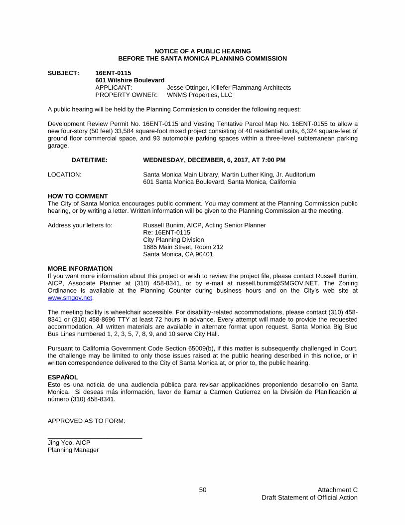
Attachment C Draft Statement of Official Action
50
NOTICE OF A PUBLIC HEARING BEFORE THE SANTA MONICA PLANNING COMMISSION
SUBJECT: 16ENT-0115
601 Wilshire Boulevard APPLICANT: Jesse Ottinger, Killefer Flammang Architects PROPERTY OWNER: WNMS Properties, LLC
A public hearing will be held by the Planning Commission to consider the following request: Development Review Permit No. 16ENT-0115 and Vesting Tentative Parcel Map No. 16ENT-0155 to allow a new four-story (50 feet) 33,584 square-foot mixed project consisting of 40 residential units, 6,324 square-feet of ground floor commercial space, and 93 automobile parking spaces within a three-level subterranean parking garage.
DATE/TIME: WEDNESDAY, DECEMBER, 6, 2017, AT 7:00 PM
LOCATION: Santa Monica Main Library, Martin Luther King, Jr. Auditorium 601 Santa Monica Boulevard, Santa Monica, California
HOW TO COMMENT The City of Santa Monica encourages public comment. You may comment at the Planning Commission public hearing, or by writing a letter. Written information will be given to the Planning Commission at the meeting. Address your letters to: Russell Bunim, AICP, Acting Senior Planner Re: 16ENT-0115 City Planning Division 1685 Main Street, Room 212 Santa Monica, CA 90401 MORE INFORMATION If you want more information about this project or wish to review the project file, please contact Russell Bunim, AICP, Associate Planner at (310) 458-8341, or by e-mail at [email protected]. The Zoning Ordinance is available at the Planning Counter during business hours and on the City’s web site at www.smgov.net. The meeting facility is wheelchair accessible. For disability-related accommodations, please contact (310) 458-8341 or (310) 458-8696 TTY at least 72 hours in advance. Every attempt will made to provide the requested accommodation. All written materials are available in alternate format upon request. Santa Monica Big Blue Bus Lines numbered 1, 2, 3, 5, 7, 8, 9, and 10 serve City Hall. Pursuant to California Government Code Section 65009(b), if this matter is subsequently challenged in Court, the challenge may be limited to only those issues raised at the public hearing described in this notice, or in written correspondence delivered to the City of Santa Monica at, or prior to, the public hearing. ESPAÑOL Esto es una noticia de una audiencia pública para revisar applicaciónes proponiendo desarrollo en Santa Monica. Si deseas más información, favor de llamar a Carmen Gutierrez en la División de Planificación al número (310) 458-8341. APPROVED AS TO FORM: ___________________________ Jing Yeo, AICP Planning Manager