planetary configuration: implications for earthquake prediction and
TRANSCRIPT

263
J. Ind. Geophys. Union ( October 2005 )Vol.9, No.4, pp.263-276
Planetary Configuration: Implications for EarthquakePrediction and Occurrence in Southern Peninsular India
N.Venkatanathan, N.Rajeshwara Rao, K.K.Sharma and P.PeriakaliDepartment of Applied Geology, University of Madras, School of Earth & Atmospheric Sciences,
Guindy Campus, A.C.College Buildings, Chennai – 600 025E.mail:[email protected],[email protected]
ABSTRACTThough there have been several attempts at earthquake prediction from different perspectives, thisattempt aims at establishing planetary configurations as a definitive means of earthquake prediction.When two or more planets, Sun and Moon are aligned more or less in line (0o or 180o) with theEarth, then the Earth would be caught in the middle of a huge gravity struggle between the Sunand the planets. The gravitational stresses would change the speed of the Earth in its orbit andwhen the speed of rotation of the earth changes the tectonic plate motion also gets affected. Thetotal angular momentum of planets involved in earthquake triggering mechanism can be calculatedand the total force acting at the epicenter in a direction opposite to that of the earth’s rotation canalso be determined. At the epicenter, the speed of rotation of the earth can be calculated with thehelp of available software. So the planetary forces in the opposite direction to the rotation of earthact as a triggering mechanism for the accumulated stress at faults and plate boundaries to be releasedabruptly. This does not, however, mean that earthquakes will occur at all edges of the plateboundaries. Two of the parameters contributing to the triggering of an earthquake at a place are a)distance of epicenter from the planet position and b) direction of force acting at the possibleepicenter. From the analysis of “significant earthquakes” over the past 100 years from all over theworld and from Southern Peninsular India, the relationship between (i) latitude, longitude, andmagnitude of the tremor and (ii) distance from the planet and direction of forces acting at anypoint can be inferred. Such inferences already made for different localities in other parts of worldhave unfolded an accuracy of more than 75% with regard to earthquake prediction.
INTRODUCTION
No Indian can forget the 51st Republic Day morningof 26 January 2001 (8.45 am). Within two minutes,the furious ground shock completely wiped out Bhuj.More than physical devastation, natural calamitiesoften leave scars on the collective psyche of an entirecommunity or population.
In more seismic-prone areas, people know how tosafeguard their lives since their awareness levels arerelatively much higher. But in regions like SouthernPeninsular India, which are traditionally consideredto be more stable than the extra-Peninsular, theknowledge of people about earthquakes is very poor,one of the main reasons for the high causality counteven for moderate earthquakes. Southern PeninsularIndia is known to have experienced severalearthquakes with a magnitude of more than 5 inhistorical times (Bansal & Gupta 1998). In mostcases, the causative factor for seismicity has been
attributed to reactivation of ancient crustal faults.Slices of the crust at the continental edge of India arebounded by NE-SW to NNE-SSW faults. Verticalmovement along the faults was imposed bystupendous sedimentation, giving rise to ridges anddepressions. The faults continue to be active,accounting for earth tremors in the Southern Peninsularregion (Subramanian & Goplalakrishnan 2002).
Due to earthquakes, there are some effects likeground shaking, ground displacement, liquefaction,flooding (tsunami), and fire which are hazardous tohuman beings (Walker 1982). The hazards mentionedabove are avoidable if prediction can be made early,which would enable mitigation of the natural hazard,reduce damage to life and property drastically andfacilitate precautionary measures by government andNGOs.
During the past several decades, there have beenseveral attempts at earthquake prediction fromdifferent perspectives. Scientists have attempted to

264
N.Venkatanathan et al
predict earthquakes using the “seismic gap” theory,by observing animal behaviour patterns or studying thechanging colour of water in natural springs.Seismologists have used warning signs like a)foreshocks, b) strain in rocks, c) ground water levels,d) chemical changes in ground water, e) radon gas inground water, f) thermal anomaly, g) ground tilting,and h) P–wave velocity (Ranjit 2001) for predictingearthquakes and issuing advance warnings to thepeople in the area likely to be affected.
The rupture zones of major South Americanearthquakes were investigated in detail by Kelleher(1972), who attempted to predict likely locations offuture earthquakes using the “seismic gap” theory.According to this theory, gaps between rupture zonestend to be the focus of large-magnitude earthquakes.He predicted the occurrence of an earthquake in asegment along the Peru Trench located between therupture zones of the 1940 and 1942 earthquakes (12°to 14° S). Kelleher’s prediction did come true but twoyears later when a large tsunamigenic earthquake (Mw~8.0) occurred in the exact region. Scholz, Sykes &Aggarwal (1973) put forward the dilatancy-diffusiontheory in an attempt to explain a great variety ofphenomena that had been observed to shortly precedeearthquakes. They opined that these phenomena wereactually precursory, and therefore could be used topredict earthquakes. Although there have beencontroversial opinions regarding the physicalbackground and efficiency of seismic gap predictions(e.g. Kagan & Jackson 1991; Nischenko & Sykes 1993;Rong, Jackson & Kagan 2003), Kelleher’s forecast wasobserved to be quite precise (Dewey & Spence 1979;Beck & Ruff 1989). Rabinovich, Kulikov & Thomson(2001) opined that there was high potential for amajor earthquake of magnitude greater than 8.0 inthe region between 15° and 24° S, straddling thePeru-Chile border, based on the existence of aseismic gap in the region and that the region hadnot experienced earthquake since 1877. Thisprediction came true when a catastrophicearthquake of Mw ~8.4 occurred about threemonths later on the coast of Southern Peru.
Hartmann & Levy (2005) investigated therelationships among the attributes of 229 earthquakerelated gas geochemical and hydrogeological precursorysignals, and applied these results to improve futureearthquake prediction strategies. They categorized thesignals into four groups, reflecting differences inmonitoring station densities, measurement methodsand physical processes related to signal occurrence: (i)radon exhalation from the earth’s crust, (ii) exhalationof other gases (helium, argon and others), (iii) temporalvariation in water level or discharge of springs and (iv)
temporal variation in temperature and dissolved ionsin the water of the monitoring sites.
Several workers have attempted to utilizehydrogeological anomalies as precursors to earthquakesand tried to forecast possible earthquake occurrences.Experimental investigations into conditions of groundwaters in order to identify hydrodynamic earthquakeforerunners were carried out by Kissin et al. (1983).Roeloffs (1988) gave a comprehensive review ofhydrologic precursors to earthquakes. Asteriadis &Livieratos (1989) studied pre-seismic responses ofunderground water level and temperature related to aM4.8 earthquake that occurred in Greece on October20, 1988. Igarashi & Wakita (1991) investigated tidalresponses and earthquake-related changes in the waterlevel of deep wells; later, they (1995) discussed thepossibility of using geochemical and hydrologicalobservations for earthquake prediction in Japan.Tsunogai & Wakita (1995, 1996) studied anomalouschanges in ground water chemistry as possibleprecursors to the Kobe and Hyogo-ken Nanbuearthquakes in Japan. A possible explanation forhydrogeochemical earthquake precursors at BadBrambach, Germany, was presented by Heinicke &Koch (2000).
Detection and monitoring of radon gas in groundwater and soil have been systematically carried out byvarious researchers during the last decades. Radonconcentrations in soil samples were analysed bothpreceding and succeeding four M 4.2–4.7 earthquakeson the San Jacinto fault in Southern California(Birchard & Libby 1980). Allegri et al. (1983) detectedradon and tilt anomalies before the Irpinia (SouthItaly) earthquake of November 23, 1980; theseanomalies were observed even at considerable distancefrom the epicenter of the quake. Segovia et al. (1989)opined that the radon anomaly observed in the soilat the Los Azufres Geothermal field, Michoacan, couldhave been a possible precursor of the 1985 Mexicoearthquake of Ms ~8.1. Ground water radonanomalies were observed by Igarishi et al. (1995) beforethe Kobe earthquake in Japan. In the Himalayanregion, similar radon monitoring and measurementshave been carried out by Virk & Baljinder (1994) andVirk (1995) in the Uttarkashi, and Kangra and Chambavalleys, respectively. In addition to radon, anomalousemissions of other gases like helium (Reimer 1985;1990), hydrogen (Satake et al. 1985; Sato et al. 1986),argon, helium/argon and nitrogen/argon ratios(Sugisaki, Ohasi & Hayashi 1978), methane/argon ratio(Kawabe 1985; 1987), and spring water chloride ion(Toutain et al., 1997).
Electrical and magnetic field measurements arealso supposed to indicate impending earthquakes. A

265
Planetary Configuration: Implications for EarthquakePrediction and Occurrence in Southern Peninsular India
heavily debated method of earthquake prediction basedon the identification of transient variations in theearth’s electric field, or seismic electric signals (SES),is the VAN method, named after the researchers whodeveloped the method (Varotsos, Alexopoulos &Nagao). The VAN method, as described by Varotsos& Alexopoulos (1984a, b) is based on observedempirical relationships between the occurrence andmagnitude (∆V) of a SES and the correspondingseismic activity. Magnetic field measurements in theultra-low frequency (ULF) band prior to the October17, 1989 Loma Prieta earthquake (Ms 7.1) showeddistinct anomalous patterns which could beinterpreted as precursors (Fraser-Smith et al. 1990).The anomalous signals began over a month before theearthquake, around September 12, when a narrowband (.05-.2 Hz) signal appeared. Approximately 13days before the earthquake there was a substantialincrease in the background noise across nearly thewhole ULF frequency band (.01-10 Hz). Starting oneday before the earthquake there was a pronounced dipin background noise, then three hours prior to theearthquake, the signal strength started to increasedramatically. The anomalous signals seem to bedirectly correlatable with the occurrence of the LomaPrieta earthquake; however, they were not observedduring two earlier magnitude 5 earthquakes, suggestingthat there is a threshold below which the anomaliesare not produced. The anomalous signals representan isolated measurement, so it is difficult, if notimpossible, to estimate the applicability of theprecursory patterns to future earthquakes. In any case,although the VAN method has been highly debatedover the years, some researchers continue to use it.
Abnormal animal or bird behaviour has been widelyused by Japanese and Chinese researchers forearthquake prediction. Some of the earliest reportsinclude those of Terada (1932) wherein a positivecorrelation was observed between abundant catches byfisheries and earthquake activity; Hatai & Abe (1932),who studied behaviour of a species of catfish,Parasilurus asotus, in tanks; and Suyehiro (1934) whoobserved abnormally high consumption of diatoms bysardines the evening before a large earthquake.Although most of these reports seem to be anecdotal,a recent explanation by Kirschvink (2000) is thatanimals have developed a higher sensitivity toearthquake precursory signals through evolutionaryprocesses. Animals living within seismically activeregions are more susceptible to burrow collapseresulting in death. Therefore, animals which have theability to detect earthquake precursors (a seismicescape response gene) would be naturally selected overthose animals which do not.
One well-known successful prediction was for theHaicheng earthquake (China) of 1975 (M 7.3).Evacuation warning was issued a day before the eventoccurred. In the preceding months, changes in landelevation and ground water levels, widespread reportsof peculiar animal behaviour, and many foreshocks hadled to a lower level warning. An increase in foreshockactivity triggered the evacuation warning (Ludwin1990). In spite of innumerable warning signs at ourdisposal, most earthquakes unfortunately do not havesuch obvious precursors. For example, there was nowarning of the 1976 Tang Shan earthquake (magnitude7.6), which caused an estimated 250,000 fatalities.Sometimes, these early warning signs may also bemisleading. For example, from August 12–19, 2003,in and around Jamnagar Taluk in Gujarat, some minortremors of magnitude 3.0 were recorded. The GujaratGovernment geared itself to face another majordisaster, but fortunately nothing happened.
If a fault segment is known to have broken in apast major earthquake, recurrence time and probablemagnitude can be estimated based on fault segmentsize, rupture history, and strain accumulation. Thisforecasting technique can only be used for well-understood faults, such as the San Andreas. No suchforecasts can be made for poorly-understood faults,such as those that caused the 1994 Northridge,California and 1995 Kobe, Japan quakes. Along the SanAndreas Fault, the segment considered most likely torupture is near Parkfield, California. Using a set ofassumptions about fault mechanics and the rate ofstress accumulation, the United States GeologicalSurvey (USGS) made a more precise Parkfield prediction– of a M 6.0 earthquake between 1988 and 1992.Though that prediction failed to materialise duringthe aforesaid period (Ludwin, 1990), an M6.0earthquake did occur on September 28, 2004, but itsrupture was opposite to what had been predicted.
Based on catalogues of historical seismicity,Keilis-Borok et al. (1988) developed predictionalgorithms designed to identify times of increasedprobability (TIPs) for a given region using statisticalmethods. They devised the CN and M8 algorithmsand used them to predict the October 17, 1989Loma Prieta earthquake of Ms 7.1. Their predictionof a =M 6.4 for the Northern California andNorthern Nevada region using the CN algorithm,however, encompassed a spatial window of 600 x450 km and a time window of 4-year TIP startingin mid-summer 1986. On the other hand, their M8algorithm predicted that an earthquake with =M7.0 would occur within 5-7 years after 1985 in aspatial window of 800 x 560 km along the coast ofCalifornia.

266
The three vital parameters – time, location andmagnitude of an earthquake – assume significanceespecially in view of the fact that they all need to berendered more accurate. The time windows of fewyears (2 years: Kelleher 1972; 4 and 5-7 years: Keilis-Borok et al. 1988) or for that matter 3 months(Rabinovich, Kulikov & Thomson 2001) need to becertainly reduced to a few days if the prediction wereto be of higher value. Similarly, it is also imperativethat the spatial windows of 15° to 24° S (Rabinovich,Kulikov & Thomson 2001) as per the seismic gaptheory, or 800 x 560 km and 600 x 450 km (Keilis-Borok et al. 1988) be minimized as much as possible.The present study demonstrates how planetaryconfigurations, their gravitational force and directionof force act as the triggering mechanism for the releaseof accumulated stresses at plate boundaries/intraplatefaults, resulting in earthquakes. This has madeprediction of plate boundary as well as intraplateearthquakes relatively much more successful withreasonable accuracy with regard to time, location andmagnitude.
SOME IMPORTANT FAULTS IN THE SOUTHERNPENINSULAR REGION(Source: www.asc.org)
1. Andhra Pradesh: NW-SE trending Kaddam fault,NW-SE trending Gundlakamma fault and faultsassociated with Godavari graben.2. Karnataka: ESE-WNW trending active faults nearBhatkal and Udipi towns and faults in the offshoreregion of the Arabian Sea.3. Kerala: Palghat-Cauvery fault and Periyar fault.4. Tamil Nadu: The E-W trending Cauvery fault,Tirukkavilur – Pondicherry fault, Vaigai river fault, andthe N-S trending Comorin – Point Calimere fault andRajapalayam – Devipattinam fault.5. Maharashtra: The N-S trending west coast andChiplin faults, the SE-NW trending Upper Godavarifault, the Ghod river fault, and the E-W trendingNarmada fault zone.6. Orissa: The Brahmani fault, and several deep-seatedfaults in the Mahanadi Delta.
PAST NOTABLE EARTHQUAKES IN SOUTHERNPENINSULAR REGION
1. 08 February 1900 – Coimbatore area, Tamil Nadu:M? 6.0; 10.800 N, 76.800 E; known as theCoimbatore earthquake, it was felt over a large sectionof south India and is the largest event during thehistorical period (Chandra 1977).2. 14 March 1938 – Bhusawal-Sawda area,
Maharashtra: Mw 6.3; 21.130 N, 75.830 E; D = 040.0km; OT = 00:48:38 UTC; maximum observedintensity VII; this earthquake was felt over a wideregion, including at Agra in the north and Mumbaiin the west. It was a deep-seated event, with a focaldepth of 40 kilometres (USGS, NEIC, Golden, CO,USA).3. 10 December 1967 – Koyna area, Maharashtra; Mw6.6; 17.450 N, 73.850 E; D = 027.0 km; OT =06:48:25 UTC; 200 people were killed and manyvillages in the Koyna Nagar area were severely affected.The Koyna Dam suffered some structural damage andleaks were observed in the face of the dam. Tremorswere felt strongly in many towns and cities in westernMaharashtra, including Mumbai and Pune. It wasalso felt in Goa and other parts of western andsouthern India (www.isc.ac.uk).4. 13 April 1969 – Kichanapalle-Gollagudem area,Andhra Pradesh: Mw 5.7; 17.810 N, 80.670 E; D =025.0 km; OT = 15:24:55 UTC; this event is oftenreferred to as the Bhadrachalam earthquake of 1969.It is among the strongest earthquakes in the SouthernPeninsula. The shock caused considerable damage inand around Bhadrachalam. The maximum observedintensity was VII. The quake interrupted thefunctioning of the Kinnerasani reservoir for a while.It was felt all over South India, including Hyderabad,where people ran out into the streets in panic (USGS,NEIC, Golden, CO, USA).5. 30 September 1993 – Killari, Maharashtra: Mw6.2; 18.066 N, 76.451 E; OT = 22:25:48 UTC; amongthe deadliest intraplate earthquakes on record. Closeto 9,000 people were killed and thousands injured inthe pre-dawn earthquake. Many villages in theepicentral area around Khilari were razed to theground. 55 people were killed in the neighbouringstate of Karnataka, in Gulbarga District. Strongtremors were experienced at Hyderabad, Pune andMumbai, and across much of Maharashtra, Karnataka,Andhra Pradesh and Goa. Tremors were felt as far asChennai (USGS, NEIC, Golden, CO, USA; Dasguptaet al. 2000).6. 08 December 1993 – Chandoli area, Maharashtra;Mw 5.1; 17.000 N, 73.650 E; D = 032.0 km; OT =01:42:17 UTC; one elderly woman died of a heartattack and 6 were injured in this early morning quake.It was felt very strongly all over western Maharashtraand Goa for close to 20 seconds. Moderate damagewas reported in several villages in the epicentral region(Dasgupta et al. 2000).7. 12 March 2000 – Koyna area, Maharashtra: Mw5.0; 17.099 N, 73.673 E, D = 033.0 km; OT =18:03:56.27 UTC; felt widely in western Maharashtraand Goa for close to 30 seconds. Structural damage
N.Venkatanathan et al
267
was reported in the epicentral region (Johnston 1993).8. 05 September 2000 – Koyna area, Maharashtra:Mw 5.3; 17.290 N, 73.760 E; D = 010.0 km; OT =00:32:45 UTC; largest earthquake (based on seismicmoment release) since December 1967. It was feltstrongly in many parts of western Maharashtra as wellas in Goa and Karnataka. More than 400 buildingswere damaged in this quake in Satara, Sangli andKolhapur Districts. A temple at Jejuri in Pune Districtwas also damaged. No injuries or fatalities werereported (IMD).9. 26 September 2001 – Off the coast of Pondicherry:Mw 5.4; 11.945 N, 80.227 E; D = 019.0 km; OT =14:56:44 UTC; three earthquake-related deathsreported in the Chennai area. It was felt widely inTamil Nadu and Pondicherry and, to a lesser extent,in adjoining parts of Andhra Pradesh and Karnataka.Slight damage was reported at Chennai and Chetpetin Tamil Nadu (USGS, NEI C, Golden, CO, USA).
MATERIALS AND METHODS
If two or more than two planets, Sun and Moon arealigned more or less in line (0o or 180o) with the Earth,then the Earth would be caught in the middle of ahuge gravity struggle between the Sun and the planets.The gravitational stresses would change the speed ofthe Earth in its orbit, and shift the centre of the solarsystem (Karl 1990). When the speed of rotation of theearth changes, the tectonic plate motion is alsoaffected, just as people collide with each other whenthe bus driver applies the brake suddenly. Thus, theplanetary forces act as a triggering mechanism for theaccumulated stress to be released abruptly.
FORCE OF ATTRACTION BY PLANETS, SUN ANDMOON
Fp1 = GMm/r2 (1)Fp2= GMm/r2 (2)Adding equations (1) & (2),Total force = Fp1 + Fp2 N (3)L = GMm/v kgm2s-1 (4)where L is angular momentum of planets, Moon andSun.
With this total angular momentum, the total forceacts at the epicenter in the opposite direction to therotation of the earth. At the epicenter, the speed ofrotation of earth can be calculated with help ofsoftware available. This does not, however, mean thatearthquakes would occur at all edges of the plateboundaries. For an earthquake to be triggered at aparticular place, two conditions should be satisfied:a) triggering distance (T.D.) and b) direction of forceacting at the possible epicenter.
TRIGGERING DISTANCES
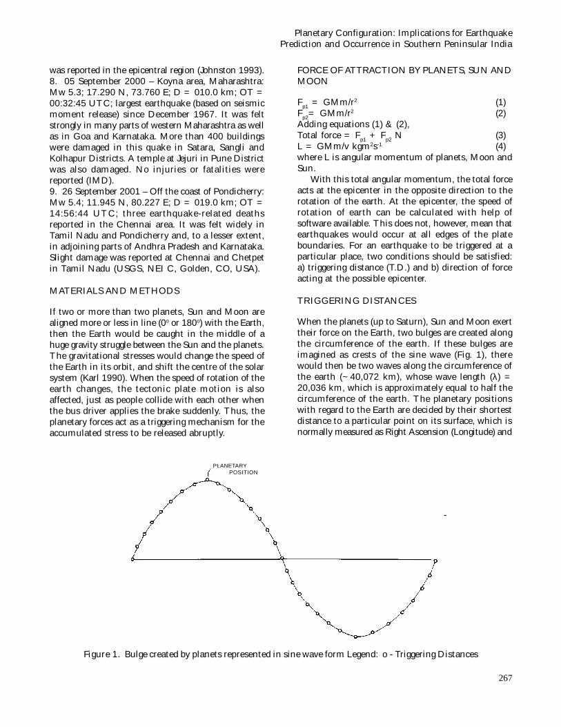
When the planets (up to Saturn), Sun and Moon exerttheir force on the Earth, two bulges are created alongthe circumference of the earth. If these bulges areimagined as crests of the sine wave (Fig. 1), therewould then be two waves along the circumference ofthe earth (~40,072 km), whose wave length (λ) =20,036 km, which is approximately equal to half thecircumference of the earth. The planetary positionswith regard to the Earth are decided by their shortestdistance to a particular point on its surface, which isnormally measured as Right Ascension (Longitude) and
Figure 1. Bulge created by planets represented in sine wave form Legend: o - Triggering Distances
Planetary Configuration: Implications for EarthquakePrediction and Occurrence in Southern Peninsular India
PLANETARY POSITION

268
Declination (Latitude). The peak of the sine waverepresents the position of the planets (Fig. 1). Thepossible epicenters would then be at 0.125λ/4, 0.25λ/4, 0.375λ/4, 0.5λ/4, 0.625λ/4, 0.75λ/4, 0.875λ/4, λ/4,and so on from the projected planet position on theearth. These distances have been termed the“Triggering Distance (T.D.)”.
DIRECTION OF FORCE
Fault lines (or) plate boundaries should be at aparticular angle, so that the net force can effectivelytrigger the earthquake. For convergent plates, the forceshould act in order to give more convergence for oneplate, so as to create enough stress to trigger the
Place,Date &
(Magnitude)
Planetsaligned
RightAscension
Declina-tion
T.D.
PlanetaryForce acting asKinetic Energy
(N)
AngularMomentumof planets(kgm2s-1)
RotationalSpeed of Earthat Epicenter
(km/hr)
Bhusawal – SawdaArea, Maharashtra,(6.3); 14.03.1938
Sun,Mercury& Venus
358.1366o -1.6358o 13774.75 2.7002 x 1028 2.6725 x 1040 1557.8419
Koyna, Maharashtra(6.6); 10.12.1967
Moon &Saturn
5.55674o 0.0427o 11270.25 4.5714 x 1025 2.3801 x 1037 1592.9501
Khilari, Maharashtra(6.2); 01.10.1993
Mars &Mercury
48.7731o 12.6109o 5009 6.0628 x 10²¹ 1.3390 x 1034 1587.6192
Chandoli, Maharashtra(5.1); 08.12.1993
Venus &Mercury 62.0581o 20.1984o 1878.375 1.3004 x 10²² 5.8811 x 1034 1596.8336
Koyna, Maharashtra(5.0); 12.03.2000
Venus &Mercury
332.9515o -10.7511o 17531.5 2.5350 x 10²² 5.8811 x 1034 1596.1219
Koyna, Maharashtra(5.3); 05.09.2000
Venus &Mercury 66.4487o 19.2562o 1252.25 1.0171 x 10²² 5.8811 x 1034 1594.3999
Figure 2. Koyna 1967 Earthquake: The Direction of Planetary force acting at the Epicenter.
Table 1. Planetary Configuration and their Forces for Maharastra Earthquakes
N.Venkatanathan et al

269
earthquake. In the case of divergent plates, the forceshould act so that they interfere with the divergenceof one plate that would increase the divergence of oneof the plates. For normal and reverse faults, thedirection of force should act perpendicular to the faultline; for strike and slip faults, it should act more orless parallel to the fault line.
DISCUSSION
Maharashtra Earthquakes
Among the several earthquakes that have occurredin Maharashtra, sixteen earthquakes in the Koyna
region (from 1967 to 2000) were analysed forplanetary configurations, net force and direction offorce. In all of these, it is apparent that planetaryconfiguration has acted as the triggering mechanismfor release of accumulated stress. Thiscomprehensive analysis has revealed that there isan inverse relationship between the magnitude ofthe earthquake and rotational speed of the Earthat the epicentre (Table 1). For example, in the caseof the earthquake that occurred on 10 December1967 with M6.6 (Fig. 2), the rotational speed of theearth was 1592.9501 km/hr, but for the 12 March2000 earthquake with M5.0 (Fig. 3), the rotationalspeed was 3.1718 km/hr higher.
Table 2. Planetary Configuration and their Forces for Tamil Nadu & Andhra Pradesh Earthquakes
Figure 3. Koyna 2000 Earthquake: The Direction of Planetary force acting at the Epicenter.
Place,Date &
(Magnitude)
Planetsaligned
RightAscension
Declination
T.D.(in km)
Planetary Forceacting as
Kinetic Energy(N)
AngularMomentumof planets(Kgm2s-1)
RotationalSpeed of Earthat Epicenter
(km/hr)
Coimbatore, TamilNadu (6.0); 08.02.1900
Moon &Jupiter 64.3750o 21.5325o 3756.75 1.4916 x 1026 5.8098 x 1037 1640.2191
Bhadrachalam, A.P.(5.7); 13.04.1969
Sun,Mercury& Saturn
25.0783o 9.5809o 8139.625 1.3264 x 1028 2.6748 x 1040 1591.0452
Off Coast ofPondicherry, (5.4);
26.09.2001
Mars &Jupiter 102.8715o 24.3130o 10644.125 1.5833 x 10²³ 5.8098 x 1037 1633.7096
Planetary Configuration: Implications for EarthquakePrediction and Occurrence in Southern Peninsular India

270
Tamil Nadu & Andhra Pradesh Earthquakes
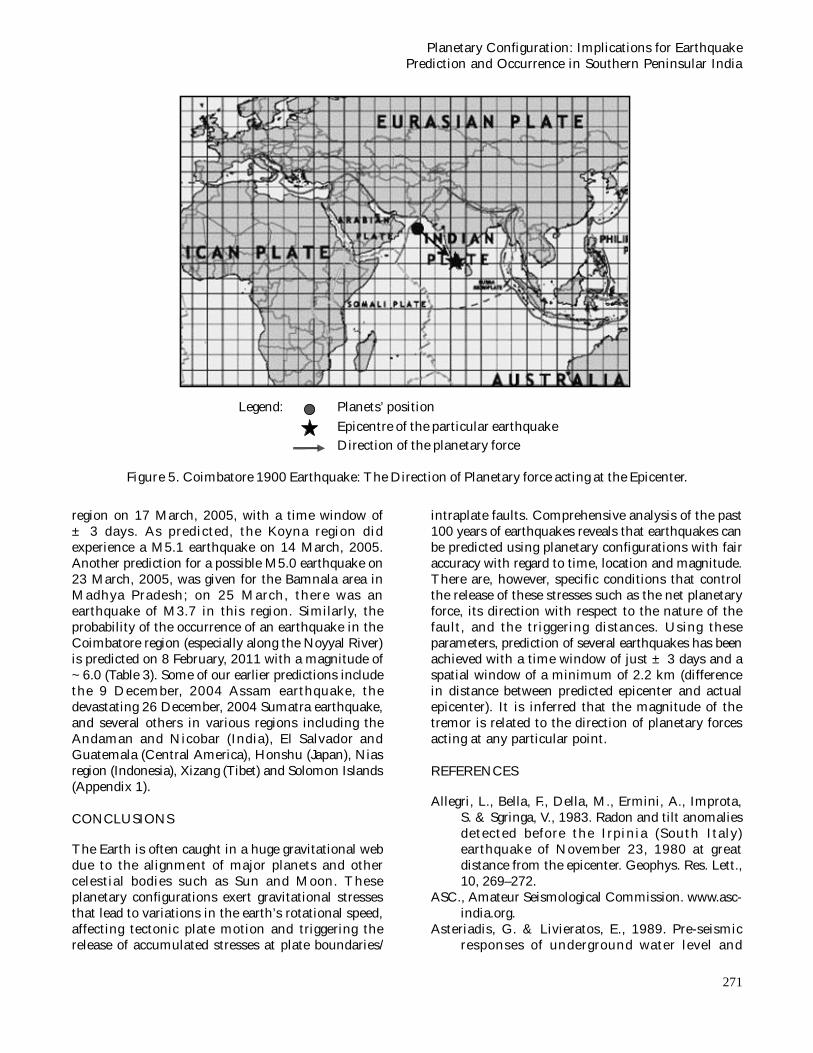
In Tamil Nadu, two major earthquakes occurred, oneat Coimbatore (8 February, 1900) and the other off thePondicherry coast (26 September, 2001). In bothcases, Jupiter aligned with another planet and wasinvolved in the triggering of stresses related to thesetwo quakes that involved strike–slip movement. Theplanetary forces acted more or less parallel to thefault line in order to trigger the earthquake. This canbe inferred from the declination of the planets(Table 2).
In the case of Coimbatore earthquake (Fig.5), theactivated fault was an E-W trending strike-slip fault;the Pondicherry earthquake also occurred due to theactivation of another strike–slip fault but with a N-Strend. So the planetary forces which can act either inparallel or in oblique parallel directions can trigger theearthquakes. This type of planetary configuration is a
rare phenomenon and most probably the reason forthe rare occurrence of earthquakes in Tamil Naduregion.
The Bhadrachalam earthquake of April 13, 1969occurred along the NW-SE trending fault transverseto the Godavari rift (Chandra 1977) triggered by theSun-Mercury-Saturn combination. The planetary forceacting as kinetic energy at the epicenter at the timeof event was 1.326446 x 1028 N, in a more or less NEdirection perpendicular to the fault at that place.
From the analysis of past 100 years of earthquakesand notable earthquakes of the Southern Peninsularregion, the preliminary investigations of planetaryconfigurations showed that there was a highprobability of occurrence of an earthquake in theKoyna region between 17 February, 2005 and 30March, 2005 with M5.0-6.0. Later, based on detailedanalysis for the same region, it was predicted that anearthquake of M5.0-5.5 would occur in the Koyna
Table: 3 - Planetary Configuration for the predicted earthquakes of Koyna region and Coimbatore.
Place,Date &
(Magnitude)
Planetsaligned
RightAscension
Declina-tion
T.D.(in km).
PlanetaryForce actingas KineticEnergy (N)
AngularMomentum of
planets(Kgm2s-1)
RotationalSpeed of Earthat Epicenter
(km/hr)
Koyna, Maharashtra(5.0 - 5.5); 17.03.2005
Venus &Sun 355.5786o -2.6958o 13148.625 3.59 x 10²² 5.60532 x 1034 1596.1219
Coimbatore, TamilNadu (6.0); 08.02.2011
Mars &Sun
321.1158o -15.7918o 19409.875 3.66 x 1026 1.06325 x 1037 1640.2191
Figure 4. Koyna 2005 Predicted Earthquake: The Direction of Planetary force acting at the Epicenter.
N.Venkatanathan et al
271
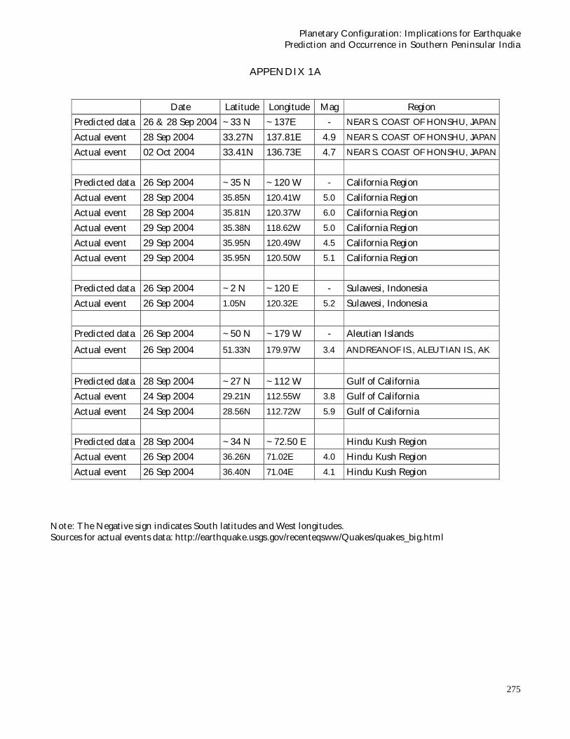
region on 17 March, 2005, with a time window of± 3 days. As predicted, the Koyna region didexperience a M5.1 earthquake on 14 March, 2005.Another prediction for a possible M5.0 earthquake on23 March, 2005, was given for the Bamnala area inMadhya Pradesh; on 25 March, there was anearthquake of M3.7 in this region. Similarly, theprobability of the occurrence of an earthquake in theCoimbatore region (especially along the Noyyal River)is predicted on 8 February, 2011 with a magnitude of~6.0 (Table 3). Some of our earlier predictions includethe 9 December, 2004 Assam earthquake, thedevastating 26 December, 2004 Sumatra earthquake,and several others in various regions including theAndaman and Nicobar (India), El Salvador andGuatemala (Central America), Honshu (Japan), Niasregion (Indonesia), Xizang (Tibet) and Solomon Islands(Appendix 1).
CONCLUSIONS
The Earth is often caught in a huge gravitational webdue to the alignment of major planets and othercelestial bodies such as Sun and Moon. Theseplanetary configurations exert gravitational stressesthat lead to variations in the earth’s rotational speed,affecting tectonic plate motion and triggering therelease of accumulated stresses at plate boundaries/
intraplate faults. Comprehensive analysis of the past100 years of earthquakes reveals that earthquakes canbe predicted using planetary configurations with fairaccuracy with regard to time, location and magnitude.There are, however, specific conditions that controlthe release of these stresses such as the net planetaryforce, its direction with respect to the nature of thefault, and the triggering distances. Using theseparameters, prediction of several earthquakes has beenachieved with a time window of just ± 3 days and aspatial window of a minimum of 2.2 km (differencein distance between predicted epicenter and actualepicenter). It is inferred that the magnitude of thetremor is related to the direction of planetary forcesacting at any particular point.
REFERENCES
Allegri, L., Bella, F., Della, M., Ermini, A., Improta,S. & Sgringa, V., 1983. Radon and tilt anomaliesdetected before the Irpinia (South Italy)earthquake of November 23, 1980 at greatdistance from the epicenter. Geophys. Res. Lett.,10, 269–272.
ASC., Amateur Seismological Commission. www.asc-india.org.
Asteriadis, G. & Livieratos, E., 1989. Pre-seismicresponses of underground water level and
Figure 5. Coimbatore 1900 Earthquake: The Direction of Planetary force acting at the Epicenter.
Legend: Planets’ position Epicentre of the particular earthquake
Direction of the planetary force
Planetary Configuration: Implications for EarthquakePrediction and Occurrence in Southern Peninsular India

272
temperature concerning a 4.8 magnitudeearthquake in Greece on October 20, 1988.Tectonophysics, 170, 165–169.
Bansal, B.K. & Gupta, S., 1998. A glance through theseismicity of Peninsular India. J. Geol. Soc.India, 52, 67 – 80.
Beck, S.L. & Ruff, L.J., 1989. Great earthquakes andsubduction along the Peru Trench.Phys. EarthPlanet Interiors, 57, 199-224.
Birchard, G.F. & Libby, W.F., 1980. Soil Radonconcentration changes proceeding and followingfour magnitude 4.2–4.7 earthquakes on the SanJacinto fault in Southern California. J. Geophys.Res., 83 B6, 3100–3106.
Chandra, U., 1977, Earthquakes of Peninsular India– A seismotectonic study. Bull. Seismol. Soc.Amer., 67(5), 1387-1413.
Dasgupta, S., Sural, B., Harendranath, L., Mazumdar,K., Sanyal, S., Roy, K., Das, L.K., Misra, P.S. &Gupta, H., 2000. Seismotectonic Atlas of Indiaand its Environs. Geological Survey of India(GSI).
Dewey, J.W. & Spence, W., 1979. Seismic gaps andsource zones of recent large earthquakes incoastal Peru. Pure Appl. Geophys., 117, 1148-1171.
Fraser-Smith, A.C., Bernardi, A., McGill, P.R., Ladd,M.E., Helliwell, R.A. & Villard, O.G., Jr., 1990.Low-frequency magnetic field measurements nearthe epicenter of the Ms 7.1 Loma Prietaearthquake. Geophys. Res. Letts., 17(9), 1465-1468.
Hartmann, J. & Levy, J.K., 2005. Hydrogeological andGasgeochemical Earthquake Precursors – AReview for Application. Nat. Haz., 34, 279–304.
Hatai, S. & Abe, N., 1932. The response of catfish,Parasilurus asotus, to earthquakes. Proc. Imp.Acad. Japan, 8, 375-378.
Heinicke,J. & Koch,U., 2000. Slug flow – A possibleexplanation for hydrogeochemical earthquakeprecursors at Bad Brambach, Germany. PureAppl. Geophys., 157, 1621–1641.
Igarashi, G. & Wakita, H., 1991. Tidal responses andearthquake-related changes in the water level ofdeep wells. J. Geophys. Res., 96 B3, 4269–4278.
Igarashi, G. & Wakita, H., 1995. Geochemical andhydrological observations for earthquakeprediction in Japan. J. Phys. Earth, 43, 585–598.
Igarashi, G., Saeki, S., Takahata, N., Sumikawa, K.,Tasaka, S., Sasaki, Y., Takahashi, M. & Sano, Y.,1995. Groundwater radon anomaly before theKobe earthquake in Japan. Science, 269, 60–61.
ISC, 2001. International Seismological Centre. On-lineBulletin, Thatcham, U.K., http://www.isc.ac.uk.
Johnston, A.C., 1993. Report TR-102261. ElectricPower Research Institute, Chap. 3.
Kagan, Y.Y. & Jackson, D.D., 1991. Seismic gaphypothesis: Ten years after. J. Geophys. Res., 96,21419-21431.
Karl S., 1990. Planetary Alignment – Part 2, GreatMoments in Science, Kruszelnicki Pty Ltd.
Kawabe, I., 1985. Anomalous changes of CH4/Ar ratioin subsurface gas bubbles as seismogeochemicalprecursors at Matsuyama, Japan. Pure Appl.Geophys., 122, 194–214.
Kawabe, I., 1987. Identification of seismo-geochemicalanomalies in subsurface gas CH4/Ar ratio,geochemical filtering of earthquakes.Geochemical J., 21, 105–117.
Kelleher, J.A., 1972. Rupture zones of large SouthAmerican earthquakes and some predictions. J.Geophys. Res., 77(11), 2087-2103.
Kellis-Borok, V.I., Knopoff, L., Kossobokov, V. &Rotvain, I., 1990. Intermediate-term predictionin advance of the Loma Prieta earthquake.Geophys. Res. Letts., 17(9), 1461-1464.
Kirschvink, J.L., 2000. Earthquake prediction byanimals: Evolution and sensory perception. Bull.Seis. Soc. Amer., 90(2), 312-323.
Kissin, I.G., Barabanov, V.L., Grinevsky, A.O., Markov,V.M. & Khudzinskiy, L.L., 1983. Experimentalinvestigations into conditions of groundwaters inorder to identify hydrodynamic earthquakeforerunners. Izvestiya, Earth Phys., 19/6, 482–491.
Ludwin, R., 1990. Earthquake Research at Parkfield,California, for 1993 and Beyond. U.S.G.S.Circular, 1116, 14.
Nischenko, S.P. & Sykes, L.R., 1993. Comment on“Seismic gap hypothesis: Ten years after ” byY.Y. Kagan and D.D. Jackson. J. Geophys. Res.,98, 9909-9916.
Rabinovich, A.B., Kulikov, E.A. & Thomson, R.E.,2001. Tsunami risk estimation for the coasts ofPeru and Northern Chile. International TsunamiSymposium 2001, Seattle, WA, Proceedings,CD, 281-291.
Ranjit, B., 2001. The Quake Manual. Outlook, 5, 26-27.
Reimer, G.M., 1985. Prediction of Central Californiaearthquakes from soil gas helium fluctuation.Pure Appl. Geophys., 122, 369–375.
Reimer, G.M. 1990. Helium increase. Nature, 347,342.
Roeloffs, E.A., 1988. Hydrologic precursors toearthquakes, A review. Pure Appl. Geophys . ,126, 177–209.
Rong, Y., Jackson, D.D. & Kagan, Y.Y., 2003. Sesimic
N.Venkatanathan et al

273
gaps and earthquakes. J. Geophys. Res., 108 (BIO)(ESE 6.1-6.1, 2471, doi: 10.1029/2002JB002334).
Satake, H., Ohashi, M. & Hayashi, Y., 1985. Dischargeof H2 from the Atotsugawa and Ushikubi faults,Japan, and its relation to earthquakes. Pure Appl.Geophys., 122, 185–193.
Sato, M., Sutton, A.J., McGee, K.A. & Robinson, R.,1986. Monitoring of hydrogen along the SanAndreas and Calveras faults in CentralCalifornia, 1980–1984. J. Geophys. Res., 91,12315–12326.
Scholz, C.H, Sykes, L.R. & Aggarwal, Y.P., 1973.Earthquake prediction - Physical basis, Science,181(4102), 803–810.
Segovia, N., De la Cruz Reyna, S., Mena, M., Ramos,E., Monin, M. & Seidel, J.L., 1989. Radon in soilanomaly observed at Los Azufres Geothermalfield, Michoacan: a possible precursor of the 1985Mexico earthquake (Ms~8.1). Nat. Haz., 1, 319–329.
Subramanian, K.S. & Gopalakrishnan, K., 2002. EarthTremors in the Coastal Belt of Tamil Nadu andPondicherry in September, 2001 – A GeologicalAnalysis. J. Geol. Soc. India, 60, 691-694.
Sugisaki, R., 1978. Changing He/Ar and N2/Ar ratiosof fault air may be earthquake precursors.Nature, 275, 209–211.
Suyehiro, Y., 1934. Some observations on the unusualbehaviour of fishes prior to an earthquake. Bull.Earthquake Res. Inst., Univ. Tokyo, Suppl., 1,228-231.
Terada, T., 1932. On some probable influence ofearthquakes upon fisheries. Bull. Earthquake Res.Inst., Univ. Tokyo, 10, 393-401.
Toutain, J.P., Munoz, M., Poitrasson, F. & Lienard,A.C., 1997. Springwater chloride ion anomalyprior to a M’L¼5.2 Pyrenean earthquake. EarthPlanet. Sc. Letts., 149, 113–119.
Tsunogai, U. & Wakita, H., 1995. Precursory chemicalchanges in groundwater: Kobe earthquake, Japan.Science, 269, 61–63.
Tsunogai, U. & Wakita, H., 1996. Anomalous changesin groundwater chemistry possible precursors ofthe 1995 Hyogo-ken Nanbu earthquake, Japan.J. Phys. Earth, 44, 381–390.
USGS, NEIC, United States Geological Survey,National Earthquake Information Centre,Golden, Colorado, USA. www.neic.usgs.gov.
Varotsos, P. & Alexopoulos, K., 1984a. Physicalproperties of the variations of the electric fieldof the earth preceding earthquakes, I..Tectonophysics, 110, 73-98.
Varotsos, P. & Alexopoulos, K., 1984b. Physicalproperties of the variations of the electric fieldof the earth preceding earthquakes, II.,Determination of epicenter and magnitude.Tectonophysics, 110, 99-125.
Virk, H.S. & Baljinder, S., 1994. Radon recording ofUttarkashi earthquake. Geophys. Res. Letts., 21,737–740.
Virk, H.S., 1995. Radon monitoring of microseismicityin the Kangra and ChambaValleys of HimachalPradesh, India. Nucl. Geophys. 9, 141–146.
Walker, B., 1982. Earthquake. Alexandria, VA. Time-Life Books Inc, USA.
Wilson, D.C., Earthquake Prediction: Methodologyand Feasibility, www.ees.nmt.edu/~davew/rweb/eqpaper2.htm.
(Accepted 2005 August 24. Received 2005 May 18; in original form 2004 December 30)
Planetary Configuration: Implications for EarthquakePrediction and Occurrence in Southern Peninsular India

274
Expected places vulnerable to earthquakes on 26 September 2004ü Planets Aligned: Sun, Mercury, Mars and Jupiterü Planetary forces: 3.54103566 x 1028 Nü Places: S.Coast of Honshu (~ 33 N, ~137 E), Sulawesi (~2 N, ~120 E),
S.Coast of Taiwan ( ~23 N, ~121 E), Papua New Guinea (~2 S, ~142 E),Solomon Is (~6 S, ~154 E), Gorda Plate (~41 N, ~124 W),Los Angeles (~35 N, ~120 W), Mexico (~15 N, ~97 W),Nicaragua (~12 N, ~87 W), Dominican Republic (~20 N, ~72 W),Gulf of Alaska (~60 N, ~136 W), & Aleutian Is (~50 N, ~179 W).
Expected places vulnerable to earthquakes on 28 September 2004
ü Planets Aligned: Sun, Moon, Mercury, Mars and Jupiterü Planetary forces: 3.56736492 x 1028 Nü Places: Taiwan (~ 22 N, ~121 E), Honshu (~33 N, ~137 E),
Hokkaido ( ~42 N, ~143 E), Kamachatka (~49 N, ~158 E),Gulf of Alaska (~58 N , ~141 W), Papua New Guinea (~7 S, ~148 E),Solomon Is. (~12 S, ~162 E), Molucca Sea (~1S, ~125 E),Gulf of California (~27 N, ~112 W), Mexico (~17 N, ~102 W),Costa Rica (~10 N, ~83 W), Hindu Kush (~34 N, ~ 72.50 E) &Ecuador (~1 S, ~82 W)
APPENDIX 1
N.Venkatanathan et al
275
Planetary Configuration: Implications for EarthquakePrediction and Occurrence in Southern Peninsular India
Date Latitude Longitude Mag Region
Predicted data 26 & 28 Sep 2004 ~33 N ~137E - NEAR S. COAST OF HONSHU, JAPAN
Actual event 28 Sep 2004 33.27N 137.81E 4.9 NEAR S. COAST OF HONSHU, JAPAN
Actual event 02 Oct 2004 33.41N 136.73E 4.7 NEAR S. COAST OF HONSHU, JAPAN
Predicted data 26 Sep 2004 ~35 N ~120 W - California Region
Actual event 28 Sep 2004 35.85N 120.41W 5.0 California Region
Actual event 28 Sep 2004 35.81N 120.37W 6.0 California Region
Actual event 29 Sep 2004 35.38N 118.62W 5.0 California Region
Actual event 29 Sep 2004 35.95N 120.49W 4.5 California Region
Actual event 29 Sep 2004 35.95N 120.50W 5.1 California Region
Predicted data 26 Sep 2004 ~2 N ~120 E - Sulawesi, Indonesia
Actual event 26 Sep 2004 1.05N 120.32E 5.2 Sulawesi, Indonesia
Predicted data 26 Sep 2004 ~50 N ~179 W - Aleutian Islands
Actual event 26 Sep 2004 51.33N 179.97W 3.4 ANDREANOF IS., ALEUTIAN IS., AK
Predicted data 28 Sep 2004 ~27 N ~112 W Gulf of California
Actual event 24 Sep 2004 29.21N 112.55W 3.8 Gulf of California
Actual event 24 Sep 2004 28.56N 112.72W 5.9 Gulf of California
Predicted data 28 Sep 2004 ~34 N ~72.50 E Hindu Kush Region
Actual event 26 Sep 2004 36.26N 71.02E 4.0 Hindu Kush Region
Actual event 26 Sep 2004 36.40N 71.04E 4.1 Hindu Kush Region
Note: The Negative sign indicates South latitudes and West longitudes.Sources for actual events data: http://earthquake.usgs.gov/recenteqsww/Quakes/quakes_big.html
APPENDIX 1A
276
N.VENKATANATHANRESEARCH SCHOLAR, DEPARTMENT OF APPLIED GELOGY,UNIVERSITY OF MADRAS, GUINDY CAMPUS, CHENNAI – 600 025PHONE: 0928211162, 09841433418E-MAIL: [email protected], [email protected], [email protected]
SUMMARY OF QUALIFICATIONS
DCAS (Comp.Sci) Alagappa, Alagappa UniversityB.Sc (Physics) Bharathidasan, The H.H.Raja’s Colege, PudukkottaiM.Sc (Physics) Bharathidasan, Jamal Mohamed College, TrichyB.Ed Annamalai, Annamalai UniversityM.Ed Annamalai, , Annamalai UniversityMBA (Marketing) IGNOU, IGNOU
RESEARCH AREA
PH.D.: PURSUING PH.D. PROGRAMME IN “PREDICTING EARTHQUAKE & ASEISMICCONSTRUCTION DESIGNING” UNDER THE GUIDANCE OF DR.N.RAJESHWARA RAO,SENIOR LECTURER, DEPARTMENT OF APPLIED GEOLOGY, UNIVERSITY OF MADRAS.
CONFERENCES ATTENTED1. Presented a paper titled “Planetary Configuration: Implications for earthquake prediction” in
the International Conference on “Managing Seismic Risk in Developing Countries (MSRDC –2004)” Organized by Disaster Management Institute, Bhopal dated 17th – 19th March 2004.
2. Presented a paper titled “Planetary Configuration: Implications for Earthquake Prediction – ACase study on Bhuj Earthquakes” in SC-E Earthquake Prediction Research Session, at theInternational Conference of the “European Seismological Commission – XXIX GeneralAssembly”, jointly organized by the University of Potsdam, Germany, and Geo ForschungsZentrum, Potsdam, Germany from September 12-17, 2004.
3. Venkatanathan. N, Rajeshwara Rao. N, Sharma K.K, Periakali. P, presented a paper titled“Planetary Configuration: Implications for Earthquake prediction – A case study on HokkaidoEarthquakes” was published in the official web site of Asian Seismological Commission. TheConference was organized by ASC on October 18 – 21, 2004 at Yerevan, Armenia.
4. Presented a paper titled “Planetary Configuration: Implications for foreshocks and failed events,Parkfield, California” in Session: Earthquakes, at the International Conference “Hazards 2004”on “Natural and Human-induced hazards” organized by NGRI, Hyderabad, India, fromDecember 2-4, 2004.
5. A paper titled “Planetary Configuration: Implications for Earthquake Prediction and Occurrencein Southern Peninsular India” presented in Main theme Session: “Inter and Intraplate Seismicityin India and future Strategies”, at the 41st Annual Convention of Indian Geophysical Union(IGU) organized by IGU, Hyderabad, India, from December 29-31, 2004.
AWARDS RECEIVED
Received “Best Teacher Award” from Lions Club for the academic year 1997 – 98.
How I entered this Field of ResearchBhuj earthquake and its repercussions:Within two minutes, the furious ground shock completely wiped out Bhuj and the life style ofBhuj people was turned upside down. Those who survived the quake took their dead on vegetablecarts to cremation and burial grounds. This catastrophic event catapulted me into this field ofresearch.
N.Venkatanathan et al

277
Dr. N.RAJESHWARA RAO
Has 20 years of teaching and research experience in the field of Micropaleontologyand Paleoseismology.
• Has published over 11 research papers in various International and National journals.• Visiting Faculty at Anna University for teaching Engineering Geology for B.E. Civil
Engineering students.• Life Member of Geological Society of India.• Life Member of Paleontological Society of India.• Field of Interest : Earthquake predict ion using planetary configurat ions,
Paleoseismicity studies using foraminiferal analysis, Ecology and distribution ofbenthic foraminifera from sewage outfalls and mangrove swamps, Ecology anddistribution of benthic foraminifera from inner shelf and saline lakes, andPathological morphogenesis in benthic foraminifera.
Dr. K.K. SHARMA
• Has 25 years of teaching and research experience in the field of ExplorationGeophysics. Since 1998 working professor in the University of Madras.
• Has published over 35 research papers in various International and National journals.• Carried out research as a visiting Research Associate at NGRI, Hyderabad and also
as visiting scientist of DST to work in NGRI, Hyderabad.• Having collaborative research work with NGRI, Hyderabad and CWRDM, Calicut.• Field of Interest: Ground water geophysics and geophysical data processing especially
potential field data.
Dr. P.PERIAKALI
• Basically a Environmental Geochemist working in the University of Madras since1975 and holding the position of professor and Head, Department of AppliedGeology.
• Has made significant pioneering research in Tamil Nadu during the last three decadesto understand the impact of toxic and heavy metal pollution in the ground wateraround mining areas and coastal ecosystems.
• Has produced 8 Ph.D. thesis in the field of Environmental geochemistry,Micropaleontology and Applied Geochemistry during the last 13 years and 7 studentsare currently working for their Ph.D. degree in the field of Environmentalgeochemistry and Applied Hydro geochemistry.
• Has published a text book for the benefit postgraduate students in geology.• Has initiated research collaborations jointly with the various organisations in India
and abroad and guiding a team of professionals in his department working in theapplied aspects of geosciences such as integrated coastal zone management,mitigation and management of natural hazard, global climate change, remote sensingand GIS applications, etc.
• Has published over 40 research papers in various National and International journals.
Planetary Configuration: Implications for EarthquakePrediction and Occurrence in Southern Peninsular India