plan number: - barrow bc - homepage · web viewthe applicant should be aware of the potential...
TRANSCRIPT

PLAN NUMBER: APPLICANT: AGENT:
2007/0902 Mr M Charnley Acorus Rural Property Services
WARD/PARISH: CASE OFFICER: DATE RECEIVED:
Lindal and Marton Parish Council
Charles Wilton01229 876553
19/07/2007STATUTORY DATE:12/09/2007
LOCATION:
Crooklands Nursery, Ulverston Road, Dalton-in-Furness
PROPOSAL:
Erection of a dwelling associated with nursery enterprise at Crooklands Nursery (Outline , but with means of access not reserved for subsequent approval)
LOCAL PLAN:
POLICY B10
Outside the settlements of Barrow, Dalton and the development cordons of villages listed in Policy B13, new residential development will only be permitted where it can be justified in accordance with Annex A of Planning Policy Statement 7 or revisions thereof. In addition the conversion of agricultural and other rural buildings to residential accommodation will not be permitted, unless the accommodation is to be occupied by those whose primary employment is in agriculture or forestry where a dwelling is essential for the working of a farm or woodland and there is no other suitable accommodation already available at the holding: or
a) The applicant has made every reasonable attempt to secure suitable business re-use and the applicant is supported by a statement of the efforts which have been made, the minimum of which must include the premises being advertised, at a realistic price, for a minimum of 12 months, that no reasonable offer has been refused and that evidence is provided to show the property has been advertised on the open market at four times in local media at roughly equal periods over the year; or
b) Residential conversion is a subordinate part of a scheme for business re-use; and
c) The building is served by satisfactory access; and
d) The scale of the conversion is appropriate to the building, its character and location.
SUMMARY OF MAIN ISSUES:Page 1 of 37
PLANNING COMMITTEE16th October 2007

Dwelling meets exception criteria for agricultural workers dwellings (horticulture). Nurseries are included in definition of agriculture (Section 336 of Act).
NON MATERIAL CONSIDERATIONS:
REPRESENTATIONS:
Development advertised on site and in local press
Dalton Motor Breakers, Neil Price Ltd and the occupiers of 5 Hall Street and Maidenlands Farm, Dalton in Furness all informed. No representations received.
Report by Acorus Rural Property Services on behalf of applicant dated July 2007 – See appendix A.
Email dated 28 th September 2007 Acorus Rural Property Services
“Following our telephone conversation of earlier I have spoken to the Charnleys and I can confirm as follows:
i) a usable floor area of 160m² would be acceptable, andii) there are concerns about the delay and cost implications of a section 106
agreement (regarding the nursery element of the site), however, if seen to be necessary there would be no objection”.
CONSULTATIONS:
Dalton with Newton Town Council (adjoining parish) – No response received
Cumbria Highways
“There are no objections to the principle of the proposal though details concerning access, parking, turning and treatment of surface water will be required at reserved matters stage and these should conform to Manual for Streets / Cumbria Design Guide”.
Lindal and Marton Parish Council
“The Clerk indicated that notification of this application had originally gone to Dalton Town Council, presumably because of confusion over the boundary between Dalton and the parish of Lindal and Marton, such boundary being on the footpath which forms the south-western edge of the nursery. He also suggested that it might be useful, and appropriate, if an opinion was forthcoming from Dalton Town Council, given the close proximity of the application site to other commercial and residential sites in that part of Dalton. Accordingly, it was PROPOSED by Councillor Lord and SECONDED by Councillor Mrs Kelly that the Parish Council accept that Dalton Town Council should express their own views on the application and that this Parish Council, mindful of the extensive developments already in that area, including a motor-breaker’s yard, confirm that it had no objection in principle to the proposal. Carried unanimously”.
Page 2 of 37
PLANNING COMMITTEE16th October 2007

Network Rail
“Thank you for the letter dated 24th July 2007 in regards to the above planning application for the erection of a dwelling at Crooklands Nursery, Ulverston Road. Please note that Network Rail does not have any objection in principle to the application and has no comment to make.”
H Gee - Environmental Health
“Due to the site’s close proximity to potentially contaminating land uses, such as a motor breakers and historic mining infrastructure, I would recommend a desk study be undertaken to produce a risk assessment addressing the potential for on-site contamination and that this should accompany any application for full planning consent.
If the desk study identifies the need for further study, a detailed site investigation should be carried out to establish the degree and nature of the contamination and its potential to pollute the environment or cause harm to human health. If remediation measures are necessary they will be implemented in accordance with the assessment and the satisfaction of the Local Planning Authority and will be followed by a validation report, which will be agreed upon before development commences”.
Highways Agency
“The application is for a single dwelling at the back end of Crooklands Nursery for the purpose of housing a worker for the nursery. There shall be no amendment to the existing access on to Ulverston Road which junctions about 250m to the North with the A590(T).
This development shall have no material impact on the traffic levels of the A590(T). I would therefore like to confirm that the Highways Agency has no objection to this current planning application”.
United Utilities
“I have no objection to the proposal”.
OFFICERS REPORT:
Crooklands Nursery is situated outside the built up area of Dalton where residential development would normally be resisted. An exception to this policy is recognised by policy B10 to instances “permitted in accordance with Annex A of PPS 7”. This is the process whereby dwellings can be justified where considered essential to the working of an agricultural holding. The Planning Act includes horticulture within this definition though garden centres are excluded. A detailed description of the enterprise is given by Acorus in their appraisal for the applicant – see appendix A.
Government Guidance (Annex A PPG 7)
This advises that it will often be as convenient and more sustainable for agricultural workers to live in nearby towns or villages so as to avoid new and potentially intrusive development in the countryside. However, it then recognises there will be some cases where the nature and demands of the work make it essential for one or more people to live
Page 3 of 37
PLANNING COMMITTEE16th October 2007

on site. In order to assess this question of need the guidance introduces the following tests:
i) there is a clearly established functional need;ii) the need relates to a full time worker, or one who is primarily employed in
agriculture and does not relate to a part time requirementiii) the unit and the agricultural activity concerned have been established for at least
three years, have been profitable for at least one of them, are currently financially sound, and have a clear prospect of remaining soiv) The functional need could not be fulfilled by another existing dwelling on the unit, or
any other existing accommodation in the area which is suitable and available for occupation by the workers concerned; and
v) Other planning requirements e.g. in relation to access, or impact on the countryside are satisfied.
Both the advisers appointed by the applicant and by the Council agree that the above tests are met.
Council’s Appraisal (Capita)
Functional Need
Advises that “there is a clearly established existing functional need on this unit at the present time arising from the care of plants grown in this unit”.
Needs relate to a full time worker
Advises that “I have looked at the labour requirements on this unit based on the current level of production in relation to plants and bearing in mind that the business currently requires 2 full time workers, a number of regular part time workers and comparing this business with other similar units that I have inspected in this county in the past, I confirm that I am satisfied that the need relates to at least 1 full time employee”.
The unit has been established for at least 3 years and has been profitable for at least 1 of them.
“Business has been established at this site for around 9 years. I have calculated the net income that this unit is likely to achieve and I am able to advise that the business is financially viable”.
Off Site Dwellings
“....essential that one full time worker who is actively involved in the management of this unit be resident or immediately adjacent to it”.
Other Planning Considerations
Access
No issues i.e. existing nursery/ garden centre access to be used, area of site sufficient for dwelling to be set back away from highway boundary
Page 4 of 37
PLANNING COMMITTEE16th October 2007

Relationship with Garden Centre
Garden centre business has been excluded from the assessment which is based solely on the nursery side of the business. While both consultants agree the nursery business is profitable and exceeds the threshold (equivalent to an agricultural workers minimum wage of £12,000) the amount is appreciably below that generated by the garden centre. While there is clearly a link between them there is a risk that over time the more profitable use may expand at the expense of the nursery. In recent years the garden centre has without doubt expanded. It would therefore seem appropriate to define areas to be retained as a nursery as opposed to the garden centre activities. The appropriate mechanism for this would be through a 106 obligation.
Size of dwelling
Size has been confirmed as being a maximum of 160 m². This would appear in scale with the operation and should be confirmed by condition with permitted development rights removed. Too large a dwelling could harm the future viability of the nursery.
RECOMMENDATION:
I recommend that:
A) Subject to the completion of a 106 obligation within a period of 6 months, for the purposes of agreeing areas limited to nursery and garden centre uses that:
B) Outline planning permission be GRANTED subject to the Standard Duration limits and the following conditions:
Condition No. 3
This permission permits a dwelling of a gross floor area not exceeding 160m2.
Reason
In order to ensure the dwelling is of a size commensurate with the established functional requirement and is not unusually expensive to construct in relation to the income that can be sustained in the long term.
Condition No. 4
The occupation of the dwelling hereby approved shall be limited to a person solely or mainly employed, or last employed, in the locality in agriculture, as defined in Section 336 of the Town and Country Planning Act 1990, or in forestry, or a widow or widower of such a person, or a dependent of such a person residing with him or her.
Reason
The site is within an area where, based upon national guidance and local plan policies, permission for a dwelling unconnected with agriculture or forestry would not normally be permitted.
Page 5 of 37
PLANNING COMMITTEE16th October 2007

Condition No. 5
Notwithstanding the provisions of the Town and Country Planning (General Permitted Development) Order, 1995 (or any Order revoking and re-enacting that Order with or without modifications), nothing in Article 3, or Schedule 2 to that Order, shall operate so as to permit, within the area subject to this permission, any development referred to in Part 1 of the Second Schedule to the Order and no such development shall be carried out at any time within that area without the prior grant of permission by the Planning Authority.
Reason
In order to ensure the dwelling remains of a size commensurate with the established functional requirement and is not unusually expensive to construct in relation to the income that can be sustained in the long term.
Condition No. 6
Prior to the commencement of any development a landscape scheme for the site, showing the trees, shrubs and hedgerows, including verges and other open spaces, together with details of any phasing of such a scheme must be submitted to and approved in writing by the Planning Authority. The scheme shall be submitted on a plan not greater that 1:500 in scale and shall contain details of numbers, locations and species of plants to be used. All planting and subsequent maintenance shall be to current British Standards. The approved scheme must subsequently be implemented by the end of the first planting season following initial beneficial occupation of the development or by such a programme as may be agreed in writing. Any trees or shrubs removed, dying being severely damaged or becoming seriously diseased within five years of planting shall be replaced by the landowner with trees or shrubs of a similar size and species to those originally required to be planted.
Reason
In the interests of the visual amenities of the area.
Condition No. 7
Before the development is commenced, a desk top study/Phase 1 report in accordance with a methodology subject to prior agreement with the Planning Authority shall be carried out by the developer to establish if the site contains contaminants, and to assess the degree and nature of the contaminants present. If this study does identify any potential for contamination, then a site investigation/Phase 2 report based upon the study shall be implemented. The method and extent of this investigation shall be agreed in writing with the Planning Authority prior to the commencement of any work. If, during the remediation works any contamination is identified that has not been considered in the original submission, then additional remediation proposals for this material shall be submitted to the Planning Authority for written approval prior to those measures being implemented. Any further approved proposals shall thereafter form part of the remediation report.The development shall not proceed until the subsequently agreed works have been carried out by the developer to the written satisfaction of the Planning Authority, which shall also include submission of a remediation validation report and risk assessment strategy, with all appropriate certification that the proposed works have been completed.
Page 6 of 37
PLANNING COMMITTEE16th October 2007

Reason
To protect the environment and the health of the public from potential hazards that may arise as a direct result of the redevelopment of the land.
The reason(s) for the grant of planning permission are as follows:
The development, subject to conformity with the stated conditions, will not cause any material harm to an interest of acknowledged importance and will not conflict with Barrow Borough Local Plan Review 1996-2006.
Page 7 of 37
PLANNING COMMITTEE16th October 2007

PLAN NUMBER: APPLICANT: AGENT:
2007/1081 Cumbria County Council
WARD/PARISH: CASE OFFICER: DATE RECEIVED:
Roosecote Charles Wilton01229 876553
17/08/2007STATUTORY DATE:11/10/2007
LOCATION:
Entrance to Bow Windows Avenue, Barrow-in-Furness
PROPOSAL:
Felling of sycamore tree and removal of stump and including the planting of a replacement tree (sorbus intermediate) in specified planting pit subject of Tree Preservation Order 1998 No. 5
LOCAL PLAN:
No specific policies.
SUMMARY OF MAIN ISSUES:
Arborical report concludes that the tree is in irreversible decline. Replacement tree to be planted by Cumbria County Council.
NON MATERIAL CONSIDERATIONS:
REPRESENTATIONS:
The Occupiers Calm Seas, Clarks Arms, 2, 4, 7 Bow Windows Avenue, Bow Windows Farm House, Bow Windows Farm Cottage, Rampside, Barrow in Furness all informed.
CONSULTATIONS:
OFFICERS REPORT:
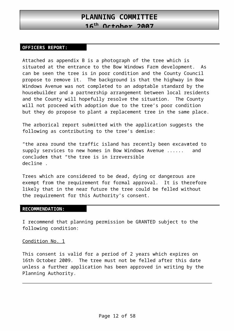
Attached as appendix B is a photograph of the tree which is situated at the entrance to the Bow Windows Farm development. As can be seen the tree is in poor condition and the County Council propose to remove it. The background is that the highway in Bow Windows Avenue was not completed to an adoptable standard by the housebuilder and a partnership arrangement between local residents and the County will hopefully resolve the situation. The County will not proceed with adoption due to the tree’s poor condition but they do propose to plant a replacement tree in the same place.
Page 8 of 37
PLANNING COMMITTEE16th October 2007

The arborical report submitted with the application suggests the following as contributing to the tree’s demise:
“the area round the traffic island has recently been excavated to supply services to new homes in Bow Windows Avenue ......” and concludes that “the tree is in irreversible decline”.
Trees which are considered to be dead, dying or dangerous are exempt from the requirement for formal approval. It is therefore likely that in the near future the tree could be felled without the requirement for this Authority’s consent.
RECOMMENDATION:
I recommend that planning permission be GRANTED subject to the following condition:
Condition No. 1
This consent is valid for a period of 2 years which expires on 16th October 2009. The tree must not be felled after this date unless a further application has been approved in writing by the Planning Authority.
Page 9 of 37
PLANNING COMMITTEE16th October 2007

PLAN NUMBER: APPLICANT: AGENT:
2007/1108 Mackenzie Construction
WARD/PARISH: CASE OFFICER: DATE RECEIVED:
Dalton South Dalton and Newton Parish Council
Leanne Largue01229 876438
21/08/2007STATUTORY DATE:15/10/2007
LOCATION:
Land at Devoke Water Gardens, Dalton-in-Furness
PROPOSAL:
Erection of a detached four bedroom house
LOCAL PLAN:
SUMMARY OF MAIN ISSUES:
Objections relate to the infrastructure outside the application site which cannot be dealt with as part of this application.
NON MATERIAL CONSIDERATIONS:
REPRESENTATIONS:
The Occupiers 4, 6, 8, Hollydene, Antycross, Newton Road, 1, 3, 5, 7, 9, 11 Dalton Fields Lane, 2, 4, 6, 8, 10, 12 Loweswater Terrace, 2, 13, 11, 9, 7, 4 Devoke Water Gardens, Dalton in Furness all informed.
The Occupier, 11 Devoke Water Gardens, Barrow-in-Furness
‘Whilst I have no grounds for objecting to the actual building, I would urge that the following should be included if the plan is approved:-
1. That all roads and pavements throughout the estate should have a final coat of tarmac. (The estate has remained unfinished for a period of 6 years)
2. That street lighting on the estate should be completed. At present there are lampposts, but no light fittings and work has been dormant for 6 years.
3. That a street name sign should be provided.4. That all shipping containers, builders’ huts etc…should be removed.5. That the spare land facing 7 and 9 Devoke Water Gardens should be landscaped
or used for parking.
Page 10 of 37
PLANNING COMMITTEE16th October 2007

In short, that the whole estate should be completed to a standard that would enable it to be adopted by the Council.’
The Occupier, 4 Devoke Water Gardens, Dalton in Furness
“Thank you for your letter dated 30"- August 2007 concerning the above mentioned Planning Application.
Whilst I have no grounds for objecting to the actual building, I would urge that the following should be included if the plan is approved:
1. That all roads and pavements throughout the estate should have a final coat of tarmac. (The estate has remained unfinished for a period of 6 years)
2. That street lighting on the estate should be completed. At present there are lampposts, but no light fittings and work has been dormant for 6 years.
3. That a street name sign should be provided.4. That all shipping containers, builders' huts etc..should be removed. 5. That the spare land facing 7 and 9 Devoke Water Gardens should be landscaped.
In short, that the whole estate should be completed to a standard that would enable it to be adopted by the Council”.
CONSULTATIONS:
Cumbria Highways
“There are no objections in principle to the location of the property, as proposed subject to satisfying the recommendations and requirements of the ground investigation reports. The access for the dwelling is already constructed and it is assumed that the estate roads and footways will be surfaced as soon as possible on completion of the new dwelling.
The only issue which remains vague at this stage is the provision of off street parking. It appears that only one space has been provided and this should ideally be 2 places for a property of this size”.
Dalton with Newton Town Council
“The Town Council have no objections in principle, but would expect Barrow Borough Council as the relevant planning authority to attach conditions to any permission requiring the completion of the existing infrastructure before further development commences”.
United Utilities
“Thank you for your planning consultation of 30 August 2007.
I have no objection to the proposal provided the site is drained on a separate system, with only foul drainage connected into the foul sewer. Surface water should discharge to the watercourse/soakaway/surface water sewer and may require the consent of the Environment Agency. It is our belief that a sewer connection could only be made by
Page 11 of 37
PLANNING COMMITTEE16th October 2007
utilising the. existing network in Devoke Water Gardens. However as this is a private network jurisdiction does NOT lie with United Utilities, this is something that the developer would need to organise and agree with the Local District Council, Private Owner(s), and the Environment Agency
A public sewer runs along the southern boundary of this site and we will not permit building over it. We will require an access strip of no less than 6 metres wide, measuring at least 3 metres either side of the centre line of the sewer, for maintenance or replacement. Deep rooted shrubs and trees should not be planted in the vicinity of the public sewer and overflow systems.
A separate metered supply to each unit will be required at the applicant's expense and all internal pipework must comply with current water supply (water fittings) regulations 1999.Should this planning application be approved, the applicant should contact our Service Enquiries on 0845 7462200 regarding connection to the water mains/public sewers.
The development is shown to be adjacent to/include our electricity underground cables. The applicant should be aware of the potential difficulties caused by trees and should consider this when carrying out planting near to the underground cables. The applicant should be advised that great care should be taken at all times to protect both the electrical apparatus and any personnel working in its vicinity. The applicant should also be referred to a relevant documents produced by the Health and Safety Executive, which is available from The Stationary Office Publications Centre and The Stationary Office Bookshops, and advised to follow the guidance given. The document is as follows: - HS(G) 47 - Avoiding danger from underground services. The applicant should also be advised that, should there be a requirement to divert the apparatus because of the proposed works, the cost of such a diversion would usually be borne by the applicant.
United Utilities offers a fully supported mapping service at a modest cost for our electricity, water mains and sewerage assets. This is a service, which is constantly updated by our Map Services Team (Tel No: 0870 7510101) and I recommend that the applicant give early consideration in project design as it is better value than traditional methods of data gathering. It is, however, the applicant's responsibility to demonstrate the exact relationship on site between any assets that may cross the site and any proposed development”.
OFFICERS REPORT:
This application has been reported to you today as several letters have been received regarding the completion of the highway/footways serving the Devoke Water Garden estate. The proposed development itself raises no issues.
Permission for 12 dwellings was granted in 1999 to the north of the application site (1999/0463). These formed 2-4 and 15-29 Devoke Water Gardens. A further 4 houses, directly adjacent to the current site, received permission in 2001 (2001/1277). The highway and footway serving these houses formed part of the earlier consent, however no condition was attached requiring its construction to an adoptable standard given that this can be dealt with under the Highways Act.
Page 12 of 37
PLANNING COMMITTEE16th October 2007

The approved dwellings have been constructed and are now occupied, however the highway/footway and estate lighting have not been completed. Capita, working on behalf of Cumbria Highways, have informed me that there is no Section 38 agreement in place and no powers available for the highway authority to enforce completion. The town council have therefore asked for a condition to be attached requiring that this work is completed “before further development commences”.
Circular 11/95 relates to the use of conditions and states that they should only be imposed where they are necessary and reasonable as well as enforceable, precise and relevant, both to planning and to the development to be permitted. With reference to the condition being relevant to the development to be permitted it states the following:
24. Unless a condition fairly and reasonably relates to the development to be permitted, it will be ultra vires. 25. Thus it is not sufficient that a condition is related to planning objectives: it must also be justified by the nature of the development permitted or its effect on the surroundings. For example, if planning permission is being granted for the alteration of a factory building, it would be wrong to impose conditions requiring additional parking facilities to be provided for an existing factory simply to meet a need that already exists, and similarly wrong to require the improvement of the appearance or layout of an adjoining site simply because it is untidy or congested; despite the desirability of these objectives in planning terms, the need for the action would not be created by the new development. Nevertheless it is proper for conditions to secure satisfactory access, for example, or parking facilities, genuinely required by the users of the proposed development.
The applicant has advised me that the highway and footway will be completed once the dwelling has been constructed. I believe it would unreasonable to attach a condition requiring its completion prior to this as the condition would not meet the above test. The estate road does not serve the dwelling, is outside the application site and therefore is not relevant to the proposed development.
RECOMMENDATION:
I recommend that planning permission be GRANTED subject to the Standard Duration Limit and the following condition:
Condition No. 2
Prior to the beneficial occupation of any part of the development, the parking spaces must be provided and marked out in accordance with the parking layout plan submitted as part of the application, and thereafter permanently retained unless the Planning Authority gives prior consent for any variation.
Reason
In order to provide a suitable level of parking associated with the development.
Page 13 of 37
PLANNING COMMITTEE16th October 2007

The reason(s) for the grant of planning permission are as follows:
The development, subject to conformity with the stated conditions, will not cause any material harm to an interest of acknowledged importance and will not conflict with Barrow Borough Local Plan Review 1996-2006.
Page 14 of 37
PLANNING COMMITTEE16th October 2007

PLAN NUMBER: APPLICANT: AGENT:
2007/1114 Mr Andrew CamilleriC2 Properties Limited
Dryden Goldsmith Architects
WARD/PARISH: CASE OFFICER: DATE RECEIVED:
Central Leanne Largue01229 876438
06/09/2007STATUTORY DATE:31/10/2007
LOCATION:
98 Greengate Street, Barrow-in-Furness
PROPOSAL:
Conversion of a three storey property into three self contained flats
LOCAL PLAN:
POLICY E9
All development should provide for its car parking requirements. However, within the Barrow town centre block (indicated in Proposals map 4 and where A13, B7, C5, C6 & C7 apply) private parking provision will not be required on-site for residential or commercial development. Parking within that area will only be available on-street or within publicly provided off-street areas. This may require the payment of commuted sums towards the cost of publicly provided parking in lieu of on-site parking provision. Development proposals in the Barrow town centre block will further be considered having regard to the level of public transport provision in the area and any improvements to that provision proposed by developers.
SUMMARY OF MAIN ISSUES:
No off-street parking is proposed, however the site is in a sustainable location, within close proximity to the shopping core.
NON MATERIAL CONSIDERATIONS:
REPRESENTATIONS:
The Occupiers 125, 127 ,129, 131, Greengate Junior School, Sure Start Community Centre, Flat 98, Greengate Street, 83, 86, 88, 90 Sutherland Street, Barrow in Furness all informed.
Page 15 of 37
PLANNING COMMITTEE16th October 2007

The Occupier, 127 Greengate Street, Barrow in Furness
“I am sorry I have not contacted you sooner, but I have been on holiday and only just returned.
My wife and I both feel strongly that this application should not be allowed, my reasons are that these flats will go to house alcoholics and substance abusers in the same way Arthur Street was, and which has subsequently ruined a healthy community, I feel now that because of the areas proposed development scheme these people shall have to relocate to anywhere that is available, and these flats will be an easy option.
The landlords (who probably do not live in the Furness area) will be looking for a quick return on their investment, and as such will put in anyone who will pay the rent, and this usually means DHSS claimants which includes the above mentioned and young ladies without partners (usually teenagers) with one or two children, these sometimes are not the major problem, its when their friends turn up that the disturbance occurs, we get it all here, the recent stabbing at the back of Harrison Street was right behind my back door, drunks shouting at all hours of the night but mostly from Thursday night (the boat Selandia) up to 5am, I work shifts and have to be up at 4.30am when my rotation occurs, Greengate Street itself is now being used as a race track by boy racers with cars and motor bikes and I kid you not, skate boards. (Ever heard one at 2am) and not a sign of a policeman. Even the cycle lane has become a hazard, it seems to be regarded now as a right of way for cyclists and one or two incidents have occurred when we have been getting out of our cars with shopping. Incidentally, what happened to the CCTV camera at the corner of Greengate St/ Rawlinson St?
My neighbours and I have constantly had to clean the debris from the town’s fast food shops from our gardens each day during the weekends, we go out each morning to find the trees with serious damage, road works cones on top of our cars, my own car has been keyed down both sides.
My wife and I have been here almost 25 years and so have most of my neighbours we own our houses and have always paid our way, why should we be the fall guys for people who choose a different path of life, indeed everywhere I seem to go in this country there are bad reports about the east European migrant workers which Barrow has now started to attract, I know they cannot all be bad, but it is happening, in fact we have just returned from Cyprus and their people are not happy about it either, I’m sorry but I cannot accept any situation that will have an adverse affect on my home, my quality of life, and my community. This application is not an investment in the community, it is a private asset which could turn into a pariah for the people of this area.
I ask the committee to refuse the application for these reasons.
p.s. Might I add that if planning permission has not yet been approved, how is it that work has now commenced on the development and has been ongoing for approx the last 6 weeks.
Thank you, but I will not be able to address the meeting, this letter is my voice, and I ask that it is heard and considered in that context”.
Page 16 of 37
PLANNING COMMITTEE16th October 2007

CONSULTATIONS:
Cumbria Highways
“The Highway Authority has no concerns in principle with the proposal though no parking has been provided and it is not clear where the proposed cycle parking is located.
The applicant incorrectly assumes that the proposal complies with PPG3 and 13 though this is not the case. The Highway Authority accepts that this is a town centre location though efforts should still be made to provide some parking. The property is bounded by parking restrictions and unless the consent can be conditioned to say that any prospective owners must not own motor vehicles, this could prove problematic”.
Environmental Health
“Sound insulation between flats is covered by Part E of the Building Regulations, enforced by Building Control. No further comments”
OFFICERS REPORT:
The application site is a three storey end terrace property located at the junction of Sutherland Street and Greengate Street. The property has traded as a DIY shop in recent times although it is currently vacant. The area is predominantly residential and is recognised within the Local Plan Review as forming part of the town centre.
The application is for the conversion of the property into three self contained flats. Access to the upper floors will be from Greengate Street whilst the ground floor flat will utilise the door at the corner of Greengate Street and Sutherland Street.
Policy
Local Plan policy B6 relates to subdivisions of existing buildings. Local Plan policy E9 relates to parking provision for conversions within certain parts of the town centre. Whilst the site is located within the town centre, it is not within the areas covered by the policy.
Consultations
Cumbria Highways have stated that they support the scheme in principle, although they raise concern regarding the lack of parking and the proposed cycle storage area.
Comments have also been received from an occupier of a property on the opposite side of Greengate Street. Several concerns are raised in the letter, however these are not planning issues and the majority have no relevance to the application. Planning is not intended to duplicate other legislation and issues such as anti-social neighbours can be dealt with under police and environmental health powers.
Page 17 of 37
PLANNING COMMITTEE16th October 2007

Issues
The proposal does not include any car parking spaces, as this is not feasible due to the limited curtilage of the building. However, government advice seeks to reduce dependence on the car. The site is situated in a sustainable location, within walking distance of both shopping areas and employment sites. Public transport, in the form of buses is readily available along Greengate Street. These issues were recognised by the inspector dealing with the recent appeal at Marsh Street (2005/0722). Members had initially refused the application based on the lack of off-street parking provided, however this decision was overturned by the inspector who referred to current government guidance and the sites sustainable location.
The amount of parking that the current retail use would generate is a further material planning consideration.
Whilst the cycle parking is not shown on the plan, it is referred to in the design and access statement and will be located in the small area next to the refuse bins. There will be space for one, perhaps, two cycles at the most and although this is limited, any attempt to provide cycle parking is encouraged.
Conclusions
The site is located within a sustainable location in terms of travel. No off-street parking has provided, which appears to be in accordance with planning policy guidance which discourages authorities from requiring off-street parking where there is no need, particularly in urban areas where public transport is available. Issues raised in the representations in the main lie outside planning control.
RECOMMENDATION:
I recommend that planning permission be GRANTED subject to the Standard Duration Limit.
The reason(s) for the grant of planning permission are as follows:
The development will not cause any material harm to an interest of acknowledged importance and will not conflict with Barrow Borough Local Plan Review 1996 - 2006 Policy.
Page 18 of 37
PLANNING COMMITTEE16th October 2007

PLAN NUMBER: APPLICANT: AGENT:
2007/1034 Mr & Mrs N Tyson
WARD/PARISH: CASE OFFICER: DATE RECEIVED:
Dalton North Askam and Ireleth Parish Council
Ian Sim01229 876384
10/08/2007STATUTORY DATE:04/10/2007
LOCATION:
High Riddings, Hollowgate, Ireleth, Askam-in-Furness
PROPOSAL:
Erection of a two storey side extension with revised access arrangements (affects a public right of way)
LOCAL PLAN:
POLICY B15
Where privacy is to be protected through distance, a minimum of 21 metres will be required between the facing windows of habitable rooms of different homes. Exceptions to this policy may be made for the facing windows of ground floor habitable rooms, where adequate screening exists and also in cases where normal standards of separation cannot be achieved and existing standards will not be eroded by accepting distances of less than 21 metres.
The use of obscure glazing in habitable room windows will not be an acceptable measure to overcome the provisions of this policy if this is deemed to provide a sub-standard level of accommodation.
POLICY D1
The Borough’s countryside will be safeguarded for its own sake and non-renewable and natural resources afforded protection. Development will be permitted in the countryside only where there is a demonstrable need that cannot be met elsewhere. Where necessary development is permitted any adverse effect on the rural character of the surroundings should be minimised subject to the development’s operational requirements.
POLICY G13
For the quiet enjoyment of recreation activities such as walking, cycling and horse riding the Borough Council will protect the following designated routes from development taking place on; or in the immediate surroundings where an interesting or visually pleasing view would be adversely affected:-
Page 19 of 37
PLANNING COMMITTEE16th October 2007

The Cistercian WayHaematite TrailCumbria Coastal WayPublic FootpathsAny existing right of way joining the rights of way network
POLICY G14
The Borough Council will seek to protect and enhance all public footpaths where new development is to take place and will encourage the linking of footpaths into housing development to provide easy access to the countryside.
SUMMARY OF MAIN ISSUES:
The main issue relates to the diversion of a Public Right of Way (602051), however, the Secretary of State would decide upon this matter. The property has no particular historical or architectural merit and although within the Ireleth Conservation Area the extension itself does not raise any significant issues. The off road parking provision, although outside the residential development, is in existence and the proposal would not alter this to any great degree within the walled location.
NON MATERIAL CONSIDERATIONS:
REPRESENTATIONS:
Development advertised on site and in the local press
The Occupiers of 1, 7-9, 3-5, 11 Sun Street, High Riddings, High Ridding Farm, 12, 14, 16 Hollowgate, High Ridding Farm, Ireleth Road, Ireleth, Askam in Furness all informed.
The Occupier, Teazelbank, Askam View, Ireleth, Askam-in-Furness
“Regarding ‘High Riddings’, Hollowgate, could I point out that if the new footpath/cart track is not adequate for farmer’s vehicles and if the church will need a new cemetery which they will do in the near future, you have to think about giving access to the lower field below the churchyard. It needs to be at least 15 ft wide to get round the bend of the new proposed extension. I want it in writing that this will be still a cart track and not be closed.”
The Occupier, Croft House, Ireleth, Askam in Furness
“Having been away from home during the last week I was not aware of the above application until my return today. I am not resident in Hollowgate and was therefore not notified directly by the Council. Although I am now aware that today is the closing date for comments I would like to register my objection to the application, in the hope that it will be included with similar objections from other local residents.
My primary objection is that the application contravenes both the Conservation Area & Building Cordon regulations.
Page 20 of 37
PLANNING COMMITTEE16th October 2007

It is well established that this area is the centre of ancient Ireleth, as registered in Domesday, and that this may well have been the route from the Old Chapel of Ireleth in Sun Street to the burial ground at the northern end of the Croft (The field). This is more than likely since the name Hollowgate itself is evidence that this was a route from a holy place, Hollow or Hallow = Holy, Gate = way or route, probably predating the Chapel by a thousand years. However much credence you may attach to this, it is nevertheless an ancient route which should be preserved as such, being within the conservation area and of obvious historical importance. Furthermore, as a public footpath and right of way it should not be the subject of individual planning applications.
During the last year the Housing Chapter Alteration has precisely defined the boundaries of the Building Cordon in this area. The proposed development lies outside the Cordon and should therefore be prohibited. If any infringement of the Building Cordon is allowed it will inevitably provide a precedent for further infringements, hence making a mockery of the entire concept of a Cordon. The integrity of ancient places such as Ireleth must be protected from the predatory whims of individuals wishing to extend their boundaries at the expense of the community. We rely on you to be our champions in this regard. Please do not fail us”.
N F U
“I am writing on behalf of my members, T & M E Johnson, Holmes Green Farm, Dalton-in-Furness, Cumbria, LA15 8JP, with regards to the planning application that has been put forward for the erection of a two storey side extension, with revised access arrangements.
My members are exceedingly concerned, regarding the access to their land, which is ordnance survey reference SD2277 3251 and also SD2277 2537. This land has been occupied by Mrs Johnson for many years and the access currently goes through past the High Riddings House, using the driveway.The proposed development will impede this highway and as we have seen from some correspondence, the entrance will be widened to allow for vehicular access around the extension, to presumably allow access to the fields.
Mr & Mrs Johnson require constant access to this land, as they have animals which mainly for welfare reasons may need to be moved at short notice and therefore the access is required twenty-four hours a day, seven days a week.The amendment to the access will also incur costs, to amend the deeds for this land and therefore, we would expect that the owner of the property would be compensating Mr & Mrs Johnson for this extra cost.
I look forward to hearing a response from you in due course and can only reiterate the point that Mr & Mrs Johnson require a four metre access to the land, which they occupy, at all times, to allow them access to their stock.
It is also rather disappointing to hear that Mr & Mrs Johnson learnt of the planning application via the evening mail, which they read, which was printed on Thursday.23 August 2007.
Enclosed is also a map of the land owned by Mr & Mrs Johnson, and as you can appreciate they are very concerned about the access that is required to the land at all times. It appears
Page 21 of 37
PLANNING COMMITTEE16th October 2007

from the plans that a four metre wide access will be facilitated at all times and this would be requested by Mr & Mrs Johnson to allow the constant access.
I look forward to hearing from you in due course regarding this matter and hope that no further queries will have to be raised by Mr & Mrs Johnson regarding this access matter, as long as it is resolved, especially the cost of amending the deeds, which would be at Mr & Mrs Johnson's expense and I hope that this can be recompensed by the applicant”.
The Occupier, 50 Westmorland Street, Barrow in Furness
As owner and daily visitor to 16, Hollowgate, the adjacent property to High Riddings, I consider the above planning proposal not to be of benefit to the neighbourhood and vehemently object to it.
The location is clearly a very old part of Ireleth village and is indeed sited in a declared Conservation Area.
The house row alignment should be maintained and respected. The proposed extension is not in sympathy with the linear pattern of Sun Street/Hollowgate.
Children use the pathway to access the upper fields for playing. Walkers use it regularly as they have done for nearly a thousand years.
By extending the property, the enjoyment of the route by the public would be drastically reduced. Walkers would no longer be able to see the end of the straight path before entering the gated area and possibly feel nervous about walking through it and being guilty of trespassing. Added to this, on several occasions, cars have obstructed the existing pathway for several hours, further adding to the possible diminishment of use by the public. This practice, according to the local Ramblers' Footpath Secretary is not acceptable. I completely agree with her.
I also feel that the farmer who owns the upper field onto which the public pathway joins, should be supported by retaining the straight definitive path and so keeping the route for his cattle transporters uncluttered by development.
During the wet Winter months, run-off rainwater flows down from the upper fields and along the pathway. Consideration should be given to the affects of the loss of top-soil area, both for the extension and the removal of the grassed area for car parking, as well as the blockage of the natural water-flow caused by the proposed building.
The proposed raising of part of the original boundary retaining wall seems illogical, since the intention is to remove the sail from behind it.
This same low wall permits my disabled wife's vehicle, when parked as per normal alongside it, on the only available hard-standing, to be de-frosted by the early morning sun-shine during the Winter months. Raising the height of the wall would prohibit this and cause extra stress to her before she could travel in her car.
Hollowgate is on a straight inclined slope with High Riddings at the top. Throughout the gloomy Winter days, the low angled Sun helps to warm and dry the entire roadway and narrow pavement. The proposed extension would black out the early morning sunshine,
Page 22 of 37
PLANNING COMMITTEE16th October 2007

cast a shadow, making the place, dark, damp and potentially dangerous to pedestrians, vehicles etc.
Please note, that the early morning, is the only time Hollowgate roadway is brightened, weather permitting, by direct sunshine throughout the entire year. The proposed extension on the ridgeline position would have a significant negative impact on the amount of sunlight we currently enjoy.
The previous very elderly couple managed well with the existing access points and employed a gardener for ground maintenance, the same one commissioned by the new owners. He could trim the hedge occasionally and when performed, the entrance to the side of the house would be clearly apparent. Thus, simply removing their concern over representatives on fund activities struggling to ascertain an access point.
I have a lot of concern regarding the huge West facing window of the proposed sun-lounge/ dining-room extension which will mean that my kitchen and patio area will be over-looked, which will have a massively undesirable loss of our privacy.
Also, noise pollution when their windows are open will be a major issue, as, they have declared their intention to use the extra floor space for dancing when entertaining fund-raising events.
Light pollution, during the Winter, is bound to be apparent from such a large glazed area and since we both enjoy the tranquillity of sitting out-doors in the patio, enjoying the darkness of the surrounding fields and star encrusted sky, gaining spiritual refreshment, I totally oppose the threatened loss of our cherished past-time.
Whilst I consider that the existing ability to park three or four cars, without even blocking the public pathway, plus another in the garage, must be wonderful, I'm even more amazed why they purchased the house five months ago, when it obviously doesn't appear to meet with any of their requirements.
Please take my strong objections into consideration and refuse this planning application”.
The Occupier, Teazle Bank, Askam View, Ireleth, Askam in Furness
“Regarding the cart track and footpath coming off the top of the Dales under the Church Yard and to the top of Hollowgate.
The Dales are unique with long strips which the monks of Furness Abbey made, they have ridges between each Dale as a boundary.
The Countryside Stewardship has it on a long term contract as a wild flower hay meadow which we plant with wild flowers each year and it works satisfactory with the farmers, so I would not like any alterations with the cart track/footpath.
I am a member of the Farmers Union and Landowner association”.
The Occupier, 3 Askam View, Ireleth, Askam in Furness
Page 23 of 37
PLANNING COMMITTEE16th October 2007
“I live just down the road from this planning application and I am against this application 100%, public footpath, parking space, historical layout of this area. I dont have to say any more this says it all. I am fully against this application”.
Page 24 of 37
PLANNING COMMITTEE16th October 2007

The Occupier, 10 Hollowgate, Ireleth, Askam in Furness
“I wish to strongly object to this proposed extension. This cartway/footpath on which this extension is to be built in an integral part of the historical layout of the village and has existed since the 11th Century and was used by the Cistercian Monks of Furness Abbey and is fundamental to preserving the villages historical background.
The proposal is in a conservation zone and on a protected footpath, I’m sure many people over the centuries would have like to build on these cartways/footpaths but people in the past decided they were worth preserving for future generations surely it is our responsibility to do the same for the next generation.
Building this extension will completely spoil the rural feel to this area, and is out of line with the linear position of Hollowgate. When you walk up Hollowgate you feel you are walking into the countryside along the footpath. Once this proposal is built the area will have a closed off cul-de-sac type feel to it and will deter people from using the footpath however well sign posted it is, as you will feel like you are entering someone’s house, and disturbing their privacy.
Although this application is in the building cordon I am sure the idea was to build and develop their property but still to protect the rural countryside, greenfield feel of the place.
Although the proposal is at the top of the street I must express my concerns regarding the light in Hollowgate, at present it gets the late sun light especially in winter, due to the low sun level and toe fact that it is to be built at the top of the incline, it could reduce the amount of sun in Hollowgate with obvious implications.
With regards to the Historical Significance of the footpath I must also point out that this is an old village even mentioned in the doomsday book and also that viking remains have been found in the area.
I understand there can be an issue with access to the fields by the farmer but I am sure he will voice his objection if he feels this is a problem.
Whilst I understand that Mr Tyson has every right to try to extend his property to suit his needs the owner has only just purchased the property and was aware of its limitations.
I hope you take these points into account when you make your decision and help protect the historical layout, the ancient footpath/cartway and rural feel to our village”.
Page 25 of 37
PLANNING COMMITTEE16th October 2007

The Occupiers, 16 Hollowgate, Ireleth, Askam in Furness
“As a neighbour adjacent to the occupiers of ‘High Riddings’ I wish to object to the planning application submitted by them.
I spend a lot of time in the kitchen and patio area and can see their large lounge window of the west gable of the house as well as background trees.
Any further development would be a direct intrusion to my privacy and pleasant outlook.
The raising of the height of the original stone/slate retaining wall is totally unacceptable as I park my vehicle parallel to it.
Being a registered disabled driver, I find during the winter months that the early morning sunshine ensures my car is both frost free and warm inside. Raising the height of the wall would eliminate all sunshine on my only available parking area.
One of the many reasons for choosing my house five years ago were the charming open views when approaching it from either Sun Street of Hollowgate. The proposed plan would destroy the whole distinctiveness of this historic landscape.
Walkers, children and animals have used this pathway for centuries and any adjustment for the proposed extension is to be condemned, as it would destroy the harmony of this rural outlook.
Community spirit would be seriously damaged, as I discovered when nearby residents voiced their dismay to me over this disrespectful proposal to build over an historic conservation area.
I sit outside in my patio regularly throughout the whole year, even the dark winter nights enjoying the darkness of the sky and believe the proposed extension would generate light pollution and thus spoil my enjoyment of this quality past- time.
Also, there will be an issue of extra noise from entertainment systems when the windows are open, as the owners stated that they would use the proposed extension (dining room/sun lounge) “as a dance floor to entertain on grand scale
Since the occupiers of ‘High Riddings’ only bought the house less than six months ago, they obviously haven’t witnessed winter rainfall on the proposed area
Run off water from the upper fields channels down the public footpath and down Hollowgate. Loss of open land and grassy area will make the problem worse
I therefore strongly oppose the above extension plan, alteration to existing boundary wall and any adjustment to the public pathway”.
The Occupier, Holmes Green Farm, Broughton Road, Dalton in Furness
“On August 23rd 2007 I read in the Evening Mail public notices, Barrow in Furness Borough Council Notice under 67 or 73 Planning (Listed Building and Conservation Areas) Act 1990 of a planning application for the erection of an extension at High Riddings, Ireleth with
Page 26 of 37
PLANNING COMMITTEE16th October 2007

revised access arrangements. This affects my vehicular right of way to land owned by me since 1986 – O.S. SD2277 3251 and SD 2277 2537.
I would like you to put on record that this access has been used for NINETY years, it has been used by my grandfather, tenant / when it was owned by my grandmother and then by my parents, now myself since 1917.
High Riddings, I remember, this property was built in 1946/47 there was not a gate leading to High Riddings, until one was put on about 20 years ago by the last owner who assured my mother that (my access now in 2007) the access would not be blocked at any time.
This access must be kept clear at all times to allow my family access to our land and also a public footpath through the same field, which is NOT a play area.
I have notified my solicitor of this proposed change of access, so that the information can be put with my deeds, these are held by Ward Hadaway, Newcastle upon Tyne.
I was not notified of this application by Barrow Borough Council, I do know that Mr Tyson (the applicant) had been in contact with your department (planning) October/November 2006, also Capita Symons Ltd – re the public footpath diversion. He did not appear to know that I was the owner of land concerned when he came to say that he was putting in the planning application “to be courteous” in his words. Would that be the notice that is stated on your “planning application form”, to be served where necessary on the adjoining land owner? A 4 metre access is needed to allow my sons access to the fields, using a tractor and trailer or 4 x 4 and trailer to collect any sick animal(s) on welfare grounds, 24 hours a day 7 days a week. I write this on their behalf.
Was it not considered necessary that I should be informed of this application. Please consider these reasons for my objection when making the final decision on this application”.
Supporting Statement – dated 18 th September 2007
“Further to our earlier telecon, the attached e-mail response of Andy Sims at Capita was the information I was quoting (I note that this was included within the Planning Pack I forwarded you at Item 8).
I note that the proposal will not now be discussed at next weeks planning committee due to the delayed response from the Council Solicitor on way forward for the diversion order. I understand that the submission will now be discussed at the 16 October Planning Committee (PM) with a site visit in the morning.
With regard footpath diversion order’s I believe that there are recent precedents within the Barrow Borough that should be considered in conjunction with this proposal. I referenced during your site visit that a public footpath was recently diverted around a property at Marton to support development. Earlier this year there was also a quite significant footpath diversion around Park House Farm to Furness Abbey Amphitheatre (circa 1km) to allow for the development of Park House Farm. As discussed I have also discussed the position with Nick Hayhurst of SLDC who also advises that such diversions are normal practice in South Lakes and not normally a problem. May I kindly request that you consider these instances in conjunction with the proposal.
Page 27 of 37
PLANNING COMMITTEE16th October 2007

Should you require any further information in conjunction with the proposal, please do not hesitate to get in touch”.
Supporting Statement – dated 19 th September 2007
“The 2 examples of Footpath Diversions are two very recent ones that I am aware of in the Barrow Borough. Another local precedent (not BBC but SLDC ) that I am aware of is at Reed Gardens at the very southern point of Little Urswick where the footpath has been diverted over some 30-40 metres to circumnavigate three building plots. Indeed discussions I had with SLDC and the Highways authority CAPITA also confirmed that diversion orders are general practice and are often undertaken at the landowners request as part of a planning application to facilitate property development. I would also assume that these had also required the approval of the Secretary of State that you referenced during your site visit to Ireleth.
My point however, is not whether the diversion should be processed through the Town & Country Planning via yourselves (as I was advised should be possible on the Capita e-mail that I forwarded you) or through the Highways act via the County Council, but that Footpath Diversion Orders can and are frequently obtained purely to facilitate development of a property or land. The fact you advised that these are not normally approved within BBC for purely landowners requirements (ie development) had given me cause for concern when clearly adjacent councils believe it is normal practice.
The other issue on the footpath (and I understand, the concern of some objectors) is the possible historic nature of the footpath. I had advised during my application that I approached the county archaeologist Mr Jeremy Parsons and he responded (letter included in the application) that he had no comment to make. Despite him being contacted by one of the objectors, I understand that this is still his position and that he has no issue with any development over the footpath. I understand that you have since contacted him and he has confirmed the same to you.
I am still trying to contact the Ramblers rep (I think the address may be incorrect) and will advise you of any progress.
I trust the above will be fully considered in conjunction with the application”.
CONSULTATIONS:
Cumbria Highways – dated 22.08.07
“There are no objections to the proposal from the Highway Authority subject to the proper diversion of the existing PROW around the new extension and to the satisfaction of any individuals and groups which may use it. It is assume that section 257 of the Town and Country Planning Act will be used to affect this diversion as mentioned within the email correspondence.
The revised parking arrangements are adequate and it is assumed that those areas illustrated as parking would need to be reduced in level to facilitate the parking and turning of vehicles”.
Page 28 of 37
PLANNING COMMITTEE16th October 2007

Cumbria Highways
“Highway widths are generally defined by boundary restrictions and in this case at the point of the proposed extension the public right of way could be defined as being 4m wide.
As the developer wishes to build into this 4m width the public footpath would need to be diverted around the extension still retaining a 4m width. This could be achieved by Barrow Borough Council planning authority processing a diversion order under the 1990 Town and Country Planning Act (Section 257). Other public rights of way legislation makes me believe that the minimum width of the diverted section of the public footpath could be reduced to 3m. This path width should be recorded in the schedule of the diversion order.
Mr Tyson need not apply to Barrow Borough Council for a Section 257 diversion order until he is aware of the success of his planning application. The Highway Authority should advise the District Planning Authority that the public footpath should not be obstructed and that if this development is to take place the public footpath should be diverted.
I am unsure of Barrow Borough Council’s charges for processing a TCPA Section 257 diversion order but I believe it is less than the £1500 to £2000 (plus VAT) range we would charge for diverting this route under the 1980 Highways Act.
There is no guarantee that a public footpath order under the 1990 Town and Country Planning Act or the 1980 Highway Act will be confirmed but from my experience an application of this nature is very likely to succeed.
I have copied this email into Cumbria County Council’s Legal Services public rights of way solicitor to give her an opportunity to make any comments on my advise”.
Askam & Ireleth Parish Council
“Two-storey side extension with revised access arrangements: No objections in principle but the Parish Council would like to see the groundwork for the proposed right of way diversion in place before the commencement of construction and to the satisfaction of all interested parties. The provision of the revised right of way and access arrangements should be written into the habitation certificate for the dwelling.
A Section 106 agreement should be put in place to ensure that the track is of a suitable standard, of hardcore or better, for the full length of the property i.e. to the field gate. We believe that there may be a surface water drain running from the back of the Church under the gate and along the existing track. This needs to be checked and re-routed if necessary”.
County Archaeologist
“I understand that there is local concern that the proposed extension may affect an historic route way. Unfortunately, the route way is not statutorily designated and it is considered that little could be gained from archaeologically recording the area of the proposed development. I therefore have no comments to make.”
Page 29 of 37
PLANNING COMMITTEE16th October 2007

OFFICERS REPORT:
The proposal is for the erection of a two storey side extension with revised access arrangement which would require the alteration of a Public Right of Way (602051). The property is within the Ireleth Conservation Area set within a countryside location being on the southern boundary of the village with access from Hollowgate Road or Sun Street. A site visit has been arranged.
The proposed extension on the western elevation would have a porch, utility room and Hall at ground floor level with a sun lounge at first floor level. This would produce a footprint of approximately 4.4 metres x 7.2 metres with a ridged roof giving a height of approximately 7.1 metres. The ridge of the extension would be off-set and lower than the ridge of the main roof. The external materials are to be upvc windows, rough cast, natural stone quoins and slate to match the main roof, no significant visual impact would occur, although it should be noted that a large window is proposed looking westwards at first floor level.
The property itself has no particular architectural merit or historical interest and the proposal would not impact upon its character.
The extension would not impact significantly upon residential properties through loss of privacy or sunlight/natural light on Hollowgate Road, due to their design nor upon Sun Street due to distance.
Members will have noted the representations received regarding, amongst other issues, the required diversion of the Public Right of Way (602051) as the extension would completely block the existing route. In this respect the County Archaeologist does not object to the re-routing of the right of way. The land within the applicant’s could satisfactorily accommodate such a change and off road parking would remain as before. It should be noted that should planning permission be granted the diversion has to be agreed by the Secretary of State and should the diversion at this stage fail, then the planning permission cannot be enacted. The applicant does not have the right to obstruct the public right of way until the new route has been constructed and I believe a legal event order approved, this modifies the definitive map following authorisation.
Part of the application site lies outside the residential development cordon for the village, i.e. proposed off- road parking areas to the west, however, in this respect this is already in existence and the changes proposed would not unduly alter the immediate character of the applicant’s curtilage.
I have considered the representations received, however, the property has no particular architectural or historical merit, the scheme does not impact to a significant extent upon the Conservation Area and complies with guidance held within Section 72 (1) of the Planning (Listed Buildings and Conservation Areas) Act 1990 and the duty placed upon Local Authorities to ‘having special regard to the desirability of preserving or enhancing the building or its setting’. The decision to divert or otherwise the Public Right of Way lies with the Secretary of State (by application to either the County Council or Borough Council) and the proposal warrants a favourable recommendation.
Page 30 of 37
PLANNING COMMITTEE16th October 2007

RECOMMENDATION:
I recommend that planning permission be GRANTED subject to the Standard Duration Limit.
Page 31 of 37
PLANNING COMMITTEE16th October 2007

PLAN NUMBER: APPLICANT: AGENT:
2007/1145 Mr D Carswell Mr D NewbyDatum Design Company
WARD/PARISH: CASE OFFICER: DATE RECEIVED:
Walney North Leanne Largue01229 876438
06/09/2007STATUTORY DATE:31/10/2007
LOCATION:
Proposed dwelling at Longlands, Mill Lane, Barrow-in-Furness
PROPOSAL:
Erection of a two storey dwelling and garage – (Outline, means of access not reserved for subsequent approval)
LOCAL PLAN:
POLICY B3
Applications for residential development on unallocated sites will be permitted where they accord with the sequential approach of the Structure Plan and also satisfy the following criteria:
i) The site is located within the built up area of existing settlements or the development cordons identified in Policy B13; and
ii) The siting, scale, layout and design (in the materials and form of the buildings) of the development is sensitive to the local environment, it promotes the principles of ‘Secure by Design’ and adequate parking provision is made; and
iii) Adequate access arrangements can be provided, including servicing the site by the public transport and by cycle routes; and
iv) The development is laid out in a way that maximises energy efficiency; and
v) The development will not result in the loss of land which has a recognised or established nature conservation interest; and
vi) The development must not cause an undue increase in traffic passing through existing residential areas such as to be detrimental to residential amenity or highway safety; and
vii) Adequate water supplies, foul and surface water sewers and sewerage treatment facilities exist or can be provided; and
Page 32 of 37
PLANNING COMMITTEE16th October 2007

viii) 'A risk-based approach will be adopted for development in or affecting flood risk areas to minimise the risk of flooding associated with the site and the potential effect development of the site might have elsewhere through increased run off or a reduction in the capacity of flood plains. This shall be in accordance with the sequential characterisation of flood risk set out in Table 1 of Planning Policy Guidance Note 25 'Development and Flood Risk; and
ix) Where contamination is suspected, a desk study is undertaken and if necessary a site investigation is undertaken and remediation strategy submitted.
POLICY B4
For allocated and unallocated sites the Authority will expect a density of at least 30 dwellings per hectare with higher densities sought in accessible locations and/or where consistent with good urban design principles.
POLICY D4
The following areas have been designated as Green Wedges:
a) Mill Beck Valleyb) Roosegatec) Land separating Ormsgill and Hawcoatd) Land north of Daltone) Land between North Walney Estate and North Vickerstownf) Land at Anticrossg) Land north of Flass Laneh) Land at Clovelly Terrace
Development within Green Wedges that would detract from their value as a setting for recreation, providing important urban space and visual relief and contrast between residential areas would not be permitted.
SUMMARY OF MAIN ISSUES:
The development is within the green wedge and would detract from its value of providing urban space and visual relief contrary to Local Plan Policy D4
NON MATERIAL CONSIDERATIONS:
REPRESENTATIONS:
The Occupiers of Tarn House, Greenlands, Longlands Cottage, Flat Tarn House, Mill Lane, 1, 2, 9 Saunders Close, Barrow District Training Centre, Borough Training Kennels, North Scale, Barrow in Furness all informed.
Page 33 of 37
PLANNING COMMITTEE16th October 2007
The Occupier, 9 Saunders Close, Barrow in Furness
“I refer to the new planning application No. B06 l 2007 / 1145 for Mr. David Carswell regarding the new build and new drive adjoining Mill Lane at LONGLANDS Walney Island.
May I first remind the committee that this application is yet again for a new building within the WALNEY GREEN WEDGE and on a site of historical interest?
Mr. Carswell has already previously had three mature trees destroyed to put in an extra drive into Longlands, and as far as I am aware without planning permission also in 2006 he had a further seven mature trees felled. This came about because of the planning departments two year delay in implementing a Tree Protection Order to all the trees an the original Longlands site, and to be blunt let down themselves and the 633 people who signed the petition to keep this historical site open.The above all went against the Bristol Planning Inspectorate who stated that, although the trees display signs of dieback and are subject to a exposed coastal location, this does not mean they are unsuitable for retention given adequate management, he also stated that establishment of new tree planting is obviously difficult on the Island and retention of any existing trees is highly desirable.At this stage I feel some history of what has happened since Mr. Neil Price bought the Longlands site in 2003.
(a) Mr. Price application to demolish Longlands House and development the site was turned down by the planning committee and again on appeal by the Bristol Planning Inspectorate.
(b) Mr. Price sold Longlands to Mr. Carswell which was reported in the Evening Mail, and whilst everyone was under the impression that Mr. Carswell owned all of the site, it was not until after Mr. Price had put in the new drive forMr. Carswell, and then preceded to apply to build a bungalow at the rear, ( which was granted) that it came to light Mr. Price still owned Longlands Cottage and had retained a sizable piece of the land.
(c) Mr. Price then applied to demolish Longlands Cottage and build a 4 bed roomed house 6 metres ( 20ft ) further away from the Main house, and as I stated at the planning meeting this was to gain access to the north-west corner of the site for further development. At this same meeting councilor Eric Woods said that any further development on this site would not be looked at favourably, and yet Charles Wilton mentioned 5 dwellings on this site even though there are only two dwellings plus planning permission for a bungalow?
(d) I therefore believe the latter to be plan B just in case the planning application by Mr. Carswell is turned down by denying him permission to put in another drive adjoining Mill Lane.
It would be rather naive to believe after reading the above that this has been nothing more than a business adventure between Mr. Price and Mr. Carswell.
To sum up I believe the application (that appear annually to develop LONGLANDS) should be turned down and a stop put to all further development because it goes against the Bristol Inspectorates judgment regarding the VISUAL RELIEF AND OPEN SETTING of this site within WALNEYS GREEN WEDGE.
Page 34 of 37
PLANNING COMMITTEE16th October 2007

Plus we have already been through this once when 633 people signed the petition to keep this historic site open with views through to Black-Combe, and that the new drive proposed would totally spoil this site (see photograph), I also believe there would be a spur off this new drive in the near future to apply for yet another house to be built as has happened in the past. Plus the extra drive would also add to traffic problems on Mill Lane and make it a greater danger to the school children who use the only pavement which is on the LONGLANDS side of the Mill Lane”.
CONSULTATIONS:
Cumbria Highways
“There are no objections in principal to the proposal from the Highway Authority, though the proposed access is fairly close to the adjacent access for the adult education centre. Can the proposed dwelling not be accessed from the existing access to the east of Longlands?
The new access, if granted permission in the current location, will require a section 184 permit and should also be constructed of a bound material, falling away from the highway so as not to discharge surface water onto the adjacent Mill Lane. I assume that the dwelling, at reserved matters stage will have adequate parking.
Finally, a clear distance of 2.4m should be provided onto the footway in order to ensure that a minimum level of visibility is provided”.
OFFICERS REPORT:
The application site is within the curtilage of Longlands, a substantial late 19 th century dwelling on a rectangular plot to the north of Mill lane. To the rear is Longlands Cottage. Opposite the plot lies Saunders Close, a relatively modern bungalow development. The rear boundary partially abuts Council owned land that incorporates the Borough Kennels but the remainder overlooks the extensive woodland/recreational area recently created between West Shore Road and North Scale. This area is allocated as Community Woodland by Policy D14 and was developed to provide informal walking, cycling and horse riding facilities.
The application is for outline consent for the erection of a two storey dwelling and garage, with means of access not reserved.
Planning history
There have been several applications relating to Longlands and its curtilage. The list forms appendix C.
As you can see from the list, permission has recently been granted for the demolition of Longlands Cottage and its replacement with a 4 bed detached house (2006/1327). Permission was also granted for the erection of a detached bungalow within the curtilage of Longlands, to the north east.
Page 35 of 37
PLANNING COMMITTEE16th October 2007

Policy
The application site is not allocated by Local Plan Policy B1 for residential development and is therefore considered as a windfall site by virtue of Policy B2, which sets down the criteria such sites must meet. As the site forms part of the curtilage of Longlands, it therefore falls within the definition of previously-developed land. The proposal therefore represents a brownfield development opportunity. Mill Lane is a local bus route and there are various shops and amenities within walking distance of the site. Consequently the proposal would appear to meet the general location criteria of Policy B2.
The site is however, included within a wider area of land between Vickerstown and North scale that is allocated as green wedge by policy D4. This policy seeks to protect important green spaces within the urban area from inappropriate development.
Representations
An objection has been received from an occupier of Saunders Close. Their concern relates to the impact of the proposal upon the green wedge, in particular upon visual relief and the impact upon mature trees on the site.
Issues
Local Plan Policy D4 is the most relevant to the application. It states that development within green wedges that would detract from their value as a setting for recreation, providing important urban space and visual relief and contrast between residential areas will not be permitted. The main issue in this case is whether the development will harm the openness of the green wedge.
Members will be aware of a recent appeal decision which related to a proposal for 25 houses under reference 2003/1235. In dismissing the appeal the inspector commented as follows:
“With the exception of outbuildings to the rear, the remainder of the site consists principally of lawns with a scattering of informal planting and small areas enclosed by hedging. Around the perimeter is a mix of trees. Despite the presence of a concrete panelled fence approximately 1.5 metres in height along the highway boundary, the predominance of open lawned areas with mature perimeter tree planting allows views across the site to the open land beyond and creates a degree of visual continuity, drawing the feeling of space through to Mill Lane.”
“The appeal site as a whole, when combined with the playing field to the south, the paddock to the north-east, the dense landscaping along the north east boundary of the adult training centre and the densely planted community woodland and areas of natural regeneration to the north and north-west in my opinion helps to provide important urban space and visual relief”.
The Inspector’s decision was considered when dealing with the application for the bungalow to the north east of longlands, however it was felt that the dwelling was acceptable for the following reason:
Page 36 of 37
PLANNING COMMITTEE16th October 2007

“The site cannot be used as a setting for recreation, therefore the only issue appears to be the impact upon visual relief. I believe this will be minimal, as views to the community woodland at the rear are limited from this point. The dwelling has been positioned close to existing buildings in an attempt to retain the open aspect of the site and ensure the dwelling does not appear as an isolated development.”
However, the same cannot be argued here as the application site allows direct and significant views from Mill Lane into the green wedge, the surrounding community woodland and beyond. This, in my opinion, provides important urban space and visual relief, which the inspector felt was worth retaining.
Allowing the application may also make it difficult to refuse similar applications for dwellings within the space between the existing houses and the highway, which in my opinion would be unacceptable.
A second issue which also needs consideration relates to the Design and Access statement. The statement is basic and does not fully assess the sites circumstances and characteristics. The key issues relating to the proposal are not raised and the statement therefore does not appear to meet the requirements of Circular 01/06.
RECOMMENDATION:
I recommend that planning permission be REFUSED for the following reason:
Reason No. 1
The proposed development by closing a significant gap in the built up frontage would unacceptably harm the openness of the green wedge contrary to policy D4 of the Barrow Borough Local Plan Review 1996-2006.
Page 37 of 37
PLANNING COMMITTEE16th October 2007