pitchblende deposits at the wood and calhoun mines, central city
TRANSCRIPT

GEOLOGICAL SURVEY CIRCULAR 186
PITCHBLENDE DEPOSITS AT THE
WOOD AND CALHOUN MINES
CENTRAL CITY MINING DISTRICT
GILP1N COUNTY, COLORADO
By F.B. Moore and C.R. Batter

UNITED STATES DEPARTMENT OF THE INTERIOR Oscar L. Chapman, Secretary
GEOLOGICAL SURVEY W. E. Wrather, Director
GEOLOGICAL SURVEY CIRCULAR 186
PITCHBLENDE DEPOSITS AT THE WOOD AND CALHOUN MINES
CENTRAL CITY MINING DISTRICT, GILPIN COUNTY, COLO.
By F. B. Moore and C. R. Butler
Washington, D. C,, 1952Free on application to the Geological Survey, Washington 25, D. C.
PITCHBLENDE DEPOSITS AT THE WOOD AND CALHOUN MINES
CENTRAL CITY MINING DISTRICT GILPIN COUNTY, COLO.
CONTENTS
Page
Abstract .................................... 1Introduction ................................. 1Geology .................................... 3Ore deposits ................................ 3Mine descriptions............................ 3
Wood mine .. .......................... 3History ........................... 4Geology.. ......................... 4Mineralogy........................ 4Ore bodies ........................ 6
Page
Mine descriptions Continued Wood mine Continued
Suggestions for exploration.......... 6East Calhoun mine ...................... 7
Geology........................... 7Mineralogy........................ 7Ore bodies ........................ 7
West Calhoun mine...................... 7Geology ........................... 7
References cited .'............................ 8
ILLUSTRATIONSPage
Plate
Figure
Table
1.2.3.1.2
1.2.
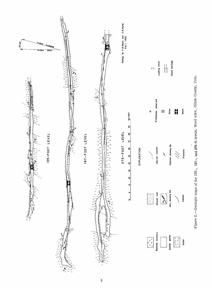
Geologic sections, showing assay data, Wood mine, Gilpin County, Colo.................. In pocketComposite map showing geology of upper levels, East Calhoun mine, Gilpin County ....... In pocketGeologic section, East and West Calhoun imine, Gilpin County.......................... In pocketGeologic map of part of the Central City district, Gilpin County, .............................. 2Geologic maps of the 135-, 197-, and 275-ft levels, Wood mine, Gilpin County, ..'............... 5
TABLESPage
Production of uranium ore, Wood mine .Assaydata, Wood mine ...............
ABSTRACT
Pitchblende has been mined in commercial quantities from four gold- and silver-bearing pyrite- sphalerite-galena veins that occur in an area about one-half mile square on the south side of Quartz Hill, Central City district, Gilpin County, Colo. These veins are the Kirk, the German-Belcher, the Wood, and the Calhoun.
Two of these veins, the Wood and the Calhoun, were studie'9 in an attempt to determine the geologic factors favprable for pitchblende deposition. All accessible workings at the Wood and East Calhoun mines were mapped by tape and compass, and the distribution of radioactivity was studied in the field. Channel and chip samples were taken for chemical assay to compare radio activity with uranium content.
The pitchblende-bearing veins cut bothpre- Cambrian granite gneiss andquartz-biotite schist; how ever, the gneiss was the more favorable host rock. Two bostonite porphyry dikes of Tertiary(?)age were crosscut by the Wood and Calhoun veins.
The pitchblende occurs inlenses erratically dis tributed along the veins and in stringers extending out ward from the veins. In the lenses it forms hard! i
masses, but elsewhere it is Soft and powdery. The pitchblende is contemporaneous with the pyrite but earlier than the sphalerite -and galena in the same vein. All the observed pitchblende was at depths of less than 400 ft. The veins probably cannot be mined profitably for the 'pitchblende alone under present conditions.
INTRODUCTION
Pitchblende was produced intermittently in the Central City district from 1872 to about 1916. The ore, some of which-contained as much as 70 percent UsOs, came chiefly from four veins, the German- Belcher, the Kirk, the Wood, and the .Calhoun. Al though few production figures are available, it is estimated that several hundred tons of uranium ore has been shipped from the district.
The Wood and Calhoun mines are on the south side of Quartz Hill in unsurveyed sec. 14, T. 3 S., R. 73 W.,about 1.5 miles southwest of Central City, Gilpin County, Colo. (fig. 1). The Realty Company of Denver, Colo. owns the Calhoun mines and leases the Wood mine. A quarter of a mile of unimproved road connects these mines with the Central City-Idaho Springs road.

Alluvium
EDDebris sheets
GILPIN 'I COUNTY I
"3 oDENVER I CENTRAL CITY
i C O L O R A .0 O !
Bostonite dikes
Manzanite
Biatite granite (Silver Plume granite)
Granite pegmatite
EHGranite gneiss
MMQuartz biotite schist
Hornblende schist
Lime silicate racks
Veins
Strike and dip of foliation
H Shaft
BInclined shaft
MINES SHOWING RADIOACTIVITY I Ayres Leavenworth 8 Harsh
2 Belcher »9 Kirk 3 Calhaun 10 Pyrinees
4 Eldorado 11 Taylor Leavenworth- 5 German 12 Waterloo
6 Gold Rock 13 West Russell7 Iran »I4 Wood
* Pitchblende produced
Geology from U.S. Geological Survey Professional Paper 94
Figure 1. --Geologic map of part of the Central City district, Gilpin County, Colo.
2

The Wood and East Calhoun mines were mapped in detail, and a geologic reconnaissance was made of the West Calhoun mine by F. B. Moore and C. R. Butler during March and April 1950 as part of the general reconnaissance investigation of radioactivity in the Colorado Front Range mineral belt. The work was done on behalf of the U. S. Atomic Energy Commission. About 4500 ft of drifts and shafts were tested for radio activity with a field counter, and channel and chip samples were taken. The purpose of this work was to determine the distribution and reserves of pitchblende in the mines. These particular mines were selected because the other mines that had produced pitchblende in the past were either inaccessible, or accessible under such adverse conditions as to make detailed map ping impracticable.
Previous geologic work on the pitchblende depos its of the Central City mining district included exam ination of 73 mines and dumps on Quartz Hill and sur rounding areas by G. B. Guillotte (official communi cation). This work was carried out between September and December, L943. The Kirk mine was dewatered in October 1944 and was examined and sampled by J. M. Hill and G. B. Guillotte.
Surface reconnaissance of Quartz Hill was made in the spring of 1949 by H. C. Granger, E. F. Beroni, and G. Phair of the U. S. Geological Survey. In January 1950, R. tl. King, H. C. Granger, and E. F. Beroni made a radiometric reconnaissance and mapped parts of the Wood and East Calhoun mines. C. C. Towle, Jr., of the Atomic Energy Commission, examined these mines in March 1949 and April 1950.
The writers gratefully acknowledge the assist ance of R. A. Bennett, L. F. Griffith, and A. A. Stapp in furnishing information of the Wood and Calhoun mines and in making their examination possible.
GEOLOGY
The pitchblende-bear ing veins on Quartz Hill are, for the most part, in medium-grained granite gneiss of pre-Cambrian age. The gneiss is light to medium gray on fresh surfaces and weathers to a reddish brown. The gneiss is exposed in an area about 4 miles long and 1.5miles wide and is surrounded byquartz- biotite schist of the Idaho Springs formation. Pre- Cambrian hornblende schist, lime-silicate rock, peg matite, and biotite granite are present but less abun dant in the district. The distribution of these rocks is shown in ,figure 1.
Tertiary(?) bostonite porphyry dikes radiate from a center on the south side of Quartz Hill near the Wood and Calhoun mines. The bostonite porphyry con sists predominantly of alkali feldspar with a small amount of quartz and varies in color from gray to red dish brown (Bastin and Hill, 1917, p. 52). A character istic of these dikes is their radioactivity, which in places, is about three times that of the surrounding gneiss. In general, radioactivity of these dikes in creases outward from the Quartz Hill area; the high est intensity occurs one and a half miles to the north.
The gneiss on Quartz Hill is interlayered with bands of quartz-biotite schist ranging from a few feet to several hundred feet in thickness. Billingsley pre sented evidence (information furnished byL. P. Griffith)
that suggests the thicker schist bands may be con tinuous for a mile or more. Thin schist bands, 10 to 15 ft thick, crop out on the south side of Quartz Hill but are not continuous for more than 200 ft along the strike. In some places foliation is well developed in the gneiss, but in others it is lacking. Where observed, it is parallel to the foliation of the adjacent schist.
According to Levering (1930, pp. 248-249), a section of gneiss and schist exposed along the Argo tunnel shows that Quartz Hill is on the crest of an anticline. The anticlinal axis strikes about N. 40°E., through the center of the hill, and the foliation in the schist and gneiss dips outward from it (fig. 1).
A series of faults that strike east to northeast and dip steeply north or south cut all the rocks on Quartz Hill. The displacement along these faults is rarely more than a few feet; faults that cut the porphyry dikes show displacement in very few places, and no offset of surface contacts was observed. These faults served as channel ways for the hydrothermal solutions that altered the wall rocks and deposited the pitchblende.
ORE DEPOSITS
Most known pitchblende deposits in the Central City district are on Quartz Hill in an area half a mile 'square. These deposits occur in gold- and silver - 1 bearing veins that follow east- or northeast-striking (faults. Two types of gold-silver ore are found in these veins; one type consists predominantly of pyrite and quartz with some chalcopyrite; and, the other type, in addition to the pyrite, quartz, and chalcopyrite, carries sphalerite and galena (Bastin and Hill, 1917, pp. 115-116). The pitchblende'occurs in association with the pyrite and quartz in veins containing both types of ore. In these veins the pyrite and quartz are earlier than the sphalerite and galena as is shown by veinlets of sphalerite cutting pyrite-quartz veinlets. A narrow belt which trends northeast through the center of Quartz Hill contains a mixture of both types of ore. Southeast of this belt, the ore is predomi nantly the pyrite-quartz type and, northwest of the belt, the ore is predominantly the sphalerite-galena type.
Pitchblende occurs in small lenses, streaks,and stringers mostly on the hanging-wall side of the veins. The lenses, generally less than 10 ft in diameter and less than 6 in. thick, are localized, usually with ac companying streaks and stringers, within poorly defined ore shoots at depths of less than 400 ft from the surface. In the Kirk mine, which contained the largest known deposit in the area, pitchblende was distributed through a vertical distance of 350 ft, but most of the ore, some containing as much as 70 to 80 percent uranium was found in the upper 250 ft (Moore and Kithil, 1913, pp. 43-44).
MINE DESCRIPTIONS
Wood mine
The Wood mine is on the south side of Quartz Hill.in unsurveyed sec. 14. T. 3S., R. 73 E., at an elevation of 9, 335 ft. The property is connected with the Central City-Idaho Springs road by a

quarter of a mile of unimproved road. The mine is under lease to the Realty Company of Denver, Colo.
The accessible workings comprise a nearly vertical shaft and drifts at 65, 135, 197 and 275 ft below the collar. The aggregate length of these drifts is about 1,050 ft. Inacessible workings include an older shaft, 120 ft east of the main shaft, and two drifts, below the 275 ft level. The lessees report that work ings extend to a depth of 600 ft.
History. --In 1871 pitchblende was first noted on the dump of the old Wood shaft by Richard Fearce (1898, pp. 157-158). The pitchblende had been thrown
away before its value was realized. The following year about three tons of ore were mined which aver aged 60 percent uranium oxide, and several more tons were hand-sorted from the dump. Small quan tities were produced until 1884 (table 1), when the supply was believed to be exhausted. In 1894, another deposit was discovered near the old shaft, and sever al shipments of ore were made from 1897 to 1900. Since 1900, about 10 tons of ore have been produced from the new shaft between the 135- and 197 ft levels. The high-grade pitchblende ore was sorted by hand, and the lower grade ore (containing probably 10 per cent or less pitchblende) was either discarded or lost in the processing for gold and silver.
Table 1. Production aof uranium ore, Wood mine
Year
1872 . - -1873 - _____________1874 84l897bn Q(^\Q1090 1899^ _ _1900"b 1913 __________________1916rp/^f-Q~] .
Pounds of ore
6,2004,0006,000
66,000
40020,000
102,600
UjOS (percent)
605070
12
5060029
Uj08 (pounds)
j > i t-v2,000
( >y*3j
20012,000
30,040
aPieures compiled from Guillotte G. B.,i944, official communication and Moore, R. B. andKlthll, K. L.,-(1913).
Cranium was also produced during these years but no figures are available. °Weighted average.
Geology. ---The country rock at the Wood mine is a medium-grained granite gneiss interlayered with quartz-bio tite schist of the Idaho Springs formation. One large body of schist occurs in the west drift on the 275-ft level (fig. 2). Hydrothermal alteration a- long the Wood vein has largely destroyed the structure in the adjacent gneiss exposed in the mine. However, the foliation of the schist is still preserved in many places on the walls of the drifts. In general, it dips to the west or northwest.
A bostonite porphyry dike, which strikes N. 40°W. and dips 65° NE., crops out at the surface 270 ft west of the new shaft. This dike is exposed 70 ft west of the shaft on the 197-ft level, and just east of the shaft on the 275-ft level (fig. 2 and-pi. 1). The radioactivity of this dike at these places is only slightly higher than that of the adjacent gneiss. A second bostonite por phyry dike, striking N. 43° W. and dipping steeply northeast, crops out 200-ft east of the^shaft, and is exposed by a crosscut from the East Calhoun mine in to the 135-ft level of the Wood mine. Radioactive anomalies in this dike as measured in the crosscut were about twice background, but these anomalies were only slightly higher than the background at the surface. Both dikes were cut and altered by the Wood vein.
The Wood vein is in a fault fissure that strikes nearly east and dips 85° N. The vein has been fol lowed for a lateral distance of nearly 1, 000 ft and to a reported depth of about 600 ft. It ranges in width from 1 to 18 in., and the adjacent wall rock has been altered and bleached along both sides of the vein for a distance of several feet, although the alteration ex tends farther into the country rock above the hanging
wall. The altered zone contains disseminated pyrite from the borders of the vein up -to a distance of 1 to 2 ft. The country rock has been silicified near the vein and sericitized farther away, destroying the original texture.
The width of the vein, in general, is related to the type of country rock in which it occurs. The operators report and the position of the stopes indi cate that the vein was thickest, and that the best ore was found, in the gneiss. In the schist the vein has a tendency to branch and, on both the 197- and 275-ft levels, it was abandoned to the west where it "horse- tailed out. "
The lack of displacement of the pre-ore dikes where cut by the vein shows that no major post-ore movement occurred along the vein. On the 135-ft level, 450 ft east of the shaft, the Wood vein is cut and displaced 18 in. by the Calhoun vein (pi. 2). This intersection plunges east at an angle of 63° from the horizontal. Apparently it was explored by the miners for only a short distance. No other crossfaults were observed along the Wood vein.
Mineralogy. --Above the 197-ft level of the Wood mine, the vein material consists chiefly of pyrite, quartz, some chalcopyrite, and, locally, pitchblende. On the 197- and 275-ft levels sphalerite is also found. A coating on the ore, called bornite by the miners but probably mostly covellite, is prominent on the 197-ft level.
The pyrite-quartz ores have been fractured after deposition. On the 197-ft level, where both
13
5-F
OO
T
LE
VE
L
197-F
OO
T
LE
VE
L
275-F
OO
T
LE
VE
L
9 10
20
30
40
SO
60
70
80
90
100 FEET
Geo
logy
by
F
.B.M
oare
an
d C
.R.B
utle
r A
pril
1950
Vei
n, s
how
ing
dip
EX
PLA
NA
TIO
N
Infe
rred
co
nta
ct
Fol
iatio
n sh
owin
g di
p
Pitc
hble
nde
obse
rved
Load
ing
chut
e
Cav
ed
wor
king
s
Sch
ist
Shoft
Fig
ure
2. -
-Geo
logi
c m
aps
of t
he 1
35-,
197-
, an
d 27
5-ft
lev
els,
Woo
d m
ine,
G
ilpin
Cou
nty,
C
olo.

sphalerite-galena and pyrite-quartz ores occur, the sphalerite is in the center of the vein and is not fractured. Sharp-walled stringers of sphal erite cut pyrite stringers in places.
The present exposures of pitchblende, thought to be near the borders of mined-out pitchblende - rich lenses, are in 1/8 to 1 in. streaks at the side of the vein near gouge. The pitchblende is soft, dark, and amorphous and is intergrown with quartz and fine-grained pyrite.| The pitch blende mined/ from the lenses was, according to the miners, a hard, black botryoidal variety. Small patches of soft pitchblende in pyrite string ers were found in the walls of the drifts more than 50 ft from the nearest known occurrence of pitchblende in the vein. Although locally sphal erite occurs adjacent to pitchblende in the vein, samples of sphalerite did not show appreciable radioactivity. A petrographic study by Bastin (1917, pp.J 123-124) of specimens from the Wood and Calhoun mines showed (1) pitchblende was deposited contemporaneously with pyrite, chal- copyrite and quartz, and (2) fractured pitchblende was cut by veinlets of sphalerite, galena, pyrite, and chalcopyrite of later age.
Ore bodies. --The position of the stopes suggests that the gold ores came from a single ore shoot that plunges 45 to the west. This shoot has been worked for a distance about 200 ft along the drifts on the 135-ft, 197-ft, and 275-ft levels.
Pitchblende is found chiefly in a zone 60 ft wide in the western part of the main ore shoot. This zone extends from near the surface to at least the 197-ft level and also plunges to the west (pi. 1). Although scattered occurrences are found elsewhere in the mine, it is 'believed that most of the pitchblende came from this zone. Fearce (1898, pp. 156-158) reports that the old shaft intersected a"vertical lenticular deposit of uraninite" at a depth of about 60 ft. The "uraninite" occurred as a 6-in. lens in a "lode" 4 ft wide. Other lenses have been found west of the old shaft below the 60-ft level, and east of the new shaft between the 135-ft and 197-ft levels.
In the sections of the mine now accessible, which does not include the shallow workings from the old shaft, most of the pitchblende occurs just below the 135-ft level. Here it is continuous along the. vein for 20 ft horizontally and vertically and has a maximum thickness of 1 in. On the 197-ft level, the best ex posure is about 1/4 in. thick and 5 ft long. Only a trace was found on the 275-ft level, but the vein on this level is inaccessible for most of its length.
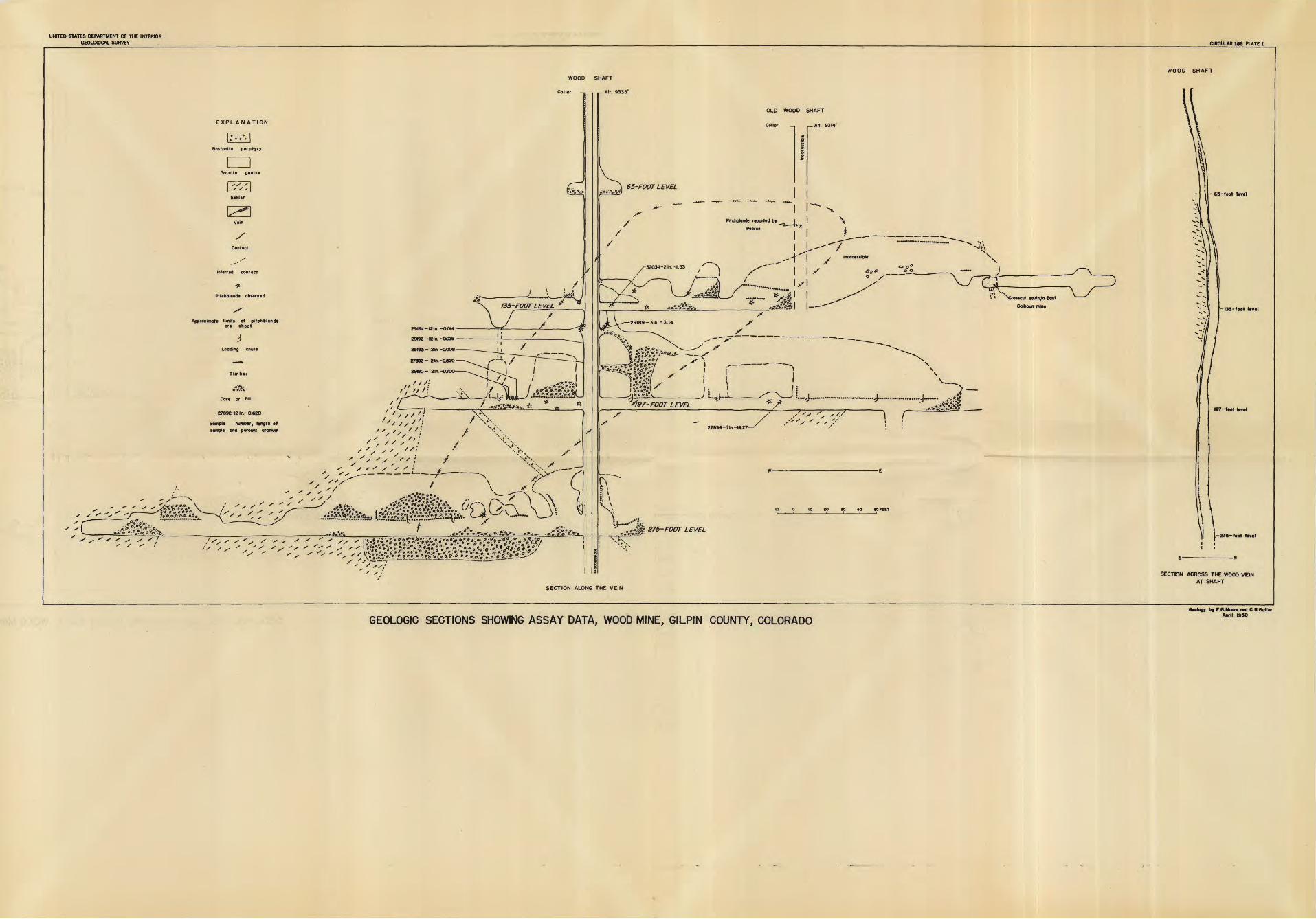
As an aid in locating small quantities of pitch blende, a field model portable survey meter was used to test all accessible workings of the mine. Channel samples, 1 ft in length, were cut across the vein in places where abnormal radioactivity was found, and chip samples were taken in several places where pitch blende occurred in stringers along the walls of the drift. The location of these samples, is shown on plate 1.
Table 2. Assay data, Wood mine
Sample no.
2789227894 a 29189 a2919029191291922919332035 a
eU (percent)
0.5214.5 3.90.70.065,086.0231.87
U (percent)
0.6214.27 3.14.70.014.029.008
1.53
Pb (percent)
1.611.61 .00
1.25.00.99.00.00
Zn (percent)
6.75.00 .00
4.86.00.00.15.00
Cu (percent)
2.451.18 1.43.00.00.00
1.25.12
Au ( oz/ton')
0.4Tr. Tr.
.00Tr.Tr.Tr.Tr.
Ag (oz/ton)
7-25.6 5-6.00
1.81.65.2l.O
aChip samples.
Suggestions for exploration. --Pitchblende in the Wood mine is localized chiefly within a westward- plunging ore shoot that extends 60 ft along the strike and'about 150ft down the plunge (pi. 1). As the ground to the east and west has already been explored by drifts and only small quantities of pitchblende were found, a horizontal extension of the shoot is believed unlikely. The shoot appears to have pinched out on the 275-ft level but, as the distribution of pitchblende in the area is erratic, this may be a local barren zone. However most of the uranium ore from other mines on Quartz Hill is reported to have come from depths of less than 400 ft.and the better ore was limited to a vertical range of about 100 ft, thus it is believed that no more than minor quantities of pitchblende are present below the 275-ft level.
The ground most favorable for exploration is within the ore shoot, particularly (1) east of the new shaft, between the 65- and 135-ft levels, and (2) west of the new shaft, between
the 135- and 275-ft levels. This ground is known to contain some pitchblende but the grade and tonnage are dependent on the presence or absence of pitch blende lenses.
The area around the Wood mine is also considered favorable for the occurrence of uranium, as mines to the north, west, and south contain pitchblende. Possible places for exploration would be (1) in blind veins north or south of the Wood vein, (2) along the intersection of the Wood and Calhoun veins, or (3) in the unexplored eastern portion of the Wood vein. A drill hole from the East Calhoun mine cuts several small veins between the Calhoun and Wood veins, and other blind veins may be present north of the Wood vein. A small quantity of pitch blende occurs near the Wood-Calhoun vein intersection on the 135-ft level of the Wood Mine. This intersection apparently hasbeenlittle explored, above or below this level. The Wood vein is 3 in. wide at the eastern face on the 135-ft level and may extend to the east for several hundred feet beyond this face.
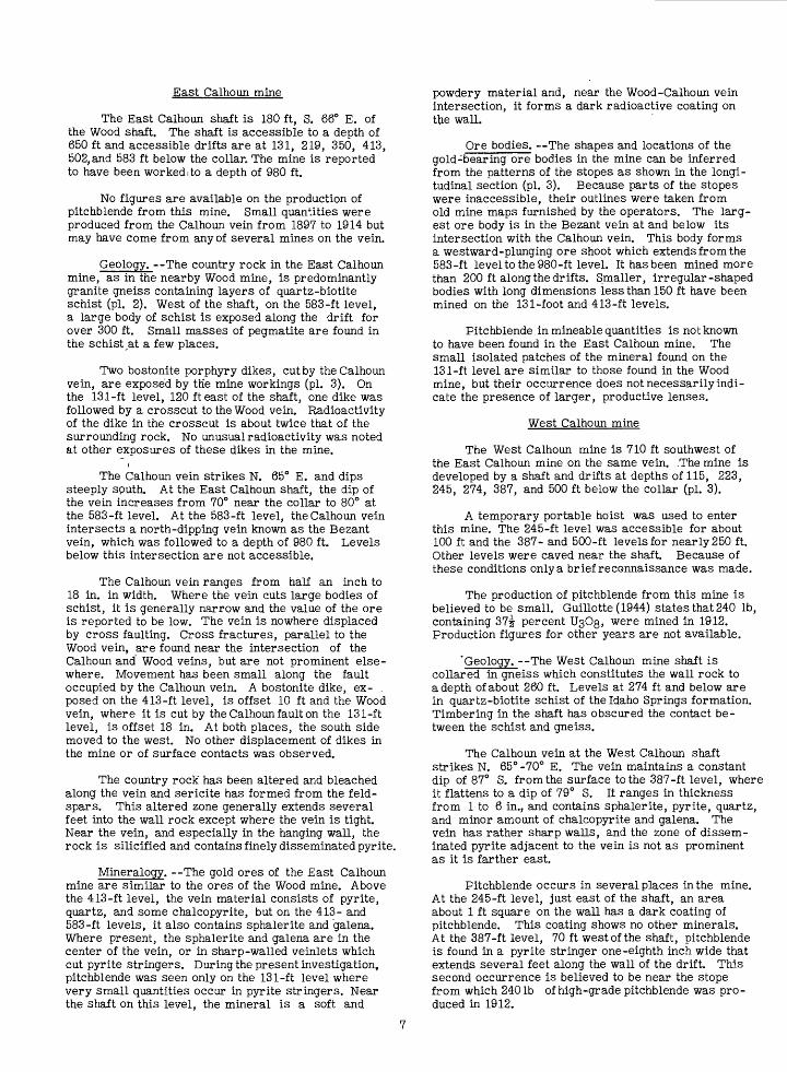
East Calhoun mine
The East Calhoun shaft is 180 ft, S. 66° E. of the Wood shaft. The shaft is accessible to a depth of 650 ft and accessible drifts are at 131, 219, 350, 413, 502, and 583 ft below the collar. The mine is reported to have been worked:to a depth of 980 ft.
No figures are available on the production of pitchblende from this mine. Small quantities were produced from the Calhoun vein from 1897 to 1914 but may have come from any of several mines on the vein.
Geology. The country rock in the East Calhoun mine, as in the nearby Wood mine, is predominantly granite gneiss containing layers of quartz-biotite schist (pi. 2). West of the shaft, on the 583-ft level, a large body of schist is exposed along the drift for over 300 ft. Small masses of pegmatite are found in the schist at a few places.
Two bostonite porphyry dikes, cut by the Calhoun vein, are exposed by the mine workings (pi. 3). On the 131-ft level, 120 ft east of the shaft, one dike was followed by a crosscut to the Wood vein. Radioactivity of the dike in the crosscut is about twice that of the surrounding rock. No unusual radioactivity was noted at other exposures of these dikes in the mine.
The Calhoun vein strikes N. 65° E. and dips steeply south. At the East Calhoun shaft, the dip of the vein increases from 70° near the collar to 80° at the 583-ft level. At the 583-ft level, the Calhoun vein intersects a north-dipping vein known as the Bezant vein, which was followed to a depth of 980 ft. Levels below this intersection are not accessible.
The Calhoun vein ranges from half an inch to 18 in. in width. Where the vein cuts large bodies of schist, it is generally narrow and the value of the ore is reported to be low. The vein is nowhere displaced by cross faulting. Cross fractures, parallel to the Wood vein, are found near the intersection of the Calhoun and Wood veins, but are not prominent else where. Movement has been small along the fault occupied by the Calhoun vein. A bostonite dike, ex- . posed on the 413-ft level, is offset 10 ft and the Wood vein, where it is cut by the Calhoun fault on the 131-ft level, is offset 18 in. At both places, the south side moved to the west. No other displacement of dikes in the mine or of surface contacts was observed.
The country rock has been altered and bleached along the vein and sericite has formed from the feld spars. This altered zone generally extends several feet into the wall rock except where the vein is tight. Near the vein, and especially in the hanging wall, the rock is silicified and contains finely disseminated pyrite.
Mineralogy. --The gold ores of the East Calhoun mine are similar to the ores of the Wood mine. Above the 413-ft level, the vein material consists of pyrite, quartz, and some chalcopyrite, but on the 413- and 583-ft levels, it also contains sphalerite and galena. Where present, the sphalerite and galena are in the center of the vein, or in sharp-walled veinlets which cut pyrite stringers. During the present investigation, pitchblende was seen only on the 131-ft level where very small quantities occur in pyrite stringers. Near the shaft on this level, the mineral is a soft and
powdery material and, near the Wood-Calhoun vein intersection, it forms a dark radioactive coating on the wall.
Ore bodies. The shapes and locations of the gold-bearing ore bodies in the mine can be inferred from the patterns of the stopes as shown in the longi tudinal section (pi. 3). Because parts of the stopes were inaccessible, their outlines were taken from old mine maps furnished by the operators. The larg est ore body is in the Bezant vein at and below its intersection with the Calhoun vein. This body forms a westward-plunging ore shoot which extends from the 583-ft level to the 980-ft level. It has been mined more than 200 ft along the drifts. Smaller, irregular-shaped bodies with long dimensions less than 150 ft have been mined on the 131-foot and 413-ft levels.
Pitchblende in mineable quantities is not known to have been found in the East Calhoun mine. The small isolated patches of the mineral found on the 131-ft level are similar to those found in the Wood mine, but their occurrence does not necessarily indi cate the presence of larger, productive lenses.
West Calhoun mine
The West Calhoun mine is 710 ft southwest of the East Calhoun mine on the same vein. .The mine is developed by a shaft and drifts at depths of 115, 223, 245, 274, 387, and 500 ft below the collar (pi. 3).
A temporary portable hoist was used to enter this mine. The 245-ft level was accessible for about 100 ft and the 387- and 500-ft levels for nearly 250 ft. Other levels were caved near the shaft. Because of these conditions only a brief reconnaissance was made.
The production of pitchblende from this mine is believed to be small. Guillotte(1944) states that 240 Ib, containing 37i percent UsOg, were mined in 1912. Production figures for other years are not available.
'Geology. --The West Calhoun mine shaft is collared in gneiss which constitutes the wall rock to a depth of about 260 ft. Levels at 274 ft and below are in quartz-biotite schist of the Idaho Springs formation. Timbering in the shaft has obscured the contact be tween the schist and gneiss.
The Calhoun vein at the West Calhoun shaft strikes N. 65° -70° E. The vein maintains a constant dip of 87° S. from the surface to the 387-ft level, where it flattens to a dip of 79° S. If ranges in thickness from 1 to 6 in., and contains sphalerite, pyrite, quartz, and minor amount of chalcopyrite and galena. The vein has rather sharp walls, and the zone of dissem inated pyrite adjacent to the vein is not as prominent as it is farther east.
Pitchblende occurs in several places in the mine. At the 245-ft level, just east of the shaft, an area about 1 ft square on the wall has a dark coating of pitchblende. This coating shows no other minerals. At the 387-ft level, 70 ft west of the shaft, pitchblende is found in a pyrite stringer one-eighth inch wide that extends several feet along the wall of the drift. This second occurrence is believed to be near the stope from which 240 Ib of high-grade pitchblende was pro duced in 1912.
REFERENCES CITED
Bastin, E. S. and Hill, J. M., 1917, Economic Moore, R. B. and Kithil, K. L., 1913, A preliminarygeology of Gilpin County and adjacent parts of report on uranium, radium, and vanadium: U. S. Bur.Clear Creek and Boulder Counties, Colo. : U. S. Mines Bull. 70, pp. 43-44.Geol. Survey Frof. Paper 94. Fearce, Richard, 1898, Some notes on the occurrence
Levering, T. S., 1930, Localization of ore in the of uraninite in Colorado: Colorado Sci. Soc. Froc.schists and gneisses of the mineral belt of the Front 5, pp. 156-158.Range, Colorado: Colorado Sci. Soc. Froc., vol.12, no. 7, pp. 248-249.
INT.-DUP. SEC., WASH.,
UNITED STATES DEPARTMENT OF THE INTERIOR GEOLOGICAL SURVEY CIRCULAR 186 PLATE 1
WOOD SHAFT
EXPL AN ATION
Bostonite porphyry
Granite gneiss
Vein
/
Contact
Inferred contact
-*
Pitchblende observed
Approximate limits of pitchblende ore shoot
Loading chute
. ri.C.-».^O
Cove or fill
27892-12 In.- 0.620
Sample number, length of sample and percent uranium
'//"*'
' ' s ''/
S /
s s ^ '^
7"',"''!' / :
'/' s i : /
'"I /" ' i- -f _7if-
/
vr-SSS:^. ^«t^A?&..9 »»: ft 5*A:«-o^ V* * o».«* ! _. _ _.!."_ rt.A'O-QV A
XxX V\X NJ
N\
^n(§
x*\v..+s. x*V'.
N» N
?y (^\x\ \..._ \
M v
y"
X
X^ _ __*'"" S^
(
\N i
SHAFT
-Alt. 9335'
OLD WOOD SHAFT
Collor _, , Alt. 9314'
\ 65-FOOT LEVEL
F»ehWende reported by I |
F-X.i Xrosi>scut Muth.to Eatt
Colhoun mine
X* ^:«>.0 0^ -^
Si97-FOOT LEVEL
SS
27894-lln.-l4.Z7-
/',
/"''. , '/ ^ r
.-.».*: ^$g& __
rsl\
10 o 10 co 90 40 sorter
t).,.--1....VftST 275-FOOT L EVEL
63- foot level
-I3S-foot level
- 197-foot level
1-275-foot level
I I I i
SECTION ACROSS THE WOOD VEIN AT SHAFT
SECTION ALONG THE VEIN
GEOLOGIC SECTIONS SHOWING ASSAY DATA, WOOD MINE, GILPIN COUNTY, COLORADOGeology by F.B.Moore and C.RButle
April 1950

UNITED STATES DEPARTMENT OF THE INTERIOR GEOLOGICAL SURVEY
OLD WOOD SHAFT
WOOD DRIFT - 135-foot lerel
WOOD VEIN
NEW WOOD SHAFT
EXPLANATION
Vein ihowmg dip broken where limbered
Contact, ihowlng dip
Inferred contact
Strike and dip of foliation
Pitchblende obierved
Top of Inclined ihaft
mnShafl going above end below levels
gCT
Bottom of ihofl
LJ
Ore chole
=*:Caved worklngi
C I
20 10 0
COMPOSITE MAP SHOWING GEOLOGY OF UPPER LEVELS, EAST CALHOUN MINE, GILPIN COUNTY, COLORADOGeology by F B.Moore and C.R.Butter
April 1950

UNITED STATES DEPARTMENT OF THE INTERIOR GEOLOGICAL SURVEY CIRCULAR 186 PLATE 3
EXPLANATION
Inferred conloel
s'~^
Inferred itopi llmilt
1 1
loading chutt
Covi or III!
=1"
Inoectffibl* worklngt
tt
Pltchbtandi obwrvcd
WEST CALH OUN SHAFT
Alt. 9390
A-~
EAST CALHOUN SHAFT
Collor _ All. 9292'
5OO- FOOT LEVEL
]".":.'> 223- FOOT LEVEL
245-FOOT LEVEL
274-FOOT LEVELOutline of inoccniibl* workings mopf furnished by optrolort
387 -FOOT LEVEL
Croueut tooth to Bezont min«
Outline of inaccessible workings from mops furnished by operators
7"^
219 - FOO T ,/.£ VEL
-^"350- FOOT LEVELS
. \~~A-
50,?-
583- FOOT LEVEL
" 643- FOOT LEVEL
--Woter level
»°, ...9 , , , 20,° FEET
-' > . »§»
Gtology by F.B.Moori ond C.R.Butlir April 1950
GEOLOGIC SECTION, EAST AND WEST CALHOUN MINES, GILPIN COUNTY, COLORADO