pinro airborne research on study of the ... airborne research on study of the white sea harp seal...
TRANSCRIPT

PINRO AIRBORNE RESEARCH ON STUDY OF THE WHITE SEA HARP
SEAL PUP PRODUCTION ABUNDANCE
VLADIMIR ZABAVNIKOV & ILYAS SHAFIKOV - PINRO
6, KNIPOVICH STREET, MURMANSK, 183038, RUSSIA
PHONE: (+7)-815-2-47-25-72,
FAX: (+7)-815-2-47-33-31,
E-MAIL: [email protected]
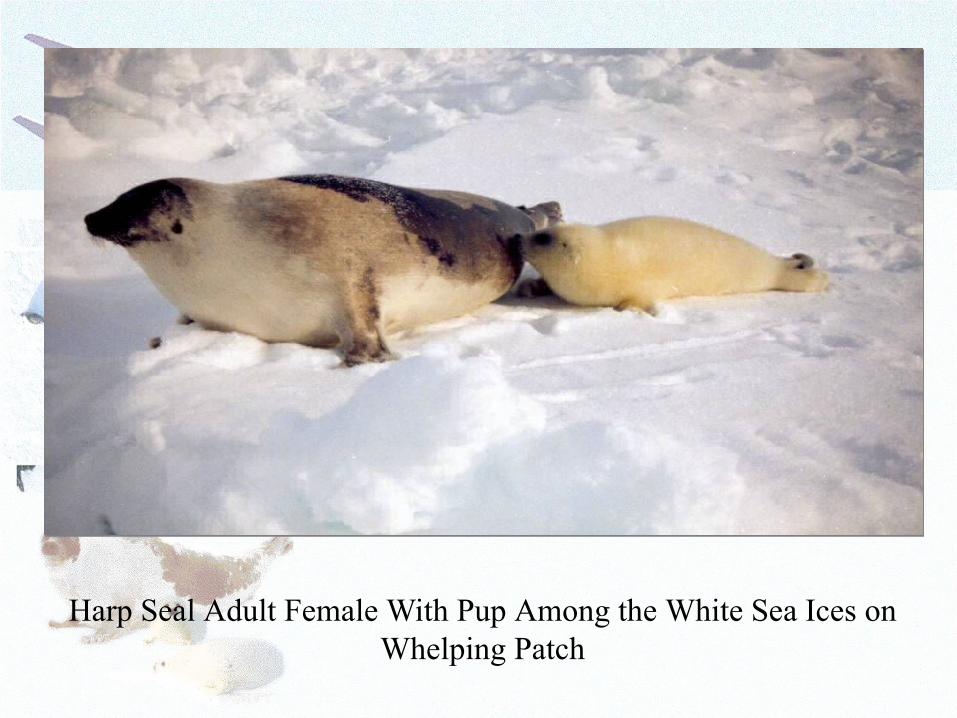
Harp Seal Adult Female With Pup Among the White Sea Ices on Whelping Patch
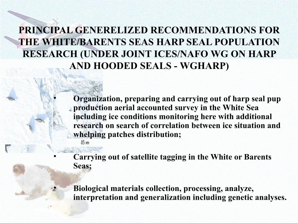
PRINCIPAL GENERELIZED RECOMMENDATIONS FOR THE WHITE/BARENTS SEAS HARP SEAL POPULATION RESEARCH (UNDER JOINT ICES/NAFO WG ON HARP
AND HOODED SEALS - WGHARP)
• Organization, preparing and carrying out of harp seal pup production aerial accounted survey in the White Sea including ice conditions monitoring here with additional research on search of correlation between ice situation and whelping patches distribution;
• Carrying out of satellite tagging in the White or Barents Seas;
• Biological materials collection, processing, analyze, interpretation and generalization including genetic analyses.

Appearance of Research Aircraft
Antonov-26 (AN-26) «Arktika» and its Main Technical
Specification
8Number of places for board operators
100-6000Height of flight, m
8-9Maximum flight duration, hr
250-400Speed range, km/h
max. 14
(harp seal-8) Number of board measuring complex
3200Maximum flight distance, km
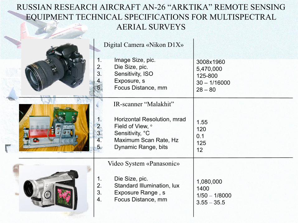
1,080,00014001/50 – 1/80003.55 – 35.5
Video System «Panasonic»
1. Die Size, pic.2. Standard Illumination, lux3. Exposure Range , s4. Focus Distance, mm
1.55 1200.1125 12
IR-scanner “Malakhit”
1. Horizontal Resolution, mrad2. Field of View, o
3. Sensitivity, °С4. Maximum Scan Rate, Hz5. Dynamic Range, bits
3008 1960х5,470,000125-80030 – 1/1600028 – 80
Digital Camera «Nikon D1X»
1. Image Size, pic.2. Die Size, pic.3. Sensitivity, ISO4. Exposure, s5. Focus Distance, mm
RUSSIAN RESEARCH AIRCRAFT AN-26 “ARKTIKA” REMOTE SENSING EQUIPMENT TECHNICAL SPECIFICATIONS FOR MULTISPECTRAL
AERIAL SURVEYS

DATA ON RESEARCH AIRCRAFT AN-26 “ARKTIKA” EXPLOITATION IN AERIAL SURVEYS OF HARP SEALS
WHELPING PATCHES
- Aerial accounted multispectral surveys altitude was 200 – 250 m, in principal – 250 m;
- Aerial accounted multispectral surveys flight speed was 300 – 320 km/h;
- The base accounted tracks were oriented along longitudes with distance between its 7,5 km, i.e. about 10’ between longitudes;
- Remote sensing equipments switched on when ice edge was crossed from open water and switched off when research aircraft reached coast or crossed ice edge again from ice to open water

PRINCIPAL REQUIREMENTS FOR HIGH QUALITY ACCOUNTED MULTISPECTRAL AERIAL SURVEY ON
WEATHER CONDITIONS
• Wind speed – no more than 10 m/s;• Absolute absent of precipitations, fogs,
haze and other atmospheric phenomenon;
• Clouds low edge – higher than 250 m.
Its meteorological conditions should observe in area more than 75% of aerial survey area simultaneously.
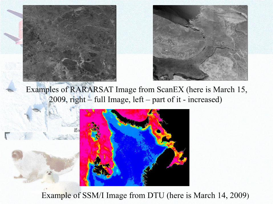
Example of SSM/I Image from DTU (here is March 14, 2009)
Examples of RARARSAT Image from ScanEX (here is March 15, 2009, right – full Image, left – part of it - increased)
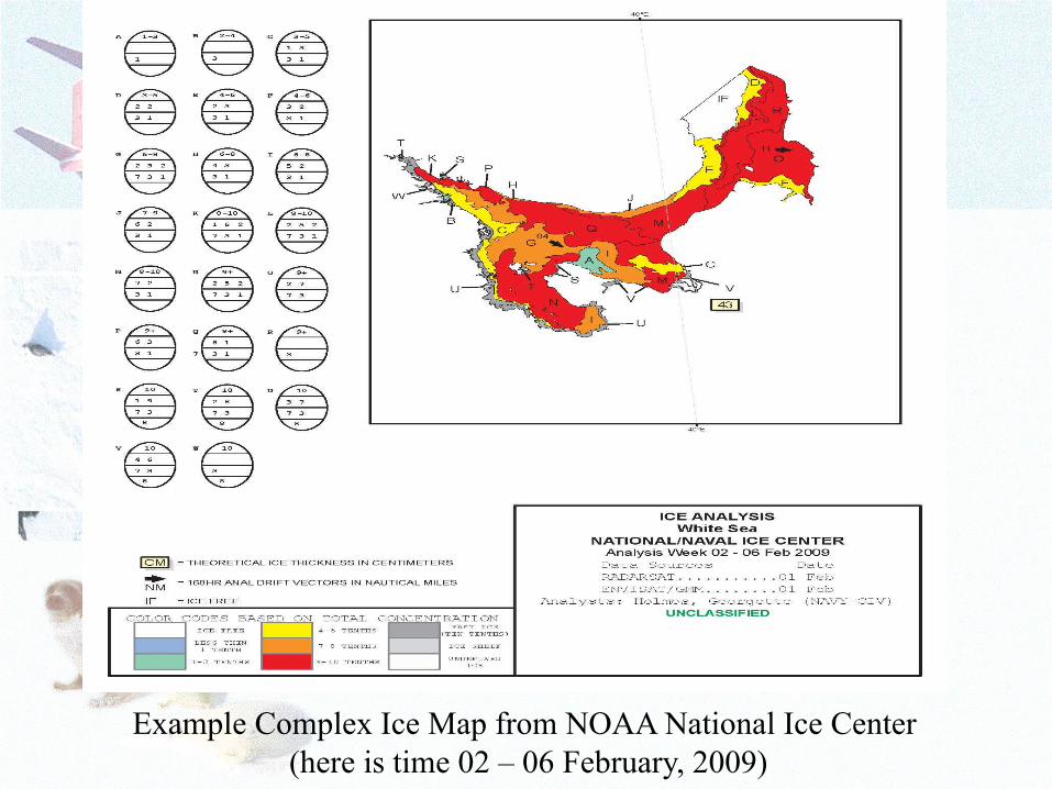
Example Complex Ice Map from NOAA National Ice Center (here is time 02 – 06 February, 2009)
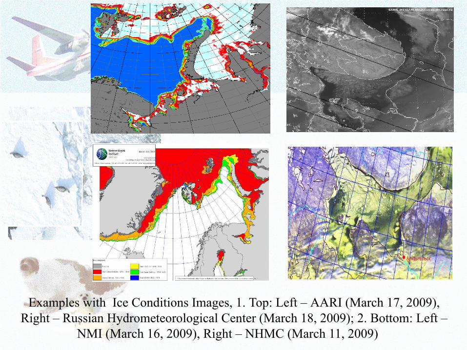
Examples with Ice Conditions Images, 1. Top: Left – AARI (March 17, 2009), Right – Russian Hydrometeorological Center (March 18, 2009); 2. Bottom: Left –
NMI (March 16, 2009), Right – NHMC (March 11, 2009)
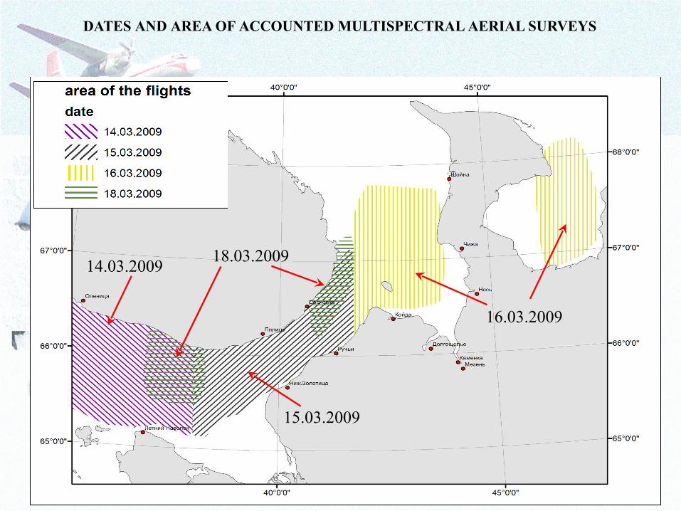
DATES AND AREA OF ACCOUNTED MULTISPECTRAL AERIAL SURVEYS
14.03.2009
15.03.2009
16.03.2009
18.03.2009
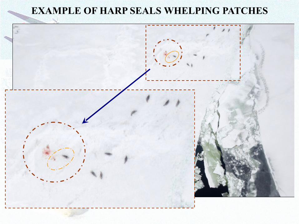
EXAMPLE OF HARP SEALS WHELPING PATCHES

IR Image
6x 3xPhoto Image Photo Image
35 mm 85 mm
Boundaries of Digital Video
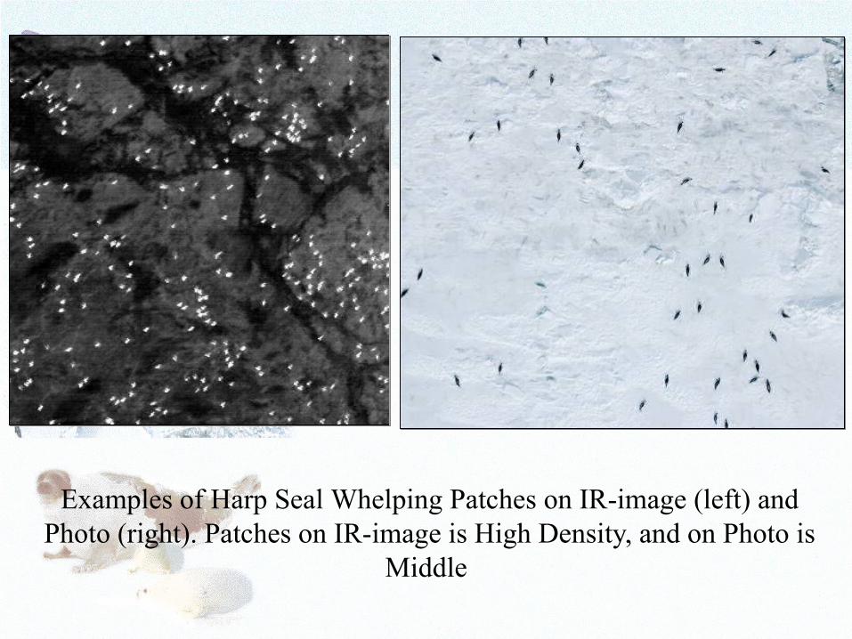
Examples of Harp Seal Whelping Patches on IR-image (left) and Photo (right). Patches on IR-image is High Density, and on Photo is
Middle

DENSITIS OF PUP PRODUCTION SPATIAL DISTRIBUTION

THE WHITE/BARENTS SEAS HARP SEAL POPULATION PUP PRODUCTION ESTIMATED NUMBERS
YearNumbers of Harp Seal Pup Production
(on M. Kingsly) Including Commercial Catches / Error
(Pieces)
1998 286 260 / 43 000
2000 339 710 / 30 000
2002 330 000 / 45 000
2003 327 000 / 41 000
2004 239 000 / 36 000
2005 122 658 / 19 900
2008 123 104 / 28 341
2009 157 000 / 17 000
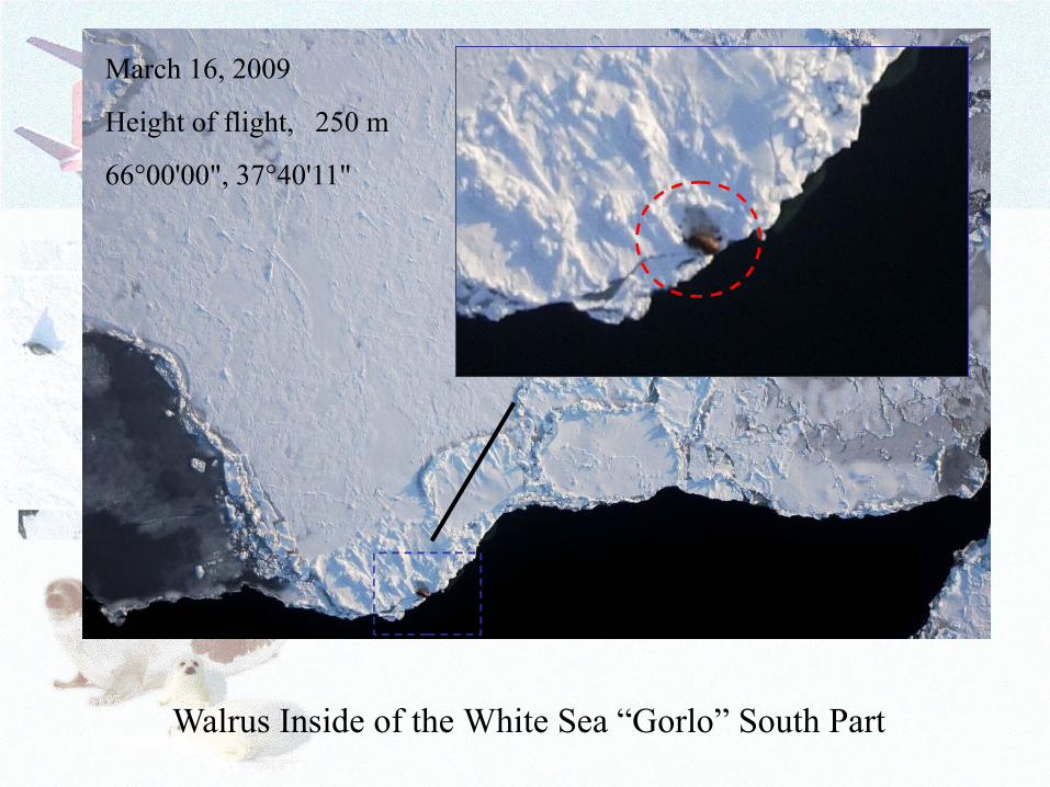
March 16, 2009
Height of flight, 250 m
66°00'00", 37°40'11"
Walrus Inside of the White Sea “Gorlo” South Part

Example of Icebreaker Route

Harp Seal Adult Female With Pup Among the White Sea Ices on Whelping Patch
Acknowledgements
Presented research was financially supported by Russian Federation Federal Fisheries Agency and PINRO. The authors thank crew of research aircraft An-26 “Arktika” from Company “Nord-Avia” (former “Aeroflot-Nord”), Archangelsk for their high quality and professional works, members of scientific group from PINRO and Company “Aeroeclogy” (S.-Petersburg) which participated in accounted multispectral aerial surveys that allowed to collect quality and reliable data and images. Also the authors thank specialists of PINRO who participated in data and images processing, analyzing, interpretation and generalization, especially of Nataly Isaeva and Roman Klepikovsky.
THANK YOU VERY MUCH FOR YOUR
ATTENTION!