pim precinct information modelling - cloud object storage ... · pim – precinct information...
TRANSCRIPT

PIM – Precinct Information Modelling
Information Modelling at a Precinct Scale to Manage
the Carbon Load of the Built Environment
UNSW: Jim Plume UniMelb: Tuan Ngo
John Mitchell Oliver Lade
David Marchant Brandon Lim
March 2015

Our purpose is to lower the carbon emissions of the built
environment
while driving the competitive
advantage for Australian industry.
Our mission is to engage in
collaborative research that provides
social and technology solutions and
policy evidence, to capture community imagination and
facilitate the transition
to a lower carbon built environment.
24/03/2015 2

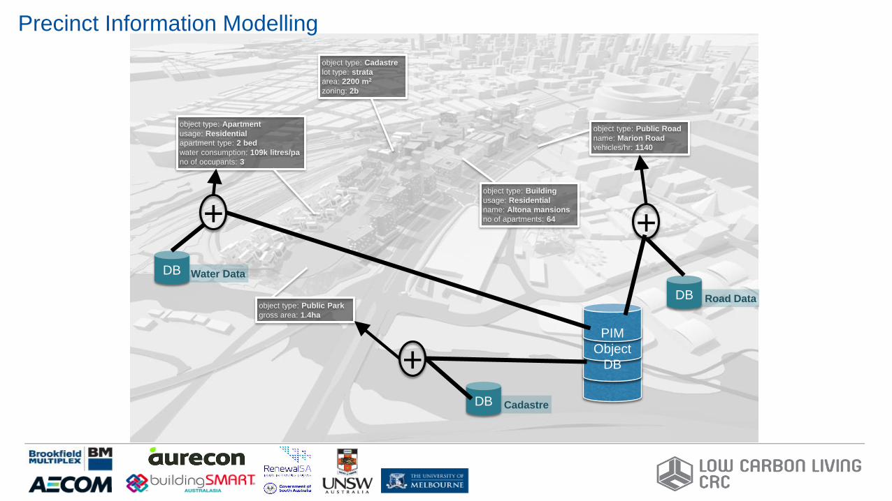
Precinct Information Modelling
A Precinct Information Model (PIM) is a
comprehensive 3D digital database Model of a
Precinct that contains all the Information needed to
support planning, design, development, construction,
management, operation, use and retro-fitting of
urban precincts.
From our perspective as a CRC, the focus is directed
towards minimisation of carbon throughout the
precinct life cycle, supported by a PIM. In a broader
context, a PIM could be used for a whole range of
other purposes.

object type: Building
usage: Residential
name: Altona mansions
no of apartments: 64
object type: Apartment
usage: Residential
apartment type: 2 bed
water consumption: 109k litres/pa
no of occupants: 3
object type: Public Park
gross area: 1.4ha
object type: Public Road
name: Marion Road
vehicles/hr: 1140
object type: Cadastre
lot type: strata
area: 2200 m2
zoning: 2b
Precinct Information Modelling
object type: Building
usage: Residential
name: Altona mansions
no of apartments: 64
object type: Apartment
usage: Residential
apartment type: 2 bed
water consumption: 109k litres/pa
no of occupants: 3
object type: Public Park
gross area: 1.4ha
object type: Public Road
name: Marion Road
vehicles/hr: 1140
object type: Cadastre
lot type: strata
area: 2200 m2
zoning: 2b
PIM
Object
DB
DB Road Data
DB Cadastre
+
+
DB Water Data
+
Precinct Information Modelling

3/24/2015 6
Source: UrbanIT, after Andreas Kohlhaas
Precinct
PIM – the Scale of Things
3/24/2015 7
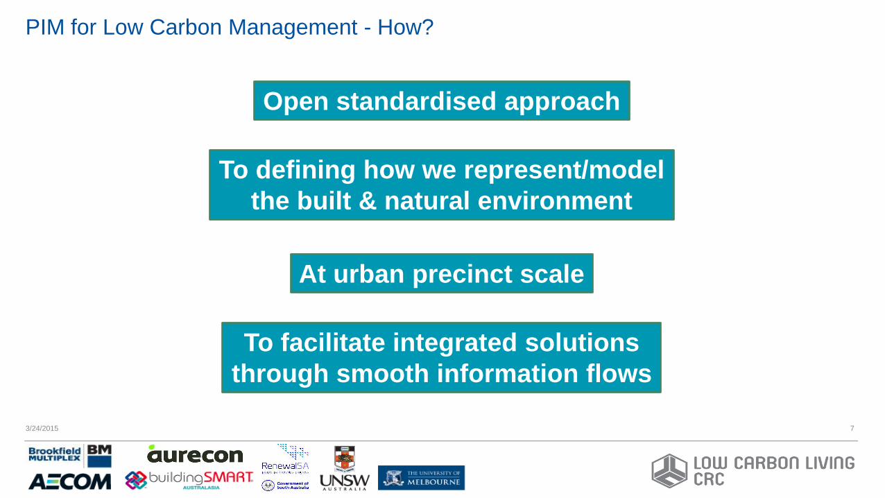
PIM for Low Carbon Management - How?
Open standardised approach
To defining how we represent/model
the built & natural environment
At urban precinct scale
To facilitate integrated solutions
through smooth information flows
3/24/2015 8
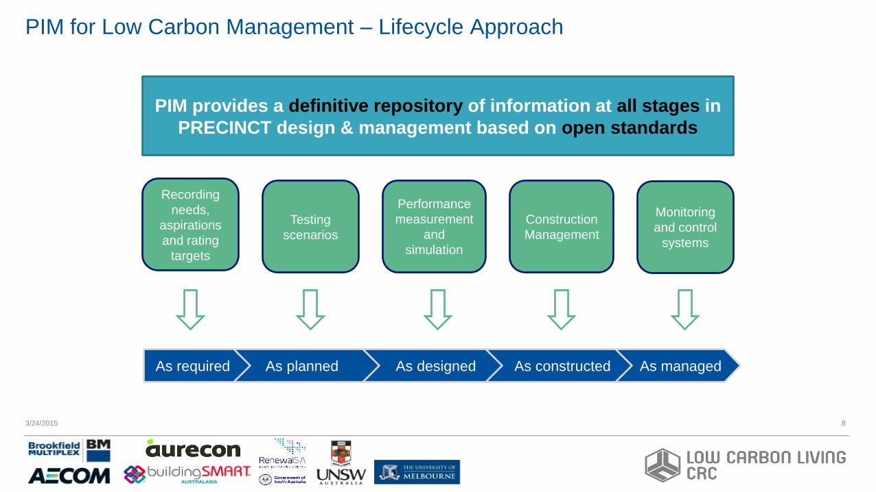
PIM for Low Carbon Management – Lifecycle Approach
As managed
PIM provides a definitive repository of information at all stages in
PRECINCT design & management based on open standards
Recording
needs,
aspirations
and rating
targets
Testing
scenarios
Performance
measurement
and
simulation
Monitoring
and control
systems
As constructed
Construction
Management
As designed As planned As required

3/24/2015 9
PIM for Low Carbon Management - What?
An object-based data model/schema
Use-case implementations
(proof of concept deliverables)
GIS Integration
3/24/2015 10
• A precinct is made up of sites that contain one or more built facilities
• Sites are linked to legal ownership through the cadastre: – Need for a 3D cadastre
• Built facilities include a range of entities: – Buildings
– Civil infrastructure (roads, railway, bridges, tunnels, etc.)
– Utility infrastructure (energy, water, waste, network, etc.)
– Open space (paved, parkland, water features, etc.)
– Structures (street furniture, shelters, public art, etc.)
• Precincts exist within an urban context: – Administrative zones (local government, census, etc.)
– Services (transport, entertainment, education, health, etc.)
Precinct Model Scope

3/24/2015 11
• PIM/BIM uses objects & relationships – Extending from buildings to infrastructure
• Object types & classification systems – role of the data dictionary for classification
• Mechanism for linking concepts across systems
• IFC schema structure – Separate spatial & elemental hierarchies
– Systems: distribution, structural, transport, etc.
– Grouping objects & aggregation
– Control & process concepts
• Mapping concepts between built environment and geographic information systems
PIM – Integration with GIS models
3/24/2015 12
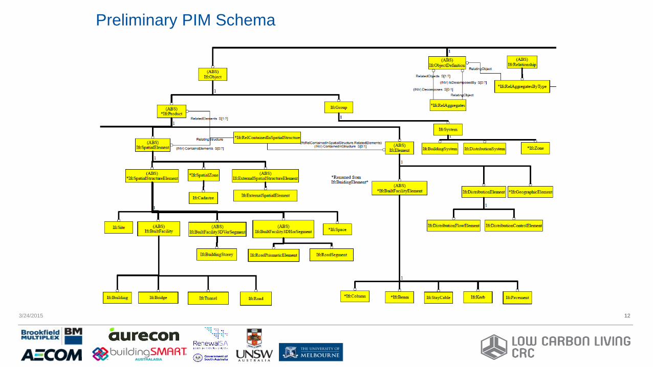
Preliminary PIM Schema
12

Precinct Use Case – Tonsley Precinct Model
24/03/2015 13

3/24/2015 14
Precinct Use Case – Broadway Space Data
14

3/24/2015 15
Precinct Use Case – Precinct Sub-Model
15
3/24/2015 16
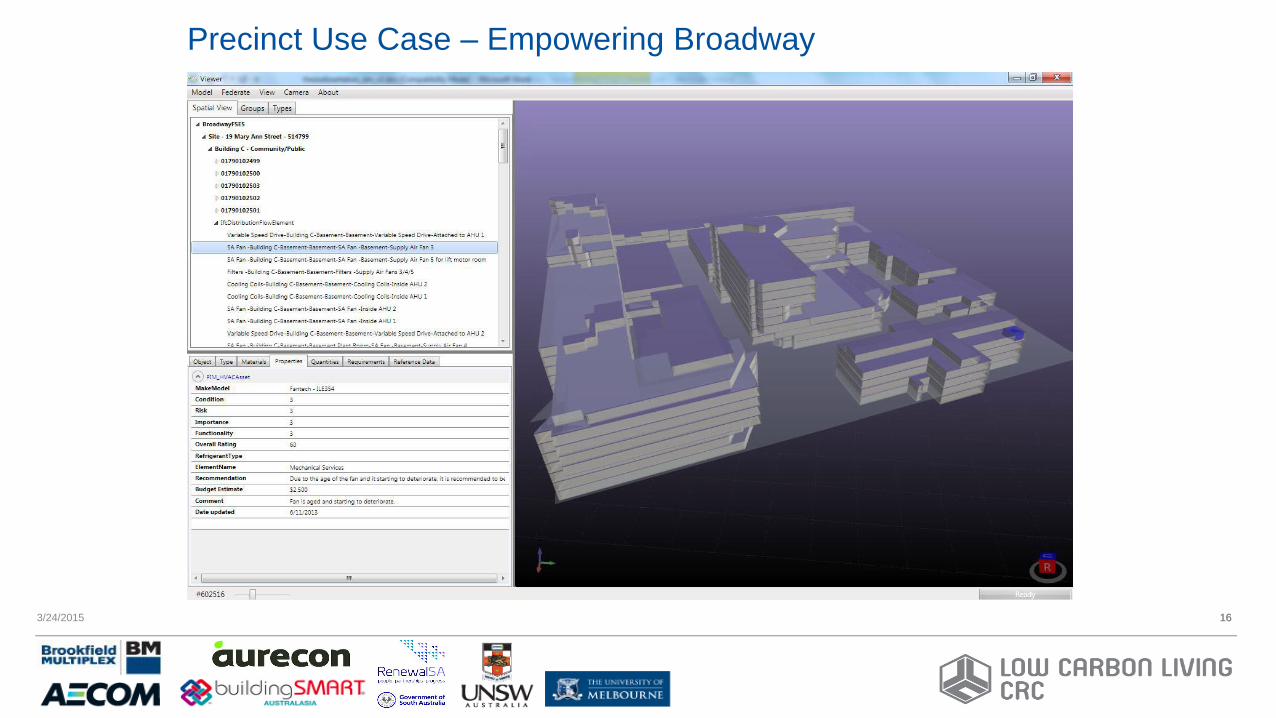
Precinct Use Case – Empowering Broadway
16
3/24/2015 17
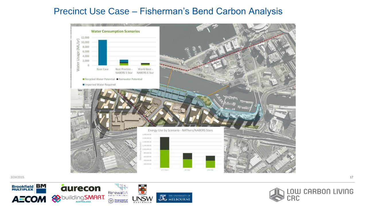
Precinct Use Case – Fisherman’s Bend Carbon Analysis
17

3/24/2015 18
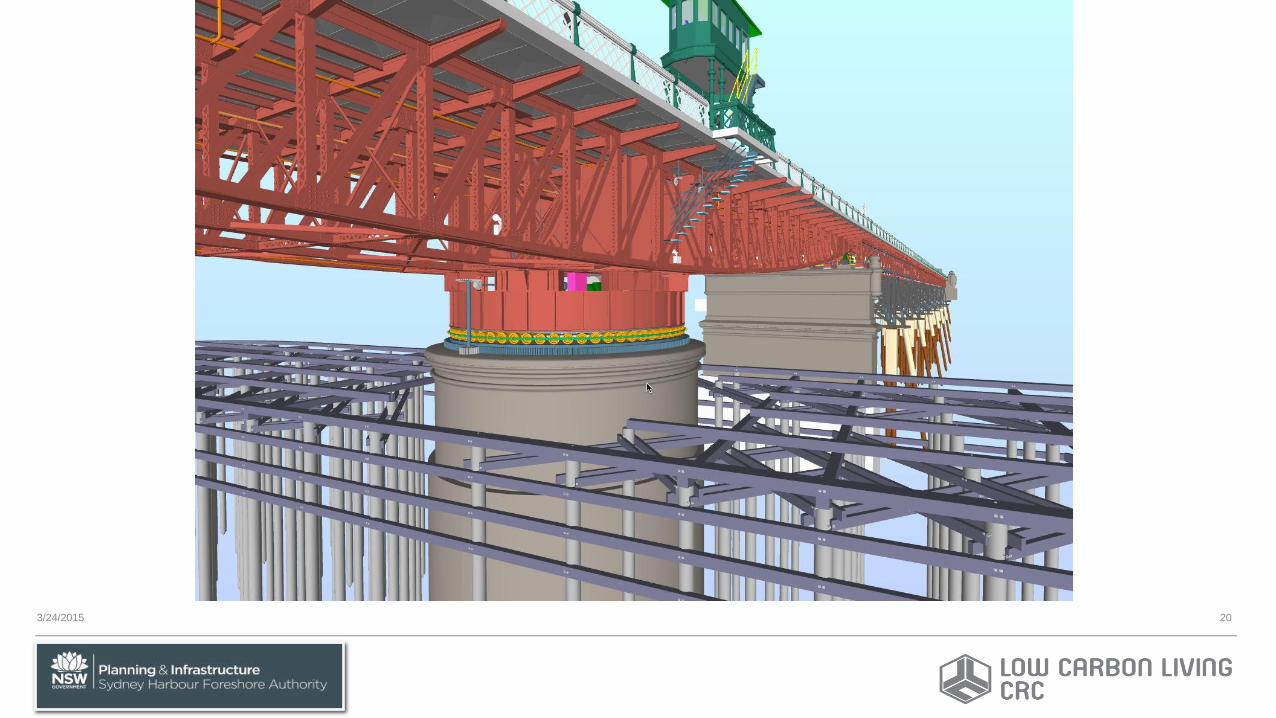
Pyrmont Bridge, Sydney - General View

3/24/2015 19
Pyrmont Bridge, Sydney
3/24/2015 20

3/24/2015 21
Pyrmont Bridge

3/24/2015 22

Acknowledgement •Pyrmont Bridge project information provided by
courtesy of NSW Sydney Harbour Foreshore Authority, Facilities Department
•Project Manager: Wayne Sahlman, SHFA •OpenBIM Consultant: John Mitchell, CQR
•BIM Modellor: Paul Hellawell, GHD

To find out more, contact:
CRC for Low Carbon Living Ltd
www.lowcarbonlivingcrc.com.au
Room 202-207, Level 2
Tyree Energy Technologies Building
UNSW Sydney NSW 2052 Australia
Twitter: @CRC_LCL
P: +61 2 9385 5402
F: +61 2 9385 5530
24/03/2015 24
Thank you
Author Contact:
Jim Plume
Senior Research Fellow, UNSW Australia