physical design framework - university of california ... · the physical design framework...
TRANSCRIPT

Physical Design Framework
UNIVERSITY OF CALIFORNIA, MERCED 2010

WE WELCOME YOUR COMMENTS Physical Planning, Design and Construction University of California, Merced 5200 N. Lake Road Merced, California 95343
http://lrdp.ucmerced.edu
Cover illustration: UC Merced Landscape Design Concept, Cliff Lowe Associates.
Physical Design Framework
UNIVERSITY OF CALIFORNIA, MERCED
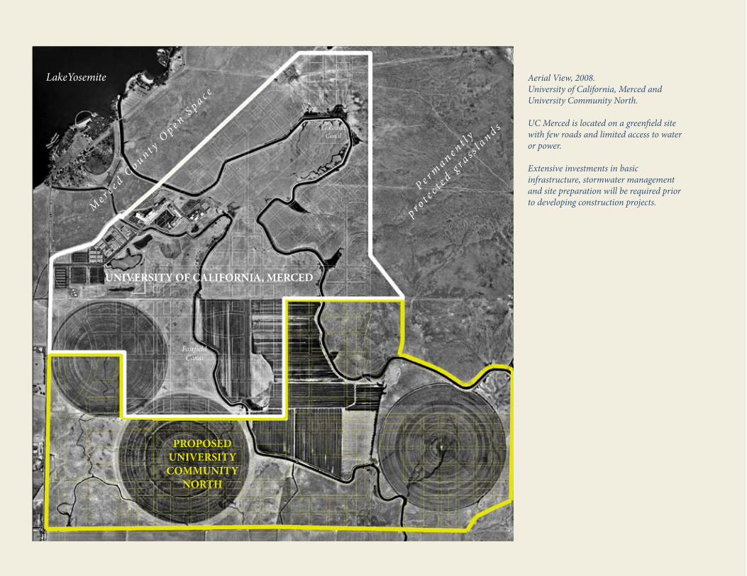
Aerial View, 2008. University of California, Merced and University Community North.
UC Merced is located on a greenfield site with few roads and limited access to water or power. Extensive investments in basic infrastructure, stormwater management and site preparation will be required prior to developing construction projects.
PROPOSED UNIVERSITY COMMUNITY
NORTH
UNIVERSITY OF CALIFORNIA, MERCED
FairfieldCanal
Le Grand Canal
P e r ma n e n t l y
p r o t ec t e
d gr a s s l a
n d s
LakeYosemite
Me r c e d C
o u n t y Op e n S
p a c e

TABLE OF CONTENTS
Introduction: Our Design Vision 7 I. FRAMEWORK OVERVIEW 8 Framework Objectives...................................... 9Relationship to Other Documents ................ 10 II. CAMPUS CONTEXT 12 Geography .........................................................13Regional Vicinity ............................................. 14Regional Access ................................................ 16Campus Site ...................................................... 18Climate .............................................................. 19 2009 LRDP Overview ......................................22Challenges and Opportunities .......................30
III. ENVIRONMENTAL DESIGN PRINCIPLES 34 1. Landscape ...................................................37 2. Site Design .................................................38 3. Modal Choice ............................................40 4. Infrastructure ............................................415. Building Design ........................................42
IV. COMMUNITy DESIGN PRINCIPLES 44 1. Programs ......................................................46 2. Places ............................................................47 3. Pathways .......................................................48 4. Systems .........................................................495. Built Form ....................................................50
V. PLANNING PRINCIPLES 52 1. Academic Core .............................................. 54 2. Student Neighborhoods ............................... 64 3. Open Spaces ................................................... 68 4. Student Service ...............................................705. The Grid ...........................................................72
VI. CAMPUS SySTEMS 74 Circulation ...........................................................75Utilities .................................................................76Stormwater ...........................................................77
VII. CAMPUS FABRIC 78 Architectural Form .............................................79 Architectural Elements ..................................... 80 Color and Materials ............................................83 Landscape System .............................................. 84 VIII. PLANNING PROCESS 86
IX. APPENDIX 90

Southwest aerial view of UC Merced, 2008.

This vision will manifest in the physical design of the campus in the following ways:
Integration• of natural and built systems such that the whole is greater than the sum of the parts
Innovation• in planning, design, and the use and applications of materials and technology
Interaction• among students, faculty, staff and the local community in their daily activities
Identity• derivative of, and unique to, the region’s cultural, historical, and environmental context
Inspiration• for sustainable design and development of livable communities
These five concepts inform the Physical Design Framework for the campus, providing the baseline for evaluating all future planning and design. The test of success, in assessing programs and projects will be the answers to these five questions: Does it integrate, does it innovate, does it foster interaction, does it contribute to our identity, and does it inspire others to emulate it? This is our design vision for UC Merced.
Our academic vision seeks to address these challenges, and so does our Physical Design Framework, which aspires to generate a model for sustainable development, by becoming, in essence, an environmental design research station.
Many of these key environmental issues are present in the San Joaquin Valley, which has the second most polluted air basin in the nation; an expected population growth rate among the nation’s highest, challenges of water quality and availability; serious economic, social and community health issues; a higher-education achievement rate among the nation’s lowest; and commute times and unemployment rates among the nation’s highest.
UC Merced is committed to developing a physical presence that will model a healthier future for the region and the world. The campus will provide a living laboratory and educational experience for those who learn, live, teach and work here, demonstrating how communities might develop in ways that support and sustain social, economic, and environmental health for both current and future generations. Since many environmental considerations are regional, we believe this approach will produce a campus, whose urban planning, architecture, infrastructure, and landscape are uniquely regional in both character and response, while modeling sustainable design excellence on a global scale.
OUR DESIGN VISION As the first American research university of the 21st century, the University of California, Merced has seized the challenge and the opportunity to incorporate and respond to the most pressing environmental challenges of our time and place. For the first time in human history, more than half of the world’s population is living in urbanized habitat. Rapidly expanding population and associated economic enterprise is straining global resources, compromising natural habitat, contributing to global warming, and impacting the social, physical, economic and environmental health of all people and our planet.
Science and Engineering 1
7

UC MERCED PHYSICAL DESIGN FRAMEWORK
viii
I FRAMEWORK OVERVIEW
Framework Objectives Relationship to Other Documents
9

viii 9
FRAMEWORK OVERVIEW
FRAMEWORK OBjECTIVES The Physical Design Framework identifies UC Merced’s environmental, community and planning principles for the design of its physical environment and how those principles integrate into the project planning and approval process. The framework provides guidance to the campus community and design professionals on how to develop a coherent yet distinctive character for each part of our young campus, while nurturing a culture of sustainability and pedestrian-oriented mobility. In accordance with Regental policy, this document delineates the information and processes that will inform Chancellor-level approval of capital projects up to and including $60 million, and Regent approval of projects above that threshold.
The Physical Design Framework applies to existing and future campus capital investment projects with an eye towards highlighting opportunities to enhance the systems that will lead to cost-effective development and operation of the campus.
FRAMEWORK STRUCTURE
Environmental Design Principles
CommunityDesign Principles
Planning Principles
PlanningProcess
INTEGRATION • INNOVATION •
INTE
RACT
ION •
IDENTITY• INSPIRATION
•+
Environmental Design is the process of addressing surrounding environmental parameters when devising plans, programs, policies, buildings or products. (Page 35)
Planning Principles outline how UC Merced’s environmental and community design principles may be implemented in specific geographic areas of the campus. (Page 53)
Community Design is the process of addressing social, recreational, cultural, economic, aesthetic and programmatic parameters in the development of the built environment (Page 45)
Planning Process establishes UC Merced’s administrative and committee structure to review and assess project design. (Page 87)
9

UC MERCED PHYSICAL DESIGN FRAMEWORK
10
RELATIONShIP TO OThER DOCUMENTS
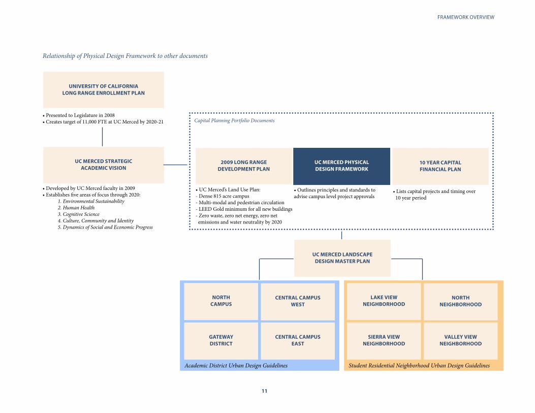
The Physical Design Framework is a companion document to the 2009 Long Range Development Plan (LRDP) and the 10-Year Capital Financial Plan.
The LRDP establishes a land use framework to accommodate 25,000 students, 12,500 student beds and 6.25 million square feet of instruction, research and administrative space on an 815 acre site.
While the LRDP provides principles and policies to guide overall campus development, the Physical Design Framework provides more developed guidelines to inform the planning and design of districts and individual projects. The LRDP also establishes a landmark “triple zero commitment” for future development. Through design innovation and best practices, UC Merced will be a zero net energy, zero net emissions, zero waste and water neutral campus by 2020. This framework articulates strategies to support these goals at the district and project level. The 10-Year Capital Financial Plan details the individual projects anticipated to be built in the coming years. While those projects may change in scope or timing, this document would remain the basis for their development and evaluation.
UC Merced is in the process of completing additional documents which will guide district level urban and landscape design. Northeast approach to UC Merced from Lake Road
10 11
FRAMEWORK OVERVIEW
Student Residential Neighborhood Urban Design Guidelines
UNIVERSITy OF CALIFORNIA LONG RANGE ENROLLMENT PLAN
Relationship of Physical Design Framework to other documents
• Presented to Legislature in 2008• Creates target of 11,000 FTE at UC Merced by 2020-21
• Developed by UC Merced faculty in 2009• Establishes five areas of focus through 2020:
1. Environmental Sustainability 2. Human Health3. Cognitive Science4. Culture, Community and Identity5. Dynamics of Social and Economic Progress
• UC Merced’s Land Use Plan:- Dense 815 acre campus- Multi-modal and pedestrian circulation- LEED Gold minimum for all new buildings- Zero waste, zero net energy, zero net emissions and water neutrality by 2020
• Outlines principles and standards to advise campus level project approvals
• Lists capital projects and timing over 10 year period
Capital Planning Portfolio Documents
UC MERCED STRATEGIC ACADEMIC VISION
2009 LONG RANGE DEVELOPMENT PLAN
10 yEAR CAPITAL FINANCIAL PLAN
UC MERCED PhySICAL DESIGN FRAMEWORK
UC MERCED LANDSCAPE DESIGN MASTER PLAN
NORTh CAMPUS
CENTRAL CAMPUS WEST
CENTRAL CAMPUS EAST
GATEWAy DISTRICT
LAKE VIEW NEIGhBORhOOD
NORTh NEIGhBORhOOD
VALLEy VIEW NEIGhBORhOOD
SIERRA VIEW NEIGhBORhOOD
Academic District Urban Design Guidelines
UC MERCED PHYSICAL DESIGN FRAMEWORK
12
II CAMPUS CONTEXT
Geography Regional Vicinity Climate
The 2009 LRDP Environmental Design Principles
Design Challenges and Opportunities

12 13
CAMPUS CONTEXT
GEOGRAPhy: ThE SAN jOAqUIN VALLEy
UC Merced’s campus is located in California’s San Joaquin Valley. Bordered on the east by the Sierra Nevada and separated from the Pacific Ocean by the Coast Ranges, the San Joaquin Valley is one of the most distinctive aspects of California’s topography.
The San Joaquin River, runs the length of the region north from the Tulare Lake Basin. This waterway is fed by the Merced, Tuolumne, Stanislaus, Mokelumne and Cosumnes Rivers. By 2050, state demographers project more than 9.4 million people will live here, an increase of 131% from 2000. While the San Joaquin Valley is known for its rich farmland, the campus site is located on the Valley’s eastern edge, away from prime agricultural soils.
San Francisco
Merced
Sacramento
Fresno
Bakersfield
Modesto
Stockton
Santa Cruz
Visalia
Madera
Hanford
San Luis Obispo
C o a s t R a n g e s
S i e r r a N e v a d a
T e h a c h a p i R a n g e
Bay Delta
San Joaquin Valley

UC MERCED PHYSICAL DESIGN FRAMEWORK
14
REGIONAL VICINITy
The 815-acre campus is located on a rural, greenfield site five miles from downtown Merced and Highway 99. Thirty thousand acres of preserved vernal pool grasslands edge the campus on its northern and eastern boundaries. Easement parcels that abut the campus are slated to join the University of California’s Natural Reserve System. Management of the easement parcels is subject to UC Merced’s Conservation Lands Management Plan (2009). Immediately south of the campus, a proposed development project known as the University Community will provide housing and services for 30,000 people on 1,100 acres of land. Implementation and land entitlement work for “University Community North” is the responsibility of the University Community Land Company, LLC (UCLC). UCLC is a partnership between the UC Regents and the Virginia Smith Trust (VST), a nonprofit charitable trust that provides scholarships to local high school students. The proposed “University Community South” is a development parcel unaffiliated with the University or the VST. In April 2009, UC Merced was granted a federal permit to proceed with future development in accordance with the 2009 LRDP. The university’s permit application was approved under Section 404 of the U.S. Clean Water Act due to the presence of federally protected wetlands.
Downtown Merced is a classic San Joaquin Valley urban core and is located 5 miles from campus.
Suburban-scale housing developments are planned east of the campus and University Community.
Northeast view of campus construction, 2004. The Sierra Nevada and permanently protected wetlands edge the northern and eastern campus boundaries.

14 15
CAMPUS CONTEXT
UC Merced’s 815-acre site is located 5 miles from downtown Merced. A proposed “University Community” along the campus’ southern border will provide 5,000 jobs and housing for 30,000 people.
Community North
Community South
Castle Airport and Aviation Center
UC MERCED PHYSICAL DESIGN FRAMEWORK
16
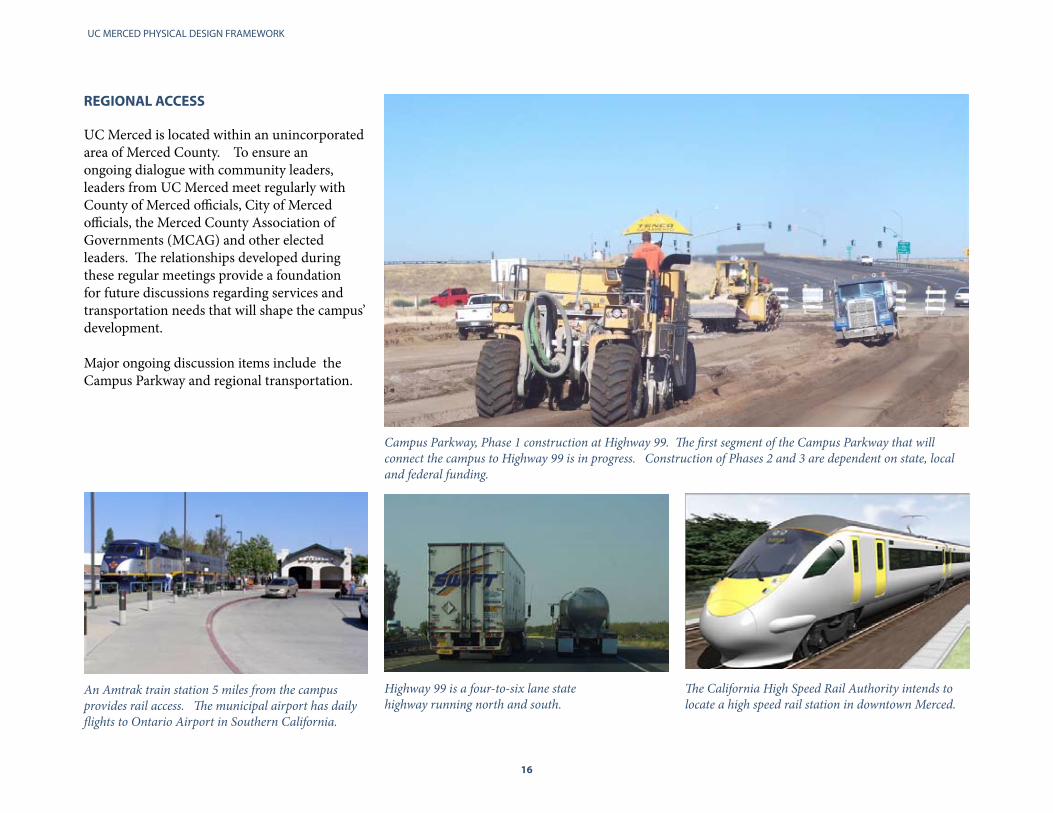
An Amtrak train station 5 miles from the campus provides rail access. The municipal airport has daily flights to Ontario Airport in Southern California.
Highway 99 is a four-to-six lane statehighway running north and south.
The California High Speed Rail Authority intends to locate a high speed rail station in downtown Merced.
REGIONAL ACCESS
UC Merced is located within an unincorporated area of Merced County. To ensure an ongoing dialogue with community leaders, leaders from UC Merced meet regularly with County of Merced officials, City of Merced officials, the Merced County Association of Governments (MCAG) and other elected leaders. The relationships developed during these regular meetings provide a foundation for future discussions regarding services and transportation needs that will shape the campus’ development.
Major ongoing discussion items include the Campus Parkway and regional transportation.
Campus Parkway, Phase 1 construction at Highway 99. The first segment of the Campus Parkway that will connect the campus to Highway 99 is in progress. Construction of Phases 2 and 3 are dependent on state, local and federal funding.
16 17
CAMPUS CONTEXT
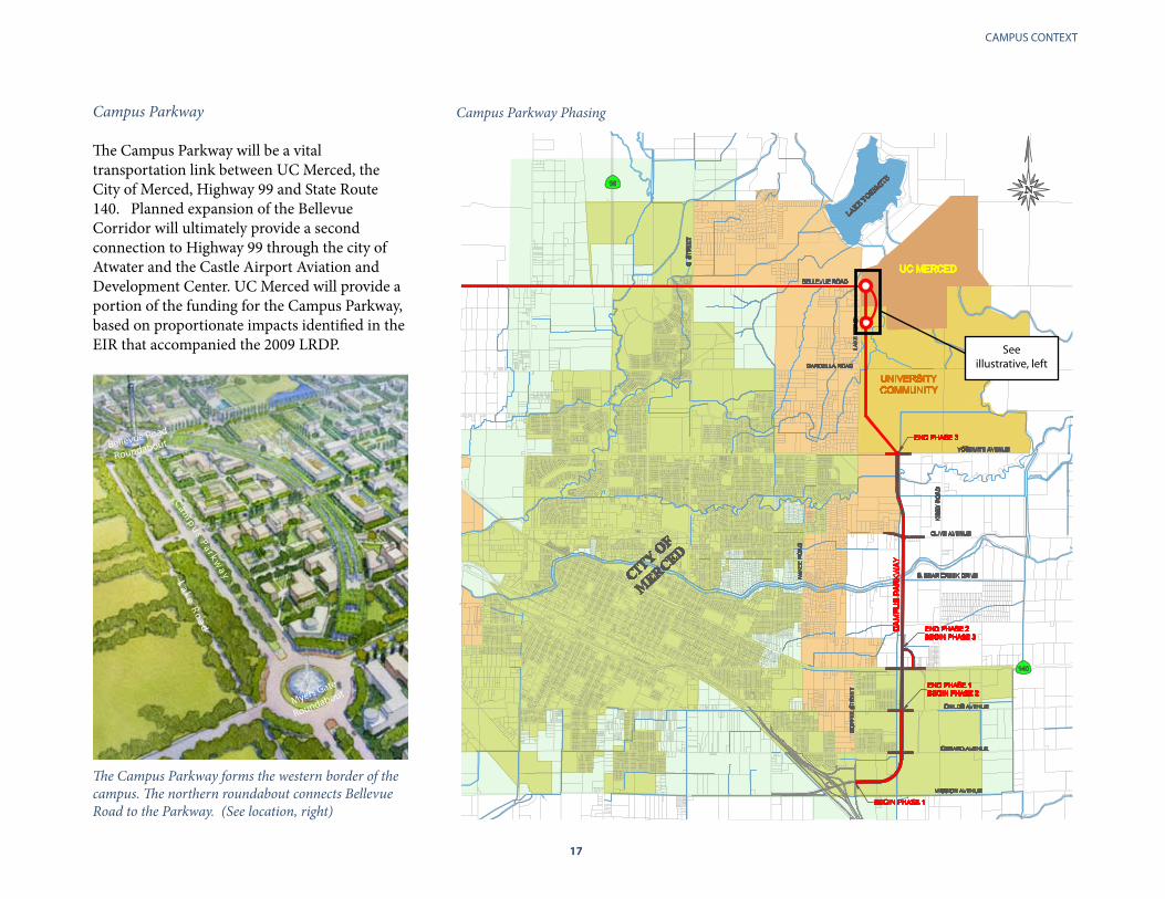
Campus Parkway The Campus Parkway will be a vital transportation link between UC Merced, the City of Merced, Highway 99 and State Route 140. Planned expansion of the Bellevue Corridor will ultimately provide a second connection to Highway 99 through the city of Atwater and the Castle Airport Aviation and Development Center. UC Merced will provide a portion of the funding for the Campus Parkway, based on proportionate impacts identified in the EIR that accompanied the 2009 LRDP.
Campus Parkway Phasing
The Campus Parkway forms the western border of the campus. The northern roundabout connects Bellevue Road to the Parkway. (See location, right)
Myers Gate
Roundabout
Lake Ro
ad
Campus Pa r kw
ay
Bellevue Road
Roundabout
See illustrative, left

UC MERCED PHYSICAL DESIGN FRAMEWORK
18
Fairfield Canal
Lake
Roa
d
ThE CAMPUS SITE
Indicated in white, UC Merced’s boundaries include 815 acres intended for academic and research buildings, open space, recreation and housing for 50% of the student body. Existing campus development covers 104 acres of the site. Two irrigation canals owned and operated by the Merced Irrigation District and connected to Lake Yosemite run through the site. Lake Yosemite is a freshwater reservoir built in 1888 for agricultural irrigation. The lake is owned by the Merced Irrigation District and its associated park, picnic areas and boating facilities are managed by the Merced County Parks and Recreation Department.
PROPOSED UNIVERSITY COMMUNITY
NORTH
UNIVERSITY OF CALIFORNIA, MERCED
FairfieldCanal
Le Grand Canal
P e r ma n e n t l y
p r o t ec t e
d gr a s s l a
n d s
LakeYosemite
Me r c e d C
o u n t y Op e n S
p a c e
Campus buildings as seen from Lake Yosemite.

18 19
CAMPUS CONTEXT
CLIMATE
Weather patterns in Merced are directly related to its geography. The Coast Ranges to the west largely buffer the Valley from the marine weather systems that originate in the Pacific, with the exception of the break at the Carquinez Straits allowing for a moderation of climatic conditions in the northern San Joaquin Valley. In Merced, the influence of this marine climate is felt to a limited degree. Summer temperatures are warm to hot and dry, with clear skies, no rainfall and cool evenings. The winters in Merced are mild, with occasional rains and frequent, heavy tule fogs. For the periods of December and January, 30 days of fog are not unusual. The significant daily temperature variation creates ideal conditions for saving energy through passive environmental systems design in buildings, which employ the cooler evenings to reduce cooling load during the day, and the warmer days to reduce heating needs in the evenings. Winds generally come from the northwest. However during the winter, cold air from the Sierra Nevada results in strong periodic easterly winds. The diagonal orientation of the campus grid along its northerly edge allows the campus to benefit from the cooling breezes coming across Lake Yosemite during the warmer months, further reducing cooling loads.
Average High and Low Temperatures, Merced.
Average Percentage of Sunshine by Month, Merced
January
February
March
April
May
June
July
August
September
October
November
December 44 %
65 %
85 %
93 %
95 %
96 %
94 %
90 %
85 %
76 %
65 %
45 %
January February March April May June July August September October November December
52 F62 F
67 F75 F
84 F90 F
97 F 95 F90 F
80 F
65 F
52 F
37 F 40 F 42 F 45 F 50 F 55 F 60 F 59 F 55 F48 F
40 F 37 F
37 degree difference

UC MERCED PHYSICAL DESIGN FRAMEWORK
20
CLIMATE AND DESIGN
Significant Daily Temperature variations can be captured in building system design to reduce overall building and energy demands.
Natural solar income, if efficiently captured, could meet most, if not all, of UC Merced’s energy needs.
In hot months, shade can generate a temperature differential of up to 20 degrees, enabling outdoor human activity to occur in relative comfort.
Average Precipitation in inches by month, Merced.
The campus open space and hydrology network must accommodate 1,600 acre feet of on and off-site rain water generated from adjacent grasslands. This renewable resource is a recreational and functional asset.
January
February
March
April
May
June
July
August
September
October
November
December 1.7
1.5
0.7
0.2
0
0
0.1
0.5
1.0
2.0
2.4
2.5
20

20 21
CAMPUS CONTEXT
Fog, clouds and rain are common features of the campus in winter. Temperatures average 45 degrees Farenheit.
The satellite image to the right identifies Merced’s location within the regular ‘tule’ fog banks common during San Joaquin Valley winters. Visibility in tule fog is often less than 1/8th of a mile, about 600 feet, but can be less than 10 feet.
Sun, low humidity and heat predominate in spring and summer. Daily high temperatures average 97 degrees Farenheit in mid July. Days above 100 degrees are not uncommon during the summer. 320 days of sunshine make shade an important part of planning and design.
Merced

UC MERCED PHYSICAL DESIGN FRAMEWORK
22
Adjacent vernal pool grasslands that create a distinct edge to campus grid
The campus’ eastern perimiter road serves as an environmental buffer, keeps most vehicles off the campus core, uses bioswales to channel off campus stormwater and provides public access to vistas of the Sierra Nevada and Lake Yosemite. Mixed-use “Main Streets” with 24-hour activity
Two linear mixed use academic/housing corridor “Main Streets”, programmed for 24-hour activity penetrate the heart of the campus and connect to the proposed University Community on the south. This creates a distinct and unique urban environment.
Energy produced onsite
The campus is currently using 50% less energy than typical university buildings would use and 40% less water. As of the end of 2009, 20% of campus energy is provided by onsite solar arrays. By 2020, the campus will be zero-net energy and all irrigation will be non-potable water.
Canals shaping the open space and bike network
The irrigation canals give form to major campus open spaces. The bicycle and pedestrian network that weaves through an orthogonal pedestrian grid designed to evoke classic San Joaquin Valley downtowns, and is oriented to maximize rooftop solar power.
The plan features:
Contextual Architecture Every building at UC Merced is designed to respond to its environment in the most responsible and sustainable manner and is LEED certified. The campus plan encourages the architectural precedent set to date and inspired by the utilitarian agricultural structures of California’s Central Valley. Combing this physical past with these 21st century ambitions will create a campus which is “of” the San Joaquin Valley, while upending traditional notions of what a campus should look like.
Arcades acting as shaded circulation network
The LRDP’s building and landscape design recommendations incorporate shading systems to reduce heat loading on buildings and protect pedestrians from the sun and inclement weather.
Stormwater basins that provide multiple functions
Stormwater is managed by naturally occurring land depressions or “bowls” partially edged by the canals. The Bowls provide an internal focus for buildings along their edges and function as open spaces and retention basins. Easements adjacent to the canals act as shaded riparian bioswale corridors to cleanse rainwater. 10-Minute Walking Radius within Academic Core
The dense campus core is designed for bicycles, transit and pedestrians on a 10 minute walking radius. Cars are relegated to the perimeter of the campus.
2009 LONG RANGE DEVELOPMENT PLAN OVERVIEW
In March 2009, the Regents adopted UC Merced’s 2009 Long Range Development Plan, (LRDP). The plan established a land use framework to accommodate 25,000 students, 12,500 beds and 6.25 MSF of academic, administrative and support on an 815 acre site. The plan also states a commitment to achieve zero net energy, zero waste and zero net emissions by 2020.
The plan seizes the opportunity to incorporate leading sustainable planning and design concepts by integrating land use, circulation and open space systems into a compelling coherent whole. The result is a plan that juxtaposes the flexibility and synergy of an urban framework with a pristine landscape.
UC Merced Tomorrow
LONG RANGE DEVELOPMENT PLAN UNIVERSITY OF CALIFORNIA, MERCED
2009 FINAL
UC Merced’s 2009 Long Range Development Plan is available at http://lrdp.ucmerced.edu
22 23
CAMPUS CONTEXT
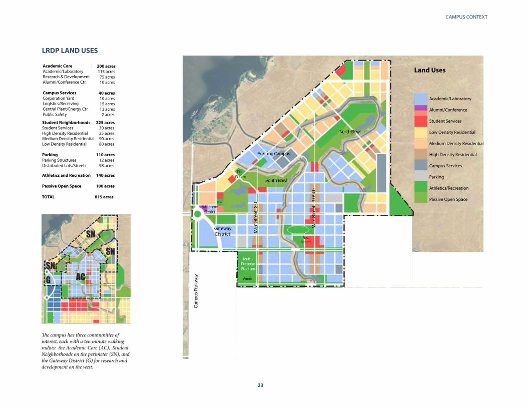
The campus has three communities of interest, each with a ten minute walking radius: the Academic Core (AC), Student Neighborhoods on the perimeter (SN), and the Gateway District (G) for research and development on the west.
Pool
Multi-PurposeStadium
Rec.Center
WelcomeCenter
Town Center
School andPark
School andPark
Magnet HighSchool and
Park NeighborhoodCenter
Gateway R+D
Arena
UC Merced LRDP
Land Use: Land Area Summary
Academic Core 200 acresAcademic/Laboratory 115 acresResearch & Development 75 acresAlumni/Conference Ctr. 10 acres
Campus Services 40 acresCorporation Yard 10 acresLogistics/Receiving 15 acresCentral Plant/Energy Ctr. 13 acresPublic Safety 2 acres
Student Neighborhoods 225 acresStudent Services 30 acresHigh Density Residential 25 acresMedium Density Residential 90 acresLow Density Residential 80 acres
Parking 110 acresParking Structures 12 acresDistributed Lots/Streets 98 acres
Athletics and Recreation 140 acres
Passive Open Space 100 acres
TOTAL 815 acres
Land Uses
Academic/Laboratory
Alumni/Conference
Student Services
Low Density Residential
Medium Density Residential
High Density Residential
Campus Services
Parking
Athletics/Recreation
Passive Open Space
Main
Stre
et 2
.0
Gateway District
Main
Stre
et 3
.0/4
.0
Existing Campus
Rec. Center
South Bowl
North Bowl
Cam
pus P
arkw
ay
Pool
Multi-PurposeStadium
Rec.Center
WelcomeCenter
Town Center
School andPark
School andPark
Magnet HighSchool and
Park NeighborhoodCenter
Gateway R+D
Arena
UC Merced LRDP
Land Use: Land Area Summary
Academic Core 200 acresAcademic/Laboratory 115 acresResearch & Development 75 acresAlumni/Conference Ctr. 10 acres
Campus Services 40 acresCorporation Yard 10 acresLogistics/Receiving 15 acresCentral Plant/Energy Ctr. 13 acresPublic Safety 2 acres
Student Neighborhoods 225 acresStudent Services 30 acresHigh Density Residential 25 acresMedium Density Residential 90 acresLow Density Residential 80 acres
Parking 110 acresParking Structures 12 acresDistributed Lots/Streets 98 acres
Athletics and Recreation 140 acres
Passive Open Space 100 acres
TOTAL 815 acres
Land Uses
Academic/Laboratory
Alumni/Conference
Student Services
Low Density Residential
Medium Density Residential
High Density Residential
Campus Services
Parking
Athletics/Recreation
Passive Open Space
LRDP LAND USES
Pool
Multi-PurposeStadium
Rec.Center
WelcomeCenter
Town Center
School andPark
School andPark
Magnet HighSchool and
Park NeighborhoodCenter
Gateway R+D
Arena
UC Merced LRDP
Land Use: Land Area Summary
Academic Core 200 acresAcademic/Laboratory 115 acresResearch & Development 75 acresAlumni/Conference Ctr. 10 acres
Campus Services 40 acresCorporation Yard 10 acresLogistics/Receiving 15 acresCentral Plant/Energy Ctr. 13 acresPublic Safety 2 acres
Student Neighborhoods 225 acresStudent Services 30 acresHigh Density Residential 25 acresMedium Density Residential 90 acresLow Density Residential 80 acres
Parking 110 acresParking Structures 12 acresDistributed Lots/Streets 98 acres
Athletics and Recreation 140 acres
Passive Open Space 100 acres
TOTAL 815 acres
Land Uses
Academic/Laboratory
Alumni/Conference
Student Services
Low Density Residential
Medium Density Residential
High Density Residential
Campus Services
Parking
Athletics/Recreation
Passive Open Space

UC MERCED PHYSICAL DESIGN FRAMEWORK
24
CAMPUS ORGANIzATION
The campus is organized by Academic Districts and Student Residential Neighborhoods. Regardless of location, projects will be inspired by a commitment to sustainable design; site planning that emphasizes orientation towards views of internal and external landscapes; and practical block and building forms. UC Merced’s districts and neighborhoods will evolve over time due to phasing and natural long-term infill and redevelopment. Individual projects will be assessed against urban design guidelines documents under development for each area.
School andPark
Town Center
School andPark
HighSchool and
Park NeighborhoodCenter
Gateway R+D
24
1
A
D
C
B 6
7
83
5
10
10
10
9
UC Merced LRDP
Communities: Neighborhoods and Districts
Academic Campus
1. North Campus2. Central Campus West3. Central Campus East4. Gateway District
Neighborhoods
A. Lake ViewB. North NeighborhoodC. Sierra ViewD. Valley View
Commons
5. Grand Ellipse6. North Bowl7. South Bowl8. East Field9. Main Street Pond10. Canals

24 25
CAMPUS CONTEXT
Central Campus East
In the longer term, Central Campus East will become the heart of the campus. It includes uses similar to the Central Campus West with another mixed-use main street, which will link the North Bowl to the east side of the future Town Center of the University Community. At its center, a second student union, a recreation center, and a student services building will face a large, ovalinear, landscaped park known as the Grand Ellipse. Gateway District
The Gateway District serves as the campus entrance and public face of the university. Focused on research and development, a broad, crescent-shaped pedestrian avenue links the Bellevue and Town Center Roundabouts of the Campus Parkway and provides a flagship address for both public and private sector research investment, with axial views into the campus from the Bellevue Corridor.
ACADEMIC DISTRICTS
North Campus
The North Campus comprises the existing campus and potential expansion and infill sites. This area has larger buildings with arcades organized around a large open landscaped area known as the Carol Tomlinson Keasey Quad. The Kolligian Library is the North Campus’ iconic building and activity center.
Central Campus West
Central Campus West will form the South Bowlsouthern edge and the west bank of the Fairfield Canal. The next significant phase of development includes a mixed-use “Main Street 2.0,” link in the North Campus to the future Town Center of the University Community. It is anchored on the north by the first student union; and the south by a sports complex. This part of the campus will have a north-south grid system with academic, research and residential buildings.
Kolligian Library passageway.
Left, Carol Tomlinson-Keasey Quad
UC MERCED PHYSICAL DESIGN FRAMEWORK
26
Valley View Neighborhood
The Valley View Neighborhood is located on the eastern edge of the campus. It is bordered by the Le Grand Canal on the north. Two open space and hydrology corridors are on the east and west. The Le Grand Canal loops north and west of the neighborhood. Higher and medium-density housing is located along the canal edge with a neighborhood center and commons in the middle of the neighborhood. An academic retreat is located at the northern edge with sweeping views of the mountains and valley, and a vista overlooking the North Bowl.
Sierra View Neighborhood
The Sierra View Neighborhood is located at the northern tip of the campus. It features an open space corridor linking the North Bowl to upland seasonal water flow, and an academic retreat with views of the vernal pool grasslands and the Sierra Nevada, and an adjacent conference and student recreation facility in the present location of the Virginia Smith Barn. Lower scale housing and buildings will be located around the North Bowl with medium-density housing being oriented toward the northeast Sierra views.
STUDENT RESIDENTIAL NEIGhBORhOODS
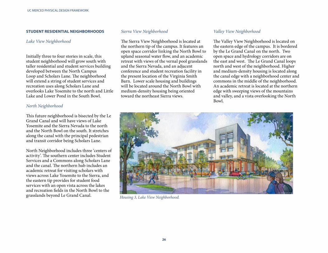
Lake View Neighborhood
Initially three to four stories in scale, this student neighborhood will grow south with taller residential and student services buildingdeveloped between the North Campus Loop and Scholars Lane. The neighborhood will extend a string of student services and recreation uses along Scholars Lane and overlooks Lake Yosemite to the north and Little Lake and Lower Pond in the South Bowl. North Neighborhood This future neighborhood is bisected by the LeGrand Canal and will have views of Lake Yosemite and the Sierra Nevada to the north and the North Bowl on the south. It stretches along the canal with the principal pedestrian and transit corridor being Scholars Lane. North Neighborhood includes three ‘centers ofactivity’. The southern center includes StudentServices and a Commons along Scholars Laneand the canal. The northern hub includes an academic retreat for visiting scholars with views across Lake Yosemite to the Sierra, andthe eastern tip provides for student food services with an open vista across the lakes and recreation fields in the North Bowl to the grasslands beyond Le Grand Canal. Housing 3, Lake View Neighborhood.

26 27
CAMPUS CONTEXT
24
1
A
D
C
B
3
100ʼ 80ʼ80ʼ65ʼ
65ʼ
65ʼ
50ʼ
50ʼ
50ʼ
50ʼ
50ʼ
80ʼ
80ʼ
80ʼ
80ʼ
UC Merced LRDP Draft
Campus Height and Massing Districts
Academic Campus
1. North Campus2. Central Campus West3. Central Campus East4. Gateway District
Student Neighborhoods
A. Lake View NeighborhoodB. North NeighborhoodC. Sierra View NeighborhoodD. Valley View Neighborhood
Land Uses
Academic/Laboratory
Alumni/Conference
Student Services
Low Density Residential
Medium Density Residential
High Density Residential
Campus Services
Parking
Athletics/Recreation
Passive Open Space
hEIGhT LIMITS
The LRDP acknowledges that the scale of development reflects the type of building under consideration. As such, building height at UC Merced will be a function of land supply, construction and infrastructure costs. Typical campus building heights will change over time, with two to four story buildings in earlier phases and taller buildings in later phases.
On sites that can serve as campus reference points, such as the end points of the Main Street corridors, the Bellevue Gateway Roundabout or visual focal points for outdoor spaces visible from the South or North Bowl, taller exceptional elements should be incorporated into the project programs and design. These could include public or semi-public gathering spaces that take advantage of vistas, or communications towers.

UC MERCED PHYSICAL DESIGN FRAMEWORK
28
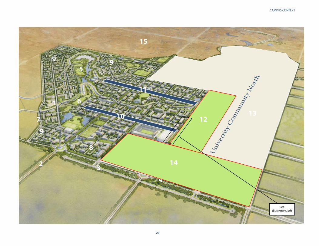
1. Kolligian Library 2. Bellevue Road3. Lake Road 4. Campus Parkway 5. North Bowl6. South Bowl7. Campus Loop Road8. Gateway District (Campus) 9. Student Housing10. Main Street 2.011. Main Street 4.012. University Community North Town Center13. University Community North Residential14. Gateway District (Community)15. Permanently preserved grasslands
CAMPUS AND UNIVERSITy COMMUNITy NORTh
Immediately south of the campus, a proposed 1,100-acre University Community will provide housing and services for 30,000 residents as well as research and business venues. The goal is to provide 5,000 jobs within a 10-minute walking distance to the campus.
The ultimate vision is an academic core seamlessly connected to vibrant pedestrian neighborhoods within a 10 to 15 minute walk. This reinforces the importance of designing each campus building so that it contributes to the development of a pedestrian culture, the local circulation network and to the open space and landscape design vision.
28
The campus’ southern border after campus completion, looking west. Patterned on “Las Ramblas,” the iconic pedestrian boulevard in Barcelona, Spain, the southern edge of the campus marks the interface between the campus and the University Community. (LRDP, Pg. 70)
28 29
CAMPUS CONTEXT
1
2 3
4
5
6
7
8
9 9
9
11
1310
15
12
14
Uni
vers
ity C
omm
unity
Nor
th
See illustrative, left

UC MERCED PHYSICAL DESIGN FRAMEWORK
30
ChALLENGES AND OPPORTUNITIES Infrastructure and Services The campus is located on a site with limited to no preexisting infrastructure. Subsequent phases of campus development will require the investment of significant resources into basic infrastructure above and beyond site preparation and the cost of structures. In contrast to the experiences of its sister campuses at their inception, UC Merced is faced with the challenge of building its infrastructure in a changed fiscal environment for funding of infrastructure and new educational facilities.
Above, Aerial view of initial phase of developement southwest towards the South Bowl. A significant investment in basic infrastructure will be required to build on sites beyond the single existing site.
Existing infrastructure spine (red) and near term areas for infrastructure investments (yellow)
Me r c e d C
o u n t y Op e n S
p a c e
Per
ma
nen
tly
Pro
tect
ed G
rass
lan
ds

30 31
CAMPUS CONTEXT
Irrigation Canals and Bridges The planned campus street and open space system intersects with two agricultural irrigation canals owned by the Merced Irrigation District. An easement held by the irrigation district extends 75 feet in each direction from the center of each canal, for a total of 150 feet. The canals serve as distinctive boundaries defining campus neighborhoods and the districts within the campus’ Academic Core. The cost of building pedestrian and vehicular bridges over the canals will add significantly to campus’ infrastructure costs.
However, each crossing becomes an opportunity to add to the aesthetic character of the campus and the quality of transition from one district to another. The canals also give form to major campus open spaces and the bicycle and pedestrian network that weaves through the campus grid.
Scholars Lane Bridge. The two irrigation canals that weave through the campus will require the campus to build multiple bridges to access building sites. UC Merced has an opportunity to celebrate those crossings through architectural design.
Bridge and Canal Crossing Program
Bridges/Utilities
Bridges/People/Bicycles
UC MERCED PHYSICAL DESIGN FRAMEWORK
32
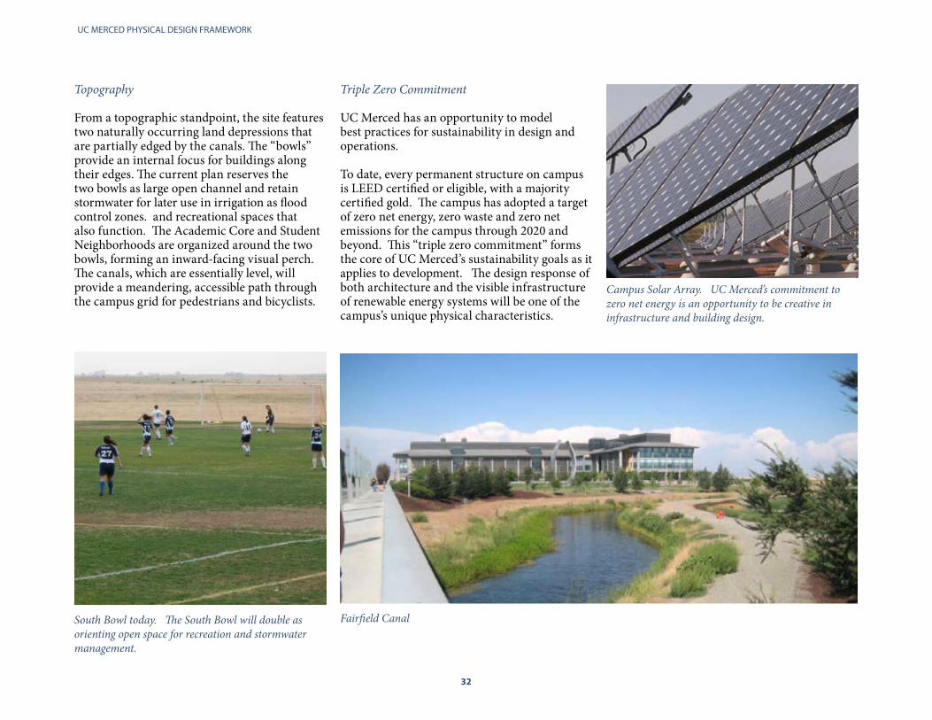
Topography From a topographic standpoint, the site features two naturally occurring land depressions that are partially edged by the canals. The “bowls” provide an internal focus for buildings along their edges. The current plan reserves the two bowls as large open channel and retain stormwater for later use in irrigation as flood control zones. and recreational spaces that also function. The Academic Core and Student Neighborhoods are organized around the two bowls, forming an inward-facing visual perch. The canals, which are essentially level, will provide a meandering, accessible path through the campus grid for pedestrians and bicyclists.
South Bowl today. The South Bowl will double as orienting open space for recreation and stormwater management.
Triple Zero Commitment UC Merced has an opportunity to model best practices for sustainability in design and operations.
To date, every permanent structure on campus is LEED certified or eligible, with a majority certified gold. The campus has adopted a target of zero net energy, zero waste and zero net emissions for the campus through 2020 and beyond. This “triple zero commitment” forms the core of UC Merced’s sustainability goals as it applies to development. The design response of both architecture and the visible infrastructure of renewable energy systems will be one of the campus’s unique physical characteristics.
Campus Solar Array. UC Merced’s commitment to zero net energy is an opportunity to be creative in infrastructure and building design.
Fairfield Canal

32 33
CAMPUS CONTEXT
SUCCESSES Every permanent building on the UC Merced campus is LEED certified or eligible, with the majority certified Gold. This has resulted in a campus physical plant that uses 50% less energy than typical University buildings.
Left and Below, Leo and Dottie Kolligian Library, LEED Gold
Central Plant, LEED Gold
Joseph E. Gallo Recreation and Wellness Center, LEED Gold
UC MERCED PHYSICAL DESIGN FRAMEWORK
34
II ENVIRONMENTAL DESIGN PRINCIPLES
Create a teaching landscape •
Connect site design to its surroundings •
Ensure the availability of modal choices •
Design visible infrastructure •
Employ distinctive building design•

34 35
ENVIRONMENTAL DESIGN PRINCIPLES
LRDP ENVIRONMENTAL DESIGN PRINCIPLES
The 2009 LRDP is based on the notion that each capital investment at UC Merced should add programmatic, qualitative and social benefits to the campus. A unifying thread throughout these investments is a demonstration of UC Merced’s leadership in sustainability through environmental systems design manifested in architectural choices, low water landscaping and building materials. Elements such as arcades, shading systems, tree-shaded walks, and drought-tolerant plants are featured prominently.
These principles focus on integration of the built and natural environment of the campus, including its networks and systems for services and mobility, into a single unified place, one that is responsive to its regional context and climate, supportive of the educational and research program, and innovative in ways that inspire both learning and emulation.
UC Merced’s 1 megawatt solar array provides 20% of the campus energy needs, exemplifying the campus’ ability to maximize the potential of its setting.
UC MERCED PHYSICAL DESIGN FRAMEWORK
36
The five LRDP environmental design principles are to:
1. Create a teaching landscape
UC Merced’s Strategic Academic Vision states the goal of educating thought leaders in sustainability. UC Merced has the opportunity to shape the natural, physical environment into memorable spaces that educate and demonstrate how to minimize the use of resources. This principle provides an opportunity for UC Merced to be a regional and global model for sustainable development.
2. Connect site design to its surroundings
Sun, wind, rain, fog and topography make stringent demands on people and structures. Buildings, landscape and urban design that reflects the distinct natural environment of the San Joaquin Valley will reduce energy use and promote human comfort. Context-sensitive site and building design can promote the benefits of connectivity to nature.
3. Ensure the availability of modal choices
Chance interactions among students, faculty, and staff promotes relationships and engagement. Physical design choices will facilitate the development of a campus culture that promotes walking, bicycle and transit access to campus destinations.
4. Design visible infrastructure
UC Merced’s goal is to maintain a connection between our urban and natural environment by making the resource impacts of our needs and actions transparent. Raising awareness of where our energy comes from and how our waste and storm water is managed will connect faculty, students and staff to the natural environment.
5. Employ distinctive building design To date, the architectural expression of sustainable design has influenced the form and aesthetics of campus buildings. This will continue through an architectural aesthetic that employs, among other features, daylighting, natural ventilation, solar collectors, green roofs, and recycled materials.
37
36 37
ENVIRONMENTAL DESIGN PRINCIPLES
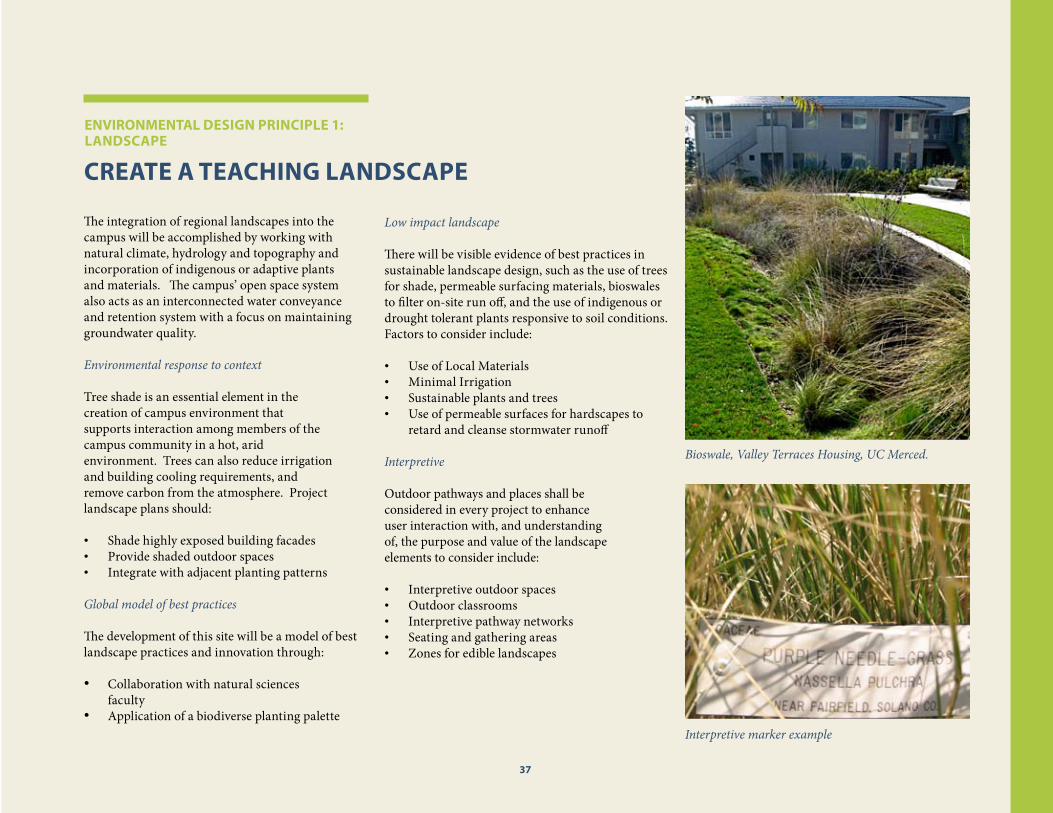
CREATE A TEAChING LANDSCAPE The integration of regional landscapes into the campus will be accomplished by working with natural climate, hydrology and topography and incorporation of indigenous or adaptive plants and materials. The campus’ open space system also acts as an interconnected water conveyance and retention system with a focus on maintaining groundwater quality.
Environmental response to context Tree shade is an essential element in the creation of campus environment that supports interaction among members of the campus community in a hot, arid environment. Trees can also reduce irrigationand building cooling requirements, and remove carbon from the atmosphere. Projectlandscape plans should:
Shade highly exposed building facades •Provide shaded outdoor spaces •Integrate with adjacent planting patterns •
Global model of best practices
The development of this site will be a model of best landscape practices and innovation through:
Collaboration with natural sciences •faculty Application of a biodiverse planting palette•
Bioswale, Valley Terraces Housing, UC Merced.
Interpretive marker example
Low impact landscape
There will be visible evidence of best practices in sustainable landscape design, such as the use of trees for shade, permeable surfacing materials, bioswales to filter on-site run off, and the use of indigenous or drought tolerant plants responsive to soil conditions. Factors to consider include:
Use of Local Materials•Minimal Irrigation•Sustainable plants and trees•Use of permeable surfaces for hardscapes to •retard and cleanse stormwater runoff
InterpretiveOutdoor pathways and places shall be considered in every project to enhance user interaction with, and understanding of, the purpose and value of the landscapeelements to consider include:
Interpretive outdoor spaces•Outdoor classrooms•Interpretive pathway networks•Seating and gathering areas•Zones for edible landscapes•
ENVIRONMENTAL DESIGN PRINCIPLE 1: LANDSCAPE
37
UC MERCED PHYSICAL DESIGN FRAMEWORK
38
CONNECT SITE DESIGN TO ITS SURROUNDINGS Site planning at both the campus and project scale will create opportunities for interaction among members of the campus community, and connect the internal program of buildings with the pathways and places within the larger neighborhood or district. To support engagement of the public realm, instructional, recreational, food service, and other socially engaging elements of each building program shall be located at the ground level and made directly accessible from adjacent streets, courtyards, plazas, arcades or pathways. Service areas, must be functional and accessible, however, they should not impinge on, or otherwise adversely impact, a buildings social and visual connection to the large campus. Solutions for reduced energy consumption, optimum energy production, and to support human comfort, will be manifest in the varied façades of the building, which take advantage of views and vistas, bring natural light to interior activities, and effectively respond to different solar orientation. The skyline will be shaped by roof forms designed to provide maximum clear area for energy generation, or bring light to interior spaces through clerestories, skylights, or light monitors,
The uphill site topography and wall design of Science and Engineering 2 provides shade and internal views of the campus. Meeting rooms are located adjacent to balconies at the upper level corners to provide interactive spaces and common access to the best views The flat roof design facilitates solar power collection efforts.
View of campus landscape from Science and Engineering 1 passageway.
The characteristics of buildings that meet this principle:
Supply ample indoor-outdoor connections •
Bring natural light deep into their interiors •
Orient buildings and outdoor areas for optimal •solar orientation
Provide shelter from winter winds and rain •
Take advantage of cooling breezes •
Preserve or take advantage of views in the •design and the interior programming of group spaces.
ENVIRONMENTAL DESIGN PRINCIPLE 2: SITE DESIGN
38

38 39
ENVIRONMENTAL DESIGN PRINCIPLES
Campus topography is more textured than it appears from above, and the physical framework takes advantage of these elevation changes to define character districts, and locate important focal points of activity. The climate ranges from dry heat in summer to dense ‘tule’ fog and rain in winter. Winds have already sculpted young campus trees in the direction of prevailing air currents.
Above, The uphill topography of the academic core. Left, The dry, treeless natural environment on the western edge of campus.
Right, Permanently preserved grasslands adjacent to the campus will provide an impressive and protected public view.

UC MERCED PHYSICAL DESIGN FRAMEWORK
40
ENSURE AVAILABILITy OF MODAL ChOICES
Mobility, access, and modal choice are essential to a sustainable and balanced transportation system. To reduce dependence on cars, the grain and texture of UC Merced provides a permeable framework most accessible at the pedestrian scale. A larger grid of bikeways, and the meandering canals, which wind through the grid, provide multiple choices for bicycles that do not conflict with other modes. Transit loops run inside the campus grid on Main Streets and boulevards, while autos are relegated to the edges. The result will be a campus that is walkable, bike-friendly and transit oriented. Projects that embody this principle will:
Support the development of a bicycle circulation •network by including bicycle access parking, and amenities in initial site plans.
Make interactivity at ground floor elevations •a central theme of building programming and design in order to promote pedestrian activity and social encounters.
Provide pedestrian shortcuts in ground level •planning of large sites and along principal diagonal corridors leading to major transit stops or parking.
Bike storage in the Academic Core
Scholars Lane Pedestrian Mall
During initial site planning, prioritize multi-•modal accessibility planning in site analysis
Promote the development of UC Merced’s •shaded pedestrian arcade system.
ENVIRONMENTAL DESIGN PRINCIPLE 3: MODAL ChOICE
40

40 41
ENVIRONMENTAL DESIGN PRINCIPLES
DESIGN VISIBLE INFRASTRUCTURE
UC Merced will be an interactive laboratory to test innovative sustainable infrastructure approaches. This acts as an extension of the technology transfer dimension of the University’s academic, research and industrial partnership activities. Site and building infrastructure systems must comply with or enhance campus standards for energy management, stormwater management, and communications systems, Key elements of campus infrastructure that model state-of-the-art or best practices in sustainable infrastructure design, should be celebrated through attention to their aesthetic design. This will be accomplished through:
Passive energy management design strategies, •such as daylighting, sun-shading, and building orientation
Active renewable energy production and •consumption monitoring and management systems
Visible stormwater management systems, like •“Green Streets” with distinctively landscaped bioswales
The simple powerful forms of UC Merced’s CentralPlant celebrate its efficient and utilitarian function and earned it a national honor award in design from the American Institute of Architects, and a LEED Gold certification.
Right, strategic sun shading on Kolligian Library reduces cooling load and provides natural lighting, yet allows views to the exterior from within.
An arcade shaded with a solar paneled roof similar to the above image will be integrated into Science and Engineering 2.
ENVIRONMENTAL DESIGN PRINCIPLE 4: INFRASTRUCTURE
41

UC MERCED PHYSICAL DESIGN FRAMEWORK
42
EMPLOy DISTINCTIVE BUILDING DESIGN UC Merced will be distinguished by its architectural character, which will employ a unique integration of:
The Central Valley’s tradition of utilitarian •industrial structures with their bold forms and honest use of regionally available materials.
State of the art sustainable design •
A 21st century urban aesthetic in which •buildings shape and activate outdoor public spaces, connecting the programs within to the arcades, courtyards, streets and pathways that form the campus circulation network.
The mixed-use and interdisciplinary programming of projects, combined with the integration of path, place and program in planning, will be be a key strategy in fulfilling the urban design intentions of creating an active, safe and engaging social environment.
Specific, highly visible sites, which demarcate important centers, gateways or edges to the campus’ neighborhoods and districts, will be identified for distinctive architectural character and features, such as lanterns or towers, arcades or plazas, or highly transparent facades, which will illuminate and activate important streets or pathways.
The burnished stainless steel sculpture, “Beginnings” stands 40 feet above Carol Tomlinson Keasey Quad.
Projects that embody this principle will:
Make distinctive contributions to the •architectural fabric of the campus
Frame and activate public spaces in ways that •make them memorable.
Reflect the bold academic ambitions of the •campus
Communicate their purpose through their •form, finish and character.
Engage people at the human scale in every •dimension.
Glass, steel and concrete composed in utilitarian forms evokes Central Valley agricultural industrial structures.
Science & Engineering 1’s arcade reflects the 21st century campus design aesthetic.
ENVIRONMENTAL DESIGN PRINCIPLE 5: BUILDING DESIGN
42

42 43
ENVIRONMENTAL DESIGN PRINCIPLES
First Lady Michelle Obama on Commencement Day, 2009. In this image, the modern urban form provides a frame for the open space of the South Bowl.
Sunlight illuminates rooms and passageways during the day.
Kolligian Library defines the streetwall and contributes to the pedestrian circulation framework.
Internal light creates a lantern effect at night.
43

UC MERCED PHYSICAL DESIGN FRAMEWORK
44
III COMMUNITy DESIGN PRINCIPLES
Locate programs to foster interaction and •engagement of the campus community
Design places within the campus to create active •centers or points of connection for people
Design pathways to dynamically connect people, •places and programs
Systems for movement, service and access •integrate aesthetic and functional designs
Shape the built form of the campus through •typology and scale standards that allow for distinctive architecture, while creating a coherent campus fabric

44 45
COMMUNITY DESIGN PRINCIPLES
COMMUNITy DESIGN PRINCIPLES
Five community design principles influence the social, recreational, cultural, economic, aesthetic and programmatic parameters of UC Merced’s built enviornment.
Locate programs to foster interaction and •engagement of the campus community
Design places within the campus to create •active centers or points of connection for people
Design pathways to dynamically connect •people, places and programs
Systems for movement, service and access •integrate aesthetic and functional designs
Shape the built form of the campus through •typology and scale standards that allow for distinctive architecture, while creating a coherent campus fabric
Integration of these principles will create an interactive campus that fosters development of scholarly and social relationships, a deeper sense of community and lead to interdisciplinary discovery of new ideas or ways of learning.
Little Lake
UC MERCED PHYSICAL DESIGN FRAMEWORK
46
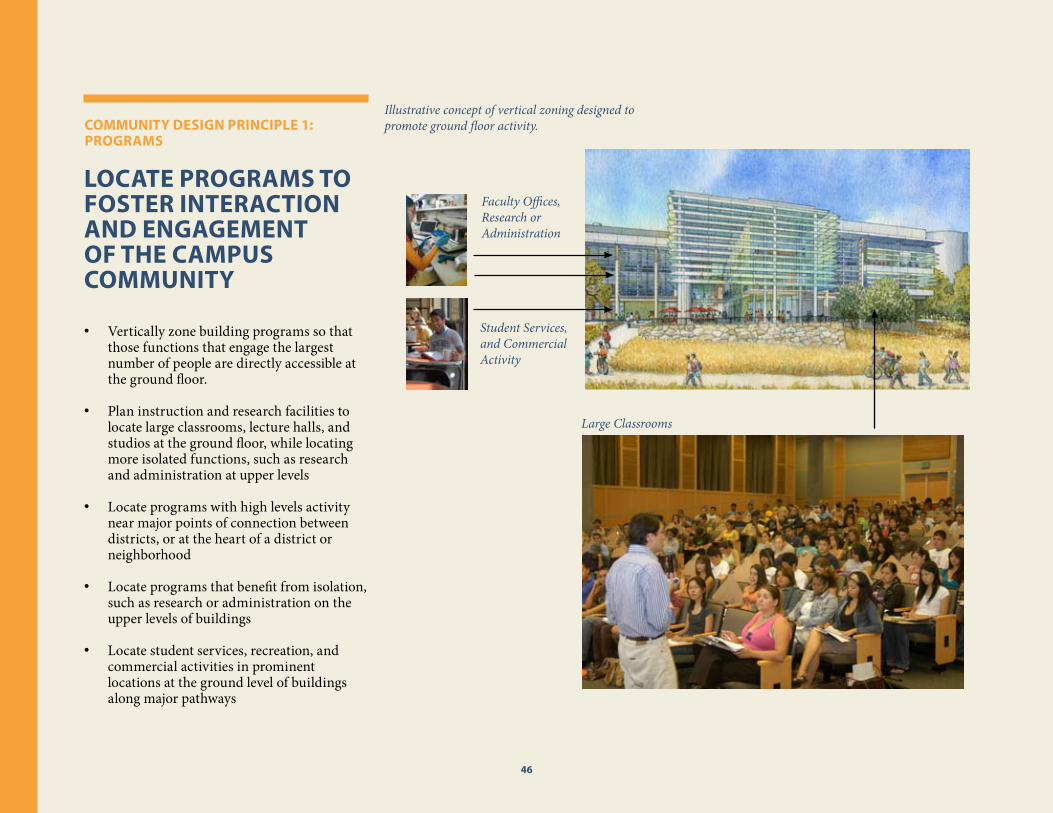
LOCATE PROGRAMS TO FOSTER INTERACTION AND ENGAGEMENT OF ThE CAMPUS COMMUNITy
Vertically zone building programs so that •those functions that engage the largest number of people are directly accessible at the ground floor.
Plan instruction and research facilities to •locate large classrooms, lecture halls, and studios at the ground floor, while locating more isolated functions, such as research and administration at upper levels
Locate programs with high levels activity •near major points of connection between districts, or at the heart of a district or neighborhood
Locate programs that benefit from isolation, •such as research or administration on the upper levels of buildings
Locate student services, recreation, and •commercial activities in prominent locations at the ground level of buildings along major pathways
Illustrative concept of vertical zoning designed to promote ground floor activity. COMMUNITy DESIGN PRINCIPLE 1:
PROGRAMS
46
Faculty Offices, Research or Administration
Student Services, and Commercial Activity
Large Classrooms

46 47
COMMUNITY DESIGN PRINCIPLES
DESIGN PLACES WIThIN ThE CAMPUS TO CREATE ACTIVE CENTERS OR POINTS OF CONNECTION FOR PEOPLE
Create mixed-use centers of activity within •each district or neighborhood
Create linear places for interaction along •specific corridors in each district or neighborhood
Create multiple outdoor venues for casual •and programmed recreational and social activities and events throughout the campus
Pool
Multi-PurposeStadium
Rec.Center
WelcomeCenter
Town Center
School andPark
School andPark
Magnet HighSchool and
Park NeighborhoodCenter
Gateway R+D
Arena
UC Merced LRDP
Land Use: Land Area Summary
Academic Core 200 acresAcademic/Laboratory 115 acresResearch & Development 75 acresAlumni/Conference Ctr. 10 acres
Campus Services 40 acresCorporation Yard 10 acresLogistics/Receiving 15 acresCentral Plant/Energy Ctr. 13 acresPublic Safety 2 acres
Student Neighborhoods 225 acresStudent Services 30 acresHigh Density Residential 25 acresMedium Density Residential 90 acresLow Density Residential 80 acres
Parking 110 acresParking Structures 12 acresDistributed Lots/Streets 98 acres
Athletics and Recreation 140 acres
Passive Open Space 100 acres
TOTAL 815 acres
Land Uses
Academic/Laboratory
Alumni/Conference
Student Services
Low Density Residential
Medium Density Residential
High Density Residential
Campus Services
Parking
Athletics/Recreation
Passive Open Space
Outdoor open space for gathering.
Recreation facilities can act as central pointsDining facilities create areas for interaction
Six different land uses at the heart of student neighborhoods express the goal of generating activity through mixed uses.
COMMUNITy DESIGN PRINCIPLE 2: PLACES
47

UC MERCED PHYSICAL DESIGN FRAMEWORK
48
DESIGN PAThWAyS TO DyNAMICALLy CONNECT PEOPLE, PLACES AND PROGRAMS
Create and support a legible hierarchy of •streets, block patterns and view corridors
Connect campus programs, places and open •spaces
Reinforce social, cultural and economic •links with the adjacent community
Town Center
Primary Walking Route
Trail
Pedestrian Mall
Student Services
Recreational Facilitiesand Fields
TransitCenter
3
3
3
3
4
62
1
5
5
7
Lake V
iew
s Lake Views Lake
Views
Lake Views Lak
eView
s Sierra Views
Sierra Views Sierra ViewsValleyViews
ValleyViews ValleyViews
UC Merced LRDP
Circulation: Pedestrians
Student Neighborhood Services
-Cafeterias/Food Service-Neighborhood Commons-Main Street
Student Union
1. Student Union 2.02. Student Union 4.0
Recreational Facilities
3. Soccer Fields4. Baseball/Softball Fields5. Intermural Gym/Rec. Center6. Multi-use Stadium7. Arena
Pedestrian Mobilty, 2009 LRDP. The primary walking routes will provide an active, connective experience. Projects along these corridors have an opportunity to contribute to the development of these corridors.
Mai
n St
reet
4.0
Bellevue Pedestrian Mall
The Grand Ellipse
The Grand Ellipse and Main Street 4.0. (LRDP, Page 69) Central Places on campus, such as the Grand Ellipse, are connected to other important places through prominent pedestrian pathways.
Out
door
A
mph
ithea
ter
COMMUNITy DESIGN PRINCIPLE 3: PAThWAyS
48

48 49
COMMUNITY DESIGN PRINCIPLES
SySTEMS FOR MOVEMENT, SERVICE AND ACCESS INTEGRATE AESThETIC AND FUNCTIONAL DESIGNS
Connect users to their surroundings by •incorporating attractive features into mobility related projects.Integrate stormwater management systems •into site and street designs, and open space and recreation area planningIncorporate utility connections and •corridors into pathways, bikeways, bridge designs and canal easements Design campus infrastructure projects •as integral elements of the landscape or building designs, or as aesthetically distinctive objects
Functional elements of the pedestrian experience can be inspiring, Illustrative.
Bridges crossing the canals should celebrate their presence, Illustrative.
Visible, well located bicycle storage is an example of how function can support a primary mobility system.
Transit stop incorporated into roundabout doubles as public space, Illustrative.
COMMUNITy DESIGN PRINCIPLE 4: SySTEMS
48 49

UC MERCED PHYSICAL DESIGN FRAMEWORK
50
ShAPE ThE BUILT FORM OF ThE CAMPUS ThROUGh TyPOLOGy
Typology and scale standards will allow for •distinctive architecture, while creating a coherent campus fabric.
Eight typologies have been developed for •prototypical Academic Blocks (Page 54), Gateway District Blocks (Page 56) and Student Residential Blocks (Page 60).
The typologies include details on net and •gross densities for application on individual projects
BLOCK TyPE AC-1 (PAGE 58) BLOCK TyPE SN-1 (PAGE 66)
APPLICATION OF BLOCK TyPE AC-1 APPLICATION OF BLOCK TyPE SN-1
Science and Engineering 1 and Clasroom Office Building
Valley Terraces
Uniform building setbacks similar to those in urban settings will define the edges of sidewalks and open space. Suburban-style forms that do not address the street edge are discouraged. Mid-block passages that facilitate cross-campus connections are encouraged.
COMMUNITy DESIGN PRINCIPLE 5: BUILT FORM
50

50 51
COMMUNITY DESIGN PRINCIPLES
Kolligian Library
50
Classroom Office Building
Dining Expansion

UC MERCED PHYSICAL DESIGN FRAMEWORK
52
IV PLANNING PRINCIPLES
Academic Core: • Facilitate interdisciplinary interaction among disciplines
Student Neighborhoods: • Develop a pedestrian culture to create vitality and activity that makes on-campus living desirable.
Open Spaces: • Organize around shared open spaces such as the North and South Bowls
Student Services: • Locate student services convieniently to form a valuable focus for on-campus residential neighborhoods
The Grid: • Maximize the return on investments in infrastructure through strategic deployment and attention to aesthetics

52 53
PLANNING PRINCIPLES
PLANNING PRINCIPLES
The Planning Principles provide general direction for projects in the Academic Core, Student Neighborhoods, Open Spaces, Student Neighborhoods and the Grid. These principles support UC Merced’s academic mission while balancing social, environmental and economic priorities.
The Grid
Maximize the return on investments in infrastructure through strategic deployment and attention to aesthetics.
Student Services
Locate student services convieniently to form a valuable focus for on-campus residential neighborhoods.
Open Spaces
Organize around shared open spaces such as the North and South Bowls.
Student Neighborhoods
Develop a pedestrian culture to create vitality and activity that makes on-campus living desirable.
Academic Core
Facilitate interdisciplinary interaction among disciplines in the academic core.

UC MERCED PHYSICAL DESIGN FRAMEWORK
54
ACADEMIC CORE Facilitate interdisciplinary interaction among disciplines in the academic core.
As the working heart of the campus, the Academic Core is defined by UC Merced’s teaching, research and administrative activities.
The focus in this area is maintaining interactions and connections between academic and research programs, and across disciplines.
Implementation opportunities through 2020
Science & Engineering 2• Instruction and Research 1• Professional School• Classroom and Office Building 2• Surface Parking lots within this area are • temporary use land banks for future development. Perimeter landscaping for temporary uses • must be designed for longevity in order to complement future academic buildings.
The Academic Core includes North Campus, the Gateway District, Central Campus West and Central Campus East. Central Campus West and Central Campus East are connected by two mixed-use, north-south Main Streets that connect to the west and eastern ends of the University Community’s Town Center.
CENTRAL CAMPUS
EAST
CENTRAL CAMPUS
WEST
NORTH CAMPUS
GATEWAY DISTRICT
University Community Town Center
Main Street 4.0
Main Street 2.0
North Bowl
South Bowl
Ranchers Road
LeGrand Canal
Fairfield Canal
Main Street 2.0
Main Street 4.0
Grand Ellipse
Campus Parkw
ay
University Community
Research and Development
Park

54 55
PLANNING PRINCIPLES
Central Campus West: Design and Interactivity
Central Campus West is the next significant phase of development for UC Merced. It is bordered by the South Bowl, the west bank of the Fairfield Canal and the University Community’s Town Center on the south. To promote interdisciplinary interaction, the critical design task for Central Campus West projects is to activate the north-south, mixed-use “Main Street 2.0” concept connecting the campus to the University Community.
This will be accomplished through building entrances that acknowledge the primacy of Main Street 2.0 and active ground floor programming that directs users to Main Street 2.0. In addition, seating, transit routing, lighting and wayfinding elements will each add to the vibrancy and interactivity of Main Street 2.0. Central Campus East: Design and interactivity
In the longer term, Central Campus East will become the heart of the campus. It includes uses similar to the Central Campus West with another mixed-use main street, (Main Street 4.0). The distinctive feature of Central Campus East is the Grand Ellipse, a large gathering place
North Campus: Design and interactivity
Bordered by irrigation canals and oriented around Carol Tomlinson Keasey Quad, the North Campus is UC Merced’s founding academic district.
To promote interactivity, new North Campus buildings, especially those fronting the grasslands view along Ranchers Road, and Ansel Adams Road, will be required to continue the established patterns of active academic and social engagement uses on the ground floor, such as lounges, food carts, and shaded pedestrian arcades.
From the perspective of the rest of the Academic Core, the North Campus is topographically uphill and prominent. Future architectural design and site choices will take advantage of this prominence by maximizing views of open space, creating a welcoming, “front door” experience along Ranchers Road, and incorporating roofline elements that contribute to a dynamic skyline.
In order to maintain the district’s vibrancy, access to the North Campus will made across iconic bridges that create a sense of arrival. The primary design goal of these bridge projects will be to ensure the North Campus remains a destination for student interaction as the campus develops.
for passive recreation and formal events. To promote interdisciplinary interaction, Main Street 2.0’s design tasks and recommendations apply to Main Street 4.0, with the additional task of activating and taking advantage of Grand Ellipse views.
Gateway District: Design and interactivity
For visitors, students and faculty approaching the campus along Lake Road, (and later, Campus Parkway), the Gateway District serves as the campus entrance and public face of the university. The heart of the district is anchored by a broad, crescent shaped pedestrian avenue that connects high profile academic efforts to related private sector activities in the University Community Research and Development Park.
Given their location along the Campus Parkway, Gateway District buildings interact with the general public. As such, they have an opportunity and obligation to celebrate their flagship location though design and material choices that communicate the university’s modern, 21st century attitude.
At the ground level, projects along the crescent-shaped avenue between the campus portion of the Gateway District and the University Community Research and Development Park will include shaded landscaping that promotes pedestrian activity as well as a robust program of site furnishings such as benches and tables.

UC MERCED PHYSICAL DESIGN FRAMEWORK
56
Building Illustrative
Strong entry identification and experience using lanterns
Transparent facade behind arcades and shading to engage and activate public street
Flat roof to optimize solar collection
Articulated streetscape incorporates shade trees and site furnishings reinforces urban patterns
Pedestrian arcades with multiple entrances
Complementary building setbacks and aligned streetwall
56

56 57
PLANNING PRINCIPLES
PLANNING PATTERNS
Buildings should form the streetwall along •major circulation corridors for at least 75% of the frontage.
Through building connections support •pedestrian shortcuts.
Ground floor building activity visible to • pedestrians.
High-density housing above common •facilities or academic uses along Main Street
12 foot wide sidewalks •
Clear unshaded roof areas for location of •solar collectors should comprise 50-70% of roof area
Emergency vehicle access to block interiors •should be incorporated into the overall landscape planning concepts at the earliest stages.
Mid-block passages that facilitate cross-•campus connections are encouraged.
Uniform building setbacks similar to those •in urban settings will define the edges of sidewalks and open space. Suburban-style forms that do not address the street edge are discouraged.
LANDSCAPE PATTERNS
Main Street functions as extended •pedestrian plaza
Canopy tree cover will vary depending on •ground floor activity
Extensive articulated hardscape on main •pedestrian routes
Seating and well-furnished courtyards •within Academic blocks.
Well-landscaped surface parking lots to •shade vehicles and screen upper level views.
Courtyards may link on a diagonal •
Lawns limited to focal point or passive • recreational use areas
Tree placements reinforce urban pattern of •a connected street grid
BUILDING PATTERNS
Flexible design of facilities, classrooms, and •labs to support evovling programs.
Buildings function as part of pedestrian •arcade system
Multiple entrances to buildings activate •streets and courtyards
High degree of linear visual connectivity •
Buildings and arcades are organized on •the urban block and address streets and courtyards
Building setbacks and cornice lines •cooperate to form defined blocks
Infrastructure and building services, such • as trash collection and delivery areas, or backflow preventers shall be designed as integral elements of the overall design and visually screened to minimize visual impacts or circulation conflicts for building occupants and pedestrians
57
UC MERCED PHYSICAL DESIGN FRAMEWORK
58
ACADEMIC DISTRICT TyPOLOGy
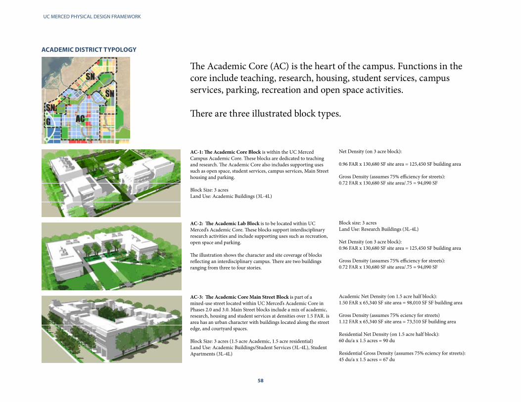
The Academic Core (AC) is the heart of the campus. Functions in the core include teaching, research, housing, student services, campus services, parking, recreation and open space activities.
There are three illustrated block types.
AC-3: The Academic Core Main Street Block is part of a mixed-use street located within UC Merced’s Academic Core in Phases 2.0 and 3.0. Main Street blocks include a mix of academic, research, housing and student services at densities over 1.5 FAR. is area has an urban character with buildings located along the street edge, and courtyard spaces. Block Size: 3 acres (1.5 acre Academic, 1.5 acre residential)Land Use: Academic Buildings/Student Services (3L-4L), Student Apartments (3L-4L)
Academic Net Density (on 1.5 acre half block):1.50 FAR x 65,340 SF site area = 98,010 SF SF building area
Gross Density (assumes 75% eciency for streets)1.12 FAR x 65,340 SF site area = 73,510 SF building area Residential Net Density (on 1.5 acre half block):60 du/a x 1.5 acres = 90 du Residential Gross Density (assumes 75% eciency for streets):45 du/a x 1.5 acres = 67 du
AC-1: The Academic Core Block is within the UC Merced Campus Academic Core. These blocks are dedicated to teaching and research. The Academic Core also includes supporting uses such as open space, student services, campus services, Main Street housing and parking.
Block Size: 3 acres Land Use: Academic Buildings (3L-4L)
Net Density (on 3 acre block): 0.96 FAR x 130,680 SF site area = 125,450 SF building area Gross Density (assumes 75% efficiency for streets):0.72 FAR x 130,680 SF site area/.75 = 94,090 SF
AC-2: The Academic Lab Block is to be located within UC Merced’s Academic Core. These blocks support interdisciplinary research activities and include supporting uses such as recreation, open space and parking.
The illustration shows the character and site coverage of blocksreflecting an interdisciplinary campus. There are two buildingsranging from three to four stories.
Block size: 3 acres Land Use: Research Buildings (3L-4L) Net Density (on 3 acre block):0.96 FAR x 130,680 SF site area = 125,450 SF building area Gross Density (assumes 75% efficiency for streets):0.72 FAR x 130,680 SF site area/.75 = 94,090 SF

58 59
PLANNING PRINCIPLES
AC-1, Illustrative.
AC-2, Illustrative. AC-3, Illustrative.
AC-1, Illustrative.

UC MERCED PHYSICAL DESIGN FRAMEWORK
60
The Gateway District (G) will primarily include academic and industrial joint-development research activities. This area could also include parking (in early phases) and uses that can take advantage of easy parkway and transit access. There are two types of industrial research block types. G-1 blocks include limited surface parking. G-2 blocks do not include parking.
GATEWAy DISTRICT TyPOLOGy
G-1: The Industrial Research Block will be located within the Gateway District. These blocks are dedicated to joint development with industry. As commercial ventures, these blocks may require on-site parking. Other supporting uses in the district would in-clude transit facilities, and research-related oce and administrativeactivies. The example illustrates a commercial-style research park with surface parking, but with higher density and less parking than found in most suburban developments (increased from 0.30 FAR to 0.45 FAR). There are three buildings illustrated from one to two stories.
Block Size: 3 acres
Land Use: Industrial Research Buildings (1L-3L) Net Density (on 3 acre block): 0.45 FAR x 130,680 SF site area= 58,800 SF Building Area
Gross Density (assumes 75% efficiency for streets): 0.34 FARx130,680 SF site area/.75 = 44,100 SF
G-2: The Industrial Research Block will be located within the Gateway District. These blocks are dedicated to joint development with industry. As commercial ventures, these blocks may require on-site parking. Other supporting uses in the district would in-clude transit facilities, and research-related oce and administrativeactivies. The example illustrates the character and site coverage of blocksthat share parking with UC Merced or have structured parking.ere are two buildings ranging from three to four stories.
Block Size: 3 acres
Land Use: Industrial Research Buildings (1L-3L)
Net Density (on 3 acre block):
0.96 FAR x 130,680 SF site area = 125,450 SF Building AreaGross Density (assumes 75% efficiency for streets):
0.72 FAR x 130,680 SF site area/.75 = 94,090 SF
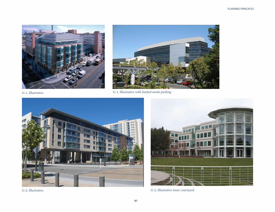
60 61
PLANNING PRINCIPLES
G-1, Illustrative.
G-2, Illustrative. G-2, Illustrative inner courtyard.
G-1, Illustrative with limited onsite parking

UC MERCED PHYSICAL DESIGN FRAMEWORK
62
INTERIM SURFACE PARKING TyPOLOGy
At full development, the 2009 LRDP has identified two on-campus parking structures serving the campus and two structures in the University Community.
However, given the cost of structured parking and the large availability of land, the LRDP has adopted a program where ground level parking is an interim land use within the near future.
The intent is that with succesive majors phases of development, parking lots will be converted to future buildings.
The following typologies describe interim surface parking lots that will accomodate campus needs and streamline the development of the campus grid.
This example illustrates the character and site coverage of blocks that would be used for interim parking. The diagram shows a full block and half block of parking with a campus residential development along Main Street 2.0. This approach allows parking to be designed to extend the street and block system that will be later developed with residential and academic buildings.
Illustrated Block Size: 3 acresLand Use: Academic and Residential Buildings (3L-5L)Interim Parking Capacity (on 3 acre block):
Parking on full block: 350 SF/space = 370 spaces/blockParking on half block: 350 SF/space =185 spaces/half blockParallel parking on street (both sides) 28-36 spaces per block90 degree parking (both sides) 60-80 spaces per block
Oblique View of Interim Surface Parking
Full block of interim parking • Permeable surface• Bioswales
Half block of interim parking • Permeable surface• Bioswales
Half block of academic or campus housing
On-street parking Parallel on 66’ ROWs 90 or 60 degrees on 80’ or larger ROWs

62 63
PLANNING PRINCIPLES
Plan View of Interim Surface Parking
1AEarly Phase
Academic or Housing
1B Half-block of Surface
Parking
1C - 1D Full-block of Interim
Surface Parking
Sustainability Options
Solar Parking Shades Permeable surfaces Bioswales
Design Implications
Parking lots can be designed to lower construction costs through a combination of:
• Use of gravel and low cost paving• Keeping infrastructure and utilities at the edge of the block; and• Utilizing passive stormwater management Best Management Practices in the parking lot design.
Implementation opportunities through 2020
Parking Lots I, J, K, L, M, N, O, P and Q•

UC MERCED PHYSICAL DESIGN FRAMEWORK
64
STUDENT NEIGhBORhOODS Develop a pedestrian culture to create vitality and activity that makes on-campus living desirable.
Four student residential neighborhoods surround the Academic Core and two penetrate the Academic Core along Main Streets 2.0 and 4.0. All neighborhoods are specifically sited to allow easy access to the core campus and will be well served by bicycle paths and transit.
Design Implcations: Promoting Pedestrianism
To energize the neighborhoods with pedestrian activity, dining services and recreation facilities will be clustered within neighborhood centers to provide a central hub of vitality at the ground level. Other design components (e.g. sidewalks, small plazas, and common use spaces ) must also encourage pedestrian activity through their programming Along the two Main Streets, ground floors shall incorporate the building’s most public and active spaces in order to activate the street.
Implementation Opportunities through 2020
• Housing 4 within Lake View Neighborhood• Housing 5 on Main Street 2.0 • Housing 6 within Lake View Neighborhood • Student Aquatics Center• Recreation and Wellness Expansion
The student neighborhoods edge the campus perimeter and penetrate the heart of the academic core along two north-south Main Streets. The intent is to house 50% of the student body on campus.
MAIN STREET
2.0
MAIN STREET
4.0
LAKE VIEW NEIGHBORHOOD
SIERRA VIEW NEIGHBORHOOD
VALLEY VIEW NEIGHBORHOODNORTH NEIG
HBORHOOD
North Bowl
South Bowl
65
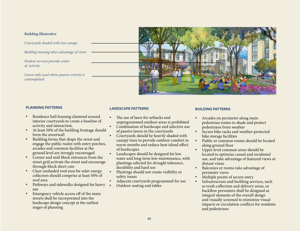
64 65
PLANNING PRINCIPLES
Building Illustrative
Courtyards shaded with tree canopy
Building massing takes advantage of views
Student services provide center of activity
Lawns only used where passive activity is contemplated
PLANNING PATTERNS
Residence hall housing clustered around •interior courtyards to create a baseline of activity and interaction. At least 50% of the building frontage should •form the streetwallBuilding forms that shape the street and •engage the public realm with entry porches, arcades and common facilities at the ground level are strongly encouragedCorner and mid-block entrances from the •street grid activate the street and encourage through-block short cutsClear unshaded roof area for solar energy •collectors should comprise at least 50% of roof areaPathways and sidewalks designed for heavy •use Emergency vehicle access off of the main •streets shall be incorporated into the landscape design concept at the earliest stages of planning
LANDSCAPE PATTERNS
The use of lawn for setbacks and •unprogrammed outdoor areas is prohibitedCombination of hardscape and selective use •of passive lawns in the courtyards Courtyards should be heavily shaded with •canopy trees to provide outdoor comfort in warm months and reduce heat island effect of hardscapesLandscapes should be designed for low •water and long-term low-maintenance, with plantings selected for drought tolerance, durability and hard use Plantings should not create visibility or •safety issues Adjacent courtyards programmed for use •Outdoor seating and tables •
BUILDING PATTERNS
Arcades on perimeter along main •pedestrian routes to shade and protect pedestrians from weatherSecure bike racks and weather-protected •bike storage facilities Public or common rooms should be located •along ground floorUpper level common areas should be •located to optimize casual and incidental use, and take advantage of featured views or distant vistasBalconies or rooms take advantage of •perimeter views Multiple points of secure entry •Infrastructure and building services, such •as trash collection and delivery areas, or backflow preventers shall be designed as integral elements of the overall design and visually screened to minimize visual impacts or circulation conflicts for residents and pedestrians
65

UC MERCED PHYSICAL DESIGN FRAMEWORK
66
The Student Neighborhoods (SN) wrap the Academic Core and are intended to provide walkable access to the heart of the campus. They include residence halls and apartments supported by student services (food and recreation) parks space, and shared parking. There are three block types illustrated. Two mixed-use Main Streets include housing that penetrates the Academic Core, (See AC-3 for block type, pg. 58).
RESIDENTIAL NEIGhBORhOOD TyPOLOGIES
SN-1: The Townhouse and Stacked Flats Block is located within UC Merced’s Student Neighborhoods. These areas will have avariety of building types, of which these townhouse andstacked at buildings are included. Recreational facilities, openspace, parking, student services and campus services will belocated in the neighborhoods as supporting uses. The example illustrates the character and site coverage of blocks with up to 27 apartments per net acre serving the walking and biking student community. These two and three story buildings include town-house units and stacked flats with shared stairs. The four-acre block includes a common courtyard.
Block Size: 4 acresLand Use: Residential Apartments (2-3L) and open space Residential Net Density: 27 du/a x 4 acres = 108 du Residential Gross Density (assumes 75% eciency for streets):20 du/a x 4 acres = 80 du
SN-2: The Walk-up Apartments Block is located within UC Merced’s Student Neighborhoods. These areas will have a variety of building types, of which these 16-apartment unit buildings are included. Recreational facilities, open space, parking, student services and campus services will be located in the neighborhoods as supporting uses. The example illustrates the character and site coverage of blocks with up to 35 apartments per net acre serving the walking and biking student community. These two-story build-ings have eight apartments connected by a common core and stairs for a total of 16 apartments.
The illustrated three-acre block includes an open spacecommons and student services.
Block Size: 3 acresLand Use: Residential Apartments (2L), open space and studentservices (1L)Residential Net Density: 35 du/a x 3 acres = 105 du
Residential Gross Density (assumes 75% eciency for streets):27 du/a x 3 acres = 87 du
SN-3: The Residence Hall Block is located within UC Merced’sStudent Neighborhoods. ese areas will have a variety ofbuilding types, of which these three story corridor buildingsare included. Recreational facilities, open space, parking,student services and campus services will be located in theneighborhoods as supporting uses. The example illustrates the character and site coverage of blocks with up to 80 apartments per net acre. These three-story buildings have corridors, elevators and common spaces on the ground floor. This three-acre block would include an open space commons.
Block Size: 4 acres Land Use: Residential Apartments (2-4L) and open space
Residential Net Density: 80 du/a x 3 acres = 240 du
Residential Gross Density (assumes 75% efficiency for streets):60 du/a x 3 acres = 180 du
SNSN
SN
SN

66 67
PLANNING PRINCIPLES
SN-1, Illustrative.
SN-2, Illustrative. SN-3, Illustrative.

UC MERCED PHYSICAL DESIGN FRAMEWORK
68
OPEN SPACES Organize around shared open spaces such as the North and South Bowls.
The North and South Bowls and the Grand Ellipse will be signature open space features of the campus. They will serve as an important shared gathering space and setting for cultural and active outdoor facilities, in addition to passive and active recreation. Landscaped with a combination of native grasslands, water features and recreation functions, building projects along the edge of these features are favored with inspirational interior views.
The linear open spaces of the Fairfield and Le Grand Canals winding through the urban grid of both connect and define the edges of various districts and present opportunities to vary building forms and optimize views to the water and riparian landscapes that edge these waterways. Implementation Opportunities through 2020
• Student Union 2.0 • Instruction and Research 1• Housing 4• Classroom Office Building 2• Early Education and Child Care 2• Professional School• Student Aquatics Center• Administration Building West• Instruction & Student Academic Services
The campus is bordered by open space on the east and northwest by permanently protected grasslands and Merced County open space. The Grand Ellipse, the North Bowl and the South Bowl are venues for passive and active recreation.
North Bowl
South Bowl
Grand Ellipse
Merced County Open Space
Permanently Protected Grasslands
Cam
pus
Park
way
East Fields
LeGrand Canal
Fairfield Canal
69

68 69
PLANNING PRINCIPLES
Building Illustrative
Glass curtain walls along northern facades take maximum advantage of natural light and open space views Aligned building forms frame central open space
Linear landscaping at the street edges contrast with informal indigenous planting in bowl area
Balconies and terraces overlook open space
PLANNING PATTERNS
Where streets form the edges of major open •spaces, consistent streetwall frontage of buildings facing the open space frame the space as an expansive outdoor room
Since the open spaces serve as stormwater •retention and flood control elements in the plan, the ground level of adjacent buildings typically sits well-above the adjacent landscape and provides opportunities for terraces and belvederes. Public access functions that overlook the Bowls and parks must be realized in the programming, planning and design of the facility.
These terraces may also serve as emergency •access pathways, but must be planned as pedestrian priority zones.
LANDSCAPE PATTERNS
Select indigenous, native, or adaptive •species
Use artificial turf or low-water, drought •tolerant lawn grass for recreational fields only in active play and practice areas
Use low scale non-intrusive plantings to •preserve views in specially identified areas, such as view corridors
Outdoor building seating to provide view •locations
Contrast formal linear plantings at edges •to provide shade and shelter, with natural, episodic plantings within the bowl to heighten the contrast between the built and natural landscape
BUILDING PATTERNS
Curtain walls to optimize views and •daylight, yet protected to reduce interior glare or solar impacts Balconies and terraces•Arcades around perimiter allow views of •open space‘Perched’ site preparation provides elevation •over open spaceIntegrate the planning of trash holding •and delivery functions with overall site planning, being careful to locate all building service functions and visible infrastructure away from open space edges of buildings, and screen them from public views.
69
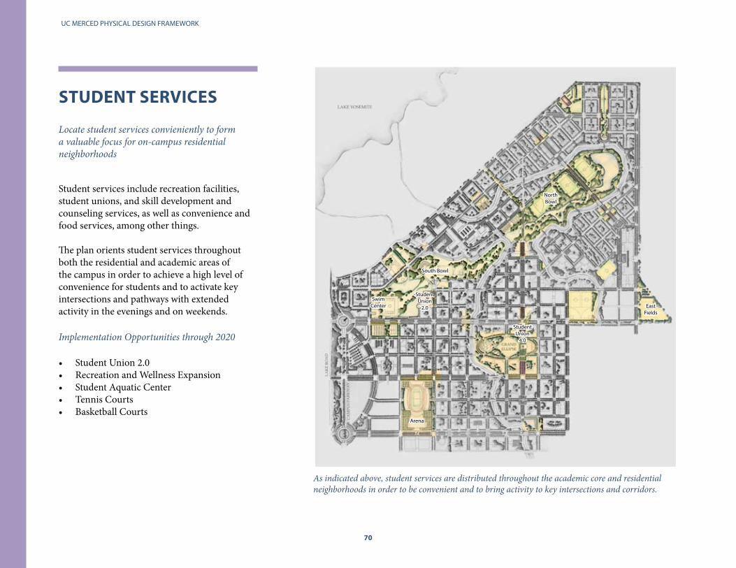
UC MERCED PHYSICAL DESIGN FRAMEWORK
70
STUDENT SERVICES Locate student services convieniently to form a valuable focus for on-campus residential neighborhoods
Student services include recreation facilities, student unions, and skill development and counseling services, as well as convenience and food services, among other things.
The plan orients student services throughout both the residential and academic areas of the campus in order to achieve a high level of convenience for students and to activate key intersections and pathways with extended activity in the evenings and on weekends.
Implementation Opportunities through 2020
Student Union 2.0• Recreation and Wellness Expansion• Student Aquatic Center• Tennis Courts• Basketball Courts•
As indicated above, student services are distributed throughout the academic core and residential neighborhoods in order to be convenient and to bring activity to key intersections and corridors.
Arena
Swim Center
Student Union
2.0
Student Union
4.0
North Bowl
South Bowl
East Fields

70 71
PLANNING PRINCIPLES
Building Illustrative
Transparent ground floor where student services contemplated Programmed ground floors along major pedestrian routes
Located near transit stops for convenient access
Flexibility to allow campus and private vendor provided student services
PLANNING PATTERNS
Located along weather protected pathways •and arcades where possibleLocated convenient to transit system access•Located in the ground level of academic •and residential buildings, to support easy access, active streets and incremental, and highly flexible development or expansion of programsIntegrate informal seating into streetscape, •and long access pathways to student service funtions to allow causual gatherings and support social encounters.Pathways and sidewalks designed for heavy •use
LANDSCAPE PATTERNS
Clear wayfinding system•Plazas, hardscape and seating•Low-water ornamental and native plantings •in structured settingsWell positioned, unprogrammed and •shaded lawns for passive use
BUILDING PATTERNS
Adherence to typology in order to readily •identify internal function Arranged for generalized functions and •loungesVisible and student activity spaces •Attention to noise and acoustics•Zones for socialization•Clear internal wayfinding •Maximize user exposure to activities •
71

UC MERCED PHYSICAL DESIGN FRAMEWORK
72
ThE GRID Maximize the return on investments in infrastructure through strategic deployment and attention to aesthetics.
The Grid incorporates a matrix that includes parking, energy production, sewage, water services, information services, waste management, and the campus streetscape and circulation system.
The hierarchy of street systems is an important underlying structure of the campus physical form. It provides the pathways and connections for both infrastructure, mobility, and access to campus services and support functions such as parking, deliveries, emergency access and the stormwater conveyance network. The corresponding streetscape reinforces this system hierarchy through a legible public realm that includes tree types, signage, surface treatments and street furnishings. Elements that highlight and serve as a model for the the campus’ sustainability mission will be celebrated.
Implementation Opportunities through 2020
• Surface Parking Lots I, J, K, L, M, N, O, and P• Corporation Yard • EH&S and Public Safety structures• Rooftop solar collection on academic buildings• Site Development and Infrastructure 4 and 5• Site Development and Infrastructure 6, 7 and 8• Central Campus West Infrastructure
The larger framework in the grid is comprised of three east-west Boulevards, the two north-south Main Streets and two major Gateways at the Campus Parkway. The campus perimeter loop provides access into the internal grid without compromising the integrity of the pedestrian oriented Academic Core.
Campus Perim
eter Loop Road
BellevueGateway Bellevue Pedestrian Mall
Central Campus Pedestrian Mall
Scholars Lane
Main Street 2.0
Main Street 4.0

72 73
PLANNING PRINCIPLES
Grid Illustrative
Campus Loop Road defines a distinct, publicly-accessible edge between the built and natural environment, and provides perimeter access to the campus grid Major campus services facilities are located at the edges of the grid for easy access
The grid is juxtaposed with the campus stormwater retention and conveyance systems running through the recreational areas in the North and South Bowls North-south Main Streets and east-west gateways provide primary infrastructure backbone for the campus
The campus grid connects and integrates the campus with the University Community
PLANNING PATTERNS
Locate parking at the edge of districts or •along secondary access routes to minimize pedestrian conflictsProvide redundancy for primary power and •communications services to each facilityEstablish a hierarchy of streets to minimize •conflict between modes of access in each districtPlan primary streets as multi-modal •corridors to serve transit, bicycles, and pedestriansLocate major campus support services at •the edges of districts or neighborhoods to provide ease of access to public utilities and services
LANDSCAPE PATTERNS
Integrate stormwater retention and •conveyance systems with streetscape, project site, and open space area planning and designCluster utilities below low rooted planting •areasDevelop streetscape landscape systems that •shade pedestrian pathways, courtyards, and building facades in warmer monthsProvide orchard style planting within all •permanent surface parking areas to and shade at least 50% of the surface area of the lot and reduce heat island effectsScreen trash holding areas, and building •service areas (e.g. transformers, backflow preventers, outdoor storage, etc.) from public view by employing walls, fencing, or hedgerows
BUILDING PATTERNS
Front buildings along major streets to •reinforce the pattern of the grid within districts and at connections to adjacent districtsAlign building facades with the north south •grid to take advantage of passive solar energy during cold months, and screen the sun during warm monthsDesign building rooftops to optimize the •potential for active solar energy collection systemsPlan infrastructure related spaces for •flexibility and expansionDesign architecturally distinctive, •utilitarian facilities for campus services and visible infrastructure
73

UC MERCED PHYSICAL DESIGN FRAMEWORK
74
V CAMPUS SySTEMS
Circulation Pedestrians Bicycles Vehicles
Landscape
Stormwater
Utilities
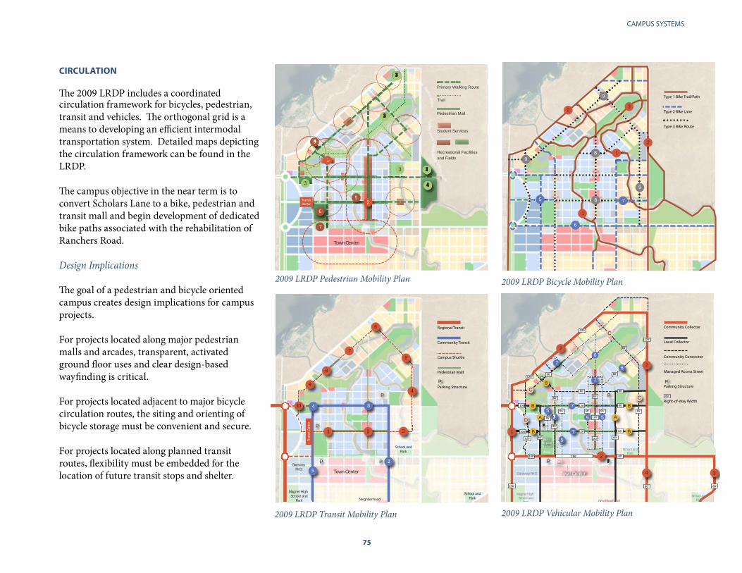
74 75
CAMPUS SYSTEMS
CIRCULATION
The 2009 LRDP includes a coordinated circulation framework for bicycles, pedestrian, transit and vehicles. The orthogonal grid is a means to developing an efficient intermodal transportation system. Detailed maps depicting the circulation framework can be found in the LRDP.
The campus objective in the near term is to convert Scholars Lane to a bike, pedestrian and transit mall and begin development of dedicated bike paths associated with the rehabilitation of Ranchers Road.
Design Implications The goal of a pedestrian and bicycle oriented campus creates design implications for campus projects. For projects located along major pedestrian malls and arcades, transparent, activated ground floor uses and clear design-based wayfinding is critical. For projects located adjacent to major bicycle circulation routes, the siting and orienting of bicycle storage must be convenient and secure.
For projects located along planned transit routes, flexibility must be embedded for the location of future transit stops and shelter.
Town Center
Primary Walking Route
Trail
Pedestrian Mall
Student Services
Recreational Facilitiesand Fields
TransitCenter
3
3
3
3
4
62
1
5
5
7
Lake V
iew
s Lake Views Lake
Views
Lake Views Lak
eView
s Sierra Views
Sierra Views Sierra ViewsValleyViews
ValleyViews ValleyViews
UC Merced LRDP
Circulation: Pedestrians
Student Neighborhood Services
-Cafeterias/Food Service-Neighborhood Commons-Main Street
Student Union
1. Student Union 2.02. Student Union 4.0
Recreational Facilities
3. Soccer Fields4. Baseball/Softball Fields5. Intermural Gym/Rec. Center6. Multi-use Stadium7. Arena
1
1
2
3
5
6
8
8
9
9
9
7
2
UC Merced LRDP Draft
Mobility: Bicycles
Type 1 Bikeways
1. Canal Trails2. Perimeter Trail3. Parkway Trail4. Bowl Trail
Type 2 Bike Lanes
5. Gateway Bike Lanes6. Town and Gown Boulevard Bike Lanes7. West Side Neighborhood Bike Lanes
Type 3 Bike Routes
8. Academic Bike Routes9. Neighborhood Connector Loop Bike Route
Type 1 Bike Trail/Path
Type 2 Bike Lane
Type 3 Bike Route
School andPark
Town Center
Magnet HighSchool and
Park NeighborhoodCenter
GatewayR+D
P
P
P
P
P
School andPark
5
3
4
8
9
21
7
6
5
3
2
16
Tran
sitCe
nter
410
Regional Transit
Community Transit
Campus Shuttle
Pedestrian Mall
Parking Structure
UC Merced LRDP
Circulation: Transit Access Transit Center
- Intermodal Station for Regional, Community and Campus Transit
-Serves Gateway District employment, stadium/arena and is adjacent to public parking structure.
Community Transit: Major Stops
1. Neighborhood Center2. Town Center, Public Parking3. Main Street 4.0, Public Parking4. Gateway North5. Gateway South6. High School Campus
Campus Shuttle: Major Stops
1. Central Campus 1 (Main Street 2.0)2. Central Campus 2 (Grand Ellipse)3. UCLC Neighborhood4. Logistics Center5. Valley View Neighborhood6. Sierra View/North Neighborhood7. North Neighborhood8. North Campus9. Lake View Neighborhood10. Welcome Center
School andPark
Town Center
Magnet HighSchool and
Park NeighborhoodCenter
Gateway R+D
P
P
P
P
P
2
2
AD A
C
5
5
5
6
67
7
7
7
C
C
B
B
B
B
B
34
2
1
School andPark
PAC
Multi-PurposeStadium
5
80’80’
80’
80’
80’80’
80’80’
80’
80’
80’
100’
80’
66’66’66’
66’
66’
66’
66’66’
80’ 80’
120’
120’
120’
120’
120’
150’
150’
120’
120’
Arena100’
UC Merced Draft LRDP Framework
Circulation: Vehicular Access Right of WaysCommunity Collector
1. Parkway (Regional Facility)2. Campus Loop Drive 2 lanes with turn lanes (black) 4 lanes with turn lanes (red)3. Community Loop Drive 2 lanes with turn lanes4. Community Central Drive 4 lanes with turn lanes
Local Collector
A. Campus Core Edge Access 2 lanes with turn lanesB. Campus Core Access 2 lanes with turn lanes
Local ConnectorC. Neighborhood Access 2 lanesD. Gateway Access, 2 lanes with turn lanes
Managed Access Street
5. Mixed-use Service Access 2 lanes6. Neighborhood Access 2 lanes7. Pedestrian Mall 2 lanes
100’
Community Collector
Local Collector
Community Connector
Managed Access Street
Parking Structure
Right-of-Way Width
2009 LRDP Pedestrian Mobility Plan 2009 LRDP Bicycle Mobility Plan
2009 LRDP Transit Mobility Plan 2009 LRDP Vehicular Mobility Plan

UC MERCED PHYSICAL DESIGN FRAMEWORK
76
UTILITIES
Utilities and infrastructure improvements phased over the next 10 years are vital to the ability of UC Merced to meets its academic objectives. While building efficiencies enable the campus to use less energy than typical university buildings, expansion of the campus beyond its current boundaries requires significant investments in extending utilities.
An objective of the ten year capital plan is to strategically extend utilities in phases in order to accomodate state-funded buildings in Central Campus West.
Design Implications The goal to strategically deploy compact, visible infrastructure campus creates design implications for campus building and infrastructure projects. Utility lines should be incorporated into the right of way grid in order to reduce implementation and servicing costs. Lines that leave the grid (e.g. diagonal orientation though proposed building sites) may limit the potential or increase the costs of future building projects. Major utility lines should be oriented to preserve future building sites.
Major utility corridors at full development are indicated in red
PROPOSED UNIVERSITY COMMUNITY
NORTH
UNIVERSITY OF CALIFORNIA, MERCED
P e r ma n e n t l y
p r o t ec t e
d gr a s s l a
n d s
LakeYosemite
Me r c e d C
o u n t y Op e n S
p a c e

76 77
CAMPUS SYSTEMS
STORMWATER
The existing stormwater conveyance system is designed to convey runoff from a 10 year, 24 hour storm. The campus will expand the stormwater system to cover additional areas of the campus as they are developed.
A preliminary stormwater management study to accomodate a 100-year storm is being developed for the area of campus where development is expected over the next 10 years. The thrust of the management approach is to use the South Bowl, bioswales and reservoirs to detain and release water during sizeable rain events.
The study has informed grading and stormwater related submissions under the 10 Year capital plan. The plan will be finalized before any projects are approved in the study area.
Site preparation, grading and erosion control will be conducted in multiple phases.
Design Implications The North and South Bowls are prominent features of the campus open space and stormwater management system. Attention to both functions requires that implementation simultaneously serve the practical stormwater and create an attractive, well-programmed recreational space for the campus community.
Stormwater management catchment study areas within scope of 10 year capital financial plan. Grading and erosion control would be conducted in phases.

UC MERCED PHYSICAL DESIGN FRAMEWORK
78
VI CAMPUS FABRIC
Architectural Form Architectural Elements
Color
Landscape System

78 79
CAMPUS FABRIC
ARChITECTURAL FORM AND MATERIALS: ThE GREAT CENTRAL VALLEy AESThETIC
Architecturally, prominent campus structures have the opportunity to take subtle design cues from the region’s underappreciated agricultural packing sheds, grain silos and outbuildings. Combined with concrete, glass and steel, the design vocabulary for the campus is both modern and geographically appropriate.
The general form of buildings will respond to the orthogonal grid and take advantage of variations created by adjacent open spaces and the sinuous form of the irrigation canals.
Especially for buildings on prominent sites, attention will be paid to quality of facades, the establishment of pedestrian arcades, and elements that create a lantern effect at night.
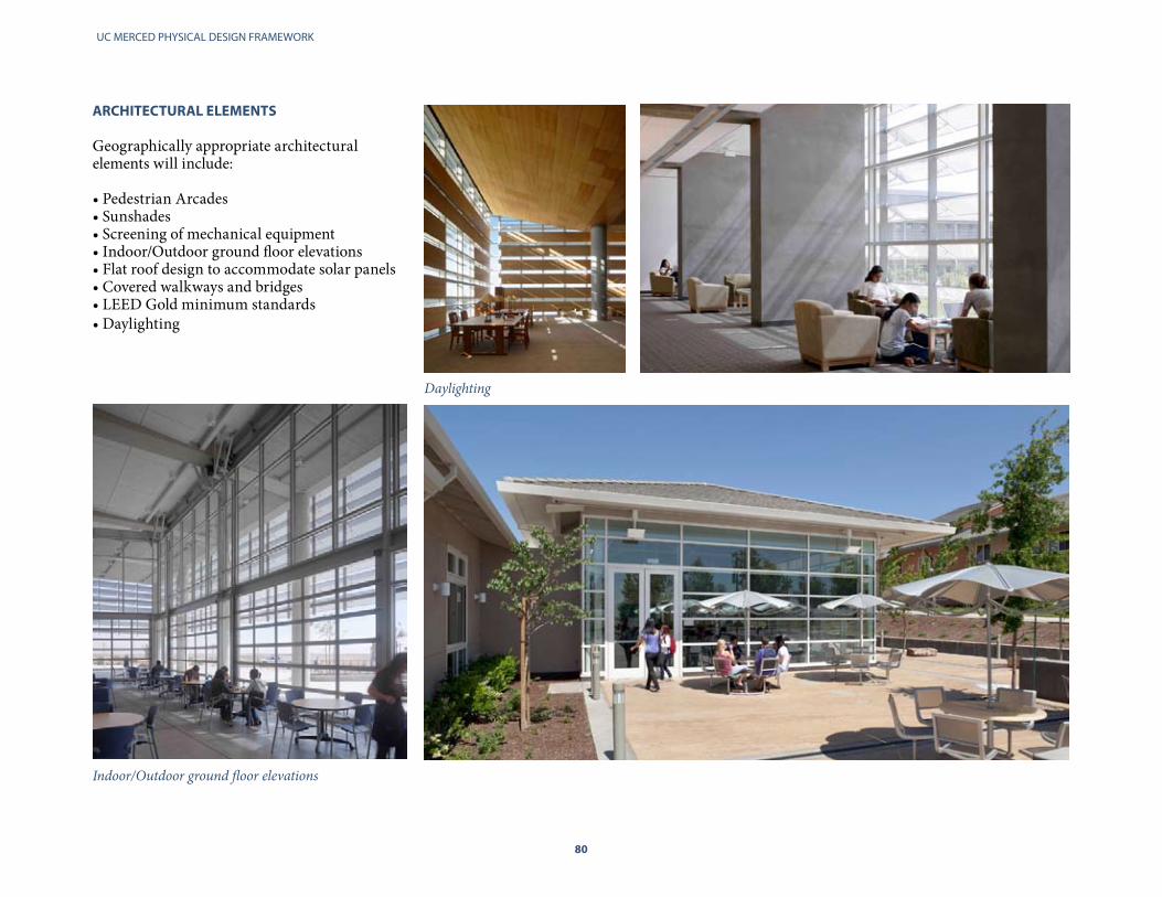
UC MERCED PHYSICAL DESIGN FRAMEWORK
80
ARChITECTURAL ELEMENTS
Geographically appropriate architectural elements will include:
• Pedestrian Arcades• Sunshades • Screening of mechanical equipment • Indoor/Outdoor ground floor elevations • Flat roof design to accommodate solar panels• Covered walkways and bridges • LEED Gold minimum standards • Daylighting
Daylighting
Indoor/Outdoor ground floor elevations

80 81
CAMPUS FABRIC
Sunshading
Flat roofs to accomodate solar panelsPedestrian Arcades
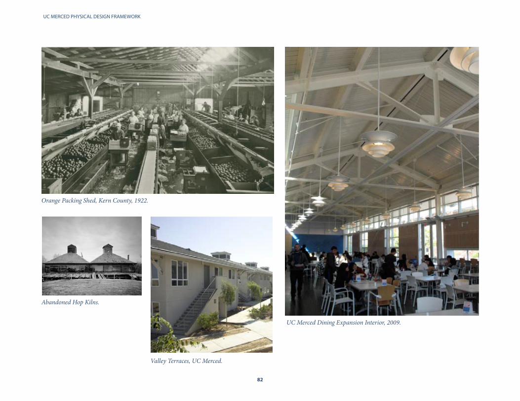
UC MERCED PHYSICAL DESIGN FRAMEWORK
82
UC Merced Dining Expansion Interior, 2009.
Orange Packing Shed, Kern County, 1922.
Valley Terraces, UC Merced.
Abandoned Hop Kilns.

82 83
CAMPUS FABRIC
COLOR AND MATERIALS
Academic Core
The Academic Core features concrete, glass and steel forms. Warm earth tone colors derived from the local landscape may be used as accent features.
Residential Neighborhoods
In accordance with the neigborhood design guildellines, greater flexibility is permitted in residential neighborhoods with regards to dominant color choices. The overall impact is an aesthetically appealing range of vibrant earth tones that blend into the natural environment and agricultural influenced environment.
The Academic Core exemplifies the use of concrete, glass and steel.
Winter in the San Joaquin Valley Spring in the San Joaquin Valley
Accent colors on the Classroom Office Building.

UC MERCED PHYSICAL DESIGN FRAMEWORK
84
Orchard like planted canopies in formal open spaces, quads, squares, plazas and parking lots evocative of the Central Valley’s agricultural landscape heritage to provide spring and fall color and deep shade for public comfort.
Riparian planting corridors along the canals and naturally drained corridors evocative of the native landscaping along the Central Valley’s waterways.
LANDSCAPE SySTEM
The objectives of UC Merced’s draft Landscape Design Plan objectives are to:
Ensure a high level of landscape quality•Achieve a varied cohesive landscape that • reflects the San Joaquin ValleySupport and define memorable campus •public spacesMinimize the use of irrigation•
The draft plan includes a species and plant list currently under review. The campus goal is to formally release the list in Fall 2010.
To support the objectives, the landscape vision for the campus is based on a four part typology reflective of the history and natural attributes of the site.
No building project design shall be approved, which does not have an approved landscape plan which integrates the project site into the surrounding landscape context, subject to soil conditions, and is consistent with these principles.
Natural and native landscape along the edges of campus development as growth occurs to merge with and buffer adjacent habitat, minimize the need for irrigation and maintain a direct con-nection to the vernal pool grasslands.
Urban streetscape plantings evocative of Central Valley communities along the campus grid street system; and ornamental plantings along special corridors, near gateways and building entries to provide seasonal color, variety and form.
UC Merced Landscape Typology

84 85
CAMPUS FABRIC
The Campus Landscape Design Plan developed by consulting arborists and horticulturist incorporates the four part typology of landscapes.
The landscape design for Science and Engineering 2 reflects the native category of the landscape typology.
UC Merced Landscape Framework
Riparian
Native
Formal
Urban

UC MERCED PHYSICAL DESIGN FRAMEWORK
86
VIII PLANNING PROCESS
Campus Design Approval Process Campus Physical Planning Committee
Campus Design Review Committee
Campus Technical Advisory Committee
Building Advisory Committee
Chancellor’s Advisory Committee on Environmental Sustainability
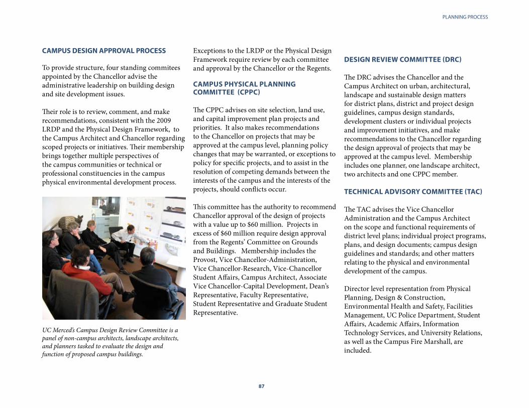
86 87
PLANNING PROCESS
Exceptions to the LRDP or the Physical Design Framework require review by each committee and approval by the Chancellor or the Regents.
CAMPUS PhySICAL PLANNING COMMITTEE (CPPC)
The CPPC advises on site selection, land use, and capital improvement plan projects and priorities. It also makes recommendations to the Chancellor on projects that may be approved at the campus level, planning policy changes that may be warranted, or exceptions to policy for specific projects, and to assist in the resolution of competing demands between the interests of the campus and the interests of the projects, should conflicts occur.
This committee has the authority to recommend Chancellor approval of the design of projects with a value up to $60 million. Projects in excess of $60 million require design approval from the Regents’ Committee on Grounds and Buildings. Membership includes the Provost, Vice Chancellor-Administration, Vice Chancellor-Research, Vice-Chancellor Student Affairs, Campus Architect, Associate Vice Chancellor-Capital Development, Dean’s Representative, Faculty Representative, Student Representative and Graduate Student Representative.
CAMPUS DESIGN APPROVAL PROCESS
To provide structure, four standing commitees appointed by the Chancellor advise the administrative leadership on building design and site development issues.
Their role is to review, comment, and make recommendations, consistent with the 2009 LRDP and the Physical Design Framework, to the Campus Architect and Chancellor regarding scoped projects or initiatives. Their membership brings together multiple perspectives of the campus communities or technical or professional constituencies in the campus physical environmental development process.
UC Merced’s Campus Design Review Committee is a panel of non-campus architects, landscape architects, and planners tasked to evaluate the design and function of proposed campus buildings.
DESIGN REVIEW COMMITTEE (DRC)
The DRC advises the Chancellor and the Campus Architect on urban, architectural, landscape and sustainable design matters for district plans, district and project design guidelines, campus design standards, development clusters or individual projects and improvement initiatives, and make recommendations to the Chancellor regarding the design approval of projects that may be approved at the campus level. Membership includes one planner, one landscape architect, two architects and one CPPC member.
TEChNICAL ADVISORy COMMITTEE (TAC)
The TAC advises the Vice Chancellor Administration and the Campus Architect on the scope and functional requirements of district level plans; individual project programs, plans, and design documents; campus design guidelines and standards; and other matters relating to the physical and environmental development of the campus. Director level representation from Physical Planning, Design & Construction, Environmental Health and Safety, Facilities Management, UC Police Department, Student Affairs, Academic Affairs, Information Technology Services, and University Relations, as well as the Campus Fire Marshall, are included.
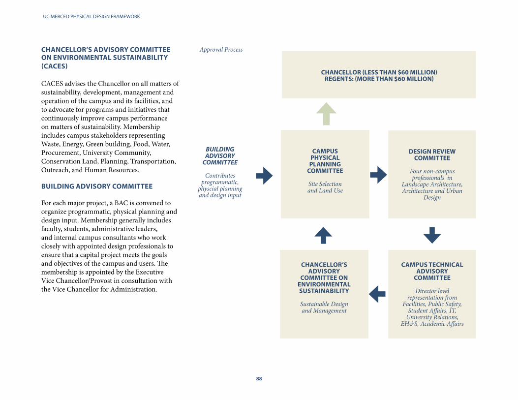
UC MERCED PHYSICAL DESIGN FRAMEWORK
88
ChANCELLOR’S ADVISORy COMMITTEE ON ENVIRONMENTAL SUSTAINABILITy (CACES)
CACES advises the Chancellor on all matters of sustainability, development, management and operation of the campus and its facilities, and to advocate for programs and initiatives that continuously improve campus performance on matters of sustainability. Membership includes campus stakeholders representing Waste, Energy, Green building, Food, Water, Procurement, University Community, Conservation Land, Planning, Transportation, Outreach, and Human Resources.
BUILDING ADVISORy COMMITTEE
For each major project, a BAC is convened to organize programmatic, physical planning and design input. Membership generally includes faculty, students, administrative leaders, and internal campus consultants who work closely with appointed design professionals to ensure that a capital project meets the goals and objectives of the campus and users. The membership is appointed by the Executive Vice Chancellor/Provost in consultation with the Vice Chancellor for Administration.
CAMPUS
PhySICAL PLANNING
COMMITTEE
Site Selection and Land Use
DESIGN REVIEW
COMMITTEE
Four non-campus professionals in
Landscape Architecture, Architecture and Urban
Design
ChANCELLOR’S ADVISORy
COMMITTEE ON ENVIRONMENTAL SUSTAINABILITy
Sustainable Design and Management
CAMPUS TEChNICAL ADVISORy
COMMITTEE
Director level representation from
Facilities, Public Safety, Student Affairs, IT,
University Relations, EH&S, Academic Affairs
Approval Process
Building Advisory
committee
Contributes programmatic,
physcial planning and design input
ChANCELLOR (LESS ThAN $60 MILLION)
REGENTS: (MORE ThAN $60 MILLION)

88 89
PLANNING PROCESS
Kolligian Library
UC MERCED PHYSICAL DESIGN FRAMEWORK
90
IX APPENDIX
Glossary of Terms
On-Campus Buildings
Acknowledgements
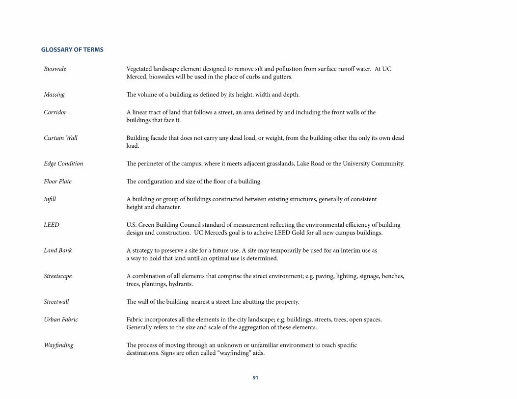
90 91
GLOSSARy OF TERMS
Bioswale Vegetated landscape element designed to remove silt and pollustion from surface runoff water. At UC Merced, bioswales will be used in the place of curbs and gutters.
Massing The volume of a building as defined by its height, width and depth.
Corridor A linear tract of land that follows a street, an area defined by and including the front walls of thebuildings that face it.
Curtain Wall Building facade that does not carry any dead load, or weight, from the building other tha only its own dead load.
Edge Condition The perimeter of the campus, where it meets adjacent grasslands, Lake Road or the University Community.
Floor Plate The configuration and size of the floor of a building.
Infill A building or group of buildings constructed between existing structures, generally of consistentheight and character.
LEED U.S. Green Building Council standard of measurement reflecting the environmental efficiency of building design and construction. UC Merced’s goal is to acheive LEED Gold for all new campus buildings.
Land Bank A strategy to preserve a site for a future use. A site may temporarily be used for an interim use asa way to hold that land until an optimal use is determined.
Streetscape A combination of all elements that comprise the street environment; e.g. paving, lighting, signage, benches, trees, plantings, hydrants.
Streetwall The wall of the building nearest a street line abutting the property.
Urban Fabric Fabric incorporates all the elements in the city landscape; e.g. buildings, streets, trees, open spaces.Generally refers to the size and scale of the aggregation of these elements.
Wayfinding The process of moving through an unknown or unfamiliar environment to reach specificdestinations. Signs are often called “wayfinding” aids.
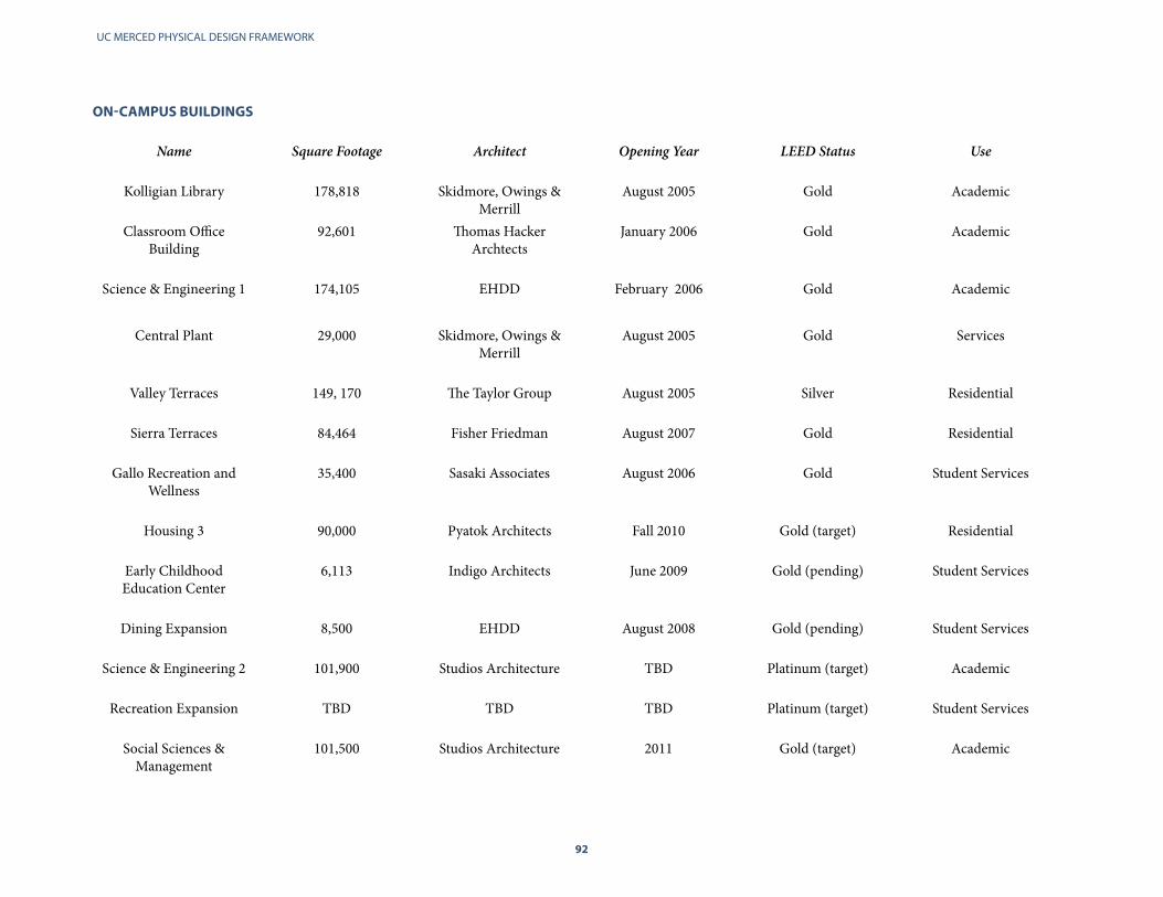
UC MERCED PHYSICAL DESIGN FRAMEWORK
92
ON-CAMPUS BUILDINGS
Name Square Footage Architect Opening Year LEED Status Use
Kolligian Library 178,818 Skidmore, Owings & Merrill
August 2005 Gold Academic
Classroom Office Building
92,601 Thomas Hacker Archtects
January 2006 Gold Academic
Science & Engineering 1 174,105 EHDD February 2006 Gold Academic
Central Plant 29,000 Skidmore, Owings & Merrill
August 2005 Gold Services
Valley Terraces 149, 170 The Taylor Group August 2005 Silver Residential
Sierra Terraces 84,464 Fisher Friedman August 2007 Gold Residential
Gallo Recreation and Wellness
35,400 Sasaki Associates August 2006 Gold Student Services
Housing 3 90,000 Pyatok Architects Fall 2010 Gold (target) Residential
Early Childhood Education Center
6,113 Indigo Architects June 2009 Gold (pending) Student Services
Dining Expansion 8,500 EHDD August 2008 Gold (pending) Student Services
Science & Engineering 2 101,900 Studios Architecture TBD Platinum (target) Academic
Recreation Expansion TBD TBD TBD Platinum (target) Student Services
Social Sciences & Management
101,500 Studios Architecture 2011 Gold (target) Academic

92 93
University of California, MercedPhysical Planning, Design and Construction
Campus Architect and Associate Vice Chancellor Thomas Lollini Catherine Kniazewycz, Director of Project Management Michael Chow, Senior Project DirectorBrad Samuelson, Director of Environmental PlanningRichard Cummings, Principal Planner Gene Barrera, Associate PlannerSuzanne Kalmann, Associate Planner
Consultants
Bruce Race, FAIA, AICP, RACESTUDIOCliff Lowe, ASLA, Cliff Lowe AssociatesDouglas Jamieson, Douglas E. Jamieson, Inc. Paul Heath, Business Place Strategies Mike Persak, Michael Hayes, Tony Zavanelli (STANTEC)
ACKNOWLEDGEMENTS
Campus Administration (LRDP)
Steve Kang, ChancellorJanet Young, Associate Chancellor and Chief of StaffKeith Alley, Exec. Vice Chancellor and ProvostMary Miller, Vice Chancellor, Administration Sam Traina, Vice Chancellor, Research and Dean of Graduate StudiesJane Lawrence, Vice Chancellor, Student Affairs Thomas Lollini, Associate Vice Chancellor and Campus ArchitectJim Genes, Special Assistant to the Vice Chancellor Leslie Santos, Director of Housing and Residence Life Robert Avalle, Director, Facilities Management John Elliott, Senior Engineer, Facilities Sajid Mian, Associate Director, Facilities Charles Nies, Assistant Vice Chancellor, Student Affairs Patti Istas, Exec. Director of CommunicationsRich Miller, Interim Associate Vice Chancellor, Research David Dunham, Campus Recreation, Director Le’Trice Curl, Director, Student Life and Judicial Affairs John O. White, Assistant Vice Chancellor, Capital Development Brian Gresham, Assistant Director, Capital Planning Larry Salinas, Director of Government Relations Rita Spaur, Chief, Campus Police Nancy Ochsner, Director, Institutional Planning and Analysis
Office of the President, University of California Charlotte Strem Tara LamontAlicia JensenMarsha Sato

UC MERCED PHYSICAL DESIGN FRAMEWORK
94
University of California, Merced5200 N. Lake RoadMerced, California 95343www.ucmerced.edu