photogrammetry of killer whales using a small hexacopter launched … · photogrammetry of killer...
TRANSCRIPT
Photogrammetry of killer whales using a smallhexacopter launched at sea1
J.W. Durban, H. Fearnbach, L.G. Barrett-Lennard, W.L. Perryman, andD.J. Leroi
Abstract: Conventional aircraft have been used for photogrammetry studies of free-ranging whales, but are often not practical in remote regions or not affordable. Here we reporton the use of a small, unmanned hexacopter (APH-22; Aerial Imaging Solutions) as an alter-native method for collecting photographs to measure killer whales (Orcinus orca) at sea. Wedeployed and retrieved the hexacopter by hand during 60 flights (average duration 13.2 min,max 15.7 min) from the upper deck of an 8.2 m boat, utilizing the aircraft’s vertical takeoffand landing (VTOL) capability. The hexacopter was quiet and stable in flight, and thereforecould be flown at relatively low altitudes without disturbing whales. The payload was aMicro Four-Thirds system camera that was used to obtain 18920 still images from an altitudeof 35–40 m above the whales. Tests indicated a ground-resolved distance of <1.4 cm acrossthe full extent of a flat and undistorted field of view, and an onboard pressure altimeterenabled measurements in pixels to be scaled to true size with an average accuracy of5 cm. As a result, the images were sharp enough to differentiate individual whales usingnatural markings (77 whales in total) and preliminary estimates resolved differences inwhale lengths ranging from 2.6 to 5.8 m. This first application at sea demonstrated theAPH-22 hexacopter to be a safe and cost-effective platform for collecting photogrammetryimages to fill key scientific data gaps about whales, and we anticipate this utility will extendto studies of other wildlife species.
Key words: UAS, hexacopter, wildlife VTOL, whales.
Résumé : Les aéronefs classiques ont été utilisés pour des études de photogrammétrie debaleines en liberté, mais souvent ils ne sont ni pratiques, ni abordables dans les régionséloignées. Ici, nous présentons un rapport sur l’utilisation d’un petit hexacoptère sanspilote (APH-22; Aerial Imaging Solutions) en tant que méthode alternative pour recueillirdes photographies afin de mesurer les épaulards (Orcinus orca) en mer. Nous avons déployéet récupéré l’hexacoptère manuellement au cours de 60 vols (durée moyenne de 13,2 min,maximum de 15,7 min) à partir du pont supérieur d’un bateau de 8,2 m, grâce à la capacitéde décollage et d’atterrissage verticaux (VTOL) de l’aéronef. L’hexacoptère était silencieux etstable en vol, et ainsi on pouvait le faire voler à des altitudes relativement basses sans per-turber les baleines. La charge utile était un système photographique Micro Four-Thirdsqu’on a utilisé pour obtenir 18920 images fixes d’une altitude de 35 à 40 m au-dessus desbaleines. Les essais ont indiqué une limite de résolution au sol de <1,4 cm sur l’étendue com-plète d’un champ de vision plan sans distorsion, et un altimètre pression embarqué a per-mis de changer l’échelle des mesures en pixels à des dimensions réelles avec uneprécision moyenne de 5 cm. Par conséquent, les images étaient suffisamment nettes pourpouvoir distinguer certaines baleines par leurs marques corporelles (77 baleines au total)
Received 16 April 2015. Accepted 10 June 2015.
J.W. Durban, H. Fearnbach, W.L Perryman. Southwest Fisheries Science Center, National Marine Fisheries Service, NOAA;8901 La Jolla Shores Drive, La Jolla, CA 92037, USA.L.G. Barrett-Lennard. Vancouver Aquarium Marine Science Center, 845 Avison Way, Vancouver, BC VG63E2, Canada.D.J. LeRoi. Aerial Imaging Solutions, 5 Myrica Way, Old Lyme, CT 06371, USA.Corresponding author: J.W. Durban (e-mail: [email protected]).1This note is one of a special series of invited papers on the use of unmanned vehicle systems in wildlife studies.
NOTE
1
Pagination not final (Please cite DOI)
J. Unmanned Veh. Syst. 3: 1–5 (2015) dx.doi.org/10.1139/juvs-2015-0020 Published at www.nrcresearchpress.com/juvs on 30 June 2015.
J. U
nman
ned
Veh
. Sys
. Dow
nloa
ded
from
ww
w.n
rcre
sear
chpr
ess.
com
by
NO
RT
HW
EST
FIS
HE
RIE
S SC
IEN
CE
CT
R o
n 07
/23/
15Fo
r pe
rson
al u
se o
nly.
et les estimations préliminaires distinguent des différences de longueur de baleine variantde 2,6 à 5,8 m. Dès la première utilisation en mer, l’hexacoptère APH-22 s’est avéré une pla-teforme sécuritaire et économique pour collecter des images photogrammétriques afin decombler des données scientifiques de base manquantes concernant les baleines, et nous pré-voyons que cette utilisation s’étendra à des études d’autres espèces fauniques.Mots-clés : système d’aéronef sans pilote (UAS), hexacoptère, faune, décollage et atterrissage verti-caux (VTOL), baleines.
Introduction
Conventional aircraft have been successfully used for photogrammetry studies of free-rangingwhales. Fixed-wing planes and helicopters have been used to obtain vertical photographs fromdirectly above whales, from which shape profiles can be measured to assess body condition to infernutritional status and pregnancy (e.g., Perryman and Lynn 2002). When combined with informationon scale (= altitude/focal length), these images can also be used to estimate absolute length (e.g.,Pitman et al. 2007) and monitor growth trends (e.g., Fearnbach et al. 2011). However, aircraft operationsare often not practical in remote regions, and not affordable under typical research budgets, andtherefore this technique has not been widely used.
Here we report on a recent project using a small unmanned aerial system (UAS) as an alternativemethod for successfully obtaining photogrammetry images of killer whales (Orcinus orca) at sea. Ourstudy area was around Vancouver Island, off the British Columbia coastline of western Canada.Previously, we used a helicopter to measure “Southern Resident” killer whales in the more accessiblewaters off Southern Vancouver Island (Fearnbach et al. 2011), but required an alternative approachto obtain comparative measurements from the “Northern Resident” population in the more remotearea at the north of the island. We chose to use a small multi-rotor UAS because vertical takeoffand landing (VTOL) capability was required to operate from a small boat, and we required stabilityin flight for photographic operations. We chose a small (1.2 kg dry weight without payload; 82 cmwingspan) hexacopter that was recently used in Antarctica to obtain photographs for counting sealsand penguins, and to estimate the size of leopard seals onshore (Goebel et al. 2015). This UAS platformhas been proven to have the endurance and performance characteristics to conduct successful photo-graphic missions in a windy environment, and to create a limited sound footprint that does not dis-turb wildlife.
Materials and methods
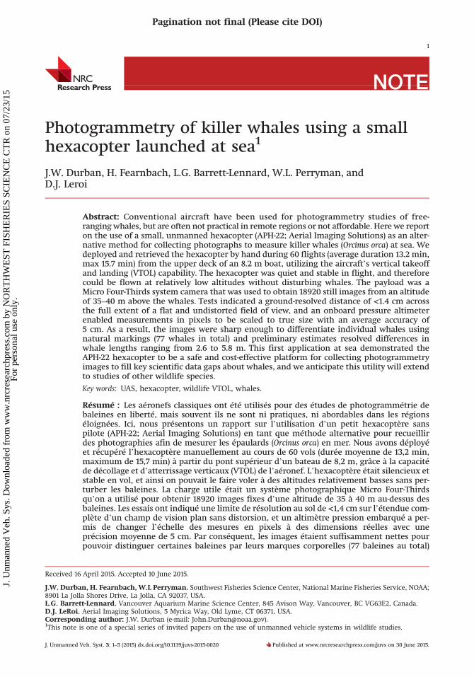
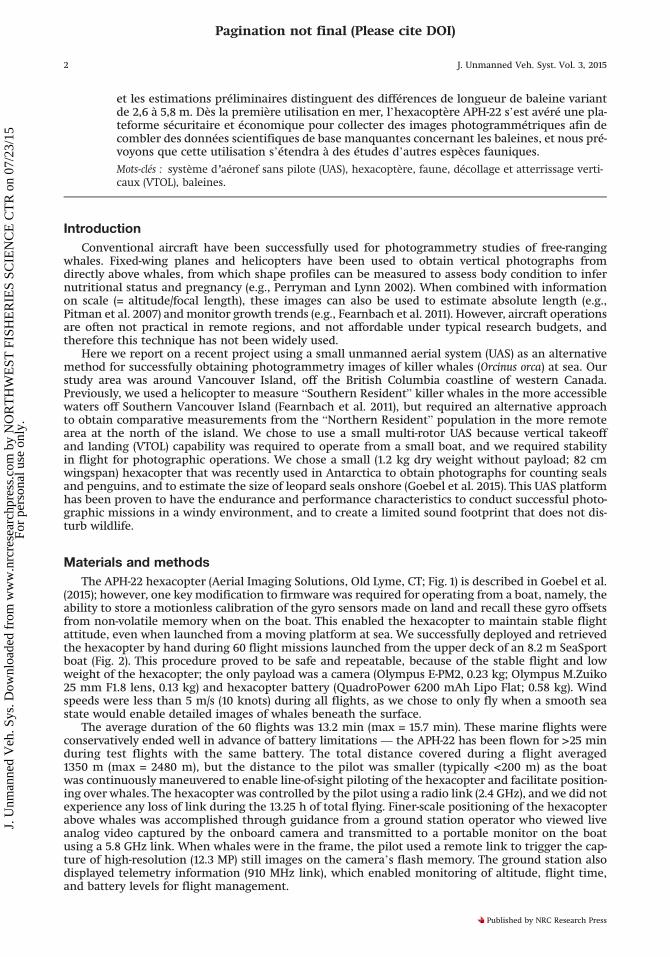
The APH-22 hexacopter (Aerial Imaging Solutions, Old Lyme, CT; Fig. 1) is described in Goebel et al.(2015); however, one key modification to firmware was required for operating from a boat, namely, theability to store a motionless calibration of the gyro sensors made on land and recall these gyro offsetsfrom non-volatile memory when on the boat. This enabled the hexacopter to maintain stable flightattitude, even when launched from a moving platform at sea. We successfully deployed and retrievedthe hexacopter by hand during 60 flight missions launched from the upper deck of an 8.2 m SeaSportboat (Fig. 2). This procedure proved to be safe and repeatable, because of the stable flight and lowweight of the hexacopter; the only payload was a camera (Olympus E-PM2, 0.23 kg; Olympus M.Zuiko25 mm F1.8 lens, 0.13 kg) and hexacopter battery (QuadroPower 6200 mAh Lipo Flat; 0.58 kg). Windspeeds were less than 5 m/s (10 knots) during all flights, as we chose to only fly when a smooth seastate would enable detailed images of whales beneath the surface.
The average duration of the 60 flights was 13.2 min (max = 15.7 min). These marine flights wereconservatively ended well in advance of battery limitations — the APH-22 has been flown for >25 minduring test flights with the same battery. The total distance covered during a flight averaged1350 m (max = 2480 m), but the distance to the pilot was smaller (typically <200 m) as the boatwas continuously maneuvered to enable line-of-sight piloting of the hexacopter and facilitate position-ing over whales. The hexacopter was controlled by the pilot using a radio link (2.4 GHz), and we did notexperience any loss of link during the 13.25 h of total flying. Finer-scale positioning of the hexacopterabove whales was accomplished through guidance from a ground station operator who viewed liveanalog video captured by the onboard camera and transmitted to a portable monitor on the boatusing a 5.8 GHz link. When whales were in the frame, the pilot used a remote link to trigger the cap-ture of high-resolution (12.3 MP) still images on the camera’s flash memory. The ground station alsodisplayed telemetry information (910 MHz link), which enabled monitoring of altitude, flight time,and battery levels for flight management.
2 J. Unmanned Veh. Syst. Vol. 3, 2015
Pagination not final (Please cite DOI)
Published by NRC Research Press
J. U
nman
ned
Veh
. Sys
. Dow
nloa
ded
from
ww
w.n
rcre
sear
chpr
ess.
com
by
NO
RT
HW
EST
FIS
HE
RIE
S SC
IEN
CE
CT
R o
n 07
/23/
15Fo
r pe
rson
al u
se o
nly.
Results and disscusion
We were successful at positioning the hexacopter directly above groups of killer whales, andobtained a total of 18920 still images from an altitude of 35–40 m. We did not observe any behavioralresponses from the whales during any of the flights, and they likely were not aware of the small hex-acopter at these altitudes. The 25 mm lens we used is considered “normal” for the Micro Four-Thirdssensor of the E-PM2 camera, in that the focal length is equal to the diagonal of a square formed by thelong dimension of the sensor, and therefore photogrammetry measurements were possible across thefull extent of a flat and undistorted field of view. Previous resolution tests over a standard medium
Fig. 1. The APH-22 hexacopter (Aerial Imaging Solutions, Old Lyme, CT) that was used to fly 60 successful missionsto collect vertical photogrammetry images of killer whales at sea. Here shown with the Olympus E-PM2 cameraand interchangeable lens system; the camera mounts on the underside of the hexacopter to be downward-facing.
Fig. 2. (a) Boat-based operations using the APH-22 hexacopter, which was hand-deployed and retrieved (photo byBruce Paterson) from the upper deck of an 8.2 m boat, and (b) used to obtain overhead images of killer whales fromaltitudes of 35–40 m (photo by Suzanne Burns; red arrow indicates the hexacopter above a killer whale).
Durban et al. 3
Pagination not final (Please cite DOI)
Published by NRC Research Press
J. U
nman
ned
Veh
. Sys
. Dow
nloa
ded
from
ww
w.n
rcre
sear
chpr
ess.
com
by
NO
RT
HW
EST
FIS
HE
RIE
S SC
IEN
CE
CT
R o
n 07
/23/
15Fo
r pe
rson
al u
se o
nly.
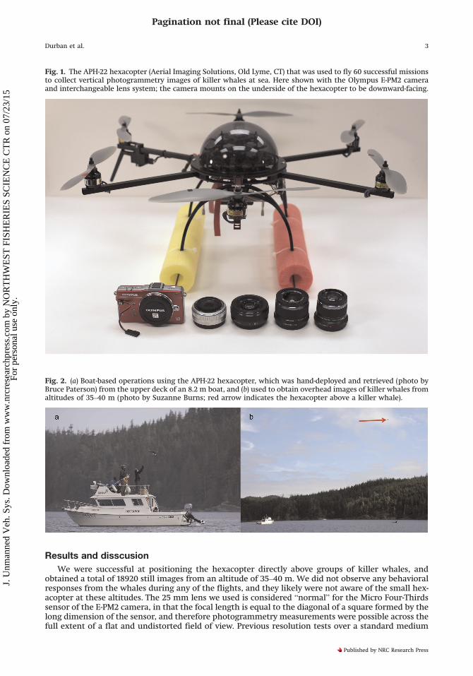
contrast (8:1) resolution target (RST-704, series C) showed that we had a ground-resolved distance of<1.8 cm using the 25 mm lens at an altitude of 50 m, which improved further to <1.4 cm at our stan-dard altitude of 35 m. Our images of the whales clearly showed that this expected resolution was rea-lized in photographs at sea: notably, we could resolve differences in natural markings to identifyindividual whales using images of their saddle patch pigmentation (Fig. 3), which allowed us to linkmeasurements to whales of known age and sex (e.g., Fearnbach et al. 2011).
One of the key requirements of our photogrammetry system is the ability to obtain whale lengthand width profiles on a real scale. Measurements from the images in pixels can be converted to a truemeasurement using the known longitudinal dimension of the camera sensor and the number of pix-els comprising this known width, and these can then be scaled to true lengths using the measured alti-tude and the focal length of the lens (e.g., Fearnbach et al. 2011). The flight controllers on thehexacopter used a Freescale MPX4115A absolute air pressure sensor, which has on-chip temperaturecompensation, for altitude measurements. We calculated the altitude of the hexacopter at 1 s intervalsby applying the standard altitude equation to the difference between the pressure while flying and thepressure at takeoff, with a known takeoff height above sea level.
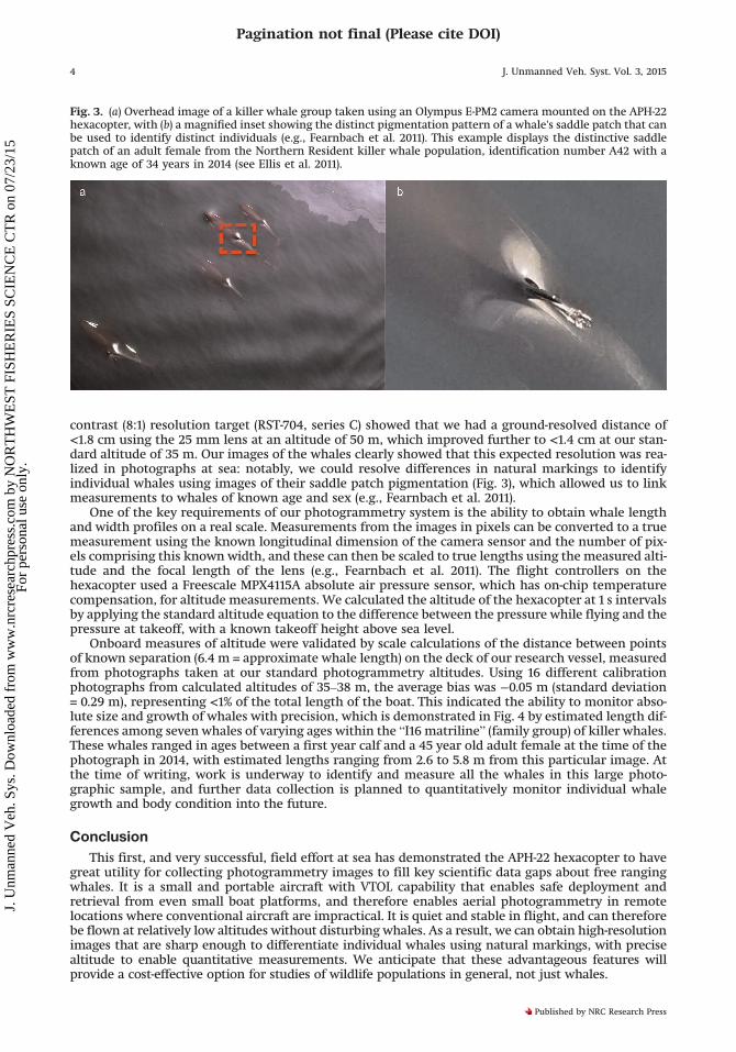
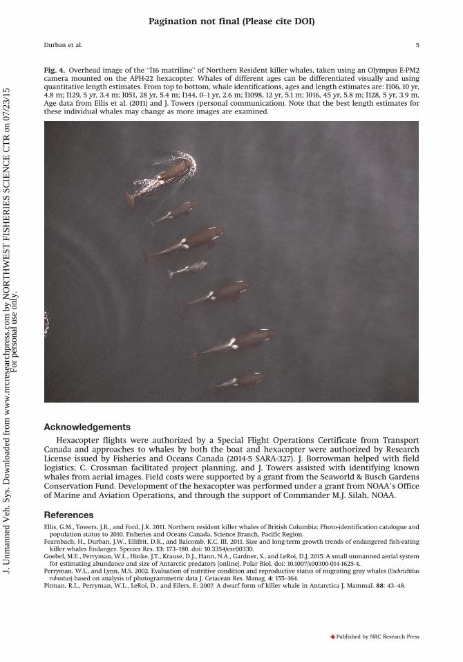
Onboard measures of altitude were validated by scale calculations of the distance between pointsof known separation (6.4 m = approximate whale length) on the deck of our research vessel, measuredfrom photographs taken at our standard photogrammetry altitudes. Using 16 different calibrationphotographs from calculated altitudes of 35–38 m, the average bias was −0.05 m (standard deviation= 0.29 m), representing <1% of the total length of the boat. This indicated the ability to monitor abso-lute size and growth of whales with precision, which is demonstrated in Fig. 4 by estimated length dif-ferences among seven whales of varying ages within the “I16 matriline” (family group) of killer whales.These whales ranged in ages between a first year calf and a 45 year old adult female at the time of thephotograph in 2014, with estimated lengths ranging from 2.6 to 5.8 m from this particular image. Atthe time of writing, work is underway to identify and measure all the whales in this large photo-graphic sample, and further data collection is planned to quantitatively monitor individual whalegrowth and body condition into the future.
Conclusion
This first, and very successful, field effort at sea has demonstrated the APH-22 hexacopter to havegreat utility for collecting photogrammetry images to fill key scientific data gaps about free rangingwhales. It is a small and portable aircraft with VTOL capability that enables safe deployment andretrieval from even small boat platforms, and therefore enables aerial photogrammetry in remotelocations where conventional aircraft are impractical. It is quiet and stable in flight, and can thereforebe flown at relatively low altitudes without disturbing whales. As a result, we can obtain high-resolutionimages that are sharp enough to differentiate individual whales using natural markings, with precisealtitude to enable quantitative measurements. We anticipate that these advantageous features willprovide a cost-effective option for studies of wildlife populations in general, not just whales.
Fig. 3. (a) Overhead image of a killer whale group taken using an Olympus E-PM2 camera mounted on the APH-22hexacopter, with (b) a magnified inset showing the distinct pigmentation pattern of a whale's saddle patch that canbe used to identify distinct individuals (e.g., Fearnbach et al. 2011). This example displays the distinctive saddlepatch of an adult female from the Northern Resident killer whale population, identification number A42 with aknown age of 34 years in 2014 (see Ellis et al. 2011).
4 J. Unmanned Veh. Syst. Vol. 3, 2015
Pagination not final (Please cite DOI)
Published by NRC Research Press
J. U
nman
ned
Veh
. Sys
. Dow
nloa
ded
from
ww
w.n
rcre
sear
chpr
ess.
com
by
NO
RT
HW
EST
FIS
HE
RIE
S SC
IEN
CE
CT
R o
n 07
/23/
15Fo
r pe
rson
al u
se o
nly.
Acknowledgements
Hexacopter flights were authorized by a Special Flight Operations Certificate from TransportCanada and approaches to whales by both the boat and hexacopter were authorized by ResearchLicense issued by Fisheries and Oceans Canada (2014-5 SARA-327). J. Borrowman helped with fieldlogistics, C. Crossman facilitated project planning, and J. Towers assisted with identifying knownwhales from aerial images. Field costs were supported by a grant from the Seaworld & Busch GardensConservation Fund. Development of the hexacopter was performed under a grant from NOAA’s Officeof Marine and Aviation Operations, and through the support of Commander M.J. Silah, NOAA.
ReferencesEllis, G.M., Towers, J.R., and Ford, J.K. 2011. Northern resident killer whales of British Columbia: Photo-identification catalogue andpopulation status to 2010. Fisheries and Oceans Canada, Science Branch, Pacific Region.
Fearnbach, H., Durban, J.W., Ellifrit, D.K., and Balcomb, K.C. III. 2011. Size and long-term growth trends of endangered fish-eatingkiller whales Endanger. Species Res. 13: 173–180. doi: 10.3354/esr00330.
Goebel, M.E., Perryman, W.L., Hinke, J.T., Krause, D.J., Hann, N.A., Gardner, S., and LeRoi, D.J. 2015. A small unmanned aerial systemfor estimating abundance and size of Antarctic predators [online]. Polar Biol. doi: 10.1007/s00300-014-1625-4.
Perryman, W.L., and Lynn, M.S. 2002. Evaluation of nutritive condition and reproductive status of migrating gray whales (Eschrichtiusrobustus) based on analysis of photogrammetric data J. Cetacean Res. Manag. 4: 155–164.
Pitman, R.L., Perryman, W.L., LeRoi, D., and Eilers, E. 2007. A dwarf form of killer whale in Antarctica J. Mammal. 88: 43–48.
Fig. 4. Overhead image of the “I16 matriline” of Northern Resident killer whales, taken using an Olympus E-PM2camera mounted on the APH-22 hexacopter. Whales of different ages can be differentiated visually and usingquantitative length estimates. From top to bottom, whale identifications, ages and length estimates are: I106, 10 yr,4.8 m; I129, 5 yr, 3.4 m; I051, 28 yr, 5.4 m; I144, 0–1 yr, 2.6 m; I1098, 12 yr, 5.1 m; I016, 45 yr, 5.8 m; I128, 5 yr, 3.9 m.Age data from Ellis et al. (2011) and J. Towers (personal communication). Note that the best length estimates forthese individual whales may change as more images are examined.
Durban et al. 5
Pagination not final (Please cite DOI)
Published by NRC Research Press
J. U
nman
ned
Veh
. Sys
. Dow
nloa
ded
from
ww
w.n
rcre
sear
chpr
ess.
com
by
NO
RT
HW
EST
FIS
HE
RIE
S SC
IEN
CE
CT
R o
n 07
/23/
15Fo
r pe
rson
al u
se o
nly.