phosphates. - usgs · in the course of these reconnoissance examina ... the upper mis sissippian...
TRANSCRIPT

PHOSPHATES
A GEOLOGIC EECONNAISSANCE IN SOUTHEASTEEN IDAHO
By A E SCHTJLTZ and E W EICHARDS
PURPOSE OF INVESTIGATION
A reconnaissance examination of the part of southeastern Idaho located between the Wyoming boundary and meridian 112deg and beshytween parallels 42deg 45 and 43deg 30 was undertaken in 1911 with the purpose of collecting data for the elimination of nonphosphate lands from the phosphate reserves After the close of the detailed field work in southeastern Idaho the writers spent three weeks in the region south of Snake Eiver and north of the areas examined in detail by Gale and Eichards 1 in 1909 and by Eichards and Mansshyfield - in 1910 and 1911 As a result of this reconnaissance examinashytion 249049 acres of withdrawn phosphate land has been restored to agricultural entry The data collected during the examination indicate that not all of the phosphate land was included in the phosshyphate reserves as originally constituted by the withdrawals of December 1908 and December 1909 The old phosphate reserve boundary has been so modified and extended as to include all the known phosphate areas Figure 32 shows the area examined in 1911 in detail (1911b) as well as the reconnaissance area (1911a) its relation to the areas surveyed in the preceding years (1909 and 1910) and described in Bulletins 430 and 470 and the extent of the phosphate reserve on July 11912 Some of the land in the Caribou Eange lying between Tincup and Garden creeks is probably undershylain by phosphate beds at depths of less than 5000 feet These lands have not yet been included in the phosphate reserve because it was found to be impossible during the short reconnaissance examination to determine the thickness of the overlying beds and to work out the necessary detailed structure to determine in what places the phosshy
i Gale H S and Richards R W Bull U S Geol Survey No 430 1910 pp 457-535 Richards R W and Mansfield G R Jour Geology vol 20 1912 pp 681-709
267
268 CONTRIBUTIONS TO ECONOMIC GEOLOGY 1911 PART I
38 39 40 41 AZ 43 44 45
__________ __ _[ lie Ta^-aS 40 41 ^ 4Z 43~- 44 45
FIGURE 32 Map showing phosphate reserve in Idaho July 1 1912 Shaded areas indicate phosphate lands
phate beds occur at depths less than 5000 feet
EARLIER WORK
The entire area was examined in 18T7 by geologists of the Hay-den Survey and deshyscribed in the report for that year North of the forty-third parshyallel the examination was conducted by Orestes St John and south of that line by A C Peale The geologic reports by these men include a fund of accurate infor-tion and represent reconnaissance work of high standard In acshycuracy and quantity however the data given in the text in both reports are well in advance of the geologic maps which accompany them The errors of the maps are solely responsible for the mislocation of the phosphate reserves as originally constituted and the main results of the present examshyination comprise corshyrections of the errors in these old maps
GEOGRAPHY
The area examined includes about 2000 square miles all lying
BECONNAISSANCE IF SOUTHEASTEBN IDAHO 269
within the Snake Eiver basin The main drainage has a northwestshyerly trend and is carried by Blackfoot River John Grays Lake and its outlet Willow Creek and Snake River A large portion of the area is included within the Caribou National Forest and is mainly used for cattle and sheep grazing during the summer A few ranchshy ers control the greater part of the remainder of the area Gray and Henry are the main trading points Post offices are maintained at Alpine Blowout Glen Gray Henry Herman Irwin Wayan and Williamsburg
Two main types of country are included in the area the lava plains or plateaus and the rugged mountainous areas which are made up of deformed sedimentary rocks mainly sandstone and limeshystone
GEOLOGY
STRATIGRAPHY
GENERALIZED SECTION
The rocks of the region range in age from Cambrian to Quaternary The stratigraphic column appears to be fully represented from the basal Carboniferous to the Cretaceous At or near the end of Creshytaceous time there was an interval of erosion which appears to have continued until the late Tertiary and is indicated by a marked unconformity
The following generalized section represents the range of condishytions as they are now interpreted for this region
Generalised section of the formations in southeastern Idaho south of Snake River
Feet Quaternary Alluvium travertine and lava flows_ Tertiary (Pliocene ) Marls marly limestones
and calcareous conglomerates also lava flows__ Unconformity Cretaceous
Coal-bearing shales and sandstones of the Colorado group_____ _________ Not determined
Bear River () formation (gray limestones calcareous sandstones and dark-colored shales) _____________________ Not determined
Cretaceous and Jurassic Beckwith formation (red shales sandstones and conglomerates with some limestone) ___________ ________ 4650
Jurassic Twin Creek limestone (shaly limestone)- 1 200-3500 Jurassic or Triassic Nugget sandstone (dark-red
to white sandstone and quartzite)_l_______ 1000-1900 Triassic
Ankareh shale (red shale with intercalated mottled limestone) ______________ 200- 670
Thaynes limestone (thin and thick bedded platy limestones) laquo_ 700-2000
270 CONTRIBUTIONS TO ECONOMIC GEOLOGY 1911 PAKT I
Triassic Continued^ Feet Woodside shale (rusty-brown to olive-green
calcareous shales intercalated with muddy limestone lentils) _______________ 1000-1200
Carboniferous 3 Permian () Phosphoria formation 1 (Bex
chert member at top over yellow to brown sandstones brown to black shales phosphate rock) ____ _________________ 75- 627
Pennsylvanian Wells formation 1 (sandy limeshystones calcareous sandstones and variable quartzites) __________ 1000-2400
Mississippian Upper Mississippian limestone (light gray
thick bedded) _______________ 1130+ Madison limestone lower Mississippian
(thin bedded dark gray to bluish gray) _ _____________ 1000
Pre-Carboniferous White quartzite (probably Or-dovician) underlain by Cambrian sediments (limestones and quartzites with beds of shale)
PRE-CARBONIFEROUS ROCKS
In the extreme southwestern portion of the area examined a white quartzite was found overthrust upon limestones of Mississippian age The quartzite is lithologically similar to a quartzite seen in 1910 in vicinity of Soda Springs and there interpreted to be of Ordovician age it here occurs in a similar discordant relation with Carboniferous rocks Associated with the Ordovician rocks is a series of limestones and quartzites of Cambrian age but no attempt was made to map the separate formational units
CARBONIFEROUS AND TRIASSIC ROCKS
General features In the course of these reconnoissance examinashytions it has been found advisable for the small-scale mapping to group the Madison limestone (lower Mississippian) the upper Misshysissippian limestone and the Wells formation (Pennsylvanian) into one map unit and the later Carboniferous (Permian ) and Triassic formations into another map unit comprising the Phosphoria formashytion (Permian ) the Woodside shale Thaynes limestone Ankareh shale (all of Lower Triassic age) and the Nugget sandstone (of either Triassic or early Jurassic age) and corresponding to the Permo-Carboniferous of the Fortieth Parallel Survey
In the southern part of the region examined the area occupied by the Permian () and Triassic formations practically represents the extent of the lands which are regarded as containing phosphate in
Richards R W and Mansfield G R Jour Geology vol 20 1912 pp 681-709
BECONNAISSANCE IN SOUTHEASTERN IDAHO 271
such quantities as will eventually be suitable for economic developshyment - The beds overlying the phosphate deposits become much thinner toward the north and in the northern part of the region the area that contains phosphate deposits susceptible of economic deshyvelopment should probably include the Twin Creek limestone and the basal member of the Beckwith formation
The general distribution of the Mississippian and Pennsylvanian rocks is shown on the accompanying map In all the areas rocks of both series outcrop the Pennsylvanian lying conformably on the Mississippian Richards and Mansfield have made a detailed study of the Mississippian and Pennsylvanian formations in the area lying immediately to the south and summarize them briefly as follows
Madison limestone (lower Mississippian) The basal Carbonifershyous rocks are dark bluish gray relatively thin bedded cliff-making limestones The base of the formation is not exposed but the thickshyness may amount to 1000 feet The fauna collected from these beds includes small cup corals Syringopora Loxoriema Productella Spirifer centronatus Chonetes Euomphalus etc and according to G H Girty corresponds to the fauna of the basal portion of the Wasatch limestone of the Wasatch Mountains of Utah as deshyscribed by the early writers
Upper Mississippian limestone Above the Madison limestone apshyparently in conformable succession though the base is not exposed occur about 1130 feet of massive light to dark-gray limestones weathering white to light gray Locally there is a zone of dark shale about 15 feet thick near the top In places also there are chert nodules in concentric and irregular forms and streaks of chert The limestones are here and there specked with siderite and seamed with calcite or aragonite and at some horizons are abundantly fossiliferous The fauna includes large cup corals with many fine septa Syringoshypora Lithostrotion Martinia and Productus giganteus
Wells formation (Pennsylvanian) The upper Mississippian limeshystone is succeeded by about 2400 feet of sandy limestones^ calcareous sandstones and quartzites of somewhat variable character At the type locality in Wells Canyon in T 10 S R 45 E the formation consists of three portions The upper and lower portions are preshydominantly calcareous the middle is mainly sandy For these strata the name Wells formation has recently been introduced1
The upper limestone 75 feet thick consists of dense gray silishyceous limestone or calcareous sandstone which weathers into white massive beds that are topographically conspicuous as cliff makers Bluish-white chert occurs in bands 2 inches to 1 foot thick and locally in ovoid nodules Toward the base the chert becomes more nodular and darker Silicified fragments of brachiopods project in
Richards R W and Mansfield G R Jour Geology vol 20 1912 pp sect81-709
272 CONTKIBUTIONS TO ECONOMIC GEOLOGY 1911 PAET I
little crescents from the weathered surfaces of the limestone The most important fossils are Squamularia and a large Productus
The middle portion comprises 1700 to 1800 feet of calcareous sandstone and quartzite with a few thin beds of limestone weathershying white red or yellow and forming smooth slopes with few proshyjecting ledges This member is sparingly fossiliferous or nonfossilif-erous No fossils have yet been found in it
The lower portion is from 100 to 800 feet thick The rocks are cherty limestones with interbedded sandstones and are topographishy
cally important as mao R4Z E cliff makers They
weather to gray or reddish colors The base of the formashytion is marked by the Schizophoria horizon (Schizoshyphoria Mar-ginifera Composita Spirifer
Bryozoa etc)111deg 3O R4-3E
Phosphoria formashytion (Permian) The Phosphoria forshymation1 which is
FIGURE 33 Map and geologic section along Fall Creek regarded as of probshyT I N Rs 42 and 43 E Idaho made from a paced able Permian age alshytraverse along Fall Creek across part of the Caribou Range 1 Bear River () formation (Cretaceous) though it may prove 2 Beckwith formation (Cretaceous and Jurassic) to be Pennsylvanian3 Twin Creek limestone (Upper Jurassic) 4 Nugget sandstone (Jurassic or Triassic) 5 Thaynes limestone overlies the Wells and Ankareh shale (Lower Triassic) 6 Woodside shale formation conformshy(Lower Triassic) 7 Phosphoria formation (Pershymian) 8 Wells formation (Pennsylvanian) 9 Madishy ably so far as obshyson limestone (Misslssippian) served in the course
of this examination Its stratigraphic relation to the overlying and underlying formations is shown in the section on Fall Creek (fig 33)
The Phosphoria formation carries the economically valuable deshyposits of phosphate of this and the surrounding region
In the region immediately south of the area covered in the course of this reconnaissance the formation consists of two portions The upper part is mainly chert and cherty limestone and has been called the Kex chert member This member ranges from a maximum thickshyness of about 450 feet to a feather edge but usually is from 100 to 240 feet thick The basal portion of the formation consists of 75
i Richards R W and Mansfield Q R Jour Qeology yol 20 1912 pp 681-709
273 RECONNAISSANCE IF SOUTHEASTERN IDAHO
to 627 feet of alternating brownish shales brownish sandstones comshypact fetid limestones usually lenticular with one two or three zones bearing beds of high-grade oolitic phosphate rock (containing 70 per cent or more of tricalcium phosphate) which range from 1 to 7 feet in thickness The natural exposures within the area examined were not good enough to afford detailed sections but in all the districts where its outcrop is indicated on the map the Phosphoria formation was noted as composed of ledge-making cherts at the top (Rex chert member) and softer rocks shales and sandstones with phosphate rock at the base The upper portion locally as on Pritchard Creek includes a thin bed of high-grade rock phosphate It is thought that careful measurements will show that the upper cherty portion of the formation occupies a relatively greater part of the entire section than it does to the south The areal distribution of this formation is pracshytically represented by the line of phosphate outcrop on Plate VI
Lower Triassic formations The lower Triassic rocks including the Woodside Thaynes and Ankareh formations occur throughout the Caribou and Blackfoot ranges and were for the most part mapped by the Hayden Survey as part of the Jura-Trias
The Woodside shale conformably overlies the Phosphoria formashytion (Permian) and is composed mainly of rusty brown to olive-green calcareous shales intercalated with muddy limestone lentils in which fossil shells are so closely matted that their specific characters are rarely discernible Toward the top limestones become a promishynent feature of the formation and the distinction between this and the overlying Thaynes limestone depends mainly upon the recognition of a cephalopod zone containing Meekoceras at the base of the Thaynes
The Thaynes limestone includes both thick-bedded and thin-bedded platy limestone Lithologically it is usually characterized by a bluish-gray color on fresh fracture but it weathers to light brown or buff and generally to an uneven sandy surface The Meekoceras zone was noted in the Blackfoot Range at several places in the southshyeastern part of the field and in sec 15 T 4 S R 40 E and sees 6 and 11 T 5 S R 40 E
A red-bed series composed of red shale and intercalated mottled limestone overlies the Thaynes limestone and is known as the Anshykareh shale This formation and the two immediately underlying formations were originally described by Boutwell from observations in the Park City mining district Utah The similarity of the beds in the Idaho section to those around Park City has led to the use of the same formation names in this region Red shales which are representative of the Ankareh shale were noted in T 7 S R 44 E and in the canyons of Pritchard and Fall creeks in T 1 N Rs 42 and 43 E
71620deg Bull 530 13 18
274 CONTRIBUTIONS TO ECONOMIC GEOLOGY 1911 PAET I
Nugget sandstone (Jurassic or Triassic) The Nugget sandstone overlies the Ankareh shale and consists of massive red sandstone with white conglomeratic sandstone at the base and top of the formashytion in places silicified to a quartzite Owing to its massive and reshysistant character the Nugget sandstone forms high ridges with broad rounded slopes The formation thins toward the north and in the north end of the Caribou Eange south of Snake Eiver is approxishymately 1000 feet thick The Nugget sandstone was recognized throughout the area examined along the Lander trail Tincup Creek Fall Creek Pritchard Creek Willow Creek near the mouth of John Grays Outlet and at several places in the Caribou and Blackfoot ranges
JURASSIC AND CRETACEOUS ROCKS
For convenience of mapping the Jurassic and Cretaceous rocks overlying the Nugget sandstone in this region have been grouped together These rocks which correspond to the Laramie and in part to the Jura Trias of the Hayden Survey reports on this area comprise the Twin Creek limestone (Upper Jurassic) the Beckwith formation (Jurassic and Cretaceous) the Bear River () formation (Upper Cretaceous) and the overlying coal-bearing sandstones and shales of the Colorado group The later Cretaceous Bear River () formation and Colorado group do not occur in the areas studied in detail but were observed throughout the northern part of the region west of the Caribou Range As all these beds occur at a considershyable distance stratigraphically above the phosphate horizon very little study was made of their distribution
The Twin Creek limestone overlies the Nugget sandstone and so far as observed in the course of this examination is conformable to it The beds consist principally of grayish-white shaly limestones and are readily recognized wherever exposed The Twin Creek beshycomes thinner toward the north and is approximately 1200 to 1500 feet thick on Fall Creek in the northern part of the Caribou Range The beds of this formation are exposed in numerous parallel antishyclines and synclines throughout the Caribou Range and are readily seen along Tincup and Fall creeks They are also exposed on Willow Creek at the mouth of John Grays Outlet and in the northern part of the Blackfoot Range In the northern part of the field they were for the most part mapped by the geologists of the Hayden Survey as a part of their Laramie formation
The Beckwith formation overlies the Twin Creek limestone and is extensively exposed in the northeastern part of the area examined particularly north and east of John Grays Lake Extensive exposhysures of these beds were also seen in the north end of Little Gray
275 EECONNAISSANCE IN SOUTHEASTEBN IDAHO
Ridge west of John Grays Lake and in the hills east of Willow Creek Throughout the Caribou Range the Twin Creek and Beck-with formations are intimately associated with the numerous antishyclines and synclines that cause the outcrops of these beds to parallel one another The exposures of these beds and their relations to one another are indicatedin the sections along Fall and Tincup creeks (figs 33 and 34) The Beckwith formation consists of reddish or chocolate-colored sandstone and shale associated with whitish to gray sandstone limestone and red conglomerates The upper memshyber consists of calcareous sandstone red conglomerate and massive gray limestone Most of the Beckwith exposures were mapped by the geologists of the Hayden Survey as part of their Laramie formation
Overlying the Beckwith formation with apparent conformity ocshycurs a series of beds whose thickness was not determined They consist of gray limestones calcareous sandstones dark-colored shales brownish and gray sandstone and light-drab calcareous deposits Interbedded with these rocks are calcareous shales and thin beds of coal The beds are very widely distributed north of the old Lander trail and east of Willow Creek lying for the most part on the west flank of the Caribou Range or between that range and Willow Creek A hurried examination was made of these beds in the Fall Creek basin and 2 miles northeast of Herman (northeast of John Grays Lake) About a quarter of a mile east of the east quarter corner of sec 25 T 3 S R 43 E a few fragmentary fossils were collected by Mr Schultz from beds that resemble lithologically the Bear River formation of western Wyoming A similar fossil bed was seen in the Fall Creek basin where the creek enters the canyon It is more than likely that St John correlated these beds as well as the Beckshywith and Twin Creek formations as Laramie on the basis of similar fresh-water fossils
T W Stanton who examined the fossils collected in T 3 S R 43 E reports on them as follows
I have examined the small lot of fresh-water fossils which you recently handed me from a locality northeast of John Grays Lake on the west slope of the Caribou Range about 2 miles east of Herman Idaho It has not been found practicable to develop the fossils by etching or otherwise and the preservation of the specimens on weathered surfaces is not satisfactory Fragments of Unio and casts of Viviparus or Campeloma are recognized and Goniobasis and possishybly other genera of fresh-water gastropods may be represented In my opinion this fauna is Cretaceous but on account of the absence of definitely charactershyistic forms I am unable to determine whether it belongs to the Bear River formation Similar imperfect fossils have been collected in Montana in rocks that are provisionally referred to the Kootenai formation
Additional good collections and accurate stratigraphic data concerning the rocks which were mapped as Laramie by St John in this general region are greatly desired
276 CONTRIBUTIONS TO ECONOMIC GEOLOGY 1911 PAET I
TERTIARY AND QUATERNARY ROCKS
On Snake River in T 1 S R 45 E near the mouth of Bear Creek is a small area of calcareous conglomerates and inferior lithographic limestones which were provisionally mapped as Carboniferous by St John1 but which appear in the light of the detailed studies that have been carried on farther to the south to be Tertiary lake beds probably of Pliocene age This correlation is made purely on litho-logic and structural grounds
On the north side of Indian Creek near the southwest corner of sec 5 T 1 N R 45 E at the north end of the Caribou Range were seen some pinkish-gray clays and greenish red and drab sandstone and clays that resemble the beds of the Wasatch formation (Eocene) of western Wyoming and that may represent the northwestward extension of that formation
The Tertiary beds on Indian Creek are overlain by igneous rocks or basalts similar to those which occur in the canyons farther west South of Indian Creek the Tertiary sediments strike approximately east and west and dip about 45deg S The greater portion of the igneous rocks represent the southern lobes of the extensive lava flows of the Snake River Plains which have been referred mainly to the Tershytiary by Russell2 There are however within the area a number of subordinate cones many of which are broken and shattered and undoubtedly served as the outlet for the later lavas surrounding them Some of these are of Pleistocene or Recent age if the Tershytiary beds are correctly determined as Pliocene
Along all the large streams in this region occur considerable deshyposits of washed soil and gravels of Quaternary age Some of the gravels along Snake River and McCoy Creek and its tributaries are washed for gold For the most part the alluvial bottoms are small and are confined to narrow strips along the streams or are cut out entirely where the stream has entrenched itself in the lava beds The largest of the alluvial bottoms occurs around John Grays Lake and marks in a way the former extent of this large inland lake
STRUCTURE
The geologic structure of the area examined is rather complex and no attempt was made to decipher any of the structure in detail The tracing of the phosphate beds however permitted all the larger units to be worked out with considerable accuracy
Three main mountain ranges more or less parallel extend in a southeast-northwest direction across the area examined The one
1 St John Orestes Report on the geological field work of the Teton division Eleventh Ann Kept U S Geol and Geog Survey Terr 1879 pp 325-508
2 Russell I C Geology and water resources of the Snake River Plains of Idaho Bull D S Geol Survey No 199 1902 pp 1-192
277 RECONNAISSANCE IN SOUTHEASTERN IDAHO
farthest to the northeast south of Snake River is the Caribou Range Southwest of the Caribou Range lies the Blackfopt Range and in the southwestern part of the area lies the northwest extension of the Soda Springs Hills
The Caribou Range is by far the most complex of these ranges and consists of an anticlinorium as indicated by the accompanying secshytion along Tincup Creek (fig 34) A large thrust fault extends along the east flank of the Caribou Range and probably represents the northward continuation of the fault that lies for the most part in Snake and Salt River valleys west of the Salt River Range Minor faulting was observed atseveral places in the Caribou Range but
R44E R46E
R44E llfis R45E R46E
FIQ0BB 34 Map and geologic section along Tincup Creek T 5 S Rs 44 45 and 46 E Idaho made from a paced traverse along Tincup Creek across part of the Caribou Range 1 Bear Riyer () formation 2 Beckwith formation 3 Twin Creek limestone
no attempt was made to study the relation of these faults to one another
The Blackfoot Range consists chiefly of the crest of an anticline faulted along the northeast and southwest limbs With these two major faults are associated numerous minor faults and folds that require considerable study before the history of the range can be worked out It is believed that the fault along the northeast flank of the Blackfoot Range and south of John Grays Lake is the northshyward extension of the Bannock fault described by Richards and Mansfield1
The Soda Springs Hills consist of a monoclinal uplift having a southeast-northwest trend and dipping toward the southwest A large fault lies along the northeast side of the range and a similar fault occurs along the southwest Both of these faults probably
1 Richards R W and Mansfield G R Jour Geology vol 20 1912 pp 681-709
278 CONTEIBTJTIONS TO ECONOMIC GEOLOGY 1911 PART I
represent the northwest extension of the faults mapped by Eich-ards and Mansfield 1 in the Soda Springs area and later correlated by them with the Bannock fault 2
O
MINERAL DEPOSITS
PHOSPHATE
The distribution of the phosphate beds or Phosphoria formation in the area examined can be best understood by referring to the map (PI VI) accompanying this report The outcrops of the phosshyphate beds seen in the field are shown by heavy black lines the inferred outcrops by dotted heavy lines The distribution of the Phosphoria formation also indicates in a general way the strucshyture of the region The phosphate beds in this region are very similar to those described by Gale Eichards and Mansfield in their reports on the areas to the south No phosphate prospects have been opened in the area examined and no attempt was made in the reconnaissance examination to prospect the phosphate outcrops and therefore detailed descriptions of the beds are lacking Samshyples of float and fragments of rock in place picked up at several places show the presence of high-grade material and workable beds similar to those prospected farther south are undoubtedly present Samples of high-grade phosphate rock were found in the following localities Diamond Creek in T 7 S R 44 E Lanes Creek in T 6 S R 44 E Several places on the southwest flauk of Little Gray Ridge southwest of John
Grays Lake in T 5 S R 43 E Southwest and northeast flanks of Little Gray Ridge or southeast extension
of Blackfoot Range in Tps 4 to 7 S Rs 41 to 44 E Northeast flank of Blackfoot Range east and southeast of Blackfoot Peak in
T 1 S R 39 E and west of Strikers ranch in T 2 S R 39 E T 4 S R 40 E northwest of the United States Reclamation Service dam on
Blackfoot River Sage Valley Tps 8 and 9 S R 46 E Caribou Range
Several places on Bear Creek Indian Creek Fall Creek Pritchard Creek Garden Creek
Two sections of the phosphate shales in the areas to the south which have been examined in detail will give an idea of the range of phosphate content which may be expected within this area
iBull TJ S Geol Survey No 470 1911 Pis X XI 2 Jour Geology vol 20 1912 pp 681-709
U 8 GEOLOGICAL SURVEY
11Z R38 E R+I E R4-ZE 111deg 30
BINGHAM BANNOCK CO
JURASSICTRIASSICANO LATE CARBONIFEROUS(PERMIAN)
Afississipiaigt and
BearRiver()JBeckwitb NuggetArikarelaarid TwinCreek ThaynesWbodsiae MississippiaDTiiiiestane
formations andHibsphoria andMadisonJimestone
Phosphate oiitcrops Phosphate outcrops XI iStalions mmtionedfound mferred in St Johns report
63 Stations mentioned in Peales report
R4-2E indeg3O R43E
MAP SHOWING THE DISTRIBUTION OF PHOSPHATE DEPOSITS IN A PORTION OF SOUTHEASTERN IDAHO SOUTH OF SNAKE RIVER
BECONNAISSANCE IN SOUTHEASTER IDAHO 279
The following detailed section of the lower part of the Phos-phoria formation was measured and sampled in 1909 under excepshytionally favorable conditions of exposure in T 11 S R 44 E in the Georgetown district
This section contains the maximum amount of high-grade phosshyphate rock and probably the highest average phosphoric acid content of all the sections which have been examined in detail in the western phosphate fields It represents then presumably an upper limit of conditions which may be found upon prospecting within the area of this reconnaissance
Complete section of the phosphate-bearwig strata in Georgetown Canyon Idaho
Field No of specishymen
144-A
144-B
144-O
144D
144-E
144-F
144-G
144-H
144-1
144-K
144-I 144-M
144-N
PzOs
Per cent Shale calcareous or muddy limestone brown weathshy
ering Into Irregular chip fragments effervesces1 vigorshyniiQlv
Phosphate rock oolitic weathering brown or grayeffervesces slightly lower 1pound Inches somewhat cherty
Shale hard brown calcareous at the top effervesces
Phosphate rock coarsely oolitic gray effervesces vigshy
Shale brownish earthy containing 6 inches of phos-
Phosphate rock including Ftin (a) Phosphate rock oolitic hard gray cal-
I (b) Phosphate rock medium gray oolitic_ 6 (c) Shale phosphatic light brown _ ___ 4
(Sample shows considerable effervescence)Phosphate rock including
(a) Phosphate rock coarsely oolitic graybrittle 1 2
(b) Phosphate rock finely oolitic brownish nrnn V A
(c) Phosphate rock coarsely oolitic dark gray 2 (d) Phosphate rock finely oolitic brownish
orro v 4
(e) Phosphate rock coarsely oolitic gray__ 7 () Phosphate rock finely oolitic thin bedded- 3 (0) Phosphate rock coarsely oolitic gray 1 4
(Sample effervesces slightly)Phosphate rock Including
(a) Phosphate rock medium to finely oolitic
(b) Shale phosphatic brownish somewhat oolitic - _ 10
Phosphate rock Including(a) Phosphate rock coarsely oolitic brownlshshy
(6) Phosphate rock shale brown thin bedded- 5 (c) Phosphate rock coarsely oolitic crumbly 4 (d) Phosphate rock medium to coarsely oolitic- 3
(Sample effervesces considerably)Shale brownish to black earthy composition thin
bedded with a few limestone lenses effervesces slightly - - - --- shy
Limestone dark compact fetid_ __ _ _ Shale brownish to black earthy effervesces slightly_ Shale Including Ftin
(a) Shale brownish-black earthy_______ 7 (b) Concealed not included In sample (probshy
(c) Shale brownish black earthy_____ 5 6 1Shale black earthy effervesces sliarhtly________
35
358
376
100
21 9
333
293
847
242
117
151
199
Equivashy Thickshylent to nessCas(PO)2
Per cent Ft in
25 677
784 6
1
821 2 11
91 O 1
480 1 5
727 4 2
668 1 10
758 4 10
530 8 9 1 O
256 12
331 17
436 ia
280 CONTRIBUTIONS TO ECONOMIC GEOLOGY 1911 PART I
Complete section of the phosphate-bearing strata in Georgetown CanyonIdaho Continued
Field Equivashy Thickshyspecishy ness No of
P2 06 lent to men Oaa(P04)2
Ftin Per cent Per cent Ft In 144-0
pound16 464 12
144-P Shale blaelc and dark brown calcareous earthy 258 563 6 2
144-Q Shale black and dark brown calcareous earthy 246 539 12
144-B Limestone shaly brownish gray effervesces vigorously 178 890 4 10 11
2 3 144-S
144-T
Phosphate rock main bed prospected coarse to meshydium oolitic gray contains two or three minor streaks of shaly material effervesces slightly 868
37 804 8U
6 4 9
Limestone massive underlying the phosphatio series
139 11
Another detailed section of the lower portion of the Phosphoria formation which was measured and sampled about 26 miles north of the locality of the above section will serve to illustrate the leanest conditions to be expected within the area of the reconnaissance This section contains the minimum amount of high-grade phosphate rock and also the lowest average content of phosphoric acid yet found in the sections measured in the Idaho portion of the phosphate reserve
Complete section of the phosphate-bearing strata in the SW i SW $ sec 7 T 8 8 R 44 E of the Boise meridian Idaho
Field Equivashy ThickshyNo of PnOB lent tospecishy nessOaa(PO)2men
Per cent Per cent Ft in 10
R 378-6 47 5
B 378-5 263 lt7 A 1 6
1ij ei
B 878-4 335 732 6 1
B 878-3 10 66 144 8
2 4
B 878-2 Phosphatic rock brownish black finely to coarsely 294 642 1 1
B 378-la 172 37 6 1 4 B 878-1 275 601 1 4
76J 7
As many of the formations overlying the phosphate beds thin greatly toward the north and the numerous parallel anticlines in
EBCONFAISSANCE IN SOUTHEASTERN IDAHO 281
the Caribou Range expose rocks varying in age from Beckwith to Nugget it is very probable that detailed work will show that phosshyphate beds underlie at depths less than 5000 feet much of the area in the Caribou Range not at present included in the phosphate reserve The same is probably true of much of the territory northshyeast and southwest of the Blackfoot Range The general relations of the Phosphoria formation to the underlying and overlying beds in the Caribou Range are shown in the section measured along Pritchard Creek (fig 35)
FIGDRB 35 Geologic section on Pritchard Creek T 1 N R 42 E Idaho 1 Twin Creek limestone 2 Nugget sandstone 3 Ankareh shale 4 Thaynes limestone 5 Woodslde shale 6 Phosphoria formation 7 Wells formation 8 Mississipplan
COAL
Coal has been reported at several localities in the region covered by the reconnaissance examination and is believed to occur in beds of Cretaceous age A coal prospect was opened several years ago in the Fall Creek basin approximately in sec 29 T 1 N R 42 E According to reports a coal of good grade was encountered but on account of the distance from settlements no extensive development work was done Owing to lack of time and the heavy fall of snow during the encampment of the reconnaissance party in this vicinity it was impossible to make an examination of the coal prospect or of the beds in which the coal occurs
According to reports coal was discovered on Willow Creek in sec 27 T 2 N R 40 E No examination was made of the beds in which the coal occurs Ranchers on Willow Creek report that a Mr Brin-son was installing machinery and expected to mine coal during the winter of 1911-12 This prospect is known locally as the Brinson mine
A somewhat similar occurrence of coal was reported on the west side of John Grays Outlet insec 24 T 1 S R 40 E The plat of this township shows a coal tunnel in the SE pound sec 24 This prospect has been opened for some time and is locally known as the Croley mine No examination was made of the beds in this immediate vicinity or of the mine itself and it is not known whether the reshyported coal occurs in Cretaceous beds or at some other horizon
282 CONTEIBTJTIONS TO ECONOMIC GEOLOGY 1911 PAET I
GOLD
Placer mining has been carried on along Snake Eiver Tincup Creek and McCoy Creek and its tributaries since 1860 The gold on these streams occurs in the gravels forming the terraces along the streams and in the deposits of bowlders gravel and sand filling the channels or forming the beds of the streams
The bars of Snake Kiver above the mouth of McCoy Creek are worked occasionally with fair results No work was being done when the present party passed this part of the river Placer sluicing on a small scale was being undertaken on the bench gravels at the junction of McCoy Creek and Snake Kiver The operators had just completed the sluice boxes and burlap tables preparatory for sluicing Panning tests of the gravels made by the operators are reported to have proved to them that sluicing operations here can be successfully conducted Sluice boxes and separating tables were seen at several points on Snake Eiver above and below the mouth of McCoy Creek Owing to lack of time and the fact that the ground was covered with 2 feet of snow when the party passed along Snake Eiver these placer workings were not examined For a more complete statement reshygarding the Snake Eiver placers the reader is referred to a report on gold developments in central Uinta County Wyo and at other points on Snake Eiver1
Gold placers have been extensively worked near the headwaters of McCoy Creek in the vicinity of Caribou Peak and on the small streams heading on the east south and north slopes of the mounshytain The largest of the hydraulic placers in the Caribou Peak region occurs on Iowa Gulch where it is asserted a good clean-up is made each year Hydraulic placer mining on a smaller scale is being done on the headwaters of Tincup Creek and on Ketchen Creek a tributary of McCoy Creek In 1911 a Mr Barnes was engaged in placer work on Ketchen Creek and said that he had made over $1000 during the months of August and September
The placer mines on Iowa Gulch were discovered in 1870 and since that time the Caribou district has had a fluctuating population Although perhaps never remarkable for extraordinary yields in gold the placers are said to give fair returns from year to year The operashytors report that the chief difficulty in extracting the placer gold in the Caribou region is the scantiness of the supply of water which lasts only about three months after the snow melts
The auriferous gravels are reported to occur most abundantly in Bilks Gulch which heads immediately east of the summit of Caribou Peak and to be distributed all along Bilks Gulch and Iowa Gulch as far as McCoy Creek a distance of about 5 miles The gravels consist of abraded volcanic and sedimentary materials largely mixed
1 Schultz A R Bull U S Geol Survey No 315 1910 pp 71-88
283 BECONNAISSANCE IN SOUTHEASTERN- IDAHO
with red and maroon shales sandstones and conglomerates of the Beckwith formation and with limestone from the Twin Creek or posshysibly the Thaynes limestone
It is quite evident that the gold in these stream gravels is derived from the rocks in the vicinity of Caribou Peak In an attempt to locate the lodes from which the gold is- derived the entire region about Caribou Peak has been pretty thoroughly prospected Tunshynels and shallow excavations may be seen in the most extraordinary and unexpected places Most of the old prospect cabins were abandoned at the time- of the writers visit but a number of them showed evidence of recent occupancy As the tops of the mountain slopes were covered by 2 feet of snow at the time it may be that operations were merely suspended for the winter Numerous shafts and tunnels have been opened on supposed parent lodes but so far as could be learned none of them have proved successful It is reported that sufficient gold was found in a vein on the southeast side of Caribou Peak to justify the building of a 40-stamp mill The mill was constructed and a tramway built between it and the mine From all indications at the stamp mill very little rock has been handled Samples were gathered from some of the rock in the tramcar but no assays have been made of the material A represhysentative of the company could not be found at the mine or at the mill on the day the writers were at this locality but prospectors in the vicinity reported that the mill was forced to close for lack of water
The major part of Caribou Peak is composed of sedimentary Jurassic and Triassic rocks which have been affected by volcanic phenomena of great interest The sedimentary beds have been metamorphosed to a greater or less extent by intrusive volcanic mashyterial and the shales in places seem to have been permeated by mineral vapors or solutions to which may be attributed the mineral pockets found in these sedimentary beds No attempt was made to work out the relation between the igneous and sedimentary rocks to ascertain the extent of the influence of the intrusive rocks on the mineral deposits or to map the productive placer ground or locate any of the veins or prospected lodes in this vicinity It would require a more extended examination than it was possible to make in order to determine the variable character of the eruptive rocks their relashytion to the sedimentary beds and their influence as a cause for ore deposition
COPPER
Copper deposits 1 in the vicinity of Montpelier Idaho in the Eed Beds of Triassic age have been prospected for some time
1 Gale H S Geology of the copper deposits near Montpelier Bear Lake County Idaho Bull U S Geol Survey No 430 1910 pp 112-121
284 CONTBIBUTIONS TO ECONOMIC GEOLOGY 1911 PAET I
but their character or value below the surface has not been revealed Prospecting of a similar nature has been carried on in the southern and eastern parts of the field on the same beds without apparent success Some prospecting for copper has also been carried on in the Caribou Mountain region presumably in beds of Beckwith age It is reported that considerable quantities of copper were found in some of the prospects in this region but from the abandoned workshyings it appears doubtful whether any of them yielded paying returns
SALT
Salt deposits in the form of rock salt and brine springs occur in Crow and Stump creek valleys in the southeastern part of the area covered by the reconnaissance survey Several of these springs were visited but no study was made of the salt deposits All the salt springs visited have been abandoned for years and the old cabins ore nearly destroyed These salt deposits have been described by Breger1
1 Breger C L The salt resources of the Idaho-Wyoming border with notes on the geology Bull U S Geol Survey No 430 1910 pp 555-569
SOME FURTHER DISCOVERIES OF ROCK PHOSPHATE IN MONTANA
By J T PARDEE
INTRODUCTION
High-grade phosphate rock was discovered by the writer in the season of 1911 at three localities in western Montana from which it has not hitherto been reported These are (1) in the Garnet Range 6 miles north of Garrison (2) at Philipsburg on the south slope of Flagstaff Hill and (3) half a mile east of Elliston north of Little Blackfoot River Rock phosphate was also discovered by R W Stone of the Geological Survey about 2 miles east of Cardwell (forshymerly known as Jefferson Island) on the Northern Pacific Railway at the summit of the cliffy slope rising to the west from Jefferson River As these discoveries were merely incidental to the prosecution of other geologic work the deposits were not studied in any great detail nor their limits found Enough was learned however to make certain that they are commercially valuable and of the same type as the phosshyphate found by Gale 1 near Melrose Mont in 1910 and that of the extensive Idaho-Wyoming field2
The first three localities mentioned lie from 60 to 70 miles north and the fourth 40 miles northeast of Melrose hence these discoveries may be said to extend the limits of the known phosphate field for those distances (See fig 36)
Although the phosphate bed was probably once continuous over much of this general region it is now found only in more or less deshytached areas as a result chiefly of deformation igneous intrusions and erosion that caused tilting elevation and in some places complete removal of the deposit or in other places its burial to a depth beyond that permitting commercial exploitation under present conditions The location of the areas in which workable phosphate may be
1 Gale H S Rock phosphate near Melrose Mont Bull U S Geol Survey No 470 1911 pp 440-451
2 Gale H S and Richards R W Phosphate deposits In southeastern Idaho and adjashycent parts of Wyoming and Utah Bull U S Geol Survey No 430 1910 pp 457-535 Richards R W and Mansfield G R Preliminary report on a portion of the Idaho phosshyphate reserve Bull TJ S Geol Survey No 470 1911 pp 371-439
285
286 CONTRIBUTIONS TO ECONOMIC GEOLOGY 1911 PAET I
expected is usually indicated with certainty by the bold outcrops of certain strata of the series that incloses the phosphate-bearing beds
-JSl
6 gt ISMUea FIGURE 36 Map showing location of recent discoveries of phosphate rock in Montana
STRATIGRAPHY AND STRUCTURE
GENERAL OUTLINE
The phosphate bed is found in rocks of Carboniferous age In this region these strata vary somewhat from place to place but cershytain of them are persistent outcrop boldly and if the upper members
EOCK PHOSPHATE IN MONTANA 287
are present almost always serve to mark phosphate localities These key strata are
1 Beds of chert usually limy or sandy and variable in thickness but always closely associated with the phosphate and usually lying just above it
2 A rather pure and massive quartzite of moderate thickness (a member of the Quadrant formation) that lies beneath the phosphate separated usually from it by a few feet of limy shale
3 A thick massive limestone known as the Madison limestone that underlies the quartzite from which it is separated usually by some red shale that also belongs to the Quadrant formation
These beds are as a rule steeply tilted and their major structural lines trend in general northwest and southeast
LOCAL DESCRIPTIONS
Garnet Range area The lower part of the following section was measured along the canyon of Warm Spring Creek north of Garshyrison and the upper part in the foothills north of Drummond
Section showing stratigraphic succession of beds in the Garnet Range area Mont
ThicknessGeologic age Formation Description (feet)
Gray-blue limestone abundant small 100 gastropodsLower Cretaceous Kootenal formation Mostly purple shale some beds of gray- 1050greenish and buff sandstone
Mostly gray buff-weathering limestone 300 with a thin bed of greenish sandstone
Lower Cretaceous()_ (Kootenal() forma- Flinty gray to dull-colored argllllte 725 Won obscurely variegated thin bed of blue
limestone at base Upper Jurassic() ElHs() formation Gray sandstone containing grains of 600
black that give it a peppered appearshyance conglomeratic at base
75 some purplish and greenish layers
150 8
Pennsylvania _ Pure quartzite massive yellow stained 250 Red shale locally mottled with cream- 300
colored spotsMissJssipplan 1000
noid fragments etc
The main structural feature of this area is an anticline whose axis coincides nearly with the northwest-southeast diagonal of the townshyship (T 10 N R 9 W Montana principal meridian) This fold ends like an upturned boat keel near the southeast corner of the township It brings to the surface a- series of rocks extending from the upper portion of the Cretaceous on its outer flanks to the Madison limestone at its crest The outcrops of these beds including that of the phosphate trace a series of U-shaped curves open to the northshywest The approximate position of the phosphate outcrop is shown on the map (fig 36) Dips on this bed vary from 54deg in the canyon
to
00
00
Q
O
P-
w
H
v_gt
3
t-i
-)_
i
a^cg
^
FIG
UR
E 3
7 V
iew
loo
king
wes
twar
d ac
ross
War
m S
prin
g C
reek
can
yon
from
poi
nt 6
mil
es
no
rth
of
G
arri
son
M
ont
in
th
e w
este
rn p
art
of T
10
N
R
9 W
289 ROCK PHOSPHATE IN MONTANA
Section at Philipsburg Mont
Geologic age Formation Description Thickness (feet)
Buff-weathering limestone and shale 100 120
OK
Phosphate bed __ ____-___ Siliceous limestone ____ Quartzite_________________
(deg) 35
220 1000
0 Not measured
The strike here is a little west of north and the dip about 50deg W Elliston The section along Little Blackfoot River at Elliston is
as follows Section at Elliston
ThicknessGeologic age Formation Description (feet)
Upper Jurasslc() Ellis() formation Gray sandstone cross-bedded specked 500 with black
Ellis formation _ Buff-weathering limestone and shale 75 100
Phosphate-- -- (deg) 200
Gray to blue limestone crinoid fragshy (a) ments etc
0 Not measured
The average strike of these beds is N 30deg E and the dip 20deg W Cardwell The section exposed by the steep slope west of Jefferson
River 1 is as follows Section at Cardwell
Geologic age Formation Description Thickness
Ft in 50 50
6 1
Pennsylvanlan Phosphate__ 6 8 6
100 150
1000
These beds dip northwest-and across the river to the northeast are cut off by a fault
THE PHOSPHATE
Physical character Float rock phosphate is but moderately abunshydant in the vicinity of outcrops of the phosphate bed The fragshyments are small blocks as large as a foot through being rare Beshycause of a closely spaced parting or fissility parallel to the bedding the phosphate rock readily splits into thin slabs and blocks and the
1 Stone R W unpublished field notes 1911
71620deg Bull 530 13 19
290 CONTKIBUTIONS TO ECONOMIC GEOLOGY 1911 PAET I
absence of large fragments in the surface mantle is thus explained The float can be most readily distinguished from other rocks by means of its finely oolitic texture thin bluish-white coating on weathered surfaces and greater heaviness The fresh fracture is usually black to brownish
^Thickness and assay value The section of the bed exposed by Warm Spring Creek in sec 19 T 10 N K 9 W as determined from a small artificial exposure is shown below The analyses were made in the laboratory of the United States Geological Survey by J G Fairchild They show the presence of a bed of high-grade phosphate more than 4 feet thick and some leaner beds
Section and analyses of phosphate ~bea in the Garnet Range
Analyses
Section EquivalentP2 05 to Oaa(PO)2
Percent Percent
173 377 Black phosphate (4 feet 4 Inches) _________________________ 324 707
227 495
The formula Ca3 (P04 ) 2 represents tricalcium phosphate or as it is more commonly termed bone phosphate Material containing 60 per cent or more of tricalcium phosphate is considered high grade Analyses of float from other portions of this township show a phosshyphoric acid content equivalent to 576 to 79 per cent of bone phosshyphate The following analyses of samples from Flagstaff Hill Philipsburg from the slope north of Little Blackfoot River just east of Elliston and from the locality near Cardwell were made by Mr Fairchild
Analyses of phosphate rock from western Montana
EquivalentDescription P2 0B to
OasCPOOa
Cardwell Per cent Per cent
239 522 276 603
Loose fragment below outcrop dark In color oolitic texture inconspicuous 180 393 Loose fragment below outcrop light brownish color coarsely oolitic 245 536
Philipsburg 309 675 235 513 123 269
Elliston 300 655
BOCK PHOSPHATE IN MONTANA deg 291
At neither Philipsburg nor Elliston was the thickness of the bed determined The outcrops show that in each place it is at least 1 foot and the distribution of float indicates that it is probably more 11 bout the same as in the Garnet Kange locality
Amount accessibility and uses Although detailed work upon which to base a tonnage estimate has not yet been done it is apparent from the examination made that in the Garnet Eange at least a large amount of phosphate is present For instance 14000 tons would be the yield of an acre underlain by a flat bed of phosphate 4 feet thick reggtWhere the phosphate bed is steeply tilted the amount beneath an acre is much greater
The phosphate at both Philipsburg and Elliston is near the tracks of the Northern Pacific Eailway that at Cardwell lies near the Chicago Milwaukee amp Puget Sound and Northern Pacific railways and that north of Garrison is readily accessible by two wagon roads one going directly north from that place the other up the valley of Warm Spring Creek The latter route is one that offers no unusual difficulties for the construction of a railroad that would with a haul of about 6 miles place the phosphate on the main line of either the Northern Pacific or the Chicago Milwaukee amp Puget Sound Eailway
The principal use of phosphate rock is to fertilize farm lands that are deficient in phosphorus one of the three essential mineral plant foods the other two being potash and nitrates The need for it will become more apparent with the deterioration of western grain lands There is also the possibility that some virgin lands may be deficient in this material and would be improved by its application The rock phosphate is largely used as a fertilizer both in finely ground form applied to the soil without chemical treatment when it is known as floats and also after treatment Avith sulphuric acid which makes the fertilizing constituents of the rock readily available as plant food
That the phosphate beds may by thus creating a demand for sulphuric acid aid in the solution of the smelter smoke problem is suggested by Gale1 That great quantities of sulphurous acids are daily escaping at Anaconda is a matter of common knowledge Nowhere does this fact appear more impressive than from a viewshypoint situated on the phosphate outcrop north of Garrison from which the vast column of smoke pouring out of the smelter stack 35 miles away at times clouding the whole Deer Lodge Valley can be plainly seen
1 Gale H S Rock phosphate near Melrose Mont Bull U S Geol Survey No 470 1911 pp 448-450
SURVEY PUBLICATIONS ON PHOSPHATES AND OTHER MINERAL FERTILIZERS
The following papers relating to phosphates and other mineral materials used as fertilizers have been published by the United States Geological Survey or by members of its staff Further references will be found under the head of Gypsum
The Government publications except those to which a price is affixed may be obtained free by applying to the Director United States Geological Survey Washington D C The priced publicashytions may be purchased from the Superintendent of Documents Government Printing Office Washington D C The one marked Exhausted is not available for distribution but may be seen at the larger libraries of the country
BLACKWELDER ELIOT Phosphate deposits east of Ogden Utah Bull 430 1910 pp 536-551 A reconnaissance of the phosphate deposits in western Wyoming Bull
470 1911 pp 452-481 DARTON N H and SIEBENTHAL C E Geology and mineral resources of the
Laramie Basin Wyoming a preliminary report Bull 364 1909 81 pp ECKEL E C Recently discovered extension of Tennessee white-phosphate field
Mineral Resources U S for 1900 1901 pp 812-813 70c Utilization of iron and steel slags Bull 213 1903 pp 221-231 25c The white phosphates of Decatur County Tenn Bull 213 1903 pp 424-
425 25c ELDRIDGE G H A preliminary sketch of the phosphates of Florida Trans Am
Inst Min Eng vol 21 1893 pp 196-231 GALE H S Rock phosphate near Melrose Mont Bull 470 1911 pp 440-451 GALE H S and RICHARDS R W Preliminary report on the phosphate deposits
in southeastern Idaho and adjacent parts of Wyoming and Utah Bull 430 1910 pp 457-535
GIRTY G H The fauna of the phosphate beds of the Park City formation of Idaho Utah and Wyoming Bull 436 1910 82 pp
HAYES C W The Tennessee phosphates Sixteenth Ann Rept pt 4 1895 pp 610-630 $120 Also Seventeenth Ann Rept pt 2 1896 pp 519-550 $235
The white phosphates of Tennessee Trans Am Inst Min Eng vol 25 1896 pp 19-28
A brief reconnaissance of the Tennessee phosphate field Twentieth Ann Rept pt 6 1899 pp 633-638
The geological relations of the Tennessee brown phosphates Science vol 121900 p 1005
Tennessee white phosphate Twenty-first Ann Rept pt 3 1901 pp 473-485
Origin and extent of the Tennessee white phosphates Bull 213 1903 pp 418-423 25c
292
PUBLICATIONS ON PHOSPHATES ETC 293
IHLSENG M C A phosphate prospect in Pennsylvania Seventeenth Ann Kept pt 3 1896 pp 955-957
MEMMINGER 0- G Commercial development of the Tennessee phosphates Sixshyteenth Ann Kept pt 4 1895 pp 631-635 $120
MOSES 0 A The phosphate deposits of South Carolina Mineral Resources U S for 1882 1883 pp 504-521 50c
ORTON EDWARD Gypsum or land plaster in Ohio Mineral Resources U S for 1887 1888 pp 596-601 50c
PENROSE R A F Nature and origin of deposits of phosphate of lime Bull 46 1888 143 pp Exhausted
PURDUE A H Developed phosphate deposits of northern Arkansas Bull 315 1907 pp 463-473 50c
RICHARDS R Wgt and MANSFIELD G R Preliminary report on a portion of the Idaho phosphate reserve Bull 470 1911 pp 371-439
STOSE G W Phosphorus ore at Mount Holly Springs Pennsylvania Bull 315 1907 474-483 50c
Phosphorus Mineral Resources U S for 1906 1907 pp 1084-1090 50c-STUBBS W C Phosphates of Alabama Mineral Resources U S for 1883-841885
pp 794-803 60c VAN HORN F B The phosphate deposits of the United States Bull 394 1909
pp 157-171 Phosphate rock Mineral Resources U S for 1911 pt 21912 pp 877-888
WEEKS F B Phosphate deposits in the western United States Bull 340 1908 pp 441-447
WEEKS F B and FERRIER W F Phosphate deposits in western United^tates Bull 315 1907 pp 449^62 50c
WILBER F A Greensand marls in the United States Mineral Resources U S for 18821883 pp 522-526 50c
JMINEEAL PAINT
SUKVEY PUBLICATIONS ON MINERAL PAINT
The following publications except those to which a price is affixed can be obtained free by applying to the Director United States Geoshylogical Survey Washington D C The priced publications may be purchased from the Superintendent of Documents Government Printing Office Washington D C
AGTHE F T and DYNAN J L Paint-ore deposits near Lehigh Gap Pennsylshyvania Bull 430 1910 pp 440-454
BURCHARD E F Southern red hematite as an ingredient of metallic paint Bull 315 1907 pp 430-434
Barytes and strontium Mineral Resources U S for 1910 pt 2 1911 pp 799-802
ECKEL E C The mineral-paint ores of Lehigh Gap Pennsylvania Bull 315 1907 pp 435-437
Metallic paints of the Lehigh Gap district Pennsylvania Mineral Resources U S for 1906 1907 pp 1120-1122 50c
HAYES C W and ECKEL E C Occurrence and development of ocher deposits in the Cartersville district Georgia Bull 213 1903 pp 427-432 25c
MILLER B L Paint shales of Pennsylvania Bull 470 1911 pp 485-497 PHALEN W C Mineral paints Mineral Resources U S for 1911 pt 2 1912 pp
971-993 STODDARD J C and CALLEN A C Ocher deposits of eastern Pennsylvania
Bull 430 1910 pp 424-439
294
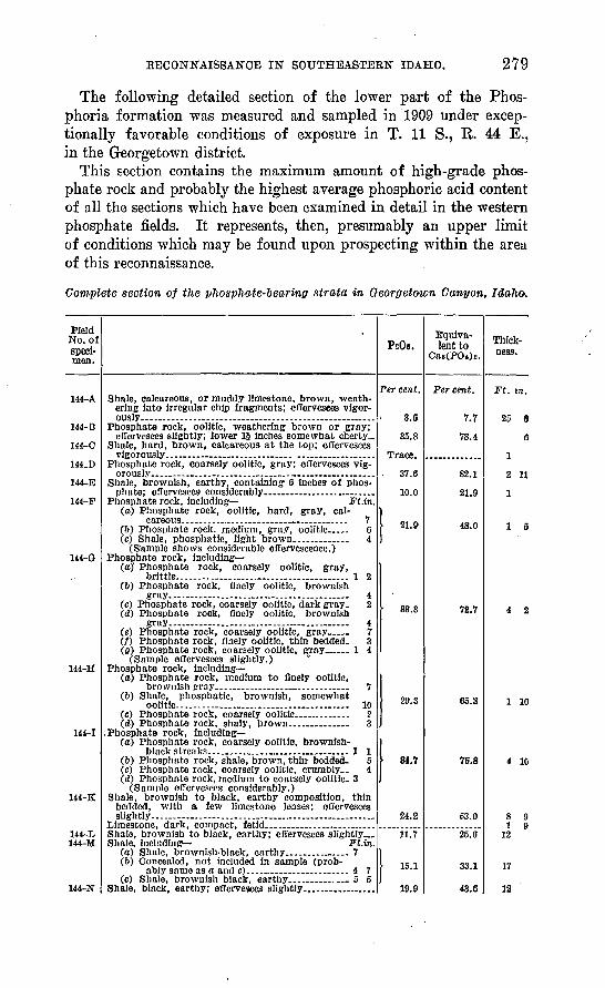