phd defense slides
TRANSCRIPT

Publishing and Consuming Geo-spatial and Government Data on
the Semantic Web Ghislain Auguste Atemezing
Multimedia Department, Eurecom
Supervisor: Dr. Raphaël Troncy, MM Department, Eurecom

§ Open Government Data benefits Ø Transparency in decision making Ø Better governance or e-governance Ø Eco-system of added value application
§ Barriers and challenges Ø Heterogeneity of data formats Ø Variety of access method Ø Lack of nomenclature
G.A. Atemezing - Publishing and Consuming Geo-Spatial & Government Data on the Semantic Web 2
Thesis Context
In this thesis we explore how Semantic Web technologies can be used for better integration and consumption of geo-spatial data.

§ Introduction
§ Research Questions
§ Contributions Ø Semantic publishing of geospatial data Ø Visualizations of Government Linked Data Ø Best Practices for metadata in vocabularies
§ Conclusion
§ Publications
G.A. Atemezing - Publishing and Consuming Geo-Spatial & Government Data on the Semantic Web 3
Outline

G.A. Atemezing - Publishing and Consuming Geo-Spatial & Government Data on the Semantic Web 4
Geospatial data: why it matters
“80% of needs for decisions from public authorities have a geospatial component”.
(Philippe Grelot, IGN-France)

G.A. Atemezing - Publishing and Consuming Geo-Spatial & Government Data on the Semantic Web 5
GeoData on the LOD Cloud
http://lod-cloud.net/versions/2014-08-30/
Linking Open Data cloud diagram 2014, by Max Schmachtenberg, Christian Bizer, Anja Jentzsch and Richard Cyganiak. http://lod-cloud.net/
In 2011 19,43% à31 geo-datasets in LOD http://lod-cloud.net/state/
G.A. Atemezing - Publishing and Consuming Geo-Spatial & Government Data on the Semantic Web 6
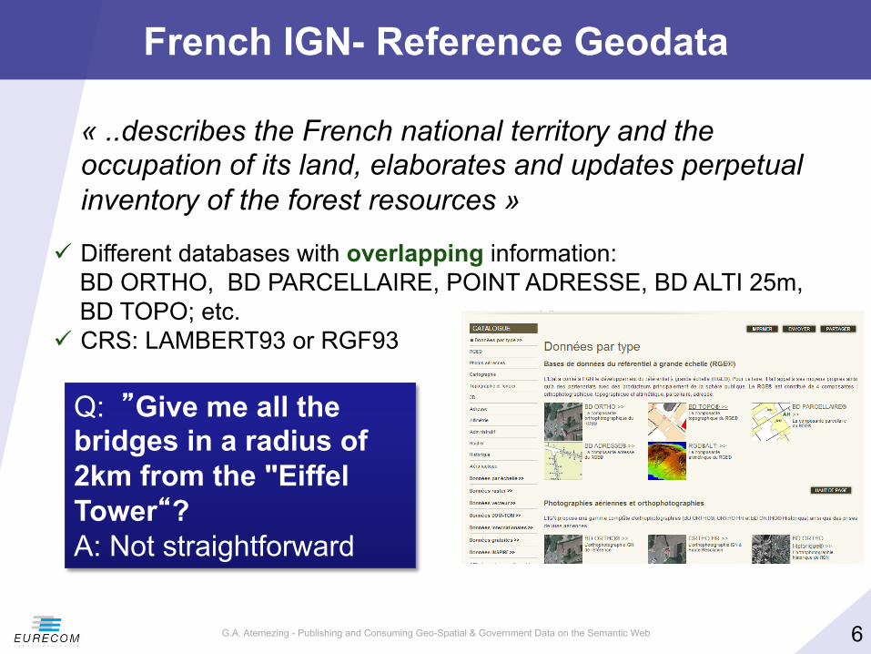
French IGN- Reference Geodata
« ..describes the French national territory and the occupation of its land, elaborates and updates perpetual inventory of the forest resources »
ü Different databases with overlapping information: BD ORTHO, BD PARCELLAIRE, POINT ADRESSE, BD ALTI 25m, BD TOPO; etc.
ü CRS: LAMBERT93 or RGF93
Q: ”Give me all the bridges in a radius of 2km from the "Eiffel Tower“? A: Not straightforward

§ How to efficiently represent and store geospatial data on the Web to ensure interoperable applications? Ø the publication of real datasets Ø the interlinking with other datasets having overlapping coverage
§ What are the best options for a user to discover, browse and interact with semantic content? Ø Can we propose a generic model for visualizing semantic
content?
§ What are the mechanisms to help preserving structured data of a high quality on the Web? Ø How to improve reusing vocabularies for better interoperability
Ø How to detect incompatibility between data and metadata
G.A. Atemezing - Publishing and Consuming Geo-Spatial & Government Data on the Semantic Web 7
Research Questions
2015/04/10

G.A. Atemezing - Publishing and Consuming Geo-Spatial & Government Data on the Semantic Web 8
Part 1
Semantic Publication of
Geo-spatial Data
2015/04/10
G.A. Atemezing - Publishing and Consuming Geo-Spatial & Government Data on the Semantic Web 9
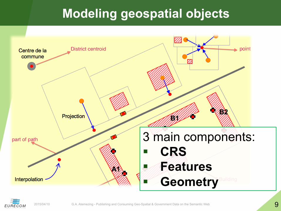
Modeling geospatial objects
2015/04/10
3 main components: § CRS § Features § Geometry

G.A. Atemezing - Publishing and Consuming Geo-Spatial & Government Data on the Semantic Web 10
Coordinate Reference Systems (CRS)
2015/04/10
§ A representation of the locations of geographic features within a common geographic framework
§ Each CRS is defined by its measurement framework Ø Geographic: spherical coordinates (unit: decimal degrees) Ø Planimetric: 2D planar surface (unit: meters) + a map projection Ø Additional measurement properties: ellipsoid, datum, standard
parallels, central meridians, etc.
§ Situation: Ø Several hundred Geographical Coordinate Systems
(WGS84, ETRS89, etc.) Ø Several thousands Projected Coordinate Systems
(UTM, Lambert93, etc.), http://resources.esri.com/help/9.3/arcgisserver/apis/rest/pcs.html

G.A. Atemezing - Publishing and Consuming Geo-Spatial & Government Data on the Semantic Web 11
CRS in France (Metropolitan + overseas)
2015/04/10
§ 10 CRSs coverage (mostly RGF93)
§ 10 projections (mostly used Lambert93)
§ 3 different ellipsoids to define the CRS
The Web only used WGS84
Publishers need converters for their geodata
G.A. Atemezing - Publishing and Consuming Geo-Spatial & Government Data on the Semantic Web 12
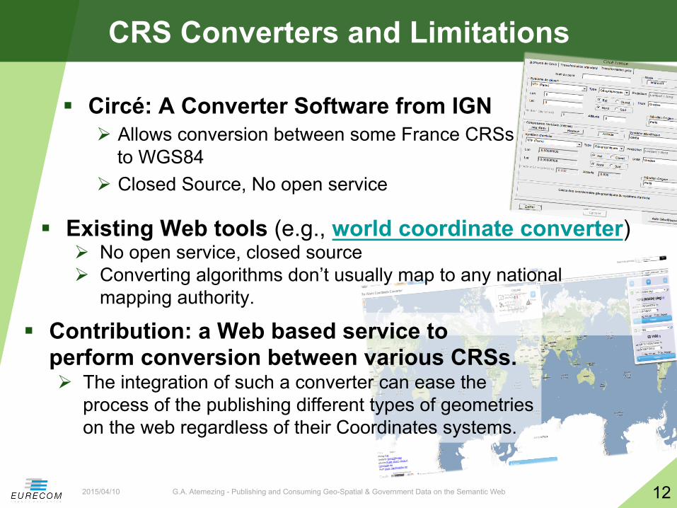
CRS Converters and Limitations
2015/04/10
§ Circé: A Converter Software from IGN Ø Allows conversion between some France CRSs
to WGS84 Ø Closed Source, No open service
§ Existing Web tools (e.g., world coordinate converter) Ø No open service, closed source Ø Converting algorithms don’t usually map to any national
mapping authority.
§ Contribution: a Web based service to perform conversion between various CRSs. Ø The integration of such a converter can ease the
process of the publishing different types of geometries on the web regardless of their Coordinates systems.

§ WGS 84 <–> Lambert 93
§ WGS 84 <–> UTM
G.A. Atemezing - Publishing and Consuming Geo-Spatial & Government Data on the Semantic Web 13
Developing a REST converter service
2015/04/10
• Many regional's’ published data involve with local CRS
International Communication
• Interpret the coordinates between these CRSs
A medium • Open services
for community • RESTFul Web
Service
A Converter Service
GOOD accuracy of the results

G.A. Atemezing - Publishing and Consuming Geo-Spatial & Government Data on the Semantic Web 14
Vocabularies for Modeling Features
2015/04/10
§ Authority list of terms (e.g. Foursquare) Ø No semantics at all!
§ SKOS Categories (e.g. GeoNames) Ø Classes are skos:conceptScheme, codes are skos:Concept
§ Domain specific ontologies (OrdS, GeoLD) Ø Interconnected subdomain ontologies (transport, hydrography, etc.)
§ Data driven ontologies (LGD, GeOnto) Ø Deeper taxonomy to structure the ontology Ø Many classes

G.A. Atemezing - Publishing and Consuming Geo-Spatial & Government Data on the Semantic Web 15
Modeling Geometry: State of the Art
2015/04/10
§ Point (lat/long) Ø WGS 84 vocabulary described by W3C
§ Rectangle (“bounding box”) Ø Geopolitical Vocabulary (FAO)
§ Points in a List Ø Sequence of points (LinkedGeoData) Ø An object is “formedBy” a ListOfPoints (GeoLinkedData.es)
§ Literals WKT datatype in RDF Ø Ordnance Survey (UK), GeoSPARQL embedding CRS in literals
§ More structured representation of complex geometry Ø NeoGeo Vocabulary (GeoVocamp), http://geovocab.org/

G.A. Atemezing - Publishing and Consuming Geo-Spatial & Government Data on the Semantic Web 16
Reusing Existing Ontologies (GeOnto)
2015/04/10
§ Ontology for geographic objects (POI) Ø Output of a French (ANR) research project Ø Obtained from NLP tools
§ Classes in French Ø rdfs:labels in FR & EN Ø No rdfs:comments Ø Few owl:ObjectProperty Ø 783 classes
§ Overlap with other vocabs Ø Need for alignment

G.A. Atemezing - Publishing and Consuming Geo-Spatial & Government Data on the Semantic Web 17
Aligning GeOnto with existing Ontologies
2015/04/10
§ Alignment of GeOnto with 5 ontologies and 2 simple taxonomies Ø LGD, DBpedia, Schema.org, GeoNames, bdtopo Ø Foursquare, Google Places
§ Goal: finding owl:equivalentClass Ø Tool : Silk framework Ø Metrics : LevenshteinDistance, Jaro Ø Labels : @en des classes Ø Aggregation Function: Mean
§ Manual validation Ø For « rdfs:subClassOf » Ø Specific alignments with GeoNames codes

G.A. Atemezing - Publishing and Consuming Geo-Spatial & Government Data on the Semantic Web 18
Alignment Process (GeoNames)– Results
2015/04/10
§ High precisions > 80%
§ BUT P(Schema.org) = 50%
Silk
• Look for skos codes that matches GeOnto classes
• Verify the links <70% • Generate « sameAs » links
SPARL Endpoint
• Use SPARQL «Construct» to generate a new graph.
Alignment File
• Export the RDF file
Vocab/taxonomies
#Classes #Classes aligned
Bdtopo 237 153 (64.65%) GeoNames 699 287 (41.06%) Google Place (*)
126 41 (32.54%)
Schema.org (*)
296 52 (17.57%)
LGD 1294 178 (13.76%) Foursquare 359 46 (12.81%) DBpedia 366 42 (11.48%)
GeOnto entities are more specific to France
G.A. Atemezing - Publishing and Consuming Geo-Spatial & Government Data on the Semantic Web 19
Proposal: CheckList for modeling geodata
2015/04/10
§ Complex Geometry Coverage Ø Need to publish more data with complex geometries Ø Reuse and extend suitable ontologies (NeoGeo, GeoSPARQL)
§ Features MUST be connected to Geometry Ø Sometimes it may requires two namespaces
§ Serialization in other GIS formats Ø Provide serialization in other GIS formats (GML, WKT, KML, etc.)
§ Structured Representation Ø Use of structured representation for complex geometry Ø This covers some of the Use Cases at IGN

G.A. Atemezing - Publishing and Consuming Geo-Spatial & Government Data on the Semantic Web 20
Proposal: Vocabulary for complex Geometry
2015/04/10
§ Extend and reuse existing vocabularies
§ Available at http://data.ignf.fr/def/geometrie
@prefix ngeo: <http://geovocab.org/geometry#>. @prefix sf: <http://www.opengis.net/ont/sf#>. […] geom:Geometry a owl:Class;
rdfs:comment "Primitive géométrique non instanciable, racine de l'ontologie des primitives géométriques. Une géométrie est associée à un système de coordonnées et un seul."@fr; rdfs:label "Géométrie"@fr, "Geometry"@en; owl:equivalentClass [ a owl:Restriction; owl:onClass ignf:CoordinatesSystem; owl:onProperty geom:crs; owl:qualifiedCardinality "1"^^xsd:nonNegativeInteger]; rdfs:subClassOf ngeo:Geometry; rdfs:subClassOf sf:Geometry.

G.A. Atemezing - Publishing and Consuming Geo-Spatial & Government Data on the Semantic Web 21
Associating CRS to Geometries
2015/04/10
§ A vocabulary for describing CRS Ø Subset of ISO 19111 model Ø Available at http://data.ignf.fr/def/ingf
§ A dataset for French CRS Ø Convert from XML data published by IGN France to RDF Ø Eg: “Lambert 2 étendu” http://data.ign.fr/id/ignf/crs/NTFLAMB2E

G.A. Atemezing - Publishing and Consuming Geo-Spatial & Government Data on the Semantic Web 22
Overview of the vocabularies and relationships
2015/04/10
G.A. Atemezing - Publishing and Consuming Geo-Spatial & Government Data on the Semantic Web 23
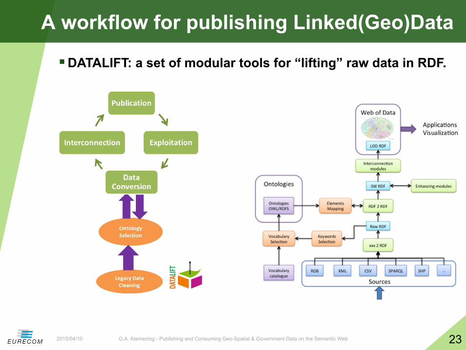
A workflow for publishing Linked(Geo)Data
2015/04/10
§ DATALIFT: a set of modular tools for “lifting” raw data in RDF.
G.A. Atemezing - Publishing and Consuming Geo-Spatial & Government Data on the Semantic Web 24
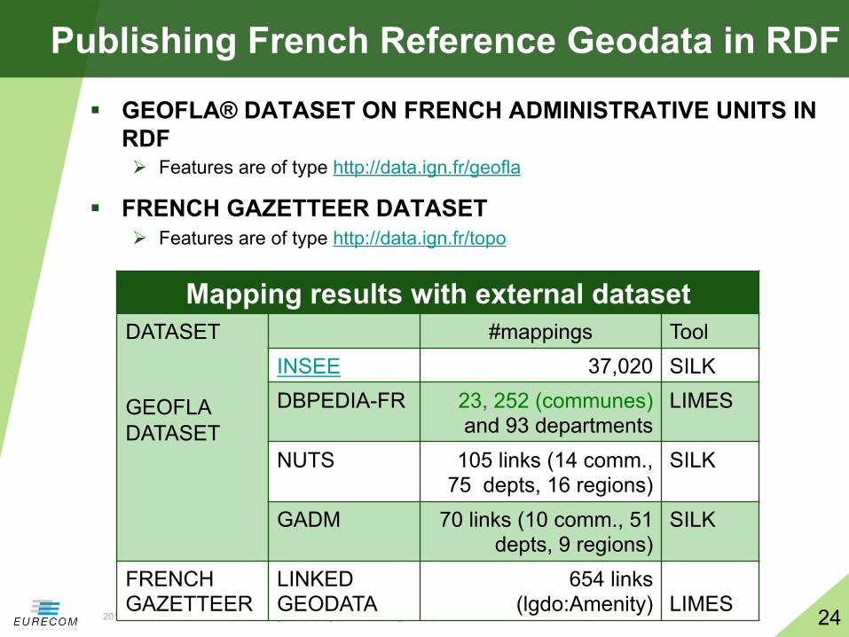
Publishing French Reference Geodata in RDF
2015/04/10
§ GEOFLA® DATASET ON FRENCH ADMINISTRATIVE UNITS IN RDF Ø Features are of type http://data.ign.fr/geofla
§ FRENCH GAZETTEER DATASET Ø Features are of type http://data.ign.fr/topo
Mapping results with external dataset DATASET GEOFLA DATASET
#mappings Tool INSEE 37,020 SILK DBPEDIA-FR 23, 252 (communes)
and 93 departments LIMES
NUTS 105 links (14 comm., 75 depts, 16 regions)
SILK
GADM 70 links (10 comm., 51 depts, 9 regions)
SILK
FRENCH GAZETTEER
LINKED GEODATA
654 links (lgdo:Amenity)
LIMES

G.A. Atemezing - Publishing and Consuming Geo-Spatial & Government Data on the Semantic Web 25
French Open Addresses in RDF Mappings
2015/04/10
BANO2RDF
LGData Amenities Paris (248052) Marseille (401404) Lyon (89061)
#matched %matched #matched %matched #matched %matched
Shop (778680) 21171 2.71 8556 1.098 3049 0.391 Restaurant (260675) 13567 5.204 2654 1.018 1882 0.721
PostOffice (87731) 971 1.106 555 0.632 173 0.197
School (318287) 883 0.277 411 0.129 197 0.061
Parking (250516) 735 0.293 625 0.24 210 0.083
PlaceOfWorship (357445) 272 0.076 193 0.053 31 0.008
PublicBuilding (26735) 97 0.362 64 0.239 21 0.078
Building (22283) 5 0.022 12 0.053 0 0

G.A. Atemezing - Publishing and Consuming Geo-Spatial & Government Data on the Semantic Web 26
Contribution to the LOD Cloud (FrLOD)
2015/04/10
§ 340 millions of triples in RDF (10% of DBPedia 2014) § Part of our work is under reused by the W3C/OGC
Spatial Data Working Group

G.A. Atemezing - Publishing and Consuming Geo-Spatial & Government Data on the Semantic Web 27
Why Visualizations Matters
2015/04/10
“Don’t ask what you can do for the Semantic Web; ask what
The Semantic Web can do for you!” (D. Karger, MIT CSAIL)
1. How to build bridge to fill the gap between traditional InfoVis tools and Semantic Web technologies
2. How can Semantic Web help in visualization?
“If you use our Linked Data, please let us know, or we might switch off!”
(Ordnance Survey)
G.A. Atemezing - Publishing and Consuming Geo-Spatial & Government Data on the Semantic Web 28
Part 2
Generating Visualizations For Linked Data
2015/04/10

G.A. Atemezing - Publishing and Consuming Geo-Spatial & Government Data on the Semantic Web 29
Visualization Categories in Government Portals
2015/04/10
§ Study of applications consuming Open Data Ø 13 applications from UK (7), USA (3) and France (3) Ø Domain: education, health, transport, government,
city, housing, criminality, foreign aid
§ Different dimensions Ø Platform (web, mobile), data sources, which views are
available (maps, charts, timeline, etc.) Ø URL policy for identifying data objects Ø Licenses for the application / for the data Ø Commercial / non-commercial

G.A. Atemezing - Publishing and Consuming Geo-Spatial & Government Data on the Semantic Web 30
Relevant Features in Visualization Tools
2015/04/10
§ Data format given as input (csv, xml, shp, rdf, etc.)
§ Data access (API, dump, etc.)
§ Language code
§ Type of view
§ External Libraries
§ License
§ Metadata: author, organization

G.A. Atemezing - Publishing and Consuming Geo-Spatial & Government Data on the Semantic Web 31
Describing an Application: Opendatacom
2015/04/10
Scope/Domain: Department for Communities and Local Government, datasets access Description: visualize available datasets (finance, housing, deprivation, geography) by authorities or postcode. On the dashboard, it provides graphs showing the national distribution of a district and how the values for this local authority compare with others in England. Supported Platform: Web URL Policy: http://{domain}/id/{...} with redirection to the corresponding document at: http://{domain}/doc/{...}. Hampshire County Council is: http://opendatacommunities.org/id/county-council/hampshire Data Sources: 36 datasets from DCLG, Administrative Geography and Postcodes from Ordnance Survey. Type of View: Graph, Map views. Visualization Tools: google visualization API, raphael.js License: Open Government license [OGL] Business Value: Non commercial

G.A. Atemezing - Publishing and Consuming Geo-Spatial & Government Data on the Semantic Web 32
DVIA: A vocabulary to describe Applications
2015/04/10
dvia: Application dct:title dvia:description dvia:keyword dvia:url dct:creator dvia:businessValue dvia:scope dvia:view
dctype:Software
dvia: Platform dct:title dvia:system dvia:preferredNavigator dvia:alternativeNavigator
dvia: VisualTool dct:title dct:description dvia:accessUrl dvia: downloadUrl
dcat: Dataset dct: title dcat: accessURL dct:references dcat: keyword
org:Organization
dvia:consumes
dvia:platform
Prefixes: @prefix dct: <http://purl.org/dc/terms/>. @prefix dcat: <http://www.w3.org/ns/dcat#>. @prefix dctype: <http://purl.org/dc/dcmitype/>. @prefix org: <http://www.w3.org/ns/org#>. @prefix dvia: <http://data.eurecom.fr/ontology/dvia#>.

G.A. Atemezing - Publishing and Consuming Geo-Spatial & Government Data on the Semantic Web 33
DVIA in Real World Datasets
2015/04/10
§ 4 applications re-using DVIA Ø Use to populate 22 past events of
hack-athons in Europe, with 889 applications from Apps4Europe.
a. The script will fetch the event or application information using
an AJAX-‐request.
b. After the server has responded with the event/application
information, the information is displayed on the page in human
readable form by modifying the DOM of the page. Furthermore, the
same information is presented also in computer readable format by
embedding RDFa in the DOM.
The embeddable script is non-optimal in the sense that the event or application information is loaded only after the actual page (where the script is embedded) has loaded. This causes some additional delay before the page is fully rendered, but the problem can be alleviated by showing loading indicators. CSS styling for the events and applications is provided using Bootstrap. All CSS rules have been made specific to the container div-element of the plugin, in order to prevent the CSS from conflicting with the CSS of the page. In the future, another solution called shadow DOM could be used to prevent conflicts between different components of the page, but at the moment the browser support is not satisfactory. Since the event and application information is directly 29
embedded on the page using DOM, the event organizer can add his own CSS styling to the plugin by overriding the provided CSS rules.
Fig 9. A screenshot of a test event displayed on an event organizer’s page. The content inside the red square is injected after page load by the embeddable script. Note! The red square is not
visible in the actual page, it was added only for visualization purposes.
29 Browser support for shadow DOM: http://caniuse.com/shadowdom [Referenced 2014-06-10]
Eurecom Semester Project - Alexis Troberg Page 18 of 27
Ø Implementation of a universal JavaScript plugin to embed RDFa in organizers events
Ø An extension for Wordpress uses DVIA.

G.A. Atemezing - Publishing and Consuming Geo-Spatial & Government Data on the Semantic Web 34
Developing Web Applications: from specific to generic approach
2015/04/10
§ Scenario 1 Ø Known Datasets, Known
vocabularies à Specific SPARQL queries
Ø Visualizations: dataset specific
§ Example Ø Datasets on schools in France Ø Vocabularies: geo vocab, data
cube, geometrie, Ø Application: PerfectSchool

G.A. Atemezing - Publishing and Consuming Geo-Spatial & Government Data on the Semantic Web 35
Developing Web Applications: from specific to generic approach
2015/04/10
§ Scenario 2 Ø Unknown Datasets, Known
domains, so domain-specific SPARQL queries
Ø Visualizations: domain specific
§ Example Ø Endpoints of geodatasets Ø Domain: geospatial Ø Application: GeoRDFviz

G.A. Atemezing - Publishing and Consuming Geo-Spatial & Government Data on the Semantic Web 36
Developing Web Applications: from specific to generic approach
2015/04/10
§ Scenario 3 Ø Unknown Datasets, Unknown
domains, so generic SPARQL queries
Ø Visualizations: adapted to domains specific
Ø Any endpoints Ø Multiple domains: geodata,
statistics, persons, cross-domains, etc..
Ø Application: ?????
Related work on configuring Semantic Web widgets by data mapping. [1] Application: Efficient search for Semantic News demonstrator in Cultural Heritage Dataset Tool: ClioPatria
[1] Hildebrand, Michiel, and Jacco Van Ossenbruggen. "Configuring semantic web interfaces by data mapping." Visual Interfaces to the Social and the Semantic Web (VISSW 2009) 443 (2009): 96.
…but “method not apply to create interfaces on top of arbitrary SPARLQ endpoints”

G.A. Atemezing - Publishing and Consuming Geo-Spatial & Government Data on the Semantic Web 37
Our Proposal
2015/04/10
Linked Data Vizualization Wizard
(LDVizWiz)

G.A. Atemezing - Publishing and Consuming Geo-Spatial & Government Data on the Semantic Web 38
Requirements of LDVizWiz (LDViz-”Wise”)
2015/04/10
§ Predefined categories associated to visual elements
§ Build on top of RDF standards Ø e.g., SPARQL queries ; Semantic Web technologies
§ Reuse existing Visualization libraries Ø e.g., Google Maps, Google Charts, D3.js, etc.
§ Reuse On-line Library of Information Visualization (OLIVE)
§ Target to non “RDF/SPARQL speakers”
§ Input: Datasets published as LOD
G.A. Atemezing - Publishing and Consuming Geo-Spatial & Government Data on the Semantic Web 39
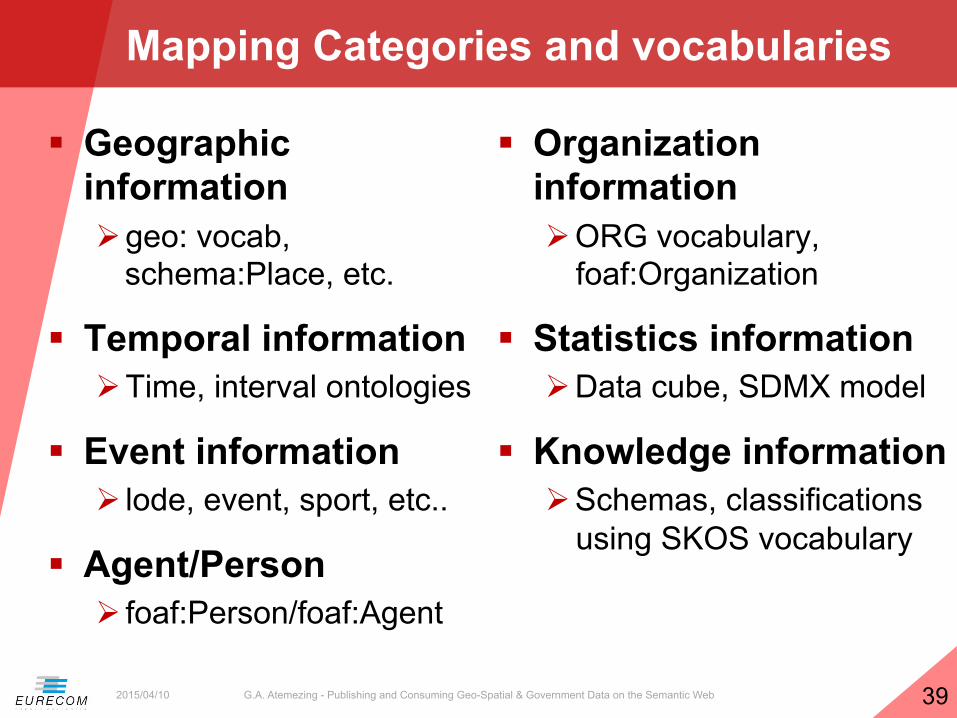
Mapping Categories and vocabularies
2015/04/10
§ Geographic information Ø geo: vocab,
schema:Place, etc.
§ Temporal information Ø Time, interval ontologies
§ Event information Ø lode, event, sport, etc..
§ Agent/Person Ø foaf:Person/foaf:Agent
§ Organization information Ø ORG vocabulary,
foaf:Organization
§ Statistics information Ø Data cube, SDMX model
§ Knowledge information Ø Schemas, classifications
using SKOS vocabulary

G.A. Atemezing - Publishing and Consuming Geo-Spatial & Government Data on the Semantic Web 40
LDVizWiz Workflow
2015/04/10

G.A. Atemezing - Publishing and Consuming Geo-Spatial & Government Data on the Semantic Web 41
Step 1: Categories Detection
2015/04/10
§ Detection of main categories in datasets Ø ASK SPARQL queries on predefined categories Ø Uses well-known vocabularies in LOV Ø Condition the type of visual elements
Det
ectio
n

G.A. Atemezing - Publishing and Consuming Geo-Spatial & Government Data on the Semantic Web 42
Experiment: Categories Detection
2015/04/10
Category Number % GEO DATA 97 21.84% EVENT DATA 16 3.60% TIME DATA 27 6.08% SKOS DATA 02 0.45% ORG DATA 48 10.81% PERSON DATA 59 13.28% STAT DATA 29 6.6%
§ Applications Ø Automatic detection of
endpoints categories Ø More “trustable” than human
tagging Ø Map categories detected with
“suitable” visual elements for the visualizations (e.g., TimeLine + maps for events data)
(*) All the endpoints retrieved from sparqles.org
Detection
Ø 444 endpoints (*) analyzed, 278 good answers (62.61%) using ASK queries.
Ø Few taxonomies in SKOS, many GEO DATA
§ Build candidate properties for visualization Ø For pop-up menus Ø For facet browsing Ø For charts display
G.A. Atemezing - Publishing and Consuming Geo-Spatial & Government Data on the Semantic Web 43
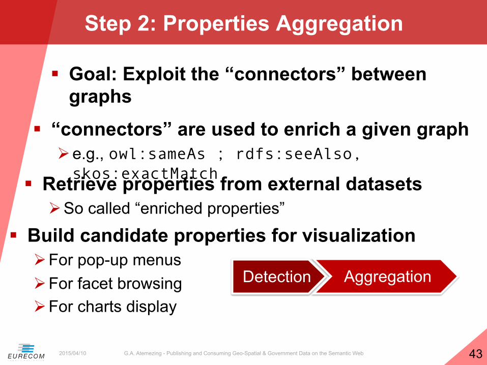
Step 2: Properties Aggregation
2015/04/10
§ Retrieve properties from external datasets Ø So called “enriched properties”
Detection Aggregation
§ Goal: Exploit the “connectors” between graphs § “connectors” are used to enrich a given graph
Ø e.g., owl:sameAs ; rdfs:seeAlso, skos:exactMatch

G.A. Atemezing - Publishing and Consuming Geo-Spatial & Government Data on the Semantic Web 44
Step 3: Publication
2015/04/10
§ Visualization Generator Ø Recommend the visual elements based on categories Ø Transform ASK queries to SELECT or CONSTRUCT
queries for input to visual library.
Detection Aggregation Publication
§ Visualization Publisher Ø Export the description of visualization in RDF Ø Add metadata for the visualization (charts) and steps
used to create it. Ø e.g., dcat:Dataset, prov:wasDerivedFrom, chart vocabulary, void:ExampleResource.

G.A. Atemezing - Publishing and Consuming Geo-Spatial & Government Data on the Semantic Web 45
Current Implementation
2015/04/10
§ Javascript light version as “proof-of-concept”
§ Url: http://semantics.eurecom.fr/datalift/rdfViz/apps/

G.A. Atemezing - Publishing and Consuming Geo-Spatial & Government Data on the Semantic Web 46
Part 3
Best Practices for metadata in vocabularies
2015/04/10

G.A. Atemezing - Publishing and Consuming Geo-Spatial & Government Data on the Semantic Web 47
W3C Govn’t LD Best Practices
2015/04/10
§ 10 best practices to help government worldwide to access and reuse their by taking benefit of Linked Data mechanism.
§ 4 steps to rich 5★ ratings datasets in TimBL scale.
Dataset selection
Dataset preparation
Dataset conversion
in RDF
Dataset publication and advertisement
Four steps corresponding to the best practicesto publish Linked Data by Governments.
(1) (2)
(3)(4)

G.A. Atemezing - Publishing and Consuming Geo-Spatial & Government Data on the Semantic Web 48
LOV in a Nutshell : http://lov.okfn.org/dataset/lov/
2015/04/10
§ A curated list of vocabularies Ø More than 495 vocabularies Ø Each of them described by vocabulary-
of-a-friend (voaf) Ø Provide a dump in N3 of the different
versions of a vocabulary Ø Quasi linearity of the growth, started with
75 vocabularies

G.A. Atemezing - Publishing and Consuming Geo-Spatial & Government Data on the Semantic Web 49
Focus on vocabularies: Disambiguating Vocabulary Prefixes
2015/04/10
Goal: align services against Linked Open Vocabularies to harmonize and manage vocabularies’ namespaces
§ Global namespaces Ø With good practices to
recommend a prefix Ø Have a more transparent list
of built-in prefixes Ø All the services understand
each other with prefixes Ø Some de facto prefixes
emerging: rdfs:, foaf:, rdf:, owl:, skos:,

G.A. Atemezing - Publishing and Consuming Geo-Spatial & Government Data on the Semantic Web 50
LOV vs PREFIX.CC-Alignment Findings
2015/04/10
14%
11%
19% 56%
Findings during alignment process
lov-‐able vocabs
Intersect-‐prefixes
vocabs in LOV
vocabs in prefix.cc
Category Number
lov-able vocabs 227 Intersect-prefixes 188
vocabs in LOV 321 vocabs in prefix.cc 925
More than 200 prefixes in prefix.cc are vocabularies

G.A. Atemezing - Publishing and Consuming Geo-Spatial & Government Data on the Semantic Web 51
Vocabulary Search and Ranking
2015/04/10
Goal Ranking vocabularies based on Information
Content Metrics
§ Metrics Ø Information Content Metric (IC): value of
information associated with a given entity Ø Partition Information Content Metric (PIC) Ø Proposed a ranking based on IC and PIC

G.A. Atemezing - Publishing and Consuming Geo-Spatial & Government Data on the Semantic Web 52
Ranking Algorithm
2015/04/10
Output ranking
Compute PIC score
Compute IC score
Grouping terms by namespace & weight assignment
Candidate terms selection in LOV

G.A. Atemezing - Publishing and Consuming Geo-Spatial & Government Data on the Semantic Web 53
Ranking Algorithm
2015/04/10
§ dcterms: http://purl.org/dc/terms/
§ Candidate terms: 53 (39 properties + 14 classes)
§ wf = 1+ 2+3 = 6
§ PIC = 1724.844
§ foaf: http://xmlns.com/foaf/0.1/
§ Candidate terms: 35 (26 properties + 9 classes)
§ wf = 1+ 2+ 3 = 6
§ PIC = 1033.197
PIC(dcterms) > PIC(foaf)

G.A. Atemezing - Publishing and Consuming Geo-Spatial & Government Data on the Semantic Web 54
Ranking Algorithm
2015/04/10
§ Top-15 terms (IC value) § Top-15 vocabs (PIC value)

G.A. Atemezing - Publishing and Consuming Geo-Spatial & Government Data on the Semantic Web 55
Applications of the Ranking Metrics
2015/04/10
§ Vocabulary life-cycle management Ø Help assessing the use of terms and vocabulary updates Ø Monitoring the use of owl:deprecated or
http://www.w3.org/2003/06/sw-vocab-status/ns#:term_status
§ Semantic Web applications Ø Vocabularies with higher PIC might be proposed to a user
as much as possible, e.g. for choosing properties to display in a facetted browsing interface
§ Interlinking datasets Ø Generate sameAs links between resources based on
vocabularies terms with lower IC value

G.A. Atemezing - Publishing and Consuming Geo-Spatial & Government Data on the Semantic Web 56
Licenses Compatibility
2015/04/10
§ Approach: Ø Licenses retrieval both for the
dataset and for the vocabularies used in the dataset.
Ø Deontic logic [1] to compute compatibility using RDF representation of licenses
9%#
3%#
47%#
1%#
3%#2%#
3%#
3%#
5%#
5%#
2%#
2%#
9%#
6%#
Crea/ve#Commons#A6ribu/on:NonCommercial:ShareAlike#3.0#Unported##Crea/ve#Commons#A6ribu/on:ShareAlike#3.0#Unported##Crea/ve#Commons#A6ribu/on#3.0#Unported##
Crea/ve#Commons#Public#Domain#Mark#1.0#
Licence#Ouverte#/#Open#Licence#
Crea/ve#Commons#A6ribu/on:ShareAlike#3.0#United#States#Crea/ve#Commons#Zero#Public#Domain#Dedica/on#Apache#License#Version#2.0#
ODC#Public#Domain#Dedica/on#and#Licence#(PDDL)#ISA#Open#Metadata#License#1.1#
W3C#SoSware#No/ce#and#License#
Crea/ve#Commons#A6ribu/on:ShareAlike#3.0#United#States#Crea/ve#Commons#A6ribu/on:NoDerivs#3.0#Unported##Crea/ve#Commons#A6ribu/on:NonCommercial:ShareAlike#2.0#Generic#
Goal Reasoning on Licenses for checking compatibilities
between vocabularies and datasets
[1] Governatori, Guido, et al. "One License to Compose Them All." The Semantic Web–ISWC 2013. Springer Berlin Heidelberg, 2013. 151-166.

G.A. Atemezing - Publishing and Consuming Geo-Spatial & Government Data on the Semantic Web 57
Our Proposal: LIVE Framework
2015/04/10
LOV
Licenses retrieval module
Licenses compatibility
module
Check consistency of licensing information
for dataset D
dataset D
retrieve vocabularies used in the dataset
retrieve licenses for selected vocabularies
vocabularies and data licenses
LIVE framework
Warning: licenses are not compatible
http://www.eurecom.fr/~atemezin/licenseChecker/

G.A. Atemezing - Publishing and Consuming Geo-Spatial & Government Data on the Semantic Web 58
The Logic
2015/04/10
§ RDF licenses: http://purl.org/NET/rdflicense
§ Logic of deontic rules: Ø constructive account of basic deontic modalities (obligation,
prohibition, permission) Ø compute the set of all conclusions for each license and then
check whether incompatible conclusions are obtained.

G.A. Atemezing - Publishing and Consuming Geo-Spatial & Government Data on the Semantic Web 59
Live Evaluation
2015/04/10
LIVE provides the compatibility in less than 5 seconds for 7 datasets
LIVE retrieves 48 vocabularies in less than 14 seconds

G.A. Atemezing - Publishing and Consuming Geo-Spatial & Government Data on the Semantic Web 60
Conclusions
2015/04/10
§ We have contributed in managing vocabulary metadata Ø Disambiguating prefixes between vocabularies Ø Improving vocabulary search and ranking Ø Providing a license compatibility framework Ø Contributing to Best Practices standard
§ We have presented models for Geodata Ø For better handling complex geometries Ø Supporting *all* CRS Ø For easy querying in SPARQL
§ We have proposed a generic visualization wizard Ø Based on predefined categories Ø Targeted to lay-users
G.A. Atemezing - Publishing and Consuming Geo-Spatial & Government Data on the Semantic Web 61
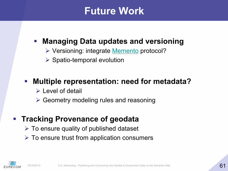
Future Work
2015/04/10
§ Managing Data updates and versioning Ø Versioning: integrate Memento protocol? Ø Spatio-temporal evolution
§ Multiple representation: need for metadata? Ø Level of detail Ø Geometry modeling rules and reasoning
§ Tracking Provenance of geodata Ø To ensure quality of published dataset Ø To ensure trust from application consumers

G.A. Atemezing - Publishing and Consuming Geo-Spatial & Government Data on the Semantic Web 62
Future Work
2015/04/10
§ Visualizations Ø Extend categories and vocabularies for detection Ø Provide templates for generating “mash-ups” to combine
domains, an mash-up widget generator Ø Investigate the “importance” of a category in dataset Ø Provide a user evaluation
§ Metadata management Ø Publish a list of common recommended prefixes Ø Foster and support current effort towards a more sustainable
governance of vocabularies. Ø Compare (P)IC with other graph-based ranking (e.g. pagerank) Ø Investigate the dependency ranking between vocabularies
G.A. Atemezing - Publishing and Consuming Geo-Spatial & Government Data on the Semantic Web 63
Publications
2015/04/10
§ Pierre-Yves Vandenbussche, G.A. Atemezing, Maria Poveda, Bernard Vatant: Linked Open Vocabularies (LOV): a gateway to reusable semantic vocabularies on the Web. Semantic Web Journal, under review, 2015.
§ G.A. Atemezing, Raphael Troncy: Modeling visualization tools and applications on the Web. Semantic Web Journal, under review, 2015.
§ G.A. Atemezing et al.: Transforming meteorological data into linked data. In Semantic Web journal, Special Issue on Linked Dataset descriptions, 2012. IOS Press.
§ Guido Governatori, Ho-Pun Lam, Antonino Rotolo, Serena Villata, G.A. Atemezing and Fabien Gandon: LIVE: a Tool for Checking Licenses Compatibility between Vocabularies and Data.(ISWC 2014, Demo Track)
§ G.A. Atemezing and Raphael Troncy: Information content based ranking metric for linked open vocabularies. (SEMANTICS 2014)
§ Ahmad Assaf, G.A. Atemezing, Raphael Troncy and Elena Cabrio: What are the important properties of an entity? Comparing users and knowledge graph point of view. In 11th Extended Semantic Web Conference (Demo Track, ESWC 2014)
G.A. Atemezing - Publishing and Consuming Geo-Spatial & Government Data on the Semantic Web 64
Publications
2015/04/10
§ Francois Scharffe, G.A Atemezing, Raphael Troncy, Fabien Gandon, Serena Villata, Bénédicte Bucher, Faycal Hamdi, Laurent Bihanic, Gabriel Kepeklian, Franck Cotton, Jerome Euzenat, Zhengjie Fan, Pierre-Yves Vandenbussche and Bernard Vatant: Enabling linked-data publication with the datalift platform. (AAAI, W10:Semantic Cities, 2012)
§ G.A. Atemezing and Raphael Troncy: Vers une meilleure interopérabilité des donneés geographiques francaises sur le Web de donneés. (IC 2012).
§ Houda Khrouf, G.A. Atemezing, Thomas Steiner, Giuseppe Rizzo and Raphael Troncy: Confomaton: A conference enhancer with social media from the cloud. (ESWC 2012, Demo Track)
§ Bernadette Hyland, G.A. Atemezing and Boris Villazón-Terrazas (editors): Best Practices for Publishing Linked Data. W3C Working Group Note pub- lished on January 9, 2014. URL: http://www.w3.org/TR/ld-bp/
§ Bernadette Hyland, G.A Atemezing, Michael Pendleton, Biplav Srivastava (editors): Linked Data Glossary. W3C Working Group Note published on June 27, 2013. URL: www.w3.org/TR/ld-glossary/
