phase i watershed assessment final report and tmdl i watershed assessment final report and tmdl ......
TRANSCRIPT

Phase I Watershed Assessment Final Report and TMDL
Sylvan Lake Watershed Custer County, South Dakota
South Dakota Water Resource Assistance Program Division of Financial and Technical Assistance
South Dakota Department of Environment and Natural Resources Steven M. Pirner, Secretary
November 2005

SECTION 319 NONPOINT SOURCE POLLUTION CONTROL PROGRAM ASSESSMENT/PLANNING PROJECT FINAL REPORT
Sylvan Lake Custer County, SD
By
Aaron M. Larson, Environmental Program Scientist
South Dakota Department of Environment and Natural Resources Water Resources Assistance Program
Sponsor
Black Hills Resource Conservation and Development Association, Inc.
November 2005
This project was conducted in cooperation with the State of South Dakota and the United States Environmental Protection Agency, Region 8.

i
Executive Summary
Sylvan Lake was included in the 1998 South Dakota 303(d) list as an impairment-related TMDL waterbody (SD DENR 1998). Information supporting this listing was derived from statewide lake assessment data (Stueven and Stewart 1996) and the 1996 305(b) report (SD DENR 1996). According to the 1996 305(b) report, causes for impaired beneficial uses include nutrients, siltation, and noxious aquatic plants. More recently, Sylvan Lake was also identified in the 2002 and 2004 South Dakota Waterbody Lists as impaired due to its eutrophic state, and is listed as high priority waterbody in terms of Total Maximum Daily Load (TMDL) development (SD DENR 2002, 2004). Because Sylvan Lake has been identified as an impaired waterbody, a watershed assessment project was initiated. The primary objectives of this assessment project were to (1) evaluate current physical, chemical, and biological integrity of Sylvan Lake and its watershed (2) determine non-point source critical areas within the watershed, (3) define management practices to improve the water quality, and (4) develop a TMDL for Sylvan Lake. Physical, chemical, and biological data for this project was collected over a 2-year period. Scott Environmental, a local consultant, conducted monthly and event-based water quality sampling at two inlet sites, one outlet site, and two lake sites from August 2001 to August 2002. Continuous discharge data was also collected from the inlet and outlet sites during this time period. South Dakota Department of Environment and Natural Resources (SD DENR) performed monthly water quality sampling, temperature and dissolved oxygen profiles at the same two lake sites from January to August 2003. Some additional historic water quality data was also available for Sylvan Lake. Almost 90% of samples collected in Sylvan Lake were considered phosphorus-limited. Due to phosphorus assimilation by algae, samples collected during late summer revealed the highest cases of phosphorus limitation. For this reason, phosphorus loads to Sylvan Lake will be targeted for reduction to allow the lake to support its designated beneficial uses and decrease the likelihood of algae blooms. Carlson’s (1977) Trophic State Index (TSI) was used to determine the approximate trophic state of Sylvan Lake and to determine the lake’s beneficial use support status. During the project period, approximately 84% of phosphorus TSI values indicate eutrophic conditions, and 13% were in the mesotrophic range. One phosphorus sample collected in October 2001 was considered hyper-eutrophic. Individual parameter and mean TSI values span all beneficial use support categories throughout the project period. Nearly half of all TSI values fell within the partially supporting category. However, no phosphorus TSI values were considered fully supporting during the project period. Only 9% of mean TSI values were considered fully supporting beneficial uses. Approximately 12.4 kg of total phosphorus are delivered to Sylvan Lake from its watershed annually. Modeling results indicate an accumulation of 5.1 kg of total phosphorus per year. The models also predicted that greater than 90% reduction of total phosphorus load from the watershed is required to meet the TMDL goal (phosphorus TSI = 45).

ii
These results indicate that internal phosphorus loading from lake sediment is a significant source of phosphorus in Sylvan Lake. According to model results and a lake total phosphorus mass balance, lake sediments contribute a significant amount of the total phosphorus load to Sylvan Lake. Approximately 7.3 kg/yr of total phosphorus (37% of the overall phosphorus load) originates from recycling of phosphorus in the lake’s sediment. This load will also be targeted for reductions to meet the TMDL goal. As the oxygen content of the water near the sediment interface declines, phosphorus and other nutrients can be released into the water. Concentrations of total phosphorus in lake sediment samples ranged from 610 to 5,100 mg/kg. Higher sediment phosphorus concentrations were observed in the deeper embayment. Dissolved oxygen and temperature profiles taken in the deeper embayment displayed seasonal stratification and oxygen depletion in the lower depths of the lake. During summer stratification, dissolved oxygen concentrations begin to decrease drastically at depths of approximately 3-4 m until concentrations reach anoxia at approximately 5-6 m of water depth. Anoxic conditions in the hypolimnion of the deeper embayment were observed as early as April and persist throughout the summer months until fall turnover. Based on sediment survey data collected during this study, Sylvan Lake has accumulated approximately 49,400 cubic yards of sediment. The majority of the accumulated sediment is shown to have been deposited in the deeper embayment. Approximately 15,000 cubic yards of sediment was removed from the shallower embayment in 1982. To slow sedimentation rates and reduce nutrient loads, the construction of artificial wetlands is recommended at each of the inlet streams. Current total phosphorus loads are 3.8 and 7.1 kg/yr for SLT-3 and SLT-4, respectively. The proposed wetland areas should reduce this total phosphorus load from 10.9 to 1.1 kg/year, approximately a 90% reduction (Fischer et al. 2004). Five lake treatment options were considered to reduce internal phosphorus loading. Of these options, two were deemed most likely to succeed: hydraulic dredging and aluminum sulfate application. Of the two, alum treatment is recommended as the primary lake treatment and will allow the lake to reach the TMDL numeric target (i.e. phosphorus TSI = 45; 0.02 mg/L of total phosphorus). It should be noted that water quality data presented in this report may not be representative of a typical year, as the study period was during a time of drought. Nonetheless, lake and watershed management recommendations presented in this report will improve water quality. To evaluate the level of improvement, water quality monitoring is recommended following the implementation of management activities.

iii
Acknowledgements The cooperation of the following organizations is gratefully appreciated. The assessment of Sylvan Lake and its watershed could not have been completed without their assistance. South Dakota Department of Environment and Natural Resources – Water Resources Assistance Program South Dakota Department of Game, Fish, and Parks – Regional Office in Rapid City, SD South Dakota Department of Game, Fish, and Parks – Custer State Park United States Environmental Protection Agency – Non-Point Source Program

iv
Table of Contents
Executive Summary ......................................................................................................................... i
Acknowledgements........................................................................................................................ iii
Table of Contents........................................................................................................................... iv
List of Figures ................................................................................................................................ vi
List of Figures ................................................................................................................................ vi
List of Tables ............................................................................................................................... viii
Introduction..................................................................................................................................... 1
Lake and Watershed Description................................................................................................. 1 Watershed Geology ..................................................................................................................... 3 Beneficial Use Assignment and Water Quality Standards .......................................................... 4
Threatened and Endangered Species .............................................................................................. 6
Project Goals, Objectives, and Activities ....................................................................................... 7
Project Goals................................................................................................................................ 7 Project Objectives........................................................................................................................ 7
Results........................................................................................................................................... 11
Stream Physical and Chemical Parameters ............................................................................... 11 Annual Loading .................................................................................................................. 11 Water Temperature ............................................................................................................. 15 Dissolved Oxygen............................................................................................................... 16 Acidification and Alkalinity ............................................................................................... 18 Solids................................................................................................................................... 20 Nitrogen .............................................................................................................................. 23 Phosphorous........................................................................................................................ 26
Stream Biological Parameters ................................................................................................... 29
Benthic Macroinvertebrate Survey ..................................................................................... 29 Fecal Coliform Bacteria...................................................................................................... 33
Lake Physical and Chemical Parameters................................................................................... 34
Water Temperature ............................................................................................................. 34 Dissolved Oxygen............................................................................................................... 35 Acidification and Alkalinity ............................................................................................... 38 Solids................................................................................................................................... 40

v
Nitrogen .............................................................................................................................. 42 Phosphorus.......................................................................................................................... 45 Limiting Nutrients............................................................................................................... 47 Trophic State....................................................................................................................... 48 Reduction Response Model ................................................................................................ 54
Lake Biological Parameters....................................................................................................... 56
Fishery................................................................................................................................. 56 Fecal Coliform Bacteria...................................................................................................... 57
Quality Assurance/Quality Control ........................................................................................... 57
Other Monitoring....................................................................................................................... 58
Sediment Survey ................................................................................................................. 58 Sediment Phosphorus Concentration .................................................................................. 59 Sylvan Lake Restoration Project......................................................................................... 59 Lake Circulation.................................................................................................................. 60
Conclusions and Recommendations ............................................................................................. 62
Watershed and Lake Management ............................................................................................ 62 Aluminum Sulfate (Alum) Treatment ....................................................................................... 62 Lake Aeration and Circulation .................................................................................................. 63 Dredging .................................................................................................................................... 63 Artificial Wetlands .................................................................................................................... 64 Bioremediation .......................................................................................................................... 64
References Cited ........................................................................................................................... 66
Appendix A: Total Maximum Daily Load (TMDL) Summary ....................................................... 69
Appendix B: Sylvan Lake Fishery Survey Report .......................................................................... 77
Appendix C: Assessment Data....................................................................................................... 83
Appendix D: Benthic Macroinvertebrate Data ............................................................................. 100
Appendix E: Quality Assurance/Quality Control (QA/QC) Data .................................................. 116
Appendix F: Water Temperature and Dissolved Oxygen Profiles ............................................. 119
Appendix G: Public Comments and TMDL Approval Letter………………...……...………...124

vi
List of Figures
Figure 1. Location of the Sylvan Lake watershed and Sylvan Lake, Custer County, SD. ............. 1 Figure 2. Average monthly precipitation for Custer County, SD (water years 1931-1998)........... 2 Figure 3. Geology of Sylvan Lake watershed................................................................................. 3 Figure 4. Location of inlake sampling sites for Sylvan Lake, Custer County, SD......................... 8 Figure 5. Location of stream sampling sites for the Sylvan Lake watershed assessment .............. 9 Figure 6. Delineation of subwatershed areas for the Sylvan Lake watershed assessment. .......... 11 Figure 7. Box plot of temperature by site for Sylvan Lake stream sites....................................... 16 Figure 8. Box plot of dissolved oxygen by site for Sylvan Lake streams sites. ........................... 17 Figure 9. Box plot of field pH by site for Sylvan Lake stream sites............................................. 19 Figure 10. Box plot of alkalinity by site for Sylvan Lake stream sites......................................... 20 Figure 11. Box plot of total solids by site for Sylvan Lake stream sites. ..................................... 21 Figure 12. Box plot of total suspended solids (TSS) by site for Sylvan Lake stream sites. ......... 22 Figure 13. Box plot of total nitrogen by site for Sylvan Lake stream sites. ................................. 24 Figure 14. Box plot of organic and inorganic nitrogen by site for Sylvan Lake stream sites....... 25 Figure 15. Box plot of total phosphorus by site for Sylvan Lake stream sites. ............................ 27 Figure 16. Box plot of total dissolved phosphorus by site for Sylvan Lake stream sites. ............ 28 Figure 17. Ratio of Ephemeroptera, Plecoptera, and Trichoptera (EPT) to Chironomidae
abundances for stream sites SLT-3 and SLT-4. ..................................................................... 30 Figure 18. Plecoptera abundances for stream sites SLT-3 and SLT-4. ........................................ 31 Figure 19. Percent sediment tolerant organisms for stream sites SLT-3 and SLT-4.................... 32 Figure 20. Hilsenhoff Biotic Index (HBI) abundances for stream sites SLT-3 and SLT-4.......... 33 Figure 21. Water temperature by month for Sylvan Lake ............................................................ 35 Figure 22. Dissolved oxygen by month for Sylvan Lake ............................................................. 36 Figure 23. Temperature and dissolved oxygen profile on August 30, 2004................................. 37 Figure 24. pH by month for Sylvan Lake categorized by site and sample depth. ........................ 38 Figure 25. Alkalinity concentrations by month for Sylvan Lake.................................................. 39 Figure 26. Total solids concentrations by month for Sylvan Lake ............................................... 40 Figure 27. Total dissolved solids concentrations by month for Sylvan Lake............................... 41 Figure 28. Total suspended solids concentrations by month for Sylvan Lake ............................. 42 Figure 29. Ammonia concentrations by month for Sylvan Lake categorized by site and sample
depth. ...................................................................................................................................... 43 Figure 30. Nitrate plus nitrite concentrations by month for Sylvan Lake .................................... 44 Figure 31. Total nitrogen concentrations by month for Sylvan Lake ........................................... 45 Figure 32. Total phosphorus concentrations by month for Sylvan Lake...................................... 46 Figure 33. Total dissolved phosphorus concentrations by month for Sylvan Lake...................... 47 Figure 34. Nitrogen:phosphorus ratios by month for Sylvan Lake .............................................. 48 Figure 35. Sylvan Lake phosphorus, chlorophyll, Secchi depth, and mean TSI values by month
showing seasonal variation..................................................................................................... 51 Figure 36. Phosphorus, chlorophyll, Secchi depth, and mean TSI values for Sylvan Lake. ........ 52 Figure 37. Historic Trophic State Index Values for Sylvan Lake (1979-2004)............................ 54 Figure 38. Model-predicted phosphorus, chlorophyll, and Secchi depth TSI values with
successive 10-percent reductions in external nutrient loading............................................... 55 Figure 39. Estimated sediment depth and water depth contours for Sylvan Lake based on
sediment survey data collected on December 24, 2003. ........................................................ 58

vii
Figure 40. Sediment total phosphorus concentrations by water depth. ........................................ 59 Figure 41. Timeline of service history and operational changes for the SolarBee circulator in
Sylvan Lake............................................................................................................................ 61
viii
List of Tables
Table 1. State surface water quality standards for Sylvan Lake, Custer State Park, SD. ............... 5 Table 2. Surface water quality criteria and designated beneficial uses for streams in the Sylvan
Lake watershed study area, Custer State Park, SD. ................................................................. 6 Table 3. Parameters measured at lake sites..................................................................................... 8 Table 4. Parameters measured at stream sites............................................................................... 10 Table 5. Subwatershed Hydrologic Contributions........................................................................ 13 Table 6. Parameter annual loads (kg) ........................................................................................... 14 Table 7. Export coefficients (kg/acre/year) for subwatersheds and total watershed area............. 15 Table 8. Descriptive statistics of water temperature (degrees Celsius) for stream sites............... 16 Table 9. Descriptive statistics of dissolved oxygen (mg/L) for stream sites. ............................... 17 Table 10. Descriptive statistics of field pH (standard units) for stream sites. .............................. 18 Table 11. Descriptive statistics of alkalinity (mg/L) for stream sites. .......................................... 20 Table 12. Descriptive statistics of total solids (mg/L) for stream sites......................................... 21 Table 13. Descriptive statistics of total suspended solids (mg/L) for stream sites. ...................... 22 Table 14. Descriptive statistics of total nitrogen (mg/L) for stream sites..................................... 23 Table 15. Descriptive statistics of organic nitrogen (mg/L) for stream sites................................ 24 Table 16. Descriptive statistics of inorganic nitrogen (mg/L) for stream sites............................. 25 Table 17. Descriptive statistics of ammonia (mg/L) for stream sites. .......................................... 26 Table 18. Descriptive statistics of nitrate/nitrite (mg/L) for stream sites. .................................... 26 Table 19. Descriptive statistics of total phosphorus (mg/L) for stream sites................................ 27 Table 20. Descriptive statistics of total dissolved phosphorus (mg/L) for stream sites. .............. 28 Table 21. Descriptive statistics of fecal coliform bacteria (CFU/100 ml) for stream sites. ......... 34 Table 22. Carlson’s trophic levels and index ranges for each level.............................................. 49 Table 23. Descriptive statistics for trophic state index (TSI) values calculated from direct
measurements and samples collected from Sylvan Lake in 2001-2003................................. 50 Table 24. Beneficial use categories for the Middle Rockies Ecoregion with TSI criteria............ 52 Table 25. Historic TSI values for Sylvan Lake. Values represent averages for each year. ......... 53 Table 26. BATHTUB model-predicted concentrations of total phosphorus, total nitrogen, and
TSI values for Sylvan Lake with successive 10-percent reductions in nitrogen and phosphorus inputs................................................................................................................... 55

Sylvan Lake Total Maximum Daily Load November 05
1
Introduction The purpose of the Custer State Park Lakes Assessment was to determine sources of impairment for three waterbodies, Sylvan Lake, Center Lake, and Legion Lake. This report discusses the current condition, possible restoration alternatives, and a Total Maximum Daily Load (TMDL) summary for one of the three lakes, Sylvan Lake, and its watershed. Lake and Watershed Description The Sylvan Lake watershed is located in north central Custer County, South Dakota. The watershed consists of nearly 565 acres of Harney Peak Granite outcrop with dense pine forest; predominately Ponderosa Pine with some Black Hills Spruce and Aspen (Figure 1).
Figure 1. Location of the Sylvan Lake watershed and Sylvan Lake, Custer County, SD.

Sylvan Lake Total Maximum Daily Load November 05
2
The Sylvan Lake watershed falls within the Middle Rockies Level III Ecoregion. A majority of the watershed area is in the Black Hills Plateau Level IV Ecoregion, with only a small portion in the Black Hills Core Highlands Level IV Ecoregion. The Black Hills Plateau is characterized by plateau topography with broad ridges and entrenched canyons. The Black Hills Core Highlands have mountainous topography with highly eroded outcrops and broad valleys. The lake is recharged by natural precipitation, which is quite variable in the study area. Average annual precipitation for the Black Hills of South Dakota is approximately 19 inches (Driscoll et al. 2000). Typically, most precipitation falls from early spring to late summer (Figure 2).
1.06
0.51 0.44 0.41 0.510.97
1.87
3.12 3.25
2.51
1.84
1.26
0
0.5
1
1.5
2
2.5
3
3.5
4
Oct Nov Dec Jan Feb Mar Apr May Jun Jul Aug Sep
Month
Aver
age
Prec
ipita
tion
(inch
es)
Figure 2. Average monthly precipitation for Custer County, SD (water years 1931-1998). (source: Driscoll et al., 2000)
The lake volume is depleted by evaporation and seepage. Excess runoff spills over the concrete dam during periods of high inflow, however, only seepage through the concrete dam structure and igneous rock was discharged during this study period. Sylvan Lake, the oldest lake in the Black Hills, was originally built by a private landowner in 1893. A natural dam site exists between massive granite outcroppings, which is where the original dam was constructed (predominantly timber construction). This dam was replaced with the existing concrete gravity arch dam, which was constructed by the Civilian Conservation Corps in the mid-1930’s. After Custer State Park was formed in the 1920’s, Sylvan Lake came under public ownership and is presently managed by the South Dakota Department of Game, Fish, and Parks (SDGFP). The lake has been an extremely popular recreational area in which to enjoy a variety of outdoor activities including swimming, boating, hiking, fishing, and rock climbing. Annual revenue is approximately $1.25 million (Goebel 2003).

Sylvan Lake Total Maximum Daily Load November 05
3
The lake has a surface area of approximately 18 acres and volume of approximately 214 acre feet. The lake has two embayments. The shallow fore bay has a mean depth of 9 ft, and the deeper bay has a mean depth of 12 ft. The two are joined by a moderately sized channel formed by granite outcropping. The source of nonpoint source pollution loading from the Sylvan Lake watershed is likely a combination of recreational uses, forest management, as well as background sources (i.e. wildlife, natural weathering, etc.). However, degraded water quality in Sylvan Lake is primarily attributed to recreational activity within the watershed. According to Wierenga and Payne (1987), 5% of the total watershed area has been converted to commercial or developed recreational use. Approximately 90% of the watershed land area is managed by the SD Department of Game, Fish and Parks (Custer State Park), while the remaining 10% is managed by the US Forest Service. Although much of the watershed remains in its natural state, the intense usage of recreational facilities within Custer State Park (e.g. fishing, camping, hiking, swimming, boating, rock climbing, automobile touring, etc.) has degraded the watershed condition. Watershed Geology Sylvan Lake lies within a basin of granite and is bounded to the south by metamorphic rock (Figure 3). Deposition of alluvial material has taken place in three drainage areas within the watershed. Gaging stations were set up on two of those drainages (sites SLT-3 and SLT-4); the additional alluvial channel was located in an ungaged portion of the watershed.
Figure 3. Geology of Sylvan Lake watershed. The watershed was formed within a basin of Harney Peak Granite and bounded to the south by metamorphic rock. Alluvium has formed within the three drainage areas of the basin.

Sylvan Lake Total Maximum Daily Load November 05
4
The host rock, Harney Peak Granite, has many pegmatitic and coarse-grained mineral deposits which consist largely of quartz and feldspar (USGS 1986). The larger deposits have central cores of quartzite surrounded by concentric layers of accessory minerals (tourmaline, garnet, apatite, etc.) that contain calcium, iron, lithium, manganese, and phosphorus. The principle phosphate deposits include apatite, amblygonite (USGS 1986), triphylite (Fahrenbach 2003), and other rare phosphate minerals (Page et al. 1953, Roberts and Rapp 1965). The crystalline nature of the host rock made it unlikely that any type of groundwater storage or springflow from outside the watershed would occur. Analysis of classical flow-net studies (ASCE 1985), and rock fractures at the study site indicated that leakage from under the toe of the dam was unlikely. Flow from the dam typically occurred through a fracture in the dam face, and flow over the spillway occurs when the water level was sufficiently high. Beneficial Use Assignment and Water Quality Standards Each waterbody within South Dakota is assigned beneficial uses. All waters (both lakes and streams) are designated with the use of fish and wildlife propagation, recreation, and stock watering. Additional uses are assigned by the state based on a beneficial use analysis of each waterbody. Water quality standards have been defined in South Dakota state statutes in support of these uses. These standards consist of suites of criteria that provide physical and chemical benchmarks from which management decisions can be developed. Sylvan Lake has been assigned the following beneficial uses: (2) coldwater permanent fish life propagation, (7) immersion recreation, (8) limited contact recreation, and (9) wildlife propagation, recreation, and stock watering. Table 1 lists the criteria that must be met to maintain the above beneficial uses. When multiple standards exist for a particular parameter, the most stringent standard is used.

Sylvan Lake Total Maximum Daily Load November 05
5
Table 1. State surface water quality standards for Sylvan Lake, Custer State Park, SD.
Parameter Criteria Beneficial Use Requiring Criteria
Nitrate – N ≤88 mg/L, daily maximum Wildlife propagation, recreation, and stock watering
Un-ionized Ammonia1 ≤0.02 mg/L, 30-day average Coldwater permanent fish propagation
Alkalinity (CaCO3) ≤750 mg/L, 30-day average ≤1,313 mg/L, daily maximum
Wildlife propagation, recreation, and stock watering
pH 6.6 – 8.6 (standard units) Coldwater permanent fish propagation
Conductivity ≤4,000 umhos/cm, 30-day average; ≤7,000 umhos/cm, daily maximum
Wildlife propagation, recreation, and stock watering
Total Dissolved Solids ≤2,500 mg/L, 30-day average; ≤4,375 mg/L, daily maximum
Wildlife propagation, recreation, and stock watering
Total Suspended Solids ≤30 mg/L, 30-day average; ≤53 mg/L, daily maximum
Coldwater permanent fish propagation
Temperature ≤65 º F Coldwater permanent fish propagation
Dissolved Oxygen2 ≥6.0 mg/L; per sample Coldwater permanent fish propagation
Fecal Coliform Bacteria3 ≤200 colonies/100mL, geomean: ≤400 CFU/100mL, per sample
Immersion recreation
Chlorides4 ≤100 mg/L, 30-day average; ≤175 mg/L, daily maximum
Coldwater permanent fish propagation
Undisassociated hydrogen sulfide4
≤0.002 mg/L, per sample Coldwater permanent fish propagation
1 Un-ionized ammonia is the fraction of ammonia toxic to aquatic life. The concentration of un-ionized ammonia is calculated and dependent on temperature and pH. The daily maximum of un-ionized ammonia standard is 1.75 times the calculated criterion for the single sample (SD DENR, 1997).
2 Dissolved oxygen concentrations must be > 7.0 mg/L in spawning areas during the spawning season. 3 The fecal coliform standard is in effect from May 1 to September 30. 4 Parameters not measured during this project. All South Dakota streams are assigned the beneficial uses of irrigation, fish and wildlife propagation, recreation, and stock watering. No additional beneficial uses have been assigned to the unnamed streams for Sylvan Lake. Table 2 lists the criteria that must be met to support the above beneficial uses.

Sylvan Lake Total Maximum Daily Load November 05
6
Table 2. Surface water quality criteria and designated beneficial uses for streams in the Sylvan Lake watershed study area, Custer State Park, SD.
Parameter Criteria Beneficial Use Requiring Criteria
Alkalinity (CaCO3) ≤750 mg/L, 30-day average; ≤1,313 mg/L, daily maximum
Wildlife propagation, recreation, and stock watering
pH 6.0 – 9.5 (standard units) Wildlife propagation, recreation, and stock watering
Conductivity ≤2,500 umhos/cm, 30-day average; ≤4,375 umhos/cm, daily maximum
Irrigation
Total Dissolved Solids ≤2,500 mg/L, 30-day average; <4,375 mg/L, daily maximum
Wildlife propagation, recreation, and stock watering
Nitrate-N ≤50 mg/L, 30-day average; ≤88 mg/L, daily maximum
Wildlife propagation, recreation, and stock watering
Total Petroleum Hydrocarbons1
≤10 mg/L, per sample Wildlife propagation, recreation, and stock watering
Oil and grease1 ≤10 mg/L, per sample Wildlife propagation, recreation, and stock watering
Sodium adsorption ration1,2
≤10 Irrigation
1 Parameters not measured during this project. 2 The SAR is used to evaluate the sodium hazard of irrigation water based on the Gapon equation. Threatened and Endangered Species No threatened or endangered species have been documented in the Sylvan Lake watershed. However, the U. S. Forest Service Region 2 Sensitive Species List has documented the Selkirk’s violet as a sensitive species in the Sylvan Lake area. Selkirk’s violet (Viola selkirkii) has been observed in the rocky area beneath the Sylvan Lake dam and also in some stream riparian areas. During the course of our study, the violets were not encountered. Care should be taken when considering management activities in this watershed.

Sylvan Lake Total Maximum Daily Load November 05
7
Project Goals, Objectives, and Activities Project Goals The purpose of this assessment project was to determine and document sources of impairments to Sylvan Lake and the watershed and to develop feasible alternatives for restoration. The primary goal of this project was to complete a phosphorus TMDL for Sylvan Lake. Project Objectives Objective 1: Lake Sampling The first objective was to determine current water quality conditions in the lake and calculate the lake’s trophic state. This information was used to determine the amount of nutrient trapping, the amount of phosphorus released from the hypolimnion, and the amount of nutrient reduction required to improve the trophic condition of the lake. Physical, chemical, and biological parameters were examined for Sylvan Lake on a monthly basis, excluding the months November and March. Samples were collected from surface and bottom depths at two sites (Figure 4). All samples were analyzed by Energy Laboratories in Rapid City, SD. Air and water temperature, dissolved oxygen, conductivity, field pH, and water depth were measured using a Yellow Springs Instruments (YSI) meter. As with stream sampling, all samples and measurements were collected using methods described in Standard Operating Procedures for Field Samplers for the South Dakota Water Resources Assistance Program (Stueven et al. 2000a). Table 3 lists all parameters measured for Sylvan Lake.

Sylvan Lake Total Maximum Daily Load November 05
8
Figure 4. Location of inlake sampling sites for Sylvan Lake, Custer County, SD.
Table 3. Parameters measured at lake sites.
Physical Chemical Biological Air temperature Total alkalinity Fecal coliform bacteria Water temperature Un-ionized ammonia E. coli Secchi transparency Total Kjeldahl Nitrogen Phytoplankton Visual observations Nitrate+Nitrite Total solids Total Phosphorus Total suspended solids Total Dissolved Phosphorus Depth Dissolved oxygen Conductivity Field pH
Objective 2: Stream Sampling The second objective was to estimate the sediment and nutrient loadings from streams in the watershed through hydrologic and chemical monitoring. The information was used to locate critical areas in the watershed to be targeted for implementation. OTT Thalimedes water level recorders were installed on two inlet streams sites (SLT-3 and SLT-4) and one outlet stream site (SLO-5) to maintain a continuous stage record for those streams for a period of one year. Figure 5 shows the location of the stream monitoring sites.

Sylvan Lake Total Maximum Daily Load November 05
9
Figure 5. Location of stream sampling sites for the Sylvan Lake watershed assessment, Custer County, SD. Instantaneous discharge measurements were taken with a hand-held current velocity meter. A regression equation was developed from the relationship between instantaneous discharge measurements and stage data to estimate continuous discharge and a hydrologic budget for the drainage system. Watershed loads were determined from discharge measurements and sample concentrations of sediment and nutrients. FLUX, a eutrophication model developed by the Army Corps of Engineers (US ACOE 1999) was used to estimate nutrient and sediment loading. All stream samples and measurements were collected using methods described in Standard Operating Procedures for Field Samplers for the South Dakota Water Resources Assistance Program (Stueven et al. 2000a). Grab samples were collected mid-stream from the same location with same method at each visit. After each water sample was collected, water and air temperature, pH, conductivity, and dissolved oxygen measurements were taken using a YSI meter. Table 4 lists all parameters assessed at stream sites.

Sylvan Lake Total Maximum Daily Load November 05
10
Table 4. Parameters measured at stream sites.
Physical Chemical Biological Air temperature Dissolved oxygen Fecal coliform bacteria Water temperature Ammonia E. coli Discharge Un-ionized ammonia Benthic macroinvertebrates Depth Nitrate+Nitrite Visual observations TKN Water level Total phosphate Total solids Total dissolved phosphate Total suspended solids Field pH Conductivity
Benthic macroinvertebrate samples were collected from both inlet stream sites in November 2001. All benthic samples were collected in accordance the Standard Operating Procedures for Field Samplers for the South Dakota Water Resources Assistance Program (Stueven et al. 2000a). Objective 3: Quality Assurance / Quality Control (QA/QC) All QA/QC activities were conducted in accordance with the Water Resource Assistance Program Quality Assurance Project Plan. QA/QC samples consisted of field blanks and field duplicate samples. The activities involved with QA/QC procedures and the results of QA/QC monitoring are reported in a subsequent section of this report. Objective 4: Watershed Modeling Sylvan Lake and its streams were modeled using the BATHTUB and FLUX models. FLUX is a program used to estimate loadings of nutrients or other water quality constituents passing a stream sampling station over a period of time. The BATHTUB program was used to estimate water and nutrient balances and identify factors controlling algal production. The model was also used to determine the nutrient load reduction required for Sylvan Lake to support its beneficial uses. The model performs calculations on a steady state, spatially segmented hydraulic network and accounts for advective transport, diffusive transport, and nutrient sedimentation.

Sylvan Lake Total Maximum Daily Load November 05
11
Results Stream Physical and Chemical Parameters
Annual Loading FLUX, a eutrophication model developed by the Army Corps of Engineers (US ACOE 1999), was used to determine hydrologic, nutrient, and sediment loadings at monitoring sites based on the flow and water quality parameter concentration data collected at the site. FLUX can calculate loadings using several available models (e.g. average flow, flow-weighted, etc.). The drainage area was divided into four subwatersheds (Figure 6). Two of the larger subwatersheds are those that drain to stream sites SLT-3 and SLT-4. Two subwatersheds adjoined the lake directly, where flows could not be recorded. Flows were estimated from these areas, and are referred to as Ungaged North and Ungaged South.
Figure 6. Delineation of subwatershed areas for the Sylvan Lake watershed assessment.

Sylvan Lake Total Maximum Daily Load November 05
12
The monthly hydrologic contributions from each gaged subwatershed area were calculated by the FLUX modeling program. Estimates of hydrologic load were calculated for each season by summing three months of hydrologic load per season (i.e. the winter season was the total of December, January, and February monthly loads; spring was the total of March, April, and May monthly loads; summer was the total of June, July, and August monthly loads; and fall was the total of September, October, and November monthly loads) (Table 5). Subwatershed SLT-4 contributed the largest hydrologic load. Subwatershed SLT-4 also contributed the largest nutrient loads and the largest loads for all sampled parameters, excluding total suspended solids. Subwatershed SLT-3 contributed the largest total suspended solids load (Table 6).

Sylvan Lake Total Maximum Daily Load November 05
13
Table 5. Subwatershed Hydrologic Contributions. The following table lists the FLUX-modeled hydrologic contributions for each site/subwatershed in the Sylvan Lake watershed.

Sylvan Lake Total Maximum Daily Load November 05
14
Table 6. Parameter annual loads (kg) delivered from subwatersheds and total loads for the entire watershed.
Parameter SLT-3 SLT-4 Ungaged N Ungaged S Total Alkalinity 885.1 1,082.7 173.4 113.2 2,254.4TKN 3.6 15.1 0.7 1.6 21.0Nitrate+Nitrite 2.5 6.1 0.5 0.6 9.7Ammonia 1.2 2.4 0.2 0.3 4.1Organic Nitrogen 0.0 12.7 0.0 1.3 14.0Inorganic Nitrogen 3.8 8.3 0.7 0.9 13.7Total Nitrogen 7.1 21.1 1.4 2.2 31.8Total Phosphorus 3.8 7.1 0.7 0.7 12.4Total Dissolved Phosphorus 2.5 4.8 0.5 0.5 8.3Total Suspended Solids 210.6 260.4 51.0 22.0 544.0Total Dissolved Solids 1,794.4 2986.0 351.6 312.1 5,444.1Total Solids 2,053.8 3,202.8 402.4 334.8 5,993.8
After the hydrologic and parameter loadings for all sites were calculated, export coefficients were developed for each of the subwatershed water quality parameters. Export coefficients were calculated by taking the annual nutrient and sediment loads (kg) at a particular site and dividing by the total area of the sub-watershed (in acres) for that site. This calculation resulted in the determination of the kilograms of sediment and nutrient per acre per year (kg/acre/year) delivered from the respective subwatershed area. Similar to the hydrologic export coefficient, these values represent a fraction of the parameter mass that might be expected from each acre in the watershed annually. Higher values indicate higher export potentials, and are signs that priority problems exist within the subwatershed. Nitrogen export coefficients for the SLT-4 subwatershed were greater than those for the SLT-3 subwatershed. Export coefficients for the solids parameters (i.e. total, total dissolved, and total suspended solids) and total phosphorus were greater in the SLT-3 subwatershed (Table 7).

Sylvan Lake Total Maximum Daily Load November 05
15
Table 7. Export coefficients (kg/acre/year) for gaged subwatersheds and total watershed area. Ungaged areas were assigned export coefficients of the closest gaged area.
Parameter SLT-3 and Ungaged North
SLT-4 and Ungaged South
Total Watershed
Alkalinity 5.479 3.383 3.990 TKN 0.022 0.047 0.037 Nitrite/Nitrate 0.015 0.019 0.017 Ammonia 0.007 0.007 0.007 Organic Nitrogen 0.000 0.040 0.025 Inorganic Nitrogen 0.024 0.026 0.024 Total Nitrogen 0.044 0.066 0.056 Total Phosphorus 0.024 0.022 0.022 Total Dissolved Phosphorus 0.015 0.015 0.015 Total Suspended Solids 1.300 0.814 0.963 Total Dissolved Solids 11.109 9.330 9.636 Total Solids 12.715 10.008 10.609
Water Temperature Water temperature is an influential variable in biological, chemical, and physical processes. Temperature can influence metabolic rates of aquatic organisms, toxicity of pollutants, and levels of dissolved oxygen. Stream water temperature is influenced by natural environmental conditions/events, including atmospheric temperatures, precipitation, and vegetation (shade). The greatest source of heat in freshwaters is solar radiation, especially waterbodies that are directly exposed to the sun (Hauer and Lamberti 1996); however, the streams that flow into Sylvan Lake drain heavily forested areas. As expected, temperature measurements were extremely variable due to seasonal atmospheric temperature differences (Table 8 and Figure 7). Temperatures at the main inlet site (SLT-4) ranged from 1.5 to 18.4 degrees Celsius (mean = 8.7), while the outlet site (SLO-5) ranged from 5.0 to 22.5 degrees Celsius (mean = 13.8). Lower mean water temperatures at inlet sites could be attributed to the water source, which is predominantly snow-melt runoff. Spring snow-melt water can keep stream water temperatures below air temperatures for several days (Hynes 1970).

Sylvan Lake Total Maximum Daily Load November 05
16
Table 8. Descriptive statistics of water temperature (degrees Celsius) for Sylvan Lake stream sites.
Number of Measurements
Mean Min Max Standard Deviation
Lower Quartile
Median Upper Quartile
SLT-3 10 8.7 1.5 18.4 5.4 3.2 9.0 11.4 SLT-4 10 8.9 4.0 14.1 3.9 5.4 8.4 12.2 SLO-5 8 13.8 5.0 22.5 6.6 7.0 15.7 18.7
Figure 7. Box plot of temperature by site for Sylvan Lake stream sites. SLT-3 and SLT-4 are inlet stream sampling sites, and SLO-5 is the outlet stream sampling site.
Dissolved Oxygen
Concentrations of dissolved oxygen (DO) often vary both spatially and temporally. Seasonal loadings of organic matter greatly influence DO concentrations (Wetzel 2001). Physical factors, such as temperature and pressure, also influence concentrations of DO. Atmospheric oxygen solubility is most affected by temperature; DO increases considerably in colder water. Concentrations of DO at both inlet stream sites were similar. Average DO concentrations were 8.1 mg/L and 8.2 mg/L for sites SLT-3 and SLT-4, respectively. Average DO

Sylvan Lake Total Maximum Daily Load November 05
17
concentration was 6.63 mg/L at the outlet site (Table 9 and Figure 8). Lower DO concentrations at the outlet are probably due to warmer water temperatures and the water source at this sampling site. Typically, water flows from the reservoir over the spillway to the outlet site during spring and summer months. During low flow periods, which includes this study period, only water that seeps through the concrete dam structure is discharged from the reservoir.
Table 9. Descriptive statistics of dissolved oxygen (mg/L) for Sylvan Lake stream sites.
Number of Measurements
Mean Min Max Standard Deviation
Lower Quartile
Median Upper Quartile
SLT-3 10 8.1 5.5 9.5 1.5 6.9 8.8 9.2 SLT-4 10 8.2 7.1 10.0 1.0 7.4 7.8 9.0 SLO-5 8 6.6 5.0 8.0 1.2 5.8 6.4 7.8
Figure 8. Box plot of dissolved oxygen by site for Sylvan Lake streams sites.

Sylvan Lake Total Maximum Daily Load November 05
18
Acidification and Alkalinity The primary measurements of acidification are alkalinity and pH. The pH scale ranges from 0 to 14, with 7 being neutral. Water with pH < 7 is considered acidic, while water with pH > 7 is considered basic. The pH of water is regulated mostly by the interaction of H+ ions. Natural waters exhibit wide variations in acidity and alkalinity. The pH of natural waters ranges between the extremes of 2 and 12 (Wetzel 2001), yet most forms of aquatic life require an environment with a pH of 6.5 to 9.0. Streams in the Sylvan Lake watershed are designated with the beneficial use of fish and wildlife propogation and stock watering, which requires pH levels to be maintained between 6.0 and 9.5. All pH measurements fell within this range. Average field pH at all sites was comparable with an average of 7.5, 7.4, and 7.6 at sites SLT-3, SLT-4, and SLO-5, respectively (Table 10). Relatively little variability in pH values was observed throughout the sampling period (Figure 9).
Table 10. Descriptive statistics of field pH (standard units) for the Sylvan Lake stream sites.
Number of Measurements
Mean Min Max Standard Deviation
Lower Quartile
Median Upper Quartile
SLT-3 10 7.5 6.9 8.0 0.4 7.3 7.5 7.7 SLT-4 10 7.4 6.8 8.4 0.5 6.9 7.3 7.6 SLO-5 8 7.6 6.8 7.9 0.4 7.5 7.6 7.9

Sylvan Lake Total Maximum Daily Load November 05
19
Figure 9. Box plot of field pH by site for Sylvan Lake stream sites. Alkalinity is a term that refers to the buffering ability of the carbonate system in water. The term is also used interchangeably with ‘acid neutralizing capacity’ (ANC), which is the capacity to neutralize strong inorganic acids (Wetzel 2001). Alkalinity is a product of geological setting. Soils rich in carbonate rock, such as limestone, provide a source of high alkalinity (Monson 2000). In general, increased alkalinity inhibits drastic pH changes. Alkalinity typically ranges from 20 to 200 mg/L in natural environments (Lind 1985). However, in a setting of entirely igneous rock, little neutralizing capacity can be expected from the soils and surrounding rock. Inlet and outlet samples were similar, although somewhat higher concentrations were observed at the outlet site (Table 11). Average alkalinity concentrations were 23.0 mg/L and 28.2 mg/L for sites SLT-3 and SLT-4, respectively. Average alkalinity concentration was 39.0 mg/L at the outlet site (Table 11 and Figure 10). Greatest variability in sample concentrations was observed at inlet stream sites, particularly at site SLT-4. The alkalinity standard of ≤ 1313 mg/L was not exceeded.

Sylvan Lake Total Maximum Daily Load November 05
20
Table 11. Descriptive statistics of alkalinity (mg/L) for Sylvan Lake stream sites.
Number of Measurements
Mean Min Max Standard Deviation
Lower Quartile
Median Upper Quartile
SLT-3 10 23.0 18.0 36.0 5.3 20.0 22.0 24.0 SLT-4 10 28.2 14.0 80.0 19.9 16.0 24.0 26.0 SLO-5 8 39.0 34.0 44.0 3.2 37.0 39.0 41.0
Figure 10. Box plot of alkalinity by site for Sylvan Lake stream sites.
Solids “Solids” is a general term that refers to suspended or dissolved materials that are present in the waterway. Two solids parameters were examined in this assessment: total solids and total suspended solids. Total solids include the sum of dissolved and suspended solids. Suspended solids consist of larger materials that do not pass through the filter; this material is also referred to as the residue. These materials include both organic and inorganic forms. Concentrations of total solids were comparable at the two inlet sites. Average total solids concentrations were 68.8 mg/L and 64.3 mg/L for sites SLT-3 and SLT-4, respectively. Average total solids concentration was 79.8 mg/L at the outlet site (Table 12 and Figure 11).

Sylvan Lake Total Maximum Daily Load November 05
21
Annual total solids load from the Sylvan Lake watershed is approximately 5,994 kg/year. Total solids export coefficient for the watershed was 10.609 kg/acre/year. The export coefficient was slightly higher for SLT-3 subwatershed (12.715 kg/acre/year) than for SLT-4 subwatershed (10.008 kg/acre/year).
Table 12. Descriptive statistics of total solids (mg/L) for Sylvan Lake stream sites.
Number of Measurements
Mean Min Max Standard Deviation
Lower Quartile
Median Upper Quartile
SLT-3 10 68.8 44.0 110.0 19.9 52.0 67.0 80.0 SLT-4 10 64.3 38.0 82.0 15.2 52.0 68.5 76.0 SLO-5 8 79.8 68.0 100.0 10.3 72.0 78.0 85.0
Figure 11. Box plot of total solids by site for Sylvan Lake stream sites. Concentrations of total suspended solids (TSS) were slightly higher at SLT-4 than at SLT-3. At SLO-5, sample concentrations of TSS were always highest and displayed the greatest variability (Table 13 and Figure 12). Average TSS concentrations were 4.2 mg/L and 8.0 mg/L for sites SLT-3 and SLT-4, respectively. Average TSS concentration

Sylvan Lake Total Maximum Daily Load November 05
22
was 14.6 mg/L at the outlet site. Higher TSS concentrations at the outlet site are possibly due to contributions from algae die-off. Annual TSS load from the Sylvan Lake watershed is approximately 544 kg/year. TSS export coefficient for the watershed was 0.963 kg/acre/year. Similar to total solids, the TSS export coefficient was slightly higher for SLT-3 subwatershed (1.300 kg/acre/year) than for SLT-4 subwatershed (0.814 kg/acre/year). Annual loads are greater from SLT-4, but this subwatershed is also larger. As a result, the export coefficient for SLT-4 subwatershed was less than SLT-3 subwatershed.
Table 13. Descriptive statistics of total suspended solids (mg/L) for Sylvan Lake stream sites.
Number of Measurements
Mean Min Max Standard Deviation
Lower Quartile
Median Upper Quartile
SLT-3 10 4.2 2.5 7.0 1.8 2.5 3.8 6.0 SLT-4 10 8.0 2.5 18.0 5.8 2.5 7.0 11.0 SLO-5 8 14.6 6.0 26.0 7.9 8.0 12.5 22.0
Figure 12. Box plot of total suspended solids (TSS) by site for Sylvan Lake stream sites.

Sylvan Lake Total Maximum Daily Load November 05
23
Nitrogen Three types of nitrogen were assessed in stream samples: (1) nitrate/nitrite, (2) ammonia, and (3) Total Kjeldahl Nitrogen (TKN). With these three parameters, relative concentrations of organic and inorganic nitrogen can be determined, as well as total nitrogen concentrations. Organic nitrogen was calculated as TKN minus ammonia. Inorganic nitrogen was calculated as the sum of ammonia and nitrate/nitrite. Total nitrogen was calculated by totaling inorganic and organic nitrogen. Concentrations of all forms of nitrogen were highest at SLO-5. Average total nitrogen concentrations were 0.34 mg/L and 0.21 mg/L for sites SLT-3 and SLT-4, respectively, while average total nitrogen concentration was 1.18 mg/L at SLO-5 (Table 14 and Figure 13). The lake appears to be a significant source of the total nitrogen load. Total nitrogen annual load entering Sylvan Lake was approximately 32 kg, while the total nitrogen annual load leaving Sylvan Lake is approximately 108 kg. Annual loads for all assessed forms of nitrogen are listed in Table 6.
Table 14. Descriptive statistics of total nitrogen (mg/L) for Sylvan Lake stream sites.
Number of Measurements
Mean Min Max Standard Deviation
Lower Quartile
Median Upper Quartile
SLT-3 10 0.34 0.28 0.69 0.12 0.28 0.31 0.32 SLT-4 10 0.21 0.05 0.75 0.26 0.05 0.12 0.16 SLO-5 8 1.18 0.73 2.13 0.48 0.83 1.09 1.40

Sylvan Lake Total Maximum Daily Load November 05
24
Figure 13. Box plot of total nitrogen by site for Sylvan Lake stream sites. Quantities of inorganic (nitrate, nitrite, and ammonia) and organic nitrogen compounds in streams are highly diverse and variable due to the variety of inputs from natural and anthropogenic sources. Ammonia is usually the dominant constituent of inorganic nitrogen, and nitrate and nitrite concentrations are typically low in unpolluted waters. Organic nitrogen concentrations usually constitute a large portion of the total nitrogen in river systems (Wetzel 2001). Average concentrations of organic nitrogen were 0.24, 0.27, and 0.99 mg/L at sites SLT-3, SLT-4, and SLO-5, respectively (Table 15). Average concentrations of inorganic nitrogen were 0.11, 0.12, and 0.20 mg/L at sites SLT-3, SLT-4, and SLO-5, respectively (Table 16). Concentrations of organic nitrogen were markedly higher than inorganic nitrogen at the outlet site (Figure 14).
Table 15. Descriptive statistics of organic nitrogen (mg/L) for Sylvan Lake stream sites.
Number of Measurements
Mean Min Max Standard Deviation
Lower Quartile
Median Upper Quartile
SLT-3 10 0.24 0.20 0.55 0.11 0.25 0.25 0.25 SLT-4 10 0.27 0.20 0.55 0.24 0.03 0.03 0.03 SLO-5 8 0.99 0.60 2.05 0.50 0.80 1.00 1.30

Sylvan Lake Total Maximum Daily Load November 05
25
Table 16. Descriptive statistics of inorganic nitrogen (mg/L) for Sylvan Lake stream sites.
Number of Measurements
Mean Min Max Standard Deviation
Lower Quartile
Median Upper Quartile
SLT-3 10 0.11 0.08 0.14 0.02 0.08 0.11 0.12 SLT-4 10 0.12 0.08 0.20 0.05 0.08 0.12 0.16 SLO-5 8 0.20 0.08 0.45 0.14 0.10 0.13 0.30
Figure 14. Box plot of organic and inorganic nitrogen by site for Sylvan Lake stream sites. Ammonia is the nitrogen end-product of bacterial decomposition of organic matter. This form of nitrogen is most readily available to algae and aquatic plants for uptake and growth. Concentrations of ammonia in fresh water are highly variable geographically, temporally, and spatially. Ammonia concentrations can range from 0-5 mg/L in unpolluted surface waters. Ammonia levels in streams and lakes are primarily influenced by the amount of primary productivity and the extent of pollution from organic matter. In general, concentrations of ammonia in well-oxygenated waters are low due to rapid utilization by the algae community (Wetzel 2001).

Sylvan Lake Total Maximum Daily Load November 05
26
Average ammonia levels at the inlet stream sites were less than reporting limits (< 0.1 mg/L), however, detectable levels were observed at the outlet site (Table 17).
Table 17. Descriptive statistics of ammonia (mg/L) for Sylvan Lake stream sites.
Number of Measurements
Mean Min Max Standard Deviation
Lower Quartile
Median Upper Quartile
SLT-3 10 0.05* 0.05* 0.05* 0.00 0.05* 0.05* 0.05* SLT-4 10 0.05* 0.05* 0.05* 0.00 0.05* 0.05* 0.05* SLO-5 8 0.14 0.05* 0.30 0.10 0.08 0.10 0.20
*Note: For statistical purposes, half of the reporting limit was used for sample results less than the reporting limit (e.g. ammonia concentrations < 0.1 mg/L were assigned a value of 0.05 mg/L). Ammonia is present in water primarily in two forms: NH4
+ (ionized form) and NH4OH (un-ionized form). The un-ionized or “undissociated” form is highly toxic to many organisms, especially fish (Wetzel 2001). For this reason, the state water quality standard for ammonia is limited specifically to un-ionized ammonia. Un-ionized ammonia concentrations for all stream sites were below the water quality criterion. Nitrate/nitrite concentrations were similar among all stream sites and ranged from less than detection to 0.15 mg/L. Slightly higher concentrations were observed at SLT-4 (Table 18). To protect the beneficial use of fish and wildlife propagation and stock watering, the state water quality standard for nitrates is ≤ 88 mg/L. All samples were well below this limit.
Table 18. Descriptive statistics of nitrate/nitrite (mg/L) for Sylvan Lake stream sites.
Number of Measurements
Mean Min Max Standard Deviation
Lower Quartile
Median Upper Quartile
SLT-3 10 0.06 0.03* 0.09 0.02 0.03* 0.06 0.07 SLT-4 10 0.07 0.03* 0.15 0.05 0.03* 0.07 0.11 SLO-5 8 0.06 0.03* 0.15 0.05 0.03* 0.03* 0.10
*Note: For statistical purposes, half of the reporting limit was used for sample results less than the reporting limit (e.g. nitrate/nitrite concentrations < 0.05 mg/L were assigned a value of 0.025 mg/L).
Phosphorous Phosphorus is present in all aquatic systems. Natural sources include the leaching of phosphate-bearing rocks and organic matter decomposition. Potential anthropogenic sources of phosphorus include fertilizers and sewage. Effects of the reservoir are apparent when comparing inlet and outlet phosphorus concentrations. Average total phosphorus concentrations were 0.11, 0.12, and 0.08 mg/L at sites SLT-3, SLT-4, and SLO-5, respectively (Table 19 and Figure 15). Total phosphorus annual load from the watershed was 12.4 kg, which is equivalent to 0.022 kg
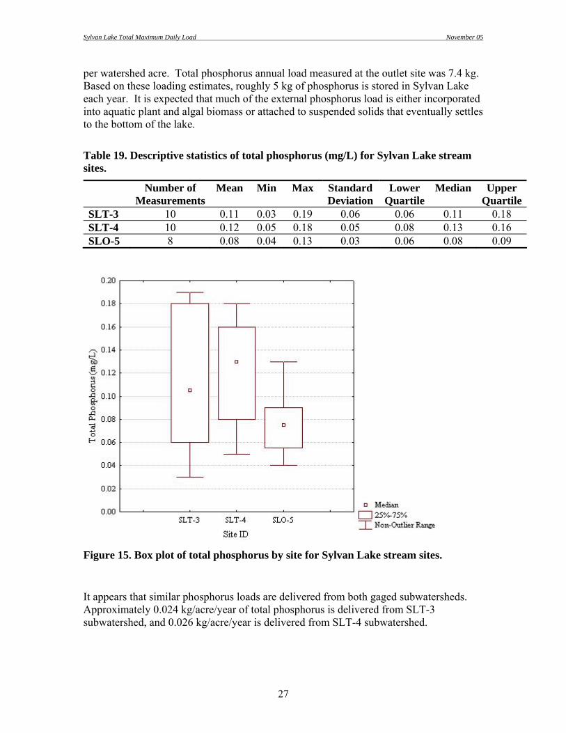
Sylvan Lake Total Maximum Daily Load November 05
27
per watershed acre. Total phosphorus annual load measured at the outlet site was 7.4 kg. Based on these loading estimates, roughly 5 kg of phosphorus is stored in Sylvan Lake each year. It is expected that much of the external phosphorus load is either incorporated into aquatic plant and algal biomass or attached to suspended solids that eventually settles to the bottom of the lake.
Table 19. Descriptive statistics of total phosphorus (mg/L) for Sylvan Lake stream sites.
Number of Measurements
Mean Min Max Standard Deviation
Lower Quartile
Median Upper Quartile
SLT-3 10 0.11 0.03 0.19 0.06 0.06 0.11 0.18 SLT-4 10 0.12 0.05 0.18 0.05 0.08 0.13 0.16 SLO-5 8 0.08 0.04 0.13 0.03 0.06 0.08 0.09
Figure 15. Box plot of total phosphorus by site for Sylvan Lake stream sites. It appears that similar phosphorus loads are delivered from both gaged subwatersheds. Approximately 0.024 kg/acre/year of total phosphorus is delivered from SLT-3 subwatershed, and 0.026 kg/acre/year is delivered from SLT-4 subwatershed.

Sylvan Lake Total Maximum Daily Load November 05
28
Similar to total phosphorus concentrations, Total dissolved phosphorus (TDP) concentrations at the inlet were higher and more variable than the outlet. TDP concentrations were 0.07, 0.08, and 0.01 mg/L at sites SLT-3, SLT-4, and SLO-5, respectively (Table 20 and Figure 16). Estimated TDP annual load was 8.3 kg, which is equivalent to 0.015 kg per watershed acre.
Table 20. Descriptive statistics of total dissolved phosphorus (mg/L) for Sylvan Lake stream sites.
Number of Measurements
Mean Min Max Standard Deviation
Lower Quartile
Median Upper Quartile
SLT-3 10 0.07 0.01 0.15 0.06 0.03 0.06 0.13 SLT-4 10 0.08 0.02 0.15 0.04 0.03 0.09 0.11 SLO-5 8 0.01 0.01 0.02 0.01 0.01 0.01 0.02
Figure 16. Box plot of total dissolved phosphorus by site for Sylvan Lake stream sites.

Sylvan Lake Total Maximum Daily Load November 05
29
Stream Biological Parameters
Benthic Macroinvertebrate Survey Three benthic macroinvertebrate samples were collected at each monitored inlet stream (sites SLT-3 and SLT-4). A D-framed net (500 µm mesh size) was used to collect composite samples at three locations in a 100 m reach immediately upstream of the water quality sampling site. Polypedilum sp. was the dominant taxon among all samples and belongs to the order Diptera (true flies) and the family Chironomidae. Chironomidae is an ecologically important group of aquatic insects and often occur in high densities and diversity. Chironomidae was the most abundant family in all stream samples. Approximately 45% of all individuals were chironomids. Ceratopogonidae, which also belongs to the order Diptera, was the second most abundant family among all samples (approximately 9% of all individuals). Ceratopogonidae are known as “biting midges,” as the adults of a few aquatic species are known to bite people and become annoying pests in some areas. In general, Diptera taxa are considered moderately tolerant of pollution in comparison to other aquatic insect groups. The orders Ephemeroptera (mayflies), Plecoptera (stoneflies), and Trichoptera (caddisflies) are considered to be more sensitive or intolerant to pollution. These more sensitive orders are often combined and measured as total “EPT” taxa. Higher numbers of EPT taxa indicate good water quality, while higher numbers of Diptera can indicate poorer water quality. A common measure or metric used to examine the relative abundances of these indicator groups is the ratio of EPT:Chironomidae. Good biological health is reflected in communities with an even distribution among all four major groups and with substantial representation in the sensitive groups (i.e. Ephemeroptera, Plecoptera, and Trichoptera). The EPT:Chironomidae metric was one of many used to compare sites SLT-3 and SLT-4. Higher values for this metric were observed at site SLT-3, indicating larger numbers of more sensitive groups and potentially better water quality than site SLT-4 (Figure 17). However, the difference between the two sites was not statistically significant (Kruskal-Wallis test, p > 0.05).

Sylvan Lake Total Maximum Daily Load November 05
30
Figure 17. Ratio of Ephemeroptera, Plecoptera, and Trichoptera (EPT) to Chironomidae abundances for stream sites SLT-3 and SLT-4. Box represents minimum and maximum values, and point represents median value (three samples per site). The relative abundance of Plecoptera, one of the most sensitive groups, was also calculated. A larger number of Plecoptera were collected at site SLT-3 than at SLT-4 (Figure 18). For this metric, the difference between the two sites was statistically significant (Kruskal-Wallis test, p < 0.05).

Sylvan Lake Total Maximum Daily Load November 05
31
Figure 18. Plecoptera abundances for stream sites SLT-3 and SLT-4. This metric displayed a statistically significant difference between the two sites (Kruskal-Wallis, p < 0.05). The relative percent of sediment tolerant taxa was calculated for each site. Sediment tolerant taxa metric was calculated by summing the relative percent abundance of taxa belonging to the following groups: oligochaetes, burrowers, gastropods, non-insects, and one tribe of chironomids (Orthocladinae). Higher numbers of sediment tolerant individuals were observed at SLT-4 (Figure 19). However, the difference between the two sites was not statistically significant (Kruskal-Wallis test, p > 0.05).

Sylvan Lake Total Maximum Daily Load November 05
32
Figure 19. Percent sediment tolerant organisms for stream sites SLT-3 and SLT-4.
The Hilsenhoff Biotic Index (HBI) metric was used to examine the average tolerance to pollution of macroinvertebrates sampled at each site. The scale of tolerance values range from 0 to 10 and increase as water quality decreases (i.e. higher values indicate more tolerant biological communities). Slightly higher HBI values were observed at site SLT-4 (Figure 20). Again, the difference between the two sites was not statistically significant (Kruskal-Wallis test, p > 0.05).

Sylvan Lake Total Maximum Daily Load November 05
33
Figure 20. Hilsenhoff Biotic Index (HBI) abundances for stream sites SLT-3 and SLT-4. Overall, macroinvertebrate data indicates average water quality at both stream sites based on the number and tolerance to pollution of organisms found in samples. Because the differences in metric values between the two sites were rarely statistically significant, only generalizations can be made concerning which of the two sites is more biologically impaired. Biological condition was slightly better at site SLT-3 than SLT-4. Results indicate potential sediment impairment at site SLT-4, possibly due to runoff from nearby paved areas. This correlates to the higher total suspended solids concentrations and load measured at SLT-4. All results, including metrics and taxa list, are presented in Appendix E.
Fecal Coliform Bacteria
Fecal coliform bacteria are found in the intestinal tract of all warm-blooded animals. Although these organisms are not disease-causing organisms themselves, their presence indicates fecal contamination and a higher probability of infectious, water-borne disease. Fecal bacteria concentrations are often highly variable. Environmental factors (e.g. sunlight exposure and water temperature) can influence concentrations of fecal bacteria in a waterway. The lifespan of fecal bacteria is relatively short compared to the

Sylvan Lake Total Maximum Daily Load November 05
34
associated animal waste, so the absence of fecal bacteria does not necessarily equate to the absence of animal waste. Average fecal coliform bacteria concentrations were 82, 90, and 41 colony forming units CFU/100 ml at sites SLT-3, SLT-4, and SLO-5, respectively (Table 21). Highest bacteria concentrations were sampled at all stream sites in July 2002. The streams in the study watershed do not have a water quality standard for fecal coliform bacteria. However, Sylvan Lake waterbody does have a water quality standard of ≤ 400 CFU/100 ml. Concentrations of E. coli were also analyzed. Excluding three samples collected in June 2002, E. coli was not detected. Detectable concentrations were very small (6, 12, and 10 CFU/100ml at sites SLT-3, SLT-4, and SLO-5, respectively). Detectable concentrations of E. coli and higher concentration of fecal coliform bacteria during the summer months may be an indicator of the seasonal human activity in the watershed.
Table 21. Descriptive statistics of fecal coliform bacteria (CFU/100 ml) for Sylvan Lake stream sites.
Number of Measurements
Mean Min Max Standard Deviation
Lower Quartile
Median Upper Quartile
SLT-3 10 82 1 690 214 2 5 35 SLT-4 10 90 1 780 243 1 4 30 SLO-5 8 41 1 250 86 1 2 34 Lake Physical and Chemical Parameters
Water Temperature Water temperature in Sylvan Lake ranged from 1.4 to 22.5 (mean = 12.3) degrees Celsius (Figure 21). Maximum temperature was reached in July. State standards require water temperatures to be maintained below 18.3 degrees Celsius to support the beneficial use of coldwater permanent fish life propagation. In July and August, the temperature limit was exceeded at surface sample depths. At depths greater than 2 meters, the temperature limit was not exceeded.

Sylvan Lake Total Maximum Daily Load November 05
35
Figure 21. Water temperature by month for Sylvan Lake categorized by site and sample depth. Temperature measurements were collected from August 2001-August 2003 (no samples collected during March or November).
Dissolved Oxygen Dissolved oxygen (DO) is made available, in part, by photosynthetic inputs from algae and aquatic plants. Conversely, microbial degradation of dead algae and aquatic plants consumes oxygen. In eutrophic lakes (i.e. high in nutrient loading with high organic production), an elevated rate of production and subsequent decomposition of organic matter can result in low or no oxygen in the lower depths of the lake (i.e. hypolimnion) (Monson 2000). The hypolimion can become anoxic as quickly as a few weeks after the onset of summer stratification and can remain anaerobic throughout this stratification period (Wetzel 2001). This trend was observed in Sylvan Lake during the spring and summer months. Sylvan Lake experiences stratification as early as April and typically remains stratified until the end of September. During the summer months, DO deficient and anoxic conditions occur at bottom depths. DO levels at near-surface depths were sufficient to support coldwater

Sylvan Lake Total Maximum Daily Load November 05
36
fish populations throughout most of the sampling season. However, levels significantly decreased during the summer months when sunlight penetration was impeded by algae growth (Figure 22).
Figure 22. Dissolved oxygen by month for Sylvan Lake categorized by site and sample depth. No samples collected during March or November. State water quality standards require DO concentrations to be maintained at or above 6.0 mg/L to support the coldwater permanent fish propagation use. Surface DO values ranged from 5.1 to 11.4 mg/L (mean = 8.4). All surface DO measurements, except one measurement in February 2002, were above this criterion. Bottom DO measurements ranged from 0.1 to 9.7 mg/L (mean = 4.55). Approximately 60% of the bottom DO measurements were below this criterion. Temperature and DO profiles were measured to determine oxygen availability and temperature conditions throughout the water column and to detect stratification. Summer stratification occurs annually in Sylvan Lake. Figure 23 is a temperature and DO profile at site SL-1 collected in August 2004. This graph demonstrates typical summer stratification observed in the deeper bay of Sylvan Lake. DO concentrations were less than 0.3 mg/L (i.e. anoxic) at or below a depth of 6 meters. Site SL-2 displayed no stratification due to its shallow depth.

Sylvan Lake Total Maximum Daily Load November 05
37
0
1
2
3
4
5
6
7
8
9
0.0 5.0 10.0 15.0 20.0 25.0
Dep
th (m
)
DO (mg/L) Temp (Degrees C)
Figure 23. Temperature and dissolved oxygen profile for Sylvan Lake at site SL-1 on August 30, 2004. Excessive nutrient loading to Sylvan Lake has contributed to a higher oxygen demand and thus lower hypolimnetic DO levels. The proposed management practices to reduce phosphorus concentrations are expected to also improve the DO levels in Sylvan Lake.

Sylvan Lake Total Maximum Daily Load November 05
38
Acidification and Alkalinity As previously stated, the primary measurements of acidification are alkalinity and pH. In Sylvan Lake, pH values ranged from 6.63 to 9.90 (mean = 7.94). The pH water quality standard for Sylvan Lake is a range of 6.6 to 8.6. The upper limit of this standard was exceeded during the months of June, July, August, and September (Figure 24). This increase in pH values can be attributed to the photosynthetic utilization of CO2 by algae and aquatic plants. Approximately 8% of all pH measurements exceeded the upper limit of the pH standard. The pH standard was never exceeded at the deepest sampling location (SL-1, bottom).
Figure 24. pH by month for Sylvan Lake categorized by site and sample depth.

Sylvan Lake Total Maximum Daily Load November 05
39
Alkalinity concentrations ranged from 30 to 62 mg/L (mean = 39). The alkalinity concentrations in Sylvan Lake are well below the water quality standard, which is ≤1,313 mg/L. Concentrations were low throughout the sampling period with minimum concentrations occurring in February at each sampling location (Figure 25).
Figure 25. Alkalinity concentrations by month for Sylvan Lake categorized by site and sample depth.
Sylvan Lake Total Maximum Daily Load November 05
40
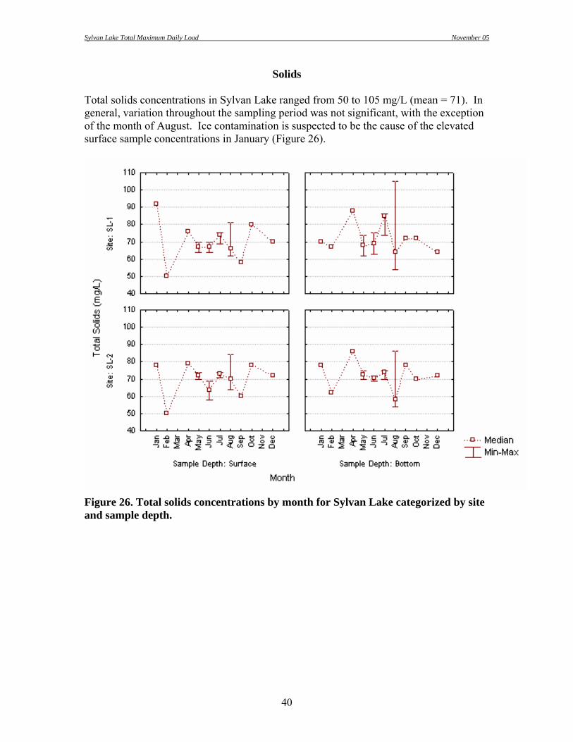
Solids Total solids concentrations in Sylvan Lake ranged from 50 to 105 mg/L (mean = 71). In general, variation throughout the sampling period was not significant, with the exception of the month of August. Ice contamination is suspected to be the cause of the elevated surface sample concentrations in January (Figure 26).
Figure 26. Total solids concentrations by month for Sylvan Lake categorized by site and sample depth.

Sylvan Lake Total Maximum Daily Load November 05
41
Typical of most waterways, total solids were mostly comprised of dissolved solids. Concentrations of dissolved solids ranged from 8 to 99 mg/L (mean = 63). Minimum concentrations of dissolved solids were observed in May at all lake sampling locations (Figure 27).
Figure 27. Total dissolved solids concentrations by month for Sylvan Lake categorized by site and sample depth.

Sylvan Lake Total Maximum Daily Load November 05
42
Total suspended solids (TSS) concentrations ranged from non-detectable levels to 62 mg/L (mean = 3). TSS concentrations displayed marked seasonality at all sampling locations. Concentrations increased in the spring due to precipitation and snow-melt runoff, with the maxima occurring in May (Figure 28).
Figure 28. Total suspended solids concentrations by month for Sylvan Lake categorized by site and sample depth.
Nitrogen Several forms of nitrogen can be found in a waterbody. Natural sources of nitrogen include precipitation, biological processes (i.e. nitrogen fixation), wildlife waste, and surface and groundwater drainage. Anthropogenic nitrogen sources include sewage inputs of organic nitrogen, fertilizer applications, and livestock waste. Ammonia levels were below the detection limit (0.02 mg/L) in nearly one-third of the samples collected in Sylvan Lake. All values below detection limits were assigned half of the limit to allow calculation of statistics. Ammonia concentrations ranged from below detection limits to 1.04 mg/L (mean = 0.14). Ammonia appears to accumulate

Sylvan Lake Total Maximum Daily Load November 05
43
under ice cover and during summer stratification in Sylvan Lake (Figure 29). Elevated ammonia concentrations in the winter months are most likely due to the lack of plant and algae utilization of this nutrient. Elevated ammonia concentrations at bottom sampling depths during the summer months is caused by anoxic conditions in the hypolimnion, which inhibits bacterial nitrification of ammonia.
Figure 29. Ammonia concentrations by month for Sylvan Lake categorized by site and sample depth.
Corrected for pH and temperature, un-ionized ammonia concentrations were all below the water quality standard. Nitrate is usually present in low concentrations in natural waters, yet it is often the most abundant inorganic form of nitrogen. Natural concentrations rarely exceed 10 mg/L and are normally less than 1 mg/L (Lind 1985). Nitrate/nitrite concentrations were below detection limits (0.05, Energy Laboratories; 0.1, State Health Laboratory) in approximately 80% of samples. Nitrate/nitrite concentrations in Sylvan Lake ranged from less than detection to 0.17 mg/L (mean = 0.05) (Figure 30).

Sylvan Lake Total Maximum Daily Load November 05
44
Maximum nitrate concentrations were observed during the winter months. All sample concentrations were well below the nitrate standard (≤ 88 mg/L).
Figure 30. Nitrate plus nitrite concentrations by month for Sylvan Lake categorized by site and sample depth. Total nitrogen was calculated for each sample by adding TKN and nitrate/nitrite concentrations. Total nitrogen values were used to determine whether nitrogen is a limiting nutrient in Sylvan Lake (see limiting nutrient section). Total nitrogen in Sylvan Lake ranged from 0.11 to 18.67 mg/L (mean = 1.15) (Figure 31).

Sylvan Lake Total Maximum Daily Load November 05
45
Figure 31. Total nitrogen concentrations by month for Sylvan Lake categorized by site and sample depth.
Phosphorus Like nitrogen, phosphorus is a biologically active element. It cycles through different states in the aquatic environment, and its concentration in any one state depends on the degree of biological assimilation or decomposition occurring in that system. The predominant inorganic form of phosphorus in lake systems is orthophosphate. Concentrations of orthophosphate were measured as total dissolved phosphorus (TDP) in this study. Phosphorus is often a limiting nutrient to algae and macrophyte production within many aquatic systems. Loading of this nutrient presents an increased eutrophication (primary production) risk. Total phosphorus concentrations of non-polluted waters are usually less than 0.1 mg/L (Lind 1985). Total phosphorus values in Sylvan Lake ranged from less than detection to 0.08 mg/L (mean = 0.05). At most lake sampling locations, maximum concentrations of phosphorus were observed in October. Due to anoxic conditions in the hypolimnion, the

Sylvan Lake Total Maximum Daily Load November 05
46
bottom sampling depth of site SL-1 experienced the highest total phosphorus concentrations of all sampling locations in July and August (Figure 32).
Figure 32. Total phosphorus concentrations by month for Sylvan Lake categorized by site and sample depth. TDP is the portion of total phosphorus that is readily available for plant and algae utilization. TDP concentrations in non-polluted waters are usually less than 0.01 mg/L (Lind 1985). TDP concentrations in Sylvan Lake ranged from below detection limits to 0.04 mg/L (mean = 0.02). Concentrations were above the minimum amount for rapid algal growth in April, which requires only 0.02 mg/L, but decreased through the growing season (Figure 33).

Sylvan Lake Total Maximum Daily Load November 05
47
Figure 33. Total dissolved phosphorus concentrations by month for Sylvan Lake categorized by site and sample depth.
Limiting Nutrients Great emphasis is placed on regulating nutrient loading to waterbodies to control aquatic productivity (i.e eutrophication). In aquatic systems, the most significant nutrient factors causing the shift from a lesser to a more productive state are phosphorus and nitrogen. Nitrogen is difficult to control because of its highly soluble nature, but phosphorus is easier to manipulate from a management perspective. Consequently, it is most often the nutrient targeted for reduction when attempting to control lake eutrophication. When either nitrogen or phosphorus reduces the potential for algal growth and reproduction, it is considered the limiting nutrient. Optimal nitrogen and phosphorus concentrations for aquatic plant growth occur at a ratio of 10:1 (N:P ratio). N:P ratios greater than 10:1 indicate a phosphorus limited system, while N:P ratios less than 10:1 indicate a nitrogen-limited system (USEPA, 1990).

Sylvan Lake Total Maximum Daily Load November 05
48
N:P ratios for Sylvan Lake ranged from approximately 2 to 588 (mean = 29). Almost 90% of samples collected in Sylvan Lake were considered phosphorus-limited. N:P ratios were generally lower in the spring and increased throughout the summer months (Figure 34). Samples collected in July, August, and September revealed the highest cases of phosphorus limitation. With the exception of one sample collected in August 2002, the ratios displayed little variability. The extreme phosphorus-limited sample (N:P = 123) was collected at the deepest sampling location (SL-1, bottom), which correlates with the high ammonia concentration observed in this sample.
Figure 34. Nitrogen:phosphorus ratios by month for Sylvan Lake categorized by site and sample depth.
Trophic State Wetzel (2001) defines ‘trophy’ of a lake as “the rate at which organic matter is supplied by or to a lake per unit time.” Trophic state is often measured as the amount of algal production in a lake, one source of organic material. Determinations of trophic state can be made from several different measures including oxygen levels, species composition of lake biota, concentrations of nutrients, and various measures of biomass or production.

Sylvan Lake Total Maximum Daily Load November 05
49
An index incorporating several of these parameters is best suited to determine trophic state. Carlson’s (1977) Trophic State Index (TSI) was used to determine the approximate trophic state of Sylvan Lake. This index incorporates measures of Secchi disk transparency, chlorophyll a, and total phosphorus into scores ranging from 0 to 100 with each 10-unit increase representing a doubling in algal biomass. Four ranges of index values (Table 22) define Carlson’s trophic levels, which include oligotrophic, mesotrophic, eutrophic, and hyper-eutrophic (in order of increasing productivity).
Table 22. Carlson’s trophic levels and index ranges for each level.
Trophic Level TSI Range Oligotrophic 0 – 35 Mesotrophic 36 – 50
Eutrophic 51 – 65 Hyper-eutrophic 66 – 100
TSI values were calculated for each of the index parameters individually. The number of samples/measurements used to calculate individual TSI values varied by parameter and year. Only surface samples/measurements from sites SL-1 and SL-2 were used for TSI calculations. Phosphorus samples were collected monthly from August through December 2001 (n = 8); January, February, and May through August 2002 (n = 12); and April through August of 2003 (n = 12, two measurements collected in July). Chlorophyll a samples were collected monthly from April through August of 2003 (n = 12, two measurements collected in July). Secchi depth measurements were taken monthly from August through October 2001 (n = 6), May through August 2002 (n = 8), and April through August of 2003 (n = 12, two measurements collected in July). Phosphorus TSI values ranged from 37.4 to 67.3 (mean = 57.3), chlorophyll a TSI values ranged from 30.6 to 64.2 (mean = 55.0), and Secchi depth TSI values ranged from 39.1 to 70.0 (mean = 53.7). Approximately 84% of phosphorus TSI values indicate eutrophic conditions, and 13% were in the mesotrophic range. One phosphorus sample collected in October 2001 was considered hyper-eutrophic. Half of the Secchi depth measurements indicated eutrophic conditions, and 46% were in the mesotrophic range. One Secchi depth measurement collected in August 2001 was considered hyper-eutrophic. Of the nine chlorophyll samples, one-third were considered eutrophic, while the other two-thirds were in the mesotrophic range. Secchi disk transparency, chlorophyll a, and total phosphorus concentrations were used to calculate a mean TSI value for each site on each sampling date. Chlorophyll a data was not available to include in the index in 2001 and 2002, because the chlorophyll samples were unknowingly stored past the holding time allowed for this analysis. Chlorophyll a data was included in the mean TSI calculations in 2003. A total of 26 mean TSI values were calculated for this study period.

Sylvan Lake Total Maximum Daily Load November 05
50
Mean TSI values indicate trophic levels comparable to individual TSI parameters (Table 23). Mean TSI values ranged from 42.3 to 66.6 (mean = 54.7). Average TSI values for the study period indicate eutrophic conditions. Approximately 70% of mean TSI values were considered eutrophic, 26% were considered mesotrophic, and only 4% were in the hyper-eutrophic range.
Table 23. Descriptive statistics for trophic state index (TSI) values calculated from direct measurements and samples collected from Sylvan Lake in 2001-2003.
Secchi TSI Phosphorus TSI Chlorophyll TSI* Mean TSINumber of Samples 14 32 9 26 Average 53.6 57.3 49.9 54.7 Median 54.2 57.3 49.1 55.1 Minimum 39.2 47.4 30.6 42.3 Maximum 70.0 67.3 64.2 66.6 Standard Deviation 7.3 5.5 9.9 6.2 * Chlorophyll data was available for 2003 only. Phosphorus, chlorophyll a, Secchi depth, and mean TSI values, displayed seasonal variation. In general, values decrease in the spring, increase during the summer, and decrease again during the fall months (Figure 35).

Sylvan Lake Total Maximum Daily Load November 05
51
Figure 35. Sylvan Lake phosphorus, chlorophyll, Secchi depth, and mean TSI values by month showing seasonal variation. Phosphorus and Secchi depth data is from 2001-2003. Chlorophyll data was available for 2003 only. Points represent median values and whiskers represent minimum and maximum values for each month. Beneficial use attainment for Sylvan Lake was also assessed using TSI values. SD DENR uses ecoregion specific criteria to evaluate beneficial use attainment. Stueven et al. (2000b) determined TSI criteria for support classifications that are specific to each South Dakota ecoregion. Sylvan Lake is located in the Middle Rockies Ecoregion. Numeric TSI criteria for beneficial use support categories for the Middle Rockies Ecoregion are listed in Table 24.

Sylvan Lake Total Maximum Daily Load November 05
52
Table 24. Beneficial use categories for the Middle Rockies Ecoregion with TSI criteria.
Beneficial Use Category TSI Criteria Not supporting >60
Partially Supporting 45-60 Fully Supporting <45
Individual parameter and mean TSI values span all beneficial use support categories throughout the project period. Nearly half of all TSI values fell within the partially supporting category. However, no phosphorus TSI values were considered fully supporting during the project period. Only 9% of mean TSI values were considered fully supporting (Figure 36).
Figure 36. Phosphorus, chlorophyll, Secchi depth, and mean TSI values for Sylvan Lake. Dashed horizontal lines represent beneficial use support categories (i.e fully, partially, and not supporting beneficial use). Phosphorus and Secchi depth data is from 2001-2003. Chlorophyll data was available for 2003 only.

Sylvan Lake Total Maximum Daily Load November 05
53
Historic TSI data was compiled from Wierenga and Payne (1987), SD DENR Statewide Lakes Assessment, and this study to examine trends in trophic state. TSI values appear to be declining since 1991. Using the current TSI beneficial use support categories, yearly average phosphorus and mean TSI values were considered partially supporting or not supporting beneficial uses (Table 25 and Figure 37).
Table 25. Historic TSI values for Sylvan Lake. Values represent averages for each year.
Year Total Phosphorus Secchi Depth Chlorophyll a Mean* 1979 59.8 m m 59.8 1981 63.2 57.3 m 60.3 1982 69.2 63.3 58.3 63.6 1983 64.2 55.9 49.9 56.7 1984 63.8 57.5 36.8 52.7 1989 64.9 62.1 m 63.5 1991 69.9 61.2 78.1 69.7 1993 65.2 62.5 63.0 63.6 2001 62.7 55.9 m 59.3 2002 55.8 51.4 m 53.6 2003 55.0 54.0 49.9 53.0 2004 53.4 44.8 52.0 50.1
* Note that some parameter TSI values were missing for years 1979, 1981, 1989, 2001, and 2002. Means were calculated using available data.

Sylvan Lake Total Maximum Daily Load November 05
54
Figure 37. Historic Trophic State Index Values for Sylvan Lake (1979-2004).
Reduction Response Model Reduction response modeling was conducted using BATHTUB, a eutrophication response model designed by the United States Army Corps of Engineers (US ACOE 1999). The model predicts changes in water quality parameters related to eutrophication (phosphorus, nitrogen, chlorophyll a, and transparency) using empirical relationships previously developed and tested for reservoir applications. Lake and tributary sample data were used to calculate existing conditions in Sylvan Lake. Tributary loading data was obtained from the FLUX model output. Inlet phosphorus and nitrogen concentrations were reduced in increments of 10% and modeled to generate an inlake reduction curve. As anticipated, the predicted inlake concentrations of total nitrogen and phosphorus decreased as modeled stream loads decreased (Table 26). Individual parameter (i.e. phosphorus, chlorophyll, and Secchi) TSI values gradually decreased with the reduction of nitrogen and phosphorus load. Based on model results, a reduction in watershed nutrient loads of approximately 90-95% would be required for Sylvan Lake phosphorus and chlorophyll TSI values to be considered fully supporting the ecoregion-specific beneficial use criteria. Even with a 100% reduction of watershed nutrient load (i.e. no external nutrient loading), the Secchi depth and mean TSI would still not reach fully supporting status (Figure 38). These findings demonstrate that internal nutrient loading from lake sediment is a potential cause of water quality problems in Sylvan Lake.
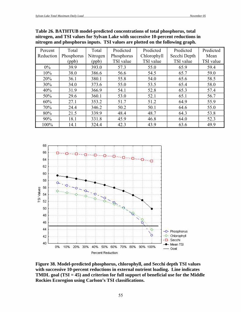
Sylvan Lake Total Maximum Daily Load November 05
55
Table 26. BATHTUB model-predicted concentrations of total phosphorus, total nitrogen, and TSI values for Sylvan Lake with successive 10-percent reductions in nitrogen and phosphorus inputs. TSI values are plotted on the following graph.
Percent Reduction
Total Phosphorus
(ppb)
Total Nitrogen
(ppb)
Predicted Phosphorus TSI value
Predicted Chlorophyll TSI value
Predicted Secchi Depth
TSI value
Predicted Mean
TSI value 0% 39.9 393.0 57.3 55.0 65.9 59.4 10% 38.0 386.6 56.6 54.5 65.7 59.0 20% 36.1 380.1 55.8 54.0 65.6 58.5 30% 34.0 373.6 55.0 53.5 65.4 58.0 40% 31.9 366.9 54.1 52.8 65.3 57.4 50% 29.6 360.1 53.0 52.1 65.1 56.7 60% 27.1 353.2 51.7 51.2 64.9 55.9 70% 24.4 346.2 50.2 50.1 64.6 55.0 80% 21.5 339.9 48.4 48.7 64.3 53.8 90% 18.1 331.8 45.9 46.8 64.0 52.3 100% 14.1 324.4 42.3 43.9 63.6 49.9
Figure 38. Model-predicted phosphorus, chlorophyll, and Secchi depth TSI values with successive 10-percent reductions in external nutrient loading. Line indicates TMDL goal (TSI = 45) and criterion for full support of beneficial use for the Middle Rockies Ecoregion using Carlson’s TSI classifications.

Sylvan Lake Total Maximum Daily Load November 05
56
Current watershed loads of total phosphorus to Sylvan Lake are approximately 12.4 kg/yr, representing approximately 63% of the overall phosphorus load to Sylvan Lake. According to model results and a lake total phosphorus mass balance, lake sediments contribute a significant amount of the total phosphorus load to Sylvan Lake. Approximately 7.3 kg/yr of total phosphorus (37% of the overall phosphorus load) originates from recycling of phosphorus in the lake’s sediment. This load will also be targeted for reductions to meet the TMDL goal. Bathtub model results show that Secchi depth TSI values are amplifying overall Mean TSI values, and may not accurately represent conditions of eutrophy in Sylvan Lake. Because Secchi depth measurements may be influenced by factors other than phosphorus concentrations and because measured chlorophyll concentrations were not available, it was decided that phosphorus TSI values alone should be used to determine support status. Based on the phosphorus TSI criteria of 45 (i.e. TMDL numeric target), a phosphorus concentration can be back calculated that would represent a surrogate numeric target for the TMDL. Using this procedure, a lake total phosphorus concentration of 0.02 mg/L was established as a secondary TMDL target. If only phosphorus loads originating from the watershed were managed, greater than 90% reduction would be required to meet the target. However, in-lake management (i.e. alum treatment) will provide a 50% reduction of the lake’s internal phosphorus load. A combination of the 90% reduction from the watershed load (from 12.4 to 1.2 kg/year) and the 50% reduction from the internal load (from 7.3 to 3.7 kg/year) will provide approximately 75% reduction of the total load (from 19.7 to 4.9 kg/year). A total load of 4.9 kg/year will result in an in-lake concentration of approximately 0.019 mg/L. Lake Biological Parameters
Fishery
The South Dakota Department of Game, Fish, and Parks (SDGF&P) last conducted a fishery survey in June of 1995. This survey consisted of using 4 ¾ inch mesh frame net sets, 2 quarter arc seine hauls with a 100 ft. x 6 ft. x ¼ inch mesh seine, and a baby frame net set with ½ inch mesh. Golden shiners, fathead minnows, and rainbow trout were collected during this survey. Healthy populations of golden shiners and fathead minnows were sampled. A total of 106 fathead minnows and 130 golden shiners were collected. Although Sylvan Lake is managed as a put and take rainbow trout fishery, only nine hatchery rainbow trout were captured by all sampling methods. Annual scheduled stocking of catchable rainbow trout and occasional supplemental stocking of adult rainbow trout maintains a viable trout fishery. On average, approximately 13,000 rainbow trout (catchable size) are stocked annually. It is expected that very little trout

Sylvan Lake Total Maximum Daily Load November 05
57
reproduction is occurring in the lake or inlet streams. The complete SD GF&P fish survey report can be found in Appendix B.
Fecal Coliform Bacteria The beneficial use of immersion recreation is assigned to Sylvan Lake. Fecal coliform bacteria concentrations must be ≤ 400 CFU/100 ml in any single sample to support this use. Sylvan Lake samples did not show detectable fecal coliform bacteria concentrations. Concentrations of E. coli bacteria in lake samples were also analyzed, and were not detected. Quality Assurance/Quality Control Proper laboratory and field sampling methods require that quality assurance and quality control (QA/QC) samples be collected. These samples should comprise 10% of the total samples taken. Nine QA/QC samples were collected during the project period, during which a total of 101 samples were collected. The QA/QC samples represent only 8.9% of the total samples collected, falling just short of the minimum requirement. Four replicate and five blank samples were collected on randomly chosen dates from Sylvan Lake or one of its tributaries. Standard chemical analysis was completed on each sample. Values above the detection limit were observed in four of the blank samples, with three occurrences for each of three parameters (alkalinity, total phosphorous, and total dissolved phosphorous). These instances of slight contamination were possibly caused by use of different distilled water brands or field contamination during handling. Replicate samples were compared to the routine samples using the industrial statistic (%I). The value given is the absolute difference between the routine and the replicate sample in percent, as follows: %I = ABS[(A-B)/(A+B)*100] %I = Industrial Statistic
ABS = Absolute Value A = Parameter value for replicate sample B = Parameter value for routine sample The average percent differences for analyzed parameters ranged from 0.0% to 33.2%. The following three parameters had an average percent difference greater that 10%: total suspended solids, nitrate/nitrite, and total dissolved phosphorous. The difference between replicate and routine samples for these parameters may be due to contamination of the sample bottles/distilled water by the field sampler, natural variability, or a laboratory error. Overall, approximately 78% of all sample pair difference estimates were less than 10%. See Appendix for all QA/QC data.

Sylvan Lake Total Maximum Daily Load November 05
58
Other Monitoring
Sediment Survey Sedimentation continues to be one of the most destructive pollutants of lakes and streams. This impairment can increase phosphorus concentrations, decrease habitat availability for invertebrates and fish, and decrease the depth of the waterbody. A sediment survey was conducted for Sylvan Lake on December 24, 2003. Water depth and sediment depth was measured with a steel probe through holes drilled in the ice. Water depth and sediment depth was recorded at each site (134 sampling locations) with Global Positioning System (GPS) equipment. Sediment depths in Sylvan Lake ranged from 0 to 6 feet (mean = 1.9). Using survey data, a sediment depth contour map was produced and total sediment volume was calculated (Figure 39). Sediment volume is approximately 49,400 cubic yards.
Figure 39. Estimated sediment depth and water depth contours for Sylvan Lake based on sediment survey data collected on December 24, 2003.

Sylvan Lake Total Maximum Daily Load November 05
59
Sediment Phosphorus Concentration Sediment samples assayed for total phosphorus were collected from 12 sites in Sylvan Lake. Samples were obtained using a Petite Ponar dredge and stored in 2-gallon HDPE containers until analyzed. Total phosphorus concentrations ranged from 610 to 5,100 mg/kg (mean = 1,706 mg/kg). Concentrations displayed a strong relationship to the water depth where the sample was collected; sediment phosphorus concentrations increase as water depth increase (Figure 40).
y = 13.45x2 - 317.50x + 2285.25R2 = 0.94
-
1,000
2,000
3,000
4,000
5,000
6,000
4.0 9.0 14.0 19.0 24.0 29.0
Depth (m)
TP C
onc.
(ppm
)
Figure 40. Sediment total phosphorus concentrations by water depth.
Sylvan Lake Restoration Project In 1979, the South Dakota Department of Game, Fish, and Parks (SDGF&P) initiated a restoration project for Sylvan Lake. This project was instigated in response to increased visitation and resulting increase in usage of the Sylvan Lake watershed area. According to the restoration project report (Wierenga and Payne 1987), much of the surface area around the lake was being degraded by foot traffic and vehicle use. Graveled parking areas, roads, and footpaths along the lakeshore were resulting in increased erosion and sedimentation in the lake. Due to increased visitation, the SD GFP and SD DENR determined that a three-phase approach was needed to restore lake conditions and protect the adjacent areas from further erosion. The first phase involved a partial removal of sediments in the reservoir forebay. The second phase included paving of the existing parking areas and driving areas to reduce sedimentation. The third phase called for riparian vegetation improvements and construction of sediment controls in the inlet areas of the lake. The total cost for this restoration project was more than $450,000. Sediment was removed from the east and southeast shoreline areas. The lake level was reduced by 2.7 meters (9 ft.) to allow the sediments to dry enough to allow removal using conventional construction equipment. Approximately 18,580 cubic meters (24,300 c.y.) of material was removed, which was 60% more material than originally projected for

Sylvan Lake Total Maximum Daily Load November 05
60
excavation. The contractor misidentified materials and depths of excavation cited in the original contract, resulting in the removal of native soils that existed prior to the reservoir’s construction. It was determined that the additional removal of sediment was beneficial to the project, so the contractor was ultimately paid for the entire volume of material removed. Graveled parking areas and roads were paved on the west side of the lake near the concession and on the east side of the lake in a parking area near a foot trail that leads to Harney Peak. Approximately 25,000 square feet of parking area was resurfaced along with associated roadway access. Approximately five acres of disturbed surface were seeded and areas around the hiking trail system were graveled to reduce these sources of sedimentation. In addition, eight sediment control structures were placed in the watershed area. As part of this restoration effort, several landuse management practices were established or changed. All lakeshore camping and horseback riding was eliminated, gasoline sales at the concession was closed, timber thinning was implemented to allow development of ground cover, and native trees and shrubs were planted to stabilize soils in areas experiencing heavy foot traffic. According to the final project report, restoration activities did not greatly improve water quality. Sampling was conducted prior to (May-September 1979) and after (October 1981- April 1984) restoration activities. Total phosphorus concentrations before and after the project were approximately the same. During sediment removal, the trophic status of Sylvan Lake worsened, becoming hypereutriphic. Once the sediment removal operations ceased, the trophic status returned to eutrophic.
Lake Circulation In an effort to control algae growth and improve oxygen levels in Sylvan Lake, a floating solar-powered circulator (Pump Systems, Inc.; SolarBee model SB2500) was installed on November 22, 2000 (Figure 41). In theory, the circulator draws water from below the machine and spreads it across the top of the reservoir with continuous surface renewal, resulting in higher DO concentrations from the depth of the intake hose to the water surface. Effects of this circulator on dissolved oxygen concentrations were monitored during this study.
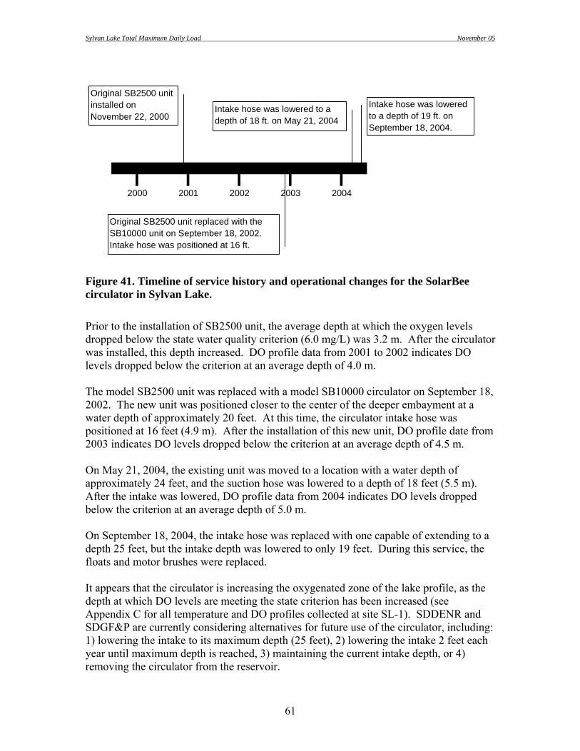
Sylvan Lake Total Maximum Daily Load November 05
61
20042000 2001 2002 2003
Original SB2500 unit installed on November 22, 2000
Original SB2500 unit replaced with the SB10000 unit on September 18, 2002.Intake hose was positioned at 16 ft.
Intake hose was lowered to a depth of 18 ft. on May 21, 2004
Intake hose was lowered to a depth of 19 ft. on September 18, 2004.
Figure 41. Timeline of service history and operational changes for the SolarBee circulator in Sylvan Lake. Prior to the installation of SB2500 unit, the average depth at which the oxygen levels dropped below the state water quality criterion (6.0 mg/L) was 3.2 m. After the circulator was installed, this depth increased. DO profile data from 2001 to 2002 indicates DO levels dropped below the criterion at an average depth of 4.0 m. The model SB2500 unit was replaced with a model SB10000 circulator on September 18, 2002. The new unit was positioned closer to the center of the deeper embayment at a water depth of approximately 20 feet. At this time, the circulator intake hose was positioned at 16 feet (4.9 m). After the installation of this new unit, DO profile date from 2003 indicates DO levels dropped below the criterion at an average depth of 4.5 m. On May 21, 2004, the existing unit was moved to a location with a water depth of approximately 24 feet, and the suction hose was lowered to a depth of 18 feet (5.5 m). After the intake was lowered, DO profile data from 2004 indicates DO levels dropped below the criterion at an average depth of 5.0 m. On September 18, 2004, the intake hose was replaced with one capable of extending to a depth 25 feet, but the intake depth was lowered to only 19 feet. During this service, the floats and motor brushes were replaced. It appears that the circulator is increasing the oxygenated zone of the lake profile, as the depth at which DO levels are meeting the state criterion has been increased (see Appendix C for all temperature and DO profiles collected at site SL-1). SDDENR and SDGF&P are currently considering alternatives for future use of the circulator, including: 1) lowering the intake to its maximum depth (25 feet), 2) lowering the intake 2 feet each year until maximum depth is reached, 3) maintaining the current intake depth, or 4) removing the circulator from the reservoir.

Sylvan Lake Total Maximum Daily Load November 05
62
If the entire lake was oxygenated, phosphorus releases from the lake sediment would likely abate. Aeration equipment, which injects forced air or pure oxygen to increase the dissolved oxygen content of the water, could be implemented to supplement the effect of the circulator. In the final report of the historic Sylvan Lake restoration project, aeration was recommended to maintain oxygen levels in the hypolimnion and to reduce total phosphorus concentrations in the lake. Conclusions and Recommendations Watershed and Lake Management Five primary inlake treatment options were considered to reduce phosphorus concentrations in Sylvan Lake. These options included a chemical treatment (alum application), dredging, aeration in combination with circulation, and bioremediation. Of the four treatment alternatives evaluated, alum treatment is recommended to meet the TMDL goals. However, additional phosphorus load reductions could be achieved by implementing other lake management options described below. Aluminum Sulfate (Alum) Treatment Sediment-bound phosphorus loads from upland erosion accumulates at the lake bottom. Low oxygen concentrations allow this sediment-bound phosphorus to be released and available for algal growth. So even when external sources of phosphorus are eliminated, this nutrient remains in oversupply. For this reason, controlling phosphorus concentrations in lakes is a two-part process: keeping phosphorus out of the lake and reducing the availability of phosphorus from lake sediments. Alum treatment involves the addition of aluminum sulfate slurry that produces an aluminum hydroxide precipitate. This precipitate removes phosphorus and suspended solids from the water column and settles to the bottom of the lake to form a phosphorus-binding blanket on the sediment surface. Alum has been used for centuries for clarification of drinking water, but only recently has it moved into the mainstream of lake management. It is a safe, effective, and economical means of controlling internal phosphorus loading. If external phosphorus loads are reduced, an alum treatment will control phosphorus levels and eliminate algae blooms for up to ten years (Conover 1988). The longevity of the treatment depends on the amount of alum applied and level of external phosphorus loading. A phosphorus load reduction of approximately 50% is expected with the implementation of alum treatment (Welch and Cooke 1995). This reduction will lower the current internal phosphorus load from 7.3 to 3.7 kg/yr.

Sylvan Lake Total Maximum Daily Load November 05
63
Lake Aeration and Circulation The purpose of aeration and circulation techniques in lake management is to increase the dissolved oxygen content of the water. Various systems are available including aeration by air/oxygen injection or circulation by mechanical mixing. Lake aeration can have multiple benefits to water quality and lake biota. Aeration can increase aquatic habitat for fish and other lake organisms. In some cases, nuisance algal blooms can be reduced or algae populations can be shifted to more desirable taxa. The use of air injection (diffuser) systems is the most common destratification method. This system uses a compressor on shore to deliver air through lines connected to a perforated pipe(s) or other simple diffuser(s) placed near the bottom, typically in the deep area of the lake. The use of a diffuser system not only adds oxygen to the water, but also encourages mixing. The rising air bubbles cause water in the hypolimnion to rise, pulling this water into the epilimnion. When the colder, hypolimnetic water reaches the lake surface, it flows across the surface and eventually sinks, mixing with the warmer epilimnetic water. The solar-powered circulator (SB10000) currently used in Sylvan lake to mix the oxygen- rich surface waters with oxygen-depleted waters in the lower depths could be supplemented with an air injection (diffuser) system. Additional oxygen delivered by an aeration system, in conjunction with the mixing action provided by the SB10000 circulator, may allow the lake to become completely aerated. Dredging Lake sediments contain much higher phosphorus concentrations than the water. Excavating the sediment in Sylvan Lake could reduce a significant source of phosphorus. Future dredging activities should be considered for the deeper embayment, because the shallow embayment has been recently dredged and the deeper embayment contains more sediment. Hydraulic dredging should be considered to remove phosphorus-laden sediments. Hydraulic dredging typically involves a rotating cutter head and a suction pump to remove sediments. The cutter head cuts into sediment layers and churns them into a slurry. The pump vacuums the slurry through floating pipe to an on-shore dewatering facility. One disadvantage of this option is the amount of time and cost involved in dewatering the excavated sediments. The limited amount of level ground in the Sylvan Lake area restricts use of lower-cost alternatives. The dry dredging option was not considered due to socio-economic reasons and cost. This option would require draining the lake and dewatering the removed sediment. While more sediment could be removed by dry dredging than hydraulic dredging, Custer

Sylvan Lake Total Maximum Daily Load November 05
64
State Park may experience a greater loss of revenue if the dry dredging option is pursued. The amount of time required to drain, dredge, and refill the lake could be as much as four years. In addition, the quality and volume of drained water, as well as surface waters downstream of draining or dewatering activities, should be considered before water is discharged downstream. Artificial Wetlands Artificial wetlands are typically engineered systems that use natural processes involving wetland vegetation, soils, and their associated microbial assemblages to assist in treating an effluent or other source of water. Wetland plants assimilate nutrients, reducing concentrations in receiving waters. Artificial wetlands are being constructed throughout the country to control the nutrient loadings to water bodies. Several communities in South Dakota, including Clear Lake, Huron, Lake Cochrane, Pickerel Lake, and Richmond Lake, have received Clean Water State Revolving Fund (CW-SRF) loans to construct artificial wetlands to improve their wastewater treatment facilities. In these cases, the wetlands follow a lagoon treatment system to further reduce pollutant levels in the wastewater prior to discharge. Numerous studies have demonstrated the non-point source pollutant removal capabilities of artificial wetland systems. Total phosphorus concentrations have been reduced by up to 90%; the amount of phosphorus reduction dependent on wetland size, plant species composition, soil properties, maintenance, etc. (USEPA 2001). It is recommended that artificial wetlands be constructed on the inlet streams to reduce phosphorus loads from the watershed. Current total phosphorus loads are 3.8 and 7.1 kg/yr for SLT-3 and SLT-4, respectively. The proposed wetland areas should reduce this total phosphorus load from 10.9 to 1.1 kg/year, approximately a 90% reduction (Fischer et al. 2004). Bioremediation One of the effects of alum treatment is increased water transparency. As algae become limited by the decrease in phosphorus concentration, the water will become more transparent. This increased water clarity may allow for natural establishment of emergent and submersed aquatic vegetation, which will further improve water quality. As algal density decreases and macrophyte colonization increases, water quality is predicted to improve. The benefits of aquatic macrophytes are well documented. Heavy stands of emergent and submerged macrophytes have been linked to a distinct reduction of phytoplankton (Wetzel 2001). Macrophyte colonization also aids in stabilization of sediments in the littoral zone, provides habitat for fish and invertebrates, and maintains water clarity (Moss et al. 1997).

Sylvan Lake Total Maximum Daily Load November 05
65
Currently, minimal aquatic vegetation exists. Cattails are scattered along the shoreline and a small amount of submergent vegetation can be found in the littoral zone of the shallow embayment. A large portion of the macrophytes were removed during the dredging activities of the previous restoration project. If macrophytes do not recolonize naturally, manual planting of desirable species should be considered. Another biological technology, biofiltration, is being employed to reduce phosphorus concentrations in surface waters. Biofiltration is based on the controlled use of the ecological characteristics of common mollusk species. Freshwater mussels are natural filter feeders, which effectively and efficiently filter organic and inorganic matter from the water. The biofiltration technology has very low costs. Most construction, including the preparation of the bedding, can be accomplished with minimal labor and materials costs. The filtration capacity is a characteristic feature of every mollusk species. On average, a single freshwater mussel (about 3 cm in diameter) can filter approximately 100 ml/hour. The volume of water filtered can be very large. Freshwater mussel populations in an area of 100 m2 can filter a volume up to 28,000 m3/day and absorb up to 5.5 g of phosphorus and 11.5 g of nitrogen (United Nations Environment Programme 2004). It should be noted that this treatment method is considered experimental. Further research may be required before this technique is widely implemented. Consideration should also be given to the species of mollusk selected; non-native species should not be used.

Sylvan Lake Total Maximum Daily Load November 05
66
References Cited Carlson, R.E. 1977. A trophic state index for lakes. Limnology and Oceanography. 22(2):361-369. Carlson, R.E. and J. Simpson. 1996. A Coordinator’s Guide to Volunteer Lake Monitoring Methods. North American Lake Management Society. Conover, Bret. 1988. The alum alternative in restoring reservoirs. Lakeline. 8(6). CSPRC. 2003. Advertisement for Sylvan Lake Resort: A Mountain Retreat. Retrieved from the World Wide Web on 24 December 2003 from http://www.custerresorts.com/lodge.asp?id=2. Eaton, A.D., L.S. Clesceri, and A.E. Geenberg (editors). 1995. Standard Methods for the Examination of Water and Wastewater, 19th Edition. American Public Health Association, Washington, D.C. Fahrenbach, Mark D. 15 Dec 2003. Personal conversation. Fischer, D.J., K.B. Goyer, D. Lipp, and G. Sanchez. 2004. Phosphorus Accumulation and Techniques for Removal in Sylvan Lake; Black Hills, South Dakota. South Dakota School of Mines and Technology, Department of Civil and Environmental Engineering: Senior Design Project Final Report. Goebel, Greg. 17 Dec. 2003. email to author. Hauer, R.F. and G.A. Lamberti. 1996. Methods in Stream Ecology. Academic Press, San Diego, CA. Hynes, H.B.N. 1970. The Ecology of Running Waters. University of Toronto Press, Canada. Koth, R.M. 1981. South Dakota Lakes Survey. South Dakota Department Water and Natural Resources, Office of Water Quality. Pierre, SD. Larson, Aaron and Andrew Repsys. 2002. Section 319 Nonpoint Source Pollution Control Program Assessment/Planning Project Final Report for Loyalton Dam, Edmunds County, SD. South Dakota Water Resource Assistance Program, South Dakota Department of Environment and Natural Resources. Pierre, SD. Lind, Owen T., 1985. Handbook of Comon Methods used in Limnology, 2nd Edition. Kendall/Hunt Publishing Company, Dubuque, IA. Monson, Bruce A. 2000. A Primer on Limnology, 2nd Edition. Water Resources Center, University of Minnesota, St. Paul, MN.

Sylvan Lake Total Maximum Daily Load November 05
67
Muenscher, Walter C. 1944. Aquatic Plants of the United States. Cornell University Press, Ithaca, NY. Moss, Brian, Jane Madgwick, and Geoffrey Phillips. 1997. A Guide to the Restoration of Nutrient-enriched Shallow Lakes. Broads Authority, Norwich, Norfolk. Page, L.R. et al. 1953. Pegmatitic Investigations, 1942-1945, Black Hills, South Dakota: US Geological Survey Professional Paper 247. 228 p. Reid G.K. 1961. Ecology of inland waters and estuaries. Van Nostrand Reinhold Co., New York. 375 pp. Roberts, W.L. and George Rapp, Jr. 1965. Mineralogy of the Black Hills: Rapid City. South Dakota School of Mines and Technology Bulletin 18. 268 p. Round, F.E. 1965. The Biology of the Algae. Edward Arnold, Ltd., London. 269 pp. Shapiro, J. 1973. Blue-green algae: why they become dominant. Science. 179:382-384. South Dakota Department of Environment and Natural Resources (SD DENR). 1996. The 1996 South Dakota Report to Congress. SD DENR, Pierre, SD. South Dakota Department of Environment and Natural Resources (SD DENR). 1998. The 1998 South Dakota Report to Congress. SD DENR, Pierre, SD. South Dakota Department of Environment and Natural Resources (SD DENR). 2000. The 2000 South Dakota Report to Congress. SD DENR, Pierre, SD. Stueven, Eugene, Alan Wittmuss, and Robert Smith. 2000a. Standard Operating Procedures for Field Samplers. South Dakota Department of Environment and Natural Resources, Division of Financial and Technical Assistance, Pierre, SD. Stueven, E.H., R.L. Smith, A.J. Repsys, and W.C. Stewart. 2000b. Ecoregion Targeting for Impaired Lakes in South Dakota. South Dakota Department of Environment and Natural Resources, Water Resource Assistance Program, Pierre, SD. Stueven, E. and Stewart, W.C. 1996. 1995 South Dakota Lakes Assessment Final Report. South Dakota Department of Environment and Natural Resources, Watershed Protection Program, Pierre, SD. United Nations Environment Programme. 2004. Source Book of Alternative Technologies for Freshwater Argumentation in Eastern and Central Europe. Retrieved from World Wide Web on 9 December 2004 from http://maestro.unep.or.jp/ietc/Publications/TechPublications/TechPub-8b/bio.asp

Sylvan Lake Total Maximum Daily Load November 05
68
United States Army Corps of Engineers (US ACOE). 1999. Simplified Procedures for Eutrophication Assessment and Prediction: User Manual. US ACOE Waterways Experiment Station. Washington, D.C. United States Environmental Protection Agency (USEPA). 1990. Clean Lakes Program Guidance Manual. EPA-44/4-90-006. Washington, D.C. United States Geological Survey (USGS). 1986. USGS Survey Bulletin 1580: Mineral Resource Potential and Geology of the Black Hills National Forest, South Dakota, and Wyoming. United States Geological Survey: United States Government Printing Office. Washington, DC. Walker, William W. 1996, updated 1999. Simplified Procedures for Eutrophication Assessment and Prediction: User Manual. US Army Corps of Engineers Instruction Report W-96-2. Washington, DC 20314-1000 Welch, Eugene B. and G. Dennis Cooke. 1995. Effectiveness and Longevity of Alum Treatments in Lakes. Water Resources Series Technical Report No. 145. University of Washington, Department of Civil Engineering, Environmental Engineering and Science. Seatle, WA Wetzel, Robert G. 2001. Limnology – Lake and River Ecosystems, 3rd Edition. Acedemic Press, San Diego, CA. Wierenga, Greg and Payne, Forrest. 1987. Sylvan Lake Restoration Project Final Report. South Dakota Department of Water and Natural Resources. Pierre, SD.

Sylvan Lake Total Maximum Daily Load November 05
69
Appendix A
Total Maximum Daily Load (TMDL) Summary

Sylvan Lake Total Maximum Daily Load November 05
70
TOTAL MAXIMUM DAILY LOAD EVALUATION
For
Sylvan Lake
(HUC 10120109)
Custer County, South Dakota
South Dakota Department of Environment and Natural Resources
November 05

Sylvan Lake Total Maximum Daily Load November 05
71
Sylvan Lake Total Maximum Daily Load Waterbody Type: Lake (Impoundment) 303(d) Listing Parameter: Trophic State Index (TSI) Designated Uses: Recreation, Coldwater Permanent Fish Life Propagation Water Size of Impaired Waterbody: 18 acres Size of Watershed: 565 acres Water Quality Standards: Narrative and Numeric Indicators: Trophic State Index and Total phosphorus concentrations Analytical Approach: Models including BATHTUB and FLUX Location: HUC Code: 10120109 Goal: 75% reduction of phosphorus load Target: Phosphorus TSI = 45 (lake total phosphorus concentration = 0.02 mg/L)
Objective The intent of this summary is to clearly identify the components of the TMDL, support adequate public participation, and facilitate the US Environmental Protection Agency (US EPA) review. The TMDL was developed in accordance with Section 303(d) of the federal Clean Water Act and guidance developed by US EPA. Introduction Sylvan Lake is an 18-acre impoundment located in the Spring Creek Basin in northern Custer County, South Dakota (Figure 1). The lake reaches a maximum depth of 34 feet (10.5 m) and holds a total water volume of 214 acre-ft (at spillway elevation). Two unnamed inlets are located on the south and east sides of the lake. Portions of the lake exhibit thermal stratification during spring and summer months. The 2004 South Dakota 303(d) Waterbody List identified Sylvan Lake for TMDL development due to elevated trophic state index (TSI) values. Information supporting this listing was derived from statewide lake assessment data.
Figure 1. Location of Sylvan Lake and watershed in Custer County, South Dakota. Problem Identification The unnamed streams to Sylvan Lake Dam drain a watershed of 565 acres that predominantly consists of evergreen forest and state park camping areas (Figure 2). The streams carry sediment and nutrient loads, which degrade water quality in the lake and have caused increased eutrophication. An estimated 12.4 kg/year of phosphorus enter Sylvan Lake from watershed runoff.

Sylvan Lake Total Maximum Daily Load November 05
72
The source of nonpoint source pollution loading from the Sylvan Lake watershed is likely a combination of recreational uses, forest management, as well as background sources (i.e. wildlife, natural weathering, etc.). However, degraded water quality in Sylvan Lake is primarily attributed to recreational activity within the watershed. According to Wierenga and Payne (1987), 5% of the total watershed area has been converted to commercial or developed recreational use. Approximately 90% of the watershed land area is managed by the SD Department of Game, Fish and Parks (Custer State Park), while the remaining 10% is managed by the US Forest Service. Although much of the watershed remains in its natural state, the intense usage of recreational facilities within Custer State Park has degraded the watershed condition. Sylvan Lake also experiences considerable internal phosphorus loading from lake-bottom sediment. An estimated 7.3 kg/yr of total phosphorus is delivered from the lake sediment.
Figure 2. Sylvan Lake watershed landuse. Description of Applicable Water Quality Standards & Numeric Water Quality Targets Sylvan Lake has been assigned beneficial uses by the state of South Dakota Surface Water Quality Standards regulations. Along with these assigned uses are narrative and numeric criteria that define the desired water quality of the lake. These criteria must be maintained for the lake to satisfy its assigned beneficial uses, which are listed below:
1) Coldwater permanent fish propagation 2) Immersion recreation 3) Limited contact recreation 4) Fish and wildlife propagation, recreation and
stock watering. Individual parameters, including the lake’s TSI value, determine the support of these beneficial uses. Sylvan Lake experiences internal phosphorus loading from its sediments and external phosphorus loading from its watershed, which has caused increasing eutrophication. Sylvan Lake is identified in the 1998, 2002, and 2004 South Dakota Waterbody Lists as impaired due to its eutrophic state. The 2002 and 2004 lists identify Sylvan Lake as a high priority waterbody in terms of TMDL development. South Dakota has narrative standards that may be applied to the undesired eutrophication of lakes and streams. Administrative Rules of South Dakota Article 74:51 contains language that prohibits the existence of materials causing pollutants to form, visible pollutants, taste and odor producing materials, and nuisance aquatic life. If adequate numeric criteria are not available, the South Dakota Department of Environment and Natural Resources (SD DENR) uses surrogate measures to indicate impairment. To assess the trophic status of a lake, SD DENR uses the mean Trophic State Index or TSI (Carlson 1977). The mean TSI incorporates measures of Secchi depth, chlorophyll a concentrations, and phosphorus concentrations. SD DENR has developed a protocol that establishes desired TSI levels for lakes based on an ecoregion approach (Stueven et al. 2000b). Sylvan Lake falls in the Middle Rockies Ecoregion. The mean TSI criterion established for this ecoregion is a mean TSI of 45. Model results show that Secchi depth TSI values amplify overall Mean TSI values, and may not accurately represent conditions of eutrophy in Sylvan Lake. Because Secchi depth measurements may be influenced by factors other than phosphorus concentrations and because measured chlorophyll concentrations were not available, it was decided that phosphorus TSI values alone should be used to determine support status.

Sylvan Lake Total Maximum Daily Load November 05
73
This protocol was used to assess impairment and determine a numeric target for Sylvan Lake. Sylvan Lake is currently considered partially supporting its beneficial uses with an average phosphorus TSI of 53. The numeric target established to improve the trophic state of Sylvan Lake is a phosphorus TSI value of 45, which equates to approximately 0.02 mg/L total phosphorus. A 75% reduction of total phosphorus load (a combination of external and internal load reductions) would be required to meet this goal. This reduction of phosphorus load will result in average lake phosphorus concentrations of approximately 0.02 mg/L and lower the TSI value by approximately 8 points and improve the trophic level of the lake from partially to fully supporting beneficial uses. Pollutant Assessment Point Sources There are no point sources of pollutants of concern in this watershed. Nonpoint Sources According to BATHTUB model results, greater than 90% reduction of watershed phosphorus loads is required meet the TMDL numeric target (i.e. phosphorus TSI = 45). Clearly, non-point sources of phosphorus from the watershed (external load) are only a portion of the total phosphorus load to Sylvan Lake. Still, external loads should be targeted for reductions using management practices recommended in the assessment report. Up to 90% of external load could be reduced with the implementation of constructed wetlands on inlet drainages. Internal phosphorus loading from lake-bottom sediment is a significant source of phosphorus and should also be targeted for reductions. Alum treatment is recommended to remove phosphorus and suspended solids from the water column. Alum that settles to the bottom of the lake will also form a phosphorus-binding blanket on the sediment surface, thereby reducing the internal phosphorus loading potential of the lake sediment. Approximately 50% of the internal load could be reduced by applying alum to Sylvan Lake. Excessive nutrient loading to Sylvan Lake has contributed to a higher oxygen demand and lower hypolimnetic DO levels. The proposed
management practices to reduce phosphorus concentrations are expected to also improve the DO levels in Sylvan Lake. Alum treatment, in conjunction with the construction of artificial wetlands, should result in a 75% reduction of the overall total phosphorus load to Sylvan Lake. The TMDL target can be achieved with the implementation of the above management practices. Linkage Analysis Water quality data was collected at two lake sites and three stream sites, including the lake’s inlet and outlet. Lake samples were composited for analysis. Samples collected at each site were taken according to South Dakota’s EPA approved Standard Operating Procedures for Field Samplers. Water samples were sent to Energy Laboratories, Inc. in Rapid City, SD for analysis. Quality Assurance/Quality Control samples were collected on 10% of the samples according to South Dakota’s EPA approved Non-point Source Quality Assurance/ Quality Control Plan. Details concerning water sampling techniques, analysis, and quality control are addressed in the assessment final report. Phosphorus export coefficients were calculated for each subwatershed and were used to define critical non-point source (NPS) pollution areas within the watershed (those with higher sediment and phosphorus loads). The SLT-3 subwatershed displayed a higher phosphorus export coefficient than the SLT-4 subwatershed. When considering locations for implementation of BMPs to control erosion and nutrient runoff, the SLT-3 subwatershed should be given higher priority than the SLT-4 subwatershed. However, modeled management practices recommended in this report are intended to be implemented in both subwatersheds. TMDL Allocations Wasteload Allocation There are no point sources of pollutants of concern in this watershed. Therefore, the “wasteload allocation” component of this TMDL is considered a zero value. The TMDL is considered

Sylvan Lake Total Maximum Daily Load November 05
74
wholly included within the “load allocation” component. Load Allocation (LA) Current total phosphorus loads from the watershed are approximately 12.4 kg/yr. A 90% reduction of external phosphorus load to Sylvan Lake may be achieved through the implementation of constructed wetlands, resulting in an annual load of approximately 1.2 kg. Current total phosphorus loads from the lake sediment (internal load) are approximately 7.3 kg/yr. A 50% reduction of internal phosphorus load in Sylvan Lake may be achieved through the addition of aluminum sulfate (i.e. alum treatment), resulting in an annual internal load or phosphorus recycling of approximately 3.7 kg (Table 1). Table 1. Load allocation (kg/yr) summary for Sylvan Lake. Load source Current Load BMP Reduction TMDL
External 12.4 Artificial wetlands 90% 1.2Internal 7.3 Alum treatment 50% 3.7Total 19.7 75% 4.9
Seasonal Variation Different seasons of the year can yield differences in water quality due to changes in precipitation and landuse. To determine seasonal differences, Sylvan Lake sample data was graphed by month to facilitate viewing seasonal differences. Nearly all parameters assessed in this study displayed seasonal variation. For example, lake total phosphorus concentrations are highest in the early spring and late fall. Because much of the biologically available phosphorus is assimilated by algae, concentrations decrease during the early part of the growing season. Concentrations increase in the fall as algae assimilation decreases. Seasonal hydrologic loadings from the Sylvan Lake watershed were also calculated. Seasonality in the hydrologic loads appeared to vary by location. Approximately one-third of the hydrologic load from subwatershed SLT-4 occurred during the fall months, while approximately one-third of the hydrologic load from SLT-3 subwatershed occurred during the spring (see page 13 of the assessment report for seasonal hydrologic budget).
Margin of Safety The margin of safety is implicit based on conservative estimations of lake model coefficients and a conservative estimation of the percent reduction of total phosphorus achieved with the alum treatment. Critical Conditions The impairments to Sylvan Lake are most severe during late summer. This is the result of warm water temperatures and peak algal growth. The TMDL load represents a measured load and may not represent the long term average load due to recent drought conditions. Follow-Up Monitoring Monitoring and evaluation efforts will be targeted toward the effectiveness of implemented BMP’s. Sample sites will be based on BMP site selection and parameters will be based on a product specific basis. Once the implementation project is completed, post-implementation monitoring will be necessary to assure that the TMDL has been reached and improvement to the beneficial uses occurs. This will be achieved through statewide lake assessment. Public Participation Efforts taken to gain public education, review, and comment during development of the TMDL involved: 1.Presentations to local groups on the findings of
the Sylvan Lake assessment. 2.30-day public notice period for public review and
comment. The findings from these public meetings and comments have been taken into consideration in development of the Sylvan Lake TMDL. Implementation Plan Funds to implement lake and watershed water quality improvements can be obtained through the SD DENR. SD DENR administers three major funding programs that provide low interest loans

Sylvan Lake Total Maximum Daily Load November 05
75
and grants for projects that protect and improve water quality in South Dakota. They include: Consolidated Water Facilities Construction program, Clean Water State Revolving Fund (SRF) program, and the Section 319 Nonpoint Source Grants program.

76
This page intentionally left blank

77
Appendix B
Sylvan Lake Fishery Survey Report Prepared by South Dakota Department of Game, Fish, and Parks

78
SOUTH DAKOTA STATEWIDE FISHERIES SURVEY 2102 - F21-R-29 Name: Sylvan Lake County: Custer Legal description: Sec. 30, R5E, T2S Location from nearest town: 5 1/2 miles N and 1 1/2 miles E of Custer, SD. Dates of present survey: 21-22 June 1995 Date last surveyed: 13-14-15 June 1990 Most recent lake management plan: F21-R-23 Date: 1989 Management classification: Coldwater Permanent Contour mapped: Date 1987 Primary Species: (game and forage) Secondary and other species: 1. Hatchery rainbow trout 1. Golden shiner 2. 2. Fathead minnow PHYSICAL CHARACTERISTICS Surface Area: 17.3 acres; Watershed: 560 acres Maximum depth: 34 feet; Mean depth: 12.8 feet Lake elevation at survey (from known benchmark): full 1. Describe ownership of lake and adjacent lakeshore property: Sylvan Lake is located within the boundary of Custer State Park and is owned by South Dakota Department of Game, Fish and Parks. 2. Describe watershed condition and percentages of land use: The watershed for Sylvan Lake is located within Custer State Park and the Black Hills National Forest. Ponderosa pine and black hills spruce are the dominant trees within the watershed. Topography of watershed is mainly steep granite outcroppings; a part of the Black Hills commonly referred to as the "needles". Immediately adjacent to the lake is a parking lot, picnic area and store & paddle-boat concession. There is a campground in the drainage above the lake. A hotel/restaurant complex, several rental cabins and a dormitory for summer help are located to the west and south of the lake. Sewage from the dormitory, hotel/restaurant and cabins is treated in the Willow Creek drainage flowing to the southwest away from the lake. Roadways and parking lots were paved after the shallow, south portion of the lake was dredged to remove silt in 1982. 3. Describe aquatic vegetative condition: There is minimal aquatic vegetation; some cattails are scattered along the shoreline and a small amount of submergent vegetation is located in the shallower portions of the lake. 4. Describe pollution problems: No pollution problems were observed during the lake survey. Silt from roadways and parking lots have been addressed by paving. 5. Describe condition of all structures, i.e. spillway, level regulators, boat ramps, etc.:

79
All structures appeared to be in good condition. CHEMICAL DATA 1. Describe general water quality characteristics. One station (A) was established near the dam and sampled on 21 June 1995 to measure chemical parameters. (See Table 1). Field measurements included temperature profile, transparency, plus surface readings for dissolved oxygen, specific conductance, pH. Temperature and dissolved oxygen were taken with a YSI electric thermometer and dissolved oxygen meter. Conductivity was determined with a YSI #33 conductivity meter. Water transparency was estimated using a 20 cm Secchi disc. A phTestr 1 model 35624-00 by OAKTON was used to measure pH. A water sample was collected from the surface, processed and sent to the laboratory for total phosphorus and chlorophyll a analysis. Water was brownish in color. Winter dissolved oxygen check on 10 January 1995 indicated 11.8 ppm at the surface and 4.2 ppm at 6.7 meters. Water temperature was 4.00C. 2. Thermocline: Yes X No Located between 2.0 and 4.0 meters. 3. Secchi disc reading: 1.4 m (2.58 ft.) 4. Station A for water chemistry is located on attached lake map (APPENDIX Figure 1). Table 1. Water chemistry results from Sylvan Lake, Custer County, on 21 June 1995. Depth Temp DO Conductivity Chl a Total Station Meters oC pH ppm umhos/cm3 (mg/m3) (PO4)mg/l A S 19.0 8.6 8.0 54 3.69 0.256 A 2 14.0 A 4 7.0 A 6 6.0 A 8 5.5 A 10 5.0 Trophic State Indices (TSI) for secchi disk transparency, chlorophyll a and total phosphorus were calculated according to criteria developed by Carlsen (1977). The TSI ranking is from 1-100. Lakes with low TSI values (<35) are considered oligotrophic, (35 to 50) as mesotrophic and with values (>50) indicating eutrophic conditions. Table 2 compares 1995 TSI values with data as reported by Koth (1981) and Stewart & Stueven (1994). Table 2. Trophic State Indices (TSI) for Sylvan Lake 1979-1980-1989-1991-1993 and 1995. Indices include Secchi disk transparency (SD), chlorophyll a (Chl a) and Total Phosphorus (TP). TSI Values 1979 1980 1989 1991 1993 1995 Mean SD 63 64 52 60 62 55 59 Chl a - 66 - 64 69 43 60 TP 61 - 73 80 70 84 74

80
Mean TSI values of 59, 60 and 74 SD,Chl a and TP respectively, indicate a eutrophic condition. BIOLOGICAL DATA 1. Describe fish collection methods: Gear used: 4 Frame net sets, 3/4 inch mesh with 75 foot leads. 1 Baby frame net set, 1/2 inch mesh with 25 foot lead. 2 Quarter arc seine hauls with 100 ft x 6 ft x 1/4 inch mesh seine. Results: Golden shiner (104) were the only species collected in four frame net sets (Table 3 and Appendix Table 1). Lengths and weights of fish were recorded. Table 3. Total catch of four, 24 hour, 3/4 inch frame nets, at Sylvan Lake, Custer County, 21-22 June 1995. Catch Total Total Mean Mean per Number Weight Weight Length Effort Species Caught % (grams) % (grams) (mm) (CPUE) Golden shiner 104 100.0 3,835 100.0 36.9 146.0 26.0 One baby frame net set on 21-22 June yielded fathead minnow (4) and golden shiner (4)(Table 4 and Appendix Table 2). All fish were measured for length and weight. Table 4. Total catch of one, 24 hour, baby frame net, at Sylvan Lake, Custer County, 21-22 June 1995. Catch Total Total Mean Mean per Number Weight Weight Length Effort Species Caught % (grams) % (grams) (mm) (CPUE) Fathead Minnow 4 50.0 20 9.2 5.0 72.3 4.0 Golden shiner 4 50.0 198 90.8 49.5 163.7 4.0 Totals 8 100.0 218 100.0 Two quarter arc seining hauls were made to sample young of year (YOY) and forage species. Fish collected by seine were identified by species, measured and weighed (Table 5 and Appendix Table 3). No YOY were observed at the time of the survey. Table 5. Total catch of two quarter arc seine hauls, 100 feet x 6 feet by 1/4 inch mesh at Sylvan Lake, Custer County, 21 June 1995. Catch Total Total Mean Mean per Number Weight Weight Length Effort Species Caught % (grams) % (grams) (mm) (CPUE) Fathead minnow 106 43.3 474 9.8 4.5 74.3 53.0 Golden shiner 130 53.1 3,123 64.9 24.0 128.7 65.0 Hatchery rainbow 9 3.7 1,215 25.3 135.0 247.9 4.5 Totals 245 100.1 4,812 100.0

81
Although Sylvan Lake is managed as a put and take rainbow trout fishery only 9 hatchery rainbow trout were captured by all sampling methods. Annual scheduled stocking of catchable rainbow trout and occasional supplemental stocking of adult rainbow (Appendix Table 4) maintain a viable trout fishery. Length-frequency charts for species and gear type are shown in Appendix Figures 2 and 3. RECOMMENDATIONS 1. Continue with six stockings of rainbow trout catchables annually totaling 13,560 fish. 1996 schedule is shown. Dates will change in following years. 01 May 1996 2,480 22 May 1996 2,480 12 June 1996 2,100 30 June 1996 2,100 24 July 1996 2,400 14 August 1996 2,000 Total 13,560 2. Conduct a lake survey on Sylvan Lake in mid to late June in the year 2000 or sooner if deemed necessary. APPENDIX Table 1. Results of four individual frame net sets on Sylvan Lake, Custer County on 21-22 June 1995. Frame Net # 1 2 3 4 Total Species Golden shiner 0 100 2 2 104 APPENDIX Table 2. Results of one baby frame net set on Sylvan Lake, Custer County on 21-22 June 1995. Frame Net # 1 Species Fathead minnow 4 Golden shiner 4 Total 8 APPENDIX Table 3. Results of two individual quarter arc seine hauls made on Sylvan Lake, Custer County on 21 June 1995. Seine # 1 2 Total Species Fathead minnow 6 100 106 Golden shiner 51 79 130 Hatchery rainbow trout 8 1 9 Totals 65 180 245
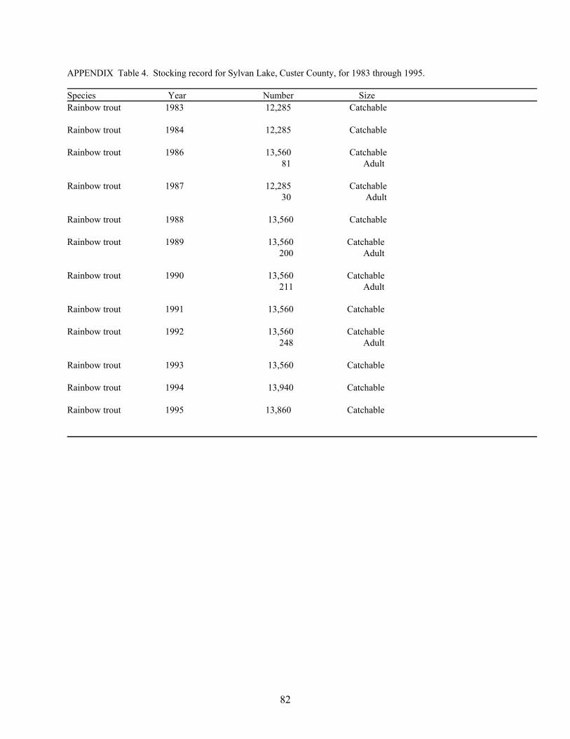
82
APPENDIX Table 4. Stocking record for Sylvan Lake, Custer County, for 1983 through 1995. Species Year Number Size Rainbow trout 1983 12,285 Catchable Rainbow trout 1984 12,285 Catchable Rainbow trout 1986 13,560 Catchable 81 Adult Rainbow trout 1987 12,285 Catchable 30 Adult Rainbow trout 1988 13,560 Catchable Rainbow trout 1989 13,560 Catchable 200 Adult Rainbow trout 1990 13,560 Catchable 211 Adult Rainbow trout 1991 13,560 Catchable Rainbow trout 1992 13,560 Catchable 248 Adult Rainbow trout 1993 13,560 Catchable Rainbow trout 1994 13,940 Catchable Rainbow trout 1995 13,860 Catchable

83
Appendix C
Assessment Data

84
Chemical Data
Site Date Time RelDepth Personnel Depth Fecal E Coli Alka Tot Sol TDS TSS TVSS Ammo Nitrate TKN Tot P TDP NO3+NO4 S Type S Depth Tot N Secchi TSI Chl a TSI Tot P TSI Secchi TSI N TSI MeanComp 16-Jun-04 13:00 Surface Larson/Mateo 44 77 73 4 <1 <.02 <0.10 0.44 0.031 0.01 GRAB 1.0 3.23 53.59 53.67 43.10 50.12Comp 16-Jun-04 13:00 Bottom Larson/Mateo 45 76 75 1 1 0.08 <0.10 0.64 0.029 0.01 GRAB 52.71Comp 22-Jul-04 11:00 Surface Larson/Mateo 43 80 75 5 1 <.02 <0.10 0.39 0.030 0.01 GRAB 1.0 2.55 50.51 53.20 46.51 50.07Comp 22-Jul-04 11:00 Bottom Larson/Mateo 46 80 72 8 2 0.17 <0.10 0.73 0.045 0.01 GRAB 59.04
Site Date Time RelDepth Personnel Depth Fecal E Coli Alka Tot Sol TDS TSS TVSS Ammo Nitrate TKN Tot P TDP NO3+NO4 S Type S Depth Tot N Secchi TSI Chl a TSI Tot P TSI Secchi TSI N TSI MeanSL05 23-Aug-01 10:57 Scott Alan 0.5 2 36 74 58 16 <0.10 2.10 0.090 <0.01 <0.05 GRAB 0.2 2.10 69.04 65.16SL05 25-Sep-01 15:32 Scott Alan 0.6 <2 34 78 69 9 0.10 1.50 0.070 0.02 0.12 GRAB 0.3 1.62 65.41 61.41SL05 18-Apr-02 15:58 Scott Alan 0.5 <2 <2 44 68 42 26 0.30 1.00 0.090 0.02 0.15 GRAB 0.2 1.15 69.04 56.47SL05 24-Apr-02 12:00 Scott Alan 0.5 <2 <2 42 84 78 6 0.30 1.10 0.060 <0.01 0.07 GRAB 0.2 1.17 63.19 56.72SL05 2-May-02 11:17 Scott Alan 0.7 <2 <2 40 78 69 9 0.10 0.90 0.130 0.01 <0.05 GRAB 0.3 0.90 74.34 52.93SL05 26-Jun-02 13:41 Scott Alan 0.6 48 10 38 86 65 21 <0.10 0.70 0.080 0.02 <0.05 GRAB 0.3 0.70 67.34 49.30SL05 21-Jul-02 15:00 Scott Alan 0.5 250 <10 38 100 77 23 0.10 0.70 0.040 0.01 <0.05 GRAB 0.3 0.70 57.34 49.30SL05 12-Aug-02 17:03 Scott Alan 0.5 20 <10 40 70 63 7 0.10 1.00 0.050 <0.01 <0.05 GRAB 0.3 1.00 60.56 54.45
Site Date Time RelDepth Personnel Depth Fecal E Coli Alka Tot Sol TDS TSS TVSS Ammo Nitrate TKN Tot P TDP NO3+NO4 S Type S Depth Tot N Secchi TSI Chl a TSI Tot P TSI Secchi TSI N TSI MeanSL1 23-Aug-01 10:14 Surface Scott Alan 26.2 <2 34 62 45 17 <0.10 2.10 0.060 <0.01 <0.05 GRAB 1.0 2.10 0.50 63.19 69.99 65.16 66.59SL1 23-Aug-01 10:14 Bottom Scott Alan 26.2 <2 38 54 48 6 0.10 1.20 0.050 <0.01 <0.05 GRAB 26.2 1.20 60.56 57.08SL1 25-Sep-01 13:45 Surface Scott Alan 24.6 <2 38 58 55.5 <5 <0.10 1.50 0.050 0.02 <0.05 GRAB 1.0 1.50 1.50 60.56 54.16 60.30 57.36SL1 25-Sep-01 13:45 Bottom Scott Alan 24.6 <2 38 72 69.5 <5 0.20 1.20 0.050 0.01 <0.05 GRAB 24.6 1.20 60.56 57.08SL1 31-Oct-01 12:50 Surface Scott Alan 24.6 <5 <2 42 80 77.5 <5 0.40 1.20 0.070 0.02 <0.05 GRAB 1.0 1.20 2.50 65.41 46.80 57.08 56.10SL1 31-Oct-01 13:07 Bottom Scott Alan 24.6 <2 <2 36 72 69.5 <5 0.40 1.20 0.060 0.02 <0.05 GRAB 24.6 1.20 63.19 57.08SL1 27-Dec-01 15:00 Surface Scott Alan 24.6 <2 <2 42 70 67.5 <5 0.40 1.20 0.050 0.04 0.12 GRAB 1.0 1.32 60.56 58.46SL1 27-Dec-01 13:25 Bottom Scott Alan 24.6 <2 <2 44 64 61.5 <5 0.40 1.20 0.050 0.03 0.09 GRAB 24.6 1.29 60.56 58.12SL1 30-Jan-02 15:40 Surface Scott Alan 26.2 <2 <2 40 92 89.5 <5 0.30 1.20 0.070 0.02 0.15 GRAB 1.0 1.35 65.41 58.78SL1 30-Jan-02 16:00 Bottom Scott Alan 26.2 <2 <2 40 70 67.5 <5 0.40 1.20 0.070 0.01 0.07 GRAB 26.2 1.27 65.41 57.90SL1 26-Feb-02 16:45 Surface Scott Alan 23.0 <2 <2 30 50 47.5 <5 0.20 0.80 0.040 <0.01 0.11 GRAB 1.0 0.91 57.34 53.09SL1 26-Feb-02 16:27 Bottom Scott Alan 23.0 <2 <2 34 67 64.5 <5 0.30 1.00 0.040 <0.01 0.11 GRAB 23.0 1.11 57.34 55.96SL1 13-May-02 15:27 Surface Scott Alan 23.0 <2 <2 36 64 16 48 <0.10 0.80 0.040 0.01 <0.05 GRAB 1.0 0.80 1.50 57.34 54.16 51.23 55.75SL1 13-May-02 15:27 Bottom Scott Alan 23.0 <2 <2 36 62 22 40 <0.10 0.60 0.040 0.02 <0.05 GRAB 23.0 0.60 57.34 47.08SL1 6-Jun-02 Surface Scott Alan 24.6 <2 <2 42 64 61.5 <5 <0.10 <0.50 0.020 <0.01 <0.05 GRAB 1.0 4.25 47.35 39.15 43.25SL1 6-Jun-02 16:40 Bottom Scott Alan 24.6 <2 <2 38 63 60.5 <5 0.10 0.80 0.040 <0.01 <0.05 GRAB 24.6 0.80 57.34 51.23SL1 1-Jul-02 9:50 Surface Scott Alan 26.2 <2 <10 38 74 71.5 <5 <0.10 0.70 0.040 <0.01 <0.05 GRAB 1.0 0.70 2.00 57.34 50.01 49.30 53.68SL1 1-Jul-02 9:50 Bottom Scott Alan 26.2 <2 <10 44 74 66 8 0.40 1.10 0.060 0.01 <0.05 GRAB 26.2 1.10 63.19 55.83SL1 5-Aug-02 15:28 Surface Scott Alan 24.6 <2 <10 38 66 61 5 <0.10 0.90 0.030 <0.01 <0.05 GRAB 1.0 0.90 1.50 53.20 54.16 52.93 53.68SL1 5-Aug-02 15:28 Bottom Scott Alan 24.6 <2 <10 44 64 58 6 0.20 1.20 0.020 0.08 <0.05 GRAB 24.6 1.20 47.35 57.08SL1 17-Apr-03 12:45 Surface Larson/Goyer 24.0 41 76 68 8 3 <0.02 <0.10 0.39 0.058 0.03 GRAB 1.0 0.80 62.70 63.22SL1 17-Apr-03 12:45 Bottom Larson/Goyer 24.0 52 88 76 12 4 0.52 <0.10 0.71 0.067 0.03 GRAB 24.0 64.78SL1 16-May-03 11:00 Bottom Larson/Goyer 25.0 40 74 69 5 2 <0.02 <0.10 <0.11 0.065 0.03 GRAB 25.0 64.34SL1 16-May-03 11:00 Surface Larson/Goyer 25.0 39 70 65 5 3 <0.02 <0.10 0.34 0.036 0.02 GRAB 1.0 1.00 50.00 55.82 60.00 55.27SL1 12-Jun-03 11:05 Surface Larson/Goyer 25.5 40 70 64 6 5 <0.02 <0.10 0.42 0.030 0.01 GRAB 1.0 2.40 53.20 47.38SL1 12-Jun-03 11:05 Bottom Larson/Goyer 25.5 44 75 65 10 7 0.03 <0.10 0.31 0.047 0.02 GRAB 25.5 59.67SL1 2-Jul-03 11:00 Bottom Larson/Goyer 25.7 45 86 74 12 7 0.06 <0.10 0.60 0.084 0.02 GRAB 25.0 68.04SL1 2-Jul-03 11:00 Surface Larson/Goyer 25.7 40 75 71 4 3 <0.02 <0.10 0.48 0.027 0.02 GRAB 1.0 3.70 47.00 51.68 41.15 46.61SL1 17-Jul-03 11:30 Bottom Larson/Goyer 25.0 48 85 76 9 7 0.27 <0.10 0.87 0.074 0.03 GRAB 25.0 66.21SL1 17-Jul-03 11:30 Surface Larson/Goyer 25.0 40 69 64 5 3 <0.02 <0.10 0.42 0.027 0.02 GRAB 1.0 2.20 48.00 51.68 48.64 49.44SL1 19-Aug-03 12:30 Bottom Larson/Goyer 23.4 62 105 99 6 4 1.04 <0.10 1.43 0.084 0.03 GRAB 23.0 68.04SL1 19-Aug-03 12:30 Surface Larson/Goyer 23.4 40 81 75 6 6 <0.02 <0.10 0.67 0.036 0.02 GRAB 1.0 1.10 63.00 55.82 58.63 59.15

85
Site Date Time RelDepth Personnel Depth Fecal E Coli Alka Tot Sol TDS TSS TVSS Ammo Nitrate TKN Tot P TDP NO3+NO4 S Type S Depth Tot N Secchi TSI Chl a TSI Tot P TSI Secchi TSI N TSI MeanSL2 23-Aug-01 9:50 Surface Scott Alan 8.2 <2 34 70 61 9 <0.10 1.50 0.050 <0.01 <0.05 GRAB 1.0 1.50 1.00 60.56 60.00 60.30 60.28SL2 23-Aug-01 9:50 Bottom Scott Alan 8.2 <2 34 54 38 16 <0.10 1.50 0.060 <0.01 <0.05 GRAB 8.2 1.50 63.19 60.30SL2 25-Sep-01 12:05 Surface Scott Alan 6.6 <2 38 60 52 8 0.10 1.20 0.050 0.02 <0.05 GRAB 1.0 1.20 1.50 60.56 54.16 57.08 57.36SL2 25-Sep-01 12:05 Bottom Scott Alan 7.4 <2 36 78 72 6 0.10 1.20 0.060 0.02 <0.05 GRAB 7.4 1.20 63.19 57.08SL2 31-Oct-01 13:27 Surface Scott Alan 6.6 <2 <2 38 78 75.5 <5 0.40 1.20 0.080 0.03 <0.05 GRAB 1.0 1.20 2.00 67.34 50.01 57.08 58.68SL2 31-Oct-01 13:43 Bottom Scott Alan 7.4 <2 <2 38 70 67.5 <5 0.40 1.50 0.080 0.02 <0.05 GRAB 7.4 1.50 67.34 60.30SL2 27-Dec-01 16:01 Surface Scott Alan 6.6 <2 <2 40 72 67 5 0.40 1.10 0.060 0.02 0.12 GRAB 1.0 1.22 63.19 57.32SL2 27-Dec-01 16:27 Bottom Scott Alan 6.6 <2 <2 46 72 69.5 <5 0.40 1.20 0.060 0.02 0.12 GRAB 6.6 1.32 63.19 58.46SL2 30-Jan-02 16:27 Surface Scott Alan 6.6 <2 <2 42 78 75.5 <5 0.20 0.90 0.050 <0.01 0.12 GRAB 1.0 1.02 60.56 54.74SL2 30-Jan-02 16:47 Bottom Scott Alan 6.6 <2 <2 40 78 73 5 0.20 0.90 0.050 <0.01 0.11 GRAB 6.6 1.01 60.56 54.59SL2 26-Feb-02 16:55 Surface Scott Alan 6.9 <2 <2 30 50 47.5 <5 <0.10 0.80 0.040 <0.01 0.09 GRAB 1.0 0.89 57.34 52.77SL2 26-Feb-02 17:17 Bottom Scott Alan 6.6 <2 <2 32 62 59.5 <5 <0.10 1.20 0.060 <0.01 0.09 GRAB 6.6 1.29 63.19 58.12SL2 13-May-02 15:49 Surface Scott Alan 8.2 <2 <2 38 70 24 46 <0.10 0.90 0.050 0.01 0.17 GRAB 1.0 1.07 1.00 60.56 60.00 55.43 60.28SL2 13-May-02 15:49 Bottom Scott Alan 8.2 <2 <2 34 70 8.0 62 <0.10 0.90 0.060 0.01 <0.05 GRAB 8.2 0.90 63.19 52.93SL2 6-Jun-02 17:10 Surface Scott Alan 8.2 <2 <2 34 58 55.5 <5 <0.10 0.60 0.020 <0.01 <0.05 GRAB 1.0 0.60 2.50 47.35 46.80 47.08 47.07SL2 6-Jun-02 17:49 Bottom Scott Alan 8.2 <2 <2 36 69 66.5 <5 <0.10 0.60 0.020 0.01 <0.05 GRAB 8.2 0.60 47.35 47.08SL2 1-Jul-02 10:24 Surface Scott Alan 8.2 <2 <10 36 74 71.5 <5 <0.10 0.60 0.030 0.01 <0.05 GRAB 1.0 0.60 2.00 53.20 50.01 47.08 51.60SL2 1-Jul-02 10:24 Bottom Scott Alan 8.2 2 <2 36 70 67.5 <5 <0.10 0.60 0.020 0.01 <0.05 GRAB 8.2 0.60 47.35 47.08SL2 5-Aug-02 15:49 Surface Scott Alan 8.2 <2 <10 38 64 59 5 <0.10 0.90 0.030 <0.01 <0.05 GRAB 1.0 0.90 1.25 53.20 56.78 52.93 54.99SL2 5-Aug-02 15:49 Bottom Scott Alan 8.2 <2 <10 36 58 53 5 <0.10 0.80 0.030 <0.01 <0.05 GRAB 8.2 0.80 53.20 51.23SL2 17-Apr-03 14:30 Bottom Larson/Goyer 10.0 42 86 64 22 4 <0.02 <0.10 0.18 0.065 0.02 GRAB 10.0 64.34SL2 17-Apr-03 14:30 Surface Larson/Goyer 10.0 42 79 69 10 3 <0.02 <0.10 0.29 0.070 0.03 GRAB 1.0 0.90 65.41 61.52SL2 16-May-03 10:20 Bottom Larson/Goyer 7.0 39 75 67 8 4 0.07 <0.10 0.49 0.042 0.02 GRAB 7.0 58.05SL2 16-May-03 10:20 Surface Larson/Goyer 7.0 38 74 69 5 4 <0.02 <0.10 0.38 0.031 0.02 GRAB 1.0 0.90 49.00 53.67 61.52 54.73SL2 12-Jun-03 10:10 Surface Larson/Goyer 12.3 40 69 65 4 4 <0.02 <0.10 0.29 0.024 0.02 GRAB 1.0 2.60 31.00 49.98 46.23 42.40SL2 12-Jun-03 10:10 Bottom Larson/Goyer 12.3 40 72 67 5 4 <0.02 <0.10 0.34 0.047 0.01 GRAB 12.0 59.67SL2 2-Jul-03 10:30 Surface Larson/Goyer 11.8 39 73 68 5 3 <0.02 <0.10 0.43 0.024 0.02 GRAB 1.0 3.60 46.00 49.98 41.54 45.84SL2 2-Jul-03 10:30 Bottom Larson/Goyer 11.8 39 74 67 7 6 <0.02 <0.10 0.45 0.033 0.02 GRAB 11.0 54.57SL2 17-Jul-03 10:30 Bottom Larson/Goyer 15.0 41 75 68 7 4 <0.02 <0.10 0.48 0.038 0.02 GRAB 15.0 56.60SL2 17-Jul-03 10:30 Surface Larson/Goyer 15.0 40 71 65 6 3 <0.02 <0.10 0.36 0.030 0.02 GRAB 1.0 2.20 53.00 53.20 48.64 51.61SL2 19-Aug-03 12:00 Bottom Larson/Goyer 13.1 41 86 80 6 5 <0.02 <0.10 0.63 0.047 0.02 GRAB 13.0 59.67SL2 19-Aug-03 12:00 Surface Larson/Goyer 13.1 40 84 80 4 3 <0.02 <0.10 0.70 0.040 0.02 GRAB 1.0 1.00 64.00 57.34 60.00 60.45
Site Date Time RelDepth Personnel Depth Fecal E Coli Alka Tot Sol TDS TSS TVSS Ammo Nitrate TKN Tot P TDP NO3+NO4 S Type S Depth Tot N Secchi TSI Chl a TSI Tot P TSI Secchi TSI N TSI MeanSLT3 23-Aug-01 11:35 Scott Alan 0.3 30 18 58 53 5 <0.10 <0.50 0.150 0.12 0.06 GRAB 0.2 0.06 76.40 13.85SLT3 25-Sep-01 15:06 Scott Alan 0.4 35 20 44 39 5 <0.10 <0.50 0.180 0.15 0.09 GRAB 0.2 0.09 79.03 19.70SLT3 10-Oct-01 11:29 Scott Alan 0.4 <4 18 52 49.5 <5 <0.10 0.60 0.190 0.14 0.09 GRAB 0.2 0.69 79.81 49.10SLT3 31-Oct-01 12:08 Scott Alan 0.4 <2 <2 20 72 69.5 <5 <0.10 <0.50 0.190 0.13 0.06 GRAB 0.2 0.06 79.81 13.85SLT3 18-Apr-02 15:20 Scott Alan 0.4 <2 <2 22 50 47.5 <5 <0.10 <0.50 0.080 0.07 0.06 GRAB 0.2 0.06 67.34 13.85SLT3 24-Apr-02 10:33 Scott Alan 0.3 4 2 24 86 83.5 <5 <0.10 <0.50 0.030 <0.01 0.05 GRAB 0.2 0.05 53.20 11.22SLT3 2-May-02 9:50 Scott Alan 0.3 2 <2 24 110 104 6 <0.10 <0.50 0.040 <0.01 0.07 GRAB 0.2 0.07 57.34 16.08SLT3 26-Jun-02 13:05 Scott Alan 0.3 6 6 22 74 67 7 <0.10 <0.50 0.060 0.04 <0.05 GRAB 0.2 63.19SLT3 21-Jul-02 14:31 Scott Alan 0.2 690 <10 36 80 74 6 <0.10 <0.50 0.080 0.04 <0.05 GRAB 0.2 67.34SLT3 12-Aug-02 16:32 Scott Alan 0.2 50 <2 26 62 59.5 <5 <0.10 <0.50 0.130 0.03 <0.05 GRAB 0.2 74.34
Site Date Time RelDepth Personnel Depth Fecal E Coli Alka Tot Sol TDS TSS TVSS Ammo Nitrate TKN Tot P TDP NO3+NO4 S Type S Depth Tot N Secchi TSI Chl a TSI Tot P TSI Secchi TSI N TSI MeanSLT4 23-Aug-01 11:55 Scott Alan 0.2 20 24 46 44 <5 <0.10 0.60 0.060 0.03 0.15 GRAB 0.3 0.75 63.19 50.30SLT4 25-Sep-01 15:24 Scott Alan 0.1 2 26 72 54 18 <0.10 <0.50 0.090 0.05 <0.05 GRAB 0.3 69.04SLT4 10-Oct-01 11:40 Scott Alan 0.2 5 24 38 36 <5 <0.10 <0.50 0.050 0.03 <0.05 GRAB 0.3 60.56SLT4 31-Oct-01 14:08 Scott Alan 0.1 <2 <2 24 74 72 <5 <0.10 <0.50 0.080 0.02 <0.05 GRAB 0.3 67.34SLT4 18-Apr-02 15:36 Scott Alan 0.1 <2 <2 16 58 52 6 <0.10 <0.50 0.180 0.15 0.13 GRAB 0.1 0.13 79.03 25.01SLT4 24-Apr-02 11:10 Scott Alan 0.1 <2 <2 42 80 69 11 <0.10 <0.50 0.150 0.10 0.11 GRAB 0.1 0.11 76.40 22.60SLT4 2-May-02 10:33 Scott Alan 0.1 <2 <2 16 76 65 11 <0.10 0.25 0.160 0.08 <0.05 GRAB 0.2 0.25 77.33 34.45SLT4 26-Jun-02 13:20 Scott Alan 0.2 56 12 14 65 63 <5 <0.10 <0.50 0.130 0.11 <0.05 GRAB 0.3 74.34SLT4 21-Jul-02 14:15 Scott Alan 0.2 780 <10 14 82 74 8 <0.10 0.60 0.160 0.11 0.06 GRAB 0.2 0.66 77.33 48.45SLT4 12-Aug-02 16:18 Scott Alan 0.2 30 <10 16 52 50 <5 <0.10 <0.50 0.130 0.12 0.08 GRAB 0.2 0.08 74.34 18.00

86
Site Date Time RelDepth Personnel Depth Fecal E Coli Alka Tot Sol TDS TSS TVSS Ammo Nitrate TKN Tot P TDP NO3+NO4 S Type S Depth Tot N Secchi TSI Chl a TSI Tot P TSI Secchi TSI N TSI MeanUnK 16-Nov-77 12:30 Surface Nelson Gene <3 30 77 62 15 0.03 <0.10 1.05 0.058 0.03 GRAB 62.70UnK 6-Feb-78 14:00 Surface Nelson Gene <3 39 82 77 5 0.30 <0.10 1.18 0.113 0.01 GRAB 72.32UnK 4-May-78 13:15 Surface Nelson Gene <3 27 98 85 13 <0.02 <0.10 1.27 0.057 0.01 GRAB 62.45UnK 9-Aug-78 10:30 Surface Nelson Gene 3 20 80 71 9 0.02 <0.10 1.24 0.027 0.02 GRAB 51.68UnK 11-Sep-79 13:30 Surface Nelson Gene 32 65 58 7 0.16 <0.05 0.74 0.100 <0.01 GRAB 70.56UnK 6-Oct-81 17:05 Bottom Goebel Greg 52 1.10 0.18 2.10 0.270 0.21 GRAB 22.0 84.88UnK 6-Oct-81 17:10 Bottom Goebel Greg 27.0 72 3.10 <0.10 8.30 2.450 1.32 GRAB 25.0 116.68UnK 6-Oct-81 16:55 Bottom Goebel Greg 40 30 21 9 0.06 <0.10 0.86 0.070 0.04 GRAB 17.0 65.41UnK 6-Oct-81 16:45 Midwater Goebel Greg 40 10 3 7 0.03 <0.10 0.88 0.054 0.02 GRAB 12.0 61.67UnK 6-Oct-81 16:20 Surface Goebel Greg 39 49 39 10 0.06 <0.10 0.59 0.045 0.02 GRAB 2.0 59.04UnK 6-Oct-81 16:35 Surface Goebel Greg 37 12 5 7 <0.03 <0.10 1.00 0.095 0.05 GRAB 7.0 69.82UnK 4-Nov-81 11:20 Bottom Goebel Greg 45 96 85 11 0.09 0.12 0.70 0.077 0.03 GRAB 14.0 66.79UnK 4-Nov-81 10:30 Surface Goebel Greg 17.0 44 96 83 13 0.05 0.10 0.65 0.082 0.04 GRAB 2.0 1.07 67.69 59.03UnK 4-Nov-81 11:00 Midwater Goebel Greg 43 100 88 12 0.05 0.10 0.62 0.076 0.03 GRAB 8.0 66.60UnK 7-Dec-81 10:00 Surface Goebel Greg 15.5 36 68 65 3 0.20 0.13 1.28 0.055 0.04 GRAB 2.0 1.37 61.94 55.46UnK 7-Dec-81 10:20 Midwater Goebel Greg 38 76 71 5 0.20 0.14 1.50 0.060 0.04 GRAB 7.0 63.19UnK 7-Dec-81 10:30 Midwater Goebel Greg 37 64 60 4 0.19 0.12 1.40 0.075 0.03 12.0 66.41UnK 14-Jan-82 10:00 Midwater Goebel Greg 40 68 66 2 0.51 0.15 1.47 0.093 0.05 GRAB 8.0 69.51UnK 14-Jan-82 10:20 Bottom Goebel Greg 16.0 40 68 65 3 0.51 0.17 1.37 0.097 0.06 GRAB 13.0 70.12UnK 14-Jan-82 9:30 Surface Goebel Greg 40 61 59 2 0.46 0.20 1.42 0.087 0.04 GRAB 2.0 1.52 68.55 53.97UnK 3-Feb-82 10:15 Midwater Goebel Greg 23 18 5 0.59 0.13 1.14 0.097 0.06 GRAB 8.0 70.12UnK 3-Feb-82 10:30 Bottom Goebel Greg 28 24 4 0.60 0.12 0.76 0.089 0.08 GRAB 14.0 68.88UnK 3-Feb-82 10:00 Surface Goebel Greg 17.0 42 40 2 0.59 0.13 1.28 0.090 0.04 GRAB 2.0 1.07 69.04 59.03UnK 3-Mar-82 10:00 Surface Goebel Greg 58 50 8 0.29 0.13 1.37 0.093 0.04 GRAB 2.0 0.53 69.51 69.15UnK 3-Mar-82 10:20 Midwater Goebel Greg 62 54 8 0.44 0.15 1.25 0.080 0.06 GRAB 8.0 67.34UnK 3-Mar-82 10:30 Bottom Goebel Greg 17.0 56 47 9 0.64 0.13 1.36 0.140 0.12 GRAB 14.0 75.41UnK 31-Mar-82 11:00 Surface Goebel Greg 42 39 3 0.19 0.16 0.84 0.077 0.07 GRAB 2.0 1.22 66.79 57.13UnK 31-Mar-82 11:20 Midwater Goebel Greg 78 69 9 0.31 0.26 1.38 0.100 0.06 GRAB 8.0 70.56UnK 31-Mar-82 11:30 Bottom Goebel Greg 17.5 130 104 26 0.59 0.39 1.68 0.196 0.13 GRAB 15.0 80.26UnK 28-Apr-82 10:40 Midwater Goebel Greg 18.5 120 114 6 <0.03 0.17 1.85 0.068 0.03 GRAB 7.0 65.00UnK 28-Apr-82 11:00 Midwater Goebel Greg 18.5 92 85 7 0.05 0.14 1.15 0.058 0.03 GRAB 12.0 62.70UnK 28-Apr-82 10:10 Surface Goebel Greg 18.5 76 66 10 <0.03 0.15 2.05 0.066 0.03 GRAB 2.0 0.68 64.56 65.56UnK 28-Apr-82 11:05 Bottom Goebel Greg 18.5 104 98 6 0.14 0.14 1.10 0.072 0.06 GRAB 16.0 65.82UnK 25-May-82 10:30 Surface Goebel Greg 22.3 78 61 17 0.41 0.63 0.71 0.123 0.07 GRAB 2.0 0.30 73.54 77.35UnK 25-May-82 11:00 Surface Goebel Greg 78 61 17 <0.03 0.17 1.03 0.092 0.06 GRAB 6.5 69.35UnK 25-May-82 11:20 Midwater Goebel Greg 72 55 17 0.03 0.36 0.90 0.110 0.05 GRAB 11.0 71.93UnK 25-May-82 11:30 Midwater Goebel Greg 70 56 14 <0.03 0.58 0.78 0.075 0.03 GRAB 15.5 66.41UnK 25-May-82 11:45 Bottom Goebel Greg 66 51 15 <0.03 0.11 0.77 0.079 0.03 GRAB 20.0 67.16UnK 8-Jun-82 11:50 Bottom Goebel Greg 25.3 66 58 8 0.14 0.13 0.71 0.084 0.05 GRAB 23.0 68.04UnK 8-Jun-82 11:40 Bottom Goebel Greg 25.3 69 60 9 <0.03 0.15 0.52 0.067 0.04 GRAB 17.8 64.78UnK 8-Jun-82 10:50 Surface Goebel Greg 25.3 70 64 6 0.03 0.12 0.74 0.075 0.03 GRAB 2.0 0.61 66.41 67.12UnK 8-Jun-82 11:10 Surface Goebel Greg 25.3 45 40 5 <0.03 0.18 0.74 0.080 0.05 GRAB 7.3 0.61 67.34 67.12UnK 8-Jun-82 11:30 Midwater Goebel Greg 25.3 58 48 10 <0.03 0.11 0.52 0.068 0.04 GRAB 12.5 65.00UnK 23-Jun-82 10:50 Bottom Goebel Greg 26.0 18 18 <1 0.59 <0.10 1.19 0.200 0.15 GRAB 24.0 80.55UnK 23-Jun-82 9:40 Surface Goebel Greg 26.0 38 30 8 <0.03 <0.10 0.53 0.082 0.03 GRAB 2.0 0.61 67.69 67.12UnK 23-Jun-82 10:05 Surface Goebel Greg 26.0 45 36 9 <0.03 <0.10 0.62 0.105 0.04 GRAB 6.5 71.26UnK 23-Jun-82 10:15 Midwater Goebel Greg 26.0 33 20 13 0.04 0.12 0.71 0.132 0.05 GRAB 11.0 74.56UnK 23-Jun-82 10:25 Midwater Goebel Greg 26.0 29 24 5 <0.03 0.10 0.51 0.087 0.04 GRAB 15.5 68.55UnK 23-Jun-82 10:35 Bottom Goebel Greg 26.0 29 22 7 0.16 0.12 0.65 0.115 0.06 GRAB 20.0 72.57UnK 7-Jul-82 9:10 Surface Goebel Greg 27.0 77 66 11 0.06 <0.10 0.53 0.068 0.01 GRAB 7.5 0.91 65.00 61.36UnK 7-Jul-82 9:40 Bottom Goebel Greg 27.0 78 58 20 1.12 <0.10 1.59 0.310 0.25 GRAB 25.0 86.87UnK 7-Jul-82 9:20 Midwater Goebel Greg 27.0 63 52 11 0.05 0.10 0.53 0.092 0.04 GRAB 13.0 69.35UnK 7-Jul-82 8:45 Surface Goebel Greg 27.0 57 52 5 0.06 0.10 0.47 0.072 0.03 GRAB 2.0 0.91 65.82 61.36UnK 7-Jul-82 9:30 Bottom Goebel Greg 27.0 75 62 13 0.10 0.13 0.61 0.124 0.08 GRAB 18.5 73.66UnK 22-Jul-82 9:00 Surface Goebel Greg 24.0 66 60 6 0.42 <0.10 1.82 0.084 0.03 GRAB 2.0 0.53 68.04 69.15UnK 22-Jul-82 9:20 Surface Goebel Greg 24.0 69 60 9 0.10 0.30 1.57 0.070 0.02 GRAB 7.0 0.53 65.41 69.15UnK 22-Jul-82 9:30 Midwater Goebel Greg 24.0 55 44 11 0.18 <0.10 0.70 0.111 0.06 GRAB 12.0 72.06UnK 22-Jul-82 9:40 Bottom Goebel Greg 24.0 75 66 9 0.37 0.28 0.87 0.162 0.13 GRAB 17.0 77.51UnK 22-Jul-82 9:50 Bottom Goebel Greg 24.0 72 58 14 1.30 <0.10 1.78 0.355 0.31 GRAB 22.0 88.83UnK 5-Aug-82 9:45 Bottom Goebel Greg 24.5 72 10 62 1.68 0.13 2.13 0.418 0.39 GRAB 22.5 91.18UnK 5-Aug-82 9:40 Bottom Goebel Greg 24.5 78 73 5 0.40 0.16 0.96 0.200 0.16 GRAB 17.0 80.55

87
Site Date Time RelDepth Personnel Depth Fecal E Coli Alka Tot Sol TDS TSS TVSS Ammo Nitrate TKN Tot P TDP NO3+NO4 S Type S Depth Tot N Secchi TSI Chl a TSI Tot P TSI Secchi TSI N TSI MeanUnK 5-Aug-82 9:00 Surface Goebel Greg 24.5 68 62 6 0.04 0.12 0.70 0.063 0.03 GRAB 2.0 1.07 63.89 59.03UnK 5-Aug-82 9:15 Surface Goebel Greg 24.5 86 83 3 0.04 0.10 0.84 0.071 0.03 GRAB 7.0 1.07 65.62 59.03UnK 5-Aug-82 9:30 Midwater Goebel Greg 24.5 76 62 14 0.09 0.12 0.68 0.095 0.05 GRAB 12.0 69.82UnK 18-Aug-82 10:00 Bottom Goebel Greg 24.0 80 56 24 1.50 <0.10 2.33 0.416 0.20 GRAB 22.0 91.11UnK 18-Aug-82 9:10 Surface Goebel Greg 24.0 32 24 8 0.03 0.10 0.87 0.068 0.02 GRAB 2.0 0.84 65.00 62.51UnK 18-Aug-82 9:25 Surface Goebel Greg 24.0 68 56 12 <0.03 <0.10 0.82 0.080 0.03 GRAB 7.0 67.34UnK 18-Aug-82 9:40 Midwater Goebel Greg 24.0 76 59 17 0.25 <0.10 0.96 0.120 0.07 GRAB 12.0 73.19UnK 18-Aug-82 9:50 Bottom Goebel Greg 24.0 79 55 24 0.65 0.11 1.10 0.250 0.20 GRAB 17.0 83.77UnK 9-Sep-82 10:10 Bottom Goebel Greg 25.0 102 78 24 2.50 <0.10 3.52 0.535 0.52 GRAB 23.0 94.74UnK 9-Sep-82 10:00 Bottom Goebel Greg 25.0 82 69 13 0.80 <0.10 1.52 0.245 0.22 GRAB 17.0 83.48UnK 9-Sep-82 9:45 Midwater Goebel Greg 25.0 66 61 5 0.20 <0.10 1.02 0.071 0.03 GRAB 12.0 65.62UnK 9-Sep-82 9:00 Surface Goebel Greg 25.0 58 53 5 0.06 <0.10 1.12 0.070 0.03 GRAB 2.0 0.91 65.41 61.36UnK 9-Sep-82 9:30 Surface Goebel Greg 25.0 64 60 4 0.07 <0.10 0.72 0.056 0.02 GRAB 7.0 62.20UnK 7-Oct-82 10:55 Bottom Goebel Greg 50 46 4 0.39 0.13 0.76 0.120 0.06 GRAB 23.0 73.19UnK 7-Oct-82 10:00 Surface Goebel Greg 25.0 46 41 5 0.26 0.13 0.77 0.104 0.07 GRAB 2.0 0.99 71.12 60.14UnK 7-Oct-82 10:15 Surface Goebel Greg 42 38 4 0.28 0.14 0.79 0.115 0.06 GRAB 7.0 72.57UnK 7-Oct-82 10:30 Midwater Goebel Greg 40 33 7 0.28 0.14 0.80 0.115 0.07 GRAB 12.0 72.57UnK 7-Oct-82 10:40 Bottom Goebel Greg 36 30 6 0.29 0.13 0.76 0.140 0.09 GRAB 17.0 75.41UnK 22-Nov-82 9:30 Surface Goebel Greg 26.0 68 61 7 0.20 0.21 1.34 0.160 0.12 GRAB 2.0 1.22 77.33 57.13UnK 22-Nov-82 10:10 Surface Goebel Greg 64 55 9 0.19 0.21 0.84 0.090 0.06 GRAB 7.5 69.04UnK 22-Nov-82 10:30 Midwater Goebel Greg 72 64 8 0.17 0.16 1.13 0.095 0.06 GRAB 13.0 69.82UnK 22-Nov-82 10:40 Bottom Goebel Greg 86 83 3 0.19 0.20 1.01 0.138 0.07 GRAB 18.5 75.20UnK 22-Nov-82 10:45 Bottom Goebel Greg 86 83 3 0.18 0.20 0.88 0.142 0.07 GRAB 24.0 75.61UnK 15-Dec-82 10:05 Bottom Goebel Greg 70 67 3 0.31 0.26 0.72 0.085 0.06 GRAB 18.5 68.21UnK 15-Dec-82 9:10 Surface Goebel Greg 26.0 94 88 6 0.32 0.31 0.83 0.145 0.11 GRAB 2.0 1.22 75.91 57.13UnK 15-Dec-82 9:50 Midwater Goebel Greg 60 58 2 0.32 0.26 0.70 0.080 0.05 GRAB 13.0 67.34UnK 15-Dec-82 10:20 Bottom Goebel Greg 50 49 1 0.32 0.21 0.70 0.095 0.06 GRAB 24.0 69.82UnK 15-Dec-82 9:25 Surface Goebel Greg 64 60 4 0.32 0.25 0.81 0.090 0.06 GRAB 7.5 69.04UnK 19-Jan-83 9:10 Surface Goebel Greg 27.0 66 64 2 0.37 0.30 0.92 0.117 0.06 GRAB 2.0 1.52 72.82 53.97UnK 19-Jan-83 9:30 Midwater Goebel Greg 8 6 2 0.45 0.25 0.96 0.115 0.07 GRAB 13.5 72.57UnK 19-Jan-83 9:45 Bottom Goebel Greg 80 72 8 0.70 0.20 1.23 0.200 0.16 GRAB 25.0 80.55UnK 22-Feb-83 9:20 Surface Goebel Greg 70 62 8 0.29 0.23 8.91 0.800 0.51 GRAB 8.0 100.54UnK 22-Feb-83 9:20 Midwater Goebel Greg 24 20 4 0.73 0.19 1.06 0.110 0.09 GRAB 13.5 71.93UnK 22-Feb-83 10:00 Bottom Goebel Greg 80 67 13 0.96 <0.10 1.56 0.310 0.29 GRAB 25.0 86.87UnK 22-Feb-83 9:10 Surface Goebel Greg 27.0 68 65 3 0.35 0.21 0.97 0.105 0.06 GRAB 2.0 1.83 71.26 51.29UnK 24-Mar-83 9:25 Midwater Goebel Greg 54 50 4 0.23 0.15 0.80 0.075 0.04 GRAB 14.0 66.41UnK 24-Mar-83 9:40 Bottom Goebel Greg 82 66 16 1.75 <0.10 2.13 0.595 0.59 GRAB 26.0 96.27UnK 24-Mar-83 9:10 Surface Goebel Greg 8.5 60 49 11 <0.03 0.19 1.15 0.208 0.14 GRAB 2.0 0.55 81.12 68.61UnK 19-Apr-83 9:15 Surface Goebel Greg 28.0 48 47 1 0.04 0.13 0.64 0.053 0.01 GRAB 2.0 1.37 61.40 55.46UnK 19-Apr-83 9:50 Midwater Goebel Greg 48 44 4 0.12 0.13 0.96 0.078 0.01 GRAB 14.0 66.97UnK 19-Apr-83 10:00 Bottom Goebel Greg 72 60 12 1.60 0.10 2.18 0.548 0.24 GRAB 26.0 95.09UnK 9-May-83 10:00 Surface Goebel Greg 27.0 78 72 6 <0.03 0.12 0.80 0.069 0.02 GRAB 2.0 1.07 65.21 59.03UnK 9-May-83 10:40 Midwater Goebel Greg 27.0 54 48 6 <0.03 0.13 0.69 0.102 0.02 GRAB 13.5 70.84UnK 9-May-83 11:00 Bottom Goebel Greg 27.0 96 82 14 0.77 0.18 1.38 0.250 0.11 GRAB 25.0 83.77UnK 23-May-83 9:40 Surface Goebel Greg 28.0 56 50 6 <0.03 <0.10 0.64 0.070 0.06 GRAB 2.0 1.22 65.41 57.13UnK 23-May-83 10:30 Bottom Goebel Greg 28.0 62 53 9 0.06 <0.10 0.92 0.220 0.08 GRAB 26.0 81.93UnK 23-May-83 10:10 Bottom Goebel Greg 28.0 66 62 4 <0.03 <0.10 0.55 0.020 0.06 GRAB 20.0 47.35UnK 23-May-83 10:00 Midwater Goebel Greg 28.0 62 56 6 <0.03 <0.10 0.68 0.165 0.06 GRAB 14.0 77.78UnK 8-Jun-83 9:40 Surface Goebel Greg 28.0 52 47 5 <0.03 <0.10 0.40 0.020 0.01 GRAB 2.0 1.52 47.35 53.97UnK 8-Jun-83 10:15 Midwater Goebel Greg 40 32 8 <0.03 <0.10 0.46 0.063 0.01 GRAB 14.0 63.89UnK 8-Jun-83 10:35 Bottom Goebel Greg 70 55 15 0.82 <0.10 1.28 0.257 0.08 GRAB 26.0 84.17UnK 22-Jun-83 9:15 Surface Goebel Greg 28.0 47 44 3 <0.03 <0.10 0.41 0.025 <0.01 GRAB 2.0 2.13 50.57 49.10UnK 22-Jun-83 9:40 Midwater Goebel Greg 28 19 9 <0.03 <0.10 0.59 0.085 <0.01 GRAB 14.0 68.21UnK 22-Jun-83 10:00 Bottom Goebel Greg 28.0 56 49 7 0.65 <0.10 1.13 0.289 0.09 GRAB 26.0 85.86UnK 6-Jul-83 10:30 Bottom Goebel Greg 27.0 100 80 20 0.34 <0.10 0.89 0.230 0.20 GRAB 25.0 82.57UnK 6-Jul-83 9:55 Surface Goebel Greg 27.0 58 55 3 <0.03 <0.10 0.42 0.025 0.01 GRAB 2.0 50.57UnK 6-Jul-83 10:15 Midwater Goebel Greg 80 74 6 <0.03 <0.10 0.41 0.040 0.01 GRAB 13.5 57.34UnK 21-Jul-83 11:45 Bottom Goebel Greg 27.5 76 62 14 1.20 0.13 1.94 0.516 0.51 GRAB 25.5 94.22UnK 21-Jul-83 10:55 Surface Goebel Greg 27.5 52 47 5 <0.03 0.12 0.95 0.037 0.01 GRAB 2.0 1.37 56.22 55.46UnK 21-Jul-83 11:20 Midwater Goebel Greg 58 48 10 0.05 0.14 0.98 0.090 0.01 GRAB 13.8 69.04UnK 4-Aug-83 11:00 Surface Goebel Greg 28.0 42 39 3 <0.03 <0.10 0.83 0.040 <0.01 GRAB 2.0 1.22 57.34 57.13

88
Site Date Time RelDepth Personnel Depth Fecal E Coli Alka Tot Sol TDS TSS TVSS Ammo Nitrate TKN Tot P TDP NO3+NO4 S Type S Depth Tot N Secchi TSI Chl a TSI Tot P TSI Secchi TSI N TSI MeanUnK 4-Aug-83 11:20 Midwater Goebel Greg 48 41 7 0.08 <0.10 0.84 0.088 0.01 GRAB 14.0 68.71UnK 4-Aug-83 11:40 Bottom Goebel Greg 28.0 68 55 13 1.00 <0.10 1.62 0.390 0.27 GRAB 26.0 90.18UnK 17-Aug-83 10:20 Surface Goebel Greg 28.0 72 61 11 0.03 <0.10 1.62 0.060 0.01 GRAB 2.0 63.19UnK 17-Aug-83 10:35 Midwater Goebel Greg 52 44 8 0.10 <0.10 0.75 0.077 <0.01 GRAB 14.0 66.79UnK 17-Aug-83 10:55 Bottom Goebel Greg 28.0 88 76 12 1.78 <0.10 2.37 0.520 0.50 GRAB 26 94.33UnK 31-Aug-83 10:35 Midwater Goebel Greg 54 49 5 0.17 <0.10 0.79 0.060 0.01 GRAB 13.5 63.19UnK 31-Aug-83 10:20 Surface Goebel Greg 27.5 70 63 7 0.03 <0.10 1.60 0.063 0.01 GRAB 2.0 0.68 63.89 65.56UnK 31-Aug-83 10:55 Bottom Goebel Greg 27.5 84 74 10 1.54 <0.10 2.06 0.565 0.42 GRAB 25.0 95.53UnK 17-Oct-83 11:10 Surface Goebel Greg 28.0 88 85 3 0.30 0.17 1.05 0.125 0.09 GRAB 2.0 1.75 73.77 51.94UnK 17-Oct-83 11:30 Midwater Goebel Greg 70 67 3 0.31 0.18 1.03 0.136 0.08 GRAB 14.0 74.99UnK 17-Oct-83 11:50 Bottom Goebel Greg 66 64 2 0.31 0.18 1.04 0.123 0.09 GRAB 26.0 73.54UnK 15-Nov-83 9:40 Surface Goebel Greg 27.0 60 58 2 0.06 0.23 0.89 0.143 0.08 GRAB 2.0 75.71UnK 15-Nov-83 9:50 Midwater Goebel Greg 64 56 8 0.06 0.21 0.84 0.136 0.08 GRAB 13.5 74.99UnK 15-Nov-83 10:20 Bottom Goebel Greg 58 55 3 0.07 0.21 1.26 0.148 0.08 GRAB 25.0 76.21UnK 12-Dec-83 10:45 Bottom Goebel Greg 48 46 2 0.46 0.24 1.16 0.163 0.10 GRAB 26.0 77.60UnK 12-Dec-83 10:00 Surface Goebel Greg 28.0 64 61 3 0.12 0.35 1.02 0.133 0.08 GRAB 2.0 1.68 74.67 52.52UnK 12-Dec-83 10:35 Midwater Goebel Greg 40 37 3 0.13 0.28 0.78 0.109 0.07 GRAB 14.0 71.80UnK 16-Jan-84 10:30 Bottom Goebel Greg 52 50 2 0.44 0.18 0.98 0.207 0.13 GRAB 26.0 81.05UnK 16-Jan-84 9:10 Surface Goebel Greg 28.0 50 48 2 0.15 0.3 0.78 0.120 0.08 GRAB 2.0 2.10 73.19 49.31UnK 16-Jan-84 10:05 Midwater Goebel Greg 46 44 2 0.19 0.25 0.72 0.108 0.08 GRAB 14.0 71.67UnK 14-Feb-84 9:00 Surface Goebel Greg 28.0 74 62 12 0.05 0.31 1.11 0.100 0.05 GRAB 2.0 0.60 70.56 67.36UnK 14-Feb-84 9:30 Midwater Goebel Greg 70 68 2 0.10 0.28 0.91 0.090 0.06 GRAB 14.0 69.04UnK 14-Feb-84 10:00 Bottom Goebel Greg 76 65 11 0.42 0.15 1.06 0.150 0.13 GRAB 26.0 76.40UnK 16-Apr-84 9:30 Surface Goebel Greg 29.0 55 51 4 <0.03 0.11 0.64 0.042 0.02 GRAB 2.0 1.70 58.05 52.35UnK 16-Apr-84 9:50 Midwater Goebel Greg 58 56 2 0.11 0.13 0.66 0.036 0.02 GRAB 14.5 55.82UnK 16-Apr-84 10:05 Bottom Goebel Greg 29.0 106 91 15 1.14 <0.10 1.72 0.470 0.47 GRAB 27.0 92.87UnK 31-May-84 10:00 Surface Goebel Greg 29.0 46 44 2 <0.03 <0.10 0.37 0.033 0.01 GRAB 2.0 54.57UnK 31-May-84 10:35 Midwater Goebel Greg 40 36 4 <0.03 <0.10 0.43 0.045 0.01 GRAB 14.5 59.04UnK 31-May-84 10:55 Bottom Goebel Greg 52 44 8 <0.03 <0.10 0.54 0.105 0.01 GRAB 27.0 71.26UnK 14-Jun-84 9:40 Surface Goebel Greg 29.0 30 26 4 <0.03 <0.10 0.50 0.036 <0.01 2.0 1.50 55.82 54.16UnK 14-Jun-84 10:10 Midwater Goebel Greg 36 34 2 <0.03 <0.10 0.57 0.025 0.01 GRAB 14.5 50.57UnK 14-Jun-84 10:30 Bottom Goebel Greg 82 73 9 0.10 <0.10 0.58 0.110 0.05 GRAB 27.0 71.93UnK 27-Jun-84 10:00 Surface Goebel Greg 29.5 76 66 10 0.05 <0.10 1.17 0.025 0.02 GRAB 2.0 0.91 50.57 61.36UnK 27-Jun-84 10:20 Midwater Goebel Greg 74 70 4 0.06 <0.10 0.48 0.025 0.02 14.8 50.57UnK 27-Jun-84 10:40 Bottom Goebel Greg 28 20 8 0.33 <0.10 0.90 0.220 0.14 GRAB 27.5 81.93UnK 11-Jul-84 9:45 Midwater Goebel Greg 58 52 6 0.08 0.15 0.60 0.075 <0.01 14.8 66.41UnK 11-Jul-84 10:00 Bottom Goebel Greg 70 64 6 0.49 0.11 0.92 0.310 0.24 GRAB 27.5 86.87UnK 11-Jul-84 9:20 Surface Goebel Greg 29.5 68 60 8 0.09 0.16 0.70 0.060 <0.01 GRAB 2.0 1.45 63.19 54.65UnK 24-Jul-84 9:40 Midwater Goebel Greg 52 48 4 0.06 <0.10 0.62 0.065 <0.01 GRAB 14.5 64.34UnK 24-Jul-84 9:45 Bottom Goebel Greg 29.0 72 62 10 0.38 <0.10 0.93 0.284 0.22 27.0 85.61UnK 24-Jul-84 9:30 Surface Goebel Greg 29.0 48 45 3 0.11 <0.10 0.62 0.052 <0.01 GRAB 2.0 1.60 61.13 53.23UnK 7-Aug-84 9:30 Surface Goebel Greg 28.5 40 36 4 0.05 <0.10 1.00 0.070 0.02 GRAB 2.0 1.45 65.41 54.65UnK 7-Aug-84 10:00 Midwater Goebel Greg 34 27 7 0.04 <0.10 0.82 0.072 <0.01 GRAB 14.3 65.82UnK 7-Aug-84 10:10 Bottom Goebel Greg 52 39 13 0.39 0.14 1.30 0.245 0.09 GRAB 26.5 83.48UnK 22-Aug-84 9:15 Surface Goebel Greg 29.0 46 42 4 0.04 0.13 1.40 0.065 <0.01 GRAB 2.0 0.76 64.34 63.92UnK 22-Aug-84 10:05 Midwater Goebel Greg 52 46 6 0.04 0.18 1.20 0.071 0.01 GRAB 14.5 65.62UnK 22-Aug-84 10:30 Bottom Goebel Greg 78 62 16 1.10 0.13 1.30 0.418 0.40 GRAB 27.0 91.18UnK 12-Sep-84 10:00 Bottom Goebel Greg 820 815 5 1.30 0.33 2.20 0.490 0.48 GRAB 27.0 93.47UnK 12-Sep-84 9:40 Midwater Goebel Greg 600 600 <1 <0.03 0.17 1.50 0.075 0.02 GRAB 14.5 66.41

89
Sediment Total Phosphorus Concentrations
Sample Number
Total Phosphorus
(mg/kg) (Dry)
Location W Location N Sample Depth
(m)
Sample Depth
(ft)
1 5,100 -103.5658000 43.8469000 8.9 29.22 2,800 -103.5652000 43.8467000 8 26.23 1,200 -103.5639000 43.8478000 1.6 5.24 1,100 -103.5644000 43.8473000 5.6 18.45 2,500 -103.5646100 43.8468000 7.8 25.66 1,600 -103.5646900 43.8461100 6.6 21.7
6E 1,700 -103.5646900 43.8461100 6.6 21.77 770 -103.5638960 43.8455300 5 16.48 830 -103.5631729 43.8452860 4.1 13.59 610 -103.5625880 43.8450702 2.6 8.510 660 -103.5619827 43.8442190 1.6 5.211 670 -103.5617690 43.8452780 2 6.612 930 -103.5613538 43.8457820 1.7 5.6

90
Sylvan Lake Field Data
Site Date Time RelDepth Personnel Depth DC A Temp Color D Fish Film Odor Precip Wind Cond DO F pH W Temp Secchi Ice Turb WeatherComp 16-Jun-04 13:00 Surface Larson/Mateo 7.8 Clear None None None Mod Mild 111.0 9.57 8.2 15.0 3.23 0.0Comp 16-Jun-04 13:00 Bottom Larson/Mateo 7.8 Clear None None None Mod Mild 145.7 4.78 8.1 11.4 15.1Comp 22-Jul-04 11:00 Surface Larson/Mateo 13.9 Dk. Green None None None Mild None 108.0 6.98 8.2 20.7 2.55 0.6Comp 22-Jul-04 11:00 Bottom Larson/Mateo 13.9 Dk. Green None None None Mild None 150.0 2.60 8.1 14.6 5.0
Site Date Time RelDepth Personnel Depth DC A Temp Color D Fish Film Odor Precip Wind Cond DO F pH W Temp Secchi Ice Turb WeatherSL05 23-Aug-01 10:57 Scott Alan 0.5 0.08 21.7 87.8 6.15 6.8 19.1 SunnySL05 25-Sep-01 15:32 Scott Alan 0.6 0.25 18.3 43.1 6.73 7.9 15.6 SunnySL05 18-Apr-02 15:58 Scott Alan 0.5 0.09 1.1 108.1 7.83 7.4 5.0 SunnySL05 24-Apr-02 12:00 Scott Alan 0.5 0.08 10.0 104.5 8.00 7.5 5.4 SunnySL05 2-May-02 11:17 Scott Alan 0.7 0.30 14.4 94.2 7.86 7.8 8.6 SunnySL05 26-Jun-02 13:41 Scott Alan 0.6 0.20 28.9 98.8 4.96 7.6 22.5 SunnySL05 21-Jul-02 15:00 Scott Alan 0.5 0.14 17.8 105.3 5.45 7.6 18.2 RainySL05 12-Aug-02 17:03 Scott Alan 0.5 0.10 16.1 100.8 6.05 7.9 15.7 Sunny
Site Date Time RelDepth Personnel Depth DC A Temp Color D Fish Film Odor Precip Wind Cond DO F pH W Temp Secchi Ice Turb WeatherSL1 23-Aug-01 10:14 Surface Scott Alan 26.2 21.1 None None None None None 90.9 10.24 9.9 19.2 0.50 None Sunny.SL1 23-Aug-01 10:14 Bottom Scott Alan 26.2 21.1 None None None None None 91.6 4.56 7.8 18.2 None Sunny.SL1 25-Sep-01 13:45 Surface Scott Alan 24.6 20.6 None None None None None 89.4 7.80 8.8 15.6 1.50 None Sunny.SL1 25-Sep-01 13:45 Bottom Scott Alan 24.6 20.6 None None None None None 89.3 4.71 8.1 13.9 None Sunny.SL1 31-Oct-01 12:50 Surface Scott Alan 24.6 10.0 None None None None None 92.9 8.70 7.8 5.5 2.50 None Sunny.SL1 31-Oct-01 13:07 Bottom Scott Alan 24.6 10.0 None None None None None 92.8 8.30 7.7 5.1 None Sunny.SL1 27-Dec-01 15:00 Surface Scott Alan 24.6 0.6 None None None None None 96.2 6.59 8.1 3.3 Mild O'cast. 12" ice cover.SL1 27-Dec-01 13:25 Bottom Scott Alan 24.6 0.6 None None None None None 99.0 4.06 7.9 3.8 Mild O'cast. 12" ice cover.SL1 30-Jan-02 15:40 Surface Scott Alan 26.2 -6.7 None None None None None 102.1 6.22 7.9 2.5 Ext O'cast. 18" ice cover.SL1 30-Jan-02 16:00 Bottom Scott Alan 26.2 -6.7 None None None None None 102.4 4.01 7.6 2.5 Ext O'cast. 18" ice cover.SL1 26-Feb-02 16:45 Surface Scott Alan 23.0 -7.2 None None None None None 101.1 5.10 7.4 4.1 Mod Sunny. 14" ice cover.SL1 26-Feb-02 16:27 Bottom Scott Alan 23.0 None None None None None 102.0 4.21 7.2 4.2 Mod Sunny. 14" ice cover.SL1 13-May-02 15:27 Surface Scott Alan 23.0 8.9 None None None None None 90.2 9.85 8.6 9.2 1.50 None Sunny.SL1 13-May-02 15:27 Bottom Scott Alan 23.0 8.9 None None None None None 90.4 8.02 8.0 7.1 None Sunny.SL1 6-Jun-02 Surface Scott Alan 24.6 16.7 None None None None None 89.6 7.95 8.5 17.3 4.25 None Sunny.SL1 6-Jun-02 16:40 Bottom Scott Alan 24.6 16.7 None None None None None 92.9 0.45 7.4 10.2 None Sunny.SL1 1-Jul-02 9:50 Surface Scott Alan 26.2 21.1 None None None None None 93.1 6.54 9.0 21.7 2.00 None Sunny.SL1 1-Jul-02 9:50 Bottom Scott Alan 26.2 21.1 None None None None None 107.1 0.42 7.6 10.2 None Sunny.SL1 5-Aug-02 15:28 Surface Scott Alan 24.6 22.2 None None None None None 96.6 6.69 8.4 19.9 1.50 None O'cast.SL1 5-Aug-02 15:28 Bottom Scott Alan 24.6 22.2 None None None None None 107.6 0.73 7.6 15.3 None O'cast.SL1 17-Apr-03 12:45 Surface Larson/Goyer 24.0 Clear None None None None Mild 97.0 11.14 8.2 7.6 0.80 None 4.1 PCSL1 17-Apr-03 12:45 Bottom Larson/Goyer 24.0 Clear None None None None Mild 171.0 0.18 7.3 5.0 None 0.2 PCSL1 16-May-03 11:00 Bottom Larson/Goyer 25.0 14.0 Lt. Green None None None None Mild 97.0 2.45 7.2 6.4 None 94.4 PCSL1 16-May-03 11:00 Surface Larson/Goyer 25.0 14.0 Lt. Green None None None None Mild 96.0 9.70 8.3 12.3 1.00 None 3.7 PCSL1 12-Jun-03 11:05 Surface Larson/Goyer 25.5 18.3 Lt. Green None None None None Mild 97.0 8.67 7.7 15.9 2.40 None 1.3 PCSL1 12-Jun-03 11:05 Bottom Larson/Goyer 25.5 18.3 Lt. Green None None None None Mild 150.0 0.11 6.8 6.4 None 4.6 PCSL1 2-Jul-03 11:00 Bottom Larson/Goyer 25.7 25.6 Lt. Green None None None None None 171.0 0.15 7.4 6.8 None 6.1 SunnySL1 2-Jul-03 11:00 Surface Larson/Goyer 25.7 25.6 Lt. Green None None None None None 108.0 9.00 7.4 19.0 3.70 None 0.4 SunnySL1 17-Jul-03 11:30 Bottom Larson/Goyer 25.0 25.6 Lt. Green None None None None Mild 234.0 0.27 6.6 7.4 None 1.6 SunnySL1 17-Jul-03 11:30 Surface Larson/Goyer 25.0 25.6 Lt. Green None None None None Mild 110.0 7.95 7.2 22.5 2.20 None 0.9 SunnySL1 19-Aug-03 12:30 Bottom Larson/Goyer 23.4 23.9 Dk. Green None None None None Mild 179.0 0.19 7.2 8.1 None 4.7 PCSL1 19-Aug-03 12:30 Surface Larson/Goyer 23.4 23.9 Dk. Green None None None None Mild 101.0 9.71 8.4 21.8 1.10 None 5.0 PCSL1 30-Aug-04 Surface Larson/Mateo 28.1 22.2 None None None None None 112.0 8.19 8.6 17.7 1.90 2.5SL1 30-Aug-04 Bottom Larson/Mateo 28.1 22.2 None None None None None 288.0 0.16 7.6 8.4 7.4

91
Site Date Time RelDepth Personnel Depth DC A Temp Color D Fish Film Odor Precip Wind Cond DO F pH W Temp Secchi Ice Turb WeatherSL2 23-Aug-01 9:50 Surface Scott Alan 8.2 21.7 None None None None None 89.3 9.58 6.7 18.9 1.00 None Sunny.SL2 23-Aug-01 9:50 Bottom Scott Alan 8.2 21.7 None None None None None 90.7 9.29 8.9 18.9 None Sunny.SL2 25-Sep-01 12:05 Surface Scott Alan 6.6 21.1 None None None None None 88.6 7.74 8.8 14.7 1.50 None Sunny.SL2 25-Sep-01 12:05 Bottom Scott Alan 7.4 21.1 None None None None None 89.6 4.28 8.4 13.5 None Sunny.SL2 31-Oct-01 13:27 Surface Scott Alan 6.6 10.0 None None None None None 92.9 8.66 7.7 5.4 2.00 None Sunny.SL2 31-Oct-01 13:43 Bottom Scott Alan 7.4 10.0 None None None None None 92.8 8.44 7.7 5.3 None Sunny.SL2 27-Dec-01 16:01 Surface Scott Alan 6.6 4.4 None None None None None 57.8 7.75 8.0 1.4 Mild O'cast. 12" ice cover.SL2 27-Dec-01 16:27 Bottom Scott Alan 6.6 4.4 None None None None None 99.4 6.68 7.8 3.3 Mild O'cast. 12" ice cover.SL2 30-Jan-02 16:27 Surface Scott Alan 6.6 -6.7 None None None None None 103.3 6.40 7.9 4.0 Ext O'cast. 18" ice cover.SL2 30-Jan-02 16:47 Bottom Scott Alan 6.6 -6.7 None None None None None 103.8 6.22 7.9 4.1 Ext O'cast. 18" ice cover.SL2 26-Feb-02 16:55 Surface Scott Alan 6.9 -7.2 None None None None None 96.8 10.97 7.8 3.6 Mod Sunny. 14" ice cover.SL2 26-Feb-02 17:17 Bottom Scott Alan 6.6 -7.2 None None None None None 100.0 8.13 7.6 4.2 Mod Sunny. 14" ice cover.SL2 13-May-02 15:49 Surface Scott Alan 8.2 7.8 None None None None None 90.4 9.70 8.4 8.6 1.00 None Sunny.SL2 13-May-02 15:49 Bottom Scott Alan 8.2 7.8 None None None None None 90.4 9.67 8.4 7.9 None Sunny.SL2 6-Jun-02 17:10 Surface Scott Alan 8.2 21.1 None None None None None 90.3 8.10 8.7 17.1 2.50 None Sunny.SL2 6-Jun-02 17:49 Bottom Scott Alan 8.2 21.1 None None None None None 90.1 8.04 8.7 15.5 None Sunny.SL2 1-Jul-02 10:24 Surface Scott Alan 8.2 21.1 None None None None None 93.7 6.40 8.8 21.6 2.00 None Sunny.SL2 1-Jul-02 10:24 Bottom Scott Alan 8.2 21.1 None None None None None 93.5 5.95 8.5 21.1 None Sunny.SL2 5-Aug-02 15:49 Surface Scott Alan 8.2 22.2 None None None None None 96.8 6.19 8.1 19.7 1.25 None O'cast.SL2 5-Aug-02 15:49 Bottom Scott Alan 8.2 22.2 None None None None None 96.6 5.48 7.9 19.2 None O'cast.SL2 17-Apr-03 14:30 Bottom Larson/Goyer 10.0 Clear None None None None Mild 99.0 8.63 7.6 6.4 None 3.6 PCSL2 17-Apr-03 14:30 Surface Larson/Goyer 10.0 Clear None None None None Mild 98.0 10.07 7.5 7.4 0.90 None 4.0 PCSL2 16-May-03 10:20 Bottom Larson/Goyer 7.0 19.0 Lt. Green None None None None Mild 93.0 9.53 8.2 10.4 None 4.3 PCSL2 16-May-03 10:20 Surface Larson/Goyer 7.0 19.0 Lt. Green None None None None Mild 96.0 9.65 8.4 12.8 0.90 None 3.4 PCSL2 12-Jun-03 10:10 Surface Larson/Goyer 12.3 18.3 Lt. Green None None None None Mild 97.0 9.19 8.0 16.0 2.60 None 1.0 PCSL2 12-Jun-03 10:10 Bottom Larson/Goyer 12.3 18.3 Lt. Green None None None None Mild 97.0 2.35 7.4 11.3 None 17.8 PCSL2 2-Jul-03 10:30 Surface Larson/Goyer 11.8 25.6 Lt. Green None None None None None 108.0 9.84 7.2 18.9 3.60 None 0.3 SunnySL2 2-Jul-03 10:30 Bottom Larson/Goyer 11.8 25.6 Lt. Green None None None None None 108.0 9.55 7.6 15.7 None 4.3 SunnySL2 17-Jul-03 10:30 Bottom Larson/Goyer 15.0 24.4 Lt. Green None None None None Mild 119.0 1.41 7.0 16.3 None 4.9 SunnySL2 17-Jul-03 10:30 Surface Larson/Goyer 15.0 24.4 Lt. Green None None None None Mild 111.0 8.25 7.8 22.4 2.20 None 1.0 SunnySL2 19-Aug-03 12:00 Bottom Larson/Goyer 13.1 23.9 Dk. Green None None None None Mild 110.0 1.08 8.1 20.0 None 5.2 PCSL2 19-Aug-03 12:00 Surface Larson/Goyer 13.1 23.9 Dk. Green None None None None Mild 101.0 9.11 8.2 21.6 1.00 None 6.6 PCSL2 30-Aug-04 Surface Larson/Mateo 10.0 22.2 None None None None None 113.0 8.83 8.4 17.4 2.3SL-2 30-Aug-04 Bottom Larson/Mateo 10.0 22.2 None None None None None 112.0 8.93 8.5 16.2 3.7
Site Date Time RelDepth Personnel Depth DC A Temp Color D Fish Film Odor Precip Wind Cond DO F pH W Temp Secchi Ice Turb WeatherSLT3 23-Aug-01 11:35 Scott Alan 0.3 0.01 23.3 38.5 8.64 6.9 11.4 SunnySLT3 25-Sep-01 15:06 Scott Alan 0.4 0.07 19.4 41.9 9.11 8.0 10.5 SunnySLT3 10-Oct-01 11:29 Scott Alan 0.4 0.07 12.8 43.8 9.54 7.7 6.2 SunnySLT3 31-Oct-01 12:08 Scott Alan 0.4 0.06 12.2 42.5 9.29 7.6 7.5 SunnySLT3 18-Apr-02 15:20 Scott Alan 0.4 0.06 1.1 98.7 8.08 7.4 3.2 SunnySLT3 24-Apr-02 10:33 Scott Alan 0.3 0.05 10.0 98.5 8.88 7.3 2.9 SunnySLT3 2-May-02 9:50 Scott Alan 0.3 0.04 14.4 44.5 9.15 7.6 1.5 SunnySLT3 26-Jun-02 13:05 Scott Alan 0.3 0.05 28.9 75.0 6.88 7.3 18.4 SunnySLT3 21-Jul-02 14:31 Scott Alan 0.2 0.03 15.6 86.3 5.49 8.0 14.6 RainySLT3 12-Aug-02 16:32 Scott Alan 0.2 0.02 16.1 79.1 5.65 7.1 10.7 Sunny
Site Date Time RelDepth Personnel Depth DC A Temp Color D Fish Film Odor Precip Wind Cond DO F pH W Temp Secchi Ice Turb WeatherSLT4 23-Aug-01 11:55 Scott Alan 0.2 0.14 23.3 61.5 7.51 6.9 14.1 SunnySLT4 25-Sep-01 15:24 Scott Alan 0.1 0.02 18.3 64.5 7.05 6.9 12.2 SunnySLT4 10-Oct-01 11:40 Scott Alan 0.2 0.07 12.8 69.0 10.02 6.8 4.0 SunnySLT4 31-Oct-01 14:08 Scott Alan 0.1 0.05 9.4 64.8 7.64 7.2 6.9 SunnySLT4 18-Apr-02 15:36 Scott Alan 0.1 0.01 1.1 47.8 8.95 7.2 5.4 SunnySLT4 24-Apr-02 11:10 Scott Alan 0.1 0.01 10.0 45.2 8.96 7.4 5.6 SunnySLT4 2-May-02 10:33 Scott Alan 0.1 0.01 14.4 44.5 9.15 7.6 5.1 SunnySLT4 26-Jun-02 13:20 Scott Alan 0.2 0.04 28.9 36.7 7.39 7.3 14.0 SunnySLT4 21-Jul-02 14:15 Scott Alan 0.2 0.03 16.7 39.1 7.29 8.4 11.7 RainySLT4 12-Aug-02 16:18 Scott Alan 0.2 0.02 16.1 39.0 7.90 7.8 9.8 Sunny

92
Site Date Time RelDepth Personnel Depth DC A Temp Color D Fish Film Odor Precip Wind Cond DO F pH W Temp Secchi Ice Turb WeatherUnK 16-Nov-77 12:30 Surface Nelson Gene -3.3 Clear 12.00 8.0 0.6UnK 6-Feb-78 14:00 Surface Nelson Gene 0.0 6.5 0.0 No DO - chemicals froze?UnK 4-May-78 13:15 Surface Nelson Gene 3.9 10.60 7.2 8.9UnK 9-Aug-78 10:30 Surface Nelson Gene 25.0 Olive 9.80 7.2 21.1UnK 11-Sep-79 13:30 Surface Nelson Gene 16.7 8.60 7.6 18.9UnK 6-Oct-81 17:05 Bottom Goebel Greg 11.1 3.90 6.8 10.0UnK 6-Oct-81 17:10 Bottom Goebel Greg 27.0 10.6 Brown 0.00 7.0 9.4 Floc in DO test was gray instead of brown.UnK 6-Oct-81 16:55 Bottom Goebel Greg 11.1 6.50 7.2 10.6UnK 6-Oct-81 16:45 Midwater Goebel Greg 11.1 7.00 7.5 11.1UnK 6-Oct-81 16:20 Surface Goebel Greg 17.8 None None None None Mod 7.90 7.9 12.2 Lake level lowered 6-8" by siphons.UnK 6-Oct-81 16:35 Surface Goebel Greg 17.8 7.90 7.7 12.2UnK 4-Nov-81 11:20 Bottom Goebel Greg 12.8 10.30 7.7 7.8UnK 4-Nov-81 10:30 Surface Goebel Greg 17.0 12.8 None None None None Mod 10.80 8.3 7.8 1.07 Lake level 9' below spillway-sunny.UnK 4-Nov-81 11:00 Midwater Goebel Greg 12.8 10.40 8.0 7.8UnK 7-Dec-81 10:00 Surface Goebel Greg 15.5 4.4 None None None None Mod 9.10 8.1 2.8 1.37 Sunny-5" ice cover.UnK 7-Dec-81 10:20 Midwater Goebel Greg 4.4 9.00 7.8 3.9UnK 7-Dec-81 10:30 Midwater Goebel Greg 4.4 9.00 7.7 3.9UnK 14-Jan-82 10:00 Midwater Goebel Greg -1.1 3.40 7.5 0.6 11" ice cover.UnK 14-Jan-82 10:20 Bottom Goebel Greg 16.0 -1.1 2.40 8.0 0.6 11" ice cover.UnK 14-Jan-82 9:30 Surface Goebel Greg -1.1 None None None Mild Ext 5.10 7.6 -0.6 1.52 4" snow cover-11" ice cover.UnK 3-Feb-82 10:15 Midwater Goebel Greg -18.9 None None None Mild Mod 1.50 6.7 0.0 1' ice cover.UnK 3-Feb-82 10:30 Bottom Goebel Greg -18.9 None None None Mild Mod 0.80 6.6 0.6 2" snow cover-cloudy-1' ice cover.UnK 3-Feb-82 10:00 Surface Goebel Greg 17.0 -18.9 None None None None Mod 3.60 6.7 -1.1 1.07 1' ice cover.UnK 3-Mar-82 10:00 Surface Goebel Greg 0.6 None None None None Mod 9.50 8.1 0.6 0.53 1" snow cover-15" ice cover.UnK 3-Mar-82 10:20 Midwater Goebel Greg 0.6 None None None None Mod 4.50 7.9 2.2 1" snow cover-15" ice cover.UnK 3-Mar-82 10:30 Bottom Goebel Greg 17.0 0.6 None None None None Mod 2.40 7.8 3.3 1" snow cover-15" ice cover.UnK 31-Mar-82 11:00 Surface Goebel Greg 3.9 None None None None Mod 7.90 8.0 3.9 1.22 Sunny-no snow cover-12" ice cover.UnK 31-Mar-82 11:20 Midwater Goebel Greg 3.9 None None None None None 6.60 8.0 4.4 12" ice cover.UnK 31-Mar-82 11:30 Bottom Goebel Greg 17.5 3.9 None None None None Mod 1.30 7.6 4.4 12" ice coverUnK 28-Apr-82 10:40 Midwater Goebel Greg 18.5 10.0 None None None None 9.10 7.8 6.1UnK 28-Apr-82 11:00 Midwater Goebel Greg 18.5 10.0 None None None None None 8.80 7.8 5.6UnK 28-Apr-82 10:10 Surface Goebel Greg 18.5 10.0 None None None None None 9.60 7.8 5.6 0.68 Cloudy.UnK 28-Apr-82 11:05 Bottom Goebel Greg 18.5 10.0 None None None None None 8.70 7.8 5.6UnK 25-May-82 10:30 Surface Goebel Greg 22.3 6.7 Brown None None None None Mod 10.10 8.4 10.6 0.30 Partly cloudy.UnK 25-May-82 11:00 Surface Goebel Greg 7.8 Brown None None None Mild None 9.00 7.6 10.6UnK 25-May-82 11:20 Midwater Goebel Greg 12.2 Brown None None None Mild None 7.30 7.5 10.0 Water level is 3' 3" below top of spillway.UnK 25-May-82 11:30 Midwater Goebel Greg 12.2 Brown None None None None None 5.00 6.9 9.4UnK 25-May-82 11:45 Bottom Goebel Greg 12.2 Brown None None None None Mod 2.70 6.9 8.33UnK 8-Jun-82 11:50 Bottom Goebel Greg 25.3 15.6 Brown 0.40 6.7 8.3UnK 8-Jun-82 11:40 Bottom Goebel Greg 25.3 15.6 Brown 3.60 6.6 10.0UnK 8-Jun-82 10:50 Surface Goebel Greg 25.3 12.2 Brown None None None None Mod 9.00 7.5 13.3 0.61 Partly cloudy.UnK 8-Jun-82 11:10 Surface Goebel Greg 25.3 12.2 Brown 8.50 7.5 12.2 0.61UnK 8-Jun-82 11:30 Midwater Goebel Greg 25.3 10.6 Brown Mod 6.10 6.8 10.6UnK 23-Jun-82 10:50 Bottom Goebel Greg 26.0 23.3 None None None None Mod 0.00 6.9 9.4UnK 23-Jun-82 9:40 Surface Goebel Greg 26.0 23.3 Brown None None None None Mod 9.10 8.9 17.2 0.61 Mostly sunny.UnK 23-Jun-82 10:05 Surface Goebel Greg 26.0 23.3 None None None None Mod 8.70 8.4 16.7UnK 23-Jun-82 10:15 Midwater Goebel Greg 26.0 23.9 None None None None Mod 1.60 6.7 12.8UnK 23-Jun-82 10:25 Midwater Goebel Greg 26.0 23.9 None None None None Mod 3.90 6.8 12.8UnK 23-Jun-82 10:35 Bottom Goebel Greg 26.0 23.3 None None None None None 1.60 6.9 10.6UnK 7-Jul-82 9:10 Surface Goebel Greg 27.0 18.3 None None None None Mod 7.30 7.6 16.7 0.91 Sunny.UnK 7-Jul-82 9:40 Bottom Goebel Greg 27.0 18.3 None None None None Mod 0.00 7.1 10.0 Sunny.UnK 7-Jul-82 9:20 Midwater Goebel Greg 27.0 18.3 None None None None Mod 3.20 6.9 13.9 Sunny.UnK 7-Jul-82 8:45 Surface Goebel Greg 27.0 18.3 None None None None Mod 7.70 7.8 17.2 0.91 Sunny-H2O 14" below top of spillway-siphan workingUnK 7-Jul-82 9:30 Bottom Goebel Greg 27.0 18.3 None None None None Mod 1.00 7.0 10.6 Sunny.UnK 22-Jul-82 9:00 Surface Goebel Greg 24.0 26.1 Green None None None None Mod 9.10 9.9 21.7 0.53 Sunny-lake level down 28" from top of spillway.UnK 22-Jul-82 9:20 Surface Goebel Greg 24.0 26.7 Green None None None None Mod 7.20 7.9 20.6 0.53 Sunny.UnK 22-Jul-82 9:30 Midwater Goebel Greg 24.0 26.7 SL - Green None None None None Mod 0.30 6.9 12.2 Sunny.UnK 22-Jul-82 9:40 Bottom Goebel Greg 24.0 26.7 SL - Green None None None Mod 0.90 7.0 11.7 Sunny.

93
Site Date Time RelDepth Personnel Depth DC A Temp Color D Fish Film Odor Precip Wind Cond DO F pH W Temp Secchi Ice Turb WeatherUnK 22-Jul-82 9:50 Bottom Goebel Greg 24.0 26.7 Green None None None Mod 0.00 7.0 10.0 Sunny.UnK 5-Aug-82 9:45 Bottom Goebel Greg 24.5 None None None Mod 0.00 7.0 9.4 Clear & sunny-mild wind.UnK 5-Aug-82 9:40 Bottom Goebel Greg 24.5 None None None Mod 0.00 7.0 10.6 Clear & sunny-mild wind.UnK 5-Aug-82 9:00 Surface Goebel Greg 24.5 Green None None None None None 7.80 9.6 20.0 1.07 Clear skies-sunny.UnK 5-Aug-82 9:15 Surface Goebel Greg 24.5 Green None None None None Mod 7.20 9.4 20.0 1.07 Clear & sunny-mild wind.UnK 5-Aug-82 9:30 Midwater Goebel Greg 24.5 21.1 Green None None None Mod 0.80 7.2 14.4 Clear & sunny-mild wind.UnK 18-Aug-82 10:00 Bottom Goebel Greg 24.0 Lt. Gray Blue None None None None 0.00 7.1 10.0 Partly cloudy-calm-hot.UnK 18-Aug-82 9:10 Surface Goebel Greg 24.0 25.0 None None None 8.00 9.5 21.7 0.84 Partly cloudy-calm-warm.UnK 18-Aug-82 9:25 Surface Goebel Greg 24.0 None None None None 7.00 9.5 21.1 Partly cloudy-warm-calm.UnK 18-Aug-82 9:40 Midwater Goebel Greg 24.0 Lt. Gray Green None None None None 0.00 7.2 13.9 Partly cloudy-calm-warm-color & odor to sample.UnK 18-Aug-82 9:50 Bottom Goebel Greg 24.0 Lt. Gray Blue None None None Mod 0.00 7.1 10.6 Partly cloudy-mild wind-warm.UnK 9-Sep-82 10:10 Bottom Goebel Greg 25.0 21.1 Gray Blue None None Extreme None None 0.00 7.0 10.0UnK 9-Sep-82 10:00 Bottom Goebel Greg 25.0 Lt. Gray None None None None 0.00 7.0 10.6UnK 9-Sep-82 9:45 Midwater Goebel Greg 25.0 Gray Green None None None None None 0.70 7.1 15.6UnK 9-Sep-82 9:00 Surface Goebel Greg 25.0 21.1 Lt. Green None None None None 7.80 8.1 18.3 0.91 Heavy surface algae-H2O 3' below top of spillway.UnK 9-Sep-82 9:30 Surface Goebel Greg 25.0 Lt. Green None None None None None 6.20 7.9 18.3UnK 7-Oct-82 10:55 Bottom Goebel Greg 12.2 Lt. Green None 3.70 7.0 7.8UnK 7-Oct-82 10:00 Surface Goebel Greg 25.0 11.1 Lt. Green None None None None Mod 4.60 6.9 7.2 0.99 Lake level 27" below full.UnK 7-Oct-82 10:15 Surface Goebel Greg Lt. Green None None None 4.30 7.1 7.2UnK 7-Oct-82 10:30 Midwater Goebel Greg Lt. Green None 4.10 7.0 7.2UnK 7-Oct-82 10:40 Bottom Goebel Greg 12.2 Lt. Green 4.10 7.0 7.8 Sunny-Freezing temp 10/6/82 (night).UnK 22-Nov-82 9:30 Surface Goebel Greg 26.0 -11.1 Lt. Green Mild 8.20 7.7 -0.6 1.22 Cloudy-no snow cover-4" ice cover.UnK 22-Nov-82 10:10 Surface Goebel Greg Lt. Green 7.50 7.5 0.6UnK 22-Nov-82 10:30 Midwater Goebel Greg Lt. Green 7.70 7.5 1.7UnK 22-Nov-82 10:40 Bottom Goebel Greg Lt. Green 7.50 7.5 1.7UnK 22-Nov-82 10:45 Bottom Goebel Greg Lt. Green 7.60 7.5 1.7UnK 15-Dec-82 10:05 Bottom Goebel Greg Lt. Green None None None None None 4.60 7.2 2.2UnK 15-Dec-82 9:10 Surface Goebel Greg 26.0 -11.7 Lt. Green None None None None None 6.30 7.2 -0.6 1.22 Sunny-3" snow cover-8" ice cover.UnK 15-Dec-82 9:50 Midwater Goebel Greg -8.3 Lt. Green None None None None None 4.60 7.3 2.2UnK 15-Dec-82 10:20 Bottom Goebel Greg -2.8 Lt. Green None None None None None 4.60 7.3 2.2UnK 15-Dec-82 9:25 Surface Goebel Greg Lt. Green None None None None None 4.90 7.3 1.7UnK 19-Jan-83 9:10 Surface Goebel Greg 27.0 -5.0 Lt. Green None None None None 4.00 6.6 -0.6 1.52 Sunny. .5" scattered snow cover. 16" ice cover.UnK 19-Jan-83 9:30 Midwater Goebel Greg -0.6 None None None None None 1.00 6.7 2.8UnK 19-Jan-83 9:45 Bottom Goebel Greg 1.1 None None None None None 0.20 6.6 2.8UnK 22-Feb-83 9:20 Surface Goebel Greg 2.8 Lt. Yellow None 0.70 6.8 3.3UnK 22-Feb-83 9:20 Midwater Goebel Greg 1.1 Lt. Yellow None None None None None 0.30 6.7 2.8 Sunny-No snow cover except scattered around shore.UnK 22-Feb-83 10:00 Bottom Goebel Greg 2.8 Lt. Yellow 0.00 7.0 3.3UnK 22-Feb-83 9:10 Surface Goebel Greg 27.0 1.1 None None None 2.10 6.7 -0.6 1.83 Ice depth 18"-Kemmerer sample just below ice.UnK 24-Mar-83 9:25 Midwater Goebel Greg 1.1 Green None 1.40 6.8 2.2 Partly cloudy.UnK 24-Mar-83 9:40 Bottom Goebel Greg 1.1 Lt. Gray 0.00 6.9 2.8UnK 24-Mar-83 9:10 Surface Goebel Greg 8.5 1.1 Green None None None None Mod 11.60 7.1 0.0 0.55 2" snow cover. Algae visible. 11" ice cover.UnK 19-Apr-83 9:15 Surface Goebel Greg 28.0 10.0 None None None Mod 11.50 7.4 1.7 1.37 5" clear ice under 6" icy snow.UnK 19-Apr-83 9:50 Midwater Goebel Greg 10.0 Lt. Yellowish 4.10 7.3 2.8 Slope runoff - slight. Creek bed under snow.UnK 19-Apr-83 10:00 Bottom Goebel Greg 11.1 Lt. Grayish 0.00 7.1 4.4 Sunny.UnK 9-May-83 10:00 Surface Goebel Greg 27.0 16.7 None None Mod 10.30 7.3 5.6 1.07 Sunny-Wind NW 15.UnK 9-May-83 10:40 Midwater Goebel Greg 27.0 16.7 Lt. Green None None None Mod 9.10 6.9 6.7 Sunny.UnK 9-May-83 11:00 Bottom Goebel Greg 27.0 16.7 Lt. Green None None None Mod 2.30 6.7 4.4 Sunny-Wind NW 15.UnK 23-May-83 9:40 Surface Goebel Greg 28 17.8 None None None None Mod 10.20 7.4 8.9 1.22 Partly cloudy.UnK 23-May-83 10:30 Bottom Goebel Greg 28.0 16.1 None None None Mod 0.50 6.5UnK 23-May-83 10:10 Bottom Goebel Greg 28.0 15.0 Lt. Yellowish None None None None Mod 5.30 6.8 6.1UnK 23-May-83 10:00 Midwater Goebel Greg 28.0 15.0 Lt. Yellowish None None None None Mod 8.10 7.0 7.2UnK 8-Jun-83 9:40 Surface Goebel Greg 28.0 17.2 Lt. Yellowish Green None None None None Mod 9.50 8.1 14.4 1.52 Partly cloudy.UnK 8-Jun-83 10:15 Midwater Goebel Greg 15.6 Lt. Green None 5.50 6.8 9.4 Mostly cloudy.UnK 8-Jun-83 10:35 Bottom Goebel Greg 11.7 Lt. Grayish Green 0.00 6.7 5.6UnK 22-Jun-83 9:15 Surface Goebel Greg 28.0 20.6 Lt. Green None None None None Mod 7.90 7.7 18.3 2.13 Mostly sunny.UnK 22-Jun-83 9:40 Midwater Goebel Greg 17.8 Lt. Green None 6.00 6.9 11.7UnK 22-Jun-83 10:00 Bottom Goebel Greg 28.0 17.8 Lt. Yellowish Green 0.00 6.8 7.8UnK 6-Jul-83 10:30 Bottom Goebel Greg 27.0 34.4 0.00 6.7 7.8 Fewer algae visible-Lake is full.UnK 6-Jul-83 9:55 Surface Goebel Greg 27.0 31.7 Lt. Green None None None None None 8.00 7.9 19.4 Sunny-Water appears the same as SY-11-2

94
Site Date Time RelDepth Personnel Depth DC A Temp Color D Fish Film Odor Precip Wind Cond DO F pH W Temp Secchi Ice Turb WeatherUnK 6-Jul-83 10:15 Midwater Goebel Greg 32.2 Lt. Green None 8.20 7.4 16.1UnK 21-Jul-83 11:45 Bottom Goebel Greg 27.5 20.0 Lt. Gray Green Extreme 0.00 6.5 7.8UnK 21-Jul-83 10:55 Surface Goebel Greg 27.5 22.2 Lt. Green None None None None Mod 9.50 9.5 21.7 1.37 Partly cloudy.UnK 21-Jul-83 11:20 Midwater Goebel Greg 22.2 Lt. Green None 4.20 6.8 16.7UnK 4-Aug-83 11:00 Surface Goebel Greg 28.0 23.3 Lt. Green Mild None None None Mod 9.20 9.5 21.7 1.22 Partly cloudy.UnK 4-Aug-83 11:20 Midwater Goebel Greg 23.3 Lt. Green None 4.20 6.8 16.7UnK 4-Aug-83 11:40 Bottom Goebel Greg 28.0 Lt. Grayish Green Extreme 0.00 6.7UnK 17-Aug-83 10:20 Surface Goebel Greg 28.0 22.8 Green None None None None Mod 10.40 10.1 21.1 Small amt film along shore-lt brown,slimy-as SY11.UnK 17-Aug-83 10:35 Midwater Goebel Greg 22.8 Lt. Green None 2.10 7.4 18.3 Water level approx. 3" below overtopping spillway.UnK 17-Aug-83 10:55 Bottom Goebel Greg 28.0 23.3 Lt. Gray Green Extreme 0.00 6.8 6.1UnK 31-Aug-83 10:35 Midwater Goebel Greg 24.4 Lt. Green None 3.60 8.6 19.4 Water running through crack in rock near dam.UnK 31-Aug-83 10:30 Surface Goebel Greg 27.5 22.8 Green None 8.50 10.0 19.4UnK 31-Aug-83 10:20 Surface Goebel Greg 27.5 22.2 Green None None None None Mod 8.70 10.0 19.4 0.68 Sunny.UnK 31-Aug-83 10:55 Bottom Goebel Greg 27.5 24.4 Lt. Gray Green Extreme 0.00 6.8 9.4UnK 17-Oct-83 11:10 Surface Goebel Greg 28.0 12.8 Lt. Yellow/Green None None 5.60 7.0 5.6UnK 17-Oct-83 11:30 Midwater Goebel Greg Lt. Yellow/Green None None None None None 5.50 7.0 5.6UnK 17-Oct-83 11:50 Bottom Goebel Greg 11.7 Lt. Yellow/Green None None None None None 5.50 7.0 6.1 H2O not going over spillway-occasional decay odor.UnK 15-Nov-83 9:40 Surface Goebel Greg 27.0 3.9 Lt. Green None None None None None 10.00 7.4 1.1 1.60 Sunny-thin ice on west side-new rope on kiemmerer.UnK 15-Nov-83 9:50 Midwater Goebel Greg 3.9 Lt. Green None None None None None 9.70 7.3 2.8UnK 15-Nov-83 10:20 Bottom Goebel Greg 4.4 Lt. Green None None None Mod 9.20 7.3 2.8UnK 12-Dec-83 10:45 Bottom Goebel Greg 2.2 Lt. Yellow/Green None 1.30 7.1 2.8UnK 12-Dec-83 10:00 Surface Goebel Greg 28.0 2.2 Lt. Yellow/Green None None None Mod 12.10 7.5 0.0 1.68 Partly cloudy-8" Ice cover.UnK 12-Dec-83 10:35 Midwater Goebel Greg Lt. Yellow/Green None 8.40 7.5 1.7UnK 16-Jan-84 10:30 Bottom Goebel Greg -11.7 Lt. Green None 0.40 6.9 2.8UnK 16-Jan-84 9:10 Surface Goebel Greg 28.0 -12.8 Lt. Green None None Mod 7.70 6.8 0.0 2.10 Mostly cloudy-1" snow cover, 13" ice cover on lakeUnK 16-Jan-84 10:05 Midwater Goebel Greg -12.8 Lt. Green None 4.50 6.9 1.7UnK 14-Feb-84 9:00 Surface Goebel Greg 28.0 5.6 Med-Lt Green None None None None 8.50 6.9 0.0 0.60 Cloudy-16.5" ice-snow cover melted-recent warm weaUnK 14-Feb-84 9:30 Midwater Goebel Greg 6.1 Very Light Green None 5.50 6.9 2.2 Deeper samples not as turbid or green as shallowUnK 14-Feb-84 10:00 Bottom Goebel Greg 7.8 Slight Green Mild 1.60 6.6 3.3UnK 16-Apr-84 9:30 Surface Goebel Greg 29.0 10.6 Lt. Green None None None 9.50 2.8 1.70 Sunny-Ice melt arnd edges-Samples just below ice.UnK 16-Apr-84 9:50 Midwater Goebel Greg 11.1 Lt. Green None 8.00 3.9UnK 16-Apr-84 10:05 Bottom Goebel Greg 29.0 12.2 Lt. Green Mild 0.20 3.9UnK 31-May-84 10:00 Surface Goebel Greg 29.0 18.9 Lt. Green None None None None Mod 9.20 7.6 13.3 Partly cloudy.UnK 31-May-84 10:35 Midwater Goebel Greg 19.4 Lt. Green None None 8.40 7.2 9.4UnK 31-May-84 10:55 Bottom Goebel Greg 20.6 Lt. Green None None 4.40 6.9 6.7UnK 14-Jun-84 9:40 Surface Goebel Greg 29.0 19.4 Lt. Green None None None None None 8.90 7.6 13.3 1.50 Partly cloudy.UnK 14-Jun-84 10:10 Midwater Goebel Greg 22.2 Lt. Green None 7.40 7.2 11.7UnK 14-Jun-84 10:30 Bottom Goebel Greg 22.2 Lt. Green 0.00 6.9 7.2UnK 27-Jun-84 10:00 Surface Goebel Greg 29.5 22.8 Green None None Mod 12.60 10.0 19.4 0.91 Sunny-4 to 5 dead minnows-Algae small, no clumpingUnK 27-Jun-84 10:20 Midwater Goebel Greg 22.8 Lt. Green None 4.70 6.7 11.7UnK 27-Jun-84 10:40 Bottom Goebel Greg 22.8 Lt. Yellow Green 0.00 6.8 6.7UnK 11-Jul-84 9:45 Midwater Goebel Greg 18.9 Lt. Yellow Green None 2.00 6.7 12.2UnK 11-Jul-84 10:00 Bottom Goebel Greg 18.9 Lt. Gray Green 0.00 6.9 7.2UnK 11-Jul-84 9:20 Surface Goebel Greg 29.5 18.9 Lt. Green None None None None Mod 9.00 9.7 19.4 1.45 Sunny.UnK 24-Jul-84 9:40 Midwater Goebel Greg 15.0 Lt. Green None 0.30 6.5 12.2UnK 24-Jul-84 9:45 Bottom Goebel Greg 29.0 15.0 Gray Green 0.00 6.7 7.2UnK 24-Jul-84 9:30 Surface Goebel Greg 29.0 15.0 Lt. Green None None None Mild Mod 7.90 9.1 20.6 1.60 Cloudy - Foggy.UnK 7-Aug-84 9:30 Surface Goebel Greg 28.5 22.8 Green None None None 9.50 9.6 21.1 1.45 Sunny. Algae is small (1/32") and evenly mixed.UnK 7-Aug-84 10:00 Midwater Goebel Greg 22.8 Lt. Green None 1.70 6.5 15.6UnK 7-Aug-84 10:10 Bottom Goebel Greg 22.8 Gray Green 0.00 6.8 8.3UnK 22-Aug-84 9:15 Surface Goebel Greg 29.0 17.2 Green None None None None Mod 8.20 10.0 19.4 0.76UnK 22-Aug-84 10:05 Midwater Goebel Greg 17.2 Green Mild 6.70 7.8 16.7UnK 22-Aug-84 10:30 Bottom Goebel Greg 17.2 Gray Green 0.00 6.9 8.9UnK 12-Sep-84 10:00 Bottom Goebel Greg 18.9 Gray Green 0.00 6.8 7.8UnK 12-Sep-84 9:40 Midwater Goebel Greg 18.9 Green None 6.30 7.4 13.9

95
DO and Temperature Data
Date Depth (m) W Temp DO Date Depth (m) W Temp DO Date Depth (m) W Temp DO
11-Jul-89 0.3 19.0 7.0 15-Jun-93 0.0 14.5 8.8 27-Dec-01 1.0 3.3 6.60.9 19.0 6.8 0.9 14.0 8.7 2.0 3.6 6.01.8 18.0 6.0 1.8 13.5 8.2 3.0 3.7 5.72.7 17.0 5.0 2.7 10.0 6.3 4.0 3.7 5.53.6 15.5 1.5 3.6 8.6 4.8 5.0 3.7 5.04.5 15.0 1.2 4.5 7.0 1.0 6.0 3.8 4.85.5 16.0 2.0 5.5 6.0 0.8 7.0 3.8 4.1
6.4 5.0 0.916-Aug-89 0.3 18.2 7.7 7.3 4.5 0.8 31-Jan-02 1.0 2.5 6.2
0.9 18.1 7.8 2.0 2.5 6.01.8 18.0 7.6 3-Aug-93 0.0 16.0 8.2 3.0 2.5 5.92.7 18.0 7.0 0.9 16.0 8.0 4.0 2.5 5.23.6 18.0 7.0 1.8 16.0 6.5 5.0 2.6 4.54.5 15.0 0.2 2.7 14.0 1.5 6.0 2.6 4.45.5 13.0 0.3 3.6 12.0 0.2 7.0 2.6 4.0
4.5 9.0 0.119-Jun-91 0.0 18.2 11.2 5.5 9.0 0.1 26-Feb-02 1.0 4.1 5.1
0.6 17.9 11.4 6.4 7.0 0.1 2.0 4.0 4.81.2 18.1 11.3 3.0 4.0 4.61.8 18.0 11.1 23-Aug-01 1.0 19.2 10.2 4.0 4.1 4.62.4 12.7 4.2 2.0 19.1 10.1 5.0 4.0 4.23.0 10.9 0.3 3.0 18.8 9.1 6.0 4.1 4.33.6 9.6 0.2 4.0 18.8 7.1 7.0 4.2 4.24.2 9.0 0.1 5.0 18.6 5.04.8 7.9 0.2 6.0 18.3 4.8 13-May-02 1.0 9.2 9.95.5 7.0 0.1 7.0 18.2 4.6 2.0 9.0 9.86.1 7.0 0.1 3.0 8.3 9.56.7 6.4 0.1 25-Sep-01 1.0 15.6 7.8 4.0 7.6 9.27.0 6.0 0.0 2.0 15.3 7.2 5.0 7.0 8.2
3.0 14.0 5.4 6.0 7.1 8.02-Oct-91 0.0 11.5 8.9 4.0 13.7 4.4 7.0 7.0 7.8
0.6 11.5 8.8 5.0 14.2 5.91.2 11.5 9.0 6.0 13.9 5.1 6-Jun-02 1.0 17.3 8.01.8 11.5 8.3 7.0 14.1 4.8 2.0 16.3 7.92.4 11.0 6.2 3.0 13.9 7.53.0 10.0 3.6 31-Oct-01 1.0 5.5 8.7 4.0 12.5 6.23.6 9.5 2.2 2.0 5.1 8.3 5.0 11.1 4.14.2 9.3 1.4 3.0 5.0 8.0 6.0 10.2 2.64.8 9.0 0.8 4.0 5.2 8.3 7.0 9.3 0.55.5 8.2 0.1 5.0 5.1 8.36.1 8.0 0.0 6.0 5.1 8.56.7 7.0 0.0 7.0 5.1 8.37.3 6.1 0.0

96
Date Depth (m) W Temp DO Date Depth (m) W Temp DO Date Depth (m) W Temp DO
2-Jul-02 1.0 21.7 6.5 16-May-03 0.0 12.3 9.7 12-Jun-03 0.1 15.9 8.72.0 18.1 6.0 0.3 12.1 9.8 0.3 15.7 8.63.0 17.4 5.9 0.7 11.5 9.9 0.6 15.5 8.64.0 15.1 4.2 0.9 11.4 9.8 0.9 15.3 8.55.0 14.0 3.3 1.2 11.4 9.7 1.2 15.1 8.46.0 12.3 1.9 1.5 11.1 9.8 1.5 14.7 7.97.0 10.2 0.4 1.9 10.9 9.7 1.8 14.4 8.0
2.2 10.1 9.8 2.2 13.9 8.35-Aug-02 1.0 19.9 6.7 2.5 9.4 9.4 2.5 13.5 8.0
2.0 19.8 6.3 2.8 9.1 9.2 2.8 13.0 7.83.0 19.3 5.2 3.1 8.3 9.0 3.1 12.2 7.14.0 19.1 4.3 3.4 7.8 8.5 3.3 11.8 6.75.0 18.7 2.0 3.7 7.6 8.3 3.7 11.7 6.36.0 15.3 0.7 4.0 7.5 8.1 4.0 11.5 6.07.0 14.7 0.5 4.3 7.4 7.7 4.3 11.3 5.5
4.6 7.0 7.0 4.6 10.7 3.918-Apr-03 0.3 7.6 11.1 5.0 6.8 6.1 4.9 9.5 0.4
0.6 7.6 11.0 5.2 6.7 6.1 5.2 8.5 0.20.9 7.6 11.0 5.5 6.7 6.2 5.5 7.6 0.21.2 7.6 11.1 5.8 6.6 6.0 5.8 7.2 0.11.5 7.5 11.0 6.1 6.6 5.8 6.1 6.9 0.11.8 7.6 11.0 6.4 6.5 5.7 6.4 6.7 0.12.2 7.6 11.0 6.7 6.5 5.8 6.7 6.7 0.12.5 7.5 10.9 7.0 6.5 5.8 7.1 6.6 0.12.8 7.5 10.9 7.3 6.5 4.2 7.3 6.5 0.13.1 7.5 10.9 7.6 6.4 2.4 7.6 6.4 0.13.4 7.3 10.9 7.9 6.3 0.13.7 6.9 10.3 8.2 6.3 0.14.0 6.6 9.14.3 6.3 8.74.6 6.1 7.94.9 5.8 7.65.2 5.7 7.55.5 5.6 7.45.8 5.5 7.16.1 5.2 5.66.4 4.8 2.96.7 4.8 0.47.0 4.9 0.37.3 4.9 0.2

97
Date Depth (m) W Temp DO Date Depth (m) W Temp DO Date Depth (m) W Temp DO
2-Jul-03 0.1 19.0 9.0 17-Jul-03 0.1 22.5 8.0 19-Aug-03 0.0 21.8 9.60.3 18.7 8.7 0.3 22.5 8.0 0.3 21.5 9.80.6 18.5 9.1 0.7 22.4 8.0 0.6 21.0 9.50.9 18.3 8.9 0.9 22.4 8.1 0.9 20.9 9.01.3 17.8 8.6 1.2 22.1 8.1 1.2 20.8 8.21.6 17.5 9.0 1.5 22.0 8.1 1.5 20.7 7.81.9 17.3 8.8 1.8 21.8 8.0 1.8 20.6 6.32.1 17.0 8.6 2.1 21.5 8.0 2.2 20.5 5.72.5 16.3 8.4 2.5 21.1 7.5 2.4 20.5 5.92.7 16.1 8.3 2.7 20.9 7.5 2.7 20.5 5.83.2 15.8 8.4 3.0 20.6 7.4 3.0 20.4 5.23.5 15.8 7.7 3.3 20.0 6.7 3.3 20.3 4.83.7 15.1 7.5 3.6 19.5 6.4 3.7 20.2 4.14.1 14.8 7.2 3.9 18.3 5.5 4.0 20.1 3.24.3 14.4 6.8 4.2 17.3 4.8 4.3 19.7 1.04.6 13.6 5.3 4.5 15.8 3.2 4.6 19.3 0.54.8 13.2 4.5 4.8 14.6 1.6 4.9 17.9 0.35.2 11.9 1.8 5.1 13.1 0.6 5.1 16.1 0.25.5 10.3 0.8 5.4 11.1 0.4 5.5 13.4 0.15.8 8.8 0.2 5.7 10.1 0.3 5.7 12.0 0.16.1 8.3 0.2 6.0 9.3 0.3 6.0 10.4 0.26.4 7.7 0.2 6.4 8.4 0.2 6.3 9.6 0.26.7 7.3 0.2 6.7 7.9 0.2 6.7 8.5 0.17.0 7.1 0.1 6.9 7.5 0.3 6.9 8.1 0.27.3 7.0 0.1 7.3 7.3 0.27.7 6.8 0.2

98
Date Depth (m) W Temp DO Date Depth (m) W Temp DO
16-Jun-04 0.5 15.0 8.8 30-Aug-04 0.5 17.7 8.21.1 15.0 10.1 1.0 16.8 8.21.6 14.9 10.0 1.5 16.4 8.32.0 14.9 9.9 2.0 16.3 8.32.6 14.9 10.0 2.5 16.2 8.23.1 14.6 9.9 3.0 16.2 8.23.9 14.0 9.4 3.5 16.2 8.14.5 12.7 7.7 4.0 16.2 7.85.1 11.9 6.8 4.5 16.1 7.65.6 11.1 4.0 5.0 16.1 7.16.1 9.4 2.4 5.5 15.8 5.26.5 8.5 1.6 6.0 13.4 0.37.0 7.8 1.1 6.5 11.8 0.27.5 6.8 0.4 7.0 9.6 0.2
7.5 8.8 0.28.0 8.4 0.2
22-Jul-04 0.5 20.8 6.81.0 20.8 6.91.5 20.8 6.92.0 20.8 6.92.5 20.7 6.83.0 20.4 6.73.5 18.5 6.44.0 17.1 5.34.5 16.3 3.65.0 15.1 1.45.5 13.9 0.66.0 11.9 0.46.5 10.5 0.37.0 9.0 0.37.5 8.1 0.3

99
Table of Abbreviations and Units
Abbreviation Parameter UnitsA Temp Air Temperature °C
Alka Alkalinity mg/LAmmo Ammonia mg/L
Chlorophyll a Chlorophyll a - corrected for Phaeophytin mg/m3
Comp CompositeCond Conductivity µmhos/cmD Fish Dead Fish
DC Discharge cfsDepth Total Water Depth ft
DO Dissolved Oxygen mg/LE Coli E Coli Coliform Colony Forming Units (CFU)/100 mL
Ext ExtremeF pH Field pH suFecal Fecal Coliform Colony Forming Units (CFU)/100 mL
Ice Ice CoverMod Moderate
NO3+NO4 Nitrate + Nitrite mg/LPrecip Precipitation
RelDepth Relative DepthRep Replicate Sample
S Depth Sample Depth ftS Type Sample TypeSecchi Secchi Depth mTDP Total Dissolved Phosphorous mg/LTDS Total Dissolved Solids mg/LTKN Total Kjeldahl Nitrogen mg/LTot N Total Nitrogen mg/LTot P Total Phosphorous mg/L
Tot Sol Total Solids mg/LTSI Chl a Trophic State Index - Chlorophyll a Chl a in mg/m3
TSI Mean Trophic State Index MeanTSI N Trophic State Index - Nitrogen N in mg/L
TSI Secchi Trophic State Index - Secchi Depth Secchi Depth in mTSI Tot P Trophic State Index - Total Phosphorous Tot P in mg/L
TSS Total Suspended Solids mg/LTurb Turbidity Nephelometric Turbidity Units (NTU)
TVSS Total Volatile Suspended Solids mg/LUnK Unknown
W Temp Water Temperature °CWeather Weather Conditions and/or Field Comments
Nitrate mg/L

100
Appendix D
Benthic Macroinvertebrate Data

101

102

103

104
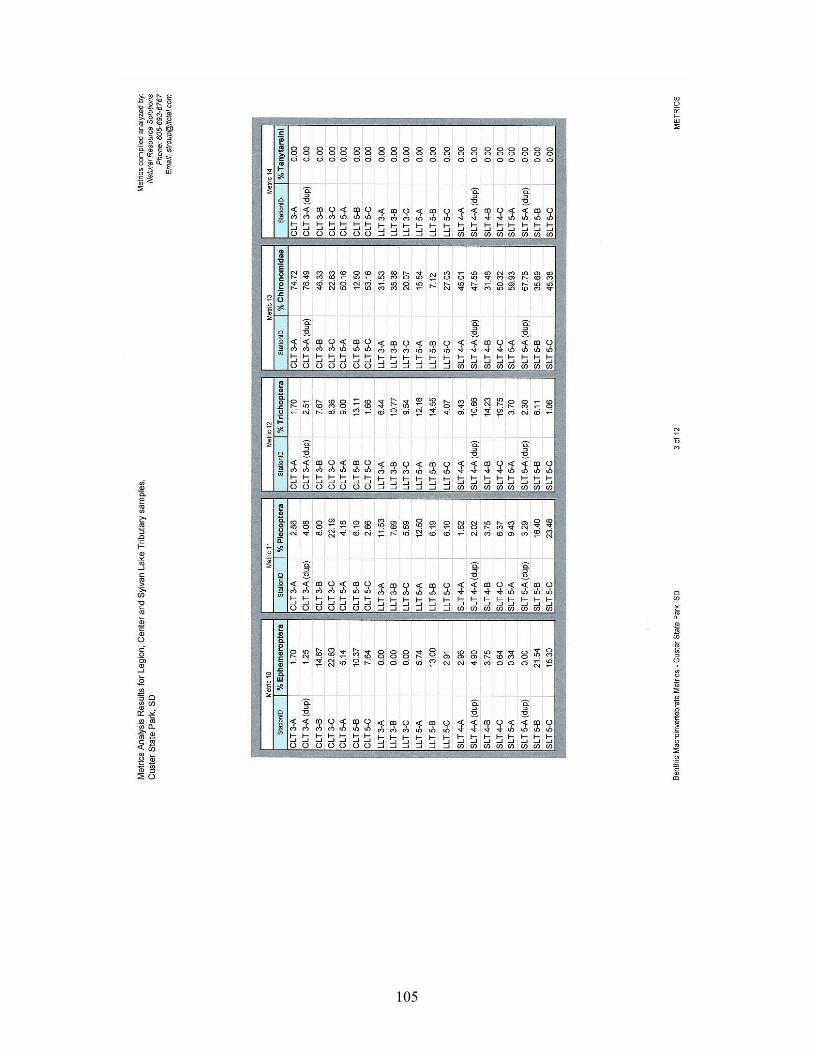
105

106

107

108

109

110

111

112

113

114

115

116
Appendix E
Quality Assurance/Quality Control (QA/QC) Data

117
QA/QC data for replicate and routine sample pairs
Site Depth Type Date E-Coli Fecal C Alka Tot S TSS Ammo Nit TKN Tot P TDP
SLT3 23-Aug-01 30 18 58 5 0.05 0.06 0.25 0.15 0.12
SLT3 Dup 23-Aug-01 34 16 66 19 0.05 0.025 0.25 0.15 0.13
6.3% 5.9% 6.5% 58.3% 0.0% 41.2% 0.0% 0.0% 4.0%
SL1 Surface 30-Jan-02 1 1 40 92 2.5 0.3 0.15 1.2 0.07 0.02
SL1 Surface Dup 30-Jan-02 1 1 42 76 2.5 0.3 0.15 0.6 0.05 0.005
0.0% 0.0% 2.4% 9.5% 0.0% 0.0% 0.0% 33.3% 16.7% 60.0%
SLT3 12-Aug-02 1 50 26 62 2.5 0.05 0.025 0.25 0.13 0.03
SLT3 Dup 12-Aug-02 1 36 26 84 17 0.05 0.025 0.25 0.13 0.03
0.0% 16.3% 0.0% 15.1% 74.4% 0.0% 0.0% 0.0% 0.0% 0.0%
SL1 Surface 12-Jun-03 40 70 6 0.01 0.05 0.42 0.03 0.013
SL1 Surface Dup 12-Jun-03 40 69 6 0.01 0.05 0.39 0.026 0.013
0.0% 0.7% 0.0% 0.0% 0.0% 3.7% 7.1% 0.0%
Average 0.0% 7.5% 2.1% 7.9% 33.2% 0.0% 10.3% 9.3% 6.0% 16.0%
Percent
Difference

118
QA/QC data for blank samples
Date E Coli Fecal Alka Tot Sol TSS Ammo NO3+NO4 TKN Tot P TDP
12-Dec-02 ND ND 10 ND ND ND ND ND ND ND
12-Dec-02 ND ND 6 ND ND ND ND ND 0.01 0.01
12-Dec-02 ND ND 6 ND ND ND ND ND 0.01 0.02
12-Dec-02 ND ND ND ND ND ND ND ND ND ND
12-Jun-03 ND ND ND ND ND ND 0.002 0.006

119
Appendix F
Water Temperature and Dissolved Oxygen Profiles

120
July 11, 1989
0
1
2
3
4
5
6
0 5 10 15 20 25
DO (mg/L) Temp (Degrees C)
August 16, 1989
0
1
2
3
4
5
6
0 5 10 15 20 25
Dep
th (m
)
DO (mg/L) Temp (Degrees C)
June 19, 1991
0
1
2
3
4
5
6
7
8
0 5 10 15 20 25
Dep
th (m
)
DO (mg/L) Temp (Degrees C)
October 2, 1991
0
1
2
3
4
5
6
7
8
0 5 10 15 20 25
Dep
th (m
)
DO (mg/L) Temp (Degrees C)
June 15, 1993
0
1
2
3
4
5
6
7
8
0 5 10 15 20 25
Dep
th (m
)
DO (mg/L) Temp (Degrees C)
August 3, 1993
0
1
2
3
4
5
6
7
0 5 10 15 20 25
Dep
th (m
)
DO (mg/L) Temp (Degrees C)
August 23, 2001
0
1
2
3
4
5
6
7
8
0 5 10 15 20 25
Dep
th (m
)
DO (mg/L) Temp (Degrees C)
September 25, 2001
0
1
2
3
4
5
6
7
8
0 5 10 15 20 25
Dep
th (m
)
DO (mg/L) Temp (Degrees C)

121
October 31, 2001
0
1
2
3
4
5
6
7
8
0 5 10 15 20 25D
epth
(m)
Temp (Degrees C) DO (mg/L)
December 27, 2001
0
1
2
3
4
5
6
7
8
0 5 10 15 20 25
Dep
th (m
)
Temp (Degrees C) DO (mg/L)
January 31, 2002
0
1
2
3
4
5
6
7
8
0 5 10 15 20 25
Dep
th (m
)
Temp (Degrees C) DO (mg/L)
February 26, 2002
0
1
2
3
4
5
6
7
8
0 5 10 15 20 25
Dep
th (m
)
Temp (Degrees C) DO (mg/L)
May 13, 2002
0
1
2
3
4
5
6
7
8
0 5 10 15 20 25
Dep
th (m
)
Temp (Degrees C) DO (mg/L)
June 6, 2002
0
1
2
3
4
5
6
7
8
0 5 10 15 20 25
Dep
th (m
)
DO (mg/L) Temp (Degrees C)
July 2, 2002
0
1
2
3
4
5
6
7
8
0 5 10 15 20 25
Dep
th (m
)
DO (mg/L) Temp (Degrees C)
August 5, 2002
0
1
2
3
4
5
6
7
8
0 5 10 15 20 25
Dep
th (m
)
DO (mg/L) Temp (Degrees C)
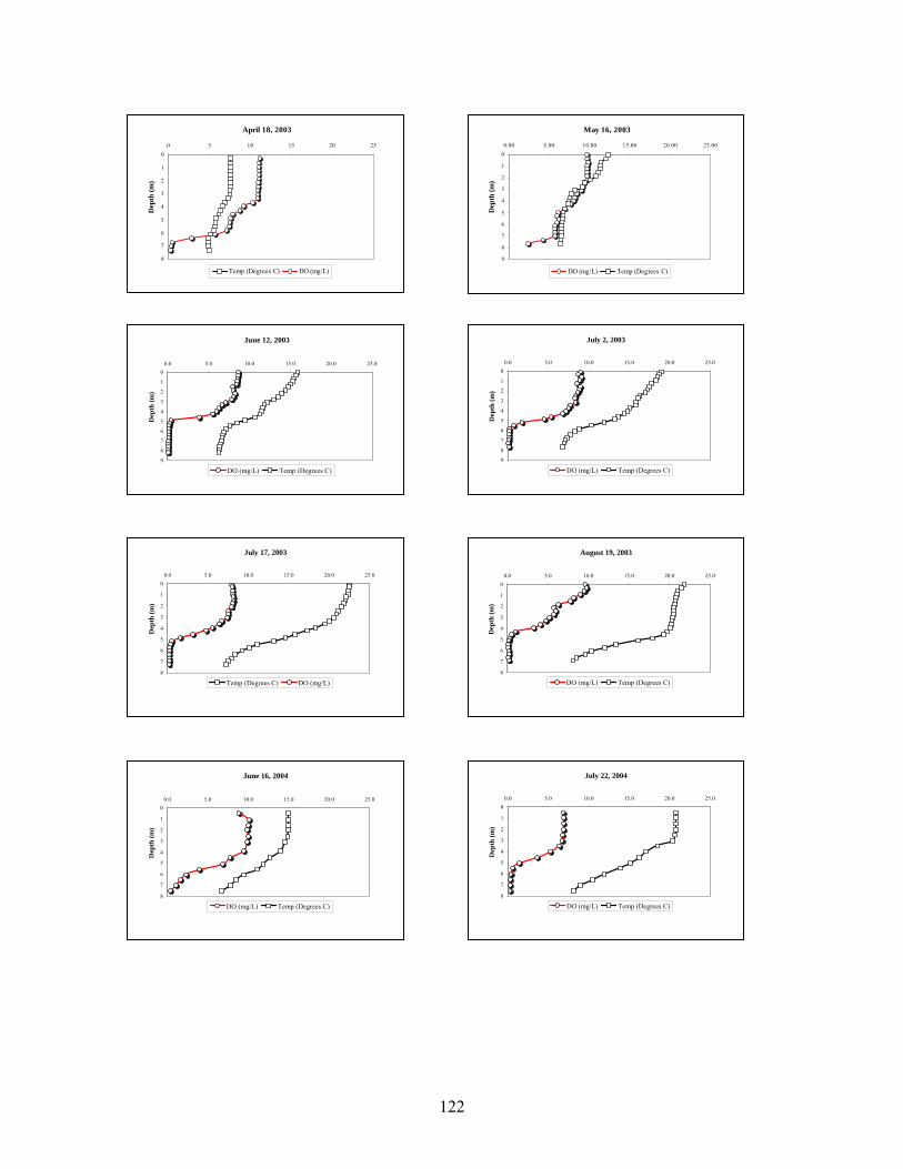
122
July 2, 2003
0
1
2
3
4
5
6
7
8
9
0.0 5.0 10.0 15.0 20.0 25.0
Dep
th (m
)
DO (mg/L) Temp (Degrees C)
July 17, 2003
0
1
2
3
4
5
6
7
8
0.0 5.0 10.0 15.0 20.0 25.0
Dep
th (m
)
Temp (Degrees C) DO (mg/L)
August 19, 2003
0
1
2
3
4
5
6
7
8
0.0 5.0 10.0 15.0 20.0 25.0
Dep
th (m
)
DO (mg/L) Temp (Degrees C)
June 16, 2004
0
1
2
3
4
5
6
7
8
0.0 5.0 10.0 15.0 20.0 25.0
Dep
th (m
)
DO (mg/L) Temp (Degrees C)
July 22, 2004
0
1
2
3
4
5
6
7
8
0.0 5.0 10.0 15.0 20.0 25.0
Dep
th (m
)
DO (mg/L) Temp (Degrees C)
April 18, 2003
0
1
2
3
4
5
6
7
8
0 5 10 15 20 25D
epth
(m)
Temp (Degrees C) DO (mg/L)
May 16, 2003
0
1
2
3
4
5
6
7
8
9
0.00 5.00 10.00 15.00 20.00 25.00
Dep
th (m
)
DO (mg/L) Temp (Degrees C)
June 12, 2003
0
1
2
3
4
5
6
7
8
9
0.0 5.0 10.0 15.0 20.0 25.0
Dep
th (m
)
DO (mg/L) Temp (Degrees C)

123
August 30, 2004
0
1
2
3
4
5
6
7
8
9
0.0 5.0 10.0 15.0 20.0 25.0D
epth
(m)
DO (mg/L) Temp (Degrees C)

124
Appendix G
Public Comments and TMDL Approval Letter

125
Response to Public Notice Comments Only one TMDL review criterion was not satisfied. The following lists this criterion and EPA’s comments. The comments are addressed below. No other public comments were received. 1. Water Quality Impairment Status
Partially satisfies criterion. Questions or comments provided below need to be addressed.
EPA’s COMMENTS - The assessment report (pp 35-36) indicates that the dissolved oxygen (DO) standard is not being met in the lake. The report (p 37) says that despite the numerous DO readings below the standard in the hypolimnion, the cold water permanent fish life propagation beneficial use is being met. This argument for not listing DO as an impairment in the lake would be supportable if: 1) there were fisheries data that supported the conclusion that the designated use is being met; and 2) the DO standard specified that the numeric DO values, when applied to stratified lakes, applied only to the epilimnion.
The 1995 fisheries data (9 surviving rainbow trout) alone do not appear to support the claim that the designated use is supported by the current conditions. Is there more recent fisheries data for the lake? Additional data or additional explanation (e.g., evidence that it is not unusual to have all of the stocked fish caught and removed during one fishing season) are needed to support the "use protected" claim.
The recorded high temperatures in the epilimnion are likely to occur concurrent with the low DO values in the hypolimnion. Therefore, it is possible to have conditions, at least for part of the summer, when the lake is unsuitable for rainbow trout (i.e., no suitable refuge - too warm in the epilimnion and insufficient DO in the hypolimnion).
Other states have addressed the stratified lake issue by specifying in the WQS that the DO standard applied only to the epilimnion of stratified lakes where the temperature of the epilimnion was suitable. Without such specificity, it is reasonable to assume the standard applies throughout the water column.
It is likely that the identified phosphorus problem is the root cause of the hypolimneic DO problem, and therefore, it might be expected that the phosphorous TMDL will address the DO issue as well. As such, it would seem that adding DO as a cause of impairment (if it can't be demonstrated that the use is unimpaired) would not have a significant effect on the proposed corrective action.
We recommend that either: 1) the TMDL be revised to include a DO target (e.g., > 6.0 mg/L) as well as an explanation in the technical analysis of how the proposed controls can be expected to result in the DO standard being met; 2) a statement that the proposed controls for phosphorous are expected to also improve the DO; 3) a statement that the DO impairment will be addressed by a separate TMDL; or 4) revisions to the DO standard. For options 2 and 3 the lake will need to be evaluated during the 2006 listing cycle and included on the list unless new data show that the standard is being met or a separate TMDL is completed and approved.

126
RESPONSE TO COMMENTS - Author agrees with EPA’s comments, and suggested change #2 above was incorporated. The following statement was added to the Pollutant Assessment section (page 73) of the TMDL summary and the Dissolved Oxygen section (page 37) of the final report. “Excessive nutrient loading to Sylvan Lake has contributed to a higher oxygen demand and thus lower hypolimnetic DO levels. The proposed management practices to reduce phosphorus concentrations are expected to also improve the DO levels in Sylvan Lake.” A DO TMDL for Sylvan Lake has not been developed due to the expected change of a water quality standards and/or 303(d) listing criteria. If the standards and/or listing criteria are not revised, the lake will be listed as an impaired waterbody in the 2006 Integrated Report.

127

128

129

130

131

132

133

134

135

136

137

NOTICE OF TOTAL MAXIMUM DAILY LOADS
The South Dakota Department of Environment and Natural Resources (DENR) announces the availability of the following Total Maximum Daily Load (TMDLs) for review and comment.
Sylvan Lake, Custer County The TMDL was developed in accordance with Section 303(d) of the federal Clean Water Act. This TMDL was developed on a watershed basis that included public involvement. TMDLs are an important tool for the management of water quality. The goal of a TMDL is to ensure that waters of the state attain water quality standards and provide designated beneficial uses. A TMDL is defined as "the sum of the individual waste load allocations for point sources and load allocations for both nonpoint source and natural background sources established at a level necessary to achieve compliance with applicable surface water quality standards." In other words, a TMDL identifies the total pollution load of any given water body can receive and still remain healthy. TMDLs are required on waters that do not attain water quality standards or assigned beneficial uses. Any person interested in reviewing this TMDL document may request a copy by telephone or by mail. Also, each document has been uploaded to DENR's website at the Internet address
http://www.state.sd.us/denr/What'sNew.htm Copies of the draft may also be obtained from Gene Stueven by writing to the address below, emailing Gene Stueven at [email protected], or by calling 1-800-438-3367. Persons are encouraged to comment electronically by sending the comments to Gene Stueven at the email address in the above paragraph. The department must receive the comments by June 6, 2005.
Department of Environment and Natural Resources Water Resources Assistance Program
523 East Capitol Avenue – Joe Foss Building Pierre, South Dakota 57501-3181
Steven M. Pirner Secretary
Department of Environment and Natural Resources