pg&e mccloud-pit hydroelectric project...may 02, 2019 · pg&e mccloud-pit hydroelectric...
TRANSCRIPT

PG&E McCloud-Pit Hydroelectric Project
State Water Resources Control Board
Water Quality Certification
Draft Initial Study / Negative Declaration
FERC Project No. 2106


PG&E McCloud-Pit Hydroelectric Project Water Quality Certification
Draft Initial Study / Negative Declaration
May 2019 Cardno, Inc. Document Information i
Document Information
Prepared for: State Water Resources Control Board—Division of Water Rights
Project Name: PG&E McCloud-Pit Hydroelectric Project
Water Quality Certification
Draft Initial Study / Negative Declaration
FERC Project No. 2106
Date: May 2019
Prepared for:
State Water Resources Control Board—Division of Water Rights P.O. Box 2000, Sacramento, CA 95812-2000
Prepared by:
Cardno, Inc. 2890 Gateway Oaks Drive, Suite 200, Sacramento, CA 95833

PG&E McCloud-Pit Hydroelectric Project Water Quality Certification
Draft Initial Study / Negative Declaration
ii Document Information Cardno, Inc May 2019
This Page Intentionally Left Blank

PG&E McCloud-Pit Hydroelectric Project Water Quality Certification
Draft Initial Study / Negative Declaration
May 2019 Cardno, Inc. Table of Contents iii
Table of Contents
Executive Summary ................................................................................................................... i
1 Introduction ...................................................................................................................1-1
1.1 Background .......................................................................................................1-1
1.2 Use of FERC’s EIS ............................................................................................1-4
1.3 Additional Environmental Analysis Required Under CEQA ................................1-4
1.4 Agency Participation and Application ................................................................1-5
1.5 Public Review Process ......................................................................................1-9
2 Project Description .......................................................................................................2-1
2.1 Overview ...........................................................................................................2-1
2.2 Existing Project .................................................................................................2-3
2.3 Existing Project Facilities ...................................................................................2-3
2.3.1 James B. Black Development ..............................................................2-3
2.3.2 Pit 6 Development ...............................................................................2-5
2.3.3 Pit 7 Development ...............................................................................2-6
2.3.4 Routine Operations and Maintenance ..................................................2-6
2.3.5 Existing Recreation Facilities ............................................................. 2-13
2.3.6 Existing Recreation Facilities Routine Operations and Maintenance .. 2-18
2.3.7 Project Safety .................................................................................... 2-18
2.3.8 Existing Environmental Measures ...................................................... 2-19
2.4 Proposed Project ............................................................................................. 2-19
2.4.1 Project Purpose and Objectives ......................................................... 2-20
2.4.2 Proposed Project Boundary ............................................................... 2-21
2.4.3 Proposed Recreation Facilities .......................................................... 2-21
2.4.4 Proposed Recreation Facility Operations and Maintenance ............... 2-31
2.4.5 Proposed Minimum Instream Flows ................................................... 2-31
2.4.6 Required Environmental Management and Monitoring Plans Under
the Proposed Project ......................................................................... 2-35
2.4.7 Proposed Project Schedule ............................................................... 2-47
3 Environmental Checklist ...............................................................................................3-1
3.1 Introduction .......................................................................................................3-1
3.2 Evaluation of Environmental Impacts ................................................................3-1
3.2.1 Aesthetics ............................................................................................3-3
3.2.2 Agricultural and Forest Resources ..................................................... 3-13
3.2.3 Air Quality .......................................................................................... 3-17
PG&E McCloud-Pit Hydroelectric Project Water Quality Certification
Draft Initial Study / Negative Declaration
iv Table of Contents Cardno, Inc. May 2019
3.2.4 Biological Resources ......................................................................... 3-23
3.2.5 Cultural Resources ............................................................................ 3-89
3.2.6 Energy ............................................................................................... 3-95
3.2.7 Geology and Soils ............................................................................. 3-99
3.2.8 Greenhouse Gas Emissions ............................................................ 3-111
3.2.9 Hazards and Hazardous Materials ................................................... 3-115
3.2.10 Hydrology and Water Quality ........................................................... 3-121
3.2.11 Land Use and Planning ................................................................... 3-133
3.2.12 Mineral Resources ........................................................................... 3-135
3.2.13 Noise ............................................................................................... 3-137
3.2.14 Population and Housing ................................................................... 3-141
3.2.15 Public Services ................................................................................ 3-143
3.2.16 Recreation ....................................................................................... 3-147
3.2.17 Transportation ................................................................................. 3-157
3.2.18 Tribal Cultural Resources ................................................................ 3-163
3.2.19 Utilities and Service Systems ........................................................... 3-167
3.2.20 Wildfire ............................................................................................ 3-173
3.2.21 Mandatory Findings of Significance ................................................. 3-179
4 References .....................................................................................................................4-1
Appendices
Appendix A Notice of Section 15063(g) Informal Consultation with Responsible and
Trustee Agencies

PG&E McCloud-Pit Hydroelectric Project Water Quality Certification
Draft Initial Study / Negative Declaration
May 2019 Cardno, Inc. Table of Contents v
Tables Table 1-1 Overview of Potential Future Permit Approval and Consultation
Requirements for the PG&E McCloud-Pit Hydroelectric Relicensing
Project ..............................................................................................................1-6
Table 2-1 Routine Operations and Maintenance Practices for Existing McCloud-Pit
Project Infrastructure .........................................................................................2-8
Table 2-2 Project Gages ................................................................................................. 2-13
Table 2-3 Proposed Recreation Facilities: Construction Personnel, Duration,
Equipment List, and Disturbed Acreage .......................................................... 2-22
Table 2-4 Proposed Project Minimum Instream Flow from McCloud Dam into the
McCloud River ................................................................................................ 2-32
Table 2-5 Proposed Project Minimum Instream Flows from Iron Canyon Dam into
Iron Canyon Creek (cfs) .................................................................................. 2-34
Table 3-1 Shasta County Federal and State Air Quality Attainment Designations ........... 3-18
Table 3-2 Shasta Lake – Lake Blvd O3 Exceedances for (Years 2013-2017) .................. 3-19
Table 3-3 Fish Species Identified in Project Reservoirs and Stream Reaches During
Relicensing Technical Studies ........................................................................ 3-30
Table 3-4 Special-Status Plant Species Known to Occur or Potentially Occurring in
the Project Area. ............................................................................................. 3-39
Table 3-5 Special-Status Wildlife Species Known to Occur or Potentially Occurring
in the Project Area. ......................................................................................... 3-55
Table 3-6 Developed Recreation Sites Inventoried in 2007 ........................................... 3-148
Table 3-7 Dispersed Recreation Sites Inventoried in 2007 ............................................ 3-149
Table 3-8 Changes in Boating and Angler Days1 under the Proposed Project .............. 3-153
Figures Figure 1-1 McCloud-Pit Project Location ............................................................................1-2
Figure 2-1 Schematic of Existing McCloud-Pit Project Operation .......................................2-2
Figure 2-2 Recreation Facilities in the Vicinity of McCloud Reservoir ............................... 2-15
Figure 2-3 Recreation Facilities in the Vicinity of Iron Canyon Reservoir .......................... 2-17
Figure 2-4 Recreation Facilities in the Vicinity of Pit 7 Reservoir ...................................... 2-30
Figure 2-5 Large Woody Debris Sites .............................................................................. 2-41

PG&E McCloud-Pit Hydroelectric Project Water Quality Certification
Draft Initial Study / Negative Declaration
vi Table of Contents Cardno, Inc. May 2019
Acronyms
AAQS Ambient Air Quality Standards
ac-ft acre-feet
APE Area of Potential Effect
AQAP Air Quality Attainment Plan
AQMD Air Quality Management District
BE Biological Evaluation
BMI benthic macroinvertebrate
BMP Best Management Practice
CAAQS California Ambient Air Quality Standards
CARB California Air Resources Board
CBC California Building Code
CDC Centers for Disease Control and Prevention
CDFW California Department of Fish and Wildlife
CEC California Energy Commission
CESA California Endangered Species Act
CEQA California Environmental Quality Act
cfs cubic feet per second
CNDDB California Natural Diversity Database
CO carbon monoxide
CPUC California Public Utilities Commission
CRHR California Register of Historic Resources
CRPR California Rare Plant Ranking
CVRWQCB Central Valley Regional Water Quality Control Board
CWA Clean Water Act
DOC California Department of Conservation
DPS Distinct Population Segment
DSOD Division of Safety of Dams
DWR California Department of Water Resources
EIS Environmental Impact Statement
ESA Endangered Species Act

PG&E McCloud-Pit Hydroelectric Project Water Quality Certification
Draft Initial Study / Negative Declaration
May 2019 Cardno, Inc. Table of Contents vii
FERC Federal Energy Regulatory Commission
FYLF foothill yellow-legged frog
GHG greenhouse gas
gpd gallons per day
GWh gigawatt hours
GWh/yr gigawatt hours per year
HMBP hazardous materials business plans
hp horsepower
IS Initial Study
IS/ND Initial Study/Negative Declaration
KOP Key Observation Point
kV kilovolt
LOP limited operating period
MIF minimum instream flow
msl mean sea level
MT CO2e metric tons of carbon dioxide equivalent
MW megawatts
MVA megavolt-ampere
NAAQS National Ambient Air Quality Standards
NAHC Native American Heritage Commission
ND Negative Declaration
NEPA National Environmental Policy Act
NOx oxides of nitrogen
NO2 nitrogen dioxide
NPDES National Pollutant Discharge Elimination System
NSVPA Northern Sacramento Valley Planning Area
O3 ozone
PAC Protected Activity Center
PCA Pest Control Adviser
PG&E Pacific Gas and Electric Company
PM particulate matter

PG&E McCloud-Pit Hydroelectric Project Water Quality Certification
Draft Initial Study / Negative Declaration
viii Table of Contents Cardno, Inc. May 2019
ppm parts per million
RM river mile
RMO Road Management Objective
ROG reactive organic gases
RPS Renewable Portfolio Standard
RTP Regional Transportation Plan
RWQCB Regional Water Quality Control Board
SHPO California State Historic Preservation Officer
SO2 sulfur dioxide
SPCC spill, prevention, control, and countermeasures
STNF Shasta-Trinity National Forest
SVAQEEP Sacramento Valley Air Quality Engineering and Enforcement
Professionals
SWPPP Storm Water Pollution Prevention Plan
TCP Traditional Cultural Properties
UCMP University of California Museum of Paleontology
USACE United States Army Corps of Engineers
USEIA United States Energy Information Administration
USEPA United States Environmental Protection Agency
USFS United States Department of Agriculture – Forest Service
USFWS United States Fish and Wildlife Service
USGS United States Geological Survey
VELB valley elderberry longhorn beetle
VMT vehicle miles traveled
VQO Visual Quality Objectives
PG&E McCloud-Pit Hydroelectric Project Water Quality Certification
Draft Initial Study / Negative Declaration
May 2019 Cardno, Inc. Executive Summary i
Executive Summary
Pacific Gas and Electric Company (PG&E) owns and operates the McCloud-Pit Hydroelectric
Project (McCloud-Pit Project, or Project) (Federal Energy Regulatory Commission [FERC]
Project No. 2106) located in the McCloud and Pit River drainages of Northern California in
Shasta and Siskiyou Counties, California. The existing Project has an installed capacity of 368-
megawatts. The Proposed Project analyzed in this document is the continued operation of the
existing McCloud-Pit Project. To receive a new FERC operating license, PG&E is required to
obtain a water quality certification (certification) under section 401 of the federal Clean Water
Act. The State Water Resources Control Board (State Water Board) is the agency responsible
for certification in California.
Issuance of a certification is a discretionary action that, under the California Environmental Quality
Act (CEQA), requires the State Water Board to analyze the subject project’s potential
environmental impacts to water quality and the designated beneficial uses of water. For the
Project, those beneficial uses are identified in the Central Valley Regional Water Quality Control
Board (CVRWQCB) Water Quality Control Plan for the Sacramento and San Joaquin River
Basins (Basin Plan)1 (CVRWQCB 2018). This draft Initial Study/Negative Declaration (IS/ND) for
the Proposed Project analyzes potential Project impacts and evaluates the level of significance of
those impacts.
Project Description
In its application for a new FERC license, PG&E proposed changes to the McCloud-Pit Project
to lessen potential Project impacts. The Proposed Project evaluated in this CEQA analysis
included:
The existing McCloud-Pit Project, including continued operations and maintenance of
existing infrastructure;
Increased minimum instream flows to protect aquatic resources in two Project-affected
stream reaches: (1) McCloud River below McCloud Dam; and (2) Iron Canyon Creek below
Iron Canyon Dam; and
Construction of recreation facility improvements and continued operation of the recreational
facilities.
In addition to the changes to the existing McCloud-Pit Project proposed by PG&E, the Proposed
Project addressed in this document incorporates the following:
Terms and conditions contained in FERC’s final Environmental Impact Statement, Appendix
D, Commission Staff Recommended Conditions, and Appendix E, Forest Service 4(e)
Conditions (FERC 2011);
1 Water Quality Control Plan for the California Regional Water Quality Control Board Central Valley Region for the
Sacramento River Basin and the San Joaquin River Basin. Fifth Edition. Revised May 2018 (with Approved
Amendments).

PG&E McCloud-Pit Hydroelectric Project Water Quality Certification
Draft Initial Study / Negative Declaration
ii Executive Summary Cardno, Inc. May 2019
United States Department of Agriculture – Forest Service (USFS) 4(e) Conditions
(USFS 2010a); and
Terms and conditions contained in the State Water Board’s certification that are necessary
to protect water quality and the beneficial uses of water outlined in the Basin Plan
(CVRWQCB 2018).
Findings and Determination
There is no substantial evidence in light of the whole record before the State Water Board that
the Proposed Project may have a significant impact on the environment. On the basis of this
evaluation, the State Water Board concludes:
(i) Implementation of the Proposed Project will not degrade the quality of the environment,
substantially reduce the habitat of a fish or wildlife species, cause a fish or wildlife population
to drop below self-sustaining levels, threaten to eliminate a plant or animal community,
reduce the number or restrict the range of a rare or endangered plant or animal, or eliminate
important examples of the major periods of California history or prehistory;
(ii) Implementation of the Proposed Project will not have impacts that are individually limited,
but cumulatively considerable; and
(iii) Implementation of the Proposed Project will not have environmental effects that will cause
substantial adverse effects on human beings, either directly or indirectly.
If the State Water Board approves the certification, it will file a Notice of Determination pursuant
to California Code of Regulations title 14, section 15075.
_______DRAFT____________________________ ______________________
Eileen Sobeck Date
Executive Director

PG&E McCloud-Pit Hydroelectric Project Water Quality Certification
Draft Initial Study / Negative Declaration
May 2019 Cardno, Inc. Introduction 1-1
1 Introduction
1.1 Background
Pacific Gas and Electric Company (PG&E) owns and operates the McCloud-Pit Hydroelectric
Project (McCloud-Pit Project or Project) located in the McCloud and Pit River drainages of
Northern California in Shasta and Siskiyou Counties, California (Figure 1-1). The Proposed
Project addressed in this document consists of the continued operation of the McCloud-Pit
Project, Federal Energy Regulatory Commission (FERC) Project No. 2106, pursuant to a new
30- to 50-year FERC license, with modifications as described below.
In its application for a new FERC license, PG&E proposed changes to the Project including:
Changes to minimum instream flows (MIFs) in the McCloud River below McCloud Dam, and
Iron Canyon Creek below Iron Canyon Dam to protect aquatic resources;
Implementation of management and monitoring plans to protect aquatic resources; and
Measures to maintain and enhance recreational opportunities, including construction to
provide additional recreation facilities.
The Proposed Project under the California Environment Quality Act (CEQA) also includes:
Terms and conditions contained in FERC’s final Environmental Impact Statement (EIS),
Appendix D, Commission Staff Recommended Conditions and Appendix E (FERC 2011);
United States Department of Agriculture – Forest Service (USFS) 4(e) Conditions
(USFS 2010a); and
Impacts of potential terms and conditions contained in the State Water Board’s certification,
that are necessary to protect water quality and the beneficial uses of water that are outlined
in the Central Valley Regional Water Quality Control Board (CVRWQCB) Water Quality
Control Plan for the Sacramento and San Joaquin Rivers Basins (Basin Plan)2
(CVRWQCB 2018).
The Proposed Project area totals 3,707.6 acres of land, of which: 1,651.4 acres (45 percent)
are federally owned and managed by the USFS; 1,239.4 acres (33 percent) are owned by
PG&E; and the remaining 816.8 acres are private lands. It consists of three power generating
developments (James B. Black, Pit 6, and Pit 7). These developments collectively include four
reservoirs, three powerhouses, five dams, two tunnels, one afterbay, and associated equipment,
transmission, and recreation facilities. Installed generation capacity for the Project is
368-megawatts (MW). The Proposed Project is discussed in more detail in Chapter 2.
2 Water Quality Control Plan for the California Regional Water Quality Control Board Central Valley Region for the
Sacramento River Basin and the San Joaquin River Basin. Fifth Edition. Revised May 2018 (with Approved
Amendments).

PG&E McCloud-Pit Hydroelectric Project Water Quality Certification
Draft Initial Study / Negative Declaration
1-2 Introduction Cardno, Inc. May 2019
Figure 1-1 McCloud-Pit Project Location

PG&E McCloud-Pit Hydroelectric Project Water Quality Certification
Draft Initial Study / Negative Declaration
May 2019 Cardno, Inc. Introduction 1-3
The McCloud-Pit Project was originally licensed by FERC on August 18, 1961. On
July 16, 2009, PG&E filed an application for a new 30- to 50-year license under FERC’s
Integrated Licensing Process. The original license expired on July 31, 2011; however, the
McCloud-Pit Project continues to operate under annual license extensions issued by FERC.
The 2009 license application included proposed changes to existing operations. The proposed
changes include: (a) higher MIF releases to protect aquatic resources in the McCloud River
below McCloud Dam, and in Iron Canyon Creek below Iron Creek Dam; (b) measures to protect
sensitive species; and (c) measures to maintain and enhance existing recreation opportunities
and provide additional recreational facilities (FERC 2011).
Compliance with the National Environmental Policy Act (NEPA) must be demonstrated prior to
FERC undertaking a federal action, including issuance of a new license to PG&E for continued
operation and maintenance of the McCloud-Pit Project. On February 25, 2011, FERC issued
the final EIS that analyzed environmental impacts of PG&E’s Proposed Project, as well as the
comments, conditions, and recommendations that FERC received during the draft EIS public
and agency review period.
To receive a new FERC license, PG&E is required to obtain a water quality certification
(certification) under section 401 of the federal Clean Water Act (CWA). The State Water
Resources Control Board (State Water Board) is the agency in California that is responsible for
acting on applications for CWA section 401 certification of hydroelectric projects. The purpose
of a certification is to protect the waters of the United States by ensuring waste discharged to
waters from a proposed activity meets water quality standards and other appropriate
requirements. As part of the FERC licensing process the State Water Board must issue or deny
certification for the McCloud-Pit Project. Certification conditions will become mandatory
conditions of the FERC license for the McCloud-Pit Project once the license is issued. PG&E
originally applied for certification by submitting an application for the Proposed Project on
January 27, 2010. An application initiates a one-year time period for the State Water Board to
act on the request for certification. From 2010 through 2017, PG&E withdrew and resubmitted
the application annually. In 2018, the State Water Board denied the application without
prejudice. On November 9, 2018, PG&E submitted the most recent application.
Issuance of a certification is a discretionary action that requires the State Water Board to
comply with CEQA. (CEQA Guidelines3 §§ 15002, subd. (i), 15357.) The State Water
Board is the lead agency under CEQA for the Project. (Pub. Resources Code, § 21067.) This
analysis was prepared to comply with CEQA to assess the environmental effects from changes
to the Proposed Project required by the certification issued by the State Water Board. In a
CEQA analysis of an existing hydroelectric project, reauthorization of a project would not likely
yield many environmental impacts because the environmental baseline against which impacts
are measured for CEQA is the existing conditions. In contrast, certification requires an analysis
of a project’s overall effect on water quality, including whether the designated beneficial uses
identified in the Basin Plan are adequately protected. The State Water Board may use a CEQA
document prepared during the certification process to aid its review of a project’s effects on
public trust resources.
3 The CEQA Guidelines are found at California Code of Regulations, title 14, sections 15000 et seq.

PG&E McCloud-Pit Hydroelectric Project Water Quality Certification
Draft Initial Study / Negative Declaration
1-4 Introduction Cardno, Inc. May 2019
To ensure compliance with CEQA, the State Water Board issued a notice, dated
October 26, 2012, for informal consultation with responsible and trustee agencies regarding the
environmental document, pursuant to CEQA Guidelines section 15063(g) (see Appendix A).
The purpose of the consultation was to seek input from the agencies responsible for resources
affected by the Proposed Project, as well as from non-governmental organizations (NGOs),
Tribes, and interested members of the community. The State Water Board sought
recommendations and supporting information regarding the type of CEQA document to prepare
for the Proposed Project. After review and consideration of comments received, it was
determined that a Negative Declaration (ND) was the appropriate document for the Proposed
Project. To confirm this conclusion and provide additional information regarding the potential
impacts of the Proposed Project, the State Water Board prepared an Initial Study (IS) for the
Project. The IS assessed potential impacts from the Proposed Project and found that the
Proposed Project will not have a significant effect on the environment. The IS is included in
Chapter 3.
1.2 Use of FERC’s EIS
CEQA Guidelines section 15221 states that when a project requires compliance with both
CEQA and NEPA, state agencies should use the EIS or Finding of No Significant Impact
(FONSI) rather than preparing an Environmental Impact Report or ND if the EIS or FONSI
complies with the provisions of CEQA. This draft IS/ND includes information that is necessary
to comply with CEQA for the purposes of the State Water Board’s certification process but was
not included in the final EIS. However, consistent per section 15150 of the CEQA Guidelines,
the draft IS/ND incorporates by reference appropriate sections of the final EIS to avoid repetition
of information. In addition, since the McCloud-Pit Project contains lands owned by the USFS,
the relicensing process resulted in the development of USFS staff recommendations and
mandatory conditions under section 4(e) of the Federal Power Act. PG&E incorporated those
recommendations and conditions into the project it presented to the State Water Board for
certification, and so they are included in the Proposed Project that is analyzed by this draft
IS/ND. The State Water Board’s certification will include terms and conditions that require
PG&E to carry out the Project in the manner it has proposed.
1.3 Additional Environmental Analysis Required Under CEQA
Pursuant to CEQA Guidelines, the scope of the environmental analysis in this draft ND
augments the analysis of the EIS completed by FERC, and includes the following:
Evaluation of resource areas that require additional analysis under CEQA that are not
required by NEPA; and
A determination of the level of significance of impacts under CEQA.
As the CEQA lead agency, the State Water Board will use the findings of this draft ND to
support the certification. FERC will incorporate the certification conditions into the new license
for the McCloud-Pit Project.

PG&E McCloud-Pit Hydroelectric Project Water Quality Certification
Draft Initial Study / Negative Declaration
May 2019 Cardno, Inc. Introduction 1-5
1.4 Agency Participation and Application
Compliance with federal, state, and local regulations, as well as environmental permits, is
required for construction and operation of the Proposed Project. PG&E and its contractors will
adhere to all applicable requirements. Major federal, state, and local permits, approvals, and
consultations identified for the licensing, construction, and operation of the Proposed Project are
described in Table 1-1.

PG&E McCloud-Pit Hydroelectric Project Water Quality Certification
Draft Initial Study / Negative Declaration
1-6 Introduction Cardno, Inc. May 2019
Table 1-1 Overview of Potential Future Permit Approval and Consultation Requirements for the PG&E McCloud-Pit
Hydroelectric Relicensing Project
Jurisdiction Permits, Approvals & Consultations
Federal Agencies
FERC FERC issued the final EIS for Hydropower License, McCloud-Pit Hydroelectric Project, FERC
Project No. 2106, California. FERC will also review this draft ND for the Proposed Project.
United States Army Corps of
Engineers (USACE)
Section 404 of the CWA authorizes the USACE to issue permits, after notice and opportunity
for public hearing, for the discharge of dredge or fill material into the waters of the United
States and adjacent wetlands. A nationwide 404 permit could be triggered by implementation
of some plans incorporated in the Proposed Project, such as the Coarse Sediment
Management Plan.
United States Fish and Wildlife
Service (USFWS)
The USFWS has jurisdiction over any species listed under the federal Endangered Species
Act (ESA). Consultation under section 7 of the federal ESA with the lead federal agency is
required. USFWS determines whether a proposed action is likely to jeopardize the continued
existence of, or destroy or adversely modify critical habitat of, federally listed species. Under
the Migratory Bird Treaty Act, USFWS has responsibility for protecting nearly all species of
birds, their eggs, and nests.
USFS, Shasta Trinity-National
Forest
The McCloud-Pit Project is located, in part, on USFS lands. USFS permits will be needed to
implement certain Proposed Project components, such as a Special Use Permit, Road Use
Permit, and Timber Harvest Agreement.
State Agencies
State Water Board Section 401 of the CWA requires that prior to the issuance of a federal license or permit for
an activity or activities that may result in a discharge of pollutants into navigable waters, the
applicant must first obtain a certification issued by the State Water Board or the appropriate
California Regional Water Quality Control Board. The State Water Board is the CEQA lead
agency for the Proposed Project and is responsible for issuing the ND, adopting CEQA
findings, and filing an associated Notice of Determination.

PG&E McCloud-Pit Hydroelectric Project Water Quality Certification
Draft Initial Study / Negative Declaration
May 2019 Cardno, Inc. Introduction 1-7
Jurisdiction Permits, Approvals & Consultations
California Office of Historic
Preservation
Under section 106 of the National Historic Preservation Act, consultation is required regarding
identification of cultural resources, and preparation of a Memorandum of Agreement for
adverse effects on resources list in or eligible for listing on the National Register of Historic
Properties and review of the Historic Properties Management Plan.
California Department of Fish and
Wildlife (CDFW)
CDFW is a California Trustee Agency (CEQA Guidelines section 15386) that has jurisdiction
over natural resources affected by a project, which are held in trust for the people of the State
of California, with regard to the fish and wildlife of the state, designated rare or endangered
native plants, and game refuges, ecological reserves, and other areas administered by
CDFW.
CDFW may also issue a Lake or Streambed Alteration Agreement (California Fish and Game
Code sections 1600 - 1616) with conditions to protect resources whenever a bed or bank of a
stream, lake, or reservoir is altered. For example, construction of boat ramps below the lake
level would require a Lake or Streambed Alteration Agreement issued by CDFW.
Native American Heritage
Commission (NAHC)
The NAHC provides protection to Native American burials from vandalism and inadvertent
destruction; provides a procedure for the notification of most likely descendants regarding the
discovery of Native American human remains and associated grave goods; and brings legal
action to prevent severe and irreparable damage to sacred shrines, ceremonial sites,
sanctified cemeteries, and places of worship on public property. The NAHC also maintains
an inventory of sacred places. Cultural resources are identified in the Proposed Project area
and NAHC guidance will help assess and mitigate any impacts to these resources.
California Department of
Transportation (Caltrans)
A transportation permit may by required for transport of oversized loads on state highways
(this permit is usually obtained by the construction contractor or subcontractors).

PG&E McCloud-Pit Hydroelectric Project Water Quality Certification
Draft Initial Study / Negative Declaration
1-8 Introduction Cardno, Inc. May 2019
Jurisdiction Permits, Approvals & Consultations
Regional Agencies
Regional Water Quality Control
Board (RWQCB)
California RWQCBs issue certifications according to the CWA section 401 for
construction-related disturbance of water quality. The Proposed Project may be subject to
the Construction General Permita for stormwater discharges associated with construction
activity. These permits would apply to all construction projects that would disturb one or more
acres of soil. These permits would require filing a Notice of Intent as well as the preparation
and implementation of a Storm Water Pollution Prevention Plan (SWPPP).
Local Agencies
Shasta County Shasta County has jurisdiction over planning, engineering, environmental health, traffic, and
roads within the County. For the Proposed Project, Shasta County has specific interest in
traffic, safety, and maintenance of road conditions.
Shasta County Air Quality
Management District (AQMD)
Under state and federal law, the local AQMD is required to develop a plan for attaining
ambient air quality standards. The Northern Sacramento Valley Planning Area (NSVPA)
2015 Triennial Air Quality Attainment Plan (NSVPA 2015) was adopted in Spring 2013. The
air quality element of the Shasta County General Plan (County of Shasta 2004) contains
control measures aimed at avoiding and reducing emissions of air contaminants into the local
environment.
Notes:
a General Permit for Stormwater Discharges Associated with Construction and Land Disturbance Activities. Water Quality Order No. 2009-0009-DWQ and
National Pollutant Discharge Elimination System No. CAS000002, as amended by Order No. 2010-0014-DWQ, Order No. 2012-0006-DWQ, and any amendments
thereto.
PG&E McCloud-Pit Hydroelectric Project Water Quality Certification
Draft Initial Study / Negative Declaration
May 2019 Cardno, Inc. Introduction 1-9
1.5 Public Review Process
This draft IS/ND is being circulated for a minimum of 30 days for public review to all individuals
who have requested a copy, to the Office of Planning and Research, to the State Clearinghouse
for distribution to appropriate resource agencies, and to the Shasta and Siskiyou County Clerks
for posting.
A Notice of Intent will be distributed to the interested parties mailing list identified on FERC
online4. The Notice of Intent identifies locations where the document is available for public
review and invites interested parties to provide written comments. A copy of the Notice of Intent
is attached to this document.
In addition, the State Water Board provided notice of intent to adopt a negative declaration by
publication, in accordance with section 15072(b) of the CEQA Guidelines, in two newspapers of
general circulation in the area affected by the Proposed Project: (1) Redding Record
Searchlight; and (2) Mount Shasta Herald. Copies of the Notice of Intent and this draft IS/ND
will also be available at two libraries near the area affected by the Proposed Project:
(1) Redding library; and (2) McCloud library.
Reviewers should focus on the sufficiency of the document in identifying and analyzing possible
impacts of the Proposed Project on the environment and, if potential impacts are identified,
ways in which the impacts might be avoided or mitigated. Comments are most helpful when
they suggest additional specific alternatives or mitigation measures to avoid or mitigate potential
significant environmental impacts identified by the commenter.
4 Interested parties mailing list is available at: www.ferc.gov, under “Documents & Filings”, and under “eService”.

PG&E McCloud-Pit Hydroelectric Project Water Quality Certification
Draft Initial Study / Negative Declaration
1-10 Introduction Cardno, Inc. May 2019
This Page Intentionally Left Blank

PG&E McCloud-Pit Hydroelectric Project Water Quality Certification
Draft Initial Study / Negative Declaration
May 2019 Cardno, Inc. Project Description 2-1
2 Project Description
2.1 Overview
The Proposed Project addressed in this document consists of the continued operation of the
McCloud-Pit Project, FERC Project No. 2106, pursuant to a new 30- to 50-year FERC license.
The McCloud-Pit Project is located along the western slope of the Cascade Range in northern
California within Shasta and Siskiyou Counties, and partially within the Shasta-Trinity National
Forest. The McCloud-Pit Project commenced commercial operation in 1965-1966. It is
composed of three hydroelectric developments, James B. Black, Pit 6, and Pit 7, which in total
encompass 3,707.6 acres. The McCloud-Pit Project has an installed generation capacity of 368
MW and generates an annual average of 364 MW of power. The locations of the various facilities
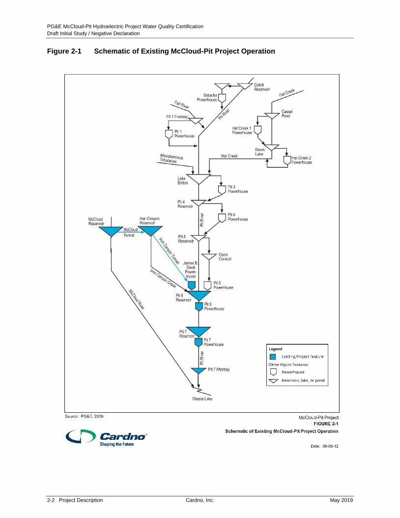
and features are presented in Figure 1-1, and a schematic of project facilities is provided in Figure
2-1. The McCloud-Pit Project is the only hydroelectric project on the McCloud River, but is one of
four hydroelectric projects owned and operated by PG&E in the Pit River basin. The three other
projects in the Pit River watershed owned and operated by PG&E include: Pit 1 Hydroelectric
Project (FERC No. 2687); Pit 3, 4, and 5 Hydroelectric Project (FERC No. 233); and Hat Creek
Hydroelectric Project (FERC No. 2661).
The McCloud-Pit Project primarily involves the transfer of water from the McCloud River basin to
the lower Pit River basin for the purposes of power generation. McCloud Reservoir is located
on the McCloud River, which originates at Moosehead Creek, southwest of Mt. Shasta, and
flows in a southwesterly direction before entering Shasta Lake. Shasta Lake is a reservoir
formed by the United States Department of Interior – Bureau of Reclamation’s Shasta Dam at
the confluence of the Pit, Sacramento, and McCloud Rivers. From McCloud Reservoir, water is
transferred via the McCloud Tunnel to Iron Canyon Reservoir, which is located on Iron Canyon
Creek, a tributary to the Pit River. Water from Iron Canyon Reservoir is transferred via the Iron
Canyon Tunnel to the James B. Black Powerhouse, which is located on the Pit River just slightly
upstream and on the opposite side of the Pit River from the Pit 5 Powerhouse (a part of PG&E’s
Pit 3, 4, 5 Hydroelectric Project). Water from the McCloud River that enters the Pit River travels
through the Pit 6 and Pit 7 developments before entering Shasta Lake. Although the
McCloud-Pit Project diverts water from the McCloud River basin into the lower Pit River basin,
both basins drain into Shasta Lake (FERC 2011).
PG&E McCloud-Pit Hydroelectric Project Water Quality Certification
Draft Initial Study / Negative Declaration
2-2 Project Description Cardno, Inc. May 2019
Figure 2-1 Schematic of Existing McCloud-Pit Project Operation

PG&E McCloud-Pit Hydroelectric Project Water Quality Certification
Draft Initial Study / Negative Declaration
May 2019 Cardno, Inc. Project Description 2-3
2.2 Existing Project
As defined by FERC, the existing Project area consists of lands necessary for the safe
operation and maintenance of the Project and other purposes, such as recreation, shoreline
control, and protection of environmental resources (FERC 2011). The Project area totals
3,707.6 acres of land, of which 1,651.4 acres (45 percent) are federally owned, 1,239.4 acres
(33 percent) are owned by PG&E, and the remaining 816.8 acres are private lands. The Project
area includes the facilities of the three hydroelectric developments (James B. Black, Pit 6, and
Pit 7), including dams and diversions; impoundments; water conveyances and associated
structures; access roads and trails; transmission, communication, and control lines;
powerhouses; gaging stations; and helicopter landing sites used for access to Project
structures. The Project area also includes land adjacent to Project features; the extent of these
zones varies depending on the feature.
2.3 Existing Project Facilities
2.3.1 James B. Black Development
2.3.1.1 McCloud Dam and McCloud Reservoir
McCloud Dam is a 241-foot-high, 630-foot-long earth- and rock-filled dam located on the McCloud
River that impounds McCloud Reservoir. The McCloud Reservoir has a surface area of 520 acres
and a maximum storage capacity of about 35,197 acre-feet (ac-ft). The spillway (elevation
2,696.0 feet above mean sea level [feet msl]) is on the south side of the dam. The reservoir has a
normal maximum water surface elevation5 of 2,680 feet msl. The dam’s spillway is equipped with
three radial gates measuring 27 feet by 24.5 feet that return spillage flows to the McCloud River.
The dam also has a 7-foot-diameter diversion/outlet tunnel that runs under the dam to a 24-inch
Howell-Bunger valve for releasing instream flows to the McCloud River, as well as an
84-inch-diameter butterfly valve for emergency use to control reservoir levels. Controls for the
diversion/outlet tunnel are located at the McCloud Tunnel intake structure within McCloud
Reservoir.
McCloud Reservoir is located on the McCloud River, which originates at Moosehead Creek,
southwest of Mt. Shasta, and flows in a southwesterly direction before entering Shasta Lake.
McCloud Reservoir is located approximately 24 river miles upstream from Shasta Lake. From
McCloud Reservoir, water is transferred through a tunnel to Iron Canyon Reservoir, on Iron
Canyon Creek.
The FERC boundary around McCloud Reservoir generally follows a contour line approximately
200 feet above the high-water line of the reservoir. The McCloud Tunnel, a 13-foot- to
17-foot-diameter tunnel, conveys water from McCloud Reservoir to Iron Canyon Reservoir. A
100-foot-wide corridor for the McCloud Tunnel extends southeast for about 7.2 miles between
McCloud and Iron Canyon Reservoirs. Where the McCloud Tunnel crosses Hawkins Creek,
there is a 0.25-mile-long, 100-foot-wide corridor for the Project access road (PG&E 2009b).
5 Normal maximum water surface elevation is the maximum level to which water may rise under normal operating
conditions, exclusive of any provision for flood surcharge.

PG&E McCloud-Pit Hydroelectric Project Water Quality Certification
Draft Initial Study / Negative Declaration
2-4 Project Description Cardno, Inc. May 2019
2.3.1.2 McCloud Tunnel
Water impounded by McCloud Dam is diverted from the McCloud River via a 7.2-mile-long
tunnel, and a 563-foot-long pipeline section at Hawkins Creek crossing, that hydraulically links
McCloud Reservoir and Iron Canyon Reservoir. A tunnel intake structure and tower, about
17 feet in diameter, within McCloud Reservoir collects water for the McCloud Tunnel
approximately 115 feet above the original river bed, and then transfers the water southeasterly
to Iron Canyon Reservoir. The differential in water surface elevations between the two
reservoirs controls the amount of water drafted through the tunnel. Water diverted through the
McCloud Tunnel diversion bypasses the reach of the McCloud River between the McCloud
Reservoir and Shasta Lake, which is approximately 24 miles long.
2.3.1.3 Iron Canyon Dam and Reservoir
Iron Canyon Dam is a 214-foot-high and 1,130-foot-long earth-filled dam that impounds Iron
Canyon Creek to create Iron Canyon Reservoir. The Iron Canyon Reservoir has a maximum
storage capacity of 24,241 ac-ft with about a 500-acre surface area. The Iron Canyon Dam has
a slide gate leading to a 48-inch-diameter pipe for instream flow releases to Iron Canyon Creek.
Normal maximum water surface elevation within the reservoir is 2,664 feet msl.
Iron Canyon Creek is a tributary of the Pit River. Water from Iron Canyon Reservoir flows
through the Iron Canyon Tunnel to the James B. Black Powerhouse. Water that flows through
the James B. Black Powerhouse discharges into the Pit River. Once in the Pit River, the water
flows through the Pit 6 and Pit 7 developments before entering Shasta Lake.
The FERC boundary around Iron Canyon Reservoir generally follows a contour line
approximately 100 to 200 feet above the high-water line of Iron Canyon Reservoir, and in some
places extends beyond this distance to include existing recreation facilities.
2.3.1.4 Iron Canyon Tunnel and Penstock
Iron Canyon Tunnel is a 2.9-mile-long, 14-foot to 18-foot-diameter tunnel that diverts water from
Iron Canyon Reservoir. A 1,194-foot-long by 11.5-foot-diameter pipeline at the Willow Spring
Creek crossing and a partially bifurcated 5,467-foot-long by 11.5-foot-diameter steel penstock
deliver water from the Iron Canyon Tunnel to the James B. Black Powerhouse. The tunnel and
penstock have a total flow capacity of 2,000 cubic feet per second (cfs). Water diverted through
the Iron Canyon Tunnel bypasses the Iron Canyon Creek reach between Iron Canyon Reservoir
and Pit 6 Reservoir, which is approximately 4 miles long.
2.3.1.5 James B. Black Powerhouse
James B. Black Powerhouse is located on the northwest bank of the Pit River, about 0.5 mile
upstream of the Pit 5 Powerhouse (FERC Project No. 233). The James B. Black Powerhouse is
a three-level, reinforced-concrete structure containing two vertical shaft impulse turbines rated
at 104,000 horsepower (hp) each. The turbines operate at a normal maximum gross head6 of
6 The normal maximum gross head is the maximum allowed vertical distance between the upstream surface water
(headwater) forebay elevation and the downstream surface water (tailwater) elevation at the tailrace.

PG&E McCloud-Pit Hydroelectric Project Water Quality Certification
Draft Initial Study / Negative Declaration
May 2019 Cardno, Inc. Project Description 2-5
1,226 feet. Two vertical axis outdoor generators, Unit 1 rated at 94.8 megavolt-ampere (MVA) 7
and Unit 2 rated at 92.6 MVA, are connected to a three-phase, 86-MVA transformer bank. Their
combined maximum capacity is 172 MW. Average annual generation within the past 30 years
(1987 to 2016) at the station is 629.9-gigawatt hours (GWh). Water is discharged from the
James B. Black Powerhouse through a tailrace leading directly from the generation units to the
Pit River.
2.3.1.6 Transmission
The primary transmission lines for the James B. Black Powerhouse (230 kilovolt [kV]) extend
about 0.5 mile from the transformer bank in the switchyard adjacent to James B. Black
Powerhouse to the switchyard adjacent to the non-Project Pit 5 Powerhouse.
2.3.2 Pit 6 Development
2.3.2.1 Pit 6 Dam and Reservoir
Pit 6 Reservoir begins shortly below the Pit 5 Powerhouse (FERC Project No. 233) on the Pit
River, and Pit 6 Dam is located approximately 5 miles downstream of James B. Black
Powerhouse. Pit 6 Dam is a 183-foot-high, 560-foot-long concrete gravity dam with a crest
elevation of 1,432 feet msl. The top of Pit 6 Dam contains a trash rake, motors for two 42-foot
high by 49-foot long slide gates, and a control building. The control building houses a hydraulic
system for two 8-foot-diameter low-level outlets at the base of Pit 6 Dam. The Pit 6 Reservoir
has a maximum storage capacity of about 15,619 ac-ft and a maximum surface area of about
268 acres. The normal maximum water surface elevation of the reservoir is 1,425 feet msl. Pit
6 Reservoir serves as the forebay for the Pit 6 Powerhouse. Two 18-foot-diameter steel
penstocks with a combined total flow capacity of 6,470 cfs extend 602 feet from the Pit 6 Dam to
the Pit 6 Powerhouse turbines located at the base of the dam.
2.3.2.2 Pit 6 Powerhouse
Pit 6 Powerhouse is located along the east bank of the Pit River at the base of Pit 6 Dam. The
powerhouse is a four-level, reinforced concrete structure, three levels of which are below grade.
The structure contains two vertical-shaft, Francis reaction turbines, which are rated at 53,000 hp
each and operate at a normal maximum gross head of 155 feet. There are two outdoor vertical
axis generators, rated at 44 MVA each, with each unit connected to a three-phase, 44-MVA
transformer bank that increases powerhouse output to 230 kV. The maximum generator
capacity is 80 MW. Average annual generation between 1987 and 2016 was 341.2 GWh.
Water is discharged from the Pit 6 Powerhouse directly into the Pit 7 Reservoir.
2.3.2.3 Transmission
The primary transmission lines for the Pit 6 Powerhouse extend about 3.3 miles from the
switchyard adjacent to Pit 6 Powerhouse to PG&E’s interconnected transmission system.
7 MVA is the measure of electrical capacity equal to the product of the voltage times the current. Electric
equipment capacities are sometimes stated in MVA.

PG&E McCloud-Pit Hydroelectric Project Water Quality Certification
Draft Initial Study / Negative Declaration
2-6 Project Description Cardno, Inc. May 2019
2.3.3 Pit 7 Development
2.3.3.1 Pit 7 Dam and Reservoir
Pit 7 Reservoir begins immediately downstream of Pit 6 Dam on the Pit River, and Pit 7 Dam is
located 6 miles downstream of Pit 6 Powerhouse. Pit 7 Dam is a 228-foot-high by 770-foot-long
concrete gravity dam. The top of Pit 7 Dam contains a trash rake, motors for two 49-foot by
42-foot slide gates at the crest of the dam, and a control building. The control building houses
hydraulic controls for two, 8-foot-diameter low-level outlets at the base of the dam. Pit 7
Reservoir has a maximum storage capacity of 34,142 ac-ft and a surface area of about
468 acres at a normal maximum water surface elevation of 1,270 feet msl. The Pit 7 Reservoir
serves as the forebay for Pit 7 Powerhouse. Two penstocks, 15 feet in diameter, extend
572 feet from the Pit 7 Dam to the turbines in the Pit 7 Powerhouse, located at the base of the
dam. Total combined flow capacity within the penstocks is 7,440 cfs.
2.3.3.2 Pit 7 Powerhouse
Pit 7 Powerhouse is located along the east bank of the Pit River at the base of the Pit 7 Dam.
The Pit 7 Powerhouse consists of a four-level reinforced concrete structure, three levels of
which are below grade. The powerhouse contains two vertical-shaft, Francis reaction turbines
that are rated at 70,000 hp each and operate at a normal maximum gross head of 205 feet.
Two vertical axis generators are rated at 52.2 (Unit 2) and 62.1 (Unit 1) MVA. Their maximum
combined capacity is 112 MW. Each unit is connected to a three-phase, 58-MVA transformer
bank that increases powerhouse output to 230 kV. The average annual generation over the last
30 years (1987 to 2016) is 470.3 GWh. Water from Pit 7 Powerhouse is directly discharged into
Pit 7 Afterbay.
2.3.3.3 Transmission
The primary transmission lines for the Pit 7 Powerhouse extend about 3.5 miles from the
switchyard adjacent to Pit 7 Powerhouse to PG&E’s interconnected transmission system.
2.3.3.4 Pit 7 Dam and Afterbay
Pit 7 Afterbay has a surface area of about 69 acres at a normal maximum water surface elevation
of 1,067 feet msl, which is the maximum water surface of Shasta Lake. The Pit 7 Afterbay Dam is
a 30-foot-high, steel reinforced, rock-fill structure, including a variable width concrete gravity weir
section8. Pit 7 Afterbay serves to attenuate flow discharging from Pit 7 Dam and Powerhouse
before entering Shasta Lake, which abuts and sometimes inundates the Afterbay.
2.3.4 Routine Operations and Maintenance
Under the current FERC license, the McCloud-Pit Project operates both as a peaking system
and a load-following system throughout the year, using the available water supply after
satisfying MIF requirements (FERC 2011).
8 A gravity weir is a solid obstruction put across a river to raise its water level.

PG&E McCloud-Pit Hydroelectric Project Water Quality Certification
Draft Initial Study / Negative Declaration
May 2019 Cardno, Inc. Project Description 2-7
James B. Black, Pit 6, and Pit 7 Powerhouses are typically operated on a peaking basis. The
powerhouses’ output varies on an hourly basis from minimum or no load during the off-peak
periods, up to the powerhouses’ maximum output during peak demand periods. During the
mid-peak demand periods, the powerhouses are operated near their more efficient loads
depending on the available flow. During periods of high flow, the powerhouses are operated at
their maximum capacities in order to minimize spill (FERC 2011).
Operations of McCloud and Iron Canyon Reservoirs are coordinated to optimize use of water.
The movement of water through the McCloud Tunnel from McCloud Reservoir to Iron Canyon
Reservoir, and then through the Iron Canyon Tunnel and penstock from Iron Canyon Reservoir
to James B. Black Powerhouse, is carefully planned in order to prevent spills at Iron Canyon
Reservoir and minimize spills at McCloud Reservoir. The water surface elevation in Iron
Canyon Reservoir is regulated through the operation of James B. Black Powerhouse. The
relative level of McCloud Reservoir and Iron Canyon Reservoir determines the rate of flow
through the McCloud Tunnel that connects the two reservoirs. When spill conditions are
forecasted because of high inflows to the reservoirs, Iron Canyon Reservoir is drawn down to
avoid use of its spillway, to maximize the McCloud Tunnel flow, and to minimize spill at McCloud
Dam. While Iron Canyon Reservoir is operated to prevent spill, the McCloud Reservoir, on
average, spills about four out of every ten years (FERC 2011).
PG&E has 72 employees based at their Burney Service Center facility for operation of its
facilities. These employees spend approximately 25 percent of their work hours on the
operation and maintenance of the existing McCloud-Pit Project. The frequency of staff visits to
Project facilities is summarized as follows:
Each of the five dams within the existing McCloud-Pit Project are visited weekly by an
operator and maintenance staff on separate days;
Five days a week, the three powerhouses are visited on rotation by an operator;
Two days a week, the three powerhouses are visited on rotation by maintenance staff; and
A planned two-week outage may occur once a year requiring up to 24 personnel visiting the
powerhouses daily during the outage.
The operation and maintenance practices for existing McCloud-Pit Project infrastructure are
shown on Table 2-1. Table 2-2 provides the location and identification number of gages in the
McCloud-Pit Project area.

PG&E McCloud-Pit Hydroelectric Project Water Quality Certification
Draft Initial Study / Negative Declaration
2-8 Project Description Cardno, Inc. May 2019
Table 2-1 Routine Operations and Maintenance Practices for Existing McCloud-Pit Project Infrastructure
Project Area
Type
Maintenance
Activity Frequency
Relevant
Project Area Description
Roads Snow removal Two to three times
per year; during
winter.
Oak Mountain Road
McCloud Reservoir
Road (Forest Road
11 to boat ramp only;
done infrequently, as
access to reservoir
needed)
Pit 6 Road
Removal is usually done using a pickup
truck or 10-wheel dump truck with snow
blade attachment. A road grader may also
be used to remove heavy snow deposits.
Roads Grading of dirt
and gravel
roads
A few times per
year; during
spring.
Oak Mountain Road Procedure entails grading approximately
three feet off the edge of the road (including
gutter).
Roads Vegetation
trimming and
hazard tree
removal
Every other year. Oak Mountain Road
Pit 6 Road
Pit 7 Road and Pit 7
Afterbay Road
Procedure is to lop and scatter on the side
of the road or chip and blow.
Roads Slide debris
removal
As needed year-
round.
Oak Mountain Road
Pit 6 Road
Pit 7 Road
Pit 7 Afterbay Road
and associated areas
Slides of 20 yards or less are repaired with
a pickup truck with snow blades or a
10-wheel dump truck with blade. Slides
less than 20 yards are repaired with the use
of loaders, excavators, and a dump truck.
Material is hauled to designated site.
Roads Ditch and
culvert cleaning
Annually; during
summer or fall.
Pit 6 Road
Oak Mountain Road
Cleaning performed with a backhoe and
hand shoveling.
PG&E McCloud-Pit Hydroelectric Project Water Quality Certification
Draft Initial Study / Negative Declaration
May 2019 Cardno, Inc. Project Description 2-9
Project Area
Type
Maintenance
Activity Frequency
Relevant
Project Area Description
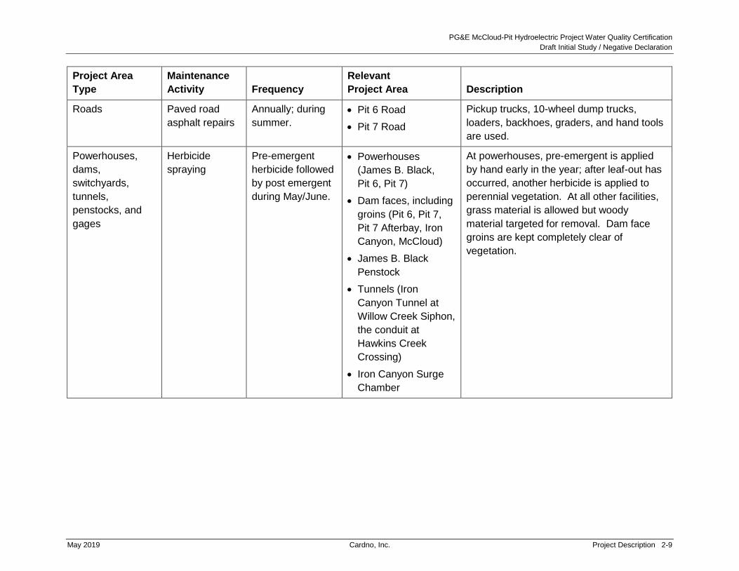
Roads Paved road
asphalt repairs
Annually; during
summer.
Pit 6 Road
Pit 7 Road
Pickup trucks, 10-wheel dump trucks,
loaders, backhoes, graders, and hand tools
are used.
Powerhouses,
dams,
switchyards,
tunnels,
penstocks, and
gages
Herbicide
spraying
Pre-emergent
herbicide followed
by post emergent
during May/June.
Powerhouses
(James B. Black,
Pit 6, Pit 7)
Dam faces, including
groins (Pit 6, Pit 7,
Pit 7 Afterbay, Iron
Canyon, McCloud)
James B. Black
Penstock
Tunnels (Iron
Canyon Tunnel at
Willow Creek Siphon,
the conduit at
Hawkins Creek
Crossing)
Iron Canyon Surge
Chamber
At powerhouses, pre-emergent is applied
by hand early in the year; after leaf-out has
occurred, another herbicide is applied to
perennial vegetation. At all other facilities,
grass material is allowed but woody
material targeted for removal. Dam face
groins are kept completely clear of
vegetation.

PG&E McCloud-Pit Hydroelectric Project Water Quality Certification
Draft Initial Study / Negative Declaration
2-10 Project Description Cardno, Inc. May 2019
Project Area
Type
Maintenance
Activity Frequency
Relevant
Project Area Description
Powerhouses,
dams,
switchyards,
tunnels,
penstocks, and
gages
Vegetation
clearing
As needed year-
round.
Powerhouses
(James B. Black, Pit
6, Pit 7); within
fenced perimeter up
to a 5-ft buffer
outside the fence
Dam faces, including
groins (Pit 6, Pit 7,
Pit 7 Afterbay, Iron
Canyon, McCloud)
Gages MC-1 and
MC-10
Follows herbicide spraying. At dam faces,
grass material allowed but woody material
targeted for removal. Dam face groins kept
completely clear of vegetation.
Powerhouses,
dams,
switchyards,
tunnels,
penstocks, and
gages
Maintain trails As needed year-
round.
Gages MC-1 and
MC-10
Trim vegetation encroaching into the path
of travel and lop and scatter trimmings.
Use of shovels to redirect runoff and abate
erosion.
Transmission
lines
Hazard tree
removal
Annually patrolled
for compliance.
12-kV distribution
line
James B. Black
Transmission Line
Pit 6 Transmission
Line
Pit 7 Transmission
Line
Lines patrolled by vehicle, off-highway
vehicle, or on-foot, as appropriate. In sites
with more difficult access, trimmed
vegetation is lopped and scattered. In
accessible sites, trees are chipped, and the
material removed off-site. Herbicide
application is applied to prevent
re-sprouting.

PG&E McCloud-Pit Hydroelectric Project Water Quality Certification
Draft Initial Study / Negative Declaration
May 2019 Cardno, Inc. Project Description 2-11
Project Area
Type
Maintenance
Activity Frequency
Relevant
Project Area Description
Transmission
lines
Vegetation
clearing
Annually patrolled
for compliance.
12-kV distribution
line
James B. Black
Transmission Line
Pit 6 Transmission
Line
Pit 7 Transmission
Line
Clearing is conducted beneath wires,
including a 10-ft buffer and the 40-ft border
area. In Year 1 the site is
masticated/mowed. In Year 2 the site is
inspected to determine if follow-up
herbicide application is necessary. Two to
three years following, the site is
re-inspected to determine what treatment
needed. Recruiting trees are removed by
hand or via individual herbicide
applications.
Transmission
lines
Herbicide
sprayinga
As needed. 12-kV distribution
line
James B. Black
Transmission Line
Pit 6 Transmission
Line
Pit 7 Transmission
Line
Herbicide applications are all ground-based
to individual plants. Generally, a backpack
unit is used 90 percent of the time and a
tank is used ten percent of the time.
Spoil pile sites Site grading Every 3–5 years,
as needed.
Downstream end of
Pit 6 and Pit 7 roads
Base of McCloud
Dam
Conduit at Hawkins
Creek Crossing
Grade maintained so site acts as a catch
basin.

PG&E McCloud-Pit Hydroelectric Project Water Quality Certification
Draft Initial Study / Negative Declaration
2-12 Project Description Cardno, Inc. May 2019
Project Area
Type
Maintenance
Activity Frequency
Relevant
Project Area Description
Spoil pile sites Material burning Approximately
once per year, as
needed.
Downstream end of
Pit 6 and Pit 7 roads
Base of McCloud
Dam
Conduit at Hawkins
Creek Crossing
Includes floating debris removed from
reservoirs, material removed from gutters,
and slide debris.
All Project Areas Employee
awareness
training
Annual refresher
training.
All Project Areas Training includes prevention of weed
transport (via dirty vehicles), cleaning
procedures for rental equipment, cleaning
procedures when moving between
watersheds, protection of special-status
occurrences, and elderberry identification
information.
Notes:
a Herbicide applications are prescribed in a recommendation prepared by a licensed Pest Control Adviser to treat a specific site and condition. Herbicides
commonly used contain one or more of the following listed active ingredients (although other suitable pesticides may be available and appropriate for a given
situation): Chlorsulfuron; Clopyralid; Oxyfluorfen; Fluazifop-P; Glyphosate; Dithiopyr; Imazapyr; Isoxaben; Oryzalin; Prodiamine; Sulfometuron; Flumioxazin;
Triclopyr; and Aminopyralid.

PG&E McCloud-Pit Hydroelectric Project Water Quality Certification
Draft Initial Study / Negative Declaration
May 2019 Cardno, Inc. Project Description 2-13
Table 2-2 Project Gages
Location USGSa Gage No. PG&E Gage No.
McCloud River near McCloud 11367500 MC-3
McCloud Reservoir Storage 11367740 MC-6
McCloud-Iron Canyon Diversion Tunnel 1367720 MC-8
McCloud River below McCloud Dam 11367760 MC-7
McCloud River near Ah-Di-Na 11367800 MC-1
McCloud River Above Shasta Lake 11368000 MC-5
Iron Canyon Reservoir Storage 11363920 MC-9
Iron Canyon Creek below Iron Canyon Dam 11363930 MC-10
Pit River at Big Bend 11363000 PH-27
James B. Black Powerhouse 11363910 MC-11
Pit 5 Powerhouse (FERC Project No. 233) 11362700 PH-69
Pit 6 Reservoir Storage 11364100 PH-58
Pit 6 Powerhouse 11364150 PH-63
Pit 7 Reservoir Storage 11364700 PH-59
Pit 7 Powerhouse 11364800 PH-64
Pit River near Montgomery Creek (downstream of Pit 7 Dam) 11365000 PH-47
Notes:
a United State Geological Survey
2.3.5 Existing Recreation Facilities
There are three developed recreation areas within the Project boundary: (1) Tarantula Gulch
boat ramp at McCloud Reservoir; (2) Deadlun Creek Campground at Iron Canyon Reservoir;
and (3) Hawkins Landing Campground and boat ramp at Iron Canyon Reservoir. All of these
facilities are located within the James B. Black Development. There are no developed
recreation sites within the Project Boundary in the lower Pit River; however, dispersed
recreation is evident in a few locations on the lower McCloud River and Hawkins Creek
Crossing (FERC 2011).

PG&E McCloud-Pit Hydroelectric Project Water Quality Certification
Draft Initial Study / Negative Declaration
2-14 Project Description Cardno, Inc. May 2019
2.3.5.1 McCloud Reservoir
Existing recreation facilities in the vicinity of McCloud Reservoir are shown on Figure 2-2. The
Tarantula Gulch boat ramp, which was constructed by PG&E and is operated by the USFS,
includes a boat ramp and a developed picnic area. Specific recreation facilities include:
Single-lane concrete boat launch ramp;
Loading dock;
Overflow parallel parking with unmarked spaces;
22 parking spaces for vehicles with trailers;
Three picnic tables;
Four wildlife-resistant trash receptacles; and
Vault restroom with two unisex accessible stalls.

PG&E McCloud-Pit Hydroelectric Project Water Quality Certification
Draft Initial Study / Negative Declaration
May 2019 Cardno, Inc. Project Description 2-15
Figure 2-2 Recreation Facilities in the Vicinity of McCloud Reservoir

PG&E McCloud-Pit Hydroelectric Project Water Quality Certification
Draft Initial Study / Negative Declaration
2-16 Project Description Cardno, Inc. May 2019
The bottom of the boat ramp is one foot below the normal minimum operating reservoir level
(elevation 2,634 feet) and typically provides boater access during the entire recreation season
(May 15 to October 15). The USFS reports that sediment and debris accumulate on the ramp
and occasionally impede boat launching (FERC 2011).
The majority of lands surrounding McCloud Reservoir are privately owned. The USFS and
PG&E lands that are accessible to the public are located on the southern end of the reservoir,
extending from near the access road to Tarantula Gulch and continuing across McCloud Dam to
Star City Creek (see Figure 2-2). Dispersed recreation is allowed on PG&E and USFS lands,
unless otherwise designated. PG&E identified nine user-created dispersed recreation sites at
lower-gradient access points accessible from Star City Road around McCloud Reservoir, and a
dispersed campsite on an island in McCloud Reservoir. The Star City Creek area is the largest
dispersed site at McCloud Reservoir, offering primitive camping on approximately 13 acres.
2.3.5.2 Iron Canyon Reservoir
There are two developed recreation areas at Iron Canyon Reservoir, which include:
Hawkins Landing Campground and boat ramp, which is owned and operated by PG&E and
comprises of: one single-lane concrete launch ramp; 11 campsites with fire rings and picnic
tables; one non-potable water hand pump; one trash receptacle; and two vault toilets.
Deadlun Campground, which is owned and operated by the USFS and comprises of:
27 campsites with fire rings and picnic tables; three vault restrooms with single, unisex,
ADA-accessible stalls; and overflow parallel parking with unmarked spaces. (See Figure 2-3.)
Hawkins Landing Campground and boat ramp have the only boat launch ramp on Iron Canyon
Reservoir. No formal parking is available at the boat launch and the number of vehicles that the
boat launch area can accommodate depends on reservoir elevation. Normal project operations
can cause Iron Canyon Reservoir to fluctuate on a daily basis, which affects the availability of
parking at the shoreline near the boat launch. When the reservoir is at full pool (2,664 feet in
elevation), visitors park vehicles in Hawkins Landing Campground. As the elevation of Iron
Canyon Reservoir lowers, more shoreline is exposed and visitors park along the shoreline,
thereby increasing the potential number of vehicles that can park near the launch area. Since
1996, PG&E has voluntarily maintained the reservoir water surface elevation above 2,615 feet
to keep the boat ramp useable during the primary recreation season from May 15 to October 15.

PG&E McCloud-Pit Hydroelectric Project Water Quality Certification
Draft Initial Study / Negative Declaration
May 2019 Cardno, Inc. Project Description 2-17
Figure 2-3 Recreation Facilities in the Vicinity of Iron Canyon Reservoir

PG&E McCloud-Pit Hydroelectric Project Water Quality Certification
Draft Initial Study / Negative Declaration
2-18 Project Description Cardno, Inc. May 2019
The majority of lands surrounding Iron Canyon Reservoir are PG&E or USFS lands. Recreation
user-created access trails (pedestrian and off highway vehicles) originate from both campgrounds
and nearby areas providing dispersed shoreline access. PG&E has identified 22 dispersed
recreation sites around Iron Canyon Reservoir with heavily used dispersed recreation sites at the
areas adjacent to Deadlun Campground and Iron Canyon Reservoir spillway.
2.3.5.3 Lower McCloud River and Hawkins Creek Crossing
Recreation areas downstream of McCloud Reservoir include the area at Hawkins Creek
crossing (inside the Project Boundary) and the lower McCloud River (outside the FERC project
boundary). Hawkins Creek crossing is a cleared level area where the McCloud Tunnel crosses
Hawkins Creek, about one mile above the confluence with the lower McCloud River. PG&E
documented several dispersed recreation sites including: two dispersed recreation sites near
Ash Camp; a dispersed campsite on Hawkins Creek at Hawkins Creek Tunnel that is accessible
via a PG&E Project road; and a dispersed campsite on the PG&E spoil pile area on Hawkins
Creek that is just north of the Hawkins Creek Tunnel (FERC 2011).
The lower McCloud River extends 24 river miles from McCloud Dam to Shasta Lake, but only
the upper nine miles of this 24-mile reach have land-based public access within USFS lands.
No Project lands are located along the lower McCloud River except for the area immediately
below McCloud Dam.
2.3.6 Existing Recreation Facilities Routine Operations and Maintenance
PG&E currently hires six to eight caretakers to operate and maintain the existing recreational
facilities generally from mid-May through mid-September, when recreation use is highest.
Caretakers are typically located at campgrounds where fees are collected. During the
off-season, when recreation use significantly decreases, the number of caretakers on-site and
the operation and maintenance effort is similarly reduced. Many existing recreation facilities are
closed during the off season.
The caretakers’ daily activities include the following: cleaning facilities; picking up litter; reporting
potential public safety hazards; correcting unsafe conditions; collecting fees; maintaining daily
campground occupancy records; pest management; managing signs; operating water systems;
performing minor maintenance and repairs on existing facilities; water treatment and testing;
dumpster waste removal; and hazard tree removal; however the septic pumping of the sealed
vault toilets are typically contracted to third parties.
2.3.7 Project Safety
The McCloud-Pit Project is currently operating under the existing FERC license and annual
license extensions, during which time FERC staff have conducted operational inspections
focused on the continued safety of the structures, identification of unauthorized modifications,
efficiency and safety of operation, compliance with the terms of the license, and proper
maintenance. In addition, the McCloud-Pit Project has been inspected and evaluated every
5 years by an independent consultant, and a consultant’s safety report has been filed for
FERC’s review. As part of the relicensing process, the FERC staff would evaluate the
adequacy of the project facilities under a new license. Special license articles would be

PG&E McCloud-Pit Hydroelectric Project Water Quality Certification
Draft Initial Study / Negative Declaration
May 2019 Cardno, Inc. Project Description 2-19
included in any license issued, as appropriate. FERC staff would continue to inspect the
McCloud-Pit Project during the new license term to assure continued adherence to
FERC-approved plans and specifications; special license articles relating to construction,
operation, and maintenance; and accepted engineering practices and procedures (FERC 2011).
2.3.8 Existing Environmental Measures
2.3.8.1 Water Flow Requirements
The current license for the McCloud-Pit Project includes MIF requirements for McCloud River
and Iron Canyon Creek below their respective dams (Article 31). For the McCloud River below
the McCloud Dam, requirements include a MIF release of 50 cfs from May through November,
and 40 cfs from December through April, as measured at gage MC-7. Steam flows in addition
to the MIF requirements are determined by month and water-year type, and are released as
necessary to maintain the 160 to 210 cfs that is required at gage MC-1, which is located below
the confluence of Hawkins Creek and the McCloud River (FERC 2011).
Flows of at least 3 cfs are required to be released to Iron Canyon Creek below Iron Canyon
Dam at all times. A minimum of 150 cfs is required below the Pit 7 Powerhouse whenever the
surface water elevation of Shasta Lake is below the invert elevation (or bottom) of the draft
tubes of the powerhouse (1,055 feet msl) (FERC 2011).
To facilitate use of the boat ramp during the recreation season from May 15 to October 15,
PG&E voluntarily keeps the water surface elevation of Iron Canyon Reservoir at or above
elevation 2,615 feet msl, instead of the minimum elevation of 2,593 feet msl allowed by the
current license.
2.4 Proposed Project
A project is defined under CEQA as “the whole of an action, which has a potential for resulting
in either a direct physical change in the environment, or a reasonably foreseeable indirect
physical change in the environment” and that requires a discretionary approval from a public
agency. (Cal. Code Regs., tit. 14, § 15378, subd. (a)(3).)
The Proposed Project evaluated in this draft IS/ND includes:
The existing McCloud-Pit Project including operations and maintenance of infrastructure;
Construction of recreational facility improvements and continued operation of the
recreational facilities;
Increased MIF releases proposed by PG&E for two Project-affected stream reaches: (1) the
McCloud River below McCloud Dam; and (2) Iron Canyon Creek below Iron Canyon Dam.
Under the Proposed Project, the range and schedule of MIF releases to protect water quality
and support the designated beneficial uses of these stream reaches (CVRWQCB 2018,
Basin Plan Table 2-1); and
Implementation of 13 monitoring and management plans. Under the Proposed Project, and
as required by USFS Final 4(e) Conditions, PG&E would develop and implement
13 resource management plans. These are described in detail in Section 2.4.6, Proposed
PG&E McCloud-Pit Hydroelectric Project Water Quality Certification
Draft Initial Study / Negative Declaration
2-20 Project Description Cardno, Inc. May 2019
Environmental Management and Monitoring Plans. All USFS plans will require FERC
approval prior to implementation.
In PG&E’s license application, dated July 2009, PG&E proposed two new hydropower
developments: (1) the McCloud Development, which would consist of a new powerhouse below
McCloud Dam that would use water stored in McCloud Reservoir; as well as an associated
transmission line that would be routed from the new McCloud powerhouse to the town of
McCloud in Siskiyou County; and (2) the Pit 7 Afterbay Development, which would consist of a
new powerhouse below the Pit 7 Afterbay Dam that would use water released from Pit 7
Afterbay; as well as an associated transmission line that would be routed from the new Pit 7
Afterbay Powerhouse to the existing Pit 7 Switchyard near Pit 7 Dam.
PG&E, however, did not finalize designs or capacities for the two proposed hydropower
developments in their license application. PG&E stated in their license application that the
economic feasibility of the two proposed hydropower developments depends in part on
conditions included in the new Project license (i.e., new minimum instream requirements). As a
result, PG&E will wait until they receive the new FERC license for the relicensing of the
McCloud-Pit Project before they determine if the two hydropower developments will be built.
Therefore, the Proposed Project addressed in this draft IS/ND does not include these two
proposed hydropower developments.
If PG&E decides to build the two proposed hydropower developments after the issuance of a
new license by FERC, then PG&E would need to request an amendment to the certification for
the relicensing of the McCloud-Pit Project. An amendment to the certification to incorporate the
development of two new hydropower facilities for the McCloud-Pit Project would require
compliance with CEQA.
2.4.1 Project Purpose and Objectives
To receive a new FERC license, PG&E is required to obtain a certification under section 401 of
the CWA. The State Water Board is the agency in California that is responsible for acting on
applications for certification of hydroelectric projects. The purpose of a certification is to protect
the waters of the United States by ensuring waste discharged to waters from a proposed activity
meet water quality standards presented in the Basin Plan (CVRWQCB 2018). The Basin Plan
identifies the beneficial uses and water quality objectives for water bodies within this geographic
region. Identified beneficial uses for the McCloud River include: municipal and domestic water
supply; power (generation); water contact recreation; canoeing and rafting; other noncontact
recreation; cold freshwater habitat; cold spawning habitat; and wildlife habitat.
The beneficial uses for the Pit River (downstream of the confluence of Hat Creek to Shasta Lake)
include all those listed for the McCloud River (except cold spawning habitat) and additionally:
agricultural supply (irrigation, stock watering); warm freshwater habitat; and warm spawning
habitat. As part of the FERC licensing process, the State Water Board must issue or deny a
certification for the McCloud-Pit Project. Conditions in a certification will become mandatory
conditions of the FERC license for the McCloud-Pit Project once the license is issued.

PG&E McCloud-Pit Hydroelectric Project Water Quality Certification
Draft Initial Study / Negative Declaration
May 2019 Cardno, Inc. Project Description 2-21
2.4.2 Proposed Project Boundary
The Proposed Project includes expansion of the existing FERC boundary by 1.88 acres to
accommodate expansion of an existing access road to Hawkins Landing Campground. All other
Project improvements would occur within the existing FERC boundary.
In addition, in 2017, PG&E proposed as a separate project an adjustment to the FERC boundary
of an additional 1.41 acres to accommodate realignment of the Pit 7 Access Road, which provides
access to Pit 7 Dam and Powerhouse. The original Pit 7 Access Road failed in 2017 due to winter
storms and landslides and, in order to re-establish access, PG&E repaired and realigned the road
along a less steep slope to reduce the likelihood of road damage in the future.
A summarized description of the Proposed Project is provided below. For a more detailed
description of the Proposed Project, refer to the final EIS, Section 2.3, Staff Alternative.
2.4.3 Proposed Recreation Facilities
PG&E proposes to construct four new recreation facilities at McCloud Reservoir, two new
recreation facilities at Iron Canyon Reservoir, one new recreation facility at Pit 6 Reservoir, and
two new recreation facilities at Pit 7 Afterbay.
In addition, PG&E proposes to make recreation improvements at McCloud Reservoir, Iron
Canyon Reservoir, and Pit 7 Afterbay. Table 2-3 lists the proposed recreation facilities, number
of workers, duration and types of equipment necessary to construct the facilities, and total
amount of disturbed acreage per facility. Figures 2-2, 2-3, and 2-4 provide the locations of the
proposed facilities. Proposed changes at each facility are described in the following sections.

PG&E McCloud-Pit Hydroelectric Project Water Quality Certification
Draft Initial Study / Negative Declaration
2-22 Project Description Cardno, Inc. May 2019
Table 2-3 Proposed Recreation Facilities: Construction Personnel, Duration, Equipment List, and Disturbed Acreage
Project
Changes Recreational Facility
Work
Crew
Duration
(Days) Equipment
Disturbed
Area (acres)
McCloud Reservoir
Improved Tarantula Gulch Boat Launch and
Day Use Area 14 60
Concrete mixer truck,
power screed, drill rig 2.6
New McCloud Day Use Area 7 15 Drill rig <1
Improved Red Banks Day Use Area 7 30 No additional equipment
required. <1
Improved Battle Creek Shoreline Access 7 10 No additional equipment
required. <1
Improved McCloud Reservoir West Dam
Shoreline Access 7 10
No additional equipment
required. <1
Improved McCloud Reservoir East Dam
Shoreline Access 7 10
No additional equipment
required. <1
Improved Star City Campground and Day Use
Area 16 65
Concrete Mixer Truck, Drill
Rig for Well, Grader, Front
End Loader, Drum Roller,
Backhoe, Three Crew
Trucks
13.6
Improved McCloud Dam River Access 7 20 No additional equipment
required. <1
Iron Canyon Reservoir
Improved Hawkins Landing Boat Launch 10 40 Concrete Mixer Truck,
Power Screed 1.7

PG&E McCloud-Pit Hydroelectric Project Water Quality Certification
Draft Initial Study / Negative Declaration
May 2019 Cardno, Inc. Project Description 2-23
Project
Changes Recreational Facility
Work
Crew
Duration
(Days) Equipment
Disturbed
Area (acres)
Improved Hawkins Landing Campground 10 60 Drill Rig, Mixer Truck 5
Improved Deadlun Campground 10 60 Drill Rig, Mixer Truck 9.8
New Gap Creek Campground 20 40
Drill Rig, Mixer Truck,
Power Screed, Drum
Roller, Paver, Grader,
Loader, Drum Roller, Two
Backhoes
6.5
New Iron Canyon Dam Boat Launch 12 60
Drill Rig, Mixer Truck,
Power Screed, Drum
Roller, Paver, Backhoe,
Grader
2.9
New Three Day Use Areas at Iron
Canyon Reservoir 5 12
No additional equipment
required. <1
Pit 7 Reservoir
Improved Upper Pit 7 Reservoir Trailheads 5 8 No additional equipment
required. <1
New Lower Pit 7 Reservoir Shoreline
Access 7 35
No additional equipment
required. <1
Pit 7 Afterbay
Improved Fenders Flat Day Use Area 12 30 Mixer Truck 2.25
Note: Each recreational area will have a baseline equipment list including: grader, dozer, front end loader, backhoe, excavator, dump truck, 3-crew trucks, plate
compactor, drum roller, paver. Additional equipment needs for each area are listed above.
PG&E McCloud-Pit Hydroelectric Project Water Quality Certification
Draft Initial Study / Negative Declaration
2-24 Project Description Cardno, Inc. May 2019
In general, nine of the 17 facility improvements would each disturb less than one acre. The
largest area of disturbance, Star City Campground and Day Use Area, would encompass
approximately 13.6 acres. The total disturbance for all new and improved facilities would be
approximately 48 acres. No additional laydown areas would be needed to construct any of
the facilities.
During construction of the recreation facility improvements, usable excess construction
materials such as lumber, paint, metal pipe, etc. would be returned to the PG&E Service Center
for use on other projects. Waste would be disposed of at local waste transfer stations or
Anderson Solid Waste Landfill. Based on the number of facilities requiring improvement, the
estimated volume of waste generated by construction would be 750 cubic yards (refer to
specific facility descriptions below).
2.4.3.1 McCloud Reservoir
Recreation facilities, and associated improvements, surrounding the McCloud Reservoir are
presented in Figure 2-2 and are described in more detail in the following sections.
2.4.3.1.1 Tarantula Gulch Boat Launch and Day Use Area
The total area disturbed by improvements to the Tarantula Gulch Boat Launch and Day Use Area
would be approximately 2.6 acres, and the work would be accomplished by approximately
14 workers over 60 working days. Planned features of the Tarantula Gulch Boat Launch include a
30-foot-wide, two-lane, concrete boat ramp and a 4-foot-wide walkway. Improvements include
extending the boat launch 4 feet in length to extend below the minimum reservoir pool elevation
(2,634 feet) and installing an 8-foot by 40-foot sliding boarding float dock or pier.
The proposed improvements would also include:
A new asphalt-surfaced access road and parking area with a maximum of 12 pull through
car/trailer parking spaces;
Ten head-in car/trailer parking spaces and six car parking spaces;
Potable water supply;
One sealed vault toilet;
Day use area with three covered picnic sites;
An access trail to the edge of the reservoir;
An informational kiosk and pay station; and
Signage and site security lighting.
PG&E McCloud-Pit Hydroelectric Project Water Quality Certification
Draft Initial Study / Negative Declaration
May 2019 Cardno, Inc. Project Description 2-25
2.4.3.1.2 McCloud Day Use Area
The total area disturbed by improvements to the McCloud Day Use Area would be less than one
acre, and the work would be accomplished by approximately seven workers over
15 working days.
The proposed improvements include:
An asphalt surfaced access drive;
Parking area for five vehicles (with one Americans with Disabilities Act-compliant space);
Five picnic sites (each with picnic table and barbecue/fire ring);
A trail surfaced with natural materials leading to the reservoir shoreline;
One sealed vault toilet;
One potable water hydrant;
One trash receptacle; and
Entry sign and informational kiosk.
2.4.3.1.3 Red Banks Day Use Area
The total area disturbed by improvements to the Red Banks Day Use Area would be less than
one acre, and the work would be accomplished by approximately seven workers over 30 working
days. The existing area is currently used for informal day use activities on the shoreline at
McCloud Reservoir, and would become a developed recreation site through the installation of
picnic tables, a vault restroom, and a shoreline access trail. The shoulder of the USFS Road
38N11 is currently used for parking. The roads into this day use area would be re-graded, and
bank stabilization measures would be necessary due to undercutting near the shoreline.
2.4.3.1.4 Battle Creek Shoreline Access
The total area disturbed by improvements to the Battle Creek Shoreline Access would be less
than one acre, and the work would be accomplished by approximately seven workers over
10 working days. This existing shoreline access currently has an asphalt parking area and
access to the water’s edge along USFS Road FS-11. The parking area would be reorganized to
encourage multiple user groups, and the trail would be surfaced with native materials.
2.4.3.1.5 McCloud Reservoir West Dam Shoreline Access
The total area disturbed by improvements to the McCloud Reservoir West Dam Shoreline
Access would be less than one acre, and the work would be accomplished by approximately
seven workers over ten working days. Improvements for this existing shoreline access would
include improving the vehicle parking area and improving accessibility of the trail to the edge of
the water by constructing new switchbacks.
PG&E McCloud-Pit Hydroelectric Project Water Quality Certification
Draft Initial Study / Negative Declaration
2-26 Project Description Cardno, Inc. May 2019
2.4.3.1.6 McCloud Reservoir East Dam Shoreline Access
The total area disturbed by improvements to the McCloud Reservoir East Dam Shoreline
Access would be less than one acre, and the work would be accomplished by approximately
seven workers over ten working days. Improvements for this existing shoreline access would
include parking area designation, improved vehicle access, and signage.
2.4.3.1.7 Star City Campground and Day Use Area
The total area disturbed by improvements to the Star City Campground and Day Use Area
would be approximately 13.6 acres, and the work would be accomplished by 16 workers over
65 working days. The existing Star City dispersed camping area would be improved to include
access road improvements, campsites, day use area, and trails. The 2.6-mile access road,
USFS Road S38N04Y, would be reconstructed.
Proposed improvements to Star City Campground would include:
Up to ten walk-in campsites and a host site, with campsite features such as a table, a tent
pad, and fire ring;
Roads with vehicle barriers;
Asphalt parking area;
Camping spurs;
One sealed vault toilet;
Animal resistant trash enclosures;
Message board and signage;
Potable water source; and
Shoreline access paths.
2.4.3.1.8 River Access below McCloud Dam
The total area disturbed by improvements to the river access below McCloud Dam would be
less than one acre, and the work would be accomplished by approximately seven workers over
20 working days.
Proposed improvements to this river access area would include:
Improvements to the access road;
Angler access trails;
Compact aggregate parking area;
One sealed vault toilet;
Animal resistant trash receptacle; and
A put-in for white water boating.

PG&E McCloud-Pit Hydroelectric Project Water Quality Certification
Draft Initial Study / Negative Declaration
May 2019 Cardno, Inc. Project Description 2-27
2.4.3.2 Iron Canyon Reservoir
Recreation facilities and associated improvements surrounding Iron Canyon Reservoir are
presented in Table 2-3 and Figure 2-3 and are described in more detail in the following sections.
2.4.3.2.1 Hawkins Landing Boat Launch
The total area disturbed by improvements to the Hawkins Landing Boat Launch would be
approximately 1.7 acres, and the work would be accomplished by approximately ten workers
over 40 working days. This existing boat launch would undergo reconstruction that would
consist of a concrete-surfaced and striped parking lot that has mix of single and double spaces
with pull-through design for a minimum of ten vehicles with trailers above the reservoir high
water level and adjacent to the existing ramp location. This boat ramp would be reconstructed
to current Cal Boating standard (surface only) for a single lane ramp.
2.4.3.2.2 Hawkins Landing Campground
The total area disturbed by improvements to the Hawkins Landing Campground would be
approximately five acres, and the work would be accomplished by approximately ten workers
over 60 working days. This existing campground would undergo reconstruction which would
include removing existing infrastructure, redesigning, and reconstructing the campground to
consist of:
An asphalt surfaced loop road, with ten campsites plus one host site (each campsite would
have a table, tent pads, asphalt surfaced parking spurs and fire rings);
Sealed vault toilets;
Signage;
Vehicle control barriers; and
A trail, surfaced with native materials, routed from the campground to the boat launch and
potable water. Some vegetation would be removed to create views of the reservoir from the
campsites near the shoreline.
2.4.3.2.3 Deadlun Campground
The total area disturbed by improvements to the Deadlun Campground would be approximately
9.8 acres, and the work would be accomplished by approximately ten workers over 60 working
days. The existing campground footprint would remain the same. Currently, the campground
has 27 campsites, including two multi-family sites. Campsites would be improved to meet a
recreational vehicle requirement of 16-foot width and include multi-family camping. For each
campsite, a tent pad, a table, animal resistant food lockers and trash receptacles, and
barbecue/fire ring would be added. The campsite interior road would be re-graded with gravel,
chip seal, asphalt surfaces, and circulation barriers to control vehicle access. Some vegetation
removal would be conducted to open the view of the reservoir. In general, the campground
would be re-graded to make campsites with flat areas more accessible. The shore access
would also be redesigned and re-graded to provide a compacted aggregate surface trail six to
eight feet wide along the shore, above the normal high-water line, and would allow for a

PG&E McCloud-Pit Hydroelectric Project Water Quality Certification
Draft Initial Study / Negative Declaration
2-28 Project Description Cardno, Inc. May 2019
continuous shoreline trail route from Deadlun Creek to Cedar Salt Log Creek (approximately
1.8 miles).
2.4.3.2.4 Gap Creek Campground
The total area disturbed by improvements to the Gap Creek Campground would be
approximately 6.5 acres, and the work would be accomplished by approximately 20 workers
over 40 working days. Proposed features for the new Gap Creek Campground include:
Asphalt surfaced access loop roads to two campground areas;
Asphalt parking area for seven walk-in campsites;
An asphalt loop road and parking spurs for 11 campsites;
Sealed vault toilets;
Potable water supply;
Picnic tables and barbecue/fire rings at each campsite;
A host campsite;
Animal resistant food lockers and trash receptacles;
Compacted aggregate trails for shoreline access;
Campground entry signs, information signage, and a pay station; and
Security lighting.
2.4.3.2.5 Iron Canyon Dam Boat Launch
The total area disturbed by improvements to the Iron Canyon Dam Boat Launch would be
approximately 2.9 acres, and the work would be accomplished by approximately 12 workers
over 60 working days. Proposed features for the new Iron Canyon Dam Boat Launch include:
A single lane concrete boat ramp constructed to Cal Boating standards with walkway and
mid-ramp turn around extended to four feet below the minimum reservoir pool elevation;
A sliding boarding float dock or pier;
An asphalt-surfaced access entry and parking area, with a minimum of 15 pull-through
vehicle parking spaces (ten with trailers);
A sealed vault toilet;
Potable water supply;
Animal resistant trash receptacle;
Day use area with five picnic tables and barbecue/fire rings;
Facility entry sign;
An informational kiosk; and

PG&E McCloud-Pit Hydroelectric Project Water Quality Certification
Draft Initial Study / Negative Declaration
May 2019 Cardno, Inc. Project Description 2-29
Security lighting.
2.4.3.2.6 Three Shoreline Access Areas at Iron Canyon Reservoir
The total area disturbed by development of three new shoreline access areas along Iron
Canyon Reservoir would be less than one acre combined, and the work would be accomplished
by approximately five workers over 12 working days. Suitable areas along the reservoir would
need to be identified. These new shoreline access areas would include surfaced parking sites
and shoreline access trails surfaced with native materials.
2.4.3.3 Pit 7 Reservoir
Recreation facilities and associated improvements surrounding Pit 7 Reservoir are presented in
Figure 2-4 and are described in more detail in the following sections.
2.4.3.3.1 Upper Pit 7 Reservoir Trailheads
The total area disturbed by improvements to trailheads around the Upper Pit 7 Reservoir would be
less than one acre, and the work would be accomplished by approximately five workers over eight
working days. Two trailheads and trails, located approximately 0.25 and 0.6 miles downstream of
the Pit 6 Dam, would be constructed along the Pit 6 Powerhouse Road to provide access to Pit 7
Reservoir. Improvements to the upstream trailhead would include providing parking along the
shoulder of the road for about four vehicles and constructing a pedestrian access (that would be
surfaced with native materials) on an existing access trail that is routed from Pit 6 Dam Access
Road to the shoreline and which can be used as a hand-launch boat access trail. Improvement to
the downstream trailhead would include a surfaced parking area for a minimum of three vehicles
and a new trail surfaced with native materials. This trail would require installing two culverts
where the trail crosses stream drainages, and a foot bridge at Cape Horn Creek. This
downstream shoreline access trail would provide a secondary location where boaters could exit
the reservoir if the flows released from Pit 6 Powerhouse prevented boaters from traveling to the
shoreline access provided at the upstream end of the reservoir.
2.4.3.3.2 Lower Pit 7 Reservoir Shoreline Access
The total area disturbed by a new shoreline access trial in the lower Pit 7 Reservoir would be
less than one acre, and the work would be accomplished by approximately seven workers over
35 working days. A new shoreline access trailhead, trail, and a location for hand-launching
boats would be constructed at the downstream end of Pit 7 Reservoir, just upstream of Pit 7
Dam. Proposed improvements include a surfaced vehicle access road and surfaced parking for
a maximum of eight vehicles. The new parking area would include a new turnaround and gate
to prevent public access to the dam and spillway. Shoreline access would be provided by
constructing an 80-foot metal stairway that would connect the Pit 7 Dam Access Road to a new
pedestrian trail (surfaced with native materials), which would extend 1,900 feet and terminate at
the shoreline. The existing floating boom would be relocated to provide beach access that is
outside the restricted access area near the dam.
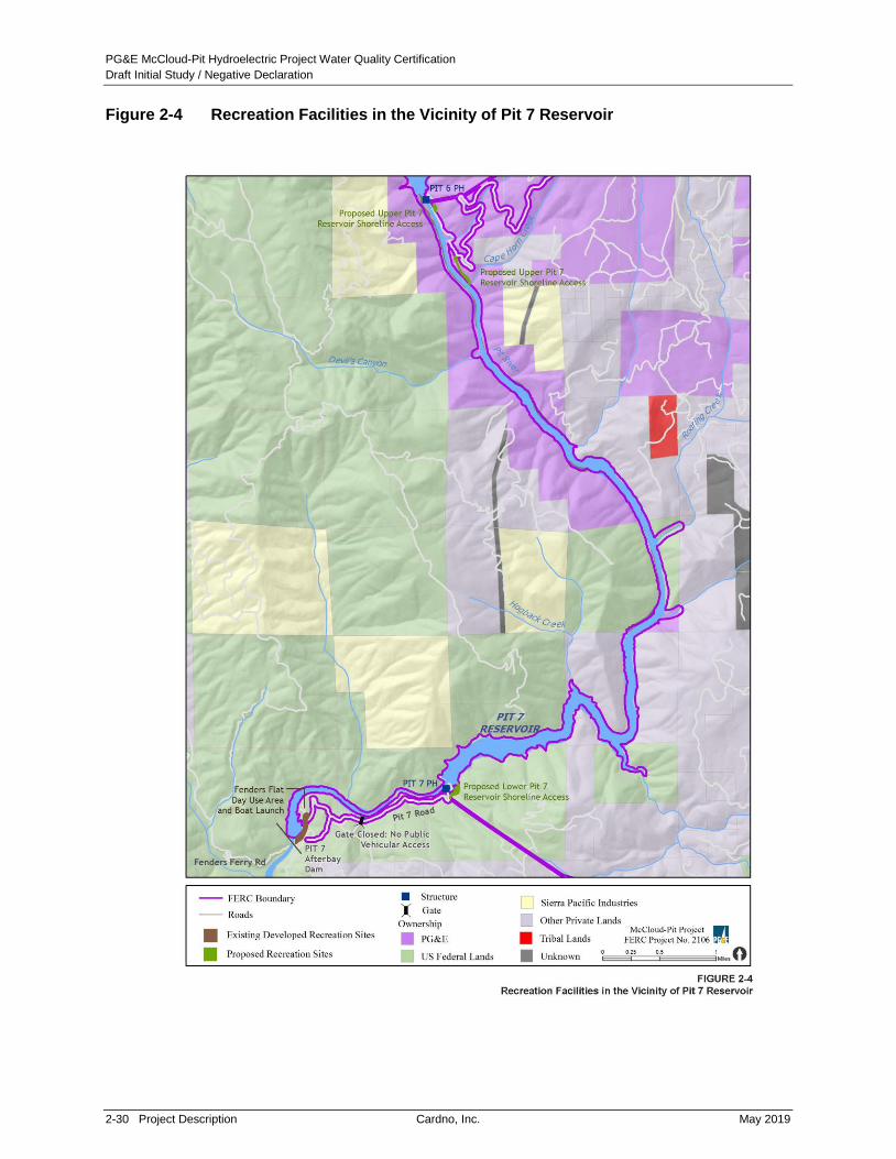
PG&E McCloud-Pit Hydroelectric Project Water Quality Certification
Draft Initial Study / Negative Declaration
2-30 Project Description Cardno, Inc. May 2019
Figure 2-4 Recreation Facilities in the Vicinity of Pit 7 Reservoir
PG&E McCloud-Pit Hydroelectric Project Water Quality Certification
Draft Initial Study / Negative Declaration
May 2019 Cardno, Inc. Project Description 2-31
2.4.3.4 Pit 7 Afterbay
2.4.3.4.1 Fenders Flat Day Use Area
The total area disturbed by improvements to Fenders Flat Day Use Area would be
approximately 2.25 acres, and the work would be accomplished by approximately 12 workers
over 30 working days. This existing site is within Shasta-Trinity Recreation Area adjacent to the
Pit 7 Afterbay Dam and includes an access road (FR 35N66) to the car-top boat launch,
parking, and dispersed camping area surrounding the solar-powered, high water-flow warning
tower. Site improvements would include a surfaced parking area, picnic tables, pedestal grill,
potable water, and sealed vault toilet. Vegetation in the area previously disturbed by off-road
vehicle use would be restored by scarifying the disturbed areas and replanting with natural
grasses. The access road to the day use area, which starts at USFS Road 35N23, is
approximately 0.2 mile-long and would be re-graded and sloped.
2.4.4 Proposed Recreation Facility Operations and Maintenance
In addition to routine recreation facility operations and maintenance described in Section 2.3.6,
the Proposed Project also includes an additional two to three caretakers at Iron Canyon
Reservoir and one to two additional caretakers at McCloud Reservoir. In addition to being
responsible for operations and maintenance at the recreation facilities where they are located,
the caretakers would also be responsible for other nearby recreation facilities such as day use
and shoreline access areas. The exact details of the how the Proposed Project recreation
facilities would be operated and maintained will be developed after the license is issued and
during the finalization of the Recreation Management Plan.
2.4.5 Proposed Minimum Instream Flows
Overall, the Proposed Project would increase MIF releases from McCloud and Iron Canyon
Dams into their respective downstream reaches. PG&E would also continue to provide MIF
releases of 150 cfs to the Pit River below Pit 7 Dam when Shasta Lake is below 1,055 feet msl
to maintain water flow in the Pit 7 Afterbay.
PG&E proposes to release mean daily flows of a minimum of 175 cfs year-round from the
McCloud Dam (as measured at PG&E gage MC-7), such that the mean daily flow at Ah-Di-Na
(PG&E gage MC-1) is at a minimum of 200 cfs. Flows would be augmented during the period of
February 15 through August 31, as described in Table 2-4. PG&E proposes to implement the
MIF release schedule for Iron Canyon Creek below Iron Canyon Dam as described in Table 2-5.

PG&E McCloud-Pit Hydroelectric Project Water Quality Certification
Draft Initial Study / Negative Declaration
2-32 Project Description Cardno, Inc. May 2019
Table 2-4 Proposed Project Minimum Instream Flow from McCloud Dam into the McCloud River
Month
Lower McCloud River MIF by
Water-Year Typea
Net Change in flow from year-round
minimum
Year-round minimum Release ≥ 175 cfs at McCloud Dam (MC-7); and Maintain ≥ 200 cfs at Ah-Di-Na (MC-1)
If the February 1 McCloud Runoff Percentageb is: Then change in flow will be:
February 15-29
0-75% No flow change
76-89% No flow change
90-99% Increase flow by 75 cfs at MC-7
100-119% Increase flow by 125 cfs at MC-7
≥120% Increase flow by 175 cfs at MC-7
March 1-15
0-75% No flow change
76-89% Increase flow by 50 cfs at MC-7
90-99% Increase flow by 50 cfs at MC-7
100-119% Increase flow by 100 cfs at MC-7
≥120% Increase flow by 150 cfs at MC-7
If the March 1 McCloud Runoff Percentagec is: Then change in flow will be:
March 16-31
0-75% No flow change
76-89% No flow change
90-99% Increase flow by 50 cfs at MC-7
100-119% Increase flow by 50 cfs at MC-7
≥120% Increase flow by 150 cfs at MC-7

PG&E McCloud-Pit Hydroelectric Project Water Quality Certification
Draft Initial Study / Negative Declaration
May 2019 Cardno, Inc. Project Description 2-33
Month
Lower McCloud River MIF by
Water-Year Typea
Net Change in flow from year-round
minimum
April 1-15
0-75% No flow change
76-89% No flow change
90-99% No flow change
100-119% Increase flow by 50 cfs at MC-7
≥120% Increase flow by 50 cfs at MC-7
All Water-Year Types
April 16 – June 30 If flow releases are ≥ 200 cfs on April 16 at MC-7 Then decrease flow at MC-7 by 50 cfs each
Friday after April 15 until flow is 200 cfs.
April 16 – June 30 If flow releases are < 200 cfs on April 16 at MC-7 Then release 175 cfs at MC-7; and maintain a
minimum of 200 cfs at Ah- Di-Na (MC-1)
July 1 – August 31 Release 175 cfs at MC-7; and Maintain a minimum of 215 cfs at Ah- Di-Na (MC-1)
September 1 –
February 15 Release 175 cfs at MC-7; and Maintain a minimum of 200 cfs at Ah- Di-Na (MC-1)
Notes:
a Using most recent California Department of Water Resources (DWR) Sacramento Valley Water-Year Type Index forecast.
b February 1 runoff (RO) percentage from DWR Bulletin 120 for McCloud River above Shasta Lake.
c March 1 RO percentage from DWR Bulletin 120 for McCloud River above Shasta Lake.

PG&E McCloud-Pit Hydroelectric Project Water Quality Certification
Draft Initial Study / Negative Declaration
2-34 Project Description Cardno, Inc. May 2019
Table 2-5 Proposed Project Minimum Instream Flows from Iron Canyon Dam into Iron
Canyon Creek (cfs)
Month
Below Normal, Dry,
Critically Dry Above Normal Wet
October 7 7 10
November 7 7 10
December 7 10 15
January 7 10 15
February 7 10 15
March 10 15 ≥ 20*
April 10 15 ≥ 20*
May 7 10 15
June 7 10 15
July 7 7 10
August 7 7 10
September 7 7 10
Notes:
* In March and April of Wet Water Year Types, the flow control valve on Iron Canyon Dam shall be fully opened.
Mean daily flow shall be at a minimum 20 cfs during this period.
In addition, PG&E proposes to implement the following measures:
Ramp down all spill events that are operationally controllable at McCloud Dam by valve
operation at a maximum rate of 150 cfs per 48 hours until the prescribed MIF value is
reached; and ramp up operationally controllable spills at McCloud Dam at a maximum rate
of 200 cfs per 24-hour period.
When testing the flow valve at Iron Canyon Dam, ramp up and ramp down at a maximum
rate of 20 cfs increments.
Determine water-year type based on “Percent of Average, April through July Forecast” for
the McCloud River above Shasta Lake, as provided by California Department of Water
Resources (DWR) Bulletin 120 or its successor.

PG&E McCloud-Pit Hydroelectric Project Water Quality Certification
Draft Initial Study / Negative Declaration
May 2019 Cardno, Inc. Project Description 2-35
2.4.6 Required Environmental Management and Monitoring Plans Under the
Proposed Project
Through a collaborative effort with relicensing participants and the public, PG&E developed nine
resource management plans that were filed with the Final License Application. Subsequently,
the USFS developed a set of draft environmental management plans to ensure that the
Proposed Project does not significantly impact natural and cultural resources on USFS
managed lands. Any of the draft environmental management plans that are incorporated as a
condition of the certification will require approval by the Deputy Director for the Division of Water
Rights (Deputy Director) prior to implementation. The Deputy Director may make modifications
to a draft plan as a condition of approval.
Under the USFS Final Section 4(e) Conditions for the Proposed Project, dated
November 29, 2010, PG&E would be required to finalize and file with FERC for approval the
following 13 environmental management/monitoring plans:
Aquatic Biological Monitoring Plan
Erosion and Sediment Control Management Plan
Fire and Fuels Management Plan
Coarse Sediment Management Plan
Historic Properties Management Plan9
Large Woody Debris Plan
Recreation Development and Management Plan
Road and Transportation Facility Management Plan
Sign and Interpretive/Education Plan
Terrestrial Biological Management Plan
Vegetation and Invasive Weed Management Plan
Visual Quality Management Plan
Water Quality and Water Temperature Monitoring Plan
These plans are described in the following sections, including components in each plan that are
required per the USFS Final Section 4(e) Conditions. All of these plans will require finalization
and approval by mandatory conditioning state and federal resource agencies prior to
implementation. If that process results in modifications of these Project components, the State
Water Board will evaluate the modifications in accordance with CEQA Guidelines
section 15162(b).
9 In FERC’s final EIS, FERC considered the Historic Properties Management Plan that PG&E filed on
January 26, 2010 to be final. On May 20, 2011, FERC executed a Programmatic Agreement to implement the 2010 Historic Properties Management Plan with the California State Historic Preservation Officer. The Historic Properties Management Plan contains provisions allowing for amendment if additional information is provided by the USFS, Winnemem Wintu Tribe, and Pit River Tribe in the future.

PG&E McCloud-Pit Hydroelectric Project Water Quality Certification
Draft Initial Study / Negative Declaration
2-36 Project Description Cardno, Inc. May 2019
2.4.6.1 Aquatic Biological Monitoring Plan
USFS Final Section 4(e) condition No. 27 requires the development of an Aquatic Biological
Monitoring Plan. The Aquatic Biological Monitoring Plan described below is incorporated into the
Proposed Project that was submitted to the State Water Board for certification. The Aquatic
Biological Monitoring Plan will define how to monitor the status of trout and other fish populations,
benthic macroinvertebrate (BMI) populations, and special-status aquatic species in the lower
McCloud River, Iron Canyon Creek, and Pit 7 Reservoir under the new MIF requirements and
other changes stipulated in the new license. Under condition 27 of the USFS Final Section 4(e)
Conditions, the Aquatic Biological Monitoring Plan will include the following components:
Fish population trend assessment in Iron Canyon Creek and the Lower McCloud River with
monitoring at specific intervals;
Standardized sampling and data protocols consistent with relicensing studies, to the extent
possible, to ensure comparability of survey results with existing data;
For Lower McCloud River and Iron Canyon Creek, periodic survey once every three years
for the first nine years following the first full year of the new license required MIF, and then
once every five years for the term of the license. For Pit 7 Reservoir, periodic survey once
every five years following license acceptance;
BMI monitoring component using the Surface Water Ambient Monitoring Program, or current
protocol, including population heterogeneity, composition, and trends;
Aquatic special-status species (e.g., western pond turtles, foothill yellow-legged frogs)
protocol and schedule for monitoring within the Project waters and rivers;
Protocols to monitor for and prevent introduction of invasive aquatic species, consistent with
State Water Board and CDFW regulations;
Report of all aquatic survey and monitoring results within one year of data collection, with a
USFS GIS compatible map that includes base data from all post-licensing surveys; and
Periodic monitoring of fish passage conditions at Gap Creek, Deadlun Creek, and Cedar
Salt Log Creek Road crossings around Iron Canyon Reservoir.
2.4.6.2 Coarse Sediment Management Plan
USFS Final Section 4(e) condition number 23 requires the development of a Coarse Sediment
Management Plan. The Coarse Sediment Management Plan described below, is incorporated
into the Proposed Project that was submitted to the State Water Board for certification. The
goal of the Coarse Sediment Management Plan is to provide an adaptive management
framework for the collection, storage, and augmentation of coarse sediment into the lower
McCloud River below McCloud Dam. The Coarse Sediment Management Plan requires
monitoring of gravel and coarse sediment augmentation that could benefit downstream aquatic
habitat in the lower McCloud River, as well as evaluation of possible gravel and coarse
sediment sources. Implementation of the plan would require the addition of 150 to 600 tons of
gravel and coarse sediment to the lower McCloud River below McCloud Dam. The anticipated
source of the gravel and coarse sediment is the Star City Creek delta in McCloud Reservoir.

PG&E McCloud-Pit Hydroelectric Project Water Quality Certification
Draft Initial Study / Negative Declaration
May 2019 Cardno, Inc. Project Description 2-37
Under condition 23 of the USFS Final Section 4(e) Conditions, the Coarse Sediment
Management Plan will include the following components:
Identify the source(s) of coarse sediment;
Identify the location(s) for coarse sediment introduction, and the facilities or improvements
necessary for accessing the Lower McCloud River below McCloud Dam;
Identify coarse sediment storage sites;
Develop a schedule for coarse sediment placement; and
Include an adaptive management component to allow non-delivery of coarse sediment in
non-spill years or in years when spring flows are insufficient to mobilize the sediment from
the placement site(s) or increased augmentation above the minimum 150 tonnes if
mobilization and dispersal monitoring results indicate capacity for greater quantities of
coarse sediment.
If practical, the excavation of coarse sediments from the Star City Creek delta would only occur
once or twice over the term of the new license. Gravel and coarse sediments would only be
excavated from within the dry portion of the Star City Creek delta, once the water line is below
the area accessible to ground-based equipment. Coarse sediments are defined as sediment
ranging in size from approximately 8 to 128 mm. Sorting of the material would be required in
order to remove the portion of material composed of sand and finer particles (0-8 mm). A gravel
shaker machine or similar mechanical device would be used to accomplish the sieving and size
sorting process. Material larger than 128 mm and smaller than 8 mm would be sorted out and
would not be used. PG&E would have the option of transporting all of the sediment to a storage
area(s) and sorting it in the storage area(s) or sorting the material on-site in the Star City Creek
delta and transporting only the sorted material to the storage area(s). Any non-suitable material
left on-site may be used for recreation development at this site as per the Recreation
Development Management Plan (e.g., beach sand). Dump trucks or lowboys may be used to
transport material to the storage area(s).
While Tarantula Gulch appears to be a potentially suitable source for coarse sediment, the
volume of material available at the Star City delta (roughly 16,200 tons) is estimated to meet the
total Proposed Project need (Nevares and Stallman 2010). As a result, it is assumed that the
Star City Creek delta would be the sole source of coarse sediment; however, all descriptions of
activities for the Star City Creek delta would also apply to the Tarantula Gulch delta if it
becomes a future source for coarse sediment during the license term. Using coarse sediment
from the Tarantula Gulch delta would only be pursued in the event that using the Star City
Creek delta deposit is found to be infeasible at any point over the duration of the License.
Areas within the delta where sediments are extracted would be re-contoured to remove hazards
or obstacles, and all temporary access roads to the reservoir inlet would be closed. If coarse
sediment sorting occurs in the Star City Creek delta, the remaining material (e.g., non-suitable
material) would be treated according to one of the following procedures: (a) re-contour over the
delta so as to not create obstacles for boaters and recreationists, and to open water passage to
the Star City Campground and Day Use Area during low water periods; or (b) remove and haul to
a disposal site. The final treatment would be determined in consultation with resource agencies.

PG&E McCloud-Pit Hydroelectric Project Water Quality Certification
Draft Initial Study / Negative Declaration
2-38 Project Description Cardno, Inc. May 2019
Once coarse sediment is placed in the lower McCloud River, it will be transported downstream
by high flows prior to a subsequent coarse gravel augmentation event. Flow events large
enough to mobilize gravel do not occur every year; therefore, it is unlikely gravel augmentation
would take place in consecutive years. During years when augmentation is implemented, the
gravel will be hauled from the storage area at the Hawkins Creek Tunnel Crossing to the base
of McCloud Dam. It is anticipated that 24 truckloads will be required to haul the planned
600 tons of gravel from the storage area to the river.
Gravel augmentation would be completed consistent with spill prevention and Best
Management Practices (BMPs). Appropriate spill equipment would be kept onsite to contain
and clean up any spill caused by equipment failure. No petroleum products, chemicals or other
hazardous material would be allowed to enter or be disposed of in a manner that it could enter
the McCloud Reservoir or McCloud River. There would be no fueling, lubrication, or
maintenance of equipment within at least 500 feet of McCloud Reservoir or the McCloud River.
2.4.6.3 Historic Properties Management Plan
In its final EIS, FERC determined the Historic Properties Management Plan that PG&E filed on
January 26, 2010 to be final. On May 20, 2011, FERC and the California State Historic
Preservation Officer executed the Programmatic Agreement to implement the final Historic
Properties Management Plan.
The Historic Properties Management Plan, which has been incorporated into the Proposed
Project presented to the State Water Board for certification, outlines continued adherence to
federal and state laws and regulations, and regular communication with other agencies, the Pit
River Tribe, and the Winnemem Wintu Tribe regarding the management of historic properties
within the Project’s Area of Potential Effect (APE). The APE is the study area as identified for
the Proposed Project in consultation with the California Office of Historic Preservation. The
Historic Properties Management Plan also specifies general treatment measures for:
operations and maintenance (including road maintenance); the management of ethnobotanical
resources; avoidance, monitoring, stabilization, data recovery, curation, and other treatment
measures pertaining to historic properties; and accidental discovery of archaeological sites or
human remains. The use of qualified Tribal Cultural Monitors is required during archaeological
surveys, site testing, data recovery, non-emergency construction, and maintenance activities
requiring ground disturbance that would create a reasonable effect to historic properties, and
during long-term historic properties monitoring. Other protocols and procedures that are also
provided in the Historic Properties Management Plan include educating the public and PG&E
staff on protecting cultural resources, inadvertent discoveries, emergency situations, curation of
recovered cultural materials, future studies, Project patrolling, monitoring of cultural resources,
and general consultation. The stipulations in the Historic Properties Management Plan are
enhanced by USFS Final 4(e) condition number 34. In addition, PG&E will determine the
eligibility of the existing hydroelectric facilities for inclusion on the National Register of Historic
Places and California Register of Historic Resources at the time of license issuance and when
the McCloud-Pit Project facilities are 50 years old.

PG&E McCloud-Pit Hydroelectric Project Water Quality Certification
Draft Initial Study / Negative Declaration
May 2019 Cardno, Inc. Project Description 2-39
2.4.6.4 Erosion and Sediment Control Management Plan
USFS Final Section 4(e) condition number 22 requires the development of an Erosion and
Control Sediment Management Plan. The Erosion and Sediment Control Management Plan
described below, is incorporated into the Proposed Project that was submitted to the State
Water Board for certification. The Erosion and Sediment Control Management Plan will
inventory, record, treat, and monitor erosion and sedimentation impacts within the Project area
and on Project-affected USFS lands and waters; and minimize future erosion and sedimentation
using PG&E BMPs and USFS regulations and guidance.10
Under condition 22 in the USFS Final Section 4(e) Conditions, the Erosion and Sediment
Control Management Plan will include, but may not be limited to the following components:
Methods for initial and periodic inventory and monitoring of the entire Project area and
Project-affected National Forest Service lands to identify erosion sites and assess site
condition for each, using protocols established in relicensing study GS-S1 (Nevares et al.
2009). Periodic monitoring and inventory will include recording effectiveness of erosion
treatment measures, and identification of new erosion sites for the term of the new license;
Criteria for ranking and treating erosion sites, including a risk rating and hazard assessment
for scheduling erosion treatment measures and monitoring at each site using protocols
developed in relicensing study GS-S1 (Nevares et al. 2009);
Erosion control measures that incorporate current standards, follow USFS regulations and
guidance (e.g., Land and Resource Management Plan, Road Management Objectives
[RMOs], BMPs), are customized to site-specific conditions, and approved by the USFS;
Develop and implement a schedule for treatment (e.g., repair, remediate, monitor) of erosion
sites, including a list of sites requiring immediate attention and a schedule for
implementation. Priority will be placed on the 56 sites ranked as having high erosion
potential in study results from GS-S1 (Nevares, Stallman, and Bowers 2009). All sites (high,
moderate, and low priority, and any new sites added as a result of periodic monitoring) will
be scheduled for treatment as described in the Implementation Plan (Exhibit Erosion and
Sediment Control Management Plan);
Effectiveness monitoring of completed erosion control treatment measures for a period of up
to three years after treatment in order to determine if further erosion control measures
are needed;
Protocols for emergency erosion and sediment control; and
Process for documenting and reporting inventory and monitoring results, including periodic
plan review and revision. Documentation shall include a USFS compatible GIS database for
maps keyed to a narrative description of detailed, site-specific, erosion treatment measures
and sediment monitoring results.
10 Water Quality Management for Forest System Lands in California (USFS 2000) provides a set of standardized
BMPs to protect water quality during the planning and construction of projects. The BMPs are organized into eight land use activity categories including Road and Building Site Construction and Watershed Management.

PG&E McCloud-Pit Hydroelectric Project Water Quality Certification
Draft Initial Study / Negative Declaration
2-40 Project Description Cardno, Inc. May 2019
2.4.6.5 Fire and Fuels Management Plan
USFS Final Section 4(e) condition number 33 requires the development of a Fire and Fuels
Management Plan. The Fire and Fuels Management Plan described below has been
incorporated into the Proposed Project submitted to the State Water Board for certification, and
will provide information necessary for preventing, preparing for, suppressing, reporting, and
investigating fires associated with the Proposed Project. The Fire and Fuels Management Plan
will also identify the following: hazard reduction/fuel treatment measures; actions and locations
of resources needed for fire prevention and response; and a process for reporting fires and
providing necessary documents associated with any fire investigation to protect the Proposed
Project and USFS resources over the term of the license.
Under condition 33 in the USFS Final Section 4(e) Conditions, the Fire and Fuels Management
Plan will include, but may not be limited to the following components:
Fuels treatment;
Prevention and response;
Access and safety;
Emergency response preparedness;
Reporting and response;
Investigation of Project related fires; and
Post-fire activities.
Other aspects of fuels management primarily related to vegetation treatments, including
powerline clearance, are contained in the Vegetation and Invasive Weed Management Plan
(see Section 2.4.6.12 below).
2.4.6.6 Large Woody Debris Management Plan
USFS Final Section 4(e) condition number 21 requires the development of a Large Woody
Debris Management Plan. The Large Woody Debris Management Plan has been incorporated
into the Proposed Project submitted to the State Water Board for certification, and will provide a
framework and guidelines for the removal of large woody debris (LWD) from McCloud
Reservoir, and subsequent placement of LWD into the McCloud River below the McCloud Dam
to augment recruitment of wood during high water flows, and contribute to the amount and
quality of aquatic habitat along channel margins and in riparian habitat above the low-flow
channel. Under condition 21 in the USFS Final Section 4(e) Conditions, the Large Woody
Debris Management Plan will specify: (a) size criteria; (b) storage and placement sites; and
(c) volume and frequency of placement, including monitoring procedures that assess the
mobilization of LWD from the augmentation site. Refer to Figure 2-5 for proposed LWD sites.
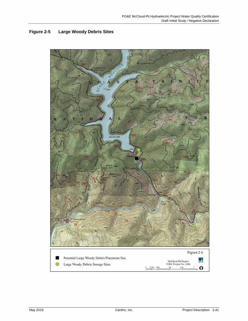
PG&E McCloud-Pit Hydroelectric Project Water Quality Certification
Draft Initial Study / Negative Declaration
May 2019 Cardno, Inc. Project Description 2-41
Figure 2-5 Large Woody Debris Sites

PG&E McCloud-Pit Hydroelectric Project Water Quality Certification
Draft Initial Study / Negative Declaration
2-42 Project Description Cardno, Inc. May 2019
2.4.6.7 Recreation Development and Management Plan
USFS Final Section 4(e) condition number 30 requires the development of a Recreation
Development and Management Plan. The Recreation Development and Management Plan has
been incorporated into the Proposed Project submitted to the State Water Board for certification,
and describes the specific tasks, components, and products that will guide the management of
recreation resources and opportunities associated with the Proposed Project. Under condition
30 in the USFS Final Section 4(e) Conditions, the Recreation Development and Management
Plan will include, but may not be limited to the following components:
Operation and Maintenance: Development and implementation of an Operation and
Maintenance component (including fee collection and retention) for all Project
recreation facilities.
Recreation Survey and Monitoring: Development and implementation of a periodic
Recreation Survey and Monitoring component with a report that is filed with FERC after
USFS approval.
Project Patrol: Development and implementation of a Project Patrol Plan for Project and
Project-affected USFS lands.
Reservoir Water Surface Management: Development and implementation of a Reservoir
Water Surface Management component that addresses recreation user safety (including
surface debris capture), discourages travel onto adjacent private lands, and displays County
code and contact information to Project users at each Reservoir surface (McCloud, Iron
Canyon, Pit 6 and Pit 7).
Construction and Reconstruction for Recreations: Construction and reconstruction of
several recreational facilities near McCloud Reservoir, McCloud River below McCloud Dam,
Iron Canyon Reservoir, Pit 6 Reservoir, and Pit 7 Reservoir and Afterbay (described in more
detail in Section 2.4.3 of this draft IS/ND).
PG&E would be required to provide water level information for McCloud and Iron Canyon
Reservoirs to the public to inform visitors when conditions are suitable for launching boats.
PG&E would also be required to provide real-time water flow information on the internet (gage
MC-1 at Ah-Di-Na) for the McCloud River below McCloud Dam to inform the public when water
flows are suitable for whitewater boating. PG&E has implemented this measure to provide
real-time public flow information, which is available at: http://cdec.water.ca.gov/dynamic
app/staMeta?station_id=MCA.
2.4.6.8 Road and Transportation Facility Management Plan
USFS Final Section 4(e) condition number 29 requires the development of a Road and
Transportation Facility Management Plan. The Road and Transportation Facility Management
Plan has been incorporated into the Proposed Project submitted to the State Water Board for
certification, and describes the scope of road maintenance, improvements, and monitoring
needed to meet new license conditions, and USFS RMOs and traffic service levels applicable to
Proposed Project roads. Under condition 29 in the USFS Final Section 4(e) Conditions, the

PG&E McCloud-Pit Hydroelectric Project Water Quality Certification
Draft Initial Study / Negative Declaration
May 2019 Cardno, Inc. Project Description 2-43
Road and Transportation Facility Management Plan will include, but may not be limited to the
following components:
Planning and Inventory: A map(s) compatible with USFS Travel Management Routes and
GIS database showing all Project roads and associated road signs within, adjacent, or
specific to the Project Boundary.
Operation, Maintenance, and Road-Associated Debris: An annual road operation and
maintenance schedule for Project roads that complies with USFS standards, RMOs, BMPs,
Limited Operating Periods, and USFS Travel Management Rule.
Construction and Reconstruction for Roads: Construction and reconstruction
implementation schedule to bring existing roads and associated facilities into compliance
with USFS standards (including RMOs and the USFS Travel Management Rule).
Monitoring: Conduct periodic traffic use surveys and periodic road capacity reviews. If the
USFS determines roads no longer meet the RMOs, define actions and timelines to
correct deficiencies.
2.4.6.9 Sign and Interpretive/Education Plan
USFS Final Section 4(e) condition number 31 requires the development of a Sign and
Interpretive/ Education Plan. The Sign and Interpretive/Education Plan has been incorporated
into the Proposed Project submitted to the State Water Board for certification and establishes
overall design guidelines and maintenance standards for existing and Proposed Project-related
signs, and will also enhance public understanding of Project-affected resources through
interpretive and educational measures. These signs, collectively referred to as “Project-Related
Signs”, include signs related to information, direction/orientation, FERC, safety, fire and fire
prevention, recreation, cultural and other resources, interpretive and education, and web media.
Under condition 31 in the USFS Final Section 4(e) Conditions, the Sign and
Interpretive/Education Plan will include, but may not be limited to the following components:
Inventory of all existing informational, FERC, safety, directional, recreation, interpretive, and
education (all non-road or traffic) signs within the Project area or associated with
Project facilities.
Collaborative development of standards, designs, and locations for all Project-Related Signs
(existing and new), including web media.
Protocols for installing, maintaining, and monitoring Project-Related Signs for the life of
the license.
The Project-Related Signs pertain directly to Proposed and Existing Project facilities, use,
amenities or opportunities and may be located within the Project area, on Project roads, on
USFS lands, or along roads external to the Project area. The only signs not addressed in this
Plan are road and traffic-related signs associated with roads external to recreation sites. Traffic-
related signs are included in the Road and Transportation Facility Management Plan.

PG&E McCloud-Pit Hydroelectric Project Water Quality Certification
Draft Initial Study / Negative Declaration
2-44 Project Description Cardno, Inc. May 2019
2.4.6.10 Terrestrial Biological Management Plan
USFS Final Section 4(e) condition number 26 requires the development of a Terrestrial
Biological Management Plan. The Terrestrial Biological Management Plan has been
incorporated into the Proposed Project submitted to the State Water Board for certification, and
outlines the specific tasks, components, and products for monitoring and surveying terrestrial
wildlife species on Project lands and USFS lands potentially affected by the Proposed Project
and specifies the measures to protect both the species and their habitat. Special-status wildlife
species potentially affected by Project activities include those that are federally threatened,
endangered or proposed, and those categorized as USFS-sensitive species, including those
listed for Survey and Manage, state-listed as endangered, California threatened, California
species of special concern, or California fully protected species. Pre-construction monitoring
and survey results will be used to determine whether Project-related activities could impact
these special-status species or their habitat, and if there is a need to adjust environmental
measures specified in the license. The list of special-status species will be reviewed annually
and updated as needed to include newly listed or remove delisted species. Under condition 26
in the USFS Final Section 4(e) Conditions, the Terrestrial Biological Management Plan will
include, but may not be limited to the following components:
Periodic surveys (including pre-disturbance/pre-construction);
Occupation and population monitoring;
Species specific mitigation measures (including avian collision and electrocution hazard
prevention measures); and
GIS mapping and reporting.
Species to be monitored include terrestrial mollusks, Shasta salamander, western pond turtles,
northern goshawk, bald eagles, peregrine falcon, northern spotted owl, willow flycatcher, special
status bats, neo-tropical birds, and forest carnivores. Additional species may be added in the
future if required by law or regulation, and if suitable habitat occurs within the Project or
Project-affected area. Surveys for valley elderberry longhorn beetle will occur under the
Vegetation and Invasive Weed Management Plan and are habitat-only surveys.
2.4.6.11 Vegetation and Invasive Weed Management Plan
USFS Final Section 4(e) condition number 25 requires the development of a Vegetation and
Invasive Weed Management Plan. The Vegetation and Invasive Weed Management Plan has
been incorporated into the Proposed Project submitted to the State Water Board for certification
and will establish overall management and monitoring actions to protect and encourage native
vegetation establishment on Project-affected lands, minimize invasive weeds, and manage
vegetation that affects Project facilities. Under condition 25 in the USFS Final Section 4(e)
Conditions, the Vegetation and Invasive Weed Management Plan will include, but may not be
limited to the following components:
Protection of special-status and revegetation source populations;
Invasive species management and monitoring, including an adaptive management element
to implement methods for prevention of aquatic invasive weeds, as necessary;

PG&E McCloud-Pit Hydroelectric Project Water Quality Certification
Draft Initial Study / Negative Declaration
May 2019 Cardno, Inc. Project Description 2-45
Revegetation implementation and monitoring;
Treatment protocols for vegetation management and hazard reduction for protection of
Project facilities and Project-affected resources within the Project affected area;
Pesticide/herbicide use approval and restrictions; and
Botanical enhancements for specific special-status wildlife species.
In addition, the Vegetation and Invasive Weed Management Plan will include an adaptive
management element which may include, but may not be limited to, public education and
signing of public boat access and preparation of an Aquatic Plant Management component of
the plan. The Vegetation and Invasive Weed Management Plan will not address Project-related
vegetation management treatment for vehicular sight distance, which is addressed in the Road
and Transportation Facility Management Plan, or fuels treatments around Project facilities,
which is contained in the Fire and Fuels Management Plan.
2.4.6.12 Visual Quality Management Plan
USFS Final Section 4(e) condition number 32 requires the development of a Visual Quality
Management Plan. The Visual Quality Management Plan is not considered a standard “plan,”
but rather is a list of measures and a timeline to implement the measures since there is general
agreement between PG&E and the USFS that specific measures are known and understood.
The Visual Quality Management Plan has been incorporated into the Proposed Project
submitted to the State Water Board for certification and will be implemented to meet USFS
Visual Quality Objectives to assure Project-affected resources that are on or affecting USFS
lands blend with the natural environment.
The goal of the Visual Quality Management Plan is to comply with laws, standards, and USFS
policy for visual (scenery) management, including the Shasta-Trinity Land and Resource
Management Plan’s guidance for “sensitive viewing areas.” The Visual Quality Management
Plan will address operation and maintenance of existing facilities, reconstruction of existing
facilities, and construction of new facilities. In addition, PG&E will be required to provide
updated photo at key observation points. Under condition 32 in the USFS Final Section 4(e)
Conditions, the Visual Quality Management Plan will include, but may not be limited to the
following components:
Operation and maintenance of existing facilities;
Reconstruction or repair of existing facilities;
Construction of new facilities; and
Key observation point monitoring.
In addition, several of the other plans described above will provide information related to
implementation of the Visual Quality Management Plan, including the Recreation Development
and Management Plan, Sign and Interpretation/Education Management Plan, Fire and Fuels
Management Plan, Vegetation and Invasive Weed Management Plan, Road and Transportation
Facilities Management Plan, and Erosion and Sediment Control Management Plan.

PG&E McCloud-Pit Hydroelectric Project Water Quality Certification
Draft Initial Study / Negative Declaration
2-46 Project Description Cardno, Inc. May 2019
2.4.6.13 Water Quality and Temperature Monitoring Plan
USFS Final Section 4(e) condition number 20 requires the development of a Water Quality and
Temperature Monitoring Plan with requirements that focus on aquatic habitats and water-based
recreation on USFS lands. The Water Quality and Temperature Monitoring Plan has been
incorporated into the Proposed Project and submitted to the State Water Board for certification.
PG&E’s license application included a proposed draft Water Quality Monitoring Plan to identify
potential Proposed Project impacts on water quality. Under condition 20 in the USFS Final
Section 4(e) Conditions, the Water Quality and Temperature Monitoring Plan will include, but
may not be limited to the following components:
Monitoring all project reservoirs every five years for contaminants at appropriate key
recreation locations (e.g. boat ramps, day use areas, near campgrounds), including E.coli, to
measure possible sanitation concerns;
Periodic monitoring of dissolved oxygen at McCloud, Pit 6, and Pit 7 Reservoirs;
Temperature monitoring from May 1 through September 30, at a minimum, for a period of
ten years following implementation of the new license instream flow schedule. Monitoring to
be conducted by Project segments (i.e., reservoirs and Project-affected rivers) are subject to
the following:
Permission to enter private lands during sensor installation/maintenance, as applicable;
Routine sensor maintenance or deployment in the spring may be delayed due to late
snows or high flows and will be initiated as early in May as possible, subject to safety
and access constraints; and
If monitoring indicates that temperatures above 20°C are occurring within the Project
reservoirs or downstream reaches, additional monitoring may be required;
Continuous monitoring of turbidity for the term of the license in the Lower McCloud River (at
MC-7 or MC-1) during fishing season (approximately April 25 to November 15) to record
elevated turbidity for recreational use.
Routine sensor maintenance or deployment in the spring may be delayed due to late
snows or high flows and will be completed prior to or as early in the fishing season as
possible, subject to safety and access constraints; and
Turbidity levels will be available real-time during the fishing season on the PG&E’s public
Project website;
Turbidity monitoring during construction, re-construction, or other soil disturbing activities to
identify point source erosion that may require repair or stabilization;
Continuous monitoring of turbidity for a minimum of five years after license acceptance in
Iron Canyon Creek (at MC-10) to ensure that PG&E’s repairs have reduced sedimentation
into the creek below the dam. If elevated turbidity (above Basin Plan levels) is still occurring
after five years, continue monitoring for an additional five years until additional mitigations
reduce turbidity to or below Basin Plan levels. If, before the end of five years, PG&E
proposes and the USFS and other applicable conditioning agencies agree and approve that

PG&E McCloud-Pit Hydroelectric Project Water Quality Certification
Draft Initial Study / Negative Declaration
May 2019 Cardno, Inc. Project Description 2-47
PG&E’s erosion control repairs have effectively reduced sedimentation and turbidity below
the dam, then turbidity monitoring at this location can cease; and
Implementation of BMPs, or the most current USFS regulations, within the Project and
Project-affected area that will satisfy the Aquatic Conservation Strategy Objectives within the
Northwest Forest Planning area, and govern implementation of:
Project operation and maintenance activities;
Project construction, reconstruction, and repair of Project sites;
Developed and dispersed recreation use;
Road use, routine maintenance, reconstruction and repair;
Vegetation manipulation;
Prescribed fire and wildland fire planning and fire suppression; and
Watershed practices.
2.4.7 Proposed Project Schedule
The only new physical components of the Proposed Project are the proposed new and
improved recreation facilities (refer to Table 2-3). Construction of the proposed recreation
facilities would be scheduled for the months of August, September, October, and November,
depending on location (refer to Table 2-3). This construction period is required to comply with
limited operating periods for protection of wildlife species. Construction would be scheduled
after issuance of the new FERC license, and is contingent on FERC approving the Recreation
Development and Management Plan.

PG&E McCloud-Pit Hydroelectric Project Water Quality Certification
Draft Initial Study / Negative Declaration
2-48 Project Description Cardno, Inc. May 2019
This Page Intentionally Left Blank

PG&E McCloud-Pit Hydroelectric Project Water Quality Certification
Draft Initial Study / Negative Declaration
May 2019 Cardno, Inc. Environmental Checklist 3-1
3 Environmental Checklist
3.1 Introduction
This chapter incorporates the Environmental Checklist contained in Appendix G of the California
Environmental Quality Act (CEQA) Guidelines. Each resource topic section includes a description
of the environmental setting, an explanation of the checklist’s impact questions, and identification
of the thresholds of significance for each question. In addition, each section describes project
components relevant to the section, including components proposed: (a) by Pacific Gas and
Electric Company (PG&E) in its license application; (b) in the terms and conditions contained in
the Federal Energy Regulatory Commission’s (FERC’s) final Environmental Impact Statement
(EIS), Appendix D – Commission Staff Recommended Conditions; and (c) in the United States
Department of Agriculture – Forest Service (USFS) 4(e) Conditions; all of which have been
incorporated into the Proposed Project that is before the State Water Board for certification. Refer
to Chapter 2 for additional Proposed Project information.
3.2 Evaluation of Environmental Impacts
The following description of the existing environmental setting relies largely on FERC’s final EIS
for the McCloud-Pit Hydroelectric Project (McCloud-Pit Project or Project) (FERC 2011), which
is incorporated by reference. As needed, supplemental information and analysis of potential
environmental impacts is provided herein to meet the requirements of CEQA.
Each resource area is evaluated against the significance criteria provided by CEQA
Appendix G11 and each impact is assigned a level of significance. The varying levels of
significance are defined as:
Potentially Significant Impact: This level of significance is used for impacts that would
exceed identified thresholds and where mitigation that would reduce the significant impact
may not be available or feasible. Under this circumstance, an Environmental Impact Report
is required.
Less than Significant with Mitigation Measures: This level of significance is used for
impacts that would meet or exceed the identified thresholds, but by implementing mitigation
measures would reduce such impacts to less than significant.
Less than Significant: This level of significance is used for impacts that would occur, but
whose degree would not meet or exceed the identified thresholds.
No Impact: This level of significance is used for impacts where clearly no effect would
occur. Where it was clear at the outset that no impact on a particular resource would occur
under any of the alternatives, the resource was evaluated at a lesser level of analysis.
11 Revised December 28, 2018.

PG&E McCloud-Pit Hydroelectric Project Water Quality Certification
Draft Initial Study / Negative Declaration
3-2 Environmental Checklist Cardno, Inc. May 2019
This Page Intentionally Left Blank

PG&E McCloud-Pit Hydroelectric Project Water Quality Certification
Draft Initial Study / Negative Declaration
May 2019 Cardno, Inc. Environmental Checklist 3-3
3.2.1 Aesthetics
Except as provided in Public Resources Code section 21099, subd. (d) (which provides that
aesthetic impacts shall not be considered significant for qualifying residential, mixed-use
residential, and employment center projects on infill sites within transit priority areas) would the
Project:
Would the Project:
Potentially
Significant
Impact
Less than
Significant
with
Mitigation
Incorporated
Less than
Significant
Impact No Impact
a. Have substantial adverse
effect on a scenic vista?
b. Substantially damage
scenic resources,
including, but not limited
to, trees, rock
outcroppings, and historic
buildings within a state
scenic highway?
c. In non-urbanized areas,
substantially degrade the
existing visual character
or quality of public views
of the site and its
surroundings? (Public
views are those that are
experienced from publicly
accessible vantage
points.) If the project is in
an urbanized area, would
the project conflict with
applicable zoning and
other regulations
governing scenic quality?
d. Create a new source of
substantial light or glare
which would adversely
affect day or nighttime
views in the area?

PG&E McCloud-Pit Hydroelectric Project Water Quality Certification
Draft Initial Study / Negative Declaration
3-4 Environmental Checklist Cardno, Inc. May 2019
Environmental Setting
The Proposed Project Study Area includes those areas that could be affected by Project
operation and maintenance. For aesthetic impacts this includes all recreational facilities,
including reservoirs and trails, and viewsheds of forest resources from various points within the
Project area. Generally, the Project area is characterized by steep, densely forested
topography in a remote scenic setting with minimal road access. Interspersed within the
canyons are water bodies including reservoirs linked together by reaches of the McCloud and
Pit Rivers, as well as a water pipeline that is above or below ground in different areas. Although
the public has identified scenic quality as one of its primary reasons for visiting the existing
recreational facilities (PG&E 2008), scenic vistas throughout the area are limited by topography
and vegetation.
At McCloud Reservoir, observation points reasonably available to the public are from the
reservoir surface. The natural landscape dominates the views throughout the area, with
human-made facilities limited to the earth-filled McCloud Dam, Tarantula Gulch boat ramp
recreation area, McCloud Tunnel intake, and public and private roads.
Iron Canyon Reservoir is situated at the confluence of five small creek tributaries, creating a
relatively shallow, five-fingered-shaped reservoir with waters extending into the narrow coves
created by the stream channels. Dense evergreen forests, which cover the surrounding hill
slopes, obscure most views of the reservoir from nearby roads; however, some open views of
the water occur. Open landscape-scale views are provided at both developed and dispersed
recreation areas located around the perimeter of the reservoir and from the water surface.
Along the Pit River, James B. Black Powerhouse is located on the north bank of the Pit River less
than three miles downstream from the town of Big Bend. Views of the powerhouse are possible
from points along the Pit River in proximity to the powerhouse, as well as from a small portion of
Oak Mountain Road, a USFS road that provides access between Iron Canyon Reservoir, the Pit
River and James B. Black Powerhouse. Vegetation and topography screen views of the
powerhouse from any considerable distance. Transmission lines leaving the powerhouse and the
penstock that supplies water to the powerhouse are visible from nearby locations.
Pit 6 and Pit 7 Reservoirs are long, narrow, and confined within the walls of the canyon, with
dense vegetation and steep topography obscuring views of the reservoirs. The Pit 7 Afterbay,
the most visible water feature within the Pit River portion of the Project, is visible from Fenders
Ferry Road (FR 34N17) where it crosses the Pit River arm of Shasta Lake and from the car-top
boat launch area at Fenders Ferry. Uplands surrounding the river are heavily forested with
evergreen oak woodland and pine vegetation. When Shasta Lake is at full pool, the reservoir
overtops the Pit 7 Afterbay Dam, changing the character of the area to one of flat water as
opposed to a flowing river.
Additional information regarding aesthetic resources in the Project area is provided in FERC’s
final EIS (FERC 2011), Section 3.3.7, Land Use and Aesthetic Resources, pages 327
through 330.

PG&E McCloud-Pit Hydroelectric Project Water Quality Certification
Draft Initial Study / Negative Declaration
May 2019 Cardno, Inc. Environmental Checklist 3-5
Visual Quality Objectives
The USFS provides preferred Visual Quality Objectives (VQOs) for its lands managed under the
Shasta-Trinity National Forest (STNF) Land and Resource Management Plan. Project area lands
within the STNF are currently classified as either Retention or Partial Retention (FERC 2011).
Retention VQOs promote landscapes that are perceived by the public as having an intact natural
or natural-looking character. Human-made changes to these landscapes should not result in
noticeable changes in form, color, or texture from those of the naturally occurring viewshed.
The USFS’s Land and Resource Management Plan (USFS 1995) for the STNF specifies VQOs
(USFS 1987) for lands within the Project area as being managed for either Retention or Partial
Retention (PG&E 2009a). Under these VQOs, management activities, when viewed by the
public, should have an intact natural or natural-looking character. The VQO classification of
Modification, for which the appearance of moderately altered landscape character is allowable,
will also be used to blend existing facilities with the natural surroundings (FERC 2011).
Partial Retention VQOs allow for more alteration of the landscape, but changes in forms, color
or texture should not be dominant and should be subdued by the natural character of the area.
FERC’s final EIS (Table 3.42 in Section 3.3.7, Land Use and Aesthetic Resources, page 330),
summarizes VQOs by general Project area.
Discussion
a. Have substantially adverse effect on a scenic vista?
Impact: Less Than Significant
Following is a summary of the potential effects of the Proposed Project on scenic vistas
associated with the Proposed Project area. Effects would be considered substantial and
adverse if they result in a permanent alteration of the visual character of scenic vistas used
by the public in a manner that considerably reduces the aesthetic value of the vistas, or that
would violate VQOs established by the USFS.
McCloud Reservoir. The natural landscape is predominant, with human-made
facilities, including the earth-filled McCloud Dam, Tarantula Gulch Boat Ramp
recreation area, the McCloud Tunnel intake, and private and public roads. Informal
fishing access pullouts and trails are adjacent to FS11 Road at several locations
around the perimeter of the reservoir. Scenic views of the reservoir from FS11 Road
and recreation areas are obstructed by vegetation and topography; however, views
from the water’s surface of the surrounding Proposed Project area are more
expansive, but also restricted by the steep forested hillsides that border the narrow,
winding fingers of the reservoir.
The Proposed Project includes changes in water flow regimes, road improvements,
and recreation facilities improvements requiring vegetation removal and other ground
disturbing activities. These changes could temporarily and permanently alter the
visual character of scenic views from the water’s surface looking toward the areas
affected by the Proposed Project (e.g., toward a recreation facility or shoreline).
Scenic views from uplands are less likely to be impacted by the Proposed Project

PG&E McCloud-Pit Hydroelectric Project Water Quality Certification
Draft Initial Study / Negative Declaration
3-6 Environmental Checklist Cardno, Inc. May 2019
because the appearance of most changes would be buffered by topography,
distance, and vegetation. Because McCloud Reservoir is one of the most popular
public recreation destinations in the Proposed Project area, changes in the
reservoir’s elevation would be noticeable, particularly the “bathtub ring” effect (i.e.,
exposed, unvegetated shoreline contrasting sharply in color and texture with the
natural quality of the surrounding landscape). However, periodic drawdown is an
ongoing action and is usually timed to occur in the fall, winter, and early spring
months when fewer visitors come to the area. These effects are also diminished
somewhat by the steep shoreline, which leaves a relatively narrow band of exposed
shoreline when compared to areas having less slope angle. The Proposed Project
instream flows are not expected to result in noticeable changes to water levels in
McCloud Reservoir because the additional releases represent a small fraction of total
reservoir storage, which will be replenished by inflow from the McCloud River, and so
the bathtub ring effect under the Proposed Project operations would be similar to the
existing Project operation. Impacts to scenic vistas from reservoir surface would
therefore not be significant.
There is potential for a significant impact on scenic views within the McCloud
Reservoir facilities area, specifically the Star City Creek Arm, where coarse sediment
extraction activities are proposed during draw down of the reservoir in the fall and a
new campground facility and access road would be constructed at the head of the
arm. For coarse gravel extraction, effects on scenic views of the Star City Creek arm
would be temporary and confined to the immediate area. Vegetation, distance, and
topography would obstruct most views of these temporary activities. Following
extraction of coarse sediments, the areas would be re-contoured to blend with
surrounding areas. It is anticipated that gravel extraction activities would be
completed before construction of a new campground facility and associated access
road adjacent to the Star City Creek arm are constructed. Because the aesthetic
effect of the sediment extraction will be temporary and, given the remoteness of the
location and the absence of a developed recreation area, unlikely to be visible to the
public, the effect will not be significant.
As discussed above, changes in flows downstream of McCloud Dam would not
noticeably alter the existing visual environment and therefore, would have no impact
on the any scenic vistas downstream on the Lower McCloud River.
Iron Canyon Reservoir. The area around Iron Canyon Reservoir is slightly less steep
than the McCloud Reservoir area, thus allowing for more opportunities to view the
region’s open landscape and scenic vistas; however, similar to the rest of the Project
area, dense mature forests dominate the surrounding mountains and reservoir
shoreline. Scenic vistas are limited, but where they do occur, consist of the open
water, forested shoreline, and distant mountains that are visible from some
developed and dispersed recreation areas, from the water’s surface, as well as from
parts of FS11 Road and USFS Road 37N78, which follow the entire Iron Canyon
Reservoir shoreline. However, the contiguous forest surrounding the reservoir,
coupled with distance and topography, would obstruct views of most, if not all, of the

PG&E McCloud-Pit Hydroelectric Project Water Quality Certification
Draft Initial Study / Negative Declaration
May 2019 Cardno, Inc. Environmental Checklist 3-7
Proposed Project activities in uplands, including localized vegetation removal and
facilities associated with proposed new and rebuilt recreation facilities. Still, the
implementation of Proposed Project components and ongoing operation of the
Proposed Project raise the possibility of significant effects on some scenic vistas
located around the reservoir.
Iron Canyon Reservoir receives moderate to high numbers of public visitors annually.
Changes in the reservoir’s surface elevation, specifically drawdown operations, are
readily noticed by the public because of its gentler sloping banks that have the
potential to expose a broad bathtub ring of mudflats, which contrast sharply in color
and texture with the adjacent uplands. However, under the Proposed Project
(including changes in the instream flow regime) the extent of releases and
drawdowns will not result in a noticeable change to the bathtub ring over existing
conditions, and so the impact of the Proposed Project on the existing bathtub ring will
not be significant.
PG&E currently conducts on-going vegetation management activities along its
230-kilovolt (kV) transmission line, which extends 0.5 mile from the James B. Black
Powerhouse to the non-Project Pit 5 Powerhouse, and a 12-kV distribution line that
runs 10.22 miles from the James B. Black Powerhouse to Iron Canyon Dam. As part
of the Proposed Project, PG&E would continue to implement similar vegetation
management actions. Since the areas along these transmission and distribution
lines have already been modified, future vegetation management actions would not
represent a change from existing conditions; therefore, the impact would not be
significant.
As discussed above, changes in flows downstream of Iron Canyon Dam would not
noticeably alter the existing visual environment and therefore, would not impact any
scenic vistas downstream of the dam.
Pit 6 and Pit 7 Reservoir. Pit 6 and Pit 7 Reservoirs are located in the very steep
and remote Pit River Canyon. Neither reservoir is readily visible or easily accessible
to the public. Access to Pit 6 Reservoir is limited to foot traffic or potentially by boat
from the Pit River upstream (for safety, this is discouraged by PG&E). Dense
vegetation and narrow, steep canyon topography preclude views of these reservoirs
from most locations and the difficult public access also limits views of the Project
area from the waters’ surface. Transmission lines leaving the James B. Black
Powerhouse and penstock that supply water to the powerhouse are visible from
nearby locations. The Pit 6 Dam and Powerhouse are visible from points along the
last mile of the Pit 6 Road as it descends into the Pit River Canyon. The Proposed
Project includes creation of a pedestrian trail near Pit 6 and Pit 7 Reservoirs. Under
existing conditions this visual character of this area has been noticeably disturbed by
human activity, including visible Project transmission lines, powerhouses, and
penstocks. The visual effect of the addition of the pedestrian trail will blend with the
existing disturbances, and so the impact will not be significant.
PG&E McCloud-Pit Hydroelectric Project Water Quality Certification
Draft Initial Study / Negative Declaration
3-8 Environmental Checklist Cardno, Inc. May 2019
The Proposed Project would not change instream flow releases from the dam or
reservoir operations, including drawdowns of the Pit 6 and Pit 7 Reservoirs. In
addition, drawdowns of these reservoirs have less effect on aesthetic resources than
that of McCloud or Iron Canyon Reservoirs because these reservoirs are rarely seen
by the public (PG&E 2009a).
PG&E currently conducts on-going vegetation management activities along their
existing 230-kV transmission line (a 3.3-mile segment from Pit 6 Powerhouse to
PG&E’s interconnected transmission system, and a 3.5-mile segment from Pit 7
Powerhouse to PG&E’s interconnected transmission system). As part of the
Proposed Project, PG&E would continue to implement similar vegetation
management actions. Since the areas along these transmission and distribution
lines have already been modified, future vegetation management actions would not
be out of character with existing conditions; therefore, this impact would be less than
significant.
Pit 7 Afterbay. The Pit 7 Afterbay is the most visible water feature in the Pit River
portion of the Proposed Project area, specifically where Fenders Ferry Road (USFS
Road 34N17) crosses over the Pit River arm of Shasta Lake and from the car-top
boat launch at Fenders Flat (PG&E 2009a). Under existing conditions, releases from
the Pit 7 Afterbay Dam via its v-notched weir affect the character of water flows in the
Pit River, as seen by the public. Water flowing from the Pit 7 Afterbay appears as
riverine when Shasta Lake levels are low, and as flat water when Shasta Lake levels
overtop the afterbay dam (PG&E 2009a). Although the Pit 7 Afterbay receives little
public use, Proposed Project activities such as the proposed road and parking area
improvements raise the possibility of a potentially significant impact on the scenic
vista afforded to the public using the Fenders Ferry Road Bridge. From this location,
viewers can see an expansive view of the Pit 7 Afterbay and Dam set against the
surrounding forest and mountains. Due to potential hazards and public safety issues
associated with fluctuating flow releases and the v-notched weir, the entire Pit 7
Afterbay is fenced on both sides with an 8-foot high chain link fence, and the area
immediately around Fenders Flat and the boat launch is heavily signed with warnings
alerting the public to the potential hazards of the area. A siren tower is also located
at Fenders Flat.
Not all Proposed Project activities would be completed concurrently, and most would
be completed in less than 2 months. The Proposed Project that is before the State
Water Board for certification includes development and implementation of the Visual
Quality Management Plan agreed to by PG&E and the USFS. The goal of the Visual
Quality Management Plan is to meet laws, standards and USFS policy for visual
(scenery) management, including Shasta-Trinity Land and Resource Management
Plan guidance for “sensitive viewing areas.” The Visual Quality Management Plan
addresses operation and maintenance of existing facilities; reconstruction of existing
facilities; and construction of new facilities. In addition, PG&E will update photo
points at Key Observation Points (KOPs), which is required per USFS VQOs (USFS
2010b). Refer to Chapter 2, Proposed Project for specific required measures

PG&E McCloud-Pit Hydroelectric Project Water Quality Certification
Draft Initial Study / Negative Declaration
May 2019 Cardno, Inc. Environmental Checklist 3-9
addressing Proposed Project operations and maintenance, reconstruction of existing
facilities, and construction of new facilities. Additional analysis of the Visual Quality
Management Plan can be found in FERC’s final EIS (FERC 2011), Section 3.3.7,
Land Use and Aesthetic Resources, pages 338 through 339. With implementation of
the Visual Quality Management Plan component of the Proposed Project, the
Proposed Project will not result in the violation of any VQOs, and so the impact of the
Proposed Project will not be significant. Overall, construction-related impacts to
visual resources would be of short duration, and permanent impacts on visual
resources as a result of implementation and operation of the Proposed Project would
be reduced or avoided with measures developed in consultation with the resource
agencies and defined in the Final Visual Quality Management Plan. The Proposed
Project impacts that have a potential to substantially and adversely affect a scenic
vista are less than significant.
Mitigation Measures: None required.
b. Substantially damage scenic resources, including, but not limited to, trees, rock
outcroppings, and historic buildings within a state scenic highway?
Impact: No Impact
Impacts to scenic resources within state scenic highways would be considered substantial
and significant if the impact considerably reduced the aesthetic value of the resources.
However, because there are no designated state scenic highways located in the Proposed
Project area (California Department of Transportation 2018), and because none of the
Proposed Project facilities areas are visible from a state scenic highway, the Proposed
Project will have no impact on scenic resources within a state scenic highway.
In addition, although the Proposed Project area lies within the STNF, none of the roads
within the Project area are designated USFS Scenic Byways (Federal Highway
Administration 2012). The few roads in the Project area are primarily USFS roads and are
therefore subject to USFS VQOs as described in the STNF Land and Resource
Management Plan (USFS 1995), which include monitoring of Project area views from KOPs.
Several KOPs on Project area USFS roads have already been established as a part of the
Aesthetic Resources Assessment prepared for the Proposed Project (PG&E 2008). The
Proposed Project would not introduce any elements that would substantially degrade the
existing visual character or quality of the Project area or its vicinity as seen from Project area
roads.
Moreover, as discussed above measures developed by PG&E in consultation with the USFS
and defined in the Final Visual Quality Management Plan will be implemented to meet USFS
VQOs (USFS 2010b). Refer to Chapter 2, Proposed Project for specific required measures
addressing Proposed Project operations and maintenance, reconstruction of existing
facilities, and construction of new facilities. Additional analysis of the Visual Quality
Management Plan can be found in FERC’s final EIS (FERC 2011), Section 3.3.7, Land Use
and Aesthetic Resources, pages 338 through 339.

PG&E McCloud-Pit Hydroelectric Project Water Quality Certification
Draft Initial Study / Negative Declaration
3-10 Environmental Checklist Cardno, Inc. May 2019
Mitigation Measures: None required.
c. Substantially degrade the existing visual character or quality of the site and its
surroundings?
Impact: Less Than Significant
Impacts of a project on the existing visual character or quality of the site and its
surroundings would be considered substantial, and thus significant, if they would negatively
affect the public’s perception of the existing visual character or violate VQO’s developed by
the USFS.
The Proposed Project area lies within the remote, rugged, and densely forested McCloud
River and Pit River canyons. The Proposed Project, including instream flow releases, road
and trail improvements, signage, and campground improvements, would be localized and
affect only the immediately surrounding area. These localized changes in the existing visual
environment raise the possibility of a negative effect on the public’s visual perception the
Proposed Project area, particularly at McCloud Reservoir and Iron Canyon Reservoir, where
public use is higher than the less accessible Pit 6 and Pit 7 Reservoirs and the Pit 7
Afterbay.
However, with implementation of the Visual Quality Management Plan component of the
Proposed Project, localized changes on USFS lands resulting from the Proposed Project will
comply with USFS VQOs (USFS 2010b). Refer to Chapter 2, Proposed Project for specific
required measures addressing Proposed Project operations and maintenance,
reconstruction of existing facilities, and construction of new facilities. Additional analysis of
the requirements for the Visual Quality Management Plan can be found in FERC’s final EIS
(FERC 2011), Section 3.3.7, Land Use and Aesthetic Resources, pages 338 through 339.
The impact of the Proposed Project on the existing visual character or quality of sites within
the Project area and its surroundings will not be significant.
Mitigation Measures: None required.
d. Create a new source of substantial light or glare which would adversely affect day or
nighttime views in the area?
Impact: Less Than Significant
For the purposes of this element, impacts would be considered substantial, and thus
significant, if the Proposed Project created a permanent new source of substantial light or
glare which would violate applicable VQOs.
Potential sources of temporary daytime glare could be created during construction by
Proposed Project related activities, including soil disturbance and the operation of
construction equipment. Solar reflection from exposed mineral soils and glass windshields
may be noticeable from long distances. An example of where this could occur would be
within the Star City Arm of McCloud Reservoir, where coarse sediment extraction is

PG&E McCloud-Pit Hydroelectric Project Water Quality Certification
Draft Initial Study / Negative Declaration
May 2019 Cardno, Inc. Environmental Checklist 3-11
proposed. However, any light or glare created from sediment extraction or construction
related activities under the Proposed Project would be temporary and not permanent.
The types of permanent sources of daytime glare that could result from implementation,
operation, and maintenance of the Proposed Project are common in the Project area under
existing conditions and existing Project operations. These sources include the changes in
flow volumes and reservoir elevation levels resulting in the expanse of potentially reflective
water and glare from fluctuating bathtub ring soils around reservoir shorelines; the
developed recreation facilities improvements, such as potentially reflective new structures
(e.g., bathrooms, signage, and concrete boat ramps); the creation of potentially reflective
gravel-surfaced pedestrian trails; and the increased parking areas that could be a
substantial source of glare from vehicles. The potential significance of these impacts would
be expected to vary depending on the size of the affected area, the number of visitors
affected, and the time of day. In addition, nighttime security lighting proposed at the
Tarantula Gulch Boat Launch at McCloud Reservoir and the Gap Creek Campground and
Iron Canyon Boat Launch at Iron Canyon Reservoir would be a permanent, locally
significant year-round source of nighttime lighting, a potential significant impact. Nighttime
recreational use of Project area campgrounds raises the possibility of the creation of a
substantial new source of seasonal nighttime lighting. It is not anticipated that there would
be a significant change in the volume of nighttime vehicle traffic on Project area roads as a
result of the Proposed Project.
However, with implementation of the Visual Quality Management Plan component of the
Proposed Project, new sources of light or glare resulting from the Proposed Project will
comply with USFS VQOs (USFS 2010b). Refer to Chapter 2, Proposed Project for specific
required measures addressing Proposed Project operations and maintenance,
reconstruction of existing facilities, and construction of new facilities. Additional analysis of
the requirements for the Visual Quality Management Plan can be found in FERC’s final EIS
(FERC 2011), Section 3.3.7, Land Use and Aesthetic Resources, pages 338 through 339.
Any new sources of light or glare created by the Proposed Project will not be substantial,
and so the impact of the proposed project will not be significant.
Mitigation Measures: None required.

PG&E McCloud-Pit Hydroelectric Project Water Quality Certification
Draft Initial Study / Negative Declaration
3-12 Environmental Checklist Cardno, Inc. May 2019
This Page Intentionally Left Blank

PG&E McCloud-Pit Hydroelectric Project Water Quality Certification
Draft Initial Study / Negative Declaration
May 2019 Cardno, Inc. Environmental Checklist 3-13
3.2.2 Agricultural and Forest Resources
In determining whether impacts to agricultural resources are significant environmental effects,
lead agencies may refer to the California Agricultural Land Evaluation and Site Assessment
Model (1997, as updated) prepared by the California Department of Conservation (DOC) as an
optional model to use in assessing impacts on agriculture and farmland.
In determining whether impacts to forest resources, including timberland, are significant
environmental effects, lead agencies may refer to information compiled by the California
Department of Forestry and Fire Protection (Cal Fire) regarding the state’s inventory of forest
land, including the Forest and Range Assessment Project and the Forest Legacy Assessment
project; and forest carbon measurement methodology provided in Forest Protocols adopted by
the California Air Resources Board (CARB).
Would the Project:
Potentially
Significant
Impact
Less than
Significant
with
Mitigation
Incorporated
Less than
Significant
Impact No Impact
a. Convert Prime Farmland,
Unique Farmland, or
Farmland of Statewide
Importance (Farmland),
as shown on the maps
prepared pursuant to the
Farmland Mapping and
Monitoring Program of
the California Resources
Agency, to non-
agricultural use?
b. Conflict with existing
zoning for agricultural
use, or a Williamson Act
contract?

PG&E McCloud-Pit Hydroelectric Project Water Quality Certification
Draft Initial Study / Negative Declaration
3-14 Environmental Checklist Cardno, Inc. May 2019
Would the Project:
Potentially
Significant
Impact
Less than
Significant
with
Mitigation
Incorporated
Less than
Significant
Impact No Impact
c. Conflict with existing
zoning for, or cause
rezoning of, forest land
(as defined in Public
Resources Code section
12220(g)), timberland (as
defined in Public
Resources Code section
4526) or timberland
zoned Timberland
Production (as defined by
Government Code
section 51104(g)?
d. Result in the loss of forest
land or conversion of
forest land to non-forest
use?
e. Involve other changes in
the existing environment
which, due to their
location or nature, could
result in conversion of
Farmland to non-
agricultural use or
conversion of forest land
to non-forest use?
Environmental Setting
Over 75 percent of the terrestrial Proposed Project area is occupied by Douglas-fir–Ponderosa
pine, Douglas-fir, and mixed conifer forests. Timber production occurs on both public and
private lands within the Proposed Project area. A majority of the privately-owned lands are
designated in the Shasta County General Plan (2004) as “Timberland” (FERC 2011). However,
none of the PG&E lands within the Project area are zoned or used for timber production.
Although the USFS conducts timber management activities on its lands, much of the STNF
lands in the Project vicinity, particularly near Iron Canyon, are classified as Landscape Scale
Restoration, which is a science-based ecosystem restoration of priority forest landscapes (Title
IV of the Omnibus Public Land Management Act of 2009).

PG&E McCloud-Pit Hydroelectric Project Water Quality Certification
Draft Initial Study / Negative Declaration
May 2019 Cardno, Inc. Environmental Checklist 3-15
The Proposed Project area is not suitable for agricultural use due to steep topography, dense
forests, poor soils, and limited access. There are no important farmlands used for cultivation or
grazing in the Project vicinity.
Discussion
a. Convert Prime Farmland, Unique Farmland, or Farmland of Statewide Importance
(Farmland), as shown on the maps prepared pursuant to the Farmland Mapping and
Monitoring Program of the California Resources Agency, to non-agricultural use?
Impact: No Impact
The Farmland Mapping and Monitoring Program classifies lands in the Project area as Other
Land (X) (DOC 2016). None of the land is used for agricultural purposes, nor is it
considered important farmland. The Proposed Project would have no impact.
Mitigation Measures: None required.
b. Conflict with existing zoning for agricultural use, or a Williamson Act contract?
Impact: No Impact
None of the PG&E lands are zoned or used for agricultural use, nor are they under an
existing Williamson Act contract (DOC 2010). Proposed Project activities would not conflict
with current Williamson Act contracts. The Proposed Project would have no impact.
Mitigation Measures: None required.
c. Conflict with existing zoning for, or cause rezoning of, forest land (as defined in
Public Resources Code section 12220(g)), timberland (as defined in Public Resources
Code section 4526) or timberland zoned Timberland Production (as defined by
Government Code section 51104(g)?
Impact: Less Than Significant
Some of the private lands in the Project area are zoned for timber production, and some of
the federal lands are managed for timber resources by the STNF. None of the PG&E lands
are zoned or used for timber production (DOC 2010). Road improvements would improve
access and would not affect timber productivity on adjacent lands. The Proposed Project
would not conflict with the existing zoning or timber uses by STNF, although special use or
other permits may be required for some new facilities to ensure compliance with the zoning
code and STNF management goals (see Section 3.2.10, Land Use). The Proposed Project
would have less than significant impact.
Mitigation Measures: None required.

PG&E McCloud-Pit Hydroelectric Project Water Quality Certification
Draft Initial Study / Negative Declaration
3-16 Environmental Checklist Cardno, Inc. May 2019
d. Result in the loss of forest land or conversion of forest land to non-forest use?
Impact: Less Than Significant.
Development of new recreational facilities and expansion of existing recreational facilities
would result in the removal of vegetation, including trees, but the effect on timberlands
would be minimal. The total area of disturbance across the Project area is expected to be
less than 50 acres, which is a small percentage of the total timberlands in the region. In
addition, much of the affected land is previously disturbed or is determined unsuitable for
timber production (USFS 2008).
None of the other Proposed Project activities would result in the loss of forest land, although
some vegetation trimming would be necessary near power lines and other facilities for
maintenance. The loss of forest land from recreational developments would be minimal and
considered a less than significant impact.
The loss of forest land from recreational developments would be less than 50 acres. No
forest land would be converted to non-forest use. Therefore, the impact would be less than
significant.
Mitigation Measures: None required.
e. Involve other changes in the existing environment which, due to their location or
nature, could result in conversion of Farmland to non-agricultural use or conversion
of forest land to non-forest use?
Impact: No Impact
Proposed Project activities would be limited to the specified work area where new facilities
would be located or around existing facilities, and no indirect land conversions are anticipated
as a result of the Proposed Project. The Proposed Project would have no impact.
Mitigation Measures: None required.

PG&E McCloud-Pit Hydroelectric Project Water Quality Certification
Draft Initial Study / Negative Declaration
May 2019 Cardno, Inc. Environmental Checklist 3-17
3.2.3 Air Quality
Where available, the significance criteria established by the applicable air quality management
district or air pollution control district may be relied on to make the following determinations:
Are significance criteria established by the applicable air district
available to rely on for significance determinations? Yes ☒ No ☐
Would the Project:
Potentially
Significant
Impact
Less than
Significant
with
Mitigation
Incorporated
Less than
Significant
Impact No Impact
a. Conflict with or obstruct
implementation of the
applicable air quality
plan?
b. Result in a cumulatively
considerable net increase
of any criteria pollutant for
which the project region is
non-attainment under an
applicable federal or state
ambient air quality
standard?
c. Expose sensitive
receptors to substantial
pollutant concentrations?
d. Result in other emissions
(such as those leading to
odors) adversely affecting
a substantial number of
people?
Environmental Setting
The Project is located in the northcentral portion of Shasta County within the Northern
Sacramento Valley Air Basin (NSVAB). The NSVAB is bound on the north and west by the
Coastal Mountain Range and on the east by the southern portion of the Cascade Mountain
Range and the northern portion of the Sierra Nevada Mountains. The height of these mountain
ranges, which can climb to 6,000 feet above mean seal level (feet msl) with individual peaks
reaching higher, act as a wall to pollutants emitted locally and from pollution that has been
transported from the broader Sacramento area by prevailing winds. Thus, the NSVAB
landscape is shaped like a bowl holding pollutants that can be further exacerbated by
temperature inversion layers acting as a lid, creating unhealthy levels of air pollution.

PG&E McCloud-Pit Hydroelectric Project Water Quality Certification
Draft Initial Study / Negative Declaration
3-18 Environmental Checklist Cardno, Inc. May 2019
The air quality in Shasta County is managed by the Shasta County Air Quality Management
District (AQMD). The Shasta County AQMD along with other air districts in the northern portion
of Sacramento Valley have combined to establish the Northern Sacramento Valley Planning
Area (NSVPA). Under the Clean Air Act, the NSVPA districts are required to develop a plan to
describe how they will attain and maintain ambient air quality standards (AAQS) for those
criteria pollutants that are currently designated nonattainment. As shown in Table 3-1, Shasta
County is State designated “nonattainment” for ozone and is “unclassified and/or in attainment”
for all other criteria pollutants for both the California AAQS (CAAQS) and National AAQS
(NAAQS).
Table 3-1 Shasta County Federal and State Air Quality Attainment Designations
Criteria Pollutants
Federal Attainment
Designation
State Attainment
Designation
Ozone (O3) Unclassified/Attainment Nonattainment
Coarse Particulate Matter (PM10) Unclassified Attainment
Fine Particulate Matter (PM2.5) Unclassified/Attainment Attainment
Nitrogen Dioxide (NO2) Unclassified/Attainment Attainment
Carbon Monoxide (CO) Unclassified/Attainment Unclassified
Sulfur Dioxide (SO2) Unclassified/Attainment Attainment
Sulfates --- Attainment
Lead Unclassified/Attainment Attainment
Hydrogen Sulfide --- Unclassified
Visibility Reducing Particles --- Unclassified
Source: CARB 2018
The NSVPA developed the Air Quality Attainment Plan (AQAP), originally prepared in 1991 and
updated triennially with the latest approved AQAP completed in 2015 (Sacramento Valley Air
Quality Engineering and Enforcement Professionals [SVAQEEP] 2015). The AQAP focuses on
the adoption and implementation of measures that curtail emissions of reactive organic gases
(ROG) and oxides of nitrogen (NOx), which are precursors that chemically react in the
atmosphere to form O3. The emissions inventory conducted in the NVSPA in 2015, shows that
a majority of the NOx emissions are from mobile sources, including cars, trucks and trains, and
stationary sources, including internal combustion engines and boilers with the majority of ROGs
emitted from area wide sources, including architectural coatings and solvents. Therefore, the
primary focus of the AQAP is to curtail emissions from these source types. The AQAP also
includes an outreach program designed to inform and educate the public regarding sources and
effects of air pollution.

PG&E McCloud-Pit Hydroelectric Project Water Quality Certification
Draft Initial Study / Negative Declaration
May 2019 Cardno, Inc. Environmental Checklist 3-19
To help determine whether counties are on track to meeting or maintaining the AAQSs,
monitoring stations are established throughout California. Shasta County has four air quality
monitoring stations. Of the four, the monitoring station closest to the Project site monitors O3,
for which Shasta County is in nonattainment. However, this station is located on Lake Blvd and
is situated in an urban cluster which is different than the Project site that is situated in a more
rural and natural setting. Thus, the local air quality at this station is not truly indicative of the air
quality at the Project site, but it is the best available data for this Project.
Air quality statistics from 2013 through 2017 for the Shasta Lake – Lake Blvd monitoring station
are provided in Table 3-2 below. The table shows the maximum O3 air quality concentrations for
the State 1-hour and 8-hour standards and the number of days that the standards were
exceeded during that given year.
Table 3-2 Shasta Lake – Lake Blvd O3 Exceedances for (Years 2013-2017)
Year
1-Hour Observations 8-Hour Averages
State Maximum
# Days > State
Standarda State Maximum
# Days > State
Standarda
2013 0.078 0 0.072 1
2014 0.067 0 0.062 0
2015 0.091 0 0.083 14
2016 0.093 0 0.082 14
2017 0.096 1 0.089 13
Source: CARB 2019
a The CAAQS for O3 1-hour concentrations is 0.09 parts per million (ppm) and the 8-hour concentrations is 0.070
ppm. The CAAQSs are exceeded when the rounded average is greater than the standard.
As shown in the above table, the area has predominantly maintained the State’s O3 1-hour
standard; however, starting in 2015 there was a jump in the number of days exceeding the State’s
O3 8-hour standard. Sources of O3 in the NSVPA include stationary sources, mobile sources,
including cars, trucks, and trains, or area sources such as consumer products or wildfires. The
broader Sacramento area is also a contributor of O3 precursor pollutants to the NSVPA as a result
of prevailing winds that transport the pollutants to this area (SVAQEEP 2015).
The CEQA thresholds of significance are located in Table AQ-4 in the Air Quality Element of the
Shasta County General Plan. Shasta County developed the Air Quality Element section in
coordination with the Shasta County AQMD. The thresholds established in this section of the
General Plan pertain to the development of land uses that generate long-term sources of
emissions, particularly from mobile sources. In general, land use development projects that
potentially emit 137 pounds per day of NOx, ROG, or PM10 would be considered to have
significant impacts to air quality.
The General Conformity Rule (Clean Air Act section 176(c)(4); 40 CFR Parts 51 and 93])
requires that the actions taken by federal agencies in nonattainment and maintenance areas do

PG&E McCloud-Pit Hydroelectric Project Water Quality Certification
Draft Initial Study / Negative Declaration
3-20 Environmental Checklist Cardno, Inc. May 2019
not interfere with plans to meet NAAQS. Under the General Conformity Rule, federal agencies
must work with state, tribal, and local governments in NAAQS nonattainment or maintenance
areas to ensure that federal actions conform to implementation plans. Since the FERC
relicensing action is in a NAAQS attainment area, the General Conformity Rule does not apply
to the Proposed Project.
Discussion
a. Conflict with or obstruct implementation of the applicable air quality plan?
Impact: Less Than Significant
As mentioned above, the applicable air quality plan for this area is the NSVPAs 2015 AQAP,
which focuses on reducing O3 precursors ROG and NOx from stationary, mobile, and area
sources. The Proposed Project would not create a permanent stationary source of air
contaminants, include a land use that would generate a substantial number of trips from
mobile sources, or involve the use of architectural coatings or solvents during recreational
improvements. As a result of the above and due to the relatively small scale of construction
activities, including number and pieces of equipment and schedule, the Proposed Project
would not conflict with or obstruct implementation of the 2015 AQAP. The Proposed Project
would have a less than significant impact.
Mitigation Measures: None required.
b. Result in a cumulatively considerable net increase of any criteria pollutant for which
the project region is non-attainment under an applicable federal or state ambient air
quality standard?
Impact: Less Than Significant
As mentioned above, the Shasta County AQMD and the County developed Thresholds of
Significance that focus on quantifying and reducing emissions from long-term, operational
emissions, specifically mobiles sources. For the purposes of this element, net increases of
criteria pollutants would be deemed cumulatively considerable if they would exceed the
Thresholds developed by the County.
Operation and maintenance of the additional recreational facility improvements would require
up to five additional caretakers. Criteria pollutant emissions, specifically emissions of NOx,
ROG, and PM10 from caretaker vehicle trips, would be negligible compared to existing
conditions and would not result in operational impacts that would significantly increase
emissions to a level of significance.
Short-term Proposed Project construction activities are not considered to be a significant
source of criteria pollutants on an individual basis. CEQA Guidelines section 15064(h)(3)
stipulates that for an impact involving a resource that is addressed by an approved plan or
mitigation program (e.g., general maintenance-related construction activities for infrastructure),
the lead agency may determine that a project’s incremental contribution is not cumulatively
considerable if the project complies with the adopted plan or program. Furthermore, if the

PG&E McCloud-Pit Hydroelectric Project Water Quality Certification
Draft Initial Study / Negative Declaration
May 2019 Cardno, Inc. Environmental Checklist 3-21
project would not exceed the CEQA Thresholds of Significance then it would also not result in
a cumulatively considerable net increase of criteria pollutants. The AQAP is the most
appropriate document to use in addressing cumulative effects for air quality because it sets
forth a comprehensive program that will lead the NSVPA, which includes the Proposed Project
area, into compliance with state air quality standards for O3. The AQAP uses control
measures and related emission reduction estimates based on emissions projections for a
future development scenario derived from land use, population, and employment
characteristics defined in consultation with local governments. Because the Proposed Project
has no significant long-term impacts that would exceed the Thresholds of Significance or
that would create emissions from sources covered by the AQAP, it is not significant on an
individual basis during construction activities. Therefore, the Proposed Project’s incremental
contribution to criteria pollutant emissions is not cumulatively considerable. The Proposed
Project would have a less than significant impact.
Mitigation Measures: None required.
c. Expose sensitive receptors to substantial pollutant concentrations?
Impact: No Impact
Certain population groups are considered more sensitive to air pollution and odors than
others; in particular, children, elderly, and acutely ill and chronically ill persons, especially
those with cardiorespiratory diseases such as asthma and bronchitis. Sensitive receptors
(land uses) indicate locations where such individuals are typically found, namely schools,
daycare centers, hospitals, convalescent homes, residences of sensitive persons, and parks
with active recreational uses, such as youth sports. Due to the remote locations of the work
sites and forest recreation land uses of the Proposed Project, there are no characteristic
sensitive receptors which would be affected by construction activities. Furthermore, since all
construction activities would be short-term (days) compared to long-term exposure criteria
(years), no significant exposures to diesel engine exhaust or fugitive dust would occur. The
Proposed Project would not result in any impacts related to exposure of sensitive receptors
to substantial pollutant concentrations.
Mitigation Measures: None required.
d. Result in other emissions (such as those leading to odors) adversely affecting a
substantial number of people?
Impact: No Impact
The Proposed Project does not include any land uses (e.g., livestock operations, refineries,
wastewater treatment plants, landfills) that would generate any substantial amounts of
long-term, odorous emissions. Short-term construction activities will generate odors during
diesel equipment operation. However, given the remoteness of the Proposed Project
location, the short construction duration and minimal pieces of equipment used combined
with existing diesel fuel standards that limits the amount of sulfur in fuel to 15 ppm, no

PG&E McCloud-Pit Hydroelectric Project Water Quality Certification
Draft Initial Study / Negative Declaration
3-22 Environmental Checklist Cardno, Inc. May 2019
significant amount of odors are anticipated from construction activities that would adversely
affect any local residents or a substantial number of temporary visitors to the Project area.
The Proposed Project would have no impact.
Mitigation Measures: None required.

PG&E McCloud-Pit Hydroelectric Project Water Quality Certification
Draft Initial Study / Negative Declaration
May 2019 Cardno, Inc. Environmental Checklist 3-23
3.2.4 Biological Resources
Would the Project:
Potentially
Significant
Impact
Less than
Significant
with
Mitigation
Incorporated
Less than
Significant
Impact No Impact
a. Have a substantial
adverse effect, either
directly or through habitat
modifications, on any
species identified as a
candidate, sensitive, or
special-status species in
local or regional plans,
policies, or regulations, or
by the California
Department of Fish and
Wildlife or the US Fish
and Wildlife Service?
b. Have a substantial
adverse effect on any
riparian habitat or other
sensitive natural
community identified in
local or regional plans,
policies, regulations or by
the California Department
of Fish and Wildlife or the
US Fish and Wildlife
Service?
c. Have a substantial
adverse effect on state or
federally protected
wetlands (including, but
not limited to, marsh,
vernal pool, coastal, etc.)
through direct removal,
filling, hydrological
interruption, or other
means?

PG&E McCloud-Pit Hydroelectric Project Water Quality Certification
Draft Initial Study / Negative Declaration
3-24 Environmental Checklist Cardno, Inc. May 2019
Would the Project:
Potentially
Significant
Impact
Less than
Significant
with
Mitigation
Incorporated
Less than
Significant
Impact No Impact
d. Interfere substantially
with the movement of any
native resident or
migratory fish or wildlife
species or with
established native
resident or migratory
wildlife corridors, or
impede the use of native
wildlife nursery sites?
e. Conflict with any local
policies or ordinances
protecting biological
resources, such as a tree
preservation policy or
ordinance?
f. Conflict with the
provisions of an adopted
Habitat Conservation
Plan, Natural Community
Conservation Plan, or
other approved local,
regional, or state habitat
conservation plan?
Environmental Setting
The Proposed Project is located along the western slope of the Cascade Range in the Central
Valley of northern California, within Shasta County, Siskiyou County, and the STNF. The
Proposed Project area originates at McCloud Reservoir and occupies the McCloud and Lower
Pit River Basins to Shasta Lake. The area surrounding the Proposed Project is primarily federal
forest land with rural communities and one larger incorporated city, Redding (>90,000
residents), nearby. Rivers and streams of the area are typically steep gradient and highly
confined, resulting in minimal flood plain development. The Proposed Project area is
characterized by a variety of vegetation types typical of mixed woodland and mid-elevation
forest habitats found in the southeastern Klamath Mountains and west-slope southern Cascade
regions. More than three-quarters of the land is occupied by Douglas-fir–Ponderosa pine,
Douglas-fir, and mixed conifer forests. The remaining land supports a wide array of vegetation

PG&E McCloud-Pit Hydroelectric Project Water Quality Certification
Draft Initial Study / Negative Declaration
May 2019 Cardno, Inc. Environmental Checklist 3-25
types where plant species diversity is high due to the complex topography of the area. In
general, the topographical features preclude extensive wetland habitat, although
wetland-associated vegetation often exists adjacent to and within the active river channel, and
additional wetlands occur in small patches along the reservoirs.
Additional descriptions of aquatic resources, terrestrial resources, and threatened and
endangered species in the Project area are provided in FERC’s final EIS (FERC 2011),
Section 3.3.2—Aquatic Resources, Section 3.3.3—Terrestrial Resources, and Section 3.3.4—
Threatened and Endangered Species.
Aquatic Resources
Aquatic Habitats
Aquatic habitats associated with the Proposed Project include major storage reservoirs
(McCloud Reservoir and Iron Canyon Reservoir), two regulating reservoirs (Pit 6 and Pit 7
Reservoirs), and one afterbay (Pit 7 Afterbay). Proposed Project-affected stream reaches
include the Lower McCloud River and Iron Canyon Creek. Each of these is briefly
described below.
McCloud Reservoir. At maximum storage pool, McCloud Reservoir has 520 surface
acres and 14 miles of shoreline. Much of the shoreline around McCloud Reservoir is
very steep and privately owned. Reservoir levels in McCloud Reservoir generally reach
maximum elevations in late spring or early summer, followed by a sustained draw down
lasting through the summer and fall. The water temperatures and water quality
conditions in the reservoir support a coldwater trout fishery.
Iron Canyon Reservoir. At maximum storage pool, Iron Canyon Reservoir has
506 surface acres and 11 miles of shoreline. Five primary tributaries drain into Iron
Canyon Reservoir and provide spawning and rearing habitat for trout. Water levels in
Iron Canyon Reservoir generally reach maximum elevations in late spring or summer,
followed by a sustained draw down lasting through the summer and fall. The water
temperatures and water quality conditions in the reservoir include a well-developed
thermocline, and a deep thermally stable hypolimnion, which supports a coldwater trout
fishery.
Pit 6 Reservoir. Pit 6 Reservoir typically has 265 surface acres and ten miles of
shoreline. Pit 6 Reservoir serves as the forebay for Pit 6 Powerhouse and water surface
elevation fluctuates daily. Littoral habitat is limited because of the steep topography of
the channel and surrounding valley. Water temperature and water quality conditions
support a transitional-zone fish assemblage (i.e., native foothill assemblage, or
Sacramento pikeminnow/Sacramento sucker/hardhead assemblage) including (in
decreasing order of abundance) native tule perch, hardhead, Sacramento pikeminnow,
and Sacramento sucker. Pit 6 Reservoir is not stocked and receives relatively low
angling pressure compared to McCloud and Iron Canyon Reservoirs because of limited
accessibility by steep canyon walls and private property restrictions.

PG&E McCloud-Pit Hydroelectric Project Water Quality Certification
Draft Initial Study / Negative Declaration
3-26 Environmental Checklist Cardno, Inc. May 2019
Pit 7 Reservoir. Pit 7 Reservoir typically has 468 surface acres and 16 miles of
shoreline; it is surrounded by steeply sloping, forested lands. Pit 7 Reservoir serves as
the forebay for the Pit 7 Powerhouse and water surface elevation fluctuates daily. The
upper reaches of this reservoir provide riverine habitat, which shifts to lacustrine habitat
for a majority of the length of the reservoir. Pit 7 Reservoir water temperature and water
quality conditions support a transitional-zone fish assemblage including (in decreasing
order of abundance) native tule perch, hardhead, Sacramento sucker, and Sacramento
pikeminnow. Pit 7 Reservoir is not stocked with trout and receives relatively low angling
pressure compared to the McCloud River and McCloud and Iron Canyon Reservoirs,
due to limited accessibility.
Pit 7 Afterbay. Pit 7 Afterbay Dam creates a run-of-the-river afterbay approximately
two miles long with an average surface area of 69 acres. The shoreline is generally
steep and rocky, and the surrounding terrain is forested with the exception of a broad,
shallow, vegetated littoral zone that occurs along the left bank in the vicinity of Fenders
Flat near Pit 7 Afterbay Dam. Aquatic habitat within the upstream half of the afterbay is
typically riverine, transitioning to more lacustrine habitat near the afterbay dam. The
broad, shallow, habitat near the afterbay dam includes submerged aquatic vegetation
that provides refuge for larval and juvenile fishes and foraging habitat for juvenile and
adult fishes.
Lower McCloud River. The Lower McCloud River extends approximately 24 miles from
McCloud Dam downstream to Shasta Lake. At its headwaters, the McCloud River is
supplied by cold-water springs that contribute to cool year-round water temperatures
throughout the 24-mile-long reach. Project facilities at McCloud Dam regulate stream
flow from the upper basin into the mainstem Lower McCloud River below the dam. The
Lower McCloud River is fed by several tributaries, which cumulatively diminish the
Project influence on flow levels and aquatic resources moving downstream from
McCloud Dam. The McCloud River supports a viable trout fishery throughout the entire
24-mile-long reach. The Lower McCloud River also supports a Sacramento
sucker/pikeminnow assemblage just above Shasta Lake; these species are typically
associated with foothill elevations and transitional zone water temperatures.
Iron Canyon Creek. Iron Canyon Creek is a relatively short stream with a total length of
4.6 miles over an elevation range of 1,041 feet (4.3 percent average gradient), from
2,470 feet at Iron Canyon Dam to 1,430 feet at the confluence with Pit 6 Reservoir. Iron
Canyon Creek receives water from Iron Canyon Reservoir, which receives water
diverted from McCloud Reservoir and from a few small tributary streams. Iron Canyon
Creek supports a self-sustaining population of rainbow trout which was found to be in
good condition during surveys, a small population of brown trout, and Pit sculpin. Iron
Canyon Creek has relatively low angling pressure compared to McCloud River and
Project reservoirs due to limited accessibility by the steep canyon and private property
restrictions.
PG&E McCloud-Pit Hydroelectric Project Water Quality Certification
Draft Initial Study / Negative Declaration
May 2019 Cardno, Inc. Environmental Checklist 3-27
Aquatic Species
This section provides a summary of special-status aquatic wildlife known to occur in the
Proposed Project area. This section also provides information on species, such as benthic
macroinvertebrates (BMI) and fish communities, that are not special-status but provide
information on existing conditions in the aquatic environment (i.e., index of aquatic
environment health).
Refer to Table 3-3 for a list of special-status aquatic wildlife species considered in this
analysis including their status, habitat requirements, and potential for occurrence in the
Proposed Project area. Special-status aquatic species are defined to include animals that
are proposed, candidate, or listed as threatened or endangered under the California
Endangered Species Act (CESA); wildlife considered species of special concern by the
California Department of Fish and Wildlife (CDFW); and California fully protected species.
In addition, this analysis includes species that are proposed, candidate, or listed as
threatened or endangered under the federal Endangered Species Act (ESA).
Benthic Macroinvertebrates. PG&E conducted BMI sampling in the Project-affected
reaches of the Lower McCloud River and Iron Canyon Creek in August and September
2007 and November 2008. During the 2007 sampling, PG&E also collected reference
samples from Squaw Valley Creek (a tributary of the McCloud River) and Clear Creek (a
tributary to Iron Canyon Reservoir). In addition, PG&E acquired historical (1999-2008)
BMI data from The Nature Conservancy’s McCloud River Preserve for comparison
purposes. From the 14 benthic samples collected by PG&E in 2007 and 2008, a total of
6,970 organisms comprising 95 distinct taxa were collected. Insects comprised a
majority of the benthic community including 13 mayfly taxa, 19 stonefly taxa, 18 caddisfly
taxa, and nine beetle taxa. Other invertebrates included oligochaetes, clams, and
gastropods. A multi-metric index based on five metrics was formulated for each sample
taken within the Project area. Overall, the physical habitat data and BMI samples
collected over ten years within the Project area generally indicated good aquatic habitat
conditions and water quality.
Aquatic Mollusks. An aquatic mollusk survey was conducted in the summer and fall
2007 to inventory mollusk species in the Project vicinity. In total, three species of
freshwater mussels, four species of Sphaeriacean clams, and nine species of aquatic
snails were found during the 2007 survey. No federal or California-listed mollusks were
identified.
Fish. During fish surveys conducted in the fall of 2007 and 2008, a total of 15 species
were observed, including four species (bluegill, brook trout, channel catfish, and spotted
bass) that had not been previously documented. Five species (bigeye marbled sculpin,
common carp, green sunfish, pit roach, and speckled dace) that were historically
observed in Project reservoirs were not observed in the 2007 and 2008 surveys. Refer
to Table 3-3 for a summary of fish species found in the Project reservoirs and stream
reaches.
The dominant species in Project reservoirs with colder water (McCloud and Iron Canyon)
and Project stream reaches with colder water (Lower McCloud River and Iron Canyon

PG&E McCloud-Pit Hydroelectric Project Water Quality Certification
Draft Initial Study / Negative Declaration
3-28 Environmental Checklist Cardno, Inc. May 2019
Creek) were rainbow trout and brown trout, with rainbow trout being dominant. In the
warmer transition-zone habitat (Pit 6 and Pit 7 reservoirs and Pit 7 Afterbay) the
dominant species included tule perch and hardhead.
Only one of the 15 species observed, hardhead (Mylopharodon conocephalus), is a
special-status species (California species of special concern). Hardhead were found in Pit 6
and Pit 7 Reservoirs and Pit 7 Afterbay. Hardhead are a large, native minnow generally
found in undisturbed areas of larger low- to middle-elevation streams (elevation between 30
and 4,760 feet in the Sacramento and San Joaquin watersheds). Its range extends from the
Kern River in the south to the Pit River in the north. Hardhead inhabit areas that have clear,
deep pools with sandy, gravel/boulder substrates and slow water velocities (less than
0.05 foot per second). Hardhead co-occur with Sacramento pikeminnow and usually with
Sacramento suckers, and tend to be absent from streams where introduced species,
especially centrarchids, predominate (Moyle 2002).
Prior to the completion of Shasta Dam in 1942, Chinook salmon and other anadromous
fishes were able to travel up the McCloud River as far as the 20-foot-high Lower Falls.
Since the completion of Shasta Dam, Chinook salmon have been extirpated from the
McCloud and Pit Rivers. Extirpation of Chinook populations had impacts to other species in
the ecosystem, notably bull trout (originally identified as Dolly Varden) that predate on early
life stages of Chinook. Bull trout are no longer present in the McCloud and Pit River
watersheds. In 1950, Keswick Dam was completed downstream of Shasta Dam, further
blocking anadromous fish passage into the Project area.
The Reasonable and Prudent Alternative from the Biological and Conference Opinion on the
Long-Term Operation of the Central Valley Project and State Water Project (National Marine
Fisheries Service 2009) includes a Fish Passage Program (Action V) to evaluate the
reintroduction of federally listed anadromous fish above three reservoirs operated by the
United States Bureau of Reclamation (Shasta, Folsom, and New Melones Reservoirs). If
implemented above Shasta Dam, the Fish Passage Program could result in the future
presence of listed anadromous fish in the waters below Project dams. However, since listed
anadromous fish are not currently present in the waters of the McCloud-Pit Project, this
analysis does not include impacts of the Proposed Project on listed salmonids.
Aquatic Amphibians
Pacific Tailed Frog. Pacific tailed frogs (Ascaphus truei) are a California species of
special concern. The Pacific tailed frog uses cold, rocky streams in humid forests of
Douglas-fir, pine, spruce, hemlock, redwood, maple, and alder, with interspersed
grassland or chaparral. Tailed frog tadpoles and adults were observed in Ladybug
Creek, a tributary to the Lower McCloud River, during two separate visits in the summer
of 2007.
Foothill Yellow-Legged Frog. The foothill yellow-legged frog (Rana boylii) (FYLF) is a
candidate for CESA listing as threatened, and a California species of special concern.
This frog inhabits small streams below 5,000 feet msl where breeding occurs in low- to
moderate- gradient streams in shallow edge-water areas, often close to confluences with
tributary streams. FYLF were observed at seven sites located between river mile

PG&E McCloud-Pit Hydroelectric Project Water Quality Certification
Draft Initial Study / Negative Declaration
May 2019 Cardno, Inc. Environmental Checklist 3-29
(RM)12 1.4 and RM 5.7 on the Lower McCloud River and associated tributaries.
Evidence of breeding (egg masses or tadpoles) was observed at four mainstem sites.
Post-metamorphic frogs (adults, juveniles, or young-of-year) were observed at four
mainstem sites and three tributaries.
In 2008, a total of twelve egg masses were observed in the Lower McCloud River
between May 8 and June 10. One egg mass was observed at Site 119, six egg masses
were observed at Site 120, four egg masses were observed at Site 122, and one egg
mass was observed at Site 140. All egg masses were recorded at depths and velocities
consistent with FYLF breeding in other California watersheds.
Aquatic Reptiles
Western Pond Turtle. The western pond turtle (Actinemys marmorata) is a California
species of special concern. This species inhabits ponds, lakes, rivers, marshes,
streams, and irrigation ditches with rocky or muddy bottoms and herbaceous vegetation.
Western pond turtles were found in Pit 6 and Pit 7 Reservoirs during 2007, as well as
along the Lower McCloud River in 2007 and 2008. At Pit 6 Reservoir, western pond
turtles were observed in the downstream half of the west side of the reservoir. At Pit 7
Reservoir, western pond turtles were observed in the downstream third of the north (river
right) side of the reservoir. On the Lower McCloud River, adult and juvenile western
pond turtles, as well as one western pond turtle egg, were incidentally observed at four
sites between RM 1.4 and 3.0 during FYLF surveys in 2007 and 2008.
12 RM is a measure of distance in miles along a river from its mouth, which begins at RM 0.

PG&E McCloud-Pit Hydroelectric Project Water Quality Certification
Draft Initial Study / Negative Declaration
3-30 Environmental Checklist Cardno, Inc. May 2019
Table 3-3 Fish Species Identified in Project Reservoirs and Stream Reaches During Relicensing Technical Studies
Species
Native /
Introduced
Federal ESA
and CESA
Status
Project
Reservoirs/Afterbays
Project
Stream Reaches
CDFW USFWSa
McCloud
Reservoir
Iron
Canyon
Reservoir
Pit 6
Reservoir
Pit 7
Reservoir
Pit 7
Afterbay
Lower
McCloud
River
Iron
Canyon
Creek
Bluegill (Lepomis
macrochirus) I — — x
Brook trout
(Salvenlinus
fontinalis)
I — — x
Brown trout
(Salmo trutta) I — — x x x x
Channel catfish
(Ictalurus
punctatus)
I — — x
Hardhead
(Mylopharodon
conocephalus)
N CSC — x x x
Largemouth bass
(Micropterus
salmoides)
I — — x
Pit sculpin (Cottus
pitensis) N — — x x

PG&E McCloud-Pit Hydroelectric Project Water Quality Certification
Draft Initial Study / Negative Declaration
May 2019 Cardno, Inc. Environmental Checklist 3-31
Table 3-3 Fish Species Identified in Project Reservoirs and Stream Reaches During Relicensing Technical Studies
Species
Native /
Introduced
Federal ESA
and CESA
Status
Project
Reservoirs/Afterbays
Project
Stream Reaches
CDFW USFWSa
McCloud
Reservoir
Iron
Canyon
Reservoir
Pit 6
Reservoir
Pit 7
Reservoir
Pit 7
Afterbay
Lower
McCloud
River
Iron
Canyon
Creek
Rainbow trout
(Oncorhynchus
mykiss)
N — — x x x x x x
Riffle sculpin
(Cottus shasta) N — — x x
Sacramento
pikeminnow
(Ptychocheilus
grandis)
N — — x x x
Sacramento
sucker
(Catostomus
occidentalis)
N — — x x x x
Smallmouth bass
(Micropterus
dolomieu)
I — — x x
Spotted bass
(Micropterus
punctulatus)
I — — x

PG&E McCloud-Pit Hydroelectric Project Water Quality Certification
Draft Initial Study / Negative Declaration
3-32 Environmental Checklist Cardno, Inc. May 2019
Table 3-3 Fish Species Identified in Project Reservoirs and Stream Reaches During Relicensing Technical Studies
Species
Native /
Introduced
Federal ESA
and CESA
Status
Project
Reservoirs/Afterbays
Project
Stream Reaches
CDFW USFWSa
McCloud
Reservoir
Iron
Canyon
Reservoir
Pit 6
Reservoir
Pit 7
Reservoir
Pit 7
Afterbay
Lower
McCloud
River
Iron
Canyon
Creek
Tui chub (Gila
bicolor) N — — x
Tule perch
(Hysterocarpus
traski)
N — — x x
Notes:
a United States Fish and Wildlife Service

PG&E McCloud-Pit Hydroelectric Project Water Quality Certification
Draft Initial Study / Negative Declaration
May 2019 Cardno, Inc. Environmental Checklist 3-33
Terrestrial Resources
Terrestrial Habitats
Provided below is a brief summary of terrestrial habitats in the Proposed Project area.
Vegetation Communities. Forty-seven vegetation series or types were mapped in the
Project area. The Project area is dominated by Douglas fir (Pseudotsuga menziesii),
ponderosa pine (Pinus ponderosa), and other mixed conifer vegetation types
(approximately 75 percent of the mapped area); and also includes a variety of other
vegetation types typical of mid-elevation forests and valleys found in the southeastern
Klamath Mountains and southern Cascade regions. Eighteen of the 47 vegetation series
or types identified are indicative of wetland or riparian habitats. Wetland and riparian
habitats are dependent on particular hydrologic regimes and are, therefore, considered
particularly sensitive to potential Project effects. The results of riparian vegetation
studies conducted as a component of the relicensing are provided below.
Riparian Vegetation. A riparian vegetation study was conducted to assess potential
Project effects in the riparian zone of the Lower McCloud River. The riparian zone of the
Lower McCloud River, as defined by the presence of riparian vegetation, is generally
less than 75 feet wide because of the confined channel and steep nature of the
surrounding valley walls. Vegetation within the riparian zone is dominated by white alder
(Alnus rhombifolia), blackfruit dogwood (Cornus sessilis), big-leaf and vine maple
(Acermacrophyllum and A. circinatum), blackberry (Rubus spp.), poison oak
(Toxicodendron diversilobum), and a variety of herbaceous species, including naked
sedge (Carex nudata) and Indian rhubarb (Darmera peltata). Douglas-fir and mixed
conifer stands occur along the uplands and toe-slopes adjacent to riparian vegetation.
Terrestrial Species
This section provides a summary of terrestrial special-status plants and wildlife known to
occur in the Proposed Project area.
Refer to Table 3-4 for a list of special-status plants considered in this analysis including their
status, habitat requirements, blooming period information, and potential for occurrence in the
Project area. Special-status plants include those listed as rare, endangered, or threatened
under CESA or assigned a California Rare Plant Ranking (CRPR) of 1, 2, or 3 by the
California Native Plant Society (2018). In addition, this analysis includes plant species that
are listed as threatened or endangered under the federal ESA.
Refer to Table 3-5 for a list of special-status terrestrial wildlife species considered in this
analysis, including their status, habitat requirements, and potential for occurrence in the
Project area. Special-status terrestrial wildlife are defined as animals that are proposed,
candidate, or listed as threatened or endangered under CESA; wildlife considered species of
special concern by CDFW; and California fully protected species. In addition, this analysis
includes wildlife species that are proposed, candidate, or listed as threatened or endangered
under the federal ESA.

PG&E McCloud-Pit Hydroelectric Project Water Quality Certification
Draft Initial Study / Negative Declaration
3-34 Environmental Checklist Cardno, Inc. May 2019
Special-Status Plants
There are no federal- or State-listed special-status plants in the Proposed Project area, and
no special-status lichens or fungi were documented in the Proposed Project area. The
following special-status plant species listed below with a CRPR of 1, 2, or 3 have been
identified in the Project area. Refer to Table 3-4 for location and number of occurrences.
Shasta eupatorium (Ageratina shastensis); CRPR 1B.2. (Nevares and Jurjavcic 2009;
California Natural Diversity Database [CNDDB] 2018)
Rattlesnake fern (Botrypus virginianus); CRPR 2B.2 (CNDDB 2018)
Northern clarkia (Clarkia borealis ssp. borealis); CRPR 1B.3 (Nevares and
Jurjavcic 2009; CNDDB 2018)
Shasta limestone monkeyflower (Erythranthe taylorii); CRPR 1B.1 (CNDDB 2018)
Butte County fritillary (Fritillaria eastwoodiae); CRPR 3.2 (Nevares and Jurjavcic 2009;
CNDDB 2018)
Howell’s lewisia (Lewisia cotyledon var. howellii); CRPR 3.2 (Nevares and
Jurjavcic 2009)
Canyon Creek stonecrop (Sedum obtusatum ssp. paradisum); CRPR 1B.3 (CNDDB
2018)
Terrestrial Invertebrates
Valley Elderberry Longhorn Beetle. Fifteen elderberry populations were identified during
botanical surveys conducted as a component of the relicensing. However, in September
2015, the USFWS withdrew the proposed rule to remove valley elderberry longhorn
beetle (VELB) from the federal list of Endangered and Threatened Wildlife and
concurrently re-evaluated and revised the range of the species. Based on the revised
range, the Proposed Project is no longer in the range for VELB.
Terrestrial Amphibians
Shasta Salamander. Shasta salamanders (Hydromantes shastae) are listed as
threatened under CESA. Shasta salamanders were found during relicensing surveys at
two sites, McCloud Reservoir and Fenders Flat/Pit 7 Afterbay Dam. This species primarily
inhabits limestone outcrops and caves and adjacent slope habitats in mixed forests of
Douglas-fir, foothill pine, and black and canyon oak. Elevations range from 1,000 to
3,000 feet msl, and it may also use a variety of non-limestone habitats within its known
range. Near McCloud Reservoir, adult and juvenile Shasta salamanders were found in
both limestone and non-limestone habitats. Near Fenders Flat/Pit 7 Afterbay Dam, adult
Shasta salamanders were found in non-limestone habitat generally located west of Pit 7
Afterbay Dam on the north side of the Pit River channel. The species likely occurs in other
available limestone and non-limestone habitats throughout the Project area.
PG&E McCloud-Pit Hydroelectric Project Water Quality Certification
Draft Initial Study / Negative Declaration
May 2019 Cardno, Inc. Environmental Checklist 3-35
Avian Species
Northern Goshawk. The northern goshawk (Accipiter gentilis), a large forest-dwelling
raptor that uses a wide variety of habitat types for foraging, nesting, and dispersal, is a
California species of special concern. Six northern goshawk individuals were detected.
Four of the northern goshawk detections were associated with a suspected northern
goshawk activity center located on USFS land approximately 0.5 mile south of Ah-Di-Na
Campground. The remaining two detections occurred at the southeast end of the Pit 6
Transmission Line approximately 1.5 miles northwest of Wengler. No additional
detections occurred during follow-up surveys for these detections, nor were any
nests found.
Willow Flycatcher. The willow flycatcher (Empidonax traillii) is a small migratory
passerine bird that nests in riparian willow thickets. This species is listed as endangered
under CESA. Willow flycatchers were detected at the Iron Canyon Reservoir and
Fenders Flat/Pit 7 Afterbay Dam survey areas, but nesting was not observed in the
Project area during relicensing surveys. Based on this, willow flycatchers are
considered “present” at Iron Canyon Reservoir in the Cedar Salt Log Creek and McGill
Creek inlets, and at Fenders Flat/Pit 7 Afterbay Dam survey areas, but not “territorial” for
the purposes of determining occupancy (i.e., breeding).
Peregrine Falcon. The peregrine falcon (Falco peregrinus anatum) was officially
removed from listing under the federal ESA and CESA in 1999, but still retains special-
status as a California fully protected species. Nesting peregrine falcon pairs were found
along almost all major Project water bodies. Within the Project area, peregrine falcons
nesting pairs were documented in large rock outcroppings along the McCloud River, Iron
Canyon Creek, Pit 7 Reservoir, and Pit 6 Reservoir. Although the location of the STNF
historical eyrie (i.e., nest) at Pit 6 could not be verified, it is likely to be the same territory
now occupied by the Pit 6-15 pair documented during 2007–2008 surveys. The 2007–
2008 surveys also documented breeding at four territories, three of which are presumed
to be previously undocumented. Each nesting pair produced at least one young and in
most cases two young were observed per active nest.
Bald Eagle. The bald eagle (Haliaeetus leucocephalus) was federally delisted (as of
August 2007), but still retains special-status under the Eagle Act, as a California State
endangered species, and a California fully protected species (CA Fish & G. Code §
3511). There are eight bald eagle nesting territories in the Project area, including two
previously unknown territories discovered during relicensing studies at Chatterdown
Creek and McCloud Bridge, and a third territory at Pit 6 Reservoir. Bald eagle prey
studies in the 1980s at McCloud and Iron Canyon Reservoirs revealed a diverse diet of
salmonids, water and land birds, and mammals including deer and squirrels. It is
suspected that salmonids make up a large portion of the diet of these eagles.
Northern Spotted Owl. The northern spotted owl (Strix occidentalis caurina), a
medium-sized nocturnal raptor that inhabits mature forest habitats, is listed as
threatened under the federal ESA and CESA and is a California species of special
concern. Critical habitat has been designated for the species, and a revised recovery

PG&E McCloud-Pit Hydroelectric Project Water Quality Certification
Draft Initial Study / Negative Declaration
3-36 Environmental Checklist Cardno, Inc. May 2019
plan was released (USFWS 2011). There is no designated critical habitat for this
species in the Project area. No northern spotted owls or active nests were detected in
the Project area. One single female northern spotted owl of unknown reproductive
status was detected just outside of the Project area in the upper Mink Creek drainage,
east of Van Sicklin Butte.
Bats
The Project area includes aquatic habitats (e.g., reservoirs, rivers), mixed conifer forests, open
habitat, and structures to support hydroelectric operations. Such habitats provide features
that support roosting, foraging, and migration for various bat species. Habitat for day, night,
and maternity roosts is available in the Project area and includes human-made structures,
trees (particularly snags and live or dead oaks), and rock features (e.g., cliffs, large rock
outcrops, and caves). Foraging habitat is present in forests, along forest edges, in meadows,
and over water bodies including reservoirs, rivers, and streams. Streams, rivers, and
transmission line corridors may also provide migration corridors for populations that migrate
through the Central Valley.
Surveys to assess habitat and the presence of bat species in the current Project area were
conducted in 2007 and 2008. Sixteen bat species, including five special-status, are known
to occur in the Project area:
Pallid bat (Antrozous pallidus) is a California species of special concern. Individuals
were detected acoustically during relicensing studies at McCloud and Iron Canyon
Reservoirs and associated structures; and detected acoustically and captured at Pit 6
and Pit 7 Reservoirs and associated structures.
Townsend’s big-eared bat (Corynorhinus townsendii) is a California species of special
concern. This species was detected acoustically during relicensing studies at the Pit 6
Reservoir shoreline and both detected acoustically and captured along the limestone
caves at McCloud Reservoir.
Spotted bat (Euderma maculatum) is a California species of special concern. Individuals
have been previously documented adjacent to an inactive sewage lagoon near the town
of McCloud.
Western mastiff bat (Eumops perotis) is a California species of special concern.
Individuals were detected acoustically during relicensing studies at the Pit 6 Dam, the
first record of this species for the Pit River.
Western red bat (Lasiurus blossevillii) is a California species of special concern.
Individuals were detected acoustically during relicensing studies at McCloud, Iron
Canyon, Pit 6, and Pit 7 Reservoirs and associated structures.

PG&E McCloud-Pit Hydroelectric Project Water Quality Certification
Draft Initial Study / Negative Declaration
May 2019 Cardno, Inc. Environmental Checklist 3-37
Special Status Mammals
Special-status mammals such as Sierra Nevada red fox (Vulpes vulpes necátor), Sierra
Nevada mountain beaver (Aplodontia rufa californica), ringtail (Bassariscus astutus), and
Oregon snowshoe hare (Lepus americanus klamathensis) may potentially occur in suitable
forest and riparian habitats in the Project area. In addition, one special-status forest
carnivore, the fisher (Pekania pennant), is known to occur in the Proposed Project area.
Information on this species is summarized below.
Fisher – West Coast Distinct Population Segment (DPS). The fisher (Pekania pennant) is a
candidate species for federal listing, as well as a California species of special concern. This
medium-sized forest carnivore is strongly associated with mature and late successional
forest habitats. The Proposed Project area is located within the current known range for
fisher, and mapping efforts identified 16,297 acres of potentially suitable habitat for this
species. One incidental fisher sighting occurred in the Proposed Project area in 2007 at
Forest Road 11 on the northeast side of Iron Canyon Reservoir.

PG&E McCloud-Pit Hydroelectric Project Water Quality Certification
Draft Initial Study / Negative Declaration
3-38 Environmental Checklist Cardno, Inc. May 2019
This Page Intentionally Left Blank

PG&E McCloud-Pit Hydroelectric Project Water Quality Certification
Draft Initial Study / Negative Declaration
May 2019 Cardno, Inc. Environmental Checklist 3-39
Table 3-4 Special-Status Plant Species Known to Occur or Potentially Occurring in the Project Area.
Scientific Name Common Name
Federal or
State
Status
CRPR
Rank
Blooming
Period/
Fertile Habitat Potential for Occurrence
Known to occur
Ageratina shastensis
Shasta ageratina,
Shasta eupatorium
– 1B.2 June–Oct Found in chaparral, lower montane
coniferous forest; rocky. Elevation: 1,312-
5,904 feet
Known to occur within 0.5 mile of the Project area.
This species was observed during relicensing surveys completed in 2009
(Nevares and Jurjavcic 2009). One small patch of approximately five plants is
present on a bank of exposed bedrock at a dispersed recreation site adjacent to
the Lower McCloud River.
CNDDB reports one occurrence, dated 2013, along McCloud Reservoir Road
(Forest Road 11). 20-30 individuals are growing in rock crevices high above the
road (CNDDB 2018).
CNDDB: There are 22 documented occurrences of this species within the 22
quadrangles encompassing the Project area. One of these occurrences, described
above, is located within 0.5 mile of the Project.
Botrypus virginianus
rattlesnake fern – 2B.2 June–Sep Found in bogs and fens, lower montane
coniferous forest (mesic), meadows and
seeps, riparian forest, and streams.
Elevation: 2,345-4,444 feet
Known to occur within 0.5 mile of the Project area.
This species was not observed during surveys conducted in 2009 (Nevares and
Jurjavcic 2009).
CNDDB reports one occurrence with 24 individuals, dated 2011, located on
private timberland approximately 0.25 mile south of the Pit 7 230-kV
Transmission Line (CNDDB 2018).
CNDDB: There are 17 documented occurrences of this species within the 22
quadrangles encompassing the Project area. One of these occurrences, described
above, is located within 0.5 mile of the Project.
Clarkia borealis ssp.
borealis
northern clarkia FSS 1B.3 June–Sep Found in chaparral, cismontane woodland,
lower montane coniferous forest; often in
roadcuts. Elevation: 1,312-5,133 feet
Known to occur within 0.5 mile of the Project area.
This species was observed during relicensing surveys completed in 2009
(Nevares and Jurjavcic 2009). A total of 20 populations were found in the
Project area: 16 populations along Oak Mountain Road, two along Pit 6 Road
and two along the Pit 6 transmission line.
CNDDB reports additional occurrences along Oak Mountain Road South,
recorded in 2010 and 2012 (CNDDB 2018).
CNDDB: There are 59 documented occurrences of this species within the 22
quadrangles that encompass the Project area. One of these occurrences, described
above, is located within 0.5 mile of the Project.

PG&E McCloud-Pit Hydroelectric Project Water Quality Certification
Draft Initial Study / Negative Declaration
3-40 Environmental Checklist Cardno, Inc. May 2019
Scientific Name Common Name
Federal or
State
Status
CRPR
Rank
Blooming
Period/
Fertile Habitat Potential for Occurrence
Erythranthe taylorii Shasta limestone
monkeyflower
– 1B.1 Apr–May Found in openings, carbonate crevices,
and rocky outcrops in cismontane
woodlands and lower montane coniferous
forests. Elevation: 1,164-3,214 feet
Known to occur within 0.5 mile of the Project area.
This species was not observed during surveys conducted in 2009 (Nevares and
Jurjavcic 2009).
CNDDB reports an unknown number of plants growing in a rocky slope along
Forest Road 11 and Hawkins Creek. The record is dated 2011.
CNDDB: There are 19 documented occurrences of this species within the 22
quadrangles that encompass the Project area. One of these occurrences, described
above, is located within 0.5 mile of the Project.
Fritillaria eastwoodiae Butte County
fritillary
FSS 3.2 March–-
June
Endemic to the foothills of the northern
Sierra Nevada and Cascade Mountains in
California. It grows in dry open woodlands
and chaparral. Can be found on
serpentine soils. Elevation: 165-4920 ft
Known to occur within 0.5 mile of the Project area.
This species was observed within the Project area during surveys conducted for
relicensing in 2009 (Nevares and Jurjavcic 2009). Six populations were
documented near the Pit 7 Afterbay.
CNDDB reports an additional population of approximately 105 plants on private
timberlands, approximately 0.3 mile southwest of the Pit 7 230-kV Transmission
Line.
CNDDB: There are 40 documented occurrences of this species within the 22
quadrangles encompassing the Project area.
Lewisia cotyledon var.
howellii
Howell's lewisia – 3.2 Apr–July Found in broad leafed upland forest,
chaparral, cismontane woodland, lower
montane coniferous forest; rocky.
Elevation: 492–6,594 feet
Known to occur within 0.5 mile of the Project area.
One population was observed at a Lower McCloud River recreation site and a
second population was documented at a recreation site between McCloud Dam
and Hawkins Tunnel in 2009 (Nevares and Jurjavcic 2009).
CNDDB: There are no documented occurrences of this species within the 22
quadrangles encompassing the Project area.
Sedum obtusatum ssp.
paradisum
Canyon Creek
stonecrop
FSS 1B.3 May–June Found in broad leafed upland forest,
chaparral, lower montane coniferous
forest, subalpine coniferous forest; granitic,
rocky. Elevation: 984-6,232 feet
Known to occur within 0.5 mile of the Project area.
This species was not observed during surveys conducted in 2009 (Nevares and
Jurjavcic 2009).
CNDDB reports a 2011 occurrence, exact location unknown, along the main
stem of Hawkins Creek.
CNDDB: There are six documented occurrences of this species within the 22
quadrangles encompassing the Project area.

PG&E McCloud-Pit Hydroelectric Project Water Quality Certification
Draft Initial Study / Negative Declaration
May 2019 Cardno, Inc. Environmental Checklist 3-41
Scientific Name Common Name
Federal or
State
Status
CRPR
Rank
Blooming
Period/
Fertile Habitat Potential for Occurrence
May Potentially Occur
Agrostis hendersonii Henderson's bent
grass
- 3.2 April–June Found in valley foothill grassland and
vernal pools. Elevation: 229-1,000 feet
Project area is within range and supports suitable habitat for this species.
However, this species was not observed during surveys conducted in 2009 (Nevares
and Jurjavcic 2009).
CNDDB: There are three documented occurrences of this species within the
22 quadrangles encompassing the Project area.
Botrychium pumicola pumice moonwort FSS 2B.2 July–Sep Found in alpine boulder, subalpine
coniferous forests, rock fields, and volcanic
soils.
Project area is within range and supports suitable habitat for this species.
However, this species was not observed during surveys conducted in 2009 (Nevares
and Jurjavcic 2009).
CNDDB: There are no documented occurrences of this species within the
22 quadrangles that encompass the Project area.
Brasenia schreberi watershield – 2B.3 June–Sep Found in marshes and swamps;
freshwater. Elevation: 98-7,216 feet
Project area is within range and supports suitable habitat for this species.
However, this species was not observed during surveys conducted in 2009 (Nevares
and Jurjavcic 2009).
CNDDB: There is one documented occurrences of this species within the
22 quadrangles that encompass the Project area.
Buxbaumia viridis buxbaumia moss FSS 2B.2 N.A. Lower montane coniferous forest,
subalpine coniferous forest, upper
montane coniferous forest; fallen,
decorticated wood or humus/moss.
Elevation: 3,199-7,218 feet
Project area is within range and supports suitable habitat for this species.
However, this species was not observed during surveys conducted in 2009 (Nevares
and Jurjavcic 2009).
CNDDB: There are no documented occurrences of this species within the
22 quadrangles encompassing the Project area.
Calochortus syntrophu Callahan's
mariposa-lily
– 1B.1 May–June Found in cismontane woodland and valley
and foothill grassland (vernally mesic).
Elevation: 1,722-3,756 feet
Project area is within range and supports suitable habitat for this species.
However, this species was not observed during surveys conducted in 2009 (Nevares
and Jurjavcic 2009).
CNDDB: There are two documented occurrences of this species within the
22 quadrangles encompassing the Project area.
Cardamine angulata seaside bittercress - 2B.1 Mar–July Wet areas, such as streambanks. Lower
montane coniferous forest and north coast
coniferous forest. Elevation: 82-3001 feet
Project area is within range and supports suitable habitat for this species.
However, this species was not observed during surveys conducted in 2009 (Nevares
and Jurjavcic 2009).
CNDDB: There are no documented occurrences of this species within the
22 quadrangles that encompass the Project area.

PG&E McCloud-Pit Hydroelectric Project Water Quality Certification
Draft Initial Study / Negative Declaration
3-42 Environmental Checklist Cardno, Inc. May 2019
Scientific Name Common Name
Federal or
State
Status
CRPR
Rank
Blooming
Period/
Fertile Habitat Potential for Occurrence
Castilleja elata Siskiyou
paintbrush
– 2B.2 May–Aug Found in bogs and fens, lower montane
coniferous forest (seeps); often
serpentinite. Elevation: 0-5,740 feet
Project area is within range and supports suitable habitat for this species.
However, this species was not observed during surveys conducted in 2009 (Nevares
and Jurjavcic 2009).
CNDDB: There are no documented occurrences of this species within
22 quadrangles that encompass the Project area.
Chaenactis
suffrutescens
Shasta chaenactis FSS 1B.3 May–Sep Found in lower montane coniferous forest,
upper montane coniferous forest; sandy.
Elevation: 2,460-9,184 feet
Project area is within range and supports suitable habitat for this species.
However, this species was not observed during surveys conducted in 2009 (Nevares
and Jurjavcic 2009).
CNDDB: There are no documented occurrences of this species within the
22 quadrangles that encompass the Project area.
Clarkia borealis ssp.
arida
Shasta clarkia – 1B.1 June–Aug Found in cismontane woodland, lower
montane coniferous forest (openings).
Elevation: 1,607-1,952 feet
Project area is within range and supports suitable habitat for this species.
However, this species was not observed during surveys conducted in 2009 (Nevares
and Jurjavcic 2009).
CNDDB: There are two documented occurrences of this species within the
22 quadrangles that encompass the Project area.
Cordylanthus tenuis ssp.
pallescens
pallid bird's-beak FSS 1B.2 July–Sep Found in lower montane coniferous forest
(gravelly, volcanic alluvium). Elevation:
2,280-5400 feet
Project area is within range and supports suitable habitat for this species.
However, this species was not observed during surveys conducted in 2009 (Nevares
and Jurjavcic 2009).
CNDDB: There are no documented occurrences of this species within the
22 quadrangles that encompass the Project area.
Crataegus
castlegarensis
Calstlegar
hawthorne
– 3 May–June Found in riparian woodland (moist); rocky
loam. Elevation: 0-4,775 feet
Project area is within range and supports suitable habitat for this species.
However, this species was not observed during surveys conducted in 2009 (Nevares
and Jurjavcic 2009).
CNDDB: There are no documented occurrences of this species within the
22 quadrangles that encompass the Project area.
Cudonia monticola mountain cudonia FSS - – Spruce needles and conifer debris under
conifers and occasionally near snow
banks. Elevation: 0-5,000 feet
Project area is within range and supports suitable habitat for this species.
However, this species was not observed during surveys conducted in 2009 (Nevares
and Jurjavcic 2009).
CNDDB: There are no documented occurrences of this species within the
22 quadrangles that encompass the Project area.

PG&E McCloud-Pit Hydroelectric Project Water Quality Certification
Draft Initial Study / Negative Declaration
May 2019 Cardno, Inc. Environmental Checklist 3-43
Scientific Name Common Name
Federal or
State
Status
CRPR
Rank
Blooming
Period/
Fertile Habitat Potential for Occurrence
Dendrocollybia
racemosa
branched collybia FSS - Late fall-
mid winter
Old growth stands on decayed or decaying
mushrooms or coniferous duff.
Project area is within range and supports suitable habitat for this species.
However, this species was not observed during surveys conducted in 2009 (Nevares
and Jurjavcic 2009).
CNDDB: There are no documented occurrences of this species within the
22 quadrangles that encompass the Project area.
Epilobium oreganum Oregon fireweed FSS 1B.2 June–Sep Found in mesic soil. Bogs and fens, lower
montane coniferous forest, meadows and
seeps, and upper montane coniferous
forest. Elevation: 1,640-7,350 feet
Project area is within range and supports suitable habitat for this species.
However, this species was not observed during surveys conducted in 2009 (Nevares
and Jurjavcic 2009).
CNDDB: There are no documented occurrences of this species within the
22 quadrangles that encompass the Project area.
Eriastrum tracyi Tracy's eriastrum FSS 3.2 May–July Found in chaparral, cismontane woodland,
and valley and foothill grassland.
Elevation: 1,033-5,840 feet
Project area is within range and supports suitable habitat for this species.
However, this species was not observed during surveys conducted in 2009 (Nevares
and Jurjavcic 2009).
CNDDB: There are no documented occurrences of this species within the
22 quadrangles that encompass the Project area.
Eriogonum ursinum var.
erubescens
blushing wild
buckwheat
FSS 1B.3 June–Sep Found in chaparral (montane), lower
montane coniferous forest; rocky.
Elevation: 2,461–6,234 feet
Project area is within range and supports suitable habitat for this species.
However, this species was not observed during surveys conducted in 2009 (Nevares
and Jurjavcic 2009).
CNDDB: There are no documented occurrences of this species within the
22 quadrangles that encompass the Project area.
Erythranthe taylorii Shasta limestone
monkeyflower
– 1B.1 Apr–May Found in cismontane woodland, lower
montane coniferous forest; openings,
carbonate crevices, and rocky outcrops.
Elevation: 1,164-3,214 feet
Project area is within range and supports suitable habitat for this species.
However, this species was not observed during surveys conducted in 2009 (Nevares
and Jurjavcic 2009).
CNDDB: There are 19 documented occurrences of this species within the
22 quadrangles that encompass the Project area.
Erythronium shastense Shasta fawn lily – 1B.2 Feb–Apr Found in cismontane woodland, lower
montane coniferous forest; usually
carbonate, rocky, north-facing or shaded
habitats. Can form clumps due to bulb
offsets.
Elevation: 1,148-3,346 feet
Project area is within range and supports suitable habitat for this species.
However, this species was not observed during surveys conducted in 2009 (Nevares
and Jurjavcic 2009).
CNDDB: There are nine documented occurrences of this species within the
22 quadrangles encompassing the Project area.

PG&E McCloud-Pit Hydroelectric Project Water Quality Certification
Draft Initial Study / Negative Declaration
3-44 Environmental Checklist Cardno, Inc. May 2019
Scientific Name Common Name
Federal or
State
Status
CRPR
Rank
Blooming
Period/
Fertile Habitat Potential for Occurrence
Eucephalis vialis wayside aster FSS 1B.2 June–Sep Found in gravelly soil. Lower montane
coniferous forest and upper montane
coniferous forest. Elevation: 2,985-5,070
feet
Project area is within range and supports suitable habitat for this species.
However, this species was not observed during surveys conducted in 2009 (Nevares
and Jurjavcic 2009).
CNDDB: There are no documented occurrences of this species within the
22 quadrangles encompassing the Project area.
Geum aleppicum Aleppo avens – 2B.2 June–Aug Found in great basin scrub, lower montane
coniferous forest, meadows, and seeps.
Elevation: 1,476-4,920 feet
Project area is within range and supports suitable habitat for this species.
However, this species was not observed during surveys conducted in 2009 (Nevares
and Jurjavcic 2009).
CNDDB: There is one documented occurrence of this species within the
22 quadrangles encompassing the Project area.
Harmonia doris-nilesiae Niles' harmonia FSS 1B.1 May–July Found in chaparral, cismontane woodland,
lower montane coniferous forest; usually
serpentinite, openings, rocky. Elevation:
2,133–5,446 feet
Project area is within range and supports suitable habitat for this species.
However, this species was not observed during surveys conducted in 2009 (Nevares
and Jurjavcic 2009).
CNDDB: There are no documented occurrences of this species within the
22 quadrangles encompassing the Project area.
Harmonia stebbinsii Stebbins' harmonia FSS 1B.2 May–June Found in chaparral and lower montane
coniferous forest; serpentinite soils.
Elevation: 1,310-5,180 feet
Project area is within range and supports suitable habitat for this species.
However, this species was not observed during surveys conducted in 2009 (Nevares
and Jurjavcic 2009).
CNDDB: There are no documented occurrences of this species within the
22 quadrangles encompassing the Project area.
Iliamna latibracteata California globe
mallow
FSS 1B.2 June–Aug Found often in burned areas, chaparral
(montane), lower montane coniferous
forest, north coast coniferous forest
(mesic), and riparian scrub (streambanks).
Elevation: 196-6,560 feet
Project area is within range and supports suitable habitat for this species.
However, this species was not observed during surveys conducted in 2009 (Nevares
and Jurjavcic 2009).
CNDDB: There are no documented occurrences of this species within the
22 quadrangles encompassing the Project area.
Ivesia pickeringii Pickering's ivesia FSS 1B.2 June–Aug Lower montane coniferous forest,
meadows, and seeps; mesic, clay, usually
serpentinite seeps. Elevation: 2,625–
4,954 feet
Project area is within range and supports suitable habitat for this species.
However, this species was not observed during surveys conducted in 2009 (Nevares
and Jurjavcic 2009).
CNDDB: There are no documented occurrences of this species within the
22 quadrangles encompassing the Project area.

PG&E McCloud-Pit Hydroelectric Project Water Quality Certification
Draft Initial Study / Negative Declaration
May 2019 Cardno, Inc. Environmental Checklist 3-45
Scientific Name Common Name
Federal or
State
Status
CRPR
Rank
Blooming
Period/
Fertile Habitat Potential for Occurrence
Lewisia cantelovii Cantelow's lewisia FSS 1B.2 May–Oct Endemic to California, known from the
northeastern mountain ranges from the
Klamath Mountains to the northern Sierra
Nevada. It grows in rocky, moist mountain
habitats. Elevation: 1,080-4,490 feet
Project area is within range and supports suitable habitat for this species.
However, this species was not observed during surveys conducted in 2009 (Nevares
and Jurjavcic 2009).
CNDDB: There is one documented occurrence of this species within the
22 quadrangles encompassing the Project area.
Lewisia cotyledon var.
heckneri
Heckner's lewisia – 1B.2 May–July Found in lower montane coniferous forest
(rocky). Elevation: 738-6,888 feet
Project area is within range and supports suitable habitat for this species.
However, this species was not observed during surveys conducted in 2009 (Nevares
and Jurjavcic 2009).
CNDDB: There is one documented occurrence of this species within the
22 quadrangles encompassing the Project area.
Limnanthes floccosa
ssp. bellingeriana
Bellinger's
meadowfoam
– 1B.2 Apr–June Found in cismontane woodland, meadows,
and seeps.
Elevation: 951-3,608 feet
Project area is within range and supports suitable habitat for this species.
However, this species was not observed during surveys conducted in 2009 (Nevares
and Jurjavcic 2009).
CNDDB: There is one documented occurrence of this species within the
22 quadrangles encompassing the Project area.
Neviusia cliftonii Shasta snow-
wreath
FSS 1B.2 April–June Found in cismontane woodland, lower
montane coniferous forest, riparian
woodland; often streamsides; sometimes
in carbonate, volcanic, or metavolcanics
soils. Elevation: 984-1,935 feet
Project area is within range and supports suitable habitat for this species.
However, this species was not observed during surveys conducted in 2009 (Nevares
and Jurjavcic 2009).
CNDDB: There are 15 documented occurrences of this species within the
22 quadrangles encompassing the Project area.
Orcuttia tenuis slender Orcutt
grass
FT 1B.1 May–Oct Found in gravelly vernal pools. Elevation:
115-5,770 feet
Project area is within range and supports suitable habitat for this species.
However, this species was not observed during surveys conducted in 2009 (Nevares
and Jurjavcic 2009).
CNDDB: There are no documented occurrences of this species within the
22 quadrangles encompassing the Project area.
Orthotrichum holzingeri Holzinger's
orthotrichum moss
– 1B.3 – Found in cismontane woodland, lower
montane coniferous forest, pinyon and
juniper woodland, and upper montane
coniferous forest; usually on rock, in and
along streams, and rarely on tree limbs.
Elevation: 2,345-5,904 feet
Project area is within range and supports suitable habitat for this species.
However, this species was not observed during surveys conducted in 2009 (Nevares
and Jurjavcic 2009).
CNDDB: There is one documented occurrence of this species within the
22 quadrangles encompassing the Project area.

PG&E McCloud-Pit Hydroelectric Project Water Quality Certification
Draft Initial Study / Negative Declaration
3-46 Environmental Checklist Cardno, Inc. May 2019
Scientific Name Common Name
Federal or
State
Status
CRPR
Rank
Blooming
Period/
Fertile Habitat Potential for Occurrence
Parnassia cirrata var.
intermedia
Cascade grass-of-
Parnassus
FSS 2B.2 July–Sep Found in rocky serpentine soils, bogs,
fens, meadows, and seeps. Elevation:
2,560-6,495 feet
Project area is within range and supports suitable habitat for this species.
However, this species was not observed during surveys conducted in 2009 (Nevares
and Jurjavcic 2009).
CNDDB: There are no documented occurrences of this species within the
22 quadrangles encompassing the Project area.
Phacelia greenei Scott Valley
phacelia
FSS 1B.2 April–June Found in serpentinite soil. Closed-cone
coniferous forest, lower montane
coniferous forest, subalpine coniferous
forest, and upper montane coniferous
forest. Elevation: 2,625-8,000 feet
Project area is within range and supports suitable habitat for this species.
However, this species was not observed during surveys conducted in 2009 (Nevares
and Jurjavcic 2009).
CNDDB: There are no documented occurrences of this species within the
22 quadrangles encompassing the Project area.
Poa sierrae Sierra blue grass – 1B.3 April–July Found in lower montane coniferous forests
on steep, shady, and moist slopes.
Elevation: 1,200-3,800 feet.
Project area is within range and supports suitable habitat for this species.
However, this species was not observed during surveys conducted in 2009 (Nevares
and Jurjavcic 2009).
CNDDB: There is one documented occurrence of this species within the
22 quadrangles encompassing the Project area.
Sedum obtusatum ssp.
paradisum
Canyon Creek
stonecrop
FSS 1B.3 May–June Found in broad leafed upland forest,
chaparral, lower montane coniferous
forest, subalpine coniferous forest; granitic,
rocky.
Elevation: 984-6,232 feet
Project area is within range and supports suitable habitat for this species.
However, this species was not observed during surveys conducted in 2009 (Nevares
and Jurjavcic 2009).
CNDDB: There are six documented occurrences of this species within the
22 quadrangles encompassing the Project area.
Sidalcea celata Redding
checkerbloom
- 3 April–Aug Cismontane woodland; sometimes
serpentine soils.
Elevation: 443-5,000 ft.
Project area is within range and supports suitable habitat for this species.
However, this species was not observed during surveys conducted in 2009 (Nevares
and Jurjavcic 2009).
CNDDB: There are no documented occurrences of this species within the
22 quadrangles encompassing the Project area.
Silene salmonacea Klamath Mountain
catchfly
FSS 1B.2 April–July Found in openings, usually serpentinite
soil, and lower montane coniferous forest.
Elevation: 2,545-4,410 feet
Project area is within range and supports suitable habitat for this species.
However, this species was not observed during surveys conducted in 2009 (Nevares
and Jurjavcic 2009).
CNDDB: There are no documented occurrences of this species within the
22 quadrangles encompassing the Project area.

PG&E McCloud-Pit Hydroelectric Project Water Quality Certification
Draft Initial Study / Negative Declaration
May 2019 Cardno, Inc. Environmental Checklist 3-47
Scientific Name Common Name
Federal or
State
Status
CRPR
Rank
Blooming
Period/
Fertile Habitat Potential for Occurrence
Stellaria longifolia long-leaved
starwort
– 2B.2 May–Aug Found in bogs, fens, meadows, seeps
(mesic), riparian woodland, and upper
montane coniferous forest.
Elevation: 2,952-6,002 feet
Project area is within range and supports suitable habitat for this species.
However, this species was not observed during surveys conducted in 2009 (Nevares
and Jurjavcic 2009).
CNDDB: There are no documented occurrences of this species within the
22 quadrangles encompassing the Project area.
Streptanthus
oblanceolatus
Trinity River jewel-
flower
FSS 1B.2 April–June Found in cismontane woodland. Elevation:
65-1,380 feet
Project area is within range and supports suitable habitat for this species.
However, this species was not observed during surveys conducted in 2009 (Nevares
and Jurjavcic 2009).
CNDDB: There are no documented occurrences of this species within the
22 quadrangles encompassing the Project area.
Stuckenia filiformis ssp.
alpina
slender-leaved
pondweed
– 2B.2 May–July Found in marshes and swamps (shallow
freshwater).
Elevation: 984–7,054 feet
Project area is within range and supports suitable habitat for this species.
However, this species was not observed during surveys conducted in 2009 (Nevares
and Jurjavcic 2009).
CNDDB: There are no documented occurrences of this species within the
22 quadrangles encompassing the Project area.
Trifolium siskiyouense Siskiyou clover – 1B.1 June–July Found in meadows and seeps; mesic.
Elevation: 2,886-4,920 feet
Project area is within range and supports suitable habitat for this species.
However, this species was not observed during surveys conducted in 2009 (Nevares
and Jurjavcic 2009).
CNDDB: One historic occurrence of this species from 1912 is documented within the
Project area; however, this location (around the town of Montgomery Creek) was
mapped by CNDDB and there are no current records of this species within the Project
area or vicinity.
Vaccinium shastense
ssp. shastense
Shasta huckleberry – 1B.3 Dec–Sep Found in acidic and mesic streambanks;
sometimes seeps, rocky outcrops,
roadsides, and disturbed areas in
chaparral, cismontane woodland, lower
montane coniferous forest, riparian forest,
and subalpine coniferous forest habitats.
Elevation: 1,066-4,002 feet
Project area is within range and supports suitable habitat for this species.
However, this species was not observed during surveys conducted in 2009 (Nevares
and Jurjavcic 2009).
CNDDB: There are four documented occurrences of this species within the
22 quadrangles encompassing the Project area.
Viburnum ellipticum oval-leaved
viburnum
– 2B.3 May–June Found in chaparral, cismontane woodland,
and lower montane coniferous forest.
Elevation: 705-4,592 feet
Project area is within range and supports suitable habitat for this species.
However, this species was not observed during surveys conducted in 2009 (Nevares
and Jurjavcic 2009).
CNDDB: There are three documented occurrences of this species within the
22 quadrangles encompassing the Project area.
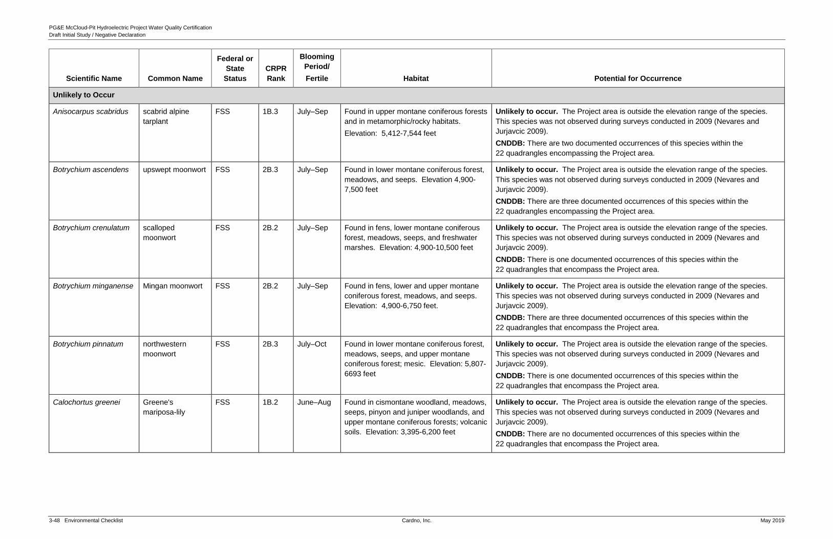
PG&E McCloud-Pit Hydroelectric Project Water Quality Certification
Draft Initial Study / Negative Declaration
3-48 Environmental Checklist Cardno, Inc. May 2019
Scientific Name Common Name
Federal or
State
Status
CRPR
Rank
Blooming
Period/
Fertile Habitat Potential for Occurrence
Unlikely to Occur
Anisocarpus scabridus scabrid alpine
tarplant
FSS 1B.3 July–Sep Found in upper montane coniferous forests
and in metamorphic/rocky habitats.
Elevation: 5,412-7,544 feet
Unlikely to occur. The Project area is outside the elevation range of the species.
This species was not observed during surveys conducted in 2009 (Nevares and
Jurjavcic 2009).
CNDDB: There are two documented occurrences of this species within the
22 quadrangles encompassing the Project area.
Botrychium ascendens upswept moonwort FSS 2B.3 July–Sep Found in lower montane coniferous forest,
meadows, and seeps. Elevation 4,900-
7,500 feet
Unlikely to occur. The Project area is outside the elevation range of the species.
This species was not observed during surveys conducted in 2009 (Nevares and
Jurjavcic 2009).
CNDDB: There are three documented occurrences of this species within the
22 quadrangles encompassing the Project area.
Botrychium crenulatum scalloped
moonwort
FSS 2B.2 July–Sep Found in fens, lower montane coniferous
forest, meadows, seeps, and freshwater
marshes. Elevation: 4,900-10,500 feet
Unlikely to occur. The Project area is outside the elevation range of the species.
This species was not observed during surveys conducted in 2009 (Nevares and
Jurjavcic 2009).
CNDDB: There is one documented occurrences of this species within the
22 quadrangles that encompass the Project area.
Botrychium minganense Mingan moonwort FSS 2B.2 July–Sep Found in fens, lower and upper montane
coniferous forest, meadows, and seeps.
Elevation: 4,900-6,750 feet.
Unlikely to occur. The Project area is outside the elevation range of the species.
This species was not observed during surveys conducted in 2009 (Nevares and
Jurjavcic 2009).
CNDDB: There are three documented occurrences of this species within the
22 quadrangles that encompass the Project area.
Botrychium pinnatum northwestern
moonwort
FSS 2B.3 July–Oct Found in lower montane coniferous forest,
meadows, seeps, and upper montane
coniferous forest; mesic. Elevation: 5,807-
6693 feet
Unlikely to occur. The Project area is outside the elevation range of the species.
This species was not observed during surveys conducted in 2009 (Nevares and
Jurjavcic 2009).
CNDDB: There is one documented occurrences of this species within the
22 quadrangles that encompass the Project area.
Calochortus greenei Greene's
mariposa-lily
FSS 1B.2 June–Aug Found in cismontane woodland, meadows,
seeps, pinyon and juniper woodlands, and
upper montane coniferous forests; volcanic
soils. Elevation: 3,395-6,200 feet
Unlikely to occur. The Project area is outside the elevation range of the species.
This species was not observed during surveys conducted in 2009 (Nevares and
Jurjavcic 2009).
CNDDB: There are no documented occurrences of this species within the
22 quadrangles that encompass the Project area.

PG&E McCloud-Pit Hydroelectric Project Water Quality Certification
Draft Initial Study / Negative Declaration
May 2019 Cardno, Inc. Environmental Checklist 3-49
Scientific Name Common Name
Federal or
State
Status
CRPR
Rank
Blooming
Period/
Fertile Habitat Potential for Occurrence
Calochortus
longebarbatus var.
longebarbatus
long-haired star-
tulip
FSS 1B.2 June–Aug Found in Great Basin scrub, lower
montane coniferous forest (openings and
drainages), meadows, seeps, and vernal
pools; clay, mesic soils.
Elevation: 3,297-6,234 feet
Unlikely to occur. The Project area is outside the elevation range of the species.
This species was not observed during surveys conducted in 2009 (Nevares and
Jurjavcic 2009).
CNDDB: There is one documented occurrence of this species within the
22 quadrangles that encompass the Project area.
Campanula shetleri Castle Crags
harebell
FSS 1B.3 June–Sep Found in lower montane coniferous forest
(rocky). Elevation: 4,000-6,000 feet
Unlikely to occur. The Project area is outside the elevation range of the species.
This species was not observed during surveys conducted in 2009 (Nevares and
Jurjavcic 2009).
CNDDB: There are no documented occurrences of this species within the
22 quadrangles that encompass the Project area.
Campanula wilkinsiana Wilkin's harebell FSS 1B.2 July–Sep Found in meadows, seeps, subalpine
coniferous forest, and upper montane
coniferous forest. Elevation: 4,166 - 8,528
feet
Unlikely to occur. The Project area is outside the elevation range of the species.
This species was not observed during surveys conducted in 2009 (Nevares and
Jurjavcic 2009).
CNDDB: There are nine documented occurrences of this species within the
22 quadrangles that encompass the Project area.
Carex comosa bristly sedge – 1B.2 May–Sep Found in coastal prairie, marshes and
swamps (lake margins), and valley and
foothill grassland. Elevation: 4,166-8,528
feet
Unlikely to occur. The Project area is outside the elevation range of the species.
This species was not observed during surveys conducted in 2009 (Nevares and
Jurjavcic 2009).
CNDDB: There are two documented occurrences of this species within the
22 quadrangles that encompass the Project area.
Carex lasiocarpa woolly-fruited
sedge
– 2B.3 June–July Found in bogs, fens, marshes, and
swamps (freshwater, lake margins).
Elevation: 5,576-6,888 feet
Unlikely to occur. The Project area is outside the elevation range of the species.
This species was not observed during surveys conducted in 2009 (Nevares and
Jurjavcic 2009).
CNDDB: There are two documented occurrences of this species within the
22 quadrangles that encompass the Project area.
Chaenactis douglasii
var. alpina
alpine dusty
maidens
– 2B.3 July–Sep Found in alpine boulder and rock field
(granitic).
Elevation: 9,397-11,152 feet
Unlikely to occur. The Project area is outside the elevation range of the species.
This species was not observed during surveys conducted in 2009 (Nevares and
Jurjavcic 2009).
CNDDB: There are no documented occurrences of this species within the
22 quadrangles that encompass the Project area.

PG&E McCloud-Pit Hydroelectric Project Water Quality Certification
Draft Initial Study / Negative Declaration
3-50 Environmental Checklist Cardno, Inc. May 2019
Scientific Name Common Name
Federal or
State
Status
CRPR
Rank
Blooming
Period/
Fertile Habitat Potential for Occurrence
Chamaesyce hooveri Hoover's Spurge FT 1B.2 July–Oct Found in vernal pools. Elevation: 82-820
feet
Unlikely to occur. The Project area is outside the elevation range of the species.
This species was not observed during surveys conducted in 2009 (Nevares and
Jurjavcic 2009).
CNDDB: There are no documented occurrences of this species within the
22 quadrangles that encompass the Project area.
Collomia larsenii talus collomia FSS 2B.2 July–Oct Found in alpine boulder and rock field,
closed-cone coniferous forest, subalpine
coniferous forest, and upper montane
coniferous forests. Elevation: 7,250-
11,480 feet
Unlikely to occur. The Project area is outside the elevation range of the species.
This species was not observed during surveys conducted in 2009 (Nevares and
Jurjavcic 2009).
CNDDB: There are no documented occurrences of this species within the
22 quadrangles that encompass the Project.
Cuscuta jepsonii Jepson's dodder – 1B.2 July–Sep Found in north coast coniferous forest;
streambanks/annual vine (parasitic).
Elevation: 3,936-7,544 feet
Unlikely to occur. The Project area is outside the elevation range of the species.
This species was not observed during surveys conducted in 2009 (Nevares and
Jurjavcic 2009).
CNDDB: There is one documented occurrence of this species within the
22 quadrangles that encompass the Project area.
Draba carnosula Mount (Mt.) Eddy
draba
FSS 1B.3 July–Aug Found in subalpine coniferous and upper
montane coniferous forests; serpentinite,
rocky soils. Elevation: 6,350-9,840 feet
Unlikely to occur. The Project area is outside the elevation range of the species.
This species was not observed during surveys conducted in 2009 (Nevares and
Jurjavcic 2009).
CNDDB: There are no documented occurrences of this species within the
22 quadrangles encompassing the Project area.
Drosera anglica English sundew – 2B.3 June–Sep Found in bogs, fens, meadows, and seeps.
Elevation: 4,264-7,396 feet
Unlikely to occur. The Project area is outside the elevation range of the species.
This species was not observed during surveys conducted in 2009 (Nevares and
Jurjavcic 2009).
CNDDB: There is one documented occurrence of this species within the
22 quadrangles that encompass the Project area.
Erigeron nivalis snow fleabane
daisy
– 2B.3 July–Aug Found in alpine boulder and rock field,
meadows, seeps, and subalpine
coniferous forest; volcanic, rocky.
Elevation: 5,691-9,512 feet
Unlikely to occur. The Project area is outside the elevation range of the species.
This species was not observed during surveys conducted in 2009 (Nevares and
Jurjavcic 2009).
CNDDB: There are two documented occurrences of this species within the
22 quadrangles that encompass the Project area.

PG&E McCloud-Pit Hydroelectric Project Water Quality Certification
Draft Initial Study / Negative Declaration
May 2019 Cardno, Inc. Environmental Checklist 3-51
Scientific Name Common Name
Federal or
State
Status
CRPR
Rank
Blooming
Period/
Fertile Habitat Potential for Occurrence
Eriogonum alpinum Trinity buckwheat FSS, CE 1B.2 June–Sep Found in alpine boulder and rock field,
subalpine coniferous forest, upper
montane coniferous forest; serpentinite,
rocky.
Elevation: 7,169-9,514feet
Unlikely to occur. The Project area is outside the elevation range of the species.
This species was not observed during surveys conducted in 2009 (Nevares and
Jurjavcic 2009).
CNDDB: There are no documented occurrences of this species within the
22 quadrangles that encompass the Project area.
Eriogonum pyrolifolium
var. pyrolifolium
pyrola-leaved
buckwheat
– 2B.3 July–Sep Found in alpine boulder and rock field
(sandy or gravelly, pumice).
Elevation: 5,494-10,496 feet
Unlikely to occur. The Project area is outside the elevation range of the species.
This species was not observed during surveys conducted in 2009 (Nevares and
Jurjavcic 2009).
CNDDB: There are four documented occurrences of this species within the
22 quadrangles encompassing the Project area.
Erythronium
klamathense
Klamath fawn lily – 2B.2 Apr–July Found in meadows, seeps, and upper
montane coniferous forest.
Elevation: 3,936-6,068 feet
Unlikely to occur. The Project area is outside the elevation range of the species.
This species was not observed during surveys conducted in 2009 (Nevares and
Jurjavcic 2009).
CNDDB: There are eight documented occurrences of this species within the
22 quadrangles that encompass the Project area.
Frasera umpquaensis Umpqua green-
gentian
FSS 2B.2 June–July Found in chaparral, lower montane
coniferous forest, meadows, seeps, and
north coast coniferous forest. Elevation:
5,100-6,230 feet
Unlikely to occur. The Project area is outside the elevation range of the species.
This species was not observed during surveys conducted in 2009 (Nevares and
Jurjavcic 2009).
CNDDB: There are no documented occurrences of this species within the
22 quadrangles that encompass the Project area.
Fritillaria gentneri Gertner’s fritillary FE 1B.1 Apr–May Chaparral, Cismontane woodland, and
lower montane coniferous forest.
Sometimes in serpentine soil. Elevation:
3,297-9,744 feet
Unlikely to occur. The Project area is outside the elevation range of the species.
This species was not observed during surveys conducted in 2009 (Nevares and
Jurjavcic 2009).
CNDDB: There are no documented occurrences of this species within the
22 quadrangles that encompass the Project area.
Hulsea nana little hulsea – 2B.3 July–Aug Found in alpine boulder and rock field,
subalpine coniferous forest; rocky,
gravelly, or volcanic soils. Elevation:
5,642-11,004 feet
Unlikely to occur. The Project area is outside the elevation range of the species.
This species was not observed during surveys conducted in 2009 (Nevares and
Jurjavcic 2009).
CNDDB: There is one documented occurrence of this species within the
22 quadrangles encompassing the Project area

PG&E McCloud-Pit Hydroelectric Project Water Quality Certification
Draft Initial Study / Negative Declaration
3-52 Environmental Checklist Cardno, Inc. May 2019
Scientific Name Common Name
Federal or
State
Status
CRPR
Rank
Blooming
Period/
Fertile Habitat Potential for Occurrence
Ivesia longibracteata Castle Crags ivesia FSS 1B.3 June Found in lower montane coniferous forest;
granitic, rocky.
Elevation: 3,937-4,593 feet
Unlikely to occur. The Project area is outside the elevation range of the species.
This species was not observed during surveys conducted in 2009 (Nevares and
Jurjavcic 2009).
CNDDB: There are no documented occurrences of this species within the
22 quadrangles encompassing the Project area
Leptosiphon nuttallii ssp.
howellii
Mountain (Mt.)
Tedoc leptosiphon
FSS 1B.3 May–Aug Found in lower montane coniferous forest
(serpentinite). Elevation: 4,000-9,185 feet
Unlikely to occur. The Project area is outside the elevation range of the species.
This species was not observed during surveys conducted in 2009 (Nevares and
Jurjavcic 2009).
CNDDB: There are no documented occurrences of this species within the
22 quadrangles encompassing the Project area.
Lewisia kelloggii ssp.
hutchisonii
Hutchison's lewisia FSS 3.2 April–June Found in openings in upper montane
coniferous forest, often on slate soils and
on soils that are sandy granitic to erosive
volcanic. Elevation: 4,800-7,000 feet.
Unlikely to occur. The Project area is outside the elevation range of the species.
This species was not observed during surveys conducted in 2009 (Nevares and
Jurjavcic 2009).
CNDDB: There are no documented occurrences of this species within the
22 quadrangles encompassing the Project area.
Lewisia kelloggii ssp.
kelloggii
Kellogg's lewisia – 3.2 April–June Found in on granitic and volcanic balds.
Elevation: 5,000-8,000 feet.
Unlikely to occur. The Project area is outside the elevation range of the species.
This species was not observed during surveys conducted in 2009 (Nevares and
Jurjavcic 2009).
CNDDB: There are no documented occurrences of this species within the
22 quadrangles encompassing the Project area.
Meesia uliginosa broad-nerved
hump-moss
FSS 2B.2 July–Oct Found in damp soil, bogs, fens, meadows,
seeps, subalpine coniferous forest, and
upper montane coniferous forest.
Elevation: 3,970-9,200 feet
Unlikely to occur. The Project area is outside the elevation range of the species.
This species was not observed during surveys conducted in 2009 (Nevares and
Jurjavcic 2009).
CNDDB: There are no documented occurrences of this species within the
22 quadrangles encompassing the Project area.
Minuartia stolonifera Scott Mountain
sandwort
FSS 1B.3 May–Aug Found in lower montane coniferous forest
(serpentinite). Elevation: 4,100-4,595 feet
Unlikely to occur. The Project area is outside the elevation range of the species.
This species was not observed during surveys conducted in 2009 (Nevares and
Jurjavcic 2009).
CNDDB: There are no documented occurrences of this species within the
22 quadrangles encompassing the Project area.

PG&E McCloud-Pit Hydroelectric Project Water Quality Certification
Draft Initial Study / Negative Declaration
May 2019 Cardno, Inc. Environmental Checklist 3-53
Scientific Name Common Name
Federal or
State
Status
CRPR
Rank
Blooming
Period/
Fertile Habitat Potential for Occurrence
Ophioglossum pusillum northern adder's
tongue
FSS 2B.2 July Found in meadows, seeps, marshes, and
swamps. Elevation: 3,280-6,560 feet
Unlikely to occur. The Project area is outside the elevational range of the species.
This species was not observed during surveys conducted in 2009 (Nevares and
Jurjavcic 2009).
CNDDB: There are no documented occurrences of this species within the
22 quadrangles encompassing the Project area.
Penstemon tracyi Tracy's
beardtongue
FSS 1B.3 June–Aug Found in upper montane coniferous forest
(rocky). Elevation: 6,495-7,250 feet
Unlikely to occur. The Project area is outside the elevation range of the species.
This species was not observed during surveys conducted in 2009 (Nevares and
Jurjavcic 2009).
CNDDB: There are no documented occurrences of this species within the
22 quadrangles encompassing the Project area.
Phacelia cookei Cooke's phacelia FSS 1B.1 June–July Great Basin scrub and lower montane
coniferous forest. Found in sandy,
volcanic soils. Elevation: 3,590-5,580 feet
Unlikely to occur. The Project area is outside the elevation range of the species.
This species was not observed during surveys conducted in 2009 (Nevares and
Jurjavcic 2009).
CNDDB: There are no documented occurrences of this species within the
22 quadrangles encompassing the Project area.
Picea engelmannii Engelmann spruce – 2B.2 – Found in upper montane coniferous
forest/perennial evergreen tree.
Elevation: 3,493-7,003 feet
Unlikely to occur. The Project area is outside the elevation range of the species.
This species was not observed during surveys conducted in 2009 (Nevares and
Jurjavcic 2009).
CNDDB: There is one documented occurrence of this species within the
22 quadrangles encompassing the Project area.
Pinus albicaulis whitebark pine FSS CBR July–Aug Found in subalpine forest. Elevation:
6,500-7,500 feet
Unlikely to occur. The Project area is outside the elevation range of the species.
This species was not observed during surveys conducted in 2009 (Nevares and
Jurjavcic 2009).
CNDDB: There are no documented occurrences of this species within the
22 quadrangles encompassing the Project area.
Polemonium
chartaceum
Mason's sky pilot FSS 1B.3 June–Aug Found in rocky, serpentinite, granitic, or
volcanic soils. Alpine boulder and rock
field, subalpine coniferous forest.
Elevation: 10,790-14,005 feet
Unlikely to occur. The Project area is outside the elevation range of the species.
This species was not observed during surveys conducted in 2009 (Nevares and
Jurjavcic 2009).
CNDDB: There are no documented occurrences of this species within the
22 quadrangles encompassing the Project area.

PG&E McCloud-Pit Hydroelectric Project Water Quality Certification
Draft Initial Study / Negative Declaration
3-54 Environmental Checklist Cardno, Inc. May 2019
Scientific Name Common Name
Federal or
State
Status
CRPR
Rank
Blooming
Period/
Fertile Habitat Potential for Occurrence
Polemonium
pulcherrimum var.
shastense
Mount (Mt.) Shasta
sky pilot
– 1B.2 June–Sep Found in alpine boulder and rock field,
subalpine coniferous forest, upper
montane coniferous forest; sometimes
volcanic soils. Elevation: 7,134-12,792
feet
Unlikely to occur. The Project area is outside the elevation range of the species.
This species was not observed during surveys conducted in 2009 (Nevares and
Jurjavcic 2009).
CNDDB: There is one documented occurrence of this species within the
22 quadrangles encompassing the Project area.
Raillardella pringlei showy raillardella FSS 1B.2 July–Sep Found in mesic, serpentinite soil. Bogs,
fens, meadows, seeps, and upper
montane coniferous forest. Elevation:
3,940-7,510 feet
Unlikely to occur. The Project area is outside the elevation range of the species.
This species was not observed during surveys conducted in 2009 (Nevares and
Jurjavcic 2009).
CNDDB: There are no documented occurrences of this species within the
22 quadrangles encompassing the Project area.
Rorippa columbiae Columbia yellow
cress
FSS 1B.2 May–Sep Found in mesic soil. Lower montane
coniferous forest, meadows, seeps,
playas, and vernal pools. Elevation: 3,940-
5,905 feet
Unlikely to occur. The Project area is outside the elevation range of the species.
This species was not observed during surveys conducted in 2009 (Nevares and
Jurjavcic 2009).
CNDDB: There are no documented occurrences of this species within the
22 quadrangles encompassing the Project area.
Silene occidentalis ssp.
longistipitata
long-stiped
campion
– 1B.2 June–Aug Found in chaparral, lower montane
coniferous forest, and upper montane
coniferous forest. Elevation: 3,280-6,560
feet
Unlikely to occur. The Project area is outside the elevation range of the species.
This species was not observed during surveys conducted in 2009 (Nevares and
Jurjavcic 2009).
CNDDB: There are two documented occurrences of this species within the
22 quadrangles encompassing the Project area.
Silene suksdorfii Cascade alpine
campion
– 2B.3 July–Sep Found in alpine boulder and rock field,
subalpine coniferous forest, and upper
montane coniferous forest; volcanic, rocky
soils. Elevation: 7,724-10,201 feet
Unlikely to occur. The Project area is outside the elevation range of the species.
This species was not observed during surveys conducted in 2009 (Nevares and
Jurjavcic 2009).
CNDDB: There are two documented occurrences of this species within the
22 quadrangles encompassing the Project area.
LEGEND:
Other Federal Status
FT = Federal Threatened
FE = Federal Endangered
FSS = Forest Service Sensitive
State Status
CE = California Endangered
CNPS (California Native Plant Society) Rare Plant Rank
1B = rare, threatened or endangered in California and elsewhere
2B = rare in California but more common elsewhere
3 = plants about which more information is needed - a review list
_.1 = Seriously threatened in California (over 80% of occurrences threatened/high degree and immediacy of threat)
_.2 = Moderately threatened in California (20-80% occurrences threatened)
_.3 = Not very threatened in California (<20% of occurrences threatened or no current threats known)
CBR = Considered but Rejected
Sources:
California Native Plant Society (CNPS). Inventory of Rare and Endangered Plants of California.
Accessed January 2018. Electronic Database.
California Natural Diversity Database (CNDDB). Rare Find 5.0. California Department of Fish
and Wildlife, Habitat Planning and Conservation Branch. Accessed October 2017. Electronic
Database.
Calflora. Information on California plants for education, research and conservation. [web
application]. Berkeley, California: The Calflora Database [a non-profit organization]. Accessed
October 2017. Electronic Database.

PG&E McCloud-Pit Hydroelectric Project Water Quality Certification
Draft Initial Study / Negative Declaration
May 2019 Cardno, Inc. Environmental Checklist 3-55
Table 3-5 Special-Status Wildlife Species Known to Occur or Potentially Occurring in the Project Area.
Scientific Common Name
Federal
Status State Status Habitat Potential for Occurrence
Known to Occur
Fish
Mylopharodon conocephalus Hardhead
minnow
— CSC Low to mid-elevation streams in the Sacramento-
San Joaquin drainage. Also present in the Russian
River.
Known to occur. Hardhead were observed during surveys conducted for
relicensing in Pit 6 and 7 Reservoirs. Unidentified minnows (due to size),
which may have been hardhead, were observed within the Lower
McCloud River in 2009 within the Project area (Nevares and Liebig,
2009).
CNDDB: There are four documented occurrences of this species within
the 22 quadrangles encompassing the Project area.
Amphibians and Reptiles
Ascaphus truei Pacific tailed frog — CSC This species uses cold, rocky streams in humid
forests of Douglas-fir, pine, spruce, hemlock,
redwood, maple, and alder, with interspersed
grassland or chaparral. Elevation for this species
can range from sea -level to 8,400 ft (Nafis 2018).
Known to occur. This species was observed within the Project area
during relicensing studies in 2008 (Nevares, Shepley, and Champe 2009).
Adult and tadpole stages of Pacific tailed frog were observed in Ladybug
Creek, a tributary to the Lower McCloud River.
CNDDB: There are 10 documented occurrences of this species within the
22 quadrangles encompassing the Project area.
Hydromantes shastae Shasta
salamander
— CT Found around cliff faces, vertical cavern walls, and
level ground in mixed forests of Douglas fir, pines,
and oaks. Lives in moist caves and rock crevices.
Mostly associated with limestone outcrops, but one
population has been found in a volcanic outcrop,
and others in forest areas with no rock outcrops.
This species is most commonly found from 800-
2,000 ft elevation.
Known to occur. Surveys conducted in 2008 as part of the relicensing
identified this species within the Project area (Nevares and Lindstrand III
2008). Individuals were recorded at McCloud Reservoir and Fenders
Flat/Pit 7 Afterbay Dam.
CNDDB: There are three documented occurrences of this species within
0.5 mile of the Project area and 39 documented occurrences of this
species within the 22 quadrangles encompassing the Project area.
Rana boylii Foothill
yellow-legged
frog
— CCT, CSC Perennial rocky (pebble or cobble) streams with
cool, clear water in a variety of habitats from valley
and foothill oak woodland, riparian forest,
ponderosa pine, mixed conifer, coastal scrub, and
mixed chaparral at elevations ranging from 0 to
6,370 feet.
Known to occur. This species was observed within the Project area
during relicensing studies completed in 2009 (Nevares, Shepley, and
Champe 2009). Individuals were observed at seven sites located
between RM 1.4 and 5.7 on the Lower McCloud River and in associated
tributaries. Evidence of breeding was observed in four mainstem sites on
the Lower McCloud River. Post-metamorphic frogs were also observed in
three tributaries. Twelve egg masses were observed in the Lower
McCloud River (FERC 2011). Suitable habitat for this species is present
within the Project area, and the Project is within the elevation range of this
species.

PG&E McCloud-Pit Hydroelectric Project Water Quality Certification
Draft Initial Study / Negative Declaration
3-56 Environmental Checklist Cardno, Inc. May 2019
Scientific Common Name
Federal
Status State Status Habitat Potential for Occurrence
CNDDB: There are 26 documented occurrences within the
22 quadrangles encompassing the Project area.
Actinemys marmorata western pond
turtle
— CSC Perennial wetlands, slow moving creeks, and
ponds, from sea level to 6,000 feet in elevation,
with overhanging vegetation and suitable basking
sites such as logs and rocks above the waterline.
Known to occur. This species was observed on-site during relicensing
surveys completed in 2008 and 2009 (Nevares, Shepley, and Champe
2009, Nevares and Lindstrand 2008). Individuals were observed in the Pit
6 and Pit 7 Reservoirs. Individuals were also observed in the Lower
McCloud River.
CNDDB: There are 27 documented occurrences of this species within the
22 quadrangles encompassing the Project area.
Birds
Accipiter gentilis northern goshawk — CSC
(nesting)
Middle to high elevation, mature, dense conifer
forests for foraging and nesting. Casual
(i.e. occasionally) in foothills during winter,
northern deserts in pinyon-juniper woodland, and
low elevation riparian habitats. 5,500–10,000 feet.
Known to occur. Suitable habitat for nesting and foraging for this
species is present within the Project area. No nests were identified during
protocol surveys conducted in 2007 and 2008, but six individuals were
observed in the Project area. Four detections were 0.5 mile south of Au-
Di-Na Campground and the remaining detections were at the southeast
end of Pit 6 transmission line (Nevares and Lindstrand 2008).
The nearest known Protected Activity Center is located approximately
0.43 mile to the east of the Project area.
CNDDB: There are 24 documented occurrences of this species within the
22 quadrangles encompassing the Project area.
Empidonax traillii willow flycatcher BCC CE
(nesting)
Wet meadow and montane riparian habitats at
elevations ranging from 2,000 to 8,000 feet. Most
often occurs in broad, open river valleys or large
mountain meadows with lush growth of shrubby
willows.
Known to occur. Non-territorial individuals were document at Cedar Salt
Log, McGill Creek, and Fenders Flat/Pit 7 Afterbay Dam survey areas.
Individuals were considered migrants (Nevares and Lindstrand 2008).
CNDDB: There are 8 documented occurrences of this species within the
22 quadrangles encompassing the Project area.
Falco peregrinus anatum American
peregrine falcon
BCC, FD
(nesting)
CD (nesting),
CFP
Occurs in greater densities in tundra and coastal
habitats, inhabits many terrestrial biomes, none
seem to be preferred. Occupied habitat during
spring and fall migration may include urban
environments.
Known to occur. Several territories were documented within the Project
area in large rock outcroppings along the McCloud River, Iron Canyon
Creek, Pit 7 Reservoir, and Pit 6 Reservoir. Survey also documented
breeding at four territories where at least one young was observed
(Nevares, Cosio and Champe. 2008a).
CNDDB: There is one documented occurrences of this species within the
22 quadrangles encompassing the Project area.
Haliaeetus leucocephalus bald eagle FD
Bald Eagle
Act,
CE, CFP Year-round resident in ice-free regions of
California. Foraging areas include regulated and
unregulated rivers, reservoirs, lakes, estuaries, and
Known to occur. Pre-relicensing surveys located eight bald eagle
nesting territories within the Project area (Nevares, Cosio, Champe
2008b). This includes two previously unknown territories on Chatterdown

PG&E McCloud-Pit Hydroelectric Project Water Quality Certification
Draft Initial Study / Negative Declaration
May 2019 Cardno, Inc. Environmental Checklist 3-57
Scientific Common Name
Federal
Status State Status Habitat Potential for Occurrence
BCC coastal marine ecosystems. Majority of bald eagles
in California breed near reservoirs and nests are
usually located within one mile of foraging habitat.
Creek and McCloud Bridge. Other territories in the Project area are
located at McCloud Reservoir, McCloud River, Iron Canyon Reservoir
(two), Pit 6 Reservoir, and Pit 7 Afterbay near Pit 7 Dam. Bald eagles are
also known to winter in the Project area.
CNDDB: There are six documented occurrences of this species within
0.5 mile of the Project area and 40 documented occurrences of this
species within the 22 quadrangles encompassing the Project area.
Laterallus jamaicensis
coturniculus
California black
rail
BCC CT, CFP Year-round resident of the western slope foothills of
the Sierra Nevada mountain range in California.
Nests in high portions of salt marshes, shallow
freshwater marshes, wet meadows, and flooded
grassy vegetation.
Known to occur. Suitable habitat for this species is present within the
Project area.
CNDDB: One known observation from June 2010 is documented
(CNDDB 2018). The observation occurred along California State Route
299 approximately 0.3 mile southwest of Fender’s Ferry Road
intersection, one mile north-northeast of King Mill Road intersection, north
of Round Mountain.
Mammals
Antrozous pallidus pallid bat — CSC Inhabits a variety of habitats, including coniferous
forests. Rock outcroppings, caves, buildings, and
bridges are used for roost sites. Pallid bats are
year-round residents that hibernate during the
winter months.
Known to occur. Individuals were captured at the Pit 6, and Pit 7 dams
and along the existing Pit 7 transmission line corridor. A juvenile was
captured at the Pit 7 Dam confirming the presence of a reproductive
population.
CNDDB: There are no documented occurrences of this species within the
22 quadrangles surrounding the Project area.
Corynorhinus townsendii Townsend's big-
eared bat
— CSC Found in all but alpine and subalpine habitats; most
abundant in mesic habitats. Requires caves,
mines, or man-made structures for roosting.
Known to occur. One non-reproductive adult female was captures along
the margins of McCloud Reservoir.
CNDDB: There are two documented occurrences of this species within
five miles of the Project area.
Euderma maculatum spotted bat — CSC The spotted bat forages over open areas and along
forest areas, particularly in association with wet
meadows, and uses creeks and rivers as a source
of water. This species roosts in rock features, often
on steep slopes or rock outcrops associated with
river drainages.
Known to occur. Suitable habitat for this species is present within the
Project area, including foraging habitat and night roosting habitat within
the recreational facilities. Individuals were documented at the Pit 4
development area in 2000. Individuals were detected within the
construction footprint of the (now-cancelled) McCloud transmission line.
CNDDB: There is one documented occurrence of this species within the
22 quadrangles encompassing the Project area.
Eumops perotis californicus western mastiff
bat
— CSC The western mastiff bat is found in rock features,
often steep slopes or rock outcrops associated with
river drainages, under slabs of exfoliating granite,
Known to occur. Individuals were detected at the Pit 6 Dam in 2007.
CNDDB: There are no documented occurrences of this species within
22 quadrangles encompassing the Project area.

PG&E McCloud-Pit Hydroelectric Project Water Quality Certification
Draft Initial Study / Negative Declaration
3-58 Environmental Checklist Cardno, Inc. May 2019
Scientific Common Name
Federal
Status State Status Habitat Potential for Occurrence
or in basaltic columns. This species is an open-air
forager and has been detected flying/foraging over
reservoirs.
Lasiurus blossevillii western red bat — CSC Forages along open streams and rivers; roosts in
tree canopy in forest, woodland, riparian, mesquite
bosque, and orchards.
Known to occur. Individuals detected year-round at the Pit 7
transmission line.
CNDDB: There are no documented occurrences of this species within
22 quadrangles encompassing the Project area.
Pekania pennanti fisher- west coast
DPS
— CCT, CSC Large areas of mature and dense forests of red fir,
lodgepole pine, ponderosa pine, mixed conifer, and
Jeffery pine forests with snags and greater than
40% canopy closure. Known to inhabit areas from
sea level along the California and Oregon coasts
up to 8,530 feet elevation in the Trinity and
Klamath/Siskiyou Mountains in northern California
and southern Oregon, and the Sierra Nevada in
California (USFWS 2017).
Known to occur. Suitable habitat for foraging is present within the
Project area (Nevares, Trawick, Champe 2009).
CNDDB: There are 55 documented occurrences of this species within the
22 quadrangles encompassing the Project area. One incidental sighting
of this species was recorded in the Project area in 2007 at Forest Road
11 on the northeast side of Iron Canyon Reservoir.
May Potentially Occur
Fish
Cottus asperrimus rough sculpin — CT, CFP Restricted to the Pit River above and below the falls
at Burney, and the Hat Creek and Fall River sub
drainages.
May occur in suitable habitat. The Project area is within the range for
this species. During surveys conducted for relicensing in 2009, one
unidentified sculpin was observed as well as riffle and pit sculpin (Nevares
and Liebig 2009).
CNDDB: There are two documented occurrences of this species within
the 22 quadrangles encompassing the Project area.
Oncorhynchus mykiss ssp. 2 McCloud River
redband trout
— CSC Lives in small spring fed tributaries of the McCloud
River.
May occur in suitable habitat. This species was not observed during
surveys conducted for relicensing in 2009 (Nevares and Liebig, 2009).
CNDDB: There are four documented occurrences of this species within
the 22 quadrangles encompassing the Project area.
Amphibians
Ambystoma macrodactylum
sigillatum
southern long-
toed salamander
— CSC Inhabits alpine meadows and high mountain ponds
and lakes. Found at elevations up to 10,000 ft.
May occur in suitable habitat. Suitable habitat for this species is
present within the Project area.
CNDDB: There are five documented occurrences of this species within
the 22 quadrangles encompassing the Project area.

PG&E McCloud-Pit Hydroelectric Project Water Quality Certification
Draft Initial Study / Negative Declaration
May 2019 Cardno, Inc. Environmental Checklist 3-59
Scientific Common Name
Federal
Status State Status Habitat Potential for Occurrence
Birds
Accipiter cooperii Cooper's hawk — W (nesting) Woodland, chiefly of open, interrupted, or marginal
type. Nest sites are mainly in riparian growths of
deciduous trees, such as canyon bottoms on river
flood-plains, and live oaks. Elevation range: sea
level to 9,000 feet. Species prefers lower
elevations with open habitats including broken
woodland and habitat edges.
May occur in suitable habitat. Suitable habitat for this species is not
abundant within the Project area.
CNDDB: There are no documented occurrences of this species within the
22 quadrangles that encompassing the Project area.
Agelaius tricolor tricolored
blackbird
BCC CCE, CSC Nests near fresh water, and emergent wetlands
with cattails or tules, but also in Himalayan
blackberry; forages in grasslands, woodland, and
agriculture.
May occur in suitable habitat. This species prefers to forage in
grassland and open woodland, which are minimal within the Project area.
Himalayan blackberry is present within the Project area and may provide
nesting habitat.
CNDDB: There is one documented occurrence of this species within the
22 quadrangles encompassing the Project area.
Aquila chrysaetos golden eagle BCC CFP Golden eagles use a variety of habitats including
conifer, hardwood or mixed woodland, alpine,
grassland, cliff, desert, savannah, and tundra.
May occur in suitable habitat. Suitable foraging and nesting habitat is
present within the Project area for this species.
CNDDB: There are no documented occurrences of this species within the
22 quadrangles encompassing the Project area.
Contopus cooperi olive-sided
flycatcher
BCC CSC Breeds in montane and northern coniferous forests,
at forest edges and openings, such as meadows
and ponds. Winters at forest edges and clearings
where tall trees or snags are present. They migrate
between their North American breeding grounds
and Central American wintering grounds.
Elevation: near sea-level to 9,400 feet.
May occur in suitable habitat. Suitable habitat for this species is
present within the Project area; however, the nearest occurrence of this
species on the eBird database is located approximately 5 miles east of
McCloud Reservoir (Sullivan et al. 2009).
CNDDB: There are no documented occurrences of this species within the
22 quadrangles encompassing the Project area.
Coturnicops noveboracensis yellow rail BCC CSC Requires large wet marsh/sedge meadows or
coastal marshes with wet soil and shallow, standing
water for nesting. Elevation: 4,150 to 5,000 feet
May occur in suitable habitat. Suitable nesting and foraging habitat for
this species is available in the Project area.
CNDDB: There are no documented occurrences of this species within the
22 quadrangles encompassing the Project area.
Cypseloides niger black swift BCC CSC Breeds in small colonies on cliffs behind or
adjacent to waterfalls in deep canyons and sea-
bluffs above the surf; forages widely in interior
steep mountain canyons, especially cliffs adjacent
to waterfalls. Forages above forests, woodlands,
canyons, valleys, and savannas in the vicinity of
May occur in suitable habitat. Suitable foraging habitat for this species
is present within the Project area. No sightings within the Project area
have been recorded on eBird (Sullivan et al. 2009), however, there are
many sightings of this species within the vicinity of the Project area.
CNDDB: There are no documented occurrences of this species within the
22 quadrangles encompassing the Project area.

PG&E McCloud-Pit Hydroelectric Project Water Quality Certification
Draft Initial Study / Negative Declaration
3-60 Environmental Checklist Cardno, Inc. May 2019
Scientific Common Name
Federal
Status State Status Habitat Potential for Occurrence
nesting locations. Breeds locally in Sierra Nevada
and Cascade Ranges.
Progne subis purple martin — CSC Nest and forages in woodland habitats including
riparian, coniferous, and valley foothill and montane
woodlands; in the Sacramento region often nests in
weep holes under elevated freeways.
May occur in suitable habitat. Suitable nesting and foraging habitat is
present for this species within the Project area.
CNDDB: There are 10 documented occurrences of this species within
five miles of the Project area.
Setophaga petechia yellow warbler BCC CSC Nests and forages in riparian and oak woodlands,
montane chaparral, open ponderosa pine, and
mixed conifer habitats.
May occur in suitable habitat. Suitable habitat for this species is
present within the Project area.
CNDDB: There are no documented occurrences of this species within the
22 quadrangles that encompass the Project area.
Strix occidentalis occidentalis California spotted
owl
BCC CSC Nests in old-growth, dense, coniferous forests.
Forages in multi-layered mixed conifer, redwood,
Douglas fir, and oak woodland habitats, from sea
level to elevations of approximately 7,600 feet.
May occur in suitable habitat. Suitable habitat is present within the
Project area for this species. The nearest California spotted owl home
range and core area to the Project area is approximately 50 miles
southeast.
CNDDB: There are no documented occurrences of this species within the
22 quadrangles encompassing the Project area.
Strix occidentalis caurina northern spotted
owl
FT CT, CSC Nests in old-growth, dense, coniferous forests.
Forages in multi-layered mixed conifer, redwood,
and Douglas fir. Elevation: sea-level to 7,600 feet.
May occur in suitable habitat. The Project area is within critical habitat
for this species and suitable habitat is present. No individuals or active
nests were observed in the Project area during relicensing studies
(Nevares and Lindstrand 2008).
CNDDB: There are no documented occurrences of this species within the
22 quadrangles encompassing the Project area.
Mammals
Aplodontia rufa californica Sierra Nevada
mountain beaver
_ CSC Found in riparian forest, woodland, and scrub
habitats, typically with dense growth of small
deciduous trees and shrubs, wet soil, and
abundance of forbs, in the Sierra Nevada & east
slope.
May occur in suitable habitat. Suitable habitat is present for this
species within the Project area.
CNDDB: There are two documented occurrences of this species within
the 22 quadrangles encompassing the Project area.
Bassariscus astutus ringtail — CFP Found in desert scrub, chaparral, pine-oak or
conifer woodland habitats with rocky areas and
fallen log debris.
May occur in suitable habitat. Suitable habitat for this species is
present within the Project area.
CNDDB: There are no documented occurrences of this species within the
22 quadrangles that encompass the Project area.
Lepus americanus klamathensis Oregon
snowshoe hare
— CSC Found in riparian habitats with thickets of
deciduous trees such as alders and willows, dense
May occur in suitable habitat. Suitable habitat for this species is
present within the Project area.

PG&E McCloud-Pit Hydroelectric Project Water Quality Certification
Draft Initial Study / Negative Declaration
May 2019 Cardno, Inc. Environmental Checklist 3-61
Scientific Common Name
Federal
Status State Status Habitat Potential for Occurrence
thickets of conifers, and sometimes ceanothus and
manzanita.
CNDDB: There are two documented occurrences of this species within
the 22 quadrangles encompassing the Project area.
Vulpes vulpes necator Sierra Nevada
red fox
FC CT Typically occurs throughout the Sierra Nevada at
elevations above 7,000 feet in forests interspersed
with meadows, or alpine forests. Open areas are
used for hunting, and forested habitats for cover
and reproduction.
May occur in suitable habitat. Presence of this species was assumed
for the purposes of relicensing.
CNDDB: There are four documented occurrences of this species within
the 22 quadrangles that encompass the Project area.
Unlikely to Occur
Invertebrates
Branchinecta conservatio conservancy fairy
shrimp
FE — Found in large, turbid, vernal, and playa pools. Unlikely to occur within the Project area. No suitable habitat is present
within the Project area for this species.
CNDDB: There are no documented occurrences of this species within the
22 quadrangles that encompass the Project area.
Branchinecta lynchi vernal pool fairy
shrimp
FT — This species inhabits vernal pools and similar
ephemeral wetlands. It is most commonly found in
grass or mud bottomed pools or basalt flow
depression pools in unplowed grasslands. Occurs
mostly in vernal pools, although it also inhabits a
variety of natural and artificial seasonal wetland
habitats, such as alkali pools, ephemeral
drainages, stock ponds, roadside ditches, vernal
swales, and rock outcrop pools. Whatever the
habitat, the wetlands in which this species is found
are small, and shallow (mean 5 centimeters).
Unlikely to occur within the Project area. No suitable habitat is present
for this species within the Project area.
CNDDB: There are no documented occurrences of this species within the
22 quadrangles encompassing the Project area.
Lepidurus packardi vernal pool
tadpole shrimp
FE — Found in a variety of natural and artificial
seasonally ponded habitat types including: vernal
pools, swales, ephemeral drainages, stock ponds,
reservoirs, ditches, backhoe pits, and ruts caused
by vehicular activities.
Unlikely to occur. Suitable habitat for this species is not present within
the Project area.
CNDDB: There are no documented occurrences of this species within the
22 quadrangles encompassing the Project area.
Pacifastacus fortis Shasta crayfish
FE CE Found only in the Fall and Hat Creek sub-drainages
of the Pit River system.
Unlikely to occur. This species is limited to the Fall and Hat Creek
drainages of the Pit River which are upstream of the Project area.
CNDDB: There are no documented occurrences of this species within the
22 quadrangles encompassing the Project area.

PG&E McCloud-Pit Hydroelectric Project Water Quality Certification
Draft Initial Study / Negative Declaration
3-62 Environmental Checklist Cardno, Inc. May 2019
Scientific Common Name
Federal
Status State Status Habitat Potential for Occurrence
Fish
Cottus klamathensis macrops Bigeye marbled
sculpin
— CSC Found in the upper Pit River and its tributaries, and
tributaries to Goose Lake.
Unlikely to occur. The Project area is outside of the known range of this
species. During surveys conducted for relicensing in 2009, one
unidentified sculpin was observed as well as riffle sculpin (Nevares and
Liebig, 2009). Suitable habitat for this species is present within the
Project area.
CNDDB: There are three documented occurrences of this species within
the 22 quadrangles encompassing the Project area.
Lavinia symmetricus mitrulus pit roach — CSC Found in the upper Pit River and its tributaries, and
tributaries to Goose Lake.
Unlikely to occur. The Project area is outside of the known range of this
species. This species was not observed during electrofishing and snorkel
surveys conducted for relicensing (Nevares and Liebig, 2009). Suitable
habitat for this species is present within the Project area.
CNDDB: There are four documented occurrences of this species within
the 22 quadrangles encompassing the Project area.
Entosphenus tridentatus Pacific lamprey — CSC Found in Pacific Coast streams north of San Luis
Obispo County and in Santa Clara River. Size of
runs is declining.
Unlikely to occur. This species was not observed during surveys
conducted for relicensing in 2009 (Nevares and Liebig, 2009).
CNDDB: There is one documented occurrence of this species within the
22 quadrangles encompassing the Project area.
Hypmesus transpacificus Delta smelt FT CE Found in brackish water below 25 degrees Celsius.
Shallow, fresh or slightly brackish backwater
sloughs and edge waters with good water quality
and substrate are used for spawning. Larvae and
juveniles need shallow, food-rich nursery habitat.
Adequate flow and suitable water quality are
required for adult access to spawning habitat and
transport of juveniles to the San Francisco Bay
rearing habitat (Center for Biological Diversity
2017).
Unlikely to occur. The Project area is outside of the range of this
species.
CNDDB: There are no documented occurrences of this species within the
22 quadrangles encompassing the Project area.
Spirinchus thaleichthys Longfin smelt FC CT
CSC
Anadromous smelt (family Osmeridae) found in
California’s bay, estuary, and nearshore coastal
environments from San Francisco Bay north to
Lake Earl, near the Oregon border (CDFW 2009)
Unlikely to occur. The Project area is outside of the range of this
species.
CNDDB: There are no documented occurrences of this species within the
22 quadrangles encompassing the Project area.

PG&E McCloud-Pit Hydroelectric Project Water Quality Certification
Draft Initial Study / Negative Declaration
May 2019 Cardno, Inc. Environmental Checklist 3-63
Scientific Common Name
Federal
Status State Status Habitat Potential for Occurrence
Oncorhynchus mykiss iridius Steelhead-
Central Valley
DPS
FT — Populations exist in the Sacramento and San
Joaquin rivers and their tributaries.
Unlikely to occur. Due to fish passage barriers, anadromous fish are not
present within the Project area. Additionally, this species was not
observed during relicensing surveys conducted in 2009 (Nevares and
Liebig, 2009).
CNDDB: There is one documented occurrence of this species within the
22 quadrangles encompassing the Project area.
Salvelinus confluentus bull trout FT CE Bottom dwellers that require deep pools in cold
water rivers. Need gravel riffles & large volume of
cold water to spawn.
Unlikely to occur. This species was extirpated from the McCloud River,
which was historically the southernmost and only bull trout population in
California, in 1975. Additionally, this species was not observed during
relicensing surveys conducted within the Project area (Nevares and
Liebig, 2009).
CNDDB: There are two documented occurrences of this species within
the 22 quadrangles encompassing the Project area.
Amphibians
Rana cascadae Cascades frog — CSC Found in riparian and marshy vegetation in
mountain lakes, streams, and ponds. The elevation
range for this species is 755 to 9,000 feet
(Nafis 2018).
Unlikely to occur. Suitable habitat for this species is present within the
Project area and the Project is within the elevation range of this species;
however, suitable lentic (flowing) habitat was not identified for this species
during the relicensing surveys, and no individuals were observed during
aquatic species surveys (Nevares, Shepley, and Champe 2009, Nevares
and Lindstrand 2008).
CNDDB: There are 12 documented occurrences of this species within the
22 quadrangles encompassing the Project area.
Rana draytonii California red-
legged frog
FT CSC Breeds in calm streams and permanent, deep, cool
ponds with overhanging and emergent vegetation
below 5,000 feet elevation. Known to occur
adjacent to breeding habitats in riparian areas,
heavily vegetated streamside shorelines, and non-
native grasslands.
Unlikely to occur. This species is most common in the low lands and
foothills. During relicensing surveys conducted in 2007-2009, suitable
habitat for this species was not identified (protocol level surveys were not
conducted). No California red-legged frog were observed in the Project
area during aquatic species surveys (Nevares, Shepley, and Champe
2009, Nevares and Lindstrand 2008).
CNDDB: There are no documented occurrences of this species within the
22 quadrangles that encompass this species.

PG&E McCloud-Pit Hydroelectric Project Water Quality Certification
Draft Initial Study / Negative Declaration
3-64 Environmental Checklist Cardno, Inc. May 2019
Scientific Common Name
Federal
Status State Status Habitat Potential for Occurrence
Rana pretiosa Oregon spotted
frog
FT CSC Inhabits aquatic environments within mixed
coniferous forest, preferring large marshy areas
that are filled by warm springs. Often found near
cool, calm, permanent water sources, such as slow
streams that meander through meadows, sluggish
streams and rivers, marshes, springs, pools, edges
of small lakes, and ponds (Nafis 2018).
Unlikely to occur. The Project area is not within the range of this
species.
CNDDB: There are no documented occurrences of this species within the
22 quadrangles encompassing the Project area.
Rhyacotriton variegatus southern torrent
salamander
— CSC Found in clear, shallow, well-shaded streams,
waterfalls, and seepages in mature to old-growth
forests. This species can be found from sea-level
to 4,500-5,000 ft. (Nafis 2018).
Unlikely to occur. Suitable habitat for this species is similar to that of
Pacific tailed frog; during surveys completed for pacific tailed frog for
relicensing, no individuals of this species were observed (Nevares,
Shepley, and Champe 2009, Nevares and Lindstrand 2008).
CNDDB: There are no documented occurrences of this species within the
22 quadrangles that encompass the Project area.
Birds
Asio flammeus short-eared owl BCC CSC Short-eared owls favor large areas of open
grassland. They nest on ground in prairies,
hayfields, and sometimes stubble fields.
Unlikely to occur. This species prefers open habitat for nesting and
foraging, which does not occur in the Project area.
CNDDB: There are no documented occurrences of this species within in
22 quadrangles that encompass the Project area.
Athene cunicularia burrowing owl BCC CSC Suitable habitat throughout their breeding range
typically includes open, treeless areas within
grassland, steppe, and desert biomes. They
generally inhabit gently-sloping areas,
characterized by low, sparse vegetation.
Unlikely to occur. This species prefers to nest and forage in disturbed
areas and in annual grassland that do not grow tall. Suitable nesting and
foraging habitat for this species is not present within the Project area.
CNDDB: There are no documented occurrences of this species within the
22 quadrangles that encompass the Project area.
Buteo swainsoni Swainson’s hawk BCC CT
(nesting)
Swainson's hawk breeding habitat includes shrub-
steppe areas with scattered trees (juniper-sage
flats and oak woodlands), large shrubs, and
riparian woodlands. Grasslands and agricultural
areas are used for foraging.
Unlikely to occur. This species prefers open grassland and agricultural
land for foraging, and nests in tall riparian trees, often sycamores or
cottonwoods. Suitable nesting and foraging habitat for this species is
minimal within the Project area.
CNDDB: There are no documented occurrences of this species within the
22 quadrangles that encompass the Project area.
Charadrius alexandrinus snowy plover BCC, FT CSC Found in barren to sparsely vegetated sand
beaches, dry salt flats in lagoons, dredge spoils
deposited on beach or dune habitat, levees and
flats at salt-evaporation ponds, river bars, along
alkaline or saline lakes, reservoirs, and ponds.
Unlikely to occur. The Project area is not within the range for this
species and this species prefers lower elevations along the California
coast. There are no sightings recorded for this species on eBird (Sullivan
et al. 2009).
CNDDB: There are no documented occurrences of this species within the
22 quadrangles that encompass the Project area.
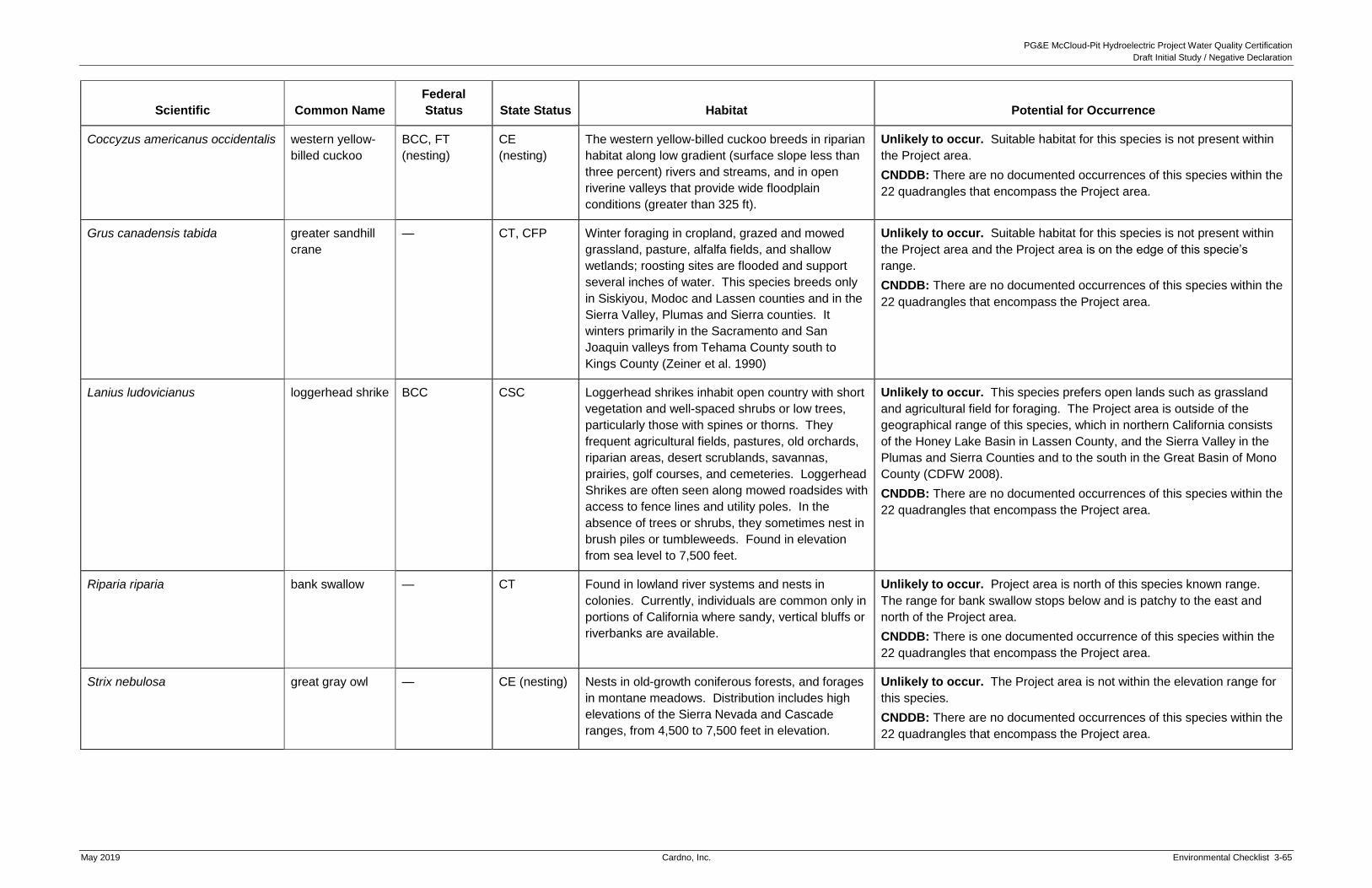
PG&E McCloud-Pit Hydroelectric Project Water Quality Certification
Draft Initial Study / Negative Declaration
May 2019 Cardno, Inc. Environmental Checklist 3-65
Scientific Common Name
Federal
Status State Status Habitat Potential for Occurrence
Coccyzus americanus occidentalis western yellow-
billed cuckoo
BCC, FT
(nesting)
CE
(nesting)
The western yellow-billed cuckoo breeds in riparian
habitat along low gradient (surface slope less than
three percent) rivers and streams, and in open
riverine valleys that provide wide floodplain
conditions (greater than 325 ft).
Unlikely to occur. Suitable habitat for this species is not present within
the Project area.
CNDDB: There are no documented occurrences of this species within the
22 quadrangles that encompass the Project area.
Grus canadensis tabida greater sandhill
crane
— CT, CFP Winter foraging in cropland, grazed and mowed
grassland, pasture, alfalfa fields, and shallow
wetlands; roosting sites are flooded and support
several inches of water. This species breeds only
in Siskiyou, Modoc and Lassen counties and in the
Sierra Valley, Plumas and Sierra counties. It
winters primarily in the Sacramento and San
Joaquin valleys from Tehama County south to
Kings County (Zeiner et al. 1990)
Unlikely to occur. Suitable habitat for this species is not present within
the Project area and the Project area is on the edge of this specie’s
range.
CNDDB: There are no documented occurrences of this species within the
22 quadrangles that encompass the Project area.
Lanius ludovicianus loggerhead shrike BCC CSC Loggerhead shrikes inhabit open country with short
vegetation and well-spaced shrubs or low trees,
particularly those with spines or thorns. They
frequent agricultural fields, pastures, old orchards,
riparian areas, desert scrublands, savannas,
prairies, golf courses, and cemeteries. Loggerhead
Shrikes are often seen along mowed roadsides with
access to fence lines and utility poles. In the
absence of trees or shrubs, they sometimes nest in
brush piles or tumbleweeds. Found in elevation
from sea level to 7,500 feet.
Unlikely to occur. This species prefers open lands such as grassland
and agricultural field for foraging. The Project area is outside of the
geographical range of this species, which in northern California consists
of the Honey Lake Basin in Lassen County, and the Sierra Valley in the
Plumas and Sierra Counties and to the south in the Great Basin of Mono
County (CDFW 2008).
CNDDB: There are no documented occurrences of this species within the
22 quadrangles that encompass the Project area.
Riparia riparia bank swallow — CT Found in lowland river systems and nests in
colonies. Currently, individuals are common only in
portions of California where sandy, vertical bluffs or
riverbanks are available.
Unlikely to occur. Project area is north of this species known range.
The range for bank swallow stops below and is patchy to the east and
north of the Project area.
CNDDB: There is one documented occurrence of this species within the
22 quadrangles that encompass the Project area.
Strix nebulosa great gray owl — CE (nesting) Nests in old-growth coniferous forests, and forages
in montane meadows. Distribution includes high
elevations of the Sierra Nevada and Cascade
ranges, from 4,500 to 7,500 feet in elevation.
Unlikely to occur. The Project area is not within the elevation range for
this species.
CNDDB: There are no documented occurrences of this species within the
22 quadrangles that encompass the Project area.

PG&E McCloud-Pit Hydroelectric Project Water Quality Certification
Draft Initial Study / Negative Declaration
3-66 Environmental Checklist Cardno, Inc. May 2019
Scientific Common Name
Federal
Status State Status Habitat Potential for Occurrence
Xanthocephalus xanthocephalus yellow-headed
blackbird
— CSC Nests in marshes with tall emergent vegetation,
often along borders of lakes and ponds; forages in
emergent wetlands, open areas, croplands, and
muddy shores of lacustrine habitat. This species
breeds east of the Cascade Range and Sierra
Nevada, in Imperial and Colorado River valleys, in
the Central Valley, and at selected locations in the
coast ranges west of the Central Valley.
Unlikely to occur. Suitable habitat for this species is sparse throughout
the Project area and the Project is not within the range of this species.
CNDDB: There are no documented occurrences of this species within the
22 quadrangles that encompass the Project area.
Mammals
Canis lupus gray wolf FE CE Montane woodlands and adjacent grasslands at
4,000 to 5,000 feet in elevation where ungulate
prey or livestock are plentiful.
Unlikely to occur. The Project area is not within the elevation range for
this species.
CNDDB: There are no documented occurrences for this species within
the 22 quadrangles that encompass the Project area.
Gulo gulo luteus California
wolverine
PT CT, CFP Mixed conifer, red fir, and lodgepole habitats, and
probably sub-alpine conifer, alpine dwarf shrub, wet
meadow, and montane riparian habitats. This
species requires dense cover for resting and
reproduction, and open areas for hunting. Dens
are found in trees, dead standing trees (snags),
downed logs, abandoned beaver lodges, among
boulders, rock ledges, in old bear dens, and in
caves. Riparian areas are used as travel corridors.
Found in the northern Sierra Nevadas in elevation
ranges of 4,300 to 7,300 feet (CDFW 2008).
Denning habitat consists of caves, cliffs, hollow
logs, and other cavities located in rocky areas free
of human disturbance.
Unlikely to occur. The Project area is outside of the elevational range
for this species.
CNDDB: There are six documented occurrences of this species within the
22 quadrangles encompassing the Project area.
Federal Status
FC = Candidate Species FD = Federal Delisted FE = Federal Endangered PT= Proposed Threatened PE = Proposed Endangered BCC = Birds of Conservation Concern
State Status
CFP = California Fully Protected CSC = California Species of Special Concern CE = California Endangered CT = California Threatened CCT = California Candidate Threatened W = CDFW Watchlist Forest Service Status
FSS = Forest Service Sensitive
Sources:
California Department of Fish and Wildlife, Natural Diversity Database. October 2017. Special Animals List. Periodic publication. 65 pp. California Department of Fish and Wildlife. Fully Protected Animals. Accessed January 2018. Access at
http://www.dfg.ca.gov/wildlife/nongame/t_e_spp/fully_pro.html California Natural Diversity Database (CNDDB). Rare Find 5.0. California Department of Fish and Wildlife, Habitat Planning and Conservation Branch.
Accessed January 2018. Electronic Database. United States Department of Agriculture – Forest Service (USFS). 2013. Regional Forester’s List of Sensitive Plant and Animal Species for Region 5. United States Fish and Wildlife Service (USFWS). Species List, Information for Planning and Conservation (IPaC). Electronic Database. Accessed October
2017.

PG&E McCloud-Pit Hydroelectric Project Water Quality Certification
Draft Initial Study / Negative Declaration
May 2019 Cardno, Inc. Environmental Checklist 3-67
Discussion
a. Have a substantial adverse effect, either directly or through habitat modifications, on
any species identified as a candidate, sensitive, or special-status species in local or
regional plans, policies, or regulations, or by the California Department of Fish and
Wildlife or the US Fish and Wildlife Service?
Impact: Less Than Significant
For the purposes of this element, an adverse effect on a species would be considered
substantial, and thus significant, if it resulted in the loss of a sufficient number of a species
to impair ongoing efforts to recover the species.
As provided in Exhibit E of the Application for New License (PG&E 2009), FERC’s final EIS
(2011), and USFS 4(e) conditions, the Proposed Project includes implementation of
increased minimum instream flows (MIFs) from McCloud and Iron Canyon Dams into their
respective downstream reaches, and a continued MIF release of 150 cubic feet per second
(cfs) to the Pit River below Pit 7 Dam when Shasta Lake is lower than 1,055 feet msl. The
Proposed Project includes implementation of ramping rates to protect fish,
macroinvertebrates, and FYLF below McCloud Dam:
Up-ramping at 100 cfs per hour prior to uncontrollable spills at McCloud Dam.
Down-ramping at 150 cfs each 48 hours at McCloud dam during spills controllable by
valve.
Maximum up-ramping during controllable spills at 200 cfs each 24 hours at McCloud
Dam.
Up-ramping and down-ramping related to testing of the flow valve at Iron Canyon
Dam in 20 cfs increments.
As part of the Proposed Project, PG&E will develop and implement an Aquatic Biological
Monitoring Plan, Erosion and Sediment Control Management Plan, Storm Water Pollution
Prevention Plan (SWPPP), Coarse Sediment Management Plan, Large Woody Debris Plan,
Water Quality and Temperature Monitoring Plan, Terrestrial Biological Management Plan,
and Vegetation, and Invasive Weed Management Plan. Results of monitoring required by
the plans will be reviewed annually by a Technical Review Group, which will develop of
adaptive management actions as needed. Because these plans are components of the
Proposed Project presented to the State Water Board for certification, they are included in
the following environmental analysis. As a whole, the Proposed Project will not result in
significant impacts to Biological Resources. In addition, PG&E will develop Project-specific
Biological Evaluations for USFS approval and continue its existing environmental training.
These plans and requirements are summarized below.
Aquatic Biological Monitoring Plan. PG&E is required to finalize the draft Aquatic
Biological Monitoring Plan (PG&E 2010) in consultation with resource agencies (i.e.,
USFS, CDFW, USFWS, and the State Water Board). The Aquatic Biological
Monitoring Plan will monitor and survey fish populations, BMI, aquatic mollusks,
western pond turtles, USFS sensitive frog species, and resident fish passage. Once

PG&E McCloud-Pit Hydroelectric Project Water Quality Certification
Draft Initial Study / Negative Declaration
3-68 Environmental Checklist Cardno, Inc. May 2019
approved and finalized, the Aquatic Biological Monitoring Plan will be implemented
as part of the Proposed Project, consistent with Measure 14 as cited in Exhibit E of
the Application for New License (PG&E 2009), FERC’s final EIS (2011), and USFS
4(e) condition number 27.
Erosion and Sediment Control Management and Storm Water Pollution
Prevention Plans. PG&E is required to finalize the draft Erosion and Sediment
Control Management Plan and a SWPPP (for construction activities) (PG&E 2010).
The Erosion and Sediment Control Management Plan would require PG&E to
inventory, record, treat, and monitor Proposed Project-related erosion and
sedimentation impacts to the Proposed Project area and affected USFS lands and
waters. The Erosion and Sediment Control Management Plan would include:
updating erosion and sediment Inventory and Risk Rating and development of a
monitoring schedule; development of a ranking process that incorporates risk rating
and hazard assessment and a schedule to repair erosion sites based on the rankings
and other management considerations; development of site specific erosion control
measures; development of emergency erosion control measures; and development
of temporary erosion control measures for planned construction, reconstruction, and
heavy maintenance.
PG&E is required to prepare and implement a SWPPP pursuant to the requirements
of the National Pollutant Discharge Elimination System (NPDES) Statewide General
Permit for Construction Activities. Under the requirements, which are regulated by
the Central Valley Regional Water Quality Control Board (CVRWQCB), the Proposed
Project will be required to implement Best Management Practices (BMPs) for the
control of erosion and sedimentation. Additionally, the provisions of the proposed
Erosion and Sediment Monitoring and Control Plan and the Road and Transportation
Facility Management Plan would require appropriate controls for erosion during
operation and maintenance. All conditions and requirements of the permits will be
included with construction specifications and implemented as part of the
Proposed Project.
Coarse Sediment Management Plan. PG&E is required to finalize the draft Coarse
Sediment Management Plan (PG&E 2010) in consultation with resource agencies.
The goal of the Coarse Sediment Management Plan is to provide an adaptive
management framework for the collection, storage, and augmentation of coarse
sediment into the lower McCloud River below McCloud Dam. The Coarse Sediment
Management Plan would require monitoring of gravel and coarse sediment
augmentation that could benefit downstream aquatic habitat in the lower McCloud
River, as well as evaluating possible gravel and coarse sediment sources.
Implementation of the Coarse Sediment Management Plan would require the
addition of 150 to 600 tons of gravel and coarse sediment. The anticipated source of
the gravel and coarse sediment is the Star City Creek delta in McCloud Reservoir.

PG&E McCloud-Pit Hydroelectric Project Water Quality Certification
Draft Initial Study / Negative Declaration
May 2019 Cardno, Inc. Environmental Checklist 3-69
Large Woody Debris Management Plan. PG&E is required to finalize the draft Large
Woody Debris Plan (PG&E 2010) in consultation with resource agencies. The Large
Woody Debris Management Plan would provide a framework and guidelines for the
removal of large woody debris from McCloud Reservoir, and subsequent placement
of large woody debris into the McCloud River below the McCloud River Dam to
augment recruitment of wood during high water flows, and contribute to the quantity
and quality of aquatic habitat along channel margins and in riparian habitat above the
low-flow channel.
Water Quality and Temperature Monitoring Plan. PG&E’s license application
included a proposed draft Water Quality Monitoring Plan to identify potential Project
impacts on water quality. USFS Final 4(e) condition number 20 requires a Water
Quality and Temperature Monitoring Plan, with monitoring requirements that focus
on aquatic habitats and water-based recreation on USFS lands.
Terrestrial Biological Management Plan. PG&E is required to finalize the draft
Terrestrial Biological Management Plan (PG&E 2010) in consultation with resource
agencies. The Terrestrial Biological Management Plan would require descriptions of
monitoring methodologies, pre-construction survey protocols, and avoidance and
protection measures for northern goshawk, bald eagle, peregrine falcon, willow
flycatcher, communities of breeding birds, special status bats, and forest carnivores.
Once finalized and approved by appropriate agencies, the Terrestrial Biological
Management Plan will be implemented as part of the Proposed Project, consistent with
Measure 14, as cited in Exhibit E of the Application for New License (PG&E 2009),
FERC’s final EIS (2011), and USFS 4(e) condition number 26.
Vegetation and Invasive Weed Management Plan. PG&E is required to finalize the
draft Vegetation and Invasive Weed Management Plan (PG&E 2010) in consultation
with resource agencies. The Vegetation and Invasive Weed Management Plan
would: (a) identify, monitor, and protect individuals and populations of special status
species, and culturally significant plant species to maintain well-distributed, viable
populations; (b) specify allowable treatment methods for Project operation and
maintenance practices to minimize the introduction and spread of invasive plant
species (including integration of USFS Region 5 Invasive Weed BMPs); (c) protect
wetland areas; and (d) restore native vegetation in areas disturbed by Project
operation and activities. Once approved and finalized, the Vegetation and Invasive
Weed Management Plan will be implemented as part of the Proposed Project,
consistent with Measure 13, as cited in Exhibit E of the Application for New License
(PG&E 2009), FERC’s final EIS (2011), and USFS 4(e) condition number 25.
Project-Specific Biological Evaluations. PG&E is required to prepare for USFS
approval a Biological Evaluation (BE) addressing the potential effects of any action to
construct Proposed Project features on USFS lands. The evaluation would include
procedures to minimize any adverse effects, meet any management plan restrictions,
and monitor implementation and effectiveness of any measures taken as part the
construction (including applicable USFS Region 5 and PG&E BMPs). This will apply to

PG&E McCloud-Pit Hydroelectric Project Water Quality Certification
Draft Initial Study / Negative Declaration
3-70 Environmental Checklist Cardno, Inc. May 2019
and protect terrestrial and aquatic USFS special status-species, consistent with
Measure 15 as cited in Exhibit E of the Application for New License (PG&E 2009),
FERC’s final EIS (2011), and USFS 4(e) condition number 11.
Annual Environmental Training. PG&E will continue to conduct existing annual training
in coordination with USFS. Training familiarizes staff with local resource issues,
special-status species, invasive plants, applicable avoidance and protection measures,
procedures for agency reporting, and applicable USFS orders. Training includes
prevention of weed transport (via dirty vehicles), cleaning procedures for rental
equipment, cleaning procedures when moving between watersheds, and protection of
special-status species. This is consistent with Measure 2, as cited in Exhibit E of the
Application for New License (PG&E 2009) and FERC’s final EIS (2011).
Aquatic Species
Additional analyses of potential environmental impacts on aquatic resources can be found in
FERC’s final EIS (FERC 2011), Section 3.3.2.2, Environmental Effects, pages 127 through 166.
Benthic Macroinvertebrates
There are no BMI species that have been identified as a candidate, sensitive, or special-status
species in the Proposed Project area; therefore, the Project would have no impact on
candidate, sensitive, or special-status BMI species.
More generally, operation of the Project raises the possibility of a potential impact to the
general BMI species assemblage in the Proposed Project area by affecting the amount of
wetted bed habitat, the amount of coarse sediment substrate, water quality (e.g., turbidity),
or water temperature in: (a) the McCloud River below McCloud Reservoir; (b) Iron Canyon
Creek below Iron Canyon Reservoir; or (c) in the Pit River below the Pit 7 Dam. However, if
the Proposed Project results in these potential impacts, the impacts will not be significant
because implementation of increased MIFs from McCloud and Iron Canyon Dams into their
respective downstream reaches and continued MIF release of 150 cfs to the Pit River below
Pit 7 Dam when Shasta Lake is lower than 1,055 feet msl would benefit the amount of
wetted bed habitat for BMI. Implementation of ramping rates would reduce stranding or
scouring of BMI. With implementation of these components of the Proposed Project, there
would be no significant adverse impacts to BMI habitat or species assemblage present in
the Proposed Project area.
Aquatic Mollusks
There are no aquatic mollusk species that have been identified as a candidate, sensitive, or
special-status species in the Proposed Project area; therefore, the Project would have no
impact on candidate, sensitive, or special-status aquatic mollusk species.
More generally, operation of the Project raises the possibility of a potential impact to the
general aquatic mollusk species assemblage in the Proposed Project area by affecting the
amount of wetted bed habitat, the amount of coarse sediment substrate, water quality (e.g.,
turbidity), or water temperature in: (a) the McCloud River below McCloud Reservoir; (b) Iron

PG&E McCloud-Pit Hydroelectric Project Water Quality Certification
Draft Initial Study / Negative Declaration
May 2019 Cardno, Inc. Environmental Checklist 3-71
Canyon Creek below Iron Canyon Reservoir; or (c) in the Pit River below the Pit 7 Dam.
However, if the Proposed Project results in these potential impacts, the impacts will not be
significant because implementation of increased MIFs from McCloud and Iron Canyon Dams
into their respective downstream reaches and continued MIF release of 150 cfs to the Pit
River below Pit 7 Dam when Shasta Lake is lower than 1,055 feet msl would likely benefit the
amount of habitat for aquatic mollusks. Implementation of ramping rates would reduce
potential stranding or scouring of aquatic mollusks. With implementation of these
components of the Proposed Project, there would be no significant adverse impacts to the
general aquatic mollusk habitat or species assemblage present in the Proposed Project area.
Fish
Hardhead are the only special-status species fish species present in the Proposed Project
area. Hardhead are present in Pit 6 and Pit 7 Reservoirs and Pit 7 Afterbay. Operation of
the Proposed Project raises the possibility of a potential impact to the habitat for hardhead,
particularly by altering the water temperature in the transition-zone habitats where they
occur. The Proposed Project could also impact other potential habitat factors, such as the
amount of physical habitat available and water quality (e.g., turbidity). However, if the
Proposed Project results in these potential impacts, the impacts will not be significant
because continued operation of the Pit 7 and Pit 6 Reservoirs, Pit 7 Afterbay, and continued
MIF release of 150 cfs to the Pit River below Pit 7 Dam when Shasta Lake is lower than
1,055 feet msl would maintain water temperature and physical habitat conditions for
hardhead. Implementation of the Aquatic Biological Monitoring Plan, Erosion and Sediment
Control Management Plan, Water Quality and Temperature Monitoring Plan, applicable
BMPs, and required agency permits would continue to support the existing habitat;
therefore, the Proposed Project would not result in significant adverse impacts to the
hardhead or hardhead habitat in the Proposed Project area. Potential turbidity-related
impacts are also discussed in Section 3.2.10, Hydrology and Water Quality.
More generally, other fish species that are currently present in the Proposed Project area,
such as rainbow and brown trout, could also be affected by operations of the Proposed
Project that affect the amount of physical habitat, stranding rates, coarse sediment
recruitment and movement, large woody debris supply, water temperature, and water quality
(e.g., turbidity). However, implementation of increased MIFs from McCloud and Iron Canyon
Dams into their respective downstream reaches and continued MIF release of 150 cfs to the
Pit River below Pit 7 Dam when Shasta Lake is lower than 1,055 feet msl would benefit the
amount of physical habitat for these species. In addition, implementation of ramping rates
would reduce fish stranding. With implementation of these components of the Proposed
Project, there would be no significant adverse impacts to the other fish species or their
habitat in the Proposed Project area.
Amphibians
FYLF, a candidate species for listing as California threatened and California species of
special concern, were observed at seven sites (and associated tributaries) in the Project
affected Lower McCloud River reach between RM 1.4 and RM 5.7. Pacific tailed frogs, a

PG&E McCloud-Pit Hydroelectric Project Water Quality Certification
Draft Initial Study / Negative Declaration
3-72 Environmental Checklist Cardno, Inc. May 2019
California species of special concern, were found in a tributary to the Lower McCloud River,
but not in a reach that could be affected by the Proposed Project. Operation of the
Proposed Project raises the possibility of impacts to water temperature and the physical
habitat of FYLF in the downstream reach of the Lower McCloud River. For example,
increased flows could reduce water temperature below those acceptable for development of
tadpoles, or out-of-season flow fluctuations (high or low) could scour or desiccate egg
masses or tadpoles.
However, if the Proposed Project results in these potential impacts, the impacts will not be
significant because implementation of seasonal MIFs from McCloud Reservoir would not be
detrimental to FYLF with regards to physical habitat or water temperature, and
implementation of ramping rates would reduce potential stranding or scouring of FYLF or
their habitat. With implementation of these components of the Proposed Project, impacts to
FYLF and their habitat in the Proposed Project area would not be significant.
Terrestrial Species
Additional analyses of environmental impacts on terrestrial resources can be found in FERC’s
final EIS (FERC 2011), Section 3.3.3.2, Environmental Effects, pages 182 through 218; and in
Section 3.3.4, Threatened and Endangered Species, pages 221 through 227.
Reptiles
WESTERN POND TURTLE
Western pond turtles were identified in Pit 6 and Pit 7 Reservoirs, as well as along the
Lower McCloud River. Western pond turtles, if nesting in uplands surrounding these
reservoirs, could potentially be directly affected by activities that involve ground disturbance
and vegetation removal including, but not limited to, construction of new recreation facilities
or Project maintenance activities such as road grading, slide removal, roadside vegetation
removal, fuels management, or other ground-disturbing activities.
Operation of the Project could potentially affect western pond turtle nesting sites near the
Lower McCloud River shoreline through inundation, if summer spills occur at McCloud Dam
or from tributary accretion below McCloud Dam during summer thunderstorms. However,
summertime spills at McCloud Dam are not a part of normal operations, and as such, are
expected to occur infrequently. Placement of large woody debris in the Lower McCloud
River may potentially benefit western pond turtle habitat quality and quantity, as well as
increase the number of basking sites.
Project maintenance activities could also affect aquatic habitats for western pond turtle by
degrading water quality. For example, ground disturbing activities could result in increased
erosion and sedimentation within the reservoirs and creeks. Fuels from construction
vehicles or other equipment, or chemicals from spraying of herbicides, could potentially
enter water bodies, resulting in contamination and degradation of water quality.
However, if the Proposed Project results in these potential impacts, the impacts will not be
significant because the Proposed Project includes implementation of plans and measures

PG&E McCloud-Pit Hydroelectric Project Water Quality Certification
Draft Initial Study / Negative Declaration
May 2019 Cardno, Inc. Environmental Checklist 3-73
including environmental training for Proposed Project staff on special-status species,
including western pond turtle; requires herbicide application methods to be designed to
avoid sensitive habitats, including aquatic and wetland habitats; and requires development
of a BE for construction of new facilities that may affect special-status species, including
western pond turtle, the Proposed Project will not result in the potential impacts identified
above. The Aquatic Biological Monitoring Plan will include surveys, monitoring, and
preconstruction surveys within suitable habitat for western pond turtle along Project
reservoirs. Monitoring and survey reports are submitted to USFS and discussed at the
Annual Consultation Meeting.
Measures contained in the Erosion and Sediment Control Management Plan and SWPPP
will minimize the potential for degradation of aquatic habitats for western pond turtle through
the treatment and monitoring of erosion sites, implementation of water quality BMPs, and
obtaining and implementing agency permits for construction projects that affect aquatic
habitats (refer to Section 3.2.9, Hydrology and Water Quality).
With implementation of these components of the Proposed Project, potential adverse
impacts to western pond turtles would not be significant.
Special-Status Plants
Six plant species ranked as CRPR 1, 2, or 3 are known to occur within the Proposed Project
area. Of these six, only three have potential to be affected by Project operations and
maintenance activities. Potential effects to special-status plants and their habitat result from
ground disturbance associated with improvements to existing Project facilities and
recreation facilities and construction of new facilities; and ongoing maintenance including
grading along roads, vegetation trimming or clearing, and herbicide spraying. As
summarized below, populations of Shasta eupatorium, Howell’s lewisia, and northern clarkia
may potentially be affected by proposed Project activities. The Proposed Project may also
affect other special-status plant populations, if identified during comprehensive surveys
required under the new license.
A small population of five Shasta ageratina (eupatorium) individuals located on
bedrock below the high-water mark of the Lower McCloud River may be inundated
as a result of increased MIFs below the McCloud Dam.
Populations of Howell’s lewisia in the vicinity of the Lower McCloud River may be
directly affected by ongoing maintenance and recreational activities at the following
Project recreation facilities: Lower McCloud River whitewater (boating) put-in;
McCloud Dam to Hawkins Creek Crossing whitewater access; and the lower
McCloud River Dispersed Recreation Site whitewater access.
Northern clarkia could be affected by ground disturbance associated with the
expansion of the access road to Hawkin’s Landing Campground. Road and
transmission line maintenance activities (e.g., grading, vegetation clearing/trimming,
and herbicide spraying) along the access road to Hawkins’ Landing Campground,
the Pit 6 Transmission Line and access road, and the Iron Canyon 12-kV
Transmission Line could also affect this species.

PG&E McCloud-Pit Hydroelectric Project Water Quality Certification
Draft Initial Study / Negative Declaration
3-74 Environmental Checklist Cardno, Inc. May 2019
However, if the Proposed Project results in these potential impacts, the impacts on
special-status plants will not be significant because PG&E will conduct annual training, in
coordination with USFS, to familiarize Proposed Project staff with botanical resources that
characterize the Project area, including special-status species, invasive plants, and
applicable avoidance and protection measures.
In addition, the Proposed Project includes implementation of the Vegetation and Invasive
Weed Management Plan. The Vegetation and Invasive Weed Management Plan would
protect special-status plants through comprehensive surveys at ten-year intervals,
monitoring of known populations, and activity-specific management actions for
special-status plant protection. Protective actions may include, but are not limited to,
pre-construction surveys in areas of proposed ground disturbance, restriction of
disturbances within 100 feet of known populations, and, where appropriate, conducting
activities after vegetation has gone to seed and salvage of the top layer of soil to maintain
the native seed bank. The Vegetation and Invasive Weed Management Plan also requires
that herbicide application treatment methods, where necessary, be designed by licensed
Pest Control Advisers (PCAs) and in consideration of site-specific conditions including the
location of special-status plants. All chemical application contractors will be qualified,
trained, and licensed pesticide contractors and will be audited closely by PG&E personnel or
their representatives to insure adherence to rules, regulations, and reporting requirements.
The condition of known populations would be assessed during surveys and associated
monitoring, and survey/monitoring results would be documented in writing and provided to
the USFS for review at the Annual Consultation Meeting.
The required BE must include measures to minimize effects to plants included on the
Regional Forester’s List of species, which includes state and federally listed plants. The BE
must also describe compliance with applicable resource management plans and BMPs.
BMPs for prevention of erosion and sedimentation and preservation of water quality will be
implemented during ground-disturbing activities or vegetation removal to avoid indirect
effects to habitat for special-status plants. Following USFS review and approval, all
measures in the BE would be incorporated as part of construction.
The protective measures in the Vegetation and Invasive Weed Management Plan do not
address the potential for inundation of the small population of Shasta ageratina located
along the Lower McCloud River below the dam. However, potential impacts to the five
individuals in this population would be considered less than significant for several reasons.
Shasta ageratina is a limestone endemic with a range restricted roughly to the SNTF. The
1995 STNF Land and Resource Management Plan notes that this species is known to occur
in suitable limestone habitats within the McCloud and Shasta ranger districts, and that it was
removed from the Regional Forester’s list of sensitive species prior to 1993. CNDDB (2018)
reports a second population of Shasta ageratina (Occurrence #7) growing in rock crevices
along Forest Road 38N11, approximately 50 to 75 feet south of the access stairway leading
to the stream gage on the Lower McCloud River. This population was first observed in 1979
with 30 or more individuals; it was not seen during surveys conducted between 1995 and
1997 (and, presumably, was not seen during relicensing surveys in 2008 and 2009) but was
observed in 2013 with between 20 and 30 individuals. The close proximity between the two

PG&E McCloud-Pit Hydroelectric Project Water Quality Certification
Draft Initial Study / Negative Declaration
May 2019 Cardno, Inc. Environmental Checklist 3-75
populations suggest that they are part of a larger metapopulation that fluctuates in extent
and in number over time. Loss of one or more individuals during inundation would not
otherwise restrict the overall size or health of the larger metapopulation (note that the
CNDDB record for the larger population along the road states that it is located high in the
rocks, where it would not be affected by road maintenance activities). Shasta ageratina may
co-occur with the Shasta salamander, which is another limestone endemic species.
Therefore, measures to protect Shasta salamander, described in a section below, may also
enhance Shasta ageratina through protection of limestone habitat. As a whole, the impact
of the Proposed Project on special-status plants will not be significant.
Invasive Plant Species
A total of 65 species of invasive plants were identified during botanical surveys conducted
as a component of the relicensing. Populations of invasive plant species are generally
correlated with high levels of disturbance. Proposed operations and maintenance,
recreation, or proposed construction activities may therefore facilitate the establishment or
spread of weeds in the Proposed Project area. The spread and introduction of invasive
plant species could degrade habitats for and compete with special-status plants.
However, if the Proposed Project results in this potential impact, the impact will not be
significant because the Vegetation and Invasive Weed Management Plan will ensure control
and monitoring of known populations of invasive weeds. Specific treatment methods for
populations identified during comprehensive surveys will be developed in consultation with
USFS, based on the specific species and site conditions. PG&E will also develop and
implement protocols and/or strategies to prevent introduction or spread of invasive weeds
including, but not limited to, cleaning of equipment prior to entry into the Project area; use of
certified weed-free straw; and use of native plant species for restoration or erosion control.
USFS Region 5 Invasive Species BMPs could also be implemented as part of the
Vegetation and Invasive Weed Management Plan. As described above, results of invasive
weed surveys and monitoring will be provided to USFS for review and discussion at the
Annual Consultation Meeting.
With implementation of these components of the Proposed Project, potential adverse
impacts to special-status plants from invasive plants would not be significant.
Invertebrates
Valley Elderberry Longhorn Beetle
As described in the previous section, the Proposed Project area supports elderberry shrub
habitat for VELB. However, based on revisions to the species’ range (USFWS 2014), the
Project is no longer in the range for VELB. Therefore, the Proposed Project would have no
effect on VELB or its habitat.
PG&E McCloud-Pit Hydroelectric Project Water Quality Certification
Draft Initial Study / Negative Declaration
3-76 Environmental Checklist Cardno, Inc. May 2019
Terrestrial Amphibians
Shasta Salamander
Shasta salamanders (Hydromantes shastae) are known to occur in limestone rock outcrops
and other non-limestone habitats in the vicinity of the McCloud Reservoir and the Pit 7
Afterbay. This species or its habitat could be affected by activities which cause ground
disturbance in previously undisturbed areas, including wet areas or seeps (particularly
during the reproductive season) and removal or crushing of limestone outcrops.
Specifically, improvements to existing recreation facilities and construction of new recreation
facilities in the vicinity of McCloud Reservoir and Pit 7 Afterbay could directly affect
salamander individuals or destroy or alter suitable habitat. Ongoing maintenance activities
at existing facilities that could potentially affect Shasta salamanders include road grading,
slide removal, roadside vegetation removal, spraying of herbicides, hazard tree removal,
and other ground-disturbing activities that may encroach either into the steep-cut slopes
along dirt roads that border the reservoirs, or near the limestone caves on the west shore of
McCloud Reservoir near the Battle Creek inlet.
However, if the Proposed Project results in these potential impacts, the impacts will not be
significant because the Vegetation and Invasive Weed Management Plan will require
herbicide application treatment methods to be designed by licensed PCAs and in
consideration of site-specific conditions and the location of suitable habitats for
special-status wildlife, including seeps or other features used by Shasta salamanders.
Development of a BE prior to construction of proposed features potentially affecting Shasta
salamander is required. Any measures included in the BE will be implemented as part of
construction. The BE must also describe compliance with applicable resource management
plans and BMPs. Following USFS review and approval, all measures in the BE will be
incorporated as part of construction.
The Terrestrial Biological Management Plan would require preconstruction surveys by a
qualified biologist in suitable habitat within 150 meters of areas that would be disturbed as
part of Proposed Project activities. Results of surveys will be provided to USFS for review
within 30 days of the activity. If salamanders are present, avoidance and protection
measures would be developed and implemented, if determined necessary through
consultation with USFS. Such measures may include, but are not limited to, avoidance of
limestone habitats or relocation of individuals to suitable habitat outside the proposed
disturbance area (but as close as possible to the occupied habitat).
PG&E will also implement applicable USFS Region 5 and PG&E BMPs, including BMPs to
minimize effects to seeps and other water bodies from ground-disturbing activities.
With implementation of these components of the Proposed Project, potential adverse
impacts to Shasta salamander would not be significant.

PG&E McCloud-Pit Hydroelectric Project Water Quality Certification
Draft Initial Study / Negative Declaration
May 2019 Cardno, Inc. Environmental Checklist 3-77
Avian Species
Northern Goshawk
Although no active nests were identified during surveys conducted for the relicensing,
northern goshawks were observed in the Proposed Project area, and this species is
assumed to be present in suitable habitat in the Project area. Northern goshawks are
known to be sensitive to disturbance during their reproductive period (February 15 through
September 15). Noise disturbance and human presence associated with construction of
new Project facilities or recreation facilities; expansion of existing recreation facilities; and
routine maintenance of Project facilities or recreation facilities could affect northern
goshawks potentially nesting in the Project area.
However, if the Proposed Project results in these potential impacts, the impacts will not be
significant. As described previously, PG&E will provide environmental training for Project
staff on special-status species including northern goshawk, and development of a BE for
construction of new facilities that may affect northern goshawk is required. In addition,
under the Terrestrial Biological Management Plan, PG&E will conduct pre-construction
surveys prior to implementation of disturbing activities along the Lower McCloud River
corridor. If nests are identified, a limited operating period (LOP) would be in place from
February 1 to August 15 within 300 acres around the nest. The Terrestrial Biological
Management Plan also would require monitoring of known nests every ten years and
comprehensive surveys within all suitable habitat once every ten years during the license
term. Monitoring and survey reports would be submitted to USFS and discussed at the
Annual Consultation Meeting, as described previously.
With implementation of these components of the Proposed Project, potential adverse
impacts to northern goshawk would not be significant.
Willow Flycatcher
Although no nesting willow flycatchers were observed in the Project area, non-territorial
individuals were detected at the Iron Canyon Reservoir and Fenders Flat/Pit 7 Afterbay Dam
survey areas. Construction of new Project facilities or recreation facilities; expansion of
existing recreation facilities; and routine maintenance of Project facilities or recreation
facilities could disturb willow flycatcher (or other neotropical migrants) during the migratory
period (late April through early June) and reproductive period (mid-May through
mid-September), potentially resulting in individuals abandoning suitable nesting territories or
causing nest abandonment or nest failure. In addition, Proposed Project operations
resulting in fluctuating reservoir elevations in Iron Canyon Reservoir and changes in Pit
River flows could result in loss of appropriate habitat.
However, if the Proposed Project results in these potential impacts, the impacts will not be
significant. As described previously, environmental training will be conducted for Project
staff on special-status species including willow flycatcher; and development of a BE is
required for construction of new facilities that may affect willow flycatcher. In addition, under
the Terrestrial Biological Management Plan PG&E will conduct pre-construction surveys

PG&E McCloud-Pit Hydroelectric Project Water Quality Certification
Draft Initial Study / Negative Declaration
3-78 Environmental Checklist Cardno, Inc. May 2019
within 250 feet of suitable habitat for willow flycatcher prior to disturbing activities during the
sensitive period, defined as May 1 to August 1. If breeding birds are present, no
non-emergency activities, including regular maintenance actions and irregular activities,
such as testing of sirens or cutting hazard trees along roads and power lines, will be
conducted within 250 feet of the nest, unless approved by agencies. The Terrestrial
Biological Management Plan would also require monitoring of known nests every ten years
and comprehensive surveys within all suitable habitat once every ten years during the
license term. Monitoring and survey reports are submitted to USFS and discussed at the
Annual Consultation Meeting, as described previously.
With implementation of these components of the Proposed Project, potential adverse
impacts to willow flycatcher would not be significant.
Peregrine Falcon
Peregrine falcon breeding activity was confirmed at five eyries in large rock outcroppings
high above the McCloud River, Iron Canyon Creek, Pit 7 Reservoir, and Pit 6 Reservoir
during surveys conducted as a component of the relicensing. Peregrine falcons are
sensitive to disturbances during the breeding season (January through August) and are
especially susceptible to disturbance during the onset of courtship (January through March).
This would include any loud disturbances (e.g., sirens, use of machinery, or blasting)
associated with construction of new Project facilities or recreation facilities; expansion of
existing recreation facilities; and routine maintenance of Project facilities or recreation
facilities. Recreational activities, such as rapid or noisy approaches associated with
motorized boating, could also disturb breeding peregrine falcons.
However, if the Proposed Project results in these potential impacts, the impacts will not be
significant. The Terrestrial Biological Management Plan would restrict non-emergency
activities that could disturb active nests during the LOP for peregrine falcon, defined as
February 1 to August 15. Activities restricted during the LOP would include (but are not
limited to) construction activities, aerial patrols, tower or pole replacements, vegetation
management, road maintenance, hazard tree removal, and testing of warning sirens. If the
LOP cannot be observed, pre-construction protocol surveys would be implemented prior to
site disturbance in or adjacent to suitable habitat. The Terrestrial Biological Management
Plan would also require annual monitoring of known peregrine falcon breeding territories,
and comprehensive surveys within all suitable habitat once every ten years during the
license term. Monitoring and survey reports are submitted to USFS and discussed at the
Annual Consultation Meeting, as described previously.
With implementation of these components of the Proposed Project, potential adverse
impacts to peregrine falcons would not be significant.
PG&E McCloud-Pit Hydroelectric Project Water Quality Certification
Draft Initial Study / Negative Declaration
May 2019 Cardno, Inc. Environmental Checklist 3-79
Bald Eagle
There are eight bald eagle nesting territories in the Proposed Project area, including one at
McCloud Reservoir, three along the Lower McCloud River, two at Iron Canyon Reservoir,
one at Pit 7 Afterbay, and one at Pit 6 Reservoir. The USFWS National Bald Eagle
Management Guidelines (Guidelines) (USFWS 2017) provide activity-specific management
recommendations for avoiding bald eagle disturbance (including nest failure, premature
fledging of young, and territory abandonment) as a result of new or intermittent activities in
the vicinity of bald eagle nests. In general, the Guidelines recommend a 660-foot buffer
around active nests for construction projects with a footprint of half an acre or greater, tree
removal, and road construction activities; a 1,000-foot buffer for use of helicopters and
fixed-wing aircraft (except for authorized biologists trained in survey techniques); and a half
mile buffer for blasting or other activities that produce extremely loud noises. New or
intermittent Proposed Project activities that could potentially result in disturbance to active
nests include construction of new recreation facilities; expansion of existing recreation
facilities; routine maintenance of Project facilities or recreation facilities; and recreational use
at new facilities. Recreational use at existing recreation facilities, including recreational
boating on the reservoirs, is not expected to disturb nesting eagles because the eagles have
historically tolerated such activities.
Proposed Project maintenance activities could also affect aquatic foraging habitats for bald
eagle by degrading water quality, which could in turn affect prey species (e.g., fish). For
example, ground disturbing activities could result in increased erosion and sedimentation in
the reservoirs and creeks. Fuels from construction vehicles or other equipment, or
chemicals from spraying of herbicides, could potentially enter water bodies, resulting in
contamination and degradation of water quality.
However, if the Proposed Project results in these potential impacts, the impacts will not be
significant because it includes implementation of the Terrestrial Biological Management
Plan. The Terrestrial Biological Management Plan would state that non-emergency
activities that could disturb active nests would be restricted during the bald eagle LOP,
defined as January 1 to August 1. Activities restricted during the LOP would include, but are
not limited to, construction activities, aerial patrols, tower or pole replacements, vegetation
management, road maintenance, hazard tree removal, and testing of warning sirens. The
Terrestrial Biological Management Plan would also require annual monitoring of known bald
eagle territories (following survey protocols described in the FERC license for the Pit 3, 4,
and 5 Hydroelectric Projects). In addition, comprehensive surveys will be conducted within
all suitable habitat once every ten years during the license term. Results of surveys and
monitoring, including the breeding status of known nests and any adverse reactions to
Proposed Project activities, will be provided to USFS 30 days prior to the Annual
Consultation Meeting. If it is determined that the Proposed Project is affecting breeding or
foraging eagles, new or additional measures will be developed and implemented, in
consultation with USFS.
Proposed Project operations are not expected to significantly affect prey availability for bald
eagles. Project reservoirs will provide ongoing forage opportunities for bald eagles. The
McCloud and Iron Canyon Reservoirs are regularly stocked with catchable-sized salmonids,

PG&E McCloud-Pit Hydroelectric Project Water Quality Certification
Draft Initial Study / Negative Declaration
3-80 Environmental Checklist Cardno, Inc. May 2019
which makes otherwise relatively oligotrophic (nutrient-poor) systems good breeding habitat
for opportunistic bald eagles (Jackman et al. 1999). Nutrient levels throughout the Lower
McCloud River are relatively low and may limit bald eagle productivity along the river
corridor; however, there is no indication that the Project directly affects these low nutrient
levels (refer to Section 3.2.9, Hydrology and Water Quality). Implementation of Proposed
Project measures, including increased minimum flows, ramping rates, and other aquatic
habitat monitoring and management plans, is expected to maintain fish habitat and fish
abundance (i.e., improve bald eagle food resources).
With implementation of these components of the Proposed Project, potential adverse
impacts to bald eagles would not be significant.
Northern Spotted Owl
Although no northern spotted owls or nests were identified during studies conducted for the
relicensing, this species is assumed to be present in suitable habitat in the Proposed Project
area. Northern spotted owls are known to be particularly sensitive to human disturbance
and habitat alterations during their reproductive period (February 15 through September 30).
Prolonged disturbance can reduce the ability for owls to detect prey, disrupt flight
responses, reduce nest attentiveness, and decrease the rate of food delivery to the nest.
Noise disturbance and human presence associated with construction of new recreation
facilities; expansion of existing recreation facilities; and routine maintenance of Project
facilities or recreation facilities could affect northern spotted owl potentially nesting in the
Proposed Project area.
However, if the Proposed Project results in these potential impacts, the impacts will not be
significant. As described previously, the Proposed Project includes environmental training
for staff on special-status species including northern spotted owl, development of a BE for
construction of new facilities that may affect northern spotted owl, and implementation of the
Terrestrial Biological Management Plan, which requires protocol-level surveys prior to non-
emergency activities that could disturb active nests or observance of an LOP during the
sensitive period (defined as February 15 to July 10). With implementation of these
components of the Proposed Project, potential adverse impacts to northern spotted owl
would not be significant.
Mammals
Special-Status Bats
Five special-status bats, including pallid bat, spotted bat, Townsend’s big-eared bat, western
red bat, and western mastiff bat, are found in the Proposed Project area. Alterations to
Proposed Project facilities that provide roosting habitat could affect roosting or hibernating
bats. Vegetation management activities, such as fuels treatment or removal of hazard trees,
may affect tree-roosting bat species. Proposed Project maintenance activities could
increase erosion and sedimentation within the reservoirs and creeks and degrade water
quality, which could affect prey species (e.g., aquatic macroinvertebrates). Fuels from

PG&E McCloud-Pit Hydroelectric Project Water Quality Certification
Draft Initial Study / Negative Declaration
May 2019 Cardno, Inc. Environmental Checklist 3-81
construction vehicles or other equipment, or chemicals from spraying of herbicides, could
potentially enter water bodies, resulting in contamination and degradation of water quality.
However, if the Proposed Project results in these potential impacts, the impacts will not be
significant. As described previously, PG&E is required to provide environmental training for
staff on special-status bats; develop of a BE for construction of new facilities that may affect
special-status species, including bats; and implement the Terrestrial Biological Management
Plan. The Terrestrial Biological Management Plan would require disturbing activities to be
scheduled to occur outside of the breeding season for special-status bats (May 1 through
August 31), to the extent feasible. Protocol surveys are required prior to disturbance during
the breeding season, and an LOP will be observed if presence is confirmed. Active roosts
will be protected with a buffer of 500 feet. Bat biologists will be consulted prior to removal of
bats, modification of roosting structures, or installation of exclusion devices. The Terrestrial
Biological Management Plan would also require monitoring of known roosts every ten years
and comprehensive surveys within all suitable habitat once every ten years during the
license term. Monitoring and survey reports are submitted to USFS and discussed at the
Annual Consultation Meeting, as described previously.
In addition, herbicide application methods designed to avoid sensitive habitats, including
aquatic foraging habitats for bats, treatment and monitoring of erosion sites, implementation
of water quality BMPs, and obtaining and implementing agency permits for construction
projects that affect aquatic habitats would reduce potential adverse impacts to pallid bat,
spotted bat, Townsend’s big-eared bat, western red bat, and western mastiff bat to less than
significant. Project operations will not significantly affect prey availability for foraging bats
because implementation of Proposed Project increased minimum flows, ramping rates, and
aquatic habitat monitoring and management plans are expected to maintain aquatic BMI
habitat and abundance. Accordingly, the impact of the Proposed Project on special status
bats will not be significant.
Fisher
Proposed Project activities could disturb forest carnivores, including fisher, as a result of
noise, human activity and disturbance, ground disturbance, and vegetation removal,
particularly trees or snags that could support dens. However, if the Proposed Project results
in these potential impacts, the impacts will not be significant. Implementation of
environmental training for staff on special-status species, including fisher, and development
of a BE for construction of new facilities that may affect fisher or their habitat, will prevent
disturbance of fishers. In addition, the Terrestrial Biological Management Plan would
require protocol surveys within 30 days prior to construction activities within suitable habitat
for fisher or other forest carnivores. If any dens are present, avoidance and protection
measures would be developed and implemented, if determined necessary through
consultation with USFS. With implementation of these components of the Proposed Project,
potential adverse impacts to fishers would not be significant.

PG&E McCloud-Pit Hydroelectric Project Water Quality Certification
Draft Initial Study / Negative Declaration
3-82 Environmental Checklist Cardno, Inc. May 2019
Summary
With implementation of Proposed Project components including the Aquatic Biological
Monitoring Plan, the Terrestrial Biological Management Plan, the Vegetation and Invasive
Weed Management Plan, BE, environmental training, the Erosion and Sediment Control
Management Plan, applicable BMPs and adaptive management actions required by other
agency permits, impacts related to species identified as a candidate, sensitive, or
special-status species would not be significant.
Mitigation Measures: None required.
b. Have a substantial adverse effect on any riparian habitat or other sensitive natural
community identified in local or regional plans, policies, regulations or by the
California Department of Fish and Wildlife or the US Fish and Wildlife Service?
Impact: Less Than Significant
For the purposes of this element, effects on riparian habitat or other sensitive natural
communities would be considered substantial, and thus significant, if the effect resulted in
the long-term loss of more than ten percent of the habitat in question or resulted in
permanent fragmentation of habitat.
Riparian habitat in the Proposed Project area could potentially be affected by operations or
by other activities that require vegetation removal, including construction of new recreation
facilities, improvements to existing facilities and recreation facilities, or vegetation
management activities, such as fuels management or hazard tree removal. The potential
effects of Proposed Project operations and construction and vegetation management are
described and analyzed below. Additional analyses of environmental impacts on riparian
resources can be found in FERC’s final EIS (FERC 2011), Section 3.3.3.2.1, Vegetation,
pages 182 through 189.
Proposed Project Operations
The relicensing included studies to determine potential effects of Proposed Project
operations on the Lower McCloud River downstream of McCloud Dam. Current large peak
flows along the Lower McCloud River, which are similar to those under pre-McCloud-Pit
Project conditions, are flows that scour or ‘reset’ vegetation on gravel and cobble bars.
Those studies demonstrate that implementation of the Proposed Project will not result in
considerable alteration of the extent of mature riparian vegetation on geomorphic features
within the stream channel. The lateral extent (or width) of riparian vegetation along stream
channel banks will not appreciably change under the Proposed Project. The linear extent
(or length) of riparian vegetation adjacent to the active channel would also remain
unchanged. The same riparian community is expected to continue to persist under the
Proposed Project operations. Therefore, potential adverse impacts to riparian habitat from
Proposed Project operations would not be significant.

PG&E McCloud-Pit Hydroelectric Project Water Quality Certification
Draft Initial Study / Negative Declaration
May 2019 Cardno, Inc. Environmental Checklist 3-83
Proposed Project Construction and Vegetation Management
Activities that require vegetation removal (e.g., construction of new recreation facilities,
improvements to existing recreation facilities, or vegetation management activities including
fuels management or hazard tree removal) could potentially result in removal of riparian
habitat or impacts to sensitive natural communities. However, if the Proposed Project
results in these potential impacts, they will not be significant because measures included in
the Vegetation and Invasive Weed Management Plan will minimize effects on sensitive
habitats, restore (revegetate) disturbed areas following construction, guide the
implementation of BMPs, and protect special-status species, local revegetation sources, and
botanical populations essential for wildlife habitat.
The Vegetation and Invasive Weed Management Plan will include measures to: control and
monitor invasive weeds (including use of herbicides); restrict all disturbance within a
100-foot buffer of known populations of special-status plant species; install protective
fencing around sensitive botanical resources; alert maintenance crews of the location of
sensitive resources; collect and salvage topsoil with seed stock (if appropriate); and develop
site-specific revegetation plans for sites larger than 0.25 acres (which will require USFS
approval). Annual USFS consultation on vegetation management will occur throughout the
life of the license.
The Vegetation and Invasive Weed Management Plan would also require that impacted
riparian and wetland areas be restored or an equivalent area enhanced. Riparian
vegetation greater than 4-inch diameter at chest height that is removed or damaged will be
replaced with like species at a 3:1 ratio. Wetlands will be replaced at a 2:1 ratio.
Consultation with CDFW and United States Army Corps of Engineers (USACE) may adjust
the mitigation ratio. Revegetation sites will be monitored, and remedial actions taken
annually if necessary, until success criteria are met (according to site-specific Revegetation
Plans) and attained for one year. If success criteria are not met after three years of
monitoring and remediation measures, then sites will be evaluated and more substantial
remedial measures will be implemented, and monitoring will occur for another two years, for
a total of five years of monitoring.
With implementation of these components of the Proposed Project, impacts on any riparian
habitat or other sensitive natural community identified in local or regional plans, policies,
regulations or by the CDFW, USACE or USFWS by Proposed Project activities will not
be significant.
Mitigation Measures: None required.

PG&E McCloud-Pit Hydroelectric Project Water Quality Certification
Draft Initial Study / Negative Declaration
3-84 Environmental Checklist Cardno, Inc. May 2019
c. Have a substantial adverse effect on state or federally protected wetlands (including,
but not limited to, marsh, vernal pool, coastal, etc.) through direct removal, filling,
hydrological interruption, or other means?
Impact: Less Than Significant
For the purposes of this element, effects would be considered substantial, and thus
significant, if the result was the long-term loss or conversion of protected wetlands or the
violation of applicable standards adopted for the protection of wetlands.
Proposed Project-affected reservoirs and rivers, as well as their tributaries, are considered
waters of the United States and are protected under the federal Clean Water Act (CWA). In
addition, several wetlands were mapped in the Proposed Project area during vegetation
mapping in support of the relicensing application. Construction of new recreation facilities or
improvement of existing recreation facilities could potentially result in fill within waters of the
United States. For example, construction of four river/shoreline access facilities at McCloud
Reservoir, two boat launches at Iron Canyon Reservoir, and one shoreline access facility at
Pit 7 Reservoir could potentially require ground disturbance and fill below the waterline of
those water bodies. In addition, construction activities could potentially require work within
jurisdictional drainages or wetlands that could result in adverse effects.
However, if the Proposed Project results in these potential impacts, the impacts will not be
significant. Implementation of the Vegetation and Invasive Weed Management Plan would
include pre-construction surveys within all areas of proposed ground disturbance to
determine the location of special-status plants or their habitats. If wetlands or other waters
of the United States are detected that would be affected by the proposed work, PG&E will
obtain permits under the CWA and other authorizations, if required. All conditions and
requirements of the permits will be included with construction specifications and
implemented as part of the project work.
In addition, applicable measures for the avoidance and protection of sensitive habitats,
including wetlands, would be included in the Vegetation and Invasive Weed Management
Plan, and implementation of required erosion control and water quality BMPs will further
protect waters of the United States and/or wetlands during construction activities. These
measures will be included in project-specific BEs. With implementation of these Proposed
Project components, adverse impacts to wetlands and other waters of the United States
would not be significant.
Mitigation Measures: None required.
d. Interfere substantially with the movement of any native resident or migratory fish or
wildlife species or with established native resident or migratory wildlife corridors, or
impede the use of native wildlife nursery sites?
Impact: Less Than Significant
For the purposes of this element, interference with the movement of species would be
considered substantial, and thus significant, if a project altered migratory corridors or

PG&E McCloud-Pit Hydroelectric Project Water Quality Certification
Draft Initial Study / Negative Declaration
May 2019 Cardno, Inc. Environmental Checklist 3-85
fishways in a manner than prevented their use by the subject species; and impacts to native
wildlife nursery sites would be considered significant if a project prevented use of the sites
during the applicable nursery period.
Resident Fish Passage
FERC (2011) noted potential barriers to resident fish passage within the Proposed Project
area. Nevares and Marine (2009 [TM 15]) conducted a survey of fish passage within the
inundation zone of the reservoirs but found no impediments to the passage of brown or
rainbow trout. However, Nevares and Marine (2009 [TM 15]) also noted the potential
presence of fish passage impediments upstream of the reservoir fluctuation zone in
tributaries to Iron Canyon Reservoir crossed by Forest Road 37N78. At the road crossings,
tributaries (McGill Creek, Deadlun Creek, Cedar Salt Log Creek, Little Gap Creek, and Gap
Creek) flow through culverts that, in addition to potentially impeding migration of brown and
rainbow trout, restrict flow and collect debris, further exacerbating passage problems. Some
of the proposed activities could temporarily obstruct fish passage through work areas, such
as road improvements across creeks or placement of gravel and large woody debris in the
Lower McCloud River.
However, if the Proposed Project results in these potential impacts, the impacts will not be
significant. Under the Aquatic Biological Monitoring Plan, Coarse Sediment Management
Plan and the Large Woody Debris Management Plan, fish passage would be restored
immediately following construction. None of the activities would result in new permanent
obstructions or barriers to fish passage through Project area waters. The USFS 4(e)
conditions stipulate aquatic biological monitoring (Condition 27) including periodic
monitoring of fish passage conditions at the above listed tributaries to Iron Canyon
Reservoir. Implementation of the Aquatic Biological Monitoring Plan would include
identification and reduction of fish passage impediments in tributaries to Iron Canyon
Reservoir. With implementation of these Proposed Project components, potential impacts
related to resident fish passage will not be significant.
Fish Entrainment
Entrainment into existing Project facilities can injure or cause mortality to fish species.
Nevares and Liebig (2009) examined entrainment potential from the McCloud Reservoir to
the Iron Canyon Reservoir (through the McCloud Tunnel), from the Iron Canyon Reservoir to
the James B. Black Powerhouse (through the Iron Canyon Tunnel), within the Pit 6 and Pit 7
powerhouses’ turbines. Through tagging studies, analyses of swim speed versus approach
velocities at intake structures, and assessment of potential survival through turbines,
Nevares and Liebig (2009) found entrainment into the James B. Black, Pit 6 and Pit 7
intakes to be low. Fish would not survive through the James B. Black turbines, but survival
through Pit 6 and Pit 7 turbines was likely to be quite high. Overall, Nevares and Liebig
(2009) concluded that the potential of fish entrainment into existing Project facilities was
quite low. In addition, Proposed Project facilities and operations are not significantly
different compared to the existing facilities and operations; therefore, higher entrainment
than baseline is not likely. Additional analyses of environmental impacts on fish passage
can be found in FERC’s final EIS (FERC 2011), Section 3.3.2.2, Environmental Effects,

PG&E McCloud-Pit Hydroelectric Project Water Quality Certification
Draft Initial Study / Negative Declaration
3-86 Environmental Checklist Cardno, Inc. May 2019
pages 160 through 162. Therefore, potential adverse impacts related to fish entrainment will
not be significant.
Migratory Bird Movements
Transmission line structures provide perching, roosting, and nesting substrate for some
avian species, especially for raptor species that inhabit open areas or habitat where natural
structures are lacking (Avian Power Line Interaction Committee [APLIC] 2006). Avian
interactions with transmission line structures can cause mortality through electrocution and
can cause power outages and reduce transmission system reliability (APLIC 2006).
However, if the Proposed Project results in these potential impacts, the impacts will not be
significant. Existing Project powerlines (James B. Black, Pit 6, and Pit 7) meet or exceed
current APLIC-recommended standards with the exception of several of the configurations
associated with the above-ground portion of the Pit 5 1101 circuit distribution line. PG&E
records have not documented any avian-caused outages or electrocutions/mortalities on
Project power lines. The Proposed Project, therefore, poses a low risk of avian
electrocutions on power lines. In addition, implementation of the Terrestrial Biological
Management Plan will include measures that further minimize any risk of avian
electrocution. This plan requires that PG&E review the list of power lines that are not in
compliance with USFWS’s Avian Protection Plan Guidelines and to complete retrofits, as
appropriate, within three years of FERC license acceptance. Given the low potential for
power line-related effects and implementation of the Terrestrial Biological Management
Plan, adverse impacts associated with migratory bird movements will not be significant.
Additional analyses of environmental impacts on migratory avian species can be found in
FERC’s final EIS (FERC 2011), Section 3.3.3.2.2, Wildlife, pages 209 through 215.
Mitigation Measures: None required.
e. Conflict with any local policies or ordinances protecting biological resources, such as
a tree preservation policy or ordinance?
Impact: No Impact
The Shasta County General Plan contains policies to protect significant fish, wildlife, and
vegetation resources and to balance wildlife habitat protection and enhancement with other
resource management (County of Shasta 2004). The Proposed Project does not conflict
with any relevant aspects of the Shasta County General Plan. Moreover, as discussed
above, the Proposed Project includes implementation of various measures that will protect
fish, wildlife, and plants in the Proposed Project area during implementation of proposed
activities. The Proposed Project will have no impact on local policies or ordinances
protecting biological resources.
Mitigation Measures: None required.

PG&E McCloud-Pit Hydroelectric Project Water Quality Certification
Draft Initial Study / Negative Declaration
May 2019 Cardno, Inc. Environmental Checklist 3-87
f. Conflict with the provisions of an adopted Habitat Conservation Plan, Natural
Community Conservation Plan, or other approved local, regional, or state habitat
conservation plan?
Impact: No Impact
No habitat conservation plans or natural community conservation plans are prepared for the
Proposed Project area. The Proposed Project would have no impact.
Mitigation Measures: None required.

PG&E McCloud-Pit Hydroelectric Project Water Quality Certification
Draft Initial Study / Negative Declaration
3-88 Environmental Checklist Cardno, Inc. May 2019
This Page Intentionally Left Blank

PG&E McCloud-Pit Hydroelectric Project Water Quality Certification
Draft Initial Study / Negative Declaration
May 2019 Cardno, Inc. Environmental Checklist 3-89
3.2.5 Cultural Resources
Would the Project:
Potentially
Significant
Impact
Less than
Significant
with
Mitigation
Incorporated
Less than
Significant
Impact No Impact
a. Cause a substantial
adverse change in the
significance of a historical
resource pursuant to
Section 15064.5?
b. Cause a substantial
adverse change in the
significance of an
archaeological resource
pursuant to Section
15064.5?
c. Disturb any human
remains, including those
interred outside of formal
cemeteries?
Environmental Setting
Cultural resources are defined as any historical or cultural feature, including archaeological
sites, historic structures, or objects. Cultural and historical resources include any resources of
historical, cultural, or archaeological significance, including historic and prehistoric sites,
information, structures, districts, and objects that have association with or are representative of
human history or prehistory.
Under CEQA, historical resources are considered part of the environment (Public Resources
Code, §§ 21060.5, 21084.1). A “historical resource includes, but is not limited to, any object,
building, structure, site, area, place, record, or manuscript which is historically or
archaeologically significant, or is significant in the architectural, engineering, scientific,
economic, agricultural, educational, social, political, military, or cultural annals of California”
(Public Resources Code, §§ 21084.1, 5020.1 subd. (j)).
The California Public Resources Code includes the California Register of Historic Resources
(CRHR) (Public Resources Code, §§ 4850 et seq.). The CRHR includes historical resources
that are listed automatically by virtue of their appearance on, or eligibility for, certain other lists
of important cultural resources, and incorporates historical resources nominated by application
and listed after public hearing. CEQA requires consideration of potential impacts to resources
that are listed or qualify for listing on the CRHR, as well as resources that are significant but
may not qualify for listing.

PG&E McCloud-Pit Hydroelectric Project Water Quality Certification
Draft Initial Study / Negative Declaration
3-90 Environmental Checklist Cardno, Inc. May 2019
Additional descriptions of cultural resources in the Proposed Project area are provided in
FERC’s final EIS (FERC 2011), Section 3.3.6, Cultural Resources, pages 290 through 308.
Discussion
a. Cause a substantial adverse change in the significance of a historical resource
pursuant to Section 15064.5?
Impact: Less Than Significant
For the purposes of this element, adverse changes to the significance of a historical
resource would be considered substantial, and thus significant, if the changes prevented
identification or study of the resource.
Archaeological and historical investigations for the Proposed Project included record
searches, archival research, studies to identify Traditional Cultural Properties (TCP), and
pedestrian surface survey. Records searches and archival research were conducted at:
Northeast Information Center at California State University, Chico;
Offices of the STNF;
Offices of the Shasta County Historical Society;
Shasta County Public Library; and
Meriam Library at California State University, Chico.
Studies to identify TCPs were conducted with the assistance of the Pit River Tribe and the
Winnemem Wintu Tribe to identify culturally sensitive areas within the Project area (Nevares
and MacDougall 2009). The Project Area of Potential Effect (APE)13 (with regards to effects
on cultural resources) was subject to pedestrian surface survey. The strategy for pedestrian
surface survey was designed for specific terrain within the APE for the purpose of identifying
cultural resources (e.g., prehistoric sites, historic sites, and isolated artifacts) in the APE.
Archaeological and historical investigations for the Proposed Project identified 33 isolated
artifacts or features and 30 sites (including 28 prehistoric sites, one historic site, and three
prehistoric/ historic sites) within the APE (FERC 2011). Two of the sites are eligible for
inclusion on the National Register and the CRHR. The eligibility for inclusion of the
remaining 28 sites is not yet determined. The TCPs identified 31 locations, several of which
are culturally sensitive to the Pit River Tribe. Consultation with the California State Historic
Preservation Officer (SHPO) and FERC has determined that four of these locations are
eligible for listing on the National Register, 18 are ineligible for listing, and nine remain
unevaluated (FERC 2011).
In June 2012, two cultural resources were recorded at Gap Creek. PG&E has recommended
one site as not eligible for listing on the National Register of Historic Places and the other site
requires formal National Register evaluation, which PG&E plans to do after the license is
13 The APE is the study area as identified for the Proposed Project in consultation with the California Office of
Historic Preservation.

PG&E McCloud-Pit Hydroelectric Project Water Quality Certification
Draft Initial Study / Negative Declaration
May 2019 Cardno, Inc. Environmental Checklist 3-91
issued. PG&E will request concurrence from SHPO and the USFS on their recommendation
on that site.
In August 2018, an additional record search was conducted at the Northeast Information
Center to identify cultural resources that might have been recorded in the Project area since
2011. This record search update indicated that three previously undocumented sites were
recorded post-2011. These consist of P45-005084 (Pit 6 Dam and Powerhouse),
P45-005085 (Pit 7 Dam and Powerhouse), and P47-005067 (Hearst McCloud River
Compound). Of these newly-recorded historic-era resources, the Pit 6 and Pit 7 dams and
powerhouses do not appear to have been evaluated for CRHR or National Register listing
eligibility. However, P47-005067 has been recommended eligible for National Register
listing under Criterion A for its association with the Hearst family and the development of
rustic mountain estates in California between 1900 and 1940, and Criterion C for the
estate’s unique architecture designed by noted architect Julia Morgan.
Activities associated with the Proposed Project raise the possibility of impacts to both known
and unknown (but inadvertently discovered) sites and culturally sensitive areas within the
Proposed Project APE that are potentially eligible for inclusion on the CRHR. However, if
the Proposed Project results in these potential impacts, the impacts will not be significant.
The Historic Properties Management Plan component of the Proposed Project outlines
continued adherence to federal and state laws and regulations, regular communication with
other agencies, the Pit River Tribe, and the Winnemem Wintu Tribe regarding the
management of historic properties within the Proposed Project APE. The Historic Properties
Management Plan also specifies: general treatment measures for operations and
maintenance (including road maintenance); the management of ethnobotanical resources;
avoidance, monitoring, stabilization, data recovery, curation, and other treatment measures
pertaining to historic properties; and responses to accidental discovery of archaeological
sites or human remains. The use of qualified Tribal Cultural Monitors is required during
archaeological surveys, site testing, data recovery, non-emergency construction, and
maintenance activities requiring ground disturbance that would create a reasonable effect to
historic properties, and during long-term historic properties monitoring. Other protocols and
procedures in the Historic Properties Management Plan involve educating the public and
PG&E staff on protecting cultural resources, inadvertent discoveries, emergency situations,
curation of recovered cultural materials, future studies, Project patrolling, monitoring of
cultural resources, and general consultation.
As designed and presented to the State Water Board for certification, the Proposed Project
will not result in significant adverse impacts to historical resources in the APE. Additional
analyses of environmental impacts on cultural and historical resources can be found in
FERC’s final EIS (FERC 2011), Section 3.3.6.2, Environmental Effects, pages 308
through 319.
Mitigation Measures: None required.

PG&E McCloud-Pit Hydroelectric Project Water Quality Certification
Draft Initial Study / Negative Declaration
3-92 Environmental Checklist Cardno, Inc. May 2019
b. Cause a substantial adverse change in the significance of an archaeological resource
pursuant to Section 15064.5?
Impact: Less Than Significant
For the purposes of this element, adverse changes to the significance of an archaeological
resource would be considered substantial, and thus significant, if the changes prevented
identification or study of the resource.
Archaeological and historical investigations for the Proposed Project did not identify any
unique archaeological resources pursuant to section 15064.5 (FERC 2011). Therefore, the
Project would not result in a substantial adverse change in the significance of a unique
archaeological resource. However, any project that involves construction and earthmoving
raises the possibility of inadvertent discovery of unique archaeological resources during
implementation of the project.
The Historic Properties Management Plan component of the Proposed Project includes
measures to protect archaeological resources in the event of an inadvertent discovery.
Specifically, measures include avoidance, monitoring, stabilization, data recovery, curation,
and other treatment measures pertaining to historic properties as well as accidental
discovery of archaeological sites or human remains; and the use of qualified Tribal Cultural
Monitors during archaeological surveys, site testing, and data recovery, non-emergency
construction and maintenance activities requiring ground disturbance that would create a
reasonable effect to historic properties, and during long-term historic properties monitoring.
Compliance with the Historic Properties Management Plan as part of the Proposed Project
will prevent the Proposed Project from resulting in substantial changes to the significance of
currently-unknown archaeological resources. With implementation of these components of
the Proposed Project, the impact on archaeological resources pursuant to 15064.5 will not
be significant. Additional analyses of environmental impacts on archaeological resources
can be found in FERC’s final EIS (FERC 2011), Section 3.3.6.2, Environmental Effects,
pages 308 through 319.
Mitigation Measures: None required.
c. Disturb any human remains, including those interred outside of formal cemeteries?
Impact: Less Than Significant
For the purposes of this element, disturbance of human remains would be considered a
significant impact if the disturbance prevented, as appropriate, the recovery or reburying of
the remains.
Archaeological investigations and TCP studies did not identify any human remains or
cemeteries associated with Native American and/or Euro-American occupation within the
APE (FERC 2011). It is not anticipated that Proposed Project-related ground disturbing
activities would inadvertently uncover human remains because of relatively poor soil and
environmental conditions for the preservation of bone in the APE. Regardless, there are

PG&E McCloud-Pit Hydroelectric Project Water Quality Certification
Draft Initial Study / Negative Declaration
May 2019 Cardno, Inc. Environmental Checklist 3-93
archaeological sites in Shasta County that contain human remains, and it is possible that
sites containing human remains may be present in the APE.
However, the Proposed Project will not result in significant impacts to inadvertently
discovered human remains. As part of the Proposed Project, PG&E will implement the
Historic Properties Management Plan, which specifically addresses the accidental discovery
of human remains. The stipulations in the Historic Properties Management Plan would
reduce potential adverse impacts to human remains identified in the APE to less than
significant. With implementation of these components of the Proposed Project, impacts to
currently unknown human remains will not be significant. Additional analyses of
environmental impacts on cultural resources can be found in FERC’s final EIS (FERC 2011),
Section 3.3.6.2, Environmental Effects, pages 308 through 319.
Mitigation Measures: None required.

PG&E McCloud-Pit Hydroelectric Project Water Quality Certification
Draft Initial Study / Negative Declaration
3-94 Environmental Checklist Cardno, Inc. May 2019
This Page Intentionally Left Blank

PG&E McCloud-Pit Hydroelectric Project Water Quality Certification
Draft Initial Study / Negative Declaration
May 2019 Cardno, Inc. Environmental Checklist 3-95
3.2.6 Energy
Would the Project:
Potentially
Significant
Impact
Less than
Significant
with
Mitigation
Incorporated
Less than
Significant
Impact No Impact
a. Result in potentially
significant environmental
impact due to wasteful,
inefficient, or
unnecessary
consumption of energy
resources, during project
construction or
operation?
b. Conflict with or obstruct a
state or local plan for
renewable energy or
energy efficiency?
Environmental Setting
Primary energy sources come in many forms, including fossil fuels (e.g., oil, natural gas,
petroleum) and renewable energy (solar, wind, water, geothermal, biomass). These primary
energy sources are either converted to electricity, a second energy source, which powers many
homes and businesses, or combusted to power vehicles, equipment, ships, trains, and planes.
The table below identifies the amount of energy consumed per capita in California in 2016 by
sector and total.
Sector Million Btu
Residential 35.2
Commercial 37.6
Industrial 47.2
Transportation 79.3
Total 199.3
Source: United States Energy Information Administration (USEIA) 2019
PG&E McCloud-Pit Hydroelectric Project Water Quality Certification
Draft Initial Study / Negative Declaration
3-96 Environmental Checklist Cardno, Inc. May 2019
Overall, in 2016 California was the fourth lowest consumer of energy in the United States.
California’s electricity consumption that has remained relatively flat over the last 40 years
(USEIA 2019). This is in part due to the work of the California Energy Commission (CEC),
which was established in 1974 by the Warren-Alquist Act. The CEC is the primary energy policy
and planning agency in the state. The CEC is responsible for ensuring safe, resilient, and a
reliable supply of energy while reducing costs and the associated environmental impacts of
energy use. One of the ways the CEC achieves this is from the establishment and enforcement
of Title 24, California’s Energy Efficiency Standards, which has led to significant savings in
energy use and billions in savings from reduced electricity bills.
The Proposed Project will utilize energy from two resource types, including fossil fuels and
electricity. Fossil fuel consumption is for the short-term use of construction equipment to
develop recreational improvements along with the vehicle trips for the up to five additional
caretakers needed to operate and maintain the facilities. Electricity consumption is associated
with the use of security lighting and potable water at recreational sites.
Discussion
a. Result in potentially significant environmental impact due to wasteful, inefficient, or
unnecessary consumption of energy resources, during project construction or
operation?
Impact: Less Than Significant
For the purposes of this element, a project would be considered to have a significant impact
if it posed a substantial risk of excess or unnecessary consumption of energy resources, and
the proportional incremental impact of producing the excess or unnecessary energy
consumed would itself be considered significant.
Construction of the recreational improvements would result in the temporary consumption of
energy from fuel use needed to operate equipment. The Proposed Project will not be
wasteful because the equipment will be used on a short-term basis and only when
necessary. In addition, there are existing tiered emissions standards for off-road equipment
established by the United States Environmental Protection Agency (USEPA) and the CARB.
The emissions standards were first implemented in 1995 and were established to limit
emissions of criteria air pollutants (e.g., NOx and PM) and as technology advanced, the
standards were further updated to require further pollutant reductions. These reductions are
achieved by creating highly efficient combustion engines that maximize fuel efficiency and
therefore reduce unnecessary consumption. Furthermore, the recreational improvements
are neither wasteful nor unnecessary as they will provide long-term benefits to persons who
access them.
Energy consumption for Proposed Project operations is limited to negligible amounts of fuel
consumption for the five additional caretaker’s vehicle trips for facility maintenance, and for
what is necessary from a health and safety perspective, which includes security lighting and
availability of a potable water supply. The Proposed Project would have a less than
significant impact given the temporary nature of energy consumed during construction and

PG&E McCloud-Pit Hydroelectric Project Water Quality Certification
Draft Initial Study / Negative Declaration
May 2019 Cardno, Inc. Environmental Checklist 3-97
limited needs for operation, and that there will be no inefficient, wasteful, or unnecessary
energy usage associated with the Proposed Project.
Mitigation Measures: None required.
b. Conflict with or obstruct a state or local plan for renewable energy or energy
efficiency?
Impact: No Impact
California has established Renewable Portfolio Standards (RPSs) that require PG&E and
other retail sellers to procure 33 percent of total electricity sales from renewable energy
sources by 2020 that increase to 60 percent by 2030 (see Section 3.2.8 for more
information). PG&E estimates that implementation of the Proposed Project will result in
annual lost hydroelectric generation, which is anticipated to qualify as a renewable energy
source during the term of the next license, of approximately 44 gigawatt-hours per year
(GWh/yr). Other scenarios yield estimated losses of 41, 46, or 61 GWh/yr. Averaged over a
year (8,760 hours), the lost hydroelectric generation represents five megawatts (MW) of
generating capacity. However, as identified in the California Public Utilities Commission’s
(CPUC) 2018 California Renewables Portfolio Standard Annual Report, PG&E has already
met the 2020 RPS obligations and is well on its way to meeting the 60 percent by 2030
requirement (CPUC 2018). Therefore, the Proposed Project’s reduction of hydroelectric
generation will not conflict with the goals established in the State’s renewable energy plan.
Mitigation Measures: None required.

PG&E McCloud-Pit Hydroelectric Project Water Quality Certification
Draft Initial Study / Negative Declaration
3-98 Environmental Checklist Cardno, Inc. May 2019
This Page Intentionally Left Blank

PG&E McCloud-Pit Hydroelectric Project Water Quality Certification
Draft Initial Study / Negative Declaration
May 2019 Cardno, Inc. Environmental Checklist 3-99
3.2.7 Geology and Soils
Would the Project:
Potentially
Significant
Impact
Less than
Significant
with
Mitigation
Incorporated
Less than
Significant
Impact No Impact
a. Directly or indirectly
cause potential
substantial adverse
effects, including the risk
of loss, injury, or death
involving:
i. Rupture of a known
earthquake fault, as
delineated on the most
recent Alquist-Priolo
Earthquake Fault Zoning
Map issued by the State
Geologist for the area or
based on other substantial
evidence of a known fault?
(Refer to Division of Mines
and Geology Special
Publication 42.)
ii. Strong seismic ground
shaking?
iii. Seismic-related ground
failure, including
liquefaction?
iv. Landslides?
b. Result in substantial soil
erosion or the loss of
topsoil?

PG&E McCloud-Pit Hydroelectric Project Water Quality Certification
Draft Initial Study / Negative Declaration
3-100 Environmental Checklist Cardno, Inc. May 2019
Would the Project:
Potentially
Significant
Impact
Less than
Significant
with
Mitigation
Incorporated
Less than
Significant
Impact No Impact
c. Be located on a geologic
unit or soil that is
unstable, or that would
become unstable as a
result of the project, and
potentially result in on- or
off-site landslide, lateral
spreading, subsidence,
liquefaction or collapse?
d. Be located on expansive
soil, as defined in
Table 18-1-B of the
Uniform Building Code
(1994, as updated),
creating substantial direct
or indirect risks to life or
property?
e. Have soils incapable of
adequately supporting the
use of septic tanks or
alternative waste water
disposal systems where
sewers are not available
for the disposal of waste
water?
f. Directly or indirectly
destroy a unique
paleontological resource
or site or unique geologic
feature?
Environmental Setting
The Proposed Project lies within the Klamath Mountain and Cascade Range geomorphic
provinces. The landscape in the vicinity of the Project area reflects widespread regional uplift
and fluvial incision results in highlands and deep canyons. The upper portion of McCloud
Reservoir is underlain by shale and greywacke sandstone. In the middle portion of McCloud
Reservoir, metavolcanic rocks are juxtaposed against outcrops of limestone and interbedded

PG&E McCloud-Pit Hydroelectric Project Water Quality Certification
Draft Initial Study / Negative Declaration
May 2019 Cardno, Inc. Environmental Checklist 3-101
tuffaceous mudstone and sandstone. Erosion tendencies along riparian slopes in the Lower
McCloud River vary according to the adjacent rock type. Mafic flows, tuffaceous mudstone, and
minor amounts of limestone occur in the lower portion of the reservoir and downstream of
McCloud Dam, and exposed rocks are strongly jointed and moderately fractured, forming steep
slopes that are generally erosion-resistant. Fractured and weathered metasedimentary and
metavolcanic rocks, however, are relatively weak and prone to mass wasting in areas with steep
slopes. Survey sites in and around Hawkins Creek are underlain by shale, siltstone, and
metavolcanic rocks, with gentle to steep slopes covered with gravelly soils and typically
supporting dense mixed conifer and oak woodland vegetation (FERC 2011).
In the Lower McCloud River watershed, soils mantling steep slopes overlaying metasedimentary
and metavolcanic rocks are typically thin and rocky, except in areas with convergent
topography, where a thicker mantle of soil and colluvium is more susceptible to landslides and
debris flow during intense storm events. Active and dormant landslide scars are susceptible to
secondary erosion by rock fall and shallow debris slides. Intensely weathered, fine-grained, and
highly erodible sedimentary rocks surrounding Iron Canyon Reservoir and the upper portions of
Pit 6 Powerhouse Road are particularly susceptible to erosion when disturbed, as are potentially
unstable landforms on fractured metamorphic rocks in the Oak Mountain Road corridor and
inner gorge of the Lower Pit River.
Soil conditions around the Lower Pit River include highly weathered upland surfaces, which in
some places are composed of saprolite. These soils are susceptible to erosion and have a
potential for high fine sediment yields if sparsely vegetated or denuded. Soils mantling the
generally steep sided canyon slopes are thin and rocky. Debris flows are commonly triggered
on steep canyon slopes with convergent topography and thick soil mantle during and following
major storm events. These conditions are commonly found in the area of Iron Canyon
Reservoir and Dam, as well as in the area of the James B. Black Development.
The Proposed Project area is located in a seismically active region of California (United States
Geological Survey [USGS] 2018). The regional seismicity is related to the extensional tectonics
of the McCloud and Pit River Basins and the volcanism of the Cascade Range. Numerous
faults and lineaments within the Hat Creek Graben, a north-northwest trending structural
depression, are located east of the Proposed Project area. The Hat Creek fault is a system of
normal faults14 and is comprised of several segments (including Soldier Creek, Arkright, Cassel,
and Old Lumber Mill faults). The segments have a combined length of approximately
35 kilometers (22 miles); the length of the system infers that it is capable of generating
magnitude 6.0 to 6.5 earthquakes (Blakeslee and Katterhorn 2010).
The nearest identified active faults to the Proposed Project area are within the Hat Creek
Graben, approximately 25 miles east. In addition, other faults are identified in the Proposed
Project area. The alignment of the Summit Valley fault crosses the Pit River at the location of
the Pit 3 Powerhouse. This fault is considered a potential seismic source and has altered the
course of the river (Sawyer 1998). Another potentially active fault, the Hatchet Mountain fault, is
mapped south of the Pit River and intersects Hwy 299. Evidence of Quaternary (within the last
two million years) displacement on the fault has been identified south of the highway (Sawyer
14 A normal fault drops rock on one side of the fault downwards relative to the other side.

PG&E McCloud-Pit Hydroelectric Project Water Quality Certification
Draft Initial Study / Negative Declaration
3-102 Environmental Checklist Cardno, Inc. May 2019
1998). Additional descriptions of geological resources in the Project area are provided in
FERC’s final EIS (FERC 2011), Section 3.3.1, Geology and Soils, pages 64 through 76.
Discussion
Additional analyses of environmental impacts on geologic resources can be found in FERC’s
final EIS (FERC 2011), Section 3.3.1.2, Environmental Effects, pages 76 through 88.
a. Directly or indirectly cause potential substantial adverse effects, including the risk of
loss, injury, or death involving:
i. Rupture of a known earthquake fault, as delineated on the most recent Alquist-
Priolo Earthquake Fault Zoning Map issued by the State Geologist for the area or
based on other substantial evidence of a known fault?
Impact: No Impact
No identified “active” faults are delineated within the Project area by the Alquist-Priolo
Earthquake Fault Zoning Act (Act). An active fault is defined by the Act as a fault which has
geomorphic evidence of surface rupture that has occurred within the last 11,000 years. The
closest identified active faults to the Project area are the faults within the Hat Creek Graben,
located approximately 25 miles to the east. The graben is bound to the west by the Rocky
Ledge fault and to the east by the Hat Creek fault and includes the Soldier Creek, Arkright,
Cassel, and Old Lumber Mill faults.
Other known faults are located in the vicinity of the Project area. The alignment of the
Summit Valley fault crosses the Pit River at the location of the Pit 3 Powerhouse. This fault
is considered a potential seismic source and has altered the course of the river (Sawyer
1998). Another potentially active fault, the Hatchet Mountain fault, is mapped south of the
Pit River and intersects Hwy 299. Evidence of Quaternary (within the last 2 million years)
displacement on the fault has been identified south of the highway (Sawyer 1998).
Earthquakes on the active Hat Creek Graben faults and the potentially active Summit Valley
and Hatchet Mountain Faults would not be expected to cause fault rupture within the Project
area as their mapped traces are not located within the Project area. Therefore, the
Proposed Project will not result in impacts involving fault ruptures.
Mitigation Measures: None required.
ii. Strong seismic ground shaking?
Impact: Less Than Significant
The Project area is located with a seismically active region of California. The regional
seismicity is related to the extensional tectonics of the Basin and Range and the volcanism
of the Cascade Range. Numerous faults and lineaments within the Hat Creek Graben, a
north-northwest trending structural depression, have been identified east of the Proposed
Project area. The Hat Creek fault is a system of normal faults and is comprised of several
segments (including the Soldier Creek fault). The segments have a combined length of
approximately 35 kilometers (22 miles); the length of the system infers that it can generate

PG&E McCloud-Pit Hydroelectric Project Water Quality Certification
Draft Initial Study / Negative Declaration
May 2019 Cardno, Inc. Environmental Checklist 3-103
magnitude 6.0 to 6.5 earthquakes (Blakeslee and Katterhorn 2010). For the purpose of this
analysis, all mapped faults with the Hat Creek Graben are considered active and present a
risk of generating light to moderate ground shaking in the Project area. The estimated peak
ground acceleration, or the maximum ground acceleration that occurs during earthquake
shaking, ranges between 0.2 to 0.3 g (the acceleration due to Earth’s gravity, equivalent to
g-force) for the eastern portion of the Proposed Project area and between 0.1 to 0.2 g for
the western portion (California Geological Survey 2006). The expected ground shaking
could result in seismically-induced slope failures and liquefaction (see response to iii below).
The risk of ground shaking has been present as an existing condition to the existing Project
since it was constructed. FERC and the California Department of Water Resources (DWR)
Division of Safety of Dams (DSOD) have the regulatory responsibility to ensure that PG&E
fully addresses seismic issues as part of their overall facility (dam) safety program. For the
purposes of this analysis, a project would be considered to have a significant impact if it
would place people or structures in areas at risk of injury or damage in the event of strong
seismic shaking.
FERC’s Dam Safety Program regulations (18 CFR Part 12D) require a Licensee (PG&E) to
retain an independent consultant, every five years, to inspect, review data (geology,
seismicity, hydrology, etc.), and prepare Project safety reports that are submitted to FERC.
These reports document detailed inspection of the Project facilities, review and evaluation of
operations, monitoring of instrumentation, stability analysis, hydrology analysis, as well as
geologic hazards, seismicity potential, and seismic safety analyses. Recently, FERC
supplemented the requirements of the 18 CFR Part 12D to include a Potential Failure Mode
Analysis for each of the dams subject to the 18 CFR Part 12D regulation.
By regulation in the California Water Code, DSOD also has requirements for seismic stability
adequacy for all dams under its jurisdiction. These requirements, in general, are satisfied by
the same FERC requirements. The most recent FERC Part 12D Safety Reports for
McCloud, Iron Canyon, Pit 6, and Pit 7 Dams were prepared in October 2006.
Other than the existing Project facilities that are inspected by FERC in connection with the
Part 12D Safety Reports (referred to above), there are no Proposed Project facilities that
could cause significant impacts if strong seismic ground shaking occurs. Even if strong
seismic ground shaking occurs in the Proposed Project area, the Proposed Project will not
result in a significant effect related to risk of loss, injury, or death.
Mitigation Measures: None required.
iii. Seismic-related ground failure, including liquefaction?
Impact: Less Than Significant
For the purposes of this analysis, a project would be considered to have a significant impact
if it would place people at risk of injury, or structures at risk of damage, in the event of
seismic-related ground failure.
Seismic activity can lead to several different types of hazards. The most common hazard is
slope failures induced by seismic shaking. Slope failures adjacent to roads could occur

PG&E McCloud-Pit Hydroelectric Project Water Quality Certification
Draft Initial Study / Negative Declaration
3-104 Environmental Checklist Cardno, Inc. May 2019
either upslope or downslope (or both) of road surfaces. In the event of a local moderate
earthquake (e.g., a magnitude of 5.0 or greater earthquake on the Hat Creek Fault),
seismically-induced land-sliding could be widespread within the Project area. Multiple
locations of rock and soil moving from upslope onto road surfaces or failure of roads in the
event of downslope ground failures could occur. Remediation for upslope landslides
includes removing material from the road surface and adding barricades to control continued
movement of debris onto the road. Downslope failure remediations may require
reconstruction of the road prism, potentially including construction of retaining walls or other
slope revetments. In most cases, remediation would rely upon the ongoing maintenance for
the public roadways.
Liquefaction is the temporary transformation of loose, saturated granular sediments from a
solid state to a liquefied state as a result of seismic ground shaking and increased pore
water pressures. In this process, the soil undergoes transient loss of strength, which
commonly causes ground displacement or ground failure. Since saturated soils are a
necessary condition for liquefaction, soil layers in areas where the groundwater table is near
the surface have higher liquefaction potential than those in areas where the water table is
deep. Clean granular materials, such as sand, have the highest potential for liquefaction; as
compared to fine grained sediments (including silt and silty clay) and coarser sediments
(such as gravel) which have less potential for liquefaction.
The potential for damage related to liquefaction (e.g., pavement failure or bridge damage) is
greatest in areas underlain by saturated Holocene alluvial deposits. Areas of such alluvial
deposits are generally restricted to the active channels of rivers and streams within the
Proposed Project area and their floodplains. These areas include portions of proposed
recreational areas and access roads to Proposed Project facilities. The access roads most
vulnerable to liquefaction hazards include the Pit 3, 4, 5 access roads and Hagen Flat Road
in areas that are underlain by Pit River alluvium, and Fenders Ferry Road in areas that are
underlain by Quaternary alluvium. However, the alluvium of the Pit and McCloud Rivers and
their tributaries are predominantly coarse grained (gravels, cobbles, and boulders) and
these materials have a low susceptibility for liquefaction.
The Proposed Project includes development and implementation of an Erosion and Sediment
Monitoring and Control Plan, which will require periodic updates of the erosion and
sedimentation hazards inventory for Project area roads, facilities, recreational areas, reservoir
shorelines, and previously identified mass wasting sites. Priority preventative treatment will be
given to erosion/mass wasting sites that were previously classified as having a high erosion
potential. Additionally, the Road and Transportation Facility Management Plan requires: (a)
periodically updating the road condition inventory performed for the Proposed Project
(Nevares and Splenda 2009a); (b) routine inspection and maintenance of Project area roads,
including cleaning of culverts and ditches; and (c) large (20 cubic yards of slide material) and
small (<20 cubic yards) landslide debris removal and road grading. Implementation of the
provisions of these plans would reduce the impacts related to land-sliding (including
seismically induced landslides) or other mass wasting process.
The California Geological Survey Seismic Hazards Program delineates areas prone to
ground failure and other earthquake-related hazards including soil, earthquake-induced

PG&E McCloud-Pit Hydroelectric Project Water Quality Certification
Draft Initial Study / Negative Declaration
May 2019 Cardno, Inc. Environmental Checklist 3-105
landslides, surface fault rupture, and tsunami inundations. Cities and counties are required
to use these maps in their land use planning and building permit processes so that these
hazards are identified and mitigated for development projects prior to the next major
earthquake (Centers for Disease Control and Prevention [CDC] 2019). Zones of required
investigation for possible earthquake faulting, landslides, and liquefaction are delineated and
include Alquist-Priolo Earthquake Fault Zones, Liquefaction Zones, and Landslide Zones.
Based on review of California Geological Survey Seismic Hazards mapping, the Proposed
Project is not located with a “Regulatory” Landslide and Liquefaction Zone, as defined by the
CDC (CDC 2019).
However, since alluvial soils have been identified in areas where recreational facilities may
be constructed, both USFS and Shasta County require review and approval of site
development plans, as applicable, as part of the permitting process for new recreational
facilities. USFS Manual 7300, Buildings and Other Structures (USFS 2017) for the STNF
specifically requires the Regional Forester to review site development plans, building
designs, and all construction proposals for recreation facilities to be located on USFS lands.
In approving site selections and development proposals, the Regional Forester will
determine whether any site-specific studies are required, such as soils testing for
liquefaction. USFS Manual 7300 also requires that recreation facility designs meet
applicable recreation facility building standards (e.g., California Building Code [CBC]) as
certified by a qualified engineer.
The CBC is based on the International Building Code and contains necessary California
amendments that are based on the American Society of Civil Engineers Minimum Design
Standards 7‐10, which provide requirements for general structural design and includes
means for determining earthquake loads as well as other loads (flood, snow, wind, etc.) for
inclusion in building codes. Structures should be able to: (1) resist minor earthquakes
without damage; (2) resist moderate earthquakes without structural damage but with some
nonstructural damage; and (3) resist major earthquakes without collapse, but with some
structural as well as nonstructural damage.
Conformance to the current building code recommendations does not constitute any kind of
guarantee that significant structural damage would not occur in the event of a maximum
magnitude earthquake. However, it is reasonable to expect that a well-designed and
well-constructed structure would not collapse or cause loss of life even in a major earthquake.
The provisions of the CBC apply to the construction, alteration, movement, replacement, and
demolition of every building or structure or any appurtenances connected or attached to such
buildings or structures throughout California including the Proposed Project. Shasta County
enforces the CBC, which establishes building requirements for all new structures based on
predicted earthquake intensities. The risk of loss of life and property damage due to seismic
activity is assumed to be minimized when a project follows the CBC.15 With implementation of
the Erosion and Sediment Monitoring and Control Plan, Road and Transportation Facility
Management Plan, and compliance with USFS and Shasta County building requirements, the
15 Shasta County. Shasta County and City of Anderson Multi-Jurisdictional Hazard Mitigation Plan, page 4-61.
September 2011.

PG&E McCloud-Pit Hydroelectric Project Water Quality Certification
Draft Initial Study / Negative Declaration
3-106 Environmental Checklist Cardno, Inc. May 2019
Proposed Project will not have a significant effect related to the exposure of people or
structures to seismic-related ground failure, including liquefaction.
Mitigation Measures: None required.
iv. Landslides?
Impact: Less Than Significant
Landslides and land-sliding are general terms used to describe the mass movement of rock,
colluvium, or soil down a slope (i.e., mass wasting or slope failure). These terms are applied
to a wide range of types of slope failures that are classified on the basis of the earth material
involved and the type and rate of slope movement. In general, gravity is the primary force
driving the process of land-sliding. The major influences that determine the potential for
land-sliding are strength of slope materials, slope geometry and surface, and subsurface
hydrology. Given these influences, steep, high slopes developed on relatively weak slope
materials are more prone to failure. Land-sliding is also more likely when high groundwater
conditions are present (i.e., during periods of intense or prolonged rainfall and spring snow
melt). For the purposes of this analysis, a project would be considered to have a significant
impact if it would place people or structures at risk of injury or damage in the event
of landslides.
The types of landslides can be generally grouped into two classes, shallow and deep-seated
failures. Shallow failures, including raveling, rockfalls, and debris slides/flows, are the most
common type of failure likely to affect access roads. These slope failures generally involve
the movement of relatively small volumes of loose rock and colluvium (i.e., unconsolidated
weathered bedrock and soil derived by slope processes). Rockfalls and raveling can occur
under dry or wet conditions while debris slides more commonly occur during periods of
elevated groundwater conditions.
The hazard presented by raveling is the accumulation of debris in roadside ditches
(particularly inboard ditches) and the blockage of culverts. The severity of the hazards
associated with rockfalls is generally controlled by the size and frequency of individual
rockfalls. Large rockfalls onto access roads have the potential to result in temporary
blockage of vehicle passage, or damage to vehicles.
The hazards associated with debris slides or flows are the potential for: (1) access roads to
be partially or completely blocked by debris; (2) proposed recreational facilities to be
inundated with slide or flow debris from above; and (3) cars to be blocked or overwhelmed by
debris flows on roads or in parking areas.
Debris failures on slopes below roads or other facilities could result in damage to road
surfaces or recreational facilities (e.g., severe cracking) or partial to complete loss of the
ground surface and underlying material. Debris on the surface could be cleared with
conventional construction equipment in hours. Barricades could be added to redirect
continued movement of debris away from roads. However, repairs to cut-slopes (e.g.,
regrading) may be required to ensure stabilization of the slope. Repair actions for downslope
slides are highly variable and could include resurfacing the roadways or facility areas; filling

PG&E McCloud-Pit Hydroelectric Project Water Quality Certification
Draft Initial Study / Negative Declaration
May 2019 Cardno, Inc. Environmental Checklist 3-107
lost material and resurfacing; reconstruction of the road prism; construction of retaining walls
or other slope revetments; and extensive regrading and supporting the slope.
The potential risk of the blockage of passage (from either class of landslide) at both the
primary and alternate access routes during an emergency or long-term closure of recreational
facilities is relatively low. In most cases, preventative treatments would be initiated by
ongoing maintenance for the public roadways.
Mass wasting and erosion hazards within the Project area were evaluated in the Inventory
and Assessment of Erosion and Sediment from Project Construction, Operation, and
Maintenance (PG&E 2009a). Several types of landslides were observed within the steep
topography of the Project area. Within the McCloud Reservoir and Lower McCloud River
Study region, 80 sites of adverse erosion were identified and the cause at three of these
sites was identified as mass wasting and ranked as a medium hazard. Landslides and
rockfalls are observed along the western margin of the reservoir. At Iron Canyon, two of the
63 identified erosion sites were ascribed to mass wasting and also ranked as medium
hazards. Due to the relatively steep terrain of most of the Project area and susceptibility of
the fractured bedrock and colluviums (i.e., unconsolidated material derived from slope
processes) to mass wasting, future slope failures may develop in other locations that may
adversely affect Proposed Project operations. However, with implementation of the
aforementioned components of the Proposed Project, impacts related to landslides will not
be significant.
The Proposed Project will not have a significant effect related to exposure of people or
structures to substantial adverse effects from landslides.
Mitigation Measures: None required.
b. Result in substantial soil erosion or the loss of topsoil?
Impact: Less Than Significant
For the purposes of this element, erosion or loss of topsoil would be considered substantial,
and thus significant, if it resulted in the violation of CWA permitting requirements.
Proposed Project implementation includes the construction of new recreation facilities,
maintenance of roadways within the Project area, and sediment excavation in support of
gravel augmentation for the Lower McCloud River. These activities could result in removal
of vegetation and disturbance of surface soils (topsoil) and subsurface soils. If exposed
soils are subject to precipitation and/or runoff from adjacent areas, erosion of the soils could
result. Transport of runoff could result in the deposition of sediment in sensitive areas such
as rivers/streams or wetlands. Additionally, improper management of runoff from roadways
could potentially cause erosion of roadside ditches and/or culverts.
However, if the Proposed Project results in these potential impacts, the impacts will not be
significant because it includes implementation of a SWPPP pursuant to the requirements of
the General Permit for Stormwater Discharges Associated with Construction and Land

PG&E McCloud-Pit Hydroelectric Project Water Quality Certification
Draft Initial Study / Negative Declaration
3-108 Environmental Checklist Cardno, Inc. May 2019
Disturbance Activities (Construction General Permit)16. Under those requirements, which
are regulated by the CVRWQCB, the Proposed Project will be required to implement BMPs
for the control of erosion and sedimentation. Such BMPs may include, but are not limited to:
Preserve existing vegetation where required and when feasible.
Apply temporary erosion controls to remaining active and non-active areas as required
by the California Stormwater BMPs Handbook – Construction and the construction
contract documents. Reapply as necessary to maintain effectiveness.
Implement temporary erosion control measures at regular intervals throughout the
defined rainy season to achieve and maintain the disturbed soil area requirements.
Implement erosion control prior to the defined rainy season.
Implement spill prevention control and countermeasures.
Stabilize non-active areas as soon as feasible after the cessation of construction
activities.
Control erosion in concentrated flow paths by applying erosion control blankets, erosion
control seeding, and lining swales, as required in the construction contract documents.
Apply seed to areas deemed substantially complete during the defined rainy season.
At completion of construction, apply permanent erosion control to all remaining disturbed
soil areas.
Documentation of BMPs and an evaluation of their effectiveness would be done through
monitoring and associated reporting, as required in the Proposed Project resource
management plans.
Additionally, the provisions of the proposed Erosion and Sediment Monitoring and Control
Plan and the Road and Transportation Facility Management Plan would require appropriate
controls for erosion during operation and maintenance (refer to Chapter 2.4.2) . Erosion
controls and regulations are further discussed in Section 4.9, Hydrology and Water Quality.
As Proposed, the Project will not result in significant impacts related to soil erosion or the
loss of topsoil.
Mitigation Measures: None required.
16 Water Quality Order No. 2009-0009-DWQ and National Pollutant Discharge Elimination System No. CAS000002,
as amended by Order No. 2010-0014-DWQ, Order No. 2012-0006-DWQ, and any amendments thereto.

PG&E McCloud-Pit Hydroelectric Project Water Quality Certification
Draft Initial Study / Negative Declaration
May 2019 Cardno, Inc. Environmental Checklist 3-109
c. Be located on a geologic unit or soil that is unstable, or that would become unstable
as a result of the project, and potentially result in on- or off-site landslide, lateral
spreading, subsidence, liquefaction or collapse?
Impact: Less Than Significant
As discussed in the response to iii and iv above, the Proposed Project has the potential to
be adversely affected by seismically induced ground failures, including land-sliding,
liquefaction, and other non-seismic mass wasting and erosion. All proposed structures and
other improvements would be designed and constructed in compliance with CBC17
provisions, including those provisions related to foundations, cut and fill slope construction,
and roadway design.
Implementation of the requirements of the Erosion and Sediment Monitoring and Control Plan
and Road and Transportation Facility Management Plan would further reduce the potential for
adverse impacts related to unstable ground conditions to a less than significant level.
Mitigation Measures: None required.
d. Be located on expansive soil, as defined in Table 18-1-B of the Uniform Building Code
(1994, as updated), creating substantial direct or indirect risks to life or property?
Impact: Less Than Significant
The Natural Resources Conservation Service (NRCS) mapping unit descriptions for all soil
units within the Project area (NRCS 2012) indicate that the linear extensibility (a measure of
shrink-swell potential or expansiveness) is low to moderate. The predominant soil types
surrounding the McCloud Reservoir (including the Neer-Pronto, Neuns-Kindig, and
Etsel-Neuns complexes) are generally sandy and gravelly loams developed on bedrock and
have low (1.5) linear extensibility. The predominant soils (including the Marpa-Holland,
deep families and Holland, deep-neuns families complexes) around the margins of Iron
Canyon Reservoir have low to moderate (1.5-4.5) linear extensibility. All foundations for
structures roadways and other improvements would be constructed in compliance with the
provisions of the CBC related to expansive soils. Therefore, potential adverse impacts to
life or property from expansive soil is less than significant.
Mitigation Measures: None required.
17 The Uniform Building Code was replaced in 2000 by the International Building Code. The CBC is based on the
International Building Code.

PG&E McCloud-Pit Hydroelectric Project Water Quality Certification
Draft Initial Study / Negative Declaration
3-110 Environmental Checklist Cardno, Inc. May 2019
e. Have soils incapable of adequately supporting the use of septic tanks or alternative
waste water disposal systems where sewers are not available for the disposal of
waste water?
Impact: No Impact
The Proposed Project does not include the disposal of septage (i.e., household waste) in
septic tanks or alternative waste water disposal systems. Sanitary waste disposal needs for
the proposed facilities will be served by vault toilets, which would be periodically pumped,
and the sewage transported to an appropriate treatment facility. Portable restroom facilities
would be used by workers during the construction phase of the Proposed Project. Because
no septic tanks are proposed, the Proposed Project will have no impact.
Mitigation Measures: None required.
f. Directly or indirectly destroy a unique paleontological resource or site or unique
geologic feature?
Impact: Less Than Significant
For the purposes of this element, impacts to paleontological resources or geologic features
would be considered significant if they would prevent identification or study of the resource or
feature. A search of the University of California Museum of Paleontology (UCMP) database
for Shasta County on May 2, 2012, did not identify any paleontological resources (i.e., fossils)
in the Proposed Project APE. Most of the fossils identified in the UCMP files were recovered
from caves. There is currently no evidence that the Proposed Project APE includes the
presence of paleontological resources. However, any project involving earthmoving and
construction raises the possibility of inadvertent discovery of paleontological resources during
implementation of the project.
As required in the Historic Properties Management Plan, if paleontological resources are
inadvertently discovered during any ground disturbing activity associated with the Proposed
Project, all work shall be immediately halted within 50 feet of the discovery, appropriate
PG&E staff shall be notified (e.g., cultural resources staff), and if determined appropriate by
PG&E staff, a qualified professional archaeologist and/or paleontologist shall inspect the
discovery to determine its significance. Any recommendations presented by the
archaeologist and/or paleontologist for the protection or recovery of paleontological
resources shall be reviewed by PG&E and appropriate agencies. Appropriate and feasible
measures will be implemented to protect and/or recover any paleontological resources.
Such measures may include, but are not limited to, preservation in place, excavation,
documentation, and curation. The Proposed Project thus will not result in significant
adverse impacts to unique paleontological resources located in the APE. Additional
analyses of environmental impacts on paleontological resources can be found in FERC’s
final EIS (FERC 2011), Section 3.3.6.2, Environmental Effects, pages 308 through 319.
Mitigation Measures: None required.

PG&E McCloud-Pit Hydroelectric Project Water Quality Certification
Draft Initial Study / Negative Declaration
May 2019 Cardno, Inc. Environmental Checklist 3-111
3.2.8 Greenhouse Gas Emissions
Would the Project:
Potentially
Significant
Impact
Less than
Significant
with
Mitigation
Incorporated
Less than
Significant
Impact No Impact
a. Generate greenhouse
gas emissions, either
directly or indirectly, that
may have a significant
impact on the
environment?
b. Conflict with an
applicable plan, policy or
regulation adopted for the
purpose of reducing the
emissions of greenhouse
gases?
Environmental Setting
The Proposed Project would not create a new permanent stationary source or develop a land
use that would generate substantial amount of greenhouse gas (GHG) emissions from mobile or
area sources. Temporary construction emissions of GHG would be a small fraction of the
estimated 82,275 metric tons of carbon dioxide equivalent (MT CO2e) emitted annually by
off-road vehicles and equipment in Shasta County, which is less than two percent of the overall
4,723,107 MT CO2e forecasted to be emitted county-wide in 2020. Similarly, marginal
increases in recreation use of forest lands would be a small fraction of the estimated
57,175 MT CO2e emitted annually by recreational activities in Shasta County, which is less than
one percent of the County-wide inventory for 2020. These GHG emissions are considered
direct emissions because they occur at the same place and time as a result of activity.
Electrical energy consumption within Shasta County accounts for an estimated
709,844 MT CO2e annually from fossil fuel generation resources provided via the grid by PG&E,
which is about 15 percent of the county-wide inventory. These GHG emissions are considered
indirect emissions because they typically occur elsewhere as a result of demand (Shasta
County AQMD 2012).
For hydroelectric generation projects, indirect GHG impacts (both beneficial or non-beneficial)
can result from changes in generation as affected by natural stream flow (due to hydrologic
conditions), releases from upstream storage reservoirs, MIF requirements, and other flow
requirements such as ramping rates. Under the Proposed Project USFS 4(e) conditions, PG&E
estimates that annual lost hydroelectric generation during the term of the next license would be
approximately 44 gigawatt-hours per year (GWh/yr). Other scenarios yield estimated losses of
41, 46, or 61 GWh/yr. Averaged over a year (8,760 hours), the lost generation represents

PG&E McCloud-Pit Hydroelectric Project Water Quality Certification
Draft Initial Study / Negative Declaration
3-112 Environmental Checklist Cardno, Inc. May 2019
five MW of generating capacity, which is less than one percent of the 1,748 MW of installed
small hydroelectric generating capacity in the state (CEC 2018).
With the passage of Senate Bill (SB) 1078 in 2002, the California Renewable Portfolio Standard
Program was established. This program initially required 20 percent of electricity retail sales to
be served by renewable energy sources by 2017; SB 107, passed in 2006, changed this
mandate to 20 percent by 2010. SB X1-2, passed in 2011, extended the RPS procurement
requirements to 33 percent by 2020. SB 350, passed in 2015, extended the RPS procurement
requirements further to 50 percent by 2030; SB 100, passed in 2018, increased this mandate to
60 percent by 2030. Renewable energy sources that count toward RPS procurement
requirements include solar, wind, biomass, geothermal, and small hydroelectric facilities
(facilities that generate 30 MW or less).
To ensure electricity retail sellers, including PG&E, are on track to meeting their RPS
obligations, the CPUC provides annual reports to the state legislature. In the most recent report
titled “2018 California Renewables Portfolio Standard Annual Report,” the RPS procurement
target of 33 percent by 2020 was met by PG&E in 2017 and they are forecasted to have
50 percent renewable energy sources by 2020 and are expected to have excess procurement
for the next six years. This excess procurement may be applied to future compliance periods.
In fact, PG&E has so much excess eligible RPS procurements that they chose not to conduct
annual RPS solicitations in 2016 and 2017. Overall, PG&E has met and exceeded the 2020
RPS obligations and is well on its way to meeting the RPS procurement mandate of 60 percent
by 2030 (CPUC 2018). On a local basis, agencies in California are in the process of
implementing identified strategies to reduce GHG emissions. On September 25, 2012, Shasta
County presented the Draft Shasta Regional Climate Action Plan (Climate Action Plan) to the
Shasta County AQMD for acceptance. The Climate Action Plan focuses on turning state
mandates into regional and local opportunities, conducting the regional baseline GHG inventory,
identifying and understanding the largest sources of GHG emissions, and developing and
understanding future GHG emissions projections and mitigations (Shasta County AQMD 2012).
Discussion
a. Generate greenhouse gas emissions, either directly or indirectly, that may have a
significant impact on the environment?
Impact: Less Than Significant
For the purposes of this element, the impacts of a project’s direct or indirect GHG emissions
would be considered significant if they would prevent implementation or attainment of
existing GHG reduction strategies or air quality goals. As mentioned above, California’s
RPS program, which was partly established to reduce emissions of GHGs from the electric
sector, requires PG&E to procure 33 percent of total electricity sales from renewable energy
sources by 2020, and 60 percent by 2030. PG&E met the 33 percent target in 2017 and is
forecasted to procure 50 percent of electricity sales from renewable energy sources by
2020, 17 percent above the mandated requirement. PG&E has the option to use this
excess procurement towards future compliance periods. Therefore, the five MW of lost
hydroelectric generation capacity associated with the compliance of the Proposed Project

PG&E McCloud-Pit Hydroelectric Project Water Quality Certification
Draft Initial Study / Negative Declaration
May 2019 Cardno, Inc. Environmental Checklist 3-113
USFS 4(e) conditions would not impede PG&E’s ability to meet its RPS obligations.
Therefore, the Proposed Project would not result in indirect effects of GHG emissions. The
Proposed Project would maintain consistent with the applicable GHG emission reduction
strategies identified by Climate Action Plan and the Climate Action Team. Proposed Project
impacts related to GHG emissions would be less than significant.
Mitigation Measures: None required.
b. Conflict with an applicable plan, policy, or regulation adopted for the purpose of
reducing the emissions of greenhouse gases?
Impact: No Impact
Due to its small scale, the Proposed Project would not conflict with state or local plans,
policies or regulations aimed at curbing GHG emissions. Therefore, the Proposed Project
would have no impact on any applicable plan, policy, or regulation adopted for the purpose
of reducing the emissions of GHGs.
Mitigation Measures: None required.

PG&E McCloud-Pit Hydroelectric Project Water Quality Certification
Draft Initial Study / Negative Declaration
3-114 Environmental Checklist Cardno, Inc. May 2019
This Page Intentionally Left Blank
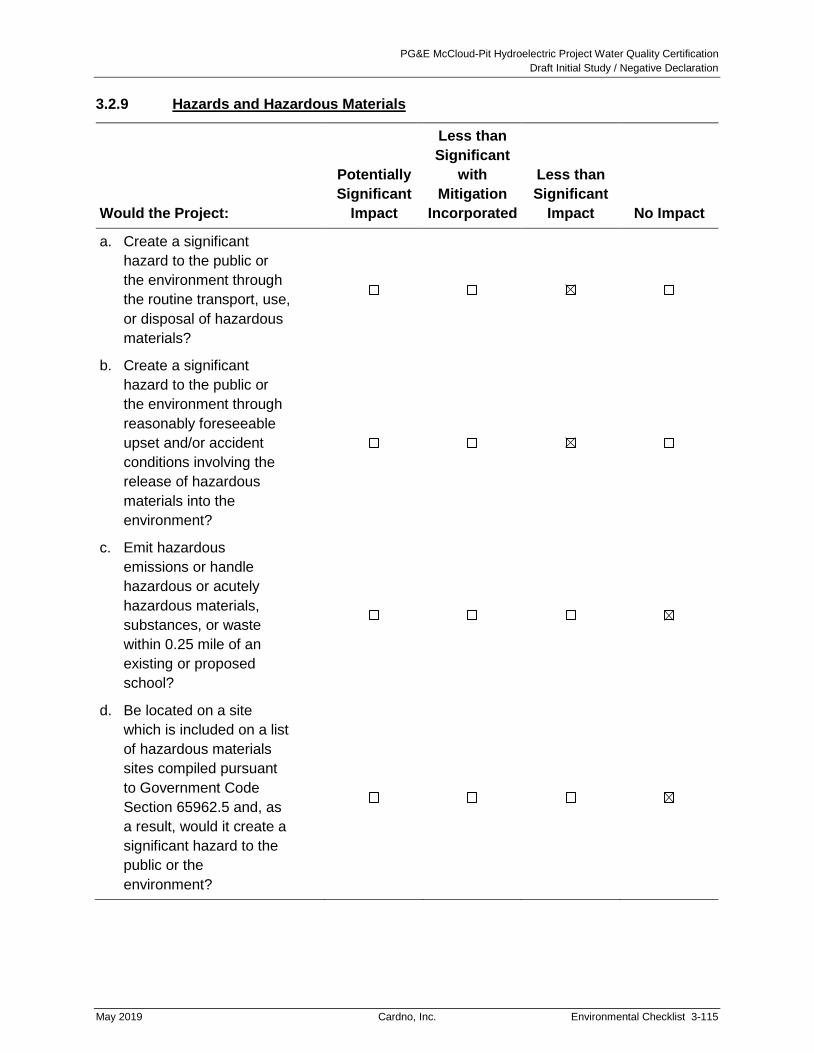
PG&E McCloud-Pit Hydroelectric Project Water Quality Certification
Draft Initial Study / Negative Declaration
May 2019 Cardno, Inc. Environmental Checklist 3-115
3.2.9 Hazards and Hazardous Materials
Would the Project:
Potentially
Significant
Impact
Less than
Significant
with
Mitigation
Incorporated
Less than
Significant
Impact No Impact
a. Create a significant
hazard to the public or
the environment through
the routine transport, use,
or disposal of hazardous
materials?
b. Create a significant
hazard to the public or
the environment through
reasonably foreseeable
upset and/or accident
conditions involving the
release of hazardous
materials into the
environment?
c. Emit hazardous
emissions or handle
hazardous or acutely
hazardous materials,
substances, or waste
within 0.25 mile of an
existing or proposed
school?
d. Be located on a site
which is included on a list
of hazardous materials
sites compiled pursuant
to Government Code
Section 65962.5 and, as
a result, would it create a
significant hazard to the
public or the
environment?

PG&E McCloud-Pit Hydroelectric Project Water Quality Certification
Draft Initial Study / Negative Declaration
3-116 Environmental Checklist Cardno, Inc. May 2019
Would the Project:
Potentially
Significant
Impact
Less than
Significant
with
Mitigation
Incorporated
Less than
Significant
Impact No Impact
e. For a project located
within an airport land use
plan or, where such a
plan has not been
adopted, within 2 miles of
a public airport or public
use airport, would the
project result in a safety
hazard or excessive
noise for people residing
or working in the project
area?
f. Impair implementation of
or physically interfere with
an adopted emergency
response plan or
emergency evacuation
plan?
g. Expose people or
structures, either directly
or indirectly, to a
significant risk of loss,
injury, or death involving
wildland fires?
Environmental Setting
Proposed Project activities would involve the transport, use, and disposal of certain hazardous
materials or substances, such as fuel for equipment and vehicles for on-going operation and
maintenance of existing area facilities, construction activities associated with new recreational
facilities, and implementation of the Coarse Sediment Management Plan. In addition,
herbicides for invasive plant treatments and vegetation management activities along existing
transmission and distribution lines would continue to be used.

PG&E McCloud-Pit Hydroelectric Project Water Quality Certification
Draft Initial Study / Negative Declaration
May 2019 Cardno, Inc. Environmental Checklist 3-117
Discussion
a. Create a significant hazard to the public or the environment through the routine
transport, use, or disposal of hazardous materials?
Impact: Less Than Significant
For the purposes of this element, a project would have a significant impact if it involved
ongoing and routine transport, use, or disposal of hazardous materials in a manner that
could create a significant hazard to the public or the environment.
The Proposed Project raises the possibility that the temporary transport, use, and disposal of
construction-related hazardous materials or substances in the Project area could pose a
hazard to the environment or public. However, if the Proposed Project results in these
potential impacts, the impacts will not be significant. Proposed Project activities, including
construction of new facilities, are required to comply with PG&E’s Existing Project spill
prevention, control, and countermeasures (SPCC) plans and hazardous materials business
plans (HMBP), which require clean-up materials on-site at all times; identify spill prevention,
containment, and clean-up measures; and specify appropriate emergency response
measures. In the event of a spill, workers will immediately implement appropriate measures
to contain and clean-up the spill to minimize environmental impacts and human or wildlife
exposure. Additionally, these plans provide that:
PG&E crew members will attend a training session on the species and habitat
adjacent to the work area to minimize adverse impacts to both.
PG&E crews will station spill containment kits at easily accessible locations within
the work and staging area(s) to facilitate prompt response in the event of a spill.
Secondary containment measures will be implemented for hazardous materials
stored in staging areas.
In the event of a spill, PG&E will follow proper notification procedures.
PG&E will also implement applicable USFS Region 5 and PG&E BMPs during Proposed
Project operation and maintenance activities, as well as improvements to or construction of
new facilities to minimize the potential for impacts to water quality through erosion and
sedimentation or contamination of water from fuels or other chemicals. Such BMPs may
include, but are not limited to:
Preserve existing vegetation where required and when feasible.
Apply temporary erosion controls to remaining active and non-active areas as
required by the California Stormwater BMPs Handbook – Construction and the
contract documents. Reapply as necessary to maintain effectiveness.
Implement temporary erosion control measures at regular intervals throughout the
defined rainy season to achieve and maintain the disturbed soil area requirements.
Implement erosion control prior to the defined rainy season.
Implement spill prevention control and countermeasures.

PG&E McCloud-Pit Hydroelectric Project Water Quality Certification
Draft Initial Study / Negative Declaration
3-118 Environmental Checklist Cardno, Inc. May 2019
Stabilize non-active areas as soon as feasible after the cessation of construction
activities.
Control erosion in concentrated flow paths by applying erosion control blankets,
erosion control seeding, and lining swales, as required in the contract documents.
Apply seed to areas deemed substantially complete during the defined rainy season.
At completion of construction, apply permanent erosion control to all remaining
disturbed soil areas.
Though this list is not necessarily complete, the identified measures are sufficient to ensure
that the Proposed Project will not result in significant impacts. Refer to Appendix C of the
2010 Draft Project Implementation Guide for a complete list of BMPs (PG&E 2010).
Documentation of BMP implementation and an evaluation of their effectiveness would be
done through monitoring and associated reporting, as required per the Proposed Project
resource management plans.
All conditions and requirements of plans will be included with construction specifications and
implemented as part of the Proposed Project. With implementation of these plans and
applicable BMPs, impacts resulting from the routine transport, use, or disposal of hazardous
materials would not be significant.
Mitigation Measures: None required.
b. Create a significant hazard to the public or the environment through reasonably
foreseeable upset and/or accident conditions involving the release of hazardous
materials into the environment??
Impact: Less Than Significant
For the purposes of this element a project would have a significant impact if project activities
posed a risk of release of hazardous materials into the environment and such a release
would itself pose a risk of injury, death, or substantial environmental harm.
Transporting, storing, and using construction-related hazardous materials or substances
could result in an accidental and temporary spill that could contaminate soil or water, affect
vegetation or wildlife, or expose people to toxic fumes or substances.
However, the Proposed Project will not have a significant impact because all conditions and
requirements of SPCC plans and HMBPs will be included with construction designs and
implemented as part of the Proposed Project. With implementation of these components of
the Proposed Project, impacts related to spills of hazardous materials or substances will not
be significant.
Mitigation Measures: None required.

PG&E McCloud-Pit Hydroelectric Project Water Quality Certification
Draft Initial Study / Negative Declaration
May 2019 Cardno, Inc. Environmental Checklist 3-119
c. Emit hazardous emissions or handle hazardous or acutely hazardous materials,
substances, or waste within 0.25 mile of an existing or proposed school?
Impact: No Impact
None of the Proposed Project activities would be implemented within 0.25 mile of a school.
The Proposed Project would have no impact.
Mitigation Measures: None required.
d. Be located on a site which is included on a list of hazardous materials sites compiled
pursuant to Government Code Section 65962.5 and, as a result, would it create a
significant hazard to the public or the environment?
Impact: No Impact
No active hazardous materials sites exist in the Proposed Project area (California
Department of Toxic Substances Control 2018). The nearest active hazardous materials
sites are in Redding. No hazardous materials sites would be affected by Proposed Project
activities. The Proposed Project would have no impact.
Mitigation Measures: None required.
e. For a project located within an airport land use plan or, where such a plan has not
been adopted, within 2 miles of a public airport or public use airport, would the
project result in a safety hazard or excessive noise for people residing or working in
the project area?
Impact: No Impact
The Project area does not contain any airports and is not within two miles of an airport. The
Proposed Project would have no impact.
Mitigation Measures: None required.
f. Impair implementation of or physically interfere with an adopted emergency response
plan or emergency evacuation plan?
Impact: Less Than Significant
As discussed in Section 3.2.16, Transportation and Traffic, Proposed Project activities could
result in temporary delays in access through work areas, but access for emergency
purposes would not be obstructed or impeded. Emergency responses and evacuations
would not be significantly impacted by the Proposed Project. (Additional discussion of
potential impacts with emergency response plans is found in Section 3.2.20.)
Mitigation Measures: None required.

PG&E McCloud-Pit Hydroelectric Project Water Quality Certification
Draft Initial Study / Negative Declaration
3-120 Environmental Checklist Cardno, Inc. May 2019
g. Expose people or structures, either directly or indirectly, to a significant risk of loss,
injury, or death involving wildland fires?
Impact: Less Than Significant
The Proposed Project area is located in a very high fire hazard zone that contains vast areas
of forest which are subject to periodic wildfire (Cal Fire 2008). Fire suppression is a shared
responsibility between the USFS, Cal Fire, and Shasta County. Response times in the event
of a fire in the Project area can be long because of the distance to fire stations and equipment
(FERC 2011). PG&E maintains fire suppression tools at existing recreation sites and its
facilities, and it conducts routine facility maintenance, such as vegetation thinning and
trimming under and near power lines and substations, to reduce the fire risk near Existing
Project facilities. Increased use of the area once the Proposed Project’s recreational
developments are complete would increase the risk and potential for fire. Construction
activities could also increase the risk of fire, although all equipment will contain appropriate
suppression tools and spark arrestors to reduce the potential for fire during construction.
PG&E’s Fire and Fuels Management Plan will be finalized in consultation with USFS, Cal
Fire, the Big Bend Volunteer Fire Department, and others, as appropriate. The plan will
provide information necessary for preventing, preparing for, suppressing, reporting, and
investigating fires associated with the Proposed Project, as required by USFS condition
number 33 (Part II, 4). The Fire and Fuels Management Plan will identify: hazard reduction
and fuel treatment measures; actions and locations of resources needed for fire prevention
and response; and a process for reporting fires and providing necessary documents
associated with any fire investigation to protect the Proposed Project and National Forest
resources over the term of the license. Other aspects of fuels management primarily related
to vegetation treatments, including powerline clearance, are contained in the separate
Vegetation and Invasive Weed Management Plan.
The risk of wildfire would continue to be very high, but implementation of the Fire and Fuels
Management Plan and appropriate measures to protect proposed and existing Project
facilities and people in the Project area would reduce impacts to less than significant.
Additional discussion of potential impacts related to wildfires is included in Section 3.2.20.
Mitigation Measures: None required.

PG&E McCloud-Pit Hydroelectric Project Water Quality Certification
Draft Initial Study / Negative Declaration
May 2019 Cardno, Inc. Environmental Checklist 3-121
3.2.10 Hydrology and Water Quality
Would the Project:
Potentially
Significant
Impact
Less than
Significant
with
Mitigation
Incorporated
Less than
Significant
Impact No Impact
a. Violate any water quality
standards or waste
discharge requirements
or otherwise substantially
degrade surface or
groundwater quality?
b. Substantially decrease
groundwater supplies or
interfere substantially with
groundwater recharge
such that the project may
impede sustainable
groundwater
management of the
basin?
c. Substantially alter the
existing drainage pattern
of the site or area,
including through the
alteration of the course of
a stream or river or
through the addition of
impervious surfaces, in a
manner which would:
i. Result in substantial on- or
off-site erosion or siltation;
ii. Substantially increase the
rate or amount of surface
runoff in a manner which
would result in flooding on-
or off-site;

PG&E McCloud-Pit Hydroelectric Project Water Quality Certification
Draft Initial Study / Negative Declaration
3-122 Environmental Checklist Cardno, Inc. May 2019
Would the Project:
Potentially
Significant
Impact
Less than
Significant
with
Mitigation
Incorporated
Less than
Significant
Impact No Impact
iii. Create or contribute runoff
water which would exceed
the capacity of existing or
planned stormwater
drainage systems or
provide substantial
additional sources of
polluted runoff; or
iv. Impede or redirect flood
flows?
d. In flood hazard, tsunami,
or seiche zones, risk
release of pollutants due
to project inundation?
e. Conflict with or obstruct
implementation of a water
quality control plan or
sustainable groundwater
management plan?
Environmental Setting
The Proposed Project is located in Northern California in the McCloud and Pit River drainages,
along the western slope of the Cascade Range. The Proposed Project is entirely contained
within the Sacramento River Hydrologic Region of California (DWR 2005a). The USGS has
defined three hydrologic drainage basins within the Proposed Project vicinity. The basins and
hydrologic unit codes for the Proposed Project Vicinity are Upper Pit (18020002); Lower Pit
(18020003); and McCloud (18020004) (USGS 2005). Within these hydrologic drainage basins,
six watersheds were identified for further description within the Proposed Project area: (1)
McCloud Reservoir; (2) Lower McCloud River; (3) Iron Canyon Reservoir; (4) Lower Iron
Canyon Creek; (5) Upper Pit River; and (6) Lower Pit River.
The McCloud River drainage basin lies within Siskiyou and Shasta Counties and has a total
drainage area of approximately 581 square miles. The McCloud River originates southeast of
Mt. Shasta at an elevation of approximately 5,500 feet and flows approximately 59 miles in a
southwesterly direction through McCloud Reservoir before entering Shasta Lake and joining the
Sacramento River. The Pit River basin is divided into the Upper Pit and the Lower Pit basins.
The Upper Pit River basin lies within Modoc and Lassen counties and has a total drainage area
of approximately 4,899 square miles. It originates from Goose Lake and flows southwesterly to

PG&E McCloud-Pit Hydroelectric Project Water Quality Certification
Draft Initial Study / Negative Declaration
May 2019 Cardno, Inc. Environmental Checklist 3-123
the Fall River Valley where it enters the Lower Pit River basin. The Lower Pit River basin lies
within Shasta County and has a total drainage area of approximately 238 square miles,
exclusive of contributing areas from the Upper Pit or McCloud River basins. The Pit River flows
southwesterly a distance of approximately 150 miles before entering into Shasta Lake and
joining the Sacramento River.
Rivers and streams of the Proposed Project area are typically steep gradient and highly
confined, resulting in minimal floodplain development. The largest flood event on record during
the study period of 1974–2006 occurred in January 1997, when mean daily flow at the Ah-Di-Na
gage downstream of McCloud Dam exceeded 25,000 cfs. The largest flood during the study
period in the Pit River watershed occurred in February 1986, when mean daily flow at the gage
downstream of Pit 7 Dam reached 49,000 cfs.
PG&E uses water at the Proposed Project for non-consumptive storage and power generation.
PG&E also operates the Proposed Project in support of several other beneficial uses identified by
(CVRWQCB 2018) for the McCloud River and the Pit River. The CVRWQCB’s Water Quality
Control Plan for the Sacramento and San Joaquin River Basins (Basin Plan)18 identifies surface
water bodies that drain into the upper Central Valley of California, including the McCloud River
and Pit River, and identifies beneficial uses for each major river. The McCloud River is
designated for municipal and domestic water supply, contact and non-contact recreation, power
production, cold freshwater habitat, coldwater spawning, and wildlife habitat. The Pit River in the
Proposed Project-affected reach (between James B. Black Tailrace and Shasta Lake) is
designated for all of the beneficial uses designated for the McCloud River, as well as water supply
for irrigation and stock watering, warm freshwater habitat, and warmwater spawning.
Although the McCloud River is not listed under section 303(d) of the CWA as an impaired water
body, the Pit River is listed for nutrients, organic enrichment, and water temperature
(USEPA 2018). The listing cites agriculture and grazing as the probable source of these
impairments, and the river is currently listed as a low priority river for the development of total
maximum daily load standards (USEPA 2018).
Additional descriptions of hydrology and water quality in the Project area are provided in
FERC’s final EIS (FERC 2011), Section 3.3.2.1, Affected Environment, pages 89 through 117.
Discussion
Additional analyses of environmental impacts on hydrology and water quality can be found in
FERC’s final EIS (FERC 2011), Section 3.3.2.2, Environmental Effects, pages 127 through 155.
a. Violate any water quality standards or waste discharge requirements or otherwise
substantially degrade surface or groundwater quality?
Impact: Less Than Significant
The Proposed Project complies with Basin Plan water quality objectives for fecal coliform
and E. coli; concentrations of bio-stimulatory substances, nutrients, chlorophyll-a, and
18 Water Quality Control Plan for the California Regional Water Quality Control Board Central Valley Region for the
Sacramento River Basin and the San Joaquin River Basin. Fifth Edition. Revised May 2018 (with Approved
Amendments).

PG&E McCloud-Pit Hydroelectric Project Water Quality Certification
Draft Initial Study / Negative Declaration
3-124 Environmental Checklist Cardno, Inc. May 2019
phytoplankton; drinking water uses and aquatic life protection; water color; dissolved oxygen
concentrations; oil and fuels; pesticides; radioactive materials; taste and odor; water
temperature; and toxic contamination. A brief discussion of Proposed Project-affected
waters in relation to pH levels, erosion and sedimentation, total suspended solids, and
turbidity is provided below.
pH Levels
The McCloud River watershed upstream of the Proposed Project area lies on volcanic
formations with few calcareous deposits that would serve to buffer natural pH variations. As
a result of these inflow conditions, and low levels of algal photosynthesis in McCloud
Reservoir, daytime sampling in McCloud Reservoir documented pH levels that occasionally
exceed Basin Plan criteria. These exceedances are part of the existing environmental
condition. The Proposed Project will not contribute to discharges of substances that directly
or indirectly affect pH, and so will have no impact on pH levels.
Sediment
Proposed Project operations and specific maintenance activities at proposed facilities may
release suspended sediment to downstream waters. Unpaved roadways and spoil piles
may act as sources of sediment during periods of high runoff. Construction of Proposed
Project recreational facilities and maintenance activities for roads and structures could result
in removal of vegetation and disturbance of surface and subsurface soils. In addition, during
relicensing studies, local erosion sources were noted just below Iron Canyon Dam that
contribute fine sediment to Iron Canyon Creek.
However, if the Proposed Project results in potential water quality impacts related to
sedimentation, the impacts will not be significant because the Proposed Project includes
implementation of the Erosion and Sediment Control Management Plan, which requires
PG&E to inventory, record, treat, and monitor Proposed Project-related erosion and
sedimentation impacts to Project and affected USFS lands and waters. The Erosion and
Sediment Control Management Plan will: (a) describe the methods, protocols, and schedule
to update the existing baseline erosion survey, and conduct subsequent periodic inventory
and monitoring of Proposed Project-related erosion and sedimentation sites; (b) prioritize
treatment sites and schedules based on a risk rating and hazard analysis process;
(c) require development of site-specific treatment measures; (d) provide emergency erosion
control protocols; and (e) include temporary measures to control site-specific erosion and
sedimentation impacts during construction or improvement of Proposed Project facilities
(including recreation facilities) or heavy maintenance of proposed facilities. These
components are consistent with Measure 12, as cited in Exhibit E of the Application for New
License and FERC’s final EIS (2011) and with USFS 4(e) Condition 22. Results of
treatment and monitoring will be submitted to USFS on an annual basis and reviewed at the
Annual Consultation Meeting. Final reports, if required, would be filed with FERC.
In addition, as part of the Proposed Project PG&E will implement applicable USFS Region 5
and PG&E BMPs during Proposed Project operation and maintenance activities, as well as
improvements to or construction of new facilities to minimize the potential for impacts to

PG&E McCloud-Pit Hydroelectric Project Water Quality Certification
Draft Initial Study / Negative Declaration
May 2019 Cardno, Inc. Environmental Checklist 3-125
water quality through erosion and sedimentation or contamination of water from the use
fuels or other chemicals. Such BMPs may include, but are not limited to:
Preserve existing vegetation where required and when feasible.
Apply temporary erosion controls to remaining active and non-active areas as
required by the California Stormwater BMPs Handbook – Construction and the
contract documents. Reapply as necessary to maintain effectiveness.
Implement temporary erosion control measures at regular intervals throughout the
defined rainy season to achieve and maintain the disturbed soil area requirements.
Implement erosion control prior to the defined rainy season.
Implement spill prevention control and countermeasures.
Stabilize non-active areas as soon as feasible after the cessation of construction
activities.
Control erosion in concentrated flow paths by applying erosion control blankets,
erosion control seeding, and lining swales, as required in the contract documents.
Apply seed to areas deemed substantially complete during the defined rainy season.
At completion of construction, apply permanent erosion control to all remaining
disturbed soil areas.
Refer to Appendix C of the 2010 Draft Project Implementation Guide for a complete list of
BMPs (PG&E 2010). Though this list is not necessarily complete, the identified measures
are sufficient to ensure that the Proposed Project will not result in significant impacts.
Documentation of BMPs and an evaluation of their effectiveness would be done through
monitoring and associated reporting, as required in the Proposed Project resource
management plans.
PG&E will also obtain agency-required permits for construction of new recreation facilities,
as required by local, California, or federal regulations, on a project-by-project basis. For
projects that would disturb one or more acres of soil, PG&E will obtain coverage under the
Construction General Permit from the Regional Water Quality Control Board (RWQCB) (or
the State Water Board, if applicable) for stormwater discharges associated with construction
activity and will prepare a SWPPP. All conditions and requirements of the SWPPP or other
permits, including measures to prevent erosion and sedimentation, will be included with
construction specifications, and implemented as part of each project. Such permits may
include but are not limited to:
A Construction General Permit from the RWQCB (or the State Water Board, if
applicable) for stormwater discharges associated with construction activity. This
applies to all construction projects that would disturb one or more acres of soil.
Requires filing a Notice of Intent as well as preparation and implementation of a
SWPPP.
CWA permits for impacts to Waters of the United States/State from the USACE and
the RWQCB (or the State Water Board, if applicable).

PG&E McCloud-Pit Hydroelectric Project Water Quality Certification
Draft Initial Study / Negative Declaration
3-126 Environmental Checklist Cardno, Inc. May 2019
Lake or Streambed Alteration Agreement from CDFW for impacts within the bed and
bank of Project-affected waters.
All conditions and requirements of the permits will be included with construction
specifications and implemented as part of the Proposed Project.
With implementation of these components of the Proposed Project, impacts related to water
quality standards or waste discharge requirements will not be significant.
Settleable Material
An accumulation of sediment, which originates upstream of the Proposed Project area,
continues to occur in McCloud Reservoir. However, there is no evidence that the settleable
material is adversely affecting beneficial uses within McCloud Reservoir. The accumulation
of sediment in McCloud Reservoir has both positive and negative implications for habitat
quality in the Lower McCloud River. As noted above, trapping of sand and finer sediment
originating in Mud Creek can have a beneficial effect on aquatic habitat quality through the
reduction in suspended particles (i.e., turbidity). Conversely, McCloud Reservoir also
interrupts gravel transport and contributes to a reduction in spawning gravel quality and
quantity between McCloud Dam and Hawkins Creek. Refer to Section 3.2.4, Biological
Resources, for a discussion of Proposed Project effects on fish and their habitat. With
implementation of the Coarse Sediment Management Plan and the Erosion and Sediment
Control Management Plan components of the Proposed Project, the potential adverse
impacts related to settleable material from the Proposed Project will not be significant.
Suspended Material
Mud Creek, a tributary upstream of McCloud Dam, adversely affects water clarity in the
Lower McCloud River by periodically delivering large amounts of fine volcanic sediment from
the Konwakiton Glacier on Mt. Shasta directly into McCloud Reservoir (via diversion to
Huckleberry Creek). These large, episodic debris flow events pre-date the Proposed Project
and are unrelated to proposed operations. Synoptic data collected during non-runoff and
non-mass-wasting-event periods indicate that suspended material levels are generally low in
all Proposed Project waters. Potential adverse impacts related to suspended material from
the Proposed Project will not be significant.
Turbidity
Proposed Project operations and routine reservoir drawdown and maintenance do not
adversely affect turbidity in the McCloud River. Periods of reservoir drawdown occurring in
2007 and 2008 were not accompanied by increased turbidity below McCloud Dam. Testing
of the lower-level valve at Iron Canyon Reservoir did cause a temporary increase in turbidity
in Iron Canyon Creek, but turbidity returned to baseline conditions within one day; therefore,
such tests are unlikely to adversely affect beneficial uses. Potential adverse impacts related
to turbidity from the Proposed Project will not be significant.
Mitigation Measures: None required.

PG&E McCloud-Pit Hydroelectric Project Water Quality Certification
Draft Initial Study / Negative Declaration
May 2019 Cardno, Inc. Environmental Checklist 3-127
b. Substantially decrease groundwater supplies or interfere substantially with
groundwater recharge such that the project may impede sustainable groundwater
management of the basin?
Impact: Less Than Significant
For the purposes of this element, a project’s impacts to groundwater would be considered
substantial, and thus significant, if the project prevented implementation of a groundwater
management plan, including by disrupting planned groundwater recharge projects, or if the
project would use more than five percent of the annual yield of a groundwater basin and
would result in lowering groundwater levels in a manner that renders existing groundwater
wells inoperable.
Groundwater contributes approximately 30 percent, or 2.7 million acre-feet (ac-ft), of the
total water supply for the Sacramento River region (DWR 2015). The Proposed Project area
is located within the Shasta – Pit Planning Area of the Sacramento River Hydrologic Region.
Based on 2010 data, the Shasta – Pit Planning Area uses three percent of the total average
annual groundwater supply of the Sacramento River Hydrologic Region. Of this amount,
12 percent (11.3 total ac-ft) is used for urban uses (DWR 2015), which includes uses from
the McCloud-Pit Project. Currently, the McCloud-Pit Project uses two wells for potable water
at Deadlun and Hawkins Campground and other PG&E facilities along the Pit River. The
extraction of groundwater would be necessary to provide a water supply for some of the
proposed recreational facilities. Up to seven new wells would need to be installed at the
following locations:
Tarantula Gulch Inlet
Tarantula Gulch Boat Launch
Star City Campground or its alternate
Red Banks Day Use
Gap Creek Campground
Iron Canyon Dam Boat Launch
Fenders Flat Day Use
Similar to the two existing wells, all the new wells would be topped with a handicap
accessible hand pump, except for one (at Iron Canyon Dam Boat Launch), as electricity is
not available at this location. However, the new wells would be designed and used for
seasonal transient uses such as hose bibs for drinking water and rinsing; other facilities
such as flush toilets, sinks, and showers would not be provided. Based on water usage
estimates from the USFS, camping and day use facilities without flush toilets and showers
require approximately six gallons per day (gpd) during the peak of the recreation season,
which is generally two months (USFS 2007a). If all the new wells are installed and
assuming peak usage occurs for the entire five-month recreation season, the Proposed
Project would require approximately 6,300 gallons (or 0.02 ac-ft) annually. This increase in
use of groundwater would be less than 0.18 percent of the total groundwater supply used for

PG&E McCloud-Pit Hydroelectric Project Water Quality Certification
Draft Initial Study / Negative Declaration
3-128 Environmental Checklist Cardno, Inc. May 2019
potable water in the Shasta – Pit Planning Area. Therefore, the Proposed Project would not
substantially deplete groundwater supplies or create significant changes to groundwater
recharge. Potential adverse impacts from the Proposed Project on groundwater would not
be significant.
Mitigation Measures: None required.
c. Substantially alter the existing drainage pattern of the site or area, including through
the alteration of the course of a stream or river or through the addition of impervious
surfaces, in a manner which would:
i. Result in substantial on- or off-site erosion or siltation;
Impact: Less Than Significant
For the purposes of this element, alteration of existing drainage patterns resulting in erosion
or siltation associated with a Proposed Project would be considered substantial, and thus
significant, if it would damage any existing structures or violate waste discharge
requirements.
The Proposed Project does not propose any changes to the course of any of the rivers or
tributary streams within the Proposed Project area relative to existing conditions. However,
it is possible that minor off-site erosion or siltation may occur as the result of construction of
new recreational facilities. If the Proposed Project results in such an impact, the impact will
not be significant because the Proposed Project includes appropriate management of these
sites as part of the Erosion and Sediment Control Management Plan and any required
Project-specific permits. The Proposed Project includes the addition of recreational facilities
slightly increasing the number of impervious surfaces, but this minor change would not
affect any existing streams or rivers. Also refer to the discussion under “ii” below.
In addition, increases in instream flow in the Lower McCloud River and Iron Canyon Creek
would occur with Proposed Project implementation. The specific changes in instream flows
below McCloud Reservoir Dam are described in Chapter 2, Project Description, Tables 2-4
and 2-5. The water flow increases are proposed to improve aquatic habitat conditions. The
increases in instream flow would be minor relative to channel-forming flows under existing
conditions. For the Lower McCloud River, the average estimates of bed mobility thresholds
range from 1,130 cfs to 2,060 cfs (Nevares and Stallman 2009). The maximum instream
flows would be 215 cfs at the Ah-Di-Na stream gage (Gage MC-1). Therefore, it is unlikely
that the new instream flows would substantially change sediment transport or channel
morphology in the Lower McCloud River. No changes to the Pit River flows are proposed or
would occur. The impacts of the Proposed Project on altering the existing drainage pattern
of the Project area related to on- or off-site erosion or siltation will not be significant.
Mitigation Measures: None required.

PG&E McCloud-Pit Hydroelectric Project Water Quality Certification
Draft Initial Study / Negative Declaration
May 2019 Cardno, Inc. Environmental Checklist 3-129
ii. Substantially increase the rate or amount of surface runoff in a manner which
would result in flooding on- or off-site;
Impact: Less Than Significant
For the purposes of this element, a project would have a significant impact if it increased the
amount of surface runoff from project sites in a manner that caused flooding where flooding
did not previously occur or that increased existing typical flood levels in a manner that
exceeded the capacity of flood management facilities.
The Proposed Project includes the construction of recreational facilities, which would
increase the amount of impervious conditions relative to existing conditions. However, if the
Proposed Project results in additional surface runoff, the impact will not be significant. The
proposed improvements are in relatively remote areas surrounded by undeveloped forested
land. No significant areas of connected impervious surfaces would be created. The
construction of bathroom facilities (i.e., small structures with impervious roofs), information
kiosks, and minor amounts of paving would result in a slight decrease in infiltration of water
into the subsurface and an incremental increase in surface water runoff in these Proposed
Project areas. However, the changes in infiltration and runoff would be negligible relative to
the amounts of infiltration and runoff within the larger Project area and watersheds of the
McCloud and Pit Rivers and their tributaries. The increased impervious surface areas would
be small relative to surrounding local undeveloped conditions (i.e., forested lands) and
would not be expected to cause localized increases in flooding hazards; therefore, the
impact would be less than significant.
Mitigation Measures: None required.
iii. Create or contribute runoff water which would exceed the capacity of existing or
planned stormwater drainage systems or provide substantial additional sources
of polluted runoff; or
Impact: No Impact
The existing and proposed facilities within the Proposed Project area are not served by an
existing public or private stormwater system. Therefore, any incremental changes to runoff
as a result of the Proposed Project would not affect the capacity of such systems. Runoff
related to proposed facilities would not provide an additional source of pollution, and would
be managed locally (i.e., at and near the facilities) by construction of ditches and culverts
and be directed into the natural drainage system (i.e., streams and rivers). The
management of runoff would be performed in compliance with the Erosion and Sediment
Control Management Plan and any required agency permits, described above. Therefore,
the Proposed Project would have no impact to existing stormwater drainage systems.
Mitigation Measures: None required.

PG&E McCloud-Pit Hydroelectric Project Water Quality Certification
Draft Initial Study / Negative Declaration
3-130 Environmental Checklist Cardno, Inc. May 2019
iv. Impede or redirect flood flows?
Impact: No Impact
For the purposes of this element, the impact of a project that results in redirection of flood
flows would be considered significant if the project resulted in a permanent expansion of the
flood plain in a manner that required redrawing of flood hazard maps, or if on a seasonal
basis the project would result in the backing up or redirection of flood flows in a manner that
damages existing residences or other structures.
Proposed recreational improvements include small structures (e.g., bathroom, boat ramps,
information kiosks, etc.), some of which may be located near rivers or streams. However,
the structures are small and isolated (i.e., separated by undeveloped land) and rivers and
streams in the Proposed Project area are typically steep gradient and highly confined,
resulting in a minimal floodplain hazard designation. Therefore, the construction of the
recreational improvements would not have the potential to impede or redirect flood flows.
Mitigation Measures: None required.
d. In flood hazard, tsunami, or seiche zones, risk release of pollutants due to project
inundation?
Impact: No Impact
The Proposed Project area is not located in a designated flood hazard, tsunami or seiche
zone. Accordingly, the Proposed Project will not have an impact related to the release of
pollutants in a flood hazard, tsunami, or seiche zone. Further, rivers and streams in the
Proposed Project area are typically steep gradient and highly confined, resulting in a
minimal floodplain hazard designation.
Seismic shaking during earthquakes can result in the formation of waves within open bodies
of water. The two major types of seismically generated waves are tsunamis and seiches.
Tsunamis are waves generated by the displacement of a large volume of water. Therefore,
tsunamis only occur in large water bodies such as oceans, bays, or large lakes.
Displacement of water can occur by several mechanisms (including subaqueous land-sliding
or explosions) but are most commonly caused by submarine displacements of the earth’s
crust resulting from earthquakes. The McCloud and Iron Canyon Reservoirs are not large
enough to allow development of tsunamis.
A seiche is a wave that oscillates in lakes, bays, or gulfs. Seiches range from a few minutes
to a few hours as a result of seismic or atmospheric disturbances. Small seiches are almost
always present on larger lakes, and the frequency of the oscillation is determined by the size
of the water body, its depth and contours, and the water temperature. Larger seiches can
be caused by nearby or distant earthquakes and occur when the seismic wave signature is
resonant with the natural period of the water body, which is controlled by its shape and
depth. If local or more distant earthquakes were to occur, a seiche could occur within the
reservoir. The magnitude of a seiche would depend on the amplitude and period of seismic
waves affecting the reservoirs. Given the size and natural period of these water bodies

PG&E McCloud-Pit Hydroelectric Project Water Quality Certification
Draft Initial Study / Negative Declaration
May 2019 Cardno, Inc. Environmental Checklist 3-131
(refer to Chapter 2), it is expected that if a seiche occurred, it would be less than one foot in
height. For these reasons, there would be no potential for a release of pollutants resulting
from flooding, tsunami, or seiche in the Proposed Project area. No impact would occur.
Mitigation Measures: None required.
e. Conflict with or obstruct implementation of a water quality control plan or sustainable
groundwater management plan?
Impact: Less Than Significant
As discussed under “a” above, PG&E will finalize and implement the Erosion and Sediment
Control Management Plan, which requires PG&E to inventory, record, treat, and monitor
Proposed Project-related erosion and sedimentation impacts to Project and affected USFS
lands and waters. PG&E will implement applicable BMPs during Proposed Project
operation and maintenance activities, as well as improvements to or construction of new
facilities to minimize the potential for impacts to water quality through erosion and
sedimentation or contamination of water from the use fuels or other chemicals. With
implementation of the Erosion and Sediment Control Management Plan, including specified
BMPs, the Proposed Project will comply with Basin Plan water quality objectives.
As discussed under “b” above, If all the proposed wells are installed and assuming peak
usage occurs for the entire five-month recreation season, the Proposed Project would
require approximately 6,300 gallons (or 0.02 ac-ft) annually. This minor increase in use of
groundwater would be less than 0.18 percent of the total groundwater supply used for
potable water in the Shasta-Pit Planning Area. Further, there is no sustainable groundwater
management plan applicable to the Proposed Project area. Therefore, the Proposed Project
would not conflict or obstruct implementation of a water quality control plan or sustainable
groundwater management plan. The impact would not be significant.
Mitigation Measures: None required.

PG&E McCloud-Pit Hydroelectric Project Water Quality Certification
Draft Initial Study / Negative Declaration
3-132 Environmental Checklist Cardno, Inc. May 2019
This Page Intentionally Left Blank

PG&E McCloud-Pit Hydroelectric Project Water Quality Certification
Draft Initial Study / Negative Declaration
May 2019 Cardno, Inc. Environmental Checklist 3-133
3.2.11 Land Use and Planning
Would the Project:
Potentially
Significant
Impact
Less than
Significant
with
Mitigation
Incorporated
Less than
Significant
Impact No Impact
a. Physically divide an
established community?
b. Cause a significant
environmental impact due
to a conflict with any
applicable land use plan,
policy, or regulation
adopted for the purpose
of avoiding or mitigating
an environmental effect?
Environmental Setting
Land in the Proposed Project area in private ownership is subject to the Shasta County General
Plan (County of Shasta 2004) and zoning ordinance. Shasta County has zoned private land
around McCloud Reservoir as Timber Production, around Iron Canyon Reservoir as Timberland
and along the Pit River as Timber Production and National Recreation Area, Shasta Unit. For
facilities located on non-PG&E-owned private lands, PG&E has established easements or
agreements with the landowner to operate and maintain its facilities (Nevares and Splenda
2008). Federal lands in the Proposed Project area are managed by the STNF pursuant to its
Land and Resource Management Plan (USFS 1995). The STNF classifies the forest land
around Iron Canyon Reservoir as Late Successional Reserve and Administratively Withdrawn
with limited access along the Pit River. The lower reaches of the Pit River are in the Shasta
Lake National Recreation Area, managed by the USFS. The rest of the Proposed Project area
is in the Shasta McCloud Management Unit of the STNF. The McCloud River Coordinated
Resource Management Plan (CRMP) provides for coordinated management of the McCloud
River, with a focus on its wild and scenic river eligibility, by federal and state resource agencies,
adjacent landowners, and conservation organizations.
Additional descriptions of land use and planning in the Project area are provided in FERC’s final
EIS (FERC 2011), Section 3.3.7.1, Affected Environment, pages 320 through 327.
Discussion
Additional analyses of environmental impacts on land use and planning can be found in FERC’s
final EIS (FERC 2011), Section 3.3.7.2, Environmental Effects, pages 330 through 338.

PG&E McCloud-Pit Hydroelectric Project Water Quality Certification
Draft Initial Study / Negative Declaration
3-134 Environmental Checklist Cardno, Inc. May 2019
a. Physically divide an established community?
Impact: No Impact
No established communities are located around the McCloud or Iron Canyon Reservoirs or
along the Lower McCloud or Pit rivers. None of the proposed recreational facilities would be
located in established communities, and other activities as part of the Proposed Project,
such as maintenance and implementation of management plans, would not affect
established communities. The Proposed Project would have no impact.
Mitigation Measures: None required.
b. Cause a significant environmental impact due to a conflict with any applicable land
use plan, policy, or regulation adopted for the purpose of avoiding or mitigating an
environmental effect?
Impact: No Impact
The designated zones and land allocations for the lands in the Project area are compatible
with recreational uses and facilities as well as hydroelectric and transmission facilities,
although special use or other permits may be necessary for new or expanded facilities.
Proposed Project maintenance activities would not conflict with the Shasta County General
Plan or Land and Resource Management Plan, and implementation of management plans
would improve land management and possibly reduce existing conflicts with land uses and
zoning. Modifications to instream flow in the Lower McCloud River do not conflict with the
river’s CRMP (USFS 1995). The CRMP is a coordinated effort between landowners and
stakeholders with a vested interest in the river. Under the CRMP, the McCloud River would
continue to be managed to preserve the pristine quality of its resources, including its free-
flowing condition and fishery below McCloud Dam. Implementation and operation of the
Proposed Project would not cause an impact due to conflicts with any land use plan or
policy. Therefore, the Proposed Project will have no impact on applicable land use policies
adopted for the purpose of avoiding or mitigating an environmental effect.
Mitigation Measures: None required.
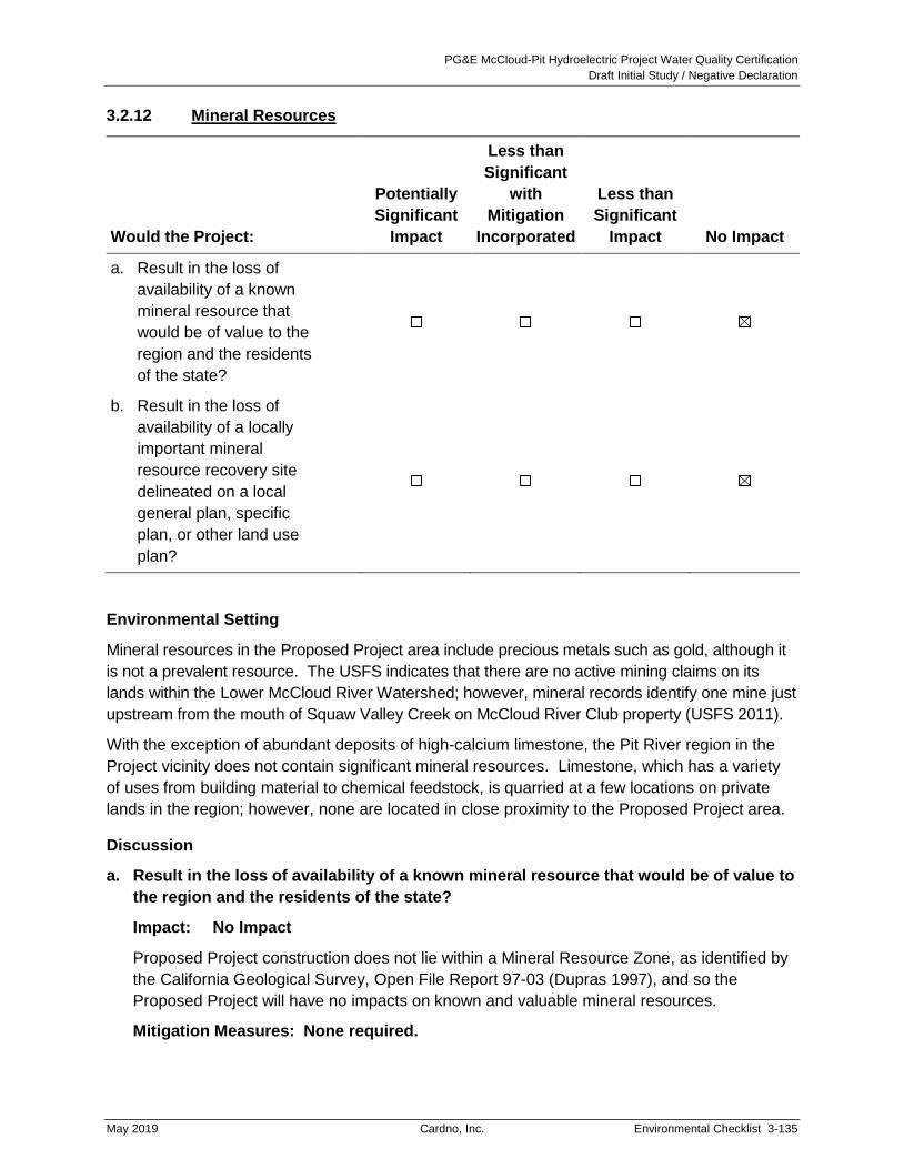
PG&E McCloud-Pit Hydroelectric Project Water Quality Certification
Draft Initial Study / Negative Declaration
May 2019 Cardno, Inc. Environmental Checklist 3-135
3.2.12 Mineral Resources
Would the Project:
Potentially
Significant
Impact
Less than
Significant
with
Mitigation
Incorporated
Less than
Significant
Impact No Impact
a. Result in the loss of
availability of a known
mineral resource that
would be of value to the
region and the residents
of the state?
b. Result in the loss of
availability of a locally
important mineral
resource recovery site
delineated on a local
general plan, specific
plan, or other land use
plan?
Environmental Setting
Mineral resources in the Proposed Project area include precious metals such as gold, although it
is not a prevalent resource. The USFS indicates that there are no active mining claims on its
lands within the Lower McCloud River Watershed; however, mineral records identify one mine just
upstream from the mouth of Squaw Valley Creek on McCloud River Club property (USFS 2011).
With the exception of abundant deposits of high-calcium limestone, the Pit River region in the
Project vicinity does not contain significant mineral resources. Limestone, which has a variety
of uses from building material to chemical feedstock, is quarried at a few locations on private
lands in the region; however, none are located in close proximity to the Proposed Project area.
Discussion
a. Result in the loss of availability of a known mineral resource that would be of value to
the region and the residents of the state?
Impact: No Impact
Proposed Project construction does not lie within a Mineral Resource Zone, as identified by
the California Geological Survey, Open File Report 97-03 (Dupras 1997), and so the
Proposed Project will have no impacts on known and valuable mineral resources.
Mitigation Measures: None required.

PG&E McCloud-Pit Hydroelectric Project Water Quality Certification
Draft Initial Study / Negative Declaration
3-136 Environmental Checklist Cardno, Inc. May 2019
b. Result in the loss of availability of a locally important mineral resource recovery site
delineated on a local general plan, specific plan, or other land use plan?
Impact: No Impact
PG&E is required to finalize and implement the Final Coarse Sediment Management Plan
(see Project Description Section 2.4.6.2). The goal of the Coarse Sediment Management
Plan is to provide an adaptive management framework for the collection, storage, and
augmentation of coarse sediment into the lower McCloud River below McCloud Dam. This
plan requires monitoring of gravel and coarse sediment augmentation that could benefit
downstream aquatic habitat in the lower McCloud River, as well as evaluating possible
gravel and coarse sediment sources. Implementation of the Coarse Sediment Management
Plan would require the excavation of 150 to 600 tons of gravel and coarse sediment. The
anticipated source of the gravel and coarse sediment is the Star City Creek delta in
McCloud Reservoir.
If practical, the excavation of coarse sediments from the Star City Creek delta would only
occur once or twice over the term of the new license. Gravel and coarse sediments would
only be excavated from within the dry portion of the Star City Creek delta, once the water
line is below the area accessible to ground-based equipment. Implementation of the Coarse
Sediment Management Plan would cause a mineral resource (aggregate) to be relocated
but would not result in the loss of availability. No other mineral resources have been
identified in the Proposed Project area. Therefore, there would be no impact related to the
loss of availability of locally-important mineral resource sites.
Mitigation Measures: None required.

PG&E McCloud-Pit Hydroelectric Project Water Quality Certification
Draft Initial Study / Negative Declaration
May 2019 Cardno, Inc. Environmental Checklist 3-137
3.2.13 Noise
Would the Project result in:
Potentially
Significant
Impact
Less than
Significant
with
Mitigation
Incorporated
Less than
Significant
Impact No Impact
a. Generation of a
substantial temporary or
permanent increase in
ambient noise levels in
the vicinity of the project
in excess of standards
established in the local
general plan or noise
ordinance, or in other
applicable local, state, or
federal standards?
b. Generation of excessive
groundborne vibration or
groundborne noise
levels?
c. For a project located
within the vicinity of a
private airstrip or an
airport land use plan or,
where such a plan has
not been adopted, within
2 miles of a public airport
or public use airport,
would the project expose
people residing or
working in the project
area to excessive noise
levels?
Environmental Setting
The Proposed Project is in a rural area with limited development. Existing ambient noise levels
are relatively low, and noise sources are primarily from environmental factors (e.g., water, wind),
existing electrical and hydroelectric facilities, transportation sources (e.g., logging trucks), and
recreational activities. Noise levels are noticeably higher near recreation areas during the peak
recreation season (late spring to early fall) and along major roadways, particularly those that are
used by logging trucks, such as USFS road 38N04Y at the Start City Creek arm of McCloud

PG&E McCloud-Pit Hydroelectric Project Water Quality Certification
Draft Initial Study / Negative Declaration
3-138 Environmental Checklist Cardno, Inc. May 2019
Reservoir. Few sensitive receptors, including recreationists and residents, are located in or near
the Project area. Per the Shasta County General Plan (2004), acceptable noise levels for
non-transportation noise at 100 feet from a residence are 55 decibels (hourly Leq19) during daytime
hours (7 a.m. to 10 p.m.) and 50 decibels (hourly Leq) during nighttime hours (10 p.m. to 7 a.m.).
Construction activities at Proposed Project recreation sites would generate noise above
55 decibels (hourly Leq) during daytime construction; however, the sites are more than 100 feet
from existing residences and businesses. Recreationists at the Project reservoirs or along the Pit
River may notice construction noise, but the distance between most proposed construction
activities and the existing recreation sites, as well as intervening vegetation and topography,
would help reduce noise levels and minimize noise exposure. Construction equipment operation
associated with implementation of the Proposed Project Coarse Sediment Management Plan and
Large Woody Debris Management Plan could generate noise that might disturb recreationists at
McCloud Reservoir and along the Lower McCloud River. Maintenance and other activities would
generate noise primarily from vehicle travel and minor construction equipment, and some
activities could take place near recreation sites or rural residences.
Discussion
a. Generation of a substantial temporary or permanent increase in ambient noise levels
in the vicinity of the project in excess of standards established in the local general
plan or noise ordinance, or in other applicable local, state, or federal standards?
Impact: No Impact
Temporary increases in existing noise levels associated with the Proposed Project’s
construction activities will not generate noise in excess of established standards, because
the construction sites are all more than 100 feet from existing residences and businesses.
Similarly, permanent increases in existing noise levels associated with the Proposed
Project’s expansion of recreational sites will not generate noise in excess of established
standards because recreational sites are all located more than 100 feet from existing
residences. The Proposed Project will not result in an impact related to established noise
standards.
Mitigation Measures: None required.
b. Generation of excessive groundborne vibration or groundborne noise levels?
Impact: Less Than Significant
For the purposes of this element, ground-borne vibration or noise would be considered
excessive, and thus significant, if it would be felt or heard at residences or businesses for
more than four hours per day over one or more consecutive ten-day periods.
Construction activities at recreation sites could result in ground-borne noise or vibrations,
but as discussed under item “a” above, the activities would not take place near residences
19 Leq is the hourly equivalent continuous noise level or the average of all noise measured from 7 a.m. to 10 p.m.
(daytime) and 10 p.m. to 7 a.m. (nighttime).
PG&E McCloud-Pit Hydroelectric Project Water Quality Certification
Draft Initial Study / Negative Declaration
May 2019 Cardno, Inc. Environmental Checklist 3-139
or businesses. None of the other Proposed Project activities are expected to result in
ground-borne noise or vibrations. Proposed Project effects related to ground-borne noise or
vibration would be less than significant.
Mitigation Measures: None required.
c. For a project located within the vicinity of a private airstrip or an airport land use plan
or, where such a plan has not been adopted, within 2 miles of a public airport or
public use airport, would the project expose people residing or working in the project
area to excessive noise levels?
Impact: No Impact
No private airstrips are located in or near the Project Area. The Proposed Project would
have no impact.
Mitigation Measures: None required.

PG&E McCloud-Pit Hydroelectric Project Water Quality Certification
Draft Initial Study / Negative Declaration
3-140 Environmental Checklist Cardno, Inc. May 2019
This Page Intentionally Left Blank

PG&E McCloud-Pit Hydroelectric Project Water Quality Certification
Draft Initial Study / Negative Declaration
May 2019 Cardno, Inc. Environmental Checklist 3-141
3.2.14 Population and Housing
Would the Project:
Potentially
Significant
Impact
Less than
Significant
with
Mitigation
Incorporated
Less than
Significant
Impact No Impact
a. Induce substantial
unplanned population
growth in an area, either
directly (for example, by
proposing new homes
and businesses) or
indirectly (for example,
through extension of
roads or other
infrastructure)?
b. Displace substantial
numbers of existing
people or housing,
necessitating the
construction of
replacement housing
elsewhere?
Environmental Setting
The Proposed Project Area is remote and sparsely populated. Because of environmental
conditions (e.g., frequent flooding, topography, inaccessibility), zoning, and land ownership
constraints associated with the Project area, there are no permanent residences or populations
that would be affected by the Project. The nearest communities to the Project are McCloud
(population 1,101 at the 2010 census), which is located approximately eight miles northeast of
McCloud Reservoir; and Big Bend (population 102 at the 2010 census), which is located
approximately four miles southeast of Iron Canyon Reservoir.
Discussion
a. Induce substantial unplanned population growth in an area, either directly (for
example, by proposing new homes and businesses) or indirectly (for example,
through extension of roads or other infrastructure)?
Impact: No Impact
None of the Proposed Project activities would induce or encourage population growth in or
near the Project area. None of the proposed new or improved recreation facilities are

PG&E McCloud-Pit Hydroelectric Project Water Quality Certification
Draft Initial Study / Negative Declaration
3-142 Environmental Checklist Cardno, Inc. May 2019
designed to be permanent living spaces, and the Proposed Project will not convert any
non-residential zones to residential zones. The Proposed Project would have no impact.
Mitigation Measures: None required.
b. Displace substantial numbers of existing people or housing, necessitating the
construction of replacement housing elsewhere?
Impact: No Impact
The Project area is in a rural area with few residences, and none of the Proposed Project
activities would result in the displacement of housing. The Proposed Project would have
no impact.
Mitigation Measures: None required.

PG&E McCloud-Pit Hydroelectric Project Water Quality Certification
Draft Initial Study / Negative Declaration
May 2019 Cardno, Inc. Environmental Checklist 3-143
3.2.15 Public Services
Would the Project:
Potentially
Significant
Impact
Less than
Significant
with
Mitigation
Incorporated
Less than
Significant
Impact No Impact
a. Result in substantial
adverse physical impacts
associated with the
provision of new or
physically altered
governmental facilities, or
the need for new or
physically altered
governmental facilities,
the construction of which
could cause significant
environmental impacts, in
order to maintain
acceptable service ratios,
response times or other
performance objectives
for any of the public
services:
Fire protection?
Police protection?
Schools?
Parks?
Other public facilities?
Environmental Setting
The USFS provides law enforcement services related to natural and cultural resource
protection, as well as fire suppression and prevention activities on National Forest lands within
the Proposed Project area. Shasta County Sheriff’s Office provides law enforcement, including
enforcement of laws related to life and property, and search and rescue services on both private
and National Forest lands within the Proposed Project area. The California Highway Patrol –
Northern Division also provides law enforcement on unincorporated public roads in the region.
Shasta County Fire Department, Cal Fire, and local community fire districts and volunteers
provide fire protection services on unincorporated, private lands in Shasta County.

PG&E McCloud-Pit Hydroelectric Project Water Quality Certification
Draft Initial Study / Negative Declaration
3-144 Environmental Checklist Cardno, Inc. May 2019
Under existing conditions, the Pit 5 Switching Center operator maintains current law enforcement
and emergency service contact information and has standard procedures for contacting law
enforcement, fire, rescue, or PG&E personnel in the event of an emergency situation such as fire
or flood. This emergency protocol will continue under the Proposed Project.
Discussion
a. Result in substantial adverse physical impacts associated with the provision of new
or physically altered governmental facilities, or the need for new or physically altered
governmental facilities, the construction of which could cause significant
environmental impacts, in order to maintain acceptable service ratios, response times
or other performance objectives for any of the public services:
Fire protection?
Impact: No Impact
Development of the Proposed Project recreation sites would potentially increase
recreational uses in the Project area and thus increase the demand on fire protection
service providers, but due to the limited size and scope of the expanded recreation
sites an increase in recreational use associated with the Proposed Project will not
require the provision of new or physically altered fire protection facilities.
In addition, the Fire and Fuels Management Plan and the Sign and
Interpretive/Education Management Plan components of the Proposed Project
would: (a) identify field sites for appropriate posting of fire danger and safety
posters, hazard, or other related sign information; and (b) develop public fire
awareness signs, messages, and brochures to educate the public about fire danger
and safety and help recreational uses avoid creating fire risks. The Project Patrol
Plan would identify areas of high fire risk that will require more frequent monitoring,
but this monitoring would be carried out by PG&E and not by local fire protection
services. The Proposed Project would not have an impact related to new or altered
fire protection facilities. (Additional discussion of wildfire-related impacts is provided
in Section 3.2.20.)
Mitigation Measures: None required.
Police protection?
Impact: No Impact
Development of the Proposed Project recreation sites would increase the demand on
local emergency service providers, including police protection, but such an increase
is expected to be minimal based on the anticipated visitation to the area. Similar to
existing conditions, emergency calls would be anticipated to increase during the
peak recreation season (i.e., between late spring and early fall). Existing service
providers would be able to meet the needs of the recreationists without the need for

PG&E McCloud-Pit Hydroelectric Project Water Quality Certification
Draft Initial Study / Negative Declaration
May 2019 Cardno, Inc. Environmental Checklist 3-145
new or physically altered governmental facilities. The Proposed Project would not
have an impact related to new or altered police facilities.
Mitigation Measures: None required.
Schools?
Impact: No Impact
The Proposed Project would not generate an increase in population that would affect
schools. Therefore, no impact to schools would occur.
Mitigation Measures: None required.
Parks?
Impact: No Impact
The Proposed Project would not generate an increase in population that would affect
parks. Therefore, no impact to parks would occur. Refer to Section 3.2.15,
Recreation, for information related to provisions for recreational resources.
Mitigation Measures: None required.
Other public facilities?
Impact: No Impact
The Proposed Project would not generate an increase in population that would affect
any other public facilities. Therefore, no impact to public facilities would occur.
Mitigation Measures: None required.

PG&E McCloud-Pit Hydroelectric Project Water Quality Certification
Draft Initial Study / Negative Declaration
3-146 Environmental Checklist Cardno, Inc. May 2019
This Page Intentionally Left Blank

PG&E McCloud-Pit Hydroelectric Project Water Quality Certification
Draft Initial Study / Negative Declaration
May 2019 Cardno, Inc. Environmental Checklist 3-147
3.2.16 Recreation
Would the Project:
Potentially
Significant
Impact
Less than
Significant
with
Mitigation
Incorporated
Less than
Significant
Impact No Impact
a. Increase the use of
existing neighborhood
and regional parks or
other recreational
facilities such that
substantial physical
deterioration of the facility
would occur or be
accelerated?
b. Include recreational
facilities or require the
construction or expansion
of recreational facilities
that might have an
adverse physical effect
on the environment?
Environmental Setting
FERC requires licensees to construct, maintain, and operate recreational facilities to meet
Project recreation demands. In addition to facilities, licensee-owned lands within the FERC
boundary for hydropower projects are open to the public for recreational activities, with the
exception of lands or areas restricted for safety or security reasons (e.g., designated for
hydropower operations).
The Proposed Project provides recreational opportunities at developed sites on McCloud
Reservoir, Iron Canyon Reservoir, and Pit 7 Afterbay. There are also developed sites on the
Lower McCloud River including Ah-Di-Na Campground, Ah-Di-Na Interpretive trails, Ash Camp
Campground, and Ash Camp Trailhead. However, the facilities on the Lower McCloud River
are operated by the USFS and are not part of the Proposed Project. The Proposed Project
provides dispersed recreation opportunities on USFS lands and PG&E-owned lands adjacent to
developed facilities on McCloud Reservoir, Iron Canyon Reservoir, James B. Black
Powerhouse, Pit 6 and Pit 7 Reservoirs, and Pit 7 Afterbay/Fenders Flat. Tables 3-6 and 3-7
display the existing recreation resources in the Project area. Additional descriptions of
recreation in the Project area are provided in FERC’s final EIS (FERC 2011), Section 3.3.5,
Recreation Resources, pages 228 through 246.

PG&E McCloud-Pit Hydroelectric Project Water Quality Certification
Draft Initial Study / Negative Declaration
3-148 Environmental Checklist Cardno, Inc. May 2019
Table 3-6 Developed Recreation Sites Inventoried in 2007
Recreation
Resource Center
Developed
Recreation Study Site
McCloud Reservoir Tarantula Gulch Boat Launch (also known as the Lake
McCloud Boat Launch)1
Iron Canyon Reservoir Deadlun Campground1
Hawkins Landing Campground
Hawkins Landing Boat Launch
Pit 7 Afterbay Fenders Flat Boat Launch1,2
Lower McCloud River Ah-Di-Na Campground
Ah-Di-Na Interpretive trails and signs
Ash Camp Campground
Ash Camp Trailhead
All access roads leading to
Project reservoirs and
developed recreation
facilities
All signs providing directions to or information about each of
the reservoirs and developed recreation facilities listed
above. Recreation sites that were inventoried are on roads
from the main county access roads to the reservoirs and
developed recreation facilities.
Notes:
1 Current USFS facilities to be rebuilt and incorporated as Project-managed facilities.
2 This site does not have any developed amenities and was considered a dispersed recreation site and assessed
under Task 2 of the Study Description (Nevares, Splenda, and Littlejohn 2008).
3 These facilities on the Lower McCloud River are not part of the Existing Project.
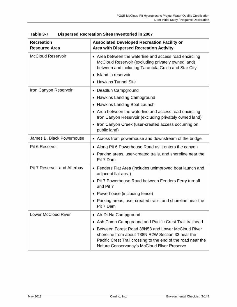
PG&E McCloud-Pit Hydroelectric Project Water Quality Certification
Draft Initial Study / Negative Declaration
May 2019 Cardno, Inc. Environmental Checklist 3-149
Table 3-7 Dispersed Recreation Sites Inventoried in 2007
Recreation
Resource Area
Associated Developed Recreation Facility or
Area with Dispersed Recreation Activity
McCloud Reservoir Area between the waterline and access road encircling
McCloud Reservoir (excluding privately owned land)
between and including Tarantula Gulch and Star City
Island in reservoir
Hawkins Tunnel Site
Iron Canyon Reservoir Deadlun Campground
Hawkins Landing Campground
Hawkins Landing Boat Launch
Area between the waterline and access road encircling
Iron Canyon Reservoir (excluding privately owned land)
Iron Canyon Creek (user-created access occurring on
public land)
James B. Black Powerhouse Across from powerhouse and downstream of the bridge
Pit 6 Reservoir Along Pit 6 Powerhouse Road as it enters the canyon
Parking areas, user-created trails, and shoreline near the
Pit 7 Dam
Pit 7 Reservoir and Afterbay Fenders Flat Area (includes unimproved boat launch and
adjacent flat area)
Pit 7 Powerhouse Road between Fenders Ferry turnoff
and Pit 7
Powerhouse (including fence)
Parking areas, user created trails, and shoreline near the
Pit 7 Dam
Lower McCloud River Ah-Di-Na Campground
Ash Camp Campground and Pacific Crest Trail trailhead
Between Forest Road 38N53 and Lower McCloud River
shoreline from about T38N R2W Section 33 near the
Pacific Crest Trail crossing to the end of the road near the
Nature Conservancy’s McCloud River Preserve

PG&E McCloud-Pit Hydroelectric Project Water Quality Certification
Draft Initial Study / Negative Declaration
3-150 Environmental Checklist Cardno, Inc. May 2019
Under the Proposed Project the following recreation enhancements would occur:
McCloud Reservoir
Tarantula Gulch Boat Launch expansion and parking lot upgrades
McCloud Day Use Area improvements
Red Banks Day Use Area improvements
Battle Creek Day-Use and Angler Access Area circulation improvements
McCloud Reservoir West Dam Angler Access Area improvements
McCloud Reservoir East Dam Access improvements
Star City Campground and Day Use Area new development
McCloud Dam Improved River Access
Iron Canyon Reservoir
Hawkins Landing Boat Launch Ramp replacement and parking lot construction
Hawkins Landing Campground reconstruction
Deadlun Campground expansion and upgrades
Gap Creek Campground new construction
Iron Canyon Dam Boat Launch and Parking Lot new construction
Three New Day Use Areas at Iron Canyon Reservoir
Pit 6 Boat Access
Pit 7 Reservoir
Upper Pit 7 Reservoir Trailheads, Trail and Boat Launch improvements
Lower Pit 7 Reservoir Day Use Area improvements
Pit 7 Afterbay
Fenders Flat Day Use Area New Construction
Additional details on each of these recreation enhancements can be found in Section 2.4,
Proposed Recreation Facilities of this document. In addition to these enhancements, instream
flow requirements would be changed such that whitewater boating opportunities on the Lower
McCloud River would be improved.

PG&E McCloud-Pit Hydroelectric Project Water Quality Certification
Draft Initial Study / Negative Declaration
May 2019 Cardno, Inc. Environmental Checklist 3-151
Discussion
Additional analyses of environmental impacts on recreation can be found in FERC’s final EIS
(FERC 2011), Section 3.3.5.2, Environmental Effects, pages 246 through 289.
a. Increase the use of existing neighborhood and regional parks or other recreational
facilities such that substantial physical deterioration of the facility would occur or be
accelerated?
Impact: Less Than Significant
For the purposes of this element, a project would be considered to have a significant impact if
it resulted in the permanent increased use of existing recreational facilities beyond the
planned capacity of such facilities, for example by displacing recreational users from an
existing recreational facility or adding residences in the vicinity of an existing recreational
facility. Impacts to recreation resources are considered for: (a) overall recreation use; (b)
angling on the Lower McCloud River; and (c) whitewater boating on the Lower McCloud River.
Impacts to Overall Recreation Use
Each of the above recreation enhancements would require several days to two months of
construction for completion. For purposes of this analysis it is assumed that not all
enhancements would be completed concurrently because PG&E plans staged construction
due to personnel and equipment restraints. Staff-recommended license conditions in the
FERC final EIS (FERC 2011) indicate construction will occur within three years following
issuance of the new license. During the three-year construction period, some existing
recreation facilities being improved and areas where new facilities are being built would be
closed to public use, potentially resulting in short-term recreation use impacts. Visitors
desiring to use these facilities might use other recreation resources within the Project area, or
the region. A common type of impact during boat launch ramp construction is a loss of access
to the reservoir for recreationists launching motorized boats. At McCloud Reservoir, Tarantula
Boat Launch is the only boat launch on the reservoir. During reconstruction, the boat launch
would be closed during the two-month construction period. This would result in a temporary
decline in motorized boating use on the reservoir, and displaced recreational users might
choose to visit other recreational sites in the area as a substitute. However, construction of
the boat launch would occur late in the year after the prime recreation season, and when the
McCloud Reservoir is at its lowest water level. At Iron Canyon Reservoir, there is an existing
boat launch that will be reconstructed and a proposed new boat launch. To maintain boating
access to the reservoir during construction at these two facilities, construction of the proposed
boat launch will be completed and opened to the public before reconstruction of the existing
boat launch.
Based on USFS visitation estimates, the STNF receives approximately 1.5 million recreation
visitors per year (USFS 2013). The Proposed Project area lies within the remote, rugged, and
densely forested McCloud River and Pit River canyons. Public recreation facilities such as
campgrounds within the Proposed Project area are primitive, typically providing only vault
toilets and no electrical, potable water, or other public utility connections. As a result,
recreation use levels within the Project area are relatively low (approximately

PG&E McCloud-Pit Hydroelectric Project Water Quality Certification
Draft Initial Study / Negative Declaration
3-152 Environmental Checklist Cardno, Inc. May 2019
33,000 recreation visitors per year). The temporary shift in motorized boating use and general
recreational use patterns would most likely not result in a significant reduction in recreation
use. The STNF offers a full range of recreational resources at Mt. Shasta, Shasta Lake,
Trinity Lake, Big Bar, Hayfork and Platina areas, in addition to the McCloud area. Over 90
campgrounds and day use areas and over 20 points of interest (e.g., boat ramps, wilderness
areas, etc.) are available within the STNF (USFS 2018). The number of visitors displaced
during construction of recreation facilities at any one time would be a small proportion of total
annual use, and there is substantial opportunity and capacity at other recreation resources
within the area to accommodate additional use resulting from temporary closures of Project
facilities on a temporary basis. Once improvements and new recreation facilities are
completed, recreation use in the Project area may subsequently increase.
Angling on the Lower McCloud River
Angling was the most documented use during the recreation survey conducted as part of the
Proposed Project relicensing studies. Moreover, the Lower McCloud River is considered a
“blue ribbon” trout fishery, offering excellent opportunities to fish in an undeveloped setting that
receives low angling pressure. Angling use of the Lower McCloud River is affected by water
releases from McCloud Dam. A relicensing study assessed Lower McCloud River flows for
angling and determined that flows of 210-375 cfs are optimal for anglers and flows of
200-475 cfs are acceptable for anglers (Nevares, Whittaker, and Shelby 2009). “Optimal” and
“acceptable” angling conditions were self-defined by the anglers who participated in the study.
PG&E analyzed the McCloud River hydrograph, below McCloud Dam, for a 33-year period
(1974 to 2006) and calculated the number of optimal and acceptable angling days that would
occur each year under: (a) the existing instream flow requirements; and (b) the final USFS
4(e) flow requirements (i.e., the new MIFs under the Proposed Project). Table 3-8 shows the
change in the number of days for angling and whitewater boating on the Lower McCloud River
between the current MIFs and the new MIFs under the Proposed Project. Under the
Proposed Project new MIFs, anglers would lose a total of 143 optimal and acceptable angling
days when compared to the existing MIFs over the period of record (1974 to 2006), or an
average loss of about four optimal and acceptable angling days each year. Given the number
of lost angling days is a small portion of the total angling days available in each water year
type (approximately two percent), there is a very low likelihood that anglers would be
displaced to other regional fishing areas. Once improvements and new recreation facilities
are completed, angling use may subsequently increase.

PG&E McCloud-Pit Hydroelectric Project Water Quality Certification
Draft Initial Study / Negative Declaration
May 2019 Cardno, Inc. Environmental Checklist 3-153
Table 3-8 Changes in Boating and Angler Days1 under the Proposed Project
Flows under the
Proposed Project
Boating
(300-1,500 cfs at Ah-Di-Na)
Angling
(<301 cfs at Ah-Di-Na)
Difference
From
Current
MIFs
Total Days
Available
with new
MIFs
Difference
From
Current
MIFs
Total Days
Available
with new
MIFs
Total Days in the Period of Record for April Through November
Final 4(e) Condition
(November 2010) +500 1,224 -143 6,010
Source: PG&E 2009, Exhibit B.
Notes:
1 Number of days is based on hydrographic data for the period of record from 1974 through 2006.
Whitewater Boating on the Lower McCloud River
Whitewater boating occurs on the Lower McCloud River. Use levels recorded during
relicensing studies were low (less than five percent of total recreation activities), which is
primarily due to limited access to the Lower McCloud River (Nevares, Whittaker, and Shelby
2009). Starting below McCloud Dam is a technically advanced 3.5 RM-long boating run
ending at Ah-Di-Na Campground. From the campground, there is an easier 20.5 RM-long
boating run ending at Shasta Lake. The whitewater boating relicensing study identified a
wide range of acceptable boating flows from 180 cfs as the minimum for “Access Based
Boating”, to 1,500 to 3,000 cfs for “Big Water Boating”. When boaters were asked to specify
a single flow that should be provided if there was a dedicated boating releases from
McCloud Dam, the median response was 800 cfs. As shown in Table 3-8, under the
Proposed Project MIFs boaters would gain 500 days, compared to the current MIFs over the
33-year of record (1974 to 2006); or an approximate gain of 15 days per year, with flows in
the 300 to 1,500 cfs flow range. Flows in the Lower McCloud under the Proposed Project
would be beneficial for whitewater boaters since there would be an increase in the number
of boating days per year. Once improvements and new recreation facilities are completed,
whitewater boating use may subsequently increase.
Recreation and Development Management Plan
The Recreation Development and Management Plan describes the specific tasks,
components, and products that will guide the management of recreation resources and

PG&E McCloud-Pit Hydroelectric Project Water Quality Certification
Draft Initial Study / Negative Declaration
3-154 Environmental Checklist Cardno, Inc. May 2019
opportunities associated with the Proposed Project. Minimum components include, but may
not be limited to:
Operation and Maintenance: Development and implementation of an Operation and
Maintenance component (including fee collection and retention) for all Project
recreation facilities.
Recreation Survey and Monitoring: Development and implementation of a periodic
Recreation Survey and Monitoring component with a Report that is filed with FERC
after USFS approval.
Project Patrol: Development and implementation of a Project Patrol Plan for Project
and Project-affected NFS lands.
Reservoir Water Surface Management: Development and implementation of a
Reservoir Water Surface Management component that addresses recreation user
safety (including surface debris capture), discourages travel onto adjacent private
lands, and displays County code and contact information to Project users on each
Reservoir surface (McCloud, Iron Canyon, Pit 6 and Pit 7).
Recreational Facility Construction: Construction and reconstruction of several
recreational facilities near McCloud Reservoir, McCloud River below McCloud Dam,
Iron Canyon Reservoir, Pit 6 Reservoir, and Pit 7 Reservoir and Afterbay (described
in more detail in Section 2.4.3).
PG&E would be required to provide reservoir water level information to the public so that
visitors would be informed when conditions are suitable for launching boats on McCloud and
Iron Canyon Reservoirs. PG&E would also be required to provide real-time water flow
information on the internet (gage MC-1 at Ah-Di-Na) for the McCloud River below McCloud
Dam to inform the public when water flows are safe for angling, or suitable for
whitewater boating.
Boaters could also reference the publicly available MC-1 Gage information to target
acceptable flows to optimize their use of the resource. In addition, the proposed McCloud
Dam Improved River Access will include a whitewater boating put-in to improve access to
the Lower McCloud River.
With implementation of the Recreation Development and Management Plan, potential
impacts resulting from potential increases of use of new and improved recreational facilities
would not be significant.
Mitigation Measures: None required.

PG&E McCloud-Pit Hydroelectric Project Water Quality Certification
Draft Initial Study / Negative Declaration
May 2019 Cardno, Inc. Environmental Checklist 3-155
b. Include recreational facilities or require the construction or expansion of recreational
facilities that might have an adverse physical effect on the environment?
Impact: Less Than Significant
For the purposes of this element, a project would be considered to have a significant impact if
it involved the construction or operation of recreational facilities, and the analysis shows that
the construction or operation would themselves cause significant environmental impacts.
The Proposed Project would implement numerous recreation enhancement activities. Many
of these actions would involve ground disturbing activities, and some are in close proximity
to reservoirs or rivers. There would be short-term construction-related impacts, but these
impacts would be minimized with implementation of PG&E’s Environmental Management
and Monitoring Plans, as discussed throughout Chapter 3 of this document. The
recreational facilities that will be constructed or renovated under the Proposed Project are
consistent with the rural character and existing recreational uses (e.g., camping, fishing, and
boating) of the Project area.
Recreational enhancements could have potential adverse effects over the long-term
(following construction). For example, construction of boat launch ramps at Tarantula
Gulch, Hawkins Landing, and Iron Canyon Dam and improving shoreline access Battle
Creek Day Use Area, at McCloud Dam, and at Star City Campground could potentially result
in shoreline erosion and impacts to shoreline vegetation, and expanded recreational sites
could result in increased vehicle traffic.
However, recreation-related impacts of the Proposed Project will not be significant because
vehicle traffic at the recreational sites would be limited to the access road, boat launch
ramp, and parking areas. Additionally, the recreation enhancements are planned to limit
uncontrolled vehicle access to the McCloud and Iron Canyon Reservoir shorelines. Several
of the recreation enhancements are planned for areas currently being used for dispersed
recreation that is causing adverse environmental impacts from uncontrolled vehicle access,
vegetation removal, and sanitation issues. The proposed recreation enhancements would
limit vehicle access to established roads and parking areas, include vault toilets, and provide
appropriate day use and camping facilities. As discussed above, potentially significant
impacts would be reduced to less than significant with the implementation of the Recreation
and Development Management Plan as part of the Proposed Project. In addition,
implementation of Proposed Project components including the Vegetation and Invasive
Weed Management Plan, Terrestrial Biological Management Plan, Recreation and
Development Management Plan, Historic Properties Management Plan, and Erosion and
Sediment Control Management Plan would ensure that recreation-related impacts of the
Proposed Project remain less than significant.
Mitigation Measures: None required.

PG&E McCloud-Pit Hydroelectric Project Water Quality Certification
Draft Initial Study / Negative Declaration
3-156 Environmental Checklist Cardno, Inc. May 2019
This Page Intentionally Left Blank
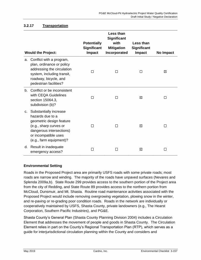
PG&E McCloud-Pit Hydroelectric Project Water Quality Certification
Draft Initial Study / Negative Declaration
May 2019 Cardno, Inc. Environmental Checklist 3-157
3.2.17 Transportation
Would the Project:
Potentially
Significant
Impact
Less than
Significant
with
Mitigation
Incorporated
Less than
Significant
Impact No Impact
a. Conflict with a program,
plan, ordinance or policy
addressing the circulation
system, including transit,
roadway, bicycle, and
pedestrian facilities?
b. Conflict or be inconsistent
with CEQA Guidelines
section 15064.3,
subdivision (b)?
c. Substantially increase
hazards due to a
geometric design feature
(e.g., sharp curves or
dangerous intersections)
or incompatible uses
(e.g., farm equipment)?
d. Result in inadequate
emergency access?
Environmental Setting
Roads in the Proposed Project area are primarily USFS roads with some private roads; most
roads are narrow and winding. The majority of the roads have unpaved surfaces (Nevares and
Splenda 2009a,b). State Route 299 provides access to the southern portion of the Project area
from the city of Redding, and State Route 89 provides access to the northern portion from
McCloud, Dunsmuir, and Mt. Shasta. Routine road maintenance activities associated with the
Proposed Project would include removing overgrowing vegetation, plowing snow in the winter,
and re-paving or re-grading poor condition roads. Roads in the network are individually or
cooperatively maintained by USFS, Shasta County, private landowners (e.g., The Hearst
Corporation, Southern Pacific Industries), and PG&E.
Shasta County’s General Plan (Shasta County Planning Division 2004) includes a Circulation
Element that addresses the movement of people and goods in Shasta County. The Circulation
Element relies in part on the County’s Regional Transportation Plan (RTP), which serves as a
guide for interjurisdictional circulation planning within the County and considers and
PG&E McCloud-Pit Hydroelectric Project Water Quality Certification
Draft Initial Study / Negative Declaration
3-158 Environmental Checklist Cardno, Inc. May 2019
incorporates, as appropriate, the transportation plans of the California Department of
Transportation and local municipalities. The RTP’s goal is to “encourage and promote the safe
and efficient management, operation and development of a regional intermodal transportation
system that, when linked with appropriate land use planning, will serve the mobility needs of
goods and people” (California Transportation Commission 2017).
The Circulation Element notes that the circulation system is dominated by the automobile, and
that there is currently little incentive to explore alternatives due to low density land uses in the
County. It states that the “most important features” of the circulation system in Shasta County
are “(1) its extensive provisions for automobile travel, and (2) the location of a major multimodal
(auto, truck, bus, rail, air, and pipe and transmission line) transportation corridor through the
SCR [South Central Region] area”20 (Shasta County Planning Division 2004). The Circulation
Element includes County Circulation and Bikeway maps, and lists the County’s objectives and
policies for its overall circulation system. The maps provided depict the locations of McCloud
and Iron Canyon Reservoirs. Regarding pedestrian traffic, the Circulation Element includes an
objective to “recognize pedestrian... circulation as functional alternative to the automobile in
urban and suburban areas.”
In regard to the coarse sediment augmentation, PG&E would not extract all 16,200 tons of
gravel at Star City Creek delta at one time, but rather would extract a maximum of
approximately 600 tons of material per year. To transfer 600 tons of gravel from Star City Creek
delta to the tunnel crossing at Hawkins Creek (a proposed storage area), would require a
maximum of approximately 23 round trips, using typical transfer trucks that haul at most 26 tons
per load. Approximately 30 days would be required to stockpile material at the Hawkins Creek
Tunnel Crossing, which includes time spent excavating, screening, and hauling gravel.
Discussion
a. Conflict with a program, plan, ordinance or policy addressing the circulation system,
including transit, roadway, bicycle, and pedestrian facilities?
Impact: No Impact.
The Circulation Element of the County’s General Plan shows that there are no bikeways in
the Proposed Project area, and only one road within the Proposed Project area, Fender's
Ferry Road, is delineated on the County circulation map. There are no public transit
corridors or stations in the Proposed Project area, and as the Proposed Project is in a rural
area rather than an urban or suburban area, it cannot conflict with the County’s objective for
pedestrian traffic. No part of the Proposed Project is located in the County’s South Central
Region. The Circulation Element does not establish any plans or policies specific to
Fender’s Ferry Road. There are no other programs, plans, ordinances, or policies that could
conflict with the Proposed Project in the Proposed Project area, and so the Proposed
Project will have no impact.
20 The South Central Region identified by the County’s General Plan includes the Cities of Shasta Lake, Redding,
and Anderson. It does not include any portion of the County lying north or east of Lake Shasta.

PG&E McCloud-Pit Hydroelectric Project Water Quality Certification
Draft Initial Study / Negative Declaration
May 2019 Cardno, Inc. Environmental Checklist 3-159
In addition, as part of the Proposed Project, PG&E would implement a Road and
Transportation Facility Management Plan. The Road and Transportation Facility
Management Plan describes the scope of road maintenance, improvements, and monitoring
needed to meet new license conditions, and USFS road management objectives (RMOs)
and traffic service levels applicable to Proposed Project roads. The objectives are to:
Develop and describe the protocols to periodically inventory Proposed Project roads,
identify road repair and reconstruction needs, and schedule priority work;
Develop and implement operation and maintenance standards including annual
reconnaissance, inspection frequencies, surface treatment and replacement, road
drainage, erosion control, invasive species control, cultural resource protections,
LOP restrictions, and safety measures;
Identify and track all traffic-related signs, including design and placement, and
periodic inspection, repair, and replacement over the license term;
Develop and implement protocols to monitor and document road use and road
capacity over the license term using traffic survey measurements (mechanical and
visual) against established RMOs; and
Describe the protocols to use borrow sites, water drafting sites, and disposal sites
including the materials to be disposed and the process to establish new sites,
if needed.
Although short-term and long-term increases in traffic may be expected as a result of
Proposed Project activities (see item “b” below), the circulation system would be maintained
and improved to accommodate the traffic.
Roads in the Proposed Project area do not provide alternative modes of transportation for the
public, and no designated mass transit or bicycle routes are located along the roads. Trails
would be improved in the Project area, which would result in increased pedestrian and boat
access to water bodies in the Project area and recreational facilities, benefitting the public.
The Proposed Project would not result in an impact due to any conflict with a program, plan,
ordinance or policy addressing the circulation system, including transit, roadway, bicycle,
and pedestrian facilities.
Mitigation Measures: None required.
b. Conflict or be inconsistent with CEQA Guidelines section 15064.3, subdivision (b)?
Impact: Less Than Significant
The Proposed Project does not propose uses that would substantially increase vehicle miles
traveled (VMT) in the area. Operation and maintenance of the Proposed Project would be
similar to existing conditions, resulting in minimal additional VMT. Improved recreation
areas may slightly increase the number of visitors in the area; however, this is not expected
to be substantial.

PG&E McCloud-Pit Hydroelectric Project Water Quality Certification
Draft Initial Study / Negative Declaration
3-160 Environmental Checklist Cardno, Inc. May 2019
During construction of the recreation improvements, the Proposed Project would generate
VMT consisting of a few daily vehicles for workers and large trucks to transport heavy
equipment at the beginning and end of construction. However, construction-related VMT
would be short-term and not substantial. Therefore, the Proposed Project would not have a
significant impact on VMT and would not result in conflicts or inconsistencies with CEQA
Guidelines section 15064.3.
Mitigation Measures: None required.
c. Substantially increase hazards due to a geometric design feature (e.g., sharp curves
or dangerous intersections) or incompatible uses (e.g., farm equipment)?
Impact: Less Than Significant
The Proposed Project does not include the construction or development of any
transportation facilities with geometric design features. However, some of the existing roads
in the Proposed Project area are winding and steep and pose hazards to travelers. Large
trucks and construction equipment using these roads may pose a hazard to recreational and
other travelers and could contribute to increased numbers of accidents. Truck and
equipment trips would be minimal and short-term during the construction periods for
Proposed Project activities, but the temporary increase in traffic on some roads in the
Project area could still contribute to significant impacts on public safety.
However, the potential impact of the Proposed Project will not be significant because it
includes implementation of the Road and Transportation Facility Management Plan that
includes measures to provide signs, properly notify travelers of activities, and establish
routes for truck and equipment traffic would help minimize potential traffic hazards and
reduce impacts.
As part of the Proposed Project, PG&E would implement the Road and Transportation Facility
Management Plan. The Road and Transportation Facility Management Plan describes the
scope of road maintenance, improvements, and monitoring needed to meet new license
conditions, and USFS RMOs and traffic service levels applicable to Proposed Project roads.
With implementation of the measures contained within the Road and Transportation Facility
Management Plan impacts related to increased hazards would not be significant.
Mitigation Measures: None required.
d. Result in inadequate emergency access?
Impact: Less Than Significant
Long-term operation and maintenance of the Proposed Project would include the addition of
up to five seasonal caretakers to operate and maintain existing recreational facilities
generally from mid-May through mid-September. All other operation and maintenance
associated with the Proposed Project (i.e., worker trips) would be similar to existing
conditions. Following recreation facility improvements, there is the potential to see an

PG&E McCloud-Pit Hydroelectric Project Water Quality Certification
Draft Initial Study / Negative Declaration
May 2019 Cardno, Inc. Environmental Checklist 3-161
increase in visitor use; however, this is not anticipated to be substantial. Traffic associated
with long-term operation and maintenance of the Project (including operation of the
recreational facilities) will not be sufficiently dense to impede emergency access. In
addition, the Proposed Project includes implementation of the Road and Transportation
Facility Management Plan which includes periodic traffic use surveys and road capacity
reviews, and actions to be taken in the event of deficiencies.
On a short-term basis, construction traffic associated with the Proposed Project could result in
temporary delays of emergency traffic during the construction period, particularly during peak
recreation periods when traffic is higher and during road improvements. While short delays
may be incurred during construction activities, roads will remain open and PG&E will maintain
emergency access routes to ensure that emergency vehicles can travel through or around the
work areas when needed. Further, the Road and Transportation Facility Management Plan
includes an annual road operation and maintenance schedule so that land management and
emergency responders are notified of construction activities prior to implementation.
Therefore, long-term and short-term impacts associated emergency access will not be
significant.
Mitigation Measures: None required.

PG&E McCloud-Pit Hydroelectric Project Water Quality Certification
Draft Initial Study / Negative Declaration
3-162 Environmental Checklist Cardno, Inc. May 2019
This Page Intentionally Left Blank

PG&E McCloud-Pit Hydroelectric Project Water Quality Certification
Draft Initial Study / Negative Declaration
May 2019 Cardno, Inc. Environmental Checklist 3-163
3.2.18 Tribal Cultural Resources
Are significance criteria established by the applicable air district
available to rely on for significance determinations? Yes ☒ No ☐
Would the project cause a
substantial adverse change in
the significance of a tribal
cultural resource, defined in
Public Resources Code section
21074 as either a site, feature,
place, cultural landscape that is
geographically defined in terms
of the size and scope of the
landscape, sacred place, or
object with cultural value to a
California Native American
tribe, and that is:
Potentially
Significant
Impact
Less than
Significant
with
Mitigation
Incorporated
Less than
Significant
Impact No Impact
a. Listed or eligible for listing
in the California Register
of Historical Resources,
or in a local register of
historical resources as
defined in Public
Resources Code section
5020.1(k)?
b. A resource determined by
the lead agency, in its
discretion and supported
by substantial evidence,
to be significant pursuant
to criteria set forth in
subdivision (c) of Public
Resources Code Section
5024.1. In applying the
criteria set forth in
subdivision (c) of Public
Resource Code Section
5024.1, the lead agency
shall consider the
significance of the
resource to a California
Native American tribe?

PG&E McCloud-Pit Hydroelectric Project Water Quality Certification
Draft Initial Study / Negative Declaration
3-164 Environmental Checklist Cardno, Inc. May 2019
Environmental Setting
Refer to Section 3.2.5, Cultural Resources.
Discussion
Would the project cause a substantial adverse change in the significance of a tribal cultural
resource, defined in Public Resources Code section 21074 as either a site, feature, place,
cultural landscape that is geographically defined in terms of the size and scope of the
landscape, sacred place, or object with cultural value to a California Native American tribe, and
that is:
a. Listed or eligible for listing in the California Register of Historical Resources, or in a
local register of historical resources as defined in Public Resources Code section
5020.1(k)?
Impact: Less Than Significant
Studies to identify TCPs were conducted with the assistance of the Pit River Tribe and the
Winnemem Wintu Tribe to identify culturally sensitive areas within the Project area (Nevares
and MacDougall 2009). Archaeological and historical investigations for the Proposed Project
identified 33 isolated artifacts or features and 30 sites (including 28 prehistoric sites, one
historic site, and three prehistoric/historic sites) within the APE (FERC 2011). Similar to the
analysis set forth Section 3.2.5, impacts would be significant if a project altered tribal
resources in a manner that prevented identification or study of the resource or, in the case of
human remains, prevented recovery or reburying of the remains. In addition, for the purposes
of this analysis, impacts to tribal cultural resources would be considered significant if they
destroyed the value the resource has for an identified California Native American tribe.
The Historic Properties Management Plan required in USFS Final 4(e) condition number 34
outlines continued adherence to federal and state laws and regulations, regular
communication with other agencies, the Pit River Tribe, and the Winnemem Wintu Tribe
regarding the management of historic properties within the Proposed Project’s APE. The
Historic Properties Management Plan also specifies general treatment measures for:
operations and maintenance (including road maintenance); the management of
ethnobotanical resources; avoidance, monitoring, stabilization, data recovery, curation, and
other treatment measures pertaining to historic properties; and accidental discovery of
archaeological sites or human remains. The use of qualified Tribal Cultural Monitors is
required during archaeological surveys, site testing, and data recovery, non-emergency
construction, and maintenance activities requiring ground disturbance that would create a
reasonable effect to historic properties, and during long-term historic properties monitoring.
With implementation of this component of the Proposed Project, impacts to tribal historical
resources would not be significant.
Mitigation Measures: None required.

PG&E McCloud-Pit Hydroelectric Project Water Quality Certification
Draft Initial Study / Negative Declaration
May 2019 Cardno, Inc. Environmental Checklist 3-165
b. A resource determined by the lead agency, in its discretion and supported by
substantial evidence, to be significant pursuant to criteria set forth in subdivision (c)
of Public Resources Code Section 5024.1? In applying the criteria set forth in
subdivision (c) of Public Resource Code Section 5024.1, the lead agency shall
consider the significance of the resource to a California Native American tribe.
Impact: Less Than Significant
Studies to identify TCPs were conducted with the assistance of the Pit River Tribe and the
Winnemem Wintu Tribe to identify culturally sensitive areas within the Project area (Nevares
and MacDougall 2009). The studies identified 31 TCP locations, several of which are
culturally sensitive to the Pit River Tribe. Consultation with the California SHPO and FERC
has determined that four of these locations are eligible for listing on the National Register,
18 are ineligible for listing, and nine remain unevaluated (FERC 2011). Based on the results
of this consultation, any locations found eligible for the National Register are considered
significant for the CRHR under the criteria set forth in subdivision (c) of the Public
Resources Code section 5024.1. Of the remaining 27 locations that have not been
evaluated for specific inclusion on the CRHR, 18 of which were found ineligible for the
National Register and thus are not deemed significant resources for the purposes of this
analysis, and the State Water Board has not concluded that substantial evidence supports
the designation of the remaining nine locations as significant resources for the purposes of
this analysis. Per the discussion under “a” above, the use of qualified Tribal Cultural
Monitors is required during archaeological surveys, site testing, and data recovery,
non-emergency construction, and maintenance activities requiring ground disturbance that
would create a reasonable effect to historic properties, and during long-term historic
properties monitoring.
Although the State Water Board has determined that there are resources that are significant
under the criteria of Public Resources Code section 5024.1, subd. (c), with implementation
of the Historic Properties Management Plan potential impacts to tribal historical resources
would be less than significant, as the Project would not cause a substantial adverse change
in the significance of eligible and/or unevaluated tribal cultural resources.
Mitigation Measures: None required.

PG&E McCloud-Pit Hydroelectric Project Water Quality Certification
Draft Initial Study / Negative Declaration
3-166 Environmental Checklist Cardno, Inc. May 2019
This Page Intentionally Left Blank

PG&E McCloud-Pit Hydroelectric Project Water Quality Certification
Draft Initial Study / Negative Declaration
May 2019 Cardno, Inc. Environmental Checklist 3-167
3.2.19 Utilities and Service Systems
Would the Project:
Potentially
Significant
Impact
Less than
Significant
with
Mitigation
Incorporated
Less than
Significant
Impact No Impact
a. Require or result in the
relocation or construction
of new or expanded
water, wastewater
treatment or stormwater
drainage, electric power,
natural gas, or
telecommunication
facilities or expansion of
existing facilities, the
construction or relocation
of which could cause
significant environmental
effects?
b. Have sufficient water
supplies available to
serve the project and
reasonably foreseeable
future development
during normal, dry and
multiple dry years?
c. Result in a determination
by the wastewater
treatment provider that
serves or may serve the
project that it has
adequate capacity to
serve the project’s
projected demand, in
addition to the provider’s
existing commitments?

PG&E McCloud-Pit Hydroelectric Project Water Quality Certification
Draft Initial Study / Negative Declaration
3-168 Environmental Checklist Cardno, Inc. May 2019
Would the Project:
Potentially
Significant
Impact
Less than
Significant
with
Mitigation
Incorporated
Less than
Significant
Impact No Impact
d. Generate solid waste in
excess of State or local
standards, or in excess of
the capacity of local
infrastructure, or
otherwise impair the
attainment of solid waste
reduction goals?
e. Comply with federal,
state, and local
management and
reduction statutes and
regulations related to
solid waste?
Environmental Setting
The Proposed Project area is remote and sparsely populated. Although PG&E infrastructure is
present, public recreation facilities such as campgrounds within the Proposed Project area are
primitive, typically providing only vault toilets and no electrical, potable water, or other public utility
connections. Cellular telephone reception is sporadic at best, mainly due to the extreme
topography of the area. In most parts of the Proposed Project area, litter removal is the
responsibility of the person that generates it; however, in developed USFS facilities such as the
campgrounds and picnic areas at Iron Canyon Reservoir and McCloud Reservoir, trash
receptacles are maintained by the USFS or a maintenance contractor. Duties of the Project Patrol
include picking-up litter and emptying trash cans on Project lands and Project-affected lands.
In accordance with the California Integrated Waste Management Act of 1989 (IWM Act), Shasta
County maintains an Integrated Waste Management Plan (IWMP). Under the IWM Act, every
city and county in California was required to reduce the volume of waste sent to landfills by 50
percent by 2000 and assure maintenance of at least a 15-year landfill capacity for solid wastes
that are generated in the county and cannot be reduced or recycled. In addition, Shasta County
adopted a Source Reduction and Recycling Element in 1991, which addresses the County’s
waste generation characteristics, source reduction, recycling, composting, education and public
information, funding, and integration of solid waste management issues.
PG&E McCloud-Pit Hydroelectric Project Water Quality Certification
Draft Initial Study / Negative Declaration
May 2019 Cardno, Inc. Environmental Checklist 3-169
Discussion
a. Require or result in the relocation or construction of new or expanded water,
wastewater treatment or stormwater drainage, electric power, natural gas, or
telecommunication facilities or expansion of existing facilities, the construction or
relocation of which could cause significant environmental effects??
Impact: Less Than Significant
For the purposes of this element, a project’s impacts would be considered significant if the
project involved the relocation or construction of utility facilities and the analysis showed that
construction or relocation would themselves result in significant environmental impacts.
Some of the Proposed Project activities would involve the installation or replacement of
culverts along trails or roads to maintain flow in drainages that cross trails or roads. Up to
ten of the recreational developments would require installation of sealed vault tanks to hold
sewage. Up to seven new groundwater wells may be drilled to serve recreational sites.
Implementation of these Project components raises the possibility of significant
environmental impacts related to construction or installation. The Proposed Project does
not involve the relocation or construction of any new or existing other water, wastewater
treatment or stormwater, electric power, natural gas, or telecommunication facilities.
Moreover, impacts associated with utilities work that will be conducted under the Proposed
Project will not be significant because they consist primarily of temporary
construction-related disturbances, and as part of Project implementation PG&E is required
to prepare and implement a SWPPP pursuant to the requirements of the Construction
General Permit.
Under the SWPPP requirements, which are regulated by the CVRWQCB, the Proposed
Project will include implementation of BMPs for the control of erosion and sedimentation.
Additionally, the provisions of the proposed Erosion and Sediment Monitoring and Control
Plan and the Road and Transportation Facility Management Plan would require appropriate
controls on erosion during operation and maintenance. All conditions and requirements of
the permits will be included with construction specifications and implemented as part of the
Proposed Project. Vault toilets would be maintained by periodic pumping, and the sewage
would be transported to an approved wastewater treatment facility. For conclusions
regarding the Proposed Project’s potential operational impacts on groundwater, see Section
3.2.10. The Proposed Project’s impacts will not have a significant impact related to
relocation or construction of new or existing utility facilities.
Mitigation Measures: None required.

PG&E McCloud-Pit Hydroelectric Project Water Quality Certification
Draft Initial Study / Negative Declaration
3-170 Environmental Checklist Cardno, Inc. May 2019
b. Have sufficient water supplies available to serve the project and reasonably
foreseeable future development during normal, dry and multiple dry years?
Impact: Less Than Significant
For the purposes of this element, a project would be considered to have a significant impact
if it, during normal, dry, or multiple dry years, it would be forced to obtain water from sources
not covered by the project proposal for project operations or maintenance.
Currently, the McCloud-Pit Project uses two wells for potable water at Deadlun and Hawkins
Campground and other PG&E facilities along the Pit River. The extraction of groundwater
would be necessary to provide a water supply for some of the proposed recreational
facilities (up to seven new wells). In addition, during construction, water would temporarily
be used for dust control. Sources of water for these uses would primarily be groundwater
but could also include existing PG&E and USFS entitlements, or the Proposed Project
reservoirs once the FERC license is renewed, via a Special Use Permit from the USFS.
Based on water usage estimates from the USFS, camping and day use facilities without
flush toilets and showers require approximately six gpd during the peak of the recreation
season, which is generally two months (USFS 2007a). If all the new wells are installed and
assuming peak usage occurs for the entire five-month recreation season, the Proposed
Project would require approximately 6,300 gallons (or 0.02 ac-ft) annually. This increase in
use of groundwater would be less than 0.18 percent of the total groundwater supply used for
potable water in the Shasta-Pit Planning Area. (For additional analysis regarding the
Proposed Project’s water use, see Section 3.2.10.)
During dry and multiple dry years, the Project still has substantial groundwater flow. It takes
several years of significantly below average precipitation (i.e., drought conditions) to
substantially deplete the summer base flow (email communication Alan Soneda, April 10,
2019). Due to the remote location and nature of the Project, in the event of severe drought
conditions, PG&E and the USFS would consult regarding options to restrict usage and/or
implement other conservation measures.
The Proposed Project has sufficient water supplies available to serve the existing and
proposed facilities and impacts to water supply would be less than significant.
Mitigation Measures: None required.
c. Result in a determination by the wastewater treatment provider that serves or may
serve the project that it has adequate capacity to serve the project’s projected
demand, in addition to the provider’s existing commitments?
Impact: Less Than Significant
Sanitary waste disposal needs for the proposed facilities will be served by vault toilets, which
would be periodically pumped, and the sewage transported to an appropriate wastewater
treatment facility. The Proposed Project includes construction of new vault toilets; however,
the increase in sewage from these toilets would be minimal. Additionally, portable restroom
facilities would be used by workers during the construction phase of the Proposed Project.

PG&E McCloud-Pit Hydroelectric Project Water Quality Certification
Draft Initial Study / Negative Declaration
May 2019 Cardno, Inc. Environmental Checklist 3-171
Therefore, the Proposed Project will not have a significant impact on the wastewater treatment
facility’s capacity to serve the Proposed Project or existing commitments.
Mitigation Measures: None required.
d. Generate solid waste in excess of State or local standards, or in excess of the
capacity of local infrastructure, or otherwise impair the attainment of solid waste
reduction goals?
Impact: Less Than Significant
The Anderson Landfill is the nearest landfill to the Project area and currently receives waste
from Existing Project facilities and other developments that generate waste in the Project
area. The landfill has a permitted capacity of 1,850 tons per day and 16.84 million cubic
yards total (California Department of Resources Recycling and Recovery 2018). The landfill
had about 10.5 million cubic yards of available capacity as of April 2018. The recreation
facilities would annually produce approximately 450 cubic yards of waste (a fraction of a
percent of the landfill’s annual capacity), which would be hauled away by the local waste
disposal company, such as Burney Disposal, Inc., and disposed at the Anderson Landfill. In
addition, construction activities would also produce a quantity of solid and possibly
hazardous waste, estimated at 750 cubic yards. Ongoing operations and maintenance
activities will produce approximately 14 cubic yards of waste annually. Over the 50-year life
of the new FERC license, the waste from the Proposed Project will total approximately
23,950 cubic yards, or about 0.002 percent of the total landfill capacity that was available as
of April 2018.
The Proposed Project would not generate solid waste in excess of state or local standards,
exceed the capacity of local infrastructure, or otherwise impair the attainment of solid waste
reduction goals contained in the Shasta County IWMP. Therefore, the Proposed Project will
not result in a significant impact related to solid waste disposal.
Mitigation Measures: None required.
e. Comply with federal, state, and local management and reduction statutes and
regulations related to solid waste?
Impact: Less Than Significant
During construction of the recreation facility improvements, usable excess construction
materials such as lumber, paint, metal pipe, etc. would be returned to the PG&E Service
Center and reused for other projects. Waste would be disposed of at local waste transfer
stations, such as the Anderson Solid Waste Landfill. The estimated volume of waste
generated by construction would be 750 cubic yards.
All Proposed Project activities would comply with applicable solid waste disposal laws and
policies, and PG&E would recycle waste when possible. Any hazardous waste generated
by Proposed Project activities would be properly disposed of at a facility that can accept the

PG&E McCloud-Pit Hydroelectric Project Water Quality Certification
Draft Initial Study / Negative Declaration
3-172 Environmental Checklist Cardno, Inc. May 2019
waste as required by HMBPs (refer to Section 3.2.8). Impacts related to solid waste
regulations would not be significant.
Mitigation Measures: None required.

PG&E McCloud-Pit Hydroelectric Project Water Quality Certification
Draft Initial Study / Negative Declaration
May 2019 Cardno, Inc. Environmental Checklist 3-173
3.2.20 Wildfire
Is the project located in or near state responsibility areas or
lands classified as high fire hazard severity zones? Yes ☒ No ☐
If located in or near state
responsibility areas or lands
classified as very high fire
hazard severity zones:
Potentially
Significant
Impact
Less than
Significant
with
Mitigation
Incorporated
Less than
Significant
Impact No Impact
a. Would the project
substantially impair an
adopted emergency
response plan or
emergency evacuation
plan?
b. Would the project due to
slope, prevailing winds,
and other factors,
exacerbate wildfire risks,
and thereby expose
project occupants to
pollutant concentrations
from a wildfire or the
uncontrolled spread of a
wildfire?
c. Would the project require
the installation of
associated infrastructure
(such as roads, fuel
breaks, emergency water
sources, power lines or
other utilities) that may
exacerbate fire risk or
that may result in
temporary or ongoing
impacts to the
environment?

PG&E McCloud-Pit Hydroelectric Project Water Quality Certification
Draft Initial Study / Negative Declaration
3-174 Environmental Checklist Cardno, Inc. May 2019
If located in or near state
responsibility areas or lands
classified as very high fire
hazard severity zones:
Potentially
Significant
Impact
Less than
Significant
with
Mitigation
Incorporated
Less than
Significant
Impact No Impact
d. Would the project expose
people or structures to
significant risks, including
downslope or
downstream flooding or
landslides, as a result of
runoff, post-fire slope
instability, or drainage
changes?
Environmental Setting
The Proposed Project area is located in a very high fire hazard zone that contains vast areas of
forest which are subject to periodic wildfire (Cal Fire 2008). Fire suppression is a shared
responsibility between the USFS, Cal Fire, and Shasta County, and response times in the event of
a fire in the Project area can be long because of the distance to fire stations and equipment
(FERC 2011). PG&E maintains fire suppression tools at existing recreation sites and its facilities,
and it conducts routine facility maintenance, such as vegetation thinning and trimming under and
near power lines and substations, to reduce the fire risk near existing Project facilities.
Discussion
a. Substantially impair an adopted emergency response plan or emergency evacuation
plan?
Impact: Less Than Significant
Shasta County has prepared an Emergency Operations Plan that describes how the County
will organize and respond to a variety of hazards, emergencies, and disasters, including
major fires. Under the Emergency Operations Plan, emergency evacuations, including the
coordination of movement control and transportation needs, are primarily the responsibility
of the Sheriff’s Office and the County Office of Emergency Services.
The Proposed Project will not impair execution of the Emergency Operations Plan. On a
temporary basis, construction traffic associated with the Proposed Project could result in
temporary delays of emergency traffic during the construction period, particularly during
peak recreation periods when traffic is higher, and during road improvements. However, this
potential impact of the Proposed Project will not result in impairment of the Emergency
Operations Plan because implementation of the Proposed Project will include
implementation of the Road and Transportation Facility Management Plan, which includes
an annual road operation and maintenance schedule so that land management and
emergency responders are notified of construction activities prior to implementation. As part

PG&E McCloud-Pit Hydroelectric Project Water Quality Certification
Draft Initial Study / Negative Declaration
May 2019 Cardno, Inc. Environmental Checklist 3-175
of the construction activities required for the Proposed Project, PG&E will maintain
emergency access routes during construction activities and ensure emergency vehicles can
travel through or around work areas when needed.
On a long-term basis, operation and maintenance of the Proposed Project will not increase
traffic in the Project area to the extent emergency response times would be impaired, and
the Proposed Project does not involve inundation of or any other impact to existing
evacuation and emergency service routes.
The Proposed Project will not have an adverse impact on an adopted emergency response
plan or emergency evacuation plan. (Additional discussion of the potential impact of the
Proposed Project on fire protection services is found in Section 3.2.15. Additional
discussion of the potential impact of the Proposed Project on emergency access is found in
Section 3.2.17.)
In addition, and more generally, PG&E’s Fire and Fuels Management Plan will provide
information necessary for preventing, preparing for, suppressing, reporting, and investigating
fires associated with the Proposed Project, as required by USFS Final 4(e) condition
number 33 (Part II, 4). The Fire and Fuels Management Plan will identify: hazard
reduction/fuel treatment measures; actions and locations of resources needed for fire
prevention and response; and a process for reporting fires and providing necessary
documents associated with any fire investigation to protect the Proposed Project and USFS
resources over the term of the license.
Minimum components in the Fire and Fuels Management Plan will include:
Fuels treatment
Prevention and response
Access and safety
Emergency response preparedness
Reporting and response
Investigation of Project related fires
Post-fire activities
Implementation of this component of the Proposed Project will further ensure that the
Proposed Project will not have a significant impact on an adopted emergency response
plan or emergency evacuation plan.
Mitigation Measures: None required.

PG&E McCloud-Pit Hydroelectric Project Water Quality Certification
Draft Initial Study / Negative Declaration
3-176 Environmental Checklist Cardno, Inc. May 2019
b. Due to slope, prevailing winds, and other factors, exacerbate wildfire risks, and
thereby expose project occupants to pollutant concentrations from a wildfire or the
uncontrolled spread of a wildfire?
Impact: Less Than Significant
Under this element, a proposed project would be considered to have a significant impact if,
due to existing natural factors, it increased the severity of existing fire risk in a manner that
could expose project occupants to wildfires or place project occupants in areas where wildfire
smoke is known to concentrate. A project that would increase the severity of existing fire risk
due to natural factors could include, for example, a housing development project placed on a
slope with prevailing uphill winds in a fire-prone area. Such placement could increase the
amount of fuels that could feed a wildfire, which would exacerbate the existing risk of wind-
driven wildfires and expose the occupants of the project to that very risk.
The Proposed Project area is located in a very high fire hazard zone that contains vast
areas of steep-sloped forests which are subject to periodic wildfire (Cal Fire 2008). The
Proposed Project involves use of motorized vehicles and equipment for construction
and maintenance. Equipment use is one of the top causes of fire in California. The
Proposed Project also includes the continued operation of hydroelectric facilities in the
Project area, the presence of which could exacerbate existing fire risks. Though Project
caretakers and maintenance workers and users of the Project’s recreational facilities
will not permanently occupy the Project area, they are considered Project occupants for
the purpose of this element. The Proposed Project could potentially exacerbate fire risk
and could potentially expose recreationists to pollutant concentrations from a wildfire or
the uncontrolled spread of a wildfire.
However, this potential impact of the Proposed Project will not be significant because the
Proposed Project includes implementation of a Fire and Fuels Management Plan, and thus
incorporates tools for preventing, preparing for, suppressing, reporting, and investigating
fires associated with the Proposed Project, as required by USFS Final 4(e) condition
number 33 (refer to Chapter 2.4.5 for more detail). The impact of the Proposed Project
related to the exposure of Project occupants to pollutant concentrations or wildfire would not
be significant.
Mitigation Measures: None required.
c. Require the installation of associated infrastructure (such as roads, fuel breaks,
emergency water sources, power lines or other utilities) that may exacerbate fire risk
or that may result in temporary or ongoing impacts to the environment?
Impact: Less Than Significant
Under this element, a proposed project would be considered to have a significant impact if it
included the construction of structures or facilities (whether temporary or permanent), the
construction or operation of which could result in the temporary or ongoing exacerbation of
fire risks or increase the rate or extent of the spread of wildfires.

PG&E McCloud-Pit Hydroelectric Project Water Quality Certification
Draft Initial Study / Negative Declaration
May 2019 Cardno, Inc. Environmental Checklist 3-177
The Proposed Project could result in impacts related to the installation of infrastructure
because it includes recreational improvements that are intended to increase recreational
use of the Project area on an ongoing basis. In addition, construction activities themselves
raise the possibility of increased fire risks.
However, the impact of the Proposed Project will not be significant because PG&E
maintains fire suppression tools at existing recreation sites and its facilities, and it conducts
routine facility maintenance, such as vegetation thinning and trimming under and near
power lines and substations, to reduce the fire risk near Existing Project facilities. PG&E’s
Fire and Fuels Management Plan will be finalized in consultation with USFS, Cal Fire, the
Big Bend Volunteer Fire Department, and others, as appropriate. The Fire and Fuels
Management Plan will provide information necessary for preventing, preparing for,
suppressing, reporting, and investigating fires associated with the Proposed Project, as
required by USFS Final 4(e) condition number 33. For example, the Fire and Fuels
Management Plan will include integration with the Sign and Interpretive/Education Plan
(required by USFS Final 4(e) condition number 31), which includes signs for educating the
public about fire danger and safety. The Fire and Fuels Management Plan will identify:
hazard reduction/fuel treatment measures; actions and locations of resources needed for
fire prevention and response; and a process for reporting fires and providing necessary
documents associated with any fire investigation to protect the Proposed Project and
National Forest resources over the term of the license. Other aspects of fuels management
primarily related to vegetation treatments, including powerline clearance, are contained in
the separate Vegetation and Invasive Weed Management Plan.
The existing risk of wildfire would continue to be very high, but the implementation of the
Proposed Project will not result in the exacerbation of fire risks or an increase of the rate or
extent of the spread of wildfires in the Project area, and so the impact of the Proposed
Project will not be significant.
Mitigation Measures: None required..
d. Expose people or structures to significant risks, including downslope or downstream
flooding or landslides, as a result of runoff, post-fire slope instability, or drainage
changes?
Impact: Less Than Significant
Under this element, the impact of a proposed project would be considered significant if it
created substantial new risks of post-fire downslope or downstream flooding or landslides or
if it resulted in the placement people or structures in areas of existing risk of post-fire
downslope or downstream flooding or landslides.
The Proposed Project will not result in the creation of new flooding or landslide risks. While
it will result in the construction of recreational facilities that will cause a negligible increase in
the amount of impervious surfaces in the Project area, the new facilities will be on relatively
flat ground and will not create landslide risks, and the increase in the amount of impervious
surfaces in the Project area will not be sufficient to create new flood risks.

PG&E McCloud-Pit Hydroelectric Project Water Quality Certification
Draft Initial Study / Negative Declaration
3-178 Environmental Checklist Cardno, Inc. May 2019
In addition, the Proposed Project will not place people or structures in areas at existing risk
of post-fire downslope or downstream flooding or landslides. A small number of small
structures (e.g., vault toilets) will be constructed as part of the Proposed Project, but these
structures will be built on relatively flat ground with relatively low risk of landslides. The
recreational sites will not be located in areas that would see increased flooding as the result
of upslope fires. The Proposed Project will not result in a significant impact related to the
exposure of people or structures to post-fire flooding or landslide risk.
Finally, exposure of people or structures to significant risks associated with post-fire slope
instability or drainage changes would be minimized through implementation of the Fire and
Fuels Management Plan. The Plan will specifically address post-fire activities such as
post-fire slope instability, runoff or drainage changes. (Additional discussion of potential
impacts related to soil stability and landslides is found in Section 3.2.7. Additional
discussion of potential impacts to hydrology, including alteration to drainage, runoff, and
flooding patterns, is found in Section 3.2.10.) The Proposed Project will not have a
significant impact regarding the exposure of people or structures to risk of post-fire
downslope or downstream flooding or landslides.
Mitigation Measures: None required.

PG&E McCloud-Pit Hydroelectric Project Water Quality Certification
Draft Initial Study / Negative Declaration
May 2019 Cardno, Inc. Environmental Checklist 3-179
3.2.21 Mandatory Findings of Significance
Potentially
Significant
Impact
Less than
Significant
with
Mitigation
Incorporated
Less than
Significant
Impact No Impact
a. Does the project have the
potential to substantially
degrade the quality of the
environment,
substantially reduce the
habitat of a fish or wildlife
species, cause a fish or
wildlife population to drop
below self-sustaining
levels, threaten to
eliminate a plant or
animal community,
substantially reduce the
number or restrict the
range of an endangered,
rare, or threatened
species, or eliminate
important examples of the
major periods of
California history or
prehistory?
b. Does the project have
impacts that are
individually limited, but
cumulatively
considerable?
(“Cumulatively
considerable” means that
the incremental effects of
a project are considerable
when viewed in
connection with the
effects of past projects,
the effects of other current
projects, and the effects of
probable future projects.)

PG&E McCloud-Pit Hydroelectric Project Water Quality Certification
Draft Initial Study / Negative Declaration
3-180 Environmental Checklist Cardno, Inc. May 2019
Potentially
Significant
Impact
Less than
Significant
with
Mitigation
Incorporated
Less than
Significant
Impact No Impact
c. Does the project have
environmental effects that
will cause substantial
adverse effects on human
beings, either directly or
indirectly?
Discussion
a. Does the project have the potential to substantially degrade the quality of the
environment, substantially reduce the habitat of a fish or wildlife species, cause a fish
or wildlife population to drop below self-sustaining levels, threaten to eliminate a
plant or animal community, substantially reduce the number or restrict the range of
an endangered, rare, or threatened species, or eliminate important examples of the
major periods of California history or prehistory?
Impact: Less Than Significant
Impacts to biological resources, such as fish, birds, sensitive species, amphibians, reptiles,
BMI communities, denning and roosting special-status mammals, and wetlands and riparian
habitat from Proposed Project activities that produce noise, human activity and disturbance,
ground disturbance, and vegetation removal could potentially occur. As provided in Exhibit
E of the Application for New License (PG&E 2009), FERC’s final EIS (2011) and USFS 4(e)
conditions, the Proposed Project includes implementation of: (a) an Aquatic Biological
Monitoring Plan; (b) Erosion and Sediment Control Management Plan; (c) Large Woody
Debris Plan; (d) Terrestrial Biological Management Plan; (e) Vegetation and Invasive Weed
Management Plan; and (f) Water Quality Management Plan. In addition, the Proposed
Project includes new ramping rate criteria and higher MIFs that are anticipated to benefit the
biological community. With implementation of these plans and flows, as described above
(and detailed in Section 2.4.6 of the Project Description Chapter), the Proposed Project
would not degrade the quality of the environment or substantially reduce wildlife or their
habitats, on either a cumulative or individual basis.
Mitigation Measures: None required.

PG&E McCloud-Pit Hydroelectric Project Water Quality Certification
Draft Initial Study / Negative Declaration
May 2019 Cardno, Inc. Environmental Checklist 3-181
b. Does the project have impacts that are individually limited, but cumulatively
considerable? (“Cumulatively considerable” means that the incremental effects of a
project are considerable when viewed in connection with the effects of past projects,
the effects of other current projects, and the effects of probable future projects.)
Impact: Less Than Significant
When a project’s contribution to a cumulative impact does not exceed an established
significant threshold, the agency may properly conclude that the project’s effects are not
cumulatively considerable. For the purposes of this discussion, the significance thresholds
for the Proposed Project’s contribution to cumulative impacts are the same as those
thresholds set out in the discussion above.
Impacts to aesthetics from Proposed Project activities, such as construction of recreation
facilities, access roads, pedestrian trails and campgrounds, and proposed road and parking
area improvements, could potentially occur. However, with finalization and implementation
of the Visual Quality Management Plan, potential impacts would be less than significant.
The Visual Quality Management Plan will be developed in consultation with the USFS and
provide measures to be implemented to meet USFS VQOs. Specifically, the Visual Quality
Management Plan will assure Proposed Project-affected resources in STNF lands blend
with the natural environment. Therefore, the Proposed Project’s individual contribution to
aesthetics impacts is not cumulatively considerable.
The Proposed Project area does not contain agricultural land; therefore, the Proposed
Project would have no individual or cumulative impact on Agricultural Resources. In regard
to forest resources, the development of new recreational facilities and expansion of existing
recreational facilities would result in the removal of vegetation, including trees, but the effect
on timberlands would be minimal. The total area of disturbance across the Project area is
expected to be less than 50 acres, which is a small percentage of the total timberlands in
the region. Therefore, the Proposed Project’s individual contribution to forest resource
impacts is not cumulatively considerable.
In regard to air quality and GHG emissions, the Proposed Project would be in conformance
with the AQAP (SVAQEEP 2015) and would not result in operational impacts that would
significantly increase criteria pollutant emissions over the long-term. Furthermore,
short-term Proposed Project construction activities are not considered to be a significant
source of criteria pollutants on an individual basis. CEQA Guidelines section 15064(h)(3)
stipulate that for an impact involving a resource that is addressed by an approved plan or
mitigation program (e.g., general maintenance-related construction activities for
infrastructure), the lead agency may determine that a project’s incremental contribution is
not cumulatively considerable if the project complies with the adopted plan or program. The
Proposed Project would be consistent with the applicable air quality and GHG emissions
plans. Therefore, the Proposed Project’s individual contribution to air quality and GHG
emissions impacts is not cumulatively considerable.
Impacts to biological resources, such as fish, birds, sensitive species, amphibians, reptiles,
BMI communities, denning and roosting special-status mammals, and wetlands and riparian
habitat from Proposed Project activities that produce noise, human activity and disturbance,
PG&E McCloud-Pit Hydroelectric Project Water Quality Certification
Draft Initial Study / Negative Declaration
3-182 Environmental Checklist Cardno, Inc. May 2019
ground disturbance, and vegetation removal could potentially occur. As provided in Exhibit
E of the Application for New License (PG&E 2009), FERC’s final EIS (2011) and USFS 4(e)
conditions, the Proposed Project includes implementation of: (a) an Aquatic Biological
Monitoring Plan; (b) Erosion and Sediment Control Management Plan; (c) Large Woody
Debris Plan; (d) Terrestrial Biological Management Plan; (e) Vegetation and Invasive Weed
Management Plan and (f) Water Quality Management Plan. In addition, the Proposed
Project includes new ramping rate criteria and higher MIFs that are anticipated to benefit the
biological community. Therefore, the Proposed Project’s individual contribution to biological
resource impacts is not cumulatively considerable.
Impacts to cultural resources, such as archaeological and historical artifacts, could
potentially occur. However, implementation of the Historic Properties Management Plan that
is part of the Proposed Project would reduce impacts on cultural resources to less than
significant. Therefore, the Proposed Project’s individual contribution to cultural resource
impacts is not cumulatively considerable.
Impacts to mineral resources and to geology and soils, such as the potential of increased
erosion related to new construction, could potentially occur. However, implementation of
the: (a) Erosion and Sediment Monitoring and Control Plan and (b) Road and
Transportation Facility Management Plan, that are part of the Proposed Project would
reduce impacts to geology and soils to less than significant. Therefore, the Proposed
Project’s individual contribution to mineral resource, geology, and soil impacts is not
cumulatively considerable.
Impacts associated with hazards and hazardous materials, such as the potential of
hazardous material spills during construction, wildland fires, or recreational hazards near the
Pit 7 Afterbay, could occur. However, implementation of the: (a) Spill Prevention, Control
and Countermeasure Plan; and (b) Fire and Fuels Management Plan, that are part of the
Proposed Project would reduce hazards-related impacts to less than significant. Therefore,
the Proposed Project’s individual contribution of hazards and hazardous materials impacts is
not cumulatively considerable.
Impacts to hydrology and water quality, such as the potential of increased erosion related to
new construction, could potentially occur. However, implementation of the: (a) SWPPP
pursuant to the requirements of the Construction General Permit; (b) Erosion and Sediment
Control Management Plan; (c) Water Quality and Temperature Monitoring Plan; (d) Road
and Transportation Facility Management Plan; and (e) new ramping rates and higher MIFs,
that are part of the Proposed Project would reduce impacts related to hydrology and water
quality to less than significant. Therefore, the Proposed Project’s individual contribution to
hydrology and water quality impacts is not cumulatively considerable.
Impacts to recreation, such as overall recreation use, angling and whitewater boating on the
McCloud River below McCloud Dam, could occur. However, with implementation of the:
(a) Recreation Development and Management Plan; (b) the new ramping rates and MIFs;
and (c) the construction of new and improved recreation facilities, that are part of the
Proposed Project would reduce impacts related to recreation to less than significant.

PG&E McCloud-Pit Hydroelectric Project Water Quality Certification
Draft Initial Study / Negative Declaration
May 2019 Cardno, Inc. Environmental Checklist 3-183
Therefore, the Proposed Project’s individual contribution to recreation impacts is not
cumulatively considerable.
The Proposed Project’s activities are consistent the Shasta County General Plan (2004)
land use projections including increases to traffic, noise, public services, population and
housing, and utilities and service systems. Therefore, the Proposed Project’s individual
contribution to land use and planning, noise, population and housing, public services, and
utilities and service systems impacts is not cumulatively considerable.
Impacts to traffic and transportation, such as increased road hazards caused by winding and
steep roads used by large trucks and construction equipment, could potentially occur.
However, implementation of the Proposed Project’s Road and Transportation Facility
Management Plan, which includes measures to provide signs, properly notify travelers of
activities, and establish routes for truck and equipment traffic, would reduce impacts related
to traffic and transportation to less than significant. Therefore, the Proposed Project’s
individual contribution to traffic and transportation impacts is not cumulatively considerable.
Mitigation Measures: None required.
c. Does the project have environmental effects that will cause substantial adverse
effects on human beings, either directly or indirectly?
Impact: Less Than Significant
As discussed previously, the Proposed Project would not expose persons to adverse
impacts related to air quality, geologic hazards, GHG emissions, hazards or hazardous
materials, hydrology or water quality, land use and planning, noise, population and housing,
or transportation/traffic hazards, or prevent utility services. These impacts were determined
to have no impact or a less than significant impact due to implementation of the
environmental management and monitoring plans that are part of the Proposed Project.
Therefore, the Proposed Project does not have significant environmental impacts which
would cause substantial adverse effects on humans either directly or indirectly, on a
cumulative or individual basis.
Mitigation Measures: None required.

PG&E McCloud-Pit Hydroelectric Project Water Quality Certification
Draft Initial Study / Negative Declaration
3-184 Environmental Checklist Cardno, Inc. May 2019
This Page Intentionally Left Blank

PG&E McCloud-Pit Hydroelectric Project Water Quality Certification
Draft Initial Study / Negative Declaration
May 2019 Cardno, Inc. References 4-1
4 References
Blakeslee, M., and S. Kettenhorn. 2010. Earthquake hazard and segmented fault evolution,
Hat Creek Fault, Northern California. American Geophysical Union, Fall Meeting 2010,
Calflora. Information on California plants for education, research and conservation. [web
application]. Berkeley, California: The Calflora Database [a non-profit organization].
Accessed October 2017. Electronic Database. Available at: https://calflora.org//.
California Air Resources Board (CARB). 2012. Statewide Portable Equipment Registration
Program. Available at: https://ww2.arb.ca.gov/our-work/programs/portable-equipment-
registration-program-perp.
California Air Resources Board (CARB). 2014. Air Monitoring Sites – Interactive Map. July 22.
Available at: https://www.arb.ca.gov/qaweb/mapdemo/map_module.php. Accessed in
March 2019.
California Air Resources Board (CARB). 2018. Area Designations Maps/State and National.
Available at: https://www.arb.ca.gov/desig/adm/adm.htm
California Air Resources Board (CARB). 2018a. Air Quality and Meteorological Information
System. Available at: https://www.arb.ca.gov/aqmis2/aqmis2.php. Accessed August
2018.
California Air Resources Board (CARB). 2018b. Shasta County AQMD List of Current Rules.
Available at: https://www.arb.ca.gov/drdb/sha/curhtml/R3-16.pdf Accessed August
2018.
California Air Resources Board (CARB). 2019. iADAM: Air Quality Data Statistics. Available at:
https://www.arb.ca.gov/adam/.
California Department of Conservation (DOC). 2010. Shasta County Williamson Act lands
2010. Available at: http://www.conservation.ca.gov/dlrp/lca/Documents/stats_
reports/2010%20Williamson%20Act%20Status%20Report.pdf. Accessed August 2018.
California Department of Conservation (DOC). 2013. Publications of the SMARA Mineral Land
Classification Project Dealing with Mineral Resources in California. March 2013.
Available at: https://www.conservation.ca.gov/cgs/Documents/Program-
MRP/mlc/SMARA_Publications_March_2013.pdf. Accessed August 2018.
California Department of Conservation (DOC). 2016. Farmland Mapping and Monitoring
Program: Shasta County Important Farmland 2008. Available at: ftp://ftp.consrv.ca.gov/
pub/dlrp/FMMP/pdf/2016/sha16.pdf. Accessed August 2018.
California Department of Fish and Wildlife (CDFW). 2004. Lower McCloud River Wild Trout
Area, Fishery Management Plan 2004 through 2009. Available at:
https://nrm.dfg.ca.gov/FileHandler.ashx?DocumentID=60019. Accessed June 6, 2013.

PG&E McCloud-Pit Hydroelectric Project Water Quality Certification
Draft Initial Study / Negative Declaration
References 4-2 Cardno, Inc. May 2019
California Department of Fish and Wildlife (CDFW). Fully Protected Animals. Available at:
http://www.dfg.ca.gov/wildlife/nongame/t_e_spp/fully_pro.html. Accessed January 2018.
California Department of Forestry and Fire Protection (Cal Fire). 2008. Very high fire hazard
severity zones in LRA: Shasta County. Fire and Resource Protection Program. May 21,
2008. Available at: http://fire.ca.gov/fire_prevention/fhsz_maps_shasta
California Department of Resources Recycling and Recovery. 2018. Solid Waste Information
System: Anderson Landfill, Inc. (45-AA-0020). Available at:
https://www2.calrecycle.ca.gov/SWFacilities/Directory/45-AA-0020/Detail/. Accessed
August 2018.
California Department of Toxic Substances Control (DTSC). 2018. EnviroStor database:
Shasta County. Available at: https://www.envirostor.dtsc.ca.gov/public/
search.asp?cmd=search&ocieerp=&business_name=&main_street_number=&main_stre
et_name=&city=&zip=&county=SHASTA&branch=&site_type=&cleanup_type=&npl=&fu
nding=&reporttype=&reporttitle=PROJECT+SEARCH+RESULTS&federal_superfund=Tr
ue&state_response=True&voluntary_cleanup=True&school_cleanup=True&operating=T
rue&post_closure=True&non_operating=True&corrective_action=True&tiered_permit=Tr
ue&evaluation=True&senate=&congress=&assembly=&critical_pol=&business_type=&c
ase_type=&searchtype=&HWMP=&censustract=&school_district=&cesdecile=&ORDER
BY=upper%28business_name%29&STATUS=ACT%2CActive. Accessed August 2018.
California Department of Transportation (Caltrans). 2018. California scenic highway mapping
system. Available at: http://www.dot.ca.gov/hq/LandArch/16_livability/
scenic_highways/index.htm. Accessed August 2018.
California Department of Water Resources (DWR). 2015. California’s Groundwater Update
2013. April 2015. Available at: https://cawaterlibrary.net/wp-
content/uploads/2017/05/GWU2013_Ch7_SacramentoRiver_Final.pdf. Accessed
October 2018.
California Energy Commission (CEC). 2018. Installed In-State Electric Generation Capacity by
Fuel Type (MW). Available at: http://www.energy.ca.gov/almanac/electricity_
data/electric_generation_capacity.html. Accessed August 2018.
California Geological Survey. 2006. Aggregate Availability in California. Available at;
http://www.consrv.ca.gov/cgs/information/publications/ms/Documents/MS_52_map.pdf.
Accessed August 2018. Updated 2018.
California Independent System Operators (CAISO). 2012. Renewables Integration Studies
Update. http://www.caiso.com/Documents/RenewablesIntegration_StudiesUpdate_
Feb10_2012.pdf. Accessed on April 2012.
California Natural Diversity Database (CNDDB). Rare Find 5.0. California Department of Fish
and Wildlife, Habitat Planning and Conservation Branch. Accessed January 2018.
Electronic Database.

PG&E McCloud-Pit Hydroelectric Project Water Quality Certification
Draft Initial Study / Negative Declaration
May 2019 Cardno, Inc. References 4-3
California Native Plant Society (CNPS). Inventory of Rare and Endangered Plants of California.
Accessed January 2018. Electronic Database. Available at:
http://www.rareplants.cnps.org/.
California Public Utilities Commission (CPUC). 2017. California Renewable Portfolio Standard
Annual Report – November 2017. Available at: http://www.cpuc.ca.gov/uploadedfiles/
cpuc_website/content/utilities_and_industries/energy/reports_and_white_papers/nov%2
02017%20-%20rps%20annual%20report.pdf.
California Regional Water Quality Control Board – Central Valley Region (CVRWQCB). 2018.
The Water Quality Control Plan (Basin Plan) for the Sacramento River Basin and the
San Joaquin River Basin. Fifth Edition. Revised May 2018 (with Approved
Amendments). ). Available at: https://www.waterboards.ca.gov/centralvalley/water_
issues/basin_plans/sacsjr_201805.pdf.
California State Parks. 2009. Complete Findings Survey of Public Opinions and Attitudes on
Outdoor Recreation in California 2009. Available at: http://www.parks.ca.gov/
pages/795/files/2009%20spoa%20complete%20findings%209_28_09.pdf. Accessed
October 29, 2013.
California Transportation Commission. 2017. 2017 Regional Transportation Plan Guidelines for
Metropolitan Planning Organizations. Available at: http://www.dot.ca.gov/hq/
tpp/offices/orip/rtp/docs/2017RTPGuidelinesforMPOs.pdf. Accessed April 22, 2019.
Daniels, R.A., and P.B Moyle. 1978. Biology, Distribution and status of Cottus asperrimus in
the Pit River drainage, northeastern California. Copeia. Vol. 1978, No. 4
(December 28, 1978), pp. 673-679.
Dupras, D. 1997. Open File Report 97-03 Mineral Land Classification of Alluvial Sand and
Gravel, Crushed Stone, Volcanic Cinders, Limestone, and Diatomite within Shasta
County, California.
Eggers, Steve (Thomas R. Payne & Associates). 2009. Iron Canyon Creek Instream Flow
Study (FA-S1), Hydraulic Simulation Files. Technical Memorandum 40. June 9.
Federal Energy Regulatory Commission (FERC). 2011. Final Environmental Impact Statement
for Hydropower License, McCloud-Pit Hydroelectric Project, FERC Project No. 2106,
California. February 2011.
Federal Energy Regulatory Commission (FERC). 2009. South Feather Power Project FERC
Project No. 2088-068, California. Final Environmental Impact Statement. FERC/EIS-
0225F. Office of Energy Projects. Washington, D.C. June.
Federal Highway Administration. 2012. National forest scenic byways. Available at:
http://byways.org/explore/byways/other/usfs. Accessed May 1, 2012.
Friends of the Pleistocene (FOP). 1995. Pacific Cell field trip guidebook Quaternary geology
along the boundary between the Modoc Plateau, southern Cascade Mountains, and
northern Sierra Nevada. Friends of the Pleistocene.

PG&E McCloud-Pit Hydroelectric Project Water Quality Certification
Draft Initial Study / Negative Declaration
References 4-4 Cardno, Inc. May 2019
Guffanti, M., and C.S. Weaver. 1988. Distribution of late Cenozoic volcanic vents in the
Cascade Range: volcanic arc segmentation and regional tectonic considerations.
Journal of Geophysical Research 93(B6):6,513-6,529.
Higinbotham, L. 1987. Montgomery Creek Formation, Klamath Mountains, Shasta County,
California. California Geology 40(6): 130-13 8.
Irwin, W.P. 1994. Geologic map of the Klamath Mountains, California, and Oregon. United
States Geological Survey, map 1-2148, scale 1:500,000.
Jennings, C.W. 1994. Fault activity map of California and adjacent areas. California Division of
Mines and Geology, Geologic Data Map No. 6.
Jones and Stokes Associates, Inc. 1988. McCloud River Wild and Scenic River Study Report:
Final Study Report. Prepared for The Resources Agency, State of California.
Sacramento, California.
Moyle, P.B., R.M. Yoshiyama, J.E. Williams, and E.D. Wikramanayake. 1995. Fish species of
special concern in California. Second edition. University of California, Davis. Prepared
for the Resources Agency, Department of Fish and Game, Inland Fisheries Division.
June.
Moyle, P.B. 2002. Inland Fishes of California. Revised and Expanded. Berkeley: University of
California.
Natural Resources Conservation Service (NRCS). 2012. Web Soil Survey, United States
Department of Agriculture. Available at: http://websoilsurvey.nrcs.usda.gov/
app/WebSoilSurvey.aspx. Accessed: August 2018.
Nevares, Steve (PG&E), Jot Splenda, and Lucy Littlejohn (The Louis Berger Group). 2008.
Data Summary for Developed and Dispersed Recreation inventory (RL-S2). Updated
October 2008. Technical Memorandum 16 (TM-16).
Nevares, Steve (PG&E) and Jot Splenda (The Louis Berger Group). 2008. Road Conditions Inventory. RL-S6, Technical Memorandum 55. July 10.
Nevares, Steve (PG&E) and Len Lindstrand III (North State Resources). 2008. Results of
Shasta Salamander Surveys in the Project Area. FA-S2, Technical Memorandum 49.
October 23.
Nevares, Steve (PG&E), Tami Cosio, and Christine Champe (Stillwater Sciences). 2008a.
Results of 2007–2008 Peregrine Falcon Habitat Use near Project Reservoirs and
Project-Affected Stream Reaches. WL-S1, Technical Memorandum 60. December 9.
Nevares, Steve (PG&E), Tami Cosio, and Christine Champe (Stillwater Sciences). 2008b.
Results of 2007–2008 Bald Eagle Habitat Use near Project Reservoirs And Project-
Affected Stream Reaches. WL-S1, Technical Memorandum 61. December 10.
Nevares, Steve (PG&E), Jay Stallman, and Ronna Bowers (Stillwater Sciences). 2009.
Inventory and Assessment of Erosion and Sediment form Project Construction,
Operation, and Maintenance (GS-S1). Technical Memorandum 67. January 29.

PG&E McCloud-Pit Hydroelectric Project Water Quality Certification
Draft Initial Study / Negative Declaration
May 2019 Cardno, Inc. References 4-5
Nevares, Steve (PG&E) and Russ Liebig (Stillwater Sciences). 2009. Results of 2007-2009
Survey of Fish Populations in Project-Affected Stream Reaches. FA-S3, Technical
Memorandum 18. November 16.
Nevares, Steve (PG&E), Holly Shepley, and Christine Champe (Stillwater Sciences). 2009.
Results of 2007 Survey of Special-Status Amphibian and Aquatic Reptiles Near Project
Reservoirs and Project-Affected Stream Reaches. FA-S2, Technical Memorandum 09.
February 11.
Nevares, Steve (PG&E), Darren Trawick, and Christine Champe (Stillwater Sciences). 2009.
Assessment of Pacific Fisher Habitat in the Project Area. WL-S4, Technical
Memorandum 62. February 3.
Nevares, Steve (PG&E) and Nicole Jurjavcic (Stillwater Sciences). 2009. Data Summary for
Special-Status and Special-Interest Plant, Lichen, and Fungi Species in the Study Area.
BR-S2, Technical Memorandum 12. July 10.
Nevares, Steve (PG&E) and Keith Marine (North State Resources). 2009. Characterization of
Fish Populations in McCloud-Pit Hydroelectric Project Reservoirs. FA-S3, Technical
Memorandum 15. January 12.
Nevares, Steve (PG&E) and Alison MacDougall (The Louis Berger Group). 2009. Traditional
Cultural Properties (CR-S2). Technical Memorandum (TM-52). Updated July.
Nevares, Steve (PG&E) and Jay Stallman (Stillwater Sciences). 2009. Assessment of Channel
Morphology and Fluvial Geomorphic Processes in the Lower McCloud River. GS-S2,
Technical Memorandum 68. January 30.
Nevares, Steve (PG&E), Doug Whittaker, and Bo Shelby (Confluence Research and
Consulting). 2009. Lower McCloud River Report on Flows and Fishing Conditions (A
Component of Recreation Flow Assessment, RL-S3). RL-S3, Technical Memorandum
58. February 12.
Nevares, Steve (PG&E) and Jot Splenda (The Louis Berger Group). 2009a. Traffic Study and
Road Condition Inventory. RL-S6, Technical Memorandum 22. January 20.
Nevares, Steve (PG&E) and Jot Splenda (The Louis Berger Group). 2009b. Road Conditions
Inventory. RL-S6, Technical Memorandum 55. July 10.
Nevares, Steve (PG&E) and Jay Stallman (Stillwater Sciences). 2010. Investigation of Star City
Creek Sediment Deposits. Technical Memorandum 76 (TM-76). October 28.
National Marine Fisheries Service. 2009. Biological Opinion and Conference Opinion on the
Long-Term Operations of the Central Valley Project and State Water Project. National
Marine Fisheries Service, Southwest Region. June 4, 2009.
Norris, Robert M., and Robert W. Webb. 1990. Geology of California.
Pacific Gas and Electric Company (PG&E). 2008. Aesthetic resources assessment (AR-S1).
Technical Memorandum (TM-57) – McCloud-Pit Project, FERC project No. 2106. Pacific
Gas and Electric Company. San Francisco, California.

PG&E McCloud-Pit Hydroelectric Project Water Quality Certification
Draft Initial Study / Negative Declaration
References 4-6 Cardno, Inc. May 2019
Pacific Gas and Electric Company (PG&E). 2009a. McCloud-Pit Hydroelectric Project FERC
Project No. 2106 Application for New License, Volume II Exhibit E, Environmental
Exhibit. July.
Pacific Gas and Electric Company (PG&E). 2009b. McCloud-Pit Hydroelectric Project FERC
Project No. 2106 response to FERC’s August 14, 2009 Additional Information Request
(AIR Response). September 10, 2009.
Pacific Gas and Electric Company (PG&E). 2009c. McCloud-Pit Hydroelectric Project, FERC
Project No. 2106, Study Report CR-S1, Archaeological and historic-era properties
(privileged). Pacific Gas and Electric Company, relicensing application.
Pedersen, Dirk and Wayne Swaney (Stillwater Sciences). 2011. Lower McCloud River 1-D
PHABSIM 2011 Supplemental Analysis. FA-S9, Technical Memorandum 77. July 29.
Pedersen, Dirk, Wayne Swaney, Scott Wilcox (Stillwater Sciences), John Klobas, and Gene
Geary (PG&E). 2012a. Lower McCloud River Chinook Salmon and Steelhead
PHABSIM Analysis. FA-S9, Technical Memorandum 81. January 23.
Pedersen, Dirk, Scott Wilcox (Stillwater Sciences), Gene Geary, and John Klobas (PG&E).
2012b. Lower McCloud River Salmon and Steelhead Spawning Gravel Mapping. FA-S9,
Technical Memorandum 80. January 20.
Sacramento Valley Air Quality Engineering and Enforcement Professionals (SVAQEEP). 2015.
Northern Sacramento Valley Planning Area 2015 Triennial Air Quality Attainment Plan.
Available at: https://www.co.shasta.ca.us/docs/libraries/resource-management-docs/aq-
docs/2015_triennial_air_quality_attainment_plan.pdf?sfvrsn=d6ebe589_2. Accessed
March 2019.
Sawyer, T.L. 1998. Potential seismic sources, Pit No. 4 Dam, Shasta County, California.
report to Pacific Gas and Electric Company, 26 pp., plus figures, table, and appendix.
Shasta County Air Quality Management District (AQMD). 2012. Draft Regional Climate Action
Plan. Available at: https://www.co.shasta.ca.us/index/drm_index/aq_index/programs/
RCAP/Draft_RCAP.aspx. Accessed August 2018.
Shasta County Planning Division (County of Shasta). 2004. Shasta County General Plan. As
amended through September 2004. Available at: https://www.co.shasta.ca.us/index/
drm_index/planning_index/plng_general_plan.aspx. Accessed August 2018.
Shuford, W.D., and Gardali, T., editors. 2008. California Bird Species of Special Concern: A
ranked assessment of species, subspecies, and distinct populations of birds of
immediate conservation concern in California. Studies of Western Birds 1. Western
Field Ornithologists, Camarillo, California, and California Department of Fish and Game,
Sacramento.
Spring Rivers Ecological Services. 2001. Geology in the vicinity of Pacific Gas and Electric
Company’s Pit 3, 4, and 5 Hydroelectric Project (FERC No. 233), Shasta County,
California. Report prepared for Pacific Gas and Electric Company. 42pp. plus figures
and tables.

PG&E McCloud-Pit Hydroelectric Project Water Quality Certification
Draft Initial Study / Negative Declaration
May 2019 Cardno, Inc. References 4-7
Stillwater Sciences. 2008. Water Temperature Monitoring Program Report for 2007 McCloud-
Pit Project. Prepared for Pacific Gas and Electric Company, Technical and Ecological
Services. WR-S3, Technical Memorandum 28. May 15.
Sullivan, B.L., C.L. Wood, M.J. Iliff, R.E. Bonney, D. Fink, and S. Kelling. 2009. eBird: a citizen-
based bird observation network in the biological sciences. Biological Conservation
142: 2282-2292.
Swaney, Wayne, Scott Wilcox, Dirk Pedersen (Stillwater Sciences), and Gene Geary (PG&E).
2011. Lower McCloud River Habitat Suitability Criteria Development for Chinook
Salmon and Steelhead. FA-S9, Technical Memorandum 79. November 8.
United States Energy Information Administration (USEIA). 2019. Rankings: Total Energy
Consumed Per Capita, 2016. Available at: https://www.eia.gov/state/rankings/?sid=US.
United States Environmental Protection Agency (USEPA). 2018. Letter Approving California
2014-2016 CWA Section 303(d) List of Impaired Waters. Available at:
https://www.waterboards.ca.gov/centralvalley/water_issues/tmdl/impaired_waters_list/20
14_int_rpt_dev/2014_2016_int_rpt/2018_0406_usepa_appr_ltr_final.pdf. Accessed
August 2018.
United States Fish and Wildlife Service (USFWS). 2003. Formal Endangered Species
Consultation on the Pacific Gas and Electric Company Transmission Separation Project,
located in the Plumas, Sequoia, and Sierra National Forests within Butte, Plumas,
Madera and Fresno Counties; in the Redding, Folsom, and Bakersfield Districts within
Madera, Fresno, Amador, Calaveras, Tuolumne, Nevada, Placer, Butte, Yuba, Shasta
and Tehama Counties, and Various Other Jurisdictions, California. United States
Department of the Interior, Fish and Wildlife Service, Sacramento Fish and Wildlife
Office. Sacramento, California.
United States Fish and Wildlife Service (USFWS). 2007. National Bald Eagle Management
Guidelines. May 2007.
United States Fish and Wildlife Service (USFWS). 2010. Bull Trout. Pacific Region. Available
at: http://www.fws.gov/pacific/bulltrout/. Accessed June 6, 2013.
United States Fish and Wildlife Service (USFWS). 2011. Revised Recovery Plan for the
Northern Spotted Owl (Strix occidentalis caurina). United States Fish and Wildlife
Service, Portland, Oregon. Available at: https://www.fws.gov/oregonfwo/Species/Data/
NorthernSpottedOwl/Recovery/Library/Documents/RevisedNSORecPlan2011.pdf.
United States Fish and Wildlife Service (USFWS). 2014. Endangered and Threatened Wildlife
and Plants; Withdrawal of the Proposed Rule To Remove the Valley Elderberry
Longhorn Beetle From the Federal List of Endangered and Threatened Wildlife. Federal
Register Vol 79, No. 180, 55874-55917. September 17, 2014. Available at:
https://www.govinfo.gov/content/pkg/FR-2014-09-17/pdf/2014-21585.pdf.
United States Fish and Wildlife Service (USFWS). 2017. Species List, Information for Planning
and Conservation (IPaC). Electronic Database. Accessed October 2017.

PG&E McCloud-Pit Hydroelectric Project Water Quality Certification
Draft Initial Study / Negative Declaration
References 4-8 Cardno, Inc. May 2019
United States Forest Service (USFS). 1987. Shasta-Trinity National Forest visual quality
objectives. United States Department of Agriculture, Trinity National Forest, California,
Regional Office. San Francisco, California.
United States forest Service (USFS). 1995. Shasta-Trinity National Forest Land and Resource
Management Plan. U.S. Department of Agriculture, Trinity National Forest, California,
Regional Office. San Francisco, California.
United States Forest Service (USFS). 1998. Redband Trout Conservation Agreement. Shasta-
Trinity National Forest.
United States Forest Service (USFS). 2000. Water Quality Management for Forest System
Lands in California. Available at: https://www.fs.usda.gov/Internet/FSE_DOCUMENTS/
stelprdb5362512.pdf. Accessed August 2018.
United States Forest Service (USFS). 2008. Land suitability class geodatabase data. File
name: LandSuitabilityClassSHF08_1. United States Forest Service, Region 5, Remote
Sensing Lab. https://www.fs.usda.gov/detail/r5/landmanagement/gis/?cid=
fsbdev3_048226
United States Forest Service (USFS). 2010a. Forest Service Final Section 4(e) Conditions,
Section 10(a) Recommendation and Comments, McCloud-Pit Hydroelectric Project,
FERC No. 2106. November 29, 2010.
United States Forest Service (USFS). 2010b. Enclosure 3: USFS Project Implementation
Guide and Draft Implementation Plans In Connection with the McCloud-pit Hydroelectric
Project, FERC No. 2106 Pacific Gas & Electric Company.
United States Forest Service (USFS). 2011. Lower McCloud Watershed Analysis. United
States Forest Service, Shasta-Trinity National Forest, Shasta-McCloud Management
Unit.
United States Forest Service (USFS). 2013. Annual Visitation Estimate. Available at:
https://apps.fs.usda.gov/nvum/results/A05014.aspx/FY2013. Accessed October 2018.
United States Forest Service (USFS). 2013. Regional Forester’s List of Sensitive Plant and
Animal Species for Region 5.
United States Forest Service (USFS). 2018. Recreation.gov website. Available at:
https://www.recreation.gov/camping/gateways/1073. Accessed October 2018.
United States Geologic Service (USGS). Seismic Hazards Mapping. Available at:
https://earthquake.usgs.gov/hazards/hazmaps/. Accessed August 2018.

PG&E McCloud-Pit Hydroelectric Project
Draft Initial Study / Negative Declaration
APPENDIX
A NOTICE OF SECTION 15063(G) INFORMAL CONSULTATION WITH RESPONSIBLE AND TRUSTEE AGENCIES


NOTICE OF SECTION 15063(g) INFORMAL CONSULTATION WITH RESPONSIBLE AND TRUSTEE AGENCIES REGARDING AN
ENVIRONMENTAL DOCUMENT FOR WATER QUALITY CERTIFICATION
MCCLOUD-PIT HYDROELECTRIC PROJECT, FEDERAL ENERGY REGULATORY COMMISSION PROJECT NO. 2106
To: Responsible and Trustee Agencies
The State Water Resources Control Board (State Water Board) plans to prepare an environmental document for Pacific Gas and Electric’s (PG&E) McCloud-Pit Hydroelectric Project (Project) pursuant to the California Environmental Quality Act (CEQA) (Pub. Res. Code, § 21000 et seq.). The Project is located on the McCloud and Pit Rivers in Shasta County, California, and consists of three power generating developments (James B. Black, Pit 6, and Pit 7). These developments collectively include four reservoirs, three powerhouses, five dams, two tunnels, one afterbay, and associated equipment and transmission facilities. The locations of the Project facilities are depicted in the attached map (Figure 1.1). The majority of Project lands are managed by the United States Department of Agriculture − Forest Service. The Project also occupies land managed by the Bureau of Land Management, as well as land owned by PG&E and other private land holders. The Project, which is licensed by the Federal Energy Regulatory Commission (FERC), is identified as FERC Project No. 2106. FERC issues licenses for the operation of projects for 30 to 50 years. PG&E applied to FERC for a new license in 2009. The existing license expired on July 31, 2011, and the Project continues to operate under an annual license issued by FERC. In compliance with the National Environmental Policy Act (NEPA), FERC prepared the Final Environmental Impact Statement (EIS) for Hydropower License, McCloud-Pit Hydroelectric Project FERC Project No. 2106, California (Issued: February 25, 2011). Copies of the Final EIS are available for review in the Commission’s Public Reference Branch, Room 2A, located at 888 First Street, N.E., Washington DC 20426. The Final EIS is also available online at: http://www.ferc.gov/industries/hydropower/enviro/eis/2011/02-25-11.asp. In accordance with section 401 of the Clean Water Act, PG&E also applied to the State Water Board for a water quality certification (certification) for the Project. PG&E’s request for certification for the Project was received by the State Water Board on December 20, 2011. The State Water Board must comply with the CEQA prior to issuing a certification.

A-2
When a Final EIS for a project is complete, the CEQA lead agency should use the federal EIS as the environmental document, if the Final EIS complies with the CEQA Guidelines1.
(Cal. Code Regs., tit. 14, §15221, subd. (a).) In this instance, the Final EIS meets many of the requirements of CEQA, and will form the basis for the State Water Board’s environmental document. In some areas, however, to comply with CEQA the State Water Board’s environmental document will need to differ from the Final EIS. NOTICE OF INFORMAL CONSULTATION
Pursuant to CEQA (Cal. Code Regs., tit. 14, §15063, subd. (g).), notice is hereby given that the State Water Board is conducting informal consultation with the responsible and trustee agencies (Agencies) to solicit input on the Project’s CEQA process. Recipients of this Notice are encouraged to inform others who are interested in the Project about this Notice. The purpose of the consultation is to seek input from the Agencies responsible for resources affected by the Project. The State Water Board would like to obtain recommendations and supporting information from Agencies regarding whether an Environmental Impact Report or a Negative Declaration should be prepared. While it is not required by CEQA, the State Water Board will accept similar input and supporting information from interested members of the public. Recommendations and supporting information should be provided to the staff person by the deadline indicated below in the Consultation Deadline and Contact section of this Notice. PROJECT DESCRIPTION
PG&E’s existing Project has an installed generating capacity of 368-megawatts. As part of the application for a new FERC license, PG&E proposes changes to the Project’s existing operations. For additional information, see the FERC NEPA document mentioned in the second paragraph of this Notice. The following are the primary proposed changes between the Existing Project and the Proposed Project for the purposes of CEQA: 1. Changes to instream flows in Lower McCloud River and Iron Canyon Creek to improve
aquatic resources;
2. Implementation of Management and Monitoring Plans to improve aquatic resources; and
3. Maintain and enhance recreational opportunities, including construction to provide additional recreation facilities.
The range and schedule of river flow in the Proposed Project are intended to support the various beneficial uses and water quality of the Existing Project area and downstream reaches. These beneficial uses include providing new or improved water based recreational facilities. The State Water Board will utilize the CEQA analysis results to support an informed decision whether to issue certification and if so, under what conditions. Issuance of a certification requires an analysis of a project’s overall effect on water quality and an analysis of whether the designated beneficial uses identified in the appropriate water quality control plan (basin plan) are adequately protected.
1 Cal. Code Regs., tit. 14, §15000 et seq.

A-3
CONSULTATION DEADLINE AND CONTACT
The State Water Board will accept written input until 12:00 PM (noon) on November 30, 2012. Written input should specifically identify that it is provided as part of the “McCloud-Pit CEQA Section 15063(g) Informal Consultation.” Written input can be submitted by mail or electronically to:
Amber Villalobos State Water Resources Control Board
Division of Water Rights – Water Quality Certification Program P.O. Box 2000
Sacramento, CA 95812-2000 or
Email: [email protected]
Questions regarding this Notice may be directed to Amber Villalobos at (916) 323-9389, or via email to [email protected] .
ORIGINAL SIGNED BY: _________________________________ Erin Ragazzi Water Quality Certification Program Manager Dated: OCT 26 2012
Enclosures: Figure 1.1: McCloud-Pit Project Location Distribution List

A-4

A-5
DISTRIBUTION LIST
MAILING LIST
Water Rights & FERC Calif Department of Fish and Game PO Box 944209 Sacramento, CA 94244-2090
Director US Bureau of Land Management 2800 Cottage Way Ste W1834 Sacramento, CA 95825-1886
U.S. Fish and Wildlife Service Field Supervisor 2800 Cottage Way, Room W-2605 Sacramento, CA 95825-1846
Kathy A Valenzuela Shasta Trinity National Forest 3644 Avtech Pkwy Redding, CA 96002
STATE OF CALIFORNIA California Air Resources Board PO Box 2815 Sacramento, CA 95812-2815
Margaret J. Kim California Resources Agency 1416 9th Street, Suite 1311 Sacramento, CA 95814
U.S. Fish and Wildlife Service Attn: FERC Coordinator 911 NE 11th Ave Portland, OR 97232-4169
Chief US Army Corps of Engineers 333 Market Street, 8th Floor San Francisco, CA 94105-2102
District Chief US Geological Survey Placer Hall - 6000 J Street, Ste 2012 Sacramento, CA 95819-6129
US Environmental Protection Agency 75 Hawthorne Street San Francisco, CA 94105-3920
Ms. Alexis Strauss, Director Water Division USEPA, Region 9 75 Hawthorne Street San Francisco, CA 94105
Mr. Robert Crandall Assistant Executive Officer Regional Water Quality Control Board 415 Knollcrest Drive Redding, CA 96002
Ms. Kimberly D. Bose Secretary Federal Energy Regulatory Commission 888 First Street, N.E. Washington, DC 20426
Mr. David Moller Pacific Gas and Electric Company Mail Code N11E P.O. Box 70000 San Francisco, CA 94177-0001
FERC Contact Califonria Fish and Game Commission Attn: Environmental Services Division 1416 9th Street Sacramento, CA 95814
Christopher Shutes FERC Projects Director 1608 Francisco Street Berkeley, CA 94703
ecc:
[email protected] [email protected] [email protected] [email protected] [email protected] [email protected] [email protected] [email protected] [email protected] [email protected]