personal navigation
DESCRIPTION
For my interaction design class, my team worked on the problem of personalizing a navigation to the different learning styles of multiple users.TRANSCRIPT

GPS NAVIGATION CONCEPT


Julie LuuJamie SiebMatt Welch
Interaction DesignFall 2010


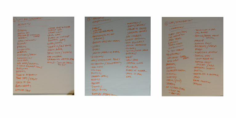
Our goal was to brainstrom current interactions that aren’t design or designed poorly and improve upon them. INTERACTION
DESIGNProject Assignment

Medical records
Geneology
Phone Books
City Info/ What to do
ATM
Self Checkout
Parking Meters
Communication During construction
Airport Security
Emergency room
Health care info
Currency
Car Dashboard
THELIST

After brainstorming the list of interactions, out of the list were voted to be picked to improve. From the smaller list, we split into teams to pick which interactions we wanted to design. We picked City/Navigation to combine into one problem. Then we brainstorm the AEIOU of city/navigation, which is the activities, enviroment, interactions, objects, and users.
AEIOUPHASE
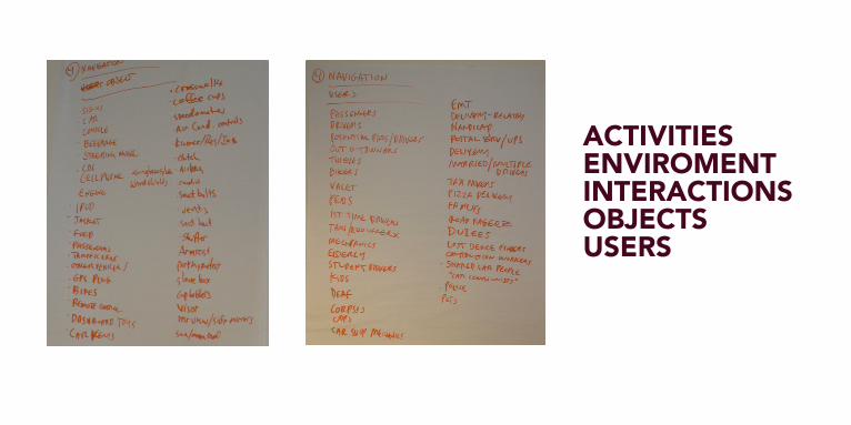
ACTIVITIESENVIROMENTINTERACTIONSOBJECTSUSERS


There is currently no personalizablenavigation system for seperate userswhen traveling and following directions.
THE PROBLEM


Create a personalizable, simplified navigation platform that is able to adapt to the different wayfinding needs of a wide variety of users.
OUR SOLUTION

During the research, we looked into different aspects of current navigation systems. We gathered information from different users by collecting them on survey monkey. From the research we found that these systems do not adapt to different types of learners.
THERESEARCH


Part of the research phase, we sent out a survey asking many questions of how one navigates, and which system they are using. These are the answers to the questions we have asked.
THE USERS
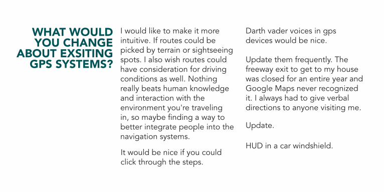
Update.
HUD in a car windshield.
Darth vader voices in gps devices would be nice.
I would like to make it more intuitive. If routes could be picked by terrain or sightseeing spots. I also wish routes could have consideration for driving conditions as well. Nothing really beats human knowledge and interaction with the environment you're traveling in, so maybe finding a way to better integrate people into the navigation systems.
Update them frequently. The freeway exit to get to my house was closed for an entire year and Google Maps never recognized it. I always had to give verbal directions to anyone visiting me.
It would be nice if you could click through the steps.
WHAT WOULD YOU CHANGE
ABOUT EXSITING GPS SYSTEMS?

Sometimes on googlemaps when you enter an address it has a really hard time finding that address.
In GPS and online maps such as mapquest/google maps, there is always a round about way they give you where it actually takes you longer.
I always thought it would be sweet if it was projected across your windshield and drew the lines on the road for you! that would be epic!
More intuitive, updated, and how a normal person drives, plus accurate.
I would make them faster at locating your vehicle while moving and have the maps easier to update without having to pay a lot of money.
There should be a "traffic/construction/detour" feature

GPS took me 5 miles along a road off of the highway considered as “shortcut”, but in reality, made me drive a 5 mile loop back onto the highway, setting me 2 miles behind where I originally turned off of the highway for the shortcut. And yes, it told me to turn off the highway again at the same spot.
I was late to a wedding this summer using a GPS. It kept trying to take us down a road that had been closed off (and was private to begin with). The GPS would not calculate an alternate route and we nearly missed the ceremony. When we received directions from someone in the wedding party, the other route was miles off from where the GPS wanted to lead us.
There is traffic. I tell tom tom to create “Alternate route” which takes me away from the traffic and then right back on to it. as opposed to taking me far away from the traffic and still close to my destination.
TELL US ABOUT A TIME YOU GOT
LOST USING A PHYSICAL MAP OR ANY GPS DEVICE.


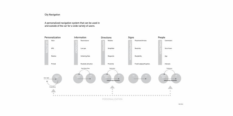
From the problem statement, we narrowed down the problem into a visual form.
THEDIAGRAMS

City Info/ Navagation | ProblemThere is no personal navigation system for separate users when traveling or following directions.
DrivingGetting gasFinding relevant thingsGPS voiceSelectingTime to destination Speed limitCataloging drive time
CarForestSuburbCityRoadStoresAlleysOne waysTunnels
Speed trapsVoice inputCigarette lightersThe carGPSOther carsToll Booths Getting help
CarGPS Steering wheelSpeedometers Coffee CupsVisorRadioAirbagCrosswalk
PassengerDriversTouristBikersValetKidsEMTDelivery Taxi driversCops
INTER
ACTION
OBJECTS
USER
S
ENVIR
ON
MEN
T
ACTIVITIES

user
simplify a car navigation system to make an users experience quick,simple, and efficent.
user
simplify a car navigation system to make an users experience quick,simple, and efficent.
USER
City Navigation
Matt Welch
A personalized navigation system that can be used in and outside of the car for a wide variety of users.
Personalization
PERSONALIZATION
GPS
Printed
User inputNAVIGATION
DEVICE
Accept/Deny
Relative
VoiceSELECTION
Low gas
Roadside attraction
Collecting Data
Road closure
Information
EFFICIENCY
Directions
Simpli�ed
Proximity
Waypoints
RelativeMA
PPING
Signs
Reactivity
Food/Lodging/Hospitals
Readability
Placement/ArrowsCOM
PREH
ENSIO
N
People
Out of town
Interests
Age
CommutersFAM
ILIAR
ITY
Destination
NAVIGATION DEVICE
NAVIGATION DEVICE
USER
De�ned through personalization
SIGN USER
Preference
NAVIGATION DEVICE
USER
De�ned through personalization
View/Select Data

Simpli�ed
Proximity
Waypoints
Relative
Reactivity
Necessities
Readability
Placement/ArrowsMain Point
Secondary
Link
Out of town
CommutersOut of TownAgeInterests
Commuters
Age
Interests
Voice
GPS
Relative
Printed
Low gas
Roadside attraction
Collecting Data
Road closure
People
Signs
Personalization
Directions
InformationCity Navigation


Our personas cover a wide variety of users ranging from age groups that have different learning styles of wayfinding.
THEPERSONAS

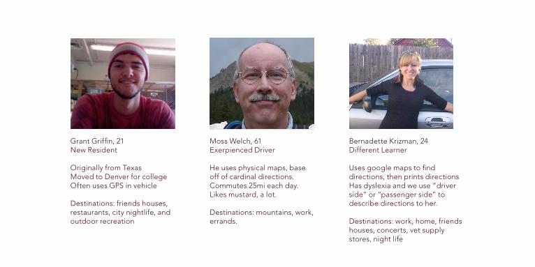
Grant Griffin21 years oldNew Resident
-Originally from Texas-Moved to Denver for College-Often uses GPS in his vehicle -Destinations: friends houses, restaurants, city nightlife, and outdoor recreation
Grant Griffin, 21New Resident
Originally from TexasMoved to Denver for collegeOften uses GPS in vehicle
Destinations: friends houses, restaurants, city nightlife, and outdoor recreation
Moss Welch, 61Exerpienced Driver
He uses physical maps, base off of cardinal directions.Commutes 25mi each day.Likes mustard, a lot.
Destinations: mountains, work, errands.
Bernadette Krizman, 24Different Learner Uses google maps to find directions, then prints directionsHas dyslexia and we use “driver side” or “passenger side” to describe directions to her.
Destinations: work, home, friends houses, concerts, vet supply stores, night life


We created visual diagrams that would help show the problem we are solving.PERSONA
DIAGRAMS
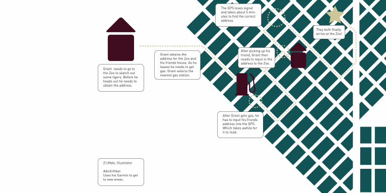
After picking up his friend, Grant then needs to reput in the address to the Zoo.
They both finally arrive at the Zoo!
The GPS loses signal and takes about 5 min-utes to find the correct address.
Grant needs to go to the Zoo to sketch out some tigers. Before he heads out he needs to obtain the address.
Grant obtains the address for the Zoo and his friends house. As he leaves he needs to get gas. Grant selects the nearest gas station.
21,Male, Illustrator
Advid Hiker.Uses his Garmin to get to new areas.
After Grant gets gas, he has to input his friends address into the GPS. Which takes awhile for it to read.
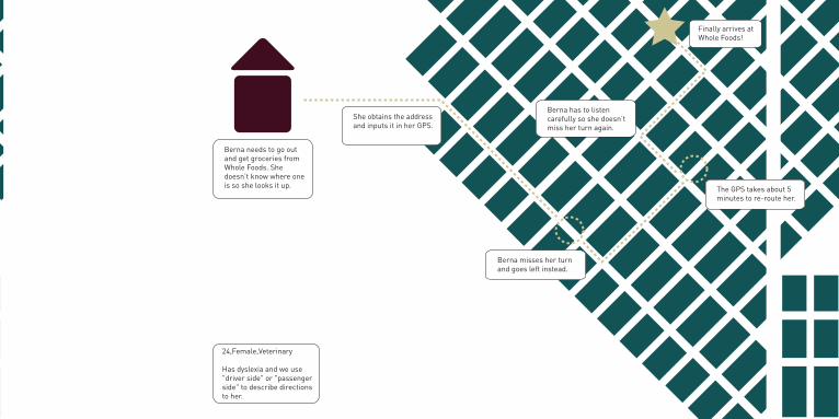
The GPS takes about 5 minutes to re-route her.
Finally arrives at Whole Foods!
Berna has to listen carefully so she doesn’t miss her turn again.
Berna misses her turn and goes left instead.
She obtains the address and inputs it in her GPS.
24,Female,Veterinary
Has dyslexia and we use "driver side" or "passenger side" to describe directions to her.
Berna needs to go out and get groceries from Whole Foods. She doesn’t know where one is so she looks it up.
After picking up his friend, Grant then needs to reput in the address to the Zoo.
They both finally arrive at the Zoo!
The GPS loses signal and takes about 5 min-utes to find the correct address.
Grant needs to go to the Zoo to sketch out some tigers. Before he heads out he needs to obtain the address.
Grant obtains the address for the Zoo and his friends house. As he leaves he needs to get gas. Grant selects the nearest gas station.
21,Male, Illustrator
Advid Hiker.Uses his Garmin to get to new areas.
After Grant gets gas, he has to input his friends address into the GPS. Which takes awhile for it to read.

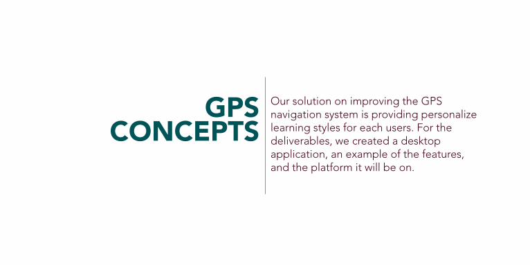
Our solution on improving the GPS navigation system is providing personalize learning styles for each users. For the deliverables, we created a desktop application, an example of the features, and the platform it will be on.
GPSCONCEPTS
WelcomeLicense AgreementInstallNavigation StyleInterestsCongratulations
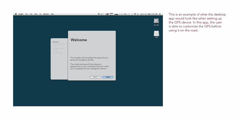
This installer will complete the setup of your personal navigation profile. The install process will also place an application on your computer that will notify you of updates for your navigation device.
Welcome
This is an example of what the desktop app would look like when setting up the GPS device. In this app, the user is able to customize the GPS before using it on the road.

Navigation StyleWelcomeLicense AgreementInstallNavigation StyleInterestsCongratulations
You are just 3 questions away from completing your personal navigation style.
What best describes where you live?
Rural Suburbs Big City
This is part of the settings, the user can pick different learning styles by surrounding areas.

WelcomeLicense AgreementInstallNavigation StyleInterestsCongratulations
Food
Movies
Music
Dancing
Art
Bars
Museums
Library
Outdoor Recreation
Sports
Theater
Coffee Shops
Bookstores
InterestsCompleting your profile with what interests you will allow your device to suggest new places to you, and remember your favorites.
What are some of your major interests?
These show the list of interest that the users can imput information. This is one of the setting that will be on the GPS device, when driving options will pop up and ask if you would like to go there. After it is installed, there is a feature that can provide a video walk through of the directions before driving.

This section will provide an understanding of how our GPS concept differ from current GPS systems now. It will provide the features of what it offers to different users of the device.
GPSFEATURES
1600 Pierce StreetLakewood, CO 80214-1466
444 S.Wadsworth BlvdLakewood, CO 80214-1466
1710 Robb. StreetLakewood, CO 80226-1466
1.work1.work2.store2.store3.home3.home
2
3
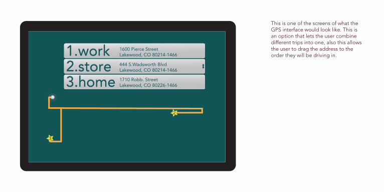
This is one of the screens of what the GPS interface would look like. This is an option that lets the user combine different trips into one, also this allows the user to drag the address to the order they will be driving in.
directions:directions:
turn passenger sideon colfaxturn passenger side on colfax
directionsdirections++
colfax
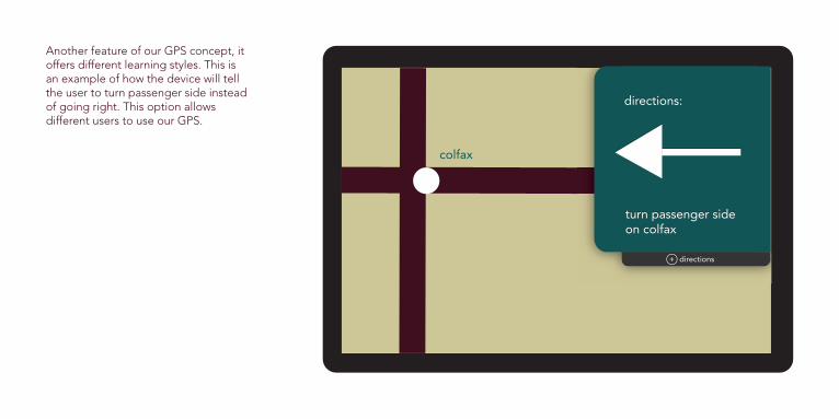
Another feature of our GPS concept, it offers different learning styles. This is an example of how the device will tell the user to turn passenger side instead of going right. This option allows different users to use our GPS.

Some users will be more used to using maps and navigating by using cardinal directions. The system accomdates there needs and provides a compass and a simple map to help them on their way.

7139 Otis CourtArvada, CO 800037139 Otis CourtArvada, CO 80003homehome
415 east 6th streetglenwood springs, co 81601415 east 6th streetglenwood springs, co 81601
glenwoodsprings
glenwood springs
This is the screen a user that prefers cardinal directions will see after inptting the address of their destination. The layout will always be oriented with top being north, the same way a physical ma would be.

This screen features the set of directions that a user preferring navigation by cardinal directons would see. directions:directions:
continue west on i-70continue west on i-70
Now travelling:Now travelling:
genesee park
idaho springs
directionsdirections++

+
Now travelling:Now travelling:
georgetown
directions:continue west on 1-70directions:continue west on 1-70
do you need tostop along the way?do you need to stop along the way?
Users are able to add directions on the fly by pressing the + directions button. If they would like to stop for gas, food or another attraction, the gps will re route and find the best way to get to the new destination.
georgetown
directions+
directions:continue west on 1-70
directionsdirectionsdirectionsdirections
directions:continue west on 1-70directions:directions:directions:continue west on 1-70continue west on 1-70continue west on 1-70
a new italian restaurant you maybe interested in just opened ingeorgetown.
Care to stop?
a new italian restaurant you may be interested in just opened in georgetown.
Care to stop?
yesyes nono savesave
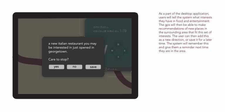
As a part of the desktop application, users will tell the system what interests they have in food and entertainment. The gps will then be able to make recommendations of new places in the surrounding area that fit this set of interests. The user can then add this as a new direction, or save it for a later time. The system will remember this and give them a reminder next time they are in the area.

glenwood springs
directionsdirections++
directions:continue west on 1-70directions:continue west on 1-70
This screen features the set of directions that a user preferring navigation by cardinal directons would see.

This is our platform of what the GPS would look like. This size is 4” by 5.75” This size is for the convience of carrying in and out of the car as well as putting this in a pocket.


This new GPS system is both easy to use and personalizable. It combines multiple features to safely custom fit any trip may it be short or long.
THECONCLUSION