persian gulf - arabian gulf - sea-seek.com · very shallow, with a maximum depth of 90 metres and...
TRANSCRIPT

Persian Gulf - Arabian Gulf
Sea - Seek
Ebook Sailing guide / Guide nautique
Persian Gulf - Arabian Gulf
Indian Ocean
November 2019
http://www.sea-seek.com November 2019
Persian Gulf - Arabian Gulf
Persian Gulf - Arabian Gulf
http://www.sea-seek.com November 2019

Persian Gulf - Arabian Gulf
Table of contents
Persian Gulf - Arabian Gulf ............................................................................... 1
1 - Doha Harbor Kuwait Bay.............................................................................. 3
2 - Al Kuwayt ....................................................................................................... 4
3 - Umm Qasr ....................................................................................................... 5
4 - Al Jubayl ......................................................................................................... 5
5 - King Abdul-Aziz Naval Base (KANB).......................................................... 6
6 - Ras Al Ghar .................................................................................................... 7
7 - Bandar dailam ................................................................................................ 7
8 - Dammam ......................................................................................................... 7
9 - Bahrain ............................................................................................................ 9
9.1 - Mina Salman port ................................................................................. 9
9.2 - Khawr al Qulayah Bahrain ................................................................. 10
10 - Bushehr........................................................................................................ 11
11 - Qatar............................................................................................................ 13
11.1 - Ras Laffan ........................................................................................ 13
11.2 - Ritz Marina Doha ............................................................................. 14
11.3 - Porto Arabia ..................................................................................... 15
11.4 - Four Seasons Luxury Marina ........................................................... 16
11.5 - Port of Doha ..................................................................................... 17
11.6 - Dhow Harbour.................................................................................. 17
12 - Banar dailam............................................................................................... 18
13 - UAE - Persian Gulf..................................................................................... 20
13.1 - Abu Dhabi Emirate........................................................................... 26
13.1.1 - Dalma island (Abu Dhabi) ................................................... 28
13.1.2 - Sir Bani Yas ......................................................................... 30
http://www.sea-seek.com November 2019

Persian Gulf - Arabian Gulf
13.1.3 - Das island (Abu Dhabi)........................................................ 32
13.1.4 - Al Futaisi island (Abu Dhabi) .............................................. 34
13.1.4.1 - Al Futaisi lighthouse ................................................ 36
13.1.5 - Marina Village - Abu Dhabi................................................. 36
13.1.6 - Lulu Island (Abu Dhabi) ...................................................... 39
13.1.7 - Mina Zayid (or Zayed) Port (Abu Dhabi) ............................ 40
13.1.8 - Dhow Harbor (Abu Dhabi) .................................................. 40
13.1.9 - Mina Fish Market (Abu Dhabi)........................................... 42
13.1.10 - Al Reem Island (Abu Dhabi) ............................................. 44
13.1.11 - Saadiyat island (Abu Dhabi) .............................................. 46
13.1.12 - Yas island (Abu Dhabi)...................................................... 48
13.1.12.1 - Yas marina and Yacht club (Abu Dhabi) ............... 49
13.2 - Dubai Emirate .................................................................................. 51
13.2.1 - Palm Jebel Ali (Dubai)......................................................... 53
13.2.2 - Jebel Ali Port........................................................................ 54
13.2.3 - Palm Jumeirah (Dubai)......................................................... 55
13.2.4 - Dubaï Marinas ..................................................................... 56
13.2.5 - World island (Dubai)............................................................ 58
13.2.6 - Palm Deira (Dubai) .............................................................. 60
13.2.7 - Mina Rachid port (Dubai) .................................................... 61
13.3 - Umm Al Qaywayn emirate .............................................................. 63
13.3.1 - Khwr Umm Al Qaywayn port ............................................. 64
13.4 - Ajman Emirate ................................................................................. 65
13.4.1 - Ajman port............................................................................ 66
13.4.2 - Al Hamriyah (Ajman) .......................................................... 67
13.5 - Sharjah Emirate ................................................................................ 69
13.5.1 - Khalid Port (Sharjah) .......................................................... 70
13.5.2 - Khor Fakkan port Sharjah .................................................... 71
http://www.sea-seek.com November 2019

Persian Gulf - Arabian Gulf
13.6 - Ras Al Khaimah Emirate W coast.................................................... 72
13.6.1 - Al Jazeera Port (Ras Al Khaimah) ....................................... 74
13.6.2 - Mina Saqr Port (Ras Al Khaimah) ....................................... 74
14 - Strait of Hormuz (Détroit d'Hormuz) ...................................................... 78
14.1 - Musandam ........................................................................................ 81
14.1.1 - Khawr Khasab ...................................................................... 82
15 - Bandar-e Shahid Reajie ............................................................................. 82
16 - Bandar Abbas ............................................................................................. 83

Persian Gulf - Arabian Gulf
Persian Gulf - Arabian Gulf 27°07.69 N51°43.41 E
Indian Ocean - Persian Gulf - Arabian Gulf
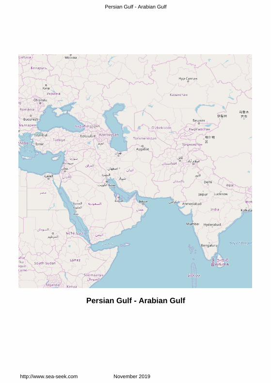
This inland sea of some 251,000 km² is connected to the Gulf of Oman in theeast by the Strait of Hormuz; and its western end is marked by the major riverdelta of the Shatt al-Arab, which carries the waters of the Euphrates and theTigris. Its length is 989 kilometres, with Iran covering most of the northern coastand Saudi Arabia most of the southern coast. The Persian Gulf is about 56kilometres wide at its narrowest, in the Strait of Hormuz. The waters are overallvery shallow, with a maximum depth of 90 metres and an average depth of 50metres.In the Persian Gulf, the sea makes up quickly and is characterized bychoppy waves, which are often all out of proportion to the wind force; the sea
http://www.sea-seek.com November 2019 Page:1

Persian Gulf - Arabian Gulf
quickly subsides after a gale.Countries with a coastline on the Persian Gulf are (clockwise, from the north):Iran, Oman (exclave of Musandam), United Arab Emirates, Saudi Arabia, Qataron a peninsula off the Saudi coast, Bahrain on an island, Kuwait and Iraq in thenorthwest.Various small islands lie within the Persian Gulf, some of which are the subject ofterritorial disputes between the states of the region.Persian Gulf is home to many small islands. Bahrain an island in the PersianGulf, is itself a Persian Gulf Arab state. Geographically the biggest island in thePersian Gulf is Qeshm island located in the Strait of Hormuz and belonging toIran. Other significant islands in the Persian Gulf include Greater Tunb, LesserTunb and Kish administered by Iran, Bubiyan administered by Kuwait, Taroutadministered by Saudi Arabia, and Dalma administered by UAE. In recent years,there has also been addition of artificial islands, often created by Arab states such as UAE for commercial reasons or as tourist resorts. Although very small, these artificial islands have had a negative impact on the mangrove habitats upon which they are built, often causing unpredicted environmental issues. Persian Gulf islands are often also historically significant having been used in the past by colonial powers such as thePortuguese and the British in their trade or as acquisitions for their empires.
Persian - Arabian Gulf
Le Golfe Persique est une merintérieure de 251 000 km qui est reliéeà la mer d'Oman à l'E par le détroitd'Ormuz. Son extrémité W esrmarquée par les grands delta du fleuvede Chatt al-Arab, qui transporte leseaux de l'Euphrate et le Tigris. Salongueur est de 989 km, avec l'Irancouvrant la plupart de la côte N et del'Arabie Saoudite la plupart de la côteS. Dans le Golfe Persique la mer selève rapidement
et se caractérise par des vagues courtes dont l'amplitude n'est pas en proportionavec la force du vent. La mer s'apaise rapidement après une tempête.Le golfe Persique est large d'environ 56 km dans sa partie la plus étroite, le
http://www.sea-seek.com November 2019 Page:2

Persian Gulf - Arabian Gulf
détroit d'Ormuz. Les eaux sont globalement très peu profonde avec uneprofondeur moyenne de 50 m et une profondeur maximale de 90 m.Les pays ayant un littoral sur le golfe persique sont, en partant du N: l'Iran, Oman(enclave de Musandam), les Emirats Arabes Unis, l'Arabie Saoudite, le Qatar surune presqu'ile de la côte saoudienne, Barhein, sur une île, le Koweït et l'Irak dansle NW.Diverses petites îles se trouvent dans le Golfe Persique, dont certaines fontl'objet de différents territoriaux entre les États de la région.Bahreïn une île dans le golfe Persique, est en soi un Golfe Persique État arabe.Géographiquement, la plus grande île du golfe Persique est l'île de Qeshm situéedans le détroit d'Ormuz et d'appartenance à l'Iran.D'autres îles importantes dans le golfe Persique comprennent la Grande Tumb ,Petite Tumb et de Kish administrée par l'Iran, Bubiyan administrée par le Koweït,Tarout administrée par l'Arabie saoudite, et Dalma administrée par les EAU.Ces dernières années, il y a des îles artificielles , souvent créés par des Étatsarabes tels que les EAU pour des raisons commerciales ou touristiques. Bien quetrès petites, ces îles artificielles ont eu un impact négatif sur la mangrove,habitats dont ils sont construits, causant souvent des problèmesenvironnementaux imprévus.
1 - Doha Harbor Kuwait Bay 29°23.03 N47°47.92 E
Indian Ocean - Persian Gulf - Arabian Gulf
http://www.sea-seek.com November 2019 Page:3

Persian Gulf - Arabian Gulf
Small port.
Petit port côtier.
2 - Al Kuwayt 29°21.10 N47°55.60 E
Indian Ocean - Persian Gulf - Arabian Gulf
Port.
Port côtier.
http://www.sea-seek.com November 2019 Page:4

Persian Gulf - Arabian Gulf
3 - Umm Qasr 30°01.31 N47°57.14 E
Indian Ocean - Persian Gulf - Arabian Gulf
Port .
Port .
4 - Al Jubayl 27°02.68 N49°41.36 E
Indian Ocean - Persian Gulf - Arabian Gulf
http://www.sea-seek.com November 2019 Page:5

Persian Gulf - Arabian Gulf
Small port protected by a breakwater. Petit port protégé par une digue.
5 - King Abdul-Aziz Naval Base (KANB) 26°58.26 N49°41.98 E
Indian Ocean - Persian Gulf - Arabian Gulf
King Abdul-Aziz Naval Base (KANB) is located just south of the steadilygrowing Jubail commercial port and industrial complex.KANB has extensivewaterfront operational and protective works, drydocking and shop repair facilities,a training complex for several hundred students in a variety of naval curricula,supply, public works, housing, community services, and other base supportbuildings to accommodate RSNF requirements.
http://www.sea-seek.com November 2019 Page:6
Persian Gulf - Arabian Gulf
6 - Ras Al Ghar 26°53.70 N49°51.53 E
Indian Ocean - Persian Gulf - Arabian Gulf
Small port protected by a breakwater. Petit port protégé par une digue.
7 - Bandar dailam 30°05.28 N50°04.21 E
Indian Ocean - Persian Gulf - Arabian Gulf
8 - Dammam 26°30.58 N50°11.63 E
Indian Ocean - Persian Gulf - Arabian Gulf
http://www.sea-seek.com November 2019 Page:7

Persian Gulf - Arabian Gulf
Dammam's King Abdulaziz Sea Port, located on the coast of the Persian Gulf,is the second largest port of Saudi Arabia. It has large equipment that allows it toreceive various types of vessels. The most important equipments are 56multi-purpose hoist, 8 container cranes, and 524 tanker containers. There are anumber of berths for ships and fishing, as well as ship repair yard. Port protégé par une digue.
http://www.sea-seek.com November 2019 Page:8

Persian Gulf - Arabian Gulf
9 - Bahrain 26°04.19 N50°31.81 E
Indian Ocean - Persian Gulf - Arabian Gulf - Bahrain
A Mina Salman port B Khawr al Qulayah Bahrain
minasalman port in bahrain
9.1 - Mina Salman port 26°12.12 N50°37.20 E
Indian Ocean - Persian Gulf - Arabian Gulf - Bahrain
http://www.sea-seek.com November 2019 Page:9

Persian Gulf - Arabian Gulf
At Mina Salman, the Deep WaterJetty, which
is 30m wide and 800m long, extends SE into Khawr al Qulayah and provides tenberths, each 150m in length. Berths 1, 3, 5, 7, and 9 are on the N side of thejetty, while Berths 2, 4, 6, 8, and 10 are on the S side of the jetty. ContainerTerminal Quay extends NE from the root of the Deep Water Jetty. Berths 11, 12,and 13, with a total length of 900m, handle grain and general cargo. Berths 15and 16, with a total length of 600m, handle container cargo.All berths have been dredged to a depth of 10.9m. Alongside depths are bestseen on the chart.It has been reported (2010) that cargo operations formerly conducted at thisfacility have been transferred to Khalifa Bin Salman port and that the berths willeventually be converted into a facility for the importation of construction material.Tel: +973 1735 9595Fax: +973 1735 9359Mail: [email protected]
9.2 - Khawr al Qulayah Bahrain 26°11.42 N50°37.89 E
http://www.sea-seek.com November 2019 Page:10

Persian Gulf - Arabian Gulf
Indian Ocean - Persian Gulf - Arabian Gulf - Bahrain
Khawr al Qulayah is an extensiveinlet circled by and containing reefs andother dangers best seen on the chart.A channel, with a least depth of 9.5m,leads through Khawr al Qulayah to abasin, with the same depth, off MinaSalman, although caution is necessary,as depths
of less than 5m have been reported (2000) on the S side of the channel in thevicinity of Buoy No. 12.A secondary channel, with a least depth of 9.7m, leads S of the main channel, butrejoins it at the basin.
10 - Bushehr 28°59.37 N50°50.29 E
Indian Ocean - Persian Gulf - Arabian Gulf
http://www.sea-seek.com November 2019 Page:11
Persian Gulf - Arabian Gulf
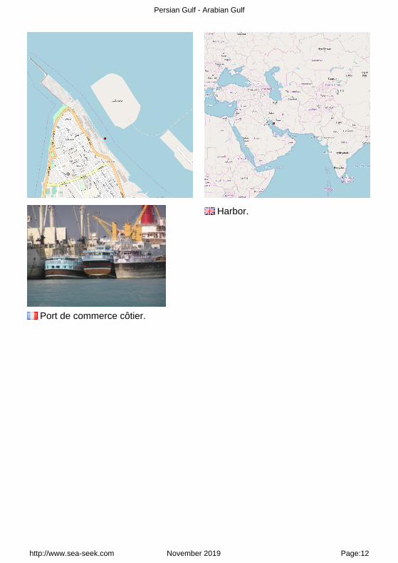
Harbor.
Port de commerce côtier.
http://www.sea-seek.com November 2019 Page:12
Persian Gulf - Arabian Gulf
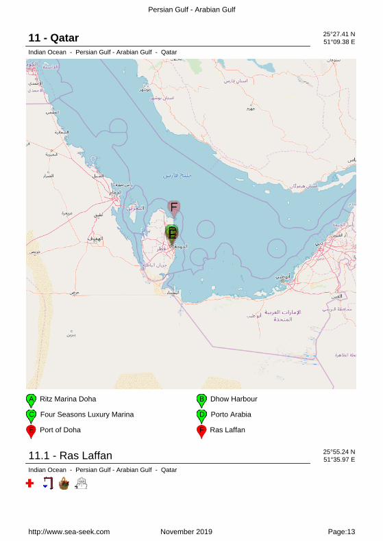
11 - Qatar 25°27.41 N51°09.38 E
Indian Ocean - Persian Gulf - Arabian Gulf - Qatar
A Ritz Marina Doha B Dhow Harbour
C Four Seasons Luxury Marina D Porto Arabia
E Port of Doha F Ras Laffan
11.1 - Ras Laffan 25°55.24 N51°35.97 E
Indian Ocean - Persian Gulf - Arabian Gulf - Qatar
http://www.sea-seek.com November 2019 Page:13

Persian Gulf - Arabian Gulf
Harbor protected by a breakwater. Port de commerce protégé par une digue.
11.2 - Ritz Marina Doha 25°22.84 N51°32.01 E
Indian Ocean - Persian Gulf - Arabian Gulf - Qatar
http://www.sea-seek.com November 2019 Page:14

Persian Gulf - Arabian Gulf
Ritz Marina Small marina close to theRitz-Carlton Hotel.
11.3 - Porto Arabia 25°21.90 N51°32.52 E
Indian Ocean - Persian Gulf - Arabian Gulf - Qatar
2011:10:12 12:41:21
Port entrance2014:03:24 10:56:02
Porto Arabia is part of The Pearl-Qatar, an
artificial island spanning nearly four million square metres.All around a lot of restaurants and luxury shops. No shipshandler or shipyard
http://www.sea-seek.com November 2019 Page:15

Persian Gulf - Arabian Gulf
facilities.
Vue la dimension du port, un navette l'après midipermet de passer d'un bord à l'autre.2012:03:25 16:11:18
Pannes dans la partie NW du port.2012:03:25 16:30:47
2014:03:24 11:46:28
2014:03:24 11:35:12
Porto Arabia est la plus grande marina des trois que composel'île artificielle Pearl Qatar situé à 19 kmau nord du centre ville de Doha, dans lalagune de West Bay. Cette marina
de luxe est bordée tout autour par de grands et très luxueux immeubles avec unepromenade de 2,5 km au nom évocateur La Croisette !!A terme elle offrira des centaines de places de port. Tout autour de nombreuxmagasins de luxe et pas de shipshandlers ou chantiers...
11.4 - Four Seasons Luxury Marina 25°19.45 N51°32.45 E
Indian Ocean - Persian Gulf - Arabian Gulf - Qatar
http://www.sea-seek.com November 2019 Page:16

Persian Gulf - Arabian Gulf
Doha Diplomatic Area Doha
11.5 - Port of Doha 25°18.21 N51°33.24 E
Indian Ocean - Persian Gulf - Arabian Gulf - Qatar
11.6 - Dhow Harbour 25°17.66 N51°32.04 E
http://www.sea-seek.com November 2019 Page:17

Persian Gulf - Arabian Gulf
Indian Ocean - Persian Gulf - Arabian Gulf - Qatar
Fishing harbour.2012:03:25 05:02:46
2014:03:23 14:52:34
12 - Banar dailam 26°44.44 N52°57.57 E
Indian Ocean - Persian Gulf - Arabian Gulf
http://www.sea-seek.com November 2019 Page:18

Persian Gulf - Arabian Gulf
http://www.sea-seek.com November 2019 Page:19

Persian Gulf - Arabian Gulf
13 - UAE - Persian Gulf 24°56.09 N53°44.21 E
Indian Ocean - Persian Gulf - Arabian Gulf - UAE - Persian Gulf
The approaches to the S coast of the Persian Gulf are generally shallow, witha few offshore reefs and islands. Inside the 40m curve, which comprises roughlythe area of Great Pearl Bank, the depths are irregular because of the reefs andshoals which extend offshore for many miles and bar access to the coast, exceptat a few points.The coastline is only partially surveyed, and some shoals and reefs are reportedto be uncharted. Coral reefs and rocks, however,are generally discernible as darkpatches, and sand bars and shoals can be easily identified as yellowish greenpatches near the shore area. The bottom is usually visible in depths of 6.5 to
http://www.sea-seek.com November 2019 Page:20

Persian Gulf - Arabian Gulf
9.2m.The prevailing wind is the NW shamal, but in winter it is often interrupted bywinds from varying directions. Squalls are common throughout the year. A highdegree of refraction or mirage occurs along all of this coast, especially in the earlymorning. The land features become greatly distorted, villages sometimes appearas clumps of rounded trees, and small uncharted hillocks or dunes assume aconsiderable height.The whole of the coastal strip is desert plain, with a few small isolated hills andscattered tablelands, and is backed by alternating regions of drifting sand andpatches of rock and salt flats. There are many salt creeks and tidal backwaters,the entrances of which are often changed by the wind, swell, and tidal scour.The towns are all very similar in appearance. Because of the hard bottom inmany places, anchorage off the whole E portion of the Trucial Coast is poor. Onthe approach of a winter shamal, which in this vicinity blows from WNW or evenfrom W, vessels should leave their anchorage. In winter, vessels should anchorfarther offshore than in summer.The UAE are a federation of 7 emirates: Abu Dhabi, Ajman, Dubai, Fujairah, Rasal-Khaimah, Sharjah and Umm al -Quwain. There are situated between ArabianGulf and Oman Gulf. The capital is Abu Dhabi, which is also the state's center ofpolitical, industrial, and cultural activities.Its oil reserves are ranked as the world's sixth-largest and the UAE possessesone of the most-developed economies in West Asia.
Weather:The prevailing wind during the summer months is the NW shamal, but betweenOctober and March, the shamal is often interrupted by the SE kaus, the NE nashi,or the SW suahili.From June to September, the shamal blows over the whole area of the PersianGulf, producing rough seas, stirring up dust clouds that affect visibility at sea, andreaching a considerable force which lasts for several days at a time.Winter storms which pass through the gulf region are generally preceded by Swinds and seas, which usually veer to NW behind the storm.Cold fronts occasionally penetrate the area with these storms, accompanied bysqualls and seas of variable direction, and are followed by a shamal. Summerwinds and seas seldom vary from a NW direction.The climate of the Arabian Peninsula as a whole is dry and hot. Average annualrainfall is minimal, except in some of the higher areas. Precipitation is erratic; longdroughts are common but may be broken by intense downpours which result in
http://www.sea-seek.com November 2019 Page:21

Persian Gulf - Arabian Gulf
flash floods.Temperatures are moderate in winter but high in summer and are reportedextremely high in the interior on summer afternoons.Evening temperatures are low enough to offer relief from oppressive daytimeheat.Relative humidity at coastal locations is high throughout the year; it is greatest inthe early morning and lowest in the afternoon, except at some places on thecoast, where the afternoon sea breezes bring moist and cooler air over the landarea.
Tides - Currents:The currents in the Persian Gulf have a predominantly counterclockwisecirculation throughout the year. In that part of the gulf covered by this sector,there are sometime strong currents in the SE part which set between NE and E,especially in January and in April, May, and June.Their speed has been observed to be from 0.4 to 0.8 knot in January, and from0.6 knot to 1.7 knots in April. Through the Strait of Hormuz there is a distinctinward flow from the Gulf of Oman during the Southwest Monsoon and a slightoutward flow during the remainder of the year.In the latter period, some water continues to flow into the Persian Gulf, but thesecurrents trend more to the N side of the gulf. Any notable local peculiarities intides and currents are described with the related features.Caution.?Several offshore oil fields are located within the area covered by thissector, some offering offshore petroleum berths and some lying within chartedlimits or restricted areas.Caution should be exercised when navigating within the vicinity of these oil fieldsas production platforms, submarine pipelines, and various other hazards, bothabove and belowwater, may be present.
UAE - Persian Gulf
Les approches de la côte Sud dugolfe Persique sont généralement peuprofondes, avec quelques récifs et îles.A l'intérieur de la courbe de 40m, quicomprend à peu près la superficie de"Great Pearl Bank", les profondeurssont irrégulières, à cause des récifs etbancs de sable qui s'étendent au largeà plusieurs miles et interdisent l'accès
http://www.sea-seek.com November 2019 Page:22

Persian Gulf - Arabian Gulf
à la côte, sauf à quelques points.Le littoral n'est que partiellement surveillé, et certains écueils et récifs ne sont pasindiqués sur les cartes. Les récifs de corail et de roches, cependant, sontgénéralement perceptibles comme des taches sombres, et des bancs de sable etles bancs peuvent être facilement identifiés comme des taches verts jaunâtres, àproximité de la zone côtière. Le fond est généralement visible à des profondeursde 6,5 à 9,2 m.Le vent dominant est le Shamal (vent du NW), mais en hiver il est souventinterrompu par des vents venant de directions différentes. Les bourrasques sontfréquentes toute l'année.Un haut degré de réfraction ou mirage se produit le long de toute cette côte,surtout en début de matinée. Le sol est très déformé, des villages apparaissentparfois comme des bouquets d'arbres arrondis et des petites buttes inexploréesou des dunes sont d'une hauteur considérable.L'ensemble de la bande côtière est formée de plaine désertique, avec quelquespetites collines isolées et des plateaux épars, à l'arrière on trouve une alternancede régions de plaques de sable, de roches et de marais salants. Il y a denombreuses criques de sel et de marigots de marée, les entrées de ceux-ci sontsouvent modifiées par le vent, la houle, et la marée.Les villes sont toutes très semblables en apparence. A cause du fond dur dansde nombreux endroits, le mouillage au large de la partie E de l'ensemble du CôteTrucial est rare. À l'approche d'un Shamal d'hiver, qui dans ce secteur souffle duWNW, les navires doivent quitter leur ancrage. En hiver, les navires doiventmouiller plus au large que l'été.Les UAE sont un état fédéral, créé en 1971, qui regroupe 7 émirats: ceux d'AbouDhabi, d'Ajman, de Charjah, de Dubai, de Fujaïrah, de Ras el Khaïmah etd'Oumn al Qaïwaïn. Ils sont situés entre le golfe Persique et le golfe d'Oman.L'enclave omanaise de Madha qui se situe dans les montagnes à l'E du paysabrite elle-même le village émiratie de Nahwa.La ville d'Abou dDhabi est la capitale politique du pays.Les émirats sont l'un des plus importants producteurs et exportateurs de pétrole.Les principales réserves gazières et pétrolières sont dans l'émirat d'Abou Dabi,qui fut déjà membre de l'Organisation des pays exportateurs de pétrole avant lacréation de la fédération.L'émirat de Dubaï, s'est lui tourné depuis quelques années vers de nouvelles ressources telles que les ports francs, les nouvelles technologies mais surtout le tourisme de luxe. La ville de Dubaï est d'ailleurs
http://www.sea-seek.com November 2019 Page:23

Persian Gulf - Arabian Gulf
devenue la capitale économique de la fédération.
MÉTÉO:Le vent dominant pendant les mois d'été est le Shamal NW, mais entre Octobreet Mars, le Shamal est souvent interrompu par le Kaus SE, le Nashi NE, ou leSuahili SW.De Juin à Septembre, le Shamal souffle sur toute la région du golfe Persique, enproduisant des mers agitées, en provoquant des nuages ??de poussière quiaffectent la visibilité en mer, et atteint une force considérable qui dure pendantplusieurs jours.Les tempêtes d'hiver qui traversent la région du Golfe sont généralementprécédées par des vents, qui habituellement se déportent vers le NW derrière latempête.Les fronts froids occasionnellement pénètrent dans la zone avec ces tempêtes,accompagnés de rafales et d'une mer de direction variable, et sont suivis par unShamal. Les vents et les mers d'été varient rarement d'une direction NO.Le climat de la péninsule arabique dans son ensemble est sec et chaud. Lesprécipitations moyennes annuelles sont minimes, sauf dans certaines des zonesles plus élevés. Les précipitations sont irrégulières; de longues sécheresses sontfréquentes, mais peuvent être brisées par des averses intenses qui entraînentdes crues soudaines.Les températures sont modérées en hiver, mais haute en été et sontextrêmement élevées à l'intérieur les après-midis d'été.En soirée les températures sont suffisamment basses pour offrir un soulagementpar rapport à la chaleur diurne oppressante.L'humidité relative à des endroits du littoral est élevée toute l'année, elle est plusforte en début de matinée et plus faible dans l'après-midi, sauf à certains endroitssur la côte, où les brises de mer d'après-midi, amènent de l'air humide et plusfrais sur le pays.
Marées - Courants:Les courants dans le golfe Persique ont une circulation principalement antihorairetoute l'année. Dans cette partie du golfe couverts par ce secteur, il y a descourants parfois forts dans la partie sud qui s'établissent entre le NE et l'E, enparticulier en Janvier et en avril, mai et Juin.Leur vitesse est de 0.4 à 0,8 n?ud en Janvier, et de 0,6 n?ud à 1,7 n?uds enavril. Dans le détroit d'Ormuz il y a un flux distincts vers l'intérieur du golfed'Oman lors de la mousson et un léger écoulement vers l'extérieur pendant lereste de l'année.
http://www.sea-seek.com November 2019 Page:24

Persian Gulf - Arabian Gulf
Dans la dernière période, un peu d'eau continue à couler dans le golfe Persique,mais ces courants se rencontrent plus vers le côté N du golfe.Attention.-Plusieurs sites d'exploitation de pétrole au large sont situés dans lazone couverte par ce secteur, certaines offrent des places aux pétroliers etcertaines se trouvent dans des zones réglementées.Il faut être prudent lorsque vous naviguez dans le voisinage de ces plates-formesde production de pétrole, les pipelines sous-marins, et divers autres dangers, suret sous l'eau, peuvent être présents.
http://www.sea-seek.com November 2019 Page:25

Persian Gulf - Arabian Gulf
13.1 - Abu Dhabi Emirate 24°24.60 N53°48.24 E
Indian Ocean - Persian Gulf - Arabian Gulf - UAE - Persian Gulf - Abu Dhabi Emirate
A Dalma island (Abu Dhabi) B Sir Bani Yas
C Das island (Abu Dhabi) D Al Futaisi island (Abu Dhabi)
E Al Futaisi lighthouse F Marina Village - Abu Dhabi
G Lulu Island (Abu Dhabi) H Mina Zayid (or Zayed) Port (Abu Dhabi)
J Dhow Harbor (Abu Dhabi) K Mina Fish Market (Abu Dhabi)
L Al Reem Island (Abu Dhabi) M Saadiyat island (Abu Dhabi)
N Yas island (Abu Dhabi) O Yas marina and Yacht club (Abu Dhabi)
http://www.sea-seek.com November 2019 Page:26

Persian Gulf - Arabian Gulf
Abu Dhabi EmirateAccess Restrictions2015:02:21 16:13:22
Abu Dhabi Emirat
Abu Dhabi is the seat of federalgovernment and the country?s capital, and haven for some of the world?sbiggest oil-producing companies and most luxurious hotels and sportingfacilities.
Abu Zaby (or Abu Dhabi), located on Abu Zaby Island, lies about 45 miles SW ofMina Jabal Ali. Besides serving as a port, the city also functions as the capital ofthe United Arab Emirates.Abu Dhabi city is the head office of the president of the state and the government, and the headquarter of foreign embassies, oil and commercial companies. Located less than 250 metres from the mainland, Abu Dhabi is anisland joined to the mainland by the Maqta and Mussafah Bridges. Yet, the cityhas many growing suburbs on the mainland.Abu Dhabi emirate is an archipelago where nearly 200 islands are strewn alongits coast.With the longest coast line in the UAE, Abu Dhabi has a large number of offshoreislands. Several of the larger islands close to the city of Abu Dhabi are beingdeveloped as leisure, business, and residential areas. The most known islands inthe Emirate are: Lulu Island, Saadiyat Island, Al Reem Island, Yas Island, DasIsland, Dalma Island and Al Futaisi Island.The majority of the islands are flat, sandy and uninhabited, but each has its own character. Futaisi Island, a 10 minute boat ride south of Abu Dhabi, has a long history and is packed with interesting flora and fauna. Both Saadiyat and Yas islands have a range of exciting facilities and attractions
http://www.sea-seek.com November 2019 Page:27

Persian Gulf - Arabian Gulf
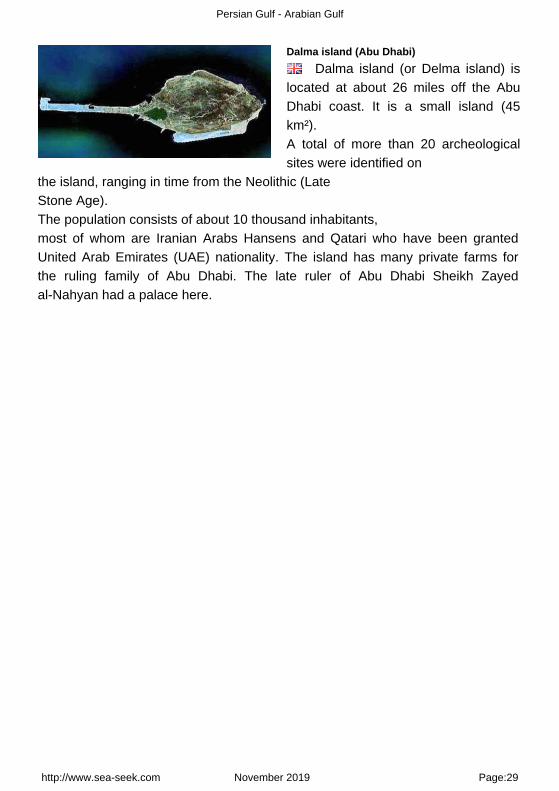
13.1.1 - Dalma island (Abu Dhabi) 24°01.20 N52°31.30 E
Indian Ocean - Persian Gulf - Arabian Gulf - UAE - Persian Gulf - Abu Dhabi Emirate - Dalma island (AbuDhabi)
163
Dalma island (Abu Dhabi)2008:02:11 11:32:51
http://www.sea-seek.com November 2019 Page:28
Persian Gulf - Arabian Gulf
Dalma island (Abu Dhabi)
Dalma island (or Delma island) islocated at about 26 miles off the AbuDhabi coast. It is a small island (45km²).A total of more than 20 archeologicalsites were identified on
the island, ranging in time from the Neolithic (Late Stone Age).The population consists of about 10 thousand inhabitants, most of whom are Iranian Arabs Hansens and Qatari who have been grantedUnited Arab Emirates (UAE) nationality. The island has many private farms forthe ruling family of Abu Dhabi. The late ruler of Abu Dhabi Sheikh Zayedal-Nahyan had a palace here.
http://www.sea-seek.com November 2019 Page:29

Persian Gulf - Arabian Gulf
13.1.2 - Sir Bani Yas 24°18.82 N52°36.74 E
Indian Ocean - Persian Gulf - Arabian Gulf - UAE - Persian Gulf - Abu Dhabi Emirate - Sir Bani Yas
160
Wildlife reservehome to many species, from Arabian oryx, gazelle and deer to giraffes, dolphinsand sea turtles.
http://www.sea-seek.com November 2019 Page:30

Persian Gulf - Arabian Gulf
Sir Bani Yas
Réserve naturelle crée en 1971. Ony trouve de nombreux mammifères etplantes de la région arabique.
http://www.sea-seek.com November 2019 Page:31

Persian Gulf - Arabian Gulf
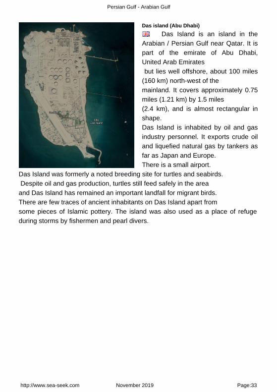
13.1.3 - Das island (Abu Dhabi) 25°09.04 N52°52.63 E
Indian Ocean - Persian Gulf - Arabian Gulf - UAE - Persian Gulf - Abu Dhabi Emirate - Das island (Abu Dhabi)
160
Aptem no 875077
http://www.sea-seek.com November 2019 Page:32
Persian Gulf - Arabian Gulf
Das island (Abu Dhabi)
Das Island is an island in theArabian / Persian Gulf near Qatar. It ispart of the emirate of Abu Dhabi,United Arab Emirates but lies well offshore, about 100 miles(160 km) north-west of the mainland. It covers approximately 0.75miles (1.21 km) by 1.5 miles (2.4 km), and is almost rectangular inshape.Das Island is inhabited by oil and gasindustry personnel. It exports crude oiland liquefied natural gas by tankers asfar as Japan and Europe.There is a small airport.
Das Island was formerly a noted breeding site for turtles and seabirds. Despite oil and gas production, turtles still feed safely in the area and Das Island has remained an important landfall for migrant birds. There are few traces of ancient inhabitants on Das Island apart from some pieces of Islamic pottery. The island was also used as a place of refugeduring storms by fishermen and pearl divers.
http://www.sea-seek.com November 2019 Page:33

Persian Gulf - Arabian Gulf
13.1.4 - Al Futaisi island (Abu Dhabi) 24°21.22 N54°19.37 E
Indian Ocean - Persian Gulf - Arabian Gulf - UAE - Persian Gulf - Abu Dhabi Emirate - Al Futaisi island (AbuDhabi)
A Al Futaisi lighthouse
http://www.sea-seek.com November 2019 Page:34

Persian Gulf - Arabian Gulf
Al Futaisi island (Abu Dhabi)
The authentic Arabian fort is a majorattraction on the island. It is built out oftraditional materials such as mudbricks. The fort provides a uniquesetting for banquets and parties.
Al Futaisi island (Abu Dhabi) Al Futaisi island (Abu Dhabi) The island of Futaisi lies in the lee ofthe barrier island of Bahrani, in a shallow sheltered lagoonal complex to the southwest of Abu Dhabi island.Some 10 kilometres long and 5 kilometres wide, it has a mosaic of different coastal habitats, including wind-blown sand and shell sands, wind-scoured rocky outcrops, sabkha (salt flats), intertidal flats and mangrove.As a consequence, despite the absence of any fresh water, the island supports a diverse flora and fauna. Sub-tidally there are seagrass beds over which small numbers of dugong (Dugong dugon), still to be found in the area, graze without threat.Nowadays this island has become a weekend resort destination.The island offers a beautiful beach and an unspoiled island to explore. the main attraction is an old fort made of mud brick (too bad that it's locked).The entire sea area around the Island is very shallow, boat access is difficult and this has ensured that most of the Island remains quiet and undisturbed, creating a very effective wildlife sanctuary over the
http://www.sea-seek.com November 2019 Page:35

Persian Gulf - Arabian Gulf
greater part of the island.
13.1.4.1 - Al Futaisi lighthouse 24°23.66 N54°18.48 E
Indian Ocean - Persian Gulf - Arabian Gulf - UAE - Persian Gulf - Abu Dhabi Emirate - Al Futaisi island (AbuDhabi)
Al Futaisi island has a beautifullighthouse on its NE coast.
13.1.5 - Marina Village - Abu Dhabi 24°28.53 N54°19.57 E
Indian Ocean - Persian Gulf - Arabian Gulf - UAE - Persian Gulf - Abu Dhabi Emirate
http://www.sea-seek.com November 2019 Page:36

Persian Gulf - Arabian Gulf
View from Marina Village
Access restrictions2015:02:21 16:13:22
Port de plaisance au pied du centrecommercial "Marina Mall" avec la vuesur la ville d'Abu Dhabi. Lieu ou setrouve l' Abu Dhabi Yacht Club.
http://www.sea-seek.com November 2019 Page:37

Persian Gulf - Arabian Gulf
Abu Dhabi Yacht Club2015:02:21 15:58:37
South East habour.
Abu Dhabi Yacht Club location inthis marina.
http://www.sea-seek.com November 2019 Page:38
Persian Gulf - Arabian Gulf
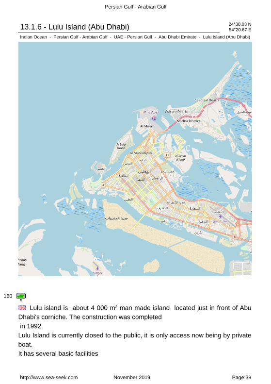
13.1.6 - Lulu Island (Abu Dhabi) 24°30.03 N54°20.67 E
Indian Ocean - Persian Gulf - Arabian Gulf - UAE - Persian Gulf - Abu Dhabi Emirate - Lulu Island (Abu Dhabi)
160
Lulu island is about 4 000 m² man made island located just in front of AbuDhabi's corniche. The construction was completed in 1992.Lulu Island is currently closed to the public, it is only access now being by privateboat.It has several basic facilities
http://www.sea-seek.com November 2019 Page:39

Persian Gulf - Arabian Gulf
such as public beaches, fresh water lake, some playing parks, cafetarias and sport space. It is surounded by extensive white beach.
Lulu Island (Abu Dhabi)
L'île Lulu est une île artificielle de4000 m² environ, située juste en facede la corniche d'Abu Dhabi.Saconstruction a été complétée en 1992.
Lulu island est actuellement fermée au public, elle est seulement accessible parbateaux privés.Elle a de nombreux services tels que plages publics, lac d'eau fraîche, quelquesparcs d'attraction, des céfétérias et des espaces sportifs.Elle est entourée par de grandes plages blanches.
13.1.7 - Mina Zayid (or Zayed) Port (Abu Dhabi) 24°32.04 N54°21.84 E
Indian Ocean - Persian Gulf - Arabian Gulf - UAE - Persian Gulf - Abu Dhabi Emirate
canal 9, 67
13.1.8 - Dhow Harbor (Abu Dhabi) 24°30.86 N54°22.29 E
Indian Ocean - Persian Gulf - Arabian Gulf - UAE - Persian Gulf - Abu Dhabi Emirate
canal 9, 67 market
http://www.sea-seek.com November 2019 Page:40

Persian Gulf - Arabian Gulf
2013:02:21 15:43:32 The Dhow Harbour in Abu Dhabi, islocated in close proximity toMina Zayed, has been developed as a Free Port for oil rigs supply vessels, buoys tug boats as well as traditional Arab dhows and launches for prompting active trade between Abu Dhabi and the Gulf countries, the Indian Sub-Continent, East Africa and most parts of the Middle East.All the berths have independent fresh water connections. Three fuel stations owned and administered by ADNOC-Fod provided necessary fuel for the users. The Free Port operates round-the-clock and is fully equipped with all the necessary equipment essential for normal handling of goods in the harbor. Handling equipment, when required, is supplied by the Seaport Authority.Dhow Harbor is approached through a buoyed channel leading N of a detachedbreakwater, the N end of which is located about 2 miles SW of Mina Zayedharbor entrance. Both the channel and basin are dredged to a depth of 6m.Municipality Port, with a dredged depth (2008) of 6m and has been constructed
http://www.sea-seek.com November 2019 Page:41

Persian Gulf - Arabian Gulf
within reclaimed land located E of the entrance channel to Dhow Harbor.Sea Wing Access Channel has been reclaimed and is no longer in use. A powercable, with a vertical clearance of 60m, crosses Khawr al Bighal close SE of itsjunction with the nowclosed Sea Wing Access Channel.A bridge to connect Abu Zaby Island and Jazirat as Sadiyat is under construction(2007) across Khawr al Bighal, in approximate position 24°31'20.4''N,54°24'09.0''E. The dredged channel in this vicinity has been reduced to a width of115m and is marked by lighted buoys.No traffic is permitted outside these buoys.The maximum vertical clearance available due to this construction is 19m,although it should be noted that the following transit limitations have beenreported (2009) to be in effect:1. Maximum allowable air draft within 40m of the centerline at high water?25m.2. Maximum allowable air draft within 40m of the centerline at low water?26m.3. All vessels needing to transit under the bridge are required to report their airdraft to Mina Zayed Port Control and receive permission prior to passing underthe bridge.
13.1.9 - Mina Fish Market (Abu Dhabi) 24°30.74 N54°22.52 E
Indian Ocean - Persian Gulf - Arabian Gulf - UAE - Persian Gulf - Abu Dhabi Emirate
http://www.sea-seek.com November 2019 Page:42

Persian Gulf - Arabian Gulf
2011:09:27 09:17:10
http://www.sea-seek.com November 2019 Page:43

Persian Gulf - Arabian Gulf
13.1.10 - Al Reem Island (Abu Dhabi) 24°29.50 N54°24.50 E
Indian Ocean - Persian Gulf - Arabian Gulf - UAE - Persian Gulf - Abu Dhabi Emirate - Al Reem Island (AbuDhabi)
163
http://www.sea-seek.com November 2019 Page:44

Persian Gulf - Arabian Gulf
Al Reem Island (Abu Dhabi)
Al Reem Island, a natural island 600meters off the northeastern coast of Abu Dhabiisland.It is the first free zones in Abu Dhabi, where foreign nationalities can buyproperty as leasehold.Reem island will be easily accessiblevia 9
bridges that will link it to Abu Dhabi, Sowwah Island and Saadiyat Island.
http://www.sea-seek.com November 2019 Page:45

Persian Gulf - Arabian Gulf
13.1.11 - Saadiyat island (Abu Dhabi) 24°32.39 N54°26.18 E
Indian Ocean - Persian Gulf - Arabian Gulf - UAE - Persian Gulf - Abu Dhabi Emirate - Saadiyat island (AbuDhabi)
163
Saadiyat Island is a large, low lying island of 27 km², 500 metres off the coastof Abu Dhabi island to be developed.Saadiyat Island?s Cultural District will house the world?s largest singleconcentration of premier cultural assets, including the Lord NormanFoster-designed Zayed National Museum, the Louvre Abu Dhabi and Frank Gehry-conceived Guggenheim Abu Dhabi. A
http://www.sea-seek.com November 2019 Page:46

Persian Gulf - Arabian Gulf
performing arts centre and a maritime museum will add to the portfolio of leading cultural institutions, all of which have been designed by Pritzker prize-winners.
Zoned into seven distinct districts featuring diverse offerings, Saadiyat, a natural island, will be a multifaceted destination. Already the island features the magnificent, shore-line Saadiyat Beach Golf Club and a modern exhibition centre and is readying for the opening of a luxurious beach club and two, fabulous ocean-view resorts.
http://www.sea-seek.com November 2019 Page:47

Persian Gulf - Arabian Gulf
13.1.12 - Yas island (Abu Dhabi) 24°29.23 N54°36.20 E
Indian Ocean - Persian Gulf - Arabian Gulf - UAE - Persian Gulf - Abu Dhabi Emirate - Yas island (Abu Dhabi)
A Yas marina and Yacht club (Abu Dhabi)
http://www.sea-seek.com November 2019 Page:48

Persian Gulf - Arabian Gulf
Yas island (Abu Dhabi)
Yas island (Abu Dhabi) Just off Abu Dhabi city, thisemerging entertainment destinationis within a 30 minute drive of the UAE capital and 50 minutes from Dubai. Here you'll find the fabulous Yas Marina Circuit - the world class motor sports race track which hosts the annual Formula 1ª Etihad Airways Abu Dhabi Grand Prix, the stunning Yas Marina with its superb Yacht Club, the Yas Links Abu Dhabi Golf Course, Ferrari World Abu Dhabi and seven new hotels, including the breathtaking signature Yas Hotel - the only one in the world straddling an F1? race track.The natural island occupies a total land area of 2,500 hectares.The marina of Yas island is at the S extremity of it.
13.1.12.1 - Yas marina and Yacht club (Abu Dhabi) 24°28.03 N54°36.47 E
Indian Ocean - Persian Gulf - Arabian Gulf - UAE - Persian Gulf - Abu Dhabi Emirate - Yas island (Abu Dhabi)
http://www.sea-seek.com November 2019 Page:49

Persian Gulf - Arabian Gulf
Located at the heart of Yas MarinaCircuit, the marina has a capacity for 143 yachts from 10m to 90m, andadditional visitor berthing for superyachts up to 150m.Mail: [email protected]:* Enter Abu Dhabi inner-coastal waters at Mina Zayed and transit southeast through the Um Al Nar Channel (also known as Khawr al Bighal).* Continue along that same course for approximately 6.0 n.m., and enter the North Sammaliyah Channel at the intersection of Jazirat Balrimayd Island and Jazirat as Al Sammaliyah Island.* NOTE: Take care at the intersection of the two channels, do not ?cut the corner?, the inside of the turn is extremely shallow and care should be taken not to leave the marked channels.* Continue within the Channel bearing south-southeast, until passing ?Little YasIsland? on your port side.* Turn east into Airport Channel (along Al Raha Beach, noting the Al Raha Beach Hotel and Al Bandar Marina on your starboard side), leaving the concrete sea wall along the south end of Yas Island on your port side. Please note that Yas Southern Marina is under construction.* Please refer to Admiralty Chart No. 3715 - United Arab Emirates, Abu Dhabi& Umm Al Nar.
http://www.sea-seek.com November 2019 Page:50

Persian Gulf - Arabian Gulf
13.2 - Dubai Emirate 25°02.52 N55°13.42 E
Indian Ocean - Persian Gulf - Arabian Gulf - UAE - Persian Gulf - Dubai Emirate
A Palm Jebel Ali (Dubai) B Jebel Ali Port
C Palm Jumeirah (Dubai) D Dubaï Marinas
E World island (Dubai) F Palm Deira (Dubai)
G Mina Rachid port (Dubai)
Dubai is a city and emirate in the United Arab Emirates (UAE).The emirate of Dubai is located south of the Persian Gulf on the ArabianPeninsula and has the largest population with the second-largest land territory byarea of all the emirates, after Abu Dhabi.
http://www.sea-seek.com November 2019 Page:51

Persian Gulf - Arabian Gulf
The emirate of Dubai shares borders with Abu Dhabi in the south, Sharjah in thenortheast, and the Sultanate of Oman in the southeast. Hatta, a minor exclave ofthe emirate, is surrounded on three sides by Oman and by the emirates of Ajman(in the west) and Ras Al Khaimah (in the north). The Persian Gulf borders thewestern coast of the emirate.Dubai lies directly within the Arabian Desert. However, the topography of Dubai is significantly different from that of the southern portion of the UAE in that much of Dubai's landscape is highlighted by sandy desert patterns, while gravel deserts dominate much of the southern region of the country.Dubai is one of the busiest ports in the United Arab Emirates, and is consideredto be the commercial capitol of that nation. The harbor is divided into threesections.
http://www.sea-seek.com November 2019 Page:52

Persian Gulf - Arabian Gulf
13.2.1 - Palm Jebel Ali (Dubai) 25°00.58 N54°59.20 E
Indian Ocean - Persian Gulf - Arabian Gulf - UAE - Persian Gulf - Dubai Emirate - Palm Jebel Ali (Dubai)
160
http://www.sea-seek.com November 2019 Page:53

Persian Gulf - Arabian Gulf
Palm Jebel Ali (Dubai) Palm Jebel Ali (Dubai)Jebel Ali palm in 2008Palm Jebel Ali is located near Jebel Ali
port. It is the most eccentric of the three islands at 50 km from downtown Dubai.With 17 palms, it will host marinas, Sea Village (themed amusement park andaquatic), residences in the crescent. The trunk is in turn composed ofcommunication channels, canals and homes. Its uniqueness lies in the fact thatbetween the crescent and palm to find houses on stilts which available in Arabicliterally write a poem of the current Emir of Dubai, Sheikh Mohammad bin Rashedal-Maktoum.Its construction started in October 2002, should have been completed in 2008,but due to technical problems and especially the financial crisis, the deadline isdeferred to 2012.
13.2.2 - Jebel Ali Port 25°01.00 N55°02.57 E
Indian Ocean - Persian Gulf - Arabian Gulf - UAE - Persian Gulf - Dubai Emirate
channel 16, 69, 72
http://www.sea-seek.com November 2019 Page:54

Persian Gulf - Arabian Gulf
13.2.3 - Palm Jumeirah (Dubai) 25°07.07 N55°07.98 E
Indian Ocean - Persian Gulf - Arabian Gulf - UAE - Persian Gulf - Dubai Emirate - Palm Jumeirah (Dubai)
160
http://www.sea-seek.com November 2019 Page:55

Persian Gulf - Arabian Gulf
Palm Jumeirah (Dubai) Palm Jumeirah (Dubai)
The Palm Jumeirah, under construction since June 2001, consists of a treetrunk, a crown with 16 fronds, and a surrounding crescent island that forms an 11 kilometer-long breakwater. The island itself is 5 kilometers by 5 kilometers. It will add 78 kilometers to the Dubai coastline.The first phase of development on the Palm Jumeirah will create 4,000 residences with a combination of villas and apartments over the next 3 to 4 years.Dozens of hotels, thousands of houses and apartments as well as marinas,restaurants, water parks, shopping centers, sports centers, spas, cinemas, etc..,Are planned. A bridge of 300 meters will connect the trunk to the mainland. Amonorail is to serve the heart of Palm Jumeirah, the Atlantis Resort, consisting ofa 1000 hotel rooms and a water park
13.2.4 - Dubaï Marinas 25°04.40 N55°08.08 E
Indian Ocean - Persian Gulf - Arabian Gulf - UAE - Persian Gulf - Dubai Emirate
http://www.sea-seek.com November 2019 Page:56

Persian Gulf - Arabian Gulf
Dubai Marina is the name of adistrict in the heart of what might becalled the New Dubai. it is located onthe seafront, 30 km southwest of thedowntown city of Dubai,close to Palm Jumeirah. Dubai Marina is a spectacular 3.5km man-made canal,which runs parallel to the coastline of Dubai and has two entry points. The northentrance of the canal is located immediately adjacent to the iconic Palm Jumeirahdevelopment, the large man-made island in the shape of a palm tree. Arrivingfrom sea, yachts may enter safely at either the northern or southern entrance,taking note that there are six fixed road bridges that span the canal at variouslocations. Each of Dubai Marina Yacht Club?s four marinas have slightly differentheight restrictions according to the various bridge heights. Tidal range in theUnited Arab Emirates averages two metres at spring tide. Approach and canaldepths within Dubai Marina are at least 2.5m at lowest astronomical tide (L.A.T.)Set in the heart of ?new Dubai?, Dubai Marina Yacht Club (DMYC) has rapidlygained a reputation as one of the renowned private yacht clubs of the region, witha purpose built clubhouse forming the centre-piece of four distinctive marinas.Arrayed along the length of a remarkable 3.5km canal, the marinas providesheltered berthing for over five hundred yachts, in a setting that is simplyunrivalled. Marine Duty Phone: +971 50 457 6046 East Marina: +971 50 6441436 Fax: +971 4 430 9766 Email: [email protected]
http://www.sea-seek.com November 2019 Page:57

Persian Gulf - Arabian Gulf
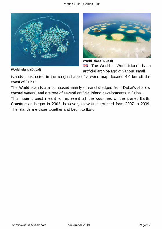
13.2.5 - World island (Dubai) 25°13.68 N55°09.85 E
Indian Ocean - Persian Gulf - Arabian Gulf - UAE - Persian Gulf - Dubai Emirate - World island (Dubai)
160
http://www.sea-seek.com November 2019 Page:58
Persian Gulf - Arabian Gulf
World island (Dubai)
World island (Dubai)
The World or World Islands is anartificial archipelago of various small
islands constructed in the rough shape of a world map, located 4.0 km off thecoast of Dubai.The World islands are composed mainly of sand dredged from Dubai's shallowcoastal waters, and are one of several artificial island developments in Dubai.This huge project meant to represent all the countries of the planet Earth.Construction began in 2003, however, shewas interrupted from 2007 to 2009.The islands are close together and begin to flow.
http://www.sea-seek.com November 2019 Page:59

Persian Gulf - Arabian Gulf
13.2.6 - Palm Deira (Dubai) 25°21.56 N55°13.60 E
Indian Ocean - Persian Gulf - Arabian Gulf - UAE - Persian Gulf - Dubai Emirate - Palm Deira (Dubai)
160
http://www.sea-seek.com November 2019 Page:60

Persian Gulf - Arabian Gulf
Palm Deira (Dubai)
Palm Deira (Dubai)Palm Deira construction
The Palm Deira is an artificialarchipelago
under construction, located alongside Deira town.The largest of the three Palm Islands, Palm Deira on completion will cover an area greater than the city of Paris. Featuring 8,000 two-storey houses, villas, and town homes, it is a thriving city in itself offering world class island living. This unique man-made palm-shaped island will consist of a trunk, a crown with 41 fronds, and a surrounding crescent island that will form a water breaker.The island will consist of residential property, marinas, shopping malls, sports facilities, clubs, and hospitality offerings. It is expected to be completed by 2015.
13.2.7 - Mina Rachid port (Dubai) 25°16.75 N55°16.74 E
Indian Ocean - Persian Gulf - Arabian Gulf - UAE - Persian Gulf - Dubai Emirate
http://www.sea-seek.com November 2019 Page:61

Persian Gulf - Arabian Gulf
channel 6, 9, 13, 14, 16
http://www.sea-seek.com November 2019 Page:62

Persian Gulf - Arabian Gulf
13.3 - Umm Al Qaywayn emirate 25°44.60 N55°22.25 E
Indian Ocean - Persian Gulf - Arabian Gulf - UAE - Persian Gulf - Umm Al Qaywayn emirate
A Khwr Umm Al Qaywayn port
Umm Al Quwain is one of the 7 emirates between Ajman and Ra's alKhaymah on the West coast of the United Arab Emirates.It covers an area of 800 square kilometres and stretches from the beautiful, lushgreen coastal mangroves lining the shores of the Persian Gulf, inland across therolling sand dunes to the fertile oasis surrounding Falaj Al Moalla.The inland oasis and hinterland town of Falaj Al Moalla lies some 50km fromUmm Al Quwain city.The name Umm Al Quwain is derived from Umm Al Quwatain, which means
http://www.sea-seek.com November 2019 Page:63

Persian Gulf - Arabian Gulf
"Mother of two powers", a reference to the powerful seafaring tradition of thisemirate.Khawr Umm al Qaywayn is an inlet comprising an extensive backwater in whichare several low islets. Extensive banks, with drying patches, extend seaward fromJazirat as Siniyah and from the peninsula of Umm al Qaywayn.Between these two banks is a narrow channel leading to Khawr Umm alQaywayn. It is entered between the W extremity of Jazirat as Siniyah and thepeninsula of Umm al Qaywayn.Jazirat Mallah, separated from Jazirat Siniyah by salt pans covered at HW,extends 5 miles NE. Burj Mallah, the SW of two conspicuous rectangular towers,stands near the SW end of Jazirat Mallah. A dangerous wreck lies 7 miles N ofthe entrance to Khawr Umm al Qaywayn.
13.3.1 - Khwr Umm Al Qaywayn port 25°34.89 N55°34.02 E
Indian Ocean - Persian Gulf - Arabian Gulf - UAE - Persian Gulf - Umm Al Qaywayn emirate
http://www.sea-seek.com November 2019 Page:64

Persian Gulf - Arabian Gulf
13.4 - Ajman Emirate 25°27.05 N55°35.20 E
Indian Ocean - Persian Gulf - Arabian Gulf - UAE - Persian Gulf - Ajman Emirate
A Ajman port B Al Hamriyah (Ajman)
nice city!!!!!!!!!!!~``~~ Ajman (also spelt Ujman) is one of the 7 emirates constituting the UAE. Withan area of just 260 km², Ajman is the smallest emirate by area. Its seat ofgovernement is Ajman, which is bordered on its north, south, and east bySharjah.Located along the Persian Gulf, Ajman also ontrols Masfut and Manama, twosmall inland enclaves (Manama and Masfout) that are primarily agricultural.Ajman is another word for a small city in Arabic.
http://www.sea-seek.com November 2019 Page:65
Persian Gulf - Arabian Gulf
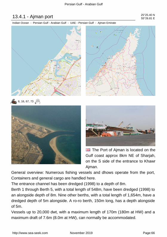
13.4.1 - Ajman port 25°25.40 N55°26.81 E
Indian Ocean - Persian Gulf - Arabian Gulf - UAE - Persian Gulf - Ajman Emirate
6, 16, 67, 73
The Port of Ajman is located on theGulf coast approx 8km NE of Sharjah,on the S side of the entrance to KhawrAjman.
General overview: Numerous fishing vessels and dhows operate from the port,Containers and general cargo are handled here.The entrance channel has been dredged (1998) to a depth of 8m.Berth 1 through Berth 5, with a total length of 548m, have been dredged (1998) toan alongside depth of 8m. Nine other berths, with a total length of 1,654m, have adredged depth of 5m alongside. A ro-ro berth, 150m long, has a depth alongsideof 5m.Vessels up to 20,000 dwt, with a maximum length of 170m (180m at HW) and amaximum draft of 7.6m (8.0m at HW), can normally be accommodated.
http://www.sea-seek.com November 2019 Page:66

Persian Gulf - Arabian Gulf
Within the bar, the channel forks into several branches, all available to local smallcraft. Irregular ridges of sand, shell, and dead coral, with depths of less than 10m,lie as far as 2.5 miles offshore in the vicinity of Khawr Ajman.Aspect.?The entrance to Khawr Ajman lies between two training walls, marked bylights, and is encumbered by a bar over which the depth is variable.A fort and several minarets are situated in Ajman. Berig al Mai, 0.5 mile SSW ofthe fort, is a conspicuous watchtower.Pilotage.?Pilotage is compulsory and is available 24 hours with 48 hours advancenotice. The pilot boards 3 miles NW of the breakwater.Regulations.?Vessels should contact the Port Authority/Harbor Control 2 hoursbefore arrival on VHF channel 16.The port authority controls vessel movement on VHF channel 6.Tel: 971-6-7470111Fax: 971-6-7470333Mail: [email protected].?The holding ground is poor and ships should not anchor in depths ofless than 20m, except in calm weather.Caution.?Shallow water was reported to lie on the inside of the channel bends; ashoal patch of 4m was found in the inner harbor. The sea breaks heavily on thebar with an onshore swell.Buoys marking the channel may be out of position, sometimes outside of thedredged channel, and should not be solely relied upon for positioning.The dredged areas are subject to siltation and depths may be less than charted.
13.4.2 - Al Hamriyah (Ajman) 25°28.31 N55°28.84 E
Indian Ocean - Persian Gulf - Arabian Gulf - UAE - Persian Gulf - Ajman Emirate
http://www.sea-seek.com November 2019 Page:67

Persian Gulf - Arabian Gulf
Al Hamriyah is a village about 7miles SSW of Umm al Qaywayn. Thetower of a new fort, with a flagstaff anda white minaret, are conspicuous. There is a creek at the S end of thevillage which connects at HW withKhawr Ajman. The creek was dredged(2004) to 3.5m. A channel, dredged toa depth of 9m (2009) and marked
by lighted buoys, extends ESE to the creek entrance from a position about 0.5mile N of the entrance to Al Hamriyah LPG Terminal and then SE from the creekentrance to a main basin about 0.8 mile long, with dredged depths of 5 to 9m.Two shorter basins, with dredged depths of 7 to 9m and 5m, respectively, extendNNE from the N side of the main basin. An unlighted mooring buoy is located 10miles offshore NNW of Al Hamriyah. Caution.?For a minimum distance of 2 milesfrom the harbor, arriving vessels should maintain a track of not less than 120°,while departing vessels should maintain a track of not less than 300°. Vessels willpass NE of the spoil ground produced by the reclamation work.
http://www.sea-seek.com November 2019 Page:68
Persian Gulf - Arabian Gulf
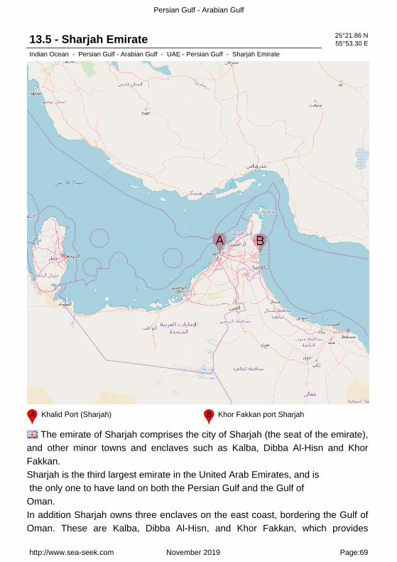
13.5 - Sharjah Emirate 25°21.86 N55°53.30 E
Indian Ocean - Persian Gulf - Arabian Gulf - UAE - Persian Gulf - Sharjah Emirate
A Khalid Port (Sharjah) B Khor Fakkan port Sharjah
The emirate of Sharjah comprises the city of Sharjah (the seat of the emirate),and other minor towns and enclaves such as Kalba, Dibba Al-Hisn and KhorFakkan.Sharjah is the third largest emirate in the United Arab Emirates, and is the only one to have land on both the Persian Gulf and the Gulf of Oman.In addition Sharjah owns three enclaves on the east coast, bordering the Gulf ofOman. These are Kalba, Dibba Al-Hisn, and Khor Fakkan, which provides
http://www.sea-seek.com November 2019 Page:69

Persian Gulf - Arabian Gulf
Sharjah with a major east coast port. In the Persian Gulf, the island of Sir AbuNu?ayr belongs to Sharjah, and Abu Musa is claimed by Sharjah, but controlledby Iran.
13.5.1 - Khalid Port (Sharjah) 25°21.99 N55°22.75 E
Indian Ocean - Persian Gulf - Arabian Gulf - UAE - Persian Gulf - Sharjah Emirate
Department of Seaports andCustoms owns and controls theemirate?s three ports (the Port ofHamriyah, Khor Fakkan, and Khalid).The Gulftainer Company Limited wasformed in 1976 to operate and managethe Sharjah Container Terminal at thePort of Khalid and the terminal at Portof Khor Fakkan.
The Port of Khalid is in the heart of Sharjah city. Port Khalid Customs Centre islocated at the main gate of the port. Customs inspection of goods and containers and passenger control are carried out at this centre.The Port of Khalid is considered a pioneer seaport of theregion, boasting the first container terminal, roll-on/roll-off cargo terminal, and free trade terminal.The Port of Khalid contains 21 berths that handle general, reefer, and
http://www.sea-seek.com November 2019 Page:70

Persian Gulf - Arabian Gulf
dry, liquid, and bulk cargoes. Facilities include two dock-side colds stores as well as oil and offshore support. Since it was first constructed, the Port of Khalid has continuously modernized its facilities and services.Tel: 971-6-5281666Fax: 971-6-5281425Mail: [email protected]
13.5.2 - Khor Fakkan port Sharjah 25°21.52 N56°22.21 E
Indian Ocean - Persian Gulf - Arabian Gulf - UAE - Persian Gulf - Sharjah Emirate
Khor Fakkan (or Khawr Fakkan) is atown located along the Gulf of Omanon the east coast of the United ArabEmirates (UAE). The town is set on thepicturesque bay of Khor Fakkan, whichmeans "Creek of Two Jaws".Khor Fakkan belongs to the emirate ofSharjah but is geographicallysurrounded
by the emirate of Fujairah.It is a natural deep water port that is now a major container terminal.
http://www.sea-seek.com November 2019 Page:71

Persian Gulf - Arabian Gulf
13.6 - Ras Al Khaimah Emirate W coast 25°50.68 N55°55.83 E
Indian Ocean - Persian Gulf - Arabian Gulf - UAE - Persian Gulf - Ras Al Khaimah Emirate W coast
A Al Jazeera Port (Ras Al Khaimah) B Mina Saqr Port (Ras Al Khaimah)
http://www.sea-seek.com November 2019 Page:72
Persian Gulf - Arabian Gulf
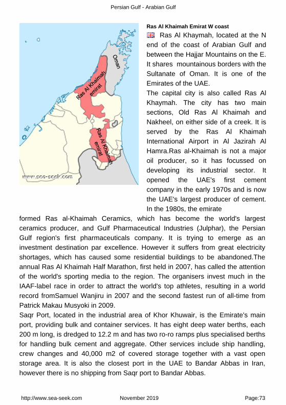
Ras Al Khaimah Emirat W coast
Ras Al Khaymah, located at the Nend of the coast of Arabian Gulf andbetween the Hajjar Mountains on the E.It shares mountainous borders with theSultanate of Oman. It is one of theEmirates of the UAE.The capital city is also called Ras AlKhaymah. The city has two mainsections, Old Ras Al Khaimah andNakheel, on either side of a creek. It isserved by the Ras Al KhaimahInternational Airport in Al Jazirah AlHamra.Ras al-Khaimah is not a majoroil producer, so it has focussed ondeveloping its industrial sector. Itopened the UAE's first cementcompany in the early 1970s and is nowthe UAE's largest producer of cement.In the 1980s, the emirate
formed Ras al-Khaimah Ceramics, which has become the world's largestceramics producer, and Gulf Pharmaceutical Industries (Julphar), the PersianGulf region's first pharmaceuticals company. It is trying to emerge as aninvestment destination par excellence. However it suffers from great electricityshortages, which has caused some residential buildings to be abandoned.Theannual Ras Al Khaimah Half Marathon, first held in 2007, has called the attentionof the world's sporting media to the region. The organisers invest much in theIAAF-label race in order to attract the world's top athletes, resulting in a worldrecord fromSamuel Wanjiru in 2007 and the second fastest run of all-time fromPatrick Makau Musyoki in 2009.Saqr Port, located in the industrial area of Khor Khuwair, is the Emirate's mainport, providing bulk and container services. It has eight deep water berths, each200 m long, is dredged to 12.2 m and has two ro-ro ramps plus specialised berthsfor handling bulk cement and aggregate. Other services include ship handling,crew changes and 40,000 m2 of covered storage together with a vast openstorage area. It is also the closest port in the UAE to Bandar Abbas in Iran,however there is no shipping from Saqr port to Bandar Abbas.
http://www.sea-seek.com November 2019 Page:73

Persian Gulf - Arabian Gulf
13.6.1 - Al Jazeera Port (Ras Al Khaimah) 25°43.03 N55°47.99 E
Indian Ocean - Persian Gulf - Arabian Gulf - UAE - Persian Gulf - Ras Al Khaimah Emirate W coast
channel 6, 16
13.6.2 - Mina Saqr Port (Ras Al Khaimah) 25°58.64 N56°03.08 E
Indian Ocean - Persian Gulf - Arabian Gulf - UAE - Persian Gulf - Ras Al Khaimah Emirate W coast
http://www.sea-seek.com November 2019 Page:74
Persian Gulf - Arabian Gulf
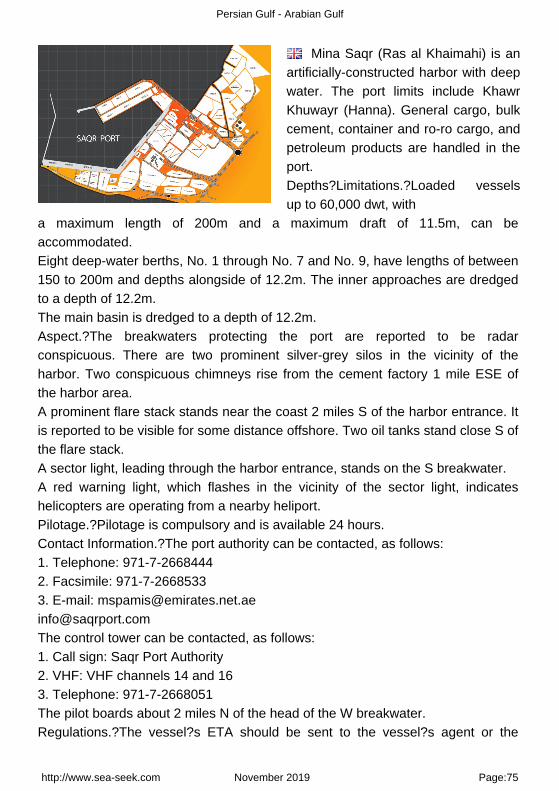
Mina Saqr (Ras al Khaimahi) is anartificially-constructed harbor with deepwater. The port limits include KhawrKhuwayr (Hanna). General cargo, bulkcement, container and ro-ro cargo, andpetroleum products are handled in theport.Depths?Limitations.?Loaded vesselsup to 60,000 dwt, with
a maximum length of 200m and a maximum draft of 11.5m, can beaccommodated.Eight deep-water berths, No. 1 through No. 7 and No. 9, have lengths of between150 to 200m and depths alongside of 12.2m. The inner approaches are dredgedto a depth of 12.2m.The main basin is dredged to a depth of 12.2m.Aspect.?The breakwaters protecting the port are reported to be radarconspicuous. There are two prominent silver-grey silos in the vicinity of theharbor. Two conspicuous chimneys rise from the cement factory 1 mile ESE ofthe harbor area.A prominent flare stack stands near the coast 2 miles S of the harbor entrance. Itis reported to be visible for some distance offshore. Two oil tanks stand close S ofthe flare stack.A sector light, leading through the harbor entrance, stands on the S breakwater.A red warning light, which flashes in the vicinity of the sector light, indicateshelicopters are operating from a nearby heliport.Pilotage.?Pilotage is compulsory and is available 24 hours.Contact Information.?The port authority can be contacted, as follows:1. Telephone: 971-7-26684442. Facsimile: 971-7-26685333. E-mail: [email protected]@saqrport.comThe control tower can be contacted, as follows:1. Call sign: Saqr Port Authority2. VHF: VHF channels 14 and 163. Telephone: 971-7-2668051The pilot boards about 2 miles N of the head of the W breakwater.Regulations.?The vessel?s ETA should be sent to the vessel?s agent or the
http://www.sea-seek.com November 2019 Page:75

Persian Gulf - Arabian Gulf
harbormaster 48 hours in advance, stating the vessel?s length, draft, and fulldetails of cargo.Contact Port Control on VHF channel 16 at least 2 hours prior to arrival.Vessels at anchor should maintain a continuous listening watch on VHF channel16.Anchorage.?Three designated anchorage areas, best seen on the chart, arelocated NW of the harbor entrance and are designated for use, as follows:1. Anchorage Zone I?for vessels less than 50m loa, barges, and small craft.2. Anchorage Zone II?for vessels greater than 50m loa.3. Anchorage Zone III?for bunkering vessels only.Caution.?Pipelines, best seen on the chart, extend N and NW from the shoreclose SW of the Khawr al Khuwayr.Caution is necessary when using Anchorage Zone I as an obstruction, marked Nand S by lighted buoys and best seen on the chart, is located in the center of thearea. Mina Saqr (Ras al Khaimahi) est un port artificiel construit dans une eauprofonde. Les limites du port comprennent Khawr Khuwayr (Hanna). Les cargos,ciment en vrac, conteneurs et rouliers, et les produits pétroliers sont traitées dansle port.Profondeurs-Limitations.-Les navires jusqu'à 60 000 tpl, avec une longueur maximale de 200m et un tirant d'eau maximal de 11,5 m, peuvent être accueillis.8 places en eau profonde, n ° 1 à n ° 7 et n ° 9, ont des longueurs de 150 à 200m et des profondeurs de 12.2m. Les approches internes sont draguées à uneprofondeur de 12,2 m.Le bassin principal est dragué à une profondeur de 12,2 m.Aspect-La digues protégeant le port porte des radars remarquables. Il ya deuxéminents silos gris-argent dans les environs du port. Deux cheminéesremarquables de l'usine de ciment se trouvent à 1 mile à l'ESE de la zoneportuaire.Une torche se trouve à proximité de la côte à 2 miles au S de l'entrée du port.Elle est visible à une certaine distance au large. Deux réservoirs d'huile s'élèventau S, proche de la torchère.Un feu de secteur, menant à l'entrée du port, se dresse sur le brise-lames S.Un voyant rouge qui clignote dans le voisinage du feu de secteur, indique que des hélicoptères opèrent à partir d'un héliport à proximité.
http://www.sea-seek.com November 2019 Page:76

Persian Gulf - Arabian Gulf
Pilotage.-Le pilotage est obligatoire et est disponible 24 heures.Contacts-Information. L'autorité portuaire peut être contacté directement, commesuit:1. Téléphone: 971-7-26684442. Télécopieur: 971-7-26685333. E-mail: [email protected]@saqrport.comLa tour de contrôle peut être contactée directement, comme suit:1. Indicatifd'appel: Saqr Port Authority2. VHF: canaux VHF 14 et 163. Téléphone: 971-7-2668051Le pilote monte à environ 2 miles N de la tête de la digue ouest.Regulations.- Le navire ETA doit être envoyé à l'agent du navire ou de la capitainerie 48 heures à l'avance, indiquant la longueur du navire, le projet, et tous les détails de la cargaison.Contactez-Port de contrôle sur le canal VHF 16 d'au moins 2 heures avantl'arrivée.Les navires au mouillage doivent écouter en permanence le canal VHF 16.Anchorage.- Trois zones de mouillage désignées sont situées au NW de l'entrée du port et sont réservées à une utilisation, comme suit:1. Anchorage Zone I-pour les navires de moins de 50m loa, les barges et lespetites embarcations.2. Anchorage Zone II-pour les navires de plus de 50m loa.3. Anchorage Zone III-pour les navires de soutage seulement.Attention.- Les pipelines s'étendent au N et NW du rivage SW proches de laKhawr al Khuwayr.La prudence est de rigueur lors de l'utilisation du mouillage de la Zone I comme une obstruction, elle est marquée au N et au S par des bouées lumineuses, et estsituée dans le centre de la zone.
http://www.sea-seek.com November 2019 Page:77

Persian Gulf - Arabian Gulf
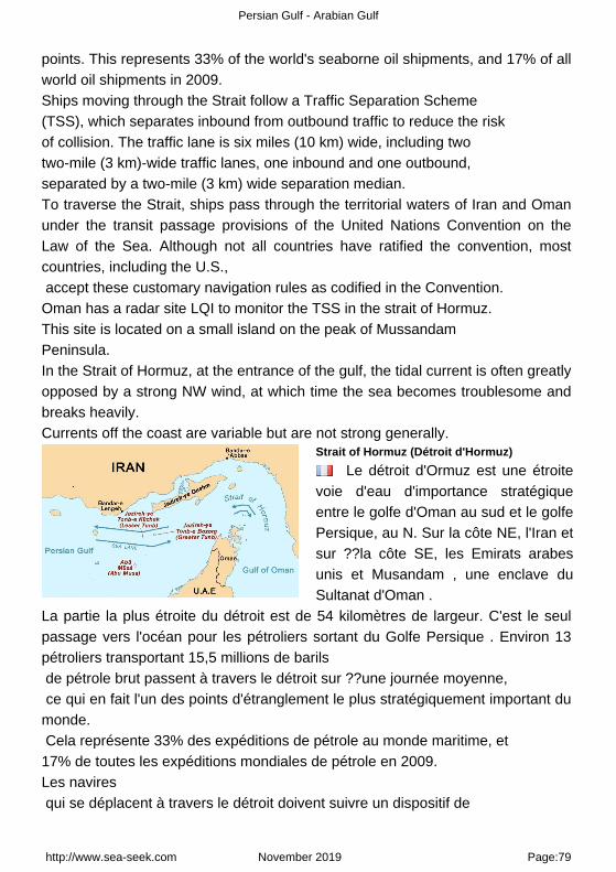
14 - Strait of Hormuz (Détroit d'Hormuz) 26°35.44 N55°51.59 E
Indian Ocean - Persian Gulf - Arabian Gulf - Strait of Hormuz (Détroit d'Hormuz)
A Musandam B Khawr Khasab
The Strait of Hormuz is a narrow, strategically important waterway betweenthe Gulf of Oman in the southeast and the Persian Gulf. On the north coast is Iranand on the south coast is the United Arab Emirates and Musandam, an exclaveof Oman.The strait at its narrowest is 54 kilometres (34 mi) wide. It is the only sea passageto the open ocean for large areas of the petroleum-exporting Persian Gulf. About13 tankers carrying 15.5 million barrels of crude oil pass through the strait on anaverage day, making it one of the world's most strategically important choke
http://www.sea-seek.com November 2019 Page:78
Persian Gulf - Arabian Gulf
points. This represents 33% of the world's seaborne oil shipments, and 17% of allworld oil shipments in 2009.Ships moving through the Strait follow a Traffic Separation Scheme (TSS), which separates inbound from outbound traffic to reduce the risk of collision. The traffic lane is six miles (10 km) wide, including two two-mile (3 km)-wide traffic lanes, one inbound and one outbound, separated by a two-mile (3 km) wide separation median.To traverse the Strait, ships pass through the territorial waters of Iran and Omanunder the transit passage provisions of the United Nations Convention on theLaw of the Sea. Although not all countries have ratified the convention, mostcountries, including the U.S., accept these customary navigation rules as codified in the Convention. Oman has a radar site LQI to monitor the TSS in the strait of Hormuz. This site is located on a small island on the peak of Mussandam Peninsula.In the Strait of Hormuz, at the entrance of the gulf, the tidal current is often greatlyopposed by a strong NW wind, at which time the sea becomes troublesome andbreaks heavily.Currents off the coast are variable but are not strong generally.
Strait of Hormuz (Détroit d'Hormuz)
Le détroit d'Ormuz est une étroitevoie d'eau d'importance stratégiqueentre le golfe d'Oman au sud et le golfePersique, au N. Sur la côte NE, l'Iran etsur ??la côte SE, les Emirats arabesunis et Musandam , une enclave duSultanat d'Oman .
La partie la plus étroite du détroit est de 54 kilomètres de largeur. C'est le seulpassage vers l'océan pour les pétroliers sortant du Golfe Persique . Environ 13pétroliers transportant 15,5 millions de barils de pétrole brut passent à travers le détroit sur ??une journée moyenne, ce qui en fait l'un des points d'étranglement le plus stratégiquement important dumonde. Cela représente 33% des expéditions de pétrole au monde maritime, et 17% de toutes les expéditions mondiales de pétrole en 2009.Les navires qui se déplacent à travers le détroit doivent suivre un dispositif de
http://www.sea-seek.com November 2019 Page:79

Persian Gulf - Arabian Gulf
séparation du trafic (DST), qui sépare ceux qui entrent et ceux qui sortent afin de réduire le risque de collision. La voie de circulation est de six miles (10 km) de large, y compris deux voies de circulation de deux mile (3 km) de large, les entrants et sortants, sont séparés par deux-mile (3 km).Pour traverser le détroit, les navires passent à travers les eaux territoriales del'Iran et Oman suivant la règle du passage en transit des dispositions de laConvention des Nations Unies sur le droit de la mer. Bien que tous les pays aientratifié la Convention, la plupart des pays, y compris les États-Unis, ont acceptéces règles de navigation coutumier codifié dans la Convention. Oman a un IQLsite radar pour surveiller le TSS dans le détroit d'Ormuz. Ce site est situé sur unepetite île sur la pointe de la péninsule Mussandam.Dans le détroit d'Ormuz, à l'entrée du golfe, le courant de marée est souventfortement opposé à un fort vent NW, à ce moment la mer devient très agitée.Les courants au large des côtes sont variables mais ne sont pas forts en général.
http://www.sea-seek.com November 2019 Page:80

Persian Gulf - Arabian Gulf
14.1 - Musandam 26°05.95 N56°17.42 E
Indian Ocean - Persian Gulf - Arabian Gulf - Strait of Hormuz (Détroit d'Hormuz) - Musandam
A Khawr Khasab
http://www.sea-seek.com November 2019 Page:81

Persian Gulf - Arabian Gulf
MusandamEckhard Pecher
Musandam est la péninsule quiconstitue la pointe nord-est de lapéninsule Arabique. Elle est située à 45km de la côte iranienne, dont elle estséparée par le détroit d'Ormuz, faisantd'elle un lieu stratégique.
14.1.1 - Khawr Khasab 26°12.42 N56°14.99 E
Indian Ocean - Persian Gulf - Arabian Gulf - Strait of Hormuz (Détroit d'Hormuz) - Musandam
Port. Port côtier.
15 - Bandar-e Shahid Reajie 27°05.68 N56°03.95 E
Indian Ocean - Persian Gulf - Arabian Gulf
http://www.sea-seek.com November 2019 Page:82

Persian Gulf - Arabian Gulf
Port protected by a breakwater.
Port protégé par une digue.
16 - Bandar Abbas 27°08.56 N56°12.72 E
Indian Ocean - Persian Gulf - Arabian Gulf
http://www.sea-seek.com November 2019 Page:83
Persian Gulf - Arabian Gulf
Harbor protected by a breakwater. Port de commerce protégé par une digue.
http://www.sea-seek.com November 2019 Page:84

Persian Gulf - Arabian Gulf
www.sea-seek.com
Responsability Responsabilité
Sea-Seek is a collection of sailinglogbooks covering harbours,anchorages, diving spots... anysubject regarding sport or pleasure atsea.
Sea-Seek is an online open-contentcollaborative pilot guide, that is, avoluntary association of individualsand groups working to develop acommon resource of humanknowledge. The structure of theproject allows anyone with an Internetconnection to alter its content. Pleasebe advised that nothing found herehas necessarily been reviewed bypeople with the expertise required toprovide you with complete, accurateor reliable information.
In particular, don't use any mappresented in Sea-Seek for thenavigation.
Note that informations in sea-seek arecompiled from a variety of freelyavailable and non controlable sourcesand therefore Sea-Seek webmastercannot be held responsible forincorrect or outdated data.
Sea-Seek est un guide du nautismeou pilote côtier en ligne. Fruit de lacontribution de chacun, il décrit lessites de mouillage, les ports, les spotsde plongée, les plages par et pour lesamoureux de la mer.
Sea-Seek est un guide nautique libre,c'est-à-dire une association volontaired'individus et de groupes quidéveloppent ensemble une source dela connaissance humaine. Sastructure permet à tout individu avecun accès Internet et un navigateurWeb de modifier le contenu disponibleici. En conséquence, sachez que riende ce que vous pouvez trouver ici n'aété nécessairement vérifié par unprofessionnel compétent dans ledomaine en question et ceci sur tousles sujets de Sea-Seek.
En particulier, n'utiliser aucune cartede Sea-Seek pour la navigation.
L'ensemble des données présentéessur Sea-Seek sont d'origines diverseset non contrôlées et ne sauraientengager la responsabilité duresponsable du sitewww.sea-seek.com.
http://www.sea-seek.com November 2019 Page:85http://www.sea-seek.com November 2019