permitting handbook - wv department of …dep.wv.gov/dmr/handbooks/documents/permitting han… ·...
TRANSCRIPT
PERMITTING
HANDBOOK
WEST VIRGINIA DEPARTMENT
OF
ENVIRONMENTAL PROTECTION
DIVISION
OF
MINING & RECLAMATION January, 2017
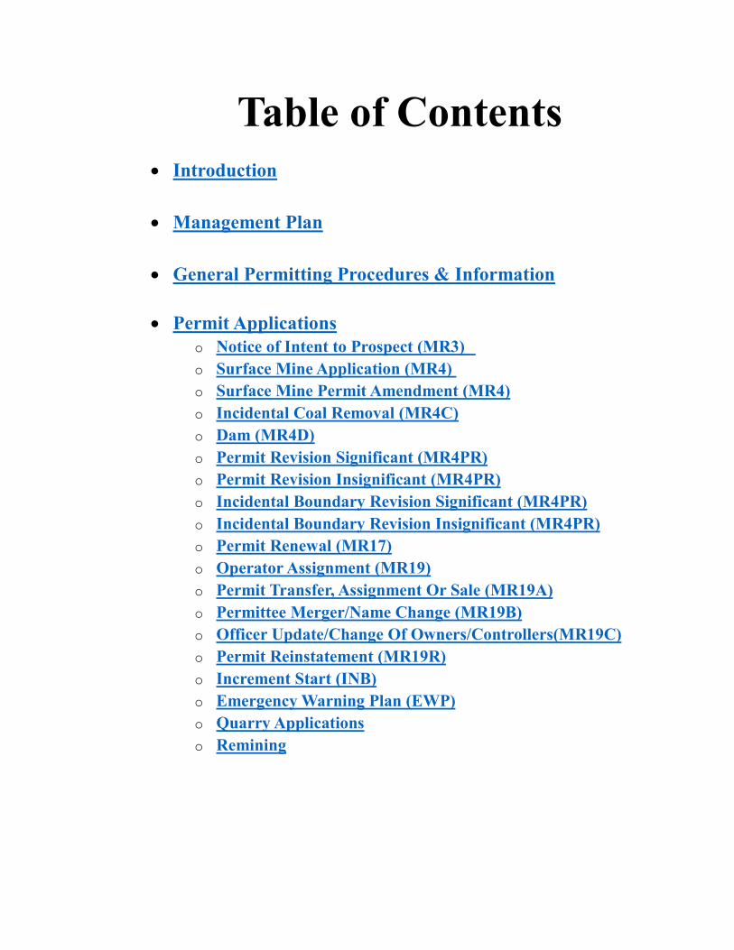
Table of Contents
Introduction
Management Plan
General Permitting Procedures & Information
Permit Applications
o Notice of Intent to Prospect (MR3)
o Surface Mine Application (MR4)
o Surface Mine Permit Amendment (MR4)
o Incidental Coal Removal (MR4C)
o Dam (MR4D)
o Permit Revision Significant (MR4PR)
o Permit Revision Insignificant (MR4PR)
o Incidental Boundary Revision Significant (MR4PR)
o Incidental Boundary Revision Insignificant (MR4PR)
o Permit Renewal (MR17)
o Operator Assignment (MR19)
o Permit Transfer, Assignment Or Sale (MR19A)
o Permittee Merger/Name Change (MR19B)
o Officer Update/Change Of Owners/Controllers(MR19C)
o Permit Reinstatement (MR19R)
o Increment Start (INB)
o Emergency Warning Plan (EWP)
o Quarry Applications
o Remining

Reference Information
o Blasting Information
o Bond Information
o Certified Record Information
o Citizen Participation
o Coal Ash Utilization, Tire Disposal & Other Information
o Cooperating & Affected Local, State & Federal Agencies
o Dam Information
o Drainage & Sediment Control Information
o Excess Spoil Disposal & AOC Information
o Fish & Wildlife Information
o FOIA Processing
o Hydrologic Information
o Informal Conference Process
o Ownership & Control Information
o Post Mining Land Use Information
o Pre-Inspection for Surface Mine Application
o Pre-Submittal Meetings
o Refuse Disposal and Reprocessing
o Roads
o State Historic Preservation Office
o Subsidence Information
o Surface Mine Board Appeals

Division of Mining and Reclamation Permitting Handbook
Return Home Page 1
INTRODUCTION

Division of Mining and Reclamation Permitting Handbook
Return Home Page 2
The Permitting Handbook provides a comprehensive guide to understanding the
processes of permit applications. It establishes procedures for preparing, handling
reviewing and approving permit applications. It includes sections on new permits,
revisions, transfers, renewals, bonding and insurance, informal conferences, protests,
subsidence, blasting, SHPO, fish and wildlife and more.
Although basically administrative in nature, this Handbook also includes technical
information, interpretations or memorandums. Additional procedures, requirements,
memorandums, technical information, etc. will be provided for inclusion, as they become
available. Hyperlinks are provided throughout the Handbook for referencing useful
information.
The West Virginia Department of Environmental Protection (DEP) now provides helpful
user information from the Division of Mining and Reclamation over the Internet. Check
out the DEP home page at http://www.dep.wv.gov/Pages/default.aspx
Want to read or copy the latest laws and regulations that govern mining and
reclamation?
The West Virginia Surface Coal Mining and Reclamation Act 22-3 and the West Virginia
Surface Mining Reclamation Regulations 38CSR2 are available for you to read or print
directly from the Internet. Additional laws and regulations associated to mining and
reclamation can be referenced in the Important Links section of the Handbook.
Need to browse or research DEP mining databases for information?
Online TAGIS (Technical Application & Geographic Information Systems) data has been
made available for all online users. Using the TAGIS system, a user can browse the
mining permit database. http://tagis.dep.wv.gov/home/
The permit database can be used to identify permit numbers, responsible parties,
issue/expiration dates, mine types, facility names, and acreage. Interactive maps of
permitted sites can also be viewed. http://tagis.dep.wv.gov/mining/
Want to keep up on the latest publications submitted by the Division of Mining and
Reclamation?
In an attempt to keep the public current on what is happening in the Division of Mining
and Reclamation, the office’s latest publications are available on the Internet for users to
access. http://www.dep.wv.gov/dmr/Pages/default.aspx
Related Sites:
Users can explore more coal mining information by checking out related sites linked to
DEP’s home page including the U.S. Environmental Protection Agency, the federal Office
of Surface Mining, the National Research Center for Coal and Energy, West Virginia
Geologic & Economic Survey, and Natural Resources Conservation Service.

Division of Mining and Reclamation Permitting Handbook
Return Home Page 3
ACRONYMS
AEPP Aquatic Ecosystem Protection Plan
AG Attorney General
AMP Adaptive Management Plan
AOC Approximate Original Contour
AOI Area of Interest
APE Area of Potential Effect (SHPO)
AST Above ground Storage Tank
AVS Applicant Violator System
AX ApplicationXtender
BAS Biological Assessment Station
BMP Best Management Practice
BWQ Baseline Water Quality
CD Certificate of Deposit
CHIA Cumulative Hydrologic Impact Assessment
CIA Cumulative Impact Area
CIF Consolidated Investment Fund
CO Cessation Order
COCF Centralized Ownership & Control Files
DEP Department of Environmental Protection
DMR Discharge Monitoring Report
DMR Division of Mining and Reclamation
ELG Effluent limitation Guidelines
ERIS Environmental Resource Information System
eSS Electronic Submittal System
FAN Final Action Notification
FOIA Freedom of Information Act
FRA Forestry Reclamation Approach
FTACO Failure to Abate Cessation Order
GPP Groundwater Protection Plan
HPI Historic Property Inventory (SHPO)
HPU Hydrologic Protection Unit
HPR Hydrologic Reclamation Unit
HQ Headquarters
IBR Incidental Boundary Revision
I & E Inspection and Enforcement
IUAR Infrequently Used Access Road
LOC Letter of Credit
MSHA Mine Safety and Health Administration
NOI Notice of Intent
NOV Notice of Violation
NPDES National Pollutant Discharge Elimination System
NRCS Natural Resource Conservation Service (formerly SCS)
NWQS Narrative Water Quality Standards

Division of Mining and Reclamation Permitting Handbook
Return Home Page 4
O&C Ownership and Control
OES Office of Emergency Services
OSM Office of Surface Mining (Federal)
OSMRE Office of Surface Mining Recommendation (from AVS)
PEP Protection & Enhancement Plan
PIO Public Information Office
PHC Probable Hydrologic Consequences
PMLU Post Mining Land Use
PMP Probable Maximum Precipitation
POC Parameter of Concern
POV Pattern of Violations
PRT Permit Review Team
PUMA Post Underground Mining Assessment
RP Reasonable Potential
RTE Rare, Threatened, Endangered (species-WVDNR)
SCMRA Surface Coal Mining& Reclamation Act (West Virginia)
SCS Soil Conservation Service (current NRCS)
SHPO State Historical Preservation Officer
SMA Surface Mine Application
SMB Surface Mine Board
SMCRA Surface Mining Control and Reclamation Act of 1977 (Federal)
SOAP Small Operator Assistance Program
SOP Standard Operating Procedure
SPCC Spill Prevention Control & Countermeasure (Plan)
SPLP Synthetic Precipitation Leaching Procedure
SWROA Surface Water Runoff Analysis
TBEL Technology Based Effluent Limit
TCLP Toxicity Characteristic Leaching Procedure
TDN Ten Day Notice
TDS Total Dissolved Solids
TIPS Technical Innovation & Professional Services
TMDL Total Maximum Daily Limit
UIC Underground Injection Control
USACE US Army Corps of Engineers
VER Valid Existing Rights
WET Whole Effluent Toxicity (Testing)
WQBEL Water Quality Based Effluent Limit
WQC Water Quality Criteria
WQS Water Quality Standards
WVSCI WV Stream Condition Index
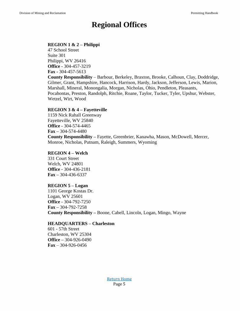
Division of Mining and Reclamation Permitting Handbook
Return Home Page 5
Regional Offices
REGION 1 & 2 – Philippi 47 School Street
Suite 301
Philippi, WV 26416
Office - 304-457-3219
Fax - 304-457-5613
County Responsibility – Barbour, Berkeley, Braxton, Brooke, Calhoun, Clay, Doddridge,
Gilmer, Grant, Hampshire, Hancock, Harrison, Hardy, Jackson, Jefferson, Lewis, Marion,
Marshall, Mineral, Monongalia, Morgan, Nicholas, Ohio, Pendleton, Pleasants,
Pocahontas, Preston, Randolph, Ritchie, Roane, Taylor, Tucker, Tyler, Upshur, Webster,
Wetzel, Wirt, Wood
REGION 3 & 4 – Fayetteville 1159 Nick Rahall Greenway
Fayetteville, WV 25840
Office - 304-574-4465
Fax – 304-574-4480
County Responsibility – Fayette, Greenbrier, Kanawha, Mason, McDowell, Mercer,
Monroe, Nicholas, Putnam, Raleigh, Summers, Wyoming
REGION 4 – Welch 331 Court Street
Welch, WV 24801
Office - 304-436-2181
Fax – 304-436-6337
REGION 5 – Logan 1101 George Kostas Dr.
Logan, WV 25601
Office - 304-792-7250
Fax – 304-792-7258
County Responsibility – Boone, Cabell, Lincoln, Logan, Mingo, Wayne
HEADQUARTERS – Charleston
601 - 57th Street
Charleston, WV 25304
Office – 304-926-0490
Fax – 304-926-0456

Division of Mining and Reclamation Permitting Handbook
Return Home Page 6
MANAGEMENT
PLAN

Division of Mining and Reclamation Permitting Handbook
Return Home Page 7
The Division of Mining and Reclamation has developed a Management Plan which became
effective on June 1, 1994. This section of the Permit Handbook entails the portion of this
plan which focuses on the Permitting Unit.
Permitting Unit:
A. Purpose:
This Plan establishes official policy and procedure for the Permitting Management Plan (PMP). Goals
of the Division of Mining & Reclamation are outlined, and standards are established in order to assure
that appropriate compliance is maintained with program requirements.
1. Headquarters - Applications received in Headquarters for decision consists of surface mining
permits, permit amendments and transfer of permits. A quality check of ownership and control
findings, a checklist for completeness and accuracy, and a brief technical review is conducted
by headquarters staff.
2. Regional Office - The Permitting Unit consists of review sections in each of the three DEP
regional offices that handle the permitting workload. The review section is divided into review
teams which consists of: Geologist/Hydrologist, Engineer, Environmental Resource Specialist,
Inspector and support staff. Each team has the responsibility for processing all permitting
applications related to coal and non-coal facilities.
B. Management Tools in Place and Pending:
1. Administrative Computer Operations: The following is information concerning databases maintained on the Environmental Resource
Information System (ERIS) and the Federal Applicant Violator System (AVS). Immediately
after permit issuance, the required permit and ownership and control information is entered in
both the state and federal computer systems.
a. An application tracking system is part of the ERIS database which tracks applications
for Notices of Intent to Prospect, Surface Mining, National Pollutant Discharge
Elimination System, Transfer of Permits, Operator Assignment, Permit Revisions,
Incidental Boundary Revisions, Permit Renewals, Surface Mining for Minerals other
than Coal, Increment Start, Emergency Warning Plans, and Certificates of Approval for
a Dam. As the need arises, additional application types are being added to ERIS for
tracking purposes.
(1) The Environmental Resources Information System (ERIS) database contains
data regarding permit applications and the tracking thereof.
(2) The status and progress of pending applications throughout the state can be
reviewed at any time by Headquarters, enabling DEP to instantly analyze
applications by region, type of application, etc.
(3) ERIS offers various reports for regional offices and/or headquarters.

Division of Mining and Reclamation Permitting Handbook
Return Home Page 8
b. Applicant Violator System AVS Login Page
(1) Applications for Surface Mining, Transfer of Permits and Operator
Assignment, are entered in the AVS with ownership and control information
associated with the applicant.
(2) Data into the AVS is entered by designated Headquarters staff only. However,
regional staff is provided with a browse access to view the organizational
family trees and to request recommendations on individuals and companies.
2. Permit Application Procedures Handbook: The contents of this handbook consist of procedures for the receipt, review, and decision of all
types of permit applications. Procedures for informal conferences, types of acceptable bonding
methods, etc. are also included. It is our intention to maintain current procedures and to provide
updates on a quarterly basis.
3. Geologic Guidance Handbook: The West Virginia Department of Environmental Protection (WVDEP), Division of Mining and
Reclamation, has developed the Geology Handbook for the purpose of assuring consistency in
the technical review of permit applications. It is also intended to be used as a technical manual
for industry representatives preparing a permit application under the West Virginia Surface
Mining Program. The document explains the types of information, which may be required in a
permit application, including procedures to sample and analyze geologic strata. Geology
Handbook
4. The Technical Innovation & Professional Services (TIPS): Staff members are responsible for learning to use various software in their field of expertise in
order to assist in specific areas of application review. Included is a wide range of software
applications from automated measurements through slope stability analyses and hydrology
/sedimentology watershed calculations to sophisticated three-dimensional geology and
subsidence prediction modeling. The TIPS generated documentation is used to develop the
facts and findings relative to the area proposed to be impacted by the SMA. Technical
Innovation and Professional Services
5. Technical Guidance Handbook: This handbook consists of general standards and specifications for erosion and sediment
control, excess spoil disposal and haulage ways for mining operations in West Virginia which
have been accepted by professional engineers and technicians as general practices within the
mining industry. However, this handbook is not to be considered nor utilized as the West
Virginia Surface Mining Reclamation Regulations, rules, policies, or law. Technical
Handbook
C. Program Supervision:
Each regional Permitting Supervisor/Environmental Resource Program Manager is responsible
for the scheduling of reviews and the timely processing of all types of permit applications for coal and
non-coal mines on all lands in West Virginia including permits on Federal lands. Ensures consistency
and quality of the review of permits in accordance with policies and procedures. Ensures that all types
of applications are entered into the application tracking part of ERIS upon receipt through the final
decision. Responsible for compiling various reports of permitting actions as requested and/or required.
Division of Mining and Reclamation Permitting Handbook
Return Home Page 9
Coordinates permit review team activities with other sections and government agencies to ensure that
all regulations are complied with. Ensures that copies of the required permit applications are placed in
the county courthouse and regional office for public review. Schedules and acts as the Secretary's
authorized representative for informal conferences, hearings, and meetings in accordance with DEP
procedures and guidelines. When necessary, shall work with the Attorney General's Office in the
preparation and defense of DEP related cases. Conducts weekly meetings with the Permitting Unit to
assess the review status, provide clarification and guidance in interpretation of law, rules and
regulations, policies and procedures. Will identify and resolve issues between the Permitting Unit and
Applicant and/or Consultant. Will oversee and assign designated staff to special projects. Assess job
performance and training needs of Permitting Unit staff and will recommend to Headquarters the
specific areas in which training is needed, including refresher training. Responsible for the approval or
denial of notices of intent to prospect, permit revisions, incidental boundary revisions, permit
renewals, operator assignments, and incremental bonding. Responsible for the recommendations to the
Secretary and preparation of facts and findings on surface mining applications and permit transfers.
D. Goals:
1. To improve staff training and to provide effective management so that the laws and regulations
are interpreted and applied appropriately, accurately, and consistently.
2. To review and process permitting applications in the most effective and efficient manner by
adhering to the Application Review Timetable.
3. To provide clear guidance to the coal industry as to the requirements of the laws and
regulations, and to use full powers provided by law to see that those requirements are met.
4. To ensure that all permitting decisions are made fairly and objectively, and in accordance with
the laws and regulations.
5. To operate efficiently, maximizing use of available resources to provide the services the public
and the industry deserve, as economically as possible.
Division of Mining and Reclamation Permitting Handbook
Return Home Page 10
GENERAL
PERMITTING
PROCEDURES
&
INFORMATION Electronic Permitting (eSS)
Assigning Permit Numbers
Filing Fees
Advertising Requirements
Review Time Guideline
Permit Status Report
Application Processing
Application Findings Overview
Additional Instructions for Findings
Application Decision Overview

Division of Mining and Reclamation Permitting Handbook
Return Home Page 11
I. Electronic Submission System (eSS) electronic Submission System
The Electronic Submission System (eSS) or ePermitting is the preparation, submittal, review,
correction, approval and publication of permit application data via the internet. eSS integrates
industry, regulators and the public with a common interface.
Information requirements are the same as the paper counterparts. The only technical requirements
for using eSS are a login ID, an internet connection and an e-mail address.
Under the ePermitting process, an applicant prepares an electronic application and submits to the
WVDEP via the internet. The applicant is able to do all of the work associated with an application
“on line” in a secure environment.
eSS, from the beginning, has been engineered to maintain a persistent and secure transaction state
so that an application may be completed over any length of time, while the contents of the work-
in-progress remains secure from all (including WVDEP personnel) except the applicant and those
authorized by the applicant. When the applicant has completed the application, it can then be
submitted to WVDEP electronically.
When the WVDEP receives the permit application and any associated filing fees, the staff can
begin the initial review process of determining the completeness of the application. Historically,
WVDEP staff would, at this point, begin entering the contents of the hard copy paper permit
application in the ERIS system. With eSS, this step is no longer necessary, resulting in a
considerable savings in time and dollars. This savings does not result in any additional burden on
the applicant.
The completeness review process is also much less labor intensive, to WVDEP, staff in that
reviewing for completeness via eSS is much more efficient than wading through large stacks of
hard copy documents to determine if all the needed materials are present. Further, the
completeness review is conducted electronically, further reducing time and cost. The applicant
receives corrections and comments, to their application, via email thus significantly reducing time,
expense and effort to both WVDEP and the applicant.
All eSS applications, once closed, are available for Public Query. Pending applications requiring
public notice are available for Public Query during the application’s advertising and public
comment period and when closed as well.
Division of Mining and Reclamation Permitting Handbook
Return Home Page 12
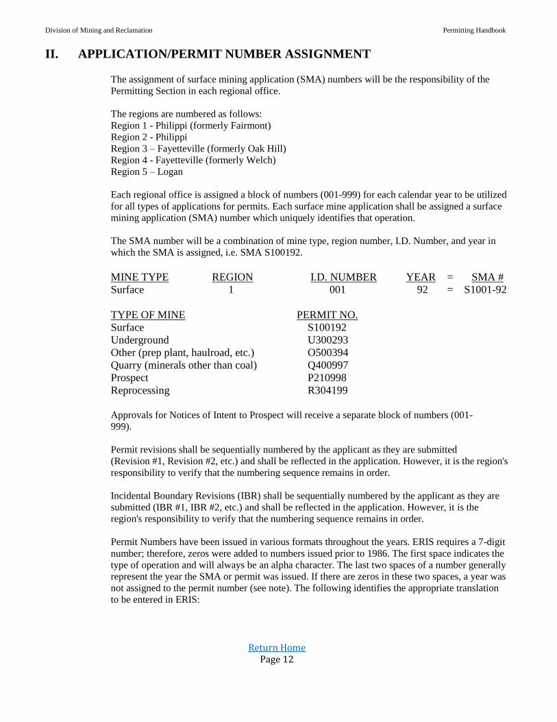
II. APPLICATION/PERMIT NUMBER ASSIGNMENT The assignment of surface mining application (SMA) numbers will be the responsibility of the
Permitting Section in each regional office.
The regions are numbered as follows:
Region 1 - Philippi (formerly Fairmont)
Region 2 - Philippi
Region 3 – Fayetteville (formerly Oak Hill)
Region 4 - Fayetteville (formerly Welch)
Region 5 – Logan
Each regional office is assigned a block of numbers (001-999) for each calendar year to be utilized
for all types of applications for permits. Each surface mine application shall be assigned a surface
mining application (SMA) number which uniquely identifies that operation.
The SMA number will be a combination of mine type, region number, I.D. Number, and year in
which the SMA is assigned, i.e. SMA S100192.
MINE TYPE REGION I.D. NUMBER YEAR = SMA #
Surface 1 001 92 = S1001-92
TYPE OF MINE PERMIT NO.
Surface S100192
Underground U300293
Other (prep plant, haulroad, etc.) O500394
Quarry (minerals other than coal) Q400997
Prospect P210998
Reprocessing R304199
Approvals for Notices of Intent to Prospect will receive a separate block of numbers (001-
999).
Permit revisions shall be sequentially numbered by the applicant as they are submitted
(Revision #1, Revision #2, etc.) and shall be reflected in the application. However, it is the region's
responsibility to verify that the numbering sequence remains in order.
Incidental Boundary Revisions (IBR) shall be sequentially numbered by the applicant as they are
submitted (IBR #1, IBR #2, etc.) and shall be reflected in the application. However, it is the
region's responsibility to verify that the numbering sequence remains in order.
Permit Numbers have been issued in various formats throughout the years. ERIS requires a 7-digit
number; therefore, zeros were added to numbers issued prior to 1986. The first space indicates the
type of operation and will always be an alpha character. The last two spaces of a number generally
represent the year the SMA or permit was issued. If there are zeros in these two spaces, a year was
not assigned to the permit number (see note). The following identifies the appropriate translation
to be entered in ERIS:

Division of Mining and Reclamation Permitting Handbook
Return Home Page 13
PERMIT NUMBERS
PREVIOUS PERMIT NUMBER FORMAT ENTER AS
D-1-83 D000183
D-1 D000100
EM-1; AO E000100
H-1 H000100
I-1 I000100
INC-8-83 C000883
L-1 L000100
M100194 M100194
O-1-83 O000183
P-1 P000100
P-1-83 P000183
Q-1-83 Q000183
R-1 R000100
R-1-83 R000183
S-1-83 S000183
S-34 S003400
U-1-83 U000183
UO-1 U000100
SMA-858 (DR-21) F000858
256-69 (DR-21) F027569
SMA 2682 M268200
SMA 808 M080800
BOR SMA 977 B097700
**WILDCAT W100000
Y100194 Y100194
**See Wildcat Log (Contact DMR database administrator)
Note: For 1981 only, convert 1-81 to Z000181. This prevents duplicates of the Permanent
Program permits issued in 1981, which have an "S" prefix.
Effective 1/1/2000, permits will be issued with 00 indicating the year 2000. The permit number
being issued in 2000 will also include the four-digit prefix indicating the regional office.

Division of Mining and Reclamation Permitting Handbook
Return Home Page 14
III. PERMIT APPLICATION FILING FEES
APPLICATION TYPE FILING FEE
MR3 Notice of Intent to Prospect $2000
MR4 Surface Mine Application $3500
MR4 Surface Mine Permit Amendment $2550
MR4C Incidental Coal Removal $3500
MR4D Dam Control Application $300
MR4PR Permit Revision Insignificant $0
MR4PR Permit Revisions Significant $2000
MR4PR Incidental Boundary Revision Insignificant $0
MR4PR Incidental Boundary Revision Significant $2000
MR17 Permit Renewal $3000
MR19 Operator Assignment Per Permit $1500
MR19A Permit Transfer, Sale or Assignment per
permit
$1500
MR19B Merger/Name Change $0
MR19C Change of Owners/Controllers $0
MR19R Reinstatement of Permit $0
INB Incremental Bonding $0
EWP Annual Emergency Warning Plan $100
REMINING $3500
QUARRY APPLICATIONS – Quarry Handbook
Note: For dams not requiring an annual Emergency Warning Plan, an annual registration fee of $100 will
be required at the yearly anniversary date of the Certificate of Approval.
Accepted Application Fee Payment Methods: Cash, Certified Check, Cashier’s Check, Bank Money
Order, US Postal Service Money Order, Credit Card (Visa, Discover, American Express, Master Card), and
Wire Transfer.
Application fee payment may be made via credit card by contacting WVDEP Accounts Receivable at 304-
926-0499 ext. 4888. All application fee submittals should be accompanied by the following information:
The DMR regional office, applicant name, permit number, application type, and the application sequence.
WVDEP Accounts Receivable staff will notify the DMR regional office of payment received.

Division of Mining and Reclamation Permitting Handbook
Return Home Page 15
IV. APPLICATION ADVERTISEMENT REQUIREMENTS
APPLICATION
TYPE
NUMBER
OF ADS
REQUIRED
COMMENT
PERIOD
INFORMAL
CONFERENCE
(MR3) Notice of Intent to Prospect NA NA NA
(MR3) Notice of Intent to Prospect greater than
260 Tons 1 15 NA
(MR4) Surface Mine Application 4 30 YES
(MR4) Surface Mine Re-Advertisement for
extension at 1 year Anniversary 1 10 NA
(MR4) Surface Mine Technically Complete 1 15 NA
(MR4) Surface Mine Permit Amendment 4 30 YES
(MR4C) Incidental Coal Removal 1 15 NA
(MR4D) Dam Application 1 15 NA
(MR4PR) Permit Revision or IBR Insignificant NA NA NA
(MR4PR) Permit Revision or IBR Significant 4 30 YES
(MR4PR) Permit Revision for Tire Disposal 4 30 YES
(MR4PR) Permit IBR within 100’ of Public Road 4 30 YES
(MR4PR) Permit IBR Involving New Landowners 4 30 YES
(MR17) Permit Renewal 4 30 YES
(MR19) Operator Assignment 1 30 NA
(MR19A) Permit, Transfer, Sale or Assignment 1 30 NA
(MR19B) Merger and/or Name Change 1 30 NA
(MR19C) Change of Owners/Controllers NA NA NA
(MR19R) Reinstatement of Permit 1 30 NA
Emergency Warning Plan NA NA NA
Incremental Bond NA NA NA
Remining 4 30 YES

Division of Mining and Reclamation Permitting Handbook
Return Home Page 16
ADDITIONAL INFORMATION
REGARDING
APPLICATION ADVERTISEMENT
1. Application must first be placed for public review in the courthouse or courthouses in the
county or counties of the proposed surface-mining operation. A signed, date stamped
courthouse placement acknowledgement must be submitted to the permit review section
before permission to advertise the application will be granted.
2. Location maps are required for the advertisement of the following applications: Notice of
Intent to Prospect, Surface Mine Applications, Permit Amendment Applications, Significant
Permit Revisions, Significant IBR, Permit Renewal and Permit Transfers.
3. For applications proposing activity in multiple counties, advertisement is required in all
counties reported where surface and/or underground activity is proposed. If a permit
amendment or IBR application proposes activity in a new county, advertisement is required
in the new county in addition to the county of the original permit.
4. Refer to 38CSR2-3.2 & 22-3-9(a) (6) & 22-3-20(a) for additional guidance relative to
advertising and public notice requirements.
V. APPLICATION REVIEW TIMETABLE GUIDELINES
APPLICATION
TYPE
FIRST
REVIEW
COMPLETED
(DAYS)
SUBSEQUENT
REVIEWS
COMPLETED
(DAYS) (MR3) Notice of Intent to Prospect 15 5
(MR4) Surface Mine Application Administrative 5 NA
(MR4) Surface Mine Application Technical 30 15
(MR4) Surface Mine Permit Amendment 30 15
(MR4D) Dam Application 45 20
(MR4PR) Permit Revision or IBR 15 5
(MR17) Permit Renewal 15 10
(MR19) Operator Assignment 10 5
(MR19A) Permit Transfer, Sale or Assignment 10 5
(MR19B) Merger and/or Name Change 10 5
(MR19C) Change of Owners/Controllers 10 5
(MR19R) Reinstatement of Permit 10 5
Emergency Warning Plan 10 5
Incremental Bond 5 5
*Review days are considered work days.
Note: All forms, letters and signage utilized in the Permitting Program processes, referenced in this
handbook, are located on the WVDEP Intranet @ Mining and Reclamation →Permitting Program.
Note: All Memorandums of Understanding and Memorandums of Agreement referenced in this handbook
are located on the WVDMR website.

Division of Mining and Reclamation Permitting Handbook
Return Home Page 17
VI. Permit Status Report
A. A report consisting of those permits issued during a specific month shall be prepared no later than
the 5th day of the month for those activities completed the previous month. This report shall be
advertised in newspapers of general circulation in the locality where the new permit area is
located. Sample available at WVDEP Intranet @ Mining and Reclamation →Permitting Program.
B. This status report shall also be provided to the County Clerk’s Office of those counties in which
new permits have been issued.
VII. Application Processing
A. Gatekeeping – All Application Types
1. Designated permit review section staff is notified via email that application has been
submitted to eSS.
2. Confirm receipt of application filing fee if required.
3. Confirm certification of application date is within thirty (30) days, and authorized signature
appears in blue ink.
4. Notify Permitting Supervisor of application submittal for Reviewer/Review Team assignments.
5. Application information entered in ERIS upon Permitting Supervisor direction.
a. The inspector assigned to a permit must be listed as an associated party for all
application types submitted in order to have knowledge of all permitting
transactions.
b. DMR headquarters bond specialist must be listed as an associated party for
Increment Start, IBR’s, Revisions, Prospects, and Renewal applications.
c. DMR headquarters AVS specialist must be listed as an associated party for SMA,
Permit Amendment, MR19, MR19A, and MR19B applications.
d. Applicant’s consultant should be listed as an associated party if applicable.
e. Application status in eSS will transition from New to Pending.
Note: Refer to the Cooperating and Affected Local, State & Federal Agencies section for
instructions regarding applications proposing valley fills.
B. Application Review, Findings and Decision
1. Certification of application for all application types must be dated within thirty (30) days of
final approval.
2. Refer to the Permit Applications section of this handbook for additional guidance relative to
each application type.
3. Refer to the Citizen Participation section of this handbook for guidance relative to comments
and informal conference requests received on applications during comment periods.

Division of Mining and Reclamation Permitting Handbook
Return Home Page 18
4. Permit applications will not be approved for expired permits unless conditions exist beyond
the control of both the permittee and WVDEP, which delay approval of the permit renewal.
5. O&C reviewers must request AVS reports for SMA, Permit Amendment, MR19, and MR19A
applications. This should occur during the initial review so that the applicant may resolve
any AVS issues reported, and avoid delays once all other requirements have been met. For
guidance refer to AVS Findings.
Notice of Intent to Prospect (MR3)
o Review
WVDEP decision must be made within fifteen (15) days of receipt of
application or corrections must be sent to applicant within fifteen (15)
days of receipt.
If the applicant has not made timely and complete corrections, the
application will be terminated. (See Application Decision Overview)
Confirm all applicable sections have been completed and approved.
o Findings
Application checklist
Reviewer recommendation
Inspector recommendation
SHPO consultation
WV Unemployment Compensation Compliance
WV Secretary of State Verification
WV Tax Department Compliance
AVS Report
Ground Water Protection Plan Fee Compliance
ERIS Applicant Block List Report
o Decision
Quality Control Checklist completed by Permitting Supervisor.
Decision based on application findings, made by Regional Permitting
Supervisor, is prepared and uploaded to eSS application.
Application must be refreshed in ERIS prior to issuance.
Application decision transmitted to associated parties via Final Action
Notification email.
Application status will transition from Pending to Closed in eSS.
Surface Mine Application (MR4) o Administrative Review
Commence review and within five (5) working days notify applicant
whether application is administratively complete or corrections are
required.
If corrections are required, the applicant must resubmit the corrected
application within thirty (30) working days. If the application is not
resubmitted within thirty (30) working days or if application is
resubmitted within thirty (30) working days and is still not
administratively complete, report application to permitting supervisor for
Division of Mining and Reclamation Permitting Handbook
Return Home Page 19
denial. Following denial, the application may be resubmitted,
accompanied by a new filing fee. (See Application Decision Overview)
Once application is deemed administratively complete, SMA number will
be assigned.
Applicant will at this point be sent a courthouse acknowledgement form
to document placement of the application, in the courthouse or
courthouses in the county or counties of the proposed surface-mining
operation, for public review.
The SMA is also available for public review at the regional WVDEP
office where SMA review is being conducted.
The regional office must receive the signed, date stamped courthouse
acknowledgement form before permission to advertise the application
can be granted. The permission to advertise milestone should be entered
in ERIS.
Notify affected agencies (See Cooperating and Affected Local, State &
Federal Agencies section).
Request WV Division of Labor and WV Workers Compensation
compliance review. (See Application Findings Overview)
A public notice of the application is automatically placed on the WVDEP
enhanced mailing list for WVDEP public notice when the milestone for
courthouse placement of the application is entered in ERIS.
o Technical Review
SMA number is valid for one year. Extension of the SMA number, by
the permitting supervisor, may be necessary for applications requiring
more than one year to obtain final decision. The initial extension must be
requested by the applicant, in writing, prior to the expiration of the
original assignment, and re-advertisement conducted (one (1) time
advertisement with ten (10) day comment period). The applicant must
demonstrate diligent pursuit by resubmitting the corrected application
within thirty (30) working days of corrections received. Extensions are
to be granted for no more than sixty (60) day increments. Subsequent
requests for SMA number extension may be granted provided diligent
pursuit of application approval is demonstrated, however, re-
advertisement is not required. If the applicant has not made timely and
complete corrections, the SMA number will not be extended and the
SMA will be terminated. (See Application Decision Overview)
The review team leader will transmit the review team’s first technical
corrections to the applicant within thirty (30) working days of SMA
number issuance. Subsequent reviews are to be completed and
transmitted to the applicant within fifteen (15) working days. The
applicant is required to resubmit the corrected application within thirty
(30) working days of corrections received. If the application remains
incomplete after two (2) rounds of technical review, a meeting shall be
scheduled with applicant and/or their consultant, to address completion
of the application.
Confirm all applicable sections have been completed and approved.
After the Secretary deems a Surface Mine Application technically
complete, the Secretary shall cause the applicant to advertise that the
application is technically complete. The one time notice shall state that
the application has been deemed technically complete by the Secretary

Division of Mining and Reclamation Permitting Handbook
Return Home Page 20
and include a fifteen (15) day public review period: Provided that,
Notice of Technical Completeness is not necessary if the application was
technically complete prior to the end of the comment period of the
original advertisement or a decision is made within ninety (90) days of
the end of the comment period or informal conference.
o Findings
Application Checklist
Tracking Form
Pre-Inspection Narrative
MR2A
Waivers
Permitting Supervisor Recommendation
Geologist Recommendation
Engineer Recommendation
Environmental Resource Specialist Recommendation
Forester Recommendation
Soil Scientist Recommendation
Inspector Recommendation
Blasting Recommendation
NPDES Summary
O&C Recommendation
CHIA
Buffer Zone Analysis
WV Division of Labor Compliance
WV Workers Compensation Compliance
WV Unemployment Compensation Compliance
WV Secretary of State Verification
WV Tax Department Compliance
AVS Recommendation
Informal Conference Information
Community Impact Statement
Affected Agency Notifications
Relevant Correspondence
Ground Water Protection Plan Fee Compliance
ERIS Applicant Block List Report
o Decision
Quality Control Checklist completed by Permitting Supervisor.
Application must be refreshed in ERIS prior to issuance
Regional Permitting Supervisor will notify DMR headquarters staff of
application recommendation. DMR headquarters staff will confirm
adequacy of bond, insurance compliance and final AVS compliance.
Assistant Deputy Director for Coal & Non-Coal Permitting will review
region and headquarter findings and make recommendation to DMR
Director for final action decision. Director’s decision is prepared and
uploaded to eSS application.
When application decision is rendered, the Secretary shall notify within
ten (10) days each person who filed comments or objections to the
application, each party to an informal conference, and the appropriate
local government agencies including the clerk of the county commission.
Division of Mining and Reclamation Permitting Handbook
Return Home Page 21
Application decision transmitted to associated parties via Final Action
Notification email.
Application status will transition from Pending to Closed in eSS.
Surface Mine Permit Amendment (MR4) o Review
Confirm permit has not expired.
Initial review shall confirm information requirements for advertising.
Applicant will at this point be sent a courthouse acknowledgement form
to document placement of the application, in the courthouse or
courthouses in the county or counties of the proposed surface-mining
operation, for public review.
The SMA is also available for public review at the regional WVDEP
office where SMA review is being conducted.
The regional office must receive the signed, date stamped courthouse
acknowledgement form before permission to advertise the application
can be granted. The permission to advertise milestone should be entered
in ERIS.
Notify affected agencies (See Cooperating and Affected Local, State &
Federal Agencies section).
Request WV Division of Labor and WV Workers Compensation
compliance review. (See Application Findings Overview)
A public notice of the application is automatically placed on the WVDEP
enhanced mailing list for WVDEP public notice when the milestone for
courthouse placement of the application is entered in ERIS.
The review team leader will transmit the review team’s first technical
corrections to the applicant within thirty (30) working days of application
being gatekept. Subsequent reviews are to be completed and transmitted
to the applicant within fifteen (15) working days. The applicant is
required to resubmit the corrected application within thirty (30) working
days of corrections received. If the application remains incomplete after
two (2) rounds of technical review, a meeting shall be scheduled with
applicant and/or their consultant, to address completion of the
application. If the applicant has not made timely and complete
corrections, the application will be terminated. (See Application Decision
Overview)
Confirm all applicable sections have been completed and approved.
Note: Bond submittal is not required for application approval, however, bond must be
provided prior to any activity on proposed permit amendment area or if permit
amendment area is proposed in an existing active increment.
o Findings
Application Checklist
Tracking Form
Pre-Inspection Narrative
MR2A
Waivers
Permitting Supervisor Recommendation
Geologist Recommendation
Division of Mining and Reclamation Permitting Handbook
Return Home Page 22
Engineer Recommendation
Environmental Resource Specialist Recommendation
Forester Recommendation
Soil Scientist Recommendation
Inspector Recommendation
Blasting Recommendation
NPDES Summary
O&C Recommendation
CHIA
Buffer Zone Analysis
WV Division of Labor Compliance
WV Workers Compensation Compliance
WV Unemployment Compensation Compliance
WV Secretary of State Verification
WV Tax Department Compliance
AVS Recommendation
Informal Conference Information
Community Impact Statement
Affected Agency Notifications
Relevant Correspondence
Ground Water Protection Plan Fee Compliance
ERIS Applicant Block List Report
o Decision
Quality Control Checklist completed by Permitting Supervisor.
Application must be refreshed in ERIS prior to issuance.
Regional Permitting Supervisor will notify DMR headquarters staff of
application recommendation. DMR headquarters staff will confirm
adequacy of bond, insurance compliance and final AVS compliance.
Assistant Deputy Director for Coal & Non-Coal Permitting will review
region and headquarter findings and make recommendation to DMR
Director for final action decision. Director’s decision is prepared and
uploaded to eSS application.
When application decision is rendered, the Secretary shall notify within
ten (10) days each person who filed comments or objections to the
application, each party to an informal conference, and the appropriate
local government agencies including the clerk of the county commission.
Application decision transmitted to associated parties via Final Action
Notification email.
Application status will transition from Pending to Closed in eSS.
Revision (Insignificant) (MR-4PR) o Review
Confirm permit has either not expired, or has obtained Phase I or Phase
II release, or has been granted a renewal waiver.
Applications shall be reviewed and recommended for approval, denial or
corrections requested within fifteen (15) working days of application
being gatekept. Resubmitted corrected applications shall be reviewed
within five (5) working days.
Division of Mining and Reclamation Permitting Handbook
Return Home Page 23
If the applicant has not made timely and complete corrections, the
application will be terminated. (See Application Decision Overview)
Confirm all applicable sections have been completed and approved.
o Findings
Application Checklist
Tracking Form
Waivers
Review Team Recommendations
WV Workers Compensation Compliance
WV Unemployment Compensation Compliance
Relevant Correspondence
ERIS Applicant Block List Report
Ground Water Protection Plan Fee Compliance
o Decision
Quality Control Checklist completed by Permitting Supervisor.
Application must be refreshed in ERIS prior to issuance.
Decision based on application findings, made by Regional Permitting
Supervisor, is prepared and uploaded to eSS application.
Application decision transmitted to associated parties via Final Action
Notification email. Application status will transition from Pending to
Closed in eSS.
Revision (Significant) (MR-4PR) o Review
Confirm permit has either not expired, or has obtained Phase I or Phase
II release, or has been granted a renewal waiver.
Applications shall be reviewed and recommended for approval, denial or
corrections requested within fifteen (15) working days of application
being gatekept. Resubmitted corrected applications shall be reviewed
within five (5) working days.
Initial review shall confirm information requirements for advertising.
Applicant will at this point be sent a courthouse acknowledgement form
to document placement of the application, in the courthouse or
courthouses in the county or counties of the proposed surface-mining
operation, for public review.
The application is also available for public review at the regional
WVDEP office where application review is being conducted.
The regional office must receive the signed, date stamped courthouse
acknowledgement form before permission to advertise the application
can be granted. The permission to advertise milestone should be entered
in ERIS.
Notify affected agencies (See Cooperating and Affected Local, State &
Federal Agencies section).
A public notice of the application is automatically placed on the WVDEP
enhanced mailing list for WVDEP public notice when the milestone for
courthouse placement of the application is entered in ERIS.
If the applicant has not made timely and complete corrections, the
application will be terminated. (See Application Decision Overview)
Confirm all applicable sections have been completed and approved.

Division of Mining and Reclamation Permitting Handbook
Return Home Page 24
o Findings
Application Checklist
Tracking Form
Pre-Inspection Narrative
MR2A
Waivers
Permitting Supervisor Recommendation
Review Team Recommendations
CHIA
WV Workers Compensation Compliance
WV Unemployment Compensation Compliance
WV Tax Department Compliance
Informal Conference Information
Affected Agency Notifications
Relevant Correspondence
Ground Water Protection Plan Fee Compliance
ERIS Applicant Block List Report
o Decision
Quality Control Checklist completed by Permitting Supervisor
Application must be refreshed in ERIS prior to issuance.
Decision based on application findings, made by Regional Permitting
Supervisor, is prepared and uploaded to eSS application.
When application decision is rendered, the Secretary shall notify within
ten (10) days each person who filed comments or objections to the
application, each party to an informal conference, and the appropriate
local government agencies including the clerk of the county commission.
Application decision transmitted to associated parties via Final Action
Notification email.
Application status will transition from Pending to Closed in eSS.
Incidental Boundary Revision (IBR) (Insignificant) o Review
Confirm permit has either not expired, or has obtained Phase I or Phase
II release, or has been granted a renewal waiver.
Applications shall be reviewed and recommended for approval, denial or
corrections requested within fifteen (15) working days of application
being gatekept. Resubmitted corrected applications shall be reviewed
within five (5) working days.
SHPO consultation can be waived if additional area proposed is under 5
acres or proposed additional area was previously disturbed.
Endangered Species Consultation (See Fish & Wildlife Information
section for guidance)
If the applicant has not made timely and complete corrections, the
application will be terminated. (See Application Decision Overview)
Confirm all applicable sections have been completed and approved.
o Findings
Application Checklist
Tracking Form
Division of Mining and Reclamation Permitting Handbook
Return Home Page 25
Waivers
Review Team Recommendations
WV Workers Compensation Compliance
WV Unemployment Compensation Compliance
Relevant Correspondence
ERIS Applicant Block List Report
Ground Water Protection Plan Fee Compliance
o Decision
Quality Control Checklist completed by Permitting Supervisor.
Application must be refreshed in ERIS prior to issuance.
Decision based on application findings, made by Regional Permitting
Supervisor, is prepared and uploaded to eSS application.
Application decision transmitted to associated parties via Final Action
Notification email. Application status will transition from Pending to
Closed in eSS.
Incidental Boundary Revision (IBR) (Significant) o Review
Confirm permit has either not expired, or has obtained Phase I or Phase
II release, or has been granted a renewal waiver.
Applications shall be reviewed and recommended for approval, denial or
corrections requested within fifteen (15) working days of application
being gatekept. Resubmitted corrected applications shall be reviewed
within five (5) working days.
Initial review shall confirm information requirements for advertising.
Applicant will at this point be sent a courthouse acknowledgement form
to document placement of the application, in the courthouse or
courthouses in the county or counties of the proposed surface-mining
operation, for public review.
The application is also available for public review at the regional
WVDEP office where application review is being conducted.
The regional office must receive the signed, date stamped courthouse
acknowledgement form before permission to advertise the application
can be granted. The permission to advertise milestone should be entered
in ERIS.
Notify affected agencies (See Cooperating and Affected Local, State &
Federal Agencies section).
A public notice of the application is automatically placed on the WVDEP
enhanced mailing list for WVDEP public notice when the milestone for
courthouse placement of the application is entered in ERIS.
SHPO consultation can be waived if additional area proposed is under 5
acres or proposed additional area was previously disturbed.
Endangered Species Consultation (See Fish & Wildlife Information
section for guidance)
If the applicant has not made timely and complete corrections, the
application will be terminated. (See Application Decision Overview)
Confirm all applicable sections have been completed and approved.
Division of Mining and Reclamation Permitting Handbook
Return Home Page 26
o Findings
Application Checklist
Tracking Form
Pre-Inspection Narrative
MR2A
Waivers Permitting Supervisor Recommendation
Review Team Recommendations
CHIA
WV Workers Compensation Compliance
WV Unemployment Compensation Compliance
WV Tax Department Compliance
Informal Conference Information
Affected Agency Notifications
Relevant Correspondence
Ground Water Protection Plan Fee Compliance
ERIS Applicant Block List Report
o Decision
Quality Control Checklist completed by Permitting Supervisor.
Application must be refreshed in ERIS prior to issuance.
Decision based on application findings, made by Regional Permitting
Supervisor, is prepared and uploaded to eSS application.
When application decision is rendered, the Secretary shall notify within
ten (10) days each person who filed comments or objections to the
application, each party to an informal conference, and the appropriate
local government agencies including the clerk of the county commission.
Application decision transmitted to associated parties via Final Action
Notification email.
Application status will transition from Pending to Closed in eSS.
Permit Renewal (MR17) o Review
Confirm application submittal occurred one hundred (120) days prior to
permit expiration date. Notify I&E staff if application submittal was not
received one hundred (120) days prior to permit expiration date.
Applications shall be reviewed and recommended for approval, denial or
corrections requested within fifteen (15) working days of application
being gatekept. Resubmitted corrected applications shall be reviewed
within ten (10) working days.
Initial review shall confirm information requirements for advertising.
Applicant will at this point be sent a courthouse acknowledgement form
to document placement of the application, in the courthouse or
courthouses in the county or counties of the proposed surface-mining
operation, for public review.
The application is also available for public review at the regional
WVDEP office where application review is being conducted.
The regional office must receive the signed, date stamped courthouse
acknowledgement form before permission to advertise the application
can be granted. The permission to advertise milestone should be entered
in ERIS.
Division of Mining and Reclamation Permitting Handbook
Return Home Page 27
Notify affected agencies (See Cooperating and Affected Local, State &
Federal Agencies section).
A public notice of the application is automatically placed on the WVDEP
enhanced mailing list for WVDEP public notice when the milestone for
courthouse placement of the application is entered in ERIS.
A time extension of sixty (60) days may be granted by the Secretary for a
permit renewal which has been submitted but is logistically impractical
to process before the expiration date. The extension must be granted
prior to the permit expiration date.
If the applicant has not made timely and complete corrections, notify the
inspector.
Confirm all applicable sections have been completed and approved.
o Findings
Application Checklist
Tracking Form
Reviewer Recommendation
Inspector Recommendation
WV Workers Compensation Compliance
WV Unemployment Compensation Compliance
WV Secretary of State Verification
WV Tax Department Compliance
Informal Conference Information
Affected Agency Notifications
Relevant Correspondence
Ground Water Protection Plan Fee Compliance
o Decision
Quality Control Checklist completed by Permitting Supervisor.
Application must be refreshed in ERIS prior to issuance.
Decision based on application findings, made by Regional Permitting
Supervisor, is prepared and uploaded to eSS application.
When application decision is rendered, the Secretary shall notify within
ten (10) days each person who filed comments or objections to the
application, each party to an informal conference, and the appropriate
local government agencies including the clerk of the county commission.
Application decision transmitted to associated parties via Final Action
Notification email.
Application status will transition from Pending to Closed in eSS.
Operator Assignment (MR19) o Review
Confirm permit has not expired.
Applications shall be reviewed and recommended for approval, denial or
corrections requested within ten (10) working days of application being
gatekept. Resubmitted corrected applications shall be reviewed within
five (5) working days.
Request WV Division of Labor and WV Workers Compensation
compliance review. (See Application Findings Overview)
Initial review shall confirm information requirements for advertising.

Division of Mining and Reclamation Permitting Handbook
Return Home Page 28
Refer to the Permit Applications - Operator Assignment section of the
handbook for guidance relative to Advance Approval requests.
Applicant will at this point be sent a courthouse acknowledgement form
to document placement of the application, in the courthouse or
courthouses in the county or counties of the proposed surface-mining
operation, for public review.
The application is also available for public review at the regional
WVDEP office where application review is being conducted.
The regional office must receive the signed, date stamped courthouse
acknowledgement form before permission to advertise the application
can be granted. The permission to advertise milestone should be entered
in ERIS.
A public notice of the application is automatically placed on the WVDEP
enhanced mailing list for WVDEP public notice when the milestone for
courthouse placement of the application is entered in ERIS.
If the applicant has not made timely and complete corrections, the
application will be terminated. (See Application Decision Overview)
Confirm all applicable sections have been completed and approved.
o Findings
Application Checklist
Tracking Form
Inspector Recommendation
O&C Recommendation
WV Division of Labor Compliance
WV Workers Compensation Compliance
WV Unemployment Compensation Compliance
WV Secretary of State Verification
WV Tax Department Compliance
AVS Recommendation
Advance Approval Documents
Relevant Correspondence
Ground Water Protection Plan Fee Compliance
ERIS Applicant Block List Report
o Decision
Quality Control Checklist completed by Permit Supervisor.
Application must be refreshed in ERIS prior to issuance.
Decision based on application findings, made by Regional Permitting
Supervisor, is prepared and uploaded to eSS application.
When application decision is rendered, the Secretary shall notify within
ten (10) days each person who filed comments or objections to the
application, each party to an informal conference, and the appropriate
local government agencies including the clerk of the county commission.
Application decision transmitted to associated parties via Final Action
Notification email.
Application status will transition from Pending to Closed in eSS.

Division of Mining and Reclamation Permitting Handbook
Return Home Page 29
Permit Transfer, Assignment or Sale (MR19A) o Review
Confirm permit has either not expired, or has obtained Phase I or Phase
II release, or has been granted a renewal waiver.
Applications shall be reviewed and recommended for approval, denial or
corrections requested within ten (10) working days of application being
gatekept. Resubmitted corrected applications shall be reviewed within
five (5) working days.
Request WV Division of Labor and WV Workers Compensation
compliance review. (See Application Findings Overview)
Initial review shall confirm information requirements for advertising.
Refer to the Permit Applications – Permit Transfer Assignment or Sale
section of the handbook for guidance relative to Advance Approval
requests.
Applicant will at this point be sent a courthouse acknowledgement form
to document placement of the application, in the courthouse or
courthouses in the county or counties of the proposed surface-mining
operation, for public review.
The application is also available for public review at the regional
WVDEP office where application review is being conducted.
The regional office must receive the signed, date stamped courthouse
acknowledgement form before permission to advertise the application
can be granted. The permission to advertise milestone should be entered
in ERIS.
A public notice of the application is automatically placed on the WVDEP
enhanced mailing list for WVDEP public notice when the milestone for
courthouse placement of the application is entered in ERIS.
If the applicant has not made timely and complete corrections, the
application will be terminated. (See Application Decision Overview)
Confirm all applicable sections have been completed and approved.
o Findings
Application Checklist
Tracking Form
MR2A
Permit Supervisor Recommendation
Inspector Recommendation
O&C Recommendation
WV Division of Labor Compliance
WV Workers Compensation Compliance
WV Unemployment Compensation Compliance
WV Secretary of State Verification
WV Tax Department Compliance
AVS Recommendation
Advance Approval Documents
Relevant Correspondence
Ground Water Protection Plan Fee Compliance
ERIS Applicant Block List Report

Division of Mining and Reclamation Permitting Handbook
Return Home Page 30
o Decision
Quality Control Checklist completed by Permitting Supervisor.
Application must be refreshed in ERIS prior to issuance.
Regional Permitting Supervisor will notify DMR headquarters staff of
application recommendation. DMR headquarters staff will confirm
adequacy of bond, insurance compliance and final AVS compliance.
Assistant Deputy Director for Coal & Non-Coal Permitting will review
region and headquarter findings and make recommendation to DMR
Director for final action decision.
Director’s decision is prepared and uploaded to eSS application.
When application decision is rendered, the Secretary shall notify within
ten (10) days each person who filed comments or objections to the
application, each party to an informal conference, and the appropriate
local government agencies including the clerk of the county commission.
Application decision transmitted to associated parties via Final Action
Notification email.
Application status will transition from Pending to Closed in eSS.
Permittee Merger or Name Change (MR19B) o Review
Review conducted at DMR headquarters.
Confirm permit has not expired.
Applications shall be reviewed and recommended for approval, denial or
corrections requested within ten (10) working days of application being
gatekept. Resubmitted corrected applications shall be reviewed within
five (5) working days.
Request WV Division of Labor and WV Workers Compensation
compliance review. (See Application Findings Overview)
Initial review shall confirm information requirements for advertising.
Applicant will at this point be sent a courthouse acknowledgement form
to document placement of the application, in the courthouse or
courthouses in the county or counties of the proposed surface-mining
operation, for public review.
The application is also available for public review at the regional
WVDEP office where application review is being conducted.
The regional office must receive the signed, date stamped courthouse
acknowledgement form before permission to advertise the application
can be granted. The permission to advertise milestone should be entered
in ERIS.
A public notice of the application is automatically placed on the WVDEP
enhanced mailing list for WVDEP public notice when the milestone for
courthouse placement of the application is entered in ERIS.
If the applicant has not made timely and complete corrections, the
application will be terminated. (See Application Decision Overview)
Confirm all applicable sections have been completed and approved.
o Findings
Application Checklist
Tracking Form
O&C Recommendation (COCF if applicable)
Division of Mining and Reclamation Permitting Handbook
Return Home Page 31
WV Secretary of State Verification
Relevant Correspondence
o Decision
Application must be refreshed in ERIS prior to issuance.
DMR headquarters staff will confirm bond information, insurance
compliance and final AVS compliance.
Assistant Deputy Director for Coal & Non-Coal Permitting will review
headquarter findings and make recommendation to DMR Director for
final action decision.
Director’s decision is prepared and uploaded to eSS application.
When application decision is rendered, the Secretary shall notify within
ten (10) days each person who filed comments or objections to the
application, each party to an informal conference, and the appropriate
local government agencies including the clerk of the county commission.
Application decision transmitted to associated parties via Final Action
Notification email.
Application status will transition from Pending to Closed in eSS.
Officer Update/Change of Owner /Controller (MR19C) o Review
Confirm permit has either not expired, or has obtained Phase I or Phase
II release, or has been granted a renewal waiver.
Review conducted at DMR headquarters.
Applications shall be reviewed and recommended for approval, denial or
corrections requested within ten (10) working days of application being
gatekept. Resubmitted corrected applications shall be reviewed within
five (5) working days.
If the applicant has not made timely and complete corrections, the
application will be terminated. (See Application Decision Overview)
Confirm all applicable sections have been completed and approved.
o Findings
Application Checklist
Tracking Form
O/C Recommendation (COCF if applicable)
WV Secretary of State Verification
Relevant Correspondence
o Decision
Application must be refreshed in ERIS prior to issuance.
Reviewer’s decision is prepared and uploaded to eSS application.
Application decision transmitted to associated parties via Final Action
Notification email.
Application status will transition from Pending to Closed in eSS.
Division of Mining and Reclamation Permitting Handbook
Return Home Page 32
Permit Reinstatement (MR19R) Note: Within one year following the notice of permit revocation, subject to the
discretion of the director and based upon a petition for reinstatement, the revoked
permit may be reinstated. The reinstated permit may be assigned to any person who
meets the permit eligibility requirements of this article.
o Review
Applications shall be reviewed and recommended for approval, denial or
corrections requested within ten (10) working days of application being
gatekept. Resubmitted corrected applications shall be reviewed within
five (5) working days.
Request WV Division of Labor and WV Workers Compensation
compliance review. (See Application Findings Overview)
Initial review shall confirm information requirements for advertising.
Applicant will at this point be sent a courthouse acknowledgement form
to document placement of the application, in the courthouse or
courthouses in the county or counties of the proposed surface-mining
operation, for public review.
The application is also available for public review at the regional
WVDEP office where application review is being conducted.
The regional office must receive the signed, date stamped courthouse
acknowledgement form before permission to advertise the application
can be granted. The permission to advertise milestone should be entered
in ERIS.
A public notice of the application is automatically placed on the WVDEP
enhanced mailing list for WVDEP public notice when the milestone for
courthouse placement of the application is entered in ERIS.
If the applicant has not made timely and complete corrections, the
application will be terminated. (See Application Decision Overview)
Confirm all applicable sections have been completed and approved.
o Findings
Application Checklist
Tracking Form
Permit Supervisor Recommendation
Inspector Recommendation
O&C Recommendation
WV Division of Labor Compliance
WV Workers Compensation Compliance
WV Unemployment Compensation Compliance
WV Secretary of State Verification
WV Tax Department Compliance
AVS Recommendation
Relevant Correspondence
Ground Water Protection Plan Fee Compliance
ERIS Applicant Block List Report
o Decision
Quality Control Checklist completed by Permitting Supervisor.
Application must be refreshed in ERIS prior to issuance.
Regional Permitting Supervisor will notify DMR headquarters staff of
Division of Mining and Reclamation Permitting Handbook
Return Home Page 33
application recommendation. DMR headquarters staff will confirm
adequacy of bond, insurance compliance and final AVS compliance.
Assistant Deputy Director for Coal & Non-Coal Permitting will review
region and headquarter findings and make recommendation to DMR
Director for final action decision.
Director’s decision is prepared and uploaded to eSS application.
When application decision is rendered, the Secretary shall notify within
ten (10) days each person who filed comments or objections to the
application, each party to an informal conference, and the appropriate
local government agencies including the clerk of the county commission.
Application decision transmitted to associated parties via Final Action
Notification email.
Application status will transition from Pending to Closed in eSS.
Dam (MR4D) o Review
Confirm permit has not expired.
Applications shall be reviewed and recommended for approval, denial or
corrections requested within forty five (45) working days of application
being gatekept. Resubmitted corrected applications shall be reviewed
within five (20) working days.
Initial review shall confirm information requirements for advertising.
Applicant will at this point be sent a courthouse acknowledgement form
to document placement of the application, in the courthouse or
courthouses in the county or counties of the proposed surface-mining
operation, for public review.
The application is also available for public review at the regional
WVDEP office where application review is being conducted.
The regional office must receive the signed, date stamped courthouse
acknowledgement form before permission to advertise the application
can be granted. The permission to advertise milestone should be entered
in ERIS.
A public notice of the application is automatically placed on the WVDEP
enhanced mailing list for WVDEP public notice when the milestone for
courthouse placement of the application is entered in ERIS.
If the applicant has not made timely and complete corrections, the
application will be terminated. (See Application Decision Overview)
Confirm all applicable sections have been completed and approved.
o Findings
Application Checklist
Tracking Form
Region Dam Engineer Recommendation
Inspector Recommendation
Blasting Recommendation
Ground Water Protection Plan Fee Compliance
ERIS Applicant Block List Report
Relevant Correspondence

Division of Mining and Reclamation Permitting Handbook
Return Home Page 34
o Decision
Application must be refreshed in ERIS prior to issuance.
Decision based on application findings, made by DMR Dam Engineer, is
prepared and uploaded to eSS application.
When application decision is rendered, the Secretary shall notify within
ten (10) days each person who filed comments or objections to the
application, each party to an informal conference, and the appropriate
local government agencies including the clerk of the county commission.
Application decision transmitted to associated parties via Final Action
Notification email.
Application status will transition from Pending to Closed in eSS.
Increment Start (INB) o Review
Confirm permit has not expired.
Applications shall be reviewed and recommended for approval, denial or
corrections requested within five (5) working days of application being
gatekept Resubmitted corrected applications shall be reviewed within
five (5) working days.
If the applicant has not made timely and complete corrections, the
application will be terminated. (See Application Decision Overview)
Confirm all applicable sections have been completed and approved.
o Findings
Application Checklist
Tracking Form
Reviewer Recommendation
Relevant Correspondence
o Decision
Quality Control Checklist completed by Permitting Supervisor.
Application must be refreshed in ERIS prior to issuance.
Decision based on application findings, made by Regional Permitting
Supervisor, is prepared and uploaded to eSS application.
Application decision transmitted to associated parties via Final Action
Notification email.
Application status will transition from Pending to Closed in eSS
Emergency Warning Plan (EWP) o Review
Confirm permit has either not expired, or has obtained Phase I or Phase
II release, or has been granted a renewal waiver.
Applications shall be reviewed and recommended for approval, denial or
corrections requested within ten (10) working days of application being
gatekept Resubmitted corrected applications shall be reviewed within
five (5) working days.
If the applicant has not made timely and complete corrections, the
application will be terminated. (See Application Decision Overview)
Confirm all applicable sections have been completed and approved.

Division of Mining and Reclamation Permitting Handbook
Return Home Page 35
o Findings
Application Checklist
Tracking Form
Reviewer Recommendation
Inspector Recommendation
Relevant Correspondence
o Decision
Application must be refreshed in ERIS prior to issuance.
Decision based on application findings, made by Regional Dam
Engineer, is prepared and uploaded to eSS application.
Application decision transmitted to associated parties via Final Action
Notification email.
Application status will transition from Pending to Closed in eSS.
Remining Application o Administrative Review
Commence review and within five (5) working days notify applicant
whether application is administratively complete or corrections are required.
If corrections are required the applicant must resubmit the corrected
application within thirty (30) working days. If the application is not
resubmitted within thirty (30) working days or if application is
resubmitted within thirty (30) working days and is still not
administratively complete, report application to permitting supervisor
for denial. Following denial, the application may be resubmitted,
accompanied by a new filing fee. (See Application Decision Overview)
Once application is deemed administratively complete, SMA number will
be assigned.
Applicant will at this point be sent a courthouse acknowledgement form
to document placement of the application, in the courthouse or
courthouses in the county or counties of the proposed surface-mining
operation, for public review.
The application is also available for public review at the regional
WVDEP office where application review is being conducted.
The regional office must receive the signed, date stamped courthouse
acknowledgement form before permission to advertise the application
can be granted. The permission to advertise milestone should be entered
in ERIS.
Notify affected agencies (See Cooperating and Affected Local, State &
Federal Agencies section).
Request WV Division of Labor and WV Workers Compensation
compliance review. (See Application Findings Overview)
A public notice of the application is automatically placed on the WVDEP
enhanced mailing list for WVDEP public notice when the milestone for
courthouse placement of the application is entered in ERIS.
o Technical Review
SMA number is valid for one year. Extension of the SMA number, by
the permitting supervisor, may be necessary for applications requiring

Division of Mining and Reclamation Permitting Handbook
Return Home Page 36
more than one year to obtain final decision. The initial extension must be
requested by the applicant, in writing, prior to the expiration of the
original assignment, and re-advertisement conducted (four (4) time
advertisement with thirty (30) day comment period). The applicant must
demonstrate diligent pursuit by resubmitting the corrected application
within thirty (30) working days of corrections received. Extensions are
to be granted for no more than sixty (60) day increments. Subsequent
requests for SMA number extension may be granted provided diligent
pursuit of application approval is demonstrated, however, re-
advertisement is not required. If the applicant has not made timely and
complete corrections, the SMA number will not be extended and the
SMA will be terminated. (See Application Decision Overview)
The review team leader will transmit the review team’s first technical
corrections to the applicant within thirty (30) working days of SMA
number issuance. Subsequent reviews are to be completed and
transmitted to the applicant within fifteen (15) working days. The
applicant is required to resubmit the corrected application within thirty
(30) working days of corrections received. If the application remains
incomplete after two (2) rounds of technical review, a meeting shall be
scheduled with applicant and/or their consultant, to address completion
of the application.
Confirm all applicable sections have been completed and approved.
o Findings
Application Checklist
Tracking Form
Pre-Inspection Narrative
MR2A
Waivers
Permitting Supervisor Recommendation
Geologist Recommendation
Engineer Recommendation
Environmental Resource Specialist Recommendation
Forester Recommendation
Soil Scientist Recommendation
Inspector Recommendation
Blasting Recommendation
NPDES Summary
O&C Recommendation
CHIA
Buffer Zone Analysis
WV Division of Labor Compliance
WV Workers Compensation Compliance
WV Unemployment Compensation Compliance
WV Secretary of State Verification
WV Tax Department Compliance
AVS Recommendation
Informal Conference Information
Community Impact Statement
Affected Agency Notifications
Relevant Correspondence

Division of Mining and Reclamation Permitting Handbook
Return Home Page 37
Ground Water Protection Plan Fee Compliance
ERIS Applicant Block List Report
o Decision
Quality Control Checklist completed by Permitting Supervisor.
Application must be refreshed in ERIS prior to issuance.
Regional Permitting Supervisor will notify DMR headquarters staff of
application recommendation. DMR headquarters staff will confirm
adequacy of bond, insurance compliance and final AVS compliance.
Assistant Deputy Director for Coal & Non-Coal Permitting will review
region and headquarter findings and make recommendation to DMR
Director for final action decision. Director’s decision is prepared and
uploaded to eSS application.
When application decision is rendered, the Secretary shall notify within
ten (10) days each person who filed comments or objections to the
application, each party to an informal conference, and the appropriate
local government agencies including the clerk of the county commission.
Application decision transmitted to associated parties via Final Action
Notification email.
Application status will transition from Pending to Closed in eSS.
VIII. Application Findings Overview
Application Checklist: Completed for each application type to insure permitting
requirements are addressed.
Tracking Form: ERIS reporting of application activities and milestones.
Pre-Inspection Narrative: Completed for Surface Mine Applications and Permit
Amendment Applications, and if deemed necessary by I&E and Permit Review staff,
Permit Revision Application.
MR2A Facts & Findings: Form is required to be reviewed and signed by the permitting
supervisor for SMA, Permit Amendment Application, Significant Permit Revision, and
Transfer Applications.
Waivers: Reviewer finding must be made for each waiver request contained within the
application.
Endangered Species Consultation: Required for SMA (See Fish & Wildlife
Information section for guidance relative to other application types).
Permitting Supervisor Recommendation: Required for SMA, Permit Amendment
Application and Permit Transfer Application.
Geologist Recommendation:
Engineer Recommendation:
Region Dam Engineer Recommendation: Required for Dam Application.
Environmental Resource Specialist Recommendation:
Forester Recommendation: Required for commercial forestry and forestry PMLU.
Soil Scientist Recommendation: Required for commercial forestry PMLU.
Inspector Recommendation: Inspector Narrative Form “A” is required for SMA,
Permit Amendment Application and Significant Permit Revision Application. Inspector
Narrative Form “B” is required for Permit Transfer Application – must address all
permits contained in application. Inspector recommendation is to be recorded in the
Division of Mining and Reclamation Permitting Handbook
Return Home Page 38
DEP Only section of the eSS application for all other application types except MR19B
and MR19C, for which no recommendation is required.
Blasting Recommendation: Required for SMA, Permit Amendment Application and
Permit Revisions adding blasting or affecting approved plan.
NPDES Summary: Required to ensure an associated HPU application has been issued
or is currently under review.
O&C Recommendation: Required for SMA, Permit Amendment Application,
Operator Assignment Application and Permit Transfer Application. If an application
references a COCF then a signoff by the DMR HQ COCF specialist shall be included
with the O&C Recommendation.
Cumulative Hydrologic Impact assessment (CHIA): Required for SMA, Permit
Amendment Application, Permit Revision Applications that include a PHC update, and
UIC related applications. The WVDEP is required to perform a cumulative hydrologic
impact assessment for each permit application to determine whether the proposed
operation has been designed to prevent material damage to the hydrologic balance
outside the permit area. The WVDEP currently utilizes a qualitative to semi-quantitative
approach to the CHIA development. CHIA describes existing hydrologic conditions in
the cumulative impact area (CIA) based on water quantity and quality information in
the permit application and other sources which are available. The CHIA also provides
a description of the geology and the watershed characteristics of the area where the
operation is located.
Buffer Zone Analysis: Required for applications proposing excess spoil, disposal fills,
refuse disposal fills, or refuse impoundments to be located in intermittent or perennial
streams.
WV Division of Labor Compliance: Required for SMA, Permit Amendment
Application, Operator Assignment Application, Permit Transfer Application, Permit
Reinstatement Application and Remining Application.
WV Workers Compensation Compliance: Required for SMA, Permit Amendment
Application, Operator Assignment Application, Permit Transfer Application, Permit
Merger and/or Name Change Application, Permit Reinstatement Application and
Remining Application.
WV Unemployment Compensation Compliance: Required for Notice of Intent to
Prospect Greater Than 250 Tons, SMA, Permit Amendment Application, Permit
Revision Application, Permit Renewal Application, Operator Assignment Application,
Permit Transfer Application, Permit Reinstatement Application and Remining
Application.
WV Secretary of State Verification: Required for Notice of Intent to Prospect, SMA,
Operator Assignment Application, Permit Transfer Application, Permit Name Change
or Merger Application, Permit Reinstatement Application and Remining Application.
WV Tax Department Compliance: Required for all applications except INB
Application, EWP Application, Dam Application, and Permit Change of
Owner/Controller Application.
AVS Recommendation: Completed by DMR HQ AVS specialist for SMA, Permit
Amendment Application, Operator Assignment Application, Permit Transfer
Application, Permit Merger/Name Change Application.
Informal Conference Information:
Community Impact Statement: See 145CSR8 for requirements.

Division of Mining and Reclamation Permitting Handbook
Return Home Page 39
Affected Agency Notifications: See Cooperating & Affected Agency section.
Relevant Correspondence:
Ground Water Protection Plan Fee Compliance: Retrieved from ERIS for all
application types.
Applicant Block List Report: Retrieved from ERIS to confirm applicant is not
delinquent on civil penalty payment and does not have a cessation order in effect.
Required for all application types except Permit Renewal Application.
IX. Additional Instruction for Findings
A. AVS Findings:
When a (MR4) surface mine application, (MR4) permit amendment application, (MR19A) permit
transfer application, (MR19B) permit merger/name change application, or (MR19) operator
assignment application is received that requires an AVS Report be made part of the application
findings, the reviewer responsible for review of the O&C information will perform the following:
Follow the protocol for conducting AVS-OSMRE Requests
Conduct a preliminary check of the permit AVS status early in the review
process so that applicant may resolve outstanding issues prior to HQ receiving
application for decision.
Contact the applicant regarding reported AVS issues.
Contact DMR HQ AVS specialist regarding AVS issues which may require OSM
inquiry for narrative or clarification.
Contact DMR HQ AVS specialist for inquiries regarding civil penalty payment
plans which may be in effect.
If necessary HQ will prepare findings to explain and /or provide for exclusion for
outstanding WV violations that should not affect the application approval.
Recommend application for HQ decision upon receiving an affirmative AVS
report or notification of HQ findings.
DMR HQ AVS specialist will conduct the final OSMRE prior to application
approval.
All contact made regarding AVS issues emailed to DMR HQ AVS specialist and/or the applicant
should have a subject line as follows:
AVS Report for Applicant Name, Permit Number & Application Type.
This will allow DMR HQ AVS specialist to create a folder for pending AVS inquiries and
periodically check the status until application decision is made. This will also allow the subject
inquiries be searched efficiently in email communications by all parties
B. AVS – OSMRE Requests AVS Login Page All application types listed below should be entered in the AVS System.
When entering an application leave the Letter off the Application/Permit Number: S501397 would
be entered as 501397 UNLESS it is a permit number that is in an old format: S-128-78 then you
should enter the application as S012878. This will be the only time you use the letter when
entering an application.

Division of Mining and Reclamation Permitting Handbook
Return Home Page 40
Application
Type
Entity Type Application
Evaluation
Permit Evaluation
SMA X
AMEND X
19B X
19A X
19 X X
1. If Application Evaluation leave off the Letter on the application/permit number: S501397
would be 501397.
2. If Permit Evaluation use permit number including the Letter.
3. All application will have the status of “under review” unless it’s a 19.
4. If there is a violation on a 19 when you do a Permit Evaluation, then do an Entity
Evaluation.
5. If out of state violations appear and are “conditional” please contact that state to see if they
are in good standing. Write either that they are in good standing or that they are not on the
OSMRE Narrative below the summary.
C. WV Division of Labor (DOL) Findings:
Form MR-1 shall be completed for SMA, Permit Amendment Application, Operator
Assignment Application, Permit Transfer Application, Permit Reinstatement Application
and Remining Application and forwarded to DOL. Dates to DOL and from DOL are entered
in ERIS. If DOL reports noncompliance, the application will not be approved until
compliance is achieved.
D. WV Unemployment Compensation Division Findings:
A query of the WV Unemployment Compensation Division database is required for Notice
of Intent to Prospect Greater Than 250 Tons, SMA, Permit Amendment Application, Permit
Renewal Application, Permit Revision and IBR Application, Operator Assignment
Application, Permit Transfer Application, Permit Merger and/or Name Change Application,
Reinstatement of Permit Application and Remining Application. This database is accessed
via the Internet at UC Defaults Login. Queries of this database should use the applicants
FEIN first and if no record is found then search by the company name. This will lessen the
likelihood of misidentification of the applicant. For all types of applications: If the database
shows the applicant to be in default, the applicant shall be informed that the database shows
them to be in default and that the application cannot be approved until they are no longer
shown to be in default. If an application is not approved within 14 days of receiving a
"Compliance" reply from the database a new query shall be performed prior to approval. If
this new query shows the applicant to be in default, the application will not be approved
until compliance is achieved.
E. WV Workers Compensation Division (WC) Findings:
Form MR-1WC shall be completed for SMA, Permit Amendment Application, Operator
Assignment Application, Permit Transfer Application, Permit Merger and/or Name Change
Application, Permit Reinstatement Application and Remining Application and forwarded to
WC. Dates to WC and from WC are entered in ERIS. WC is allowed 15 calendar days to

Division of Mining and Reclamation Permitting Handbook
Return Home Page 41
provide DEP with a response. Failure of WC to respond in this time frame will result in
DEP’s assumption that the applicant is in compliance. If WC reports noncompliance, the
application will not be approved until compliance is achieved. SMA and Permit Transfer
Applications, for which the applicant reports no employees, may be issued with the
following conditions placed on the permit face: (1) Applicant must obtain WV Workers
Compensation coverage for all applicable workers on site prior to permit activation or
reactivation. (2) If the mine operator will be different from the applicant, it will be necessary
to complete and submit as a separate “Application for Operator Assignment” to the
appropriate DEP Regional Office prior to permit activation or reactivation.
F. WV Secretary of State (SOS) Findings:
A query of the WV Secretary of State database is required for Notice of Intent to Prospect,
SMA, Permit Renewal Application, Operator Assignment Application, Permit Transfer
Application, Permit Merger and/or Name Change Application, Reinstatement of Permit
Application and Remining Application to insure applicants are active companies (they do
not have a closed status) and registered to do business in West Virginia (unless they are sole
proprietorships or general partnerships). The officers list should also be reviewed; however,
only a major discrepancy in the SOS officer listing and the application listing should be
questioned (i.e. if an ended officer is listed in SOS and a new officer is listed in the
application, do not consider this a correction). But, if a new officer (an individual which has
never been listed in AVS and/or ERIS) is listed in SOS and the list in the application does
not have this individual, then this should be considered a correction.
G. WV Tax Department Findings:
Required for all applications except INB Application, EWP Application, Dam Application,
and Permit Change of Owner/Controller Application. The Coal Reclamation Monthly Detail
Report provided by the Excise Tax Unit shall be reviewed for applicant delinquency prior to
application issuance. If the report indicates applicant noncompliance, the application will not
be approved until compliance is achieved.
X. Application Decision Overview
A. Application Approval Application is complete and accurate, and applicant has complied with all
requirements of 38CSR2 and 22-3.
Applicant has demonstrated that reclamation as required by 38CSR2 and 22-3 can be
accomplished under the reclamation plan contained within the permit application.
Application findings recommend issuance.
When application decision is rendered, the Secretary shall notify within ten (10) days
each person who filed comments or objections to the application, each party to an
informal conference, and the appropriate local government agencies including the
clerk of the county commission.
Final Action Notification (FAN) email sent to associated parties.
Within thirty (30) days of FAN, any person with an interest which is or may be
adversely affected by the director’s decision may request a hearing before the Surface
Mine Board.

Division of Mining and Reclamation Permitting Handbook
Return Home Page 42
B. Application Denial
Application is incomplete and does not comply with 38CSR2 and 22-3.
Applicant has not demonstrated that reclamation as required by 38CSR2 and 22-3 can
be accomplished under the reclamation plan contained within the permit application.
Application findings recommend denial.
Prior to the FAN, the Secretary shall notify within ten (10) days each person who filed
comments or objections to the application, each party to an informal conference, and
the appropriate local government agencies including the clerk of the county
commission.
Final Action Notification (FAN) email sent to associated parties.
Within thirty (30) days of FAN, applicant may request a hearing before the Surface
Mine Board.
C. Application Termination
Application has not been resubmitted in a timely manner following request for
corrections to the application.
Note: When reviewing the ERIS pending application list for application inactivity, contact the
applicant to either schedule a meeting or generate application resubmittal or application
withdrawal prior to termination notice being sent.
o Notice of application termination will be sent if application is not resubmitted
within sixty (60) days following a request for corrections to the application.
o Notice of application termination will be transmitted via email to all parties
associated to the application. Verify email receipt.
o Applicant must respond to notice of application termination within 15 days of
receiving notice, to avoid application termination.
Acceptable responses are:
(1) Resubmittal of application with all requested corrections addressed.
(2) Request for additional time to resubmit with justification. Permitting
Supervisor will review and grant extension if justified.
(3) Application withdrawal. Withdrawal request from authorized
applicant representative is required. A Final Action Notification
(FAN) email is sent to associated parties informing of application
withdrawal.
o If no response is received or justification for extension is not granted, a Final
Action Notification (FAN) email is sent to associated parties informing of
application termination.
o Prior to the FAN, the Secretary shall notify within ten (10) days each person who
filed comments or objections to the application, each party to an informal
conference, and the appropriate local government agencies including the clerk of
the county commission.
Application resubmitted with in-complete corrections to the application.

Division of Mining and Reclamation Permitting Handbook
Return Home Page 43
Note: Insure that requests for corrected information were effectively communicated prior to
proceeding with a termination notice. Applicant should be provided opportunity to meet and
discuss the application prior to termination notice being sent.
o Notice of application termination will be transmitted via email to all parties
associated to the application. Verify email receipt.
o Applicant must respond to notice of application termination within 15 days of
receiving notice, to avoid application termination.
Acceptable responses are:
(1) Resubmittal of application with all requested corrections addressed.
(2) Request for additional time to resubmit with justification. Permitting
Supervisor will review and grant extension if justified.
(3) Application withdrawal. Withdrawal request from authorized
applicant representative is required. A Final Action Notification
(FAN) email is sent to associated parties informing of application
withdrawal.
o Prior to the FAN, the Secretary shall notify within ten (10) days each person who
filed comments or objections to the application, each party to an informal
conference, and the appropriate local government agencies including the clerk of
the county commission.
o If no response is received or justification for extension is not granted, a Final
Action Notification (FAN) email is sent to associated parties informing of
application termination.

Division of Mining and Reclamation Permitting Handbook
Return Home Page 44
PERMIT
APPLICATIONS

Division of Mining and Reclamation Permitting Handbook
Return Home Page 45
I. (MR3) NOTICE OF INTENT TO PROSPECT (Section 13 of 38CSR2 & Section 7 of 22-3)
Application Fee: $2000
Advertisement: Not Applicable for Prospect Less Than 250 Tons
Comment Period: Not Applicable for Prospect Less Than 250 Tons
Advertisement: 1 Time for Prospect Greater Than 250 Tons
Comment Period: 15 Days for Prospect Greater Than 250 Tons
Term: 2 Years
Application is required for the field gathering of surface or subsurface geologic, physical, or
chemical data by trenching, drilling, geophysical, or other techniques necessary to determine the
quality and quantity of overburden and coal of an area; or the gathering of environmental data to
establish the conditions of an area before beginning surface mining and reclamation operations,
where such activity may cause any disturbance of the land surface or may cause any appreciable
effect on land, air, water, or other environmental resources. Regardless of whether or not any
disturbance is anticipated, the gathering of environmental data on lands designated unsuitable
pursuant to Section 22 of 22-3 shall be considered prospecting and subject to the requirements of
Section 13 of 38CSR2.
A complete and accurate “Notice of Intent to Prospect” will expedite the review process. A Notice
of Intent to Prospect must show approximate routes and locations of roads to be used or
constructed. The approximate location of each anticipated prospecting excavation or drill hole
shall be indicated on the map. If applicant is unsure how many drill holes or pits will be used, they
shall propose the maximum anticipated number of holes and anticipated total acres to be disturbed.
Minor movement of these sites when prospecting is acceptable as long as total permitted acreage is
not exceeded and there are no new surface owners.
Additional Information:
Cannot be transferred or sold via a MR-19A unless a complete stock purchase or
an asset purchase thru bankruptcy court. It is, however, to be included in a MR-
19B application since the original due to the company having a name change or
merger;
In cases of merger and name change (MR-19B), open prospect operations shall be
included
Cannot be revised, unless ordered by the Secretary;
Cannot conduct blasting activities, unless approved by Secretary and in
accordance with Section 6 of the Surface Mining Reclamation Regulations;
Shall be valid for two years;
Sediment control for the disturbed area may take several forms depending upon
the circumstances. Sediment sumps, ditches, straw bales, or filter cloth are all
acceptable alone or in combination as long as the proposed plan will prevent
sedimentation from leaving the disturbed area.
A typical site plan for each type of prospect site is required. Also, typical cross
sections for each type of proposed site will be required. The typical site plan
should show flow direction, sediment control, access road, and provide
dimensions of the site. Bore holes should show grouting the entire length. The
typical site plan is only an example and does not have to be to scale.
Division of Mining and Reclamation Permitting Handbook
Return Home Page 46
If the applicant proposes “dropping a dozer blade, grader, etc.” on existing roads
and sites, then the area must be bonded. This includes widening, upgrading, etc. of
existing roads.
SHPO, Wildlife Heritage Lands Inquiry, reclamation bond, and requirements of
Section 13 of the regulations may be waived if there is no surface disturbance (i.e.,
dropping of a dozer blade, grader, etc.);
The prospect map submitted with the application does not have to be signed by
RPE or company.
II. (MR4) SURFACE MINE APPLICATION (Section 3 of 38CSR2 & Section 9 of 22-3)
Application Fee: $3500
Advertisement: 4 Times
Comment Period: 30 Days
Term: 5 Years
Application is required for activities conducted on the surface of lands for the removal of coal, or,
subject to the requirements of Section 14 of 22-3, surface operations and surface impacts incident
to an underground coal mine, including the drainage and discharge from the mine. The activities
include: Excavation for the purpose of obtaining coal, including, but not limited to, common
methods as contour, strip, auger, mountaintop removal, box cut, open pit and area mining; the uses
of explosives and blasting; reclamation; in situ distillation or retorting, leaching or other chemical
or physical processing; the cleaning, concentrating or other processing or preparation and loading
of coal for commercial purposes at or near the mine site; and the areas upon which the above
activities occur or where the activities disturb the natural land surface. The areas also include any
adjacent land, the use of which is incidental to the activities; all lands affected by the construction
of new roads or the improvement or use of existing roads to gain access to the site of the activities
and for haulage; and excavations, workings, impoundments, dams, ventilation shafts, entryways,
refuse banks, dumps, stockpiles, overburden piles, spoil banks, culm banks, tailings, holes or
depressions, repair areas, storage areas, processing areas, shipping areas and other areas upon which
are sited structures, facilities, or other property or materials on the surface, resulting from or incident
to the activities: Provided, that the activities do not include the extraction of coal incidental to the
extraction of other minerals where coal does not exceed sixteen and two-thirds percent of the
tonnage of minerals removed for purposes of commercial use or sale, or coal prospecting subject to
Section 7 of 22-3.
A. Subject: Facilities or Structures Used in Common
Date: February 15, 1994
Applicants for new mining permits or revisions to existing permits which propose to jointly use
mining-related facilities or structures permitted on adjacent operations, will conform to the
following policy.
The plans of a facility or structure (i.e., haulroad, drainage structure, etc.) that is to be shared by
two or more separately permitted mining operations may be made a part of each application or
may be included in one permit application and referenced in the other applications.
Each permittee shall be required to bond the facility or structure unless the permittees proposing to
share it agree to another arrangement for assuming their respective responsibilities.

Division of Mining and Reclamation Permitting Handbook
Return Home Page 47
A copy of this written agreement must be made a part of each application and shall at a minimum
specify the respective bonding responsibilities of each party (to include a bond release procedure)
for the facility or structure to be commonly used.
The Secretary may approve such an agreement where it is demonstrated that all regulatory
requirements for the facility or structure will be met.
B. Subject: Permitting of Coal Preparation Facilities
Date: November 1995
Coal preparation plants are defined under Section 38-2-2.20 of the Rules and Regulations.
Coal loadout facility is any facility which is used to load coal for transportation and is not included
under the definition of a coal preparation plant.
All coal preparation plants require a permit under Chapter 22, Article 3 regardless of their distance
from the mine site.
The only sites which do not require a permit are coal loadout facilities as defined above. However,
these sites shall be required to obtain an NPDES permit where there is a point source discharge.
Any facility which physically (including crushing, sizing or sieving) or chemically (even if with
water only) processes coal is required to obtain an Article 3 reclamation permit.
C. Subject: Y Permit-Underground Workings in WV with No Surface Disturbance
Date: January 18, 2001
Approval: John Ailes
This is the procedure for underground mining operations extending into West Virginia from a
surrounding state but having no surface disturbance in West Virginia. These types of operations
are permitted in another state and only the underground workings are within the West Virginia
border. West Virginia needs to be aware of these underground mining operations as they are
subject to law and regulations like any other mining permit and have the same potential problems.
An application that proposes this type of situation is called a “Y” permit and will be tracked in
ERIS as a type “WHY” application. A “Y” prefix is added to the application number once the
application has a SMA number.
The surface mine application (MR4) will be used and the following sections are required: A-1, A-
2, A-3, D-1, E-1, Section I, Section J, Part III General Applicant Information, Section M, Section
S, Section U, Section X and Section Y. Additional sections may be required, if applicable, at the
discretion of the field office permit supervisor. The filing fee, advertisement and comment period
will follow MR4 application requirements. A copy of the permit approval from the surrounding
state must also be included in the application to verify that the applicant does have a valid permit.
Upon review and approval, a permit face will be prepared for signature in headquarters. As stated
on the permit face, yearly updates on the progress of the mining will be required to be submitted to
the regional I & E Supervisor. The updates should include a Progress Map. Update will be filed
with the permit.

Division of Mining and Reclamation Permitting Handbook
Return Home Page 48
D. Subject: Coal Bed Methane
Date: November 10, 2004
Approval: Joe Parker, Acting Director, DMR
The West Virginia Surface Coal Mining and Reclamation Act (WVSCMRA) covers, among other
things, surface disturbances associated with coal mining. Accordingly, sites for coal prospecting
boreholes and degasification of coal mines are to be covered by applicable mining permit.
However, jurisdiction over exploration for coal bed methane and production wells for coal bed
methane (CBM) gas is not subject to WVSCMRA.
Specifically, WVSCMRA applies where coal seams are being processed (burned, heated,
liquefied, etc.) in situ to extract the coal itself in a gaseous or liquid state and where
degasification holes are solely for the purpose of ventilating an underground mine.
At the point these degas holes become CBM production wells they are no longer covered
under WVSCMRA. If there is a WVSCMRA permit, the area, including the road to the
well, can be deleted from the permit by changing the post mining land use and applying
for release on the areas to be used.
This memo applies only to WVSCMA. Other permits may be required such as
groundwater protection, oil and gas or air quality to name a few.
III. (MR4) SURFACE MINE PERMIT AMENDMENT
(Section 19(b) (3) of 22-3)
Application Fee: $2550
Advertisement: 4 Times
Comment Period: 30 Days
A. Subject: Permit Amendments
Date: March 5, 1998
Application may be submitted to allow extension to an area already covered by the permit,
except incidental boundary revisions, shall be made by application for another permit. If
the permittee desires to add the new area to his or her existing permit in order to have
existing areas and new areas under one permit, the Secretary may so amend the original
permit”. These two statements are intended to authorize amendments to existing permits,
when the public notice and performance requirements for coal removal are satisfied, that
allow new and existing areas to be placed under one permit. As a result, permit
amendments are permissible under the following criteria. The permit amendment
application will consist of a surface mine application (MR-4) with “AMENDMENT”
written on the front in bold letters. The application for the new area is subject to all
procedures and requirements applicable to applications for original permits under this
article. All sections of the MR-4 including filing fees, public notices and recalculation of
site specific bond for total area (original and new area) will be required. The only sections
or information that may be referenced and not included are the sections which are identical
to the original permit. The amendment, as outlined in Section 19(b) (3) of 22-3, will be
restricted to extensions of mining area contiguous to the original permit area (not
including haulroads). Amendment acreage will be limited to no more than 35% of the

Division of Mining and Reclamation Permitting Handbook
Return Home Page 49
original permitted acreage. Variances of the 35% limit may be approved by the Secretary
on a site-specific basis. The type of mining must be continued as approved in the original
permit. Since amendments become part of the original permit, release provisions will be
incorporated and processed with the original permit. There are advantages to allowing this,
both to industry and regulatory authorities.
Many mining complexes comprising of multiple permit numbers would be under one
permit. The savings in paperwork and time required to complete and file paperwork would
be substantial. Additionally, it would facilitate reclamation of abandoned sites contiguous
to active permits and provide for more effective mining in the case of newly discovered
reserves. All the laws and regulations would apply to amendments, therefore, no law or
regulation is compromised.
IV. (MR4C) INCIDENTAL COAL REMOVAL (Section 28 of 22-3)
Application Fee: $3500
Advertisement: 1 Time
Comment Period: 15 Days
Term: 2 years
Application is required for a special authorization to engage in surface-mining as an incident to the
development of land for commercial, residential, industrial or civic use.
Application and instructions for completing are at DMR Forms.
V. (MR4D) DAM APPLICATION (Section 2.5 of 38CSR4 & Section 5 of 22-14)
Application Fee: $300
Advertisement: 1 Time
Comment Period: 15 Days
Application is required to place, construct, enlarge, alter, remove, abandon, or repair a dam or
whenever there is a change in ownership or control of dam.
VI. (MR4PR) PERMIT REVISION “SIGNIFICANT” (Section 3.28 of 38CSR2 & Section 19 of 22-3)
Application Fee: $2000
Advertisement: 4 Times
Comment Period: 30 Days Application is required for departure from the terms and conditions of the existing permit. Where
the permit revision constitutes a significant departure from the terms and conditions of the existing
permit which may result in a significant impact in any of the following areas:
The health, safety, or welfare of the public;
The hydrologic balance in the area of operation;
Division of Mining and Reclamation Permitting Handbook
Return Home Page 50
The postmining land use;
Areas prohibited from mining pursuant to the provisions of subsection (d) section 22
of 22-3 ;
An individual's legal right to receive notice, as prescribed by the provisions of this
rule;
It shall be deemed to be a significant revision and be subject to the public notice
requirements of subdivisions 3.2.a, 3.2.b., 3.2.c. and 3.2.d. of 38CSR2
Examples of Significant Revision Alternative postmining land use
Change in underground mining area to include or add mining of reserves underneath
dwellings, structures, perennial or intermittent streams. (Gas lines excluded if stated
in lease or other documentation.)
Change in underground mining area to include or add mining of reserves in or
underneath a watershed not addressed in the original application.
Method of mining is changed to include augering or another mining method.
Addition of fly ash for any purpose other than a soil amendment
Disposal of tires generated on site (one time, ten-day advertisement)
Add refuse to any permit not originally approved with refuse disposal
VII. (MR4PR) PERMIT REVISION “INSIGNIFICANT” (Section 3.28 of 38CSR2 & Section 19 of 22-3)
Application Fee: Not Applicable
Advertisement: Not Applicable
Comment Period: Not Applicable
Application is required for departure from the terms and conditions of the existing permit. Where
the permit revision constitutes only an insignificant departure from the terms and conditions of the
approved permit, it shall be deemed to be a non-significant revision requiring no public notice.
Examples of Insignificant Revision
Sewage sludge or fly ash as soil amendment
Change in method of operation
Change in mining and reclamation plan (unless mining type change)
Changes in drainage control (unless under dam control)
Changes in drainage plan
Changes to backfilling and regrading plan (unless variance required)
Changes to revegetation plan
Changes to haulroads, access roads, or other transportation facilities
Expansion of underground mining area (except those listed as “significant”)
Division of Mining and Reclamation Permitting Handbook
Return Home Page 51
VIII. (MR4PR) PERMIT INCIDENTAL BOUNDARY REVISION “SIGNIFICANT” (Section 29 of 38CSR2 & Section 19 of 22-3)
Application Fee: $2000
Advertisement: 4 Times or 1 Time (See Table)
Comment Period: 30 Days or 10 Days (See Table) Application is required to allow minor shifts or extensions of the permit boundary into non-coal
areas or areas where any coal extraction is incidental to or of only secondary consideration to the
intended purpose of the IBR. IBRs may also include the deletion of bonded acreage which is
overbonded by another valid permit and for which full liability is assumed in writing by the
successive permittee. IBRs may also include the deletion of undisturbed bonded acreage. IBRs shall
not be granted for any prospecting operations. Where the permit revision constitutes a significant
departure from the terms and conditions of the existing permit which may result in a significant
impact in any of the following areas:
The health, safety, or welfare of the public;
The hydrologic balance in the area of operation;
The postmining land use;
Areas prohibited from mining pursuant to the provisions of subsection (d) section 22 of
22-3;
An individual's legal right to receive notice, as prescribed by the provisions of this rule;
It shall be deemed to be a significant revision and be subject to the public notice
requirements of subdivisions 3.2.a, 3.2.b., 3.2.c. and 3.2.d. of 38CSR2
Examples of significant IBR Disturbance within 100 feet of right of way of public road (except where mine access
road joins right of way)
Disturbance in new drainage area or watershed
Opening in different drainage even within original mine development area, i.e.
populated area, recreational area, etc.
IBR’s may be approved for: Add and delete to add mineral in valley fill where coal will be covered
Add and delete to add mineral where geologic variations occur (changes in dip, etc.)
Punch outs from an underground mine required for production
Punch ins are allowed only if the original portals need to be moved because of problems
or if incidental or of secondary consideration, i.e. belt coal to different mines.
Punching out of a mountain and punching into a different mountain will require a new
permit application.
IBR’s may not be approved for: Adding a coal seam not included in the original permit unless it is incidental to the
construction of valley fills, ponds, etc.

Division of Mining and Reclamation Permitting Handbook
Return Home Page 52
A. Subject: Incidental Boundary Revision (IBR) Limitations
Date: September 2, 1999
An application to exceed IBR limitations would only be designated as significant if the permit
revision also constitutes a significant departure from the terms and conditions of the existing permit.
“For purpose of surface mining operations, the maximum total acreage to be permitted under one
or more IBR(s) shall not exceed twenty (20) percent of the original permitted acreage or a maximum
of fifty (50) acres, whichever is less, throughout the life of the permit. Acreage limitation for IBR(s)
on underground mining operations shall be limited to one hundred fifty (150) percent of the original
permitted acreage or a maximum of fifty (50) acres, whichever is less, throughout the life of the
permit; Provided, that the Secretary may grant a waiver specifying larger acre limits where the
applicant demonstrates that the nature and complexity of the operation clearly requires more than
fifty (50) acres for additional facilities to include but not be limited to site development, air shafts,
fan ways, vent holes, roads, staging areas, etc.” The question has arisen as to which types of
operations can be granted a waiver as provided for under this regulation. It is the position of this
agency that this waiver may only be considered for underground mining operations and those refuse
disposal or preparation operations where the activity directly facilitates these operations.
Furthermore, the provision at 38-2-3.29(e) shall be required of the permittee when an IBR
application request this waiver.
Note: The proposal map contained within an approved IBR application shall be the permit map of
record, therefore, all permit activity since permit issuance must be reflected. If the proposal map
requires multiple maps to reflect the permitted area, the entire map set must be submitted. This will
also apply to drainage maps, blasting maps and supplemental maps for underground coal mining.
IX. (MR4PR) PERMIT INCIDENTAL BOUNDARY REVISION “INSIGNIFICANT” (Section 29 of 38CSR2 & Section 19 of 22-3)
Application Fee: Not Applicable
Advertisement: Not Applicable
Comment Period: Not Applicable
Application is required to allow minor shifts or extensions of the permit boundary into non-coal
areas or areas where any coal extraction is incidental to or of only secondary consideration to the
intended purpose of the IBR. IBRs may also include the deletion of bonded acreage which is
overbonded by another valid permit and for which full liability is assumed in writing by the
successive permittee. IBRs may also include the deletion of undisturbed bonded acreage. IBRs shall
not be granted for any prospecting operations.
Examples of insignificant IBR Geologic variations requiring a shift in boundary (except those listed as significant)
Relocation of portal adjacent to original opening if within same mine development area
IBR’s may be approved for: Add and delete to add mineral in valley fill where coal will be covered
Add and delete to add mineral where geologic variations occur (changes in dip, etc.)
Punch outs from an underground mine required for production

Division of Mining and Reclamation Permitting Handbook
Return Home Page 53
Punch ins are allowed only if the original portals need to be moved because of problems
or if incidental or of secondary consideration, i.e. belt coal to different mines.
Punching out of a mountain and punching into a different mountain will require a new
permit application.
IBR’s may not be approved for: Adding a coal seam not included in the original permit unless it is incidental to other
construction valley fills, ponds, etc.
Note: The proposal map contained within an approved IBR application shall be the permit
map of record, therefore, all permit activity since permit issuance must be reflected. If the
proposal map requires multiple maps to reflect the permitted area, the entire map set must
be submitted. This will also apply to drainage maps, blasting maps and supplemental maps
for underground coal mining.
X. (MR17) PERMIT RENEWAL (Section 3.27 of 38CSR2 & Section 19 of 22-3)
Application Fee: $3000
Advertisement: 4 Times
Comment Period: 30 Days
Permit renewal applications must be submitted 120 days prior to permit expiration date. All active
surface mining operations shall be subject to the renewal requirements and provisions for issuance
of a renewal discussed in Section 19 of 22-3: Provided, That the Secretary shall waive the
requirements for renewal if the permittee certifies in writing that all coal extraction is completed,
that all backfilling and regrading will be completed and reclamation activities are ongoing.
The certification must be signed and notarized by an accountable official of the applicant. If the
certification is complete and accurate, the inspector shall initial and date the request in the upper
right corner and forward the request to his/her immediate supervisor for formal approval. By
initialing the request, the inspector will be confirming that all coal extraction is complete and
reclamation activities are complete or ongoing. Note: Coal extraction does not include coal that is
stockpiled on the permit area; the company should be encouraged to haul this coal stockpile, if
any, off of the permit prior to the permit expiration date.
A. Subject: Bond Calculation for Permit Renewal
Date: September 8, 2003
Approval: Joe Parker, Acting Director, DMR
In the June 27, 2003 Federal Register, the Office of Surface Mining approved a change to 38CRS-
2- 11.5.a to require the agency to make a determination as to the adequacy of the existing bond at
renewal. The approved section reads “All existing permits for surface mining operation in the four
major categories set forth in subdivision 11.5b of this subsection shall be reviewed by the
Secretary at the time of a renewal, and a determination as to the adequacy of existing bond and
shall not be renewed by the Secretary until the appropriate amount of bond has been posted.”
The reviewer shall compare the information in the existing bond calculation using the matrix(s)
with information submitted with the renewal and the inspector to determine if there have been any
changes in any of the criteria’s used to determine correct bond amount. The reviewer and inspector

Division of Mining and Reclamation Permitting Handbook
Return Home Page 54
shall make this determination within 15 working days of the end of comment period or submittal
of the certificate of publication and the applicant is to be notified of the bond determination if there
is an increase in amount to be posted for the renewed operation. If there is an increase in the
amount to be posted, the new bond shall be submitted and approved prior to approval of the
renewal.
This applies to Renewal submitted after July 1, 2003
B. Subject: Current Standard Compliance
Date April 15, 2016
Be advised that when an application for Article 3 permit renewal is submitted, 38CSR2-3.27.a.3
requires the existing permit be in compliance with current applicable environmental protection
standards of the Act and Regulations.
The applicant shall confirm in an attachment to the renewal application that the permit is in
compliance, with particular attention to the following areas:
Site Specific Bond
o Contemporaneous Reclamation Waiver & Required $5000/Acre
o Bond Increase or Decrease
Surface Water Runoff Analysis (SWROA)
o Has It Been Completed or Waived?
Surface Water & Ground Water Monitoring
Mining & Reclamation Plan
o Regrading Cross Section Compliance?
Revegetation/Planting Plan
o Invasive/Noxious Plants?
o Is Forest Reclamation Approach Being Followed?
o Topsoil & Topsoil Substitute Recovery and Redistribution
Fish & Wildlife
o Endangered & Threatened Species?
Selenium Potential
o Handling Plan?
Post Mining Land Use Change
Probable Hydrologic Consequences
o Is Monitoring Adequate to Demonstrate Predictions?
Blasting
Underground Injection
o Is the Injection Activity Permitted Under Article 3?

Division of Mining and Reclamation Permitting Handbook
Return Home Page 55
Post Underground Mining Assessment (Puma)
o Discuss Timing of Submittal
The reviewer of the permit renewal may need to confer with geologists and engineers to determine
if permit compliance is current. Inspectors will be relied upon for their thorough knowledge of the
permit. If evidence that areas of the existing permit do not meet current applicable environmental
protection standards of the Act and Regulations, either through applicant acknowledgement or
reviewer discovery, a revision to the existing permit must be submitted to address deficiencies.
Additional Information:
38CSR2-3.27.a.2 requires a statement within the renewal application that the terms
and conditions of the preplan are being satisfactorily met.
38CSR2-3.27.a.3 requires a statement within the renewal application that the
operation is in compliance with current applicable environmental protection standards
of the Act and Regulations.
Those operations which have been granted inactive status in accordance with subsection
14.11 of 38CSR2 shall also be subject to the renewal requirements of Section 19 of 22-
3.
38CSR2- 3.27.d allows a time extension of sixty (60) days be granted by the Secretary
for permit renewal which has been submitted but is logistically impractical to process
before the expiration date.
1. Progress maps submitted with the MR-17 should be entitled “Renewal Progress Map” and
should provide all the information contained on the original proposal map. In addition, all
subsequent permit modifications affecting the original proposal map and incidental boundary
revisions must also be included on the Renewal Progress Map. Renewal Progress Maps must
adhere to the size, scale and color-coding requirements contained in Section 3.4 of 38CSR2.
Please insure that regraded, operational, and undisturbed areas are properly reflected and
color-coded on the Renewal Progress Map. It is important to note that once the permit
renewal application is approved, the Renewal Progress Map will then become the official map.
This will also apply to drainage maps, blasting maps and supplemental maps for underground
coal mining.
2. If a permit renewal application is submitted early to change from full permit bond to
incremental bond the following will apply:
All increments reporting any disturbed area must be recorded as active.
Increments without disturbed area may be recorded as inactive and eligible for bond
refund.
Each active increment must have a minimum $10,000 bond posted.
Environmental liabilities must be assessed prior to any bond refunded. I&E staff will
make findings on liabilities identified.
Bond adjustment must be documented in the milestones.
Progress and Incremental Bond maps must be included in the application.

Division of Mining and Reclamation Permitting Handbook
Return Home Page 56
Any deletion of undisturbed permit area or overbonded permit area must be addressed
with an IBR application.
New expiration date will be 5 years from the approval date of the early renewal
application.
XI. (MR19) OPERATOR ASSIGNMENT (Section 3.25.c of 38CSR2 & Section 19 of 22-3)
Application Fee: $1500 per Permit
Advertisement: 1 Time
Comment Period: 30 Days
Application is required when a permittee wishes to assign the mining operation through an
agreement, contract, job contract, etc., to another person, but retain the permit. This also includes
underground mining operations, augering, highwall mining, and underground faceup operations.
All other contractors are exempt. One application may include multiple permits when the
applicant is the same, the permittee is the same, and all of the permits are located within one DEP
regional office.
Additional Information:
A. Complete MR-19 when the following changes in ownership or control
(officers and/or owners) occurs for Operators:
50% or more of ownership change in operator or its owner
Less than 50% change in ownership in operator or its owner but the percentage is the
largest block of stock owned (i.e. no one with 50% or more ownership)
All the officers for the operator or its owner have changed
1. Include changes in all levels of the organizational structure where applicable.
2. Ownership or control changes not identified above shall be submitted on Form MR-
19C.
B. Additional permits may be added to an existing MR-19 approval when:
The permits to be added are in the same geographical area or within the same mining
complex and can only be requested if no ownership or control changes have
occurred since original approval of MR-19.
The request shall include a statement that the operator’s ownership and control has not
changed since the original MR-19 approval.
Request shall be entered in ERIS as a new application with a comment that it is an
addition and reference the permit number that it is added to.
The O/C reviewer compares the data in ERIS, AVS, and Secretary of State for
consistency, confirms compliance with Worker’s Compensation, Division of Labor
and OSMRE is requested and received.
If a discrepancy exists, approval is not granted and operator is advised to submit new
MR-19.

Division of Mining and Reclamation Permitting Handbook
Return Home Page 57
If Worker’s Compensation or Division of Labor is not in compliance, and/or if
OSMRE is “DENY”, approval is not granted until the permit block is resolved.
The Permit Supervisor shall issue the approval reflecting the additional permit
number(s).
Note: It shall be the responsibility of the permittee and/or operator to notify DEP
when operator has left the site by submitting the “Notice to Cease Operator
Assignment” form to the regional office. DMR Forms
C. Advance Approval:
Permit Supervisor may grant Advance Approval for 60 days for Operator Assignment and/or
Transfer, Assignment or Sale of permit after the following has been completed:
Insurance coverage for the permit has been confirmed
o There are no WV delinquent civil penalties
o There are no WV unabated cessation orders
o There have been no permits revoked
o Division of Labor compliance
o Worker’s Compensation compliance
o Company at this point is advised to advertise
o Request for Advance Approval is signed by permit supervisor (Advance Approval can
be granted on or after date company is advised to advertise if DOL and WCD are
received in compliance.
Note: Advance approval dates are to be entered in both ERIS and AVS (notify HQ for AVS
entry). If application is withdrawn or terminated, the inspector and headquarters are notified and
an “end date” is entered in ERIS and AVS. If final approval has not been granted at the 60-day
deadline, the inspector shall be notified and the operator must cease operations. Extensions of
advance approvals requires prior consultation with the Assistant Deputy Director for Coal and
Non-Coal Permitting.
XII. (MR19A) PERMIT TRANSFER, ASSIGNMENT OR SALE
(Section 3.25 of 38CSR2 & Section 19 of 22-3)
Application Fee: $1500 per Permit
Advertisement: 1 Time
Comment Period: 30 Days
Application is required to address a change in ownership pursuant to 38CSR2 subsection 2.85 or
other effective control over the right granted in a permit. One application may include multiple
permits when the applicant is the same and the permittee is the same.
Additional Information:
Complete MR-19A when the following changes in ownership or control
(officers and/or owners) occurs for Permittee:
o 50% or more of ownership change in permittee or its owner
o Less than 50% change in ownership in permittee or its owner but the percentage is
the largest block of stock owned (i.e. no one with 50% or more ownership)

Division of Mining and Reclamation Permitting Handbook
Return Home Page 58
o All of the officers for the permittee or its owner have changed
Include changes in all levels of the organizational structure where applicable.
Advance Approval:
Permit Supervisor may grant Advance Approval for 60 days for Operator Assignment
and/or Transfer, Assignment or Sale of permit after the following has been completed:
o Insurance coverage for the permit has been confirmed
o There are no WV delinquent civil penalties
o There are no WV unabated cessation orders
o There have been no permits revoked
o Division of Labor compliance
o Worker’s Compensation compliance
o Company at this point is advised to advertise
o Request for Advance Approval is signed by permit supervisor (Advance Approval
can be granted on or after date company is advised to advertise if DOL and WCD
are received in compliance.
Note: Advance approval dates are to be entered in both ERIS and AVS (notify HQ for
AVS entry). If application is withdrawn or terminated, the inspector and headquarters are
notified and an “end date” is entered in ERIS and AVS. If final approval has not been
granted at the 60-day deadline, the inspector shall be notified and the operator must cease
operations. Extensions of advance approvals requires prior consultation with the Assistant
Deputy Director for Coal and Non-Coal Permitting.
Addressing Permit Applications for Permits Pending Transfer:
o Applications submitted for a permit pending transfer must be submitted under the
current permittee name. If the permit transfer is approved before other permit
applications obtain approval, the applicant name must be changed to reflect the
new permittee.
o The application must be on the applicant side in eSS in order to change the name.
o These requests should go to HQ ERIS/eSS Program Support Team Member in the
form of an email. That person will verify the permit has been transferred and
change the name in eSS. The requestor will get an automated email confirmation
of the name change.
o Once the name is changed, in eSS, the regional office is tasked with ending the old
Permittee/Applicant, and adding the new Permittee/Applicant using the issue date
of the permit transfer as the start date on the "Assoc. Parties" tab in ERIS. This
must happen on all applications that are pending at the time of the transfer.
o The new Permittee/Applicant should then be instructed to reset all eSS Sections
that reflect the old Permittee/Applicant as well as replace any attachments
referencing the previous permittee, for all pending applications.
Division of Mining and Reclamation Permitting Handbook
Return Home Page 59
XIII. (MR19B) PERMITTEE MERGER/NAME CHANGE (Section 3.26 of 38CSR2 & Section 19 of 22-3)
Application Fee: Not Applicable
Advertisement: 1 Time
Comment Period: 30 Days
Application is required to address a permittee merger or name change.
Note: Application is processed at headquarters.
XIV. (MR19C) OFFICER UPDATE /CHANGE OF OWNERS/CONTROLLERS
(Section 3.26 of 38CSR2 & Section 19 of 22-3)
Application Fee: Not Applicable
Advertisement: 1 Time
Comment Period: 30 Days
Application is required when the following changes in ownership or control (officers and/or
owners) occurs for Permittee and/or Operator:
Any changes in officers and/or directors
10 to 49% of ownership change
Note: Application is processed at headquarters.
Note: During the review of the MR-19C, it may be determined that Forms MR19A or MR19 may
be required. This may happen if the situation falls under the definition of “Transfer, Assignment or
Sale” in the WV Surface Mining Reclamation Regulations. If MR19A or MR19 is required, the
company and the regional office will be notified.
A. Subject: Annual Update and/or Notification of Change of Owners, Officers, Directors or
Partners (Form MR-19C)
Date: October 1, 1994
Permittee shall submit MR-19C application to the DEP Headquarters office. Within 24-hours of
receipt, the MR19C shall be entered in ERIS.
If fifty percent or more of the ownership has changed because of this “update”, the change must be
identified on the application sections for MR-19A.
Result of Cessation Order:
If permittee indicates “no changes in ownership and control”:
o The assigned reviewer verifies that current officers and owners match in ERIS and
AVS. If so, reviewer completes an O&C Signoff form and sends approval letter to
company. Any new address information or phone number should be entered in the
systems. Enter approval date in ERIS and file update in the O&C company file; or
Division of Mining and Reclamation Permitting Handbook
Return Home Page 60
o If discrepancies exist between the systems, the company is notified in writing to
submit documentation to correct the databases. O&C Signoff form to include in
the comment section that a “verification request” has been sent. A listing of the
owners and controllers in SMIS shall be sent to the company along with a request
that the information be reviewed and if any changes have occurred, a new 19C
must be submitted.
If DMR has sufficient documentation indicating changes in ownership and control have occurred,
the appropriate enforcement staff shall be notified and instructed to proceed with enforcement
action.
When update indicates “changes have occurred in ownership and control”, the
assigned reviewer completes the appropriate checklists and:
o compiles a deficiency letter;
o ensures that ERIS and AVS are updated;
o completes an O&C Signoff form, enters date in ERIS and files update in the O&C
company file
Verification of submittal shall be the responsibility of the inspector (or I & E regional
staff) by inquiring in ERIS.
Change of Ownership and Control:
When update indicates “changes have occurred in ownership and control”, the
assigned reviewer completes the appropriate checklists and:
o compiles a deficiency letter; or
o ensures that ERIS and AVS are updated;
o completes an O&C Signoff form, ensures that date is entered in ERIS and files
update in the O&C company file
If current ownership and control information is not submitted by the permittee within a twelve-
month period (i.e. SMA, 19A, or 19C), the appropriate enforcement staff shall be notified and
instructed to issue a Notice of Violation.
If the assigned reviewer determines a “permit block” exists with an owner or controller, the
reviewer notifies the company in writing.
XV. (MR19R) PERMIT REINSTATEMENT (Section 17(b) of 22-3)
Application Fee: Not Applicable
Advertisement: 1 Time
Comment Period: 30 Day
The MR-19R is utilized when a petition for reinstatement has been approved by the Secretary for a
revoked permit, within one year of revocation. This reinstated permit may be assigned to any
person who meets the eligibility requirements of Chapter 22, Article 3, Section 17 of the Act. There
is no "advance approval" for this application. Application is processed in the regional office.

Division of Mining and Reclamation Permitting Handbook
Return Home Page 61
XVI. (INB) INCREMENT START (Section 11.4 of 38CSR2 & Section 11 of 22-3)
Application Fee: Not Applicable
Advertisement: Not Applicable
Comment Period: Not Applicable
Application is required for bonding of succeeding increments of surface mining and reclamation
operations. Minimum bond amount per increment shall be $10,000. The scheduled amount of
each bond increment shall be filed in the sequence approved in the permit, and shall be filed with
the Secretary at least thirty (30) days prior to the commencement of surface coal mining and
reclamation operations in the subject incremental area.
XVII. (EWP) EMERGENCY WARNING PLAN (Section 33 of 38CSR4 & Section 10 of 22-14)
Annual Registration Fee: $100
Advertisement: Not Applicable
Comment Period: Not Applicable
Application is required annually to address notification and action procedures for public protection
and remedial action in the event of an emergency related to a Class C dam.
Note: For dams not requiring an annual Emergency Warning Plan, an annual registration fee of
$100 will be required at the yearly anniversary date of the Certificate of Approval.
XVIII. QUARRY APPLICATIONS Refer to Quarry Handbook
XIX. REMINING (Section 23 of 38CSR2 / Section 2.26 of 38CSR2 & Section 13(b) 3 of 22-3)
Application Fee: $3500
Advertisement: 4 Times
Comment Period: 30 Days
Term: 5 Years
A. Subject: Coal Remining Operations
Date: May 25, 2011
Approval: Lewis Halstead
The West Virginia Surface Mining and Reclamation Rules §38-2-2.26 states “Coal
Remining Operations means a coal mining operation on lands which would be eligible for
expenditures under section 4, article 2 of Chapter 22.” That means created prior to August 3, 1977
or AML eligible.
The criteria in the rules §38-2-23 outlines the performance standards for this type of remining
operation. §38-2-23.1.b. states that a demonstration must be made in writing that the volume of all
Division of Mining and Reclamation Permitting Handbook
Return Home Page 62
reasonably available spoil located in the vicinity must be used to reclaim the reaffected or enlarged
highwall. It is obvious that the language “reaffected or enlarged” means that an additional fresh cut
of the pre-existing highwall can be taken and if there is not enough reasonably available spoil, an
approximate original contour (highwall) variance can be granted using the surface mine
application Section O-5-A.
All spoil generated during the second cut operation, in addition to all reasonably available spoil
from the prelaw area, must be utilized to eliminate as much highwall as that volume of spoil will
provide for. Keep in mind that 14.8.a.4 (pertains to steep slope mining) says “The operator shall at
a minimum retain all overburden and spoil on the solid portion of the existing or new benches and
backfill and grade the area to the most moderate slope possible.
Where the highwall contains more than one coal seam and both are not remined in all places and a
demonstration has been made that there is not enough spoil available to totally eliminate all
highwall, the highwall AOC variance can be applied to either, or both, of the seams as long as all
available spoil is used for reducing the highwall (overstacking on the bottom seam would not
constitute eliminating as much of the wall as possible) and all of the other criteria in §38-2-23 are
met.
Those criteria are:
1. Demonstrate in writing that the volume of all reasonably available spoil located in the vicinity
of the remining operation is insufficient to completely backfill the reaffected or enlarged
highwall.
2. Demonstration that the highwall has been reduced to the maximum extent technically practical.
3. All spoil was used to reclaim high wall and there is no overstacking.
4. Demonstrate the post mining slope will not exceed either the angle of repose or such lesser
slope as is necessary to achieve a minimum long-term static safety factor of 1.3 and to prevent
slides and will not cause a hazard to public safety or significant damage to the environment.
5. Sufficient number x-sections characterize pre and postmining conditions. The steeper the area
the more x-sections are needed.
6. The remaining requirements of §38-2-23.1.
Additional Information:
• Statutory authority Subsection 301(p) of the federal Clean Water Act (33
U.S.C. Section 1311(p)).
• Statutory authority Chapter 22B, Article 3, Section 4c of the State Code of West
Virginia.
• Regulatory authority Title 47, Series 30, WVNPDES Rules for Coal Mining Facilities.
• Regulatory authority Title 46, Series 6, Section 6, variances from Numeric Water Quality
Standards for Remining Activities.
• WV DEP Policy dated September 29, 1993, Compliance Limits for Water Quality on
Remining Operations.

Division of Mining and Reclamation Permitting Handbook
Return Home Page 63
The development of modified effluent limits for an NPDES remining permit is derived through a
Best Professional Judgement (BPJ) methodology developed by the State and subject to review by
the U. S. Environmental Protection Agency (EPA). These BPJ limits are based on a combination
of factors including the collection and analysis of baseline water quality premining discharges over
a period of at least twelve (12) months. It is advantageous to sample premining discharges for
longer periods because the larger number of samples will more accurately reflect seasonal
variability. In no event, can the BPJ limits exceed the load levels of pH, iron, and manganese
which existed prior to the remining operation covered by the NPDES remining permit. The BPJ
limits will generally be less stringent than the technology-based limits set forth in federal EPA
regulations at 40 CFR Part 434. Also, these BPJ limits apply only to the portion of the operation
which involves remining. The Environmental Quality Board may grant a specific variance for
remined areas of coal remining operations from standards of water quality set forth in Title 46,
Series 1, setting standards for iron, manganese, or pH prior to the issuance of Coal Mining NPDES
Permit.
Division of Mining and Reclamation Permitting Handbook
Return Home Page 64
REFERENCE
INFORMATION
Division of Mining and Reclamation Permitting Handbook
Return Home Page 65
Blasting
Information Guidelines for Blasting Near Impoundments & Dams
Blasting Requirements for IBRs & Amendments
Reactivating an Inactive / Phase Released Permit
SOP for Review and Approval of Waivers of Blasting Limits

Division of Mining and Reclamation Permitting Handbook
Return Home Page 66
SUBJECT: Guidelines for Blasting Near Impoundments & Dams
EFFECTIVE DATE: September 10, 2010
REVISED: August 25, 2016
The Division of Mining & Reclamation will consider all dams/impoundments meeting the
definitions in WV Legislative Rule, Title 38, Series 2, Sections 5.4.c.5, 5.4.c.6, 22.4a and 22.4.b to
be “other structures” even if owned by the permittee. Blasting near these “other structures” shall
comply with WV Legislative Rule, Title 199, Series 1, Section 3.7. Airblast limits in 199CSR,
Section 3.6.c.1 shall not apply to dams or impoundments. The protection afforded in 199CSR1,
Sections 3.6.h and 3.6.i shall apply unless alternate limits are approved by the Secretary. If the
permittee requests a waiver of the limits stated above, then sufficient data on the engineering
properties of either the embankment or foundation materials, must be included with the waiver to
support the alternate limits requested. The specific area for analysis of material properties will be
those zones identified by critical failure analysis consistent with safety failure analysis submitted
for seismic events that were submitted for the structure.
Permittee may use the US Department of the Interior, Bureau of Reclamation’s study GR-85-9
(November 1985), titled “Review of Present Practices Used in Predicting the Effects of Blasting
on Pore Pressure”, or other studies and data as guidance when submitting the alternate limits. The
following shall be used in preparing and analyzing waivers of this type.
1. All blasting waivers must be submitted as a permit revision.
2. The prevention of liquefaction of those critical zones due to blasting vibrations shall be
demonstrated. The construction and foundation material must meet the classification of:
a. Saturated loose sand or silts sensitive to vibrations,
b. Medium dense sands or silts, or
c. Material not sensitive to vibrations, or
d. Equivalent, as identified in submitted test analysis results.
3. If the analysis indicates the foundation material is “saturated loose sand or silts” then an
alternate limit will not be allowed without site specific data showing the material is not
sensitive to proposed blasting vibrations, such that it could cause seismic failure of that zone.
4. If the analysis indicates the material is “medium dense sands and silts” a PPV limit of 2 in/sec
may be granted. Monitoring data (see Item 6 below) must be collected for all shots which
register above a 1 in/sec PPV monitoring level.
5. If the analysis indicates the material is “not sensitive to vibrations” a PPV limit of 4 in/sec
may be granted. Monitoring data (see Item 6 below) must be collected for all shots which
register above a 3 in/sec PPV monitoring level.
6. Monitoring data shall include:
a. The location of all blasts, seismographs and monitoring well used to compile the data.
b. The blast log, seismograph readings and pore pressure/water level readings for each
shot registering over the monitoring level.
o Must be able to correlate each type of data with the shot producing it.
o All piezometers, extensometers or other ground monitoring devices on or near the
dam must be read immediately before and immediately after each shot above the
monitoring level.
Division of Mining and Reclamation Permitting Handbook
Return Home Page 67
c. Records of review of pore pressure/water level increases by a qualified professional
(see 11. below).
7. The revision must state that all monitoring data will be maintained at or near the site, and
made readily available for review by DMR.
8. The compliance point will be located in the most sensitive material, within the critical zone
(usually the foundation material).
a. For up-stream construction of refuse impoundments, the compliance point will be
established within the foundation material of each completed stage of the
embankment.
b. If monitoring is not done in the most sensitive material in question, then the
compliance point will be in natural ground just off the embankment on the side
blasting will occur.
9. If site specific studies can demonstrate the structure will maintain structural seismic safety
factors with higher PPVs, then DMR will consider increasing the limit above the assigned
limit. Site specific data on the relationship between the compliance seismograph and pore
pressure/water level would be needed to support the increase, or the submission of additional
studies to justify the requested increase limits. A minimum set of viable, statistical, site
specific data must be submitted for DMR to consider an increase in the PPV limit. Should
the permittee submit a dynamic response analysis (based on the embankment’s design
specifications) showing the structure could withstand a higher PPV limit, then DMR will
review that analysis for a potential increase in the PPV limit assigned. The analysis needs to
address the potential for destabilization of the embankment and the foundation material.
10. The revision must address when increases of pore pressure/water level reading (due to blast
vibrations) will halt blasting until the structural data is reviewed by a registered professional
engineer experienced in the design and construction of impoundments (see 39CSR2, Section
5.4.d.4) and they document it is safe to resume blasting. This review (and monitoring data
reviewed) must be maintained at or near the site, and made readily available for review by
DMR.
A. SUBJECT: Blasting Requirements for IBRs & Amendments
DATE: August 29, 2012
REVISED: June 6, 2016
The permit (as currently approved) has met all requirements for blasting. If an application for an
IBR or Amendment to that permit is submitted, then the IBR/Amendment area will be addressed
separately from the existing permitted area. The exception would be if a revision was included
with the IBR/Amendment to add blasting to the existing permitted area. If such a revision was
included, then the entire existing permit and the IBR/Amendment area would be addressed
together and would require a complete update of blasting section.
All IBRs and Amendments constitute a change to the pre-blast survey area and the blasting map.
The “proposal” map can also be used as the “blasting map”, provided all information required can
be clearly shown on the combined proposal/blasting map. On maps where no blasting will occur
there needs to be a note stating “There will be no blasting on the permitted area shown on this
map”. For applications where blasting is proposed, a map insert on the proposal map should be
depicted to indicate where a separate blasting map is required to address blasting requirements.
When an IBR/Amendment is proposed (without revising blasting on the existing permitted area)
there are 4 possible scenarios; (1) Blasting is currently permitted, and you propose to blast on the

Division of Mining and Reclamation Permitting Handbook
Return Home Page 68
new area also, (2) Blasting is currently permitted, and you do not propose to blast on the new area,
(3) Blasting is not currently permitted, and you propose to blast on the new area, (4) Blasting is not
currently permitted, and you do not proposed to blast on the new area either. The blasting
requirements in the IBR/Amendment for each scenario is addressed separately below.
1. Blasting is currently permitted, and you propose to blast on the new area also.
a. Submit appropriate updated sections of the blast section which are changed by the
addition of the area. (T4 list, DMM-67, 1,000-foot site specific blast plans, new
waivers, etc.)
b. A new blast map showing all the proposed, deleted and currently permitted area must
be submitted.
2. Blasting is currently permitted, and you do not propose to blast on the new area.
a. The application narrative must clearly state no blasting will occur on ANY portion of
the proposed IBR/Amendment area.
b. A revised blast map must be submitted showing all the proposed, deleted and
currently permitted area.
o Show revised half mile (or seven tenths mile) survey limits if deletion of area
occurs.
o Use an easily identifiable symbol (crosshatched etc.) to identify each of the “No
Blasting” areas being added.
o Show the “No Blasting” area symbol being used in the legend.
3. Blasting is not currently permitted, and you propose to blast on the new area.
a. The entire blasting section must be addressed, but only concerning the areas being
added. (Ex. If the new area added is not within 500 feet of an underground mine, but
the original area was, you mark that section as NA)
b. A revised blast map must be submitted showing all the proposed, deleted and
currently permitted area.
o Show the half mile (or seven tenths mile) survey limits from the areas being added
only.
o Use an easily identifiable symbol (crosshatched etc.) to identify the “No Blasting”
areas (originally permitted area).
o Show the “No Blasting” area symbol being used in the legend.
4. Blasting is not currently permitted, and you do not proposed to blast on the new area either.
a. The application narrative must clearly state no blasting will occur on ANY portion of
the permit.
b. The proposal map must state there will be no blasting on the entire permit.
c. A Blasting Map would not be need to be submitted.
B. SUBJECT: Reactivating an Inactive / Phase Released Permit
DATE: May 5, 2006
If a permit went inactive or was phase released prior to implementation of 199CSR1 and is being
reactivated, then Section T of the surface mine application must be updated and submitted as a
revision. Section T-4 and the blasting map should identify the structures being added by the 0.7-
mile radius and be updated to show any structures added or removed since the last update. If the
permit meets the criteria requiring pre-blast surveys to 0.7 mile of the blasting area (22-3-13a(a),
then pre-blast surveys must be completed for those structures between 0.5 mile of the permit area
and the 0.7 mile of the blasting area radii. All of Section T may need updated.

Division of Mining and Reclamation Permitting Handbook
Return Home Page 69
C. SUBJECT: SOP for Review and Approval of Waivers of Blasting Limits
DATE: September 1, 2010
REVISED: April 26, 2016
Requests for a waiver of peak particle velocity (PPV) and/or airblast limits or requests for a waiver
of the 300-foot blasting restriction must be submitted to the Division of Mining and Reclamation
(DMR), permitting section, as a minor revision or included in any other type of permitting
application.
A blasting map identifying the structure(s) the waiver is requested for, must be a part of the
application if the approved map on record does not coincide with the waiver. The waiver must
reference the structure identification on the blast map.
Section L of the SMA form must be included listing the type waiver.
No waiver shall become effective until approved by the Secretary.
Requests for alternate limits:
1. The request must state the permit number(s), limits being requested, what structures it will
apply to and how compliance will be determined.
2. The request must state a maximum PPV limit and maximum airblast limit. PPV and airblast
cannot be unlimited.
3. The seismograph must be capable of monitoring above the numerical limits set in the waiver.
4. The request must be signed by a principal officer of the permittee.
5. An agreement from the structure owner must accompany the request.
a. The agreement must identify the parties and principals involved.
b. The agreement must have sufficient information for DMR to verify the legitimacy of
the document (IE: owner’s letterhead, owner name and contact info, etc.).
c. The agreement must be signed by the structure owner or an authorized representative.
d. The agreement must clearly identify the structure(s) to which the agreement applies
(IE: gas well numbers, power tower numbers, all wells or towers in a specific area,
etc.).
e. The agreement must contain a statement that the permittee is not relieved of any
liability, if the structure is damaged by the blasting.
f. Waiver must address all safety precautions to ensure the safety of those involved and
public.
Requests to blast within 300 feet of a protected structure:
1. The request must state the permit number.
2. The request must be signed by a principal officer of the permittee.
3. The request must include provisions for monitoring each blast within 300 feet of the
structure with a seismograph.
Division of Mining and Reclamation Permitting Handbook
Return Home Page 70
4. An agreement from the structure owner must accompany the request.
a. The agreement must identify the parties and principals involved.
b. The agreement must have sufficient information for DMR to verify the legitimacy of
the document (IE: owner’s letterhead, owner name and contact info, etc.).
c. The agreement must be signed by the structure owner or an authorized representative.
If the structure is occupied by other than the owner; the occupant must also waive the
restriction.
d. The agreement must clearly state that the owner and occupant know that they may
refuse permission to blast within 300 feet.
e. The agreement must clearly identify safety precautions to be employed by the
operator and state that the owner and occupant will also comply with the safety
precautions.
f. The agreement must clearly identify the structure(s) to which the agreement applies
(IE: house number from the T-4 list, physical address, etc.)
g. The agreement must contain a statement that the permittee is not relieved of any
liability, if the structure is damaged by the blasting.
Division of Mining and Reclamation Permitting Handbook
Return Home Page 71
Bond
Information General Bonding Requirements
Procedure for Consolidated Investment Fund
Procedure for Site Specific Bonding
Procedure for Certificates of Deposit
Reviewing Bond Requirements
Division of Mining and Reclamation Permitting Handbook
Return Home Page 72
A. Subject: General Bonding Requirements
Date: August 5, 2005 (Revised May 2006)
Revised: August 25, 2016
Method of Bonding:
Section 22-3-11. of the Surface Coal Mining and Reclamation Act states in part:
“…The penal amount of the bond shall be not less than one thousand dollars not more than five
thousand dollars for each acre or fraction thereof…”
“…The bond shall cover (1) the entire permit area, or (2) that increment of land within the permit
area upon which the operator will initiate and conduct surface mining and reclamation operations
within the initial term of the permit. …”
1. Full Permit Bonding (the entire permit area):
If operator chooses to bond the entire permit area, bond shall be submitted before issuance at
the approved site-specific rate(s).
2. Incremental Bonding (that increment of land within the permit area):
If operator chooses to incrementally bond a permit, bond amount for each increment shall be
an amount sufficient to cover any fractions for each increment.
For example, a permit that has multiple increments with a site-specific rate of $3,800 as
follows:
Increment #1 - 10.8 Acres (round to 11.0) x $3,800 site specific rate = $41,800.00 bond
Increment #2 - 4.3 Acres (round to 5.0) x $3,800 site specific rate = $19,000.00 bond
If multiple site-specific rates apply to one permit, any one increment must be confined to only
one site-specific rate.
An Increment Start application is required for bonding of succeeding increments of surface
mining and reclamation operations. Minimum bond amount per increment shall be $10,000.
The scheduled amount of each bond increment shall be filed in the sequence approved in the
permit, and shall be filed with the Secretary at least thirty (30) days prior to the
commencement of surface coal mining and reclamation operations in the subject incremental
area.
B. Subject: Cash Performance Bonds - Request to Invest Consolidated Investment Fund
Date: March 1, 1997
Cash performance bonds posted with the Department of Environmental Protection
“DEP” pursuant to §22-2-11, §22-6-26, and §22-15-12 of the Code of West Virginia are invested
in the West Virginia Consolidated Investment Fund “C.I.F.”.
Division of Mining and Reclamation Permitting Handbook
Return Home Page 73
Cash performance bonds placed in the C.I.F. earn interest at a variable monthly rate. Statements
are issued to the remitter on a monthly basis. Principal amounts and interest earned may be
distributed at any time throughout the year when applicable regulations for release of bond have
been met or upon acceptable alternate bonding.
Investors whose bonds are forfeited will receive interest earned up to date of forfeiture. Principal
amounts become property of DEP. Interest on bonds which remain in the fund will be withdrawn
in January and paid in March.
Applicant must complete the “Request to Invest - West Virginia Consolidated
Investment Fund” form and submit with a cash performance bond in order to place in the C.I.F.
The W-9 Internal Revenue Service Form must also be completed and submitted.
C. Subject: Site Specific Bonding
Date: March 1, 1997
Revised: August 25, 2016
West Virginia Surface Mining Reclamation Regulations 38-2-11.6, effective December 1, 1992,
provides that the four major categories of mining permits, specifically surface mines, underground
mines, coal refuse disposal sites, and coal preparation plants, shall be subject to the site-specific
bonding requirements of Section 11a of the Act and this subsection.
1. The applicant will complete the site-specific bond section of the eSS application using the
criteria and tables set forth in Section 11.6 of the regulations.
2. The applicant must provide documentation, i.e., copies of awards, etc. for the applicant only, to
support environmental enhancement reductions.
3. If the site-specific bond amount proposed by the applicant complies with Section 11.6 of the
regulations, the Permit Review Team will approve the site-specific bond section of the eSS
application.
4. If the applicant’s proposed site specific bond amount is not deemed acceptable by the Permit
Review Team and the Permit Supervisor, the bond may be rebutted in accordance with the
regulations within fifteen (15) days of receipt of notification.
5. If a written rebuttal is received, a conference will be scheduled by the Permit Supervisor within
fifteen (15) days of receipt of the written rebuttal with the applicant to hear arguments and
applicant is notified of conference.
6. The Permit Supervisor shall issue a written decision within five (5) days following the
conference setting forth a final bond amount.
7. All documentation pertaining to the site-specific bond determination shall be included in the
Facts and Findings of the application.
Note: All forms for the various types of performance bonds accepted by WVDEP are found
on the WVDEP website.
Division of Mining and Reclamation Permitting Handbook
Return Home Page 74
D. Subject: Certificates of Deposit as Collateral Bond
Date: March 1, 1997
Certificates of Deposit submitted as collateral bond shall be subject to the following conditions:
1. Certificates of Deposit “CD” shall be assigned to the Department of Environmental Protection,
reflect the assignment upon the books of the bank issuing CD, and be automatically renewed for
successive terms. If applicant desires CD to include applicant name, CD will only be acceptable if
assigned as follows and includes a letter of assignment (See Sample)
Department of Environmental Protection or
Department of Environmental Protection AND “Applicant/Permittee Name”
2. Bank must affix their seal to CD.
3. A statement by the bank that “the depositor is entitled to interest accrued on this
CD”.
4. A waiver in accordance with §22-3-11 and Section 11.3 of the Rules and Regulations must be
included with CD. (Sample waiver).
5. The DEP will only accept CD’s issued by a bank authorized to conduct business in WV.
6. The DEP shall value collateral at their current market value, not face value.
Therefore, a supplemental amount must be submitted, either included in the CD amount of a
separate check, to include the maximum amount of interest penalty for each CD or a notarized
letter from the bank issued CD waiving the interest penalty.
7. The DEP shall obtain possession of and keep in custody all collateral submitted by applicant
until authorized for release or replacement.
8. Transfer of CD as performance bond must be submitted with Transfer of Performance Bond
found on our DMR web page under DMR Forms.
REVIEWING BOND REQUIREMENTS
7. CASHIER’S/CERTIFIED CHECK 1. Cashiers or Official Check payable to Department of Environmental Protection.
2. Request to Invest WV Consolidated Investment Fund form (signed by Co. official).
3. W-9 Form Completed.
B. CERTIFICATE OF DEPOSIT
1. CD must be payable to:
Applicant and Department of Environmental Protection.
2. CD must:
a. Contain statement indicating the depositor is to receive any and all interest,
b. Be on WV bank,
c. Include bank seal.

Division of Mining and Reclamation Permitting Handbook
Return Home Page 75
3. A separate check in the amount of an early withdrawal penalty (amount to be determined by
the issuing bank) shall be submitted with the CD, and be accompanied by the W-9 Form and
Request to Invest (Option to Invest) Form for investment of the penalty amount.
4. Include the CD Waiver form from bank specifying that the bank holds no liens
5. Include the Letter of Assignment form.
6. Combined total of CDs and LOCs issued by one banking institution cannot exceed $250,000
per depositor.
C. LETTER OF CREDIT
1. Irrevocable Letter of Credit format must be followed exactly. Letter must be typed on bank
letterhead.
2. Balance Sheet (from bank) must be included
3. Combined total of CDs and LOCs issued by one banking institution cannot exceed $250,000
per depositor.
D. SURETY BONDS
1. Reclamation Surety Bond form.
2. Confirm accuracy of applicant name, address, county location, acreage and bond amount.
3. Acreage fractions must be rounded up to the next whole acre for calculation of bond amount.
4. Pg. 1 must bear official corporate seals for Applicant and Surety corporations. If Applicant is
an LLC, they won’t have a corporate seal so they must attach a copy of their Articles of
Organization.
5. Pg. 2 - Verify that the proper block for Acknowledgement and Notary Seal is completed for
each signatory on 1st page of bond.
6. An Attorney-in-Fact usually signs for the insurance provider and, if that is the case, the Power
of Attorney document must be attached to the bond naming the person who signed as an
Attorney in Fact. The POA document must bear the same date as the bond instrument.
All forms available on our DMR web page.
Division of Mining and Reclamation Permitting Handbook
Return Home Page 76
Certified Record
Information
Certified Record Policy
Procedures for Preparing a Certified Record
Division of Mining and Reclamation Permitting Handbook
Return Home Page 77
A. Subject: Preparing a Certified Record Policy
Date: August 7, 2007
This procedure shall be utilized for the preparation of a certified record to be submitted to the
Surface Mine Board (SMB) as outlined in WV Code §22B-1-7(e) and §49-1-3. The rule for
certified record read as follows:
W.Va. Code 22B-1-7(e)
Within fourteen days after receipt of a copy of the notice of appeal, the appropriate chief or the
secretary shall prepare and certify to the board a complete record of the proceedings out of which
the appeal arises including all documents and correspondence in the applicable files relating to the
matter in question.
W. Va. C.S.R. §49-1-3 The Certified Record.
3.1. Certifying the Record. Within fourteen (14) days after receipt of a copy of the notice
of appeal, the director or the director’s designee shall prepare and certify to the board
a complete record of the proceedings out of which the appeal arises, including all
documents and correspondence in the applicable files relating to the matter in question.
Preparation of the Record. A single copy of each document shall be submitted in
chronological order with each page numbered consecutively.
Evidence. The certified record shall be evidence of the agency’s consideration of the
matter appealed, and shall form the basis of the board’s review.
Amendment. To remedy an omission, any party may request an amendment to the
certified record upon written application to the board. During the hearing on the
appeal, requests for amendments may be made orally.
DMR Procedures
The SMB receives the appeal, in written form, and will provide a copy to the DMR contact person.
The DMR contact person will notify appropriate personnel to prepare the certified record. OLS
will assign an attorney to the case and will contact the office preparing the certified record.
Within ten (10) days of SMB receipt of the notice of appeal, the supervisor shall be responsible for
preparation of the complete record of the proceedings out of which the appeal arises, including all
documents and correspondence in the applicable files relating to the matter in question. The
certified record should contain only pertinent information. For example, if an appeal concerned
blasting of an approved application, it would not be necessary to provide a copy of the entire
permit application for the certified record, only the sections of the application dealing with
blasting.
Once the information is gathered, and the supervisor has discussed the case with the attorney, it
is then ready to be submitted to the DMR contact person. Please verify that all copies are legible.
The certified record must be in chronological order, beginning with the most recent document. If
the certified record is a permitting issue and inserts of all revisions are needed, then put all
revisions together in the order of the SMA.
Division of Mining and Reclamation Permitting Handbook
Return Home Page 78
The DMR contact person will number the pages once their review is complete. A cover sheet must
be attached indicating the following information:
(Company Name) vs. WVDEP
Surface Mine Board Case No. _____
Table of Contents (for each document in the certified record, give a description of the document,
date and number of pages)
The record should then be submitted to the DMR contact in the headquarters office.
Please do not certify the record, it will be certified in the headquarters office.
** A sample format of the cover sheet inventory can be found on the intra-net under Mining and
Reclamation - Administration Forms.
Certified Record Procedures
• The SMB receives a copy of the appeal and notifies DMR.
• The DMR contact person will notify appropriate personnel to prepare the certified
record.
• OLS will assign an attorney, who will contact the office preparing the certified record
within 5 days.
• The certified record must be submitted to the DMR contact person within 10 days.
• The supervisor will be responsible for the preparation of the complete record. This
includes all documents and correspondence relating only to the matter in question.
• The record should contain only pertinent information.
o If there is an appeal appealing an IBR and they specify blasting, only submit the
documents that relate to blasting.
o No green cards or copies of envelops, unless it is an appeal regarding an issue of
time.
• Once the information is gathered, and the supervisor has discussed the case with the
attorney, it is ready to be submitted to the DMR contact person.
• All copies must be legible.
• The certified record must be in chronological order, beginning with the most recent
document.
• If the issue has more than one permit, put in permit order first and then chronological
order.

Division of Mining and Reclamation Permitting Handbook
Return Home Page 79
• If the certified record is a permitting issue only submit the final corrected copy along
with all correction request. (The attorney will request copies of corrections if
needed.)
o Do not put in nice folders with separators, separate by paper clips and do not
staple.
o Do not submit a copy of the appeal.
o Do not submit a narrative describing the case. If one is submitted it is given
directly to the attorney and is not inserted in the certified record. A narrative is for
attorney use only.
o Only submit documents that were used in the decision-making process.
• If the permit is an electronic permit, it has to be printed section by section with the
attachments submitted at the end of each section.
• Maps must have signature and seal, unless specified otherwise.
• A Certified Record Inventory Sheet must be submitted with each case.
o You can find a sample copy of this on the intra-net.
o E-mail the completed Inventory Sheet to the DMR contact person.
• The record should then be submitted to the DMR contact person.
• The DMR contact person will number the pages once their review is complete and the
attorney has approved it.
• Do not certify the record, it will be certified in the headquarters office.

Division of Mining and Reclamation Permitting Handbook
Return Home Page 80
Citizen
Participation Overview
Site Visits
Release of Liability Form

Division of Mining and Reclamation Permitting Handbook
Return Home Page 81
Citizen Participation
&
Surface Mine Permit Application Process
Process also applies to Article 3 permit renewal and significant permit revision applications.
Article 3 permit transfer application and operator assignment application processes do not
include informal conference and site visit.
Once administratively complete, the surface mine application (SMA) is advertised in a
local newspaper of general circulation in the county of the proposed surface-mining
operation once a week for four consecutive weeks followed by a comment period of
thirty (30) days. 22-3-20(a) Permit transfers and operator assignments are advertised
one time with a comment period of thirty (30) days. The end of comment date can be
found in the published advertisement
The SMA is placed for public review at the courthouse or courthouses in the county or
counties of the proposed surface-mining operation prior to the first advertisement
being published. 22-3-20(a)
The SMA is also available for public review at the regional WVDEP office where
SMA review is being conducted. 22-3-20(a)
A public notice of the application is automatically placed on the WVDEP enhanced
mailing list for WVDEP public notice when the milestone for courthouse placement of
the application is entered in ERIS.
Comments received during the thirty (30) day comment period will be reviewed, an
agency response will be sent and comments will be filed with the application. 22-3-
20(b)
Petitions received during the comment period will be reviewed, an agency response
will be sent to the selected petition representative and the petition will be filed with
the application.
A copy of the comments will be forwarded to the applicant, who must provide proof to
the agency of their response to each commenter and petition representative.
Comments received after the end of the comment period will be reviewed, made part
of the application file and a copy provided to the applicant. Applicant response is not
required for comments received after the close of the comment period.
Commenters requesting an informal conference within the thirty (30) day comment
period will be notified by certified mail of the date, time and place of the conference.
22-3-20(b)
Division of Mining and Reclamation Permitting Handbook
Return Home Page 82
The secretary may arrange with the applicant, upon request by any party to the
conference proceeding, access to the proposed mining for gathering information
relevant to the proceeding. 22-3-20(b)
The secretary shall hold a conference in the locality of the proposed surface-mining
operation within three (3) weeks after the close of the public comment period. 22-3-
20(b)
A notice of the informal conference will be published in a newspaper of general
circulation in the locality of the proposed surface-mining operation at least fourteen
(14) days prior to the informal conference. 22-3-20(b)
The secretary’s written findings granting or denying the permit for the proposed
surface-mining operation will be furnished to the persons who were parties to the
informal conference within thirty (30) days of the informal conference. 22-3-21(a)
When a permit is issued or approved, the secretary shall notify within ten (10) days
each person who filed comments or objections to the application, each party to an
informal conference, and the appropriate local government agencies including the
clerk of the county commission. 38CSR2-3.2.d
Within thirty (30) days after the applicant is notified of the secretary’s decision, the
applicant or any person with an interest which is or may be adversely affected may
request a hearing before the Surface Mine Board. 22-3-21(b) Surface Mine Board
Subject: Site Visit for Gathering Information Relevant to the Informal Conference
Date: February 17, 2012
Approval: Tom Clarke, Director, Division of Mining and Reclamation
After an informal conference request, W. Va. Code 22-3-20(b) and W. Va. CSR 38-2-3.27.c.2.C
provides that the Director may arrange with the applicant, upon request by any party to the
conference, access to property to gather information relevant to a new surface mine application, a
significant revision of an existing permit, a permit renewal or a permit extension. Requests for
access to the proposed mining area for the purpose of gathering information relevant to an
informal conference will be arranged at the discretion of the Director, Regional Office Manager or
permit supervisor.
Before the decision is made to grant a request for access, the following shall apply:
Site visit shall be scheduled to occur prior to the informal conference.
Interested parties shall identify in advance who plans to attend and any proposed
sampling, photography or other activity they wish to undertake. The DEP may limit
the number of participants as reasonably necessary to assure safety and conserve
agency resources while allowing information to be gathered. All activities require
prior coordination with operator.
Each participant on a site visit shall be required to sign a DEP waiver of liability for
each site visit and will be subject to any required operator safety training. The DEP
waiver of liability form is attached.
Division of Mining and Reclamation Permitting Handbook
Return Home Page 83
Each participant on a site visit shall be responsible for supplying their own personal
protective equipment- i.e., hard hat, steel toed boots or other equipment as necessary
to assure safety.
Participants shall behave responsibly and follow the direction of the DEP
representative. The DEP representative shall have discretion to immediately terminate
any site visit.
Information that is gathered shall be relevant to the informal conference scheduled to
be held with regard to the specific issues presented by the pending permit application,
significant revision, renewal or extension. If DEP determines that any information
gathered during the site visit is not relevant to the informal conference or is used for
any other purpose than presenting information at the informal conference, the DEP
will refuse to arrange further information gathering site visits for the party or parties
that abuse the process.
RELEASE OF LIABILITY (Refer to Intra-net for Printable/Computer form)
In exchange for access to the proposed mining area for the purpose of gathering information
relevant to an informal conference pursuant to W.Va. Code § 22-3-20(b) and CSR §38-2-
3.27.c.2.C, organized by the West Virginia Department of Environmental Protection (“WVDEP”),
601 57th Street, Southeast, Charleston, West Virginia, 25304, and for the use of the property,
facilities or services of the WVDEP, I agree for myself and (if applicable) for the members of my
family, to the following:
1. I agree to observe and obey all posted rules and warnings, and further agree to follow any oral
instructions or directions given by WVDEP or the employees, representatives and agents of
WVDEP.
2. I recognize that there may be certain inherent risks associated with the above-described activity
and I assume full responsibility for personal injury to myself and (if applicable) my family
members, and further release and discharge WVDEP, its employees, representatives and agents,
for injury, loss or damage, including damage to my property, arising out of my participation in
the information gathering site visit organized by WVDEP pursuant to W.Va. Code § 22-3-20(b)
and CSR §38-2-3.27.c.2.C, whether caused by the fault of myself, my family, WVDEP or other
third parties.
3. Any legal or equitable claim that may arise from participation in the above-described activity
shall be resolved under West Virginia law.
I HAVE READ THIS DOCUMENT AND UNDERSTAND IT. I FURTHER UNDERSTAND
THAT BY SIGNING THIS RELEASE, I VOLUNTARILY SURRENDER CERTAIN
LEGAL RIGHTS. Dated: _____________________________
Signature: _____________________________________________________
Participant: ____________________________________________________
Address: ______________________________________________________
________________________________________________________
In case of emergency, please call _____________________________ (relationship:__________)
at telephone number ________________________ or __________________________________.
Company & Mine Name: _______________________
Permit Number: _______________________
Application ID: _______________________
Date of Visit: _______________________
Division of Mining and Reclamation Permitting Handbook
Return Home Page 84
Coal Ash Utilization,
Tire Disposal,
Sludge
&
Other Information
Coal Combustion By-Product Utilization Policy (SCLP)
Municipal Waste Sludge as Soil Amendment on Mined Lands
Division of Mining and Reclamation Permitting Handbook
Return Home Page 85
A. Subject: Coal Combustion By-Product Utilization Policy
Date: January 13, 1998
Revision Date: October 20, 2016
1. Applicable Provision of State Law
The West Virginia Department of Environmental Protection (WVDEP) Division of Mining
and Reclamation (OMR) recognizes the need for guidance to the mining, utility, and
manufacturing industries on the beneficial use of coal combustion byproducts and the disposal
of coal combustion wastes. The OMR further recognizes that coal combustion by-products and
coal combustion wastes have both beneficial uses and the potential to provide positive impacts
where properly managed. The following policy provides the necessary guidance and required
criteria for the beneficial use of coal combustion by-products regulated under Articles 2, 3, or
4 of Chapter 22 of the West Virginia Code, so long as such placement is in conformance with
an approved plan or permit issued pursuant to such provisions of the code.
Coal combustion by-products means the residuals, including fly ash, bottom ash, bed ash,
boiler slag, and flue gas emission control waste produced by coal-fired or coal/gas-fired
electrical or stream generating units which are beneficially used. Coal combustion wastes
means these same materials which are disposed of and not beneficially used.
Coal combustion waste disposal and coal combustion by-product utilization are not defined as
solid waste according to the Solid Waste Management Act Section 22-15-2.27 of the West
Virginia Code, when placed on a facility regulated under Articles 2, 3, or 4. Coal combustion
waste disposal and coal combustion by-product utilization are subject to the applicable Surface
Coal Mining and Reclamation Act, the Surface Mining and Reclamation of Minerals Other
than Coal Act, Abandoned Mine Lands and Reclamation Act, the Water Pollution Control Act,
and the Groundwater Protection Act. This document addresses beneficial uses of coal
combustion by-products. A document addressing the disposal of coal combustion wastes on
mined areas may be developed at the discretion of the Secretary.
2. Permits, Revision, and Modifications
The OMR may approve the utilization of coal combustion by-products for a beneficial use as
described in an application for an Article 3 or 4 permit or revisions to existing permits. Coal
combustion by-products may also be used when approved by the DEP Office of Abandon
Mine Lands (AML) under Article 2.
For pre-approved uses, as describe in this policy, a written notification shall be deemed
sufficient to meet the permit revision application requirements. Pre-approved utilization
notifications shall automatically, without further agency action, constitute an insignificant
revision to the Article 3 or 4 permit and/or minor modification to the National Pollution
Discharge Elimination System (NPDES) permit. Permit revisions for acceptable beneficial
uses listed below will be subject to the provisions of the Code of State Regulations (CSR) 38-
2-3.28 and will generally be handled as insignificant revision to the Article 3 and/or minor
modification to the NPDES permit. Permit revisions of Article 4 and related NPDES permits
will be subject to the provisions of CSR 47-10-9.2.
The beneficial use of coal combustion by-products on surface mining and quarry operations
will be evaluated by the OMR in accordance with plans, design specifications, testing
Division of Mining and Reclamation Permitting Handbook
Return Home Page 86
procedures, and monitoring requirements as set forth and submitted on the MR-36 form. The
MR-36 form will serve as an element to both Article 3 or 4 permit application and the NPDES
permit application. Coal combustion byproducts may be utilized on a mining operation only
within the permit area, or within such permit area as modified to accommodate the beneficial
use of coal combustion byproducts.
3. Beneficial Uses
Pre-approved uses and examples of acceptable beneficial uses are listed below.
Beneficial uses other than those listed below will be evaluated by OMR on a case-by case
basis through the evaluation of plans, design specifications, results of testing and analysis of
the coal ash, water quality sampling and analysis, overburden analysis, and conformity with
the applicable laws and regulations of the State.
a. Pre-approved uses include:
(1) Subsidence control as part of a confined cementitious mixture.
(2) Abatement of underground mine fires as part of a cementitious mixture.
Pre-approved uses will require written notification at least 30 days prior to initiation of such
use. The notification will include a description of the use, start and completion dates, a map
showing the area where the use will occur, details on the proposed mix including components
and proportions, and the estimated amount of coal combustion by-product to be used. The 30-
day notification period may be waived at the discretion of the Secretary.
b. Acceptable beneficial uses include:
(1) Coal combustion by-products may be used as a soil amendment, subject to the
provisions of applicable regulation.
(2) Coal combustion by-products may be used as a source of alkaline addition to
neutralize potentially acid-producing materials in the following: (a) coarse
coal refuse, fine coal refuse, and combined coal refuse disposal sited (b)
backfills, conventional excess spoil disposal fills, and (c) to line pit floors
subject to the applicable regulations and the following criteria.
Coal combustion by-products used for neutralizing potentially acid
producing materials in coarse coal refuse, fine coal refuse, and combined
coal refuse disposal sites shall comply with the following requirements:
o The net neutralization potential of the coal combustion byproduct(s)
shall be greater than or equal to 5 tons per 1000 tons CaCO3
equivalent, and
o The minimum application of coal combustion by-product will be
determined by the formula:

Division of Mining and Reclamation Permitting Handbook
Return Home Page 87
Where:
A = Required amendment (in tons)
W = Amount of waste rock: refuse to be neutralized (in
tons)
%S = Percent sulfur in waste rock, e.g. 2% = 2 tons per
100 tons of rock
%NNP= Percent net neutralization potential of
amendment, e.g. %NP - %MPA (NP = Neutralization
Potential, MPA = Maximum Potential Acidity)
A = (W X %S X 3.125) X 1.1
%NNP
Notes:
Pyritic sulfur may be substituted for total sulfur.
The S and NNP are percentages which make them tons per 100 rather than tons per 1000. The
formula was provided by Paul Ziemkiewicz of the National Mine Land Reclamation Center at
West Virginia University.
o The ratio of coal combustion by-product(s) to refuse shall not exceed
8:1 calculated on a weight basis.
Coal combustion by-products used for neutralizing potentially acid
producing materials in backfills and conventional excess spoil disposal
fills shall comply with the following requirements:
o The net neutralization potential of the coal combustion byproduct(s)
shall be greater than or equal to 5 tons per 1000 tons CaCO3
equivalent, and
o The minimum application of coal combustion by-product will be
determined by the formula:
Where:
A = Required amendment (in tons)
W = Amount of waste rock: refuse to be neutralized (in
tons)
%S = Percent sulfur in waste rock, e.g. 2% = 2 tons per
100 tons of rock
%NNP= Percent net neutralization potential of
amendment, e.g. %NP - %MPA (NP = Neutralization
Potential, MPA = Maximum Potential Acidity)
A = (W X %S X 3.125) X 1.1
%NNP
Division of Mining and Reclamation Permitting Handbook
Return Home Page 88
Notes:
Pyritic sulfur may be substituted for total sulfur.
The S and NNP are percentages which make them tons per 100 rather than tons per 1000. The
formula was provided by Paul Ziemkiewicz of the National Mine Land Reclamation Center at
West Virginia University.
The addition of coal combustion by-products for alkaline addition will not be allowed if it will
significantly increase the volume of excess spoil.
Neutralization potential of the spoil or backfill material may be considered in certain cases at
the discretion of the OMR.
Coal combustion by-products used for lining pit floors shall comply with
the following requirements:
o The net neutralization potential of the coal combustion byproduct(s)
shall be greater than or equal to 20 tons per 1000 tons CaCO3
equivalent, or
o The coal combustion by-product(s) must exhibit pozzolanic
properties.
Coal combustion by-products proposed as a source of alkaline addition
not meeting the above criteria may be evaluated by the OMR on a case-
by-case basis. The application of coal combustion byproducts as an
alkaline additive should be uniformly mixed/blended throughout the
material to be neutralized.
(3) Coal combustion by-products may be utilized to encapsulate potentially toxic
material. Coal combustion by-products exhibiting a low hydraulic
conductivity (less than or equal to 1 X 105 cm/sec) may be used to provide a
low permeability zone around toxic materials.
(4) Coal combustion by-products may be utilized to replace coal refuse removed
from a coal refuse pile, where the removal of the coal refuse is for the purpose
of fueling a coal-fired or coal refuse-fired electric power generating facility.
Only the coal combustion by-products generated from the facility may be
utilized. The utilization of coal combustion by-products shall be subject to the
provisions of CSR 38-2-22 provided that the moisture content of the coal
combustion by-products as specified in the application is within the range
required to achieve suitable compaction, and is placed in one foot lifts and
compacted to ninety percent standard proctor.
(5) Coal combustion by-products may be utilized to fill underground voids or to
reduce acid mine drainage discharges or otherwise improve water quality in
permitted or abandoned sites in accordance with the applicable regulations.
(6) Coal combustion by-products may be used to improve the stability and/or
enhance the material handling characteristics of coal refuse disposal facilities
subject to the provisions of the applicable regulations and section III(B)(2)(a)
of this policy.

Division of Mining and Reclamation Permitting Handbook
Return Home Page 89
(7) Coal combustion by-products may be used to prevent and control spontaneous
combustion or to otherwise control burning of coal refuse disposal facilities
subject to the provisions of the applicable regulations.
(8) Coal combustion by-products may be used to return disturbed areas to
approximate original contour (AOC), where additional fill is required to
properly reclaim the site, only after using all available spoil material subject to
the provisions of the applicable regulations.
(9) Coal combustion by-products (bottom ash or boiler slag) may be used as anti-
skid material, if such use is consistent with West Virginia Division of
Highways specifications.
(10) Coal combustion by-products may be used as a partial replacement for soil in
covering coal refuse disposal facilities (coarse coal refuse piles, combined
coal refuse disposal facilities, and coal refuse slurry impoundments) subject to
the provisions of the applicable regulations.
(11) Coal combustion by-products may be used to construct base material for
roads, parking areas, storage areas, etc., to stabilize foundation soils.
(12) Coal combustion by-products may be used in accordance with the plan, as
approved, on abandoned mine land (AML) reclamation and no-cost
reclamation projects subject to the requirements of Article 2. Coal combustion
by-products may be used for Special Reclamation Projects subject to the
requirements of Article 3 and 4.
(13) Coal combustion by-products may be used in demonstration projects. The
DEP encourages demonstration projects which will allow monitoring of
beneficial use applications of coal combustion by-products and the collection
of data to allow the evaluation of beneficial use performance.
(14) Coal combustion by-products may be used for the construction of liner
systems. The evaluation of the liner system shall be included in the
application and shall include engineering analysis and laboratory testing. The
acceptability of liner systems shall be determined on a case-by-case basis.
(15) Coal combustion by-products may be used for sealing of underground mine
openings.
More than one coal combustion by-product may be utilized on a permit so long as the overall
coal combustion by-product mixture is determined to meet the criteria in Items 1 through 15
above.
c. Coal combustion by-products may be used in other applications as approved by the
Secretary.

Division of Mining and Reclamation Permitting Handbook
Return Home Page 90
4. Water Quality
Surface and ground water monitoring stations for the purpose of monitoring coal combustion
by-product leachates at coal combustion by-product facilities may be established at appropriate
locations so as to satisfy the requirements of both the Surface Mining Act (SMCRA) and the
NPDES program. In the event that discharge points are established at different locations than
the designated monitoring stations, analysis of water at the discharge point will include the
same chemical parameters as for the monitoring station.
5. Coal Combustion By-Product Assay
The coal combustion by-products or wastes to be utilized on a surface mining or quarry
operation will be analyzed and tested by the applicant for the parameters and properties set
forth in the MR-36 form. Periodic retesting of the coal combustion byproducts may be required
from time to time by the OMR, provided that the Synthetic Precipitation Leaching Procedure
(SPLP) test (for metals only) shall be performed, at least annually. (EPA SW-846 Method
1312)
In the event that the source of the coal combustion by-products or wastes being utilized or
disposed of on a permit area changes, prior approval for the change must be requested on an
updated MR-36 form and all required testing and analysis shall be performed on the coal
combustion by-products from the new source.
Coal combustion by-products, which exhibit potentially toxic or potentially acid producing
characteristics, will not be approved for beneficial use.
Coal combustion by-products may be modified by the generator prior to shipment.
If this is the case, the modified coal combustion by-products or wastes shall be analyzed and
reported on the application form as such.
6. Permitting Decision
The decision on issuance or denial of an application for a permit and revision or modification of
an existing permit will be in accordance with Chapter 22, Articles 3 and 4 of the Code of West
Virginia. This decision will be based on an interpretation of: the mining and reclamation plan;
sampling, testing, and analytical data; and other information known or made available to the
Secretary. The Secretary’s decision will be in favor of minimizing risk to the environmental
integrity of the State’s air, land, and water.
B. Subject: Municipal Waste Sewage Sludge as Soil Amendment on Mined Lands
Date: March 16, 1993
No sewage sludge disposal is allowed on any mining operation unless the permittee submits and
obtains approval of a permit revision from the Division of Mining and Reclamation and the
producing facility is permitted by the Office of Water
Resources. The revision application for sludge disposal must contain a copy of a permit and
approved sludge disposal plan issued by the Department of Environmental
Protection, Office of Water Resources. The revision required for sludge use as a soil amendment
or additive will be in the form of a non-significant revision to the revegetation plan.

Division of Mining and Reclamation Permitting Handbook
Return Home Page 91
The following procedures shall apply to non-significant permit revisions for use of sewage sludge:
(1) Each request for a permit revision will be submitted on forms prescribed by
the Secretary, signed by an accountable official of the applicant and notarized.
(2) The applicant shall submit five (5) copies of the revision proposal.
(3) A map must be submitted which shows all of the original permit area and the
area proposed for sludge disposal/use.
(4) Maps must be signed by the inspector, if he/she recommends approval. The
revision must also be reviewed by the permit review team.
(5) The applicant must submit a cover letter describing the type and purpose of the
proposed revision.
(6) The revision package must include a copy of the approval issued by the Office
of Water Resources for the land application project, i.e. sewage sludge
disposal.
(7) The information submitted must include the sewage sludge application rate as
approved by the Office of Water Resources, and copies of all analyses of the
sewage sludge as required by the Office of Water Resources.
(8) The final decision to approve or deny the permit revision will be made by the
Department of Environmental Protection regional permit supervisor in
consultation with the I & E Supervisor.

Division of Mining and Reclamation Permitting Handbook
Return Home Page 92
Cooperating
&
Affected
Local, State
&
Federal Agencies
Notification to Affected Agencies
Notification to the West Virginia Development Office
Affected Agencies to be Notified
Checklist - Affected Agency Notification
Memorandum regarding MOU
Notification Form to Federal Agencies in MOU
Agency Websites
Division of Mining and Reclamation Permitting Handbook
Return Home Page 93
A. Subject: Notification to Affected Agencies
Date: March 1, 1997
Revised: May 30, 2000
Upon receipt of an "Administratively Complete" application for a surface mining permit,
Amendment, significant permit revision/IBR, or permit renewal, DEP shall notify all federal or
state government agencies with authority to issue permits and licenses applicable to the proposed
surface mining and reclamation operation or those agencies with an interest in the proposed
operation. Send agency notification letter and a copy of the legal advertisement to the agencies
listed on the following page. Reviewer Team Leader shall complete checklist.
B. Subject: Notification to the West Virginia Development Office
Date: May 30, 2000
Approval: Ken Politan, Assistant Chief, OMR
Effective immediately, the West Virginia Development Office (Development Office) is to be
notified upon receipt of a Surface Mining Application (SMA), Amendment, Renewal, or
significant revision/IBR when it pertains to surface mining only.
For this notification only, the notification letter included in this section must be revised to indicate
the date the application was received by DEP. It is important for the Development Office to know
the date the application was received because the applicant must submit information to the
Development Office within a specific time frame. A copy of the legal ad is to be attached to the
notification letter.
Affected Agencies to be Notified
1. WV Soil Conservation District WVCA - Conservation District Offices
2. Regional Planning Development Council WV Regional Planning and Development
3. Applications in Northern WV to Pittsburgh except Braxton/Webster/Pocahontas/Gilmer
to Huntington. Applications in Southern WV to Huntington
U. S. Army Corps of Engineers
1000 Liberty Avenue
ATTN: Chief Regulatory Branch
Pittsburgh, PA 15222-4186
U. S. Army Corps of Engineers
502 8th Street
ATTN: Chief of Energy Resource Branch
Huntington, WV 25701

Division of Mining and Reclamation Permitting Handbook
Return Home Page 94
4. National Park Service
National Resource Management Specialist
104 Main Street
P. O. Box 246
Glen Jean, WV 25846
Only applications on the Gauley, New, or Bluestone Rivers watersheds.
5. WV Department of Environmental Protection
Division of Air Quality
601 57th Street
Charleston, WV 25304
6. Division of Culture and History
Historic Preservation Officer
1900 Kanawha Blvd East
Charleston, WV 25305
7. U. S. Fish & Wildlife Service
P.O. Box 1278
Elkins, WV 26241
8. DNR Wildlife Heritage Data Base
Elkins Operations Center
Box 67, Ward Road
Elkins, WV 26241
9. Office of Miner’s Health, Safety and Training
1615 Washington Street, East
Charleston, WV 25311-212610
10. Office of Miner’s Health, Safety and Training
14 Commerce Dr., Suite 1
Westover, WV 26501
11. *Office of Surface Mining
1027 Virginia Street, East
Charleston, WV 25301
Attn: Roger Calhoun
12. *Environmental Protection Agency (EPA)
1650 Arch Street
Philadelphia, PA 16103-2029
Attn: Director of the NCER
13. If in city limits, notify municipal government

Division of Mining and Reclamation Permitting Handbook
Return Home Page 95
14. Any public works which may have an interest of be affected (sewage & water treatment
authorities or water companies in locality of operation).
15. West Virginia Coalfield Development Office (Surface applications only)
Capitol Complex, Building 6, Room 553
Charleston, WV 25305-0311
Attn: Energy Development Specialist
Note: When approved for advertisement, place copy of application on file at County Clerk’s
Office.
* Notification required only for applications proposing valley fills.
C. Subject: Notification to Affected Agencies
Date: April 12, 1999
From: Lewis A. Halstead, Assistant Chief
A Memorandum of Understanding (MOU) has been executed between DEP and the
Office of Surface Mining, EPA, U. S. Army Corps of Engineers and the U. S. Fish and Wildlife
Service. In accordance with the MOU, all surface mine applications submitted with fills will now
require the attached notification letter to be submitted to each of the noted federal agencies along
with a copy of the sample ad and two maps.
Please inform all applicants that if the surface mining application contains fills, they must submit
eight (8) additional maps with the application. Four (4) topographic maps at a scale of 1” to 500’
(1” to 200’ for underground) and four (4) topographic maps of a scale of 1” to 2000’ (standard
USGS topographic maps) will be required by the applicant. The notification to the federal agencies
is to be mailed within ten (10) days of receipt of the application. Each region is to insert their
address on the letterhead of the notification to indicate which region is reviewing the application.
At the bottom of the second page of the notification is the agency and contact person to receive the
notification.
Please use this notification process immediately. The notification to other affected agencies will
not change. If you have any questions, please contact this office.
FREQUENTLY REFERENCED FEDERAL & STATE SITES
US Army Corps of Engineers
USACOE Civil Works Regulatory Program and Permits
US Dept. of Agriculture Natural Resources Conservation Service
Home | NRCS
Web Soil Survey - Home
US Department of Agriculture Forest Service
Northeastern Area State & Private Forestry - USDA Forest Service
US Environmental Protection Agency
US Environmental Protection Agency
Division of Mining and Reclamation Permitting Handbook
Return Home Page 96
US Fish & Wildlife Service
U.S. Fish and Wildlife Service
https://www.fws.gov/westvirginiafieldoffice/
US Geological Survey
USGS.gov
Miners Safety & Health Administration
Mine Safety and Health Administration (MSHA)
National Park Service
NPS.gov Homepage (U.S. National Park Service)
National Research Center for Coal and Energy
Home | NRCCE
Office of Surface Mining Reclamation & Enforcement
Office of Surface Mining Reclamation and Enforcement (OSMRE)
The OSMRE Appalachian Region
AVS Login Page
Appalachian Regional Reforestation Initiative (OSMRE)
ARRI
WV Development Office
West Virginia Department of Commerce Business & Work Force
Office of Coalfield Community Development - Community Impact Statements
WV Department of Commerce Office of Coalfield Community Development
WV Regional Planning & Development Districts
WV Regional Planning and Development
WV Attorney General
Office of the WV Attorney General
WV Conservation Agency
WVCA - Home
WVCA - Conservation District Offices
WV Division of Forestry
Division of Forestry
WV Geological & Economic Survey
West Virginia Geological and Economic Survey (WVGES)
WV Department of Agriculture
Department of Agriculture
WV Department of Health & Human Resources
WVDHHR
WV Department of Transportation
West Virginia Department of Transportation
WV Division of Highways
Division of Highways
Coal Resource Transportation System Roads (CRTS)
CRTS
Division of Mining and Reclamation Permitting Handbook
Return Home Page 97
WV Division of Natural Resources
West Virginia Division of Natural Resources
WV Office of Miners’ Health, Safety & Training
West Virginia Office of Miners' Health Safety and Training
WV State Historical Preservation Office
West Virginia Division of Culture and History
WV Division of Labor
West Virginia Division of Labor Home Page
WV Unemployment Compensation Division
WorkForce West Virginia - Employers
WV Workers Compensation Division
Workers' Compensation
WV Secretary of State Secretary of State
WV Tax Department
WV State Tax Department

Division of Mining and Reclamation Permitting Handbook
Return Home Page 98
Dam
Information Application for Certificate of Approval for a Dam
Monitoring & Emergency Warning Plan
Application Fee & Annual Registration for Coal Related Dams

Division of Mining and Reclamation Permitting Handbook
Return Home Page 99
A. Subject: Application for Certificate of Approval for A Dam - (MR-4, Part IV)
Date: May 1, 1994
Revised September 1, 2016
1. Applicant shall complete and submit the DAM application utilizing the West Virginia Department of Environmental Protection - Division of Mining and Reclamation - Electronic Submittal System (eSS). Applicant shall submit a filing fee in the amount of $300.00 for each dam application, payable to the WVDEP - Division of Mining and Reclamation. After technical review is complete, a Monitoring and Emergency Warning Plan (EWP) shall be either updated or prepared and submitted via the eSS system.
2. An appropriate reclamation bond is required if associated with an existing surface mining permit, pending surface mining application, or quarry operation.
3. The permit supervisor will assign the permit application to be reviewed by a Permit Review Engineer utilizing the eSS. Upon completion of the engineering review, the engineer shall prepare a facts and findings statement with recommendations. The Permit Review Engineer shall also complete a technical checklist.
4. Permit Supervisor will notify the applicant to begin the Class I Legal Advertisement (1-time publication with a 15-day comment period). Applicant is required to submit proof of publication (certification of publication) from the newspaper to be included in the facts and findings.
5. If a request for a public hearing is received within the comment period, a hearing shall be
scheduled. The Permit Supervisor will:
Preside over hearings and ensure that all proceedings are electronically recorded;
Notify the person(s) making the request of said hearing by certified mail; Advise the Permit Review Engineer reviewing the application to be present at
hearing; Notify applicant of hearing and advise that attendance by representative(s) of
applicant is recommended, but not mandatory; Provide a brief explanation of the contents of application; and Prepare a recommendation for approval or denial to be included with facts and
findings.
6. A Dam Certificate of Approval shall be prepared and signed by the Secretary or other designated Permit Review staff in headquarters. The engineer’s facts and findings and completed technical checklist shall be uploaded to the eSS application.
7. Distribution of the approved application will utilize the WVDEP eSS system.
Accompanying Monitoring and Emergency Warning Plans, if applicable, can be accessed
through the eSS system.

Division of Mining and Reclamation Permitting Handbook
Return Home Page 100
eSS Application Available
EXAMPLE
Monitoring & Emergency Warning Plan
This document has been written as an example guide and format for monitoring and warning plans
to be submitted to DEP for approval. The example has been written for a “worst case” scenario
where the dam is above a community and has a high risk of failure. Obviously, many dams in WV
will not fit this example in many respects and we expect the persons involved in designing the
plans to design to the specific situation.
The DEP will assist the owners of dams in designing the plans to the specific situation, attend on-
site meetings with owners, dam monitors, officers of the Office of Emergency
Services, and law enforcement officials. DEP will show those involved in the plan what to look for
under various monitoring conditions.
The owner of the dam is responsible for writing the monitoring plan and for coordinating with
county emergency officials concerning the evacuation portion of the plan. One (1) original plus
nine (9) copies of the plan must be prepared and submitted to the appropriate DEP regional office
for review and approval. DEP will distribute approved plans.
Emergency plans usually become out of date quickly due to changes in persons involved, shelving
of plans in a forgotten place, or changes made to the dam. To prevent this from happening, DEP
will make periodic unannounced inspections of the dam and request that the owners produce the
plan and discuss how it works as “dry run”. An annual update of the plan shall be submitted for
approval by DEP and may be submitted as part of the annual certification under the Dam Control
Regulations. More frequent updating of the plans may be required by DEP based on rapidly
changing personnel or site conditions.
B. Subject: Application Fee & Annual Registration for Coal Related Dams
Date: April 17, 2001
Revised September 1, 2016
Approval: Harold D. Ward, Acting Director - DMR
The applicant for a certificate of approval for placement, construction, enlargement, alteration,
transfer, repair or removal of a coal related dam must pay a fee of $300.00 for review of the
application.
Each company holding a Certificate of Approval for a Dam (coal-related) must pay an annual
registration fee of $100.00. This annual fee will be submitted with the annual update of the
Emergency Warning Plan (Dam Class C). For dams not requiring annual Emergency Warning
Plans (Dam Class A or B), the annual registration fee will be required at the yearly anniversary
date of the Certificate of Approval.
The fees shall be payable to the Department of Environmental Protection in the form of a cashier’s
check, certified check or bank money order. The regional office will deposit the fees. For tracking
purposes, please indicate on the deposit slip in the Fee Type Box “Dam Fee”.
Division of Mining and Reclamation Permitting Handbook
Return Home Page 101
Drainage
&
Sediment Control
Information Sediment Control Ponds
Temporary Sediment Control Structures
Sediment Dams, Embankment Type: Elimination of Principal Spillway
Procedure for Termination of Surface Water Monitoring
Surface and Groundwater Monitoring
Guidance for Delineation of Ephemeral/Intermittent Streams
Stream Buffer Zone Policy
Constructed Outcrop Barriers
Surface Water Runoff
SWROA Requirements for Existing Permits
Surface Water Runoff Analysis
Permitting Guidance for Bioreactors

Division of Mining and Reclamation Permitting Handbook
Return Home Page 102
A. Subject: Sediment Control Ponds
Date: January 19, 1993
The West Virginia Surface Mining Reclamation Regulations at 38-2-5.4(a) require that sediment
control structures shall be designed, constructed, located, maintained, and used in accordance with
the Regulations and in such a manner as to minimize adverse hydrologic impacts in the permit and
adjacent areas to prevent material damage outside the permit area. Additionally, 38-2-5.4(b) (2) of
the Regulations requires that sediment control structures be located as near as possible to the
disturbed area.
Recent permit applications have proposed constructing sediment control ponds which are located
considerable distances from the disturbed areas to be controlled. However, it has been observed
that substantial amounts of sediment can be deposited in the stream channel, prior to the drainage
from the disturbed area entering the pond. This condition would therefore, be in direct conflict
with 38-2-5.4(a) of the Regulations, as it relates to material damage outside the permit area.
In the past, this agency has allowed the permittee to bond the section of the stream located
between the disturbed area and the sediment control structure, thus making it part of the permitted
operation. However, this practice does not comply with the intent of the Regulations as they relate
to preventing material damage to the stream and requiring that sediment control structures be
located as near as possible to the disturbed area.
Therefore, for those applications which propose to locate sediment control structures outside the
main operational area, it shall be the policy of this agency to require these structures to be located
absolutely as near as possible to the disturbed area to be controlled and no longer allow the area of
stream in question to be bonded. Additional sediment control measures, i.e. silt fences, temporary
sumps, etc., may need to be incorporated into the permittee’s drainage plan where sections of
unpermitted streams are located between the sediment control structure and the disturbed area to
be controlled. Failure to consider this in permit or field application may result in violations
occurring in the stream segment between the disturbed area and the drainage structure.
B. Subject: Temporary Sediment Control Structures
Date: March 1, 1993
The West Virginia Surface Mining Reclamation Regulations at 38-2-5.4(a) require that sediment
control structures be constructed in appropriate locations for the purposes of controlling
sedimentation. Furthermore, all runoff from the disturbed area shall pass through a sedimentation
control system. The Regulations at 38-2-5.4(d)(1) require that, prior to any surface mining
activities in the component drainage area of a permit controlled by a sediment control structure,
that specific structure shall be certified as to construction in accordance with the plans, designs,
and specifications set forth in the preplan, or in accordance with as-built plans.
Therefore, in order to comply with these requirements, each application for a new permit must
include plans which show that sediment control structures can be constructed and certified prior to
any surface mining activities within the area to be controlled by each structure. It is realized,
however, that some structures cannot be constructed until a certain amount of mining has occurred,
particularly in steep slope areas. This situation would require that a “temporary” sedimentation
control system be designed, constructed, and certified in accordance with the preplan and
Regulations. These “temporary” structures would then provide the required sediment control for
the area being disturbed, until such time that the “permanent” sedimentation control system could
be constructed and certified.

Division of Mining and Reclamation Permitting Handbook
Return Home Page 103
It is important to remember that all new permit applications must include specifications for the
design, construction, maintenance, location, and certification of all sediment control structures.
Please ensure that you continue to require this information in the preplan.
Furthermore, for existing permits that do not contain plans which adequately comply with these
requirements, an application for permit revision should be required at the next mid-term review,
permit renewal, or it violations of associated performance standards arise.
C. Subject: Sediment Dams, Embankment Type: Elimination of Principal Spillway
Date: April 13, 1992
In accordance with the regulations Title 38, CSR2, Section 5.4 (c) (1), the principal spillway
requirements may be waived by the Secretary if the emergency spillway is designed at a minimum
to safely pass the peak rate of discharge of a 25-year, 24-hour frequency storm in an open channel
constructed by non-erodible material and capable of maintaining sustained flows.
If the emergency spillway is excavated totally in solid rock, or if it is fully lined with properly
placed concrete, it will be considered non-erodible. Further, for purposes of this regulation, non-
erodible material may include a variety of engineered systems, such as but not necessarily limited
to graded rock riprap, rock gabions, grout-filled filter point fabric systems, and synthetic meshes
or grids (in which case the erosion protection may consist of a system incorporating soil, the mesh
or grid, and the channel vegetation).
For any engineered channel lining, the approved plans must include adequate hydrologic and
hydraulic analyses, information on material and system properties, and construction specifications
to assure that the structure will perform and remain functional under design conditions. For
instance, if a graded rock riprap lining is selected, the design must specify the rock gradation range
(usually by size and percentage of the total), and general shape characteristics. In some cases, a
graded bedding will be necessary.
The design certification of the sediment control structure must encompass the spillway and its
erosion protection. The construction certification for the sediment control structure must likewise
include the spillway and erosion protection.
D. Subject: Procedure for Termination of Surface Water Monitoring
Date: June 12, 1993
The West Virginia Surface Mining Reclamation Regulations at 38-2-14.7(a) provide for the
termination of surface water monitoring as it relates to the Surface Mining Permit. 38-2-14.7(a)
states “Monitoring shall continue until bond release unless the operator demonstrates that
continued monitoring is unnecessary to achieve the purpose of the monitoring plan”.
Confusion has arisen regarding the procedure and the documentation necessary for the termination
of surface water monitoring. In addition, inquiries have been made as to whether a surface water
monitoring plan may be modified to delete surface water monitoring sites.
Therefore, the following is a description of the procedure and information to be utilized by this
office in reviewing requests to terminate surface water monitoring.
1. The request should be processed as an insignificant permit revision;

Division of Mining and Reclamation Permitting Handbook
Return Home Page 104
2. For surface extraction mining operations, the permit and/or area of the permit associated with
the request should meet the vegetation requirements of Phase II release. The request shall
contain the following information:
One year of raw water data for the area after backfilling has occurred;
Surface water monitoring data for the requested area;
Comparison of the pre and post mining data to document the impacts of the operation;
and
Documentation that the operation does not require chemical treatment to meet effluent
limits.
3. For underground mining operation, the permit and/or area of the permit associated with the
request should have been active for at least five (5) years. The request shall contain the
following information:
One year raw water data for the area;
Surface water monitoring data for the requested area;
Comparison of the pre and during mining data to document the impacts of the operation;
and,
Documentation that the operation does not require chemical treatment to
Meet effluent limits.
The State can order resumption of the water monitoring program upon notice if the operation
begins to chemically treat water and/or is adversely impacting the area.
E. Subject: Surface and Groundwater Monitoring
Date: February 27, 1992
In accordance with 3.22(g) and (h) of the Regulations, all permits shall contain a surface and
groundwater monitoring plan. These plans shall identify monitoring site locations, quantity and
quality parameters, and sampling frequency. Monitoring parameters shall include but are not
limited to: total dissolved solids or specific conductance corrected at 25 degrees Celsius, total
suspended solids, flow measurements, pH, acidity, alkalinity, total iron, total manganese and
sulfates.
These parameters differ from the NPDES requirements for instream monitoring in that all of the
parameters required by Article 3 are usually not required by the NPDES permit. The routine
instream parameters for NPDES are flow, pH, Iron and Manganese.
The inspectors should inform their operators that they have to begin sampling and analyzing for
the above listed parameters as soon as possible but no later than March 15, 1992. The sampling
frequency should be detailed in the Surface Water Monitoring Plan contained in the Article 3
permit. If there is no plan in the permit, the sampling frequency must be at least quarterly. These
reports should be submitted to the local inspector on a calendar quarterly basis.
After the inspector has reviewed the reports, they should be placed in the Regional file.
Also, if groundwater monitoring has not been waived, the operators must be sampling, analyzing,
and reporting according to their groundwater monitoring plan contained in the Article 3 permit.

Division of Mining and Reclamation Permitting Handbook
Return Home Page 105
F. Subject: Guidance for Delineation of Ephemeral/Intermittent Streams
Date: October 26, 1999
1. Introduction
This guidance is being developed to conform with the Memorandum Opinion and Order of
October 20, 1999 pertaining to buffer zones and water quality standards for
intermittent/perennial streams.
2. Definitions
The Federal SMCRA definition of ephemeral stream which means “a stream which flows
only in direct response to precipitation in the immediate watershed or in response to the
melting of a cover of snow and ice, and which has a channel bottom that is always above the
local water table” and wet weather streams defined in 46CSR1-2.22 “as streams that flow
only in direct response to precipitation or whose channels are at all times above the water
table” are synonymous.
Intermittent streams are defined in part, in 38CSR2-2.69, as “a stream or reach of a stream
that is below the local water table for at least some part of the year, and obtains its flow from
both surface runoff and groundwater discharge”.
Intermittent streams are defined in 46CSR1-2.9 as those streams which have no flow during
sustained periods of no precipitation and which do not support life whose life history requires
residence in flowing waters for a continuous period of at least six (6) months.
Ordinary high water mark as defined in 33 CFR 329.11 is the line on the stream bank
established by the fluctuation of water levels and indicated by physical characteristics such as
clear, natural line impressed on the bank, shelving, changes in soil characteristics, destruction
or limits of terrestrial vegetation, and the presence of litter and debris.
3. Rationale
If a buffer zone waiver was requested in the application, the presumption is that the proposed
fills, refuse facilities, sediment control facilities and ponds (“structures”) are in intermittent or
perennial streams, unless clearly documented in the application.
The procedure below applies to structures for both pending applications and issued permits. It
will be utilized to determine the local water table in order to delineate the point between
ephemeral and intermittent stream segments. The applicant must demonstrate, to the
satisfaction of the Secretary, that each structure is not located in an intermittent / perennial
stream.
4. Procedure
Step 1. The applicant may utilize information contained in the application to demonstrate
that the structure is not in the intermittent stream. If the data in the application shows stream
flow (not direct response to precipitation) within the footprint of the structure, then it is in
intermittent reaches of the stream. However, if the data in the application contains no
documentation that the stream channel within the footprint of the structure is ephemeral, the
applicant must proceed to Step 2.
Division of Mining and Reclamation Permitting Handbook
Return Home Page 106
Step 2. Field Evaluation (conducted jointly by applicant and agency).
Delineate the upper most extent of the ordinary high water for each stream channel
within the footprint. Locate this point on a map and provide sufficient supporting
documentation.
Begin walking downstream, until pooled or flowing water is observed in channel
within the footprint. Locate this point on a map and provide sufficient supporting
documentation.
Dig a hole, preferably 12 inches or deeper, in the streambed outside the area of the
pool to see if water is entering the hole, this should be apparent within a few minutes.
If not, repeat process downstream until local water table is established or outside the
buffer zone area. If no consensus can be reached between applicant and agency
proceed to Step 3.
Step 3. A biological survey using the “single habitat EPA Rapid Bio assessment Protocol”
must be conducted for the footprint of the structure. If the footprint of the structure is void of
indications of aquatic life then the area is deemed to be an ephemeral reach of the stream.
However, if there is evidence of aquatic life present in the stream that requires less than six
months of water flow to complete its life cycle, then the section of stream is deemed to be
intermittent.
G. Subject: Stream Buffer Zone Policy
Date: March 15, 2004
Approval: F. Joe Parker, Acting Director
This document is intended to clarify the agency’s interpretation of Section 5.2 of the regulations and
ensure consistency among applications.
1. Natural Drainways at 38 CSR 2 § 5.1:
Section 5.1 allows overburden placement in natural drain ways provided that the sediment load
is not materially increased and stream quality is not materially affected. A natural drainway is
defined as any natural watercourse, which may carry water to the tributaries and rivers of the
watershed.
2. Stream Channel Diversions at 38 CSR 2§ 5.3:
Section 5.3 provides for stream channel diversions as needed for safety, stability, protection
against flooding and resulting damage to life and property if constructed in such a manner to
avoid additional contributions of suspended solids to streams.
3. Sediment Control at 38 CSR 2 § 5.4:
Section 5.4 specifies construction of sediment ponds provided that they are as near as possible
to the disturbed area and out of the perennial segments unless no other suitable location is
available for the required controls and storage capacities. Such water retention structures are to
be constructed in a manner so as to minimize adverse hydrologic impacts, to prevent material
damage outside the permit area and assure safety of the public.
4. Habitat Restoration and Replacement in Riparian Zones at 38 CSR 2 § 8.2: Section 8.2
requires the avoidance where practicable and the restoration or replacement of riparian
vegetation along streams where mining activities are unavoidable.

Division of Mining and Reclamation Permitting Handbook
Return Home Page 107
5. Mining through Natural Watercourses at 38 CSR 2 § 14.8:
Section 14.8 recognizes mining through natural watercourses in steep slope mining operations.
When such activities occur, the backfill area must provide channels, flumes or other device to
insure stability and prevent erosion.
6. Lateral Underdrains and Excess Spoil Placement at 38 CSR 2 § 14.14 and the Act at 22-3-
13(b) (22) (D):
Excess spoil placement in valley fills can occur in valleys that contain either springs, natural
watercourses, or wet weather seeps whereby lateral underdrains shall be constructed from said
wet areas to the main underdrains in such a manner that infiltration and entrapment of water
within the fill will be prevented.
7. Intermittent or Perennial Streams at 38 CSR 2 § 5.2 (Stream Buffer Zone Rule):
From the examples including but not limited to those listed above, certain stream incursions are
required, recognized, allowed for or contemplated in concert with normal surface coal mining
and reclamation operations. Therefore, it is the interpretation of the agency that Section 5.2 of
the regulations does not apply to areas of the permit where such activities have been provided
for otherwise, such as those under Sections 5.1 (natural drain ways), 5.3 (stream channel
diversions and diversion ditches), 5.4 (instream pond footprints), 8.2 (stream restoration
activities), and 14.14 (valley fill footprints).
However, Section 5.2 applies to the areas below or as in the example of major stream channel
diversion, sometimes above the aforementioned exceptions and all other areas of the permit
within 100 feet of an intermittent perennial stream. The Secretary may authorize disturbance to
these areas only upon making the findings as stated below.
In this regard to Section 5.2 of the regulations, question P-1 of the surface mining application
reads as follows:
P-1 Provide a map showing ephemeral/intermittent stream delineations in
accordance with the WVDEP October 1999 Guidance Policy for all obvious
channels within100 feet of the proposal area.
Does this stream delineation indicate that a variance to disturb land within 100 feet of an
intermittent or perennial stream is required?
______ Yes _______ No
If yes, provide a narrative to show that surface mining activities will not:
Adversely affect the water quantity of the stream;
Adversely affect the water quality of the stream;
Adversely affect other environmental resources of the stream (e. g. physical,
biological, water uses, etc.);
Cause or contribute to violations of applicable State or Federal Water quality
standards.
Identify as Attachment P-1
If a variance has been requested the applicant will check ‘Yes’ and ensure that all four variance
requirements (as listed A through D) under P-1 have been adequately justified in the narrative for
each individual area (below valley fill toe or other ponds, roads, encroachments, etc.) within 100
feet of any stream delineated as intermittent or perennial.

Division of Mining and Reclamation Permitting Handbook
Return Home Page 108
If a variance has not been requested to disturb land within 100 feet of an intermittent of perennial
stream, the applicant will check ‘No’.
H. Subject: Constructed Outcrop Barriers
Date: May 1, 2002
Approval: Matt Crum, Director, DMR
Standard engineering practices for constructed outcrop barriers shall include the following:
1. The design of the constructed barrier shall take into consideration site conditions.
2. The construction of the outcrop barrier shall occur simultaneously with the removal of the
natural barrier and be located at or near the edge of the lowest coal seam being mined.
Temporary measures must be place until the barrier is constructed.
3. The recommended outslope of the constructed barrier is 2h: 1v with a static safety factor of 1.3.
4. If the proposed outslope is steeper than 2h: 1v, the constructed barrier shall be designed to have
a static safety factor of 1.5.
5. If constructed barrier is part of the sediment control system (sediment ditch), the constructed
barrier shall be designed to have a static safety factor of 1.5.
I. Subject: Surface Water Runoff
Date: March 3, 2004
Approval: F. Joseph Parker, Director
The new Storm Water Runoff rule at 38 CSR 2-5.6.d require all active mining operations must be
consistent with the requirements of 38 CSR 2-5.6. Therefore, we are providing notice to remind you that
you are required to demonstrate in writing that the operation is in compliance with 5.6 of the rules or
submit a revision that is consistent with the requirements of 5.6 of the rules according to the following
schedule:
1. Operations with acreage greater than 400 acres within 180 days of January 1, 2004.
2. Operations with acreage between 200 and 400 acres within 360 days of January 1, 2004.
3. Operations with acreage between 100 and less than 200 acres within 540 days of January 1,
2004.
4. Operations with acreage between 50 and less than 100 acres within 720 days of January 1,
2004.
5. Operations with acreage less than 50 acres excluding haulroads, loadouts, and ventilation
facilities within 900 days of January 1, 2004. In addition, an exemption can be considered on
a case-by-case basis.
Active mining operations, as defined in 5.6.d of the rules, exclude permits that have obtained at least a
Phase I release and are vegetated. In addition, permits or portions of permits that meet at least Phase I
standards are vegetated may be excluded on a case-by-case basis. If your permit will meet at least Phase
Division of Mining and Reclamation Permitting Handbook
Return Home Page 109
I standards and be vegetated within the above-mentioned time frames for the particular permit acreage, a
schedule may be provided in writing documenting when the permit will meet at least Phase I standards
and will be vegetated. This includes a contingency plan in the event the permit does not meet Phase I
standards and is not vegetated.
For permits approved prior to August 2003 where information was submitted consistent with the
requirements of 5.6 of the rules, you are required to document in writing what submittal (SMA #, IBR #,
etc.) contains this information.
J. Subject: SWROA Requirements for Existing Permits
Date: May 25 2004
Approval: F. Joseph Parker, Acting Director
The requirement to implement a surface water runoff analysis (SWROA) on active mining operations is
provided by rule at 38-CSR2-5.6.d. Of the West Virginia Surface Mining Regulations. After January 1,
2004, all existing permits must comply with the SWROA requirements according the following
timetable based upon permitted acreage.
Permitted acreage > 400 acres: SWROA due date is June 29, 2004
Permitted acreage ≥ 200 and ≤ 400 acres: SWROA due date is December 26, 2004
Permitted acreage ≥ 100 and < 200 acres: SWROA due date is June 24, 2005
Permitted acreage ≥ 50 and < 100 acres: SWROA due date is December 21, 2005
Permitted acreage < 50 acres: SWROA due date is June 19, 2006
If a SWROA has been previously approved for an existing permit and the entire permit remains in
compliance with those SWROA designs, the permittee needs only to submit a written statement, signed
by a corporate official having signatory authority, to the permit supervisor. This statement needs to
address that the permit is SWROA compliant and specify what approved permitting transaction
contains the SWROA design, e.g., Amendment #1, Revision #5, etc. After verification, the associated
ERIS entry description should be revised, if needed, to show that a SWROA compliance demonstration
is included.
If a permit, or portion thereof, is not SWROA compliant, a permit revision will be required to
incorporate the required designs into the permit, regardless of whether on-ground remedial construction
is anticipated or not. Allowable exclusions to the SWROA requirement include permits, or portions
thereof, that are vegetated and qualify for Phase I release standards. Such exclusions will require a
written request to be submitted as a permit revision. Permit review should coordinate with the inspector
to verify any requested SWROA exclusions on a case-by-case basis. The associated ERIS entry
description should indicate that the revision contains a SWROA compliance demonstration.
If a permit will become Phase I eligible within the above-mentioned timeframes, a written schedule
may be provided to the inspector by the permittee specifying when the permit will achieve these
standards. The submitted schedule must also include a contingency plan for SWROA compliance in the
event the permit fails to meet this stipulated timeframe. This statement needs to be signed by a
corporate official having signatory authority.
SWROA submittals for “not started” permits may be postponed if the permittee provides a written
statement to the inspector stating that the permit’s SWROA will be performed and submitted as a

Division of Mining and Reclamation Permitting Handbook
Return Home Page 110
permit revision prior to permit activation. This statement needs to be signed by a corporate official
having signatory authority.
K. Subject: Surface Water Runoff Analysis (SWROA)
Date: March 27, 2006 (Revised July 10, 2006)
Approval: Lewis Halstead
This procedure shall be utilized to satisfy the SWORA requirement described in 38 CSR 2 §5.6.d.1.e
for active mining operation with permitted acreage less than 50 acres.
If permit is less than 50 acres and it is a haulroad, loadout, or ventilation facility, the permittee does
not need to do anything, as they are exempt.
Permits other than haulroad, loadouts, and ventilation facilities must do one of the following:
Request an exemption in writing (These will be considered on a case by case basis.)
Demonstrate in writing that the operation is in compliance; or
Submit a Revision that includes a SWROA
The request for an exemption or the demonstration can be in a form of a letter and shall be included in
an application for permit revision (MR-4-PR).
L. Subject: SWROA Modeling, Runoff Monitoring, and Data Recording
Date: November 24, 2015
Approval: Harold D. Ward, Acting Director
Surface Water Runoff Analysis (SWROA) requirements were codified in the West Virginia Surface
Mining Reclamation Regulations (38-CSR2-5.6, et seq.) and became effective June 1, 2003. At its
inception, SWROA was effectively applied to existing permits and became a routine design
requirement for future permits. Nevertheless, some confusion still exists relating to hydrologic
modeling, runoff monitoring, data collection, field reporting, and termination aspects of this rule. The
purpose of this policy is to provide clarification for permits containing SWROA designs.
1. Evaluation Point Siting Requirements
Any evaluation point (EP) chosen for hydrologic modeling shall be located so that pre-mining,
during-mining, and post-mining peak flow volumes can be compared at a common location. To
comply with the “no-net increase” SWROA requirement, calculated during-mining and post-
mining peak flow volumes cannot exceed those of the pre-mining condition. Also, EP locations
must be as close as practical to the permitted acreage while being located upstream of any
critical structures such as, houses, buildings, stream constrictions/encroachments, etc.
SWROA pre-mining modeling should consider existing ground cover conditions at the time of
permit issuance. Hydrologic analyses for the pre-mining condition must rely on realistic curve
number and hydrologic soil group (HSG) assumptions applicable to actual on-ground conditions.
HSG assumptions shall be substantiated by using the United States Department of Agriculture –
Natural Resources Conservation Service – Web Soil Survey, as follows:
http://websoilsurvey.sc.egov.usda.gov/App/HomePage.htm.
Failure to account for available sheet flow can exaggerate peak flows from pre-mining areas and
result in reduced SWROA protection. Therefore, all pre-mining flow calculations should assume

Division of Mining and Reclamation Permitting Handbook
Return Home Page 111
Sheet flow conditions of three hundred feet (300 ft.) at the onset of the hydraulic flow path through
any component watershed, unless otherwise documented.
2. SWROA Design Storm
The minimum SWROA design storm is a 25 year/24-hour precipitation event. The SWROA
design storm is based upon the design standard applied to the most immediate hydraulic structure
upstream of each EP within the associated watershed area. Typically, this will result in a 25
year/24-hour event to base SWROA designs upon, but occasionally a 100 year/24 hour design
standard may apply. Other instances triggering the 100 year/24 hour SWROA design requirement
would be the presence of occupied dwellings or significant stream constrictions/encroachments
located upstream of an EP.
3. Runoff Monitoring Plan and Data Collection (U-3)
The intent of a site-specific runoff monitoring plan for a permit is to accumulate rainfall/runoff
data for precipitation events of 1 year/24 hour or greater until the permit meets phase II release
requirements. The runoff monitoring location(s) chosen by the permittee should be easily
accessible and be representative of component watersheds within the permit boundaries where
mining disturbance is expected to result. Rainfall and flow measurement methodologies should be
adequately detailed in Item U-3.
Any permit having an approved SWROA with an incomplete or missing U-3 monitoring plan that
fails to fulfill the above-mentioned goals will require a permit revision to incorporate an
acceptable monitoring plan.
The permittee is required to record daily precipitation and report monthly. Additionally, peak
runoff resulting from any precipitation event of 1 year/24 hour or greater, must be measured at the
designated location(s) identified in Item U-3 and be recorded. All recorded data, including rainfall
data, shall be reported to the Secretary on a monthly basis in the format specified by Item U-3 of
the approved permit.
4. Inspection of Drainage/Sediment Structures and Reporting on Integrity/Function
Any precipitation event of 1 year/24 hour or greater, based upon the permittee’s designated rain
gauge in Item U-3, will require the permittee to conduct a permit-wide inspection to evaluate all
constructed drainage/sediment structures. Such inspection should verify that the structures remain
structurally intact and can still function as intended. A report is to be submitted to the Secretary
addressing such findings. Present rule language allows 48 hours before a report has to be
submitted to the Secretary.
Reporting is to be in written format so that a tangible record can be included in the permit file.
Reporting to the inspector via email will be deemed acceptable; a telephone call to the inspector is
also acceptable provided that timely follow-up (within one week) is submitted in written form.
5. Implementation/Termination of SWROA Requirements
All permits are required to have approved SWROA designs prior to any on-ground disturbance,
unless otherwise exempted. For permits less than 50 acres, SWROA may be exempted on a case-
by-case basis, if adequately justified and approved in a permit revision. Further, haulroads,
Division of Mining and Reclamation Permitting Handbook
Return Home Page 112
loadouts, and ventilation facilities are excluded from any SWROA requirements. If a SWROA
exemption is granted for any permit, all aspects of the SWROA rule are waived, including U-3
rainfall/runoff monitoring.
When a permit becomes Phase II eligible and complete drainage structure removal occurs, the
SWROA runoff monitoring plan (U-3) can be terminated. At this time, recording of rainfall and
resulting runoff responses will no longer be required. The permittee should submit a letter to the
inspector addressing proposed SWROA termination for a permit.
M. Subject: Permitting Guidance for Bioreactors
Date: December 30, 2013
Approval: Harold D. Ward, Acting Director
1. Authority
The West Virginia Department of Environmental Protection has authority for the Guidance
document as per 38 C.S.R.2.
2. Introduction
With recent advances in research, the construction and use of bioreactors for treatment of
selenium and other parameters has increased. The West Virginia Department of
Environmental Protection (DEP) finds that these structures can be successful in reducing the
concentrations of the pollutants for which they are designed. The DEP also finds that a
procedure is required in the permitting of these bioreactors to ensure compliance with the
requirements of 38 C.S.R.2.
3. Background
A bioreactor is a structure that is designed to mimic the conditions found in a naturally
occurring wetland area. Research has shown that naturally occurring microbes that digest
selenium, and other parameters, currently exists within a majority of the mining operations;
however, the naturally occurring conditions are not conducive to stimulate increased activity.
Within a bioreactor, organic medium is installed along with a water distribution method that
creates an anaerobic environment along with a readily available carbon source used by the
microbes as a source of energy.
4. Permitting
Prior to construction of a bioreactor, the permittee shall submit an application to the DEP for
review and approval. The Regional Permit Supervisor will determine if the proposed activity
requires submittal as a revision, modification of Incidental Boundary Revision. The
application will include design drawings that accurately reflect the design flow, volume and
type of organic material, and flow distribution system.
If the structure is proposed as a “Permanent Impoundment”, the permittee must address the
requirements of 38 C.S.R. 2.5.4.h.
5. Certification
Upon completion of construction, the structure shall be certified in accordance with 38
C.S.R.2.5.4.d.

Division of Mining and Reclamation Permitting Handbook
Return Home Page 113
Excess Spoil Disposal
&
AOC
Information
Durable Rock Fills
Determination of Form of Mining
AOC/Excess Spoil Guidance (3/18/99 Draft)
Final AOC Guidance Document Policy (02/19/04)

Division of Mining and Reclamation Permitting Handbook
Return Home Page 114
A. Subject: Durable Rock Fills
Date: November 13, 1992
The West Virginia Surface Mining Reclamation Regulations at 38-2-14.14(g) (7), for durable rock
fills, state in part that “the underdrain system may be constructed simultaneously with excess spoil
placement by the natural segregation of dumped materials”. This construction method results in
the larger dumped rocks settling on the bottom of the valley floor to form an adequate underdrain.
It has been observed during recent field visits that a few durable rock fills were being constructed
using multiple side dumping points, which were located well ahead of the developing toe.
However, this construction method, also known as “wing dumping, can create several types of
problems.
Excessive side dumping of spoil creates increased disturbed area within the limits of the fill that
results in an increased sediment load upon the sediment control structure. Additionally, when
conditions arise which dictate that a durable rock fill cannot be constructed to meet its original
design capacity, any spoil which had been previously side dumped ahead of the developing toe
would then have to be handled again and placed within the confines of the fill. Thus, this practice
can result in environmental problems and unnecessary additional disturbance.
Therefore, for durable rock fills, it shall be the policy of this agency to limit side dumping or
“wing dumping” of spoil to a distance not to exceed 300 feet downstream from the developing toe,
as measured horizontally. The developing toe shall be defined as that area which is clearly being
formed by the dumping of materials from points located near the center of the hollow.
B. Subject: Determination of Form Mining
Date: November 13, 1992 (Revised September 1, 2016) This document is intended to clarify the agency position of the requirements that apply to
determining the form of mining for applying the correct AOC Policy.
Whether or not the site is determined to be contour or area mining for a steep slope surface mine
also determines whether the AOC Final Guidance Document (AOC+) or the AOC 1999 (AOC
Castle) policy applies. In making this determination, the form of mining will be decided based on
which form of mining constitutes greater than 50% of the area mined.
If a permit application proposes both contour and area mining, the type of mining that constitutes
greater than 50% of the surface area of mineral removal shall determine the type of mining used
for determining which AOC Policy applies to the permit.
C. Subject: AOC/Excess Spoil Guidelines
Date: June 24, 1999 In order to establish a common beginning point for the AOC analysis, the applicant is to be
requested to supply calculations, maps and cross-sections which are based upon the AOC/Excess
Spoil Guidance of March 18, 1999. This will be in addition to the demonstration of AOC
calculations contained in the mine designs and proposal maps submitted as part of the application.
Other justification may be used; however, they must yield same or similar results as this agency
will use this document for comparison as to whether AOC is achieved.
The foregoing information, together with information contained in the No Practical Alternatives
document, will be used to evaluate valley fill size, location, and whether the backfilled area has
been returned to AOC.

Division of Mining and Reclamation Permitting Handbook
Return Home Page 115
As always, the regulatory requirements of slope stability, drainage, etc., will apply to the review of
the application. This applies to all applications which have not been approved.
MOUNTAINTOP RECLAMATION: AOC AND EXCESS SPOIL DETERMINATIONS
DRAFT
To: Michael Miano, Director
From: AOC/Excess Spoil Guidance Team (WVDEP-David Dancy, Jim Pierce, Joe Ross, Ken
Stollings, Ed Wojtowicz; OSM-Michael Superfesky, Michael Castle)
Subject: DRAFT - AOC/Excess Spoil Guidance
Date: March 18, 1999
Executive Summary This guidance document, through the implementing regulations of the West Virginia Surface Coal Mining
and Reclamation Act (WVSCMRA), provides an objective and systematic process for achieving
approximate original contour (AOC) on steep-slope surface mine operations while providing a means for
determining excess spoil quantities. Using this process maximizes the amount of mine spoil returned to
the mined area while minimizing the amount of mine spoil placed in excess spoil disposal sites, i.e., valley
fills. This, in turn, minimizes impacts to aquatic and terrestrial habitats through ensuring compliance with
environmental performance standards imposed by WVSCMRA.
The definition of approximate original contour, as found in the Surface Mining and Coal Reclamation Act
of 1977 (SMCRA) and WVSCMRA, requires that the final surface configuration, after backfilling and
grading, closely resemble the general surface configuration of the land prior to mining while maintaining
the necessary flexibility to accommodate site-specific conditions. A detailed analysis of the terms in the
definition of AOC, along with additional reclamation requirements in the environmental performance
standards of WVSCMRA and the promulgated rules serve to constrain what post-mining configuration is
feasible. That is, a surface coal mining operation must meet not only AOC standards, but satisfy numerous
other requirements including stability, access, and environmental provisions such as drainage, erosion and
sediment control that influence the determination of AOC. Other factors that affect configuration are the
diversity of the terrain, climate, biological, chemical and other physical conditions in the area and their
impacts on fish, wildlife, and related environmental values.
The key variables found in the AOC definition, influencing AOC determination are: configuration,
backfilling and grading, disturbed area (mined area in SMCRA), terracing or access roads, closely
resembles, and drainage patterns. These variables, for analysis purposes, can be logically grouped into
three focus areas: (A) configuration, (B) stability, and (C) drainage.
These focus areas are addressed through a formula-like model that portrays these variables in an objective
yet flexible process for determining what post-mining surface configuration meets the AOC definition.
Applying this process during mine planning will determine the amount of total spoil material that must be
retained in the mined-out area. The resultant post mining configuration should closely resemble the
premining topography, thus satisfying not only the access, drainage control, sediment, and stability
performance standards of WVSCMRA, but achieving approximate original contour as well. These same
performance standards, applied in a similar formula-like model, determine the quantity of excess spoil that
must be placed in excess spoil disposal site(s).
Division of Mining and Reclamation Permitting Handbook
Return Home Page 116
Using the AOC model in conjunction with the excess spoil model not only ensures compliance with the
environmental performance standards of WVSCMRA, but provides an objective and feasible means for
determining what constitutes compliance with the approximate original contour definition.
I. Applicable Provisions of State Law
Surface Mining Control and Reclamation Act of 1977 (SMCRA)
30 USC 1291 Section 701(2)
West Virginia Surface Coal Mining and Reclamation Act (WVSCMRA)
22-3-3(e)
22-3-13(d) (3)
22-3-13(b) (4)
22-3-13(b) (10) (B), (C), (F), (G)
West Virginia Surface Mining Reclamation Regulations (WVSMRR)
38 CSR 2-2.47
38 CSR 2-2.63
38 CSR 2-5.2, 5.3, 5.4
38 CSR 2-8, 8.a
38 CSR 2-14.5
38 CSR 2-14.8.a
38 CSR 2-14.14
38 CSR 2-14.15.a
II Objectives
This guidance document has been developed to accomplish the following objectives:
Provide an objective process for achieving AOC while ensuring stability of backfill material and
minimization of sedimentation to streams.
Provide an objective process for minimizing the quantity of excess spoil that can be placed in
excess spoil disposal sites such as valley fills.
Minimize watershed impacts by ensuring compliance with environmental performance standards
imposed by WVSCMRA.
Minimize impacts to aquatic and terrestrial habitats.
Provide an objective process for use in permit reviews as well as field inspections during mining
and reclamation phases.
Maintain the flexibility necessary for addressing site-specific mining and reclamation conditions
that require discretion by the regulatory authority as intended by WVSCMRA and Congress.
The West Virginia Division of Environmental Protection’s (WVDEP) Office of Mining and Reclamation
(OMR) recognizes the need for guidance on how the various performance standards of the West Virginia
Surface Mining Control and Reclamation Act (WVSCMRA) and implementing regulations, West Virginia
Surface Mining Reclamation Regulations (WVSMRR), Title 38, Series 2, influence the final land
configuration following coal mining and reclamation. The following guidance document delineates the
amount of excavated broken rock (also called mine spoil or overburden) that WVSCMRA considers
“backfill,” i.e., spoil placed in the mine area to restore the approximate original contour. Further, this
document determines the amount of overburden or “excess” spoil that may be placed in excess spoil

Division of Mining and Reclamation Permitting Handbook
Return Home Page 117
disposal sites outside the mining area or “pit.” In so doing, this document provides guidance, as needed
for WVSCMRA program administration in steep slope terrain, for determining whether the WVSCMRA
provision of “approximate original contour,” or AOC, has been attained.
Chapter 22, Article 3-13(b)(3) of WVSCMRA, as well as State and Federal regulations, requires all mining
operations to return the mined areas to AOC, unless an appropriate variance is granted by the appropriate
regulatory authority. Chapter 22, Article 3-3(e) of WVSCMRA defines AOC to mean,
“that surface configuration achieved by the backfilling and grading of the disturbed
areas so that the reclaimed area, including any terracing or access roads, closely
resembles the general surface configuration of the land prior to mining and blends
into and complements the drainage pattern of the surrounding terrain, with all
highwalls and spoil piles eliminated: Provided, That water impoundments may be
permitted pursuant to subdivision (8), subsection (b), section thirteen of this article:
Provided, however, That minor deviations may be permitted in order to minimize
erosion and sedimentation, retain moisture to assist revegetation, or to direct surface
runoff.”
Section 701(2) of the Surface Mining Control and Reclamation Act of 1977 (SMCRA) uses the term mined
area instead of disturbed area. SMCRA requires that the mined area be reclaimed so that the area closely
resembles the general surface mining configuration of the land prior to mining. Section 14.15 of
WVSMRR requires, “Spoil returned to the mined-out area shall be backfilled and graded to the
approximate original contour with all highwalls eliminated.” Section 2.89 of WVSMRR defines “pit” to
mean “that part of the surface mining operation from which the mineral is being actively removed or
where the mineral has been removed and the area has not been backfilled.” Section 2.47 of the WVSMRR
regulations defines excess spoil as “overburden material disposed of in a location other than the pit.”
III. Elements of AOC Definition
In order to determine whether approximate original contour has been attained, processes must be
developed to objectively assess what surface configuration closely resembles the general surface
configuration of the land prior to mining, while maintaining the flexibility required to accommodate the
diversity in terrain, climate, biologic, chemical and other physical conditions in areas subject to mining
operations, as intended by Congress in Public Law 95-87 (SMCRA). To accomplish this, it is necessary to
determine, and address, the variables that influence the postmining surface configuration. A detailed
analysis of the terms in the definition of AOC, and additional reclamation requirements in the performance
standards of WVSCMRA and the promulgated rules serve to constrain what post-mining configuration is
feasible. That is, a surface coal mining operation must meet not only the AOC standards, but satisfy
numerous other requirements, including stability, access, and environmental provisions such as drainage,
erosion, and sediment control that influence the determination of AOC. Focusing on the collective
requirements of WVSCMRA leads to an objective process for obtaining AOC.
The key variables found in the AOC definition, influencing AOC determination are: configuration,
backfilling and grading, disturbed area (mined area in SMCRA), terracing or access roads, closely
resembles, and drainage patterns. These variables logically group into the following three focus areas:
(A) configuration, (B) stability, and (C) drainage.
A. Configuration: Configuration relates to the shape of regraded or reclaimed area after the
reclamation phase. This shape should closely resemble the general pre-mining shape or
surface configuration. However, final configuration, including elevation, is restricted or
Division of Mining and Reclamation Permitting Handbook
Return Home Page 118
affected by the requirement to comply with performance standards found in WVSCMRA,
such as ensuring stability, controlling drainage, and preventing stream sedimentation.
B. Stability: The second focus area, stability, concentrates on ensuring that the reclaimed
configuration is stable. Section 22-3-13(b)(4) of WVSCMRA requires the mining operation,
at a minimum, to “Stabilize and protect all surface areas, including spoil piles, affected by the
surface mining operation to effectively control erosion and attendant air and water pollution.”
The WVSMRR also requires that spoil returned to the mined-out area to be backfilled and
graded to achieve AOC (see 38 CSR-2-14.15.a.). The backfilling process places the spoil
material in the mined-out area, while the grading process shapes and helps compact the
material in a manner that ensures that the material is stable.
State regulations, (see 38 CSR-2-14.8.a. and 14.15.a) require the backfilled material to be
placed in a manner that achieves a postmining slope necessary to achieve a minimum long-
term static safety factor of 1.3, prevent slides, and minimize erosion. This is often obtained
by using a combination of slopes and terraces (benches) as needed. Generally acceptable
prudent engineering configurations are slopes of 2 horizontal to 1 vertical and terraces not to
exceed 20 feet in width. The 2:1 slope is measured between the terraces. Compliance with
these stability requirements, such as adding terraces and designed slopes, renders it virtually
impossible to replicate the configuration of the land prior to mining. However, if backfilling
and grading utilizes 2:1 slopes with terraces, the mine site will be reclaimed to a shape that
closely resembles the pre-mining configuration.
C. Drainage: The third focus area, drainage, as referred to in the AOC definition, requires the
postmining surface configuration to complement the drainage pattern of the surrounding
terrain. WVSCMRA, see Section 22-3-13(b) (10) (B), (C), (F), and (G). WVSCMRA also
requires the proposed operation “minimize the disturbances to the prevailing hydrologic
balance at the mine-site and in associated offsite areas and to the quality and quantity of
water in surface and groundwater systems both during and after surface mining operations
and during reclamation...” Among these requirements are the prevention of stream
sedimentation, construction of certified sediment structures prior to disturbance, restoration
of recharge capacity of the mined area to approximate pre-mining conditions, and any other
actions that the regulatory authority may require.
The State regulations, (see 38 CSR 2-2.63), define hydrologic balance to mean:
“The relationship between the quality and quantity of water inflow to, water outflow from
a hydrologic unit including water stored in the unit. It encompasses the dynamic
relationships among precipitation, runoff, evaporation, and changes in ground and
surface water levels and storage capacity.”
Specific requirements for the protection of the hydrologic balance are found in 38 CSR 2-14.5; 38 CSR 2-
5.2, 5.3 and 5.4. These performance measures require the minimization of disturbance to the hydrologic
balance within the permit and adjacent areas as well as preventing material damage outside the permit area.
The regulations provide appropriate measures for complying with these requirements through the use of
designed diversions channels and appurtenant drainage conveyance structures, designed sediment control
structures, and measures, such as minimizing erosion, disturbing the smallest practical area at any one
time, stabilizing the backfill, and retaining sediment within the disturbed area. As with stability,
compliance with these drainage control requirements makes it virtually impossible to replicate the
configuration of the land prior to mining.

Division of Mining and Reclamation Permitting Handbook
Return Home Page 119
Other performance standards that affect the reclamation configuration of the mine site must also be taken
into account. If access to the reclaimed area is necessary, the placement of a road will obviously factor
into the possible post-mining landform. The flatter areas cut into backfill slopes or placed on the mined
bench at the toe of backfill, the more difficult it becomes to create a reclamation “template” that parallels
the land configuration prior to mining. It is an absolute necessity to provide some combinations of these
flat areas in a reclaimed mine backfill for access, as well as drainage and erosion control (sediment ditches,
terraces, diversion channels), to conform to the environmental performance standards.
Another consideration in designing the post-mining configuration is minimizing the adverse impacts on
fish, wildlife, and related environmental values (see 38 CSR 2-8). While seemingly general, when put into
context with the requirements of the Fish and Wildlife Coordination Act and Clean Water Act, the
provisions combine to limit mine site spoil disposal disturbances to stream channels and terrestrial
habitats. This results in the requirement that excess spoil disposal should be confined to the smallest
practicable site. Minimizing spoil disposal fill sizes means maximizing the amount of spoil backfill on the
mining bench. Maximizing backfilling on the mine bench does not circumvent the need for stable backfill
slopes, adequate drainage control, access roads (where necessary), and erosion/sediment control.
However, it is feasible to configure a reclaimed area to satisfy configuration, stability, drainage control and
also closely resemble the land surface that existed before mining. The planning process utilized in
developing a surface coal mining permit application, while complex, can and must simultaneously satisfy
all of these competing performance standards.
IV AOC and Excess Spoil Determination
This guidance document applies to steep-slope surface mining operations (see 38 CSR 2-14.8.a), including
area mines and contour mines, that remove all or a large portion of the coal seam or seams running through
the upper fractions of a mountain and propose to return the site to AOC. As described in the previous
sections, many variables, such as stability requirements, drainage requirements, and sediment control
requirements, affect or determine what the post-mining surface configuration, or shape, of the land will be
at a steep slope surface coal mining operation proposing to return the site to AOC. Incorporating
compliance with these performance standards into the proposed permit application requires the applicant to
carefully plan the mining and reclamation phases of the proposed surface coal mining operation. This
process requires, among other requirements, plans showing: post-mining contour maps, cross-sections, and
profiles; spoil volume calculations; drainage structure designs; sediment control structure designs; access
road designs (if justified); spoil placement sequences; and excess spoil determinations and calculations.
When these findings are integrated, the resulting surface configuration of the land should satisfy the
Congressional intent, as presented in SMCRA, the Legislative intent as presented in WVSCMRA, and
related regulations, of returning the land to AOC.
A. AOC Model: Portraying these performance standards as variables in a model or formula
provides an objective, yet flexible, process for determining what post-mining surface
configuration meets the AOC definition, while complying with the other performance
standards in WVSCMRA. The following terms were developed and defined for use in the
formula:
OC- Pre-mining configuration, or volume of backfill material required to replicate the original
contours of the undisturbed area proposed to be mined.
SR- Backfill volume displaced due to compliance with stability requirements.
DR Backfill volume displaced due to compliance with drainage control requirements.

Division of Mining and Reclamation Permitting Handbook
Return Home Page 120
SCR- Backfill volume displaced due to compliance with sediment control requirements.
AR- Backfill volume displaced due to compliance with access/maintenance requirements.
AOC- Volume of backfilled spoil required to satisfy the Congressional intent of SMCRA for
approximate original contour.
This document uses the above acronyms for illustrative purposes only and are not intended to represent
standard engineering terminology. Instead, they illustrate the AOC model process, rather than quantifying
each term in the formula. While the terms can be quantified individually, this is not required by the AOC
model process. Use of the model results in a reclamation configuration that can be quantified into a
cumulative volume, accounting for the overall effect of the individual reclamation components which are
performance standards in WVSCMRA. Volume calculations, however, are an integral requirement in
order to satisfy the model.
The term “backfill volume displaced” refers not to specific volumes, but to the concept that, if not for
complying with these performance standards, additional spoil or backfill material volumes could
theoretically be placed in the location where these structures or slopes are proposed. (See Figure 1). In
practice, however, placing additional spoil in these locations will violate other performance standards.
Details of Backfill Volume Displaced When Complying with Performance Standards
Figure 1
Based on the terms and illustrations used above, the following formula determines the amount of backfill
which must be returned to the mined area to satisfy AOC.
OC - SR - DR - SCR - AR = AOC
Several of the terms must be further quantified to be used consistently in the AOC model:

Division of Mining and Reclamation Permitting Handbook
Return Home Page 121
Total Spoil Material (TSM) - Total spoil material is all of the overburden that must be handled as a result
of the proposed mining operation. TSM will either be placed in the mined area or in excess spoil disposal
sites (valley fill or pre-existing benches). This value is determined by combining the overburden (OB)
volume over the uppermost coal seam to be excavated with the interburden (IB) volumes between the
remaining lower coal seams. These values are typically expressed as bank cubic yards (bcy).
TSM volumes are determined by using standard engineering practice, such as average-end area, stage-
volume calculations, or 3-dimensional (3-D) grid subtraction methods. The regulatory authority must have
adequate information submitted by the applicant to properly evaluate TSM calculations. If the applicant
utilizes an average-end area method, cross-sections must be supplied for a base line or lines, at an interval
no less than every 500 feet–or more frequently, if the shape of the pre-mined area is highly variable
between the 500-foot intervals. If the applicant utilizes a stage-storage method, areas measured with a
polar planimeter should also be determined on a contour interval (CI) that is representative and reflects any
significant changes in slope (20' CI or less recommended). If a 3-D model is used, the pre-mining contour
map and, if possible, a 3-D model graphic should be provided. The grid node spacing used in generating
volumetric calculations should be identified. If digital data is utilized by the applicant, it should be in a
format and on a media acceptable to the regulatory authority.
TSM is determined by calculating the in-situ overburden and interburden volume, multiplied by a
“bulking” factor (BF). Bulking factors are calculated by a two-step process: 1) “swell” volume is
determined from the amount of expected expansion of in-situ material through the incorporation of air-
filled void spaces; 2) “shrink” volume can be calculated from the amount the swelled material compacts
during placement (reducing the void spaces and, consequently, the volume). Thus, the bulking factor is the
swell factor minus the shrink factor, which varies based on the overburden lithology (e.g., sandstone swells
more and shrinks less than shales). TSM is reported in cubic yards (cy). Permit applications should
contain a justification of the weighted bulking factor utilized-based not only on the weighting of individual
swell factors calculated for each major rock type to be excavated that will be placed in the backfill, but on
the shrinkage or compaction factor due to spoil placement methods as well. In equation form:
(OB + IB) x BF = TSM
Spoil Placement Areas - There are only two areas that TSM can be placed: 1) disturbed area (mined area
in SMCRA) or backfill (BFA); and, 2) excess spoil disposal areas (ESD), i.e. valley fills.
BFA - the backfill area, referred to as the mine area, is generally thought of as the area between, if
viewed from a cross-section, the outcrop boundaries of the lowest coal seam being mined.
(See Figure 2)
ESD - excess spoil disposal sites are areas outside of the mined area used for placement of
excess spoil. (See Figure 2)

Division of Mining and Reclamation Permitting Handbook
Return Home Page 122
Figure 2
Original Contour (OC) - The original configuration of the mine area is determined from topographic
maps of the proposed permit area. This configuration is developed through the use of appropriate cross-
sections, slope measurements, and standard engineering procedures. Sufficiently detailed topographic
maps, adequate numbers of cross-sections, or labeled 3-D model grids/graphics should be submitted that
illustrate the representative pre-mine topography and slopes. Digital data should be submitted with the
application in a format and on a media acceptable to the regulatory authority.
Stability Requirements (SR) - The concept of stability, in this model, focuses on the stability of the
slopes of the spoil material placed in the backfill areas or excess spoil disposal sites. The spoil material
must be placed in such a manner as to prevent slides or sudden failures of the slopes. State regulations
require that slopes be designed to prevent slides and achieve a minimum, long-term static safety factor of
1.3. This safety factor should be the result of a worst-case stability analysis. There are standard
engineering analytical procedures that use unique shear strength and pore water pressure factors of the
spoil material, for performing slope stability analyses. Therefore, it is the spoil strength characteristics and
the water level anticipated within the backfill that determine the slope to which material can be placed and
satisfy the safety factor requirement of the Federal and state counterpart regulations.
A generally acceptable practice, unless it results in a safety factor of less than 1.3, includes grading the
backfill slopes (between the terraces) on a 2 horizontal to a 1 vertical ratio (2H: 1V, or a 50 feet rise in 100
foot of slope length) and placing terraces where appropriate or required to control erosion or surface water
runoff diversion (See Figure 3). It may be theoretically possible to place spoil on slopes steeper than 2:1,
but other performance requirements may not recommend exceeding 2:1 slopes. For example, the Mine
Safety and Health Administration recommends that slopes not be greater (steeper) than 2:1, because that is
the maximum safe slope for operation of tracked-equipment.
AOC backstackUndisturbed areaExcess Spoil due to AccessExcess Spoil due to Sediment/DrainageExcess Spoil due to Stability
Mountaintop bench Pre-mine topography
Contour bench
Excess SpoilDisposal Site

Division of Mining and Reclamation Permitting Handbook
Return Home Page 123
Figure 3
Slopes shallower or less than 2:1, with appropriate terraces, would result in more excess spoil material and
would not closely resemble pre-mining configuration. Thus, the basis for these slopes would have to be
documented based on engineering practices and approved by the regulatory authority. For example, if
overburden and interburden were predominantly weak shales that cannot attain a 1.3 factor of safety at 2:1
slopes, more gentle slopes could be justified. The 2:1 backfill slope, and associated terraces or drainage
conveyances will determine the ultimate backfill height for the mined area. This final elevation may be
lower than the pre-mining elevation, approximate the pre-mining elevation, or exceed the pre-mining
elevation.
However, as can be seen in Figure 4, this reclamation technique results in a configuration or shape that
closely resembles the premining configuration, when defining the “approximate original contour.”
Drainage Control Requirements (DR) - Drainage structures are used to divert or convey surface runoff
away from the disturbed area, after complying with effluent standards. These structures must be properly
designed to adequately pass the designed flow. These structures are designed using standard engineering
practices and theory. The purpose of these structures is to minimize the adverse impacts to the hydrologic
balance (e.g., erosion, sedimentation, infiltration and contact with acid/toxic materials, etc.) within the
permit area and adjacent areas, as well as prevent material damage outside the permit area while ensuring
the safety of the public. The size and location of these structures vary throughout the permit area
depending on factors, such as travel time, time of concentration, degree of slope, design peak runoff curve,
and depth, length, and width of drainage structures. The size and location of these structures necessarily
reduce backfill spoil volume because of the flat area required to properly construct effective structures and
meet drainage requirements.
Sediment Control Requirements (SCR) - Sediment control structures, like drainage control structures,
are used to minimize the adverse impacts to the hydrologic balance within the permit area and adjacent
areas, as well as prevent material damage to areas outside the permit area while ensuring the safety of the
public. Their primary purpose is to prevent, to the extent possible, additional contributions of sediment to
stream flow or to runoff outside the permit area. Oftentimes, drainage control structures and sediment
control structures are combined into a single dual-purpose structure, i.e., the sediment control structure
20'
2h1v
1v2hBackfill AreaAccess
Road
Terraces
Sediment/Drainage Ditch
4'8'35'15'
MSHA Berm
Mine Bench
Factor of Safety = 1.3
Values, except 2h:1v slope, are for example only (e.g., width/depth)

Division of Mining and Reclamation Permitting Handbook
Return Home Page 124
discharges from the disturbed area. These structures must be properly designed to accommodate the
required sedimentation storage capacity and are designed using standard engineering practices and theory.
As with drainage structures, the size and location of these structures dictate the amount of flat area that
will, consequently, displace backfill spoil storage. When reviewing the size and placement of these
structures for adequacy in meeting effluent and drainage control requirements, the regulatory authority will
also assess the design plans to assure the structures are no larger/wider than needed for proper design.
Access/Maintenance Roads (AR) - these structures are often necessary to gain access to sediment control
structures for cleaning and maintenance. They may also serve to provide principal access to the mining
operation and reclamation areas. The size and location of these roads or benches will vary throughout the
mine site and should be based on documented need. This distinction is important, because the larger the
road, the more backfill material displaced which will increase the size of the excess spoil disposal sites.
The regulatory authority permit review should evaluate the necessity for roads in the final reclamation
configuration and approve only those widths suited for the road purpose and equipment size.
The top of the backfill should be no wider/flatter than is necessary for safely negotiating the largest
reclamation equipment utilized for the mine site (see Figure 4). Areas larger than necessary to work this
equipment would need to be documented and approved by the regulatory authority. The final
configuration of the top of the backfill should be graded in a manner to facilitate drainage and prevent
saturation.
Excess Spoil Due toSediment/Drainage
Excess Spoil Due to AccessUndisturbed
Excess Spoil Due to Stability
Backfill MountaintopBench
Contour Bench
Figure 4a-results in lower elevation than pre-mining
AOC backstackUndisturbed areaExcess Spoil due to AccessExcess Spoil due to Sediment/DrainageExcess Spoil due to Stability
Mountaintop bench Pre-mine topography
Contour bench
Figure 4b- results in approximately pre-mining elevation

Division of Mining and Reclamation Permitting Handbook
Return Home Page 125
Backfill (AOC)Undisturbed areaAccess road
Sediment/drainageExcess Spoil Dueto Stability
2:1 Slope
Pre-mine topography
Figure 4c-results in higher elevation than pre-mining
Figure 4. Restoring contours and meeting performance standards
B. AOC Process Determination Applying these performance requirements in the mine planning process will determine the amount of total
spoil material which must be retained in the mined-out area. The backfill material that will be placed
within the mined-out area can be backfilled in a flexible configuration, in accordance with a practical mine
sequencing and haul back operation. Consequently, the resultant post-mining configuration should closely
resemble the pre-mining topography, thus satisfying not only the access, drainage, sediment, and stability
performance standards of WVSCMRA, but AOC in addition (See Figure 4).
Summarizing the formula or process:
Formula: OC - SR - DR - SCR - AR = AOC
Step 1: Determine original or pre-mining configuration (Original Contour (OC))
Step 2: Subtract from Original Contour:
Volume displaced due to Stability Requirements (SR) (based on documented plans)
Volume displaced due to Drainage Requirements (DR) (based on documented plans)
Volume displaced due to Sediment Control Requirements (SCR) (based on
documented plans)
Volume displaced due to Access Requirements (AR) (based on documented plans)
Step 3: Evaluate results. The remaining volume is what has been termed backfill (BKF) or
spoil material placed in mined-out area. The configuration of this backfill material will
be (point where 2:1 out slopes begin) dependent on the placement of roads, sediment,
and drainage control structures (see Figures 1, 3 and 4)
Step 4: This is an iterative process that is linked to the placement of excess spoil in excess spoil
disposal sites.
C. Excess Spoil Determination Model: The parameters used in the formula developed for determining the quantity of backfill material also are
used to develop a model or formula for determining the quantity of excess spoil. As with the backfill
quantity formula, converting these variables into a model or formula provides an objective, yet flexible,
process for determining the excess spoil quantity, while complying with the performance standards in
WVSCMRA.
Division of Mining and Reclamation Permitting Handbook
Return Home Page 126
Applicable terms and concepts used in the development of the model:
TSM- Total spoil material to be handled or available. This material will be
classified as either backfill material (BKF) or excess spoil material (ES)
OC- Pre-mining configuration, or volume of backfill material required to replicate
the original contours of the undisturbed area proposed to be mined.
SR- Backfill volume displaced due to compliance with stability requirements.
DR- Backfill volume displaced due to compliance with drainage control
requirements.
SCR- Backfill volume displaced due to compliance with sediment control
requirements.
AR- Backfill volume displaced due to compliance with access/maintenance
requirements.
AOC- Volume of backfilled spoil required to satisfy the intent of WVSCMRA for
approximate original contour.
BKF- Volume of backfill or spoil material placed in the mined area
ES- Volume of excess spoil remaining after satisfying AOC by backfilling and
grading to meet SR, DR, SCR, AR.
The term “backfill volume displaced” refers not to specific volumes, but to the concept that, if not for
complying with these performance standards, additional spoil or backfill material volumes could
theoretically be placed in the location where these structures or slopes are proposed (See Figure 1). Spoil
material unable to be placed in backfill area (in order to comply with all other performance standards), by
default, must be excess spoil (ES), and placed in an approved excess spoil disposal site(s). The process for
quantifying these terms is in Section IV A, above.
The ES quantity, as determined by the following formula, is obtained by complying with the stability
(slopes) standards as well as incorporating the other performance standards such as drainage controls,
sediment control, and access/maintenance requirements.
The excess spoil relationships.
ES = TSM - BKF
Since BKF = OC - (SR + DR + SCR + AR),
Therefore:
ES = TSM - (OC - (SR + DR + SCR + AR))
The regulatory authority should carefully evaluate the spoil balance information provided in the permit
application to assure that excess spoil volumes are not inflated merely for achieving cost savings from
material handling costs. Inflated excess spoil volumes would most likely occur because of wider or more
numerous flat areas than required for drainage, sediment, or erosion control; access roads; or top of
backfill areas. Use of backfill slopes less that 2:1 would also increase the excess spoil disposal. Permits
that propose to conduct steep-slope surface mining operations, but change plans due to unanticipated field
conditions (e.g., mining reduced to contour strip from area mining), should submit permit revisions
containing revised volumetric calculations and excess spoil designs.
Solving this formula establishes the quantity of excess spoil material (ES) that must be placed in an excess
spoil disposal site(s) (See Figure 2). Generally, this ES volume, and/or mining logistics, requires more
than one site. Typically, in steep-slope regions of Appalachia, excess spoil is placed in adjacent valleys.
In areas where extensive “pre-law” mining (prior to passage of SMCRA, or August 3, 1977) has occurred,

Division of Mining and Reclamation Permitting Handbook
Return Home Page 127
pre-existing benches are commonplace. Sometimes, operations utilize adjacent pre-existing benches
(without coal removal occurring) as part of the permitted area for excess spoil disposal–if in close
proximity to the operation. More often, pre-existing benches are part of the mined area, and provide for
storage of additional backfill material–ultimately reducing the volume of excess spoil. Performance
standards for excess spoil disposal areas are found in 38 CSR 2-14.14.
The most common site selected to place excess spoil is in the adjacent valleys. Site selection is typically
made by calculating a stage-storage-volume curve for each valley adjacent to the mining operation. This
stage-storage relationship changes, dependent on the point in the valley from which the downstream limits
of fill is established. The permit application should contain the alternative stage-storage-volume data
illustrating the various valley capacities for excess spoil storage dependent on toe location and crest
elevation.
If pre-existing benches are to be used as excess spoil disposal sites, the capacity of each pre-existing bench
area must be calculated. Typically these calculations utilize the average-end area method based on cross-
sections representing the site configuration. After determining the capacity of these sites, the total value
determined for excess spoil will be reduced by this value. The remaining quantity of excess spoil will then
be placed in an adjacent valley(s), as described above.
Other factors, besides the quantity of material, that go into this ES site selection may include: 1) if a
valley, the steepness of the valley profile (so as not to exceed 20 percent for durable rock fills or other
value designated by regulatory authority relative to design changes for additional stability); 2) location in
relation to mining phase; and, 3) other statutory requirements, such as the size of watershed that can be
disturbed without additional permitting requirements.
Regardless of which factor(s) determine the location of the toe of the fill, the process is an iterative
procedure that requires the available backfill and excess spoil material to balance, consistent with the
formula developed above. After this material balance is achieved, the excess spoil disposal areas are
designed to accommodate this quantity of excess spoil. If the excess spoil disposal site is a valley fill, this
design will determine the height or elevation of the crest (top) of the excess spoil disposal site or fill. Once
this design is complete, and top of fill elevation is determined, the next step would be to repeat or perform
another iteration using the AOC model or process (See Figure 5).
If the excess spoil disposal sites are pre-existing bench areas, the sites are designed to accommodate the
calculated quantity of excess spoil, while complying with the performance standards imposed by the
regulatory authority’s regulations.
BackfillUndisturbed areaExcess spoil due to accessExcess spoil due to drainage/sediment controlExcess spoil due to stability
Pre-minetopography
Height of fill area determined through material balance process
Figure 5: Pre-mine topography
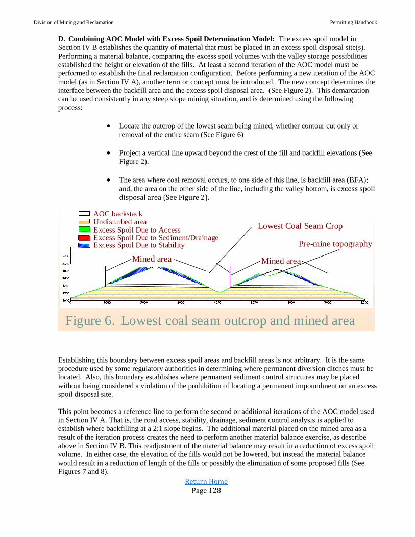
Division of Mining and Reclamation Permitting Handbook
Return Home Page 128
D. Combining AOC Model with Excess Spoil Determination Model: The excess spoil model in
Section IV B establishes the quantity of material that must be placed in an excess spoil disposal site(s).
Performing a material balance, comparing the excess spoil volumes with the valley storage possibilities
established the height or elevation of the fills. At least a second iteration of the AOC model must be
performed to establish the final reclamation configuration. Before performing a new iteration of the AOC
model (as in Section IV A), another term or concept must be introduced. The new concept determines the
interface between the backfill area and the excess spoil disposal area. (See Figure 2). This demarcation
can be used consistently in any steep slope mining situation, and is determined using the following
process:
Locate the outcrop of the lowest seam being mined, whether contour cut only or
removal of the entire seam (See Figure 6)
Project a vertical line upward beyond the crest of the fill and backfill elevations (See
Figure 2).
The area where coal removal occurs, to one side of this line, is backfill area (BFA);
and, the area on the other side of the line, including the valley bottom, is excess spoil disposal area (See Figure 2).
Figure 6. Lowest coal seam outcrop and mined area
AOC backstackUndisturbed areaExcess Spoil Due to AccessExcess Spoil Due to Sediment/DrainageExcess Spoil Due to Stability Pre-mine topography
Mined area Mined area
Lowest Coal Seam Crop
Establishing this boundary between excess spoil areas and backfill areas is not arbitrary. It is the same
procedure used by some regulatory authorities in determining where permanent diversion ditches must be
located. Also, this boundary establishes where permanent sediment control structures may be placed
without being considered a violation of the prohibition of locating a permanent impoundment on an excess
spoil disposal site.
This point becomes a reference line to perform the second or additional iterations of the AOC model used
in Section IV A. That is, the road access, stability, drainage, sediment control analysis is applied to
establish where backfilling at a 2:1 slope begins. The additional material placed on the mined area as a
result of the iteration process creates the need to perform another material balance exercise, as describe
above in Section IV B. This readjustment of the material balance may result in a reduction of excess spoil
volume. In either case, the elevation of the fills would not be lowered, but instead the material balance
would result in a reduction of length of the fills or possibly the elimination of some proposed fills (See
Figures 7 and 8).

Division of Mining and Reclamation Permitting Handbook
Return Home Page 129
Figure 7
Figure 8
Figure 9. How the AOC process affects fill length
Second iteration AOC
Company proposed AOCFirst iteration AOCFirst iteration material balance fill
Original valley profileSecond iteration material balance fill
AOC backstackUndisturbed areaExcess Spoil Due to AccessExcess Spoil Due to Sediment/DrainageExcess Spoil Due to StabilityAdditional backfillBackfill
Pre-mining topographyExcessspoil
Backfill
Undisturbed Area

Division of Mining and Reclamation Permitting Handbook
Return Home Page 130
Reevaluation of fill designs using this second iteration becomes an important component of the permit
design. Reduction in fill lengths could result in the toe of the fill being placed upon too steep of a slope–
requiring additional material excavation for a keyway cut, or additional material placement for a
stabilizing toe buttress.
However, this process may still result in large flat areas at the fill crest that could be used to store
additional backfill. This provides the further option of storing additional excess spoil in the crest area–
reducing excess spoil fill length. This option would further minimize terrestrial and aquatic impacts in the
excess spoil disposal area because the toe of the fill would move upstream (See Figure 9).
E. Contour Mining Operations: Contour mining excavates only part of the mountainside, leaving
undisturbed areas above and below the excavation (see Figure 10). The mining phase of a contour mine
creates a cliff-like highwall and shelf-like bench on the hillside that must be restored to approximate
original contour, with the highwall completely eliminated, in the reclamation phase. The AOC/excess
spoil determination models, described in IV A-C, are used to achieve AOC and determine excess spoil
volumes for this type of surface mining operation as well.
For example, a contour mine typically takes one (1) contour “cut” (see Figure 10) and progresses around
the coal outcrop, leaving a highwall and bench after the coal is removed. Reclaiming the site, utilizing the
AOC process, would require documentation showing drainage structure designs, access road requirements,
and properly designed sediment structures. The application would also require documentation
demonstrating the stability of the outslope of the material placed in the backfill area. Regulations require
that slopes be designed to prevent slides and achieve a minimum long-term static safety factor of 1.3. A
generally acceptable practice, unless it results in a static safety factor of less than 1.3, includes grading the
backfill slopes (between terraces where required) on a 2 horizontal to a 1 vertical ratio (2H:1V) (See
Section IV A for details). If compliance with the other performance standards, i.e., drainage, access, and
sediment control, result in backfill out-slopes being steeper than 2:1, the application should contain
adequate documentation that the backfill configuration meets a 1.3 static safety factor (see Figure 10).
Documentation described in Section IV A would be required if slopes flatter than 2:1 are proposed.
Undisturbed areaBackfill displaced-stabilityBackfill displaced-drainageBackfill displaced-accessBackfill
Highwall
Contour bench
Backfill
Figure 10
Oftentimes, contour mining operations encounter long, narrow ridges or points that require more than one
cut to recover the coal seam(s). Although the mining phase utilizes both the contour and area mining
methods when this occurs, the AOC/excess spoil determination models are used in the same way for
determining AOC and excess spoil volumes. The same principles and performance standards apply–

Division of Mining and Reclamation Permitting Handbook
Return Home Page 131
drainage, sediment control, and access requirements must be designed and documented. Also, compliance
with the stability requirements for the outslopes of the backfill must be achieved and documented.
However, in order to comply with these requirements and achieve AOC, the reclamation phase of these
sites must integrate two perspectives when utilizing the AOC model:
Elimination of the highwall (perpendicular to the ridge line);
Returning all spoil material that is not excess spoil to the mined area(s) (the
area between the highwall and the end of the ridge line). Combining the two
perspectives results in a postmining configuration that closely resembles the
general configuration of the ridge or point prior to mining, while still
complying with the performance standards discussed earlier in Section IV A-
D
END OF DOCUMENT
Division of Mining and Reclamation Permitting Handbook
Return Home Page 132
D. Subject: Final AOC Guidance Document Policy
Date: February 19, 2004
Approval: F. Joe Parker, Acting Director
All surface mine applications submitted after March 24, 2000, must have the Final AOC Guidance
Document Policy used to determine the adequacy of the AOC design and fill placement.
This Policy updates the June 5, 2000 Director Michael C. Castle, Final AOC Guidance Document
Policy without substantive change to its contents. As mutually agreed by the Coal Permitting Quality
Assurance/Quality Control (QA/QC) Advisory Panel at its February 19, 2004 session; acknowledge
errata have been corrected, minor editing was performed and illustrative figures have been inserted.
It is important to note that the Final AOC Guidance Document Policy does not apply to contour mines.
Contour mining applications (regardless of date of receipt) will be reviewed using the existing
AOC/Excess Spoil Guidelines document (1999), which does apply to contour operations.
Division of Mining and Reclamation Permitting Handbook
Return Home Page 133
FINAL AOC GUIDANCE DOCUMENT
WITH
ERRATA CORRECTIONS THROUGH FEBRUARY 19, 2004
ORIGINAL DOCUMENT DRAFTED JANUARY 27, 2000
ORIGINAL DOCUMENT EFFECTIVE MARCH 24, 2000
Division of Mining and Reclamation Permitting Handbook
Return Home Page 134
1. INTRODUCTION AND BACKGROUND
1.1 APPLICABLE PROVISIONS OF STATE LAW
1.2 PURPOSE, OBJECTIVES AND APPLICABILITY
1.3 ACRONYM DEFINITIONS
2. AOC AND EXCESS SPOIL QUANTITY RELATIONSHIP
2.1 ELEMENTS OF AOC DEFINITION
2.2 INTRODUCTION OF AOC MODEL CONCEPT
2.3 DEFINITION OF CONFIGURATION
2.3.1 Introduction
2.3.2 Total Spoil Material (TSM)
2.3.3 Original Contour (OC)
2.4 EFFECT OF PERFORMANCE STANDARDS ON BACKFILL VOLUME
2.4.1 Introduction
2.4.2 Stability Requirements (SR)
2.4.3 Drainage Control Requirements (DR)
2.4.4 Sediment Control Requirements (SCR)
2.4.5 Access/Maintenance Roads (AR)
2.4.6 Maximum Backfill Requirements (MBR)
3. AOC DETERMINATION (MOUNTAINTOP MINING)
3.1 INTRODUCTION
3.2 BACKFILL SPOIL DETERMINATION MODEL
3.3 EXCESS SPOIL DETERMINATION
3.4 ADJUSTMENT TO ES AND BKF TO REFLECT OFF SITE DISPOSAL
3.5 ADDITIONAL BACKFILL CAPACITY REQUIRED BY AOC MODEL
3.6 SUMMARY OF VOLUME ALLOCATIONS
3.7 ISOLATED COAL SEAMS
4. EXCESS SPOIL DISPOSAL AREA DEFINITION
4.1 INTRODUCTION
4.2 EQUIVALENT SWELL HEIGHT
4.3 TARGET FILL ELEVATION
5. EXCESS SPOIL DISPOSAL OPTIMIZATION (MOUNTAINTOP MINING)
5.1 INTRODUCTION
5.2 SPOIL DISPOSAL PLAN APPROVAL
5.3 PRESUMED CRITERIA TEST
5.4 “ESDA BANK” ANALYSIS
6. AOC DETERMINATION (CONTOUR MINING)
7. EXCESS SPOIL DISPOSAL OPTIMIZATION (CONTOUR MININIG)
8. AOC/FILL OPTIMIZATION PANEL
9. AOC COMPLIANCE/AOC VARIANCE REQUESTS
9.1 AOC COMPLIANCE DETERMINATION
9.2 AOC VARIANCE REQUEST EVALUATION
10. REPORTING REQUIRMENTS, PERMIT REVISIONS, AND AMENDMENTS
10.1 REPORTING
10.2 REQUIREMENTS FOR PERMIT REVISIONS
10.3 PERMIT AMENDMENTS TO ADD MINERAL EXTRACTION
10.4 ADJACENT PERMITS OR PERMIT AMENDMENTS

Division of Mining and Reclamation Permitting Handbook
Return Home Page 135
1. INTRODUCTION AND BACKGROUND
1.1 Applicable Provisions of State Law
Surface Mining Control and Reclamation Act of 1977 (SMCRA)
30 USC 1291 Section 701(2)
West Virginia Surface Coal Mining and Reclamation Act (WVSCMRA)
22-3-3(e)
22-3-13(d) (3)
22-3-13(b) (4)
22-3-13(b) (10) (B), (C), (F), (G)
West Virginia Surface Mining Reclamation Regulations (WVSMRR)
38 CSR 2-2.47
38 CSR 2-2.63
38 CSR 2-5.2, 5.3, 5.4
38 CSR 2-8, 8.a
38 CSR 2-14.5
38 CSR 2-14.8.a
38 CSR 2-14.14
38 CSR 2-14.15.a
1.2 Purpose, Objectives and Applicability
An objective and well-defined method for determining post-mining land configuration is necessary
to assure compliance with applicable laws, provide an opportunity for early coordinated regulatory
review, and allow for meaningful and timely public input and transparent decision-making.
This method is referred to as the “AOC Process” throughout this document.
The AOC Process outlined in this document shall be undertaken for all proposed steep slope
surface coal mining applications. Steep slope operations are all operations where the natural slope
of the land within the permit area exceeds an average of twenty (20) degrees, as measured from the
horizontal. The AOC Process shall be completed before the issuance of a Surface Mining
Application (SMA) number by WVDEP.
Nothing in this AOC Process shall be construed to regulate the surface activity solely associated
with underground mining or coal refuse facilities.
This guidance document has been developed to accomplish the following objectives:
Provide an objective process for achieving AOC while ensuring stability of backfill
material and minimization of sedimentation to streams.
Provide an objective process for determining the quantity of excess spoil that may be
placed in excess spoil disposal sites such as valley fills.
Optimize the placement of spoil to reduce watershed impacts.

Division of Mining and Reclamation Permitting Handbook
Return Home Page 136
Provide an objective process for use in permit reviews as well as field inspections during
mining and reclamation phases.
Maintain the flexibility necessary for the operator to address site-specific
mining and reclamation conditions.
1.3 Acronym Definitions
The following acronyms are used throughout the AOC Process:
OC – Volume of material required to replicate the Original Contours of the
undisturbed area.
TSM – Total Spoil Material to be handled or available.
SR – Backfill volume displaced due to compliance with Stability Requirements.
DR – Backfill volume displaced due to compliance with Drainage control
Requirements.
SCR – Backfill volume displaced due to compliance with Sediment Control
Requirements.
AR – Backfill volume displaced due to compliance with Access/maintenance
Requirements.
MBR – Backfill volume displaced due to compliance with the reduction of peak
backfill elevation to meet Maximum Backfill Requirements.
AOC – Volume of backfilled spoil and configuration required to satisfy the definition
of Approximate Original Contour.
OB – Volume of material in the Overburden.
IB – Volume of material in the Interburden.
BF – Bulking Factor. The result of the swell factor minus the shrinking factor
associated with a certain material.
BFA – Back Fill Area. The area inside the outcrop of the lowest isolated coal seam
mined.
ESDA – Excess Spoil Disposal Area. The area outside of the mined area used for
placement of excess spoil.
OSDA – Off-Site Disposal Area.
IBKF – Initial Back Fill volume. The spoil material placed in the mined area prior to
the placement of any excess spoil areas.
ES – The volume of Excess Spoil remaining after satisfying AOC by backfilling and
grading to meet SR, DR, SCR, AR, and MBR.
OSDV – The quantity of material in Off-Site Disposal Volume.
ABKF – The volume of Additional Back Fill created by revising the location of the
toe of the backfill slope as required by the AOC process.
ESDV – Excess Spoil Disposal Volume. The volume of excess spoil remaining after
deducting the total backfill volume that shall be placed in an excess volume disposal
facility.
IES – Initial Excess Spoil. The volume of total spoil produced from mining less the
volume that can be backfilled in the mined area.
ESH – Equivalent Swell Height. The height calculated by dividing the sum of OB
and IB by BFA, and multiplying this ratio by the bulking factor, BF.
TFE – Target Fill Elevation. The sum of the average elevation of the outcrop of the
primary mountaintop seam with each valley selected for fill placement, plus ESH.
Division of Mining and Reclamation Permitting Handbook
Return Home Page 137
BKF – BacK Fill volume. The volume of spoil material to be returned to the mined
area.
2. AOC AND EXCESS SPOIL QUANTITY RELATIONSHIP
2.1 Elements of AOC Definition
The following terms are necessary for development of the AOC Process:
A. Configuration: - Configuration relates to the shape of the regraded or reclaimed area.
In addition to complying with the definition of AOC the reclaimed configuration must
comply with performance standards found in WVSCMRA, such as ensuring stability,
controlling drainage, and preventing stream sedimentation.
B. Stability: - Stability relates to the placement of material in the regraded or reclaimed
area. State regulations (see 38 CSR-2-14.8.a. and 14.15.a) require material to be placed
in a manner that achieves a minimum long-term static safety factor, prevents slides, and
minimizes erosion.
C. Drainage: - Drainage relates to moving water from and within the regraded or
reclaimed area. Reclaimed drainage configurations must comply with performance
standards found in WVSCMRA, such as minimizing sedimentation, and restoring
water quality and quantity.
2.2 Introduction of AOC Model Concept
The AOC Process includes the development a volumetric model referred to as the AOC Model.
This volumetric model provides a definitive and reproducible means to calculate the volumes of
material that can be backfilled or placed in excess spoil disposal areas. The volumes obtained
from the AOC Model are used as a volumetric basis for the actual mine configuration. The
proposed final regrade configuration of the Mine Plan may vary from the AOC Model except as
described below.
Portraying these performance standards as variables in a model or formula provides an objective
process for determining what post-mining surface configuration meets the AOC definition, while
complying with the other performance standards in WVSCMRA. The following terms were
developed and defined for use in the AOC Model:
Configuration
OC- Volume of material required to replicate the original contours of the undisturbed
area proposed to be mined. OC includes overburden (OB), interburden (IB), and coal
in their undisturbed pre-mining state.
TSM- Total spoil material to be handled or available. This material will be classified
as either backfill material (BKF), excess spoil material (ES), or offsite disposal material
(OSDV)
Performance Standards
SR- Backfill volume displaced due to compliance with Stability Requirements.
DR Backfill volume displaced due to compliance with Drainage Control
Requirements.
SCR- Backfill volume displaced due to compliance with Sediment Control
Requirements.
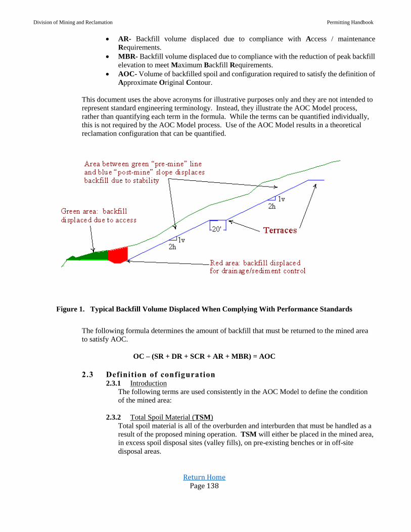
Division of Mining and Reclamation Permitting Handbook
Return Home Page 138
AR- Backfill volume displaced due to compliance with Access / maintenance
Requirements.
MBR- Backfill volume displaced due to compliance with the reduction of peak backfill
elevation to meet Maximum Backfill Requirements.
AOC- Volume of backfilled spoil and configuration required to satisfy the definition of
Approximate Original Contour.
This document uses the above acronyms for illustrative purposes only and they are not intended to
represent standard engineering terminology. Instead, they illustrate the AOC Model process,
rather than quantifying each term in the formula. While the terms can be quantified individually,
this is not required by the AOC Model process. Use of the AOC Model results in a theoretical
reclamation configuration that can be quantified.
Figure 1. Typical Backfill Volume Displaced When Complying With Performance Standards
The following formula determines the amount of backfill that must be returned to the mined area
to satisfy AOC.
OC – (SR + DR + SCR + AR + MBR) = AOC
2.3 Definition of configuration 2.3.1 Introduction
The following terms are used consistently in the AOC Model to define the condition
of the mined area:
2.3.2 Total Spoil Material (TSM)
Total spoil material is all of the overburden and interburden that must be handled as a
result of the proposed mining operation. TSM will either be placed in the mined area,
in excess spoil disposal sites (valley fills), on pre-existing benches or in off-site
disposal areas.

Division of Mining and Reclamation Permitting Handbook
Return Home Page 139
TSM volumes are determined by using standard engineering practice, such as
average-end area, stage-volume calculations, or 3-dimensional (3-D) grid subtraction
methods. The Director must have adequate information submitted by the applicant to
properly evaluate TSM calculations. If the applicant uses an average-end area
method, cross-sections must be supplied for a base line or lines at an interval no less
than every 500 feet or more frequently if the shape of the pre-mined area is highly
variable between the 500-foot intervals. If the applicant uses a stage-storage method,
areas measured by polar planimeter should also be determined on a contour interval
(CI) that is representative and reflects any significant changes in slope (20' CI or less
recommended). If a 3-D model is used, the pre-mining contour map and, if possible, a
3-D model graphic should be provided. The grid node spacing used in generating
volumetric quantities should be identified. If digital data is used by the applicant, it
should be in a format and on a media acceptable to the Director.
TSM is determined by combining the overburden (OB) volume over the uppermost
coal seam to be excavated with the interburden (IB) volumes between the remaining
lower coal seams, and then multiplying this sum by a “bulking” factor (BF). Bulking
factors are calculated by a two-step process: 1) “swell” volume is determined from the
amount of expected expansion of previously undisturbed natural material through the
incorporation of air-filled void spaces; 2) “shrink” volume can be calculated from the
amount the swelled material compacts during placement (reducing the void spaces
and, consequently, the volume). Thus, the bulking factor is the swell factor minus the
shrink factor, which varies based on the overburden lithology (e.g., sandstone swells
more and shrinks less than shale). The applicant shall clearly identify the value of BF
used. Permit applications that propose a BF greater than 30% shall contain a
justification of the weighted bulking factor utilized-based not only on the weighting of
individual swell factors calculated for each major rock type to be excavated that will
be placed in the backfill, but also on the shrinkage or compaction factor due to spoil
placement methods. In equation form:
(OB + IB) x (1 + BF) = TSM
Spoil Placement Areas - There are only three areas that TSM may be placed:
Backfill (BFA)
Excess spoil disposal areas (ESDA), i.e. valley fills.
off-site disposal areas (OSDA)
BFA Backfill Area (mined area) is the area inside the outcrop of the
lowest coal seam mined. (See Figure 2)
ESDA Excess Spoil Disposal Area. The area outside of the mined area
used for placement of excess spoil. (See Figure 2)
OSDA Off-Site Disposal Areas include but are not limited to:
Unreclaimed mine sites that are not subject to SMCRA and State mining
reclamation laws that are permitted and bonded by the applicant for spoil
disposal
Approved AML or bond forfeiture projects that require such additional
spoil to achieve final reclamation
Existing benches in accordance with 38 CSR-2.14.14.
Existing mined post SMCRA mined areas and excess spoil disposal areas
that can accommodate additional spoil disposal that do not change the toe
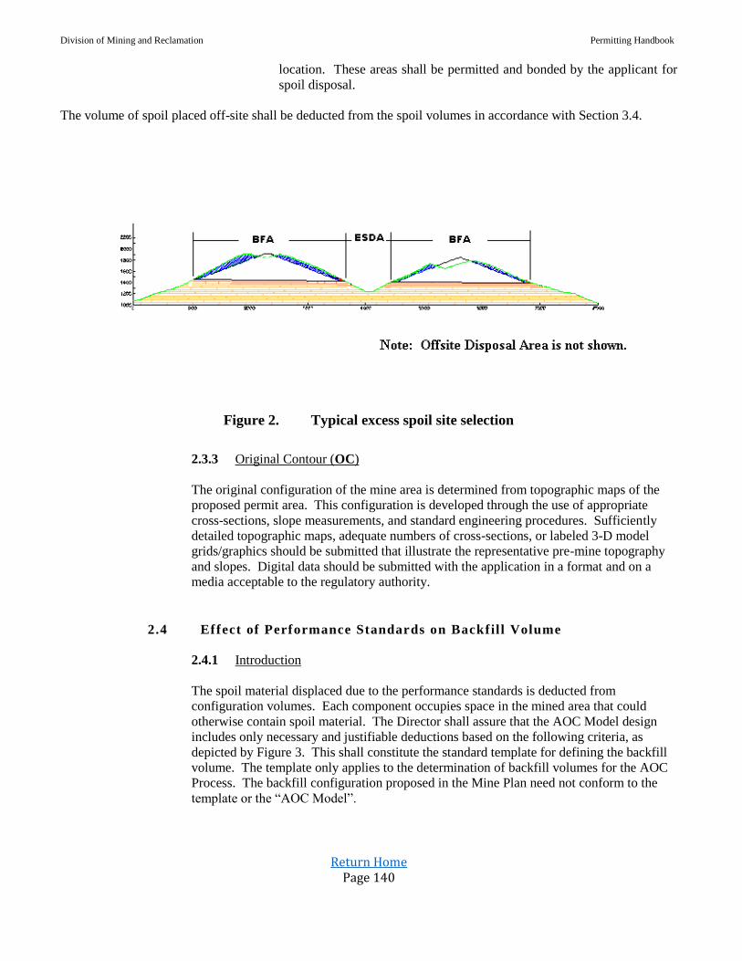
Division of Mining and Reclamation Permitting Handbook
Return Home Page 140
location. These areas shall be permitted and bonded by the applicant for
spoil disposal.
The volume of spoil placed off-site shall be deducted from the spoil volumes in accordance with Section 3.4.
Figure 2. Typical excess spoil site selection
2.3.3 Original Contour (OC)
The original configuration of the mine area is determined from topographic maps of the
proposed permit area. This configuration is developed through the use of appropriate
cross-sections, slope measurements, and standard engineering procedures. Sufficiently
detailed topographic maps, adequate numbers of cross-sections, or labeled 3-D model
grids/graphics should be submitted that illustrate the representative pre-mine topography
and slopes. Digital data should be submitted with the application in a format and on a
media acceptable to the regulatory authority.
2.4 Effect of Performance Standards on Backfil l Volume
2.4.1 Introduction
The spoil material displaced due to the performance standards is deducted from
configuration volumes. Each component occupies space in the mined area that could
otherwise contain spoil material. The Director shall assure that the AOC Model design
includes only necessary and justifiable deductions based on the following criteria, as
depicted by Figure 3. This shall constitute the standard template for defining the backfill
volume. The template only applies to the determination of backfill volumes for the AOC
Process. The backfill configuration proposed in the Mine Plan need not conform to the
template or the “AOC Model”.

Division of Mining and Reclamation Permitting Handbook
Return Home Page 141
Figure 3. Template for stability, drainage, sediment control, and access control requirement.
2.4.2 Stability Requirements (SR)
The slopes of the spoil material placed in the backfill areas or excess spoil disposal sites
must be stable. Accordingly, the spoil material shall be placed in such a manner as to
prevent slides or slope failures and achieve a minimum, long-term static safety factor of
1.3 for the backfill.
For the purpose of determining the backfill volume for the AOC Model the backfill slopes
shall consist of a 2 horizontal to a 1 vertical (2H:1V) slope between the terraces plus a
terrace of twenty feet (20’) width constructed at each one hundred feet (100’) vertical rise
above the toe of the backfill.
If the applicant demonstrates that the overburden and interburden cannot attain a 1.3 factor
of safety at 2:1 slopes, more gentle slopes may only be justified by the submission of
geotechnical test data and stability analyses to the Director.
2.4.3 Drainage Control Requirements (DR)
Drainage structures are used to divert or convey surface runoff. For the determination of
backfill volumes for the AOC model, it is assumed that all drainage structures, except for
clean water diversion ditches, are integrated with the sediment control structures.
The integration of the drainage structure with the sediment control structures only apply
for the determination of backfill volumes for the AOC Model and the final design and
configuration need not conform to the AOC Model.
If the applicant proposes a diversion ditch to transport discharge from undisturbed areas,
or from drainage control structures, these structures must be properly designed to provide
the required capacity and designed using standard engineering practices and theory. When
reviewing the size and placement of these structures, the Director shall assess the design
plans to assure the structures are no larger/wider than necessary for proper design and
comply with standard engineering practices.

Division of Mining and Reclamation Permitting Handbook
Return Home Page 142
The design of the drainage structures only apply for the determination of backfill volumes
for the AOC Model and the final design and configuration need not conform to the AOC
Model.
2.4.4 Sediment Control Requirements (SCR)
For the determination of backfill volumes for the AOC Model, the design of the sediment
control structures shall include the drainage structures (except for diversion ditches). It is
also assumed that the sediment control structures are located at the toe of the backfill
slopes on the pavement of the primary mountaintop seam and on the seam mined for
contour mining.
For the purpose of the AOC Model the design of the sediment control shall consist of
continuous ditches around the perimeter of both the primary mountaintop seam and on the
lowest seam mined for contour mining. These structures must have a total design depth
(including freeboard) of no less than 3 feet. These structures must be properly designed to
provide the required sediment storage capacity and designed using standard engineering
practices and theory.
When reviewing the size and placement of these structures used in the AOC Model, the
Director shall assess the design plans to assure the structures are no larger/wider than
necessary for proper design and comply with standard engineering practices.
The design of the sediment control structures only applies to the determination of backfill
volumes for the AOC Model. The final design and configuration need not conform to the
AOC Model.
2.4.4 Access/Maintenance Roads (AR)
For purposes of this AOC Model, the applicant must justify, based on operation specific
details, all access and maintenance road and safety berm widths. Under no circumstances
may the road width exceed 25 feet plus a maximum allowance of 10 feet (horizontal) for
a safety berm. An allowance for roads shall be provided for roads located on the primary
mountaintop seam outcrop and along the outcrop of the lowest seam mined for contour
mining, or each outcrop for Multiple Contour Operations.
The Director shall also assess the road configuration to assure the roads and safety berms
are no larger/wider than necessary.
The design of the roads only applies to the determination of backfill volumes for the
AOC Model. The final design and configuration need not conform to the AOC Model.
2.4.5 Maximum Backfill Requirements (MBR)
The crest of the backfill ridge must accommodate the mining equipment that transports
and places the spoil but the crest must not be unnecessarily wide. For purposes of this
AOC Model, the backfill crest width shall not exceed 100 feet. The applicant must justify,
based on operation specific details, any backfill crest width in excess of 30 feet.

Division of Mining and Reclamation Permitting Handbook
Return Home Page 143
The AOC Model can create an anomaly when the extent of the mined area is significantly
increased due to contour mining within the perimeter of valley fills. As the total mined
area expands, the potential backfill height increases. In certain instances, the AOC Model
generates a peak backfill elevation that is substantially higher than the surrounding terrain.
To avoid this anomaly, an applicant shall not be required to design backfill higher than the
peak pre-mining elevation within the mined area for purposes of calculating backfill
volume and excess spoil volume using this model.
The MBR applies only for the determination of backfill volumes for the AOC Model. The
final design and configuration need not conform to the AOC Model as it does not establish
a ceiling elevation above which no backfill material can or must be placed in the actual
Mine Plan. Incorporating the other components of the AOC definition in the proposed
final regrade configuration will prevent the development of a flat plateau in the Mine Plan.
3. AOC DETERMINATION – (Mountaintop Mining)
3.1 Introduction
Applying these performance requirements in the mine planning process will determine the
amount of total spoil material that must be retained in the mined area to satisfy the
objective criteria for AOC. The calculations and drawings developed through application
of this plan are used to determine the volumetric components of AOC.
3.2 Backfill Spoil Determination Model
The backfill material that will be placed within the mined area can be backfilled so that the
resulting post-mining configuration closely resembles the pre-mining topography, thus
satisfying not only the access, drainage, sediment, and stability performance standards of
SMCRA and WVSCMRA, but also providing flexibility and meeting the AOC
requirements.
Restating the AOC Model from the previous section:
OC – (SR + DR + SCR + AR + MBR) = AOC
Step 1: Determine original or pre-mining configuration Original Contour (OC)
Step 2: Subtract from Original Contour:
Volume displaced due to Stability Requirements (SR)
Volume displaced due to Sediment Control Requirements (SCR) which include Drainage
Requirements (DR) except for clean water diversion ditches, as defined above
Volume displaced due to Access Requirements (AR)
Volume displaced due to Maximum Backfill Elevation Requirements (MBR)
Step 3: The remaining volume is the initial backfill (IBKF) which is the spoil material placed in
the mined area prior to the placement of any excess spoil areas.
Therefore, the relationship becomes:
IBKF = OC – (SR + DR + SCR + AR + MBR)

Division of Mining and Reclamation Permitting Handbook
Return Home Page 144
3.3 Excess Spoil Determination
The parameters used in the AOC Model for determining the TSM also are used to
determine the quantity of excess spoil. This approach provides an objective process for
determining what excess spoil (ES) is.
The additional terms and concepts used are:
IBKF- Volume of backfill or spoil material placed in the mined area prior to the
placement of any excess spoil areas
ES- Volume of excess spoil remaining after satisfying AOC by backfilling and grading to
meet SR, DR, SCR, AR, MBR.
OSDV- Volume of spoil material placed in an approved off-site location
The ES quantity, as determined by the following formula, is obtained by complying with
the stability standards and other performance standards.
The excess spoil relationships:
ES = TSM - IBKF
Therefore:
ES = TSM - (OC - (SR + DR + SCR + AR + MBR)
3.4 Adjustment to ES and BKF to reflect Off Site Disposal
Operations may use adjacent pre-existing benches (without coal removal occurring) as part of
the permitted area for excess spoil disposal. If pre-existing benches are to be used as excess
spoil disposal sites, the capacity of each pre-existing bench area must be calculated.
Additional off-site material disposal locations include Abandoned Mine Land (AML) sites,
Bond Forfeiture sites and civil works projects approved by the Director.
Excess spoil may be placed on adjacent, post SMCRA, mine sites that have suitable locations
for spoil disposal. Any such areas used for spoil disposal must be appropriately permitted
and bonded.
The total quantity of off-site disposal volume (OSDV) shall be calculated and details shall be
provided to the Director. The information submitted shall be sufficient to allow the Director
to review the adequacy of calculation.
As an incentive to use previously disturbed areas, the quantity of off-site disposal OSDV
shall be deducted from the Total Spoil Material (TSM), resulting in a reduction in both the
Excess Spoil (ES) and the Initial Backfill (IBKF). The allocation of this volume shall be
based on the ratio of Excess Spoil (ES) to Total Spoil (TSM).
The deduction decreases the volume of Total Spoil Material; therefore, the new value for
Total Spoil Material (TSMN) is defined as:
TSMN = TSM – OSDV
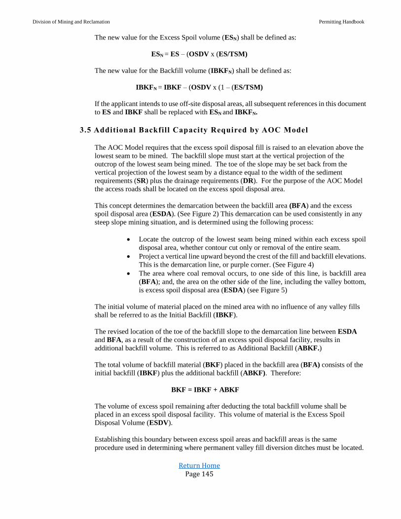
Division of Mining and Reclamation Permitting Handbook
Return Home Page 145
The new value for the Excess Spoil volume (ESN) shall be defined as:
ESN = ES – (OSDV x (ES/TSM)
The new value for the Backfill volume (IBKFN) shall be defined as:
IBKFN = IBKF – (OSDV x (1 – (ES/TSM)
If the applicant intends to use off-site disposal areas, all subsequent references in this document
to ES and IBKF shall be replaced with ESN and IBKFN.
3.5 Additional Backfill Capacity Required by AOC Model
The AOC Model requires that the excess spoil disposal fill is raised to an elevation above the
lowest seam to be mined. The backfill slope must start at the vertical projection of the
outcrop of the lowest seam being mined. The toe of the slope may be set back from the
vertical projection of the lowest seam by a distance equal to the width of the sediment
requirements (SR) plus the drainage requirements (DR). For the purpose of the AOC Model
the access roads shall be located on the excess spoil disposal area.
This concept determines the demarcation between the backfill area (BFA) and the excess
spoil disposal area (ESDA). (See Figure 2) This demarcation can be used consistently in any
steep slope mining situation, and is determined using the following process:
Locate the outcrop of the lowest seam being mined within each excess spoil
disposal area, whether contour cut only or removal of the entire seam.
Project a vertical line upward beyond the crest of the fill and backfill elevations.
This is the demarcation line, or purple corner. (See Figure 4)
The area where coal removal occurs, to one side of this line, is backfill area
(BFA); and, the area on the other side of the line, including the valley bottom,
is excess spoil disposal area (ESDA) (see Figure 5)
The initial volume of material placed on the mined area with no influence of any valley fills
shall be referred to as the Initial Backfill (IBKF).
The revised location of the toe of the backfill slope to the demarcation line between ESDA
and BFA, as a result of the construction of an excess spoil disposal facility, results in
additional backfill volume. This is referred to as Additional Backfill (ABKF.)
The total volume of backfill material (BKF) placed in the backfill area (BFA) consists of the
initial backfill (IBKF) plus the additional backfill (ABKF). Therefore:
BKF = IBKF + ABKF
The volume of excess spoil remaining after deducting the total backfill volume shall be
placed in an excess spoil disposal facility. This volume of material is the Excess Spoil
Disposal Volume (ESDV).
Establishing this boundary between excess spoil areas and backfill areas is the same
procedure used in determining where permanent valley fill diversion ditches must be located.

Division of Mining and Reclamation Permitting Handbook
Return Home Page 146
FIGURE 4. Delineate mined and excess spoil areas.
Section 5 of this guidance document contains an optimization procedure for mountaintop
mining excess spoil disposal plans. Successful optimization is attained through elevating
excess spoil fills to a target height above the mined area, thus converting a portion of Initial
Excess Spoil (IES) to additional backfill volume (ABKF) and thereby reducing the size and
impact of valley fills.
3.6 Summary of Volume Allocations
Summarizing the previous terms and relationships, excess spoil is the total spoil produced
from mining the property less the amount that can be backfilled in the mined area:
IES = TSM – IBKF
Through the use of previously mined benches, AML projects, and other off-site disposal sites,
the volume of both Excess Spoil and Backfill may be reduced. As a result of these reductions:
ESN = TSMN - BKFN
If spoil is placed in the mined area, this volume is converted from IES to Additional Backfill
volume (ABKF). The Excess Spoil Disposal Volume (ESDV) is the Initial Excess Spoil (IES)
less that volume converted to backfill as ABKF.
IES = ABKF + ESDV
or
ESDV = IES – ABKF
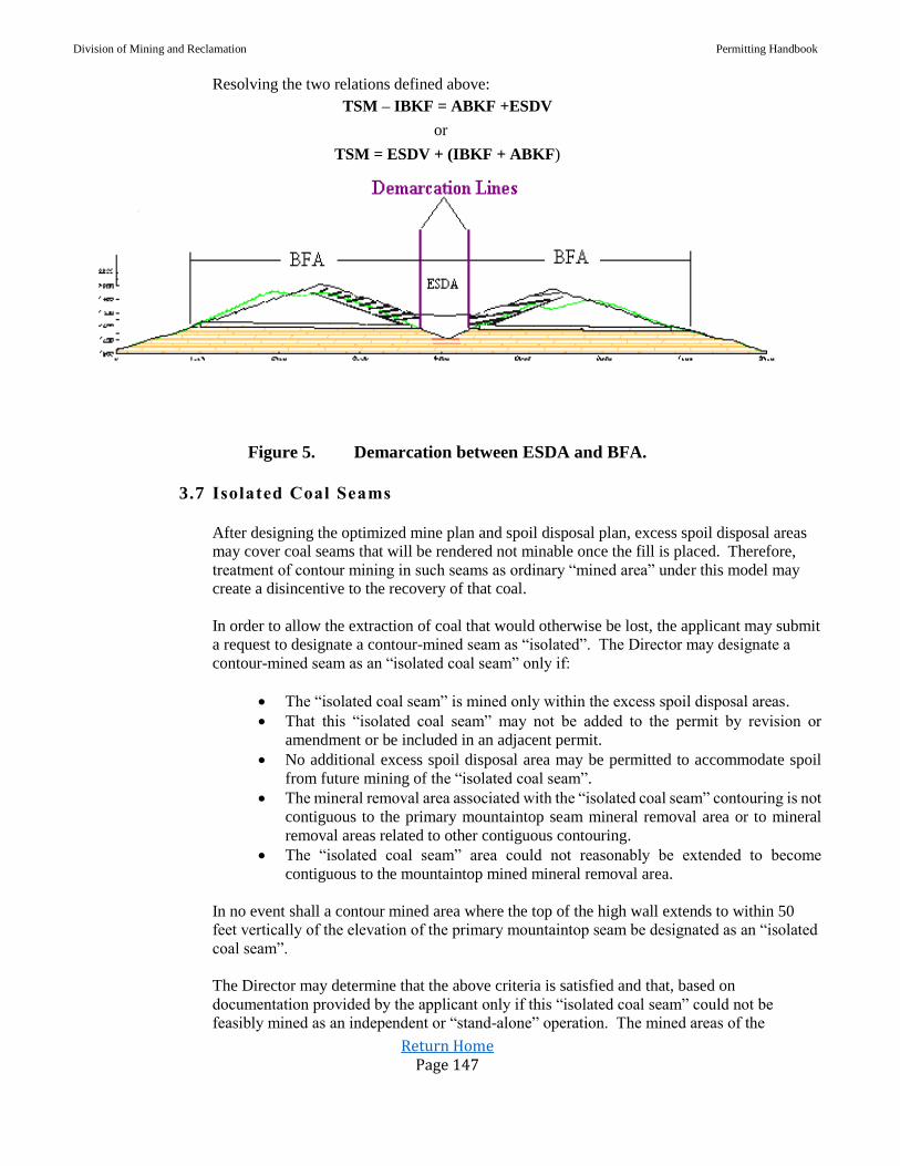
Division of Mining and Reclamation Permitting Handbook
Return Home Page 147
Resolving the two relations defined above:
TSM – IBKF = ABKF +ESDV
or
TSM = ESDV + (IBKF + ABKF)
Figure 5. Demarcation between ESDA and BFA.
3.7 Isolated Coal Seams
After designing the optimized mine plan and spoil disposal plan, excess spoil disposal areas
may cover coal seams that will be rendered not minable once the fill is placed. Therefore,
treatment of contour mining in such seams as ordinary “mined area” under this model may
create a disincentive to the recovery of that coal.
In order to allow the extraction of coal that would otherwise be lost, the applicant may submit
a request to designate a contour-mined seam as “isolated”. The Director may designate a
contour-mined seam as an “isolated coal seam” only if:
The “isolated coal seam” is mined only within the excess spoil disposal areas.
That this “isolated coal seam” may not be added to the permit by revision or
amendment or be included in an adjacent permit.
No additional excess spoil disposal area may be permitted to accommodate spoil
from future mining of the “isolated coal seam”.
The mineral removal area associated with the “isolated coal seam” contouring is not
contiguous to the primary mountaintop seam mineral removal area or to mineral
removal areas related to other contiguous contouring.
The “isolated coal seam” area could not reasonably be extended to become
contiguous to the mountaintop mined mineral removal area.
In no event shall a contour mined area where the top of the high wall extends to within 50
feet vertically of the elevation of the primary mountaintop seam be designated as an “isolated
coal seam”.
The Director may determine that the above criteria is satisfied and that, based on
documentation provided by the applicant only if this “isolated coal seam” could not be
feasibly mined as an independent or “stand-alone” operation. The mined areas of the

Division of Mining and Reclamation Permitting Handbook
Return Home Page 148
“isolated” coal seam shall not be used to define the lowest seam mined for demarcation
between the ESDA and BFA.
4. EXCESS SOIL DISPOSAL AREA DEFINITION
4.1 Introduction
A standardized approach for characterizing excess spoil disposal sites allows consistent and
reproducible analysis and calculation of both the Excess Spoil Disposal Volume (ESDV) and
the Additional Backfill (ABKF) volume resultant from the construction of excess spoil
disposal site(s).
The calculations defined in this section are used for the excess spoil disposal optimization
process discussed in of this document.
4.2 Equivalent Swell Height
The Equivalent Swell Height (ESH), in feet, is calculated by dividing the sum of overburden
volume (OB) and the interburden volume (IB), in bank cubic feet, by the mineral extraction
area, in square feet, (also termed Backfill Area BFA), and then multiplying that value by the
determined bulking factor (BF) as utilized by the applicant in the AOC Model.
ESH = [(OB+IB)/BFA] x BF
For example, a bulking factor of 25% shall be expressed as 0.25 in this relationship.
4.3 Target Fill Elevation
The Target Fill Elevation (TFE) for each valley fill is defined as the sum of the average
elevation of the outcrop of the primary mountaintop seam within each valley selected for fill
placement, plus the ESH. To simplify volume calculations and solely for calculation, each
excess spoil disposal area shall be assumed to have a horizontal top surface. (See Figure 4)
5. EXCESS SPOIL DISPOSAL OPTIMIZATION (MOUNTAINTOP MINING)
5.1 Introduction
The procedure described in this section applies only to those watersheds in which
mountaintop mining is proposed. If mountaintop mining is not proposed in a specific
watershed but other mining types (e.g. contouring) are to be used, the excess spoil
optimization procedure specific to those mining types shall be employed for any fill within
that watershed.
5.2 Spoil Disposal Plan Approval
An application for a mountaintop surface mine permit shall be deemed to have an optimized
spoil disposal plan only if the:
plan satisfies the Presumed Criteria Test, or
Division of Mining and Reclamation Permitting Handbook
Return Home Page 149
total non-mineral removal area affected by valley fills does not exceed the “Excess Spoil
Disposal Area Bank” (ESDA Bank) plus the Acreage Tolerance
Under unusual circumstances the AOC / Fill Optimization Panel may approve
exceptions to fill optimization as described in Section 8 of this guidance document.
Mining operations receiving such approved exceptions do not have optimized spoil
placement plans. If an applicant is seeking an AOC variance, the applicant must
follow the appropriate procedures described in Section 9.2 of this guidance document.
5.3 Presumed Criteria Test
The proposed excess spoil disposal plan in the AOC Model shall be presumed to be
optimized if it meets the Presumed Criteria Test. The excess spoil disposal plan is optimized
with regard to spoil disposal and the disturbed area associated with valley fills when every
proposed valley fill in the AOC Model achieves the “target fill elevation." This design
approach establishes the toe of each valley fill.
Calculation of the “presumed criteria” valley fill toes shall comply with the following steps:
Step 1 Select the valleys to be considered or qualified for excess spoil disposal.
Step 2 Determine the maximum downstream toe location to be considered for each valley fill.
Environmental factors, statute, rules, property rights, operational issues, and other factors
will influence this location.
Step 3 Define the value for Excess Spoil (ES) based on backfilling with no valley fills. The initial
backfill volume (IBKF) will be determined using the AOC Model.
Step 4 Define the “equivalent swell height” (ESH).
Step 5 Define the average elevation of the primary mountaintop seam, upstream of the maximum
downstream toe (as defined in Step 2) in each valley selected for the placement of excess
spoil.
Step 6 Determine the Target Fill Elevation (TFE) for the top of each excess spoil disposal
structure. The TFE is the average elevation of the primary mountaintop seam plus the
equivalent swell height as defined in Step 4.
Step 7 Determine the volume of ES to be allocated to each fill. For the combination of the ESDV
and ABKF required to contain the ES volume, establish the toe location for each fill.
Step 8 Document compliance with the above criteria by preparing and submitting as part of the
surface mine application details of each valley fill model developed in Step 7. Each model
shall include a plan view and profile view at a scale of 1”=200’ (or as otherwise approved)
and appropriate engineering calculations.
Step 9 Design the final regrade configuration and excess disposal areas of the Mine Plan in any
sequence or configuration as long as the toe located in Step 7 does not move downstream
and the design complies with Section 9.1 of this document.
Positive Determination — If the proposed toe location for each valley fill is maintained at or upstream of
the toe location established for each valley fill in accordance with the above AOC Model procedure, the
Director shall find that the Excess Spoil Disposal Area (“ESDA”) has been optimized.
Negative Determination - If any of the proposed valley fills have a toe location that does not permit the
fill to meet the Presumed Criteria Test as described, the Director shall notify the applicant that it must
submit calculations to define the ESDA Bank.
Division of Mining and Reclamation Permitting Handbook
Return Home Page 150
5.4 “ESDA Bank” Analysis
If the proposed excess spoil disposal plan does not achieve a positive determination under the
Presumed Criteria Test, the excess spoil disposal plan will be evaluated using the ESDA
Bank analysis. This analysis employs the procedures defined in the preceding sections of the
AOC Model except that the crest elevation of each fill is fixed to calculate the ESDA Bank.
This procedure provides a standardized means of comparing and rating available excess spoil
disposal sites to achieve the most efficient placement of the excess spoil. Each fill is
evaluated to determine its spoil disposal capacity per specified length of valley. The total
volume of excess spoil is then assigned to the fills in descending order based on each fill’s
relative “efficiency.” The result will be the optimum placement of spoil in terms of cubic
yards per acre of ESDA.
Calculation of the ESDA Bank shall comply with the following steps:
Step 1 Define the primary mountaintop mining seam. This is the lowest seam within each
proposed valley fill site that is being mountaintop mined
Step 2 Select the valleys to be considered or qualified for excess spoil disposal
Step 3 Determine the maximum downstream toe location to be considered for each valley fill.
Environmental factors, statutes, rules, property rights, operational issues, and other
factors will influence this location
Step 4 Define the value for Excess Spoil (ES) based on backfilling with no valley fills. The
backfill volume (IBKF) will be determined using the AOC Model
Step 5 Define the “equivalent swell height.”(ESH)
Step 6 Determine the Target Fill Elevation (TFE) for each excess spoil disposal structure. The
TFE is the average elevation of the primary mountaintop seam plus the equivalent swell
height as defined in Step 5
Step 7 Construct a straight baseline from the logical toe to the top of backfill (IBKF) generally
along the centerline of each valley to be filled. The baselines should be oriented
perpendicular to the face of the anticipated valley fills at their logical toe. Draw a profile
along the baseline for each valley to be filled from the top of the initial backfill.
Step 8 Locate the toe for the Initial Increment for each fill. The toe location for the Initial
Increment shall be the lowest stratigraphically of either:
the most upstream toe that complies with the geotechnical stability requirements
defined by the regulations, or
50 horizontal feet downstream of the outcrop of the lowest seam to be mined
Step 9 Calculate the excess spoil disposal volume (ESDV) and the additional backfill volumes
(ABKF) associated with the Initial Increment. For this optimization model only, assume
a constant valley fill front face slope for all valley fills and all “slices” of 2.4h: 1v.
Step 10 Separate the remaining portions of all of the selected fills into equal length increments
referred to as “slices” (these slices are perpendicular to the baseline constructed in Step
7). These “slices” shall extend from the Initial Increment all the way along the profile to
the toe selected in Step 2. The slice length along the profile shall be selected by the
applicant but may be no greater than 500 feet. The slice length shall be consistent for all
fills and all slices, except for the last slice which shall be adjusted pro-rata to the ES
volume required.
Step 11 Calculate the excess spoil disposal volume (ESDV) and the additional backfill volume
(ABKF) associated with each “slice”. As in Step 9, these volumes include the additional
backfill volumes defined by the AOC Process.

Division of Mining and Reclamation Permitting Handbook
Return Home Page 151
Step 12 Develop a matrix indicating the volume of excess spoil disposal volume (ESDV) and
additional backfill volume (ABKF) for each Initial Increment plus each of the “slices” for
each valley fill under consideration.
Step 13 Calculate the optimum configuration of fill “slices.” This optimization shall be based on
the sequential inclusion of each Initial Increment for the valley fills under consideration.
The selection process shall continue until the excess spoil volume (including additional
backfill volume) equals the Excess Spoil (ES). If the sum of all the initial increments
equals or exceeds the ES volume proceed to Step 16.
Step 14 If the volume of all of the Initial Increments does not meet the ES volume, sequentially
include the increment with the greatest volume (excess spoil disposal volume (ESDV)
plus additional backfill volume (ABKF)). Continue to select the “slice” with the next
highest volume (naturally each fill must be selected in logical order). The selection
process shall continue until the excess spoil volume (including additional backfill volume)
equals the Excess Spoil (ES).
Step 15 If sufficient disposal volume is not available within the defined logical toes, the elevation
of the valley fill surface shall be increased, and the iterations run again, thus creating
further ESDV and ABKF.
Step 16 For the combination of the “Initial Increments” and “slices” required to contain the ES
volume, determine the total area used for excess spoil. This area is referred to as the
ESDA Bank. The ESDA Bank shall be the area determined by utilizing a polar
planimeter in the calculations of the excess spoil disposal area portion of the valley fill.
(I.e. the area outside the mined area but contained by the fill between the toe and the
outcrop of the lowest seam mined.)
Step 17 Develop the final regrade configuration and excess disposal areas of the Mine Plan in any
sequence or configuration as long as the area used for excess spoil disposal does not
exceed the ESDA Bank plus the specified acreage tolerance. The only limitation on the
design is that it must comply with Section 9.1.
Step 18 After the applicant has defined the excess spoil disposal areas for the Mine Plan, the total
area utilized for excess spoil under this configuration (Proposed Excess Spoil Disposal
Area) shall be compared to the optimum excess spoil disposal area (ESDA Bank.)
Acreage Tolerance: An acreage tolerance factor shall be applied to the ESDA Bank.
The Acreage Tolerance shall be ten percent (10%) of the area below the outcrop of the
primary mountaintop seam but contained within the valley fill footprints.
Positive Determination - The Director shall find that the Proposed Excess Spoil
Disposal Area has been optimized and permit review may proceed if the proposed
excess spoil disposal area for the entire permit area does not exceed the ESDA Bank
plus the Acreage Tolerance.
Negative Determination - If the application does not meet the above criteria, the
Director shall issue a written “notice of negative excess spoil optimization” to the
applicant and the permit application shall be submitted to an independent AOC / Fill
Optimization Panel for consideration. Mining operations that receive a negative
determination do not have an optimized spoil disposal plan.
6. AOC DETERMINATION (COUNTOUR MINING)
This document does not apply to contour mining.

Division of Mining and Reclamation Permitting Handbook
Return Home Page 152
7. EXCESS SPOIL DISPOSAL OPTIMIZATION (CONTOUR MINING)
This document does not apply to contour mining.
8. AOC / FILL OPTIMIZATION PANEL
In accordance with procedures described in Section 5 of this AOC Model, the Director shall promptly
notify an applicant when an application does not comply with the spoil optimization guidelines. Upon
receipt of a “notice of negative excess spoil optimization” the applicant may:
Withdraw the permit application
Revise the permit application to request an AOC variance
Revise the permit configuration in order to meet the excess spoil optimization
criteria, or
Submit the excess spoil handling plan to the “AOC / Fill Optimization Practices
Advisory Panel” (the “Panel”) for evaluation.
If the applicant submits the excess spoil handling plan to the Panel for evaluation, the Director shall
convene the Panel.
Following submittal of the excess spoil handling plan to the Panel, the applicant shall provide detailed
plans and calculations clearly stating why it believes the proposed permit configuration cannot be
optimized. Throughout the process, the burden of proof will remain on the applicant to justify its
proposal.
The Panel shall be comprised of, an appointee of Mountain State Justice, Inc. or its assigns, an
appointee jointly made by the West Virginia Coal Association and West Virginia Mining and
Reclamation Association, or its assigns, and a neutral member jointly selected by those panel
members. The State will pay reasonable hourly rates and expenses for panel members within the 60
calendar days of submission of invoice.
The appointees must have a degree in Mining Engineering or Civil Engineering. The members need
not be registered professional engineers. The appointees may have no interest, financial or otherwise,
in the surface mining permit under review. If a conflict of interest arises, the panel member with the
conflict shall be replaced by an alternate appointed by the appropriate party.
A Panel meeting shall be scheduled and convened within twenty-one (21) days of the submittal of the
required information to WVDEP, as determined by the Director. The Panel shall hear the applicant’s
argument in support of its plan. Following the meeting of the Panel, the Panel shall issue a written
recommendation within fifteen (15) days of the completion of the hearing. An exception to
optimization may be recommended only after the Panel makes specific and detailed findings that there
is no reasonable alternative to the exception. A majority vote of the Panel shall constitute a decision.
The “ESDA Limit” is the sum of ESDA Bank and the Acreage Tolerance, as established in Section 5.4.
For Mountaintop Mining the Panel may recommend by majority vote an exception of up to 10% greater
than the “ESDA Limit”. When this occurs the fill placement is not optimized.
The Director shall not be bound by the recommendation of the Panel. However, if the Director does
not follow the recommendation of the Panel, the Director shall make written findings justifying his

Division of Mining and Reclamation Permitting Handbook
Return Home Page 153
decision. In no event however may The Director approve an AOC compliant plan for Mountaintop
Mining that is more than 10% greater than the “ESDA Limit.”
9. AOC COMPLIANCE / AOC VARIANCE REQUESTS
9.1 AOC Compliance Determination
This AOC Process provides an objective means of assessing compliance with AOC
specifically for steep-slope mining applications.
The “AOC Model” determined by the application of design components generates a
volumetric determination of AOC. The AOC Process does not require that the Mine Plan
matches the configuration of the “volumetric AOC Model”.
The applicant shall submit detailed plans, cross sections and calculations as part of the permit
application to define the final regrade configuration proposed in the Mine Plan. This
documentation shall provide a clear indication to the Director relating to compliance with the
tests detailed below. In addition, the documentation shall include the final reclamation plan,
which clearly indicates the proposed post mining configuration.
The Director has the authority to determine that the final reclamation plan is not compliant
with the AOC, even if is compliant with the volumetric requirements of the AOC Process (e.g.
that it does not satisfy the aesthetic components of AOC). In addition, the Director shall
assure that the final reclamation plan conforms to the following tests.
Backfill Volume: The quantity of spoil material to be returned to the mined area (BKF)
(or BKFN if applicable) is calculated in Section 3.5. The final spoil balance and regrade
design must demonstrate that at a minimum this volume of spoil to be placed as backfill
in the Mine Plan.
Valley Fill Design: The spoil optimization procedures in this AOC Process establish
the maximum downstream toe location for each valley fill. Those maximum
downstream locations must not be exceeded in the final Mine Plan.
Backfill Configuration: Strict adherence to the “volumetric AOC Model” will often
result in a reclaimed site that appears rigidly uniform and artificial. Therefore,
applicants shall develop and submit as part of the permit application regrade plans that
address aesthetic values along with engineering issues. This can be accomplished
through the incorporation of landforms and other creative types of landscaping.
However, the applicant must comply with certain objective configuration criteria that
are established by this AOC Process.
Watershed Pattern: The final “volumetric AOC Model” will create a readily
identifiable ridge system separating the regraded site into discrete watersheds. This
general watershed pattern must be maintained in the final Mine Plan. In those areas
where the MBR constraint affects the AOC Model, a series of sub watersheds that
reflect the pre-mining watershed system are to be established in the Mine Plan
Backfill Inflection Points: A boundary is established in the AOC Model between the
backfill slopes and the generally level or moderately sloped areas used for access,
drainage features, and sediment control. This boundary is the demarcation between the
Backfill Area (BFA) and the Excess Spoil Disposal Area (ESDA). To maintain the
general configuration generated by the “volumetric AOC Model”, this boundary is to

Division of Mining and Reclamation Permitting Handbook
Return Home Page 154
be preserved in its approximate location in the final mine plan. Approximate is
defined as being within 100 feet of the location of the BFA / ESDA boundary as
defined in this AOC Process. Variations in elevation are allowable to promote
drainage and to provide flexibility in shaping the final regraded configuration as
defined in the Mine Plan.
Final Pit: It is recognized that it is not practical to fully restore the final pit area to the
configuration developed by the AOC Model. The inability to meet the ideal
configuration shall not require an AOC variance, if the applicant can demonstrate in
the Mine Plan that it has adequately addressed the issue of final pit reclamation
through measures such as downsizing the active pit as mining draws to a close.
However, the final pit regrade shall conform to the watershed pattern requirement and
shall not result in any change to the quantity of BKF placed in the mined area (BFA).
These criteria will provide the regulatory authority with an objective, quantifiable means
of assessing the Mine Plan’s compliance with the approximate original contour
requirements. For purposes of incorporating environmental enhancements into the final
reclaimed configuration, the Director may allow an adjustment to the Backfill Volume
test so that up to ten percent (10%) of BKF may be converted to ESDV, provided that
the toe of each optimized valley fill shall not be moved downstream.
This adjustment is granted to encourage stream restoration projects, wetlands
development, and similar aquatic habitat projects. The applicant is encouraged to
restore streams by configuring the fills so that there is a positive grade from one side of
the fill to the other so that the lower side of the fill intercepts the down dip pavement of
the primary mining seam.
9.2 AOC Variance Request Evaluation
When an applicant applies for an AOC variance for a mountaintop surface mine, the
applicant shall include a complete excess spoil-handling plan that includes excess spoil
optimization in compliance with the AOC Process. This plan shall be based on returning the
mined area fully to AOC and shall include all calculations and other details needed to
establish the ESDA Bank (AOC) without the AOC variance.
The ESDA Bank procedure shall be repeated using the proposed alternate post-mining
configuration instead of the AOC configuration to determine the corresponding Alternate
ESDA Bank acreage. The applicant shall present both analyses in a clear and organized
manner, complete with all supporting documentation. All variance requests shall indicate the
additional excess spoil disposal area in excess of that required to achieve AOC. This
additional area is the difference between the Alternate ESDA Bank and the ESDA Bank
(AOC).
This procedure will provide the Director a quantifiable means of evaluating the impact of the
alternate post-mining configuration versus the projected impacts if the site were returned to
AOC by providing a specific additional acreage resulting from that variance request.
Any spoil disposal plan for which the Alternate ESDA Bank is greater than the ESDA Bank
(AOC) shall not be considered optimized.

Division of Mining and Reclamation Permitting Handbook
Return Home Page 155
10. REPORTING REQUIREMENTS, PERMIT REVISIONS AND AMENDMENTS
10.1 Reporting
The optimization of the excess spoil disposal area, as defined in Section 5, for a particular
permit remains valid only if the operation is in compliance with its approved mine plan.
For all operations found AOC compliant as defined in section 9.1 of this guidance
document, the operator shall submit to the Director a semi-annual report certified by a
Professional Engineer registered in West Virginia, that the operation is in compliance with
its spoil handling plan and that the operation can maintain the excess spoil optimization
plan as included in the permit.
10.2 Requirements for Permit Revisions
For all operations found AOC compliant as defined in section 9.1 of this guidance document, the Director shall require a permit revision prior to the operator implementing any material changes in the mine operation and mine plan. The operator must justify in the semi-annual report why any changes are necessary. A material change is defined as any change that is greater than 5%. Changes include:
The volume of overburden generated.
The areal extent of coal to be mined.
The spoil balance.
Change the final regrade configuration so it does not comply with Section 9.1.
Increase the ESDV.
Move the toe of any valley fill downstream.
Impact the approved excess spoil optimization plan.
An operator who places spoil under a non-compliant spoil handling plan shall be
deemed to be in serious violation of its permit. The Director shall deem this as
significant imminent environmental harm to land and water resources and a
cessation order shall be issued pursuant to 38 C.S.R. 2-20.3.a.1.
The permit revision shall include the following:
A description of the proposed change to the mine plan.
A revised and updated material balance.
The status of each valley fill, particularly those completed or in progress.
An updated AOC Process.
A revised excess spoil optimization evaluation.
If using the ESDA Bank method, the volume of spoil already placed in any valley fill must be addressed prior to completing the optimization process for any permit revision. This shall be done by determining the minimum configuration of each fill that can accommodate the volume of material already placed, then deducting the corresponding existing excess spoil disposal area from the calculated optimum before the remaining area is reallocated.

Division of Mining and Reclamation Permitting Handbook
Return Home Page 156
10.2 Requirements for Permit Revisions
For all operations found AOC compliant as defined in section 9.1 of this guidance
document, the Director shall require a permit revision prior to the operator implementing
any material changes in the mine operation and mine plan. The operator must justify in the
semi-annual report why any changes are necessary. A material change is defined as any
change that is greater than 5%. Changes include:
The volume of overburden generated
The areal extent of coal to be mined
The spoil balance.
Change the final regrade configuration so it does not comply with Section 9.1.
Increase the ESDV.
Move the toe of any valley fill downstream.
Impact the approved excess spoil optimization plan.
An operator who places spoil under a non-compliant spoil handling plan shall be
deemed to be in serious violation of its permit. The Director shall deem this as
significant imminent environmental harm to land and water resources and a
cessation order shall be issued pursuant to 38 C.S.R. 2-20.3.a.1.
The permit revision shall include the following:
A description of the proposed change to the mine plan
A revised and updated material balance
The status of each valley fill, particularly those completed or in progress
An updated AOC Process
A revised excess spoil optimization evaluation
If using the ESDA Bank method, the volume of spoil already placed in any valley fill must be
addressed prior to completing the optimization process for any permit revision. This shall be done
by determining the minimum configuration of each fill that can accommodate the volume of
material already placed, then deducting the corresponding existing excess spoil disposal area from
the calculated optimum before the remaining area is reallocated.
10.4 Adjacent Permits or Permit Amendments
The objective of this section is to ensure that segmented permitting actions such as a “string
of pearls” are not used to evade the intent of spoil optimization.
If an application for a permit by an operator is adjacent to or contiguous with another active
permit or permits controlled or operated by that operator, then the Director shall consider the
operation as a “total operation” if:
Excess spoil disposal areas on the permit under consideration receive spoil from
more than one permit, or
The post mining contours at the boundary between the permits are different from
the pre-mining contours. This means that if the regrade at the permit boundary
continues between the two permits and is continuous and different from the pre-
mining elevation
The operation does not have total independent utility, including sediment control
structures and access roads.
Division of Mining and Reclamation Permitting Handbook
Return Home Page 157
If a permit is part of a “total operation” then the application shall meet the requirements of
the AOC Model for the “total operation” including the new permit under consideration. The
AOC Model shall consider the total volumes in the operation and shall either:
Ensure that all fills meet the presumed criteria test, or
Use the ESDA Bank analysis. In using the ESDA Bank any existing fills on the “total
operation” shall be deducted from the ESDA Bank before reallocation of any residual
ESDA.
Nothing in this section shall be construed to limit Off Site Disposal Areas (OSDA).
__________________________END OF DOCUMENT______________________
D. Subject: Clarification of the Applicability and Certification for Operations Designed
Using Final AOC guidance Document (Steep Slope Operations Only)
Date: August 1, 2011 (Revised September 1, 2016)
This procedure shall be utilized for the clarification of the applicability and certification for operations
designed using the Final AOC Guidance Document.
Policy/Procedures:
The West Virginia Surface Mining Reclamation Regulations provide for objective and well-
defined methods for determining Approximate Original Contour (AOC) and to assure compliance.
The Final AOC Guidance Document applies to steep-slope surface mining applications submitted
after March 24, 2000. This Guidance Document is commonly referred to as (AOC-Plus) and is
located within Section 29 of the Permit Handbook.
The Final AOC Guidance Document does not apply to underground, refuse, contour or non-steep
slope surface mining facilities.
Section 10.1 and 10.2 of the Final AOC Guidance Document provides criteria and guidance for
Semi-Annual Certifications of AOC by a Registered Professional Engineer (RPE). The purpose of
the Semi-Annual AOC Certification is to determine if the operation is in compliance with its spoil
handling plan which was developed as part of the AOC Final Guidance Document and if the
operation can maintain the excess spoil optimization plan as included in the approved permit. To
ensure compliance, at a minimum, the following information shall be included in the semi–annual
submission:
Certification of Compliance with Final AOC Guidance Document
Volumetric Table
o Comparison to Spoil Balance in approved Permit,
Progress Map
Cross-section information for any areas backfilled to final regrade
o Current cross-sections of the backfill area shall be compared with regrade plan
and cross-sections in the approved Permit

Division of Mining and Reclamation Permitting Handbook
Return Home Page 158
The Certification criteria are as follows:
1. The operation is in compliance with its spoil handling plan which was developed as part of the
AOC Final Guidance Document;
2. The operation can maintain the excess spoil optimization plan as included in the approved
permit; and
3. There have been no material changes in, or are any material changes anticipated (defined as
greater than 5%), in the following:
a. The volume of overburden generated
b. The areal extent of coal to be mined
c. The spoil balance
d. The final regrade configuration, so it does not comply with section 9.1 of the Final
AOC Guidance Document
e. Increases in the Excess Spoil Disposal Volume (ESDV)
f. Moving the toe of any valley fill downstream, or
g. Other changes that impact the approved excess spoil optimization plan, such as
changes in mining method or equipment.
4. If any changes have occurred or are anticipated in the above, the operator must justify in the
semi-annual report why the changes have occurred.
5. Should the answer be “yes” to any part of Paragraph 3 above (Question 3 on the Certification
Form), the permittee shall submit a permit revision implementing any material changes in the
mine operation and mine plan.
6. The required certifications should be submitted by the 15th day of January and July for the
preceding (July 1 and December 31) and (January 1 and June 30) periods, respectively.
7. The Certification requirement described herein applies to both AOC and AOC Variance
permits, which are designed in accordance with the Final AOC Guidance Document.
8. Since August, 2011, an AOC certification form (MR-29) has been available to perform the
semi-annual AOC certifications. This form insures that all necessary information is being
captured and appropriately addressed for each certification.

Division of Mining and Reclamation Permitting Handbook
Return Home Page 159
Fish & Wildlife
Information
Applicability of State (WVDNR) Wildlife Resources Lands Inquiries
Guidelines for Applying for a State (WVDNR) Wildlife Resources Lands Inquiry
Guidelines and Applicability for Endangered Species Consultation
Division of Mining and Reclamation Permitting Handbook
Return Home Page 160
A. Subject: Applicability of State (WVDNR) Wildlife Resources Lands Inquiries
Date: March 1, 1997
1. The following types of applications require a Lands Inquiry Response be included in the
application:
MR-4 - Surface Mine Application
MR-3 - Notice of Intent to Prospect
MR-21- Reprocessing
MR-4PR- Incidental Boundary Revision
MR-17*- Permit Renewal
2. An existing Lands Inquiry Response may be utilized if the following conditions are met:
The date of the existing response may not exceed two (2) years prior to the date of
approval of the application;
The existing response must be within 2,500 feet of the new submittal;
Future permits entirely within a permitted area, including sufficient bond on file with
DMR, shall not require a new Lands Inquiry Response regardless of the two (2) year
limitation;
The name on the Lands Inquiry Response does not in any way have to be connected
with the applicant.
*The two (2) year limitation does not apply to permit renewals on permits that have been started.
An existing Lands Inquiry Response for a started permit can be utilized in a permit renewal
application. If the permit has not been started at the time of permit renewal, then a new Land
Inquiry Response is required.
It is the applicant’s responsibility to obtain and include a copy of the signed and dated Lands
Inquiry Response in the appropriate applications.
B. Subject: Guidelines For Applying For A State (WVDNR) Wildlife Resources Lands
Inquiry*
Date: June 1, 1999
These guidelines were determined by the West Virginia Department of
Environmental Protection to prevent inconsistencies in the review process.
Applications to the Division of Natural Resources must include the following:
1. Estimate of the total acreage to be permitted.
2. Limits of the proposed operation clearly shown on all maps.
3. Two (2) copies of the Proposal/Drainage map(s), minimum scale of
1” =500’, with water discharge points and stream crossings clearly shown.
4. Two (2) copies of a topographic map (1” =2000’) with the proposed operation site clearly
shown.
5. A location map, such as a county road map, with the site clearly shown.

Division of Mining and Reclamation Permitting Handbook
Return Home Page 161
6. Latitude and longitude for operation clearly shown.
7. Receiving streams clearly shown on all maps.
8. A check for $150.00 made out to the WV Division of Natural Resources.
• If the application is for a prospect you may send two (2) copies of the proposal/drainage map
and one copy of the location map, or two (2) copies of the topographic map. Please be sure to
include the above guidelines. Be site-specific when giving the limits of your operation by showing
drill holes, and give a centrally located latitude/longitude.
Incomplete application packets will be returned. If you have any questions, please contact Barbara
Sargent at 304-637-0245 or [email protected]
Note: For this analysis, WVDNR reviews an area within a 2-mile radius and six miles
downstream.
* Send completed application packages to WV Division of Natural Resources,
P.O. Box 67, Elkins, WV 26241 Attention: Barbara Sargent/Coal Related Lands Inquiry.
C. Subject: Guidelines and Applicability For Endangered Species Consultation*
Date: September – 2004
Updated – January 2007 & January 2010
This guidance was developed to provide a consistent approach to endangered species consultation
in conformance with the national programmatic 1996 Biological Opinion between the OSM and
the U. S. Fish & Wildlife Service for approved state coal programs.
Regardless of acreage, all Surface Mining Applications and Amendments (Form MR-4) and
Permit Renewals (Form MR-17) of Not Started permits require consultation.
Consultation is also required for all Incidental Boundary Revisions (IBR’s)
(Form MR-4PR) please contact Headquarters staff listed below concerning IBR’s.
For Notices of Intent to Prospect (Form MR-3) and Incidental Coal Removal (Form MR-4C),
Headquarters staff listed below should be contacted if the associated WVDNR Wildlife Lands
Inquiry is check-marked for rare, threatened or endangered species.
* Submit consultation materials by email only on Form MR-27 entitled
“Request for Endangered Species Consultations” to [email protected]. This form is
available on our WVDEP web page under Division of Mining and Reclamation.
If you have any questions, please contact Head Quarters Biology Endangered Species Specialists
at (304) 926-0499.
Division of Mining and Reclamation Permitting Handbook
Return Home Page 162
FOIA PROCESSING

Division of Mining and Reclamation Permitting Handbook
Return Home Page 163
DMR
FOIA PROCESSING
1. FOIA requests can be received via:
Phone call to HQ or Regional office.
Email to [email protected], HQ staff or Regional office staff.
Letter to HQ or Regional office.
Citizen visit to HQ or Regional office.
Direct request made to DMR staff in the field.
2. Be sure to obtain requester contact information.
Mailing address, email address, phone number
3. The HQ DMR FOIA coordinator should be notified of all requests not received through the
WVDEP website. The HQ DMR FOIA coordinator will maintain a status report for all DMR
FOIA requests received to insure proper processing.
4. FOIA requests forwarded to the HQ DMR FOIA coordinator will be relayed to the appropriate
regional office for processing. The DMR regional administrator and regional permitting
supervisor will be the point of contact for FOIA request and responsible for insuring that FOIA
requests are processed properly.
5. All DMR FOIA requests are to be handled in accordance with WVDEP Communication Policy:
Information Requests 06/24/15. The policy can be found at DEP Intranet - Policies and
Administrative Rule folder.
6. If information requested is known not to be maintained by DMR but by another division within
DEP, email [email protected] indicating the request should be handled by another DEP division.
DMR responsibility is complete at this point.
7. All FOIA requests for DMR information should be forwarded to [email protected] for FOIA
number assignment. Include requester contact information and description of information that
is being requested.
All HQ and Regional staff related to processing the FOIA request should be copied on
all emails to DEP FOIA office and the requester.
HQ and Regional staff will assist in completing FOIA request by providing input
regarding location of requested information if necessary.
DMR information is currently maintained in the following locations:
o WVDEP – Document Warehouse
o ApplicationXtender (AX)
o ERIS
o eSS
Respond to FOIA requester within five (5) days of receiving request and provide the
following as applicable:
That upon further review it was determined that the information is not available within
DMR files.
o Email DEP FOIA office and the requester indicating that DMR does not maintain
requested information. If information requested is maintained by another division

Division of Mining and Reclamation Permitting Handbook
Return Home Page 164
within DEP, include in email to DEP FOIA office and the requester that the
request should be handled by another DEP division. DMR responsibility is
complete at this point.
That information is available online at the WVDEP Public Query e-Permitting
Application Search and online at the WVDEP Document Management Web Access.
That information is readily available to be mailed, emailed, or picked up at HQ or
Regional office.
o What form is the information requested?
o Paper hard copy, CD, email attachment
o Inform requester of cost associated with providing information
That information will be available at a later date (provide estimated date) to be mailed,
emailed, or picked up at HQ or Regional office.
o What form is the information requested?
o Paper hard copy, CD, email attachment
o Inform requester of cost associated with providing information.
8. Email [email protected] upon completing FOIA information request.
Provide description of information provided.
Include date that information delivery was executed.
Attach FOIA billing invoice.
Copy HQ DMR FOIA coordinator and all HQ and Regional office staff related to the
FOIA request.

Division of Mining and Reclamation Permitting Handbook
Return Home Page 165
Hydrologic
Information
CHIA Writing Guidelines
CHIA Guidance and Monitoring Requirements
Selenium Implementation Guidance
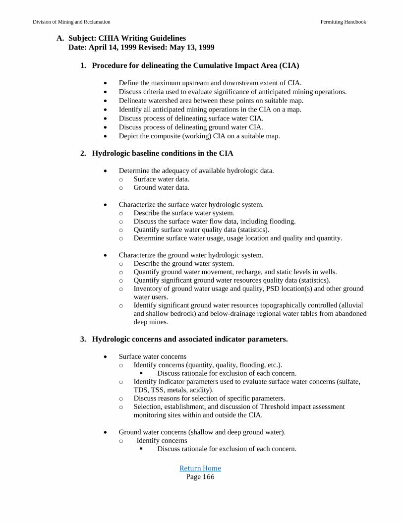
Division of Mining and Reclamation Permitting Handbook
Return Home Page 166
A. Subject: CHIA Writing Guidelines
Date: April 14, 1999 Revised: May 13, 1999
1. Procedure for delineating the Cumulative Impact Area (CIA)
Define the maximum upstream and downstream extent of CIA.
Discuss criteria used to evaluate significance of anticipated mining operations.
Delineate watershed area between these points on suitable map.
Identify all anticipated mining operations in the CIA on a map.
Discuss process of delineating surface water CIA.
Discuss process of delineating ground water CIA.
Depict the composite (working) CIA on a suitable map.
2. Hydrologic baseline conditions in the CIA
Determine the adequacy of available hydrologic data.
o Surface water data.
o Ground water data.
Characterize the surface water hydrologic system.
o Describe the surface water system.
o Discuss the surface water flow data, including flooding.
o Quantify surface water quality data (statistics).
o Determine surface water usage, usage location and quality and quantity.
Characterize the ground water hydrologic system.
o Describe the ground water system.
o Quantify ground water movement, recharge, and static levels in wells.
o Quantify significant ground water resources quality data (statistics).
o Inventory of ground water usage and quality, PSD location(s) and other ground
water users.
o Identify significant ground water resources topographically controlled (alluvial
and shallow bedrock) and below-drainage regional water tables from abandoned
deep mines.
3. Hydrologic concerns and associated indicator parameters.
Surface water concerns
o Identify concerns (quantity, quality, flooding, etc.).
Discuss rationale for exclusion of each concern.
o Identify Indicator parameters used to evaluate surface water concerns (sulfate,
TDS, TSS, metals, acidity).
o Discuss reasons for selection of specific parameters.
o Selection, establishment, and discussion of Threshold impact assessment
monitoring sites within and outside the CIA.
Ground water concerns (shallow and deep ground water).
o Identify concerns
Discuss rationale for exclusion of each concern.

Division of Mining and Reclamation Permitting Handbook
Return Home Page 167
o Indicator parameters used to evaluate ground water concerns (sulfate, TDS,
TSS, metals, etc.).
o Discuss reasons for selection of specific parameters).
o Selection, establishment, and discussion of Threshold impact sites (wells)
where impacts are to be assessed within and outside the CIA.
4. Material damage criteria
Existing State stream water quality standards
o Site-specific material damage criteria based on pre-determined stream quality
and effluent standards, and use categories 47CSR2
o Threshold limits based on stream water use categories.
List of criteria for each parameter at each site.
Existing State stream water quantity standards.
o Site-specific material damage criteria based on pre-determined stream quality
and effluent standards, and use categories water which may be affected by
changes in water quantity.
o Threshold limits based on stream water use categories.
List of criteria for each parameter at each site.
o Site-specific material damage criteria.
o List of criteria for each parameter at each site.
Baseline data ranges for significant ground water resources.
5. Assessment of cumulative impacts of mining on indicator parameters
Mining methods used within the CIA.
o Describe the mining methods being used.
o Discuss effects of various mining methods on hydrology of the CIA.
Surface water
o Predictive methods used: data and/or modeling.
Discuss reasons for using these methods.
o Discuss assumptions of the methods.
o Projected values of indicator parameters at identified surface water monitoring
sites to determine the impact of the proposed operation on the hydrologic
balance on and off the permit areas.
Quantity parameters at monitoring sites.
Quality parameters at monitoring sites.
Quality, quantity parameters at Threshold impact sites.
Ground water
o Predictive methods used: data and/or modeling.
o Discuss reasons for using these methods.
o Discuss assumptions of the methods.

Division of Mining and Reclamation Permitting Handbook
Return Home Page 168
o Projected values of indicator parameters at identified ground water impact sites
to determine the impact of the proposed operation on the hydrologic balance on
and off the permit areas.
Quantity parameters at monitoring sites.
Quality parameters at monitoring sites.
Quality, quantity parameters at Threshold impact sites (if different).
6. Determination and statement of findings
Determination of material damage potential to surface water resources.
o Comparison of projected values with material damage criteria.
o Potential for material damage to the surface water system.
o Determination that the proposed operation will minimize disturbance to the
hydrologic balance within the permit area and adjacent area.
o Determination that the proposed operation will prevent material damage to the
hydrologic balance (surface water) outside the permit area.
Determination of material damage potential to significant ground water resources.
o Comparison of projected values with material damage criteria to significant
ground water resources.
o Potential for material damage to significant ground water aquifers.
o Determination that the proposed operation will minimize disturbance to the
hydrologic balance within the permit area and adjacent area.
o Determination that the proposed operation will prevent material damage to the
hydrologic balance (ground water) outside the permit area.
7. Statement of findings
Summary of findings (Facts and Findings statement).
o Discuss what is proposed by the Company to minimize concerns stated in the
CHIA (PHC and HRP).
Discussion
o Reasons for these findings.
B. WVDEP CHIA Writing Guidelines Date: 4/14/99 Revised 5/13/99
1. Procedure for delineating the CIA
Phase I. Define maximum upstream and downstream extent of CIA.
Step 1. Develop criteria to test the impact significance from mining operations that are
spatially and hydrologically distant to the proposed operation:
a. Compare the prevailing water data that reflects impacts from mining such as acidity,
alkalinity, TDS, TSS, sulfate, metals.
b. Identify the areas of downstream dilution as a basis for exclusion of additional
downstream operations.
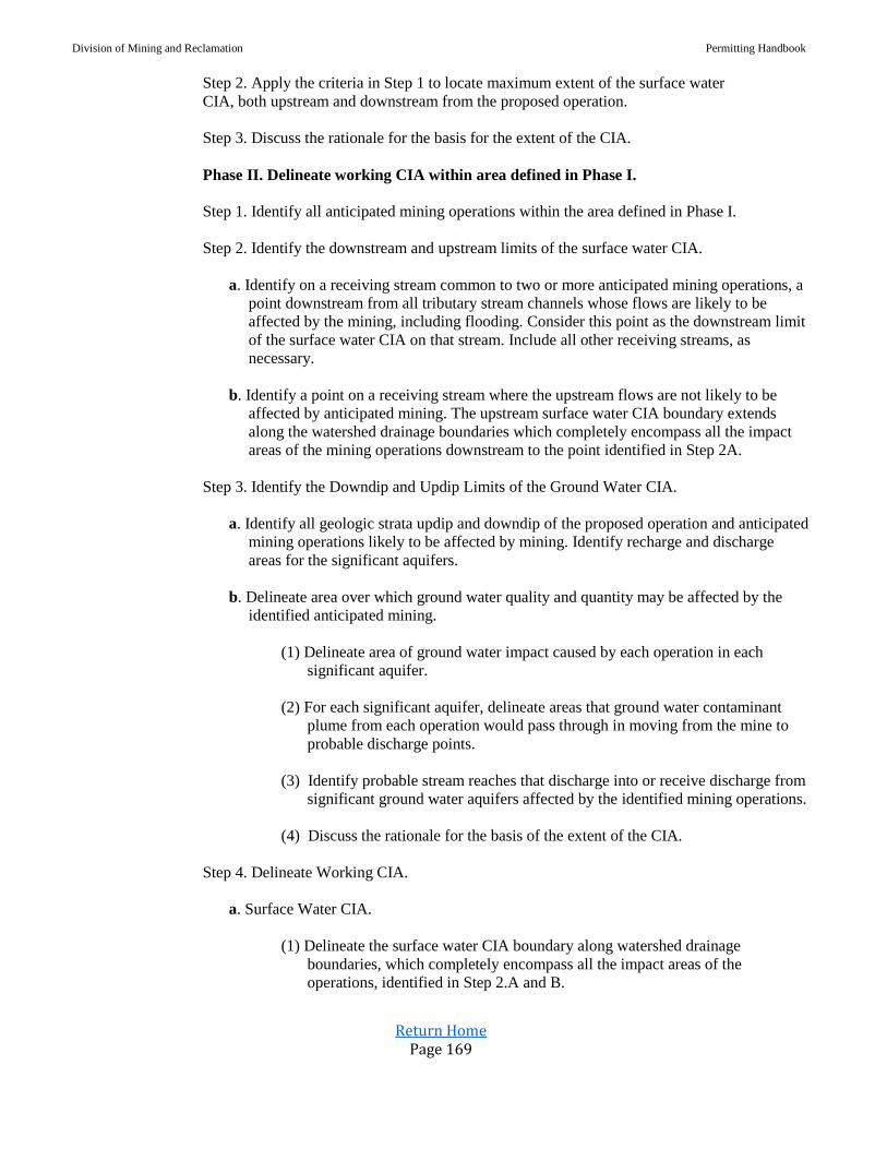
Division of Mining and Reclamation Permitting Handbook
Return Home Page 169
Step 2. Apply the criteria in Step 1 to locate maximum extent of the surface water
CIA, both upstream and downstream from the proposed operation.
Step 3. Discuss the rationale for the basis for the extent of the CIA.
Phase II. Delineate working CIA within area defined in Phase I.
Step 1. Identify all anticipated mining operations within the area defined in Phase I.
Step 2. Identify the downstream and upstream limits of the surface water CIA.
a. Identify on a receiving stream common to two or more anticipated mining operations, a
point downstream from all tributary stream channels whose flows are likely to be
affected by the mining, including flooding. Consider this point as the downstream limit
of the surface water CIA on that stream. Include all other receiving streams, as
necessary.
b. Identify a point on a receiving stream where the upstream flows are not likely to be
affected by anticipated mining. The upstream surface water CIA boundary extends
along the watershed drainage boundaries which completely encompass all the impact
areas of the mining operations downstream to the point identified in Step 2A.
Step 3. Identify the Downdip and Updip Limits of the Ground Water CIA.
a. Identify all geologic strata updip and downdip of the proposed operation and anticipated
mining operations likely to be affected by mining. Identify recharge and discharge
areas for the significant aquifers.
b. Delineate area over which ground water quality and quantity may be affected by the
identified anticipated mining.
(1) Delineate area of ground water impact caused by each operation in each
significant aquifer.
(2) For each significant aquifer, delineate areas that ground water contaminant
plume from each operation would pass through in moving from the mine to
probable discharge points.
(3) Identify probable stream reaches that discharge into or receive discharge from
significant ground water aquifers affected by the identified mining operations.
(4) Discuss the rationale for the basis of the extent of the CIA.
Step 4. Delineate Working CIA.
a. Surface Water CIA.
(1) Delineate the surface water CIA boundary along watershed drainage
boundaries, which completely encompass all the impact areas of the
operations, identified in Step 2.A and B.

Division of Mining and Reclamation Permitting Handbook
Return Home Page 170
b. Ground Water CIA.
(1) Delineate ground water CIA boundary to encompass the maximum extent of
contaminant plumes and areas of drawdown.
(2) The groundwater CIA encompasses all drawdown cones and contaminant
plumes that affects or discharges to common surface streams or alluvial
aquifers.
c. The composite of the surface and ground water CIA’s is the working CIA for the
proposed operation.
2. Procedures to Determine the Baseline Conditions in the CIA
Phase III. Define Hydrologic Baseline Condition in the extent of the CIA.
Step 1. Determine the adequacy of available hydrologic data
a. Occurrence and Distribution of Data
(1) Low stream flow water quality related to stream standards, and surface water
user needs.
(2) Annual low flows and period of occurrence. Compare low flows to normal
base, mean annual, high flows relate to rainfall data
(3) Significant aquifer production and ground water resources providing needs for
domestic use, biota, and the protection of the hydrologic balance as relates to
use.
b. Water Quality Characteristics
(1) Baseline data including pH, alkalinity, acidity, SO4, conductance,
TSS, TDS, Fe, Mn, Al, and temperature.
(2) Sampling frequency of six months’ data of PHC baseline parameter and 16
Parameters one-time sample; refer to CHIA guidance memo for applicability.
(3) Surface flows, static levels and pump test for wells.
Step. 2 Characterize the Surface Water Hydrologic System in Relation to Runoff.
a. Characterize the Surface Water in the Watersheds of the Working CIA.
(1) Description of basin in total area, topographic relief, basin length, and average
basin slope.
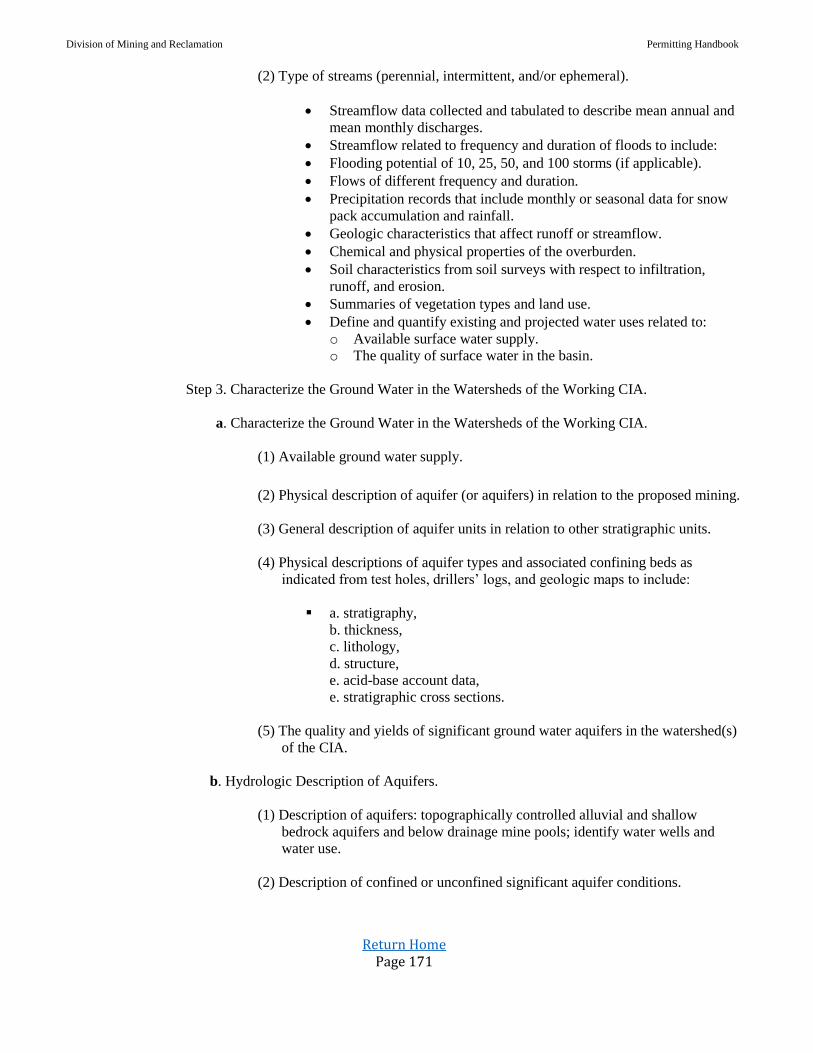
Division of Mining and Reclamation Permitting Handbook
Return Home Page 171
(2) Type of streams (perennial, intermittent, and/or ephemeral).
Streamflow data collected and tabulated to describe mean annual and
mean monthly discharges.
Streamflow related to frequency and duration of floods to include:
Flooding potential of 10, 25, 50, and 100 storms (if applicable).
Flows of different frequency and duration.
Precipitation records that include monthly or seasonal data for snow
pack accumulation and rainfall.
Geologic characteristics that affect runoff or streamflow.
Chemical and physical properties of the overburden.
Soil characteristics from soil surveys with respect to infiltration,
runoff, and erosion.
Summaries of vegetation types and land use.
Define and quantify existing and projected water uses related to:
o Available surface water supply.
o The quality of surface water in the basin.
Step 3. Characterize the Ground Water in the Watersheds of the Working CIA.
a. Characterize the Ground Water in the Watersheds of the Working CIA.
(1) Available ground water supply.
(2) Physical description of aquifer (or aquifers) in relation to the proposed mining.
(3) General description of aquifer units in relation to other stratigraphic units.
(4) Physical descriptions of aquifer types and associated confining beds as
indicated from test holes, drillers’ logs, and geologic maps to include:
a. stratigraphy,
b. thickness,
c. lithology,
d. structure,
e. acid-base account data,
e. stratigraphic cross sections.
(5) The quality and yields of significant ground water aquifers in the watershed(s)
of the CIA.
b. Hydrologic Description of Aquifers.
(1) Description of aquifers: topographically controlled alluvial and shallow
bedrock aquifers and below drainage mine pools; identify water wells and
water use.
(2) Description of confined or unconfined significant aquifer conditions.
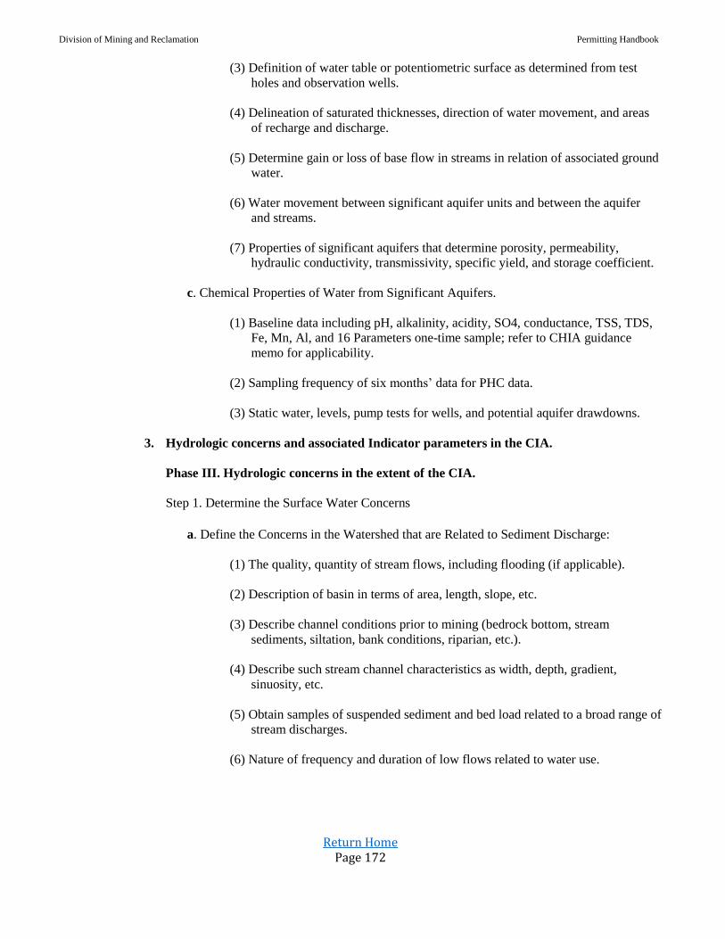
Division of Mining and Reclamation Permitting Handbook
Return Home Page 172
(3) Definition of water table or potentiometric surface as determined from test
holes and observation wells.
(4) Delineation of saturated thicknesses, direction of water movement, and areas
of recharge and discharge.
(5) Determine gain or loss of base flow in streams in relation of associated ground
water.
(6) Water movement between significant aquifer units and between the aquifer
and streams.
(7) Properties of significant aquifers that determine porosity, permeability,
hydraulic conductivity, transmissivity, specific yield, and storage coefficient.
c. Chemical Properties of Water from Significant Aquifers.
(1) Baseline data including pH, alkalinity, acidity, SO4, conductance, TSS, TDS,
Fe, Mn, Al, and 16 Parameters one-time sample; refer to CHIA guidance
memo for applicability.
(2) Sampling frequency of six months’ data for PHC data.
(3) Static water, levels, pump tests for wells, and potential aquifer drawdowns.
3. Hydrologic concerns and associated Indicator parameters in the CIA.
Phase III. Hydrologic concerns in the extent of the CIA.
Step 1. Determine the Surface Water Concerns
a. Define the Concerns in the Watershed that are Related to Sediment Discharge:
(1) The quality, quantity of stream flows, including flooding (if applicable).
(2) Description of basin in terms of area, length, slope, etc.
(3) Describe channel conditions prior to mining (bedrock bottom, stream
sediments, siltation, bank conditions, riparian, etc.).
(4) Describe such stream channel characteristics as width, depth, gradient,
sinuosity, etc.
(5) Obtain samples of suspended sediment and bed load related to a broad range of
stream discharges.
(6) Nature of frequency and duration of low flows related to water use.
Division of Mining and Reclamation Permitting Handbook
Return Home Page 173
b. Determine Erosion and Sediment Potential in Mined Areas:
(1) Describe probable effects of erosion and sediment yield during the mining
and reclamation phases of the operation.
(2) Estimate flow and sediment yield from 10, 25, 50, and 100-year storms.
(3) Relate proposed drainage design to geomorphic stability of mined areas after
reclamation.
c. Assessment Monitoring Sites in the Selection, Establishment and Discussion of Threshold
Impact CIA.
(1) Discuss selection of Threshold Monitory sites where impacts are assessed.
Within the CIA
Outside the CIA
(2) Low-flow water quality related to stream standards and water user needs.
(3) Locates sites on map of CIA
Step 2. Determine the Ground Water Concerns
a. Identify concerns and discuss rationale for inclusion of each concern addressing
significant ground water resource and /or PSD wells.
b. Potential chemical constituents from the disturbed overburden that may affect the water
quality (acidity, alkalinity, TSS, TDS, sulfate and metals).
c. Indicator parameters used to evaluate significant ground water concerns (sulfate, TDS,
metals, storativity, and recharge)
d. Discuss the potential for dewatering of alluvial aquifers due to underground mining,
especially longwall mining.
e. Discuss the potential for dewatering significant aquifers due to underground mining,
especially longwall mining.
f. Selection, establishment and discussion of Threshold impact assessment-monitoring
sites in the CIA.
(1) Discuss selection of Threshold impact sites where impacts are to be assessed.
Within the CIA
Outside the CIA
(2) Low-flow water quality related to stream standards and water use needs.
(3) Locate sites on map of CIA.
Division of Mining and Reclamation Permitting Handbook
Return Home Page 174
4. Procedures for defining Material Damage criteria
Step 1. Assemble Existing State, Federal, and Local Standards Which Apply to the Expressed
Hydrologic Concerns in the PHC
a. Water Quality Standards
(1) Existing State stream water quality standards.
(2) Stream quality and effluent standards, and stream water use categories (refer to
Title 46-1-6 and Appendix E).
(3) List of criteria for each monitoring parameter at each site.
(4) Consider standards used by surrounding states.
(5) Consider quality needs for present and potential uses.
Refer to EPA (1976) and McKee and Wolf (1963) for suggested limits of
specific constituents relative to use.
(6) Threshold limits based on stream water use categories, and ground water limits
based on available baseline data.
b. Water Quantity
(1) Existing stream water quantity standards.
(2) The material damage limits assigned to significant ground water resources will
be based on the prevailing baseline ground water data.
(3) Consider needs of probable uses.
(4) Identify stream reaches and significant aquifers that will dewatered by
subsidence.
(5) Consider possible channel stability problems resulting from discharge changes.
Step 2. Develop Material Damage Criteria
(1) List of site-specific material damage criteria for each Indicator parameter
related to mining.
(2) Site-specific material damage criteria based on pre-determined stream quality
(Threshold limits), stream water use categories Title 46-1-6, and effluent
standards.
(3) Geomorphology
Watershed characteristics related to sediment
Stream characteristics related to sediment discharge
Division of Mining and Reclamation Permitting Handbook
Return Home Page 175
Channel and hillside erosion in mined areas
Flooding potential in mined areas (if applicable)
Step 3. Develop any Additional Criteria Considered Necessary for an Adequate Assessment
of Material Damage
a. Need for incremental change (or time rate of change) limits.
(1) Establish a site-specific set of material damage criteria for each Threshold
Monitoring site.
Within the CIA, ground water and surface water
Outside the CIA, ground water and surface water
(2) Describe existing and potential hydrologic problems related to concerns for the
proposed operation:
Water-quality problems that could be created by the geochemistry of the
overburden:
o Special handling plan, alkaline amendment.
o Encapsulation cells.
o Roof/floor rock associated with deep mines.
Effects of changed discharge regimes on channel stability and increase in
peak discharges that may create a flooding potential.
Longwall mining effects upon streamflow and aquifers.
Subsidence fractures on surface lands (affected areas).
Concerns identified in previous CHIA studies.
Problems identified in regional studies by State and/or Federal agencies.
Step 4. Select representative Indicator Parameters for Quantifying Hydrologic Concerns to
Evaluate Changes and Assess Impacts on the Hydrologic Balance.
List of criteria for each Indicator parameter at each Threshold Monitoring site.
Within the CIA
Outside the CIA
(1) Site-specific material damage criteria.
(2) List of criteria for each parameter at each site.
(3) Baseline data ranges for significant ground water resources.
5. Procedures for Assessing the Cumulative Impacts of Mining on Indicator Parameters
Step 1. Analysis of Cumulative Hydrologic Impacts
a. Mining methods used within the CIA
b. Assessment of cumulative impacts on the surface and ground water
(1) Analysis of the hydrologic system that will undergo additional stress with the
addition of the proposed operation to all anticipated mining in the CIA.
Division of Mining and Reclamation Permitting Handbook
Return Home Page 176
(2) Utilize the baseline surface water and NPDES DMR data, and PHC baseline
ground water data from Anticipated Mining permits.
Step 2. Estimate Values of Indicator Parameters that Reflect Mining in the CIA.
a. Prediction (estimation) of cumulative impacts from mining.
b. Estimation of the magnitude of changes to each parameter value that can be expected
because of mining on surface and ground water.
c. Analyses of cumulative impacts can be accomplished by:
(1) Qualitative methods and/or solute mass balance equation.
(2) Empirical equations and statistical analysis.
(3) Computer modeling.
Step 3. Analysis Techniques for Predicting the Impacts of Mining
a. Qualitative methods.
(1) Systematic evaluation of qualitative and quantitative data with an estimation of
indicator parameters that could be anticipated because of mining; including
streamflow loss from deep mining.
b. Empirical equations; relationships
(1) Solute mass balance equation
(2) Theis equation
(3) Universal soil loss equation
(4) Rationale equation
(5) Muskingum flow routing equation
(6) Statistical analysis, including univariate and multivariate techniques
c. Mathematical/numerical computer modeling.
(1) WCMS (Watershed Characteristics Modeling System)/ArcView
(2) Boss-Watershed, HEC/HMS, RAS
(3) Modflow-GMS
(4) EarthVision
Division of Mining and Reclamation Permitting Handbook
Return Home Page 177
6. Procedures for Determining Material Damage Potential to Surface and Ground Water
Resources
Step. 1 Comparison of Anticipated Values with Prevailing Values
a. Determine Potential for Material Damage from Indicator Parameters that Reflect the
Effects of Mining.
(1) Quantify the Indicator parameters and compare the values to the material
damage criteria at Threshold Monitoring sites. Ranges may be used for
Indicator parameters, rather than precise, single values.
Ranges may be used for indicators, rather than precise, single values.
(2) Determine the magnitude of the Indicator parameters and compare the values
to the material damage criteria.
Ranges may be used for indicators, rather than precise, single values.
(3) Comparisons of projected values (or ranges) for the Indicator parameters that
indicate mining.
Rationale for decisions.
7. Statement of Findings.
Step 1. Summary of Findings that Determines the Potential for Material Damage to the
Hydrologic Balance Outside the Permit Area.
a. Determination whether the hydrologic assessment of the CIA indicates that the addition
of the proposed operation to all probable cumulative impacts of all anticipated mining
may cause more than minimal disturbance to the hydrologic balance within the permit
area and adjacent areas, or may cause material damage to the hydrologic balance
outside the permit area.
b. Determinations may be based on Threshold monitoring site evaluations of quality and
quantity of surface and ground water.
c. Discuss what is proposed by the applicant to minimize concerns stated in the PHC and
HRP.
Discussion of preventative and/or remedial measures.
Step 2. Write a statement of findings with all supporting evidence and rationale for decisions.
a. Utilize best professional judgement in evaluating all available qualitative and
quantitative data and arrive at material damage determinations. Discuss rationale.
C. Subject: CHIA Guidance and Monitoring Requirements
Date: May 18, 1999
The CHIA guidance document previously sent out is intended to provide the building blocks for
enhancing the overall CHIA process. It is further intended to provide the CHIA writer with a
template to assist in developing the CHIA document and to ensure that PHC’s are able to provide
adequate data to complete the CHIA. Because this is a guidance document developed primarily

Division of Mining and Reclamation Permitting Handbook
Return Home Page 178
from existing guidelines not all elements will apply to all permits all the time. Rather the writer
must use the document to fit the proposed operation into a framework of anticipated mining and
the Cumulative Impact Area (CIA).
It is intended that this guidance will enable this process to be enhanced on a logical and
progressive basis. It is not possible to raise the bar to the next level overnight. The previous
guidance was provided in an expedited fashion so we could begin the thought process on what will
be required and gain feedback on establishment of the assessment process. This will lead us to a
position from which we can fully implement the guidance on newly submitted permits.
Because of the complexity of the issue and the questions and concerns evidenced the following
additional clarification and guidance is being provided:
1. Permits under review where PHC’s are complete and CHIA’s under development:
a. PHC – contains at least six months’ baseline groundwater and surface water data and
groundwater inventory.
In addition to the SMCRA baseline parameters to be monitored in accordance with
Title 38, Series 2, Sections 3.22.b.2 and 3.22.c.2 for the PHC, aluminum and
temperature shall also be sampled monthly and quarterly during mining.
Be aware that both temperature and field pH shall be in accordance with approved
methods.
At least one month’s sample if warranted, based on stream use, type of mining activity
and proximity of water intakes, from each PHC surface water monitoring station shall
be analyzed for the following parameters in Table 4-C:
1. Antimony
2. Arsenic
3. Beryllium
4. Cadmium
5. Chromium
6. Copper
7. Lead
8. Mercury
9. Nickel
10. Selenium
11. Silver
12. Thallium
13. Zinc
14. Cyanide
15. Phenols
16. Nitrates
If determined necessary samples must be obtained prior to mining.
b. CHIA’s
1. Identify CIA – describe and discuss rationale.
2. Identify threshold limits (at minimum those contained in regulations)
3. Discuss mitigation of material damage and intent of monitoring plan.

Division of Mining and Reclamation Permitting Handbook
Return Home Page 179
2. Newly submitted permits:
a. Should be reviewed with the entire guideline document in mind.
b. CHIA should contain applicable portions of the guidance document.
3. NPDES Table 4-C (16 parameters as referenced above)
a. NPDES Table 4-C for permits in A will only be required where warranted or refuse and
flyash are involved and be (1) baseline sample for each SWMP and GWMP.
b. NPDES Table 4-C for permits in B will be required for all permits and require one
baseline sample for each SWMP and GWMP.
c. The absence of, or non-compliance of the parameters of NPDES Table 4-C will be used
to detail monitoring plans.
It is anticipated that the enhanced process will be fully developed and integrated with NPDES and
NEPA where applicable for all new SMA’s, Revisions, and IBR’s, etc.
D. Subject: Selenium Implementation Guidance
Date: November 13, 2007
1. Introduction: The West Virginia Department of Environmental Protection (DEP) has statewide effluent data
and instream water-quality data indicating selenium concentrations in certain locations exceed
the current water quality criteria (WQC) for aquatic life. This memorandum documents
permitting procedures that will be implemented to reduce the potential for new mining
activities to cause or contribute to selenium WQC violations. 1
As such, the Probable Hydrologic Consequences (PHC) Statement in applications for new
Surface Coal Mining and Reclamation Act (SCMRA) permits or permit amendments,
submitted after January 1, 2008, shall address the potential for mining activities to cause or
contribute to selenium exceeding the current WQC by providing information as described
herein. DEP will attempt to process currently pending applications and applications submitted
during the interim period (before January 1, 2008) with readily available information, but may
require additional information if necessary to determine operational requirements for the
control of selenium in permitted discharges.
Mining activities initially deemed to have the potential to cause or contribute to selenium
violations will be required to provide information, as set forth below in Section 1.
Those activities determined to have reasonable potential to violate selenium WQC will be
required to develop an effective mechanism for preventing/minimizing the weathering of and
leaching of selenium as set forth in Section 2. SMCRA and NPDES permits issued for such
activities will contain operating requirements for the control of selenium, require baseline water
quality monitoring, contains selenium effluent limitations and self-monitoring requirements, as
appropriate.
1 This document reflects the current state of knowledge in Selenium regulation/prevention. As more facilities permitted under this guidance are constructed, DEP will review the effectiveness of the controls set forth herein.

Division of Mining and Reclamation Permitting Handbook
Return Home Page 180
Applicants not wishing to implement the described procedures must provide additional testing
of materials, alternative handling procedures, historical water quality or other data that
demonstrates there is no reasonable potential to violate the selenium WQC.
2. Section 1 A proposed activity will initially be deemed to have a potential to cause or contribute to
selenium WQC violations if:
a. The proposed mining is in the Winifrede to Upper No.5 Block coal seam interval.
(Seam nomenclature as defined by the West Virginia Geologic and Economic Survey)
or;
b. Site-specific or adjacent water quality data (associated with mining in the same
geologic strata) shows concentrations equal to or more than 5 ug/l. This water data
may include, but is not limited to, application water quality data (e.g. PHC, anti-
degradation BWQ sampling), effluent data from adjacent mining operations (e.g.
NPDES Table 2 IV C analysis) and instream monitoring data from DEP Trend Stations,
DMRs, and DEP Stream Assessments or;
c. This provision is met if the receiving stream for a proposed discharge is listed on the
operable Section 303(d) List for use impairment related to selenium, or;
d. There is an approved selenium Total Maximum Daily Load for the receiving stream or
downstream waters that mandates regulation of selenium in the discharges from the
activity.
3. Section 2 Surface and deep mining operations initially deemed to have potential to cause or contribute to
selenium water quality criteria violations may be required to perform overburden sampling, as
follows:
Overburden Sampling Plan The recommended spacing of sample sites will be on approximately 2000-foot spacing 1, or
other spacing approved by the geologist reviewing the surface mining application. The holes
will be located on the uppermost part of the strata to be mined and drilled down to 10 feet
below the lowest coal seam to be mined for surface mines and strata a minimum of 50 feet
above and 10 feet below the seam to be mined for deep mines. This will help ensure that all the
overburden to be disturbed is sampled. Detailed geologic logs of the drill holes, to include
chroma as per Munsell’s chart, are required2.
All overburden, including the coal seam(s), will be sampled for selenium according to U.S.
EPA-600/2-78-054 Field and Laboratory Methods Applicable to Overburdens and Minesoils,
Chapter2. This method generally requires sampling every 5 feet for sandstones, 3 feet for shale
or other soft rock including coal seams, or each time the strata or chroma changes. The core
should be split longitudinally along its length, and a composite analysis shall be done for each
stratum. (Stratum sub-sampling is not acceptable.)
1 Geologic Handbook, Pages 29 to 33, published by the DEP in September 2005 for further guidance. 2 Geologic Handbook, Pages 23 to 25, published by the DEP in September 2005 for further guidance
Division of Mining and Reclamation Permitting Handbook
Return Home Page 181
Each sample will be analyzed for total selenium by the 3050B (for Acid Digestion of Solids)
method. The laboratory performing the test must have a valid DEP Laboratory Certification
Program approval to perform metals analysis.
If the total selenium concentration of any strata is equal to or greater than 1 mg/kg, then the
activity will be deemed to have reasonable potential to violate selenium WQC and the applicant
shall implement a selenium encapsulation plan or alternatives, as described in Section 3. If all
of the tested materials exhibit selenium concentrations less than 1 mg/kg, then the activity will
be deemed not to have reasonable potential to cause or contribute to selenium water quality
criteria violations.
4. Section 3
Surface Mine and Deep Mine Face-up Operations
Selenium Encapsulation Plan
Surface mine and deep mine face-up operations determined to have reasonable potential to
violate selenium WQC shall encapsulate the following materials:
a. All black/dark grey coal pit materials (Munsell Soil Color Chart of 2.5 or less) that are
visibly differentiated in the field. Mining companies typically term this material “pit
cleanings.”
b. Any overburden stratum greater than 12 inches in thickness with selenium
concentrations greater than 1 mg/kg or Munsell Soil Color Chart of 2.5 or less. The
reviewing geologist may also require encapsulation of strata that are individually less
than 12 inches in thickness, if they meet the selenium or Munsell conditions and are
proximate to strata of similar characteristics.
c. The floor shall be removed and encapsulated if the selenium concentration is equal to or
greater than 1 mg/kg to avoid contact with the water/rock interface.
Encapsulation shall be accomplished as follows:
a. The material shall be encapsulated promptly to minimize weathering and leaching of
selenium.
b. The material shall be encapsulated in an area of the job that is high and dry, away from
watercourse, and under no circumstance shall any of this material be put in a valley fill.
c. The material shall be put on a free draining pad of at least 10 feet of coarse non-toxic
material and the selenium laden material shall be encapsulated covered with at least 4
feet of the most impervious material on the surface mine job.
d. The encapsulation cells need to be certified by a registered professional engineer or
licensed land surveyor that they were constructed to the permit application
specifications and located geographically (GPS) on the progress maps.
Division of Mining and Reclamation Permitting Handbook
Return Home Page 182
Deep Mining / Augering
Deep mining and augering operations initially deemed to have potential to cause or
contribute to selenium water quality criteria violations will be required to provide the
following requirements or meet the following conditions.
The location of openings in coal seams, with potential to cause or contribute to selenium
exceeding the current WQC, will be placed in such a manner to prevent a gravity
discharge. During active mining operations with pumped discharges, the applicant shall
demonstrate, in their Hydrologic Reclamation Plan (Section J-11) and NPDES application
(Modules 7 and 8), the methodologies that will be utilized to ensure compliance with
applicable water quality based effluent limitations.
5. Section 4
WV/NPDES Permit Considerations
The WV/NPDES Permit for any activity determined to have reasonable potential to cause
or contribute to selenium exceeding the current WQC will include selenium effluent
limitations and self-monitoring requirements. For Tier 1 anti-degradation implementation,
effluent limitations will require the achievement of selenium water quality criteria end-of-
pipe for outlets associated with instream treatment structures and all other outlets where
no dilution is available in the immediate receiving stream. For outlets with available
receiving stream dilution, effluent limitation development will incorporate dilution, but
only to the extent that assures compliance with applicable water quality standards. For
Tier 2 and higher waters, anti-degradation implementation may result in selenium effluent
limitations more stringent than those described herein.
WV/NPDES permits for activities that are determined to not have reasonable potential to
cause or contribute to selenium water quality criteria violations shall not contain selenium
effluent limitations. However, those permits may contain selenium self-monitoring
requirements to confirm that the activity is not adversely impacting water quality.
D. Subject: Selenium Implementation Guidance
Date: November 13, 2007
Revised: December 30, 2013
This policy DOES NOT supersede the November 13, 2007 policy.
1. The West Virginia Department of Environmental Protection (DEP) has statewide effluent
data and in-stream water-quality data indicating selenium concentrations in certain
locations exceed the current water quality criteria (WQC) for aquatic life. This
memorandum documents permitting procedures that will be implemented to reduce the
potential for new mining activities to cause or contribute to selenium WQC violations.
This document reflects the current state of knowledge in selenium regulation and
prevention. As more facilities permitted under this guidance are constructed, the DEP will
review the effectiveness of the controls set forth herein. Limited situations may arise that
are not addressed by this guidance. In those situations, discretion may be exercised by the
permit review staff after consultation with DEP headquarters.

Division of Mining and Reclamation Permitting Handbook
Return Home Page 183
As such, if selenium is initially identified as a “Parameter of Concern” (POC), the
Probable Hydrologic Consequences (PHC) Statement in application for new Surface Coal
Mining and Reclamation Act (SMRCA) permits or permit amendments, submitted after
January 1, 2008, shall address whether or not selenium is a POC by providing information
as described herein.
Mining activities where selenium has initially been identified as a “POC” as outlined in
Section 1 of this document will be required to perform overburden sampling for selenium
as set forth in Section 2.
Applicants not wishing to implement the described procedures must provide additional
testing of materials, alternative handling procedures, historical water quality or other data
that demonstrates selenium is not a “POC” or does not have a reasonable potential to
violate the selenium WQC.
A proposed activity will initially be deemed to have selenium as a “POC” if:
o The proposed mining is in the Winifrede to Upper No.5 Block coal seam interval.
(Seam nomenclature as defined by the West Virginia Geologic and Economic
Survey) or;
o Site-specific or adjacent water quality data (associated with mining in the same
geologic strata) shows concentrations equal to or more than 5 µg/l. This water
data may include, but is not limited to, application water quality data (e.g. PHC,
anti-degradation BWQ sampling), effluent data from adjacent mining operations
(e.g. NPDES Table 2 IV C analysis) and in-stream monitoring data from DEP
Trend Stations, DMRs, and DEP Stream Assessments or;
o If the immediate receiving stream for a proposed discharge is listed on the
operable Section 303(d) List for use impairment related to selenium, or;
o There is an approved selenium Total Maximum Daily Load for the receiving stream
or downstream waters that mandates regulation of selenium in the discharges from
the activity.
2. Section 2 – Surface and deep mining operations initially deemed to have selenium as a POC
shall be required to perform overburden sampling, as follows:
Overburden Sampling Plan
The recommended spacing of sample sites will be on approximately 2000 foot spacing1, or
other spacing approved by the geologist reviewing the surface mining application. The
holes will be located on the uppermost part of the strata to be mined and drilled down to 10
feet below the lowest seam to be mined for surface mines and strata a minimum of 50 feet
above and 10 feet below the seam to be mined for deep mines. This will help ensure that all
the overburden to be disturbed is sampled. The reviewing geologist may require
supplemental sampling locations, if deemed necessary. Detailed geologic logs of the drill
holes, to include chroma as per Munsell’s chart, are required2.
All strata, including the coal seam(s) will be sampled for selenium according to U.S. EPA-
1 Geologic Handbook, pages 29 to 33, published by the DEP in September 2005 for further guidance. 2 Geologic Handbook, pages 23 to 25, published by the DEP in September 2005 for further guidance.

Division of Mining and Reclamation Permitting Handbook
Return Home Page 184
600/2-78-054 Field and Laboratory Methods Applicable to Overburdens and Minesoils,
Chapter 2. This method generally requires sampling every 5 feet for sandstones, 3 feet for
shale or other soft rock including coal seams, or each times the strata or chroma changes.
The core should be split longitudinally along its length, and a composite analysis shall be
done for each stratum. (Stratum sub-sampling is not acceptable.)
Each sample will be analyzed for total selenium by the 3050B (for Acid Digestion of
Solids) method. The laboratory performing the test must have a valid DEP Laboratory
Certification Program approval to perform metals analysis.
If the total selenium concentration of any strata is equal to or greater than 1 mg/kg, the
applicant shall implement a selenium isolation plan or alternatives, as described in Section 3.
If all of the tested materials exhibit selenium concentrations less than 1 mg/kg, then the
activity will be deemed not to have reasonable potential to cause or contribute to selenium
water quality criteria violations.
3. Surface Mine and Deep Mine Face-up Operations
Selenium Isolation Plan
Surface mine and deep mine face-up operations with the total selenium concentration of any strata is equal to or greater than 1 mg/kg, shall isolate the following materials:
a. All black/dark grey coal pit materials (Munsell Soil Color Chart of 2.5 or less) that
are visibly differentiated in the field. Mining companies typically term this material
“pit cleanings.”
b. Any overburden stratum greater than 12 inches in thickness with selenium
concentrations greater than 1 mg/kg or Munsell Soil Color Chart of 2.5 or less. The
reviewing geologist shall also require isolation of strata that are individually less than
12 inches in thickness, if they meet the selenium or Munsell conditions and are
proximate to strata of similar characteristics. Provided that where the permit
specifically demonstrates that this material has a selenium concentration less than
1mg/kg, isolation of the material will not be required.
c. The pavement floor shall be removed and isolated if the selenium concentration is
equal to or greater than 1 mg/kg to avoid contact with the water/rock interface.
Pavement is defined as the pit floor associated with the lowest seam to be mined
within any a specific area of the operation and as identified in Item 6 below.
Isolation shall be accomplished as follows:
a. The material shall be isolated promptly to minimize weathering and leaching of
selenium
b. The material shall be isolated in an area of the operation that is high and dry, away
from watercourse, and under no circumstance shall any of this material be put in a
valley fill.
c. The material shall be put on a free draining pad of at least 10 feet of coarse non-
toxic material and the selenium laden material shall be covered with at least 4 feet
of the most impervious material available on the surface mining operation.
d. Provided that DEP shall require revision to this plan, where it is demonstrated as
necessary to meet performance standards.

Division of Mining and Reclamation Permitting Handbook
Return Home Page 185
e. The isolation cells are to be certified by a registered professional engineer or
licensed land surveyor that they were constructed as per permit specifications and
located geographically (GPS) on the progress maps.
f. For applications proposing excavated in-stream sediment control structures; any
coal seam or dark carbonaceous shale encountered during the excavation of the
structure shall be removed, handled, and disposed of in accordance with the
procedures specified herein or other appropriate method approved by the Director.
Deep Mining/Augering
Deep mining and augering operations with total selenium concentration of the coal seam
being mined, immediate roof, or pavement equal to or greater than 1 mg/kg, will be required
to provide the following requirements or meet the following conditions.
The location of openings in coal seams, with total selenium concentration of the coal seam
being mined, immediate roof, or pavement equal to or greater than 1 mg/kg, will be situated
in such a manner to prevent a gravity discharge, unless the applicant can demonstrate by
other methods that the anticipated discharge will not cause or contribute to a violation of the
WQS for selenium. During active mining operations with pumped discharges, the applicant
shall demonstrate, in their Hydrologic Reclamation Plan (Section J-11) and NPDES
application (Modules 7 and 8), the methodologies that will be utilized to ensure compliance
with applicable water quality based effluent limitations.
4. WV/NPDES Permit Considerations
The WV/NPDES Permit for all operations located in the Kanawha formation, Winifrede to
Upper No.5 Block coal seam, shall contain selenium report only requirements. The
WV/NPDES Permit for any activity determined to have reasonable potential to cause or
contribute to selenium exceeding the current WQC will include selenium effluent
limitations and self-monitoring requirements.
For Tier 1 anti-degradation implementation, effluent limitations will require the
achievement of selenium water quality criteria end-of-pipe for outlets associated with in-
stream treatment structures and all other outlets where no dilution is available in the
immediate receiving stream. For outlets with available receiving stream dilution, effluent
limitation development will incorporate dilution, but only to the extent that assures
compliance with applicable water quality standards. For Tier 2 and higher waters, anti-
degradation implementation may result in selenium effluent limitations more stringent than
those described herein.
WV/NPDES permits for activities that are determined to not have reasonable potential to
cause or contribute to selenium water quality criteria violations shall not contain selenium
effluent limitations. Operations that demonstrate the ability to achieve compliance with the
WQC for selenium through implementation of procedures described in Section 3 may be
determined to not have the potential to cause or contribute to a violation of the WQC for
selenium. However, those permits shall contain selenium report only requirements to
confirm that the activity is not adversely impacting water quality.
Division of Mining and Reclamation Permitting Handbook
Return Home Page 186
Informal
Conference
Process Procedure Overview
Standard Operating Procedure

Division of Mining and Reclamation Permitting Handbook
Return Home Page 187
INFORMAL CONFERENCE PROCEDURE OVERVIEW
FOR
ARTICLE 3 APPLICATIONS
Initiated by Citizen Request 22-3-20(B)
o To Be Scheduled Within 21 Days Following Application End of Comment Date
Send Citizen Acknowledgement of Request Receipt
Notify Applicant of Request
Notify Staff of Request
Secure Informal Conference Location 22-3-20(B)
Advertise Informal Conference 22-3-20(B)
o Must Be Published At Least Two Weeks Prior To Informal Conference
Notify Requesters and Applicant of Informal Conference Date & Location
o Must Occur Two Weeks Prior To Informal Conference
Notify Staff of Location and Date
Informal Conference Preparation
o Equipment & Information Needed
o Signage Needed
o Staff Needed
o Security Needed
Informal Conference Conducted
o Set Up Stations
Participant Sign in Station
Information Station/Stations
Participant Comment Reception Station/Stations
– Verbal/Written/Video
o Closing Statement
Informal Conference Completed
o Informal Conference Records Maintained with Application Findings
Record Retention to Comply with Current Agency Policy
Division of Mining and Reclamation Permitting Handbook
Return Home Page 188
Informal Conference
A. SCOPE AND APPLICABILITY
The purpose of this document is to provide a procedure for scheduling and conducting an informal
conference for surface coal mining operations. Any person having an interest which is or may be
adversely affected, or the officer or head of any federal, state or local governmental agency, may
request an informal conference on a surface mining application (SMA), amendment, significant
revision, IBR, or renewal application. The Permit Supervisor (or another appointed employee)
shall act as authorized agent of the Secretary and coordinate all informal conferences.
§22-3-20. Public notice; written objections; public hearings; informal conferences.
§22-3-21. Decision of director on permit application; hearing thereon.
B. SUMMARY OF METHOD
This SOP is being developed to standardize the informal conference proceedings.
C. DEFINITIONS
SMA- Surface Mine Application
REV- Permit Revision
IBR- Incidental Boundary Revision
ESS- Electronic Submission System (E-Permitting)
WVDEP- West Virginia Department of Environmental Protection
DMR – Division of Mining and Reclamation
D. HEALTH & SAFETY WARNINGS
Contact local authorities prior to the conference about potential security issues. It may be
necessary to have state or local police force on hand for more controversial informal conferences.
Have the local police and/or emergency services contact information available.
E. CAUTIONS
Remember that there is a likelihood of cameras and other recording devices being used by those
participating in the conference, so all staff should present themselves in a professional manner and
limit answers to factual information as presented in the permit application, DEP rules, and
regulations. Do not make assumptions or guesses when answering questions and do not engage in
argumentative situations.
F. PERSONNEL QUALIFICATIONS/RESPONSIBILITIES
The Permit Supervisor will determine the number of staff needed for each informal conference.
Staffing needs will vary for different application types. The typical surface mine application
(SMA) may utilize a staff geologist, engineer, environmental resource specialist, blasting

Division of Mining and Reclamation Permitting Handbook
Return Home Page 189
specialist, and inspector/inspector supervisor. An informal conference for a renewal may only
utilize the Inspection and Enforcement staff, Office of Explosives and Blasting (OEB) staff, and an
environmental resource specialist.
G. EQUIPMENT AND SUPPLIES
Sign-In Station (Station A) Informal Conference Sign-In sheet. Applicant/Permittee, Application/Permit Number, Application
Type & Sequence Number, Date, Time, and Location of Conference should be filled out at the top
of each page. (APPENDIX)
1. Folding table and chairs as needed.
2. Pens
3. Rules of Conduct - placed in table top easel (APPENDIX)
4. Request for copy of informal conference recording forms (APPENDIX)
5. Signage for conference
6. Duct tape/scotch tape for sign placement
7. Easels for large poster boards
8. Laptop computer
9. Printer
10. Extension cords
11. Station A sign
Information Stations (Stations B) 1. Application/permit maps & drawings
2. CD copy of the permit application
3. Laptop computer
4. Projector and connector cables
5. Projector screen
6. Easels for large poster boards
7. Copy of Act and Rules
8. Extension cords
9. Station B sign/signs
Recording Station for Public Comments (Station C) 1. Microphones and table top microphone stands (At least 1 set per recording station).
2. Digital mp3 recorder (At least 2).
3. Portable folding table and chairs as needed.
4. Signage with permittee/permit number – placed in table top easel (APPENDIX)
5. Rules for comments – placed in table top easel (APPENDIX)
6. Pen and paper for taking notes during comments
7. Sign in sheet to keep track of commenters (APPENDIX)
8. Person taking comments may want to have water.
9. Extension cord for each recorder.
10. Copy of Act and Rules
11. Folder to collect written comments
12. Video recorder
13. Backup digital recorder
14. Station C sign

Division of Mining and Reclamation Permitting Handbook
Return Home Page 190
H. PROCESS When a request for an informal conference is received within the appropriate comment period and
subsequently granted, the conference should be scheduled within three weeks of the end of
comment date for the pending application. A notification to the requestor(s), applicant, and
applicant’s consulting firm is sent out by certified mail two weeks prior to the scheduled
conference date advising the date, time, and location of the informal conference. A legal
advertisement must be published in a newspaper of general circulation around the proposed
mining activity at least two weeks prior to the informal conference. Most newspapers have strict
deadlines for legal advertisements, usually several days in advance of publication.
The Permit Supervisor shall notify the review staff, inspector and inspector supervisor, OEB staff,
Public Information Office (PIO) and Environmental Advocates Office of the date, time, and
location of the informal conference. PIO may provide additional staff for controversial
conferences or when members of the press are expected. DEP staff should be made aware of
specific concerns provided during the application comment period in order to prepare for the
informal conference.
Selection of the facility to hold the conference should begin as soon as the request for the
conference is granted to ensure deadlines are adhered to. If the request for an informal conference
is also accompanied by a request for an information-gathering site visit, the Permit Supervisor
should make every effort to accommodate the site visit, if granted, prior to the Informal
Conference. In all cases the informal conference must meet the statutory deadlines and not be held
up due to scheduling a site visit. Local DMR inspectors should be consulted about what facilities
are available to hold an informal conference. The DMR PIO staff may also be of assistance in
securing a location for the informal conference.
A suitable location should be found within the locality of the proposed mining activity. Schools or
community centers provide the best opportunity to handle potentially large crowds and give
adequate space for crowd control and conference set-up. WVDEP offices, churches, hotel meeting
rooms, and parks have all been used to hold conferences in the past. It is best to have a large
capacity facility even if small crowds are expected. Informal Conferences are often covered by
local news media, and also spread over social media, so even if the initial response is only a few
letters of protest, the crowds can be large.
Scheduling public school buildings usually involves going through the county Board of Education
and may require board approval. Be sure to confirm with the facility prior to the conference to
ensure the building will be open when the staff arrives.
If rental fees are needed, an email should be sent to WVDEP administrative services manager with
a WV-15 Request for Temporary Space and a WV-96 Agreement Addendum for the facility.
Some facilities may also require a certificate of liability insurance, which can also be obtained by
contacting WVDEP administrative services manager.
Signage should be placed at the building entrance of the informal conference site with WVDEP
logo, purpose of the informal conference, and date and start time of the informal conference.
If the informal conference is held in a building with a hallway leading to the room designated for
the informal conference, signage such as directional arrows should be used to direct participants to
the sign-in station.
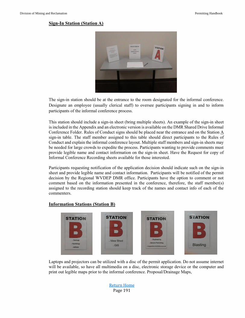
Division of Mining and Reclamation Permitting Handbook
Return Home Page 191
Sign-In Station (Station A)
The sign-in station should be at the entrance to the room designated for the informal conference.
Designate an employee (usually clerical staff) to oversee participants signing in and to inform
participants of the informal conference process.
This station should include a sign-in sheet (bring multiple sheets). An example of the sign-in sheet
is included in the Appendix and an electronic version is available on the DMR Shared Drive Informal
Conference Folder. Rules of Conduct signs should be placed near the entrance and on the Station A
sign-in table. The staff member assigned to this table should direct participants to the Rules of
Conduct and explain the informal conference layout. Multiple staff members and sign-in sheets may
be needed for large crowds to expedite the process. Participants wanting to provide comments must
provide legible name and contact information on the sign-in sheet. Have the Request for copy of
Informal Conference Recording sheets available for those interested.
Participants requesting notification of the application decision should indicate such on the sign-in
sheet and provide legible name and contact information. Participants will be notified of the permit
decision by the Regional WVDEP DMR office. Participants have the option to comment or not
comment based on the information presented in the conference, therefore, the staff member(s)
assigned to the recording station should keep track of the names and contact info of each of the
commenters.
Information Stations (Station B)
Laptops and projectors can be utilized with a disc of the permit application. Do not assume internet
will be available, so have all multimedia on a disc, electronic storage device or the computer and
print out legible maps prior to the informal conference. Proposal/Drainage Maps,
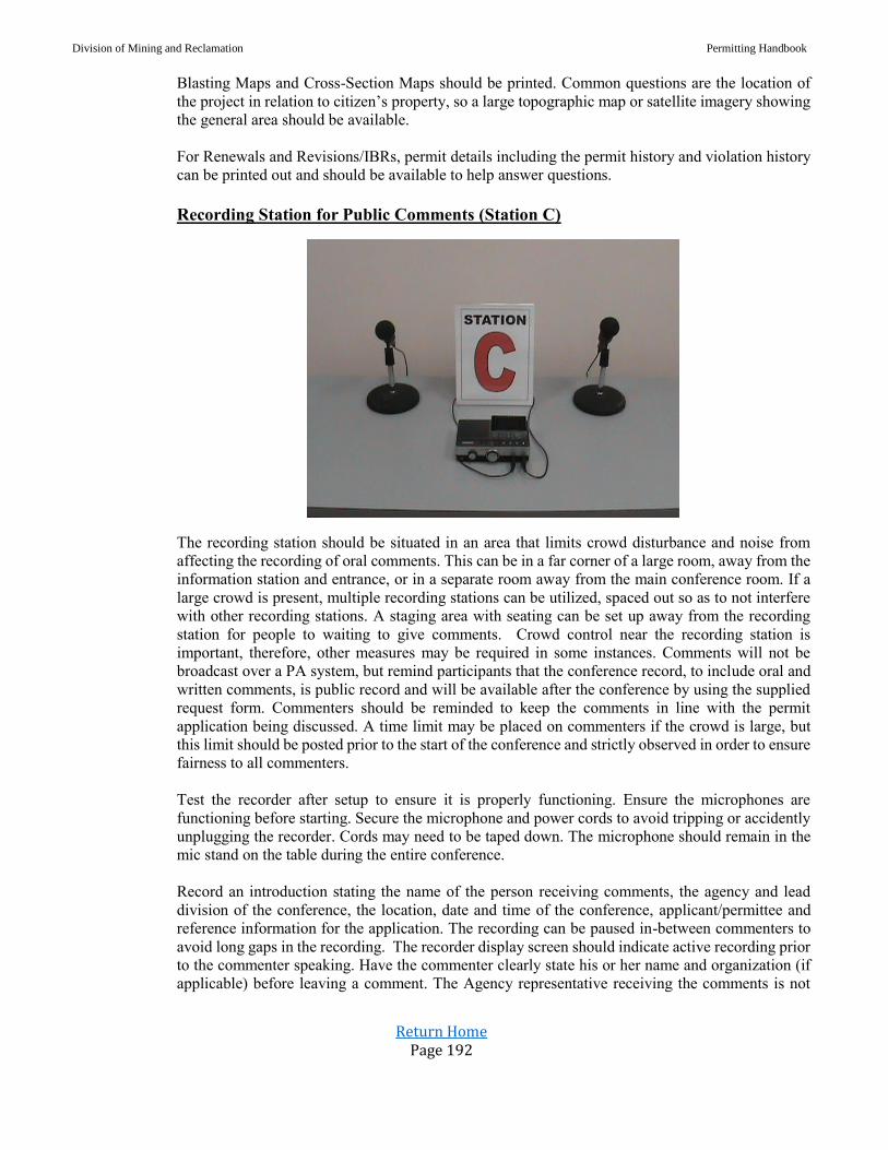
Division of Mining and Reclamation Permitting Handbook
Return Home Page 192
Blasting Maps and Cross-Section Maps should be printed. Common questions are the location of
the project in relation to citizen’s property, so a large topographic map or satellite imagery showing
the general area should be available.
For Renewals and Revisions/IBRs, permit details including the permit history and violation history
can be printed out and should be available to help answer questions.
Recording Station for Public Comments (Station C)
The recording station should be situated in an area that limits crowd disturbance and noise from
affecting the recording of oral comments. This can be in a far corner of a large room, away from the
information station and entrance, or in a separate room away from the main conference room. If a
large crowd is present, multiple recording stations can be utilized, spaced out so as to not interfere
with other recording stations. A staging area with seating can be set up away from the recording
station for people to waiting to give comments. Crowd control near the recording station is
important, therefore, other measures may be required in some instances. Comments will not be
broadcast over a PA system, but remind participants that the conference record, to include oral and
written comments, is public record and will be available after the conference by using the supplied
request form. Commenters should be reminded to keep the comments in line with the permit
application being discussed. A time limit may be placed on commenters if the crowd is large, but
this limit should be posted prior to the start of the conference and strictly observed in order to ensure
fairness to all commenters.
Test the recorder after setup to ensure it is properly functioning. Ensure the microphones are
functioning before starting. Secure the microphone and power cords to avoid tripping or accidently
unplugging the recorder. Cords may need to be taped down. The microphone should remain in the
mic stand on the table during the entire conference.
Record an introduction stating the name of the person receiving comments, the agency and lead
division of the conference, the location, date and time of the conference, applicant/permittee and
reference information for the application. The recording can be paused in-between commenters to
avoid long gaps in the recording. The recorder display screen should indicate active recording prior
to the commenter speaking. Have the commenter clearly state his or her name and organization (if
applicable) before leaving a comment. The Agency representative receiving the comments is not

Division of Mining and Reclamation Permitting Handbook
Return Home Page 193
there to answer questions, but may speak to provide clarity to certain points or direct the individual
to the appropriate agency representative at the informal conference who may answer the question.
A video recorder can be placed near the comment table to serve as a backup recording device.
Ending the Conference A prepared statement should be read over the PA system towards the end of the conference. This
may be as the number of commenters decrease or due to facility closing times. Since conferences
do not have a set end time, it will be the judgement of the Permit Supervisor or his or her appointee
when this point is reached. There have been times when no individuals have shown up for the
conference. In these situations, if no party has shown within an hour of the scheduled conference
start time, the conference may be concluded and documented in the electronic recording device that
no individuals have participated in the conference.
An example of the ending statement:
Thank you all for participating in this informal conference. We will be concluding
this conference shortly. If you wish to leave a written or recorded comment, please
do so at this time. The comments will be forwarded to the appropriate DMR
permitting staff for review and response and shall be considered in the granting or
denying of the permit. The applicant and those persons who commented, either by
written or verbal form, will be notified of the decision. Anyone wishing a copy of
the recordings may do so by completing a Request for copy of Informal Conference
Recording and mailing to the DEP regional office along with payment. The cost is
$5.00 per recording.
I. CRITERIA, CHECKLISTS, OR OTHER STANDARDS
Checklist is included in the Appendix section.
J. DATA AND RECORDS MANAGEMENT
1. Forms to be used (and location), All blank forms and posters can be found on the DEP
Division of Mining and Reclamation shared drive under the “Informal Conference” folder.
Completed forms will be stored in the regional permit file following the division’s retention
policy and in Section X of the application Facts and Findings in ESS.
2. Reports to be written, and A summary of the informal conference should be written by the
Permit Supervisor and include number of speakers, a discussion of the comments received,
time, date and location of conference. The informal conference summary and the oral and
written comments are to be forwarded to the division director for review.
3. Data and record storage information Recordings of the informal conference will be saved in
MP3 format and uploaded to the Blue Book or Facts and Findings section of the referenced
permit application. All sign-in sheets and written comments should be uploaded to section X
of the permit Facts and Findings.
K. RESOURCES See Appendix for Resources
Division of Mining and Reclamation Permitting Handbook
Return Home Page 194
L. FREQUENCY Upon receiving and granting an informal conference request.
M. QUALITY CONTROL AND QUALITY ASSURANCE The Permit Supervisor will follow up each informal conference with an evaluation of whether the
informal conference was conducted according to the standard operating procedure. Any issues,
concerns, problems, or suggestions for improvement should be noted and shared with the Division
Director. Each staff member participating in the informal conference should be consulted for
input.
N. REFERENCES N/A
O. APPENDIX Sign-in Sheet
Request for copy of Informal Conference Recording
Informal Conference Guide Poster
Citizen Involvement in the Permitting Process Poster
Rules of Conduct Poster
Checklist

Division of Mining and Reclamation Permitting Handbook
Return Home Page 195
Ownership
&
Control Information
Ownership and control review of permit applications
Centralized ownership and control file (COCF)
Procedure for ownership and control in databases
Proper notification for ownership and control changes
Procedure for Secretary of State’s database

Division of Mining and Reclamation Permitting Handbook
Return Home Page 196
A. Subject: Ownership and Control Review of Permit Application
Date: February 1, 1996
Revised: August 25, 2016
This procedure shall be utilized for the ownership and control reviews of every
Surface Mining Application (MR-4), Application for Transfer, Assignment or Sale of a permit
(MR-19A), Notification of Permittee Merger and/or Name Change (MR-19B),
Application for Operator Assignment (MR-19), and Notification of Change of Owners,
Officers, Directors or Partners (MR-19C) submitted.
1. Upon receipt of an application, the Ownership and Control (“O/C”) reviewer will review the
application and all other documentation for completeness and accuracy.
2. The O/C reviewer will:
Complete the appropriate checklist to determine if applicant has submitted
information required in the Surface Mining Reclamation Regulations.
Compare the information provided in the application with information currently in
the Applicant Violator System (“AVS”), the WV State System (“ERIS”), and the
WV Secretary of State System (“SOS”).
Request a recommendation from the AVS to determine if applicant is permit blocked
for any reason.
3. If the O/C reviewer determines that the application is not complete, if discrepancies are found,
or if a permit block is found, a request for corrections will be made.
4. After the O/C reviewer receives the applicant’s response to the corrections, all new
information provided will be reviewed for completeness and accuracy.
5. If the O/C reviewer determines the application to be complete and accurate and no permit
blocks are found, the O/C reviewer shall prepare a signoff sheet.
6. Upon completion of the O&C review, the reviewer shall upload their signoff and checklist into
the Facts and Findings folder of the application.
B. Subject: Centralized Ownership and Control Files
Date: February 18, 1999
Revised: August 25, 2016
A Centralized Ownership and Control File (COCF) is the MR-20 form which identifies all the
owners and controllers of permit holding companies. Approved COCF’s may be referenced in
MR-4, MR-19, and/or MR-19A applications. The West Virginia
Surface Mining Reclamation Regulations provide for the COCF under §38.2.3.1.o.
The application is submitted in the name of the parent company (the company one level above the
highest permit holding company in the chain of ownership). The first step in establishing a COCF
is a meeting with personnel in the DEP headquarters. At the time of the meeting, the procedures
and requirements will be fully explained and the MR-20 form given to the applicant. The MR-20
is not generally available as other DEP forms are, because the initial meeting is crucial to a timely
review.

Division of Mining and Reclamation Permitting Handbook
Return Home Page 197
After a COCF is submitted for review, the DMR HQ COCF Specialist will review, approve and
maintain the file. It is preferred that the applicant designate one person to be the COCF contact
person, and that the contact person actually be a company representative, although some
companies prefer to name a consultant to this position. Part of the rationale behind the use of the
COCF is the facility of maintaining accurate information on the companies when only 2
individuals are involved.
After the review of the COCF has been completed and the file is approved, an applicant covered
by the file may reference the COCF instead of including complete ownership and control
information in each application submitted. During the comment period for any application that
references an approved COCF, it is the applicant’s responsibility to ensure that identical copies of
the file are delivered to the appropriate courthouse(s) and regional office(s). COCF’s are NOT to
be left in courthouses or regional offices after the comment period expires.
In the event an applicant chooses to correct an application in process (i.e., one that contains
complete ownership and control information and has been or is being advertised) by referencing an
approved COCF, the application must be re-advertised (one time, ten-day comment period).
The Permittee must update and recertify all information, including permit history, in the COCF
at least every 90 days after approval, or within 15 days of a change in information. When
information is updated to make changes before the 90-day certification is due, the next
certification will be due 90 days from the date of the most recent certification. Also, with an
approved COCF, a Permittee will no longer be required to submit ownership and control update
letters in applications. Accordingly, Permittees holding approved COCF’s are not required to
submit the MR-19C (Annual Ownership and Control Update) on a yearly basis, although this will
still be required in the event of issuance of a Cessation Order.
Permittees having approved files will be required to submit a completed MR-19B
(Notification of Merger or Name Change) in addition to updating the COCF to reflect such
changes when appropriate. This application requires an advertisement and thirty-day comment
period.
Having a COCF is a privilege. If the Permittee does not recertify the information in the COCF
within a 90-day period, the Permittee will be afforded a 30-day extension. If the Permittee has not
updated the COCF within the extended amount of time, the COCF will be considered null and
void. If the DMR HQ COCF Specialist becomes aware of any changes and has not been notified of
such pending changes, the Permittee will be contacted by certified letter giving ten (10) days from
receipt of such letter to update the COCF. If nothing is submitted within the allotted time, the
COCF will be considered null and void. There may be case-specific instances and extreme
circumstances that warrant the DMR HQ COCF Specialist waiving this provision.
C. SUBJECT: General Procedures for Ownership and Control in ERIS and AVS
DATE: May 1, 1995
Revised: August 25, 2016
This procedure shall be utilized when discrepancies exists with the ownership and control data
between:
AVS and ERIS; or
AVS/ERIS and the application being reviewed.

Division of Mining and Reclamation Permitting Handbook
Return Home Page 198
1. When an entity is listed in AVS and ERIS but not identified in the application being reviewed,
the applicant shall be notified in writing of any discrepancies between the application and the
AVS and ERIS.
2. Entities omitted from application shall remain as an owner/controller in AVS and ERIS until
end dates are sufficiently documented. Application is corrected by:
Including the entities initially omitted; or
Applicant submits documentation establishing end date(s).
3. Requests by O/C reviewers for changes in AVS and/or ERIS shall include the following and
shall be forwarded to headquarters as soon as the data is verified:
Database Change Request;
Copy of documentation supporting the change; and
Screen print of AVS and ERIS indicating the specific changes to be made.
Database Change Requests Procedure
All database change requests are to be emailed to DMR HQ COCF specialist.
Email subject line should read DCR for “company name”
Database change requests associated with a COCF will be reviewed by DMR HQ COCF
specialist to confirm consistency with the COCF. DMR HQ COCF specialist will then
forward confirmed changes to DMR HQ AVS specialist for database entry.
Database change requests not associated with a COCF will be forward by DMR HQ
COCF specialist to DMR HQ AVS specialist for database entry.
O&C reviewers and DMR HQ COCF specialist will receive an email from DMR HQ
AVS specialist upon database updates.
D. SUBJECT: Proper Notification of Ownership or Control Changes
DATE: July 1, 1999
An approved operator will complete a new MR-19 when the following has occurred in ownership
and/or control (officers and/or owners):
50% or more of ownership change in operator or its owner
Less than 50% change in ownership in operator or its owner but the percentage is the
largest block of stock owned (i.e. no one with 50% or more ownership)
All the officers for the operator or its owner have changed
Include changes in all levels of the organizational structure where applicable
A permittee will complete MR-19A (marked ownership and control changes only) when the
following changes in ownership and/or control (officers and/or owners) has occurred:
50% or more of ownership change in permittee or its owner
Less than 50% change in ownership in permittee or its owner but the percentage is the
largest block of stock owned (i.e. no one with 50% or more ownership)
All the officers for the permittee or its owner have changed
Include changes in all levels of the organizational structure where applicable

Division of Mining and Reclamation Permitting Handbook
Return Home Page 199
APPROVAL: The regional office will prepare an approval letter and forward to Headquarters for
final approval and signature. A MR-2 (permit face) will not be issued.
Permittee and/or operator shall complete MR-19C when the following changes in ownership or
control (officers and/or owners) occurs:
Any changes in officers and/or directors
10 to 49% of ownership changes
When name changes or mergers occur with the permittee, a MR-19B form must be completed.
E. SUBJECT: Procedures for Secretary of State’s Database
DATE: May 15, 1995
On July 1, 1997, the West Virginia Secretary of State’s (SOS) office instituted a fee of $15 to
make changes to company records which are not submitted in conjunction with the Annual
Corporate Return. Because of this new fee and the fact, under state law, corporations are only
required to update information with the SOS once a year, we are no longer requiring companies to
update SOS due to permit review discrepancies.
You should continue to check the SOS database. This is to ensure that applicants are active
companies (they do not have a closed status) and registered to do business in
West Virginia (unless they are sole proprietorships or general partnerships). The officers list
should also be reviewed; however, only a major discrepancy in the SOS officer listing and the
application listing should be questioned (i.e. if an ended officer is listed in SOS and a new officer
is listed in the application, do not consider this a correction). But, if a new officer (an individual
which has never been listed in AVS and/or ERIS) is listed in SOS and the list in the application
does not have this individual, then this should be considered a correction.
This procedure supersedes the policy issued on February 3, 1993 and a procedure (updated), called
“Questions and Answers: Standard Application, Ownership and Control
Unit”.

Division of Mining and Reclamation Permitting Handbook
Return Home Page 200
Post Mining Land Use
Information
Post Mining Land Use on Mountaintop Removal and Steep Slope Mining with an
AOC Variance
Durability / Topsoil Substitutes
Topsoil & Topsoil Substitute Guidance
Commercial Forestry
Productivity and Ground Cover Success Standards

Division of Mining and Reclamation Permitting Handbook
Return Home Page 201
A. Subject: Postmining Land Use on Mountaintop Removal &
Steep Slope Mining with an AOC Variance
Date: May 20, 1999
Revised: August 25, 2016
To comply with the WVDEP/OSM Action Plan for resolving mountaintop mining and steep slope
issues, the Surface Mining Application (MR-4) form is being revised. Any permit application with
an AOC variance that is pending or submitted, must have the following information. The applicant
should be provided with the revised section of the SMA form which is available on the Intranet.
Mountaintop Removal AOC Variance Criteria
The changes regarding mountaintop removal mining operations with variances from
AOC are reflected in Section O, question O-5.C and will require the applicant to address the
following pursuant to WV Surface Coal Mining Act 22-3-13(c) (3).
A mountaintop removal AOC variance may only be granted if the applicant proposes to remove
the entire coal seam or seams running through the upper fraction of the hill, ridge, or mountain
creating a level plateau or gently rolling contour with no highwalls remaining and capable of
supporting postmining land uses in accordance with the following requirements:
The proposed postmining land use of the affected land is limited to Heavy Industry,
Light Industry and Commercial Services, Commercial Forestry, Cropland, Bio-
Cropland, Residential or Public Service.
The proposed use constitutes an equal or better use compared with the premining use.
The proposed use will be compatible with adjacent land uses and existing State and
local land use plans.
County commissions and other State and Federal agencies were provided an
opportunity to review and comment on the proposed land use.
The application contains a specific plan and assurances that the proposed postmining
land use will be:
° Compatible with adjacent land uses;
° Practicable with respect to financing and completing the proposed use;
° Supported by commitments from public agencies where appropriate;
° Planned pursuant to a schedule attached to the reclamation plan so as to integrate
the mining operation and reclamation with the postmining land use;
° Designed by an approved person to assure the stability, drainage, and configuration
necessary for the intended use of the site; and
° Obtainable according to data regarding expected need and market.
All other requirements of the Act will be met.
Division of Mining and Reclamation Permitting Handbook
Return Home Page 202
Steep Slope AOC Variance Criteria
Also, Question O-5.B relating to steep slope mining (average greater than 20 degrees) is being
revised to require the applicant to specifically address the following as required by
38 CSR 2.14.12:
The land after reclamation is suitable for industrial, commercial, residential or public
use (including commercial forestry, biofuel cropland and recreational facilities)
All highwalls will be completely backfilled in a manner that results in a static safety
factor of 1.3;
Only spoil not necessary to achieve the postmining land use may be removed from
the mine bench;
The watershed of the permitted and adjacent areas will be improved by reducing
pollutants, environmental impacts or flood hazards; provided that, the watershed will
be deemed improved only if:
o The amount of total suspended solids or other pollutants discharged to ground or
surface water from the permit area will be reduced, so as to improve the public or
private uses or the ecology of such water, or flood hazards within the watershed
containing the permit area will be reduced by reduction of the peak flow discharge
from precipitation events or thaws; and
o The total volume of flow from the proposed permit area, during every season of
the year, will not vary in a way that adversely affects the ecology of any surface
water or any existing or planned use of surface or ground water;
Appropriate Federal, State and local government agencies were provided an
opportunity to comment on the proposed postmining land use and deemed it to be an
equal or better economic or public use;
The plan is designed and certified by a registered professional engineer to assure
stability, drainage, and configuration necessary for the intended use of the site;
The surface landowner requested in writing that a variance be granted to achieve the
approved alternative postmining land use;
The alternative postmining land use requirements are met;
All other applicable requirements of the Act and regulations, except for those relating
to AOC, are met.
The reviewer will be required to specifically address each of these requirements and justify their
decision in the facts and findings (MR-2A) at the bottom of the variance page.
Division of Mining and Reclamation Permitting Handbook
Return Home Page 203
B. Subject: Durability / Topsoil Substitutes
Date: September 22, 1999
A meeting was held on Thursday, September 16, 1999, to discuss the Office of
Surface Mining's (OSM) concerns on the following issues regarding their permit reviews:
1. How can a material be durable and still be identified as a topsoil substitute?
2. What is the topsoil substitute proposed to be used in each phase of the operation?
Regarding the first issue, it was explained to OSM that durability is a function of whether a
material slakes in water and topsoil substitute is a function of whether the material can be a
media which is capable of supporting and maintaining the approved post mining land use.
The analyses for durability and topsoil substitute are not interrelated. Therefore, a material
that meets the criteria for durability cannot be excluded as a topsoil substitute. The only way
a material can be excluded as a topsoil substitute is based on the analysis specified in the
rules and/or the resulting media is not capable of supporting and maintaining the approved
post mining land use.
It was further stated that "durable" material is used as a topsoil substitute throughout the
Appalachian coal fields. After a discussion, OSM concurred that a material can both meet the
criteria for durability and the criteria as a topsoil substitute, with some mechanical action for
sizing.
The second issue is related to "the best available" material used as a topsoil substitute. OSM
stated "the best available" material is not clearly indicated in the application. At first, OSM
stated is should be "best material" on the permit. It was explained to OSM that this approach
is impracticable. OSM concurred but still stated that the application must clearly indicate
“what is the best available material?” It was suggested that since the mining and reclamation
plan denotes the sequence and/or phase of mining proposed for the operation and that each
sequence has a spoil balance, the application could indicate the topsoil substitute(s) that
would be used for each sequence/phase of the operation. OSM then agreed with this concept
as long as the material identified has site-specific analyses conducted.
C. Subject: Topsoil & Topsoil Substitute Guidance
Date: September 28, 2016
Approval: Harold D. Ward, Acting Director
1. Purpose The purpose of this guidance is to provide clarification of topsoil and topsoil substitutes
and their utilization with regard to Article 3 application review. Also referenced are the
performance standards for topsoil and topsoil substitutes with regard to inspection and
enforcement of an approved Article 3 permit.
2. Permit Review Discussion “Topsoil” is defined in 38CSR2 2.128 as the A and E horizon soil layer of the four (4) major soil
horizons.
Division of Mining and Reclamation Permitting Handbook
Return Home Page 204
“Overburden” is defined in 38CSR2 2.84 as consolidated or unconsolidated material of any
nature which overlies a mineral deposit, excluding topsoil.
Operation Plans & Specifications contained within an application, according to 38CSR2.3.6.d
require” A description of how the applicant will remove, store and redistribute topsoil, subsoil or
topsoil substitutes, and other materials. When topsoil substitutes are proposed, analytical data,
and laboratory certification required in subdivision 14.3.c of this rule shall be made a part of the
permit application; the suitability determination,”
If sufficient topsoil material (A & E horizons) is not available to meet post mining land use
requirements, then information for a topsoil substitute is required in the Article 3 application.
Forestland and wildlife post mining land uses require the uniform redistribution of at least four
(4) feet of topsoil or topsoil substitute across the mine area.
38CSR2 14.3 states that “Any substitute material used for topsoiling must be capable of
supporting and maintaining the approved postmining land use. This determination of capability
shall be based on the results of appropriate chemical and physical analysis of overburden and
topsoil. These analyses shall include at a minimum depth, thickness, and areal extent of the
substitute structure or soil horizon, pH, texture class, percent coarse fragments and nutrient
content. A certification of analysis shall be made by a qualified laboratory stating that:
14.3.c.1. The proposed substitute material is equally suitable for sustaining vegetation
as the existing topsoil;
14.3.c.2. The resulting soil medium is the best reasonably available in the permit area
to support vegetation; and
14.3.c.3. The analyses were conducted using standard testing procedures.
14.3.d. Soil Amendments. Nutrients and soil amendments in the amounts determined
by soil tests shall be applied to the redistributed surface soil layer so that it supports the
approved postmining land use and meets the revegetation requirements of section 9 of
this rule. These tests shall include nutrient analysis and lime requirement tests. Results
of these tests shall be submitted to the Secretary with the final planting report as required
by this rule.
3. Permit Review Focus Items The reviewer/reviewers shall ensure that all Article 3 applications which are required to address
topsoil and/or topsoil substitute meet the following standards:
Clarification and consistent use of terminology related to topsoil and/or topsoil
substitute throughout Article 3 application sections.
Consistency of topsoil and/or topsoil substitute material’s proposed use throughout
Article 3 application sections.
Requirement for laboratory certification of topsoil substitute analysis.
Requirement for topsoil substitute variance.
Identification and assurance of quantity and availability of topsoil and/or topsoil
substitute material for distribution within the scope of the mining and reclamation plan.
Proposal maps shall identify the location of topsoil storage areas.
4. Inspection &Enforcement Discussion According to 38CSR2 14.3.a, with regard to topsoil removal, “Prior to disturbance of an area,
topsoil shall be removed from the area to be disturbed in a separate layer and if not immediately
redistributed, it shall be segregated and stockpiled in a separate stable location as specified in
Division of Mining and Reclamation Permitting Handbook
Return Home Page 205
the preplan. Stockpiled topsoil shall remain in place until used for redistribution unless
otherwise approved by the Secretary. Stockpiled topsoil shall be protected from excessive
compaction. Where the removal of vegetative material, topsoil or other materials may result in
erosion, the Secretary may limit the size of the area from which these materials are removed at
any one time.
A variance approving a topsoil substitute does not relieve the permittee of the requirement to
remove all available topsoil and stockpile for redistribution across the mine area during final
regrading. The above regulation requires topsoil to be removed and stored at locations
indicated on the proposal map.
§22-3-13 (b)(5) further emphasizes the need for topsoil recovery stating, “Remove the topsoil
from the land in a separate layer, replace it on the backfill area, or if not utilized immediately,
segregate it in a separate pile from other spoil and, when the topsoil is not replaced on a backfill
area within a time short enough to avoid deterioration of the topsoil, maintain a successful
vegetative cover by quick growing plants or by other similar means in order to protect topsoil
from wind and water erosion and keep it free of any contamination by other acid or toxic material:
Provided, That if topsoil is of insufficient quantity or of poor quality for sustaining vegetation,
or if other strata can be shown to be more suitable for vegetation requirements, then the operator
shall remove, segregate and preserve in a like manner any other strata which is best able to
support vegetation;”
5. Reference Information
38CSR Applicable Regulations:
Definitions
2.84. Overburden means consolidated or unconsolidated material of any nature which
overlies a mineral deposit, excluding topsoil.
2.128. Topsoil means the A and E-horizon soil layer of the four (4) major soil horizons.
Maps
3.4.d.18. The location and extent of topsoil borrow areas, and the location of topsoil
storage areas;
Operation Plans & Specifications
3.6.b.2. Overburden and topsoil handling and storage areas and structures;
3.6.d. A description of how the applicant will remove, store and redistribute topsoil,
subsoil or topsoil substitutes, and other materials. When topsoil substitutes are proposed,
analytical data, and laboratory certification required in subdivision 14.3.c of this rule
shall be made a part of the permit application; the suitability determination,
3.6.e. Where topsoil borrow areas are proposed, the applicant shall submit a reclamation
plan for such areas;
Removal of Abandoned Coal Refuse Disposal Piles Project Narrative
3.14.b.10.B. The area of land to be affected by the removal operation, including any coal
storage and topsoil borrow and storage areas;
Division of Mining and Reclamation Permitting Handbook
Return Home Page 206
PMLU - Commercial Forestry & Forestry
7.4.b.1.D. Soil and Soil Substitutes.
7.4.b.1.E. Soil Placement and Grading.
PMLU – Homestead
7.5.j. Soils, Soil Placement and Grading.
PMLU – Forestland
7.6.b. Planting Plan
7.6.c. Soil placement, Substitute material and Grading.
PMLU – Wildlife
7.7.b. Planting Plan
7.7.c. Soil placement, Substitute material and Grading
PMLU – Bio-Fuel Cropland
7.8.2. Soil reconstruction specifications
PMLU - Prime Farmlands 10.4.c. Soil Replacement.
Performance Standards
14.1.d. Topsoil Markers.
14.3. Topsoil.
14.3.a. Removal. Prior to disturbance of an area, topsoil shall be removed from the area
to be disturbed in a separate layer and if not immediately redistributed, it shall be
segregated and stockpiled in a separate stable location as specified in the preplan.
Stockpiled topsoil shall remain in place until used for redistribution unless otherwise
approved by the Secretary. Stockpiled topsoil shall be protected from excessive
compaction. Where the removal of vegetative material, topsoil or other materials may
result in erosion, the Secretary may limit the size of the area from which these materials
are removed at any one time.
14.3.b. Redistribution. Prior to redistribution of topsoil, the regraded land shall be
treated, if necessary, to reduce the potential for slippage of the redistributed material
and/or to enhance root penetration. Topsoil and other materials shall be redistributed in
a manner that prevents excess compaction and that achieves an approximate uniform
contour, soil density, and surface water drainage system. Immediately after
redistribution all topsoil areas shall be protected from wind and water erosion, stable
thickness, consistent with the approved postmining land uses,
14.3.c. Top Soil Substitutes. Any substitute material used for top soiling must be
capable of supporting and maintaining the approved postmining land use. This
determination of capability shall be based on the results of appropriate chemical and
physical analysis of overburden and topsoil. These analyses shall include at a minimum
depth, thickness, and areal extent of the substitute structure or soil horizon, pH, texture
class, percent coarse fragments and nutrient content. A certification of analysis shall be
made by a qualified laboratory stating that:
o 14.3.c.1. The proposed substitute material is equally suitable for sustaining
vegetation as the existing topsoil;

Division of Mining and Reclamation Permitting Handbook
Return Home Page 207
o 14.3.c.2. The resulting soil medium is the best reasonably available in the permit
area to support vegetation; and
o 14.3.c.3. The analyses were conducted using standard testing procedures.
o 14.3.d. Soil Amendments. Nutrients and soil amendments in the amounts
determined by soil tests shall be applied to the redistributed surface soil layer so
that it supports the approved postmining land use and meets the revegetation
requirements of section 9 of this rule. These tests shall include nutrient analysis and
lime requirement tests. Results of these tests shall be submitted to the Secretary with
the final planting report as required by this rule.
22-3 Applicable Code
§22-3-9. Permit application requirements and contents. (13) Cross-section maps or plans of the proposed affected area, including the actual area to be
mined, prepared by or under the direction of and certified by a person approved by the director,
showing pertinent elevation and location of test borings or core samplings, where required by the
director, and depicting the following information: (A) The nature and depth of the various strata
or overburden; (B) the location of subsurface water, if encountered, and its quality; (C) the nature
and thickness of any coal or rider seams above the seam to be mined; (D) the nature of the stratum
immediately beneath the coal seam to be mined; (E) all mineral crop lines and the strike and dip
of the coal to be mined, within the area of land to be affected; (F) existing or previous surface-
mining limits; (G) the location and extent of known workings of any underground mines,
including mine openings to the surface; (H) the location of any significant aquifers; (I) the
estimated elevation of the water table; (J) the location of spoil, waste or refuse areas and topsoil
preservation areas; (K) the location of all impoundments for waste or erosion control; (L) any
settling or water treatment facility or drainage system; (M) constructed or natural drainways and
the location of any discharges to any surface body of water on the area of land to be affected or
adjacent thereto; and (N) adequate profiles at appropriate cross sections of the anticipated final
surface configuration that will be achieved pursuant to the operator's proposed reclamation plan;
§22-3-13. General environmental protection performance standards for surface-
mining; variances. (b)(5) Remove the topsoil from the land in a separate layer, replace it on the backfill area, or if
not utilized immediately, segregate it in a separate pile from other spoil and, when the topsoil is
not replaced on a backfill area within a time short enough to avoid deterioration of the topsoil,
maintain a successful vegetative cover by quick growing plants or by other similar means in order
to protect topsoil from wind and water erosion and keep it free of any contamination by other
acid or toxic material: Provided, That if topsoil is of insufficient quantity or of poor quality for
sustaining vegetation, or if other strata can be shown to be more suitable for vegetation
requirements, then the operator shall remove, segregate and preserve in a like manner any other
strata which is best able to support vegetation;
(b)(6) Restore the topsoil or the best available subsoil which is best able to support vegetation;

Division of Mining and Reclamation Permitting Handbook
Return Home Page 208
6. SOIL HORIZONS

Division of Mining and Reclamation Permitting Handbook
Return Home Page 209
D. Subject: Guidance for Review of Topsoil Substitute Information
Date: January 24, 2017
Approval: Harold Ward, Acting Director
The use of topsoil substitute material, as it pertains to forestland and wildlife post-
mining land uses, may be approved by the Secretary provided the applicant
demonstrates the following: the volume of topsoil on the permit area is insufficient to
meet the depth requirements of 7.6.c.1 (48 inches), the substitute material consists of
at least 75% sandstone, has a composite phase pH between 5.0 and 7.5, has a soluble
salt level of less than 1.0 mmhos/cm and is in accordance with §14.3.
§14.3 states that topsoil shall be removed from the area to be disturbed in a separate
layer, and if not immediately redistributed, it shall be segregated and stockpiled in a
separate stable location. §14.3.c further states that the determination of topsoil
substitute capability shall be based on the results of a chemical and physical analysis
of overburden and topsoil. This analysis will include the minimum depth, thickness,
and areal extent of the substitute material. This certification must be made by a
qualified laboratory and state that the proposed substitute material is equally suitable
for sustaining vegetation as the existing topsoil (§14.3.c.1), the resulting soil medium
is the best reasonably available in the permit area to support vegetation (§14.3.c.2),
and the analyses were conducted using standard testing procedures (§14.3.c.3).
To ensure that these regulations are adequately addressed in the Surface Mine
Application (SMA), the SMA discusses topsoil substitutes in several sections.
Section I-13 is where the topsoil substitute analysis report is provided. This is where
the chemical and physical comparison of the native soil to the topsoil substitute
material is detailed and the statements of §14.3.c.1, §14.3.c.2, and §14.3.c.3 are
presented. In reviewing this report, it is important to remember the volume and
chemical requirements detailed in §7.6.c and §7.6.c.1 specify at least 48 inches of
material. Additionally, this material needs to consist of at least 75% sandstone, have a
composite phase pH between 5.0 and 7.5, and have a soluble salt level of less than 1.0
mmhos/cm.
The geologic cross section, Section I-7, shows the depth, thickness, and areal extent of the
substitute material.
Volumetric calculations that verify the necessary quantity of the substitute material is
available through the mining phases in Section N-1B.
The planting plans provided in Section O-9 of the SMA discuss, in part, a prediction of
the mine soil character based on overburden analysis, soil analysis, and other available
information (Section O-9A). This narrative needs to discuss the use of substitute material
as a growth medium for the proposed post-mining vegetation.
Division of Mining and Reclamation Permitting Handbook
Return Home Page 210
When issuing topsoil substitute waiver approvals, ensure the following items are
addressed:
1. Is the topsoil substitute waiver information provided in Section I-13?
a. Does it have adequate chemical and physical comparison to native soils?
o Percentage of sandstone?
o Color of sandstone?
o pH range?
o Soluble salts less than 1 mmhos/cm?
b. Does the narrative clearly state that the material is equally suitable for
sustaining vegetation as the existing topsoil (§14.3.c.1), the resulting soil
medium is the best reasonably available in the permit area to support
vegetation (§14.3.c.2), and the analyses were conducted using standard testing
procedures (§14.3.c.3)?
c. Is the report signed by a Certified Soil Scientist who works for an approved
laboratory?
2. Does the Geologic Cross Section (Section I-7) show the topsoil substitute horizons?
3. Does the mine plan in Section N-1B discuss the use of topsoil substitutes, and if so,
are the aspects of §3.4.d.18, §3.6.b.2, and §3.6.d adequately addressed?
a. Is the best, most reasonably available substitute material identified for each
mining phase?
b. Are volume calculations provided by mining phase to prove enough substitute
material is available?
c. Is there language that states the existing topsoil material will be reserved and
added to the topsoil substitute material
d. Do the phase maps show the proposed location of topsoil substitute material
storage?
4. Does the planting plan (Section O-9) reference the use of topsoil substitute?

Division of Mining and Reclamation Permitting Handbook
Return Home Page 211
E. Subject: Commercial Forestry
Date: September 13, 2000
Approval: John Ailes, Deputy Chief, OMR
Revised: August 25, 2016
OSM has recently approved commercial forestry as a postmining land use for AOC variance on
mountaintop removal permits only. The following are guidelines for all permits approved with this
postmining land use after August 18, 2000:
• Commercial forestry land use must be on the area seeking a mountaintop AOC variance.
Commercial forestry land use cannot be used on steep slope variance areas.
• The Planting and Management Plan must be developed by a Registered
Professional Forester.
38CSR7.4.1.A
• Two copies of each plan must be submitted to the Division of Forestry District
Forester and two copies to the Secretary of WVDEP.
38 CSR 7.4.b.1.A.6
• Before approving a planting plan for commercial forestry, the plan must be reviewed and
approved by a Registered Professional Forester employed by the WV Division of
Forestry or the WVDEP. In addition, a Certified Professional Soil Scientist must review
and shall field verify the soil slope and sandstone mapping.
38CSR7.4.b.1.B.1
• The Secretary of WVDEP shall ensure that the reviewing forester and soil scientist
prepares site specific written findings addressing each of the elements contained in the
plan. These findings shall be made part of the facts and findings section of the
application.
38CSR7.4.b.1.B.1
F. Subject: Productivity & Ground Cover Success Standards
Date: May 1, 2002
Approval: Matt Crum, Director, DMR
The productivity success standards for grazing land and hayland will be based upon
determinations for similar map units as published in the productivity tables in Natural Resources
Conservation Service (NRCS) soil surveys for the county or from average county yields
recognized by the United States Department of Agriculture. The yields for grazing land or hayland
will be measured in material produced per acre or animal units supported. The success of
production shall be equal to or greater than that of the standard obtained from the tables.
Evaluation methods for productivity to be utilized are described in section 1 of “Technical
Guides of Reference Areas and Technical Standards for Evaluating Surface Mine Vegetation in
OSM Regions I and II” by Robert E. Farmer, Jr. et al., OSM J5701442/TV-54055A, 1981, U.S.
Department of the Interior, Office of Surface Mining Reclamation and Enforcement.
The productivity success standard for cropland shall be determined using yields for reference
crops from unmined areas. Reference crop yields shall be determined from the current yields
Division of Mining and Reclamation Permitting Handbook
Return Home Page 212
records of representative local farms in the surrounding area or from the average county yields
recognized by the United States Department of Agriculture. The success of production shall be
equal to or greater than that of the reference crop from unmined areas. Evaluation methods for
productivity to be utilized are described in section 1 of “Technical Guides of Reference Areas and
Technical Standards for Evaluating Surface Mine Vegetation in OSM Regions I and II” by Robert
E. Farmer, Jr. et. al., OSM J5701442/TV-54055A, 1981, U.S. Department of the Interior, Office of
Surface Mining Reclamation and Enforcement.
The company shall be responsible for providing DEP with copies of the productivity tables and/or
data used to determine reference crop yield. Where the USDA or other agricultural data for
productivity does not exist for a particular county, the applicant will work with the DEP and the
USDA to develop standards for the proposed area.
Ground cover success shall be based on the Rennie and Framer technique described in section 3 of
“Technical Guides of Reference Areas and Technical Standards for Evaluating Surface Mine
Vegetation in OSM Regions I and II” by Robert E. Farmer, Jr. et.al. OSM J5701442/TV-54055A,
1981, U.S. Department of the Interior, Office of Surface Mining Reclamation and Enforcement. et.
al., OSM J5701442/TV-54055A, 1981, U.S. Department of the Interior, Office of Surface Mining
Reclamation and Enforcement.
Division of Mining and Reclamation Permitting Handbook
Return Home Page 213
Pre-Inspections
for Surface Mine Applications
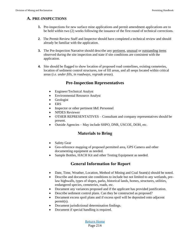
Division of Mining and Reclamation Permitting Handbook
Return Home Page 214
A. PRE-INSPECTIONS
1. Pre-inspections for new surface mine applications and permit amendment applications are to
be held within two (2) weeks following the issuance of the first round of technical corrections.
2. The Permit Review Staff and Inspector should have completed a technical review and should
already be familiar with the application.
3. The Pre-Inspection Narrative should describe any pertinent, unusual or outstanding items
observed during the site inspection and state if site conditions are consistent with the
application.
4. Site should be flagged to show location of proposed road centerlines, existing cemeteries,
location of sediment control structures, toe of fill areas, and all seeps located within critical
areas (i.e. under fills, in roadways, regrade areas).
Pre-Inspection Representatives
Engineer/Technical Analyst
Environmental Resource Analyst
Geologist
ERS
Inspector or other pertinent I&E Personnel
NPDES Reviewer
OTHER REPRESENTATIVES – Consultant and company representatives should be
present.
Outside Agencies – May include SHPO, DNR, USCOE, DOH, etc.
Materials to Bring
Safety Gear
Geo-reference mapping of proposed permitted area, GPS Camera and other
documenting equipment as needed.
Sample Bottles, HACH Kit and other Testing Equipment as needed.
General Information for Report
Date, Time, Weather, Location, Method of Mining and Coal Seam(s) should be noted.
Describe and document site conditions to include but not limited to any wetlands, pre-
law highwalls, types of slopes, parks, historical lands, homes, structures, utilities,
endangered species, cemeteries, roads, etc.
Document any variances proposed and if the applicant has provided justification.
Describe sediment control plans. Can they be constructed as proposed?
Document excess spoil plans and if excess spoil will be deposited onto adjacent
permit(s).
Document jurisdictional determination findings.
Document if special handling is required.

Division of Mining and Reclamation Permitting Handbook
Return Home Page 215
Include NPDES information. Are outlets presumed to be precipitation or non-
precipitation induced and located in natural drainways.
Document if mitigation will be required to include plans if available.
Document Transportation Plans.
All known significant concerns that need to be considered for review team/I&E
recommendations shall be documented.
Any unresolved issues, Special Conditions and Potential Adverse Environmental
Impacts or conditions that may cause major design changes to the application shall be
documented.
Permit Review Team Leader shall record notes and complete the pre- inspection
report. Any unresolved issues shall be documented and presented to the Permit
Supervisor.
Pre & Post Mining Land Uses
Is the PMLU compatible with the proposed site configuration?
If adjacent permits, has the planting plans been successful?
If the proposed PMLU is Forestland or Fish and Wildlife, has the applicant requested
a topsoil substitute waiver request?
If a topsoil substitute waiver is requested, is appropriate information available in
Section I-13 of the application demonstrating that the substitute material is of
sufficient quantity and equally suitable for sustaining vegetation as the existing
topsoil.
If a topsoil substitute waiver has been requested, is information presented in
Section(s) N, O and I of the application consistent?
The applicant shall demonstrate 4’ of suitable cover material is available in
accordance with 38-2-7.6.c.1 if sufficient topsoil material is not present.
In accordance with 38-2-7.7.c.2 the applicant shall provide information demonstrating
that topsoil substitute material consists of at least 75% sandstone, has a composite pH
between 5.0 and 7.5, has a soluble salt level < 1.0 mmhos/cm. Substitute materials
with less than 75% sandstone may be allowed provided that the applicant has
demonstrated overburden in the mine area does not contain an adequate volume to
meet the depth requirements.

Division of Mining and Reclamation Permitting Handbook
Return Home Page 216
Pre-Submittal
Meetings

Division of Mining and Reclamation Permitting Handbook
Return Home Page 217
A. Pre-Submittal Meetings
1. Title of Meeting (WVDEP DMR Pre-Submittal Meeting)
2. Complete Form Below (Sample form will be on Intra-net):
Applicant: Permit Type:
Project Name: Application Type: Choose an item.
Date: Click here to enter a date. Coal Seam(s):
Consultant: County: Choose an item.
Receiving Stream(s): Nearest PO
Proposed:
Participants:
Name Organization Phone Email
3. NPDES/BWQ NPDES Handbook
a. NPDES/BWQ SAMPLING SITES
Were BWQ Points Established? Choose an item.
Number of Points Established? Choose an item.
Six (6) consecutive months of BWQ – Two (2) samples per month.
Samples must comply with NPDES BWQ Protocol.

Division of Mining and Reclamation Permitting Handbook
Return Home Page 218
b. AEPP
Is an AEPP required? Choose an item.
If yes, BAS sites must be established by the Regional Biologist in accordance with
the Narrative Water Quality Guidance Document.
Contact Alice Lee to set benthic sites
AEPP AMPs should be included in section J-11 of the Article III permit
application.
4. Geology/Hydrology Geology Handbook
a. Surface and Groundwater PHC (Sections J-3 and J-4)
Were PHC Points Established? Choose an item.
Number of Points Established: Choose an item.
PHC data must be with 2 years of application submittal date. Six (6) consecutive months
of data for each PHC site with the following parameters:
Total Hot Acidity (mg/l or ppm) Mineral Acidity (mg/l or ppm)
Total Alkalinity (mg/l or ppm) Aluminum (mg/l or ppm)
Total Dissolved Solids (mg/l or ppm) Flow (cfs or gpm)
Total Iron (mg/l or ppm) Total Manganese (mg/l or ppm)
pH (Std. Units) Specific Conductance (µmhos)
Sulfates (mg/l or ppm) Total Suspended Solids (mg/l or ppm)
One sample out of the six months must contain the following parameters:
Total Acidity (mg/l or ppm) Total Alkalinity (mg/l or ppm)
Total Aluminum (mg/l or ppm) Antimony (mg/l or ppm)
Arsenic (mg/l or ppm) Beryllium (mg/l or ppm)
Cadmium (mg/l or ppm) Total Chlorides (mg/l or ppm)
Chromium (mg/l or ppm) Copper (mg/l or ppm)
Cyanide (mg/l or ppm) Total Dissolved Solids (mg/l or ppm)
Field pH (Std. Units) Flow (cfs or gpm)
Total Iron (mg/l or ppm) Lead (mg/l or ppm)
Total Manganese (mg/l or ppm) Mercury (mg/l or ppm)
Nickel (mg/l or ppm) Nitrates (mg/l or ppm)
Phenols (mg/l or ppm) Selenium (mg/l or ppm)
Silver (mg/l or ppm) Specific Conductance (µmhos)
Total Sulfates (mg/l or ppm) Total Suspended Solids (mg/l or ppm)
Temperature (C) Thallium (mg/l or ppm)
Turbidity (mg/l or ppm) Zinc (mg/l or ppm)
All data must be included sections J-3 (Surface) and J-4 (Ground) of the permit
application when submitted. Failure to submit water data may result in denial of
application.

Division of Mining and Reclamation Permitting Handbook
Return Home Page 219
Hydrologic Information
b. Groundwater Inventory
Groundwater Inventory (J-2) must be conducted within a half-mile radius of the bonded
area and any underground works. All groundwater users, seeps, discharges, and public
water sources need to be properly identified in J-2 and on the Geohydrologic Map (minus
confidential PSD information).
A one-time sample for each groundwater user should be included in the application at the
time of submittal using the PHC sampling parameters (excluding the one-time heavy
metals parameters unless directed by the Regional Staff Geologist.
Information is required for administrative completeness.
Hydrologic Information
c. ABA/Selenium/Slake-Durability/Properties of Soft Rock
Number of Core Holes assigned: Choose an item.
Will offsite Geologic Data be used? Choose an item. Permit No.:
The location and number of core holes will be assigned by the Regional Permit Geologist.
Any deviation of location or number must be approved by the Geologist prior to submittal.
Core holes should be labeled consistently throughout application and mapping.
Core must be analyzed for ABA and Selenium on all material to be disturbed plus 10 ft
below the lowest coal seam to be mined. Material Handling Plans must reflect this data
and be certified in accordance with the Selenium Guidance Document. (I-11/O-8)
If Durable Rock Fills are proposed, a Slake Durability analysis must be included. (I-5)
Underground activities require Properties of Soft Rock, though this may be waived by the
Review Geologist. (I-12)
All information must be included in the application at time of submittal or the application
may be denied.
Hydrologic Information
5. InterAgency/Intra Agency Consultation
a. SHPO Consultation
Is SHPO Required? Choose an item.
If YES, SHPO consultation should be submitted prior to submitting the permit application.
Approval does not need to occur for Administrative Review, but consultation must be
started.
All correspondences should be included in section G-3 of the permit application.
State Historic Preservation Office
Division of Mining and Reclamation Permitting Handbook
Return Home Page 220
b. DNR Lands Inquiry Consultation
Will a DNR Lands Inquiry be required? Choose an item.
If YES, a Lands Inquiry must be submitted in section H-2 of the application. The Lands
Inquiry must be within 2 years of submittal date. Lands Inquiry does not need to be
permit specific, but must cover the affected project area.
Fish & Wildlife Information
c. Endangered Species Consultation
Will Endangered Species Consultation be required? Choose an item.
Does the permit fall with a buffer zone for known endangered/protected species?
Choose an item.
If YES, consultation may be started before permit is submitted. Submit all required
information to WVDEP review Biologist in Kanawha City.
Initial consultation letter must be in the permit application for administrative
completeness. Bat Studies are valid for 5 years from the date conducted. Protection and
Enhancement Plans may have tree cutting restrictions.
All correspondences should be included in H-4 of the permit application.
NLEB Compliance Bulletin
6. Engineering Technical Handbook
a. Jurisdictional Impacts Has a USACE Jurisdictional Determination been conducted? Choose an item.
The USACE approved JD, including map with all applicable information and USACE
determination letter, should be included in section P-1 of the permit application when
submitted.
Drainage & Sediment Control Information
b. Excess Spoil Disposal Will any Fills be associated with this application? Choose an item. If YES, what type of Fill? Choose an item.
Number of Fills: Choose an item.
The USACE approved JD, including map with all applicable information and USACE
determination letter, should be included in section P-1 of the permit application when
submitted.
Excess Spoil Disposal & AOC Information
c. SWROA Is a SWROA required for this application? Choose an item. Drainage & Sediment Control Information

Division of Mining and Reclamation Permitting Handbook
Return Home Page 221
7. Variance/Waivers
a. Variance/Waiver Request Will there be any variance/waiver requests? Choose an item. If YES: list variance/waivers.
All variance/waiver requests should include the applicant’s justification for the specific
request addressed in the appropriate section of the application. All variance/waiver
request should be listed in section L-1 of the permit application upon submittal.
8. Meeting Summary
Summary of Submittal/Special Notes
Prepared By:

Division of Mining and Reclamation Permitting Handbook
Return Home Page 222
REFUSE DISPOSAL
And
REPROCESSING

Division of Mining and Reclamation Permitting Handbook
Return Home Page 223
A. Subject: Coal Processing Waste Disposal in Backfill
Date: June 9, 1995
38-2-14.15(m) of the Surface Mining Reclamation Regulations states in part that coal processing waste
(coal refuse) placed in the backfill will not contain acid-producing or toxic-forming materials. For
purposes of this section, coal processing waste will be considered not containing acid-producing or
toxic-forming materials if:
1. It has been demonstrated to the satisfaction of the agency by laboratory testing to be non-toxic
and/or non-acid-producing; or
2. An adequate handling plan including alkaline additives has been developed and demonstrated
to the satisfaction of the DEP that the material after alkaline addition is non-toxic and/or non-
acid-producing. This additive should not include alkaline overburden unless mixture has
been demonstrated to the satisfaction of the agency by laboratory testing, as described
below, to be non-toxic and/or non-acid-producing prior to placement.
Site-specific plans developed by the permittee will be evaluated on a case-by-case basis by the DEP.
The plans shall include at a minimum the following:
1. Simulated weathering tests on the coal processing waste alone;
2. Simulated weathering tests on the coal processing waste mixed with the proposed additive at
the projected rates;
3. Contingency plan; and
4. The feasibility of the proposed plan.
The simulated weathering study shall continue until steady state conditions are achieved.
Existing operations permitted to dispose of coal processing material waste in the backfill shall
have their plans reviewed by DEP in order to determine if they comply with 38-2-14.15(m)
and this procedure.
Coal processing disposal sites which meet all of the criteria of 38-2-22 will not be considered
as disposing of coal processing waste under 38-2-14.15(m).
B. Subject: Removal of Abandoned Coal Refuse Piles
Date: May 1, 2002
Approval: Matt Crum, Director, DMR
The Secretary may issue a reclamation contract, in accordance with 38-2-3.14, solely for the removal of
existing abandoned coal processing waste piles; only if the average quality of the refuse material does
not meet the minimum BTU value standards to be classified as coal and/or has a percent ash value of
greater than 50, as set forth in ASTM standard D 388-99.
Refuse material that does not meet minimum BTU value standards to be classified as coal means; a pile
of waste products of coal mining, physical coal cleaning, and coal preparation operations (e.g. culm,
gob, etc.) containing coal, matrix material, clay, and other organic and inorganic material in which the
material in the pile has a calculated average BTU value less than 10,500.
Calculation of the average BTU value of the pile will be based on samples taken in a minimum of five
different, uniformly distributed locations. The number and spacing of sampling locations should take
into account variability of the material in short distances.

Division of Mining and Reclamation Permitting Handbook
Return Home Page 224
ROADS Valid Existing Rights for Haulroads
Internal Primary Roads
Delta Routes
One Hundred Feet of Highway Variance

Division of Mining and Reclamation Permitting Handbook
Return Home Page 225
A. Subject: Valid Existing Rights for Haulroads
Date: September 25, 1998
This document is to clarify and provide guidance on the definition of Valid Existing Rights (VER) for
haulroads. The WV Surface Mining Regulations §38-2-2.130 state …” For haulroads, valid existing
rights means a road or recorded right-of-way or easement for a road which was in existence prior to
August 3, 1977.”
If a right-of-way or easement existed prior to August 3, 1977, existing rights apply to that right-of-way
or easement width regardless of the existing road width or even if no road was ever built.
If no right-of-way or easement existed prior to August 3, 1977, but a road can be proven to have been in
existence prior to August 3, 1977, then VER exists. The applicant can only bond the existing road and
ditchline. The road cannot be widened without a waiver being obtained from the owner of the dwelling
within 300 feet.
Existing means existing on August 3, 1977. Waivers are not acceptable for public buildings, schools,
churches, community or institutional buildings, public parks or cemeteries.
B. Subject: Internal Primary Roads
Date: March 18, 1993
The West Virginia Surface Mining Reclamation Regulations at 38-2-2.58 provide a definition for a
haulageway or access road. However, ramps and routes of travel within the immediate mining area or
within spoil or coal mine waste disposal areas are excluded from this definition. Furthermore, the
Regulations at 38-2-4.1 classify each road, as defined in subsection 2.58, as either a primary road or an
infrequently used access road.
Confusion has arisen of late regarding the definition of “immediate mining area” and when a road is
classified as “primary”. Immediate mining area, as envisioned by 38-2-2.58 of the Regulations and
reinforced by federal register language, refers to the area where coal is being removed from the seam
and to other areas that should not be subject to the performance standards for roads because they are
subject to frequent surface changes. These other areas may include areas where topsoil and overburden
are being moved and areas undergoing active reclamation. Utilizing this as a basis, any road which is
not within the immediate mining area and will be in place and in use for six months or longer, will be
classed as a primary road.
As a result, these internal primary roads must meet performance standards and be certified in
accordance with 38-2-4.13 of the Regulations. A design must be contained in the permit which
provides sufficient detail that assures performance standards will be met. This design should include
and may be limited to a typical cross section and a narrative which addresses the surfacing material, a
water management plan which assures that drainage from the mined area flows to the proper sediment
control structure, and that the road will be properly constructed, maintained, and certified. However,
site specific conditions may require that additional criteria be included in the design. It is realized that
most of these roads are constructed in areas where drainage from the road is treated by sediment control
structures designed and constructed for the mined area, so sediment control should not be a factor in
these designs. The focus of these designs should be on proper surfacing, slope, grade, and drainage
conveyance to ensure performance standards can be adhered to.
Division of Mining and Reclamation Permitting Handbook
Return Home Page 226
Certifications for these internal primary roads should include a profile, plan view, and appropriate cross
sections. This information would then show that the road is built in accordance with the approved plan,
except as otherwise noted in the certification statement.
Please ensure that all future permit applications include plans which comply with these requirements.
Furthermore, for existing permits that do not contain plans which adequately comply with these
requirements, an application for permit revision, to include a road design as review, permit renewal, or
if violations of associated performance standards arise, whichever should occur first.
C. Subject: Delta Routes
Date: October 1991
A delta road is a road shown on Department of Highway county road maps as being maintained but not
owned by the state.
All roads shown on the Department of Highway county road maps as being delta routes are to be
bonded by the permit. The operator must provide proof of legal right to conduct mining operations on
these roads in the permit application.
D. Subject: One Hundred Feed of Highway Variance
Date: December 2, 1999
Chapter 22-3-22(d)(3) states “Within one hundred feet of the outside right-of-way line on any public
road, except where mine access roads or haulage roads join such right-of-way line, and except that the
Secretary may permit the roads to be relocated or the area affected to lie within one hundred feet of the
road if, after public notice and an opportunity for a public hearing in the locality, the Secretary makes a
written finding that the interests of the public and the landowners affected thereby will be protected;”
As part of section C-7a of the surface mining application, the company must submit justification for
having proposed the operation within 100 feet of the outside right-of-way of a public road and
demonstrate how the public and landowner affected will be protected.
OMR staff will review the justification and plans to ensure that the public and landowner protection is
addressed. Findings will be documented using the approved Waiver or Variance Approval section of
the DMM-2A.

Division of Mining and Reclamation Permitting Handbook
Return Home Page 227
State Historic
Preservation Officer
Procedure
Attachment to Procedure

Division of Mining and Reclamation Permitting Handbook
Return Home Page 228
A. SUBJECT: State Historic Preservation Officer (SHPO)
DATE: December 1, 1993
The West Virginia State Historic Preservation Office (SHPO) is authorized pursuant to Chapter
29, Article 1, Section 5 of the Code of West Virginia to review all undertakings permitted, funded,
licensed or otherwise assisted in whole or in part by the State in order to carry out its duties and
responsibilities under State and Federal laws.
Chapter 22, Article 3, Section 22(d)(2) of the Code of West Virginia requires joint approval by the
DEP and SHPO of the issuance of permits for surface mining operations which will adversely
affect any publicly-owned park or place included in the National Register of Historic Sites or the
National Register of Natural Landmarks.
CSR 38-2-3.19 provides that the DEP will submit to the SHPO for its review any permit
applications for surface mining operations which will adversely affect any publicly owned park or
place listed on the National Register of Historic Places or any archeological sites.
Therefore, DEP will provide to SHPO those elements of an administratively complete permit
application, or permit related actions as listed in Attachment A, which are necessary for SHPO to
perform its review as follows:
1. Applicant will complete Form MR-SHPO for those types of applications specified in the form
and submit to the DEP Regional Office in all copies of the appropriate permitting
application. One separate copy of the completed MR-SHPO with the following attachments
will be submitted to DEP to be forwarded to SHPO for review:
One topographic map at a scale of 1" to 500', color coded to show the boundaries and
extent of the proposed surface mining operation;
One topographic map of a scale of 1" to 2000' (standard USGS topographic maps)
which show the boundaries of the proposed operation.
Include photographs of all structures (excluding trailers and temporary buildings,
any structure built within the past twenty-five years, and equipment) situated on or
adjacent to the proposed operation.)
NOTES: “Adjacent” in this context means within one-thousand feet of the proposed
or permitted area. All photographs must be keyed to the project map.
Indicate places where photographer stood and direction the camera was aimed.
Applicant’s statement of the conditions of the proposed surface mining site with
particular attention given to any known historic, cultural, or archeological resources,
and how these resources will be protected.
2. SHPO will review and submit response to DEP within thirty (30) days of receipt. SHPO may
request an extension of an additional thirty (30) days. Failure of SHPO to respond within the
appropriate time period will constitute a recommendation for approval of the application.
Division of Mining and Reclamation Permitting Handbook
Return Home Page 229
Responses received will be handled in the following manner:
If SHPO responds that the operation will adversely affect an identified site, the DEP
will require applicant to revise application to prevent the adverse impacts, or
implement other protection measures jointly approved by DEP and SHPO.
If SHPO responds that the operation, based on the application data and/or field
investigations, will impact important historic, cultural, and archeological resources
which are not listed or eligible for listing on the state or national registers, SHPO will
describe the basis for the findings and make recommendations to DEP for further
investigations to be performed by the applicant which will verify the existence or
non-existence of historic and cultural resources. In the event that such exist, SHPO
will again be provided an opportunity to review the applicant's proposals and provide
comments and recommendations.
SHPO comments and/or correspondence will be forwarded to the applicant for
appropriate action, with copies placed in the regional application file.
3. SHPO will provide to each DEP regional office a monthly report of each application received
and in the review process.
Waiver of SHPO for previously disturbed area: SHPO could be waived by one of the
following:
a. If the topographic map shows an existing road;
b. If the applicant submits pictures of the existing disturbed area. A site plan type map
would need to be submitted with the pictures showing the location of each picture on
the disturbed area to be bonded.
B. Subject: Permitting Actions to be Transmitted by DEP to SHPO for Review
Date: (Revised 12/3/96)
1. All MR-4 applications for new surface and underground mining permits
2. All MR-3 applications for prospecting approvals except as follows:
a. Those which do not involve any land disturbance;
b. Those which involve channel sampling along existing roadways, trails tramways or
existing benches, and where excavation by heavy equipment is not required for
access or sampling;
c. Those which involve only core drilling and are less than ten acres;
d. Those in which land disturbance is proposed only on slopes of twenty degrees (20º) or
greater in steepness.

Division of Mining and Reclamation Permitting Handbook
Return Home Page 230
3. All MR-17 applications for renewal of existing permits except as follows:
a. Those on which all projected land disturbance has occurred prior to the renewal date;
b. Those on which mining and/or land disturbance is not completed, but is documented
to have had a prior SHPO review with findings of no existence of, or no effect on,
historic or cultural resources.
4. All incidental boundary revisions (IBR’s) which involve more than five acres of land
disturbance, 1 unless such land disturbance borders along the original permit boundary, and is
not a unit extension of the permit boundary as an appendage to the permit. 2
1 DEP will maintain a record of all IBR’s which are not transmitted to SHPO, and will provide to SHPO a monthly listing of such IBR’s and
other permitting actions. After six months from the effective date of this policy, SHPO will advise DEP of any recommended changes of the
types of IBR applications which should be reviewed.
2 Examples of unit extensions or appendages to the permit are: new roads, fills, staging or storage areas, new portals, etc.
Proposed disturbances of greater than five acres on ridgetops or valley floors are subject to SHPO review regardless of purpose.
Division of Mining and Reclamation Permitting Handbook
Return Home Page 231
Subsidence
Information
Procedure for Subsidence
Groundwater Well Monitoring Plans
Protection of Perennial and Intermittent Streams
Underground Mine Outcrop Barriers and Post Mining Hydrology Evaluation
Procedure for Pre-Subsidence Structure Survey
Clarification of Subsidence Memo and/or New Regulations
Post Underground Mining Assessment (PUMA)
Division of Mining and Reclamation Permitting Handbook
Return Home Page 232
A. Subject: Subsidence
Date: May 22, 1996
This procedure supersedes the March 23, 1993 memorandum and is in response to
The Energy Policy Act of 1992 and the March 31, 1995 Federal Register.
1. a. Subsidence Survey Map: The map described in 3.12 of the June 1, 1995
Surface Mining Reclamation Regulations must identify structures, location and
type of domestic water sources, perennial and intermittent streams or renewable
resource lands both on the permit area and adjacent areas within an angle draw of
at least 30 degrees. However, an angle other than 30-degree can be used based
upon results of site specific analyses and demonstration that a different angle of
draw is justified. Computer program packages predicting surface movement and
deformation caused by underground coal extraction can be utilized.
b. Pre-subsidence Structural Survey: The survey described in Series 16 of the
I&E Handbook shall be submitted and acknowledged by DEP prior to any
underground extraction within the area defined by the angle shown in 1.a. above
for any structure for which a survey is required. Structural surveys are required
for all non-commercial or residential dwellings and structures related thereto.
No mining shall take place in any area for which a structural survey is required
until such survey is completed and acknowledged by DEP.
For areas of extraction that is less than or equal to 60 percent, a pre-subsidence
structural survey exemption may be requested by the permittee; provided, it is
demonstrated that damage to the structure(s) will not occur (adequate support).
In areas of developmental mining (less than or equal to 60 percent extraction),
a postponement of the pre-subsidence structural survey may be requested by the
permittee; provided, it is demonstrated that damage to the structure(s) will not
occur. No mining (extraction greater than 60 percent) within the angle of draw
shall occur until the pre-subsidence structural survey is completed.
In areas for which a pre-subsidence structure survey exemption and/or
postponement is granted and the percent extraction exceeds 60 percent, the
exemption and/or postponement for the structural survey is voided for the entire
underground mining operation. In addition, the presumption of causation will
apply to any damage to structure(s) as a result of earth movement within a 30-
degree angle of draw from any underground extraction.
If water supply is any other than a public utility, the permittee must submit
information described in Series 16 of the I&E Handbook with the request for
exemption or postponement.
Note: 30-degree angle of draw is only for survey purpose. 15-degree angle of
critical deformation is for protection zone and must be clearly denoted on the
subsidence map.

Division of Mining and Reclamation Permitting Handbook
Return Home Page 233
c. Schedule of Compliance:
(1) Not-started Permits: Both a. and b. above must be submitted to and
acknowledged by DEP prior to initiation of any mining activities. No mining
shall take place in any area for which a structural survey is required until such
survey is submitted to and acknowledged by DEP.
(2) Existing Permits with Reserves: Both a. and b. above must be submitted to
and acknowledged by DEP no later than August 1, 1996. However, both a.
and b. above are required for previously mined areas only if second mining is
contemplated.
(3) A permittee may submit for review existing surveys if the permittee believes
they have surveyed an area previous to this policy to the extent that it complies
with this policy. This information may be deemed acceptable provided it
satisfies the intent of this policy, provides sufficient information to adequately
investigate complaints, and the affected party has been notified and concurs.
(4) Previously mined areas: Both a. and b. above are not required for areas
where mining was completed prior to August 1, 1996. However, both a. and b.
above are required for previously mined areas only if second mining is
contemplated.
2. Presumption of Causation: If alleged subsidence damage to any noncommercial or
residential dwellings and structures related thereto occurs as the result of earth movement
within the area which a pre-subsidence structure survey is required, a rebuttable presumption
exists that the underground mining operation caused the damage.
a. If the permittee was denied access to the land or property for the purpose of conducting
the pre-subsidence survey, no presumption of causation will exist.
b. The presumption will be rebutted if, for example, the evidence establishes that:
(1) The damage predated the mining in question
(2) The damage was proximately caused by some other factor or factors and was
not proximately caused by subsidence; or
(3) The damage occurred outside the surface area within which subsidence was
actually caused by the mining in question.
c. In any determination whether damage to protected structures was caused by subsidence
from underground mining, all relevant and reasonably available information will be
considered by the DEP.
3. Liability: Regardless of the date of issuance, permittee is liable for subsidence damage caused
by underground mining that occurred after October 24, 1992.
4. Maintenance Cost of Replacement Water Supply: Replacement of water supply
includes an equivalent water delivery system. Therefore, the permittee is responsible for
payment of operation and maintenance cost of the equivalent water delivery system which is in
excess of customary and reasonable delivery cost for the premining water supply. Upon
agreement by the permittee and the water supply owner, the obligation to pay such operation
and maintenance costs may be satisfied by a onetime payment in the amount which covers the
present worth of the increased annual operation and maintenance cost agreed to by the
permittee and the water supply owner.
Division of Mining and Reclamation Permitting Handbook
Return Home Page 234
5. Bonding for Subsidence Damage: When subsidence related damage occurs to lands,
structures, or water supply, and if DEP issues violation(s), the DEP may extend the 90-day
abatement period to complete repairs, but shall not exceed one year from date of violation
notice. Provided, however, the permittee demonstrates, in writing, that it would be
unreasonable to complete repairs within the 90-day time period. If extended beyond 90-days, as
part of the remedial measures, the permittee shall post an escrow bond to cover the estimated
costs of repairs.
NOTE: Memorandums dated March 7, 1995 and April 24, 1995 regarding groundwater
wells and protection of streams remain in effect.
B. Subject: Groundwater Well Monitoring Plans
Date: March 7, 1995
The West Virginia Surface Mining Reclamation Regulations at 38-2-3.12.(a)(8) require that an
application for an underground coal mining permit contain a subsidence control plan which
includes a description of monitoring plans to determine the commencement and degree of
subsidence so that other appropriate measures can be taken to prevent, reduce or correct material
damage. Additionally, the Regulations at 38-2-3.22(b)(4) require that if the determination of the
probable hydrologic consequences (PHC) indicates that a currently used or significant
groundwater resource is likely to be contaminated, diminished, or interrupted, additional
information shall be provided as necessary to fully evaluate such probable hydrologic
consequences as water availability and suitability for both the premining and postmining land use
in order to plan remedial and reclamation activities such as alternative water sources.
With respect to groundwater wells which have been determined to have the potential to be
adversely impacted by underground coal mining, it shall be the position of this agency to require
that the permit contain a groundwater well monitoring plan which includes at a minimum, the
following:
1. Which wells, if not all, that must be monitored to determine if any adverse impacts are
occurring. The decision as to which wells must be monitored shall be made by the Secretary
during a review of the permit/application. If the Secretary determines that the necessary data
cannot be obtained from existing residential groundwater wells, then the permittee/applicant
shall be required to install an adequate number of properly designed monitoring wells.
2. The frequency, duration and parameters of monitoring for all applicable wells, will be
determined by the Secretary.
3. An acknowledgement by the permittee that for any well that is determined to have been
adversely impacted by their mining operation, an alternative source of water will be supplied
to the well user within 24 hours of the determination. The monitoring plan shall clearly
identify proposed alternative water sources.
4. For existing permitted underground mining operations, the I & E Inspector, in consultation
with Permit Review, shall review the subsidence control and groundwater well monitoring
plans to determine their adequacy. This determination may necessitate that a permit revision
application by submitted by the permittee.
Division of Mining and Reclamation Permitting Handbook
Return Home Page 235
C. Subject: Protection of Perennial and Intermittent Streams
Date: April 24, 1995
The West Virginia Surface Mining Reclamation Regulations at 38-2-3.12(a)(8) require that an
application for an underground coal mining permit contain a subsidence control plan which
includes a description of monitoring plans to determine the commencement and degree of
subsidence so that other appropriate measures can be taken to prevent, reduce or correct material
damage. Additionally, the Regulations at 38-2-3.22(c) (4) require that if the determination of the
probable hydrologic consequences
(PHC) indicates that a currently used or significant surface water resource is likely to be
contaminated, diminished, or interrupted, additional information shall be provided as necessary to
fully evaluate such probable hydrologic consequences as water availability and suitability for both
the premining and postmining land use in order to plan remedial and reclamation activities.
With respect to perennial streams and significant intermittent streams (whose loss could cause
material damage to the hydrologic balance) which have been determined to have the potential to
be adversely impacted by underground coal mining, it shall be the position of this agency to
require that the permit contain a subsidence plan which includes at a minimum, the following:
1. A survey that identifies all perennial and intermittent streams within the critical angle of
deformation. The survey shall also identify which streams that could be materially damaged
by subsidence.
2. A stream monitoring plan in order to determine if any adverse impacts are occurring. The
decision as to which streams must be monitored shall be made by the Secretary during a
review of the permit/application. The frequency and duration of monitoring will be determined
by the Secretary.
3. A mining plan that clearly defines the measures that will be taken to prevent or minimize
material damage to perennial and significant intermittent streams prior to mining. This could
include but is not limited to stream lining and in some cases prohibition of mining if
prevention of material damage cannot be adequately documented to the satisfaction of the
Secretary.
4. A contingency plan which defines the mitigated/remedial measures and timetable.
For existing permitted underground mining operations, the I & E Inspector, in consultation
with Permit Review, shall review the subsidence plans to determine their adequacy. This
determination may necessitate that a permit revision application be submitted by the permittee.
D. Subject: Underground Mine Outcrop Barriers and Post Mining
Hydrology Evaluation
Date: May 22, 1996 Revised: November 15, 2012
Approval: Lewis Halstead
Purpose: This procedure is intended to prevent the occurrence of a “mine blowout,” and to
prescribe the requirements for the evaluation of post underground mining hydrologic impacts prior
to bond reduction for operations that proposes underdrainage mining and/or where the Secretary

Division of Mining and Reclamation Permitting Handbook
Return Home Page 236
has determined the application has an elevated risk of blowout or offsite impacts. “Blowouts” are a
rapid release of large volume of water impounded in underground mine workings to the land
surface due to the failure of outcrop barrier pillar.
1. The permit applicant must leave an unmined section of coal where the coal seam approaches the
land surface to create an outcrop barrier pillar except:
a. Where the applicant has demonstrated in the permit application that based upon the
geologic and hydrologic conditions in the permit area no accumulation of water in the
underground workings will occur;
b. In those locations where the applicant has proposed mine entries for ventilation and
transportation of men and materials.
c. Areas where a determination has been made that hydrologic head relief is required.
2. The permit applicant must demonstrate the outcrop barrier is of sufficient width to support the
overburden and prevent its failure and sudden release of water due to water pressure against the
unmined coal. The applicant must provide an outcrop barrier pillar design based on sound
engineering principles. An overburden blow out and stability analysis must be performed and
included in the permit package.
3. When the overburden blow out and stability analysis indicates that the coal seam is the weakest
point, the permit applicant may use the Empirical Formula (commonly known as the Rule of
Thumb) which states that the width of the outcrop barrier W = 50 + H where W is the width of
the coal barrier in feet and H is the maximum hydrostatic head that can be built on the outcrop
barrier.
4. The outcrop barrier design must also consider seepage analysis in estimating the flow that will
be expected from the barrier. The outcrop barrier may be lengthened if estimated flow rates are
such that surface water hydrology is likely to be adversely impacted. Alternatively, methods to
decrease seepage by use of impermeable materials behind the barrier including curtain grouting
may be prescribed.
5. Where underground mining is proposed to be conducted to an adjacent abandoned waterlogged
mine, the effect of additional head of water must be considered by the permit applicant in the
design of internal and outcrop barriers. For this purpose, the accuracy of maps of the abandoned
mine must be verified by additional borings or by the use of geophysical survey techniques
when determined necessary.
6. The width of all outcrop barriers as determined from the design computations must be plotted
on the topographic map and included in the permit application. The seam elevations along the
outcrop line, location and elevations of springs and seeps must also be plotted on the
topographic map. Methods to conduct the water flows safely from seeps downstream of the
barrier must be incorporated in the permit.
7. Where multi-seam mining is proposed, the permittee must demonstrate that outcrop barriers in
the upper seam are underlain by solid coal barriers in the lower seam, except as provided under
item 1.b or where the stability analysis shows that partial mining can occur and that remaining
pillars in the lower seam will support the outcrop barriers in the upper seam. The permittee
must demonstrate that developmental maps for multi-seam mining include information relating
to proposed underground barriers, where mining has already occurred and where it is planned.

Division of Mining and Reclamation Permitting Handbook
Return Home Page 237
8.The permit applicant must demonstrate that procedures for the prevention of buildup of
hydrostatic head beyond the designed water level is assured by drilling relief wells or using
angled boreholes into the hillside at a point in the overburden for direct passage of mine water
to the surface are included in the permit.
However, the uses of these methods which result in gravity discharge from acid producing coal
seam are prohibited. Alternatively, pumping of water from deep mine workings to the surface
may be included in the permit package. Where such procedures for prevention of the buildup of
water beyond the designed water level are used, the permittee must demonstrate that
appropriate water treatment methods are included in the permit.
9. Applications that proposes underdrainage mining and/or where the Secretary has determined the
application has an elevated risk of blowout or other adverse offsite impacts applicant must
provide monitoring plans to include measurements on hydraulic head, quality and quantity of
water discharged from workings and verification of outcrop barriers on a regular basis, as
determined by the reviewer and/or the inspector. This information shall be used by the
permittee to perform an analysis of surface and groundwater quantity and quality that will be
prior to granting bond reduction. This analysis must be submitted at least 180 days prior to
submittal of initial release request.
The analysis will include an assessment of the data to show that material damage has been
prevented. The analysis can include an evaluation of any trends which may exist in the
available data that which demonstrate the elevated risk of blowout or other adverse offsite
impacts have been minimized and material damage have been prevented.
E. Subject: Pre-Subsidence Structure Survey Procedures
Date: June 30, 1995
The survey process begins with the operator informing in writing all residents or owners of
manmade dwellings or manmade structures located within a thirty (30) degree angle of draw
projected from the mining limits. This notification must state the reason for the survey and that
denial of access will mean that no presumption of causation will exist. The notification must be
mailed or delivered to the resident/owner via certified mail or signed and witnessed receipt. The
certification number will be referenced on the letter.
Surveys must be submitted and acknowledged by this agency prior or simultaneously to owners
and residents receiving the Notice (6-month notice) described in 38-2-16.1 of the West Virginia
Surface Mining Reclamation Regulations. No mining may take place in any area for which a
survey is required until such survey is completed, and acknowledged by this office.
The list of residents and owners shall be reviewed and updated by the permittee at a minimum
annually for new structures and residents. Within fifteen (15) days of becoming aware of any
changes to the original survey (new residents/structures/etc.) the permittee must complete and
submit to this agency a revised survey. Any new individuals and /or structures must have a survey
if mining (mineral extraction) in the area is not completed.
A copy of the notice of the right to a survey along with the return receipt must be submitted to the
appropriate Regional Office. A "Notice" will be mailed to the permittee advising the permittee that
these surveys must be conducted for the insurance carrier who has indemnified the permittee for
subsidence related damages. If carrier elects to engage the services of another entity to conduct the
survey, the carrier must certify, in writing, that this person or entity is qualified to do such work.
Division of Mining and Reclamation Permitting Handbook
Return Home Page 238
Once the Regional Office receives the surveys, they shall be logged in and date stamped. Then,
one copy of each survey will be submitted to Headquarters for review.
Upon review by headquarters staff, if the survey is found to be complete and adequate, it will be
sent back to the regional office. The regional office will then notify the permittee that the survey
has been reviewed and appears to be of sufficient detail to identify the condition of the structure.
The permittee shall provide a copy to the owner/resident at this time.
A "log" will be kept at each Regional Office to track each survey during the process. Each survey
shall be entered in the log book at the Regional Office and contain the following information:
Resident/Owner
SMA or Permit Number
Permittee name
Date Notification received by owner/resident
Date “Notice” sent to permittee
Date “Notice” received by permittee
Date survey received
Date survey acknowledged (accepted)
Date acknowledgment letter sent
The following guidelines must be adhered to when reviewing a pre-subsidence survey. The
inspector must perform the initial review with final review being conducted by the supervisor. The
guidelines are provided to assist in evaluating whether the survey adequately documents pre-
subsidence damage and other physical conditions which could be affected by subsidence. Each
survey of a building and structures related thereto should be bound or stapled together and shall
conform to the following format:
Name of owner
Name of tenant (if applicable)
Permittee and SMA# or Permit #
A copy of the Notification for the Pre-subsidence Survey. If access is denied, include
documentation.
Address of structure, description of structure and location identifier keyed to the
subsidence survey map
Mailing address of owner and tenant
Plan view of the relative location of structures surveyed (scale not required)
General description of structure (number of stories, construction materials for frame,
construction material for exterior finish and approximate age, if available).
A general description of the survey methods and direction of progression of the
survey, including a key to any abbreviations used.
Sufficient exterior photographs to illustrate a wide angle full frame view of each
exterior wall, close-up photographs to illustrate any pre-subsidence damages noted,
and mid-range photographs to illustrate relationships of close-up photos to wide
angle photos. Exterior photos should also illustrate the condition of visible
foundation walls, sidewalks, steps, porches, chimneys, well houses, fences, utilities,
garages, out buildings and other exterior structures.
Information on the type of water supply (public utility, private multi-dwelling water
systems, well(s) spring, cistern).

Division of Mining and Reclamation Permitting Handbook
Return Home Page 239
If water supply is any other than a public utility, survey must include water analysis
(tds or spec. cond. at 25 degrees centigrade, pH, acidity, alkalinity, total Fe, total
manganese, and sulfates) and a description of the type of system and treatment being
used. For wells, give type (drilled or dug) and, if available well log, depth, age, depth
and type of casing or lining, static water level, flow data, pump capacity, drilling
contractor and indicate source of data.
Documentation of the conditions of each interior room to include comments on type
of finishing material for each interior wall, ceiling and floor, and notations on the
location and approximate dimensions of any defect or unusual condition. Interior
condition may be illustrated by drawings, sketches, narrative description and
photographs.
**A notation of any unusual construction technique or method, especially extra-
ordinary or sub-standard ("not-to-code") materials or spacing, absence of footer or
foundations, pre-fabricated or modular construction, previous relocation of the
structure, unusual lot construction or foundation and similar unusual conditions.
A notation describing any portion of the structure not documented and explanation of
why.
Signature of the person conducting the survey, name and address of person or firm
conducting the survey and a copy of insurance carrier documents certifying that the
person or firm is qualified to conduct pre-subsidence surveys.
Photographs submitted with a survey must be provided on a CD as well as printed copies. Videos
can be used as a supplement only. Items marked with “**” above may be entirely documented
by photographs if sufficient photographs are included to adequately illustrate the required
information.
F. Subject: Clarification of Subsidence Memo and/or New Regulations
Date: July 22, 1997
Since the DEP/OMR procedure for “Subsidence Survey Maps” and
“Pre-Subsidence Surveys” were signed on May 28, 1996, there has been debate over “whether the
30º angle of draw is measured from mining limits or from limits of 60% extraction or both.” Also,
the question arose as to where the 15º angle of critical deformation is measured? The 15º angle of
critical deformation has always been measured from any underground mining.
The Federal Regulations 817.121(c) (4) state: “within an area determined by projecting a 30-
degree angle of draw from the outermost boundary of any underground mine working to the
surface of the land.”
The following is the clarification of the policy and/or new regulations.
1. A survey map is required showing 30º from any underground mining.
2. An I & E or permitting exemption from pre-subsidence surveys, if less than
60% extraction, may be requested by the company. This demonstration has to satisfy the
agency that subsidence will not impact a structure within the 30º angle of draw measured
from any coal removal and the 30º angle of draw from the >60% extraction area. This area
will be exempt from pre-subsidence surveys if the exemption is approved.
Division of Mining and Reclamation Permitting Handbook
Return Home Page 240
3. The presumption of causation will apply within 30º angle of draw from >60% extraction, if
an exemption is granted. If no exemption, then presumption of causation is within 30º from
any mining.
4. For alleged damage in areas outside of the 30º angle of draw of any coal removal, and for any
damage in exempted areas, investigations will be undertaken (by DEP) to determine if
subsidence caused the damage and who is liable for damage.
G. Subject: Water Rights and Replacement
Date: July 1, 1995
Upon receipt of notification that a water supply was adversely affected by mining, the permittee
shall provide drinking water to the user within twenty-four (24) hours.
Within two (2) weeks, the permittee shall have the user hooked up to a temporary water supply.
The temporary supply shall be hooked up to existing plumbing, if any, to allow the user to conduct
all normal activities associated with domestic water use. This includes drinking, cooking, bathing,
washing, noncommercial farming, and gardening.
Within two (2) years of notification the permittee shall have the user connected to a permanent
water supply.
The permittee is responsible for payment of operation and maintenance costs on a replacement
water supply in excess of reasonable and customary delivery costs that the user incurred.
Upon agreement by the permittee and the user (owner), the obligation to pay such operation and
maintenance costs may be satisfied by a one-time lump sum amount agreed to by the permittee and
the water supply user (owner).
H. Subject: Post Underground Mining Assessment (PUMA)
Date: June 13, 2016
This information is to clarify the November 15, 2012, policy titled, “Underground Mine
Outcrop Barriers and Post Mining Hydrology Evaluation,” which is included in the Permitting
Handbook, and the Inspection and Enforcement Handbook, Series 15, pages 4-5.
The November 15, 2012 policy requires the submittal of hydrologic analyses for underdrainage
mines and mines having blowout potential, or other possible adverse offsite impacts. Its intent is
twofold. First, in cases where there is no discharge from a mine at the time of a request for Phase I
bond release, it provides a quantitative method to demonstrate that the post-mining discharge will
be in compliance with applicable water quality standards; thereby, providing rationale in support
of the approval or denial of the release application. Secondly, the policy is intended to be forward-
looking to assure that during the permit review of new mining applications or expansions of
existing underground mines, the permit review team will require adequate pre-mining and during-
mining groundwater and/or surface water monitoring, as necessary, to enable the permittee to
demonstrate that the predictions in the Probable Hydrologic Consequences (PHC) remain valid,
prior to the initial bond release. This required supplemental information for the PHC has become
known as the Post Underground Mining Assessment (PUMA).
Division of Mining and Reclamation Permitting Handbook
Return Home Page 241
Therefore, based upon its defined scope, a PUMA is not necessary for all deep mines or when
resulting mine discharges are compliant with applicable water quality standards. Only
underdrainage mines or other mines having an elevated blowout risk or those lacking sufficient
data to demonstrate the validity of the predictions of the PHC will require such analyses.
Typically, PUMAs are not required for above-drainage mines unless elevated risks of blowout or
other adverse offsite impacts exist, e.g., artesian effects, subsidence material damage, stream
dewatering, etc.
All underground mine permits must be evaluated to determine the need for a PUMA, with
such determination documented in the permit record. Therefore, within thirty (30) days of the
completion of underground mining operations, the permittee shall submit a Deep Mine
Abandonment Plan in the form of an Article 3 permit revision. This revision will provide the
documentation necessary to uphold the approved PHC and Hydrologic Reclamation Plan (HRP),
thus affirming that a PUMA is not required for the permit. Otherwise, a PUMA will be required
for the permit. The associated permit revision will require all relevant PUMA information and
resulting updates to the PHC, HRP, and existing mine seal designs necessary for approval. The
regional Geologist IV will be responsible for conducting the review of the submitted information,
with engineering assistance as required.
Should a pending Phase I release application exist for an underground permit, the inspector, after
conferring with the region’s Geologist IV and the I & E Supervisor, will order the permittee on an
MR-6 inspection form to perform a PUMA evaluation. Likewise, the revision should either
include a PUMA, or present adequate documentation supporting why a PUMA is not applicable.
The assigned inspector is to immediately contact the assigned Release Specialist or the Release
Supervisor and make them aware of this outstanding requirement. Under no circumstance is the
release application to remain pending while the required PUMA revision is being prepared
or under agency review. The applicant may either withdraw the application or it will be
denied until the requirement is met.
Additionally, there may be permits approaching Phase II and Phase III release that achieved Phase
I status prior to the November 15, 2012 Policy. If such permits require PUMAs, as determined by
the region’s Geologist IV and I&E Supervisor, the inspector will order the permittee on an MR-6
inspection form to submit a permit revision incorporating all applicable PUMA requirements prior
to processing the release request. It will be the responsibility of the regional Geologist IV to
review any resulting permit revisions.
The PUMA shall at a minimum include the following information to support all PHC predictions,
as follows:
Final mine map depicting coal seam contours, areas of known water inundation, limits
of mining, adjacent mining operations, topographical features, the location of all
boreholes (both vertical and horizontal), mine barriers, and dewatering sites.
Detail map showing coal seam elevation contours, outcrop barrier widths, and if
applicable, internal barrier widths adjacent to other mine workings.
For above-drainage mines, identify any seeps or punch-outs on the down dip end of
the mine and provide any available water data from seeps and/or punch-outs.
Identification of any overlying or underlying mines.

Division of Mining and Reclamation Permitting Handbook
Return Home Page 242
Resulting hydraulic head calculations reflecting the effects from superjacent,
subjacent, and adjacent mining extents; potential barrier interaction between mines;
and fracture-induced permeability increases from multiple seam and longwall mining.
Comprehensive outcrop barrier evaluation comparing existing dimensions and
potential hydraulic heads to originally approved values in permit. For significant
departures, a factor of safety reevaluation will be necessary.
Depiction of existing or anticipated mine pool elevations for the mine and inclusion of
requirements for monitoring and mine pool level maintenance to control artesian or
other adverse effects, if applicable.
Supporting analyses and descriptions of all underground water discharge(s) from the
permit and associated underground mining limits.
Provide the most recent water data from the approved Article 3 surface and
groundwater monitoring sites. At a minimum, provide six (6) consecutive months or,
if monitoring quarterly, two (2) years of samples.
Identification of any pump stations, their pump rates, and sampled water qualities.
Assessment of any injection sites and associated injected volumes affecting mine pool
elevations.
Discussion of past stream dewatering events or well impacts and associated
remediation for the specific mine.
Evaluation of all water sources intentionally introduced to the mine void.
More data may be required, at the discretion of the reviewing geologist.
Division of Mining and Reclamation Permitting Handbook
Return Home Page 243
Surface Mine Board
Appeals Overview
Board Members
Actions Which Initiate Appeals
Steps Following Appeal Notification
Reference Information

Division of Mining and Reclamation Permitting Handbook
Return Home Page 244
West Virginia Department of Environmental Protection
Surface Mine Board http://www.dep.wv.gov/smb/Pages/default.aspx
Formerly known as the Reclamation Board of Review, the West Virginia Surface Mine
Board’s function is to hear appeals regarding the issuance or denial of permits, permit
conditions, notices of violation for alleged violation of law or regulations by the West Virginia
Department of Environmental Protection, Division of Mining and Reclamation.
Board Members The Board shall be composed of seven members who shall be appointed by the Governor with the
advice and consent of the Senate. Not more than four members of the board shall be of the same
political party.
One of the appointees to such board shall be a person who by reason of previous vocation,
employment or affiliations, can be classed as one capable and experienced in coal mining, one
experienced in the practice of agriculture, one capable and experienced in modern forestry
practices, one capable and experienced in engineering, one capable and experienced in water
pollution control or water conservation problems, one with significant experience in the advocacy
of environmental protection, and one shall be a person who represents the general public interest.
In any case brought before the board relating to quarry operations, two alternate board members
will serve on the board who have expertise related to the operation of quarries. These two alternate
members will serve in place of the board member appointed due to his or her expertise in coal
operations and the board member which has been appointed due to his or her expertise in forestry.
The members of the board shall be appointed as follows: two members appointed to serve a term
of two years; two members appointed to serve a term of three years; two members to serve a term
of four years; and one member to serve a term of five years.
Current Board Members
James Smith, Chairman Represents: Engineering
Occupation: Coal Mining
Politics: Republican
Member: Since 2007
Experience:
Ed Grafton, Vice Chairman Represents: Forestry
Occupation: Retired from Glenville State College
Politics: Democrat
Member: Since 1970
Experience:
Division of Mining and Reclamation Permitting Handbook
Return Home Page 245
Henry Rauch Represents: Water Pollution Control
Occupation: Geology Professor at West Virginia University
Politics: Independent
Member: Since 1978
Experience: Ph.D. degree in geochemistry/hydrogeology from Penn State University. Since 1970, geology
professor for West Virginia University, teaching, research and service work in water pollution and water
resources. Primary specialty area is the impact of coal mining on ground and stream waters.
Stephen Butler, Alternate Vice Chairman Represents: Agriculture
Occupation: West Virginia Farm Bureau
Politics:
Member: Since 2016
Experience:
Mark Schuerger Represents: Coal Industry
Occupation: Coal Company
Politics: Republican
Member: Since 2007
Experience:
Jon Hunter Represents: Advocacy of Environment
Occupation: Former Member of the Legislature
Politics: Democrat
Member: Since 2009
Experience:
Ronald Crites Represents: General Public Interest
Occupation: Former Sheriff
Politics: Democrat
Member: Since 2009
Experience:
Division of Mining and Reclamation Permitting Handbook
Return Home Page 246
Actions That Can Initiate
Surface Mine Board Appeals
Permitting Actions
Permit Application Issuance/ Denial 38CSR-2-3.32.A & 22-3-21(B)
Performance Bond & Site Specific Bond Decisions
Ownership & Control/Transfers Decisions
Bond Release Actions
Permit Release Approval/Denial 38CSR-2-12.2.G & 22-3-23(F)
Inspection & Enforcement Actions
Citizen Complaint Investigation (Mr-35) 22-3-2
Citizen Request for Site Inspection Decision 38CSR-2-18.3.B
Civil Penalty Assessment 38CSR-2-20.10.B.1 & 22-3-17(D)(1)
Enforcement of Performance Standards
Inactive Status Request
Showcause Request
Notification of Surface Mine Board Appeal
Upon notification of an appeal to the Surface Mine Board the following steps should be
taken:
Inform the DMR staff involved with actions leading to notice of appeal.
Inform staff of hearing date.
Obtain information necessary for preparation of certified record – consult with
WVDEP legal counsel.
Compile & submit certified record – follow sample certified record inventory -
consult with HQ coordinator & WVDEP legal counsel.
Certified record must be submitted to board within fourteen (14) days of appeal
notice.
Meet with WVDEP legal counsel for hearing preparation.
Attend hearing (may involve a site visit).
Appeal may include intervenors for the appellants and/or appellees, such as
permittee’s legal counsel, citizen’s groups, environmental groups, individual
citizens.
Division of Mining and Reclamation Permitting Handbook
Return Home Page 247
A judicial review of the ruling by surface mine board may be requested by the
appellant or the appellee. The judicial review may take place in the circuit court of
Kanawha County or the county in which the surface mining operation is located.
The circuit court judgement is final unless reversed, vacated or modified on appeal
to the supreme court of appeals. 22b-4
Reference Information
for
Surface Mine Board Appeals
Surface Mine Board Link on WVDEP Website - SMB
38CSR2 West Virginia Surface Mine Reclamation Rules - 38CSR2
WV Code Chapter 22 Article 3 West Virginia Surface Coal Mining & Reclamation -
Act 22-3
49CSR1 Procedural Rules Governing Appeals Before the Surface Mine Board -
49CSR1
WV Code Chapter 22b Article 1 Environmental Boards - 22b-1
WV Code Chapter 22b Article 4 Surface Mine Board 22b-4
WVDEP Permit Hearing & Appeals Guide – Office Of Environmental Advocate
Appeals Guide
WVDEP Citizen’s Guide - Office Of Environmental Advocate Citizen Guide
Sample Certified Record Sample Certified Record

Division of Mining and Reclamation Permitting Handbook
Return Home Page 248
IMPORTANT
LINKS Quarry Handbook Quarry Handbook
Geology Handbook Geology Handbook
Technical Handbook Technical Handbook
Inspection & Enforcement Handbook I & E Handbook
WV Surface Mining Reclamation Rules 38CSR2
WV Surface Coal Mining & Reclamation Act 22-3
Surface Mining Blasting Rule 199CSR1
Coal Related Dam Safety Rules 38CSR4
Dam Control & Safety Act 22-14
Rules for Quarrying & Reclamation 38CSR3
Quarry Reclamation Act 22-4
Groundwater Protection Rules Coal Mining Operations 38CSR2f
Requirements Governing Water Quality Standards 47CSR2
Water Resources Special Rules 47CSR11
WV/NPDES Rules for Coal Mining Facilities 47CSR30