permitting for offshore projects, complexities and challengespermitting for offshore projects,...
TRANSCRIPT

Prevention First 2012Permitting for Offshore Projects, Complexities and Challenges
Permitting for Offshore Projects, Complexities and Challenges

Prevention First 2012Permitting for Offshore Projects, Complexities and Challenges
Topics of Discussion Overview of each of the projects and there technical
challenges: Calleguas Hueneme Outfall Project Beta Unit Pipeline Replacement Project PG&E 3D Seismic Study
the permitting process including a review of the agency roles and responsibilities based the changing regulatory requirements; and
Application process and recommendations.

Prevention First 2012Permitting for Offshore Projects, Complexities and Challenges
Calleguas MWD Salinity Management Pipeline

Prevention First 2012Permitting for Offshore Projects, Complexities and Challenges
SMP Overview Pipeline system to transport saline water
downstream for reuse or to an ocean outfall. Alignment roughly parallels Calleguas Creek
and tributaries from Simi Valley to discharge point.
Length: ~35 miles Diameter: 18-inch (upstream) to 48-inch
(downstream) Maximum design flow: 30 cfs (13,500 gpm)

Prevention First 2012Permitting for Offshore Projects, Complexities and Challenges
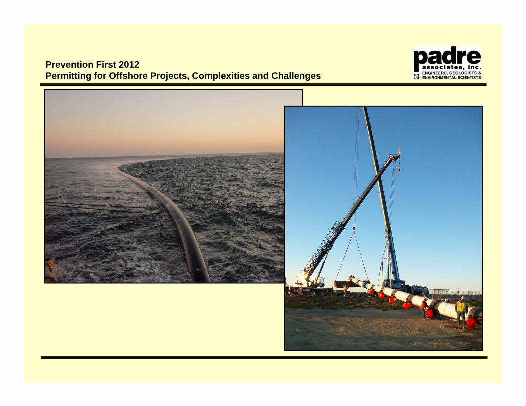
Outfall Plan
Prevention First 2012Permitting for Offshore Projects, Complexities and Challenges
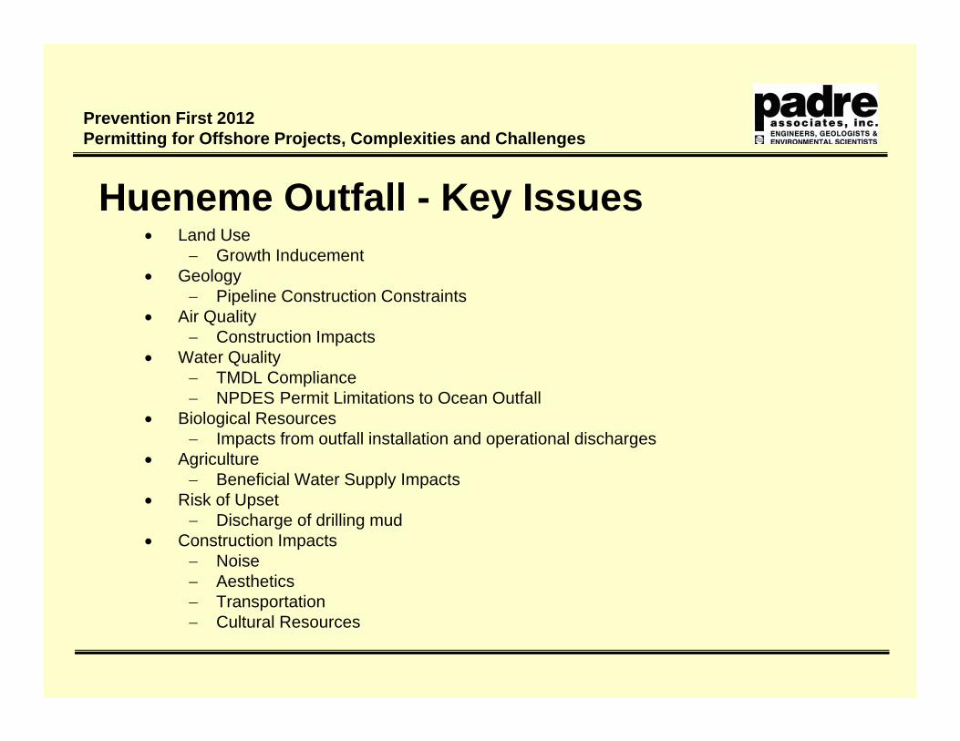
Hueneme Outfall - Key Issues Land Use
Growth Inducement Geology
Pipeline Construction Constraints Air Quality
Construction Impacts Water Quality
TMDL Compliance NPDES Permit Limitations to Ocean Outfall
Biological Resources Impacts from outfall installation and operational discharges
Agriculture Beneficial Water Supply Impacts
Risk of Upset Discharge of drilling mud
Construction Impacts Noise Aesthetics Transportation Cultural Resources

Prevention First 2012Permitting for Offshore Projects, Complexities and Challenges
Hueneme Outfall - Agency Approvals Calleguas MWD
California Environmental Quality Act (CEQA) Lead Agency California State Lands Commission
Tidelands Lease California Coastal Commission
Coastal Development Permit (CDP) Regional Water Quality Control Board
NPDES Permit 401 Certification
Army Corps of Engineers 404 Certification
NOAA Fisheries / U.S. Fish and Wildlife Service (FWS) Endangered Species Act (ESA) Consultation
City of Port Hueneme – Encroachment Permit City of Oxnard – Encroachment Permit U.S. Coast Guard – Notice to Mariners
Prevention First 2012Permitting for Offshore Projects, Complexities and Challenges

Prevention First 2012Permitting for Offshore Projects, Complexities and Challenges

Prevention First 2012Permitting for Offshore Projects, Complexities and Challenges
State Waters Line
Port Boundary Line
Beta Unit Pipeline Replacement Project

Prevention First 2012Permitting for Offshore Projects, Complexities and Challenges
Beta Unit Background Platforms located 9 miles offshore of Huntington Beach in
250 to 700 feet of water. Elly and Ellen installed in 1980 with first production in
1981. Platform Eureka installed in 1985.
Originally installed by Shell, now owned and operated by Beta Offshore
Pipeline leak (12” produced fluids pipeline) in 1999. Platform Eureka shut-in until April 2008 when pipeline
reconfirmation was approved by MMS. Beta Offshore become operator in May 2010 and is
proposing to replace existing pipeline confirmation with new pipelines

Prevention First 2012Permitting for Offshore Projects, Complexities and Challenges
12
DP VesselInstallation

Prevention First 2012Permitting for Offshore Projects, Complexities and Challenges
Beta Pipeline - Key Issues Geology
Marine Landslides and Gas Pockets
Pipeline Construction Constraints
Biological Resources Hardbottom Habitat Marine mammal Impacts
Risk of Upset Increased Pipeline Safety
Construction Impacts Air Quality Transportation Cultural Resources

Prevention First 2012Permitting for Offshore Projects, Complexities and Challenges
Beta Unit Pipeline - Agency Approvals MMS – BOEMRE – BOEM/BSEE
National Environmental Policy Act (Lead Agency) South Coast Air Quality Management District
Permit to Operate Regional Water Quality Control Board
401 Certification Army Corps of Engineers
404 Certification NOAA Fisheries / U.S. Fish and Wildlife Service (FWS)
Endangered Species Act (ESA) Consultation U.S. Coast Guard – Notice to Mariners

Prevention First 2012Permitting for Offshore Projects, Complexities and Challenges

Prevention First 2012Permitting for Offshore Projects, Complexities and Challenges

Prevention First 2012Permitting for Offshore Projects, Complexities and Challenges

Prevention First 2012Permitting for Offshore Projects, Complexities and Challenges
PG&E 3D Seismic Project Objectives Obtain improved deep (>1 km [>0.6 mi]) imaging of
the Hosgri and Shoreline fault zones to better define fault geometry - in the vicinity of the DCPP- at the intersection of the Hosgri and Shoreline
fault zones near Point Buchon- at the intersection of the San Simeon and Hosgri
fault zones near Point Estero Expand regional seismic database

Prevention First 2012Permitting for Offshore Projects, Complexities and Challenges
Proposed Action
Box 1 – Offshore Diablo CanyonBox 2 – Estero Bay to offshore Santa
Maria River Mouth fault intersections
Box 3 – Offshore Cambria to Estero Bay
Box 4 – Estero Bay

Prevention First 2012Permitting for Offshore Projects, Complexities and Challenges
Offshore Seismic Imaging Survey Cambria to Point San Luis in water up to 1,400 ft. Specialized survey vessel approximately 235 ft in length Two strings of tuned air guns with a volume of 3,300 in3
Vessel-towed hydrophone streamer array of 3.7 miles in length Additional scout and support vessels

Prevention First 2012Permitting for Offshore Projects, Complexities and Challenges
Towed Air Gun Array and Hydrophone Streamers

Prevention First 2012Permitting for Offshore Projects, Complexities and Challenges
3D Seismic Project - Key Issues Geology
Target Identification and Alternative Technologies Air Quality
Vessel Emissions Biological Resources
Impacts to fish resources Impacts to marine mammals
Vessel movements Noise impacts
Commercial and Recreational Fishing Preclusion Long term impacts on fish populations
Recreational Uses Preclusion and noise impacts
Prevention First 2012Permitting for Offshore Projects, Complexities and Challenges
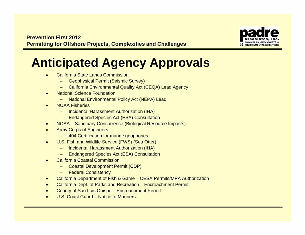
Anticipated Agency Approvals California State Lands Commission
Geophysical Permit (Seismic Survey) California Environmental Quality Act (CEQA) Lead Agency
National Science Foundation National Environmental Policy Act (NEPA) Lead
NOAA Fisheries Incidental Harassment Authorization (IHA) Endangered Species Act (ESA) Consultation
NOAA – Sanctuary Concurrence (Biological Resource Impacts) Army Corps of Engineers
404 Certification for marine geophones U.S. Fish and Wildlife Service (FWS) (Sea Otter)
Incidental Harassment Authorization (IHA) Endangered Species Act (ESA) Consultation
California Coastal Commission Coastal Development Permit (CDP) Federal Consistency
California Department of Fish & Game – CESA Permits/MPA Authorization California Dept. of Parks and Recreation – Encroachment Permit County of San Luis Obispo – Encroachment Permit U.S. Coast Guard – Notice to Mariners

Prevention First 2012Permitting for Offshore Projects, Complexities and Challenges
Project Approach Clearly Define Project Approach and
Phasing Kick-off Meeting – Define Critical Success
Factors Develop Workplan
Determine Available Site Resource Information/Data Review
Complete Engineering Review and Site Specific Surveys
Evaluate Potential Project Resource Issues and Alternatives
Identify Interested Parties and Resource Agencies
Conduct Evaluation of Resource Issues Submit Comprehensive Application
Package Prepare Final Documentation and
Mitigation Compliance Plan

Prevention First 2012Permitting for Offshore Projects, Complexities and Challenges
Key Application Inputs Clearly Defined Project Description
Detailed Engineering Review Well Defined Work Procedures Equipment List Construction Schedule
Environmental Characterization including site specific surveys Geophysical Survey Biological Survey Cultural Resource Survey
Air Emissions Estimates and Mitigation Measures Critical Operations and Curtailment Plan Oil Spill Contingency Plan Mitigation Compliance Plan Marine Wildlife Contingency Plan