people and spaces in roman military bases || the fort at hesselbach
TRANSCRIPT

Cambridge Books Online
http://ebooks.cambridge.org/
People and Spaces in Roman Military Bases
Penelope M. Allison
Book DOI: http://dx.doi.org/10.1017/CBO9781139600248
Online ISBN: 9781139600248
Hardback ISBN: 9781107039360
Chapter
9 - The fort at Hesselbach pp. 222-231
Chapter DOI: http://dx.doi.org/10.1017/CBO9781139600248.010
Cambridge University Press

9 The fort at Hesselbach
INTRODUCTION
As discussed in Chapter 4, analyses of the distribution patterns of artefacts
excavated from the fort at Hesselbach were carried out as a control for the
main sites in this study. While this fort was extensively excavated, using
open-plan excavation similar to that at Oberstimm and Ellingen, and the
provenances of many of the artefacts were published, the depositional pro-
cess indicates that this fort is less suitable for these analyses than the other
forts in this study. While a process of decommissioning may have taken
place, the excavator, Dietwulf Baatz, also identified a period of civilian set-
tlement, after the fort had been abandoned by the military (Baatz 1973: 28).
Further, he observed that a large part of this fort had subsequently suffered
considerable erosion (1973: 38). This fort therefore does not meet the depo-
sitional criteria required for this study. At the same time, though, it serves
as a contrast with the other sites in the study to demonstrate that their
remains are relatively securely attributable to their military occupation, and
that their abandonment processes and taphonomic conditions are suited to
this type of study, and therefore that their artefact distribution patterns are
likely to be useful in the interpretation of socio-spatial practices. This fort is
discussed at this point in the study because it falls, chronologically, between
the forts at Oberstimm and Ellingen.
The location
The medieval and modern village of Hesselbach is located 40 km north-east
of Heidelburg, just south of Wurzberg (Baatz 1973: 9–12 and figs. 1–2)
(Figures 1.1 and 9.1). The small 0.56-hectare Roman fort lay at the edge of
the modern village in a field on a south-west slope. The palisade trench for
the limes ran 145 m from main gateway of the fort.
Excavation history
This fort has been known since eighteenth century, and its walls since the
beginning of the nineteenth century (Baatz 1973: 9). The earliest excavations222
Downloaded from Cambridge Books Online by IP 216.165.126.139 on Tue Nov 26 07:24:02 WET 2013.http://dx.doi.org/10.1017/CBO9781139600248.010
Cambridge Books Online © Cambridge University Press, 2013

Introduction 223
Figure 9.1 Location map for Hesselbach.
were carried out here by F. Kofler in May 1895 (Baatz 1973: 9–13), consist-
ing of small test pits concentrated on the latest fortifications which did not
destroy Roman occupation levels inside the fort. Further test investigations,
looking for stone fortifications, were undertaken in 1964 (Baatz 1973: 12),
but more extensive excavations were carried out by Baatz between Septem-
ber 1964 and August 1966 (Baatz 1973; see also Baatz 1971). No external
settlement, or vicus, has been found (see Baatz 1973: 12).
The history and chronology of the fort
Baatz identified this fort as part of a chain of auxiliary or numerus forts
to secure the border on Oldenwald limes. This organisation of the Upper
German limes began after the Saturninus revolt (88/89 ce), and inscriptions
from Bockingen and Jagsthausen indicate that auxiliary units were being
transferred away from Oldenwald and Neckar limes between 148 and 161 ce
(Baatz 1973: 66, 77). Baatz observed that the Neckar and Oldenwald limes
were frequently associated with Numeri Brittonum (1973: 68). On the bases
of these troop movements and the dating of the ceramic remains from the
Downloaded from Cambridge Books Online by IP 216.165.126.139 on Tue Nov 26 07:24:02 WET 2013.http://dx.doi.org/10.1017/CBO9781139600248.010
Cambridge Books Online © Cambridge University Press, 2013

224 The fort at Hesselbach
0 10 20 m
8-9 7
4 3
5
6 2 1
N
Figure 9.2 Plan of the fort at Hesselbach.
fort, Baatz dated it somewhere between c. 95 and 165 ce (1973: 66–7, 82),
but argued that it lasted only some fifty years. He also suggested (1973: 70)
that the unit here was very probably a Numerus Brittonum, at least under
Antoninus Pius (138–61 ce) and, as there is no evidence for a change of unit,
probably also before 130 ce. However, the coin evidence is rather limited
to substantiate this dating and, according to Baatz (1973: 70) there are no
securely dated inscriptions confirming the presence of other British units in
the Oldenwald region before 145 ce (see also Reuter 1999: esp. 385–9 and
457).
The excavations and depositional condition
During the main excavations only a portion of the actual fort was excavated –
0.198 hectares (Baatz 1973: 82). However, a relatively complete fort plan
showing the layout of the internal buildings was reconstructed from these
excavations (Figure 9.2). Individual rooms within some of the buildings
were also identified. These structures indicate that the fort was orientated
with the main gateway to the north-east.
Downloaded from Cambridge Books Online by IP 216.165.126.139 on Tue Nov 26 07:24:02 WET 2013.http://dx.doi.org/10.1017/CBO9781139600248.010
Cambridge Books Online © Cambridge University Press, 2013

Introduction 225
The slope of the land towards the south-west has caused erosion to much
of the Roman surface (Baatz 1973: 38, fig. 18). The central and north-east
parts of the fort were seriously eroded. At the same time, this has also meant
that much material in the retentura was well preserved, if relocated and
mixed with remains from the praetentura. The best-preserved areas for the
lower-level remains are in the south-west part of the fort – most of Buildings
3 and 6, and the southern parts of the Buildings 1, 2 and 4 (see Baatz 1973:
fig. 18).
Baatz noted that many of the types of artefacts that might be expected
at a military base were not found at this site (1973: 82), particularly metal
finds. No traces of building fittings (e.g. door locks, clamps, bolts), metal
fittings for vehicles, or weapons were recorded, and only four coins (cat. nos.
A1–4) and three nails (cat. no. M5a–c) were found. Iron slag was recorded
but probably from post-fort occupation of the site (1973: 64–5). Baatz
also noted that proportionately very few artefacts could be attributed to
specific contexts and that few were associated with the last phase of military
occupation (1973: 83). Also, no traces of burning were observed, except
for a reddish layer in the middle of Building 4 (1973: 63). Baatz therefore
argued that the fort at Hesselbach was not rapidly abandoned or destroyed
by a catastrophe, but that much material was salvaged and systematically
removed by departing troops (1973: 63 and 82). The subsequent occupation
of the site by a civilian settlement, together with the evident erosion, no
doubt contributed to Baatz’s difficulty in identifying artefacts that were
assuredly from military contexts.
Building phases and stratigraphical information
The 1960s excavations revealed three building phases of the fortifications of
this fort. Phase A had a wood and earth wall; in phase B the fortifications
had an inner and outer dry-stone skin with earth fill between; in phase C
they consisted of a mortar-and-stone wall. However, Baatz found no clear
stratigraphical connection between these fortification phases and building
phases of internal buildings (1973: 28). He divided the latter into Period
1 and Period 2, with a Period 2a consisting of repair. Period 1 is possibly
contemporary with fortification phase A; Period 2 with fortification phase
B, and Period 2/2a with fortification phase C. Baatz called the period of
civilian occupation Period 3 (1973: 63–6). Remains from Period 3 consisted
of shallow settlement pits cut through the earlier buildings, indicating that
most of the previous military buildings were no longer extant at this stage.
Downloaded from Cambridge Books Online by IP 216.165.126.139 on Tue Nov 26 07:24:02 WET 2013.http://dx.doi.org/10.1017/CBO9781139600248.010
Cambridge Books Online © Cambridge University Press, 2013
226 The fort at Hesselbach
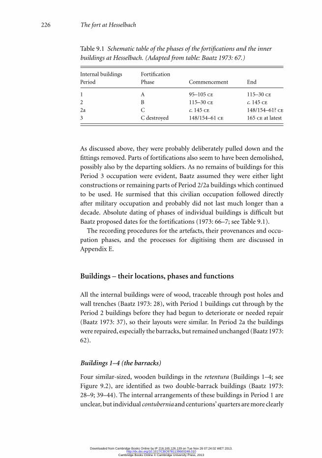
Table 9.1 Schematic table of the phases of the fortifications and the inner
buildings at Hesselbach. (Adapted from table: Baatz 1973: 67.)
Internal buildings Fortification
Period Phase Commencement End
1 A 95–105 ce 115–30 ce
2 B 115–30 ce c. 145 ce
2a C c. 145 ce 148/154–61? ce
3 C destroyed 148/154–61 ce 165 ce at latest
As discussed above, they were probably deliberately pulled down and the
fittings removed. Parts of fortifications also seem to have been demolished,
possibly also by the departing soldiers. As no remains of buildings for this
Period 3 occupation were evident, Baatz assumed they were either light
constructions or remaining parts of Period 2/2a buildings which continued
to be used. He surmised that this civilian occupation followed directly
after military occupation and probably did not last much longer than a
decade. Absolute dating of phases of individual buildings is difficult but
Baatz proposed dates for the fortifications (1973: 66–7; see Table 9.1).
The recording procedures for the artefacts, their provenances and occu-
pation phases, and the processes for digitising them are discussed in
Appendix E.
Buildings – their locations, phases and functions
All the internal buildings were of wood, traceable through post holes and
wall trenches (Baatz 1973: 28), with Period 1 buildings cut through by the
Period 2 buildings before they had begun to deteriorate or needed repair
(Baatz 1973: 37), so their layouts were similar. In Period 2a the buildings
were repaired, especially the barracks, but remained unchanged (Baatz 1973:
62).
Buildings 1–4 (the barracks)
Four similar-sized, wooden buildings in the retentura (Buildings 1–4; see
Figure 9.2), are identified as two double-barrack buildings (Baatz 1973:
28–9; 39–44). The internal arrangements of these buildings in Period 1 are
unclear, but individual contubernia and centurions’ quarters are more clearly
Downloaded from Cambridge Books Online by IP 216.165.126.139 on Tue Nov 26 07:24:02 WET 2013.http://dx.doi.org/10.1017/CBO9781139600248.010
Cambridge Books Online © Cambridge University Press, 2013

Introduction 227
identifiable in Period 2. Many contubernia had evidence of tiled hearths.
Traces of chalk and mortar on the walls of the rooms in the centurions’
quarters indicate that these were plastered, or at least whitewashed.
Building 5 (principia)
Building 5, in the middle of the fort, had a typical ground plan and position
for a principia, with a central room that was probably the shrine (sacellum)
and the two side rooms that were probably administrative (Baatz 1973:
32–4; 46–50). The occupation surfaces of this building were missing.
Building 6 (praetorium?)
Building 6, in the centre of the retentura, was entered by a corridor on
the north side facing Building 5 (the principia) and built with the same
construction techniques as the barrack buildings (Baatz 1973: 31–2; 45–6).
It had three to four rooms either side of a central corridor, with a small
room at the end. In Period 1 it was larger with more, smaller rooms, and in
Period 2 it was smaller, with fewer larger rooms, four of which had hearths.
Baatz noted that this building was smaller than centurions’ quarters in
legionary fortresses but larger than those in auxiliary forts. He felt that it
could possibly have been the house of the unit leader although it could
scarcely have been considered a praetorium. He observed that an inscription
from Oldenwald limes indicated that some of the legion’s centurions were
named as commanders of numeri (praepositi) and suggested that such a
praepositus was accommodated in the building (Baatz 1973: 45). He also
observed that, in numeri Brittonum forts, such buildings with similar-sized
rooms along a central corridor are identified as valetudinaria (1973: 45).
However, he argued that the building at Hesselbach seemed too large for
this function in this small fort and suggested that it may have provided
accommodation for a special group of soldiers.
Building remains on right half of praetentura
(Building 7 – granary or storerooms?)
The praetentura was badly eroded (Baatz 1973: 35, 50–1). Baatz proposed
that there had probably been storerooms here as there is no evidence for
these in retentura. He identified the easternmost storeroom (Building 7) as
a granary (horreum) although also suggested it as an alternative residence
for a praepositus (1973: 45, 50–1), as this building was 13.1 m wide and
Downloaded from Cambridge Books Online by IP 216.165.126.139 on Tue Nov 26 07:24:02 WET 2013.http://dx.doi.org/10.1017/CBO9781139600248.010
Cambridge Books Online © Cambridge University Press, 2013

228 The fort at Hesselbach
208 m long and had irregular internal divisions not reportedly found in
horrea. Baatz also suggested that Building 7 could have performed all the
functions of a horrea, armamentaria and workshops, under one roof.
Buildings on left side of praetentura (Buildings 8 and 9 – Stables?)
Two rectangular Period 2 buildings were preserved on the left side of the
praetentura, with small poorly preserved but identifiable Period 1 buildings
beneath – Buildings 8 and 9 (Baatz 1973: 35–6; 52–3). Baatz argued that
these buildings were unlikely to have been barracks and were most probably
stables. In this part of the praetentura Baatz also identified a water-storage
pit, for the animals to drink from. During Period 1 there had been an oven,
to the north, which went out of use in Period 2 when a small shed, Building
10, was built over it.
Organisation and strength of the military unit
From these remains Baatz argued that Hesselbach was a standard numerus
fort, occupied by the same unit in both periods of occupation (1973: 30–1,
54, 62). He also argued (1973: 56) that the ground plan probably indicates
that the unit was divided into four similar parts forming two pairs, and
surmised that each barracks would have held thirty to thirty-two men
and that the strength of unit was probably c. 120 men, with a total of
130 including centurions, principales, and unit commander (1973: 58–9).
Additional soldiers could conceivably have been housed in Building 6.
ACTIVITY AND IDENTITY CATEGORIES FORSPECIFIC ARTEFACTS
The published artefact catalogue for the fort at Hesselbach includes arte-
facts from the excavations between 1964 and 1966 and also those from the
older excavations of Kofler (Baatz 1973: 82–114). Of some 1,200 catalogued
artefacts most are ceramic remains and many were from unprovenanced
and eroded contexts. Only eighty-two can potentially be ascribed an activ-
ity or identity category used in this study and some fifty-seven of these are
worked stone balls, some conceivably used as counterweights. As for the
other sites in this study, the reasons for many of these ascriptions are cov-
ered under the general categorisations outlined in Chapter 5. The individual
Downloaded from Cambridge Books Online by IP 216.165.126.139 on Tue Nov 26 07:24:02 WET 2013.http://dx.doi.org/10.1017/CBO9781139600248.010
Cambridge Books Online © Cambridge University Press, 2013

Analyses of artefact distribution 229
artefacts discussed below are those for which more specific information has
been used in their categorisation.
Possible bead, spindle whorl or gaming counter
Baatz’s cat. no. T14 is a disc of reused terra sigillata, 32 mm in diameter
with a central hole of 4 mm. It is therefore similar to the disc types 1–3
from the Casa del Menandro in Pompeii (Allison 2006a: 380–1), the
very small hole suggesting that it was most probably a bead although it
could conceivably have been a spindle whorl. Baatz suggested (1973: 88)
that it was a gaming counter so this disc is categorised here as ‘dress?/
cloth-working?/furniture?/gaming’ and as possibly associated with women,
‘female?’.
Possible weighing and measuring equipment
Sixty large irregularly shaped sandstone balls were recorded in the fort at
Hesselbach. Baatz identified three of these as the remains of hand mills,
probably used in food preparation, but argued that the rest were likely
to have been used either as counterweights (Baatz 1973: 112–13) or as
slingshot. As their exact function is not clear, for the purposes of this study
these fifty-seven stone balls (cat. nos. W1d–f) are categorised as possibly
‘weighing and measuring?’, and as possibly male-related, ‘male?’.
ANALYSES OF ARTEFACT DISTRIBUTION
An assessment of the quality and usefulness of the data from this fort for
these analyses is included in Appendix E.
The distribution of artefacts associated with dress andspecific activities
Eighty-two artefacts from the fort at Hesselbach have been ascribed an activ-
ity and identity category. Only one bronze brooch and one pierced ceramic
disc were potentially associated with dress, although the latter may have
been used alternatively in either gaming or in cloth production. Artefacts
Downloaded from Cambridge Books Online by IP 216.165.126.139 on Tue Nov 26 07:24:02 WET 2013.http://dx.doi.org/10.1017/CBO9781139600248.010
Cambridge Books Online © Cambridge University Press, 2013

230 The fort at Hesselbach
associated with other specific activities include one knife, associated with
cutting and sharpening; iron slag, associated with metalworking; and some
fifty sandstone balls, possibly associated with weighing and measuring.
Most of these items, including the two potential dress-related items, do
not have identifiable provenances, and are undated (Allison 2012: Hessel-
bach Interactive Map <HGE01>). Interestingly, much of the metalworking
material was found in the areas that were most heavily eroded – in the
northern part of the fort and in the vicinity of the Building 5. The prove-
nances of only seven of the fifty-seven sandstone balls are identifiable. These
are scattered but, notably, three were found in a shallow pit in one of the
contubernia of Building 2, although not well dated.
As the precise activity with which the sandstone balls were associated is
unclear the main activity identified here is metalworking. However, most of
this material was from Period 3 contexts or undated and probably indicates
the use of this site after its military occupation. Only the ceramic disc is
possibly associated with women’s activities or dress, but is unfortunately
unprovenanced and undated.
Conclusions and building use
This artefact distribution pattern gives tantalizing glimpses of some of
the possibly non-combat activities at this site. Because of the depositional
circumstances at the site, however, it is not clear how these activities were
related to each other, where they took place or indeed whether they took
place while military personnel were resident. The apparent lack of any items
associated with combat dress or combat equipment suggests, rather, that
it is much more difficult for this site, than for the others in this study, to
associate this material with either spaces or people from the military phases
of this fort.
One of the important questions for understanding the socio-spatial prac-
tices within this fort is the function of Building 6. Baatz argued that, despite
its layout as a corridor building it was too large to be a valetudinarium
and so suggested that it was a residence for the fort commander (1973:
31–2). The artefacts recorded from this building, and also from the corri-
dor building (Building 2) at Oberstimm, which Schonberger identified as
a valetudinarium, then replaced with a horreum (1978: 57 and 65), pro-
vide little indication of the functions for these buildings (see also corridor
building, Building F, in the fort at Ellingen – Chapter 10, p. 239). Rather,
Downloaded from Cambridge Books Online by IP 216.165.126.139 on Tue Nov 26 07:24:02 WET 2013.http://dx.doi.org/10.1017/CBO9781139600248.010
Cambridge Books Online © Cambridge University Press, 2013
Analyses of artefact distribution 231
these varied interpretations imply that the building layout is of little help in
understanding how these building types were used.
In summary, the approach taken by the excavators to the fort at Hes-
selbach and the comprehensive publication of its plans, its catalogue of
artefacts and at least some of their provenances is potentially appropriate
for this study. However, because artefact recording focused on provenancing
artefact types considered stratigraphically important for understanding the
chronology of the site, the artefact provenances have been inconsistently
recorded. Thus, there is a lack of good contextual information and con-
sistent recording for every excavated artefact necessary for spatial analyses.
More importantly, though, the apparent systematic dismantling of this fort,
evident reoccupation by a civilian settlement, and then the considerable
erosion to much of the site means that both pre- and post-abandonment
depositional processes render it unsuitable for the spatial analyses of arte-
fact distribution to assess socio-spatial practices within this military fort.
However, for all these reasons, it emphasises the quality and significance of
the artefact distribution patterns at the other forts in this study.
Downloaded from Cambridge Books Online by IP 216.165.126.139 on Tue Nov 26 07:24:02 WET 2013.http://dx.doi.org/10.1017/CBO9781139600248.010
Cambridge Books Online © Cambridge University Press, 2013