people and place hemispheres human-environmental interactions · hemispheres human-environmental...
TRANSCRIPT
People and PlaceCurriculum Resources on
Human-Environmental Interactions He
mis
pher
es
Hemispheres is a joint project of:Teresa Lozano Long Institute of Latin American Studies
Center for Middle Eastern StudiesCenter for Russian, East European & Eurasian Studies
South Asia Institute
in the College of Liberal Artsat The University of Texas at Austin

Primary Authors:
Natalie Arsenault, Outreach CoordinatorTeresa Lozano Long Institute of Latin American Studies
Christopher Rose, Outreach CoordinatorCenter for Middle Eastern Studies
Allegra Azulay, Outreach CoordinatorCenter for Russian, East European & Eurasian Studies
Jordan Phillips, Outreach CoordinatorSouth Asia Institute
People and PlaceCurriculum Resources on
Human-Environmental Interactions
People and PlaceCurriculum Resources on
Human-Environmental Interactions
Final VersionOriginal Compilation Date: June 2005
Final Publication Date: April 2007
Permission is granted to reproduce this unit for classroom use only. Please do not redistribute this unit without prior permission.
For more information, please see: http://www.utexas.edu/cola/orgs/hemispheres/
Permission to include copyrighted materials in this unit is indicated in citations.
39
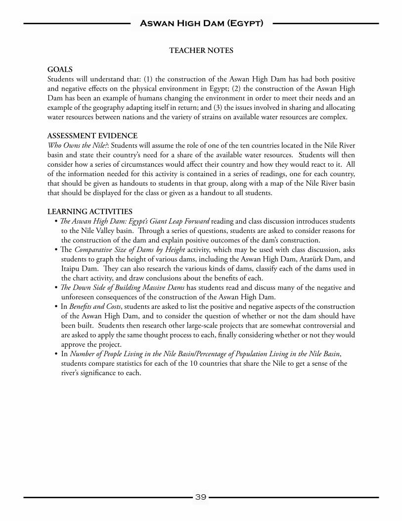
Aswan High Dam (Egypt)
TEACHER NOTES
GOALSStudents will understand that: (1) the construction of the Aswan High Dam has had both positive and negative effects on the physical environment in Egypt; (2) the construction of the Aswan High Dam has been an example of humans changing the environment in order to meet their needs and an example of the geography adapting itself in return; and (3) the issues involved in sharing and allocating water resources between nations and the variety of strains on available water resources are complex.
ASSESSMENT EVIDENCEWho Owns the Nile?: Students will assume the role of one of the ten countries located in the Nile River basin and state their country’s need for a share of the available water resources. Students will then consider how a series of circumstances would affect their country and how they would react to it. All of the information needed for this activity is contained in a series of readings, one for each country, that should be given as handouts to students in that group, along with a map of the Nile River basin that should be displayed for the class or given as a handout to all students.
LEARNING ACTIVITIES• The Aswan High Dam: Egypt’s Giant Leap Forward reading and class discussion introduces students
to the Nile Valley basin. Through a series of questions, students are asked to consider reasons for the construction of the dam and explain positive outcomes of the dam’s construction.
• The Comparative Size of Dams by Height activity, which may be used with class discussion, asks students to graph the height of various dams, including the Aswan High Dam, Atatürk Dam, and Itaipu Dam. They can also research the various kinds of dams, classify each of the dams used in the chart activity, and draw conclusions about the benefits of each.
• The Down Side of Building Massive Dams has students read and discuss many of the negative and unforeseen consequences of the construction of the Aswan High Dam.
• In Benefits and Costs, students are asked to list the positive and negative aspects of the construction of the Aswan High Dam, and to consider the question of whether or not the dam should have been built. Students then research other large-scale projects that are somewhat controversial and are asked to apply the same thought process to each, finally considering whether or not they would approve the project.
• In Number of People Living in the Nile Basin/Percentage of Population Living in the Nile Basin, students compare statistics for each of the 10 countries that share the Nile to get a sense of the river’s significance to each.
40
Aswan High Dam (Egypt)
The Aswan High Dam: Egypt’s Giant Leap Forward
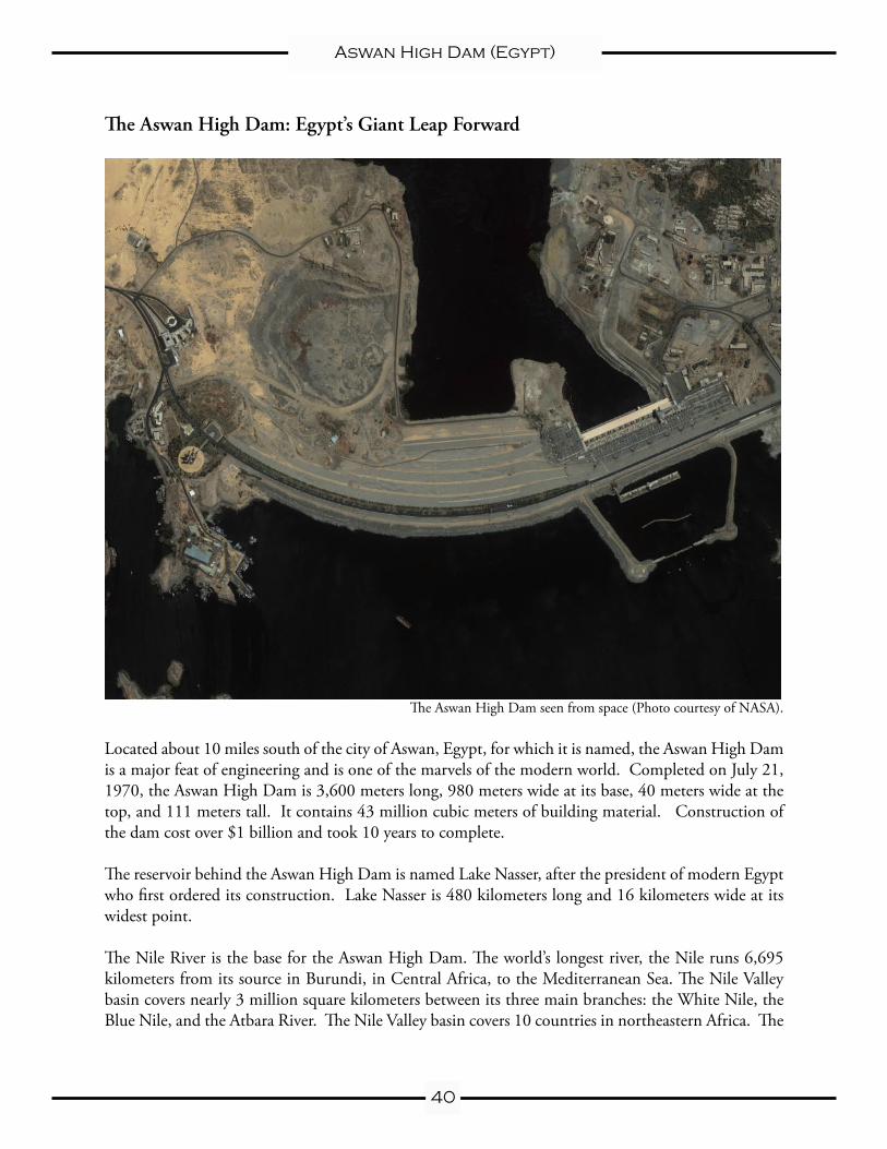
The Aswan High Dam seen from space (Photo courtesy of NASA).
Located about 10 miles south of the city of Aswan, Egypt, for which it is named, the Aswan High Dam is a major feat of engineering and is one of the marvels of the modern world. Completed on July 21, 1970, the Aswan High Dam is 3,600 meters long, 980 meters wide at its base, 40 meters wide at the top, and 111 meters tall. It contains 43 million cubic meters of building material. Construction of the dam cost over $1 billion and took 10 years to complete.
The reservoir behind the Aswan High Dam is named Lake Nasser, after the president of modern Egypt who first ordered its construction. Lake Nasser is 480 kilometers long and 16 kilometers wide at its widest point.
The Nile River is the base for the Aswan High Dam. The world’s longest river, the Nile runs 6,695 kilometers from its source in Burundi, in Central Africa, to the Mediterranean Sea. The Nile Valley basin covers nearly 3 million square kilometers between its three main branches: the White Nile, the Blue Nile, and the Atbara River. The Nile Valley basin covers 10 countries in northeastern Africa. The
41
Aswan High Dam (Egypt)
branches of the Nile come together in Sudan, and flow north across the Sahara desert into Egypt.
Most of the water contributed to the Nile comes from the Blue Nile, which originates at Lake Tana in Ethiopia. Heavy rainfall washes away the rich, fertile soil of Ethiopia’s highlands and sends it down-river in the form of silt, which eventually collects in the Nile Delta in Egypt. Only a small percentage of the water carried down the Nile eventually reaches the Mediterranean. The rest either evaporates or is diverted for use in irrigation and farming, as drinking water, or for other purposes.
The average flow of the Nile River is about 50 million cubic meters per day. During the rainy season, however, the three branches of the Nile River increase their flow to just over 700 million cubic meters per day.
There were several reasons that the government of Egypt wanted to build a dam across the Nile. Since the days of the pharaohs, the Nile has flooded every year, depositing a layer of rich, fertile silt washed downriver from Ethiopia. But the flooding wasn’t consistent—one year, the floods might be low, resulting in weak soil that produced few crops. The next year, the floods might be high, destroying buildings, homes, roads, and washing away important features of the land. At the beginning of the twentieth century, the British colonial administration built a dam near Aswan to control the flooding. By the 1950s, however, it was clear that this dam wasn’t going to help with the needs of a growing country.
The construction of the Aswan High Dam has had many positive effects on Egypt. The dam is also a hydroelectric power plant, and is equipped with 12 turbines, each capable of producing 175 megawatts of electricity, or 2.1 gigawatts total. The power plant began operating in 1967, and by the mid-1970s, the Aswan High Dam was producing half of Egypt’s electrical supply. The new electrical production allowed many villages to have electricity for the first time. The Aswan High Dam is still a major part of Egypt’s electrical supply, and produces about 15% of the country’s needs each year.
Another benefit from the construction of the Aswan High Dam is that agricultural production can now take place year round. Since the Nile floods have been stopped, many farmers can now squeeze in three growing cycles each year, tripling the amount of crops that can be harvested. In a country that is 94% desert, the ability to triple wheat and cotton each year has been a huge benefit.
Some people have questioned whether the Aswan High Dam has created a dangerous situation. Al-though earthquakes are not common in Egypt, they do happen from time to time. If the Aswan High Dam were to be destroyed, the Nile Valley would be hit with a wall of water that would not be able to stop until it reached the Mediterranean Sea. A destructive wall of water moving north would reach every major city in Egypt, and afterwards the country would have little access to clean water. Others point out that the dam was built to withstand strong earthquakes and that there is very little chance that the dam could ever be destroyed either by natural or human forces.
42
Aswan High Dam (Egypt)
The Aswan High Dam: Egypt’s Giant Leap ForwardComprehension Exercises
(1) What is the importance of the Aswan High Dam? Why did the Egyptian government want to build it?
(2) List three benefits that have come from the construction of the Aswan High Dam.
(3) Do you think there are any bad things that might come out of the building of the Aswan High Dam? What are they?
(4) How do you think that the other countries that use the Nile might view the Aswan High Dam?
Name:
43
Aswan High Dam (Egypt)
Name:
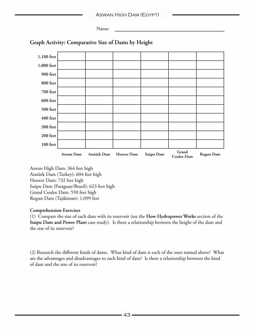
Graph Activity: Comparative Size of Dams by Height
1,100 feet
1,000 feet
900 feet
800 feet
700 feet
600 feet
500 feet
400 feet
300 feet
200 feet
100 feet
Aswan Dam Atatürk Dam Hoover Dam Itaipu Dam Grand Coulee Dam Rogun Dam
Aswan High Dam: 364 feet highAtatürk Dam (Turkey): 604 feet highHoover Dam: 732 feet highItaipu Dam (Paraguay/Brazil): 623 feet highGrand Coulee Dam: 550 feet highRogun Dam (Tajikistan): 1,099 feet
Comprehension Exercises(1) Compare the size of each dam with its reservoir (see the How Hydropower Works section of the Itaipu Dam and Power Plant case study). Is there a relationship between the height of the dam and the size of its reservoir?
(2) Research the different kinds of dams. What kind of dam is each of the ones named above? What are the advantages and disadvantages to each kind of dam? Is there a relationship between the kind of dam and the size of its reservoir?
44
Aswan High Dam (Egypt)
The Down Side of Building Massive Dams
The Water Table: The water table is the upper level of underground water. If you dig a hole nearly anywhere, you will eventually strike water. In swampy areas, the water table is very close to the surface (or ground level), which is why marshy conditions are found there. In other areas, the water table is very low, which is why deep wells must be dug to reach water and bring it to the surface. In desert areas, places where the water table comes close enough to the surface to allow plants to grow are called oases.
In many places in Egypt’s Nile Valley, the water table has been rising much closer to the surface than before and, in many places, the rising levels are threatening ancient monuments. One particular dan-ger is the formation of salt. The sand and soil of the Nile basin are naturally salty. Before the Aswan High Dam was built, the annual flooding of the Nile would wash the salt into the Mediterranean. But now that the flooding has stopped, the natural salt, along with salt added from artificial fertilizer usage, has been building up over time.
There are two problems with the buildup of salt in the soil. First, the salty soil makes the ground water salty, which means that it can’t be used for drinking or irrigation because too much salt is harmful to humans, animals, and plants. Second, salt causes limestone to decay much quicker than normal, and most of Egypt’s ancient monuments are built of limestone. Archaeologists fear that the rising water table could cause the destruction of many of these structures, from the temples of the pharaohs in Luxor to the great Sphinx in Giza.
There are several possible solutions, such as installing wells to lower the water table, replacing the foundation stones with other materials, or injecting a chemical sealant between the structures and the soil to create a barrier. All of these are very expensive and risk possible damage to the ancient monu-ments.
Soil and Fertility:Although one of the benefits of the Aswan High Dam was the ability of farmers to grow crops year round, the stoppage of the Nile floods has had negative effects as well. The yearly flooding deposited a layer of rich, fertile soil that was excellent for growing crops. Without the flooding, farms in Egypt have had to begin using artificial fertilizer to enrich the soil every year. Many fertilizers consist of harsh and dangerous chemicals that can leak into the ground and drinking water systems if not used properly.
Disease:Another side effect of the construction of the Aswan High Dam is an increase in the rates of people infected with a disease called schistosomiasis, or bilharzia (bill-HAR-zee-ya). Bilharzia is caused by a parasite carried by snails that bores itself into the skin of humans, and it flourishes in standing water. Bilharzia has been a problem in Egypt for millennia—some mummies from the Pharaonic period show visible symptoms of advanced stages of the disease.
The flow of the Nile once helped with the problem, because bilharzia needs slow moving or standing water to develop. However, with the construction of the dam, the parasite has found a new home in
45
Aswan High Dam (Egypt)
the standing water of Lake Nasser. From there, it is sent with the Nile water downriver and is often transmitted into the feet of farm workers in their fields. This caused the rate of infection to increase rapidly.
Bilharzia is a disease that is easy to treat if it is caught in its early stages. The problem is that it can take as long as 20 or 30 years for symptoms to develop, at which point the disease is incurable and can eventually lead to death. By the early 1980s experts estimated that nearly 70% of the population in some rural communities was infected with the disease.
From the mid 1960s until the mid 1980s, a nationwide campaign to treat the infection and spread awareness of how to prevent it was organized in villages throughout the country. The campaign was made popular by an announcement that one of Egypt’s most beloved celebrities, actor/singer Abdel Halim Hafez, suffered from it. Patients came to small clinics where they received a series of ten injec-tions to remove the parasite from their system. An educational campaign alerted people not to swim in the Nile or work barefoot in the fields. In the late 1980s, an oral treatment was introduced, finally bringing the disease under control.
Although the campaign was very successful in reducing the rate of bilharzia infection, it had another re-sult. In the mid 1980s, it was still not known that blood-borne diseases such as AIDS could be spread by using needles that were not sterilized properly between uses. As a result, Egypt now has one of the highest infection rates of Hepatitis C, an incurable and potentially fatal disease of the liver, which has been directly linked to the campaign to eradicate bilharzia. It is estimated that 12–15% of Egypt’s population has the disease, one of the highest rates of infection in the world. (The rate of infection in the United States, for example, is about 1.8%.)
46
Aswan High Dam (Egypt)
Name:
The Down Side of Building Massive DamsComprehension Exercises
(1) What is the problem with the water table in Egypt? Why is it important to find a solution?
(2) Why is salty soil bad? What measures can be taken to make the soil less salty?
(3) What is bilharzia? How is it contracted?
(4) How did the construction of the Aswan High Dam contribute to higher rates of bilharzia in-fection? How did the construction of the dam contribute indirectly to higher rates of Hepatitis C infection?
47
Aswan High Dam (Egypt)
Benefits and Costs: Was the Aswan High Dam Worth It?
Instructions:Draw a large T-chart on the chalkboard or an overhead transparency. Ask students first to list all of the positive results of the Aswan High Dam’s construction. List these in the left column. Then ask students to list the negative results of the Aswan High Dam’s construction. List these in the right column.
Now ask students to consider the following questions:Was the construction of the Aswan High Dam a good thing?
If we had to consider whether to build the dam today, with all of the information we have now, would it be built? Why or why not?
As a tie-in activity, ask students to research a local development that may have been controversial when first proposed, and ask them to consider the same questions. Was it worth it? If the idea were proposed today, would it still be built? Why or why not?
What does this say about the considerations that go into planning for major projects, and why it takes so long to plan them?
Homework:Have students research other projects such as the Three Gorges Dam in China, the proposal to drill for oil in the Arctic National Wildlife Refuge (ANWR) in Alaska, or the proposed Nuclear Waste Depository at Yucca Mountain in Nevada and complete the following questions:
Name of projectWhy is this project considered important? What are the reasons that this project is considered necessary?List three positive things that will come out of this project if it is completed.List three negative things that will come out of this project if it is completed.Do you think this project should be approved? Why or why not?
48
Aswan High Dam (Egypt)
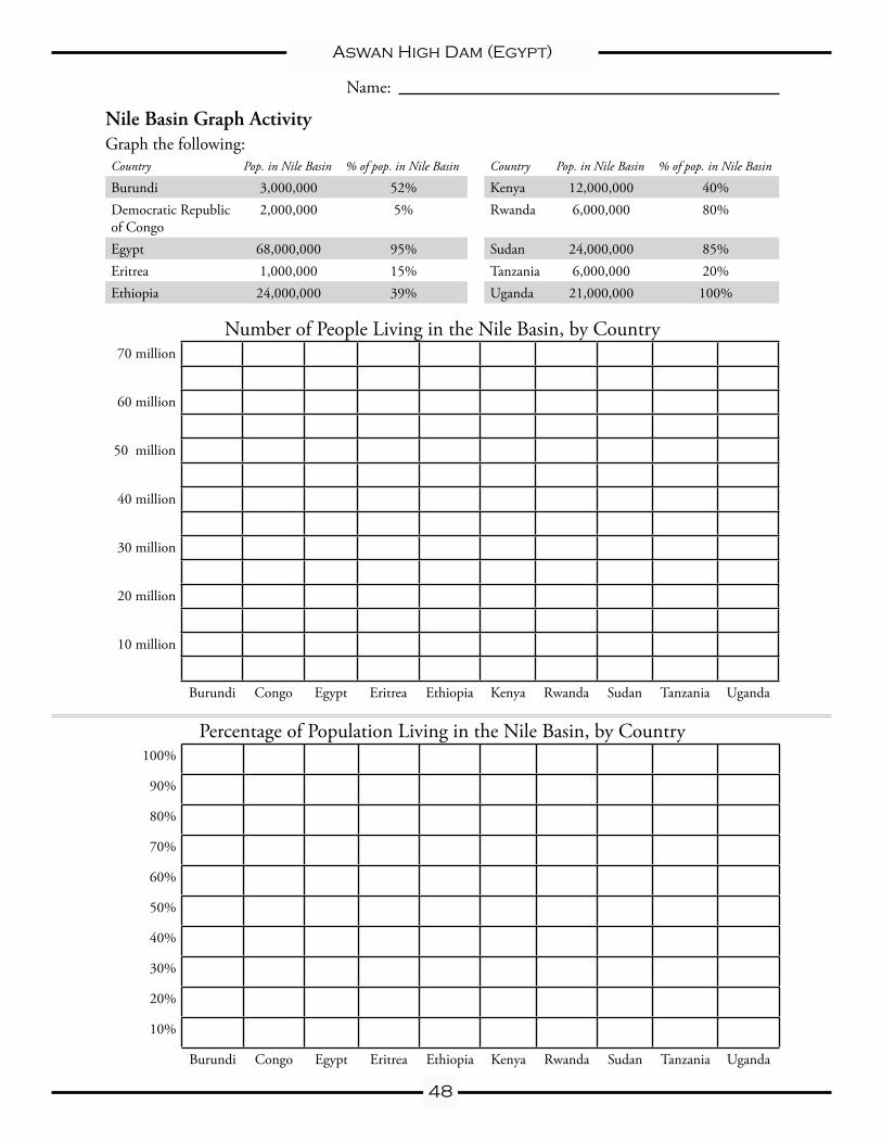
Nile Basin Graph ActivityGraph the following:Country Pop. in Nile Basin % of pop. in Nile Basin Country Pop. in Nile Basin % of pop. in Nile Basin
Burundi 3,000,000 52% Kenya 12,000,000 40%Democratic Republic of Congo
2,000,000 5% Rwanda 6,000,000 80%
Egypt 68,000,000 95% Sudan 24,000,000 85%Eritrea 1,000,000 15% Tanzania 6,000,000 20%Ethiopia 24,000,000 39% Uganda 21,000,000 100%
Number of People Living in the Nile Basin, by Country 70 million
60 million
50 million
40 million
30 million
20 million
10 million
Burundi Congo Egypt Eritrea Ethiopia Kenya Rwanda Sudan Tanzania Uganda
Percentage of Population Living in the Nile Basin, by Country100%
90%
80%
70%
60%
50%
40%
30%
20%
10%
Burundi Congo Egypt Eritrea Ethiopia Kenya Rwanda Sudan Tanzania Uganda
Name:
49
Aswan High Dam (Egypt)
Nile Basin Graph Activity, p. 2Comprehension Exercises
(1) Which country has the most people living in the Nile basin? Which country has the highest percentage of people living in the Nile basin?
(2) Which country has the least amount of people in the Nile basin? Which country has the lowest percentage of people living in the Nile basin?
(3) Which country is most dependent on the Nile River? Why?
(4) Which country is least dependent on the Nile River? Why?
(5) What are the difficulties in having so many people depend on the river? What are some of the problems that nations might have with each other?
(6) What are some of the ways that nations can work together to share the Nile River?
(7) Who do you think owns the Nile?
50
Aswan High Dam (Egypt)
Who Owns the Nile?
Activity: Give each student a copy of the map, or display it on an overhead.
Assign each of the following readings to individual, pairs, or small groups of students. Have each of them read the passage and summarize the importance of the Nile to the country they represent. Have a representative from each group stand up and explain why the Nile is important to their country.
As a final activity, pose the following hypothetical situations and ask each group to consider how their country might react in each case. Students should justify their answers based on the knowledge they have gained from reading about the positive and negative aspects of the Aswan High Dam’s construc-tion, the information contained in the reading on the importance of the Nile to their country, and the information contained in the graphs and in the answers to the questions about the graphs.
HOW WOULD YOUR COUNTRY REACT IF:• Ethiopia builds a large dam across the Blue Nile that reduces the flow of water by
40%? (How will Eritrea, Sudan, and Egypt react?)• Burundi builds a dam for hydroelectric energy, promising to share with Rwanda in
exchange for 10% of the water, which Burundi plans to use for irrigation? (How will Rwanda, Congo, and Uganda react?)
• Sudan opens a new series of irrigation canals that will divert 15% of the flow of the Nile River for use in agriculture? (How will Egypt react?)
• Tanzania builds a fertilizer plant on the shore of Lake Victoria that will use a large amount of water from the lake to clean out the plant on a regular basis? The water will then be dumped back into Lake Victoria without being purified. (How will Uganda, Kenya, Rwanda, and Burundi react?)
• An earthquake destroys the Aswan High Dam and Lake Nasser begins to empty into the Nile Valley in Egypt? (How will Egypt and Sudan react?)
51
Aswan High Dam (Egypt)
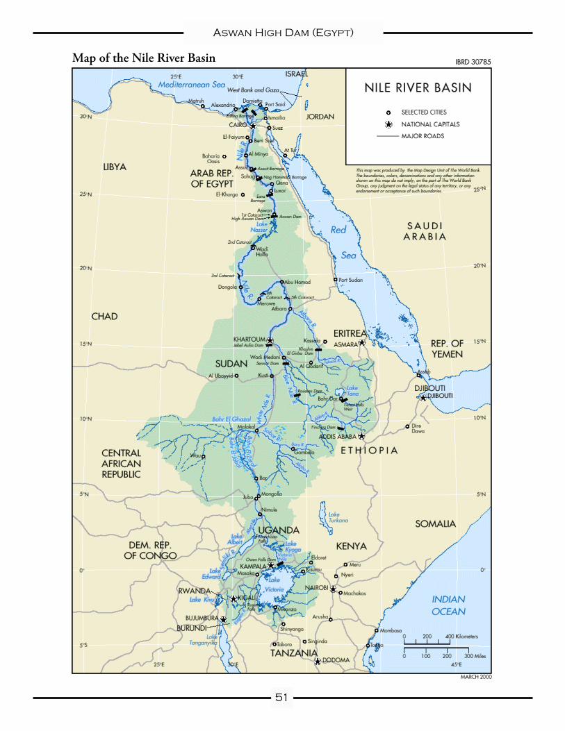
Map of the Nile River Basin
52
Aswan High Dam (Egypt)
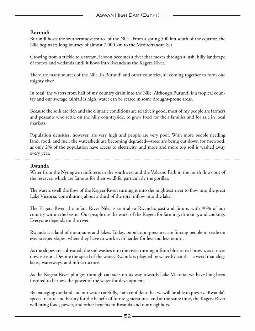
Burundi Burundi hosts the southernmost source of the Nile. From a spring 500 km south of the equator, the Nile begins its long journey of almost 7,000 km to the Mediterranean Sea.
Growing from a trickle to a stream, it soon becomes a river that moves through a lush, hilly landscape of forests and wetlands until it flows into Rwanda as the Kagera River.
There are many sources of the Nile, in Burundi and other countries, all coming together to form one mighty river.
In total, the waters from half of my country drain into the Nile. Although Burundi is a tropical coun-try and our average rainfall is high, water can be scarce in some drought-prone areas.
Because the soils are rich and the climatic conditions are relatively good, most of my people are farmers and peasants who settle on the hilly countryside, to grow food for their families and for sale in local markets.
Population densities, however, are very high and people are very poor. With more people needing land, food, and fuel, the watersheds are becoming degraded—trees are being cut down for firewood, as only 2% of the population have access to electricity, and more and more top soil is washed away every year.
RwandaWater from the Nyungwe rainforests in the southwest and the Volcano Park in the north flows out of the reserves, which are famous for their wildlife, particularly the gorillas.
The waters swell the flow of the Kagera River, turning it into the mightiest river to flow into the great Lake Victoria, contributing about a third of the total inflow into the lake.
The Kagera River, the infant River Nile, is central to Rwanda’s past and future, with 90% of our country within the basin. Our people use the water of the Kagera for farming, drinking, and cooking. Everyone depends on the river.
Rwanda is a land of mountains and lakes. Today, population pressures are forcing people to settle on ever-steeper slopes, where they have to work even harder for less and less return.
As the slopes are cultivated, the soil washes into the river, turning it from blue to red-brown, as it races downstream. Despite the speed of the water, Rwanda is plagued by water hyacinth—a weed that clogs lakes, waterways, and infrastructure.
As the Kagera River plunges through cataracts on its way towards Lake Victoria, we have long been inspired to harness the power of the water for development.
By managing our land and our water carefully, I am confident that we will be able to preserve Rwanda’s special nature and beauty for the benefit of future generations, and at the same time, the Kagera River will bring food, power, and other benefits to Rwanda and our neighbors.
53
Aswan High Dam (Egypt)
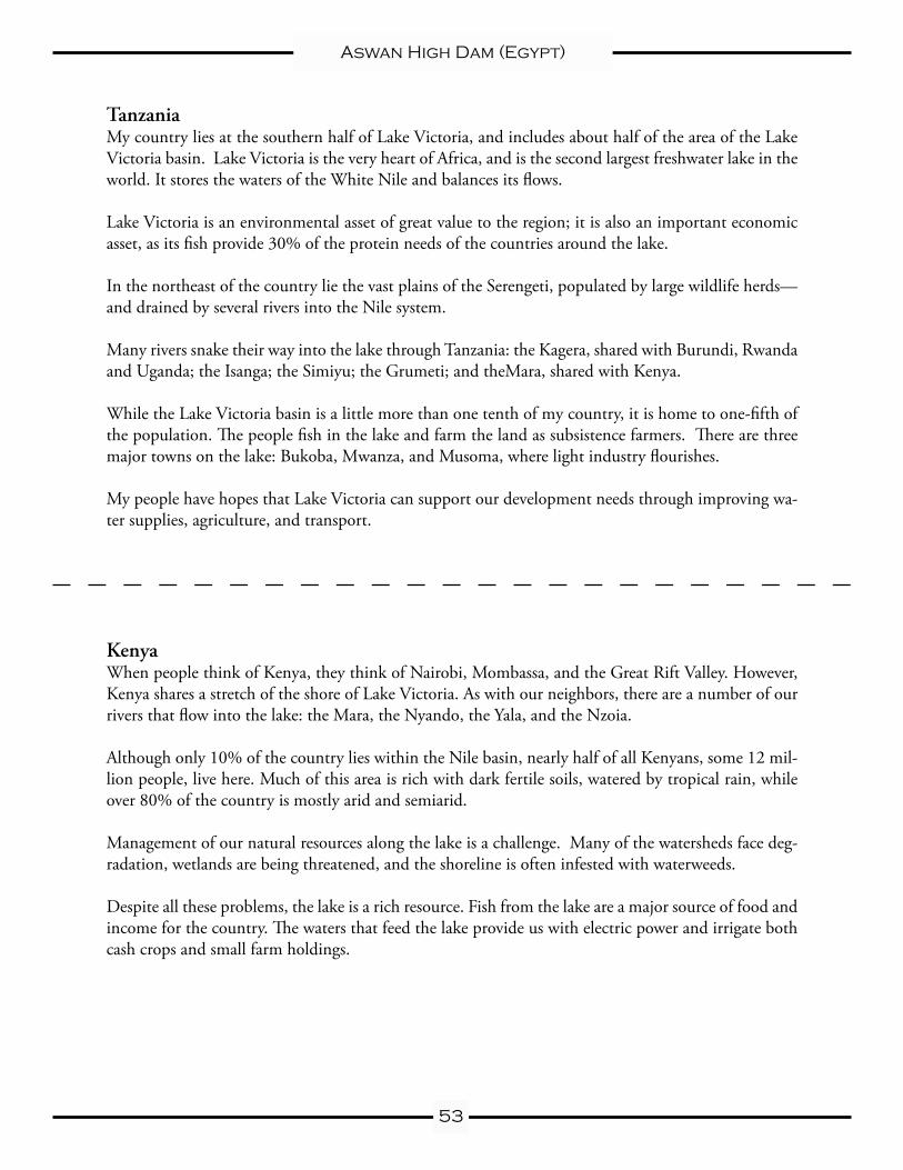
Tanzania My country lies at the southern half of Lake Victoria, and includes about half of the area of the Lake Victoria basin. Lake Victoria is the very heart of Africa, and is the second largest freshwater lake in the world. It stores the waters of the White Nile and balances its flows.
Lake Victoria is an environmental asset of great value to the region; it is also an important economic asset, as its fish provide 30% of the protein needs of the countries around the lake.
In the northeast of the country lie the vast plains of the Serengeti, populated by large wildlife herds—and drained by several rivers into the Nile system.
Many rivers snake their way into the lake through Tanzania: the Kagera, shared with Burundi, Rwanda and Uganda; the Isanga; the Simiyu; the Grumeti; and theMara, shared with Kenya.
While the Lake Victoria basin is a little more than one tenth of my country, it is home to one-fifth of the population. The people fish in the lake and farm the land as subsistence farmers. There are three major towns on the lake: Bukoba, Mwanza, and Musoma, where light industry flourishes.
My people have hopes that Lake Victoria can support our development needs through improving wa-ter supplies, agriculture, and transport.
Kenya When people think of Kenya, they think of Nairobi, Mombassa, and the Great Rift Valley. However, Kenya shares a stretch of the shore of Lake Victoria. As with our neighbors, there are a number of our rivers that flow into the lake: the Mara, the Nyando, the Yala, and the Nzoia.
Although only 10% of the country lies within the Nile basin, nearly half of all Kenyans, some 12 mil-lion people, live here. Much of this area is rich with dark fertile soils, watered by tropical rain, while over 80% of the country is mostly arid and semiarid.
Management of our natural resources along the lake is a challenge. Many of the watersheds face deg-radation, wetlands are being threatened, and the shoreline is often infested with waterweeds.
Despite all these problems, the lake is a rich resource. Fish from the lake are a major source of food and income for the country. The waters that feed the lake provide us with electric power and irrigate both cash crops and small farm holdings.
54
Aswan High Dam (Egypt)
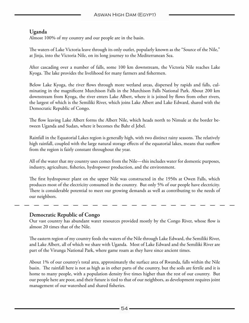
Uganda Almost 100% of my country and our people are in the basin.
The waters of Lake Victoria leave through its only outlet, popularly known as the “Source of the Nile,” at Jinja, into the Victoria Nile, on its long journey to the Mediterranean Sea.
After cascading over a number of falls, some 100 km downstream, the Victoria Nile reaches Lake Kyoga. The lake provides the livelihood for many farmers and fishermen.
Below Lake Kyoga, the river flows through more wetland areas, dispersed by rapids and falls, cul-minating in the magnificent Murchison Falls in the Murchison Falls National Park. About 200 km downstream from Kyoga, the river enters Lake Albert, where it is joined by flows from other rivers, the largest of which is the Semiliki River, which joins Lake Albert and Lake Edward, shared with the Democratic Republic of Congo.
The flow leaving Lake Albert forms the Albert Nile, which heads north to Nimule at the border be-tween Uganda and Sudan, where it becomes the Bahr el Jebel.
Rainfall in the Equatorial Lakes region is generally high, with two distinct rainy seasons. The relatively high rainfall, coupled with the large natural storage effects of the equatorial lakes, means that outflow from the region is fairly constant throughout the year.
All of the water that my country uses comes from the Nile—this includes water for domestic purposes, industry, agriculture, fisheries, hydropower production, and the environment.
The first hydropower plant on the upper Nile was constructed in the 1950s at Owen Falls, which produces most of the electricity consumed in the country. But only 5% of our people have electricity. There is considerable potential to meet our growing demands as well as contributing to the needs of our neighbors.
Democratic Republic of Congo Our vast country has abundant water resources provided mostly by the Congo River, whose flow is almost 20 times that of the Nile.
The eastern region of my country feeds the waters of the Nile through Lake Edward, the Semiliki River, and Lake Albert, all of which we share with Uganda. Most of Lake Edward and the Semiliki River are part of the Virunga National Park, where game roam as they have since ancient times.
About 1% of our country’s total area, approximately the surface area of Rwanda, falls within the Nile basin. The rainfall here is not as high as in other parts of the country, but the soils are fertile and it is home to many people, with a population density five times higher than the rest of our country. But our people here are poor, and their future is tied to that of our neighbors, as development requires joint management of our watershed and shared fisheries.
55
Aswan High Dam (Egypt)
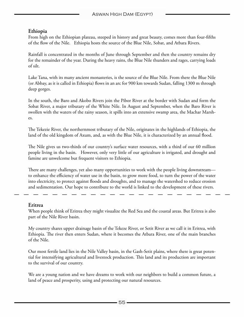
Ethiopia From high on the Ethiopian plateau, steeped in history and great beauty, comes more than four-fifths of the flow of the Nile. Ethiopia hosts the source of the Blue Nile, Sobat, and Atbara Rivers.
Rainfall is concentrated in the months of June through September and then the country remains dry for the remainder of the year. During the heavy rains, the Blue Nile thunders and rages, carrying loads of silt.
Lake Tana, with its many ancient monasteries, is the source of the Blue Nile. From there the Blue Nile (or Abbay, as it is called in Ethiopia) flows in an arc for 900 km towards Sudan, falling 1300 m through deep gorges.
In the south, the Baro and Akobo Rivers join the Pibor River at the border with Sudan and form the Sobat River, a major tributary of the White Nile. In August and September, when the Baro River is swollen with the waters of the rainy season, it spills into an extensive swamp area, the Machar Marsh-es.
The Tekezie River, the northernmost tributary of the Nile, originates in the highlands of Ethiopia, the land of the old kingdom of Axum, and, as with the Blue Nile, it is characterized by an annual flood.
The Nile gives us two-thirds of our country’s surface water resources, with a third of our 60 million people living in the basin. However, only very little of our agriculture is irrigated, and drought and famine are unwelcome but frequent visitors to Ethiopia.
There are many challenges, yet also many opportunities to work with the people living downstream—to enhance the efficiency of water use in the basin, to grow more food, to turn the power of the water into electricity, to protect against floods and droughts, and to manage the watershed to reduce erosion and sedimentation. Our hope to contribute to the world is linked to the development of these rivers.
Eritrea When people think of Eritrea they might visualize the Red Sea and the coastal areas. But Eritrea is also part of the Nile River basin.
My country shares upper drainage basin of the Tekeze River, or Setit River as we call it in Eritrea, with Ethiopia. The river then enters Sudan, where it becomes the Atbara River, one of the main branches of the Nile.
Our most fertile land lies in the Nile Valley basin, in the Gash-Setit plains, where there is great poten-tial for intensifying agricultural and livestock production. This land and its production are important to the survival of our country.
We are a young nation and we have dreams to work with our neighbors to build a common future, a land of peace and prosperity, using and protecting our natural resources.
56
Aswan High Dam (Egypt)
Sudan My country is vast, the largest on the continent of Africa. It contains two-thirds of the Nile basin and is characterized by great diversity from the vast wetlands of the south to the great tracts of desert in the north.
North of the border with Uganda, at Mongalla, the Bahr el Jebel enters the Sudd wetlands, the largest wetland area in Africa—the size of Belgium.
West of Malakal, the Bahr el Ghazal drains a vast area of southwestern Sudan, however, the Bahr el Ghazal’s flow into Lake No and the White Nile is minimal.
Below Lake No, the Nile flows eastward and becomes the White Nile. A few miles upstream it is joined by the Sobat River from the east, almost doubling its flow through extremely flat and increasingly arid terrain.
Khartoum sits at the confluence of the White and Blue Niles. From Khartoum the Main Nile, or Lower Nile, has yet 3,100 km to travel on its journey to the delta and the Mediterranean Sea in Egypt. The only inflow to the river is the Atbara tributary from the east.
The Nile is our main source of freshwater in the Sudan. We use it for everything—for our drinking water, to irrigate our land, and to generate our electricity.
The Nile is our lifeblood, but it is also at times a threat. During the last years, we have had major floods with substantial damage. The river, which brings us life, also brings us enormous quantities of silt that fill our reservoirs and canals and damage our infrastructure.
Egypt Finally, on its long journey to the sea, the Nile reaches Egypt. Egypt is home to more than 60 million people, most of whom live in a narrow strip along the banks of the river. The Nile enters Egypt at the top of Lake Nasser, the reservoir of the Aswan High Dam.
On its way through Egypt, the Nile passes by the legacies of ancient civilizations: the temples of Luxor, the Valley of the Kings, the Pyramids, as well as the towns and villages, farms and fields of modern Egypt, until it reaches Cairo with its 18 million inhabitants.
North of Cairo, the river fans out into a huge delta as it approaches the Mediterranean. Two main chan-nels are formed: the Damietta and the Rosetta branches. The area includes fields of crops and several lakes, many towns, and our second city, the ancient port of Alexandria.
Apart from the Nile, there is no other surface water in Egypt. The country receives hardly any rainfall and almost all the water we need for agriculture, domestic and industrial supplies, navigation, and tourism comes from the Nile. All along its banks, the desert has been turned green by the waters of the Nile.
We depend upon the flow of the Nile. For our people, the management of the river is essential for survival.
About Hemispheres
Created in 1996, Hemispheres is the international outreach consortium at the University of Texas at Austin. Hemispheres utilizes University resources to pro-mote and assist with world studies education for K-12 and postsecondary schools, businesses, civic and non-profit organizations, the media, governmental agencies,
and the general public.
Comprised of UT’s four federally funded National Resource Centers (NRCs) dedicated to the study and teaching of Latin America; the Middle East; Rus-sia, East Europe & Eurasia; and South Asia, Hemispheres offers a variety of free and low-cost services to these groups and more. Each center coordinates its own outreach programming, including management of its lending library, speakers bureau, public lectures, and conferences, all of which are reinforced by collabora-tive promotion of our resources to an ever-widening audience in the educational
community and beyond.
Hemispheres fulfills its mission through: coordination of pre-service and in-service training and resource workshops for educators; promotion of outreach resources and activities via exhibits and presentations at appropriate state- and nation-wide educator conferences; participation in public outreach events as or-ganized by the consortium as well as by other organizations; and consultation on appropriate methods for implementing world studies content in school, business,
and community initiatives.
For more information, visit the Hemispheres Web site at:http://www.utexas.edu/cola/orgs/hemispheres/
or e-mail: [email protected]
http://www.utexas.edu/cola/orgs/hemispheres/[email protected]
Teresa Lozano Long Institute of Latin American Studies
Natalie Arsenault, Outreach DirectorThe University of Texas at Austin
1 University Station D0800SRH 1.310
Austin, TX 78712(512) 232-2404
Fax (512) [email protected]
Center for Middle Eastern Studies Christopher Rose, Assistant Director
The University of Texas at Austin1 University Station F9400
WMB 6.102Austin, TX 78712
(512) 471-3582Fax (512) 471-7834
Center for Russian, East European & Eurasian Studies
Allegra Azulay, Outreach CoordinatorThe University of Texas at Austin
1 University Station A1600GRG 106
Austin, TX 78712(512) 471-7782
Fax (512) [email protected]
South Asia InstituteRachel Meyer, Outreach Coordinator
The University of Texas at Austin1 University Station G9300
WCH 4.134Austin, TX 78712
(512) 475-6038Fax (512) 471-3336