pensacola bay bridge replacement - home - west … tpo pensacola bay bridge replacement...pensacola...
TRANSCRIPT

Pensacola Bay Bridge ReplacementPensacola Bay Bridge ReplacementProject Development & Environment StudyProject Development & Environment StudyProject Development & Environment StudyProject Development & Environment Study
Presentation to FloridaPresentation to Florida AlabamaAlabamaPresentation to FloridaPresentation to Florida--AlabamaAlabamaTransportation Planning OrganizationTransportation Planning OrganizationTCC, CAC, BPAC, & TPO MeetingsTCC, CAC, BPAC, & TPO MeetingsFeb 23Feb 23rdrd / Mar 12/ Mar 12thth, 13, 13thth, 14, 14thth 20122012

Project LimitsProject Limits
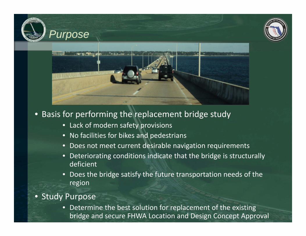
PurposePurpose
• Basis for performing the replacement bridge study• Lack of modern safety provisions N f ili i f bik d d i• No facilities for bikes and pedestrians
• Does not meet current desirable navigation requirements• Deteriorating conditions indicate that the bridge is structurally d fi i tdeficient
• Does the bridge satisfy the future transportation needs of the region
• Study Purpose• Determine the best solution for replacement of the existing bridge and secure FHWA Location and Design Concept Approval

Project DeliveryProject Delivery
Planning• Candidate Projects Based on Preliminary Analysis and
determination of need• Prioritize Projects• Funding Options/Availability Reviewed/Programming
Project Development & Environment Study
Funding Options/Availability Reviewed/Programming
• Develop Preliminary Alternatives• Assessment of Potential Environmental and Community Impacts • Substantial Public Involvement Initiativesy
Preliminary Design
• Preferred Alternative(s) advance to Preliminary Engineering
• Develop up to 30% Design Plans• Additional Public Outreach
Final Design
• Agency Coordination
• Proceed through Design, 60, 90 % plans• Permitting Process• Final Cost Estimatesg
Right-of-Way/ Acquisition
• Final Cost Estimates
• Proceed with acquisition of necessary property
Acquisition
Construction

PD&E Task ElementsPD&E Task Elements
P j t D l t &Project Development & Environment Study
• Evaluate Current Conditions – Data Collection– Environmental, Social, Engineering
• Forecast Future Needs – Traffic
• Evaluate Alternative Corridors• Develop Alternative Alignments
• Perform Assessments of Potential Environmental and Community ImpactsCommunity Impacts
• Select an Alternative to advance into Preliminary Engineering

Bridge ApproachesBridge Approaches
Gulf Breeze Approach
Pensacola Approach
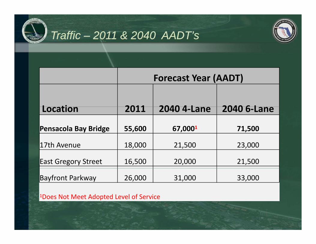
Traffic Traffic –– 2011 & 2040 AADT’s2011 & 2040 AADT’s
F t Y (AADT)Forecast Year (AADT)
L ti 2011 2040 4 L 2040 6 LLocation 2011 2040 4‐Lane 2040 6‐Lane
Pensacola Bay Bridge 55,600 67,0001 71,500
17th Avenue 18,000 21,500 23,000
East Gregory Street 16,500 20,000 21,500
Bayfront Parkway 26,000 31,000 33,000
1Does Not Meet Adopted Level of Serviceoes ot eet dopted e e o Se ce

Safety Safety –– Accident LocationsAccident Locations

Road & Bridge ConfigurationsRoad & Bridge Configurations
• Three lanes in each direction• Shoulders adjacent to the travel lanes (bridge only)• Pedestrian/bicycle path in each direction
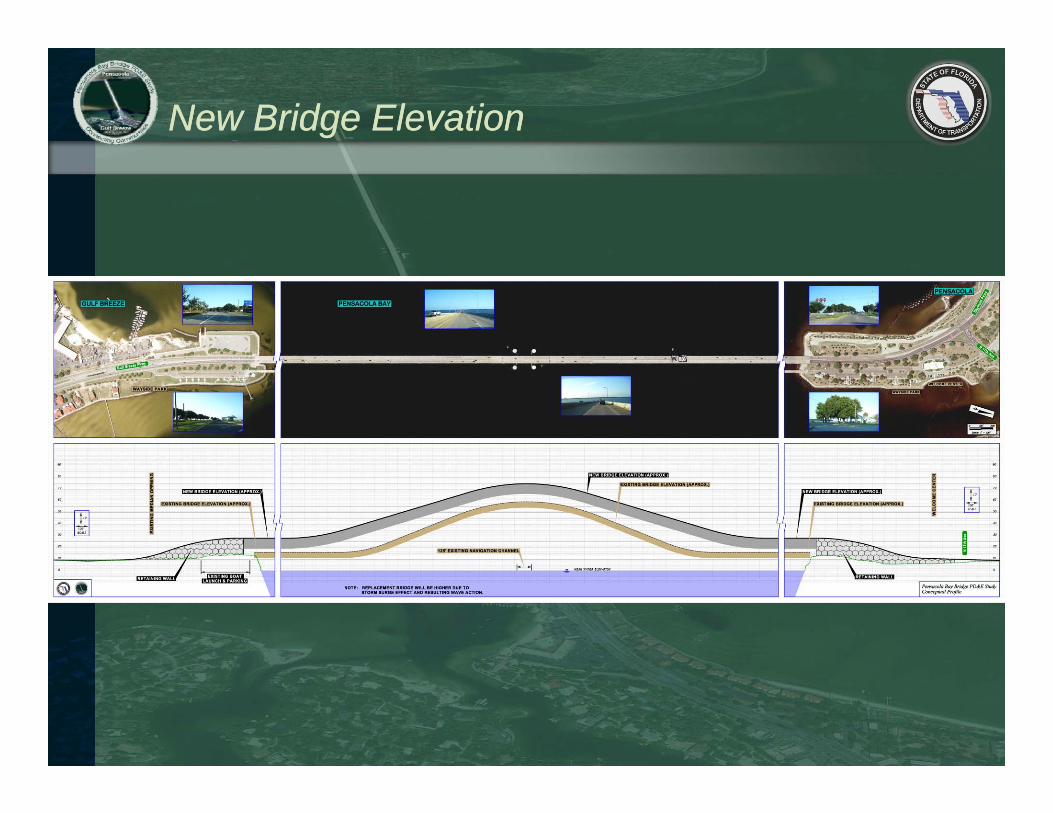
New Bridge ElevationNew Bridge Elevation
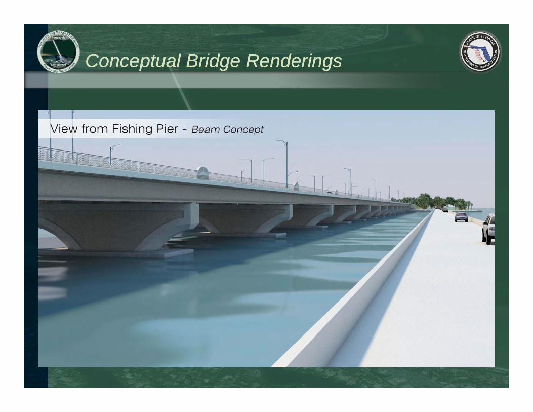
Conceptual Bridge RenderingsConceptual Bridge Renderings
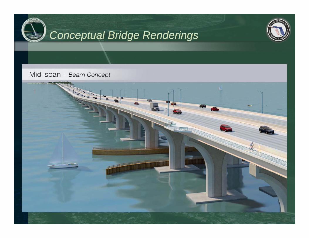
Conceptual Bridge RenderingsConceptual Bridge Renderings

Conceptual Bridge RenderingsConceptual Bridge Renderings

Corridor Alternatives Workshop Corridor Alternatives Workshop –– August 2011August 2011
West Corridor
East CorridorCentral Corridor
East Corridor

Corridor Alternatives Meeting (September 2011) Corridor Alternatives Meeting (September 2011) East & West Corridor Representative AlignmentsEast & West Corridor Representative Alignments
West East

Corridor Alternatives Meeting (September 2011)Corridor Alternatives Meeting (September 2011)Central Corridor Representative AlignmentsCentral Corridor Representative Alignments
Central West Central East

1717thth Avenue Flyover Ramp Avenue Flyover Ramp
Flyover being developed for each corridor alternative
Flag MemorialGreen Shores Restoration
Fish & Wildlife Bldg
Railroad Bridge
Welcome Center
Boat LaunchFishing Pier
Boat Launch
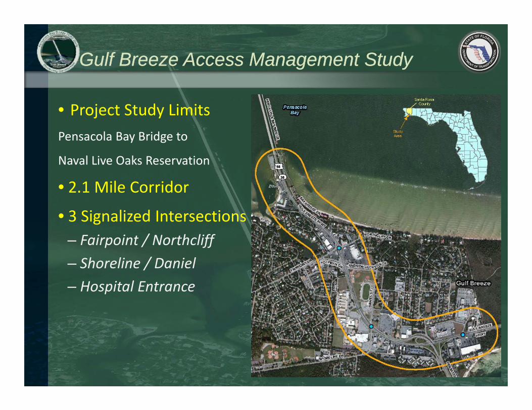
Gulf Breeze Access Management StudyGulf Breeze Access Management Study
• Project Study LimitsPensacola Bay Bridge to
Naval Live Oaks Reservation
• 2.1 Mile Corridor
• 3 Signalized Intersections– Fairpoint / Northcliff– Shoreline / DanielH it l E t– Hospital Entrance

Gulf Breeze Access Management StudyGulf Breeze Access Management Study
Major Tasks include:
1. Traffic Analysis– Existing Conditions– Forecasted 2040 Conditions
2. Crash Analysis
3. Access Management Analysis– Existing Median Openings
St t i t i ti th h t th id– Strategies to improve operations throughout the corridor– Reports and Meetings

Existing TrafficExisting Traffic
• Fairpoint / Northcliff– LOS AM (PM): D (C)– Delay (seconds): 41.6 (33.7)
• Shoreline / Daniel– LOS AM (PM): C (D)– Delay (seconds): 22.1 (38.5)
• Hospital Entrance– LOS AM (PM): C (C)– Delay (seconds): 33.6 (21.8)

Future Traffic Future Traffic –– No Build No Build
• Fairpoint / Northcliff– LOS AM (PM): E (E)– Delay (seconds): 71.6 (79.8)
• Shoreline / Daniel– LOS AM (PM): E (E)– Delay (seconds): 75.0 (75.7)
• Hospital Entrance– LOS AM (PM): F (F)– Delay (seconds): 225.6 (166.7)

Improvements to Hospital EntranceImprovements to Hospital Entrance
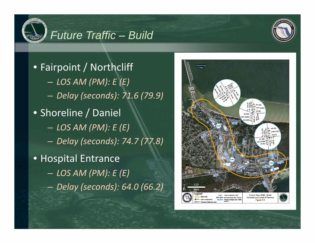
Future Traffic Future Traffic –– Build Build
• Fairpoint / Northcliff– LOS AM (PM): E (E)– Delay (seconds): 71.6 (79.9)
• Shoreline / Daniel– LOS AM (PM): E (E)– Delay (seconds): 74.7 (77.8)
• Hospital Entrance– LOS AM (PM): E (E)– Delay (seconds): 64.0 (66.2)

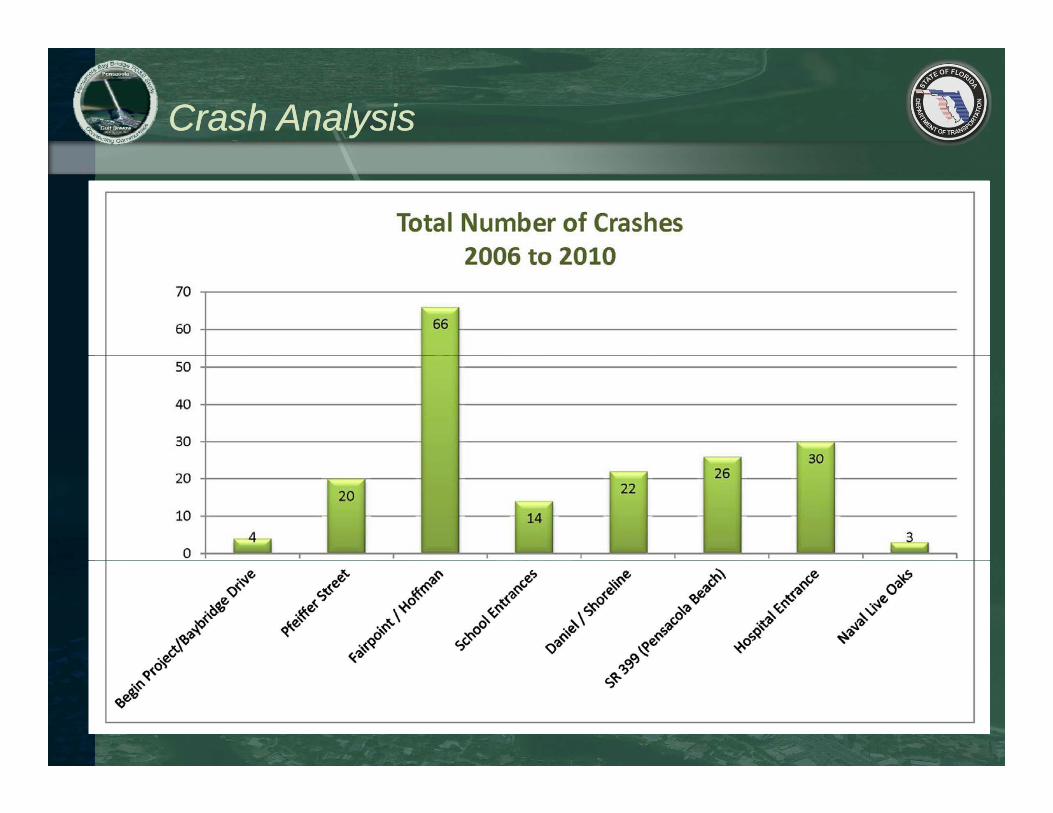
Crash AnalysisCrash Analysis
• Crash Data from City of Gulf Breeze
• 5‐years of data: 2006 to 2011• Crash Statistics• Crash Statistics
– 185 crashes– 165 non‐injury crashes with 397 persons involved– 98 injury crashes with 153 persons injured
Crash AnalysisCrash Analysis
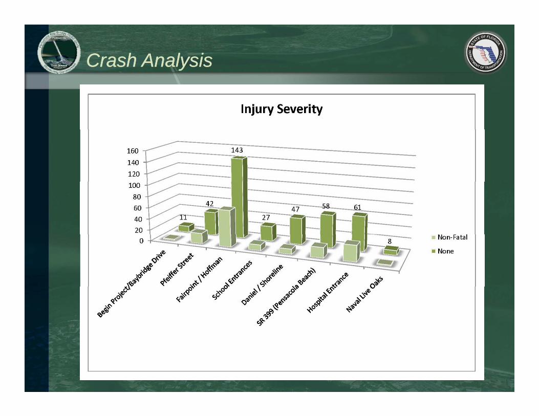
Crash AnalysisCrash Analysis
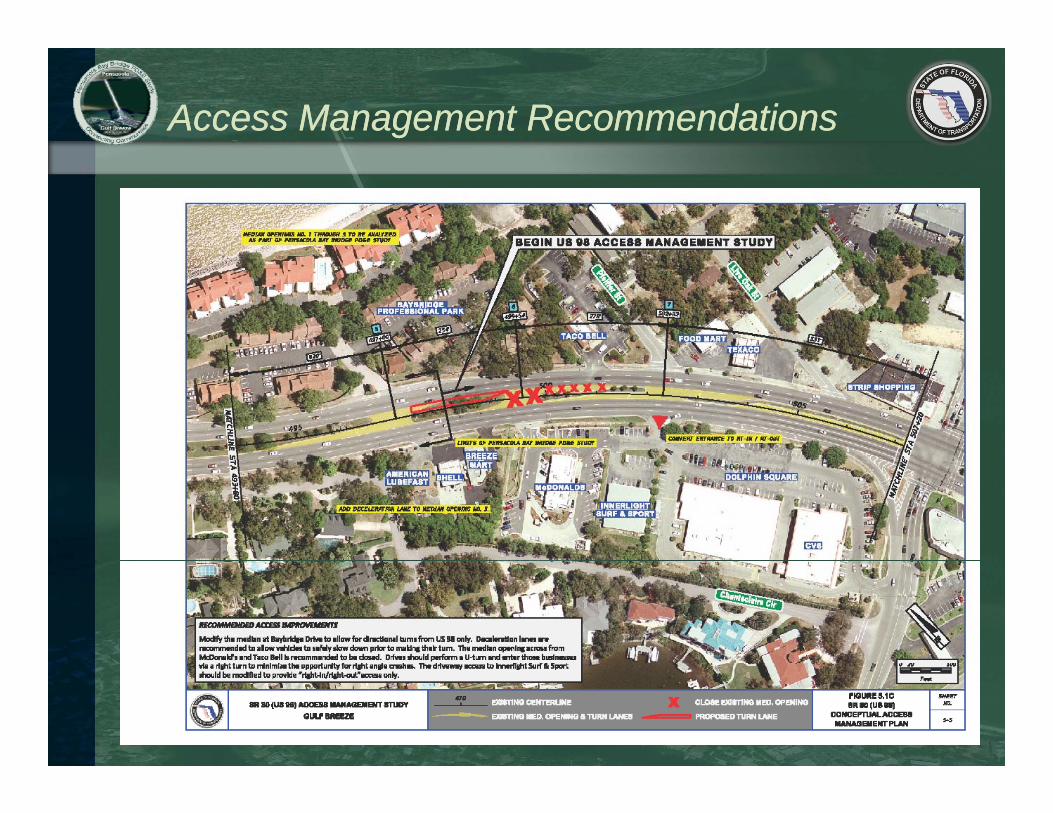
Access Management RecommendationsAccess Management Recommendations
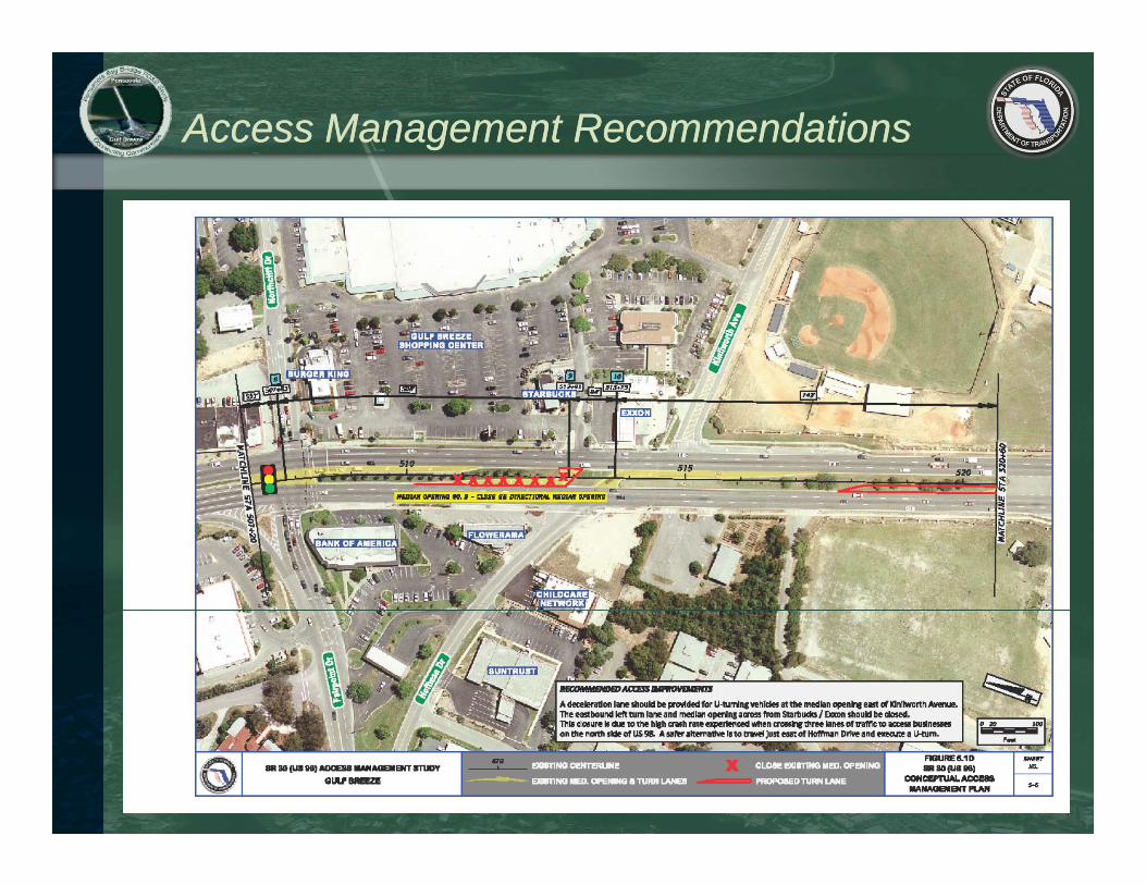
Access Management RecommendationsAccess Management Recommendations

Toll Revenue StudyToll Revenue Study
Major Tasks include:
1. Model Review and Refinement
2. Model Application and Sensitivity Testing
3. Preliminary Geometry and Layout
4 Micro‐Simulation and Operational Analysis4. Micro Simulation and Operational Analysis– Scenario 1: Toll Entire Bridge– Scenario 2: Toll New Capacity
5. Construction Cost and R/W impacts
6. Feasibility Report6 eas b y epo

Toll Revenue Opinion SurveyToll Revenue Opinion Survey
Sh ld t ll b l d th b id t Sh ld t ll b d t i t i f diShould tolls be placed on the bridge to provide local revenue?
Should tolls be used to assist in funding the additional cost of aesthetic features?
1200
1400
1600
1000
1200
1400
600
800
1000
600
800
1000
0
200
400
0
200
400
Strongly Oppose
Oppose Neutral Support Strongly Support
Strongly Oppose
Oppose Neutral Support Strongly Support
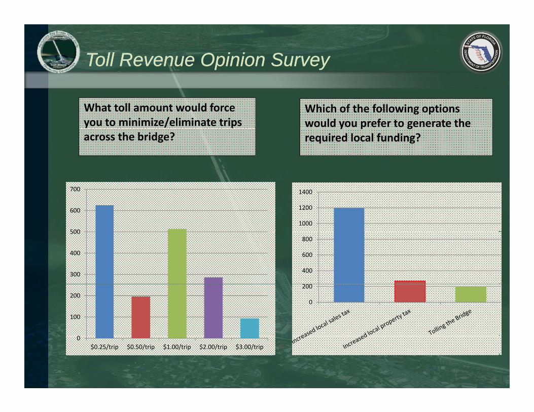
Toll Revenue Opinion SurveyToll Revenue Opinion Survey
Which of the following options would you prefer to generate the
What toll amount would force you to minimize/eliminate trips y p g
required local funding? across the bridge?
1000
1200
1400
500
600
700
200
400
600
800
300
400
500
0
200
0
100
200
0$0.25/trip $0.50/trip $1.00/trip $2.00/trip $3.00/trip

US DOT Section 4(f) LegislationUS DOT Section 4(f) Legislation
• Protects the following:– Public Parks– Recreation Areas
Wildlif W t f l R f– Wildlife or Waterfowl Refuges– Historic Sites
• Jurisdiction and significance of the above sites can be:– National– State– Local
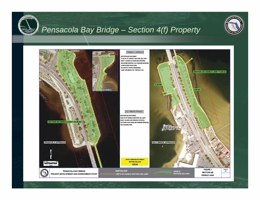
Pensacola Bay Bridge Pensacola Bay Bridge –– Section 4(f) PropertySection 4(f) Property
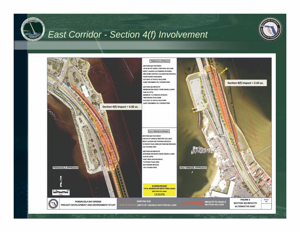
East Corridor East Corridor -- Section 4(f) InvolvementSection 4(f) Involvement
Section 4(f) Impact = 2.65 ac.
Section 4(f) Impact = 4.82 ac.

Central East Alternative Central East Alternative –– Section 4(f) InvolvementSection 4(f) Involvement
Section 4(f) Impact = 1.73 ac.
Section 4(f) Impact = 4.19 ac.

Central West Alternative Central West Alternative –– Section 4(f) InvolvementSection 4(f) Involvement
Section 4(f) Impact = 1.04 ac.
Section 4(f) Impact = 0.00 ac.

West Alternative West Alternative –– Section 4(f) InvolvementSection 4(f) Involvement
Section 4(f) Impact = 2.32 ac.
Section 4(f) Impact = 0.00 ac.

US DOT Section 4(f) LegislationUS DOT Section 4(f) Legislation
• US DOT Secretary of Transportation (or his designate)– Shall not approve any project that takes land from:
• Public park, recreation area, wildlife or waterfowl refuge, or historicsite……unless:
» There is no feasible and prudent alternative to the use of suchland
» The project includes all possible planning to minimize harm
• Process– Determine if any Section 4(f) sites are in the project area
Determine if there are any alternatives that avoid the property– Determine if there are any alternatives that avoid the property– If not avoidable, minimize harm
• Reduce amount of right of way required from the Section 4(f) property• Collaborate with park officials to provide enhancements

Section 4(f) Section 4(f) -- Potential Involvement Potential Involvement
Pensacola Bay Bridge ‐ Section 4(f) InvolvementAcres Directly Impacted
Alternative
Pensacola Approach Gulf Breeze Approach
East Side West Side East Side West Side Total
ac ac ac ac ac
East 4.82 2.65 ‐ 7.47
N/A
Central East 4.19 1.50 0.23 5.93
C t l W t 1 04 1 04Central West ‐ ‐ 1.04 1.04
West ‐ ‐ 2.32 2.32
*Note: Acreages are based upon the representative alignments developed within each corridor.

Public OutreachPublic Outreach
• Throughout the study conduct a comprehensive and continuous Public Involvement Program
Website
Newsletters
pensacolabaybridge.comCommunity
Stakeholders
Special InterestNeighborhood
Associations
Special Interest
GroupsLocal Government
Meeting
One – On – One
Informal Public
Meetings
Project Advisory
Local, State
& Federal
Officials
Federal, State &
Local Government
MeetingsProject Advisory
Group (PAG)

Public OutreachPublic Outreach
• Throughout the study conduct a comprehensive and continuous Public Involvement Programcontinuous Public Involvement Program
– FLA‐ALA TPO April 15, 2011– City of Pensacola April 18, 2011– City of Gulf Breeze April 27, 2011– Santa Rosa County April 28, 2011– United Peninsula Association June 06 2011– United Peninsula Association June 06, 2011– Project Advisory Group Mtg. #1 July 06, 2011– Corridor Workshop (Open House) Aug. 11, 2011– Corridor Alternatives Mtg. (Open House) Oct. 18, 2011– Project Advisory Group Mtg. #2 Dec. 06, 2011
FLA ALA TCC Feb 23 2012– FLA‐ALA TCC Feb. 23, 2012– FLA‐ALA CAC, BPAC, & TPO Mar 12‐14, 2012

What’s Next?What’s Next?
• Complete Corridor Analysis March 2012
• Select Corridor April 2012• Select Corridor April 2012
• Develop Alignments Within Selected Corridor May/June 2012
• Further Evaluate Engineering / Environmental /Further Evaluate Engineering / Environmental /
& Community Impacts June/July 2012
• Public Alternatives Meeting July/Aug 2012Public Alternatives Meeting July/Aug 2012
• Refine Alignments Sept/Oct 2012
• Develop Draft National Environmental PolicyDevelop Draft National Environmental Policy
Act (NEPA) and Draft Section 4(f) Documents Nov/Dec/Jan
• Public Hearing March 2013Public Hearing March 2013
• Select Preferred Alternative/Secure FHWA Approval May 2013

Contact US!Contact US!
www.PensacolaBayBridge.com
J. Brandon Bruner, PEProject Development EngineerFDOT, District 31074 Hi h 90
Dan Kristoff, PEProject ManagerRS&H 10748 D d P k Bl d S th
Nick Arnio, PE, PTOEDeputy Project ManagerRS&H1701 H it Bl d S it 1011074 Highway 90
Chipley, FL 32428(850) 415‐[email protected]
10748 Deerwood Park Blvd. SouthJacksonville, FL 32256‐0597(904) 256‐2139 [email protected]
1701 Hermitage Blvd., Suite 101Tallahassee, FL 32308(850) 558‐2800 [email protected]

Thank You!Thank You!
Pensacola Bay Bridge ReplacementPensacola Bay Bridge ReplacementProject Development & Environment StudyProject Development & Environment Study
Presentation to FloridaPresentation to Florida AlabamaAlabamaPresentation to FloridaPresentation to Florida--AlabamaAlabamaTransportation Planning OrganizationTransportation Planning OrganizationTCC, CAC, BPAC, & TPO MeetingsTCC, CAC, BPAC, & TPO MeetingsFeb 23Feb 23rdrd / Mar 12/ Mar 12thth, 13, 13thth, 14, 14thth 20122012