prepared in cooperation with the california … in cooperation with the california geological survey...
TRANSCRIPT

U.S. Department of the InteriorU.S. Geological Survey
Fact Sheet 2005–3107 September 2005
Prepared in Cooperation with the California Geological Survey
Southern California Landslides—An Overview
Printed on recycled paper
Southern California’s Complex Landscapes Contribute to LandslidesSouthern California is tectonically active and geologically complex, and this complexity strongly controls when and where landslides occur throughout the region. (See the USGS Web site that describes the geologi-cal setting and history of southern California, http://scamp.wr.usgs.gov/scamp/html/scgeo.html for more information.) In general, landslides are more common where slopes are steep and rocks are weak, and these conditions are all too common in southern California. Steep slopes are abundant because ongoing tec-tonic deformation pushes up rock that is too weak to support the steep slopes. Some of the uplifted material is geologically very young sediment that has not consolidated into more resistant rock. However, even older and harder rocks have been sheared and fractured by tectonic movement along the plate boundary, and thus
they can be quite weak too. The weak rock weathers and erodes rapidly to form steep-sided gullies and larger valleys. It is this steep, rugged terrain carved into relatively weak material that sets the stage for widespread landsliding. Southern California experi-ences many kinds of landslides: shallow, rapid debris flows triggered by heavy rainfall, rock falls from steep slopes as a result of earthquakes, and slower moving slumps and earth flows on slopes that can fail under many different conditions.
Winter Rainstorms and Debris FlowsAlmost all of southern California’s rain falls during the winter rainy season, which typically lasts from November through April. The most common land-slides triggered by winter storms are debris flows (popularly called “mudslides”), which are shallow
View of the La Conchita landslide taken March 16, 2005. The lightest-colored, exposed rock to the left of the center of the photo is the main scarp of the 1995 slide. The southeast part of the 1995 deposit (central part of photo; it extends into a housing development) remobilized in 2005. Photograph by Jonathan Godt, USGS. A report on the La Conchita landslide is available online: http://pubs.usgs.gov/of/2005/1067
IntroductionSouthern California lies astride a major tectonic
plate boundary defined by the San Andreas Fault and numerous related faults that are spread across a broad region. This dynamic tectonic environ-ment has created a spectacular landscape of rugged mountains and steep-walled valleys that compose much of the region’s scenic beauty. Unfortunately, this extraordinary landscape also presents serious geologic hazards. Just as tectonic forces are steadily pushing the landscape upward, gravity is relent-lessly tugging it downward. When gravity prevails, landslides can occur.
landslides of water-saturated soil and rock fragments that travel downslope rapidly as muddy slurries. The flowing mud carries rocks, vegetation, and other natural and man-made debris as it rushes down the slopes. Debris flows can reach speeds up to 56 kilo-meters/hour (35 miles/hour). Hillsides left denuded by wildfires, and drainages filled by debris washed off these denuded slopes, are also susceptible to flooding and debris flows during and immediately following heavy rainstorms. Debris flows most com-monly form after heavy rainfall onto steep slopes underlain by weak rock units. Although many steep slopes appear stable when dry, they can, without warning, produce damaging debris flows when satu-rated by intense rainfall, water from broken pipes, or misdirected drainage from roads, roofs, or large paved areas.
As a general rule, at least 250 millimeters (10 inches) of seasonal rainfall are needed to make southern California hillsides susceptible to debris flows. Once the seasonal rainfall exceeds 250 mil-limeters, intense rainfall—more than 50 millimeters (2 inches) in 6 hours in the lowlands or more than 100 millimeters (4 inches) in 6 hours in the moun-tains—can trigger debris flows. Although the likeli-hood of debris flows begins to decline after a day or more of dry weather, deeper, generally slow-moving landslides can occur days, weeks, or months after a period of prolonged rainfall has ended.
Deep-Seated LandslidesAlthough much of the water from prolonged rainfall runs off or evaporates, some soaks into the ground. It gradually moves downward through soil and bed-rock, particularly during years of above-average rainfall. In many places, fractures or impermeable layers of rock or soil deflect this downward-moving water laterally toward a slope face. There, the water can weaken the slope and cause landslides long after the rain has stopped. Movement is usually triggered by cumulative rainfall during long periods (weeks to
years). Most landslides that result from this process are relatively deep earth flows and translational or rotational earth slides and rock slides. Translational landslides are typically a few meters to tens of meters deep, and rotational slides range in depth from several meters to tens of meters. Deep-seated transla-tional and rotational landslides, including rock slides, tend to fail a little at a time and move more slowly than debris flows, but a few do accelerate to rapid movement. Consequently, these deep slides rarely cause loss of life, but they commonly destroy homes and infrastructure in hillside areas.
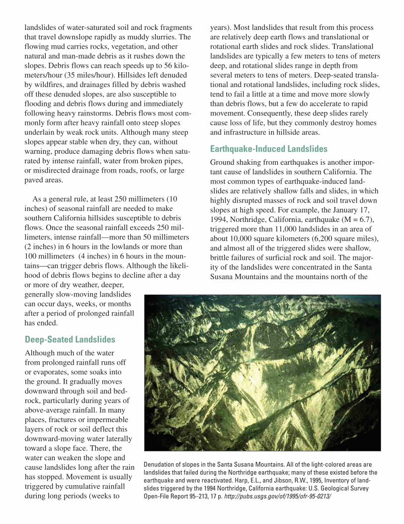
Earthquake-Induced LandslidesGround shaking from earthquakes is another impor-tant cause of landslides in southern California. The most common types of earthquake-induced land-slides are relatively shallow falls and slides, in which highly disrupted masses of rock and soil travel down slopes at high speed. For example, the January 17, 1994, Northridge, California, earthquake (M = 6.7), triggered more than 11,000 landslides in an area of about 10,000 square kilometers (6,200 square miles), and almost all of the triggered slides were shallow, brittle failures of surficial rock and soil. The major-ity of the landslides were concentrated in the Santa Susana Mountains and the mountains north of the
Denudation of slopes in the Santa Susana Mountains. All of the light-colored areas are landslides that failed during the Northridge earthquake; many of these existed before the earthquake and were reactivated. Harp, E.L., and Jibson, R.W., 1995, Inventory of land-slides triggered by the 1994 Northridge, California earthquake: U.S. Geological Survey Open-File Report 95–213, 17 p. http://pubs.usgs.gov/of/1995/ofr-95-0213/

For more information
1. The California Geological Survey (CGS) phone: (213) 239-0878, http://www.consrv.ca.gov/cgs/
2. U.S. Geological Survey, http://www.usgs.gov, http://landslides.usgs.gov
3. Information on southern California geology and the Southern California Areal Mapping Project (SCAMP): http://scamp.wr.usgs.gov/
4. Campbell, R.H., 1975, Soil slips, debris flows, and rainstorms in the Santa Monica Mountains and vicinity, southern Califor-nia: U.S. Geological Survey Professional Paper 851, 51 p.
5. Many cities and counties also employ geologists or con-tract with consulting companies that are knowledgeable about landslides. For lists of registered professionals please see the Association of Engineering Geologists (AEG): http://www.aegweb.org, and the American Society of Civil Engi-neers (ASCE): http://www.asce.org.
Lynn HighlandNational Landslide Information CenterU.S. Geological SurveyFederal Center, Box 25046, MS 966Denver, CO 80225 USA1-800-654-4966http://landslides.usgs.gov
This fact sheet is available on-line at http://pubs.usgs.gov/fs/2005/3107
Publication layout by Margo L. JohnsonLandslide scars above US 101 west of Ventura. Photograph by Jonathan Godt, March 2005.
Santa Clara River valley, where most of the earthquake energy was directed. These areas are underlain by weak, geologically young rock that is being uplifted and severely deformed by com-pressional forces generated along the tectonic plate boundary. Analysis of the distribution of landslides induced by the Northridge earthquake forms the basis for seismic landslide hazard analysis of southern California. It was later discov-ered that dust generated by these same landslides caused an outbreak of valley fever (coccidioidomycosis) that hospital-ized dozens of people and led to three fatalities. (See http://landslides.usgs.gov/recent/archives/1997northridge.php for more information on the valley fever outbreak.)
Man-Made LandslidesAlthough several types of human-induced landslides are common in south-ern California, most can be avoided or mitigated. They are most commonly a result of building roads and structures without adequate grading of slopes, of poorly planned alteration of drainage patterns, and of disturbing old landslides. Most of these situations can be avoided through careful planning and design by qualified professionals and knowledgeable oversight by appropriate regulatory agencies.
Bluebird Canyon landslide, June 1, 2005, near Laguna Beach, California. This area experienced a landslide in 1978, about 50–100 meters (150–300 feet) to the west of the 2005 event. The 2005 landslide caused 350 homes to be evacuated, of which 15 were damaged or destroyed. The movement was most likely caused by heavy rains in January and February 2005. This type of deep-seated landslide move-ment is common in southern California in the months following a season of heavy rainfall. Photograph by Jim Bowers, USGS.

Before a Storm:
1. Watch the patterns of storm-water drainage on slopes near your home, and note especially the places where runoff water converges, increasing flow over soil-covered slopes. Watch the hillsides around your home for any signs of land move-ment, such as small landslides or progressively tilting trees.
2. Become familiar with the land around you. Learn whether landslides have occurred in your area by contacting local officials, state geological surveys or departments of natural resources, and univer-sity departments of geology. Slopes that contain known landslides are likely to move again in the future.
3. Support your local government in efforts to develop and enforce land-use and building ordi-nances that regulate construction in areas sus-ceptible to landslides and debris flows. Buildings should be located away from steep slopes, streams and rivers, intermittent-stream channels, and the mouths of mountain channels.
4. Contact your local authorities to learn about the emergency-response and evacuation plans for your area, and develop your own emergency plans for your family and business.
During Heavy Rainfall:
1. Stay alert and stay awake! Many debris-flow fatal-ities occur when people are sleeping. Listen to a radio for warnings of intense rainfall. Be aware that intense short bursts of rain may be particu-larly dangerous, especially after longer periods of heavy rainfall and damp weather.
2. If you are in areas susceptible to landslides and debris flows, consider leaving if it is safe to do so. Remember that driving during an intense storm is hazardous.
3. Listen for any unusual sounds that might indicate moving debris, such as trees cracking or boulders knocking together. A trickle of flowing or falling mud or debris may precede larger flows. If you are near a stream or channel, be alert for any sud-den increase or decrease in water flow and for a change from clear to muddy water. Such changes may indicate debris-flow activity upstream, so be prepared to move quickly. Don’t delay! Save yourself, not your belongings.
4. Be especially alert when driving. Embankments along roadsides are particularly susceptible to landslides. Watch the road for collapsed pavement, mud, fallen rocks, and other indications of pos-sible debris flows.
After Heavy Rains—When the Danger Is Slow-Moving Landslides:
Areas prone to landslides:
• On or immediately above old landslides• On or at the base of slopes• In or at the base of minor drainage hollows• At the base or top of an old fill slope• At the base or top of a steep cut slope• Developed hillsides where leach field septic sys-
tems are used
Features that might indicate potential landslides:
• Springs, seeps, or saturated ground in areas that have not typically been wet
• New cracks or unusual bulges in the ground, street pavements or sidewalks
• Soil moving away from foundations• Ancillary structures such as decks and patios tilt-
ing or moving relative to the main house• Tilting or cracking of concrete floors and founda-
tions• Broken water lines and other underground utilities• Leaning telephone poles, trees, retaining walls, or
fences• Offset fence lines• Sunken or down-dropped road beds• Rapid increase in creek water levels; water may be
darker or look muddier than usual• Sudden decrease in creek water levels although
rain is still falling or has just recently stopped• Sticking doors and windows, and open spaces
around jambs and frames that indicate they are out of plumb
What to do if you suspect imminent landslide danger:
1. Get out now!2. Contact your local fire, police, or public works
department.3. Inform affected neighbors.
What Can You Do If You Live Near Steep Hills?